UNIVERSITY OF PRINCE EDWARD ISLAND ARCHIPELAGIC … · university of prince edward island...
211
UNIVERSITY OF PRINCE EDWARD ISLAND ARCHIPELAGIC MATTERS: THE CASE OF THE UNITED NATIONS CONVENTION ON THE LAW OF THE SEA AND THE REPUBLIC OF THE PHILIPPINES by ANDREW MARK MACRAE HALLIDAY A THESIS SUBMITTED TO THE FACULTY OF ARTS, IN PARTIAL FULFILMENT OF THE REQUIREMENTS FOR THE DEGREE OF MASTER OF ARTS IN ISLAND STUDIES CHARLOTTETOWN, PRINCE EDWARD ISLAND MAY, 2013 © ANDREW HALLIDAY 2013
-
Upload
truongthuy -
Category
Documents
-
view
250 -
download
0
Transcript of UNIVERSITY OF PRINCE EDWARD ISLAND ARCHIPELAGIC … · university of prince edward island...
UNIVERSITY OF PRINCE EDWARD ISLAND
ARCHIPELAGIC MATTERS:
THE CASE OF THE UNITED NATIONS CONVENTION ON THE LAW OF THE
SEA AND THE REPUBLIC OF THE PHILIPPINES
by
ANDREW MARK MACRAE HALLIDAY
A THESIS
SUBMITTED TO THE FACULTY OF ARTS,
IN PARTIAL FULFILMENT OF THE REQUIREMENTS FOR THE
DEGREE OF MASTER OF ARTS IN ISLAND STUDIES
CHARLOTTETOWN, PRINCE EDWARD ISLAND
MAY, 2013
© ANDREW HALLIDAY 2013
PERMISSION TO USE GRADUATE THESIS
Title of Thesis: “Archipelagic Matters: The Case of the United Nations Convention on the Law of the Sea and the Republic of the Philippines”,
Name of Author: Mr. Andrew Halliday
Faculty: Arts
Department/Discipline: Island Studies
Degree: Master of Arts Year: 2013
Name of Supervisor(s): Dr. Barry Bartmann
Members of Supervisory Committee: Dr. Godfrey Baldacchino
In presenting this thesis in partial fulfilment of the requirements for a graduate degree from the
University of Prince Edward Island, the author has agreed that the Robertson Library, University
of Prince Edward Island, may make this thesis freely available for inspection and gives
permission to add an electronic version of the thesis to the Digital Repository at the University
of Prince Edward Island. Moreover the author further agrees that permission for extensive
copying of this thesis for scholarly purposes may be granted by the professor or professors who
supervised the author’s thesis work, or, in their absence, by the Chair of the Department or the
Dean of the Faculty in which the author’s thesis work was done. It is understood that any
copying or publication or use of this thesis or parts thereof for financial gain shall not be
allowed without the author’s written permission. It is also understood that due recognition shall
be given to the author and to the University of Prince Edward Island in any scholarly use which
may be made of any material in the author’s thesis.
Signature: ___________________________
Address: ____________________________
____________________________________
____________________________________
Date: _______________________________
ii
University of Prince Edward Island
Faculty of Arts
Charlottetown
CERTIFICATION OF THESIS WORK
We, the undersigned, certify that Mr. Andrew Halliday, candidate for the degree of
Master of Arts (Island Studies) at the University of Prince Edward Island, Canada, has
presented a thesis, in partial fulfillment of the degree requirements, with the following
title: “Archipelagic Matters: The Case of the United Nations Convention on the Law of the Sea and the Republic of the Philippines”, that the thesis is acceptable in form and content, and that a satisfactory knowledge of the field covered by the thesis was
demonstrated by the candidate through an oral examination held on April 8th, 2013.
Examiners:
Supervisor ___________________________________
Dr. Barry Bartmann
Committee member ___________________________________
Dr. Godfrey Baldacchino
External examiner ___________________________________
Dr. Richard Campanaro
Date: April 8th, 2013
iii
Abstract
The United Nations Convention on the Law of the Sea (UNCLOS) contained a specific
section for “Archipelagic States” (Part IV) which are given many rights under the
archipelagic regime including, if desired, to designate archipelagic sea lanes (ASLs)
through their archipelagic waters. While designation of ASLs is optional, regardless of
ASL status, the right of archipelagic sea lane passage (ASLP) for all maritime users is
guaranteed. This thesis examines the case of the Republic of the Philippines in
designating ASLs and the influences impacting this process at the state and international
levels.
This thesis argues that the process of adoption of archipelagic sea lanes by mid-ocean
archipelagic states is one which favours the maritime powers over the archipelagic
states. Further, in relation to the Philippine case, the efforts of the Republic of the
Philippines in repeating some actions undertaken by Indonesia during its case, will
strengthen the international system bias and end in a result which will be the by-product
of interests other than that of the Philippine state.
iv
Acknowledgements
First, I must thank Dr. Barry Bartmann, my supervisor, a renowned political scientist,
island scholar, and a pillar of knowledge. I also owe a very heartfelt debt of gratitude to
UPEI’s Canada Research Chair in Island Studies, Dr. Godfrey Baldacchino. It is primarily through their efforts that I have completed this step of my learning journey.
My sincere thanks to the many scholars from whom I have had the honour of learning a
great deal while completing this research: the aforementioned Drs. Bartmann and
Baldacchino; UPEI Professor Emeritus of Economics, Dr. Palanisamy Nagarajan;
distinguished Visiting Professors; Dr. Stephen A. Royle, Professor of Island Geography,
School of Geography, Archaeology and Paleoecology, Queen’s University Belfast,
Northern Ireland; and Dr. Geoff Bertram, Senior Associate, Institute of Governance and
Policy Studies, Victoria University of Wellington, New Zealand.
During the course of my program, I spent one semester on an exchange to the University
of Malta. I am deeply indebted to the Islands & Small States Institute, led by their
Director, Dr. Lino Briguglio. Further thanks are due to Dr. Simone Borg; Ms. Isabelle
Pisani, Administrator; and Ms. Marlene Debono, Visiting Students’ Coordinator & Welfare Advisor for International Students, for their assistance in making my stay
productive and welcoming.
A specific note of thanks to Professor David Attard, Director of the United Nations
International Maritime Law Institute; Deputy Director Dr. Norman Martinez; and IMLI
Librarian Ms. Verica Cole for their personal accessibility and access to their excellent
facilities.
A big thank you to UPEI and the many campus community members, far too numerous
to name, involved with the Island Studies constellation. Additional recognition is due to
the staff of Robertson Library, and to the many partner academic libraries across Canada
from whom I received materials through the inter-library loan system. To my fellow
Island Studies colleagues, thank you for your friendships, learned opinions and your
enthusiasm.
Please note that all correspondences, legislation and facts are current as of September
30, 2012. I humbly submit this research to the world and note any factual errors or
omissions are my responsibility and solely my own.
v
Table of Contents
Approval Page…………………………………………………………………………………….ii
Abstract ......................................................................................................................................... iii
Acknowledgements ....................................................................................................................... iv
Table of Contents ........................................................................................................................... v
List of Tables .............................................................................................................................. viii
List of Figures ............................................................................................................................... ix
List of Abbreviations ..................................................................................................................... x
Chapter One: Introduction .......................................................................................................... 1
1.1: GENERAL INTRODUCTION ......................................................................................... 1
1.2: BACKGROUND ............................................................................................................... 4
1.3: THESIS OBJECTIVES ................................................................................................... 4
1.4: THESIS SIGNIFICANCE ................................................................................................ 5
1.5: RESEARCH QUESTIONS ............................................................................................. 5
1.6: THEORETICAL APPROACH ........................................................................................ 7
1.7: METHODOLOGY .......................................................................................................... 10
1.8: STRUCTURE OF THESIS ........................................................................................... 15
1.9: CONCLUSION ............................................................................................................... 17
Chapter Two: Archipelagos and the Law of the Sea ........................................................... 18
2.1: INTRODUCTION ........................................................................................................... 18
2.2: LEGAL CONSIDERATIONS ........................................................................................ 20
2.3: THE UNITED NATIONS PROCESS .......................................................................... 22
UNCLOS III ......................................................................................................................... 23
2.4: THE UNITED NATIONS CONVENTION ON THE LAW OF THE SEA, 1982 ..... 26
2.5: UNCLOS, 1982 – PART IV: ARCHIPELAGIC STATES .......................................... 29
The Indonesian & Philippine Contributions to Part IV ....................................................... 31
2.6: THE ARCHIPELAGIC CONCEPT .............................................................................. 32
The Archipelagic Concept Trade-Off ................................................................................... 33
2.7: CASE CLARITY ............................................................................................................. 34
2.8: THE INDONESIAN EXPERIENCE ............................................................................. 35
Background .......................................................................................................................... 35
Djuanda Declaration - 1957 ................................................................................................ 35
vi
Law No. 4 – 1960 ................................................................................................................. 37
Indonesian Straits Incidents ................................................................................................. 38
2.9: INDONESIAN ASL PROCESS .................................................................................... 39
2.10: THE INTERNATIONAL MARITIME ORGANIZATION .......................................... 42
Indonesian Objection to Mandate ........................................................................................ 42
The Sticking Point of a Fourth ASL ..................................................................................... 44
Bilateral Discussions ........................................................................................................... 45
2.12: GENERAL PROVISIONS ON THE ADOPTION, DESIGNATION, AND
SUBSTITUTION OF ARCHIPELAGIC SEA LANES........................................................ 45
2.13: GPASL INTRODUCTION OF PARTIAL REGIME ................................................. 47
2.14: CONSEQUENCES OF THE IMO DECISION (PARTIAL REGIME) .................... 49
2.15: CONCLUSION ............................................................................................................. 51
Chapter Three: The Case of the Republic of the Philippines ............................................. 52
3.1: BACKGROUND ............................................................................................................. 52
3.2: TIMELINE OF THE ACTIONS OF THE PHILIPPINES ........................................... 52
Note Verbale (1955) ............................................................................................................. 52
UNCLOS I & II .................................................................................................................... 53
Republic Act 3046 (1961) .................................................................................................... 54
Presidential Decree 1599 (1978) ......................................................................................... 54
UNCLOS Signing Objection (1982) ..................................................................................... 55
Baseline Legislative Efforts (1987) ...................................................................................... 55
The Period of 1990-2008 ..................................................................................................... 56
Republic Act 9522 (2009) .................................................................................................... 57
3.3 THE MATTER OF PHILIPPINE ASLs ......................................................................... 62
1997 ASL Proposal .............................................................................................................. 62
3.4 DOMESTIC LEGISLATION TO ESTABLISH PHILIPPINE ASLs ........................... 63
Archipelagic Sea Lane #1 .................................................................................................... 66
Archipelagic Sea Lane #2 .................................................................................................... 66
Archipelagic Sea Lane #3 .................................................................................................... 67
3.5: PROBABLE REASONING BEHIND DOMESTIC LEGISLATION .......................... 68
Domestic Political Agendas/Posturing ................................................................................ 68
Testing Public Opinion? ...................................................................................................... 68
Advancing the ASL Submission Process .............................................................................. 69

vii
What impacts will this course of action have? ..................................................................... 70
3.6: POSSIBLE FACTORS INFLUENCING THE PHILIPPINES ASL PROCESS ...... 73
3.7: CONCLUSION ............................................................................................................. 112
Chapter Four: Findings and Analysis ................................................................................... 113
4.1: INTRODUCTION ......................................................................................................... 113
4.2: SCENARIOS ................................................................................................................ 113
4.3: THE FAILURE OF ACHIEVING THE ARCHIPELAGIC CONCEPT .................... 114
4.4: FINDINGS ..................................................................................................................... 115
Research Question #1 ........................................................................................................ 115
Research Question #2 ........................................................................................................ 116
Research Question #3 ........................................................................................................ 121
Research Question #4 ........................................................................................................ 139
Research Question #5 ........................................................................................................ 140
4.5: CONCLUSION ............................................................................................................. 142
Chapter Five: Conclusion ....................................................................................................... 144
5.1: CLOSING REMARKS ................................................................................................. 144
5.2: INTERNATIONAL LAW, GEOPOLITICS AND ARCHIPELAGOS ....................... 145
5.3: A PARTING NOTE ...................................................................................................... 147
5.4: FURTHER STUDY ...................................................................................................... 148
Non-Complaint Baselines .................................................................................................. 150
ASL Cases of other Archipelagic States ............................................................................. 151
References ............................................................................................................................... 152
Appendix A: UNCLOS, Part IV .............................................................................................. 167
Appendix B: UNCLOS Definitions ........................................................................................ 172
Appendix C: Philippine government declaration upon signing UNCLOS ....................... 180
Appendix D: Images................................................................................................................ 182
viii
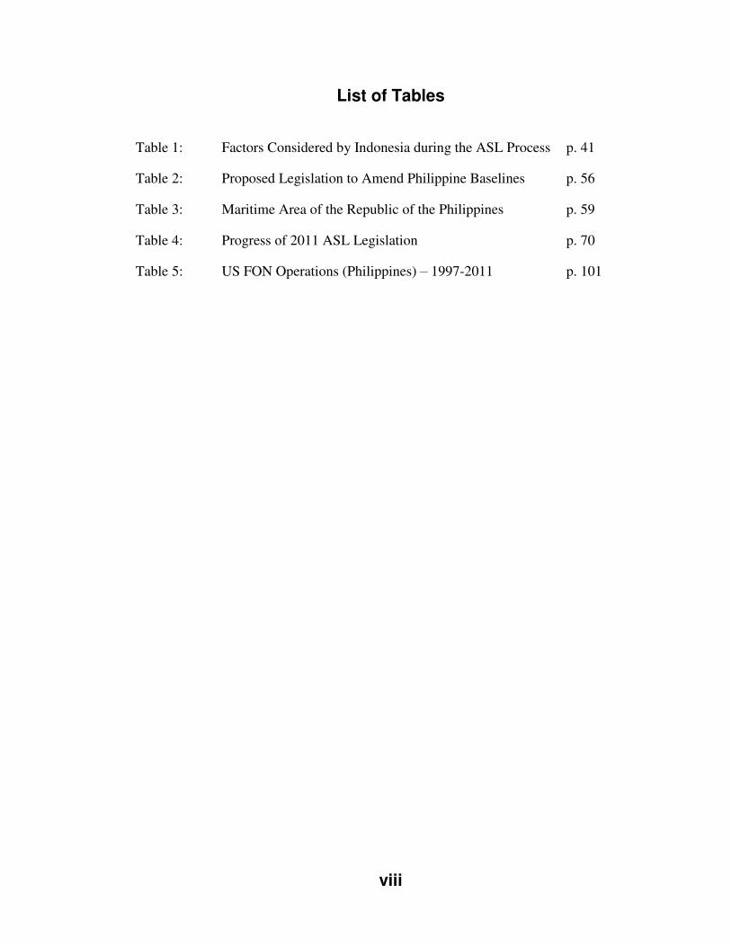
List of Tables
Table 1: Factors Considered by Indonesia during the ASL Process p. 41
Table 2: Proposed Legislation to Amend Philippine Baselines p. 56
Table 3: Maritime Area of the Republic of the Philippines p. 59
Table 4: Progress of 2011 ASL Legislation p. 70
Table 5: US FON Operations (Philippines) – 1997-2011 p. 101
ix
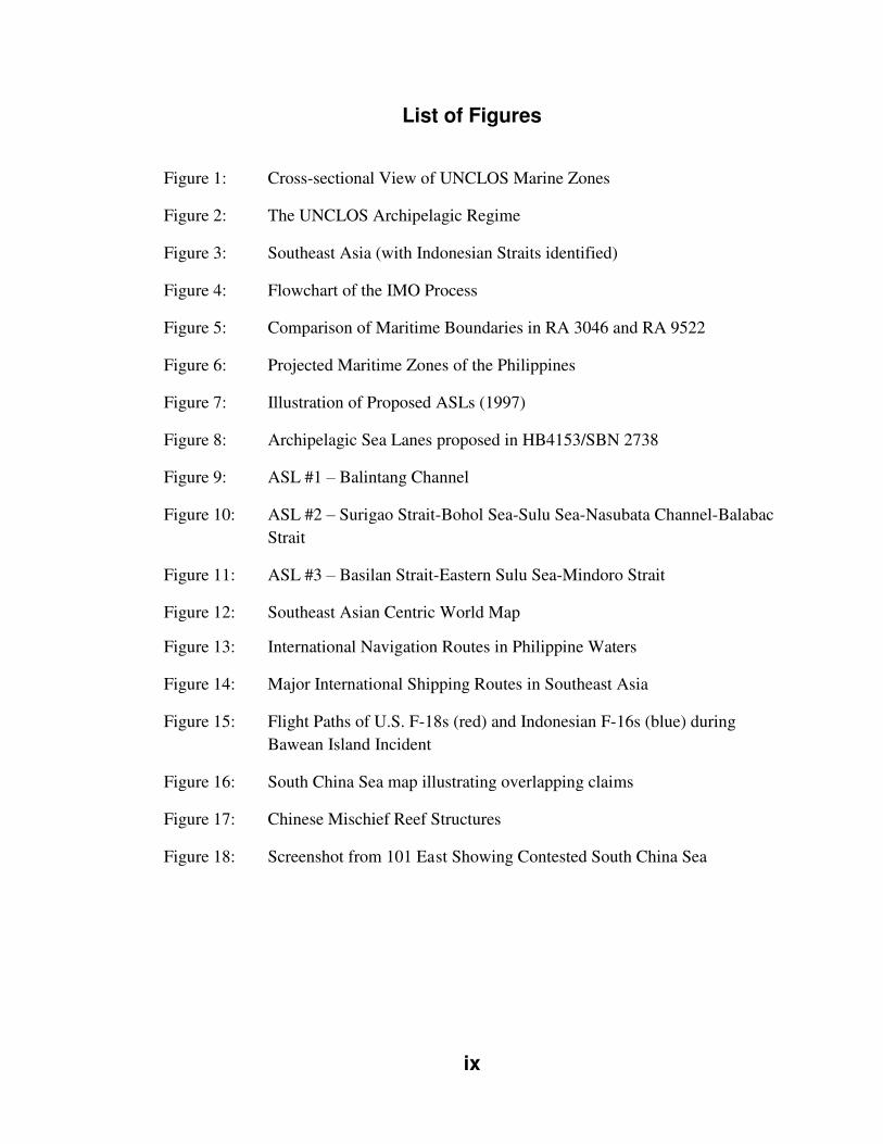
List of Figures
Figure 1: Cross-sectional View of UNCLOS Marine Zones
Figure 2: The UNCLOS Archipelagic Regime
Figure 3: Southeast Asia (with Indonesian Straits identified)
Figure 4: Flowchart of the IMO Process
Figure 5: Comparison of Maritime Boundaries in RA 3046 and RA 9522
Figure 6: Projected Maritime Zones of the Philippines
Figure 7: Illustration of Proposed ASLs (1997)
Figure 8: Archipelagic Sea Lanes proposed in HB4153/SBN 2738
Figure 9: ASL #1 – Balintang Channel
Figure 10: ASL #2 – Surigao Strait-Bohol Sea-Sulu Sea-Nasubata Channel-Balabac
Strait
Figure 11: ASL #3 – Basilan Strait-Eastern Sulu Sea-Mindoro Strait
Figure 12: Southeast Asian Centric World Map
Figure 13: International Navigation Routes in Philippine Waters
Figure 14: Major International Shipping Routes in Southeast Asia
Figure 15: Flight Paths of U.S. F-18s (red) and Indonesian F-16s (blue) during
Bawean Island Incident
Figure 16: South China Sea map illustrating overlapping claims
Figure 17: Chinese Mischief Reef Structures
Figure 18: Screenshot from 101 East Showing Contested South China Sea
x
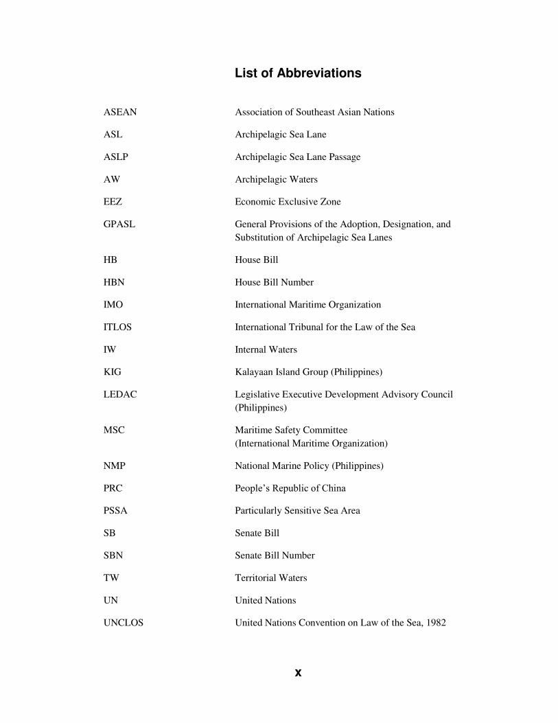
List of Abbreviations
ASEAN Association of Southeast Asian Nations
ASL Archipelagic Sea Lane
ASLP Archipelagic Sea Lane Passage
AW Archipelagic Waters
EEZ Economic Exclusive Zone
GPASL General Provisions of the Adoption, Designation, and
Substitution of Archipelagic Sea Lanes
HB House Bill
HBN House Bill Number
IMO International Maritime Organization
ITLOS International Tribunal for the Law of the Sea
IW Internal Waters
KIG Kalayaan Island Group (Philippines)
LEDAC Legislative Executive Development Advisory Council
(Philippines)
MSC Maritime Safety Committee
(International Maritime Organization)
NMP National Marine Policy (Philippines)
PRC People’s Republic of China
PSSA Particularly Sensitive Sea Area
SB Senate Bill
SBN Senate Bill Number
TW Territorial Waters
UN United Nations
UNCLOS United Nations Convention on Law of the Sea, 1982
xi
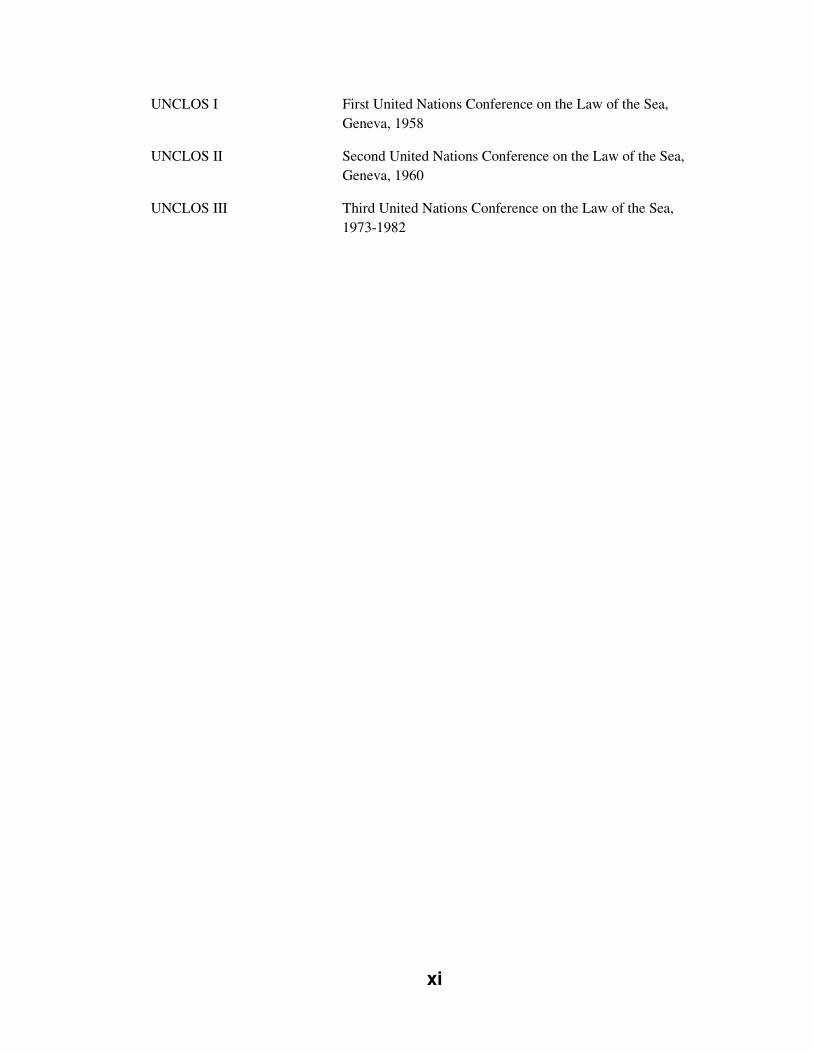
UNCLOS I First United Nations Conference on the Law of the Sea,
Geneva, 1958
UNCLOS II Second United Nations Conference on the Law of the Sea,
Geneva, 1960
UNCLOS III Third United Nations Conference on the Law of the Sea,
1973-1982

1
Chapter One: Introduction
In the field of island studies, the archipelago remains one of the least examined
metageographical concepts.
(Lewis & Wigen, 1997, quoted in Stratford et al, 2011: 118)
1.1: GENERAL INTRODUCTION
The field of island studies has been decoded as “the critical, inter- and pluri-disciplinary
study of islands on their own terms” (Baldacchino, 2007: 16). In the course of my
graduate studies, I have come to know many islands of the world. My knowledge of said
islands is as varied and different as the islands themselves. I have been introduced to
islands of numerous shapes and sizes which can be found in all corners of the planet.
One particular type of island, or rather, I should say islands, became of great interest to
me. What I am referring to are the islands known as archipelagos.
What is an archipelago? As explained by Stratford et al. (2011: 120):
The etymology of archipelago provided in the Oxford English Dictionary indicates that the word was “evidently a true Italian compound” of arch (from the Greek signifying ‘original’, ‘principal’) and pelago (deep, abyss, sea). The coinage was probably suggested by the medieval Latin name of the Ægean Sea, Egeopelagus. The earliest usage of the word given by the OED occurs in a Treaty of 30 June 1268, between the Venetians and Byzantine Emperor Michael Palaeologus. What may be the first use, then, occurs in the context of the Byzantine empire’s reclaimed power in the Ægean. Later uses in the early modern period indicate that the word continued to be used in its specific reference to the Ægean but was also gaining currency as a more general term for a group of islands in the sea.
2
Archipelagos are a geographically clustered group of islands which can vary in
many ways which can include geologic composition, the number and size of islands, and
the spatial geography of the islands. The geo-political aspects of archipelagos also range
from sovereign country to sub-national jurisdiction of a land-locked or coastal state, or
even a politically split archipelago, such as the Comoro archipelago, which is split
between the sovereign state of Comoros and the French overseas department of
Mayotte.
Webster’s Dictionary defines an archipelago as “a group of islands”
(http://www.merriam-webster.com/dictionary/archipelago). Turning next to the Oxford
Dictionary, it terms an archipelago as “a sea or stretch of water having many islands”
(http://oxforddictionaries.com/definition/english/archipelago?q=archipelago). This
definition has been noted by one scholar as “first emphasiz[ing] the sea, which is
interspersed with islands” (Andrew, 1978: 47).
The contrast between these two dictionary definitions of archipelagos is very
telling. In the field of Island Studies, Epali Hau’ofa is recognized as the first to advance
the concept of distinguishing between “islands in a far sea” and “a sea of islands”
noting:
The first emphasises dry surfaces in a vast ocean far from the centres of power.
When you focus this way you stress the smallness and remoteness of the islands.
The second is a more holistic perspective in which things are seen in the totality
of their relationships. (1993: 7)
Hau’ofa was a Pacific Islander who spoke of the transition of the historical connotation of Oceania as reflected in his two above noted terms:
It was continental men, namely Europeans, on entering the Pacific after crossing
huge expanses of ocean, who introduced the view of 'islands in a far sea'. From
3
this perspective the islands are tiny, isolated dots in a vast ocean. Later on it was
continental men, Europeans and Americans, who drew imaginary lines across the
sea, making the colonial boundaries that, for the first time, confined ocean
peoples to tiny spaces. These are the boundaries that today define the island
states and territories of the Pacific. (1993: 7)
His insights remind us that archipelagos are more than geographic constructions.
Stratford et al. theorize that “perhaps, at least as conceptual manifestations, archipelagos
are fluid cultural processes, sites of abstract and material relations of movement and
rest, dependent on changing conditions of articulation or connection” (2011: 122). They
also advance the idea that within archipelagos the duality of both “theoretical and
empirical archipelagic relations exist[s]” (Stratford et al., 2011: 125).
The specific archipelagos that my research deals with are the sovereign mid-
ocean archipelagic states. These states are composed solely of the islands which make
up their respective archipelagos. LaFlamme (1983: 361) identified four major attributes
which truly distinguish an archipelagic state from other states: a large number of islands;
the consideration that the waters surrounding its islands are within its boundaries and an
integral part of its heritage; the islands (with few exceptions) are small and
economically underdeveloped; and a centrifugal tendency. This tendency invokes the
characteristics of many societies such as, the centralization of critical populace mass,
economic activities and power of the dominant island(s) and the trickle down
dependency of the smaller, less developed islands. Fitzmaurice (1959: 88, quoted in
LaFlamme, 1983: 361) states that “the real essence of an archipelago is the concept of a
self-contained and relatively compact group, not a loose congeries of islands dotted over
a large extent of sea.”
4
1.2: BACKGROUND
The United Nations Convention on the Law of the Sea (UNCLOS), 1982 identifies mid-
ocean archipelagic states as a distinct category which are given the power, if desired, to
designate sea lanes through their archipelagic waters. The first goal of this thesis is to
start a discussion that examines the practice of archipelagic sea lane designation by
these states, including popular responses, through a specific “island studies” lens. The
second research goal is to demonstrate the inter-disciplinary nature of mid-ocean
archipelagic states and their actions around designating (or not) archipelagic sea lanes
(ASLs).
1.3: THESIS OBJECTIVES
My first thesis objective is to expand the knowledge of the area of mid-ocean
archipelagic states and the rights afforded them under Part IV of the United Nations
Convention on the Law of the Sea (UNCLOS). Given that this Convention is merely
thirty years old and came into force in 1994, this field of study is relatively new.
Furthermore, as only one of the twenty-two mid-ocean archipelagic states has gone
through the archipelagic sea lane submission process, there is much to learn from this
experience with an eye to the future.
My second thesis objective is to research and understand how the Law of the Sea
processes are unfolding for mid-ocean archipelagic states. It is noteworthy that this
research will have much academic importance as well as practical application to assist
other states in their deliberations of future policy decisions. Indeed, there is a lack of
formal research on this topic, including from the specific comparative island studies
perspective.
5
1.4: THESIS SIGNIFICANCE
The short term significance of my research for the field of Island Studies is
considerable. The Philippines are a timely and interesting case as they tackle this issue.
There have been many developments in the last number of years. The existing pertinent
academic literature in this sub-field is rather limited and consists mostly of contributions
by legal academics, and other very important contributors who are involved in the ASL
process (legislators, government consulted experts, public servants), and are writing of
their own respective countries. I feel that one long-term, significant contribution for
Island Studies is critical academic analysis to this issue and offer this from a
comparative point of view drawing upon the inter-disciplinary nature of Island Studies
and of this very issue itself.
1.5: RESEARCH QUESTIONS
My research questions developed from the previously stated research goals and
objectives are:
1. Will the Philippines enact ASLs?
2. How specifically has the Indonesian experience influenced the
Philippines?
3. What additional factors are influencing the Philippines?
4. What are the implications of these findings on the Philippines?
5. What are the implications of these findings on other mid-ocean
archipelagic states?
6
Thesis Statement
Hence, drawing upon these research questions, I propose that the actions and
decisions of the Republic of the Philippines surrounding a possible archipelagic sea lane
submission to the International Maritime Organization (IMO) have been influenced by
many variables, including the experience and results of Indonesia’s archipelagic sea lane
submission to the same IMO.
This thesis is driven by a real interest in the maritime aspects of islands. The
linkages between islanders, the land, and the sea have been noted by many authors and
academics across a number of disciplines including island studies throughout history.
These linkages are further strengthened when one looks to the case of archipelagos.
Additionally, the maritime frontier is the sole frontier, save outer space, which is
free of jurisdictional claim (though many are pending) and set to be discovered. The
high seas are an ever evolving journey through international relations, diplomacy,
environmental concerns, resource management, and many other issues. The sum of these
parts is the fact that islands are playing a central role in the maritime frontier and shall
continue to do so. Questions abound as to the future of the high seas in the face of
globalization. The short histories of UNCLOS, 1982; post-colonial sovereign islands;
and a multitude of other dynamics find us at a time when the stakes are quite high and
much is left to be decided.
I was drawn to the maritime law aspect of islands when looking at the future of
the Canadian Arctic Archipelago. Working deeper into the Law of the Sea, I discovered
the stand-alone status of this archipelago (Article 234), as well as an entire dedicated

7
section on archipelagic states (Part IV). This thought process evolved further towards
the unique case of mid-ocean archipelagic states as laid out in Part IV.
Looking more closely at the subject, I was intrigued to find the challenges long
faced by many archipelagic states, including two of the most populous island states in
the world (Indonesia and the Philippines). It struck me as a very curious issue that such
heavily populated “large” archipelagic states would struggle on the international stage to
have their voices heard, and their views accepted.
These are the central reasons as to why I chose this topic. I feel that it is a very
important and timely area of research for the field of island studies.
1.6: THEORETICAL APPROACH
I next consulted various social science methodology texts to determine which methods
and designs best suited my research questions. Yin (2003: 6) writes that “how” and
“why” research questions lend themselves to case study research, owing to the fact that
“such questions deal with operational links needing to be traced over time.”
As Yin (2003: 1) notes, “[a]s a research strategy, the case study is used in many
situations to contribute to our knowledge of individual, group, organizational, social,
political, and related phenomena.” Hakim (1987: 61) identifies the case study as “the
social research equivalent of the spotlight or the microscope; its value depends crucially
on how well the study is focused.” Punch (1998: 150, quoted in Silverman, 2010: 138)
states:
8
The basic idea is that one case (or perhaps a small number of cases) will be studied in detail, using whatever methods seem appropriate. While there may be a variety of specific purposes and research questions, the general objective is to develop as full an understanding of that case as possible.
Additionally, Yin (2003: 14) highlights the case study approach as “an all-
encompassing method – covering the logic of design, data collection techniques, and
specific approaches to data analysis.” Hakim (1987) points out that by design, case
studies are flexible and demand a wider range of research skills from the researcher in
collecting and analysing the data.
This research is an explanatory case study which explains the hows and whys
when it comes to the Philippine case of the archipelagic sea lanes issue. This single case
is the most appropriate design given the recent developments surrounding ASL
submission in the Philippines. The last few years have seen the Republic of the
Philippines take noteworthy actions in both policy and legislation as it relates to
UNCLOS.
This study into influence from the Indonesian case strengthens the Philippine
analysis, due to Indonesia being the only mid-ocean archipelagic state to proceed with
ASL submission to the IMO. Furthermore, to a point both states share similarities of
political geography, regional histories, regional (international) influences from state and
intergovernmental sources, and a shared, long standing advocacy of the archipelagic
concept.
I carefully selected this explanatory case study because it was the most
appropriate and timely case of archipelagic state action under UNCLOS, Part IV (ASL
submission). The Indonesian and Philippine states have been the most visible, most
9
vocal, and most engaged archipelagic states in advocating for recognition within
international maritime law of the concept of the wholeness of an archipelago. Indonesia
is the only state to have gone through the ASL process. The Philippines have long been
a leading voice for the archipelagic concept and have had several recent developments,
raising the possibility of an ASL designation and submission in the near future.
I chose to implement the case study approach in my research because I feel it is
the most appropriate theoretical approach to fully research, analyse, and explain the
Philippine state position and to identify linkages from the Indonesian case which are
influencing the Philippines. Additionally, these linkages have the possibility of showing
trends that can be applied to other mid-ocean archipelagic state cases in the future. The
strategic selection of this particular case contributes significantly to the external validity
of this case, by means of improved allowance for testing through literal and theoretical
replication (Yin, 1989, as cited in de Vaus, 2001: 239).
The selection of a case study approach, as with any theoretical approach,
includes challenges and research limitations. In particular as mentioned previously, case
studies rely very heavily on the researcher for a wide range of skills to collect and
interpret the research data. Thus interpretation, validity, and reliability are the challenges
which must be recognized. However, I feel that the strengths of this theoretical approach
outweigh its limitations.
Furthermore, this explanatory case takes a systemic approach to analyse its
political geography elements. As adapted from a study by Cohen and Rosenthal (1971:
5-31, as quoted in Cohen, 1973: 17), their framework best explains the construction of a

10
systemic approach to studying geopolitics. The following template serves this case well
when extrapolating this framework to review what has evolved into a geopolitical
question of international law:
The geopolitical system was advanced as the unit within which the political process interacts with geographical space. Political transactions, structures and societal forces are the components of the process; place, area and landscape are the components of geographical space. Process and space interact through the formation of political action areas, and various ideological attachments, organizations, and perceptions characterize these actions areas.
1.7: METHODOLOGY
This research is inter-disciplinary by design, given the multi-faceted nature of the issue
of mid-ocean archipelagic states designating archipelagic sea lanes. Sub-fields which are
drawn from include maritime law, international relations, domestic public policy and
public administration, marine environmental science, political ecology, environmental
politics, transportation and logistics, geography and anthropology. It is through the
compiling of relevant data from these various sub-fields, that this thesis constructs a
wider inter-disciplinary analysis of this issue.
The research method employed in this thesis is qualitative research accomplished
through a literature review with multiple sources of evidence. This allows for a full
examination of the archipelagic concept, the Indonesian process, the Philippine
possibility, and possible impacts on the Philippines by the Indonesian process.
The research is largely focused through in-depth archival research utilizing
primary sources such as historical documents, government publications and legislation,
and official records, and secondary sources including academic texts, scholarly journal
articles, theses, conference papers, reports, and print media. Interviews with respective
11
government officials in Indonesia and the Philippines were not conducted due to time
and access constraints.
Leading authors concerning the issue of mid-ocean archipelagic states in
International Law include Evensen (1957), Dubner (1976), Rodgers (1981) and
Munavvar (1993); and Southeastern Asia regional experts Tangsubkul (1984),
Kwaitkowska and Agoes (1991), and Beckman (2007). Commenting on the IMO and its
role and actions in this process are authors such as Warner (2000), Johnson (2000), and
Forward (2009). Readings on the Indonesian case include Coquia (1983), Agoes (1991;
1997), Djalal (2003; 2009) and Puspitawati (2005). Readings on the Philippines case
include Santiago (1974), Batongbacal (2002; 2008), Encomienda (2009), and Bensurto
Jr. (2012).
Additional research included sources from the international community (United
Nations Division for Ocean Affairs and Law of the Sea, United Nations Convention on
the Law of the Sea I & III, International Maritime Organization); government
publications and legislation (Government of Indonesia, Government of the Philippines,
Australian Government, United States Government); and print media sources (Far East
Economic Review, New York Times, The Jakarta Post, The Philippine Star, Associated
Press).
During the course of my research, I utilized research facilities at the University
of Prince Edward Island. Furthermore, I traveled on academic exchange to the
University of Malta and utilized research facilities there, as well as at the United Nations
International Maritime Law Institute which is housed in Msida, Malta. While in Malta, I
12
was quite fortunate to be given permission to sit in on multiple undergraduate law
lectures by Professor David Attard1 dealing specifically with the Law of the Sea
Convention. These lectures were invaluable in providing a better grounding in the legal
nuances of maritime law.
To conclude, this chosen method and procedure ensure that my research is
comprehensive and encompasses all evidence to construct a completed case picture for
this Philippine case.
Case Study Design
Yin (2003: 20) explains research design as “a logical plan for getting from here to
there,” where “here” refers to the research questions posed and “there” denotes the
conclusions reached to the questions.
Yin (2003: 21) offers five key segments to successful research design:
1. A study’s questions;
2. Its propositions, if any;
3. Its unit(s) of analysis;
4. The logic linking the data to the propositions; and
5. The criteria for interpreting the findings.
1 Professor Attard is the Director of the International Maritime Law Institute, an organ of the International Maritime Organization. As of October 1, 2011, he is a sitting Judge on the International Tribunal for Law of the Sea (ITLOS).
13
This case involves looking at five research questions as stated previously
(section 1.5) in this chapter. The proposition of this case is that the Philippine case study
has been influenced by the Indonesian case. The unit of analysis in this case is
archipelagic sea lane adoption by means of submissions to the International Maritime
Organization by mid-ocean archipelagic states as defined and permitted by criteria
outlined in Part IV of the United Nations Law of the Sea Convention.
During the course of analyzing the data collected, I relied more heavily on a few
chosen analytical tools. As outlined in Yin (2003), these include pattern matching,
explanation building, rival explanations, and chronological analysis. I employ pattern
matching when analysing my research data to help assist in locating trends lending
themselves to factors which are influencing this case, alongside the Indonesian
experience. Secondly, as this is an explanatory case, I utilize a strong analytical
narrative to build my explanation of this case. This explanation aims to explain which
factors are influencing the case, and to attempt to quantify how great this influence is.
Third, armed with identified possible influencing factors, I run these factors against the
six real life rivals which Yin (2003: 113) lists:
1. Direct Rival
o “An intervention (“suspect 2”) other than the target intervention
(“suspect 1”) accounts for the results”
2. Commingled Rival
o “Other interventions and the target intervention both contributed to the
results”
14
3. Implementation Rival
o “The implementation process, not the substantive intervention, accounts
for the results”
4. Rival Theory
o “A theory different from the original theory explains the results better”
5. Super Rival
o “A force larger than but including the intervention accounts for the
results”
6. Societal Rival
o “Social trends, not any particular force or intervention, account for the
results”
The defined criteria this thesis shall employ for determining whether the
proposition offered is supported by the data will include any direct references to the
Indonesian case, or any alterations in government policy or direction concerning the
Philippines ASL process that the evidence points to as stemming from the Indonesian
case. The burden of proof, explanation and validity lie solely on the strength of
arguments put forth in this thesis.
This explanatory case strives to produce an idiographic explanation, which de
Vaus (2001: 233) defines as “focus[ing] on particular events, or cases, and seek[ing] to
develop a complete explanation of each case.” Also, de Vaus (2001: 236) notes the
15
importance of case study design to the historical context by pointing out that case
studies specifically include this element in order to offer a better understanding. These
two previously mentioned design features lend a better internal validity to this case (de
Vaus, 2001: 233).
1.8: STRUCTURE OF THESIS
This thesis is structured through clearly defined chapters dealing with specific materials
grouped into sections. This first chapter has introduced the background, thesis
objectives, research goals, thesis significance, research questions, and research
methodology and methods. The subsequent chapters are chronologically presented as
follows:
Chapter Two: Archipelagos and the Law of the Sea outlines the history of the
UNCLOS process dating back to the end of World War II, including pertinent facts of
Indonesia’s experience in adopting ASLs. The chapter starts with the pre-preparatory
work leading to the UN conferences, UNCLOS I and II, which are touched in short
order. UNCLOS III and the archipelagic concept are then discussed at greater length,
lead into a section on the UNCLOS, 1982; the genesis of this thirty year process. Then,
Part IV (Archipelagic States) of UNCLOS is reviewed, along with the trade-off
negotiated by mid-ocean archipelagic states for Part IV. Next, considerations around the
legal history (or lack thereof) for mid-ocean archipelagic states are highlighted, along
with another major creation of UNCLOS, 1982, the marine jurisdiction of Economic
Exclusive Zones (EEZ). Chapter Two then moves to explain the historical background
of the mid-ocean archipelagic state of Indonesia in relation to UNCLOS. Lastly, an
16
examination of the process undertaken by Indonesia to designate their archipelagic sea
lanes, and the actions and role of the IMO is offered.
Chapter Three: The Case of the Republic of the Philippines concisely presents
the facts of the case of the Republic of the Philippines as it relates to UNCLOS. The
chapter starts with an introduction to the Philippines case, providing concise background
information on the Republic of the Philippines. Also discussed is Philippine domestic
history around the archipelagic concept, with respect to national legislation and actions
of the executive branch. This historical review is strengthened by looking at the
evolution of the Philippine position relative to the archipelagic regime and UNCLOS.
Highlighted is a 1997 text which presents a case for archipelagic sea lane (ASL)
designation in the Philippines including two technically thought-out ASLs. Then,
special attention is paid to the most important part of the case: the very recent legislative
efforts of Philippine lawmakers to domestically designate three ASLs, the actions and
decisions of which are closely examined.
Chapter Four: Findings and Analysis sets out to answer my five research
questions. To begin, I look to answer the most pressing question: will the Philippines
enact ASLs? Having explained the Philippine case and whether ASLs will be enacted, I
move to analysing how specifically the Indonesian experience has impacted the
Philippines case. I then seek to answer my third research question, by identifying further
factors beyond the Indonesian experience which are influencing the Philippine case.
These factors are identified as the root issues of extensive debate within the
populace and all branches of Philippine government surrounding the possibility of the
17
designation of archipelagic sea lanes. They include many policy matters such as regional
states such as China, global maritime powers such as the United States, international
intergovernmental organizations, and international public opinion and civil society
actors, to name but a few.
These factors are contextually woven together into an explanatory narrative
identifying common linkages. Further, these factors are applied against the recent
Philippine actions in an effort to test how much, and illustrate the lengths to which, each
factor has been accounted for and applied by the Republic of the Philippines.
Finally, this chapter moves to the two remaining research questions which deal
with implications based on the findings. These research questions are answered by
theorizing what the implications of the study are, for the Philippines; and for the other
mid-ocean archipelagic states.
In Chapter Five: Conclusion I conclude this paper by summarizing the main
arguments of this thesis. This summary of my findings is used to draw main
conclusions. Furthermore, I offer comment as to possible further study within this
subject area.
1.9: CONCLUSION
This chapter has introduced the case of the Republic of the Philippines and the United
Nations Convention on the Law of the Sea. This chapter has briefly discussed the
history and background archipelagos, UNCLOS, and the relationship between them.
Additionally the thesis objectives, research goals, thesis significance, research questions,
and research methodology and methods have all been outlined.
18
Chapter Two: Archipelagos and the Law of the Sea
In this new era on which we have entered, the effective unit of foreign policy and
strategy is no longer the nation state, however large, but the coalition of such
states brought together and held together for certain purposes.
(Lester B. Pearson, 1956, future Prime Minister of Canada, quoted in Vital,
2006: 84)
2.1: INTRODUCTION
The international climate in the post-World War II era was one of change. While the
major maritime powers such as the United States, the U.S.S.R., and the United Kingdom
continued to wield significant influence and authority, this period was marked by the
vast divestment of colonies from many nations and the increased maturation of
relatively young countries as well as those soon to emerge.
Kapoor (2009: 177) noted three main keys which led to the increased
international interest in further development of the law of the sea in the period following
World War II: the rapid advancement in ocean technology, the emergence of new
nations from the old colonial empires and the increased demand for ocean resources.
The ever developing archipelagic states wanted to assert their voices on the
international stage to ensure that their states had a cohesive unity and sovereignty which
enclosed their islands and the waters surrounding them as one. This concept was a
central nationalistic element of recently obtained sovereignty for these countries. As I
19
shall discuss in greater detail in section 2.8, Indonesia undertook policies and legislation
to enshrine the archipelagic concept, with the Philippines shortly following suit.
The importance of the archipelagic concept to the archipelagic state was
immense. Sovereignty, unity and territorial integrity leading to security and stability
were at, or near, the top of the list. Also, not to be discounted were the economic
interests within the waters of the respective archipelagos: natural resources are an
important asset to any island state. Indeed, these attributes are distinctive priorities of all
states, be them land-locked, coastal or island. However, the international community
was not very receptive to these measures. Under the long held “Freedom of the High
Seas” concept, vessels from all flag states had been using the waters and shipping lanes
in and around the islands of both countries for decades, if not centuries. Burke (1977:
269) termed the interests of this position as “[e]fficiency, economy, and convenience in
transportation [which] serve all nations” as possibly at risk. An even more alarming
topic for the maritime powers that could and, ultimately did, end up being raised was the
status of the waters, raising restrictions on their respective navies.
Jackson (2007: 142) believes that globalization is not displacing sovereignty,
pointing out that while integration has vastly increased due to technology in today’s
world, goods and vessels have been transiting the globe for centuries. What this view
fails to acknowledge is the effect of decolonization when superimposed over our rapidly
integrating world. As I stated earlier in this section, these former colonies are
predominately islands. Specifically, in the cases of Indonesia and the Philippines, these
two archipelagic states are clusters of islands which have international marine routes
passing through them. Jackson’s generalization fails to recognize the plight of these

20
archipelagic states and the wider negotiations of UNCLOS which unfolded over the
better part of the second half of the twentieth century.
The archipelagic state has recently emerged on the international system. Indeed,
LaFlamme (1983: 361) notes that “[d]espite the fact that literally hundreds of
anthropologists have conducted fieldwork within such societies, the concept of the
archipelagic state has received relatively little attention.” This observation holds true for
most fields of research, and the connected lack of understanding extends to the
international system. Further complicating the archipelagic issue was the fact that it was
largely absent from existing customary international law, and as such, it was a unique,
one-off sui generis matter for debate and discussion. (Andrew, 1978: 50) Given what
was at stake, a clear division of polar opposite viewpoints was clearly evident. The
debate would unfold through the UNCLOS process and continues to an extent to this
very day.
2.2: LEGAL CONSIDERATIONS
Amongst the legal hurdles archipelagic states faced was the absence of this issue in
existing international law. Andrew (1978: 49) was quite accurate in stating that “the
different regimes of jurisdiction or types of marine zones are borrowed from traditional
international law, which is continent-based and land-centric, and thus poorly fit the
archipelago’s situation.” With respect to sovereignty, the principle of uti possidetis juris
(‘as you have, so may you hold’) might have applied. The uti possidetis juris principle
means “according to which existing boundaries are the pre-emptive basis for
determining territorial jurisdictions in the absence of mutual agreement of all affected
21
state parties to do otherwise” (Ratner, 1996; Shaw, 1996, as quoted in Jackson, 2007:
110).
However, there are three main factors which seem to have ruled this principle
out. First, the global context during the Cold War meant neither side (the United States
and the U.S.S.R.) would want to broach this issue; second, the boundaries of the
archipelagic states were contested by a large number of states at UNCLOS, including
the maritime powers; and lastly, in the context of the Cold War, the strategic
significance of the waters in question, and the lack of existing international law at the
time of UNCLOS, meant that the maritime powers were not going to allow the
archipelagic states to gain absolute sovereignty over their waters, thus restricting
available access to user states.
Further consideration can be undertaken of the international law regime which
was in place for waters. Dating back to Hugo Grotius in 1609, the long standing debate
has centered on the openness of the seas. Mare liberum, as referred to earlier, is Latin
for “free (open) sea” and was the predominate school of thought in colonial seafaring
powers for centuries (Santiago, 1974: 315). An opposing concept, mare clasum or
“closed sea” pertained and still does, to waters which fall under national jurisdiction
(Santiago, 1974). Thus, there were two clearly defined polar opposing concepts with no
visible middle ground. The masterstroke of UNCLOS would be to locate, construct and
move towards an acceptable compromise for all nations.
22
2.3: THE UNITED NATIONS PROCESS
The United Nations convened three multi-lateral conferences (UNCLOS I, II and III)
over a period of thirty years to discuss matters surrounding marine and maritime issues
including state maritime boundaries, the high seas, resources, mining and navigation.
These conferences were large international affairs, where negotiators and diplomats
from across the globe attempted to reach consensus to hash out an all-encompassing
agreement.
Prior to UNCLOS I, Jens Evensen, a Norwegian jurist, was engaged to produce a
scholarly legal report on the issue of archipelagos and their waters. This report, Certain
Legal Aspects Concerning the Delimitation of the Territorial Waters of Archipelagos,
was submitted on November 29, 1957, and took a critical look at archipelagos. Evensen
(1957: 290) defined an archipelago as, “…a formation of two or more islands (islets or
rocks) which geographically may be considered as a whole.” He also distinguished
between two particular types of archipelagos: coastal, and outlying (mid-ocean). The
report reviewed existing studies, the views of international bodies and publicists on the
issue, and the practices of various archipelagic states. Evensen reached the following
conclusion:
In the writer's opinion, the waters between and inside the islands and islets of the above-mentioned type of archipelago must be considered as internal waters. But, where the waters of such an archipelago form a strait, it is in conformity with the prevailing rules of inter-national law that such a strait cannot be closed to traffic. Whether a water passage is to be considered a strait or not, must be decided in each specific case.
23
The archipelagic issue was not resolved at UNCLOS I. A lack of consensus around the
legal status of waters found within mid-ocean archipelagos put the archipelagic issue on
the table for future discussions (Talaie, 1998: 209). UNCLOS II involved “no detailed
discussions on the issues related to mid-ocean archipelagos (Talaie, 1998). However,
tense off-program discussions around the issue were taking place. After the completion
of UNCLOS II, the Conference Chairman, Arthur Dean wrote:
Under international law, foreign vessels may not pass through internal waters as of right, even if their passage is innocent. It is for this reason that we do not recognize the validity of this extensive and unilateral archipelago theory. (Dean, 1960, as noted in Coquia, 1983: 22)
UNCLOS III
The stage was set for a third conference to conclude negotiation and debate, bringing to
fruition a comprehensive international agreement to bear. A media report in The Times
(London) (June 12, 1974: 16) the week prior to the conference started commented:
It also represents arguably the most complex set of negotiations ever undertaken. More governments are taking part than at any previous international meeting, including a general assembly of the United Nations itself. (…) For essentially Caracas, for 10 weeks, will be one vast horsetrading arena in which conflicting rights and interests will be bartered and bargained for, haggled over, swapped and abandoned.
During the course of UNCLOS III, the archipelagic issue was a key point of debate.
The mid-ocean archipelagic cause was strengthened through its numbers, as many newly
independent states including Fiji, Tonga, Mauritius and the Bahamas joined forces with
Indonesia and the Philippines in protecting their position (Talaie, 1998: 209).
In the context of the ongoing Cold War, the maritime powers were in agreement
on one matter – that “…their interest in the mobility of their sea-borne strategic forces
24
[was] ‘non-negotiable’” (Ghosh, 1987: 905). These forces included submarines which
could be prevented from conducting unannounced and submerged operations within
archipelagos should the waters be deemed internal (Andrew, 1978: 51). Sanger (1983:
83, as quoted in Greene, 1992: 8) identified that “[t]he superpowers made unimpeded
passage through straits their single non-negotiable demand in the Law of the Sea
Conference.” Succinctly put, the major maritime powers were of the belief that innocent
passage rights within any archipelagic waters regardless of classification (territorial or
internal) would negate their desired marine mobility (Andrew, 1978: 51). The possible
reality of having eleven straits commonly used in international shipping and navigation
falling into internal waters of archipelagos would certainly have caught the attention of
the maritime powers (Gable, 1984: 13).
A rather significant point in negotiations came about when the archipelagic
group was split from the group of states which housed what the UNCLOS process
referred to as “straits used for international navigation.”2 As Professor K.L. Koh had
theorized about the relationship between archipelagic regimes and straits used for
international navigation:
…if straits ultimately link part of the high seas or an economic zone, the fact that the immediate geographical connection consists of two bodies of archipelagic waters becomes irrelevant. If this is accepted then some archipelagic sea lanes could well be classified as straits used for international navigation (Koh, 1982, as quoted in Rothwell, 1990: 500).
2 UNCLOS, 1982, Part III: Straits used for International Navigation.
25
A further split occurred when Canada secured separate status for the Canadian Arctic
Archipelago under what became UNCLOS Article 234.3
Such divisions were a reality of the UNCLOS process and can be viewed in
different manners. It might have possibly been a divide-and-conquer technique.
Otherwise, from a different perspective, it could be seen as a natural division to further
separate agendas. Such divisions were apparent as opinions were diverse and the stakes
were unquestionably high.
During the course of negotiations of UNCLOS III, a working group was struck
to address the archipelagic issue through the development of what was known as the
“Single Negotiating Text” (Amerasinghe, 1974: 546). The archipelagic states of
Indonesia, the Philippines, Fiji and Mauritius; and the United Kingdom (as a major
maritime power) both put forward separate proposals as to what the draft archipelagic
regime text should be. These proposals were representative of the two opposing
positions, and both advocated quite strongly for a closed regime (the archipelagic states)
and an open regime (U.K.), respectively.
Amerasinghe (1974: 556) identifies the aims of the U.K. proposals as limiting
the archipelagic sea area and to align the proposed archipelagic regime closely to that of
the territorial sea. Such aims were pursued to allow for a more open regime as noted
above. LaFlamme (1983: 361), around the same time as the completion of UNCLOS III,
pointed out that the objectives routinely levelled at the archipelagic concept were the
3 Article 234 governs any ice-covered areas of all coastal states, however this example deals specifically with Canada and the Canadian Arctic Archipelago.
26
closing of certain shipping lanes4 and the monopolization of prime fishing grounds, but
wisely noted that strategic military concerns are in fact equally, if not even more,
important.
The negotiations on UNCLOS III were concluded on April 30, 1982
(Tangsubkul and Fung-wai, 1983: 858). In the large context of an exhaustive negotiation
composed of different concurrent working groups set over a large number of years, it is
difficult to fully assess how the final text came to be. Further complicating this task is
the fact that much of the important and sensitive negotiations happened in camera, and
were not recorded. These negotiations primarily attempted to address the issues of
maritime law pertaining to military assets and passage rights, leading Booth (1985: 4) to
refer to the “backroom quality of the diplomatic treatment” of this issue.
2.4: THE UNITED NATIONS CONVENTION ON THE LAW OF THE SEA, 1982
The end result of UNCLOS III was the fully negotiated and agreed upon United Nations
Convention on Law of the Sea. A key aspect of UNCLOS is the framework nature of
this agreement. It has been termed an “umbrella convention” due to the references to
applicable standards and regulations located in other international agreements and
treaties.
Given the enormity and complexity of hammering out an all-encompassing
international agreement on maritime legal issues, UNCLOS, 1982 is a by-product of its
circumstances and reality. Over the course of thirty years of negotiation, over a wide
breadth of topics, through applying diplomacy and negotiation, concessions were made
by many states on many issues. In the words of UNCLOS III President Tommy Koh 4 See also Hollick (1981), U.S. Foreign Policy and the Law of the Sea.
27
(1982: 36), “although the Convention consists of a series of compromises, they form an
integral whole.”
Additionally, as put so elegantly by Allott (1983: 8):
But a Flying Dutchman wandering the sea areas of the world, carrying his copy of the Convention, would always be able to answer in legal terms the questions: who am I? who is that over there? where am I? what may I do now? what must I do now? The Convention would never fail him.
These views about UNCLOS dating back to around the time of UNCLOS III completion
are optimistically hopeful. Guoxing (2000: 7), no doubt with the benefit of hindsight,
makes indirect reference to the challenges that had been faced in implementation,
cautioning that, “difference in understanding and interpretation is prevalent in the world
community.” Speaking to the specifics, Guoxing makes reference to the ongoing
disagreement on interpretation between archipelagic states (Indonesia) and maritime
powers (United States).
UNCLOS Created Marine Zones and Passage Regimes
The objective clarity afforded by UNCLOS is embodied in the many newly created
marine zones (Figure 1) and passage regimes5 contained in it. Batongbacal (2008: 2)
explains the various jurisdictional considerations and rights attached to each of the
marine zones mandated by UNCLOS in the following statement:
Complete state sovereignty is recognized only within the internal waters. In territorial waters and archipelagic waters, states allow all ships to simply pass through [read: transit passage] (if they do anything else while passing, they may be subject to state jurisdiction). Beyond that distance, states have steadily less than full sovereignty and only specific powers (especially access to natural resources), until the 200 nautical mile limit where the high seas begin.
5 See Appendix D for all figures.See Appendix B for a complete list of UNCLOS definitions of marine zones and passage rights.
28
From there, the freedom to navigate and use the high seas remains, and the seas are the common heritage of humanity.
Economic Exclusive Zones (EEZ)
Economic Exclusive Zones were another new creation contained within UNCLOS. As
explained by Dutton (2011: 54):
The creation of the exclusive economic zone in 1982 by UNCLOS as a region extending beyond the territorial sea to a maximum of two hundred nautical miles from a coastal state’s shores was a carefully balanced compromise between the interests of coastal states in managing and protecting ocean resources and those of maritime user states in ensuring high-seas freedoms of navigation and overflight, including for military purposes. Thus while in the exclusive economic zone the coastal state was granted sovereign rights to resources and jurisdiction to make laws related to those resources, high-seas freedoms of navigation were specifically preserved for all states, to ensure the participation of maritime powers in the convention.
Booth (1985: 38) highlights that with the creation of EEZs, “32% of the world’s oceans
(about 28 million square miles) [are placed] under national administration of various
formats.”
Right of Transit Passage
In the context of UNCLOS in its entirety, there is one passage regime of which to take
particular note. The right of “transit passage” created by UNCLOS applies to all marine
jurisdictions outside of internal waters, for all user states, in all coastal states. Olson
(1996: 3) identifies the development and inclusion of “transit passage” as the central
strategic concept agreed upon in UNCLOS III, advocated for jointly by both the
U.S.S.R. and the United States.
29
2.5: UNCLOS, 1982 – PART IV: ARCHIPELAGIC STATES
The archipelagic concept was negotiated and agreed upon as Part IV of the completed
Convention. This apparent victory by the so termed ‘lesser states’ was indeed gaining
the legitimization of archipelagic waters. However, the end product is a compromise
which illustrates the failure of archipelagic states to enshrine all their arguments into the
final document (Coquia, 1983: 36). Faced with the pressures of the Cold War, the
concessions provided by the archipelagic states were termed by one academic as
“inescapable” (Ghosh, 1987: 907).
UNCLOS, Part IV deals specifically with archipelagic regimes (Figure 2).6 It
grants certain powers to the states in exchange for certain concessions to user states
(primarily the major maritime powers). ASL passage allows for flexibility with certain
military modes of transit which would not be allowed under the regime of innocent
passage rights. These include the abilities for submarines to remain submerged while
transiting within ASLs and for surface military vessels to travel in formation or to
launch and recover aircraft. Furthermore, the archipelagic state cannot suspend or
hamper ASL passage, whereas, in the traditional internal waters regime, innocent
passage rights can indeed be suspended (Tsamenyi; Mfodwo, 2001: 29).7 The
archipelagic state is granted rights to temporarily suspend innocent passage rights in
limited conditions (Rothwell, 1990: 498).8 Notwithstanding the ASLs, within the
archipelagic waters, the archipelagic state regulates innocent passage rights for foreign
vessels. Innocent passage rights call for prior notification, surface submarine travel and
6 For a full documented history of the origin, development and new international status of the concept of archipelagic states, see: UN Publications. “Archipelagic States: Legislative History of Part IV of the United Nations Convention.” 7 See also, UNCLOS Article 52[1] 8 See also, UNCLOS Article 52[2]
30
suspension of flight operations (Far Eastern Economic Review, December 29,
1994/January 5, 1995).9 Once an ASL submission is approved and implemented, it
limits all overflight (air) traffic only to the airspace above the designated ASLs
(Tsamenyi; Mfodwo, 2001: 29).10
Herman (1985: 198) points out in the conclusion of his timely analysis of the off-
lying (mid-ocean) archipelagic concept within UNCLOS that it contains hidden legal
complexities within the “Archipelagic States” section (Part IV). These complexities
concern states fitting the state criteria as defined under Part IV, inexact science of
delineating baselines and interpretations around the legal status of minor features such
as “reefs, low-tide elevations, and rocks” (1985: 199).
There are twenty-two states that formally claim archipelagic state status under
UNCLOS.11 Talaie (1998: 213) notes that each island state weighs its own factors and
considerations in determining whether or not to proclaim archipelagic status. According
to Kopela (2007: 501) fifteen of these have enacted baselines:12 However, Kopela fails
to determine whether or not the respective statuses and baselines are compliant with
UNCLOS. It should be noted that the Philippines is included on her list, but as shall be
discussed, the Philippine baselines at that time were quite contentious, non-compliant
9 See also, UNCLOS Article 52[1] 10 See also, UNCLOS Article 53[5] 11 These states are Antigua and Barbuda, Bahamas, Cape Verde, Comoros, Dominican Republic, Fiji, Grenada, Indonesia, Jamaica, Kiribati, Maldives, Marshall Islands, Mauritius, Papua New Guinea, Philippines, Saint Vincent and the Grenadines, Sao Tome and Principe, Seychelles, Solomon Islands, Trinidad and Tobago, Tuvalu, and Vanuatu. <http://www.un.org/Depts/los/LEGISLATIONANDTREATIES/PDFFILES/table_summary_of_claims.pdf> (As at July, 15, 2011). 12 As of 2007, the Bahamas, Comoros, Kiribati, Marshall Islands and Seychelles had not defined their archipelagic baselines. Kopela (2007: 515) raises a further interesting point that six mid-ocean archipelagic states (Dominican Republic, Fiji, Kiribati, Marshall Islands, Tuvalu and Solomon Islands) recognize innocent passage of both ships and aircraft; as opposed to UNCLOS, which only requires recognition of ships.
31
with UNCLOS, and not recognized by the international community. Consulting the
United Nations (U.N.) summary of claims as of July 2011, five archipelagic states have
enacted legislation that makes allowances for straight baselines: Dominican Republic,
Grenada, Kiribati, Mauritius, and Vanuatu.13
The Indonesian & Philippine Contributions to Part IV
Both Indonesia and the Philippines played substantial roles in ensuring that
the archipelagic concept was debated, and a recognizable portion of the concept
was included in UNCLOS. The fundamental belief, on which Indonesia and the
Philippines based their respective views of the archipelagic concept, was the
requirement to safeguard their individual states’ political unity and the territorial
integrity of their land and waters as a singular unit (Tangsubkul, 1984, as quoted
in Batongbacal, 2004: 50).
Rothwell (1990: 497) points to three main points which Indonesia presented for their
arguments:
its consistent adherence to the Wawasan Nusantara concept in Indonesian
law, having effect on both internal and international law14;
acquiescence on the part of neighbouring states who implicitly accepted
the existence of Indonesian baselines which surrounded the archipelago;
and
13<http://www.un.org/Depts/los/LEGISLATIONANDTREATIES/PDFFILES/table_summary_of_claims.pdf> (As at July, 15, 2011) 14 Wawasan means “outlook”; Nusantara refers to “people”, and “seeks the unification of the land, waters, and the people of Indonesia” (Rothwell, 1990: 496).
32
the international support the emerging archipelagic regime advocated by
Indonesia, the Philippines, Fiji and Mauritius had received in international
fora.
It was noted by Munavvar (1995: 287-288) that the Philippines “argued that the
unity of the archipelagic state and the protection of its security, the preservation
of its political and economic unity, the preservation of its marine environment and the
exploitation of its marine resources justified the inclusion of the waters inside an
archipelago under the sovereignty of the archipelagic state and the granting of
special status over such waters.”15
2.6: THE ARCHIPELAGIC CONCEPT
As noted earlier, the Philippines’ argument focused on territorial integrity and security,
to bring these waters inside the archipelago under the sovereignty of the state. To reach
this goal, the state must first define what limits constitute the archipelago. These
arguments were supported and reinforced by other archipelagic states, including
Indonesia. As stated by one prominent Indonesian:16
It is the status of the waters enclosed by the archipelagic baselines which constitutes the most essential element of the concept rather than the method of drawing straight archipelagic baselines, in as much as it gives meaning to the concept of unity.
O’Connell (1971, quoted in Herman, 1985: 177) writing prior to the commencement of
the UNCLOS III was able to fully capture the core arguments of the archipelagic states:
15 Also Bautista (2011), p. 43 16 Nugroho Wisnumurti, in Archipelagic Waters and Archipelagic Sea Lanes (as quoted in Kwaitkowska and Agoes, 1991), page unknown.
33
The essence of mid-ocean archipelago theory is that a relationship exists between the features themselves, so that a situation exists which is analogous to that of a complex coast of a continental country. In a sense a group of islands cannot be an archipelago without a centripetal emphasis which gives coherence to the whole, and expresses itself in an outer periphery which is the equivalent of the “general direction of the coast.”
At issue with the archipelagic concept were the considerations of customary
freedom of navigation versus the archipelagic states’ concept of territorial integrity and
full sovereignty. However, the archipelagic states truly viewed the larger context of
these waters running much deeper into the very essence of their statehood:
The archipelago concept is essentially a child of the basic unity that permeates the land, the water, and the people. Geography, economics, politics, and, in some cases, history, interweave to form a seamless and distinct whole. The concept is a function of the identity of the archipelago itself; for without this sense of identity, the archipelago will fail of statehood. (Santiago, 1974: 364)
The Archipelagic Concept Trade-Off
In order to objectively review the archipelagic concept, the role of sovereignty
within the concept must first be examined. How exactly does this trade-off work and
what conditions does it place on the sovereignty of the archipelagic states?
This trade-off involved the negotiation of the passage rights known as
“archipelagic sea lane passage” (ASLP). Cay (2010: 39) refers to the archipelagic sea
lane designation as “[the] greatest contribution of archipelagic states to the international
community, particularly to major maritime powers because their right to navigation
through archipelagic waters is being upheld and guaranteed.”
Jackson (2007: 22) explains that, “sovereignty is like LEGO: it is a relatively
simple idea but you can build different things with it, large or small, as long as you
34
follow the rules.” Hence, sovereignty involves uniform principles but can take any
number of forms in the real world. Given that the majority of the civilized world has
long been discovered, mapped and divided, one particular frontier of sovereignty at this
point in time involves the relatively new field of international maritime law. Freedom of
the High Seas (mare liberum) was a staple doctrine of customary international law for
centuries. Through the process of decolonization which has primary occurred in the
second half of the twentieth century, many new independent states joined the
international community. Many of these states were islands scattered throughout the
oceans across the globe.
These newly sovereign island states seated around the table during the UNCLOS
process had their own national interests to pursue. Jurisdiction of the physical land was
not in question. However, the debate centered upon the waters surrounding these states
and their jurisdictional limits over such waters would be a central aspect of the
UNCLOS negotiations.
Not surprisingly, the island states wanted full sovereignty over their waters.
Specifically, archipelagic states had a very unique case to make. The matters of the
design and drawing of the baselines enclosing these waters and the status of the said
waters contained within were to be up for interpretation, discussion, and negotiation.
2.7: CASE CLARITY
This thesis is a single explanatory case examining and explaining the position of the
Republic of the Philippines with respect to ASLs. However, research data are being
drawn from the Indonesian case of ASL submission, and as such, it is important to
35
distinguish the differences between the two cases. As clarified by Santiago (1974: 372)
close to forty years ago in the midst of the UNCLOS process:
The case of Indonesia resembles greatly that of the Philippines, as evidenced by the use of identical terms. But although similar, the two cases bear the following distinctions: Firstly, perhaps because the Indonesian archipelago occupies a more central geographical position in South-east Asia, the case of Indonesia has received much more protest and criticism. Secondly, while the Philippines is a unique example of archipelago in the sense that it has two large centers (Luzon and Mindanao) surrounded by thousands of islands and separated by relatively broad waters, Indonesia is even more unique because it has not only one or two centers, but at least four main parts - Sumatra, Java, Borneo, and Celebes. In Indonesia, the whole state apparatus and development might be seriously jeopardized if one of these four islands were isolated from the rest.
2.8: THE INDONESIAN EXPERIENCE
Background
The Indonesian belief in the archipelagic concept has been discussed in some
detail in a preceding chapter. Building further upon that explanation, the following quote
from Indonesian diplomat Noegroho Wisnomoerti accurately captures the essence of the
archipelagic concept in the nationalistic fabric and discourse (1987, as quoted in Ku,
1991: 1):
The nationhood of Indonesia is built on the concept of unity between the Indonesian islands and the inter-connecting waters. Those seas are regarded as a unifying, not a separating element...It was the first political manifestation of the concept of national unity which had inspired the nationalist movement started in 1908, to lead the national struggle for independence.
Djuanda Declaration - 1957
On December 13, 1957, the Government of Indonesia issued the Djuanda
Declaration, a new policy which extended its territorial sea to 12 nautical miles (Agoes,
36
1991: 123). The Djuanda Declaration has been called “…Indonesia’s major legal move
to establish its position as an archipelagic state” (Agoes, 1991). Agoes identifies four
main considerations for the issuing of the Djuanda Declaration:
the geographical shape of Indonesia as an archipelagic state consisting of
thousands of islands, has characteristics and features requiring its own
special regulation;
for the territorial unity of Indonesia, all of the archipelago and its
connecting waters must be considered a unified whole;
the territorial sea limit under Article 1 paragraph 1 of the 1939 ordinance
is no longer consistent with the safety and security interests of Indonesia;
every state has the right to take the necessary measures to protect the
unity and safety of its territory.
These four points are all rooted in the obvious desire to strongly maintain and
reinforce Indonesia’s territorial integrity. This is truly the legitimation of the strong
nationalistic narrative by the newly sovereign state, the Wawasan Nusantara view, with
the archipelagic concept at its very core. Hamzah (1984: 30) states that Wawasan
Nusantara, “represents the apex of its political aspiration of one nationality, one
language and one homeland; by integrating the land and the water territories of
Indonesia into one fatherland; an idea which originated in a Youth Pledge in 1928.”
37
Law No. 4 – 1960
In 1960, Indonesian lawmakers passed Law No. 4, a law which dealt further with
the matter of territorial waters. This law contained four rather simple paragraphs
summarized by the following points (Agoes, 1991: 124):
straight baselines shall be drawn connecting the outermost points of the
outermost islands;
waters situated within those baselines, including the sea-bed and its
subsoil, as well as the airspace above them, and their resources, shall be
placed under the country’s full sovereignty;
the breadth of the territorial sea shall be 12 nautical miles; and
innocent passage through the internal waters shall be guaranteed, provided
that it is not prejudicial to the country’s interests and as long as it does
not disturb its security and good order.
This legislation immediately more than doubled the size of the Indonesian territory,
owing to the inclusion of many square kilometers of territorial waters (Agoes, 1991). It
can be pointed out that these two measures can be viewed as a progression of legalizing,
and by extension, lending legitimacy to, the Indonesian archipelagic concept.
The timing, scope and mandates of these two actions by the Indonesian
government were the by-products of the ongoing UNCLOS process. The Djuanda
Declaration appears to have been a cautious small first step that was taken prior to the
convening of UNCLOS I. The Indonesian government wanted to test the reaction of the
international community to the Declaration, prior to formally enshrining the ideals into

38
law (Agoes, 1991: 124). By contrast, after failing to receive support for the archipelagic
concept at UNCLOS I, the Indonesian government chose to deliberately enact Law No.
4 (1960), prior to the start of UNCLOS II (Agoes, 1991).
Indonesian Straits Incidents
Indonesia has fiercely enforced and protected its waters since
independence. It has made attempts to close its straits to user state vessels on four
separate occasions: 1958, 1964, 1978 and 1988. These attempts were reactions to
the actions of the Netherlands (1958), Britain (1964), and in the last two instances,
“an effort to impose Indonesia’s sovereignty over some of the world’s most vital
choke points” (Far Eastern Economic Review, Dec. 29, 1994/Jan. 5, 1995).
A report in the Far Eastern Economic Review in 1996 was the first to
disclose a 1978 incident where “…an Indonesian frigate dropped depth-charges
close to two Soviet submarines that had ignored instructions to surface.” To
engage in such an episode against a maritime superpower, albeit at a calmer period
of the Cold War, truly underlines the strong Indonesian resolve over its waters.
The views of the United States can be observed through this passage from a
letter dated April 4, 1989 which was written by Mr. David H. Small, then United
States Assistant Legal Adviser for Oceans and International Environmental and
Scientific Affairs (as quoted in Leich, 1989: 560):
The United States cannot accept either express closure of the straits or conduct that has the effect of denying navigation and overflight rights. While it is perfectly reasonable for an archipelagic state to conduct naval exercises in its straits, either expressly or constructively, that creates a threat to the safety of users of the straits, or that hampers the right of navigation and overflight through the straits or archipelagic sea lanes.
39
These seemingly aggressive Indonesian actions were explained by Etty Agoes, then
Executive Director of the Centre for Archipelagic Studies, Law and Development
(Jakarta, Indonesia), in 1996 thus, “Some people feel we have to protect our status,
because we spent so much time fighting for it. (…) It’s not so much they’re hardliners,
but they’re trying to be careful” (Far Eastern Economic Review, 1996). In view of the
strong nationalistic views held by Indonesia concerning Wawasan Nusantara and the
archipelagic concept, it was to be with great resolve and diplomacy that the Government
set out to plan its ASL submission.
2.9: INDONESIAN ASL PROCESS
Indonesia began the long process of ASL designation in 1994 with a series of national
surveys, and on the public administration side, finished national inter-agency
coordination in 1995 (Djalal: 2009). Hashim Djalal, then Ambassador-at-Large for
Maritime Affairs to the Foreign Minister, viewed an ASL submission as, “[Making]
Indonesia more of a whole (…) It has a long-term strategic significance.” In the same
report, officials indicated a proposal was not targeting international shipping, but rather
“putting a rein on foreign warships” (Far Eastern Economic Review, Dec. 29, 1994/Jan.
5, 1995).
External consultations occurred in 1996 with the International Hydrographic
Organization, and user states including the United States, the United Kingdom and
Australia (Djalal: 2009). These bilateral consultations focused on both the design of the
archipelagic sea lanes and the rules that would apply to their usage. The strategic
importance of the Indonesian sea lanes cannot be understated. A forced diversion of the

40
archipelago by sea-going vessels would add over three thousand miles and massive
budgetary overages in fuel and all other incurred expenses (Ghosh, 1987: 905).
However, it was later argued by Rushli (2012: 2) that the Indonesian sea lanes
while vital are more so secondary to the Strait of Malacca and Singapore, owing to the
increased journey length from Asia Pacific to the Indian Ocean. He offers the
Indonesian route of Lombok-Makassar adds 7,500 nautical miles and increases annual
shipping costs anywhere from $84 billion USD to $250 billion USD (Rushli, 2012). It is
noted that the Lombok-Makassar route is an important route for Australian trade, and
concludes that the Indonesian routes “play a critical role in the flow of the world’s
shipping,” and any interruption on these routes would negatively impact international
shipping and the global economy (Rushli, 2012).
The Indonesian government noted in their submission to the International
Maritime Organization’s (IMO), Maritime Safety Committee (MSC) that they
considered the following factors (Table 1) during the course of determining and
designing their ASLs.
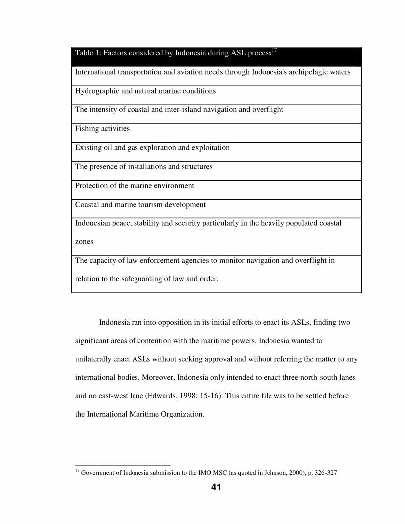
41
Table 1: Factors considered by Indonesia during ASL process17
International transportation and aviation needs through Indonesia's archipelagic waters
Hydrographic and natural marine conditions
The intensity of coastal and inter-island navigation and overflight
Fishing activities
Existing oil and gas exploration and exploitation
The presence of installations and structures
Protection of the marine environment
Coastal and marine tourism development
Indonesian peace, stability and security particularly in the heavily populated coastal
zones
The capacity of law enforcement agencies to monitor navigation and overflight in
relation to the safeguarding of law and order.
Indonesia ran into opposition in its initial efforts to enact its ASLs, finding two
significant areas of contention with the maritime powers. Indonesia wanted to
unilaterally enact ASLs without seeking approval and without referring the matter to any
international bodies. Moreover, Indonesia only intended to enact three north-south lanes
and no east-west lane (Edwards, 1998: 15-16). This entire file was to be settled before
the International Maritime Organization.
17 Government of Indonesia submission to the IMO MSC (as quoted in Johnson, 2000), p. 326-327
42
2.10: THE INTERNATIONAL MARITIME ORGANIZATION
Towards the completion of the UNCLOS process, a looming question became the U.N.
regulation of the new Convention. Kingham and McRae (1978: 127) noted that existing
U.N. agencies seemed capable of this task; however, organizational reviews and top
level direction to ensure appropriate and harmonious distribution of areas of
responsibility would be required. Specifically focusing on Part IV (archipelagic regime),
would an existing U.N. organ be mandated to regulate or would a new agency need to be
created?
The Law of the Sea Convention enshrined states’ rights to regulate the adoption
of ASLs to “the competent International Organization” (Article 53[9]). This
responsibility has fallen to the United Nations’ International Maritime Organization
(Beckman, 2007: 120; also Johnson, 2000, Batongbacal, 2004; Bateman, 2007;
Forward, 2009). The International Maritime Organization (IMO) came into existence in
1948 as a U.N. mandated body responsible for deliberating and regulating shipping
matters and standards (Harrison, 2011: 155). The IMO’s own documentation states the
purpose of the organization as (as quoted in Harrison, 2011: 156):
to provide machinery for co-operation among Governments in the field of governmental regulation and practices relating to technical matters of all kinds affecting shipping engaged in the international trade; [and] to encourage and facilitate the general adoption of the highest practicable standards in matters concerning the maritime safety [sic.], efficiency of navigation and prevention and control of marine pollution from ships.
Indonesian Objection to Mandate
Indonesia held some key objections concerning the perceived mandate of the
IMO when it came to the ASL process. These objections centered around the fact that
43
the IMO is an organization with a focus on international shipping and trade. Building
upon the earlier quoted purpose, the IMO’s own mission statement identifies its purpose
“is [to promote] safe, secure and efficient shipping on clean oceans” (as quoted in
Forward, 2009: 152).
Indonesia notified the IMO in 1996 that it intended to submit its proposal for
consideration. This triggered the long process (Figure 4), in which Indonesia attempted
to achieve adoption of their ASL submission. The IMO designated its Maritime Safety
Committee (MSC) to take control of this file. The MSC deeming this matter as a routing
issue, further delegated the file to its navigational sub-committee.
The role and mandate of the IMO was a contentious subject between the
maritime powers and Indonesia. Indonesia was of the opinion that the IMO would fill a
technical role, to review the proposal and deem it safe for navigation (Edwards, 1999:
17). They recognized the IMO’s authority merely “on matters relating to navigational
aids and the safety of shipping – not on the delineation of sea lanes” (Far East
Economic Review, February 29, 1996). An unidentified source within the Indonesian
Defence Ministry was quoted early in 1995 explaining, “We [Indonesia] will designate
the sea lanes unilaterally, (…) but we will seek the IMO’s advice on the type and
intensity of navigational aids” (Far East Economic Review).
The maritime powers were of the belief that the IMO was required to adopt a
much more “hands on” approach. An Australian statement which was widely supported
by other states indicated that much larger issues, such as the number of normal routes
and other international law matters, needed to be considered by the IMO (Edwards,
44
1999: 17). The Indonesian submission was left vulnerable to the maritime powers due to
one simple sentence contained within the submission; "Pending the designation of other
sea lanes through other parts of the archipelagic waters, the right of sea lanes passage
may be exercised in the relevant archipelagic waters in accordance with the Law of the
Sea Convention, 1982" (as quoted in Edwards, 1999: 16).
The Sticking Point of a Fourth ASL
The initial Indonesian proposal consisted of three north-south archipelagic sea
lanes. The international community and the maritime powers protested the absence of
over ten additional routes (Kaye, 2008: 16). In 1996, during the course of the
negotiation, Walter Slocombe, American Under-Secretary of Defence for Policy, went
on record to state that Indonesia had “by no means” ruled out a fourth ASL, an east-west
one (Far East Economic Review, May 2, 1996). Two weeks later, Ali Alatas, the
Indonesian Foreign Minister was quoted in the New York Times (May 16, 1996):
They want a fourth archipelagic sea-lane going east-west through the Java Sea… But we have told them that the Java Sea is full of undersea cables and oil rigs. It's a very shallow sea, in many parts only 45 meters. So we are rather reluctant to make it an archipelagic sea-lane.
In opposition to any additional lanes being proposed, Indonesian representatives
indicated that shallow depths, overcrowding with domestic marine traffic, and the
presence of oil and gas rigs made these proposed areas unsafe for passage by user states
vessels, and “especially submerged submarines” (New York Times).
By late 1997, Indonesia had offered a small concession to the Americans in
particular. Indonesia offered a short ASL that would act as an entry branch onto their
submitted Sunda Strait lane (north-south) allowing surface military vessels en-route to
45
or from Singapore to “maintain operational readiness” (Far East Economic Review,
August 21, 1997). However, the Indonesian position on a fourth east-west lane was
bluntly restated in the Far Eastern Economic Review which read, “[Indonesia] are still
opposed to an east-west sea lane that would traverse the length of the archipelago,
pointing out that only three or four warships actually use that route each year anyway.”
Bilateral Discussions
Bilateral discussions became an important forum for this matter. These dated
as far back as 1991 with “a number of bilateral consultations” (Edwards, 1998: 15)
between the United States and Indonesia. In the period covering February 1996 to early
2000, there occurred three formal bilateral meetings between Indonesia and Australia,
and, one formal bilateral meeting between the United States and Australia (Warner,
2000: 170). My research did not manage to uncover how many informal meetings or
discussions between any or all state parties occurred.
2.12: GENERAL PROVISIONS ON THE ADOPTION, DESIGNATION, AND
SUBSTITUTION OF ARCHIPELAGIC SEA LANES
Through the formal and bilateral meetings, the IMO came to consider nineteen
agreed upon points around process for an ASL submission. These points were endorsed
and issued as the General Provisions on the Adoption, Designation, and Substitution of
Archipelagic Sea Lanes (GPASL). Johnson (2000: 322) highlights four key
developments which she terms as “major innovations” encompassed in the GPASL:
46
the creation of a concept of partial designation;
reinforcement of the “obligation” (in Art. 53[4]) upon archipelagic states to
include all international navigation routes in their archipelagic sea-lanes
proposals;
more onerous pre-proposal procedures especially for the archipelagic state; and
a formalised role for foreign states in relation to the preparation and
determination of a proposal
Johnson (2000: 331) noted that the GPASL increases the control of user states and the
IMO over the designation process. Batongbacal (2004: 67) analyses the impacts of the
GPASL on mid-ocean archipelagic states concluding:
From an archipelagic state perspective, the GPASL may have undermined, rather than strengthened, the archipelagic state regime under the LOS Convention. The introduction of the concept of partial proposal or designation takes away from the archipelagic state the initiative to decide with finality on the designation of its ASLs, nullifies the benefit of designating any ASLs at all, and undermines the provisions of Part IV referring to substitution of sea lanes, elimination of similarly convenient routes, and application of innocent passage in undesignated routes. It severely limits the ability of the archipelagic state to rationalize the maritime traffic routes within its archipelagic waters, and practically legitimizes unmitigated passage through all waters of the archipelago. In addition, although the GPASL was issued by an international institution with competence over commercial shipping, its truly important provisions were actually negotiated and settled outside the IMO, between a select few members concerned with non-commercial issues such as naval mobility.
Warner (2000: 170) offers that, while the GPASLs are indicative of “some practical
compromises necessary to implement [ASLs],” they did, “achieve[s] an appropriate
balance between archipelagic and user state interests.”
47
2.13: GPASL INTRODUCTION OF PARTIAL REGIME
The GPASLs introduced a concept advocated by the maritime states of a partial
submission or proposal by Indonesia. The GPASLs define partial archipelagic sea
lanes proposal as, “[An] archipelagic sea lanes proposal by an archipelagic state which
does not meet the requirement to include all normal passage routes and navigational
channels as required by UNCLOS. (para 2.2)” (as quoted in Warner, 2000: 176). The
IMO determined that partial designation allowed for the “continued exercise of ASLP in
other routes normally used for international navigation located within archipelagic
waters,” notwithstanding the authorization of the three submitted Indonesian
archipelagic sea lanes (as quoted in Batongbacal, 2004: 55). Harrison (2011: 185)
contends that a partial proposal concept is, “[A] procedural device that aims to satisfy
the conditions in Article 53(4) that archipelagic sea lanes must include all normal
passage routes used as routes for international navigation or overflight.” Warner rightly
points out the notion of a partial proposal or designation was not foreseen in UNCLOS,
and clearing up the status of navigational rights for user states outside the designated
ASLs was the main focus of the bilateral meetings upon agreement of the partial
allowance (2000, quoted in Batongbacal, 2004: 55, Also Rothwell, 1990; Bateman,
2007).
Not all are so sure as to the benefit of this regime. As Bateman (2007: 44) points
out, a partial designation is, in actuality, not consistent with UNCLOS Article 53(4),
which calls for ASLs to “include all normal passage routes.” Batongbacal further argues
his position opposing the partial concept, explaining:
48
The concept of partial designation also undermines the provision allowing the archipelagic state to substitute sea lanes under article 53(7) of the LOS Convention, and to no longer designate sea lanes which duplicate routes of similar convenience between the same entry and exit points under article 53(4). (…)If a complete ASL designation must at all times include “all routes”, then there is no situation in which substitution can be called for, nor is there any opportunity to eliminate redundant routes; for that matter, neither is there any more utility in designating any ASLs since ASLP can be exercised practically anywhere in archipelagic waters. (2004: 56)
In the same article, Batongbacal supports his position by quoting Warner (2000) who
said “[i]t has constantly been the position of the archipelagic states that solely innocent
passage should apply in all other archipelagic waters, if ASLs have been formally
proposed and approved by the IMO” (2004: 56). Batongbacal also states that “should a
proposal be viewed as partial by user states it seems unlikely that the regime of innocent
passage shall solely apply.” These observations are echoed by Forward (2009: 143) who
called the partial proposal a “significant victory” (for the maritime powers) noting such
a designation “rendered the Indonesian ASLs practically useless because there is no
compulsion for maritime countries to use them.”
Batongbacal (2004: 66) later notes that the Indonesian designation revealed the
key fundamental issue surrounding establishment of an ASL regime is the impact on the
military and state vessels of user states. Specifically, military vessels and their varied
operations, which Batongbacal: refers to as “naval surface, sub-surface, and aerial
united,” are heavily restricted by a complete ASL designation, while commercial traffic
can merely exercise innocent passage rights within all archipelagic waters.

49
In the view of Captain Jonathan P. Edwards, USN, JAGC (United States Navy,
Judge Advocate General’s Corps),18 when viewing the different ASL passage regimes in
a military operations context:
From an operational standpoint, designation of a partial system of archipelagic sea lanes is preferable to designation of a complete system. This is because in a complete system, international law does not require archipelagic states to include normal passage routes of similar convenience between the same entry and exit points. A complete system is therefore likely to have fewer sea lanes than a
partial system will have normal passage routes. [emphasis added] (1999: 22)
The Royal Australian Navy stated in their policy and opinion newsletter, Semaphore
(2005: 2):
It is in Indonesia’s interests to designate all normal routes as ASLs. Once it has fully designated its ASLs, transiting vessels will be restricted to exercising ASLP only in those ASLs, and will be limited to innocent passage through the rest of the archipelago. Until this is completed, Indonesia will have difficulty in enforcing its domestic law against transiting vessels.
On the matter of military and state vessels, Batongbacal maintains that:
Such ships are beyond the IMO’s jurisdiction and competence, which is why the substantial negotiations and discussions addressing the contentious issues had to take place not in the IMO sessions, but rather in bilateral inter-sessional meetings. This is an indication of the IMO’s limitation as a dispute settlement forum. [emphasis added] (2004: 66)
2.14: CONSEQUENCES OF THE IMO DECISION (PARTIAL REGIME)
Indonesia’s archipelagic sea lane proposal was deemed by the IMO as a partial
submission, and thus a partial regime was designed in May 1998 (Cay, 2010: 5). The
partial designating of the Indonesian ASLs also carried with it obligations towards the
end goal of a full designation. Indonesia is required to update the IMO on its plans for
18 Edwards’ view is offered in an academic paper which was submitted to the Naval War College. It is important to note that such a paper is deemed to represent solely the author’s views and not those of the U.S. military or U.S. Government.
50
preparatory work (i.e. surveys) and “is ultimately required to propose for adoption
archipelagic sea lanes including all normal passage routes and navigational channels;”
however, no timeline is attached to these obligations (Semaphore RAN, 2005: 2).
The analysed impacts of this decision seem clear. Johnson (2000: 332) writes in
her conclusion that the general consequence of the Indonesian process was that it
“reinforced that [ASL] regime's focus on preserving the interests of user states arguably
to a further diminution of control by archipelagic states.” Harrison (2011: 198) more
directly observes, “[t]he IMO offers another example of informal mechanisms for
change being used by states in preference to the formal amendment procedures found in
the Convention.”
The response of the Indonesian government in the aftermath of the IMO
ruling has been rather careful. There has been no further action or submissions by
Indonesia to the IMO. Arguably, this illustrates either a complete loss of
confidence in the IMO in the role of neutral body, or could go as far as a rejection
of the IMO’s mandate (Forward, 2009: 153). Indonesia did take the step of
enacting domestic legislation in 2002, which enshrined the three ASLs into law as
a full designation, granting only innocent passage rights to all maritime traffic
outside of them (Forward, 2009). It was not until 2003 at an IMO conference that
Indonesia offered up any inclination it may consider consenting to a desired east-
west lane; however, the same source referenced Indonesian officials indicating the
required surveying for such a lane “might take several more years” (Far Eastern
Economic Review, July 17, 2003).
51
2.15: CONCLUSION
This chapter has outlined the history of the UNCLOS process dating back to the end of
World War II, including the archipelagic concept long advocated for the archipelagic
states. This process cumulated in the United Nations Convention on the Law of the Sea,
which enshrined the rights of mid-ocean archipelagic states under Part IV (Archipelagic
States). These rights were the negotiated trade-off between the major maritime powers
and the archipelagic states; which were forced to compromise on their archipelagic
concept. Lastly, this chapter explained the historical background of the mid-ocean
archipelagic state of Indonesia in relation to UNCLOS, highlighting the process
undertaken by Indonesia to designate their archipelagic sea lanes. The role and actions
of the International Maritime Organization in the Indonesian process and the
establishment of the General Provisions on the Adoption, Designation, and Substitution
of Archipelagic Sea Lanes were discussed, looking at the impact on Indonesia and in
relation to the initially negotiation compromise found in UNCLOS, Part IV.
52
Chapter Three: The Case of the Republic of the Philippines
“An island is a nervous duality: it confronts us as a juxtaposition and confluence of the understanding of local and global realities, of interior and exterior references of meaning, of having roots at home while also deploying routes away from home” (Godfrey Baldacchino, Islands – Objects of Representation, 2005: 248)
3.1: BACKGROUND
The Republic of the Philippines is an archipelagic state comprised of 7,107 islands,
geographically stretching over many miles of water (Bautista, 2010: 115). Its long
history with the archipelagic concept was previously introduced in Chapter Two.
Additionally, the previous chapter explained the key points of the development of
international maritime law throughout the UNCLOS process. This process identified the
prerequisite matter of state baselines that, together with the status of waters enclosed
within, make up the key aspects of the archipelagic concept. Such issues need to be
reviewed as they are so interwoven with archipelagic sea lanes.19
3.2: TIMELINE OF THE ACTIONS OF THE PHILIPPINES
Note Verbale (1955)
The Philippines stated their position concerning their waters, in essence the
archipelagic concept, in a Note Verbale to the Secretariat of the United Nations dated
19 For more information, read Batongbacal, Jay. Philippine Maritime Territories and Jurisdictions; Part I: Why the Law of the Sea is so critical for the Philippines. Asia Pacific Policy Bulletin. Asian Center – University of the Philippines. 2008
53
December 12, 1955, during the course of the initial preparatory work in advance of
UNCLOS I:
The position of the Philippine Government in the matter is that all waters around, between and connecting the different islands belonging to the Philippine Archipelago irrespective of their widths or dimensions, are necessary appurtenances of its land territory, forming an integral part of the national or inland waters, subject to the exclusive sovereignty of the Philippines. (as quoted in Ku, 1991: 17)
UNCLOS I & II
The Philippines attempted to advance the topic of straight baselines for
archipelagos (archipelagic concept) for debate in UNCLOS I and II. However, this effort
was abandoned due to disagreement by the major maritime powers and a general
absence of any other backing (Batongbacal, 2002: 2). Johnston (1988: 115) explains the
specifics of this attempt at UNCLOS I in the following passage20:
At UNCLOS I the Philippines introduced two alternative versions of a proposal for incorporation into the proposed convention: either that the straight baseline method, which had been approved by the ICJ21, should be extended to archipelagos lying off the coast “whose component parts are sufficiently close to one another to form a compact whole, and have been historically considered collectively as a single unit”; or that island groups with those characteristics “may be taken in their totality and the method of straight baselines may be applied to determine their territorial sea.” In both versions of the Philippine proposal it was made clear that the baselines “shall be drawn along the coast of the outermost islands, following the general configuration of the archipelago.” Both versions were rejected, and indeed almost ignored.
In the aftermath of the failure of UNCLOS and an apparent lack of international will to
address the archipelagic concept, the Philippines enacted Republic Act 3046, An Act to
Define the Baselines of the Territorial Sea of the Philippines, on June 17, 1961 (Talaie,
1998: 209).
20 The quoted passages within are from UN Doc A/CONF.13/C.I/L.98, 1 April 1958 21 ICJ refers to the International Court of Justice
54
Republic Act 3046 (1961)
Republic Act 3046 was the first piece of domestic legislation enacted by the
Philippines to define the limits of their territory. This Act established straight baselines
around the outermost islands of the archipelago, based on the Treaty of Paris (1898)
limits (RA 3046, Preamble). Moreover, Republic Act 3046 designated all waters within
these baselines as inland or internal waters (RA 3046, Section 2).
Republic Act 5446 (1968)
Republic Act 3406 was amended on September 18, 1968, by the passing of
Republic Act 5446 (Tangsubkul, 1984: 46). The significant reason for amendment was
to include Sabah22 (North Borneo) within the Philippine territory as it related to drawing
the baselines (Santiago, as cited in Tangsubkul, 1984: 46), as the new Republic Act
5446 (Section 2) clearly stated:
The definition of the baselines of the territorial sea of the Philippine Archipelago as provided in this Act is without prejudice to the delineation of the baselines of the territorial sea around the territory of Sabah, situated in North Borneo, over which the Republic of the Philippines has acquired dominion and sovereignty.
Presidential Decree 1599 (1978)
Presidential Decree 1599 came into effect on June 11, 1978, establishing the
Philippine Economic Exclusive Zone (EEZ):
There is hereby established a zone to be known as the exclusive economic zone of the Philippines. The exclusive economic zone shall extend to a distance of two hundred nautical miles beyond and from the baseline from which the territorial sea is measured: provided, that, where the outer limits of the zone as thus determined overlap the exclusive economic zone of an adjacent or neighbouring State, the common boundaries shall be determined by agreement with the State
22 Sabah is a territory on Borneo Island, today recognized as a Malaysian state which is also claimed by the Republic of the Philippines.
55
concerned or in accordance with pertinent generally recognized principles of international law on delimitation. (Section 1) (http://www.un.org/Depts/los/LEGISLATIONANDTREATIES/PDFFILES/PHL_1978_
Decree.pdf)
UNCLOS Signing Objection (1982)
The Philippines signed UNCLOS on December 10, 1982 and ratified it on May
8, 1984 (Garcia, 2005: 55). At the time of signing, as allowed under Article 310, a
formal declaration was made which explicitly stated that the Philippine signing did not
impact their views on sovereignty (Appendix C). This declaration, while in line with
their domestic legislation and Constitution, took a diametrically opposing view to the
very international convention which the country was signing. Accordingly so, this
declaration was officially protested by many states.
This declaration highlighted the precarious position which the Government of
the Philippines was attempting to maintain. They had negotiated in good faith during the
course of the UNCLOS process and were unhappy with certain concessions that were
made by archipelagic states. It has also been recognized as a domestic political
maneuver; that is, a tool to assist in ensuring ratification by the Philippine legislature
(Batongbacal, 2005: 6).
Baseline Legislative Efforts (1987)
In 1987, the Congress of the Philippines debated legislation (HBN 16085; SBN
206 – See Table 2) concerning the territory’s baselines, which was ultimately defeated
(Encomienda, 2009: 460). Mr. Alberto A. Encomienda, Secretary-General; Maritime
and Ocean Affairs Center, Department of Foreign Affairs, Republic of the Philippines,
remarked in a panel discussion on ASLP in 2009:
56
That’s why I cited in my presentation that way back in 1987, well before UNCLOS came into force, we did attempt to pass legislation in Congress in order to get our archipelagic basepoints and baselines to conform to UNCLOS. That law did not pass because of political considerations not having to do
with UNCLOS. [emphasis added]
The Period of 1990-2008
The almost twenty year period spanning from 1990 until 2008 produced few
immediate changes to the status quo of the Philippine position on the archipelagic
concept. In 1991, Kwaitkowska (1991: 4) noted that in contrast to the Indonesian
legislation, the Philippine statutes are noteworthy for being the “most excessive instance
of noncomformity” with UNCLOS. This was due to the absence of recognition of
innocent passage rights within the legislation, owing to the waters being defined as
internal waters (Kwaitkowska, 1991). Also, one of the baselines contained in Republic
Act 3046 (1961), even with the amendment by Republic Act 5446 (1968), stretches well
over 125 nautical miles (NM) which contravenes UNCLOS Article 47(2) which only
allows archipelagic baselines up to 100 NM, save for three percent which may be
longer, up to 125 NM (Kwaitkowska, 1991).
Such was the case of two contradictory positions, even after becoming a
signatory to the Convention much earlier (1982): UNCLOS and the Philippines’
domestic legislation. Indeed, the domestic legislation became more difficult to cling to
upon UNCLOS entering into force in 1994. Nevertheless, the Republic of the
Philippines continued to hold to their long standing position. However, the turn of the
millennium began to see a slow sea change in the Philippines in terms of their maritime
policy. The following table, Table 2, shows the legislative efforts to amend Philippine
baseline legislation.
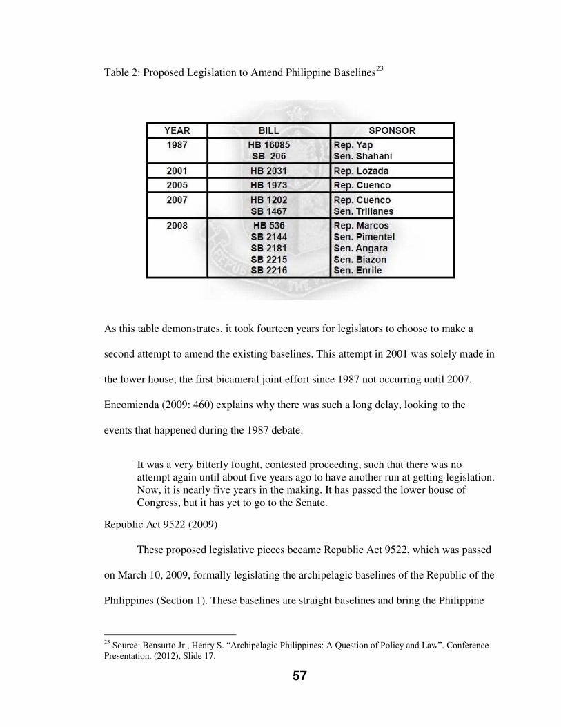
57
Table 2: Proposed Legislation to Amend Philippine Baselines23
As this table demonstrates, it took fourteen years for legislators to choose to make a
second attempt to amend the existing baselines. This attempt in 2001 was solely made in
the lower house, the first bicameral joint effort since 1987 not occurring until 2007.
Encomienda (2009: 460) explains why there was such a long delay, looking to the
events that happened during the 1987 debate:
It was a very bitterly fought, contested proceeding, such that there was no attempt again until about five years ago to have another run at getting legislation. Now, it is nearly five years in the making. It has passed the lower house of Congress, but it has yet to go to the Senate.
Republic Act 9522 (2009)
These proposed legislative pieces became Republic Act 9522, which was passed
on March 10, 2009, formally legislating the archipelagic baselines of the Republic of the
Philippines (Section 1). These baselines are straight baselines and bring the Philippine
23 Source: Bensurto Jr., Henry S. “Archipelagic Philippines: A Question of Policy and Law”. Conference Presentation. (2012), Slide 17.
58
baseline system into UNCLOS compliance (Cay, 2010: 55). This legislation further
claims two separate “Regime of Islands” as governed by UNCLOS Article 121; the
Scarborough Shoal and the Philippine Kalayaan Island Group (KIG) (Section 2).24
Additionally, RA 9522 instructs for itself and all baselines and maps to be “deposited
and registered with the Secretary General of the United Nations” (Section 4). Lastly, RA
9522 amends all pre-existing “laws, decrees, executive orders, rules and issuances” (e.g.
Republic Act 3406, Republic Act 5446), to ensure uniformity with this Act (Section 8.).
There was significant opposition to the passage of RA 9522 within the
Philippines. Senator Miriam Defensor Santiago opposed this legislation in the belief that
“if the Philippines declares itself an archipelagic state, the declaration would contradict
the Treaty of Paris which sets out the boundaries of the Philippine national territory,
which are wider than those allowed by the LOSC [Law of the Sea Convention]”
(Bautista, 2010: 117).
Furthermore, Santiago argued:
If the Philippines declares itself an archipelagic state, our zone of sovereignty would collapse. Our internal waters would become archipelagic waters where the ships of all states will enjoy the right of innocent passage. In addition, foreign states would have the right of so-called archipelagic sea lane passage. Ships of all states would have the right of passage and their aircraft would have the right of over flight (Santiago, 2009, as quoted in Bautista, 2010: 117).
Additionally, opposition appeared as a case against the Republic of the
Philippines Government, brought to the Supreme Court of the Philippines (Bensurto Jr.,
2012: Slide 22). G.R. No. 187167 (Prof. Merlin Magallona, et al v. Eduardo Ermita, et
24 UNCLOS Article 121 defines an Island and affords Islands rightful claim over their own Territorial Seas, Contiguous Zone, EEZ and Continental Shelf as outlined by UNCLOS. The KIG is formally defined in Presidential Decree 1596.
59
al) was filed by two law professors (one also being a Representative) and thirty-seven
University of the Philippines College of Law students. The petitioners claimed that RA
9522 was unconstitutional because it “dismembers a large portion of the national
territory” (G.R. No. 187167 Decision).
The Supreme Court dismissed the case in a unanimous ruling on July 16, 2011
(ibid). Associate Justice Carpio in his decision noted several key points, the first of
which was that the passing of RA 9522 had in fact increased the size of the Philippine
maritime area (Figure 5), as shown in the following table:
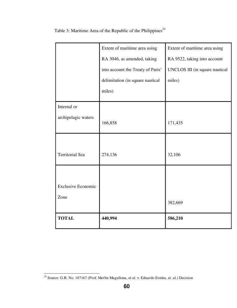
60
Table 3: Maritime Area of the Republic of the Philippines25
Extent of maritime area using
RA 3046, as amended, taking
into account the Treaty of Paris’
delimitation (in square nautical
miles)
Extent of maritime area using
RA 9522, taking into account
UNCLOS III (in square nautical
miles)
Internal or
archipelagic waters
166,858
171,435
Territorial Sea
274,136
32,106
Exclusive Economic
Zone
382,669
TOTAL 440,994 586,210
25 Source: G.R. No. 187167 (Prof. Merlin Magallona, et al. v. Eduardo Ermita, et. al.) Decision
61
Secondly, Associate Justice Carpio, in rejecting the petitioners’ arguments
against Article 2 (RA9522), writes:
In fact, the demarcation of the baselines enables the Philippines to delimit its exclusive economic zone, reserving solely to the Philippines the exploitation of all living and non-living resources within such zone. Such a maritime delineation binds the international community since the delineation is in strict observance of UNCLOS III. If the maritime delineation is contrary to UNCLOS III, the international community will of course reject it and will refuse to be bound by it.
UNCLOS III favors States with a long coastline like the Philippines. UNCLOS III creates a sui generis maritime space – the exclusive economic zone – in waters previously part of the high seas. UNCLOS III grants new rights to coastal states to exclusively exploit the resources found within this zone up to 200 nautical miles. UNCLOS III, however, preserves the traditional freedom of navigation of other states that attached to this zone beyond the territorial sea before UNCLOS III (G.R. No. 187167 Decision).
Lastly, in concluding, Associate Justice Carpio offers the following explanation
of the true merit of RA 9522:
Absent an UNCLOS III compliant baselines law, an archipelagic state like the Philippines will find itself devoid of internationally acceptable baselines from where the breadth of its maritime zones and continental shelf is measured. This is recipe for a two-fronted disaster: first, it sends an open invitation to the seafaring powers to freely enter and exploit the resources in the waters and submarine areas around our archipelago; and second, it weakens the country’s case in any international dispute over Philippine maritime space. These are consequences Congress wisely avoided.
The enactment of UNCLOS III compliant baselines law for the Philippine archipelago and adjacent areas, as embodied in RA 9522, allows an internationally-recognized delimitation of the breadth of the Philippines’ maritime zones and continental shelf. RA 9522 is therefore a most vital step on the part of the Philippines in safeguarding its maritime zones, consistent with the Constitution and our national interest (G.R. No. 187167 Decision).
62
3.3 THE MATTER OF PHILIPPINE ASLs
1997 ASL Proposal
In 1997, the Institute of International Legal Studies at the University of the
Philippines released its maiden publication in its Ocean Law and Policy Series. This
publication entitled “Issue Focus: Designation of Sea Lanes in the Philippines” offers an
in-depth look at a probable ASL submission.26As illustrated by Figure 7, this publication
proposed two ASLs for the Republic of the Philippines.
These two lanes, one east-west and one north-south, are described by the author
as follows:
The East-West will traverse from Balabac Strait to Sulu Sea Junction going through Bohol Sea between Northern Mindanao and Southern Negros Islands and the Bohol Islands then through Surigao Strait going through Pacific Ocean. The North-South route is from Celebes Sea going through Sibuto Passage between Sibuto Island and Simunol Island, Bongao passing through the Sulu Sea to Mindoro Strait into the South China Sea (Manansala, 1997: 7, as quoted in Palma, 2009: 7; Cay, 2010: 59).
Additionally, a separate author of a different chapter in this text outlines factors
for consideration by the Philippines, should they indicate a desire to make an ASL
designation and thus, submission (Feir, 1997: 12-14, as quoted in Palma, 2009: 9; Cay,
2010: 59)27:
26 During the course of my literature review, I was unable to obtain a copy of this publication. Efforts were made through UPEI’s Robertson Library, the inter-library loan system and also the Library of Congress. Palma (2009) and Cay (2010) both make specific reference to the ASL proposal from this publication in their respective works. 27 While Palma and Cay both cite Feir’s list, neither author chose to explain out, or directly elaborate upon it. Palma only reproduces Feir’s list, while Cay speaks to the merits of Manansala’s two proposed ASLs (as explained above), validated against Cay’s own criteria of Legal Issues, Environmental Issues, and Major Security Issues (pp. 59-65).
63
the effectiveness of the government to monitor the sea lanes;
security of the country;
measures to ensure safe, expeditious and continuous passage;
fisheries and marine environment;
inter-island shipping; and
the possible connection with the Indonesian established ASLP.
3.4 DOMESTIC LEGISLATION TO ESTABLISH PHILIPPINE ASLs
House Bill No. 4153, tabled by Speaker Feliciano Belmonte Jr., was filed in the
Philippine House of Representatives on February 8, 2011 (Congress of the
Philippines). It was referred to the House Foreign Affairs Committee on February
15, 2011; the committee reported back in June of that year recommending to
“approve without amendment” (Congress of the Philippines). The Bill was
approved on January 24, 2012, receiving unanimous support (189-0) (Congress of
the Philippines). The approved House Bill No. 4153 was sent to the Senate for
consideration on January 26, 2012, and was referred to the Senate Foreign
Relations Committee (January 31, 2012) (Congress of the Philippines).28
However, the Senate were also working on an identical proposed piece of
legislation.
Senate Bill No. 2738 was tabled by Senator Antonio “Sonny” F. Trillanes
IV on March 10, 2011, roughly one month after House Bill No. 4153 was filed in
28 While tabled by Speaker Belmonte Jr., the Philippine Congress allows Representatives to sign upon bills as co-authors with the principal author’s permission. For a full list of the fifty-one Representatives credited with co-authorship: See, Lorelei V. Castillo. “House Approves Establishment of Archipelagic Sea Lanes”. Congress of the Philippines. January 3, 2012.
64
the Lower House (Senate of the Philippines). The Senate Bill (No. 2738) was
referred to the Senate Foreign Relations Committee on March 14, 2011, where it
was joined by the House Bill (No. 4153) more than ten months later (Senate of the
Philippines). Senator Trillanes identified the purpose of his proposed legislation as
being to define the maritime boundaries of the Philippines as outlined by criteria
set forth in UNCLOS (Manila Standard Times, April 4, 2011). The same media
report featured comments by Palawan Rep. (House of Representatives) Antonio
Alvarez who is against the bill, citing a “…compromise [of] national security as
the Armed Forces ha[ve] no naval or aerial capability to protect the country’s
sovereignty” (Manila Standard Times). I believe it is conceivable that Alvarez is
geographically sensitive, given the close proximity of Palawan to the Spratly
Islands, eighteen kilometers to the north (Manila Standard Times). Also, it should
be noted that two of the three proposed ASLs exit Philippine waters on either end
of the island of Palawan.
Further opposition from Palawan on these bills came in the fall of 2011, as the
Palawan Council for Sustainable Development passed a resolution against the proposed
legislation (Inquirer Southern Luzon, September 19, 2011). This resolution was further
enhanced as it was signed by Palawan provincial governor Abraham Mitra on
September 15, 2011. In media reports, Mitra was quoted as stating, “We’re afraid its
provisions will not be binding to foreign vessels and might prejudice small fishermen,
open our seas and the province to more foreign incursions” (Inquirer Southern Luzon).
Further concerns raised in this particular media report included swiftly
increasing Chinese naval power in the region and breaching the protected marine areas
65
in the area including the Tubbataha Reefs National Marine Park (Inquirer Southern
Luzon, September 19, 2011). The governor indicated that organized opposition would
be applied against the Senate since the House was fully expected to pass its’ bill (which
it did). He further expressed that Palawan Province would lobby to delay any ASL
designations until the national government consulted with the IMO “as to the necessity,
propriety and location of the ASL” (Inquirer Southern Luzon).
Given the grave concerns raised by Palawan representatives, the
governor’s final statement concerning what amounts to IMO approval can be
interpreted as technically correct, but it still very alarming. It appears to be a basic
contradiction of the concerns of Palawan, aimed at disarming the national
government, but at what I would consider a much greater cost. This posturing
illustrates the choice facing the Philippines government as when to initiate
dialogue with the IMO, the choice which is at the very foundation of this case.
House Bill No. 4153 and Senate Bill No. 2738 are identical. Short-titled
the Philippine Archipelagic Sea Lanes Act(s), these propose to amend the existing
Republic Act 9522, outlining rights and regulations placed upon vessels of any
flag which are exercising passage rights within Philippine ASLs (The Philippine
Star, February 3, 2012). The amendments outline the terms of passage rights, in
practice mirroring the passage rights as outlined under UNCLOS. This legislation
also includes geographic coordinates to designate the intended ASLs and air routes
(The Philippine Star). These Bills propose three ASLs for the Philippine
archipelago, which are shown in the following figures: Figure 8 (collectively);
Figure 9 (ASL #1); Figure 10 (ASL #2); Figure 11 (ASL #3):
66
Archipelagic Sea Lane #1
ASL #1 is an east-west lane which spans the Balintang Channel within the
Luzon Strait, above Luzon Island in the very north of the Philippines, described in the
proposed legislation as follows (HB 4153: 7):
The archipelagic sea lane that may be used for exercising the right of archipelagic sea lanes passage for sailing from the Philippine Sea to the South China Sea or vice versa through the Balintang Channel, is Archipelagic Sea Lane I (…). (Section 11[a])
This specific route was not incorporated in the 1997 proposal (section 3.3, 1997 ASL
Proposal). Nor was any route to the north of the island of Luzon, servicing the Luzon
Strait, included.
Archipelagic Sea Lane #2
ASL #2 runs east-west through the heart of the Philippine archipelago,
interconnecting many different bodies of water, described in the proposed legislation as
(HB 4153: 8):
The archipelagic sea lane that may be used for exercising the right of archipelagic sea lanes passage for sailing from the Philippine Sea to the South China Sea or vice versa through the Surigao Strait, Bohol Sea, Sulu Sea, Nasubata Channel and Balabac Strait is Archipelagic Sea Lane II (…). (Section 11[b])
This lane, ASL #2, appears to match one of the two lanes found in the 1997 ASL
proposal (section 3.3). While not having specific waypoints for the 1997 lanes, visual
inspection of the two images (1997; 2011) has convinced this author they are indeed
identical.

67
This route in particular was identified by critics to have the potential to place
pressure upon the Tubbataha Reef, a UNESCO World Heritage Site; and the Verde
Island Passage Marine Corridor, an area of exceptional marine and shorefish
biodiversity (Encomienda, 2009, as quoted in Cay, 2010: 61). These areas are amongst
the most fragile and biodiverse marine regions found in the world (Encomienda, quoted
in Cay). These accusations are refuted by Bensurto Jr., who explicitly expounds:
The allegation that Tubattaha Reef will be violated and ran over by the proposed ASL is not correct. The axis lines actually do not touch the protective zone of Tubattaha Reef. The extent of the theoretical 20 M limit beyond which, ships traversing the ASL are not allowed to deviate is not a license for ships or the ASL to violate the protective zone of Tubattaha Reef. Tubattaha Reef is protected by law and the ASL 20m limit for deviation does not repeal or modify this particular law. The ASL is by no means a license to disregard the protective zone of Tubattaha. On the contrary, ships traversing the ASL are obligated to respect Philippine law in this regard under the “due regard” principle. (2012: Slide 50)
Archipelagic Sea Lane #3
ASL #3 runs north-south down the Philippine archipelago, hugging the easterly
edge of the Eastern Sulu Sea’s length, described in the proposed legislation as (HB
4153: 8):
The archipelagic sea lane that may be used for exercising the right of archipelagic sea lanes passage for sailing from the Celebes Sea to the South China Sea or vice versa through the Basilan Strait, Eastern Sulu Sea and Mindoro Strait, is Archipelagic Sea Lane III (…). (Section 11[c])
A variation of this route appears as the second ASL in the 1997 ASL proposal (section
3.3). The Mindoro Strait leg (between waypoints (G) and (H)) appears identical, after
which the ASL cuts back into the middle of the Sulu Sea, running predominately
68
straight south and exiting the Philippine territory between Sabah (North Borneo) and the
western most island of Tawi-Tawi province.
3.5: PROBABLE REASONING BEHIND DOMESTIC LEGISLATION
Domestic Political Agendas/Posturing
Given that elected representatives from two different parties introduced identical
legislation in the two houses of the Philippine Parliament within weeks of each other,
there is a probability that this is a case of political gamesmanship. However, this
possibility seems rather remote given that the House Bill was introduced by the Speaker
of the House. The Speaker is a member of the governing party and sits on the
President’s Legislative Executive Development Advisory Council (LEDAC) (111th
LEDAC Meeting Brief). LEDAC met under the current President for the first time on
February 28, 2011 (111th LEDAC Meeting Brief). This council drives the government’s
legislative agenda, and this first meeting served to present the President’s legislative
priorities to members (111th LEDAC Meeting Brief). The February 28, 2011 meeting
presented priority bills which were grouped under five distinct categories. Located under
the heading “Sovereignty, Security, and Rule of Law” were two bills of particular
interest: The Archipelagic Sea Lane Act and The Act to Define the Maritime Zones of the
Republic of the Philippines (111th LEDAC Meeting Brief).
Testing Public Opinion?
Given the above stated facts, it is possible that this legislation was introduced in
order to test the will of the people when it comes to the possibility of making a full ASL
submission to the IMO. Since both the government and opposition members were quick
69
to table something during the same session of Parliament, both sides could be interested
in gauging public interest in this divisive issue. However, since it is on the Presidential
priority legislative agenda, this seems like an unlikely political maneuver by the
opposition.
Advancing the ASL Submission Process
The probable reason for this domestic legislation, supported by strong evidence, is the
intention of the Republic of the Philippines to move forward towards ASL designation.
The Office of the President and Philippine lawmakers have collaborated to advance the
ASL submission process by tabling the identical bills. This is a distinct possibility as the
Philippine Senate website notes, “Major legislation is often introduced in both houses in
the form of companion (identical) bills, the purpose of which is to speed up the
legislative process by encouraging both chambers to consider the measure
simultaneously” (Senate of the Philippines). Additionally, this tactic is noted to
“dramatize the importance or urgency of the issue and show broad support for the
legislation” (Senate of the Philippines).
The very fact that the Speaker of the Lower House and a prominent Senator were
the two legislators to bring these bills forward could, in fact, mean that these bills are
companions. Senator Trillanes does not sit on LEDAC, and is a member of an
opposition party. However, none of my research to date has indicated explicitly that
these pieces of legislation are companion bills. Notwithstanding this fact, none of my
research has explicitly indicated or proven the opposite to be true. The circumstantial
evidence would appear to support these bills being companion bills advancing the
UNCLOS compliance agenda as set forth by the President.
70
What impacts will this course of action have?
The impacts of the chosen course of action of tabling draft legislation could be
momentous, and possibly negatively so for the government and people of the
Philippines. The foremost concerning impact is the basic effect of ‘tipping one’s hand’
in relation to any future ASL submission to the IMO. With national legislation on public
record, the Philippines, in essence, have given the major maritime powers and
international community a baseline from which to negotiate. Coupled with the fact that
an official ASL submission has not been formally confirmed as of yet by the Philippine
government, this gives the international community a significant head start, and I argue,
further tilts the process against the Philippines before any IMO process even convenes.
Another probable impact surrounds the ongoing work of the Philippine
government on a possible ASL submission. The government did establish a working
group composed of representatives from various departments and agencies. The very
action of tabling this legislation for debate would seem to circumvent and pre-empt the
work of this previously struck government working group.
Additionally, I would question whether a piece of legislation is the proper
vehicle to advance an issue into the public domain for input, consultation, and comment.
A piece of legislation is rather static and explicitly defined which, while allowing for
changes through amendment, is not conducive as a starting point for discussion. I would
suspect that the Philippine government intends to consult with many stakeholders,
including but not limited to citizens, other levels of government and various experts in
the course of designing an ASL submission.
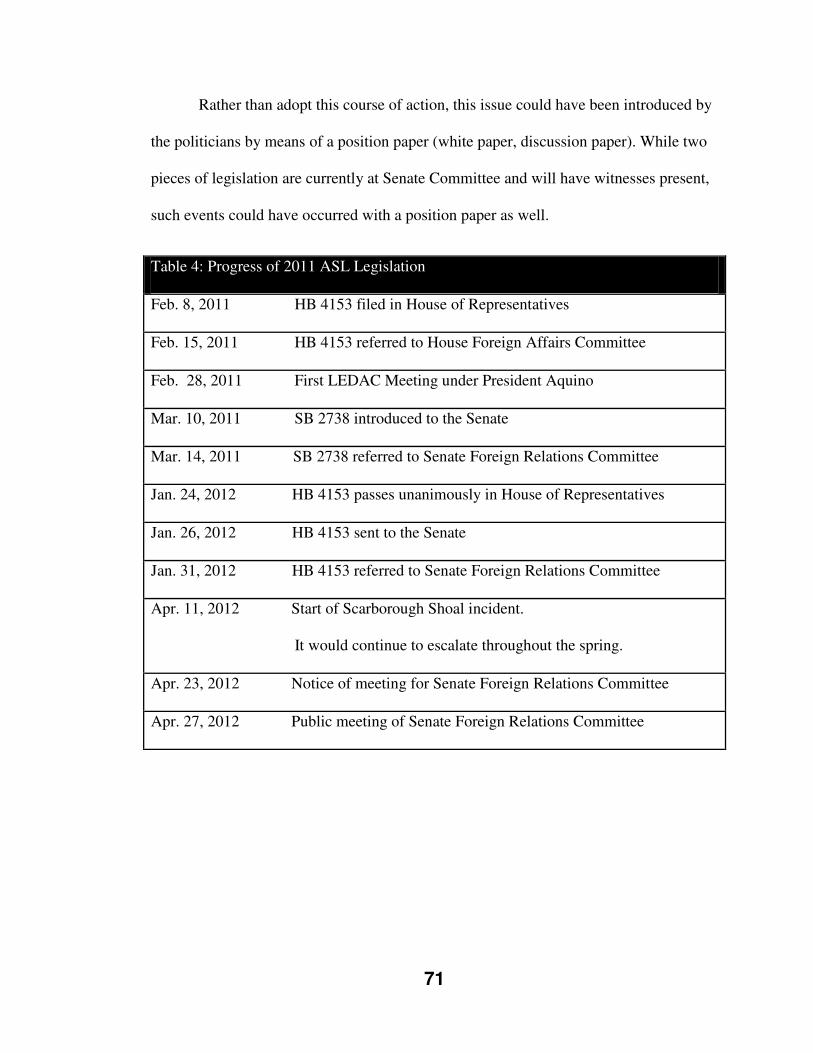
71
Rather than adopt this course of action, this issue could have been introduced by
the politicians by means of a position paper (white paper, discussion paper). While two
pieces of legislation are currently at Senate Committee and will have witnesses present,
such events could have occurred with a position paper as well.
Table 4: Progress of 2011 ASL Legislation
Feb. 8, 2011 HB 4153 filed in House of Representatives
Feb. 15, 2011 HB 4153 referred to House Foreign Affairs Committee
Feb. 28, 2011 First LEDAC Meeting under President Aquino
Mar. 10, 2011 SB 2738 introduced to the Senate
Mar. 14, 2011 SB 2738 referred to Senate Foreign Relations Committee
Jan. 24, 2012 HB 4153 passes unanimously in House of Representatives
Jan. 26, 2012 HB 4153 sent to the Senate
Jan. 31, 2012 HB 4153 referred to Senate Foreign Relations Committee
Apr. 11, 2012 Start of Scarborough Shoal incident.
It would continue to escalate throughout the spring.
Apr. 23, 2012 Notice of meeting for Senate Foreign Relations Committee
Apr. 27, 2012 Public meeting of Senate Foreign Relations Committee
72
As mentioned earlier, the two pieces of legislation are still before the Senate
Foreign Relations Committee. On April 23, 2012, a notice of meeting was given for the
Committee to meet on April 27, 2012, to consider three issues:
1. West Philippines Sea Issues (Bajo de Masinloc and Spratly Islands)
2. Maritime Zone Bills
i. SBN 2723, SBN 2737, HBN 4185
3. Archipelagic Sea Lanes Bills
i. SBN 2738, HBN 4153
The meeting was a public hearing that was scheduled to last for three hours. As
indicated by the meeting notice, the primary issue of concern was the West Philippines
Sea Issues; Bajo de Masinloc (Scarborough Shoal) and the Spratly Islands. An
escalating incident with the Chinese at Scarborough Shoal during this time would seem
to explain the time sensitive scheduling of this Senate Committee. Further, due to the
overlapping nature of these three agenda issues, one can ascertain the majority of the
discussion at this meeting dealt specifically with the escalating incident.
Indeed, The Manila Times from April 27, 2012 featured an article on this
meeting entitled “Senate tackles Panatag dispute.” Within the article, Committee Chair
Senator Legarda was attributed as saying, “the hearing will focus on the legal and
political repercussions arising from the impasse.” The article further reports that
government and private sector officials were invited “to provide inputs and updates on
the steps the country is planning to take to resolve the impasse.”
73
3.6: POSSIBLE FACTORS INFLUENCING THE PHILIPPINES ASL PROCESS
The effect of the Indonesian experience
The matter of a partial submission is one of the possible main concerns for the
Philippines around ASL designation and submission. The continued use of non-
designated routes by maritime states within Indonesia is thought to “effectively
quarantine Indonesia’s behaviour” [read: opposition to the partial concept] (Kaye, 2008:
17). Such actions do not go unnoticed by the greater international community, including
other mid-ocean archipelagic states. As I shall discuss as part of a subsequent variable,
the United States, in particular, chose to take direct maritime and aviation action in a
government program to emphasize American views on claims they feel are excessive
and unjustified to which many states are subjected. It certainly must have an impact on
the minds of policy makers to see Indonesia subject to such actions, even after a long
and drawn-out partial “victory.”
Republic of the Philippines Comment on IMO Indonesian Process
The Philippines delegation made two comments when the MSC of the IMO
approved the GPASLs and the partial Indonesian proposal. The Philippine delegation
gave notice that it may, in the future, propose amendments to the General Provisions on
Ships’ Routing; and it also explicitly stated that the discussions and agreements on the
designation of Indonesian’s archipelagic sea lanes should exclusively apply to the
Indonesian archipelagic sea lanes and should not be interpreted as creating a precedent
for future applications for the designation of archipelagic sea lanes (Beckman, 2007:
127).
74
The Philippines were clearly concerned with the direction of the process
considering the Indonesian proposal. The Philippine statement was the chance to
formally put on the official record their views on this process as individualistic to
Indonesia’s proposal, and not as a precedent setting direction. Owing to the fact that the
issues were decided in inter-sessional meetings between Indonesia and the user states,
and not in the course of the sanctioned IMO process, the Philippines refused to agree to
be bound by the results of these negotiations (Batongbacal, 2004: 59). It is unclear as to
whether the Philippines would be bound by precedence to the IMO process experienced
by Indonesia.
IMO Influence
In the framework of “IMO Influence” the biggest concern for the
Philippines is the possibility of a partial proposal ruling. Given the historical
context of the operation of user states in the waters within the Philippine
archipelago, there is a real potential for multiple lanes to be considered before the
IMO.
Coquia (as quoted in Kwaitkowska & Agoes, 1991) ruminated that any
consideration of Philippine straits as those employed for international navigation
as viewed through UNCLOS would “…practically open all waters within the
Philippine archipelago… This would certainly nullify the very concept of the
archipelagic State.” [emphasis added]
This analysis has proved very telling albeit in slightly different parameters.
While Coquia’s forewarning in the context of straits for international navigation
did not come to be, the issue of a partial proposal through the IMO presents a very
75
similar and realistic danger for mid-ocean archipelagic states. This danger is that
there are numerous routes which have been utilized for international navigation
within the archipelagic waters of the Philippines. Hence, there is a very good
chance that regardless of the number of routes brought forward in any Philippine
submission, there will be a multitude of additional possible routes which could be
advocated for by the larger international community.
Bensurto Jr.’s conference presentation points would appear to clarify the
Republic of the Philippines’ position and thought process concerning the role of the
IMO in a Philippine designation of ASLs and possible formal submission. He confirms
that the Philippines will submit their designated ASLs to the IMO (2012, Slide 59). He
also offers his counter opinion on the subject of domestic ASL designation prior to IMO
approval being “premature” citing:
the designation of ASL 1) is not only necessary but it is also urgent for the Philippines to protect its security and marine environment; and 2) for which reason, the designation of sea lanes as a valid exercise of a state’s substantive and inherent right to preserve itself could not be negated by the procedural requirement under Article 53.9.29 (2012, Slide 52)
The main point of Bensurto Jr.’s argument is that UNCLOS, specifically Article
53(9), does not explicitly state that IMO approval must precede the designation of ASLs
by a mid-ocean archipelagic state (2012, Slide 59) Thus, as argued in a following slide:
As such, the taking of a different procedure to comply with international law will not necessarily give the IMO the authority not to adopt the sea lanes earlier designated by an archipelagic state. In the first place, IMO is not empowered to approve or disapprove designated sea lanes. Its exact function under Article 53.9
29 The referred to procedural requirement under UNCLOS Article 53(9) is the IMO adoption of ASLs in consultation with the submitting mid-ocean archipelagic state.
76
is specifically limited to “may adopt only such sea lanes and traffic separation schemes as may be agreed with the archipelagic state.” (2012, Slide 60)
Bensurto, Jr. concludes his position (and one must surmise, the Republic of the
Philippines position concurrently), that the legitimacy of any ASL designation, partial or
full, must merely pass the test of “command[ing] respect from the international
community.”
UNCLOS Compliance with Territorial Boundaries
The history of the Philippines and its boundaries is a complex one. The Republic
of the Philippines claims successor-state status from the United States as received via
treaty from Spain (Bautista, 2011: 44). The Republic of the Philippines stakes its claims
to its territorial boundaries by means of three treaties: the Treaty of Paris (December 10,
1898), between Spain and the United States; the Treaty of Washington (November 7,
1900) between the United and Spain; and the Treaty concluded on January 2, 1930
between the United States and Great Britain (Bautista, 2008, as quoted in Bautista,
2011: 38).
Throughout the entire UNCLOS process, the Philippines made repeated attempts
for acknowledgement and recognition of their international treaty limits under the
international law principle of historic title (Ingles, 1983, as quoted in Bautista, 2011:
44). However, due to objectives by the maritime powers, the United States chief among
them, the Philippine efforts were not successful. Bautista (2011: 35) points out the two
main reasons why the boundaries are contested in international law, and generally not
accepted by the greater international community. He first highlights the absolute
position of Philippines government that their national boundaries are the ones found in
77
the 1898 Treaty of Paris. The second reason is the more contentious fact that the
Philippines view their waters as internal within these baselines, complete with full
sovereignty.
Additionally, prior to RA 9522, some of these baselines were too long and
collectively covered too large of an area to fit the archipelagic regime under UNCLOS,
which limits lengths of individual baselines and total water to land ratio at 9:1 (Article
47(1)). In this situation the Philippines are not alone, as Tsamenyi, Schofield and
Milligan (2009: 445, as cited in Cay, 2010: 69) point out Cape Verde, the Dominican
Republic, and the Maldives are also all identified as mid-ocean archipelagic states that
have enacted baselines which contravene Article 47 of UNCLOS. This, in effect, would
void the archipelagic waters claimed by the said states, and as such, would not permit
ASL submission to the IMO.
An amending of the baselines to bring them into UNCLOS compliance was
advocated for by Batongbacal in the year prior to the introduction of RA 9522. He
writes:
Under UNCLOS, the Philippines can enclose even much larger bodies of water than within the treaty limits, and place them under internationally recognized sovereign rights and jurisdictions. This includes sovereignty over archipelagic waters, which can extend farther than what non-archipelagic states are entitled to. For this, we need to define the baselines along our coast and then extend the maritime zones from them. We can enclose the Sulu Sea and all inter-island waters without question, even if beyond the 12 nautical miles from shore. Practically all of the important living and non-living resources and presently possible uses of the ocean, from fishing to petroleum exploitation, would fall within those maritime zones and our control over them would not be subject to question so long as we abide by UNCLOS. These maritime zones encompass a much greater area than was ever included in the International Treaty Limits (2008: 4).
78
Batongbacal’s passionate argument raises several valid points, the most predominant of
which is international recognition and legitimacy of the sovereignty and control over the
maritime space and marine and seabed resources.
Batongbacal also reminds readers that such control is conditional based on
adhering to UNCLOS. He further explains such rights come with a trade-off, the very
essence of the debate and the compromise found in the previously explained UNCLOS,
Part IV:
We are to allow the passage of foreign vessels, including submarines, through those waters under certain conditions, but only as long as they are only passing through and not making a call to any port. If they do anything not connected with simply passing through, then we have the right to exercise our sovereignty and jurisdiction (2008: 4).
UNCLOS Compliance with the Republic of the Philippines Constitution
At the national level, the Philippines Constitution has undergone a number of
redrafts and reissues since independence. However, one of the few constants that has
remained in the document is the archipelagic concept. A useful example is found below
in the most recent version of the Philippine Constitution:
1987 Philippines Constitution
Article 1
The national territory comprises the Philippine archipelago, with all the islands and waters embraced therein, and all other territories over which the Philippines has sovereignty or jurisdiction, consisting of its terrestrial, fluvial and aerial domains, including its territorial sea, the seabed, the subsoil, the insular shelves, and other submarine areas. The waters
around, between, and connecting the islands of the archipelago,
regardless of their breadth and dimensions, form part of the internal
waters of the Philippines. [emphasis added]
79
The Constitution of the Philippines has long been, and continues to be, non-complaint
with UNCLOS.30 The archipelagic concept embodied through the definition of national
territory which includes internal waters, is fully enshrined in law. Internal waters restrict
any “innocent passage” rights and also require pre-notification by all vessels.
The two opposing viewpoints of this issue are quite divisive for the Philippines.
A root cause for this division can be traced back to the independence movement itself.
The government of the newly independent Philippines pursued a very strong nation
building policy which was very much centered upon the archipelagic concept. The
unified archipelago of the independent Philippines was championed as a central theme
which helped to stabilize the state.
Domestic Public Opinion
Thus, the people of the Philippines are very hesitant to “lose” what they view as
their internal waters. To subscribe in its entirety to UNCLOS would be to have
archipelagic waters, not internal waters. Archipelagic waters are still sovereign waters;
however as explained earlier they have a few conditions to sovereignty attached
(passage rights). It appears that the collective public conscience and popular opinion are
very much against this trade off.
Much like Indonesia, the Philippines has long championed its belief in the
archipelagic concept, a concept inclusive of the principle of full sovereignty over its
waters. Given the long standing fight since independence against numerous state
30 The United Nations has the 1973 Philippine Constitution on file, rather than the 1987 version. The specific section on file is the definition of “National Territory,” as illustrated by Article 1 (1987). I suspect the reason why the previous Constitution (1973) is on file, is that while the Constitution was updated the definition of “National Territory” has long remained the same.
80
parties, the people of the Philippines have yet to warm up to a weakening of their
perceived sovereignty. This point was further illustrated with formal opposition to the
passing of RA 9522 (2009) as noted in a previous section.
Time and Expense for ASL Proposal
Clearly, should the Philippines choose to submit an ASL proposal to the IMO
they will want to do it once, and do it right. Given what is at stake, the surveying and
other preparatory work will be immense. It is clear that the geographic alignment and
composition of the Philippine archipelago is unique and vastly different from the
Indonesian archipelago. The Philippines government will want to have a watertight
proposal and be armed with as much pertinent and relevant data as it can accumulate in
order to speak to and defend its proposal successfully. There is a need for a strong
political will to broach the divisive ASL issue, and take action to invest significantly in
manpower, technology, and expertise in order to best determine the possible routing for
ASLs. The government of the Philippines has engaged working groups in the past
surrounding this issue, but this research in unable to confirm if there has been any
investment in the required technical preparatory work.
Philippine National Marine Policy (1994)
In 1994, the Philippines enacted a National Marine Policy (NMP) aimed to
“exercise its stewardship responsibilities, harmonize existing laws and ocean uses,
promote coordination among government agencies concerned with the use of maritime
space and resources, and maximize benefits from utilization of ocean resources within
sustainable limits” (Cicin-Sain, 2004, as quoted in Garcia, 2005: 14). The NMP
81
championed four core criteria for consideration in all marine policy decisions (Garcia,
2005: 56):
Development planning should take into account the archipelagic
characteristics of the country.
Coastal marine areas are viewed as the locus of community,
ecology, and resources.
Implementation of the LOSC [UNCLOS] must be consistent
with national interests as prescribed in the NMP. [emphasis
added]
Concerned and affected sectors actively participate in a
coordinative and consultative planning and policy-making process
through the Cabinet Committee on Maritime and Ocean Affairs.
Garcia reports that the NMP “views [UNCLOS] as a legal reform agenda and a valuable
input in defining the geographic scope of the country’s ocean policy.” Hence, it would
seem that the NMP has the opportunity to encourage reformation of the Philippine
legislation to bring it in line with UNCLOS, and furthermore, clarifying the maritime
boundaries of the Republic.
Inter-Island Transport/Domestic Economy
Batongbacal points out that as of 1997 the Philippines transports up to 98 percent
of its domestic trade in goods via the marine based inter-island shipping network (1997,
as quoted in Batongbacal, 2004: 51; 2005: 8). Given the centrifugal characteristic of
archipelagic states, this figure would represent a significant density of domestic marine
82
shipping traffic in already busy waters. This characteristic is enhanced due to Santiago’s
already noted observation of the Philippines containing two large centers, these being
Luzon and Mindanao.
The Philippine economy is also very reliant on marine industries including
fishing. As noted by Toganivalu of Fiji at a 1974 UNCLOS III session, archipelagic
peoples are the “farmers of the sea” (UNCLOS III Official Records, as quoted in Ghosh,
1987: 905). The Philippines 2002 Census of Fisheries tallied about 1.8 million
municipal and commercial fishing operators; within this figure 1.752 million are
individual, municipal fishers (Garcia, 2005: 27).31
The historical importance of the inter-island maritime network cannot be
overstated. Movement of people and goods by water is the key linkage for the Philippine
archipelago. The maritime mode of transport was, and continues to be, the only viable
transportation network amongst the islands of the Philippines. Thus, the economy of the
Philippines is very reliant and possibly vulnerable to disruption of the movement of
persons and goods on the crowded waters of its archipelago. This fact, coupled with
potential impact on the commercial and non-commercial domestic fisheries, should
reinforce the challenge and hazards of ASL designation.
As a probable benefitting counterpoint, it was highlighted by Tangsubkul and
Fung-wai (1983: 869) that Indonesia and the Philippines possess the highest ratio of
water to land in the Southeast Asian region, coupled with the least developed fisheries.
Based on this, they identified that the adoption of UNCLOS and 200 NM EEZ would
31 Municipal fisheries refers to vessels less than three gross tons, non-vessel fishing and aquaculture activities.

83
allow for a greater prospect of enhancements in fishing gear, techniques, conservation
methods and industry management (Tangsubkul and Fung-wai, 1983).
Routing Concerns
Should the Philippines decide to formulate a submission for consideration; a
number of factors identified in this chapter will also need to be weighed against the
routing of any ASLs. It is noted that conceivable ASLs routes would be crossing inter-
island transportation routes, many fishing grounds, as well as large, commercial fishing
operations (Bateman, 2007: 46).
Environmental Concern
The Philippines is known to be a unique eco-system filled with an impressive
number of marine and coastal species of flora, fauna and habitats. Beckman (2007: 128)
highlights two areas of great concern to the Philippines in the consideration of
designating ASLs: the narrow width of the existing sea lanes and the environmental
hazards to the uniquely bio-diverse marine areas of the archipelago. In a recently
released report, the United Nations Environmental Programme reported that the
Philippines are estimated to have 1,170 Marine Protected Areas (MPAs) of various
scales and governance (UNEP National and Regional Networks of Marine Protected
Areas: A Review in Progress).
Tsamenyi and Mfodwo (2001: 37) point out that growing concerns surrounding
maritime shipping traffic and the impact and risks to the marine environment will in
their minds lead to additional regulation at all levels, thus further restricting the
traditional freedoms of navigation. These authors note that such restrictions will likely
84
predominately occur through the efforts of archipelagic and coastal states to project their
regulatory influence further (literally and figuratively) over their marine areas.
One idea which was advanced in 1996 by Ambassador Alberto A. Encomienda,
the Secretary-General of the Maritime and Ocean Affairs Center within the Philippine
Foreign Affairs Ministry, was to designate the entire Philippines archipelago as a
Particularly Sensitive Sea Area (PSSA) (The Philippine Star, December 15, 2006; Cay,
2010: 61). This designation would have forced the IMO to take action to offer special
protection due to vulnerability to shipping activities.32 The idea of a PSSA designation
was discussed, but it did not progress from initial discussions as the Philippines has
shifted its maritime policy towards UNCLOS compliance and ASL designation.
Regulatory & Enforcement Capacity
A factor of significance for both the Philippines and the greater international
community is the Philippine ability to regulate and enforce the ASLs and the attached
passage rights. This ability is in regard to the access and safe passages of the lanes.
Furthermore, the waters of the greater Southeast Asian area are an area of greater
concentration for piracy. Historically, International Maritime Bureau (IMB) figures
ranging from the mid-1990s to the early years of the new millennium indicated that
around one half of all maritime piracy acts in those years occurred in Southeast Asian
waters (Bradford, 2011: 190). More recently, IMB statistics from 2010 place this area
second only to the Horn of Africa in piracy and armed robbery occurrence, with
seventy-one recorded cases (Bradford, 2011).
32 http://www.imo.org/ourwork/environment/pollutionprevention/pssas/Pages/Default.aspx. The IMO defines a PSSA as an area that needs special protection through action by IMO because of its significance for recognized ecological or socio-economic or scientific reasons and which may be vulnerable to damage by international maritime activities.
85
Political Geography of the Philippines
This external influence (political geography) is also known as “geopolitics,” a
term that invokes the idea of the various facets of geography combined with sub-fields
of political science. Consulting the texts, Cohen (1973: 6) calls political geography “the
spatial consequences of the political process”. A Dictionary of Geography defines
political geography as “The study of states, their frontiers and boundaries, their inter-
and global relations, their contacts and their groupings; the variation of political
phenomena from place to place, considered with other features of the earth as the home
of Man” (Monkhouse, 1970: 274).
The archipelagos of both Indonesia and the Philippines are situated relatively
close together at the junction of the North Pacific Ocean, the China Seas, and the Indian
Ocean (Figure 12). This strategic location finds them intersecting many international
shipping lanes. Ghosh (1987: 905) pointed out that a detour around Indonesia would add
over three thousand miles to a sea journey. In addition, Amerasinghe (1974: 559) noted
during the height of UNCLOS III that closure of the Indonesian and Philippine maritime
areas to international shipping would hamper access between the Indian and Pacific
oceans, making international maritime shipping more complicated and expensive. The
close proximity of these archipelagic states to the Asian mainland, India and the Bay of
Bengal, and Australia guarantees their economic importance will only continue to grow
as the Asian economy expands and emerges.
This location also puts Indonesia and the Philippines right in the transit corridors
of the navies of the world (Figure 13). Additionally, there are strategic concerns for the
western military powers with many operations occurring on the East African and Middle
86
Eastern area. Indeed, it has been noted that the strategic situation has, in fact, grown and
intensified in the age of globalization and nuclearization (Chew, 2007: 19). Some
analysts have also argued that the strategic importance has increased since UNCLOS has
entered into force (New York Times, May 16, 1996). As identified and discussed by
Bateman (2007: 47):
[T]he Philippine archipelago sits astride major shipping routes between the Americas and southern China and Southeast Asia, as well as between northern Australia and the Lombok Strait and Northeast Asia. The narrowness of some straits highlights the potential difficulties in developing axis lines and applying the ten per cent rule in UNCLOS Article 53(5). Other international shipping routes lie immediately to the north of the Philippines through the Luzon Strait between Taiwan and the Philippines, and to the south between Mindanao and Indonesia. Parts of these routes pass through Philippine archipelagic waters.
Physical Geography of the Philippines
A second external influence tied into geography is the physical geography of the
Philippines. A Dictionary of Geography (1970) defines physical geography as “[t]hose
aspects of [geography] which are concerned with the shape and form of the land-
surface, the configuration, extent and nature of the seas and oceans, the enveloping
atmosphere, the thin layer of the soil, and the ‘natural’ vegetation cover” (1970: 265).
The marine spatial dimension of physical geography of the Philippines, dealing with the
condensed concentration of the entire archipelago, is probably the most relevant issue in
physical geography to this case. Additionally, a sub-element of physical geography
deals with the classification and functional purpose of many straits in Philippine waters
for international navigation (Figure 14). Palma (2009: 7) classifies five key routes of
international navigation out of the many that run through the Philippine territory33:
33 Palma classifies the Luzon, Surigao, and Balabac routes as “critical for military activities,” while citing the other areas as areas of international tanker usage.
87
Luzon Strait-Bashi Channel-Balintang Channel, and Babuyan Channel;
Verde Island Passage-San Bernardino Strait;
Mindoro Strait-Basilan Strait-Sibutu Passage;
Surigao Strait-Balabac Strait; and
Balut Channel
Australia
Australia is in a unique position of being strategically and economically
dependent upon the sea lanes through the Southeast Asian archipelagos (Warner, 2000:
170). Over ninety-five percent of Australia’s international import volume is via sea; and
over ninety-nine percent of Australia’s communications data traffic is via fibre optic
submarine cables (Kaye, 2008: 1). Olsen (1996: 18) additionally illustrated the
importance of Indonesia to Australia identifying that sixty percent of Australian marine
traffic transits through Indonesia.
While its fortunes are associated more so with Indonesia, there is still importance
for Australia in the Philippine archipelago. Australia continues to be engaged in
Southeast Asia, but still relies on strategic allies such as the United States to assist in
ensuring that its regional foreign policy interests are best served.34
The United States of America35
The United States has long been involved in Southeast Asia, dating back as far
the Spanish-American War in the late nineteenth century. America in fact, took
34 The American and Australian governments recently came to an agreement that sees a U.S. military presence once again on the continent of Australia. United States Marines are serving in Darwin, Northern Australia and indications are the size and capacity of the American contingent will continue to grow. 35 See, especially, Tommy Koh. “United States and Southeast Asia.” The Asia Foundation (2008).
88
possession of the entire Philippine archipelago as an overseas territory under the Treaty
of Paris in 1898 (CIA World Factbook). They would not relinquish control of the
Philippines until after the completion of World War II (CIA World Factbook).
Given the United States’ prolonged period of colonial dominance and
spearheading of the Allies’ actions in the Pacific theatre during World War II, American
influence has been quite significant across this region, and specifically in the
Philippines. The initial relationship after American negotiation with the Spanish is rather
complicated. The Philippine people had waged resistance to the Spanish, and were
assured the Americans were looking to free them, just as the Americans had done with
the Cubans. Thus, once American colonial rule was imposed, a bloody and very bitter
civil war erupted which the Americans were able to squash. After this initial period, the
relationship between the Philippines and the United States in the mid-twentieth century
appears to have been strong. The Americans had returned and liberated the Philippines
from Japanese occupation. In the post-war period, independence was given to the
Philippines quite willingly by the Americans. In fact, as Wight (1978: 230) notes, within
the decolonization period following World War II, with all imperial powers and their
colonies, only the Philippines received independence “granted with entire spontaneity
by the imperial power.” While this view ignores that many small islands were similarly
given away, it does illustrate the nature of the colonial relationship between the United
States of America and the Philippines in the aftermath of World War II.
With Philippine independence this close connection continued, especially around
the area of external security. This formalized connection dated back to the eight party
Southeast Asian Collective Defence Treaty, signed in September 1954 in Manila.
89
Indeed, it was noted around this time that the United States played the “unprecedented
role of maintaining the new buffer zone round the borders of resurgent China, which had
become the principal Asiatic front in the [C]old [W]ar, and especially of trying to
strengthen the weak states of South-east Asia, lying between China in the north, India in
the west and Australia in the south” (Koh, 2008: 39). As further noted by Tommy Koh:
Since the end of World War II, Southeast Asia has regarded the United States as a security guarantor of the Asia-Pacific and welcomes its forward deployed military presence in the region. America’s security presence has ensured that Southeast Asia has not been dominated by any one power; a core objective of U.S. security strategy in the region (2008: 39).
The maritime mobility afforded to the United States and to its navy would have been
next to absolute during this period. The central principle around which this U.S.
maritime power has been built is the autonomy of the high seas, which is known as
freedom of navigation.
Historical American Foreign Policy towards the Philippines
America’s long standing interest in maritime mobility fits nicely into the
American foreign policy ideology of containment of the U.S.S.R., followed by a focus
on the Middle East (Iran containment, Iraq and Afghanistan conflicts), and now the
current foreign policy priority of China and Southeast Asia. This containment method
allows the U.S. to push out its assets and borders through permanent military
instillations much closer to the states in question. These instillations allow for
garrisoned military members and operating or supporting platforms for both naval and
air assets.

90
Thus, with the continued concentration on the Middle East and Eurasia, the
waters of the Indonesian and Philippine archipelagos are vastly strategic areas of
potential operation for the United States. The Americans had long maintained bases in
the Philippines, the most important of them being Clark Air Force Base and Subic Bay
Naval Base, and had taken sole responsibility for external security of the Philippines
throughout its independent history (Storey, 1999). These bases were also important to
the Philippine economy, being the second largest employer in country, trailing only the
government (Royle, 2001: 144).
The Philippine-American military relationship changed significantly after the
close of the Cold War (Storey, 1999). Philippine opinion became split once the threat of
the Cold War had passed as to the necessity of housing American installations and
personnel.36 As described by Storey (1999):
In 1991, volcanic ash from the Mount Pinatubo volcano rendered Clark Air Force Base unusable, and the United States withdrew. Although the United States military wanted to continue to use Subic Bay, the Philippine Senate voted to terminate the U.S. lease over the bases in September 1991. Washington chose not to re-negotiate the treaty as the closure of the bases fitted in with plans to "down-size" U.S. forces in the region following the end of the Cold War. In September 1992, the Americans handed over Subic Bay to the Philippine Government, and two months later, the last U.S. military personnel left the Philippines.
U.S. Position on Treaty of Paris/Philippine Baselines
The United States never supported the Philippine efforts to have the baselines as
defined under the Treaty of Paris (1898) recognized by the international community.
Following the declaration made by the Philippines in 1986 upon signing UNCLOS,
36 Storey, Ian. “Creeping Assertiveness: China, the Philippines and the South China Sea Dispute.” Contemporary Southeast Asia. Vol. 21. No. 1. (1999). Page unknown.
91
which reaffirmed their expanded baselines, the U.S. made their own responsive
statement:
The Government of the United States does not share its view concerning the proper interpretation of the provisions of those treaties, as they relate to the rights of the Philippines in the waters surrounding the Philippine Islands. The Government of the United States continues to be of the opinion that neither those treaties, nor subsequent practice, has conferred upon the United States, nor upon the Republic of the Philippines as successor to the United States, greater rights in the waters surrounding the Philippine Islands than are otherwise recognized in customary international law. (Roach and Smith, 1996: 221, as quoted in Bautista, 2010: 122)
UNCLOS & Non-Signing
In the course of the UNCLOS negotiations, the major maritime powers (U.S.,
U.S.S.R. and U.K.) were very hesitant to yield any ground around the issue of mid-
ocean archipelagic states. As previously mentioned, the most contentious issue
surrounded the achievable balance between the long entrenched international law
position of freedom of navigation by user states over the waters in question, against the
archipelagic states’ position of restrictive access and increased sovereignty by
themselves.
The reservations of the maritime powers were stated from the beginning of the
process. The United States made their position explicitly clear in a 1958 press release:
If you lump islands into an archipelago and utilize a straight baseline system connecting the outermost points of such islands and then draw a twelve-mile area around the entire archipelago, you unilaterally attempt to convert
into territorial waters or possibly even internal waters vast areas of the high seas formerly freely used for centuries by the ships of all countries. [emphasis added] (Dubner, 1976: 41)
92
In the early 1980s, Mr. Elliot Richardson (Special Representative of the President
for the Law of the Sea Convention and head of the U.S. delegation to UNCLOS III),
outlined the five main naval interests for the U.S. (Booth, 1985: 63-67):
Limiting the expansion of the territorial sea
Maintaining passage through straits
Maintaining passage through archipelagic seas
Maintaining traditional rights in the areas covered by the new EEZs
Creation of a carefully balanced and compulsory system of dispute settlement
It is important to also point out once again that the contention around this
balance was hinged on the impact on the military and governmental vessels of the
maritime powers. In the course of UNCLOS negotiations, the foreign policy interests of
military freedom of maneuverability were very much front of mind, rather than any
considerations around trans-national shipping.37 However, as noted in the previous
chapter, a compromise was struck and Part IV of UNCLOS mandating archipelagic
regimes became a reality. Nonetheless, as forcefully stated by Galdorisi (1997: 144),
“Preservation of the rights of navigation and overflight for U.S. military ships and
aircraft, other U.S. flagged craft, and other U.S. owned ships and aircraft has always
been a top priority – if not the top priority – of United States oceans policy.”
It is also timely now to note that the United States has yet to sign on to the Law
of the Sea Convention. While their refusal specifically centers on the part which deals
with sea-bed mining, they also do have noted reservations around aspects of the
37 While strategic considerations were a priority in relation to foreign policy, the issue of shipping access was still important and often referenced. See Hollick (1981), U.S. Foreign Policy and the Law of the Sea.
93
archipelagic regime including certain states baselines and maritime claims. The refusal
to sign, which dates back to the Reagan administration, may have, in recent years, come
closer to ending. The administrations of both George W. Bush (Bellinger III, 2006: 4)
and Barack Obama (Bower and Poling, 2012: 1) have voiced their desire to see
Congress vote to support the signing of UNCLOS.
As noted by Bellinger III (2006: 8): “As the nation with the world’s largest navy,
an extensive coastline and a continental shelf with enormous oil and gas reserves, and
substantial commercial shipping interests, the United States certainly has much more to
gain than lose from joining the Law of the Sea Convention.” Professor John Norton
Moore, an American Law of the Sea expert at the University of Virginia’s Center for
Oceans Law and Policy, believes that UNCLOS is at its core a product of U.S. national
interests and highlights three key reasons for continual U.S. observance of UNCLOS:
“restoring U.S. oceans leadership, protecting U.S. oceans interests, and enhancing U.S.
foreign policy” (Miheva-Natova, 2005: 29). However, regardless of the official position
of the U.S. and the status of its signing, it is still in good faith adhering to the principles
of UNCLOS. This is not likely to change into the future, nor will their expectation that
the Republic of the Philippines will submit an ASL proposal for consideration at some
point.
FON Program
As noted previously, the UNCLOS process was an exercise in agreement
through consensus, thus allowing the maritime powers to veto any measures not suiting
them. The United States did exactly this when faced with the issue of the maritime
boundaries of the Republic of the Philippines, one which was founded in the 1898
94
Treaty of Paris and, as discussed earlier, advanced under the grounds of historic title
(Van Dyke, 1985, as quoted in Bautista, 2011: 44). This disapproval of the Philippine
proposal removed it from the discussion and scuttled any chance of the wider
international acceptance that was sought. However, this is not the only method to which
the United States has resorted to in order to show their displeasure or contrary view to
another state’s position.
The United States Navy acting with direction from the Defense Department and
the State Department began a formalized program termed Freedom of Navigation in
1979. The U.S. State Department website
(http://www.state.gov/e/oes/ocns/opa/maritimesecurity/) states the following explanation
for the FON Program:
U.S. policy since 1983 provides that the United States will exercise and assert its navigation and overflight rights and freedoms on a worldwide basis in a manner that is consistent with the balance of interests reflected in the Law of the Sea (LOS) Convention. The United States will not, however, acquiesce in unilateral acts of other states designed to restrict the rights and freedoms of the international community in navigation and overflight and other related high seas uses. The FON Program since 1979 has highlighted the navigation provisions of the LOS Convention to further the recognition of the vital national need to protect maritime rights throughout the world. The FON Program operates on a triple track, involving not only diplomatic representations and operational assertions by U.S. military units, but also bilateral and multilateral consultations with other governments in an effort to promote maritime stability and consistency with international law, stressing the need for and obligation of all states to adhere to the customary international law rules and practices reflected in the LOS Convention.
For an explanation on the inner-workings of the program, we turn to Greene
(1992), himself a serving U.S. Naval Officer at the time:
95
Each year the State Department prepares a target list of those nations making excessive territorial sea claims and confers with the U.S. Navy about which nations on the list will be subject to a challenge during that operational year. The Navy usually has a free hand in how it will implement the program, except where politically sensitive areas (PSA) are concerned… in those cases the State Department requires prior coordination. Simply put, this program involves United States military assets deliberately encroaching on territory claimed by sovereign states which the Americans do not view as legitimate claims under UNCLOS. (1992: 14)
While this explanation is now over twenty years old, it sheds some light as to how
the program was operated. Also, while some slight change in personnel, process
and policy (politically sensitive areas) is inevitable, the shared jurisdictional
design, and checks and balances between the U.S. Department of Defense and
U.S. State Department have remained. The FON Program is applied to claims
from many states, including allies, and is vetted through annual report to
Congress, made by both the United States Navy and the State Department (Kaye,
2008: 38).
FON Program Example (Indonesian Bawean Island F-18 Incident)
In July 2003, it was reported that the American carrier the USS Carl Vinson
launched five F-18s while in Indonesia’s archipelagic waters, some 300 kilometres
outside of the designated ASL (Far Eastern Economic Review, July 17, 2003). 38 The
Indonesian Air Force scrambled F-16 fighters to intercept the American aircraft, and the
incident received significant attention domestically in Indonesia (Bunturo, 2010: 186).
The incident was further fueled by disagreement over the rights and requirements of the
Indonesian state and the American vessels and aircraft. Additionally, the Indonesian
38 This is a brief description of the incident. For a full account, See: Buntoro, 2010: 186-192.
96
government claimed the American F-18s violated international law by means of over
flight of Bawean Island (Figure 15) (Bunturo, 2010: 191). An article in the Far East
Economic Review (July 17, 2003) quoted a senior US official who termed the incident
“normal flight operations.” In a corresponding report, former Indonesian Ambassador-
at-Large for the Law of the Sea, Hasjim Djalal indicated the Americans had not broken
any international laws, due to Indonesia’s partial ASL submission and designation, and
lack of east-west sea lanes (The Jakarta Post, July 7, 2003). Given the stated facts of
this incident and the American response, it is clear that this was a deliberate action that
was carried out under the FON program.
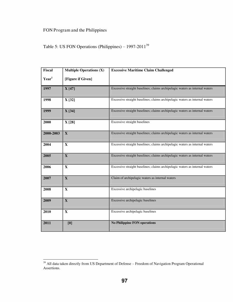
97
FON Program and the Philippines
Table 5: US FON Operations (Philippines) – 1997-201139
39 All data taken directly from US Department of Defense – Freedom of Navigation Program Operational Assertions.
Fiscal
Year1
Multiple Operations (X)
[Figure if Given]
Excessive Maritime Claim Challenged
1997 X [47] Excessive straight baselines; claims archipelagic waters as internal waters
1998 X [32] Excessive straight baselines; claims archipelagic waters as internal waters
1999 X [34] Excessive straight baselines; claims archipelagic waters as internal waters
2000 X [28] Excessive straight baselines
2000-2003 X Excessive straight baselines; claims archipelagic waters as internal waters
2004 X Excessive straight baselines; claims archipelagic waters as internal waters
2005 X Excessive straight baselines; claims archipelagic waters as internal waters
2006 X Excessive straight baselines; claims archipelagic waters as internal waters
2007 X Claim of archipelagic waters as internal waters
2008 X Excessive archipelagic baselines
2009 X Excessive archipelagic baselines
2010 X Excessive archipelagic baselines
2011 [0] No Philippine FON operations
98
The data contained in the table reveal a few interesting trends and facts
surrounding the U.S. FON program as it relates to the Philippines. While there have not
been flashpoint incidents receiving international attention like the Indonesian examples,
there is a clear trend of FON operations directed at the Philippines happening in
significant numbers. The Philippine maritime claims specifically targeted by the FON
program over these years are the archipelagic baselines and the Philippine interpretation
concerning the sovereignty of their archipelagic waters.
For the first year of data reported in Table 5 (Fiscal Year 1997), the United
States military conducted an operational assertion through Philippine claimed waters at
an average of close to one transit per week (forty-seven occurrences). As stated in the
FON reports, these transits were carried out under the respective right of innocent
passage, transit passage or high seas freedom. The three successive years in which
figures were obtained, show a slight decrease from FY 1997, but a rather constant level
of roughly thirty operational assertions a year.
Unfortunately, the change in reporting method in FY 2000 halted the disclosure
of the specific number of operations. The FY 2000-2003 summary report and
subsequent years only identify if more than one operation was carried out against the
respective country in that fiscal year. Thus, this data shows, for ten consecutive years
(FY 2001-FY 2010) for which no hard data are available, the FON program carried out
more than one operational assertion against Philippine claims every year until 2010.
The most interesting and timely discovery in this FON data is that in FY 2011,
the United States conducted zero FON operational assertions within Philippine claimed
99
territory. This does not mean that the United States has changed its position on
Philippines’ maritime claims; the U.S. continues to not recognize these claims. On
January 14, 2011, then Defense Secretary Robert Gates, during a speaking engagement
at Keio University in Tokyo remarked, “A fundamental principle of the United States
virtually since its founding is freedom of navigation. (…) We feel very strongly and it is
enshrined in the UN Law of the Sea Treaty. (…) [This is] An example where it would be
very difficult for us to compromise” (via Youtube, US Department of State – East Asia
& Pacific Media Hub).
However, for the moment it would seem that larger strategic concerns (i.e.
China) and the cultivating of a more prosperous and advantageous relationship with the
Philippines has taken the state off the FON program roster. FY 2012 data was not
accessible at the time of writing, but it would be interesting to see if this trend has
continued. Also it is important to note that, with the passing of RA 9522 (2009), the
Philippines have made their baselines compliant and started on the course of full
UNCLOS compliance.
Bradford (2011: 183) states the key strategic aim of American maritime
operations is “…to sustain credible combat power in the Western Pacific and Arabian
Gulf/Indian Ocean so as to preclude attempts at interrupting vital sea lines of
communication and commerce.” The action of maintaining such a deterrent force is a
useful pawn to be wielded and, should the need arise, could also be deployed as a
proactive or reactionary force. Additionally, as concluded by Bradford:
100
The United States is a resident power in the Indo-Pacific and the free flow of commerce to, from, and within that region is vital to the prosperity of Asia, the United States and the world. Therefore, the United States has clearly established its commitment to sustaining safe and secure sea lanes open to all. (2011: 203)
Concluding Thought
The Southeast Asian area is a fast developing region and expanding on its global
significance. In 2005, American exports to East Asia were worth $169 billion (Kay,
2005: 4). The United States will be eager to maintain cordial relations with their allies in
the area, of which the Philippines are close to top of the list. The two countries share a
mutual-defence treaty, but the treaty does not elaborate on American assistance in
contested jurisdictions (Scarborough Shoal, Spartly Islands, etc) (Kay, 2005: 4). The
Republic of the Philippines is also an officially recognized major non-NATO ally of the
United States (The Economist, April 28, 2012). This relationship will continue to
develop and grow, notwithstanding any disagreement around the Philippines and its
baselines.
The United States has implemented major shifts in its maritime assets in the
region in the last number of years moving them closer to Indo-Pacific sea lanes, and the
U.S. DOD officials have resolved to increase their positions in Southeast Asia into the
future (Bradford, 2011: 183). A Cooperative Strategy for 21st Century Seapower, the
2007 released U.S. strategy contained two key statements, highlighted by Bradford,
which outline the American’s strategic reliance on the sea lanes of Indonesia and the
Philippines:
101
Credible combat power will be continuously postured in the Western Pacific and the Arabian Gulf/Indian Ocean to protect our vital interests, assure our friends and allies of our continuing commitment to regional security, and deter and dissuade potential adversaries and peer competitors.
(…)
We will not permit conditions under which our maritime forces would be impeded from freedom of maneuver and freedom of access, nor will we permit an adversary to disrupt the global supply chain by attempting to block vital sea-lines of communication and commerce. (2011: 185)
Additionally, as the Obama administration enters its second term, the
American foreign policy focus is further transitioning. This shift, widely reported
as a “Pivot to Asia” has been referred to by Deputy Defense Secretary Ashton B.
Carter as a “new, strategic era” (via Youtube, US Department of State – East Asia
& Pacific Media Hub). This phrase would appear to be the buzzword for
rebranding America away from the War of Terror and towards the emerging issues
in Southeast Asia. As explained by the Deputy Defense Secretary to a press
roundtable in Tokyo on July 21, 2012, there are two key points which illustrate the
American efforts to refocus energies towards Asia Pacific:
All the capacity that has been tied up in Iraq and Afghanistan for the last ten years is capacity that we can focus now on Asia-Pacific theatre. That is tremendous capacity. Even though our Defense budget is not continuing to grow as a consequence of our desire to deal with the deficit issues in the United States. In that budget we are shifting the weight of innovation and investment from counter-insurgency type warfare to the kinds of capabilities which are most relevant to the Asia-Pacific theatre. For both those reasons we have abundant resources to make this rebalancing. (via Youtube, US Department of State – East Asia & Pacific Media Hub)
Hence, with such a regional refocusing underway, America seems attentive in
efforts to keep Chinese regional hegemonic aspirations thwarted and beyond reach. In
the face of these efforts, agreeing to politely disagree with the Philippines concerning its
102
maritime claims while reducing direct diplomatic pressure appears to be the current
thrust of American foreign policy. This decision allows the U.S. to potentially benefit
regionally in their efforts to improve relationships with allies and strengthen their
deployed presence of U.S. military personnel.
Indeed, the Philippines and the United States recently reached an agreement to
allow the U.S. military to once again have a foothold in the Philippine archipelago. The
agreement was summarized by a Philippine government official who stated, “the U.S.
will not return to the bases they gave up in 1991, but they will be here regularly and are
welcome here" (The Diplomat, October 16, 2012). The probable explanation for this
type of arrangement can be found in comments made in July 2012 by a Philippine
Presidential spokesperson, rejecting the idea of the U.S. military re-establishing bases on
Philippine soil due to such actions violating the Philippine Constitution (ABS-CBN
News, July 18, 2012).
The direction of American foreign policy and attitude is further reinforced when
taking the Philippine case into consideration. The United States are aware of the status
and progress of the ASL submission issue within the Philippines. Accordingly, the
breathing room afforded the Philippines through the removal of the FON operations is a
minimal risk as the Philippines struggles with their own foreign policy as it relates to
possible ASL submission.
Furthermore, the United States are safe in the knowledge that any ASL
submission by the Philippines to the IMO will be fully exposed to the IMO process. As
discussed, this process will significantly influence the Philippine submission, and the
103
process itself is influenced by intervener states, of which the United States is all but
guaranteed to be one. With respect to the previously explained IMO process, it was
noted that the United States views “continuing and participation in the IMO [as] one key
to ensuring a regime that protects U.S. vital interests” (Galdorisi, 1997: 150).
The People’s Republic of China
The Philippines must also carefully weigh where an ASL proposal would fall
within their existing foreign policy priorities. There are significant disputes in Southeast
Asia between the various ASEAN countries, as well as China, over contested islands,
territorial waters, and the continental shelf. The islands themselves are not the main
prize; rather it is the territorial waters and marine resources (fisheries, natural resources)
which are the true bounty (Royle, 2001, p. 156). China has largely been the instigator
(and antagonist) of these disputes. Dutton (2011: 55) is of the belief that “China is
pursuing three main objectives in the South China Sea and Southeast Asia: regional
integration, resource control, and enhanced security.”
The official Chinese position was stated in May 2009 in official correspondence
to the United Nations which read: “China has indisputable sovereignty over the islands
in the South China Sea and the adjacent waters, and enjoys sovereign rights and
jurisdiction over the relevant waters as well as the seabed and subsoil thereof” (Rahman
and Tsamenyi, 2010: 328).
The Chinese policy around the contested South China Sea involves their recently
well-publicized claim line (identified as a solid red line in Figure 16). This claim line
was for the first time officially expressed and submitted to an international body on May
104
7, 200940 (Bensurto Jr., 2011: 19). However, Beijing has always been rather vague as to
its intentions and the depth and specifics of this claim. Dutton (2011: 45) refers to it as
“a studied policy of ambiguity about the line’s meaning.” Dutton goes further in
identifying “four dominant schools of thought” found in China related to the policy for
basing or explaining their claim: sovereign waters, historic waters, island claims, and
security interests. Having numerous competing strategies being enforced by a wide
range of government departments, military commands and state agencies further
magnifies the lack of clarity (The Economist, April 28, 2012).
Therefore, these strategies are seemingly loosely packaged into Chinese actions
which lend themselves to a type of creeping jurisdiction. Booth defines creeping
jurisdiction as: “the extension of national or international rules and regulations, and
rights and duties over and under the sea, in straits and coastal zones, on and under the
seabed, and in the vast stretches of the high sea” (Booth, 1985: 38). While noting the
Chinese claim line is a static line, it is the state actions within the claim zone where this
creeping jurisdiction is occurring.41 All four of the schools of thought identified by
Dutton, are strengthened by the outward expansion of formalized jurisdiction by the
Chinese state. Hence, it would appear that China has formally pushed out its boundaries
and are now moving to solidify their holdings within this claim zone prior to
international scrutiny.
40 Bensurto Jr. refers to the Chinese claim line as the “9 dash line”. He further distinguishes that in 1949 the Chinese nationalist government of the day issued a map containing a “9-dotted line”. This document lends weight to the Historic Waters ideology identified by Dutton. 41 Tony Walker refers to Chinese scholars terming the Chinese actions in relation to the Spratly Islands as “creeping assertiveness”. See, “The Waters Beyond Mischief Reef”. Financial Times. March 15, 1995. p. 23. These actions have most certainly continued since 1995, leading to a blending of creeping assertiveness aging into creeping jurisdiction in a sense.
105
South China Sea
The entire South China Sea region is filled with overlapping jurisdictional
claims, contested islands and competing continental shelf submissions (Figure 17). This
region, which includes the Scarborough Shoal, is claimed in its entirety by China, and
smaller claims are staked by Vietnam, Malaysia, Brunei and the Philippines. The
background, footing, and standing in international law of each claim are too immense to
discuss here, and are not required to be distilled for this particular case. It is however,
important to note for the purposes of this case, that the respective countries contest each
other’s overlapping claims.42 Therefore, the dispute is a massive study in its own right,
the most complex and pending overlapping jurisdictional claim at this point in time, and
one which I only shall reference to a few specific incidents to illustrate its impact on
Philippine foreign policy and a possible ASL submission.
Mischief Reef Incident
The Mischief Reef (Chinese: Meiji; Philippine: Panganiban) is an atoll, 130
miles from the island of Palawan, which is part of the Philippines Kalayaan Island
Group, itself part of the bigger Spratly Islands within the 200 NM Philippines’ EEZ
(Philippines Daily Inquirer, May 2, 2012). The Philippines’ claim to the Kalayaan
Island Group involved fifty islands within the larger Spratly Islands (Storey, 1999). The
Chinese military occupied Mischief Reef at some point in the monsoon season in 1994,
a season in which the Philippine Navy were not engaged in patrolling the region
(Philippines Daily Inquirer, May 2, 2012).
42 Bensurto Jr. (2011) notes that the Chinese claim was officially protested by the Philippines, Indonesia, Vietnam and Malaysia.
106
The Chinese occupation of the reef first came to Philippine attention after a
Philippine fishing vessel skipper alerted authorities that he and his crew were
imprisoned for multiple days by Chinese military forces at Mischief Reef (Makinano,
1998: 20, as quoted in Storey, 1999). Storey (1999) explains what the Philippines
discovered upon investigation:
Reconnaissance aircraft later confirmed the existence of Chinese structures on the Reef -- four platforms on stilts, with three to four octagonal bunkers on each platform, equipped with satellite communication equipment. Eight Chinese naval vessels were also seen near the Reef.
Facilities that were described initially as four structures were explained by the
Chinese government as “shelters for fishing vessels” (Financial Times, March 15,
1995). The Philippines protested this intrusion into their EEZ, and attempted to seek a
resolution to the issue. The Chinese refused to budge, but the two countries signed a
‘Code of Conduct’, “aimed at preventing similar incidents occurring in the future, and
increasing bilateral co-operation in the South China Sea” (Storey, 1999).
The situation remained static until October 1998, when the Philippines released
“photographs of Chinese vessels unloading construction materials at the reef” (Storey,
1999). Over the course of the subsequent year, China constructed what one recent
Pilipino news article called “a four-story military garrison” (Philippine Daily Inquirer,
May 2, 2012). In September 2012, Philippine news sources reported that photographs
from July 2012 showed significant facilities upgrades had occurred on Mischief Reef
once more. The article included a photo mosaic (Figure 17) from different years
showing the increasing structural footprint and identified “a windmill, solar panels, a
concrete platform suitable for use as a helipad and a basketball court” as the most recent
107
upgrades (The Philippine Star, September 3, 2012). The Mischief Reef continues to be a
lasting reminder to Manila of what must be perceived as the threatening aspirations of
China in the South China Sea. Such a background is fortified by the pattern of Chinese
state actions.
Reed Bank Incident
In March 2011, two Chinese patrol boats forced the survey vessel MV Veritas
Voyager to withdraw from the Reed Bank area; an area within the Philippine EEZ which
is also claimed by China (Storey, 2011: 7). The Philippine General in charge of the
region is on record saying the ship was ordered by the Chinese vessels to stop its
undertakings due to the area being under Chinese jurisdiction (Storey, 2011). The
Republic of the Philippines lodged an official complaint with the Chinese embassy in
Manila; responding to this complaint roughly two weeks later a Chinese Foreign
Ministry spokesperson stated:
China owns indisputable sovereignty over the [Spratly] Islands and their adjacent waters. Oil and gas exploration activities by any country or company in the waters under China’s jurisdiction without permission of the Chinese government constitutes violation of China’s sovereignty, rights and interests, and thus are illegal and invalid. (as quoted in Storey, 1991)
ASEAN Proposal
The Philippines have explored different means to address such regional foreign
policy episodes. As mentioned, in an effort to limit and resolve Mischief Reef, they
signed a pact with China. Another example was in September 2011 when the Philippines
held a regional meeting in Manila with maritime and legal experts from the ASEAN
States to study a Philippine proposal which, amongst other things, advocates for turning
the contested islands into a “zone of peace, freedom, friendship and cooperation”
108
(Associated Press, as reported in The China Post, September 23, 2011). This proposal
has been a non-starter, and all sides remain entrenched in their claims.
Scarborough Shoal Incident
At the time of writing (January 2013), China and the Philippines are locked into
a territorial dispute over the Scarborough Shoal (Chinese: Huangyan Island;
Philippines: Bajo de Masinloc). The Shoal is located within the Philippines 200 NM
EEZ as set forth in international law. However, it is also within the extensive Chinese
dotted line, a horseshoe shaped claim over the South China Sea by China. As in Figure
16, the Chinese claim is illustrated in Figure 18, as the red dotted line, however the
Philippine EEZ is not shown.
This dispute escalated in April 2012, when Philippine fishermen discovered
eight Chinese fishing vessels in these waters which are disputed and claimed by both
countries. The incident which I will detail below was reported by Foreign Policy (April
12, 2012) as “the tensest moment militarily for the Philippines in years.” Additionally,
the Government of the Republic of the Philippines was quoted as stating to the Chinese
ambassador: “[The Philippines was] prepared to secure its sovereignty [in the disputed
areas]” (Foreign Policy, April 12, 2012).
Upon discovery of the Chinese fishermen and vessels, the Pilipino Navy
responded to the area, rather swiftly around April 11-12, with a warship and attempted
to detain the Chinese, under accusations of illegal entry and poaching. (Associated
Press, April 15, 2012). These efforts were hindered and ultimately prevented by two
Chinese patrol boats that had also responded. During the course of the standoff, the
109
Chinese fishermen withdrew during the period of April 14-15 (Associated Press). All
the ships remained in a standoff as both sides were unwilling to withdraw.
On April 25, 2012, a Chinese foreign ministry spokesperson warned the
Philippines, “internationalizing this issue will only complicate and magnify the
situation. (…) We [China] do not wish to see the Philippines get other countries
involved and get them to take sides over the issue” (Agence France-Presse, April 25,
2012). On April 26, 2012, it was reported that the Philippines were interested in
bringing the matter before the International Tribunal for the Law of the Sea (ITLOS) to
mediate the conflict.43 A spokesman for the Chinese Embassy in Manila was quoted in
response:
[The Shoal] is China’s inherent territory on which we have sufficient legal basis. (…) [Manila should] fully respect China’ sovereignty. (…) [The Philippine government must] commit to the consensus we reached on settling the incident through friendly diplomatic consultations, and not to complicate or aggravate this incident so that peace and stability in that area can be reached. (Philippine Daily Inquirer, April 26, 2012)
In retort to the Chinese comments, a Philippine spokesperson stated concerning the
ITLOS process, “we are prepared to do it alone” (Philippine Daily Inquirer).
Al Jazeera: 101 East – ‘Standoff at Scarborough Shoal’
The Al Jazeera current affairs news show 101 East aired an episode entitled
‘Standoff at Scarborough Shoal’ on August 3, 2012. The show reported that the Chinese
fishermen were engaged in poaching sharks and collecting rare corals and giant clams. It
43 In January 2013 the Philippines delivered a Note Verbale to the Chinese indicating that they have requested the tribunal, under Article 287, to rule on the validity of the Chinese claim line within the South China Sea. The Chinese reiterated their position that the ASEAN countries should solve their disputes and not internationalize the issues (even though China is not a member state of ASEAN).
110
further revealed that, after a two month standoff, the Philippine government reported
that both sides agreed to withdraw their vessels and impose a fishing ban.
The Al Jazeera presenter chartered a Philippine vessel to take her out to the
Shoal to investigate the situation. As the vessel approached the Scarborough Shoal, they
found four Chinese patrol vessels, one of which came upon them and ordered them
away. When queried by the Al Jazeera chartered vessel why they were being asked to
leave, the reason radioed back by the Chinese vessel was “Your vessel has entered the
sea area under the jurisdiction of the People’s Republic of China and leave the area
immediately.” The Chinese patrol vessels escorted the Al Jazeera charted Philippine
vessel a full ten nautical miles away, before turning back. It should be noted that the
program (101 East) issued an interview request to the Chinese embassy in Manila which
was declined.
Finishing Thoughts
Rahman and Tsamenyi (2010: 329) conclude in their analysis that China is
coupling longstanding economic and political pressures together with ratcheted up
militarized pressure against other claimant states and regional interveners such as the
United States. The authors view these actions as, “a concerted effort to bolster its
[China’s] strategic position in the South China Sea, returning to a trend that had been
evident since the early 1970s, but which is now enabled by far greater resources and
military capabilities than before” (Rahman and Tsamenyi). The Mischief Reef, Reed
Bank, and the more recent Scarborough Shoal incidents are all blatant examples of what,
111
from the Philippine perspective, is a very difficult and challenging relationship between
regional neighbours.
West Philippine Sea Naming
Philippine President Benigno Aquino III issued Administrative Order 29, signed
September 5, 2012, retitling as the West Philippine Sea, “the Luzon Sea and the waters
around, within and adjacent to the Kalayaan Island Group, which form parts of Spratlys,
and Bajo De Masinloc, which is also known as Scarborough Shoal.” This action was
denounced by both China and Taiwan. A spokesperson for President Aquino III is
quoted in a newspaper article stating: "We've been calling the EEZ as West Philippine
Sea so that should not be an area where should be friction among nations—ASEAN. So
we don't see it as a cause for conflict among ASEAN or our other neighbors” (Sun Star,
September 12, 2012).
Hence, with such volatility in the region, the Philippines must determine whether
they wish to appear to weaken their international relations by ceding their claims on
internal waters in order to submit an ASL proposal.
International Public Opinion & Civil Society Actors
This factor was explicitly identified by Tsamenyi and Mfodwo (2001: 37) who write:
This [factor] clearly has a long range/long-term character and influences both States and international organisations in unpredictable ways. The principal conduit for these diffuse pressures is the internationally active non-governmental organizations (NGOs), with some degree of support from sympathetic governments, international organisations and the mass media.
Whilst most pressure on navigational rules comes from NGOs with an explicit maritime agenda (for eg. Greenpeace and WWF) the influence of NGOs active in other arenas (eg human rights NGOs, animal welfare NGOs, trade and
112
development NGOs) should not be overlooked as these groups also contribute to the overall process of norm change in international law generally.
An excellent example of this type of pressure is the heightened and generalised public concern in all countries with regard to the ecological health of the oceans. In legal and political terms this is evidenced in the growing calls for the application of the precautionary principle to all uses of the sea.
It is clear that in the years since the publication of Tsamenyi and Mfodwo this factor
remains very much in evidence and at play. There is great potential for international
public opinion and civil-society actors to influence any Philippine submission.
Meanwhile the situation here remains tense and can degenerate into a regional military
confrontation.
3.7: CONCLUSION
This chapter has identified and introduced the facts of the case of the Republic of the
Philippines as it relates to UNCLOS. Philippine domestic history around the
archipelagic concept, with respect to national legislation and actions of the executive
branch was presented in a timeline and discussed. Additionally, this chapter highlighted
a 1997 text which presented a case for archipelagic sea lane (ASL) designation in the
Philippines including two technically thought-out ASLs. This is followed by the most
important part of the case: the very recent legislative efforts of Philippine lawmakers to
domestically designate three ASLs. These actions are examined with a specific focus to
identify possible factors influencing the Republic of the Philippines in this process.
113
Chapter Four: Findings and Analysis
The law of the sea is a dynamic phenomenon. While the words in UNCLOS may
remain static, their interpretation will change over time
(Sam Bateman, 2007: 55)
4.1: INTRODUCTION
Bateman’s quote above highlights the significant challenges that still face UNCLOS to
this day. This ‘dynamic phenomenon’ is dependent on one’s interpretation, which as
Bateman forecasts does not remain static over the long run. Add in domestic and foreign
agendas around politics and policy, and it becomes easier to see how murky and gray the
implementation of UNCLOS has been and shall continue to be.
4.2: SCENARIOS
The longstanding assumption was that any submission by the Philippines would stand as
complete due to the density of the archipelago, which severely limits the number of
possible ASLs; but the possibility of a partial designation and its implications were not
anticipated (Batongbacal, 2004: 60). Therefore, the findings and analysis will serve to
illustrate which scenario is most likely to occur.
There are three envisioned scenarios pertaining to the matter of Philippine ASL
submission and adoption by the IMO. The first scenario to review would be a decision
by the Philippines to not go forward with an ASL submission, thus maintaining the
status quo. In the case of a non-submission, as per the UNCLOS Article 53 (12),
114
freedom of navigation on existing routes would be retained by all states: “If an
archipelagic state does not designate sea lanes or air routes, the right of archipelagic sea
lanes passage may be exercised through the routes normally used for international
navigation.” Kaye (2008: 16) notes a non-submission by archipelagic states “is also the
most advantageous position for maritime states wanting freedom of navigation.”
The second probable scenario is a Philippine submission resulting in a
partial regime designation by the IMO. Batongbacal (2004: 55) offers the
following analysis:
The concept of partial designation may be critically questioned. The idea that an ASL designation that does not cover all routes through the archipelago is deemed a partial designation, and does not prevent the exercise of the ASLP in other undesignated routes, renders the designation practically ineffective. No benefit is gained by the archipelagic state in
making a partial proposal and designation, since all routes not
designated are still subject to ASLP anyway. A partial designation is like no designation at all [emphasis added].
The third scenario would be a submission which was fully adopted by the IMO, thus
giving the Philippines the sole distinction of having a full ASL regime. Beckman (2007:
129) notes that an advantage gained through ASL designation is the ability to have
clearly defined routes and to be better able to monitor traffic within these lanes for
vessel-source pollution.
4.3: THE FAILURE OF ACHIEVING THE ARCHIPELAGIC CONCEPT
In weighing all the factors, one vital fact must be strongly considered. There is broad
agreement amongst scholars that the Philippines were not successful in gaining support
and recognition of their territorial boundaries – the very core piece of their internal
115
waters and archipelagic concept (Bautista, 2010: 135). The results of this failure spelled
out by Batongbacal are clear:
The Philippines ultimately has no choice but to implement the
Convention, for non-compliance places it in a far less favourable
position on account of the non-recognition by foreign nations of any action that is inconsistent with the Convention’s rules [emphasis added] (Batongbacal, 2001, as quoted in Bautista, 2010: 136).
Bautista (2011: 48) continues to support Batongbacal’s views, drawing the conclusion
that, “The idea of sovereignty carries a very strong emotional appeal to the
nationalistic sentiments of Filipinos, or to the people of every nation for that matter.
However, obstinately holding on to an idea which does not have a secure basis in
international law is more embarrassing to the Philippine Government.” This point is
further reinforced by Batongbacal in a more recent article. He states, “The International
Treaty Limits are not universally recognized as comprising the full extent of the
Philippine national territory. As far as the world is concerned, our territorial waters end
at 12 nautical miles from each island’s shores” (2008: 3).
4.4: FINDINGS
Hence, the Philippines find themselves currently in a very difficult position. In order to
better appreciate this state of affairs, a review of the findings related to the six posed
research questions is proposed below.
Research Question #1
Will the Philippines enact ASLs?
Bensurto Jr. notes that RA 9522 is the first step of a three step legislative process: the
other two steps being maritime zone legislation and ASL legislation (2012, Slide 7).
116
Additionally, this thesis, has already discussed the fact that the Philippine President’s
priorities as acknowledged through his LEDAC committee include proposed legislation
for both maritime zones and ASLs. Indeed, the bills for these remaining steps
highlighted by Bensurto Jr., the legislating of maritime zones and ASLs, prioritized by
the President, are currently (February 2013) before the Senate Foreign Relations
Committee as highlighted in Chapter Two.44
The evidence found in the research data seems to suggest that the Republic of the
Philippines will move forward to enact ASLs. The twin bills from both Houses,
endorsed and amongst the President’s priorities show that the Philippine Government is
indeed on course. However, it is impossible to say with absolute certainty that these bills
will pass, and that the designation of ASLs will overcome all obstacles to become
Philippine law.
While enacting domestically legislated ASLs can be considered a step forward,
under the terms of UNCLOS, any ASLs must be sent on to the ‘competent international
organization’ that being the IMO for adoption. The research data suggests that the
Philippines do intend to forward their domestically approved ASLs to the IMO.
Research Question #2
How specifically has the Indonesian experience influenced the Philippines in its own
ASL process?
This case has set out to investigate and explain that the Republic of the Philippines and
their actions and decisions surrounding whether to submit archipelagic sea lanes to the
44 The April 27, 2012 Senate Foreign Relations Committee meeting agenda contained the Scarborough Shoal incident (Agenda Item No. 1), Maritime Zone Bills – SBN 2723, SBN 2737, HBN 4185 (Agenda Item No. 2), and ASL Bills – SBN 2738, HBN 4153 (Agenda Item No. 3)
117
International Maritime Organization has been influenced by the Indonesian experience
of archipelagic sea lane submission to the International Maritime Organization.
During the course of investigation there has been no qualitative research data
uncovered which directly and explicitly states that the Republic of the Philippines has
been influenced by the Indonesian case. However, such explicit data would need to be
sourced directly from the Philippine Government in order to lend it legitimacy and
validity. Moreover, such documents, if they were to exist, would do so at a very senior
and highly confidential level.
Hence, given the unlikeliness of unearthing such research data, this case was
designed to use a wide range of data sources in lieu of such documentation. While this
thesis is unable to offer explicit evidence of Indonesian influence, the data uncovered
does offer some indication of probable direct and indirect influence. Having thus
framed this analysis as direct and indirect Indonesian experience influence, how is one
to explain the specifics of these influences?
Patterns of Shared Experiences
When reviewing the experience of Indonesia and the Philippines, there are some
major patterns which can be extrapolated. It is clear that the concession of maritime
sovereignty for defined archipelagic sea lanes has been a divisive issue for both states.
While not debating the reality and viability of the maritime sovereignty these states
claim, regardless of its legality, their sovereignty has been deeply enshrined into the
individual and collective psyche of the peoples of Indonesia and the Philippines.
118
Both states fought long and hard in their efforts for international recognition for
their archipelagic concept. This concept is closely tied, in both cases, to the nationalistic
narrative of independence. Each of these states has a comparatively short history of
independence, one which stretches just past the start of the UNCLOS process. Hence,
the memories and feelings around the gains of independence are still quite fresh.
Once independent, Indonesia and the Philippines were proactively working
through their respective Parliaments to enshrine their archipelagic concept and maritime
sovereignty in national legislation. During the course of the UNCLOS conferences
Indonesia and the Philippines were the two archipelagic states who worked
collaboratively and tirelessly to advance the idea of the archipelagic concept. They were
joined by other archipelagic states (Fiji, Mauritius) for UNCLOS III to passionately
represent, advocate and criticize in the name of the archipelagic concept; however, the
archipelagic torch was clearly carried for many years by Indonesia and the Philippines
alone.
Indonesia weighed the perceived benefits, while not necessarily anticipating a
‘partial regime’ and decided to go ahead with an ASL submission. The Philippines is
currently found in a very interesting position which appears to be leaning towards a
formal submission to the IMO. I must surmise that this pattern of shared experience has
influenced this case.
Republic of the Philippines comment on the IMO Indonesian Process
Secondly, the Philippines did interject during the Indonesian process, arguing it
represented a one-off and not a precedent, and refused to be bound by that process or its
119
outcome. The Philippines also wish to reserve the right to suggest changes to the
GPASLs in the future. To reserve the ability to amend the GPASLs seems to be a
fallback position should the Philippines be bound to the IMO process followed with the
Indonesian submission. Such an action would appear to weaken the Philippines’
objection in the first place. Additionally, with respect to the fight to not follow the IMO
process, it would seem very unlikely that the Philippines will win such a battle in the
court of international opinion and the halls of the United Nations. Regardless, these
interjections can be viewed as a direct influence on the Philippine case.
IMO Influence
It is clear from the research data that the mid-ocean archipelagic states did not
foresee the rise of a partial regime. The literature further reveals the role which this
regime plays in altering the UNCLOS landscape and tilting it in favour of the maritime
powers. This is owing to the fact that as interveners, interested states are able to
influence the end product of a formal ASL submission by a mid-ocean archipelagic
state. Such influence I recognize as a by-product of the Indonesian case, as Indonesia
was the first mid-ocean archipelagic state to formally submit proposed archipelagic sea
lanes to the IMO.
As previously noted in this thesis, American foreign policy in Southeast Asia,
while being driven by apparent Chinese hegemonic aspirations, is leading to a closer
military relationship with American regional allies, specifically the Philippines. The
easing of hard power diplomacy, such as the FON Program, is transforming into soft
power, made easier by the Philippine desire for semi re-establishment of American
military assistance and security guarantees.
120
Applying the IMO influence to the Philippine case, this transition illustrates
shifting foreign policy concerns of both the United States and the Philippines
respectively, with the added failsafe, or incentive, for America of the IMO influence
variable for any Philippine maritime policy pursuits (designating ASLs). That being
said, it appears that the evidence supports that the Republic of the Philippines are
confident in the belief that they can subvert the IMO influence variable by means of
setting their national house in order and domestically designating ASLs before bringing
these forward as a complete package. This belief is supported through the Philippine
opinion, dating back to the Indonesian case, that the IMO has no role or authority to
alter submissions. This would seem to be the second pillar of which the Philippines hold
to the belief of avoiding any influence from the Indonesian experience.
It should be noted that this was the same opinion held by Indonesia during its
own submission. Indonesia argued this position after submitting its domestically
approved proposal. The end results of the Indonesian case which were quite
unfavourable to Indonesia were of course the unforeseen ‘partial regime’ being enacted.
As a signatory state to UNCLOS, the Philippines are obligated to conform, this
conversion occurring in a stand-alone forum of the IMO, as governed by international
interpretations of vague references in UNCLOS. It is clear that the Philippines are still
viewed with great importance by the IMO. The current Secretary-General of the IMO
took office on January 1, 2012 and his first official mission to a Member State was to
the Philippines in early February (IMO Press Release, February 9, 2012). While the
official IMO press release concerning the visit did not directly mention ASL issues, the
release affirmed support “…in all facets of the country’s maritime development” (ibid).
121
The path forward chosen by the Philippines appears to be an ASL submission to
the IMO for adoption. But, the simple example of the birth of the GPASL and the
‘partial regime’ should serve to demonstrate the unpredictability from a mid-ocean
archipelagic state’s view of this entire exercise.
Consequently, I feel the Philippines have long been influenced by the Indonesian
experience, stretching as far back as their stated objections to Indonesian process and
precedent. This direct influence stems from the interjected objection, influencing a
belief that this on-the-record objection will merit them a clean slate. Adamantly
convinced they shall be a fresh, stand-alone case for IMO consideration, there is further
influence, in the form of the rather confident Philippine position, that the domestically
legislated ASLs will be adopted by the IMO without amendment. Be this as it may, I
remain rather skeptical of the Philippine ability to avoid the IMO influence variable in
the course of formal ASL designation. Thus, I think the Indonesian experience shall
indirectly influence the Philippine case in the form of future IMO influence to any ASL
submission. For these stated reasons, it is my belief that the Indonesian experience has
both directly and indirectly influenced the Philippines case.
Research Question #3
What additional factors are influencing the Philippines?
These additional factors have been extrapolated from the research data, and represent a
substantial composition of converging evidence. This interconnecting trait can be
attributed as the ‘archipelagic effect’ of maritime policy in the Philippines.
122
Full UNCLOS Compliance
As this thesis has identified, the Philippines have a few interconnected issues
relating to UNCLOS, including the designation of ASLs. Designating ASLs is but one
component of the larger matter of the Philippines becoming compliant to UNCLOS.
Furthermore, while ASL designation is non-compulsory, the other issues such as
baselines (addressed in RA 9522) are in fact mandatory. The legality of the Republic of
Philippines’ position is questioned by Bautista when he points out:
once a state expresses its consent to be bound by an international undertaking, that state must comply with its obligations arising from that undertaking in good faith. This is embodied in the international legal principle of pacta sunt servanda, codified in the Vienna Convention on the Law of Treaties, which in Article 26 states: ‘[e]very treaty in force is binding upon the parties to it and must be performed by them in good faith.’ Thus, the Philippine Government is obliged to observe this rule vis-à-vis its commitments under the LOSC [UNCLOS] (2011: 46-47).
The Republic of the Philippines issued a declaration on October 26, 1988 which
indicated that it will abide by UNCLOS and that the Republic is indeed intending to
uniform its domestic legislation with UNCLOS, and furthermore, will be legislating
ASL passage in the future (Lotilla, 1995, as quoted in Bautista, 2011: 45).
Baselines/Territorial Boundaries
Encomienda makes reference in 2009, to efforts to pass updated and compliant
baseline legislation (which ultimately passed and became RA 9522) as “clear proof that
we want and we are in the process of complying with UNCLOS” (2009: 460). Bensurto
Jr. corroborates this in 2012, noting in his presentation that RA 9522 is “significant” and
illustrates a move towards “complete adherence to UNCLOS” (Bensurto Jr., 2012: Slide
123
7). Given the two men’s positions within the Republic of the Philippines45 the validity
and credibility of this data is strong. The continuity of their message and positions,
which seems to parallel the current presidential term of Aquino III, is also important. In
examining the actions and statements of key Philippine officials and legislators it would
appear that the Republic of the Philippines intends to become fully compliant with
UNCLOS in the near future.
Constitution definition including Internal Waters
Having assurances that the Philippines intends to fully comply with UNCLOS,
the last major domestic legal hurdle remains that of the Constitution. The Constitution
opens with an unambiguous statement that the waters of the Philippines are internal
waters. As shown in a previous chapter, this branding is very much inconsistent with
UNCLOS.
Given that maritime zone legislation is currently before the Senate Foreign
Relations Committee, I must surmise that this legislation will adequately comply with
UNCLOS in its designation of the maritime zones of the Philippines. While my
research has failed to identify the exact method as to how the Republic of the
Philippines will reach a solution to their Constitution, such tinkering is an inflammatory
exercise at the best of times. Thus, I strongly doubt that the Philippines would choose to
rekindle the divided domestic opinion through a full opening and amending of the
national Constitution. It will be interesting to see how the Philippine Administration
brings the Constitution into UNCLOS compliance.
45 Encomienda is identified as the then: Secretary-General, Maritime and Ocean Affairs Center, Department of Foreign Affairs, Republic of the Philippines (2009, Page 393). Bensurto Jr. is identified as the then: Secretary-General, Commission on Maritime and Ocean Affairs Secretariat (2012, Slide 1).
124
Environmental Concerns
This factor stands both on its own merit, and can also be connected to the
forthcoming factors of “Routing Concerns” and “Time & Expense for ASL Proposal.”
Bensurto Jr., highlights the growing concern of marine environment protection as the
key trigger for government action to designate ASLs through legislation:
If the Philippines does not designate, MPAs would be vulnerable. Thus, it is better for the Philippines designate ASL in order to protect MPAs by limiting the area covered by ASL. Indeed, this was one of the rationale behind the designation of ASL so as to avoid as many MPAs and Fishery areas as possible (2012, Slide 50).
He further reinforces the importance of environmental protection, citing it also as the
reason why the Philippines has chosen to act immediately by legislating ASLs
domestically, rather than by first going through the IMO process:
It is precisely because of the urgency of providing protection to the country’s marine biodiversity and corals that the procedure under Article 53.9 should not be looked at as something that prevents the archipelagic state from exercising its substantive and inherent right to protect its marine resources for its people. This is state-preservation (2012, Slide 55).
Therefore, “Environmental Concerns” is having a dual influence on the Philippines.
Firstly, it would seem to be the main cause for government action on this issue; and
secondly, it also is the stated primary catalyst for the urgency of government action. It is
evident that the Philippines, like Indonesia, will desire to keep the number of ASLs
through its archipelago to an absolute minimum. Beckman (2007: 127) supports this
position arguing that it is likely to be defended by the Philippines under the auspices of
environmental considerations. As such, the factor of ‘Environmental Concern’ appears
to be significantly influencing the Republic of the Philippines and the ASL issue.
125
Domestic Public Opinion
The Philippines has found the issues of ASL designation and the larger context
of UNCLOS compliance to be quite contentious, dating back to the negotiations. Indeed,
the government undertook the unprecedented step of a stated objection while signing
UNCLOS, indicating that the Philippine position of sovereignty over its waters was
unchanged. Such a step, identified to ease domestic opposition, starkly highlights how
difficult consensus has been to locate and achieve.
Mr. Anders Sjaastad, Senior Advisor at the Norwegian Institute of International
Affairs (NUPI) offered this observation in relation to South-eastern Asian States: “…for
some of the littoral states that can still remember their colonial past, the principle of
sovereignty is sacrosanct and any arrangement or action, which could be seen to
undermine it, is taboo” (2005: 7). It is has been conceded by Philippine state officials
that divided opinion exists; indeed it would be next to impossible not to recognize this
factor. “Divided Public Opinion” has influenced this case for well over four decades.
Nonetheless, given the recent actions of the Philippines, it appears that while the state
acknowledges divided public opinion, it has made the decision to push forward
regardless. Taking that qualifier into account, “Domestic Public Opinion” has the future
possibility of influencing the Philippine case, as it has done previously.
Time & Expense for ASL Proposal
On the surface, it is difficult to ascertain the preparatory work and cost incurred
in working up the ASLs contained in the currently debated legislation. However, the
embodiment of this factor is the adage “do it once, and do it right.” It is clear through
the data that the Republic of the Philippines has thought long and hard about ASL
126
designation and submission. While internal government information concerning
expenditures and human resource allocation are not contained in my data, it is telling
that the current administration has made the larger matter of UNCLOS compliance and
the concurrent issue of ASL designation a priority. Given this distinction, I must accept
that the President and the government have invested required levels of resources into
developing these lanes. Furthermore, dating back to previous administrations, I would
propose that since the ratification of UNCLOS in 1994, continuing through the
Indonesian experience and also the 1997 proposal, that preparatory work would have
been undertaken if not externally, then most certainly internally, to mock up the various
scenarios facing the Philippines with ASLs.
When I consider the factor of “Time & Expense for ASL Proposal,” I view it as
only being possible to influencing the case in a cautious, delaying fashion. However,
since Philippine officials have indicated the challenges faced by such a divisive public
opinion, I would argue that the short-term political implications have played a larger
role in the delayed fate of the Philippine case, as opposed to various administrations
taking the ‘Time & Expense for ASL Proposal’ into consideration.
Since ASLs have been identified, included in Presidential priorities, and are
before the Congress currently, I am led to suppose that all due diligence has been
completed. On this probable assumption, I must also believe that all necessary
preparatory work, technical activities and engagement exercises would be included in
such due diligence. Therefore, while the data is unable to determine conclusively, it
would seem that there was significant influence surrounding “Time & Expense for ASL
Proposal” prior to the 2011 tabled legislation in the Philippine case.
127
Routing Concerns
This identified factor ties very closely into the preceding factors “Environmental
Concerns,” “Time & Expense for ASL Proposal” and as well the succeeding factor
“Inter-Island Transport/Domestic Economy.” The research data reveals two sets of
ASLs publically proposed in the Philippines. While one set (1997ASL Proposal) was
put forth in text by seemingly informed experts, the second set (2011) is found in the
currently pending legislation. Therefore, in order to analyse any influence around
routing concerns, the most logical approach would seem to be to compare the two sets of
ASLs.
For starters, it is worth pointing out that, of the three 2011 routes, only one
appears identical to a proposed 1997 route (ASL #2). Next, ASL #3 the North-South
route, contains one leg that appears identical as proposed in the second 1997 route,
while the routing south of Panay Island is different in the two proposed routes (1997 &
2011). Thus, this leads me to conclude that the routing change is due to an output of
preparatory work. Additionally, ASL #1, the East-West route in the Luzon Strait, only
appears in this research within the outstanding proposed legislation. Examined closer,
there are two smaller east-west straits running between various Philippine islands in the
larger Luzon Strait. Hence, there has most certainly been “Routing Concerns” taken into
consideration to choose one over the other. Clearly there would seem to be a great deal
of work which has gone into taking numerous concerns, opinions, and considerations
into account while developing the now proposed ASLs. Thus, the combination of these
developments around routing illustrates that factoring ‘Routing Concerns’ has
influenced the Philippine ASL issue.
128
Philippine National Marine Policy (1994)
As discussed in Chapter Three, one of the core criteria found within the
Philippine NMP is: “Implementation of the LOSC [Law of the Sea Convention] must be
consistent with national interests as prescribed in the NMP.” Therefore, as an ASL
submission is optional, the NMP is primarily concerned with any Philippine compliance
to UNCLOS being carried out in the best interest of the State. It is evident that, over the
course of development, the authors of the NMP would have consulted extensively with
stakeholders and experts to produce sound, tight policy. Also taking note that this policy
decree occurred the same year as UNCLOS came into force (1994), this policy was in
all probability laid down to guide any future courses of action chosen by the Republic of
the Philippines.
Moreover, the overwhelming viewpoint of the vast majority of the research data
indicates that becoming UNCLOS compliant is the best course for the Philippines. By
embracing UNCLOS, the Philippines passed RA 9522 which provides recognized
baselines which demarcate a larger national territory than under the Treaty of Paris
(1898) limits. As Justice Carpio’s decision in G.R. No. 187167 (Prof. Merlin
Magallona, et al. v. Eduardo Ermita, et. al.) found: “RA 9522 is therefore a most vital
step on the part of the Philippines in safeguarding its maritime zones, consistent with the
Constitution and our national interest.” As admitted by officials, the pending legislative
pieces that enact maritime zones and designate ASLs are the next steps in UNCLOS
compliance that seek to meet the terms of the NMP and by extension the national
interest of the Republic of the Philippines. In the clear efforts to champion and abide by
the NMP and the action of becoming UNCLOS compliant and designating ASLs,
129
reinforced by the unanimous ruling of the Supreme Court of the Philippines, I must
theorize that the ‘Existing National Marine Policy’ has influenced the Philippine case.
Inter-Island Transport/Domestic Economy
This factor, as already stated, is closely tied to the factors of “Routing Concerns”
and by the aforementioned linkage identified through the “Time & Expense of ASL
Proposal” factor. The factor of “Inter-Island Transport/Domestic Economy” is
heightened by the almost total reliance of the Philippines on marine-based domestic
movement of goods. Given the large number of fishers operating within Philippine
waters, as well as the importance of prescribed lanes, the integrated, safe management of
marine users becomes obvious.
This connection to “Routing Concerns” owes in no small part to the illustrated
variance between the 1997 and 2011 proposed ASLs. These changes would have come
about for a variety of reasons, which can be interrelated with fair likelihood to
“Environmental Concerns” and “Inter-Island Transport/Domestic Economy.” This
explanation attests that “Inter-Island Transport/Domestic Economy” has influenced the
Philippine case.
Regulatory & Enforcement Capacity
The Philippines is required upon designation of ASLs to properly protect and
regulate these lanes as well as to have the ability to enforce these measures. As noted
when discussing international law, the burden of enforcement falls to the affected state,
and there is no obligation for any state to take action. Also UNCLOS, Part IV places a
further onus on the archipelagic states if designating ASLs, to ensure that they are safe
130
by regulating traffic and invoking traffic separation schemes if necessary. The evidence
shows that “Regulatory & Enforcement Capacity” has definitely influence this case, and
will continue to.
Political Geography
To begin, this case has identified “Political Geography” in the context of
international level, external influence. However, prior to analysing this factor in the
external setting, scrutiny must be paid to its relationship to other already reviewed
influences. The factor of “Political Geography” is intricately woven into many of the
previously identified and analysed domestic influences. In fact, this factor should be
recognized as both a state level and international level influence. Arguments can be
made that it domestically links directly to “Routing Concerns.” Given the strategic
location, from a domestic perspective, the routing of possible routes must make sense at
the local, national and international level. Additionally, “Political Geography” very
much factors into internal Philippine foreign policy decisions.
On the strictly international level, the “Political Geography” of the Philippines is
a huge consideration for regional foreign policy in Southeast Asia as much as for any
other state. On this basis, “Political Geography” is interconnected to all the regional
foreign policy agendas of other states termed as external influences in this case. Hence,
“Political Geography” is studying the intersection of geographical and political
considerations; the two substantive issues of the Philippines case. This leads me to
identify “Political Geography” as the main conjoining factor, significantly influencing
this case.
131
Physical Geography
Within the Philippine case, physical geography can be observed to have
previously been included in the factors of “Routing Concerns” and to what I would
argue a slightly smaller extent of “Environmental Concerns.” No two archipelagos are
alike. Granted, UNCLOS offers loose parameters in order to group them into a
distinctive category. However, as pointed out many times in the data, the “Physical
Geography” of the Philippines presents a unique set of challenges relating to ASLs,
specifically as I noted in Chapter Three, pertaining to the condensed concentration of the
islands. The impact of this is through the spatial inability to site ASLs in many of the
straits in the Philippines. This, therefore, places a quantifiable limit on the viable
number of ASLs that can be designated. So, in this manner, “Physical Geography” has
already and will continue to influence this case.
International System Influences in Southeast Asia
Chapter Three notes there are a number of state actors operating in the Southeast
Asian region exerting possible influences on this case. The ones of main interest and
thus highlighted in the case include China, Australia and the United States. There is also
a major regional intergovernmental organization (ASEAN) in which all states including
the Philippines (but not China) hold membership.
Association of Southeast Asian Nations (ASEAN)
Prior to reviewing the state actors, it is prudent to first look more closely at
ASEAN. This organization is the primary platform for regional diplomacy, and acts as a
counterbalance to China. Broadly, it is where discussions around the disputed islands of
the South China Sea occur amongst the neighbour claimant states. In the context of this
132
case, it was mentioned that ASEAN was the venue for the attempted resolution of the
Mischief Reef incident, and the Philippine shared sea/zone of cooperation proposal.
However, as both these examples illustrate, ASEAN is a venue for ideas and discussion
and is limited by that mandate. For this case, ASEAN does not have a large role to play
concerning ASLs, but is involved through the regional tensions which themselves are
influencing this case. Since ASEAN is unable to resolve these tensions owing to the
vested national interests of all the state parties, ASEAN has not had an influence on this
case.
Theoretically, ASEAN could influence this case, in the event that the issue of
Philippine ASLs becomes an overriding regional matter. Yet, this is a doubtful course of
action, since Philippine compliance to UNCLOS would only help to strengthen their
case to the international community for the Scarborough Shoal and the KIG. Further,
ASEAN member states are hesitate to engage China on behalf of any other state, as each
ASEAN member has its own priorities, claims and foreign policy agenda. Therefore, it
is not likely any other ASEAN states will be pressuring the Philippines around this
issue, and ASEAN should continue to be a non-factor in this case.
Australia
While Australia is predominately dependent on the Southeast Asian marine
shipping routes, it is more intertwined to Indonesian than the Philippine routes owing to
physical geography. In addition, in the last number of months we have seen the Obama
administration shift their foreign policy focus towards Asia-Pacific, and the Gillard
government has warmed to a closer security relationship with America as a result. The
research suggests that Australia to date has not influenced the Philippine case.
133
Furthermore, the projection of American regional hegemony means that Australia stands
little chance of influencing the Philippine case into the future.
The United States of America
The United States have had a long and direct relationship with the Philippines.
This relationship has evolved from colonial power to hegemonic security protectorate to
regional ally. As the main strategic ally in the region, the Philippines was previously
home to major US military bases for decades, and after a divorce of more than two
decades, recently welcomed back a semi-permanent American military presence. In the
context of this case, the U.S. have actively opposed the archipelagic concept during the
UNCLOS process, the Philippine baselines prior to RA 9522 and the Philippine claim of
internal waters within their baselines. This opposition took the form of diplomatic
protest and also the FON program.
These recent developments, discussed further in Chapter Three, indicate that the
Americans are once again going to play a vital, on location role in Philippine regional
security in Southeast Asia. This is one major aspect of the American foreign policy shift
towards the Asia-Pacific. Also given the strong allied association between the two
states, it would appear that the U.S. is poised to play a leading role in Philippine foreign
policy in the future. The United States has and will continue to influence this case.
The People’s Republic of China
China has been the most prolific source of episodic influence around this case in
the period following UNCLOS entering into force. As the extensive section in the
preceding chapter outlined, there have been a number of incidents between the
134
Philippines and China in the contested South China Sea. These incidents have a direct
influence on this case because of their temporal and spatial dimensions. The continual
pressure which Beijing has ratcheted and applied to Manila has flared up the already
divided issue of jurisdiction and sovereignty over Philippine waters. The Mischief Reef,
Reed Bank, and Scarborough Shoal incidents have all occurred within the Philippine
maritime jurisdiction of its UNCLOS mandated Economic Exclusive Zone (EEZ).
The Chinese seem intent on strengthening their hold over the South China Sea.
As noted, there appear to be multiple paths proposed with the many branches and organs
of the state on how to proceed. While the ambiguity of official policy remains as cloudy
as international law itself, state actions would suggest a “possession is nine tenths of the
law” belief, in essence a case of effective occupation. It is a possibility that these factors
will produce a scenario of a Chinese effort, similar to the archipelagic states with the
archipelagic concept, to secure international support for their South China Sea holdings
through recognition into customary international law.
In addition, the reintroduction of an American military presence (albeit semi-
permanent)in the Philippines will evoke a Chinese response. These two powerful states
and their actions will ultimately play a large role in the future of this case. This data as a
result leads me to conclude that Chinese influence has been long-standing and shall
continue in this case.
135
International Public Opinion & Civil Society Actors
This external influence ties into the factors of ‘IMO Influence’ and
‘Environmental Concerns’. As related to ‘IMO Influence’ during the UNCLOS process,
the archipelagic states failed in their efforts to sway international public opinion for
recognition and acceptance of the archipelagic concept. A second feature connecting to
‘IMO influence’ is the stated belief of the Republic of the Philippines that the most
crucial test, for what they hope are their soon-to-be domestically legislated ASLs, is to
command respect from the international community.
Secondly, there is the direct association with ‘Environmental Concerns’
Tsamenyi and Mfodwo (2001) cite the ecological well-being of the oceans as their
example when identifying this factor. Thus, the most likely scenario for influence would
seem to involve environmental considerations. The plight of the marine environment has
become engrained in the lexicon of citizens, policy makers and pundits throughout the
international community. This suggestion is greatly validated by Encomienda’s PSSA
proposal and Bensurto Jr.’s indication that environmental protection is the main
reasoning behind ASL designation. Taken all together, these strands indicate that
‘International Public Opinion & Civil Society Actors’ have significantly impacted the
Philippines case and will continue to do so.
The Influence of International Law
After careful consideration, there is one significant influence which this case has
yet to formally account for and analyse. This is the influence of “International Law,” an
influence that outshines all others previously identified and analysed.
136
The efforts of the international community to address the legality of many
maritime matters in the post-World War II period, was to be the first significant effort at
a universal doctrine for the maritime area of international law. Wight (1978: 108)
defines the purpose of international law as “to define the rights and duties of one state,
acting on behalf of its nationals, towards other states.” Therefore, it can be argued that
international law (UNCLOS) represents the starting point for interpretation, foreign
policy direction and diplomacy.
It has been noted that international law is quite decentralized and
“overwhelmingly the result of objective social forces” (Morgenthau, 1993: 256).
Morgenthau also advises that international law “owes its existence and operation to two
factors, both decentralized in character: identical or complementary interests of
individual states and the distribution of power among them.” The dispersing traits found
in the international law carry down into the three components of legal systems:
“legislation, adjudication, and enforcement” (Morgenthau). Morgenthau keys in on three
main areas concerning the legislative component of international law: the usage of
vague wording, the openness in interpretation (magnified by this vagueness), and the
binding force (or not) applied to signatory states. Looking specifically at the issue of
vagueness, Morgenthau writes:
For such documents, in order to obtain the approval of all subjects of the law, necessary for their acquiring legal force, must take cognizance of all the divergent national interests that will or might be affected by the rules to be enacted. In order to find a common basis on which all those different national interests can meet in harmony, rules of international law embodied in general treaties must often be vague and ambiguous, allowing all the signatories to read the recognition of their own national interests into the legal text agreed upon (ibid: 260).
137
Moving onward to the component of adjudication, three important matters
highlighted are, most importantly, the scope and mandate of the jurisdiction of legal
system, as well as the organizational structure of the legal system and the ramifications
of legal decisions (Morgenthau, 1993: 262). The judicial body with jurisdiction for
UNCLOS is the International Tribunal on the Law of the Sea (ITLOS). Immediately,
one must recognize there is a limitation of jurisdiction with ITLOS, to only the signatory
states of the Convention. Also any cases are only brought forward upon agreement from
all affected parties, and there is a lack of legal linkage with other courts or the
International Court of Justice (ICJ).
The final component of legal systems is enforcement of any judicial decisions.
There is most definitely a challenge to small or less powerful states when it comes to
enforcement. The principle of law enforcement in international law is that while the
victim has the right to enforce, no state has the obligation to enforce (Morgenthau, 1993:
266). Hence as explained by Morgenthau (1993, 266), “The small nation must look for
the protection of its rights to the assistance of powerful friends; only thus can it hope to
oppose with a chance of success an attempt to violate its rights”.
This assistance is weighed against national interest of the power (larger state),
political (domestic and foreign policy) concerns and a sizing up of the situation
(Morgenthau, 1993: 266). As this case has shown, the Philippines have lived this
nightmare specifically in the context of Chinese expansion into their EEZ, and the warm
and cool (and warm again) security relationship with the United States to combat this
encroachment.
138
The challenges found in international law in relation to the case are best
summarized by a very telling paragraph in Morgenthau’s cornerstone text:
Governments, however, are always anxious to shake off the restraining influence that international law might have upon their foreign policies, to use international law instead for the promotion of their national interests, and to evade legal obligations that might be harmful to them. They have used the imprecision of international law as a ready-made tool for furthering their ends. They have done so by advancing unsupported legal claims and by misinterpreting the meaning of generally recognized rules of international law. Thus the lack of precision inherent in the decentralized nature of international law is breeding ever more lack of precision, and the debilitating vice that was present at its birth continues to sap its strength (1993: 259).
Analysis
The future is not certain for the archipelagic concept under UNCLOS and the ASL
regime. A 2006 conference hosted by the United States Naval War College, posed the
question of long term (2020) stability of the ASL passage regime, to forty-two attending
legal experts from various states: “51% did not believe [ASL] passage would remain
stable” (Kaye, 2008: 2). In relation to this shared view, Bateman’s (2007: 1) views are
insightful; the belief that the regional tensions and domestic political influences of East
Asia will cause state practices to differ from traditional interpretations of law; indeed he
terms East Asia as “critical” going forward in the form and design of any international
Law of the Sea.
139
Research Question #4
What are the implications of these findings on the Philippines?
Implementation Rival Theory (Parallel Streams)
This case is a multiple case of two linked processes: Philippine designation of ASLs
accomplished by means of domestic legislation; and, international recognition of
Philippine ASLs through adoption by the IMO.
This aspect of this case can be identified as a possible implementation rival
theory. The rationale behind this reasoning has to do with the order in which these two
processes are occurring. The Republic of the Philippines has made the explicit choice to
conduct a domestic process prior to any formalized international exposure, thus
introducing international influences more so towards the end rather than closer to the
beginning. As such, I believe once this process reaches the international level, that the
result will be a parallel reflexive exposure to the majority of these factors once again.
This exposure exercise will be facilitated by the IMO and involved the states prior
branded as influences in this case, in their roles an intervener states.
Once again, to restate, this theoretical offering is strengthened and I would argue
validated by the analysis of my first and second research question. The Indonesian
experience involved a first process of Indonesia domestically designating ASLs after
careful consideration of numerous factors (Table 1), followed by Indonesia taking these
lanes to the IMO and being exposed to significant influencing factors (“IMO influence”:
intervener states, the introduction of GPASLs) with the end result being that of a “partial
regime.” Furthermore, the partial regime forces Indonesia to be susceptible to external
140
influence with a requirement to enact a fourth lane (East-West) hanging over its head,
and mostly definitely, as a result influencing domestic factors yet again.
Realist View of International Law
Moving this analysis up or back once more, depending on your perspective, we
can apply this theory to the actions of the archipelagic states in the setting of the entire
thirty year period of UNCLOS. For this particular period, the archipelagic states began
negotiations with a firm position of the archipelagic concept, the result of external
influences including independence, and domestic factors which were manipulated as a
result of external influences (the easiest example being independence). This archipelagic
concept developed at the state level, was then exposed to the international level through
UNCLOS negotiations. After working through the international level influences, the
archipelagic concept was not readily accepted. This response led the archipelagic states
to enact domestic legislation to strengthen their archipelagic concept, prior to it being
bumped back up to the international level in the next round of UNCLOS. This cycle
illustrates another example of the implementation rival theory for archipelagic states and
the Law of the Sea.
Research Question #5
What are the implications of these findings on other mid-ocean archipelagic states?
The issue of ASL submission for other mid-ocean archipelagic states has the potential to
be as difficult as it has been for Indonesia, and for the ongoing Philippine case. One
specific matter which would need addressing by the respective archipelagic states is the
matter of baselines which obey the criteria outlined in UNCLOS, Article 47. This matter
141
is at issue for states such as Cape Verde, the Dominican Republic and the Maldives,
which as previously mentioned have enacted non-compliant baselines.
Furthermore, the remaining mid-ocean archipelagic states must weigh the benefit
of archipelagic status should they choose to claim it and subsequently enact compliant
baselines. Once settling the issue of baselines, only then can archipelagic states look to
address further UNCLOS matters such as the choice to designate and seek IMO
adoption of ASLs. This all being so, it can be said that Indonesia and the Philippines can
be considered the two most pressing cases in relation to the international system given
their political geography and their long-standing historical positions.
This as such, a comment as to the implications on the larger international system
is warranted as well. The primary interested parties are those connected to the IMO
process; the intervener states and the IMO itself. The reasoning for this is rather simple.
As this thesis has laid out above, the one maritime user group specifically targeted and
therefore affected by ASL adoption are warships.46 Thus, while commercial marine
traffic is guaranteed ASLP with or without designated ASL, restrictive conditions are
attached to warships upon the adoption of ASLs.
Therefore while certainly having an interest in this case, the international system,
outside of major maritime powers and their respective navies, is not fully vested upon
the outcome of Philippine ASL designation and IMO adoption. As such, the
implications on the greater international community would appear to be rather clear. The
46 This is owing to the fact that the designation of ASLs restricts all maritime traffic to these lanes with strict restrictions on military activities mirroring the restrictions of transit passage. All traffic is confined only to these lanes, whereas in the absence of designation, a much less concise and more open to interpretation section, ‘routes normally used for international navigation’ (Article 53[12]) absent of conditions is used.
142
acts of ASL designation and adoption are of interest to the international community;
however, these acts are of most concern those states affected by them, the major
maritime powers and the particular mid-ocean archipelagic state.
4.5: CONCLUSION
The most-likely scenario for the Republic of the Philippines based on the implications of
this analysis is as follows. In all likelihood, the Philippines will go forward to the IMO
with its three domestically designated ASLs as a complete package in their eyes. Firstly,
the Philippines will submit this package and indicate that this is the extent of its
submission due to “Environmental Concerns.” The “IMO Influence” of the IMO itself
and the intervener states will with high probability reject this outright. This will force
the Philippines to argue its case that the IMO has only the mandate to adopt, not amend
any archipelagic state submission. The Philippines will fight the same battle as
Indonesia did in the previous century. Given the evidence collected, the Philippines may
be likely to lose this debate.
The Philippines shall then point to its objection during the Indonesian process
and request a new, unique process. Again, it would seem this argument is likely to fail.
The next most logical fallback will be the Philippines turning to its interjection during
the Indonesian process, that the Philippines have reserved the right to amend the
GPASL. While I choose not to speculate on the outcome of this last particular point, the
main implication drawn from these findings is that the Philippines will still be
forced to endure influence from many factors, the probable results of which will be
a request for additional ASLs and, depending on the outcome of that request, a
143
partial designation of the Philippines submission by the IMO (thus rendering the
three domestically legislated ASLs powerless).
144
Chapter Five: Conclusion
“We are the sea, we are the ocean, we must wake up to this ancient truth and together use it to overturn all hegemonic views that aim ultimately to confine us again, physically and psychologically, in the tiny spaces which we have resisted accepting as our sole appointed place, and from which we have recently liberated ourselves.” (Epeli Hau’ofa, Our Sea of Islands, 1993: 16)
5.1: CLOSING REMARKS
Indeed, “Archipelagic Matters” serves a dual purpose for this case. I have chosen it as
the title, and even more importantly, it embodies the essence of the challenge for the
Philippines respecting the Law of the Sea. Archipelagos are centrifugal in nature; the
international system is as well, and so too are the numerous influences on the pending
designation of ASL by the Philippines; further still, centrifugal claims can be made
concerning the IMO and the process of adoption of ASLs. The intentions of the
Republic of the Philippines are clear: it intends to conform to UNCLOS, designate
ASLs, and have them adopted by the IMO.
It would appear that the Philippines seeks to mirror how Indonesia proceeded, by
domestically enacting ASLs through national legislation and then bringing those ASLs
forward in a formal submission to the IMO. While the intentions are good and
honourable, it is troubling to see the Philippines choosing to interpret the role of the
IMO as it does. While the Philippine position in this regard is on record and has been
unchanged for many years, I must question why it has not changed given the rise of the
“partial regime” and the Indonesian experience.
145
The IMO influence will have a substantive impact on any future ASL
submissions by mid-ocean archipelagic states. The variance in this influence shall be
dependent on how early in an ASL submission process the respective mid-ocean
archipelagic state identifies this influence. Early identification would afford the mid-
ocean archipelagic state the foresight to be fully prepared for this influence since all
future ASL submissions, including those of the Philippines, will be subjected to it.
5.2: INTERNATIONAL LAW, GEOPOLITICS AND ARCHIPELAGOS
The deliberately vague nature of UNCLOS allows for a wide range of interpretations.
Hence, the ever maturing archipelagic states began to look towards ASL submission
upon UNCLOS entering into force in 1994. The major maritime powers were in
retrospect, not prepared in the beginning, for such a hardened position by Indonesia.
The Indonesian proposal, domestically codified, failed to contain any East-West
lane as desired. This lack of any east-west lane would have alarmed the maritime
powers: such an absence would eliminate the possibility of any ASL substitution as
allowed under Article 53(7). Undeniably, however, the physical geography of the
Indonesian archipelago would suggest only one probable route for an east-west lane.
Seemingly, the hard stance that Indonesia took led the maritime powers to seek an
alternative solution to an apparent standoff that concerned the number of ASLs.
What followed is an interesting example of power politics on full display by the
maritime powers. As noted, international law is challenged by the limitations of
interpretation; therefore, it is rather open to the perception of each respective state. As
previously explained, there was a slight identity crisis for the IMO as it pertained to
146
UNCLOS, Part IV. It would appear that the major maritime powers, unable to persuade
Indonesia for a fourth lane, determined they would instead demand satisfaction to their
problem from the IMO.
Again, as earlier discussed, UNCLOS requires archipelagic states to submit their
designated ASLs to the IMO (the competent international organization) for adoption.
Absence from the text is any reference, passing or otherwise, that gives this organization
the mandate to edit, alter, amend, or pass judgment upon any submission. Nevertheless,
the major maritime powers found agreeable interpretation at the IMO, leveraged one
would presume through all possible avenues, to construct an entirely new conditional
framework attached to and negating the spirit of UNCLOS. The GPASLs placed further
onus and burden on archipelagic states, allowing the maritime powers to reclaim the
balance of power lost and advantage they had ceded (temporally it now appears) through
the negotiated agreement of UNCLOS.
A further comment is reserved to acknowledge the absolute impact the United
States of America has held, as the great hegemonic power of the second half of the 20th
century, on the negotiations, development and internationally recognized interpretation
on many portions of the law of the sea. The unfortunate irony for lesser states, including
the archipelagic states, is the continual refusal of the United States to become a
signatory to UNCLOS. This irony is further advanced within this case by the resurgence
of the American influence in Southeast Asia and precisely in the Philippines.
Therefore, I must conclude my interpretation of the data collected is that
international law and more accurately the Law of the Sea has, to date, failed archipelagic
147
states, through all three of its components: legislation, adjudication, and enforcement.
Additionally, it would appear that the Law of the Sea shall continue to fail archipelagic
states into the future.
5.3: A PARTING NOTE
Regional foreign policy tensions and concerns coupled with overlapping,
competing jurisdictional claims will inevitably delay the Philippine ASL process. This
process and its stakeholders, pressures and influences are intricately connected, as has
been stated repeatedly in this paper. This case intersects and links all levels of the state,
such as the archipelagic concept itself. A resolution of the South China/West Philippine
Seas disputes would certainly go a long way to putting the ASL issue on firmer footing
within the Philippines.
As demonstrated by the case, the issue is influenced by countless domestic,
national and foreign influences, interests and concerns. Owing to this composition and
construction, the matter shall only be resolved at such time as a correct majority of
variables align. This majority must be led by a domestic mandate, a buy-in by the
Philippine people to legitimize compliance to UNCLOS through agreeable public
opinion.
The process of deciding upon archipelagic sea lane submission and the
submission itself are both susceptible to variable influences from a wide range of
sources. Once it does proceed to the IMO, regardless of the Philippines’ contradictory
held belief and any forthcoming efforts, it is likely that the IMO influence, be it through
148
intervener states, the IMO itself, or most likely a combination of both, shall be imposed
against a Philippine submission.
Notwithstanding this, given the role played by the IMO and its actions to date,
including the installation of GPASLs and the partial regime, questions can be asked
concerning the mandate, role, and actions of the IMO into the future. It has been thirty
years since the signing of UNCLOS, and close to twenty years since it has come into
force. Yet, while twenty-two states claim mid-ocean archipelagic status, only Indonesia
has submitted archipelagic sea lanes. The Indonesian submission, as explained, has been
deemed partial, and there is no indication of a timely resolution towards a full
designation.
Meanwhile, the Philippine case is currently being influenced by a multitude of
factors with national legislation being considered, but as of yet no official
acknowledgement or indication of a formal ASL submission to the IMO.47 Boiled down
to the crux of the issue, the Philippines must weigh the benefit of UNCLOS compliance
and ASL designations, together with United States assistance against Chinese intentions,
rising jurisdictional concerns around South China Sea, and dispute resolution through
ITLOS.
5.4: FURTHER STUDY
This thesis has argued that the Republic of the Philippines has be influenced in
its action to enact archipelagic sea lanes by many influences including the experiences
of Indonesia in enacting and adopting its’ own archipelagic sea lanes. This thesis has 47 While Bensurto Jr. confirms in his conference presentation that the ASLs contained in the domestic legislation will be forwarded to the IMO, there has been no correspondence or statements via official branches or bodies of the State.
149
structured compelling data which would appear to indicate that the Republic of the
Philippines does intend to enact archipelagic sea lanes and seek adoption via the
International Maritime Organization. However, I must note that this case study design
along with my research methods do pose a few limitations upon these results. These
limitations are found in the inability to explicitly quantify and verify my results. Firstly,
this thesis builds a very strong body of secondary data, but I was unable to receive
confirmation directly from the Philippines government as to its intentions.48 I can
support my results through statements made by representatives of the Permanent
Mission of the Republic of the Philippines to the United Nations concerning the rule of
law. In an address by the Philippine Secretary of Foreign Affairs to the General
Assembly on October 1, 2012, the Secretary stated:49
Furthermore, from the perspective of the rule of law, and given the maritime disputes that have intensified in the Asian region, the UN Convention on the Law of the Sea has never been more relevant than it is today. All States must respect their obligations to settle their maritime disputes by peaceful means, without threats or use of force, under UNCLOS. A rules-based approach under UNCLOS can peacefully resolve these Asian maritime disputes.
Today, my country faces its most serious challenge to the security of its maritime domain and integrity of its national territory, as well as its effective protection of its marine environment.
To address this challenge and to arrive at a durable resolution, we must rely on the rule of law and not the force of arms. We must rely on the body of rules that state that disputes must be resolved peacefully. We must rely on the norms and rules enshrined in the UNCLOS.
We therefore rely on our friends and allies and all those who believe in the peaceful and fair management of the seas and oceans to uphold the rule of law
48 I contacted the Permanent Mission of the Republic of the Philippines to the United Nations directly by email in Spring 2013 asking for the written policy positions of the state relating to my research questions. 49 http://www.un.int/philippines/statements/20121001generaldebate_67thUNGA.htm. See also: http://www.un.int/philippines/news/20121001nypm10.htm

150
and UNCLOS. We will endeavor to elicit a more proactive action from the General Assembly.
This statement does seem to indicate strong desires of the Republic of the Philippines to
adhere to UNCLOS and the rule of law.
Secondly, this thesis and research strategy has limitations of validity of results.
This thesis could have produced a falsification of my thesis statement through an
unexpected outcome; however as discussed above verification is not as easily
accomplished in this case. Also, case study design can raise questions around
generalization and replication. Given the unique nature of archipelagic states, there is
potential for future study to be challenged if drawing generalities from this thesis and
likewise attempting to replicate these results.
However, this research can be expanded upon in a variety of ways. The major
domestic issue of perceived internal waters sovereignty traded off against the
archipelagic waters regime could be researched at a local community and/or national
level within the respective mid-ocean archipelagic states. Such research could be used
by the particular mid-ocean archipelagic states, academia, other mid-ocean archipelagic
states or even international bodies such as the United Nations.
Non-Complaint Baselines
There is also a unique avenue available to study the issue of baseline compliance
for the five other mid-ocean archipelagic states mentioned above. Additionally this issue
can be studied in the context of possible ASL submission by the said states, for as has
been mentioned above, these states shall be unable to proceed on ASL submission until
their baselines are compliant.
151
ASL Cases of other Archipelagic States
Outside of Indonesia and the Philippines, my literature review and research did
not uncover any other mid-ocean archipelagic states that are entertaining possible ASL
submission to the IMO. Thus, the question should be posed: why has no other mid-
ocean archipelagic state pursued ASL submission? This issue is an important one in the
context of island studies and international maritime law. The possibility exists that the
factors identified by this case could be influencing other mid-ocean archipelagic states.
Researching additional cases would provide answers as to why mid-ocean archipelagic
states are seemingly rejecting the option of designating ASLs.
There is also vast potential to further research this issue and look to the future
and to the large number of mid-ocean archipelagic states who have yet to act at all.
Indonesia and the Philippines were the most vocal, highest profile and geopolitically
important archipelagic states. Is there a desire by any additional archipelagic states to
seek ASL adoption? Likewise, is there a desire by the major maritime powers or the
“greater international community” for particular archipelagic states to adopt ASLs?
Advancing the knowledge will assist the greater understanding of the many factors
which all mid-ocean archipelagic states should soberly consider in relation to the rights
granted under UNCLOS, Part IV. Clearly archipelagos do matter.
152
References
101 East - Standoff at Scarborough Shoal. (Aug. 3, 2012). [Television Program] Al
Jazeera.
Agence France-Presse. (2012, Apr 25). Beijing warns Manila on sea dispute.
Philippines Daily Inquirer - Inquirer Global Nation.
Agoes, E. R. (1991). Indonesia and the LOS convention: Recent developments in
ocean law, policy and management. Marine Policy 122-131.
Allott, P. (1983). Power sharing in the law of the sea. The American Journal of
International Law, 77(1), 1-30.
Amerasinghe, C. F. (1974). The problem of archipelagos in the international law of
the sea. The International and Comparative Law Quarterly, 23(3), 539-575.
American carrier tests sea lanes. (2003, July 17). Far Eastern Economic Review.11.
Anda, R. D. (2011, September, 19). Palawan hits congress bill on int'l sea lanes.
Inquirer Southern Luzon
Andrew, D. (1978). Archipelagos and the law of the sea. Marine Policy. 46-64.
Antiporda, J. (2012, April 27). Senate tackles Panatag dispute. The Manila Times.
Associated Press. (2011, Sept 23). Philippines launches regional meeting to discuss
disputed sea. The China Post.
153
Associated Press. (2012, Apr 4). Philippine president: No war with china over
shoal. Mercury News Online.
Ba, A. D. (2011). Staking claim and making waves in South China Sea: How
troubled are the waters? Contemporary Southeast Asia, 33(3), 269-291.
Baldacchino, G. (2005). Editorial: Islands - objects of representation. Geografiska
Annaler: Series B, Human Geography, 87(4), 247-251.
Baldacchino, G. (2007). Introducing a world of islands. In G. Baldacchino (Ed.), A
world of islands: An island studies reader, 1-29. Charlottetown, P.E.I. and Luqa,
Malta: UPEI Institute of Island Studies and Agenda Academic.
Bartmann, B. (2004). Political realities and legal anomalies. In T. Bahcheli, B.
Bartmann & H. Srebrnik (Eds.), De facto states: The quest for sovereignty, 12-31.
Abingdon: Routledge.
Bateman, S. (2007). UNCLOS and its limitations as the foundation for a regional
maritime security regime. The Korean Journal of Defense Analysis, 19(3), 27-56.
Batongbacal, J. (2002). A Philippine perspective on archipelagic state issues.
Maritime Studies, 122(3), 18.
Batongbacal, J. (2004). Barely skimming the surface: Archipelagic sea lanes
navigation and the IMO. In A. G. O. Elferink, & D. R. Rothwell (Eds.), Oceans
management in the 21st century: Institutional frameworks and responses, 49.
Leiden, NLD: Brill Academic Publishers.
154
Batongbacal, J. (2008). Part I: Why the law of the sea is so critical for the
Philippines. (No. 1). Diliman: Asian Center - University of the Philippines.
Bautista, L. B. (2010). The legal status of the Philippine treaty limits in
international law. Aegean Rev Law Sea, (1), 111-139.
Bautista, L. B. (2011). Philippine territorial boundaries: Internal tensions, colonial
baggage, ambivalent conformity. Journal of Southeast Asian Studies, 16, 35-53.
Beckman, R. (2007). Archipelagic sea lanes passage in southeast asia:
Developments and uncertainties. In Guan, Kwa Chong and Skogan, John K. (Ed.),
Maritime security in Southeast Asia, 117. New York: Routledge.
Bellinger III, J. B. (2008). The United States and the law of the sea convention.
Law of the Sea Institute Talk - Occasional Paper #5, UC Berkeley. 1-12.
Beltran, J. (2012, Sept. 12). Palace: AO 29 not meant to stir up tension. Sun Star.
Bensurto Jr., H. S. (2011). Cooperative architecture in the South China Sea:
ASEAN-china zone of peace, freedom, friendship and cooperation. Maritime
Security in the South China Sea Conference and Papers, 1-36. Washington.
Bensurto Jr., H. S. (2012). Archipelagic Philippines: A question of policy and law
(Conference Presentation). Washington: Centre for Strategic and International
Studies.
155
Berlins, M. (1974, 12 June 1974). A sea of troubles for international law makers.
The Times, 16.
Booth, K. (1985). Law, force & diplomacy at sea. London: George Allen & Unwin.
Bower, E., & Poling, G. (2012). Advancing the national interests of the United
States: Ratification of the law of the sea. Washington: Center for Strategic and
International Studies.
Bradford, J. F. (2011). The maritime strategy of the United States: Implications for
Indo-Pacific sea lanes. Contemporary Southeast Asia, 33(2), 183-208.
Buntoro, K. (2010). An analysis of legal issues relating to navigational rights and
freedoms through and over Indonesian waters, 1-303. (Doctoral dissertation)
University of Wollongong).
Burke, W. T. (1977). Who goes where, when, and how: International law of the sea
for transportation. International Organization, 31(2), 267-289.
Carter, Deputy Secretary of Defense Ashton B. (July 21, 2012). Dep. Secretary of
Defense on the U.S. pivot to Asia Pacific. Media Roundtable, Tokyo: US
Department of State - East Asia & Pacific Media Hub.
Castillo, L. V. (2012, Jan. 3). House approves establishment of archipelagic sea
lanes. Congress of the Philippines.
156
Cay, V. J. E. (2010). Archipelagic sea lanes passage and maritime security in
archipelagic Southeast Asia, 1-140. (Master’s thesis) World Maritime University.
Chew, E. (2007). Crouching tiger, hidden dragon: The Indian Ocean and the
maritime balance of power in historical perspective. S. Rajaratnam School of
International Studies Working Paper, 144.
Cohen, S. B. (1973). Geography and politics in a world divided. New York: Oxford
University Press.
Coquia, J. (1983). Development of the archipelagic doctrine as a recognized
principle of international law. Philippine Law Journal, 58, 13-41.
Crisostomo, S. (2006, December 15). Gov’t eyes declaration of tubbataha as
sensitive sea area. The Philippine Star.
de Vaus, D. (2001). Research design in social research. London: Sage Publications.
Djalal, H. (2009). Indonesia's archipelagic sea lanes. In Cribb, Robert and Ford,
Michele (Eds.), Indonesia beyond the water's edge: Managing an archipelagic
state, 59. Singapore: ISEAS.
Dubner, B. H. (1976). The law of territorial waters of mid-ocean archipelagos and
archipelagic states. The Hague: Martinus Nijhoff.
Dutton, P. (2011). Three disputes and three objectives. Naval War College Review,
64(4), 42-67.
157
Edwards, Jonathan P. (Captain USN). (1999). The development and operational
impact of Indonesia’s approved partial system of archipelagic sea lanes. U.S. Naval
War College.
Esplanada, J. E. (2012, Apr 26). China rejects PH bid to bring shoal dispute to
international court. Philippine Daily Inquirer.
Evensen, J. (1957). Certain legal aspects concerning the delimitation of the
territorial waters of archipelagos. Official Records of the United Nations
Conference on the Law of the Sea (Preparatory Documents), 1, 289-302.
Forward, C. (2009). Archipelagic sea-lanes in Indonesia - their legality in
international law. Australia and New Zealand Maritime Law Journal, 23, 143.
Gable, F. (1984). The emerging regime of islands as archipelagic states. (Masters
of Marine Affairs, University of Rhode Island).
Galdorisi, G. V. (1997). Oceans policy issues. Beyond the law of the sea: New
directions for U.S. oceans policy, 142-172. London: Praeger.
Garcia, M. (2005). Progress in the implementation of the Philippine national
marine policy: Issues and options, 1-97. (United Nations - The Nippon Foundation
Fellow, Center for Maritime Policy, University of Wollongong).
Gates, D. S. R. (Jan. 14, 2012). On Asia Pacific: Defense Secretary Gates discusses
freedom of navigation. Keio University, Tokyo: US Department of State - East Asia
& Pacific Media Hub.
158
Ghosh, S. (1987). Changing law in a changing world: Case of mid-ocean
archipelagos. Economic & Political Weekly, 22(23), 902-908.
G.R. no. 187167 (prof. merlin magallona, et al. v. eduardo ermita, et. al.),
(Supreme Court of the Philippines, 2011).
Greene, Lt. Comm. (USN) James K. (1992). Freedom of navigation: New strategy
for the Navy's FON program. (Naval War College). 1-25.
Greitens, S. C. (2012, Apr 12). Drama on the high seas. Foreign Policy.
Guoxing, J. (2000). SLOC security in the Asia Pacific. Honolulu: Asia-Pacific
Center for Security Studies.
Hakim, C. (1987). Case studies. In M. Bulmer (Ed.), Research design: Strategies
and choices in the design of social research, 61-75. London: Allen & Unwin.
Hamzah, B. A. (1984). Indonesia's archipelagic regime: Implications for Malaysia.
Marine Policy, 8(1), 30-43.
Hardy, J. (2012, October 16). Back to the future: The U.S. navy returns to the
Philippines. The Diplomat.
Harrison, J. (2011). In Crawford J., Bell J. S. (Eds.), Making the law of the sea: A
study in the development of international law. New York: Cambridge University
Press.
159
Hau'ofa, E. (1993). Our sea of islands. In E. Waddell, V. Naidu & E. Hau'ofa
(Eds.), A new oceania: Rediscovering our sea of islands, 1-17. Fiji: School of
Social and Economic Development, The University of the South Pacific.
Herman, L. L. (1985). The modern concept of the off-lying archipelago in
international law. In C. B. Bourne (Ed.), The Canadian yearbook of international
law, 172. Vancouver: UBC Press.
Hollick, A. L. (1981). UNCLOS III: Variations on a theme. U.S. foreign policy and
the law of the sea, 284-349. New Jersey: Princeton University Press.
Indonesian archipelagic sea lanes. (2005), Semaphore -- Newsletter of the RAN Sea
Power Centre, 1-2.
Institute of Defense and Strategic Studies, Nanyang Technological University.
(2005). A report for IDSS-NUPI public seminar on maritime security in southeast
asia. IDSS-NUPI Public Seminar on Maritime Security in Southeast Asia, Traders
Hotel, Singapore. 1-20.
International Maritime Organization. (9 Feb 2012). IMO secretary-general pledges
support for Philippines maritime development. IMO - Press Release.
Jackson, R. (2007). Sovereignty: Evolution of an idea. Cambridge, UK: Polity
Press.
Jayewardene, H. W. (1990). Mid-ocean archipelagos. The regime of islands in
international law, 103-190. Dordrecht, Netherlands: Kluwer Academic Publishers.
160
Johnson, C. (2000). A rite of passage: The IMO consideration of the Indonesian
archipelagic sea-lanes submission. The International Journal of Marine and
Coastal Law, 15(3), 317.
Johnston, D. M. (1988). Delineation of baselines and closing lines. The theory and
history of ocean boundary-making, 95-122. Kingston and Montreal: McGill-
Queen's University Press.
Kapoor, R. (2009). Development of international principles. Ocean management.
Jaipur, IND: Global Media.
Kay, L. (2005). Indonesian public perceptions of the U.S. and their implications for
U.S. foreign policy, Pacific Forum CSIS Issues & Insights, 5(4), 1-50.
Kaye, S. (2008). Freedom of navigation in the Indo-Pacific region. RAN Sea Power
Centre, Papers in Australian Maritime Affairs No. 22
Kingham, J.D. & McRae, D.M. (1979). Competent international organizations and
the law of the sea. Marine Policy, 3(2), 106-132.
Koh, T. (2008). United States and Southeast Asia. America's role in Asia: Asian
and American views (pp. 35-54). USA: The Asia Foundation.
Kopela, S. (2009). 2007 archipelagic legislation of the Dominican Republic: An
assessment. The International Journal of Marine and Coastal Law, 24(3), 501-533.
161
Ku, C. (1991). The archipelagic states concept and regional stability in Southeast
Asia. Case Western Reserve Journal of International Law, 23(3), 463.
Kwaitkowska, B. (1991). The archipelagic regime in practice in the Philippines and
Indonesia - making or breaking international law? International Journal of
Estuarine and Coastal Law, 6(1), 1-32.
Kwaitkowska, B., & Agoes, E. R. (1991). Archipelagic state regime in the light of
the 1982 UNCLOS and state practice. Bandung: Netherlands Cooperation with
Indonesia in Legal Matters.
LaFlamme, A. G. (1983). The archipelagic state as a societal subtype. Current
Anthropology, 24(3), 361-362.
Legarda, S. L. B. (2012, Apr 23). Notice of meeting. Republic of the Philippines
Senate.
Leich, M. N. (1989). Contemporary practice of the United States relating to
international law. The American Journal of International Law, 83(3), 558-564.
McBeth, J. (1994, Dec 29/1995, Jan 5). Troubled waters. Far Eastern Economic
Review, 18-19.
McBeth, J. (1996, Feb 29). Water of strife. Far Eastern Economic Review, 30.
Mihneva-Natova, A. (2005). The relationship between United Nations convention
on the law of the sea and the IMO conventions. (United Nations - The Nippon
162
Foundation Fellow, Center for Oceans Law and Policy, University of Virginia).1-
69.
Monkhouse, F. J. (1970). A dictionary of geography (Second Ed.). Chicago: Aldine
Publishing Company.
Morgenthau, H. J. (1993). Politics among nations: The struggle for power and
peace (Brief Ed.). Boston: McGraw-Hill.
Munavvar, M. (1995). Ocean states: Archipelagic regimes in the law of the sea.
Netherlands: Martinus Nijhoff Publishers.
Nordquist, M. H., Koh, T. T. B., & Moore, J. N. (2009). Freedom of seas, passage
rights and the 1982 law of the sea convention. Brill Academic Publishers.
Olson, T. (1996). Maritime strategy and the new law of the sea: Losers and gainers;
with a focus on Southeast Asia. Centre for International and Security Studies, York
University - Working Paper, 17
Palace rejects return of US bases. (2012, July 18). ABS-CBN News
Palma, M. A. (2009). The Philippines as an archipelagic and maritime nation:
Interests, challenges, and perspectives. (No. 182). Singapore: S. Rajaratnam School
of International Studies.
Puspitawati, D. (2005). The East/West archipelagic sea lanes passage through the
indonesian archipelago. Maritime Studies, 1.
163
Rahman, C., & Tsamenyi, M. (2010). A strategic perspective on security and naval
issues in the South China Sea. Ocean Development & International Law, 41, 315-
333.
Republic of the Philippines - Office of the President. (2011). Briefer on the 111th
legislative executive development advisory council meeting, February 28, 2011.
Richardson, M. (1996, May 16). Western allies press Indonesia to open more sea-
lanes to warships. New York Times.
Rights of passage. (1996, May 2). Far Eastern Economic Review, 12.
Rodgers, P. (1981). Midocean archipelagos and international law: A study in the
progressive development of international law. New York: Vantage Press.
Rodis, R. (2012, May 2). Scarborough will not be mischief reef redux. Philippines
Daily Inquirer - Inquirer Global Nation.
Romero, A. (2012, September 3). 'China expanding mischief structures'. The
Philippine Star .
Romero, P. (2012, Feb 3). House approves phl baseline law. The Philippine Star .
Rothwell, D. R. (1990). The Indonesian straits incident. Marine Policy, 14(6), 491-
506.
Royle, S. A. (2001). A geography of islands: Small island insularity. London:
Routledge.
164
Rusli, Mohd Hazmi bin Mohd. (2012). Maritime highways of Southeast Asia:
Alternative straits? ( No. 24). Nanyang Technological University, Singapore: S.
Rajaratnam School of International Studies.
Salita, R. E. (2011, Apr 4). Aquino wants to open sea, air lanes to foreign vessels.
Manila Standard Today.
Santiago, M. D. (1974). The archipelagic concept in the law of the sea: Problems
and perspectives. Philippine Law Journal, 49(3), 315-386.
Sea-lane concession. (1997, Aug 21). Far Eastern Economic Review, 12.
Shoal mates. (2012, Apr 28). The Economist.
Siboro, T. (2003, July 7). Investigation continues into U.S. jets intrusion. The
Jakarta Post.
Silverman, D. (2010). Selecting a case. Doing qualitative research (Third Ed.).
137-151. London: Sage Publishing.
Storey, I. (1999). Creeping assertiveness: China, the Philippines, and the South
China Sea dispute. Contemporary Southeast Asia, 21(1), 95-118.
Storey, I. (2008). Securing Southeast Asia’s sea lanes: A work in progress. Asia
Policy, (6), 95-127.
Storey, I. (2011, May 6). China and the Philippines: Implications of the Reed Bank
incident. China Brief , 6-9.
165
Stratford, E., Baldacchino, G., McMahon, E., Farbotko, C., & Harwood, A. (2011).
Envisioning the archipelago. Island Studies Journal, 6(2), 113-130.
Talaie, F. (1998). Recognition of a special legal regime for mid ocean archipelagos
and its implications for the Pacific Rim region. Pacifica Review: Peace, Security &
Global Change, 10(3), 203-225.
Tangsubkul, P. (1984). The Southeast Asian archipelagic states: Concept,
evolution, and current practice. ( No. 15). Honolulu, Hawaii: East-West
Environmental and Policy Institute.
Tangsubkul, P., & Fung-Wai, F. L. (1983). The new law of the sea and
development in Southeast Asia. Asian Survey, 23(7), 858-878.
Tsamenyi, M., & Mfodwo, K. (2001). Analysis of contemporary and emerging
navigational issues in the law of the sea. RAN Sea Power Centre, Working Paper
No. 8, 1-47.
UNEP. (2008). National and regional networks of marine protected areas: A
review of progress. Cambridge: UNEP-WCMC.
Vital, D. (2006). The inequality of states. In C. Ingebritsen, I. Neumann, S. Gstohl
& J. Beyer (Eds.), Small states in international relations (pp. 77-88). Washington:
University of Washington Press.
Walker, T. (1995, March 12). The waters beyond mischief reef. Financial Times,
23.
166
Warner, R. (2000). Implementing the archipelagic regime in the international
maritime organization. In Rothwell, DB and Bateman, Sam (Ed.), Navigational
rights and freedoms and the new law of the sea (pp. 170-187). Netherlands: Kluwer
Law International.
Wight, M. (1978). Power politics. Leicester: Leicester University Press.
Yin, R. K. (2003). Case study research (Third Ed.). California: Sage Publications.
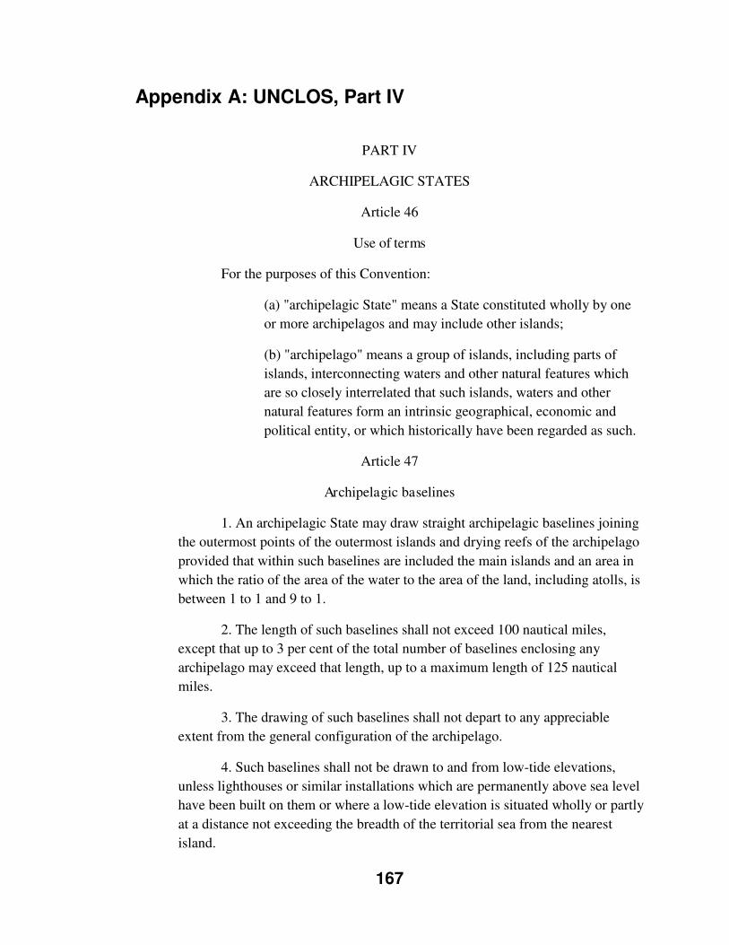
167
Appendix A: UNCLOS, Part IV
PART IV
ARCHIPELAGIC STATES
Article 46
Use of terms
For the purposes of this Convention:
(a) "archipelagic State" means a State constituted wholly by one
or more archipelagos and may include other islands;
(b) "archipelago" means a group of islands, including parts of
islands, interconnecting waters and other natural features which
are so closely interrelated that such islands, waters and other
natural features form an intrinsic geographical, economic and
political entity, or which historically have been regarded as such.
Article 47
Archipelagic baselines
1. An archipelagic State may draw straight archipelagic baselines joining
the outermost points of the outermost islands and drying reefs of the archipelago
provided that within such baselines are included the main islands and an area in
which the ratio of the area of the water to the area of the land, including atolls, is
between 1 to 1 and 9 to 1.
2. The length of such baselines shall not exceed 100 nautical miles,
except that up to 3 per cent of the total number of baselines enclosing any
archipelago may exceed that length, up to a maximum length of 125 nautical
miles.
3. The drawing of such baselines shall not depart to any appreciable
extent from the general configuration of the archipelago.
4. Such baselines shall not be drawn to and from low-tide elevations,
unless lighthouses or similar installations which are permanently above sea level
have been built on them or where a low-tide elevation is situated wholly or partly
at a distance not exceeding the breadth of the territorial sea from the nearest
island.
168
5. The system of such baselines shall not be applied by an archipelagic
State in such a manner as to cut off from the high seas or the exclusive economic
zone the territorial sea of another State.
6. If a part of the archipelagic waters of an archipelagic State lies
between two parts of an immediately adjacent neighbouring State, existing rights
and all other legitimate interests which the latter State has traditionally exercised
in such waters and all rights stipulated by agreement between those States shall
continue and be respected.
7. For the purpose of computing the ratio of water to land under
paragraph l, land areas may include waters lying within the fringing reefs of
islands and atolls, including that part of a steep-sided oceanic plateau which is
enclosed or nearly enclosed by a chain of limestone islands and drying reefs
lying on the perimeter of the plateau.
8. The baselines drawn in accordance with this article shall be shown on
charts of a scale or scales adequate for ascertaining their position. Alternatively,
lists of geographical coordinates of points, specifying the geodetic datum, may
be substituted.
9. The archipelagic State shall give due publicity to such charts or lists of
geographical coordinates and shall deposit a copy of each such chart or list with
the Secretary-General of the United Nations.
Article 48
Measurement of the breadth of the territorial sea, the contiguous zone,
the exclusive economic zone and the continental shelf
The breadth of the territorial sea, the contiguous zone, the exclusive
economic zone and the continental shelf shall be measured from archipelagic
baselines drawn in accordance with article 47.
Article 49
Legal status of archipelagic waters, of the air space
over archipelagic waters and of their bed and subsoil
1. The sovereignty of an archipelagic State extends to the waters enclosed
by the archipelagic baselines drawn in accordance with article 47, described as
archipelagic waters, regardless of their depth or distance from the coast.
169
2. This sovereignty extends to the air space over the archipelagic waters,
as well as to their bed and subsoil, and the resources contained therein.
3. This sovereignty is exercised subject to this Part. 4. The regime of
archipelagic sea lanes passage established in this Part shall not in other respects
affect the status of the archipelagic waters, including the sea lanes, or the
exercise by the archipelagic State of its sovereignty over such waters and their
air space, bed and subsoil, and the resources contained therein.
Article 50
Delimitation of internal waters
Within its archipelagic waters, the archipelagic State may draw closing
lines for the delimitation of internal waters, in accordance with articles 9, 10 and
11.
Article 51
Existing agreements, traditional fishing rights
and existing submarine cables
1. Without prejudice to article 49, an archipelagic State shall respect
existing agreements with other States and shall recognize traditional fishing
rights and other legitimate activities of the immediately adjacent neighbouring
States in certain areas falling within archipelagic waters. The terms and
conditions for the exercise of such rights and activities, including the nature, the
extent and the areas to which they apply, shall, at the request of any of the States
concerned, be regulated by bilateral agreements between them. Such rights shall
not be transferred to or shared with third States or their nationals.
2. An archipelagic State shall respect existing submarine cables laid by
other States and passing through its waters without making a landfall. An
archipelagic State shall permit the maintenance and replacement of such cables
upon receiving due notice of their location and the intention to repair or replace
them.
Article 52
Right of innocent passage
1. Subject to article 53 and without prejudice to article 50, ships of all
States enjoy the right of innocent passage through archipelagic waters, in
accordance with Part II, section 3.
170
2. The archipelagic State may, without discrimination in form or in fact
among foreign ships, suspend temporarily in specified areas of its archipelagic
waters the innocent passage of foreign ships if such suspension is essential for
the protection of its security. Such suspension shall take effect only after having
been duly published.
Article 53
Right of archipelagic sea lanes passage
1. An archipelagic State may designate sea lanes and air routes
thereabove, suitable for the continuous and expeditious passage of foreign ships
and aircraft through or over its archipelagic waters and the adjacent territorial
sea.
2. All ships and aircraft enjoy the right of archipelagic sea lanes passage
in such sea lanes and air routes.
3. Archipelagic sea lanes passage means the exercise in accordance with
this Convention of the rights of navigation and overflight in the normal mode
solely for the purpose of continuous, expeditious and unobstructed transit
between one part of the high seas or an exclusive economic zone and another
part of the high seas or an exclusive economic zone.
4. Such sea lanes and air routes shall traverse the archipelagic waters and
the adjacent territorial sea and shall include all normal passage routes used as
routes for international navigation or overflight through or over archipelagic
waters and, within such routes, so far as ships are concerned, all normal
navigational channels, provided that duplication of routes of similar convenience
between the same entry and exit points shall not be necessary.
5. Such sea lanes and air routes shall be defined by a series of continuous
axis lines from the entry points of passage routes to the exit points. Ships and
aircraft in archipelagic sea lanes passage shall not deviate more than 25 nautical
miles to either side of such axis lines during passage, provided that such ships
and aircraft shall not navigate closer to the coasts than 10 per cent of the distance
between the nearest points on islands bordering the sea lane.
6. An archipelagic State which designates sea lanes under this article may
also prescribe traffic separation schemes for the safe passage of ships through
narrow channels in such sea lanes.
7. An archipelagic State may, when circumstances require, after giving
due publicity thereto, substitute other sea lanes or traffic separation schemes for
171
any sea lanes or traffic separation schemes previously designated or prescribed
by it.
8. Such sea lanes and traffic separation schemes shall conform to
generally accepted international regulations.
9. In designating or substituting sea lanes or prescribing or substituting
traffic separation schemes, an archipelagic State shall refer proposals to the
competent international organization with a view to their adoption. The
organization may adopt only such sea lanes and traffic separation schemes as
may be agreed with the archipelagic State, after which the archipelagic State
may designate, prescribe or substitute them.
10. The archipelagic State shall clearly indicate the axis of the sea lanes
and the traffic separation schemes designated or prescribed by it on charts to
which due publicity shall be given.
11. Ships in archipelagic sea lanes passage shall respect applicable sea
lanes and traffic separation schemes established in accordance with this article.
12. If an archipelagic State does not designate sea lanes or air routes, the
right of archipelagic sea lanes passage may be exercised through the routes
normally used for international navigation.
Article 54
Duties of ships and aircraft during their passage,
research and survey activities, duties of the archipelagic State
and laws and regulations of the archipelagic State
relating to archipelagic sea lanes passage
Articles 39, 40, 42 and 44 apply mutatis mutandis to archipelagic sea
lanes passage.

172
Appendix B: UNCLOS Definitions
Archipelago
"archipelago" means a group of islands, including parts of islands,
interconnecting waters and other natural features which are so closely
interrelated that such islands, waters and other natural features form an intrinsic
geographical, economic and political entity, or which historically have been
regarded as such. (Article 46 [b])
Archipelagic State
"archipelagic State" means a State constituted wholly by one or more
archipelagos and may include other islands; (Article 46[a])
Archipelagic Sea Lane
An archipelagic State may designate sea lanes and air routes thereabove, suitable
for the continuous and expeditious passage of foreign ships and aircraft through
or over its archipelagic waters and the adjacent territorial sea. (Article 53[1])
Archipelagic Sea Lane Passage
All ships and aircraft enjoy the right of archipelagic sea lanes passage in such sea
lanes and air routes. (Article 53[2])
Archipelagic sea lanes passage means the exercise in accordance with this
Convention of the rights of navigation and overflight in the normal mode solely
173
for the purpose of continuous, expeditious and unobstructed transit between one
part of the high seas or an exclusive economic zone and another part of the high
seas or an exclusive economic zone. (Article 53[3])
Such sea lanes and air routes shall traverse the archipelagic waters and the
adjacent territorial sea and shall include all normal passage routes used as routes
for international navigation or overflight through or over archipelagic waters
and, within such routes, so far as ships are concerned, all normal navigational
channels, provided that duplication of routes of similar convenience between the
same entry and exit points shall not be necessary. (Article 53[4])
Such sea lanes and air routes shall be defined by a series of continuous axis lines
from the entry points of passage routes to the exit points. Ships and aircraft in
archipelagic sea lanes passage shall not deviate more than 25 nautical miles to
either side of such axis lines during passage, provided that such ships and aircraft
shall not navigate closer to the coasts than 10 per cent of the distance between
the nearest points on islands bordering the sea lane. (Article 53[5])
An archipelagic State which designates sea lanes under this article may also
prescribe traffic separation schemes for the safe passage of ships through narrow
channels in such sea lanes. (Article 53[6])
An archipelagic State may, when circumstances require, after giving due
publicity thereto, substitute other sea lanes or traffic separation schemes for any
sea lanes or traffic separation schemes previously designated or prescribed by it.
(Article 53[7])
174
Such sea lanes and traffic separation schemes shall conform to generally
accepted international regulations. (Article 53[8])
In designating or substituting sea lanes or prescribing or substituting traffic
separation schemes, an archipelagic State shall refer proposals to the competent
international organization with a view to their adoption. The organization may
adopt only such sea lanes and traffic separation schemes as may be agreed with
the archipelagic State, after which the archipelagic State may designate,
prescribe or substitute them. (Article 53[9])
The archipelagic State shall clearly indicate the axis of the sea lanes and the
traffic separation schemes designated or prescribed by it on charts to which due
publicity shall be given. (Article 53[10])
Ships in archipelagic sea lanes passage shall respect applicable sea lanes and
traffic separation schemes established in accordance with this article. (Article
53[11])
If an archipelagic State does not designate sea lanes or air routes, the right of
archipelagic sea lanes passage may be exercised through the routes normally
used for international navigation. (Article 53[12])
Contiguous Zone
In a zone contiguous to its territorial sea, described as the contiguous zone, the
coastal State may exercise the control necessary to: (a) prevent infringement of
its customs, fiscal, immigration or sanitary laws and regulations within its
175
territory or territorial sea; (b) punish infringement of the above laws and
regulations committed within its territory or territorial sea. (Article 33[1])
The contiguous zone may not extend beyond 24 nautical miles from the
baselines from which the breadth of the territorial sea is measured. (Article
33[2])
Passage Rights
Passage means navigation through the territorial sea for the purpose of: (a)
traversing that sea without entering internal waters or calling at a roadstead or
port facility outside internal waters; or (b) proceeding to or from internal waters
or a call at such roadstead or port facility. (Article 18[1])
Passage shall be continuous and expeditious. However, passage includes
stopping and anchoring, but only in so far as the same are incidental to ordinary
navigation or are rendered necessary by force majeure or distress or for the
purpose of rendering assistance to persons, ships or aircraft in danger or distress.
(Article 18[2])
Innocent Passage
Subject to this Convention, ships of all States, whether coastal or land-locked,
enjoy the right of innocent passage through the territorial sea. (Article 17)
Passage is innocent so long as it is not prejudicial to the peace, good order or
security of the coastal State. Such passage shall take place in conformity with
this Convention and with other rules of international law. (Article 19[1])
176
Passage of a foreign ship shall be considered to be prejudicial to the peace, good
order or security of the coastal State if in the territorial sea it engages in any of
the following activities:
(a) any threat or use of force against the sovereignty, territorial integrity or
political independence of the coastal State, or in any other manner in violation of
the principles of international law embodied in the Charter of the United
Nations;
(b) any exercise or practice with weapons of any kind;
(c) any act aimed at collecting information to the prejudice of the defence or
security of the coastal State;
(d) any act of propaganda aimed at affecting the defence or security of the
coastal State;
(e) the launching, landing or taking on board of any aircraft;
(f) the launching, landing or taking on board of any military device;
(g) the loading or unloading of any commodity, currency or person contrary to
the customs, fiscal, immigration or sanitary laws and regulations of the coastal
State;
(h) any act of wilful and serious pollution contrary to this Convention;
(i) any fishing activities;
(j) the carrying out of research or survey activities;
177
(k) any act aimed at interfering with any systems of communication or any other
facilities or installations of the coastal State;
(l) any other activity not having a direct bearing on passage.
(Article 19[2])
Innocent Passage under Part III: Straits used for International Navigation
The regime of innocent passage, in accordance with Part II, section 3, shall apply
in straits used for international navigation: (a) excluded from the application of
the regime of transit passage under article 38, paragraph 1; or (b) between a part
of the high seas or an exclusive economic zone and the territorial sea of a foreign
State. (Article 45[1])
There shall be no suspension of innocent passage through such straits. (Article
45[2])
Innocent Passage under Part IV: Archipelagic States
Subject to article 53 and without prejudice to article 50, ships of all States enjoy
the right of innocent passage through archipelagic waters, in accordance with
Part II, section 3. (Article 52[1])
The archipelagic State may, without discrimination in form or in fact among
foreign ships, suspend temporarily in specified areas of its archipelagic waters
the innocent passage of foreign ships if such suspension is essential for the
protection of its security. Such suspension shall take effect only after having
been duly published. (Article 52[2])
178
Internal Waters
Except as provided in Part IV, waters on the landward side of the baseline of the
territorial sea form part of the internal waters of the State. (Article 8[1])
Territorial Sea/Waters
Every State has the right to establish the breadth of its territorial sea up to a limit
not exceeding 12 nautical miles, measured from baselines determined in
accordance with this Convention. (Article 3)
Transit Passage
In straits referred to in article 37[Straits used for International Navigation], all
ships and aircraft enjoy the right of transit passage, which shall not be impeded;
except that, if the strait is formed by an island of a State bordering the strait and
its mainland, transit passage shall not apply if there exists seaward of the island a
route through the high seas or through an exclusive economic zone of similar
convenience with respect to navigational and hydrographical characteristics.
(Article 38[1])
Transit passage means the exercise in accordance with this Part of the freedom
of navigation and overflight solely for the purpose of continuous and expeditious
transit of the strait between one part of the high seas or an exclusive economic
zone and another part of the high seas or an exclusive economic zone. However,
the requirement of continuous and expeditious transit does not preclude passage
through the strait for the purpose of entering, leaving or returning from a State

179
bordering the strait, subject to the conditions of entry to that State. (Article 38
[2])
180
Appendix C: Philippine government declaration upon
signing UNCLOS50
The government of the Republic of the Philippines hereby manifests that in signing the
1982 United Nations Convention on the Law of the Sea, it does so with the
understandings embodied in this declaration, made under the provisions of Article 310
of the Convention, to wit:
The signing of the Convention by the Government of the Republic of the Philippines
shall not in any manner impair or prejudice the sovereign rights of the Republic of the
Philippines under and arising from the Constitution of the Philippines;
Such signing shall not in any manner affect the sovereign rights of the Republic of the
Philippines as successor of the United States of America, under and arising out of the
Treaty of Paris between Spain and the United States of America of December 10, 1898,
and the Treaty of Washington between the United States of America and Great Britain
of January 2, 1930;
Such signing shall not diminish or in any manner affect the rights and obligations of the
contracting parties under the Mutual Defense Treaty between the Philippines and the
United States of America of August 30, 1951, and its related interpretative instrument;
nor those under any other pertinent bilateral or multilateral treaty of agreement to which
the Philippines is a party;
Such signing shall not in any manner impair or prejudice the sovereignty of the Republic
of the Philippines over any territory over which it exercises sovereign authority, such as
the Kalayaan Islands, and the waters appurtenant thereto;
50 As quoted in Batongbacal (2002), p. 4-5
181
The Convention shall not be construed as amending in any manner any pertinent laws
and Presidential Decrees or Proclamations of the Republic of the Philippines. The
Government of the Republic of the Philippines maintains and reserves the right and
authority to make any amendments to such laws, decrees or proclamations pursuant to
the provisions of the Philippine Constitution;
The provisions of the Convention on archipelagic passage through sea lanes do not
nullify or impair the sovereignty of the Philippines as an archipelagic state over the sea
lanes and do not deprive it of authority to enact legislation to protect its sovereignty
independence and security;
The concept of archipelagic waters is similar to the concept of internal waters under the
Constitution of the Philippines, and removes straits connecting these waters with the
economic zone or high sea from the rights of foreign vessels to transit passage for
international navigation;
The agreement of the Republic of the Philippines to the submission for peaceful
resolution, under any of the procedures provided in the Convention, of disputes under
[A]rticle 298 shall not be considered as a derogation of Philippine sovereignty.
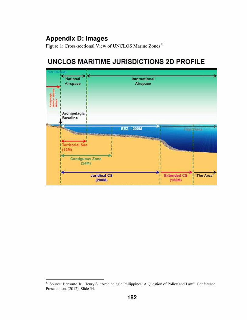
182
Appendix D: Images
Figure 1: Cross-sectional View of UNCLOS Marine Zones51
51 Source: Bensurto Jr., Henry S. “Archipelagic Philippines: A Question of Policy and Law”. Conference Presentation. (2012), Slide 34.
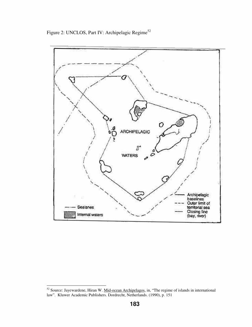
183
Figure 2: UNCLOS, Part IV: Archipelagic Regime52
52 Source: Jayewardene, Hiran W. Mid-ocean Archipelagos, in, “The regime of islands in international law”. Kluwer Academic Publishers. Dordrecht, Netherlands. (1990), p. 151
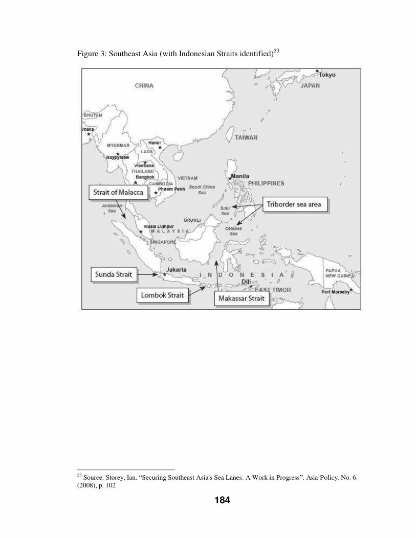
184
Figure 3: Southeast Asia (with Indonesian Straits identified)53
53 Source: Storey, Ian. “Securing Southeast Asia's Sea Lanes: A Work in Progress”. Asia Policy. No. 6. (2008), p. 102
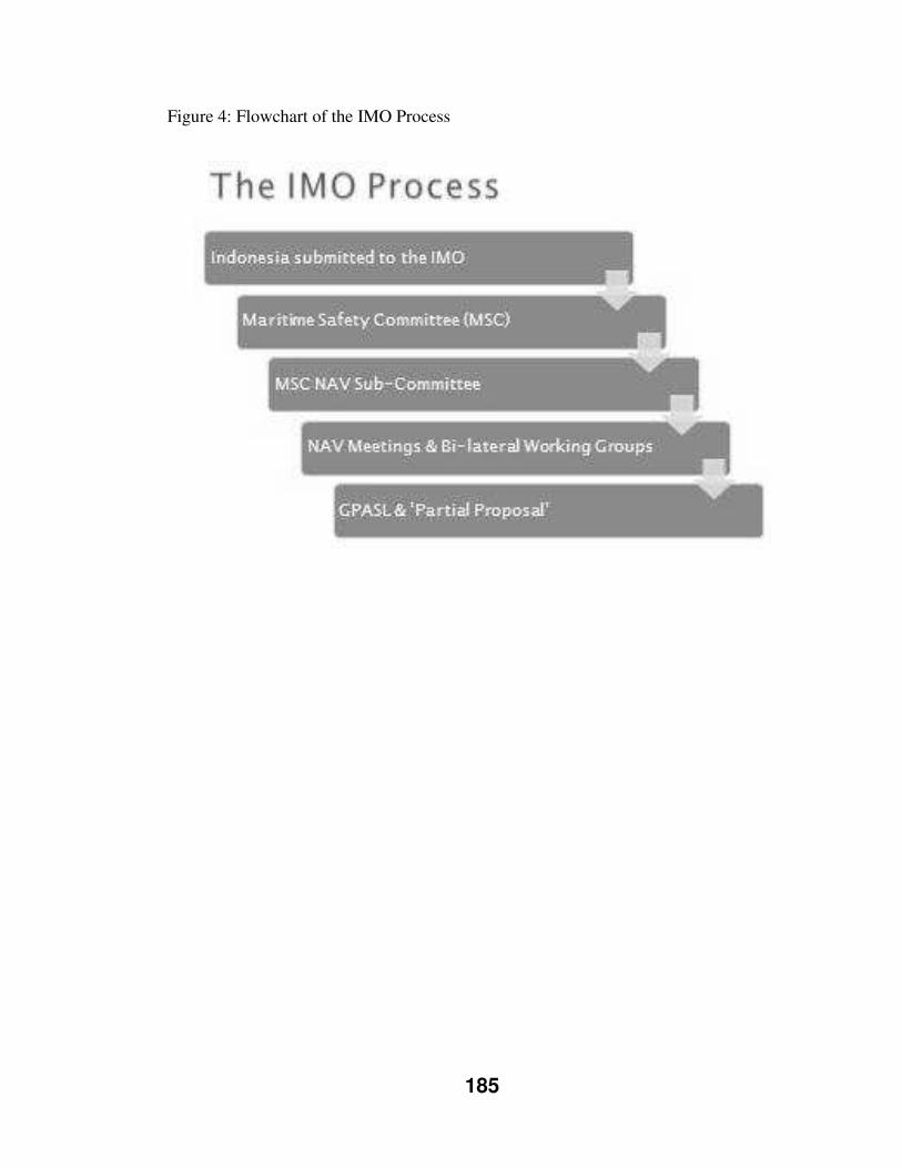
185
Figure 4: Flowchart of the IMO Process
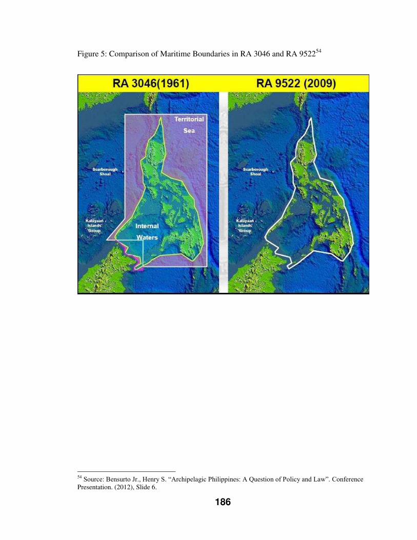
186
Figure 5: Comparison of Maritime Boundaries in RA 3046 and RA 952254
54 Source: Bensurto Jr., Henry S. “Archipelagic Philippines: A Question of Policy and Law”. Conference Presentation. (2012), Slide 6.
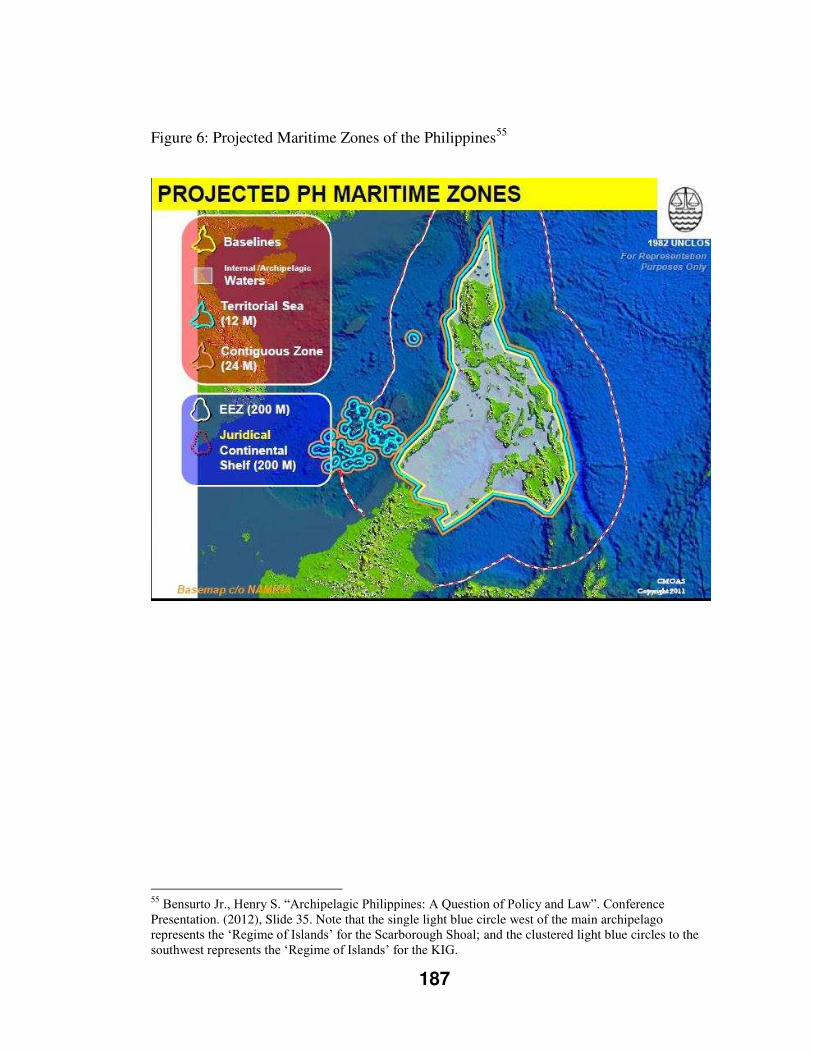
187
Figure 6: Projected Maritime Zones of the Philippines55
55 Bensurto Jr., Henry S. “Archipelagic Philippines: A Question of Policy and Law”. Conference Presentation. (2012), Slide 35. Note that the single light blue circle west of the main archipelago represents the ‘Regime of Islands’ for the Scarborough Shoal; and the clustered light blue circles to the southwest represents the ‘Regime of Islands’ for the KIG.
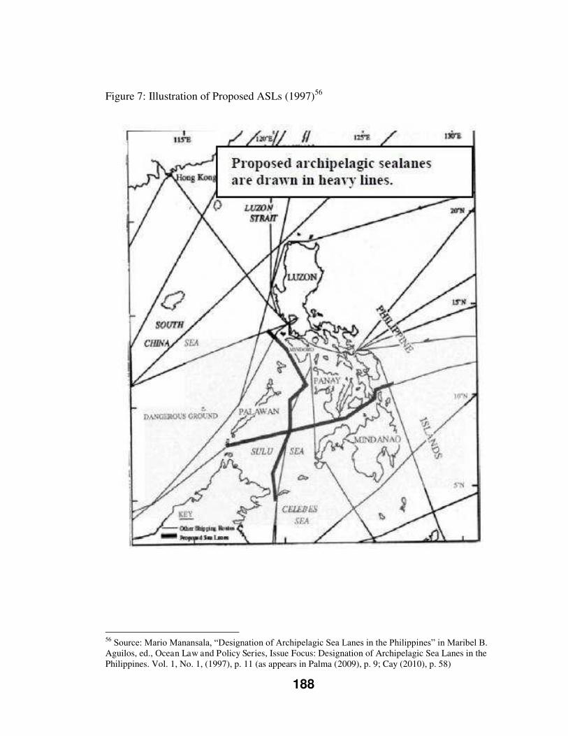
188
Figure 7: Illustration of Proposed ASLs (1997)56
56 Source: Mario Manansala, “Designation of Archipelagic Sea Lanes in the Philippines” in Maribel B. Aguilos, ed., Ocean Law and Policy Series, Issue Focus: Designation of Archipelagic Sea Lanes in the Philippines. Vol. 1, No. 1, (1997), p. 11 (as appears in Palma (2009), p. 9; Cay (2010), p. 58)
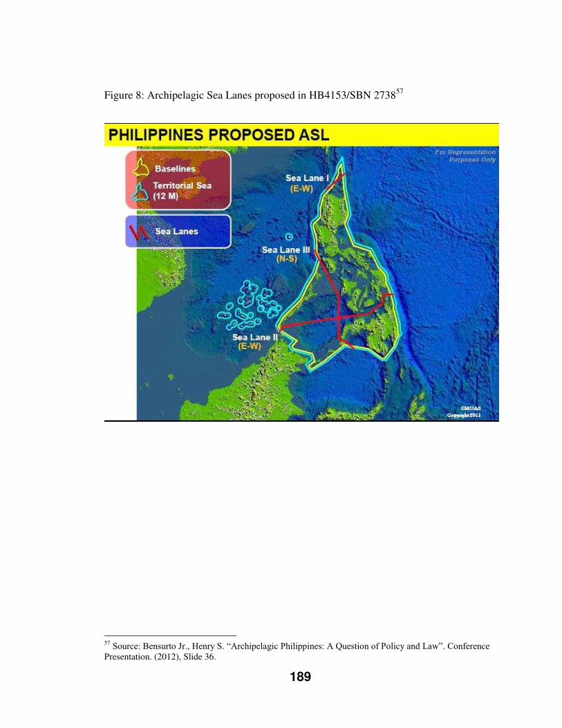
189
Figure 8: Archipelagic Sea Lanes proposed in HB4153/SBN 273857
57 Source: Bensurto Jr., Henry S. “Archipelagic Philippines: A Question of Policy and Law”. Conference Presentation. (2012), Slide 36.
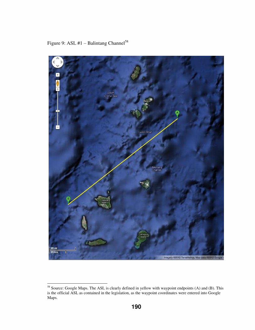
190
Figure 9: ASL #1 – Balintang Channel58
58 Source: Google Maps. The ASL is clearly defined in yellow with waypoint endpoints (A) and (B). This is the official ASL as contained in the legislation, as the waypoint coordinates were entered into Google Maps.
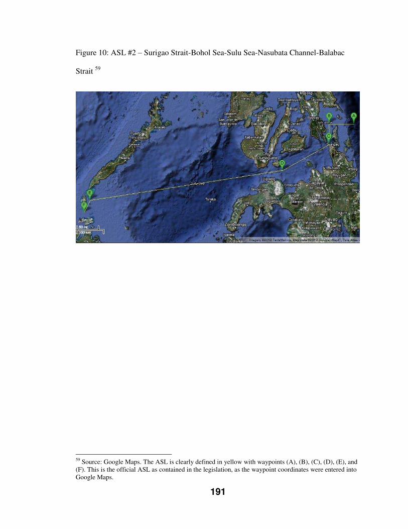
191
Figure 10: ASL #2 – Surigao Strait-Bohol Sea-Sulu Sea-Nasubata Channel-Balabac
Strait 59
59 Source: Google Maps. The ASL is clearly defined in yellow with waypoints (A), (B), (C), (D), (E), and (F). This is the official ASL as contained in the legislation, as the waypoint coordinates were entered into Google Maps.
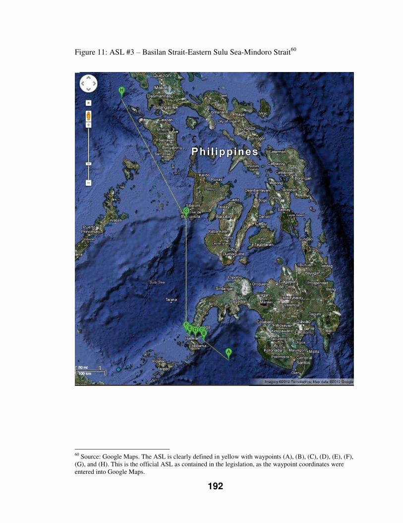
192
Figure 11: ASL #3 – Basilan Strait-Eastern Sulu Sea-Mindoro Strait60
60 Source: Google Maps. The ASL is clearly defined in yellow with waypoints (A), (B), (C), (D), (E), (F), (G), and (H). This is the official ASL as contained in the legislation, as the waypoint coordinates were entered into Google Maps.
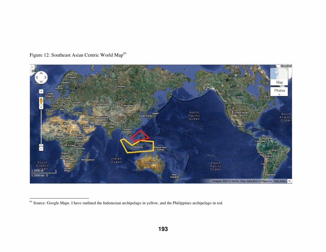
193
Figure 12: Southeast Asian Centric World Map61
61 Source: Google Maps. I have outlined the Indonesian archipelago in yellow, and the Philippines archipelago in red.
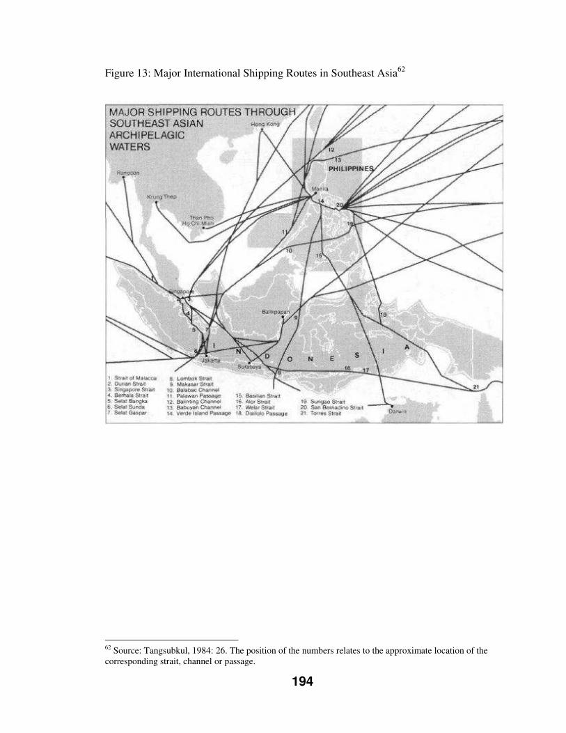
194
Figure 13: Major International Shipping Routes in Southeast Asia62
62 Source: Tangsubkul, 1984: 26. The position of the numbers relates to the approximate location of the corresponding strait, channel or passage.
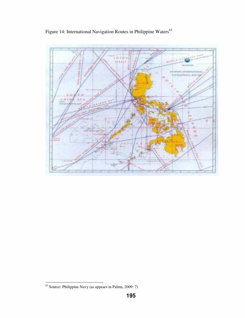
195
Figure 14: International Navigation Routes in Philippine Waters63
63 Source: Philippine Navy (as appears in Palma, 2009: 7)
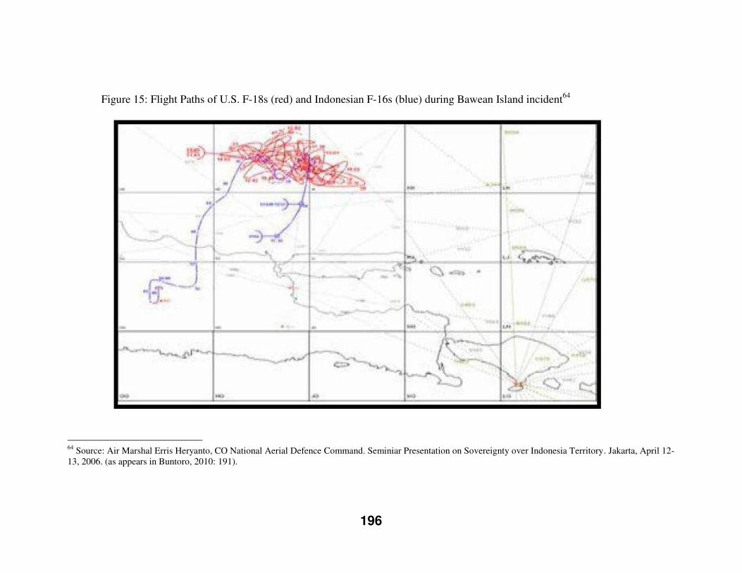
196
Figure 15: Flight Paths of U.S. F-18s (red) and Indonesian F-16s (blue) during Bawean Island incident64
64 Source: Air Marshal Erris Heryanto, CO National Aerial Defence Command. Seminiar Presentation on Sovereignty over Indonesia Territory. Jakarta, April 12-13, 2006. (as appears in Buntoro, 2010: 191).
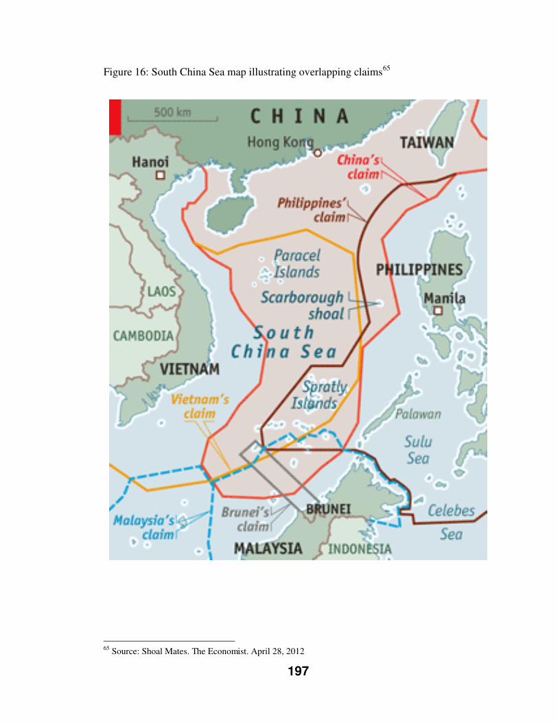
197
Figure 16: South China Sea map illustrating overlapping claims65
65 Source: Shoal Mates. The Economist. April 28, 2012
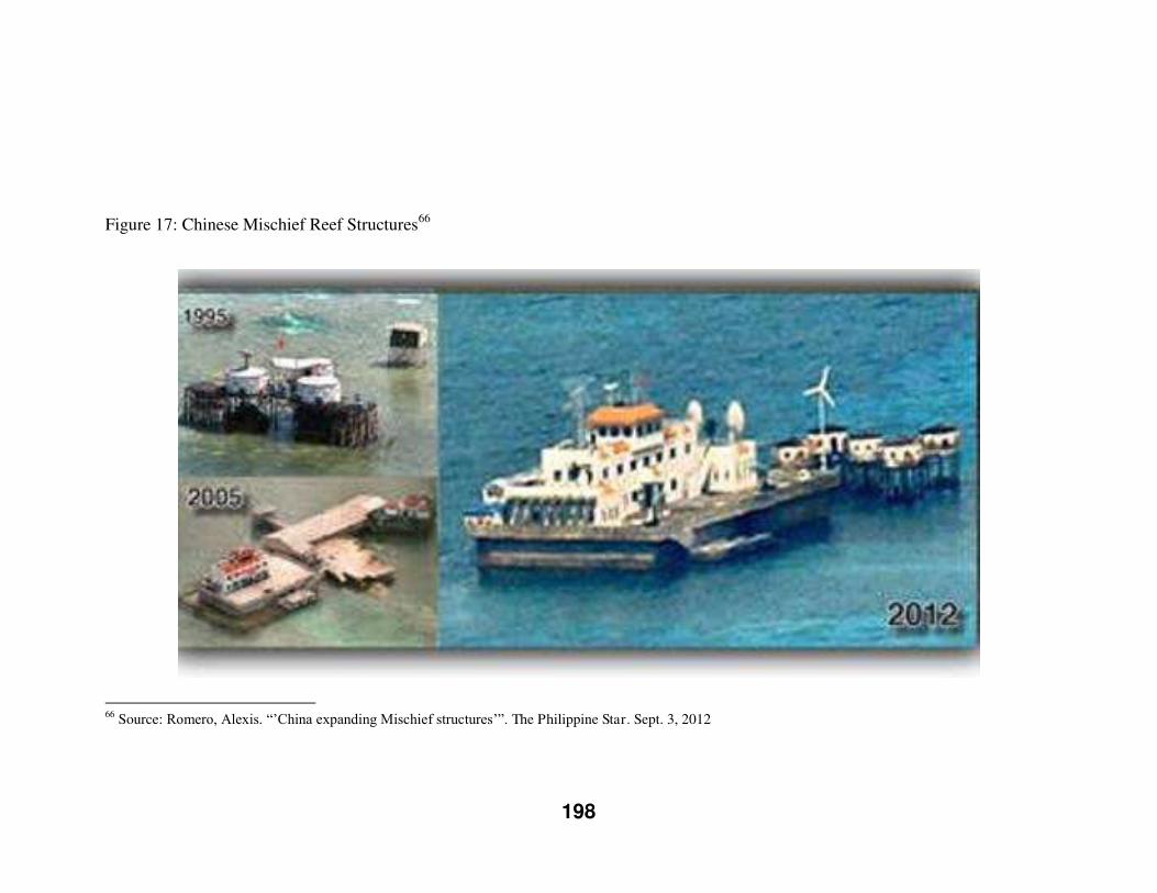
198
Figure 17: Chinese Mischief Reef Structures66
66 Source: Romero, Alexis. “’China expanding Mischief structures’”. The Philippine Star. Sept. 3, 2012
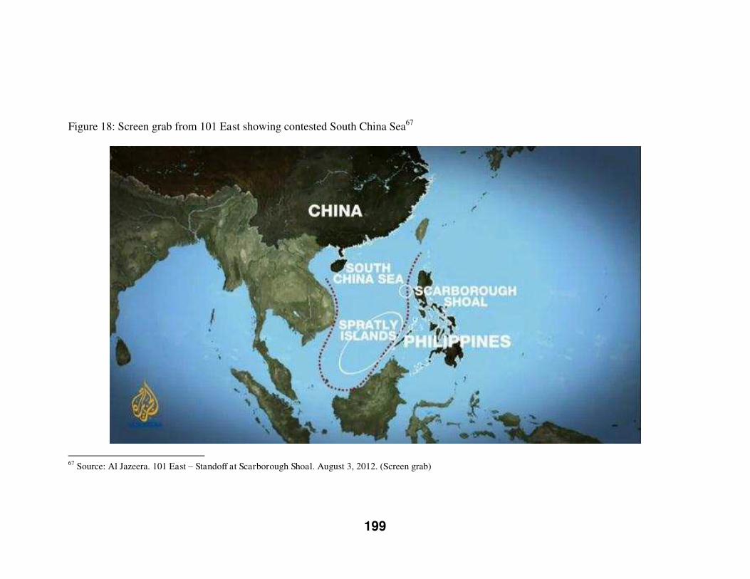
199
Figure 18: Screen grab from 101 East showing contested South China Sea67
67 Source: Al Jazeera. 101 East – Standoff at Scarborough Shoal. August 3, 2012. (Screen grab)