University of Groningen Geoarchaeological tsunami deposits at Palaikastro … · 2016-03-05 ·...
23
University of Groningen Geoarchaeological tsunami deposits at Palaikastro (Crete) and the Late Minoan IA eruption of Santorini Bruins, Hendrik J.; MacGillivray, J. Alexander; Synolakis, Costas E.; Benjamini, Chaim; Keller, Joerg; Kisch, Hanan J.; Kleugel, Andreas; van der Plicht, Johannes; Klügel, Andreas Published in: Journal of Archaeological Science DOI: 10.1016/j.jas.2007.08.017 IMPORTANT NOTE: You are advised to consult the publisher's version (publisher's PDF) if you wish to cite from it. Please check the document version below. Document Version Publisher's PDF, also known as Version of record Publication date: 2008 Link to publication in University of Groningen/UMCG research database Citation for published version (APA): Bruins, H. J., MacGillivray, J. A., Synolakis, C. E., Benjamini, C., Keller, J., Kisch, H. J., ... Klügel, A. (2008). Geoarchaeological tsunami deposits at Palaikastro (Crete) and the Late Minoan IA eruption of Santorini. Journal of Archaeological Science, 35(1), 191-212. https://doi.org/10.1016/j.jas.2007.08.017 Copyright Other than for strictly personal use, it is not permitted to download or to forward/distribute the text or part of it without the consent of the author(s) and/or copyright holder(s), unless the work is under an open content license (like Creative Commons). Take-down policy If you believe that this document breaches copyright please contact us providing details, and we will remove access to the work immediately and investigate your claim. Downloaded from the University of Groningen/UMCG research database (Pure): http://www.rug.nl/research/portal. For technical reasons the number of authors shown on this cover page is limited to 10 maximum. Download date: 11-05-2019
Transcript of University of Groningen Geoarchaeological tsunami deposits at Palaikastro … · 2016-03-05 ·...
University of Groningen
Geoarchaeological tsunami deposits at Palaikastro (Crete) and the Late Minoan IA eruption ofSantoriniBruins, Hendrik J.; MacGillivray, J. Alexander; Synolakis, Costas E.; Benjamini, Chaim; Keller,Joerg; Kisch, Hanan J.; Kleugel, Andreas; van der Plicht, Johannes; Klügel, AndreasPublished in:Journal of Archaeological Science
DOI:10.1016/j.jas.2007.08.017
IMPORTANT NOTE: You are advised to consult the publisher's version (publisher's PDF) if you wish to cite fromit. Please check the document version below.
Document VersionPublisher's PDF, also known as Version of record
Publication date:2008
Link to publication in University of Groningen/UMCG research database
Citation for published version (APA):Bruins, H. J., MacGillivray, J. A., Synolakis, C. E., Benjamini, C., Keller, J., Kisch, H. J., ... Klügel, A.(2008). Geoarchaeological tsunami deposits at Palaikastro (Crete) and the Late Minoan IA eruption ofSantorini. Journal of Archaeological Science, 35(1), 191-212. https://doi.org/10.1016/j.jas.2007.08.017
CopyrightOther than for strictly personal use, it is not permitted to download or to forward/distribute the text or part of it without the consent of theauthor(s) and/or copyright holder(s), unless the work is under an open content license (like Creative Commons).
Take-down policyIf you believe that this document breaches copyright please contact us providing details, and we will remove access to the work immediatelyand investigate your claim.
Downloaded from the University of Groningen/UMCG research database (Pure): http://www.rug.nl/research/portal. For technical reasons thenumber of authors shown on this cover page is limited to 10 maximum.
Download date: 11-05-2019

Journal of Archaeological Science 35 (2008) 191e212http://www.elsevier.com/locate/jas
Geoarchaeological tsunami deposits at Palaikastro (Crete)and the Late Minoan IA eruption of Santorini
Hendrik J. Bruins a,*, J. Alexander MacGillivray b, Costas E. Synolakis c,d,Chaim Benjamini e, Jorg Keller f, Hanan J. Kisch e,
Andreas Klugel g, Johannes van der Plicht h,i
a Ben-Gurion University of the Negev, Jacob Blaustein Institutes for Desert Research, Sede Boker Campus, 84990, Israelb British School of Archaeology at Athens, Odos Souedias 52, 10676 Athens, Greece
c University of Southern California, Director, Tsunami Research Center, Viterbi School of Engineering, Los Angeles, CA, USAd Technical University of Crete, Director, Natural Hazards Laboratory, Chania, Greece
e Ben-Gurion University of the Negev, Department of Geological and Environmental Sciences, 84105 Beer Sheva, Israelf University of Freiburg, Institute of Mineralogy, Petrology and Geochemistry, 79104 Freiburg, Germany
g University of Bremen, Department of Geosciences, 28334 Bremen, Germanyh University of Groningen, Centre for Isotope Research, Nijenborgh, Groningen, The Netherlands
i Faculty of Archaeology, Leiden University, Leiden, The Netherlands
Received 13 May 2007; received in revised form 23 August 2007; accepted 24 August 2007
Abstract
The explosive eruption at Santorini in the Aegean Sea during the second millennium BCE was the largest Holocene volcanic upheaval in theEastern Mediterranean region. The eruption was disastrous for the Minoan settlements at Santorini, but the effect on human society in the neigh-bouring islands and regions is still clouded in uncertainty. Tsunami generation was suggested, but comparatively little evidence was found. Thelack of firm tsunami traces is particularly puzzling in Crete with its coastal settlements of the Late Minoan IA period, during which the Santorinieruption occurred. Here, we report the discovery of extensive geoarchaeological tsunami deposits at Palaikastro in north-eastern Crete. Thesedeposits are characterized by a mixture of geological materials, including volcanic Santorini ash, and archaeological settlement debris. Varioustsunami signatures were identified: (1) erosional contact with the underlying strata, (2) volcanic ash intraclasts in the lower part of the deposit,(3) reworked building stone material in the lower part of the deposit, (4) individual marine shells, (5) marine micro-fauna, (6) imbrication ofrounded beach pebbles, settlement debris, ceramic sherds and even bones, (7) multi-modal chaotic composition. Late Minoan human settlementactivities at Palaikastro provided architectural and stratigraphic frameworks in space and time that recorded and preserved tsunami evidence asgeoarchaeological deposits. Such stratigraphic resolution and preservation may not occur in the natural landscape. Volcanic ash transported bywind from Santorini south-east to Crete preceded the tsunami. Geological, archaeological and radiocarbon dating criteria all converge, indicatingthat the tsunami deposits are coeval with the Minoan Santorini eruption. Field evidence suggests that tsunami waves at Palaikastro were at least9 m high. Inverse tsunami modeling was attempted, based on these newly discovered tsunamigenic deposits. The initial wave in the generationregion at Santorini that best fits the stratigraphic data is a wave with þ35 to �15 m initial amplitude and a crest length of about 15 km.� 2007 Elsevier Ltd. All rights reserved.
Keywords: Minoan Santorini eruption; Crete; Geoarchaeological tsunami deposits; Micromorphology; Volcanic ash geochemistry; Radiocarbon dating; Tsunami
modeling
* Corresponding author. Tel.: þ972 8 659 6863/6875 (secr.); fax: þ972 8 659 6881.
E-mail address: [email protected] (H.J. Bruins).
0305-4403/$ - see front matter � 2007 Elsevier Ltd. All rights reserved.
doi:10.1016/j.jas.2007.08.017
192 H.J. Bruins et al. / Journal of Archaeological Science 35 (2008) 191e212
1. Introduction
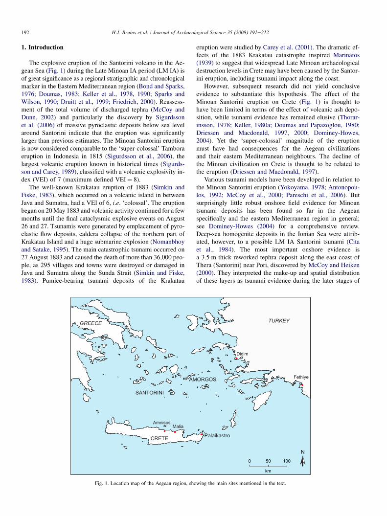
The explosive eruption of the Santorini volcano in the Ae-gean Sea (Fig. 1) during the Late Minoan IA period (LM IA) isof great significance as a regional stratigraphic and chronologicalmarker in the Eastern Mediterranean region (Bond and Sparks,1976; Doumas, 1983; Keller et al., 1978, 1990; Sparks andWilson, 1990; Druitt et al., 1999; Friedrich, 2000). Reassess-ment of the total volume of discharged tephra (McCoy andDunn, 2002) and particularly the discovery by Sigurdssonet al. (2006) of massive pyroclastic deposits below sea levelaround Santorini indicate that the eruption was significantlylarger than previous estimates. The Minoan Santorini eruptionis now considered comparable to the ‘super-colossal’ Tamboraeruption in Indonesia in 1815 (Sigurdsson et al., 2006), thelargest volcanic eruption known in historical times (Sigurds-son and Carey, 1989), classified with a volcanic explosivity in-dex (VEI) of 7 (maximum defined VEI¼ 8).
The well-known Krakatau eruption of 1883 (Simkin andFiske, 1983), which occurred on a volcanic island in betweenJava and Sumatra, had a VEI of 6, i.e. ‘colossal’. The eruptionbegan on 20 May 1883 and volcanic activity continued for a fewmonths until the final cataclysmic explosive events on August26 and 27. Tsunamis were generated by emplacement of pyro-clastic flow deposits, caldera collapse of the northern part ofKrakatau Island and a huge submarine explosion (Nomanbhoyand Satake, 1995). The main catastrophic tsunami occurred on27 August 1883 and caused the death of more than 36,000 peo-ple, as 295 villages and towns were destroyed or damaged inJava and Sumatra along the Sunda Strait (Simkin and Fiske,1983). Pumice-bearing tsunami deposits of the Krakatau
eruption were studied by Carey et al. (2001). The dramatic ef-fects of the 1883 Krakatau catastrophe inspired Marinatos(1939) to suggest that widespread Late Minoan archaeologicaldestruction levels in Crete may have been caused by the Santor-ini eruption, including tsunami impact along the coast.
However, subsequent research did not yield conclusiveevidence to substantiate this hypothesis. The effect of theMinoan Santorini eruption on Crete (Fig. 1) is thought tohave been limited in terms of the effect of volcanic ash depo-sition, while tsunami evidence has remained elusive (Thorar-insson, 1978; Keller, 1980a; Doumas and Papazoglou, 1980;Driessen and Macdonald, 1997, 2000; Dominey-Howes,2004). Yet the ‘super-colossal’ magnitude of the eruptionmust have had consequences for the Aegean civilizationsand their eastern Mediterranean neighbours. The decline ofthe Minoan civilization on Crete is thought to be related tothe eruption (Driessen and Macdonald, 1997).
Various tsunami models have been developed in relation tothe Minoan Santorini eruption (Yokoyama, 1978; Antonopou-los, 1992; McCoy et al., 2000; Pareschi et al., 2006). Butsurprisingly little robust onshore field evidence for Minoantsunami deposits has been found so far in the Aegeanspecifically and the eastern Mediterranean region in general;see Dominey-Howes (2004) for a comprehensive review.Deep-sea homogenite deposits in the Ionian Sea were attrib-uted, however, to a possible LM IA Santorini tsunami (Citaet al., 1984). The most important onshore evidence isa 3.5 m thick reworked tephra deposit along the east coast ofThera (Santorini) near Pori, discovered by McCoy and Heiken(2000). They interpreted the make-up and spatial distributionof these layers as tsunami evidence during the later stages of
TURKEY
Fethiye
Didim
SANTORINI
GREECE
AmnisosMalia
Palaikastro
AMORGOS
CRETE
N0 50 100
km
Fig. 1. Location map of the Aegean region, showing the main sites mentioned in the text.
193H.J. Bruins et al. / Journal of Archaeological Science 35 (2008) 191e212
the eruption. Other significant stratified findings are fromDidim and Fethye in south-western Turkey (Fig. 1), wherea ca. 10 cm thick sandy layer, interpreted as tsunamigenic, un-derlies Minoan Santorini tephra (Minoura et al., 2000).
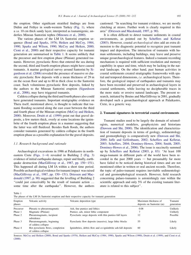
The various phases of the LM IA Santorini eruption se-quence (Bond and Sparks, 1976; Heiken and McCoy, 1984,1990; Sparks and Wilson, 1990; McCoy and Heiken, 2000;Cioni et al., 2000) and their respective capacity for tsunamigeneration are summarised in Table 1. It seems unlikely thatthe precursor and first eruption phase (Plinian) generated tsu-namis. However, pyroclastic flows that entered the sea duringthe second, third and fourth eruption phases might have causedtsunamis. A marine geological survey around Santorini by Si-gurdsson et al. (2006) revealed the presence of massive or cha-otic pyroclastic flow deposits with a mean thickness of 29 mon the ocean floor and up to 80 m thick close to the Santorinicoast. Such voluminous pyroclastic flow deposits, linked bythe authors to the Minoan Santorini eruption (Sigurdssonet al., 2006), may have triggered tsunamis.
Caldera collapse during the third and fourth phases also couldhave generated tsunamis. Important stratigraphic evidence onThera itself, mentioned above, is thought to indicate that tsu-nami flooding occurred along the east coast between the thirdand fourth phase of the Minoan eruption (McCoy and Heiken,2000). Moreover, Druitt et al. (1999) point out that gravel de-posits, a few meters thick, overly at some locations the ignim-brite of the fourth eruption phase in a manner suggesting thatthe latter was still fluidized. Besides flash floods, the authorsconsider tsunamis generated by caldera collapse in the fourtheruption phase as a possible explanation for the gravel deposits.
1.1. Research background and rationale
Archaeological excavations in 1986 at Palaikastro in north-eastern Crete (Figs. 1e4) revealed in Building 2 (Fig. 3)evidence of initial earthquake damage, repair and finally, earth-quake destruction (MacGillivray et al., 1987, pp. 150e151).This happened all during LM IA within a short time period.Possible archaeological evidence for tsunami impact was raised(MacGillivray et al., 1987, pp. 150e151). Driessen and Mac-donald (1997, p. 90) suggested that the levelling of Building 2‘‘could just conceivably be the result of tsunami action .some time after the earthquake’’. However, the authors
cautioned: ‘‘In searching for tsunami evidence, we are mostlyclutching at straws. Further work is clearly required in thisarea’’ (Driessen and Macdonald, 1997, p. 90).
It is often difficult to detect tsunami sediments in coastalenvironments, as pointed out by Scheffers and Kelletat(2003). However, coastal archaeological sites add an extra di-mension to the diagnostic potential to recognize past tsunamiimpact and deposition. The interaction of tsunamis with hu-man settlements, including buildings, may leave and preserveunique geoarchaeological features. Indeed a tsunami recordingmechanism is required with sufficient resolution and memorycapability in space and time, which may be lacking in the nat-ural landscape. On the other hand, past human activities incoastal settlements created stratigraphic frameworks with spa-tial and temporal dimensions, i.e. archaeological layers. There-fore, the geological impact of earthquakes and tsunamis mayhave been recorded and preserved in archaeological layers incoastal settlements, while leaving no decipherable traces inthe more static or erosive natural landscape. The present re-search, initiated by Bruins and MacGillivray in 2001, graduallydeveloped such a geoarchaeological approach at Palaikastro,Crete, in a generic way.
2. Tsunami signatures in terrestrial coastal environments
Tsunami studies used to be largely the domain of seismol-ogists, numerical modelers, geophysicists and historians(Dawson and Shi, 2000). The identification and characteriza-tion of tsunami deposits in terms of geology, sedimentologyand geomorphology is comparatively new (Dawson and Shi,2000; Jaffe and Gelfenbaum, 2002; Scheffers and Kelletat,2003; Scheffers, 2004; Dominey-Howes, 2004; Smith, 2005;Dominey-Howes et al., 2006). The issue is succinctly summedup by Scheffers and Kelletat (2003, p. 83): ‘‘At least 100mega-tsunami in different parts of the world have been re-corded in the past 2000 years d but presumably far morehave failed to be noticed during historical times and are notmentioned either in written or oral ancient records. Therefore,the topic of paleo-tsunami requires inevitable sedimentologi-cal and geomorphological research. However, field researchconcerning palaeo-tsunamis is astonishingly rare within thescientific approach and only 5% of the existing tsunami liter-ature is related to this subject’’.
Table 1
The phases of the LM IA Santorini eruption and their respective capacity for tsunami generation
Eruption
phases
Volcanic activity Volcanic deposition type Maximum thickness of
deposits on Santorini (m)
Tsunami
generation
Precursor Phreatic to phreatomagmatic Ash, fine pumice and lithics 0.08 Unlikely
Phase 1 Magmatic (Plinian) Pumice, ash, minor lithic component 7 Unlikely
Phase 2 Phreatomagmatic, incipient
subsidence
Pyroclastic surge deposits with thin pumice-fall layers 12 Possible
Phase 3 Phreatomagmatic, beginning
of caldera collapse
Pyroclastic flow deposits (massive), large lithic blocks 55 Likely
Phase 4 Hot pyroclastic flows, completion
of caldera collapse
Ignimbrites, debris flow and co-ignimbrite ash-fall deposits 60 Likely
Sources: McCoy and Heiken (2000), Bond and Sparks (1976), Heiken and McCoy (1984, 1990), Sparks and Wilson (1990), Druitt et al. (1999), and Cioni et al.
(2000).
194 H.J. Bruins et al. / Journal of Archaeological Science 35 (2008) 191e212
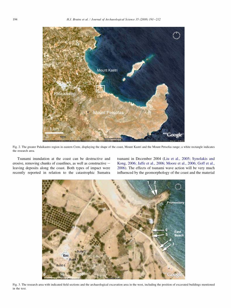
Fig. 2. The greater Palaikastro region in eastern Crete, displaying the shape of the coast, Mount Kastri and the Mount Petsofas range; a white rectangle indicates
the research area.
Tsunami inundation at the coast can be destructive anderosive, removing chunks of coastlines, as well as constructive eleaving deposits along the coast. Both types of impact wererecently reported in relation to the catastrophic Sumatra
tsunami in December 2004 (Liu et al., 2005; Synolakis andKong, 2006; Jaffe et al., 2006; Moore et al., 2006; Goff et al.,2006). The effects of tsunami wave action will be very muchinfluenced by the geomorphology of the coast and the material
Fig. 3. The research area with indicated field sections and the archaeological excavation area in the west, including the position of excavated buildings mentioned
in the text.
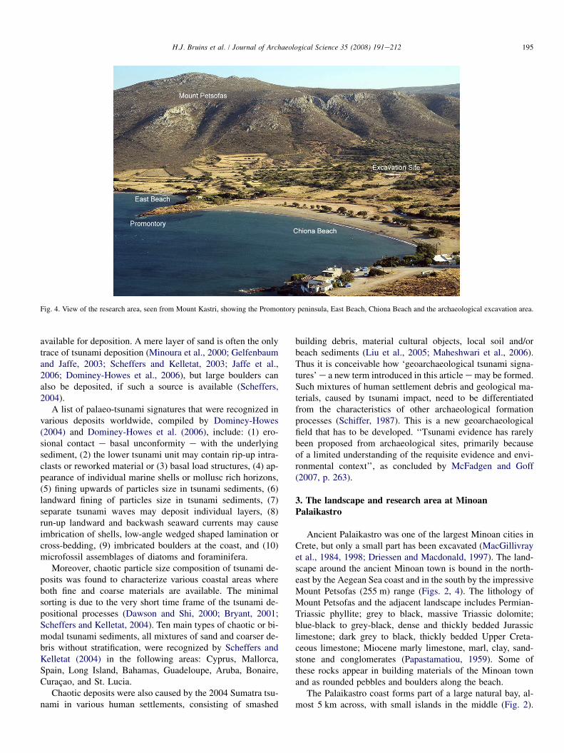
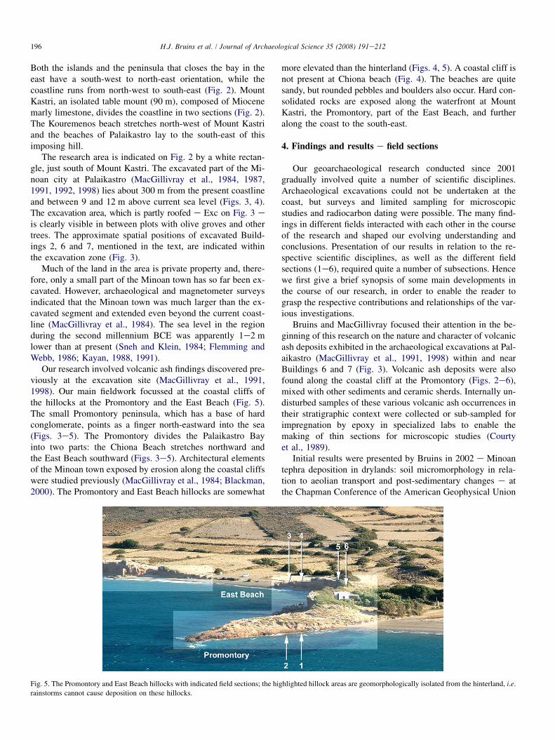
Fig. 4. View of the research area, seen from Mount Kastri, showing the Promontory peninsula, East Beach, Chiona Beach and the archaeological excavation area.
195H.J. Bruins et al. / Journal of Archaeological Science 35 (2008) 191e212
available for deposition. A mere layer of sand is often the onlytrace of tsunami deposition (Minoura et al., 2000; Gelfenbaumand Jaffe, 2003; Scheffers and Kelletat, 2003; Jaffe et al.,2006; Dominey-Howes et al., 2006), but large boulders canalso be deposited, if such a source is available (Scheffers,2004).
A list of palaeo-tsunami signatures that were recognized invarious deposits worldwide, compiled by Dominey-Howes(2004) and Dominey-Howes et al. (2006), include: (1) ero-sional contact e basal unconformity e with the underlyingsediment, (2) the lower tsunami unit may contain rip-up intra-clasts or reworked material or (3) basal load structures, (4) ap-pearance of individual marine shells or mollusc rich horizons,(5) fining upwards of particles size in tsunami sediments, (6)landward fining of particles size in tsunami sediments, (7)separate tsunami waves may deposit individual layers, (8)run-up landward and backwash seaward currents may causeimbrication of shells, low-angle wedged shaped lamination orcross-bedding, (9) imbricated boulders at the coast, and (10)microfossil assemblages of diatoms and foraminifera.
Moreover, chaotic particle size composition of tsunami de-posits was found to characterize various coastal areas whereboth fine and coarse materials are available. The minimalsorting is due to the very short time frame of the tsunami de-positional processes (Dawson and Shi, 2000; Bryant, 2001;Scheffers and Kelletat, 2004). Ten main types of chaotic or bi-modal tsunami sediments, all mixtures of sand and coarser de-bris without stratification, were recognized by Scheffers andKelletat (2004) in the following areas: Cyprus, Mallorca,Spain, Long Island, Bahamas, Guadeloupe, Aruba, Bonaire,Curacao, and St. Lucia.
Chaotic deposits were also caused by the 2004 Sumatra tsu-nami in various human settlements, consisting of smashed
building debris, material cultural objects, local soil and/orbeach sediments (Liu et al., 2005; Maheshwari et al., 2006).Thus it is conceivable how ‘geoarchaeological tsunami signa-tures’ e a new term introduced in this article e may be formed.Such mixtures of human settlement debris and geological ma-terials, caused by tsunami impact, need to be differentiatedfrom the characteristics of other archaeological formationprocesses (Schiffer, 1987). This is a new geoarchaeologicalfield that has to be developed. ‘‘Tsunami evidence has rarelybeen proposed from archaeological sites, primarily becauseof a limited understanding of the requisite evidence and envi-ronmental context’’, as concluded by McFadgen and Goff(2007, p. 263).
3. The landscape and research area at MinoanPalaikastro
Ancient Palaikastro was one of the largest Minoan cities inCrete, but only a small part has been excavated (MacGillivrayet al., 1984, 1998; Driessen and Macdonald, 1997). The land-scape around the ancient Minoan town is bound in the north-east by the Aegean Sea coast and in the south by the impressiveMount Petsofas (255 m) range (Figs. 2, 4). The lithology ofMount Petsofas and the adjacent landscape includes Permian-Triassic phyllite; grey to black, massive Triassic dolomite;blue-black to grey-black, dense and thickly bedded Jurassiclimestone; dark grey to black, thickly bedded Upper Creta-ceous limestone; Miocene marly limestone, marl, clay, sand-stone and conglomerates (Papastamatiou, 1959). Some ofthese rocks appear in building materials of the Minoan townand as rounded pebbles and boulders along the beach.
The Palaikastro coast forms part of a large natural bay, al-most 5 km across, with small islands in the middle (Fig. 2).
196 H.J. Bruins et al. / Journal of Archaeological Science 35 (2008) 191e212
Both the islands and the peninsula that closes the bay in theeast have a south-west to north-east orientation, while thecoastline runs from north-west to south-east (Fig. 2). MountKastri, an isolated table mount (90 m), composed of Miocenemarly limestone, divides the coastline in two sections (Fig. 2).The Kouremenos beach stretches north-west of Mount Kastriand the beaches of Palaikastro lay to the south-east of thisimposing hill.
The research area is indicated on Fig. 2 by a white rectan-gle, just south of Mount Kastri. The excavated part of the Mi-noan city at Palaikastro (MacGillivray et al., 1984, 1987,1991, 1992, 1998) lies about 300 m from the present coastlineand between 9 and 12 m above current sea level (Figs. 3, 4).The excavation area, which is partly roofed e Exc on Fig. 3 eis clearly visible in between plots with olive groves and othertrees. The approximate spatial positions of excavated Build-ings 2, 6 and 7, mentioned in the text, are indicated withinthe excavation zone (Fig. 3).
Much of the land in the area is private property and, there-fore, only a small part of the Minoan town has so far been ex-cavated. However, archaeological and magnetometer surveysindicated that the Minoan town was much larger than the ex-cavated segment and extended even beyond the current coast-line (MacGillivray et al., 1984). The sea level in the regionduring the second millennium BCE was apparently 1e2 mlower than at present (Sneh and Klein, 1984; Flemming andWebb, 1986; Kayan, 1988, 1991).
Our research involved volcanic ash findings discovered pre-viously at the excavation site (MacGillivray et al., 1991,1998). Our main fieldwork focussed at the coastal cliffs ofthe hillocks at the Promontory and the East Beach (Fig. 5).The small Promontory peninsula, which has a base of hardconglomerate, points as a finger north-eastward into the sea(Figs. 3e5). The Promontory divides the Palaikastro Bayinto two parts: the Chiona Beach stretches northward andthe East Beach southward (Figs. 3e5). Architectural elementsof the Minoan town exposed by erosion along the coastal cliffswere studied previously (MacGillivray et al., 1984; Blackman,2000). The Promontory and East Beach hillocks are somewhat
more elevated than the hinterland (Figs. 4, 5). A coastal cliff isnot present at Chiona beach (Fig. 4). The beaches are quitesandy, but rounded pebbles and boulders also occur. Hard con-solidated rocks are exposed along the waterfront at MountKastri, the Promontory, part of the East Beach, and furtheralong the coast to the south-east.
4. Findings and results e field sections
Our geoarchaeological research conducted since 2001gradually involved quite a number of scientific disciplines.Archaeological excavations could not be undertaken at thecoast, but surveys and limited sampling for microscopicstudies and radiocarbon dating were possible. The many find-ings in different fields interacted with each other in the courseof the research and shaped our evolving understanding andconclusions. Presentation of our results in relation to the re-spective scientific disciplines, as well as the different fieldsections (1e6), required quite a number of subsections. Hencewe first give a brief synopsis of some main developments inthe course of our research, in order to enable the reader tograsp the respective contributions and relationships of the var-ious investigations.
Bruins and MacGillivray focused their attention in the be-ginning of this research on the nature and character of volcanicash deposits exhibited in the archaeological excavations at Pal-aikastro (MacGillivray et al., 1991, 1998) within and nearBuildings 6 and 7 (Fig. 3). Volcanic ash deposits were alsofound along the coastal cliff at the Promontory (Figs. 2e6),mixed with other sediments and ceramic sherds. Internally un-disturbed samples of these various volcanic ash occurrences intheir stratigraphic context were collected or sub-sampled forimpregnation by epoxy in specialized labs to enable themaking of thin sections for microscopic studies (Courtyet al., 1989).
Initial results were presented by Bruins in 2002 e Minoantephra deposition in drylands: soil micromorphology in rela-tion to aeolian transport and post-sedimentary changes e atthe Chapman Conference of the American Geophysical Union
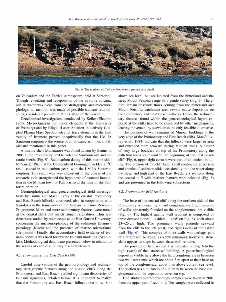
Fig. 5. The Promontory and East Beach hillocks with indicated field sections; the highlighted hillock areas are geomorphologically isolated from the hinterland, i.e.
rainstorms cannot cause deposition on these hillocks.
197H.J. Bruins et al. / Journal of Archaeological Science 35 (2008) 191e212
Fig. 6. The northern cliff of the Promontory peninsula in detail.
on Volcanism and the Earth’s Atmosphere, held at Santorini.Though reworking and redeposition of the airborne volcanicash in water was clear from the stratigraphy and micromor-phology, no mention was made of possible tsunami relation-ships, considered premature at this stage of the research.
Geochemical investigations conducted by Keller (ElectronProbe Micro-Analysis for major elements at the Universityof Freiburg) and by Klugel (Laser Ablation Inductively Cou-pled Plasma Mass Spectrometry for trace elements at the Uni-versity of Bremen) proved unequivocally that the LM IASantorini eruption is the source of all volcanic ash finds at Pal-aikastro mentioned in this paper.
A marine shell (Patellidae) was found in situ by Bruins in2001 at the Promontory next to volcanic Santorini ash and ce-ramic sherds (Fig. 9). Radiocarbon dating of this marine shellby Van der Plicht at the University of Groningen yielded a 14Cresult coeval in radiocarbon years with the LM IA Santorinieruption. This result was very important in the course of ourresearch, as it strengthened the hypothesis of tsunami inunda-tion in the Minoan town of Palaikastro at the time of the San-torini eruption.
Geomorphological and geoarchaeological field investiga-tions by Bruins and MacGillivray at the coastal Promontoryand East Beach hillocks continued, also in cooperation withSynolakis in the framework of the Aegean Tsunamis ResearchProgramme. More and more sedimentary features were notedat the coastal cliffs that match tsunami signatures. Thin sec-tions were studied by microscope at the Ben-Gurion University,concerning the micromorphology of the sediments (Bruins),petrology (Kisch) and the presence of marine micro-fauna(Benjamini). Finally, the accumulative field evidence of tsu-nami deposits was used for inverse tsunami modeling (Synola-kis). Methodological details are presented below in relation tothe results of each disciplinary research element.
4.1. Promontory and East Beach cliffs
Careful observations of the geomorphology and sedimen-tary stratigraphic features along the coastal cliffs along thePromontory and East Beach yielded significant discoveries oftsunami signatures, detailed below. It is important to realizethat the Promontory and East Beach hillocks rise to ca. 8 m
above sea level, but are isolated from the hinterland and thesteep Mount Petsofas range by a gentle valley (Fig. 5). There-fore, stream or runoff flows coming from the hinterland andMount Petsofas catchment area cannot cause deposition onthe Promontory and East Beach hillocks. Hence the sedimen-tary features found within the geoarchaeological layers ex-posed at the cliffs have to be explained by other mechanisms,leaving movement by seawater as the only feasible alternative.
The position of wall remains of Minoan buildings at thevery edge of the Promontory and East Beach cliffs (MacGilliv-ray et al., 1984) indicate that the hillocks were larger in areaand extended more seaward during Minoan times. A clusterof very large boulders on top of the Promontory along thepath that leads southward to the beginning of the East Beachcliff (Fig. 6, upper right corner) were part of an ancient build-ing. The erosion of the cliff face is still continuing at presentand chunks of sediment slide occasionally into the water alongthe steep and high part of the East Beach. Six sections alongthe coastal cliff with distinct features were selected (Fig. 5)and are presented in the following subsections.
4.2. Promontory: field section 1
The base of the coastal cliff along the northern side of thePromontory is formed by a hard conglomerate. Eight remainsof walls, apparently founded on the conglomerate, are visible(Fig. 6). The highest quality wall remnant is composed ofthree dressed stones e ashlars e (AW on Fig. 6), each about23e25 cm high. Two prominent walls protrude seawardfrom the cliff to the left (east) and right (west) of the ashlarwall (Fig. 6). This complex of three walls was perhaps partof a ‘staircase’ building, as a few remaining horizontal stoneslabs appear as steps between these wall remains.
The position of field section 1 is indicated on Fig. 6 to theright (west) of the ‘staircase’ building. A geoarchaeologicaldeposit is visible here above the hard conglomerate in betweentwo wall remnants, which are about 3 m apart at their base ontop of the conglomerate, about 1 m above current sea level.The section has a thickness of 2.20 m in between the base con-glomerate and the vegetation cover on top.
Undisturbed micromorphology samples were taken in 2001from the upper part of section 1. The samples were collected in
198 H.J. Bruins et al. / Journal of Archaeological Science 35 (2008) 191e212
rather fine sediment, mixed with coarser components, at thefollowing stratigraphic position: 10 cm above the uppermoststone of the wall remnant west of the ashlar wall, 10 cm belowa horizontal stone slab e possibly a step of the staircase, about40 cm below the vegetation cover. The position of this sampleis ca. 1.70 m above the base conglomerate and 2.60 m abovecurrent sea level. The samples were impregnated by epoxy ina specialized lab to enable the making of thin sections. Micro-scopic studies of these thin sections from the upper part of sec-tion 1 revealed marine micro-fauna, including coralline algae(Fig. 15e), foraminifera (Fig. 15f) and inter-tidal zone compo-nents, such as pieces of cemented beach-rock and roundedbeach sand in these multi-modal deposits.
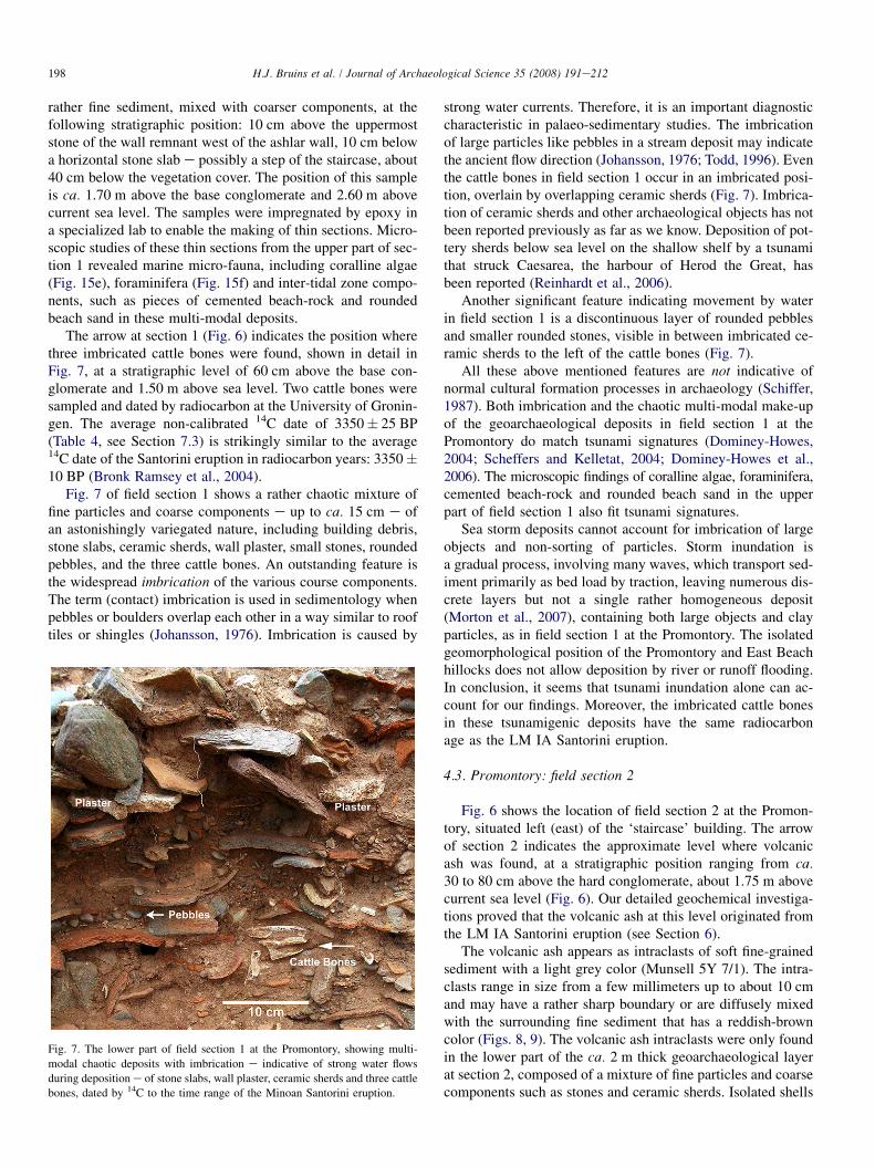
The arrow at section 1 (Fig. 6) indicates the position wherethree imbricated cattle bones were found, shown in detail inFig. 7, at a stratigraphic level of 60 cm above the base con-glomerate and 1.50 m above sea level. Two cattle bones weresampled and dated by radiocarbon at the University of Gronin-gen. The average non-calibrated 14C date of 3350� 25 BP(Table 4, see Section 7.3) is strikingly similar to the average14C date of the Santorini eruption in radiocarbon years: 3350�10 BP (Bronk Ramsey et al., 2004).
Fig. 7 of field section 1 shows a rather chaotic mixture offine particles and coarse components e up to ca. 15 cm e ofan astonishingly variegated nature, including building debris,stone slabs, ceramic sherds, wall plaster, small stones, roundedpebbles, and the three cattle bones. An outstanding feature isthe widespread imbrication of the various course components.The term (contact) imbrication is used in sedimentology whenpebbles or boulders overlap each other in a way similar to rooftiles or shingles (Johansson, 1976). Imbrication is caused by
Fig. 7. The lower part of field section 1 at the Promontory, showing multi-
modal chaotic deposits with imbrication e indicative of strong water flows
during deposition e of stone slabs, wall plaster, ceramic sherds and three cattle
bones, dated by 14C to the time range of the Minoan Santorini eruption.
strong water currents. Therefore, it is an important diagnosticcharacteristic in palaeo-sedimentary studies. The imbricationof large particles like pebbles in a stream deposit may indicatethe ancient flow direction (Johansson, 1976; Todd, 1996). Eventhe cattle bones in field section 1 occur in an imbricated posi-tion, overlain by overlapping ceramic sherds (Fig. 7). Imbrica-tion of ceramic sherds and other archaeological objects has notbeen reported previously as far as we know. Deposition of pot-tery sherds below sea level on the shallow shelf by a tsunamithat struck Caesarea, the harbour of Herod the Great, hasbeen reported (Reinhardt et al., 2006).
Another significant feature indicating movement by waterin field section 1 is a discontinuous layer of rounded pebblesand smaller rounded stones, visible in between imbricated ce-ramic sherds to the left of the cattle bones (Fig. 7).
All these above mentioned features are not indicative ofnormal cultural formation processes in archaeology (Schiffer,1987). Both imbrication and the chaotic multi-modal make-upof the geoarchaeological deposits in field section 1 at thePromontory do match tsunami signatures (Dominey-Howes,2004; Scheffers and Kelletat, 2004; Dominey-Howes et al.,2006). The microscopic findings of coralline algae, foraminifera,cemented beach-rock and rounded beach sand in the upperpart of field section 1 also fit tsunami signatures.
Sea storm deposits cannot account for imbrication of largeobjects and non-sorting of particles. Storm inundation isa gradual process, involving many waves, which transport sed-iment primarily as bed load by traction, leaving numerous dis-crete layers but not a single rather homogeneous deposit(Morton et al., 2007), containing both large objects and clayparticles, as in field section 1 at the Promontory. The isolatedgeomorphological position of the Promontory and East Beachhillocks does not allow deposition by river or runoff flooding.In conclusion, it seems that tsunami inundation alone can ac-count for our findings. Moreover, the imbricated cattle bonesin these tsunamigenic deposits have the same radiocarbonage as the LM IA Santorini eruption.
4.3. Promontory: field section 2
Fig. 6 shows the location of field section 2 at the Promon-tory, situated left (east) of the ‘staircase’ building. The arrowof section 2 indicates the approximate level where volcanicash was found, at a stratigraphic position ranging from ca.30 to 80 cm above the hard conglomerate, about 1.75 m abovecurrent sea level (Fig. 6). Our detailed geochemical investiga-tions proved that the volcanic ash at this level originated fromthe LM IA Santorini eruption (see Section 6).
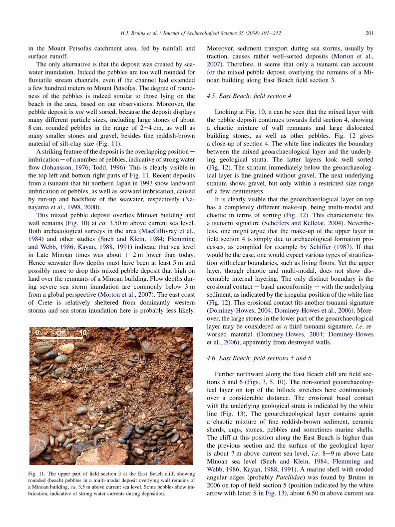
The volcanic ash appears as intraclasts of soft fine-grainedsediment with a light grey color (Munsell 5Y 7/1). The intra-clasts range in size from a few millimeters up to about 10 cmand may have a rather sharp boundary or are diffusely mixedwith the surrounding fine sediment that has a reddish-browncolor (Figs. 8, 9). The volcanic ash intraclasts were only foundin the lower part of the ca. 2 m thick geoarchaeological layerat section 2, composed of a mixture of fine particles and coarsecomponents such as stones and ceramic sherds. Isolated shells
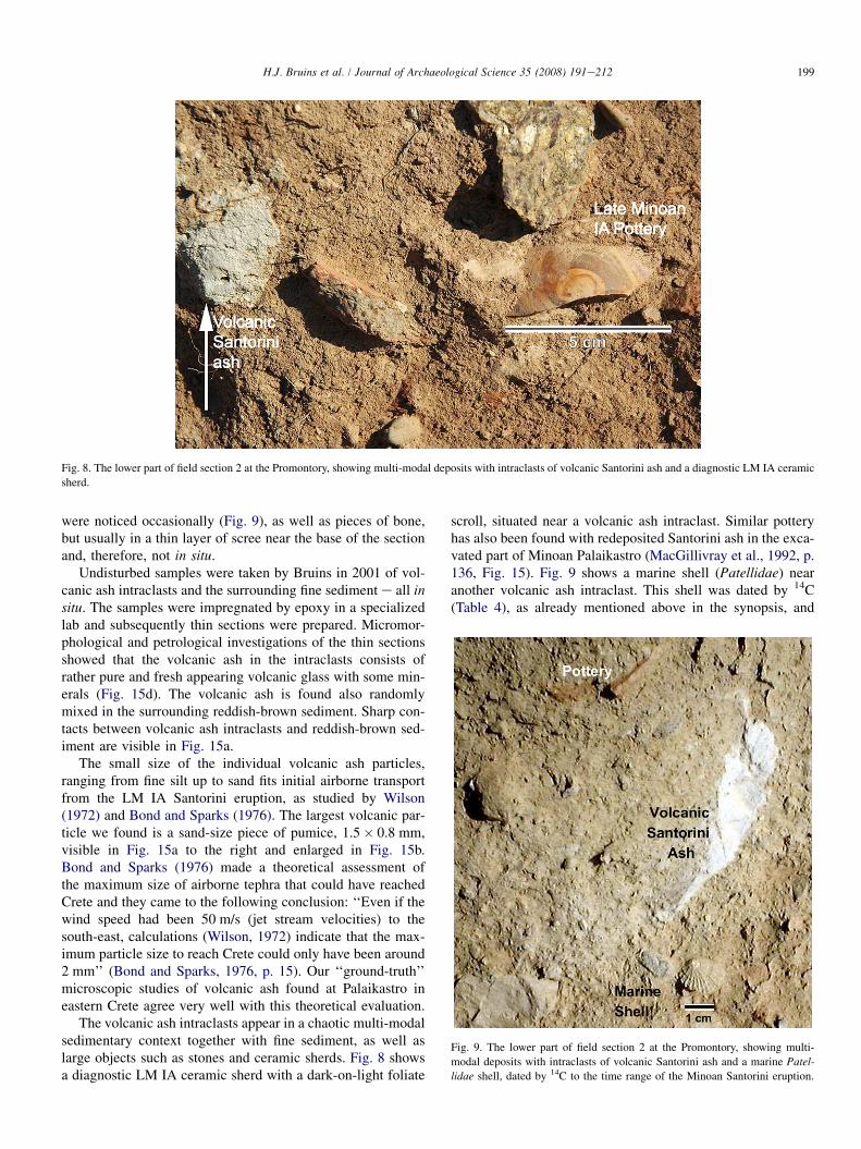
199H.J. Bruins et al. / Journal of Archaeological Science 35 (2008) 191e212
Fig. 8. The lower part of field section 2 at the Promontory, showing multi-modal deposits with intraclasts of volcanic Santorini ash and a diagnostic LM IA ceramic
sherd.
were noticed occasionally (Fig. 9), as well as pieces of bone,but usually in a thin layer of scree near the base of the sectionand, therefore, not in situ.
Undisturbed samples were taken by Bruins in 2001 of vol-canic ash intraclasts and the surrounding fine sediment e all insitu. The samples were impregnated by epoxy in a specializedlab and subsequently thin sections were prepared. Micromor-phological and petrological investigations of the thin sectionsshowed that the volcanic ash in the intraclasts consists ofrather pure and fresh appearing volcanic glass with some min-erals (Fig. 15d). The volcanic ash is found also randomlymixed in the surrounding reddish-brown sediment. Sharp con-tacts between volcanic ash intraclasts and reddish-brown sed-iment are visible in Fig. 15a.
The small size of the individual volcanic ash particles,ranging from fine silt up to sand fits initial airborne transportfrom the LM IA Santorini eruption, as studied by Wilson(1972) and Bond and Sparks (1976). The largest volcanic par-ticle we found is a sand-size piece of pumice, 1.5� 0.8 mm,visible in Fig. 15a to the right and enlarged in Fig. 15b.Bond and Sparks (1976) made a theoretical assessment ofthe maximum size of airborne tephra that could have reachedCrete and they came to the following conclusion: ‘‘Even if thewind speed had been 50 m/s (jet stream velocities) to thesouth-east, calculations (Wilson, 1972) indicate that the max-imum particle size to reach Crete could only have been around2 mm’’ (Bond and Sparks, 1976, p. 15). Our ‘‘ground-truth’’microscopic studies of volcanic ash found at Palaikastro ineastern Crete agree very well with this theoretical evaluation.
The volcanic ash intraclasts appear in a chaotic multi-modalsedimentary context together with fine sediment, as well aslarge objects such as stones and ceramic sherds. Fig. 8 showsa diagnostic LM IA ceramic sherd with a dark-on-light foliate
scroll, situated near a volcanic ash intraclast. Similar potteryhas also been found with redeposited Santorini ash in the exca-vated part of Minoan Palaikastro (MacGillivray et al., 1992, p.136, Fig. 15). Fig. 9 shows a marine shell (Patellidae) nearanother volcanic ash intraclast. This shell was dated by 14C(Table 4), as already mentioned above in the synopsis, and
Fig. 9. The lower part of field section 2 at the Promontory, showing multi-
modal deposits with intraclasts of volcanic Santorini ash and a marine Patel-lidae shell, dated by 14C to the time range of the Minoan Santorini eruption.

200 H.J. Bruins et al. / Journal of Archaeological Science 35 (2008) 191e212
yielded a result similar to the radiocarbon date of the LM IASantorini eruption (see Section 7.3).
The non-sorted multi-modal make-up of field section 2, likefield section 1 at the other side of the ‘staircase’ building, fitsa tsunami signature (Scheffers and Kelletat, 2004). Moreover,the presence of intraclasts e composed of volcanic ash e inthe lower parts of the geoarchaeological layer matches anothertsunami signature (Dominey-Howes, 2004; Dominey-Howeset al., 2006). The sea surrounds the Promontory and onemay ask whether storms could be responsible for these de-posits? A study by Morton et al. (2007), aimed to distinguishtsunami and storm deposits from each other, concluded thatmud intraclasts are strong evidence of tsunami deposition.The mud in our case is fine-grained volcanic ash, whichmust have been present to enable the formation of intraclastsby the tsunami, but the principle appears the same. Sedimenttransport during sea storms is primarily as bed load by traction(Morton et al., 2007), which does not lead to non-sorted cha-otic deposits with intraclasts.
Moreover, time wise, the in situ marine shell (Patellidae),dated by radiocarbon, the adjacent volcanic ash intraclast(Fig. 9), the diagnostic ceramic sherd next to another volcanicash intraclast (Fig. 8), all fit the time of the LM IA Santorinieruption. Also the dated cattle bones of section 1 had a radio-carbon age similar to the latter eruption. This multiple evi-dence supports a tsunami event during the LM IA Santorinieruption that struck the Palaikastro area.
4.4. East Beach: field section 3
The hillock that exists on the Promontory continues south-ward along the East Beach (Fig. 5), rising to levels of ca. 9 mabove sea level at the highest points, marked by hard
conglomerates and cemented cross-bedded aeolianite sand-stone. The East Beach cliff is usually higher and more verticalthan the cliff along the Promontory, but becomes progressivelylower southward (Fig. 5). Further on the cliff disappears andonly a few isolated remnants remain along the East Beach.Continuing south-eastward another hillock with cliff, isolatedfrom the hinterland, exists along the coast (Fig. 5). The ancienttown covered the coastal area from the tip of the Promontorysouth-eastward along the East Beach over a length of about300 m in the Late Minoan period (MacGillivray et al., 1984,p. 140).
A geoarchaeological layer of mixed composition forms theupper layer on the East Beach cliff at many sections, but noteverywhere. The layer is usually without visible internalstratification and without sorting and includes fine reddish-brown sediment, settlement debris, large and small (building)stones, ceramic sherds, cups, wall plaster, flooring pieces,rounded (beach) pebbles, and sometimes a marine shell.This geoarchaeological layer occurs at elevations rangingfrom beach level to a maximum height of ca. 7 m, but is absentat the highest parts of the cliff and various other segments. Itsthickness ranges from less than 0.5 m to more than 2 m.
Field section 3 along the East Beach is located in thecomparatively lower southern part of the cliff (Figs. 3, 5,10). The boundary between the mixed geoarchaeologicallayer and older geological strata is indicated by a whiteline (Fig. 10). A large concentration of rounded pebbles,ca. 3.5 m above sea level, is visible above wall remains ofa Minoan building (Fig. 10). This is not an ordinary streamchannel deposit. The land surface behind the East Beach cliffslopes down to a valley that separates the Promontory andEast Beach hillocks from the hinterland (Fig. 5). Therefore,this channel with rounded pebbles could not have originated
Fig. 10. The East Beach cliff with field sections 3e6.
201H.J. Bruins et al. / Journal of Archaeological Science 35 (2008) 191e212
in the Mount Petsofas catchment area, fed by rainfall andsurface runoff.
The only alternative is that the deposit was created by sea-water inundation. Indeed the pebbles are too well rounded forfluviatile stream channels, even if the channel had extendeda few hundred meters to Mount Petsofas. The degree of round-ness of the pebbles is indeed similar to those lying on thebeach in the area, based on our observations. Moreover, thepebble deposit is not well sorted, because the deposit displaysmany different particle sizes, including large stones of about8 cm, rounded pebbles in the range of 2e4 cm, as well asmany smaller stones and gravel, besides fine reddish-brownmaterial of silt-clay size (Fig. 11).
A striking feature of the deposit is the overlapping position eimbrication e of a number of pebbles, indicative of strong waterflow (Johansson, 1976; Todd, 1996). This is clearly visible inthe top left and bottom right parts of Fig. 11. Recent depositsfrom a tsunami that hit northern Japan in 1993 show landwardimbrication of pebbles, as well as seaward imbrication, causedby run-up and backflow of the seawater, respectively (Na-nayama et al., 1998, 2000).
This mixed pebble deposit overlies Minoan building andwall remains (Fig. 10) at ca. 3.50 m above current sea level.Both archaeological surveys in the area (MacGillivray et al.,1984) and other studies (Sneh and Klein, 1984; Flemmingand Webb, 1986; Kayan, 1988, 1991) indicate that sea levelin Late Minoan times was about 1e2 m lower than today.Hence seawater flow depths must have been at least 5 m andpossibly more to drop this mixed pebble deposit that high onland over the remnants of a Minoan building. Flow depths dur-ing severe sea storm inundation are commonly below 3 mfrom a global perspective (Morton et al., 2007). The east coastof Crete is relatively sheltered from dominantly westernstorms and sea storm inundation here is probably less likely.
Fig. 11. The upper part of field section 3 at the East Beach cliff, showing
rounded (beach) pebbles in a multi-modal deposit overlying wall remains of
a Minoan building, ca. 3.5 m above current sea level. Some pebbles show im-
brication, indicative of strong water currents during deposition.
Moreover, sediment transport during sea storms, usually bytraction, causes rather well-sorted deposits (Morton et al.,2007). Therefore, it seems that only a tsunami can accountfor the mixed pebble deposit overlying the remains of a Mi-noan building along East Beach field section 3.
4.5. East Beach: field section 4
Looking at Fig. 10, it can be seen that the mixed layer withthe pebble deposit continues towards field section 4, showinga chaotic mixture of wall remnants and large dislocatedbuilding stones, as well as other pebbles. Fig. 12 givesa close-up of section 4. The white line indicates the boundarybetween the mixed geoarchaeological layer and the underly-ing geological strata. The latter layers look well sorted(Fig. 12). The stratum immediately below the geoarchaeolog-ical layer is fine-grained without gravel. The next underlyingstratum shows gravel, but only within a restricted size rangeof a few centimeters.
It is clearly visible that the geoarchaeological layer on tophas a completely different make-up, being multi-modal andchaotic in terms of sorting (Fig. 12). This characteristic fitsa tsunami signature (Scheffers and Kelletat, 2004). Neverthe-less, one might argue that the make-up of the upper layer infield section 4 is simply due to archaeological formation pro-cesses, as compiled for example by Schiffer (1987). If thatwould be the case, one would expect various types of stratifica-tion with clear boundaries, such as living floors. Yet the upperlayer, though chaotic and multi-modal, does not show dis-cernable internal layering. The only distinct boundary is theerosional contact e basal unconformity e with the underlyingsediment, as indicated by the irregular position of the white line(Fig. 12). This erosional contact fits another tsunami signature(Dominey-Howes, 2004; Dominey-Howes et al., 2006). More-over, the large stones in the lower part of the geoarchaeologicallayer may be considered as a third tsunami signature, i.e. re-worked material (Dominey-Howes, 2004; Dominey-Howeset al., 2006), apparently from destroyed walls.
4.6. East Beach: field sections 5 and 6
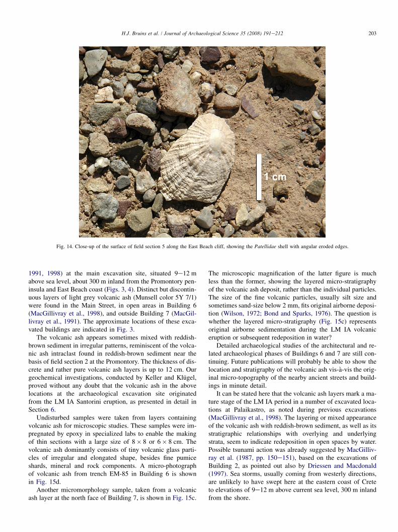
Further northward along the East Beach cliff are field sec-tions 5 and 6 (Figs. 3, 5, 10). The non-sorted geoarchaeolog-ical layer on top of the hillock stretches here continuouslyover a considerable distance. The erosional basal contactwith the underlying geological strata is indicated by the whiteline (Fig. 13). The geoarchaeological layer contains againa chaotic mixture of fine reddish-brown sediment, ceramicsherds, cups, stones, pebbles and sometimes marine shells.The cliff at this position along the East Beach is higher thanthe previous section and the surface of the geological layeris about 7 m above current sea level, i.e. 8e9 m above LateMinoan sea level (Sneh and Klein, 1984; Flemming andWebb, 1986; Kayan, 1988, 1991). A marine shell with erodedangular edges (probably Patellidae) was found by Bruins in2006 on top of field section 5 (position indicated by the whitearrow with letter S in Fig. 13), about 6.50 m above current sea
202 H.J. Bruins et al. / Journal of Archaeological Science 35 (2008) 191e212
Fig. 12. Field section 4 at the East Beach cliff. The white line indicates the erosional contact e basal unconformity e between the multi-modal chaotic
geoarchaeological layer and the underlying geological strata. Wall remains and dislocated building stones are present as reworked material in the lower part of
the geoarchaeological layer.
level. This shell (Fig. 14) has so far not been dated and mightbe out of context, but other marine shells have been noted inthe layer. Angular shell fragments are typical in a historicaltsunami deposit on the marine shelf at Ceasarea, Israel (Rein-hardt et al., 2006).
Wall remnants are not evident in field sections 5 and 6, butthree flat stones are visible at the erosional basal contact of thegeoarchaeological layer with the underlying stratum (Fig. 13,see black arrows). Two of these stones touch each other andthe third lies a bit further in the same position and at thesame level. Perhaps these were flagstones, signifying an an-cient archaeological surface that existed here before accumu-lation of the mixed geoarchaeological layer.
In conclusion, the latter layer in field sections 5 and 6 is toohigh for storm deposits, but contains three possible tsunamisignatures: basal unconformity, individual marine shells(Dominey-Howes, 2004; Dominey-Howes et al., 2006) andmulti-modal chaotic composition (Scheffers and Kelletat,2004). Such a sedimentary make-up is incompatible with seastorm deposits (Morton et al., 2007).
5. Volcanic Santorini ash deposits in the excavatedinland part of Minoan Palaikastro
Volcanic ash was discovered during previous years in thecourse of archaeological excavations (MacGillivray et al.,
Fig. 13. Field sections 5 and 6 along the East Beach cliff. The white line indicates the erosional contact e basal unconformity e between the multi-modal chaotic
geoarchaeological layer and the underlying geological strata. Three flagstones (black arrows) are present at the erosional contact. A Patellidae shell was found on
the surface of section 5 (white arrow with letter S), 6.50 m above current sea level.
203H.J. Bruins et al. / Journal of Archaeological Science 35 (2008) 191e212
Fig. 14. Close-up of the surface of field section 5 along the East Beach cliff, showing the Patellidae shell with angular eroded edges.
1991, 1998) at the main excavation site, situated 9e12 mabove sea level, about 300 m inland from the Promontory pen-insula and East Beach coast (Figs. 3, 4). Distinct but discontin-uous layers of light grey volcanic ash (Munsell color 5Y 7/1)were found in the Main Street, in open areas in Building 6(MacGillivray et al., 1998), and outside Building 7 (MacGil-livray et al., 1991). The approximate locations of these exca-vated buildings are indicated in Fig. 3.
The volcanic ash appears sometimes mixed with reddish-brown sediment in irregular patterns, reminiscent of the volca-nic ash intraclast found in reddish-brown sediment near thebasis of field section 2 at the Promontory. The thickness of dis-crete and rather pure volcanic ash layers is up to 12 cm. Ourgeochemical investigations, conducted by Keller and Klugel,proved without any doubt that the volcanic ash in the abovelocations at the archaeological excavation site originatedfrom the LM IA Santorini eruption, as presented in detail inSection 6.
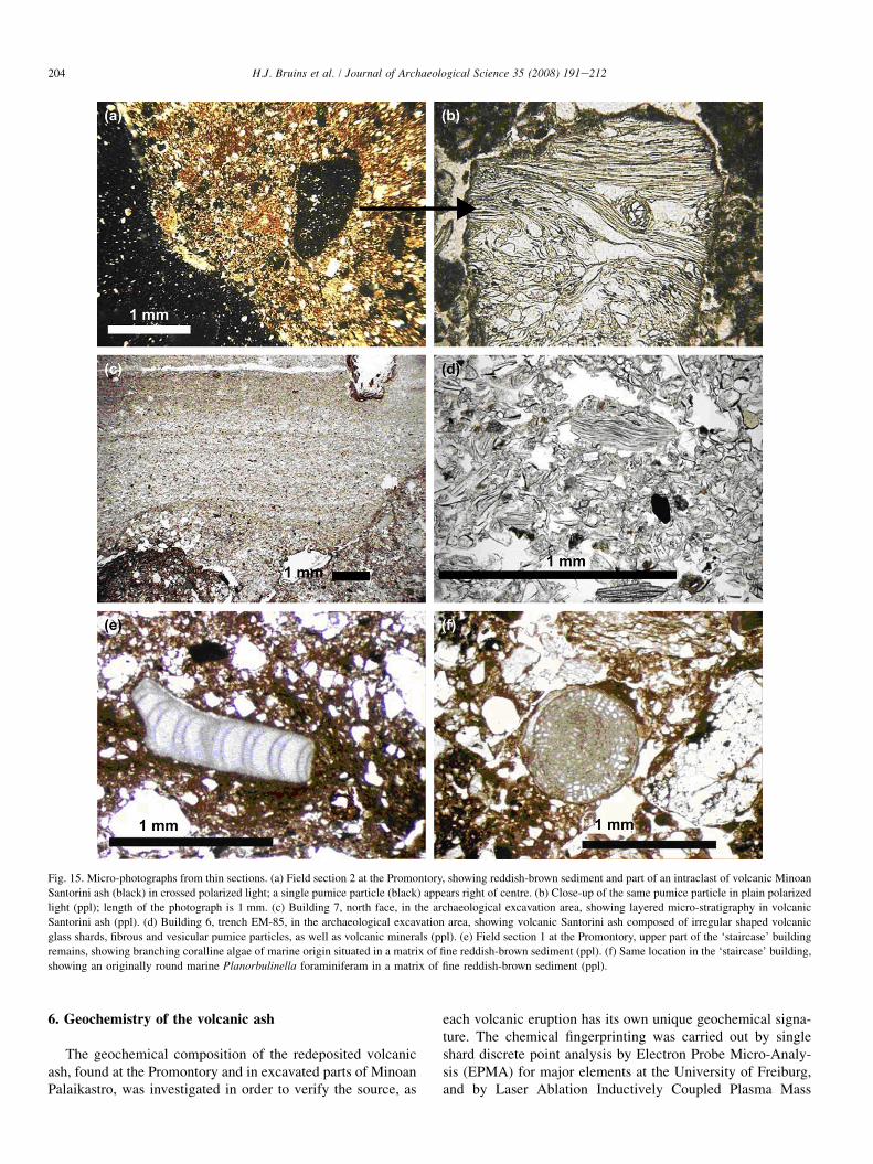
Undisturbed samples were taken from layers containingvolcanic ash for microscopic studies. These samples were im-pregnated by epoxy in specialized labs to enable the makingof thin sections with a large size of 8� 8 or 6� 8 cm. Thevolcanic ash dominantly consists of tiny volcanic glass parti-cles of irregular and elongated shape, besides fine pumiceshards, mineral and rock components. A micro-photographof volcanic ash from trench EM-85 in Building 6 is shownin Fig. 15d.
Another micromorphology sample, taken from a volcanicash layer at the north face of Building 7, is shown in Fig. 15c.
The microscopic magnification of the latter figure is muchless than the former, showing the layered micro-stratigraphyof the volcanic ash deposit, rather than the individual particles.The size of the fine volcanic particles, usually silt size andsometimes sand-size below 2 mm, fits original airborne deposi-tion (Wilson, 1972; Bond and Sparks, 1976). The question iswhether the layered micro-stratigraphy (Fig. 15c) representsoriginal airborne sedimentation during the LM IA volcaniceruption or subsequent redeposition in water?
Detailed archaeological studies of the architectural and re-lated archaeological phases of Buildings 6 and 7 are still con-tinuing. Future publications will probably be able to show thelocation and stratigraphy of the volcanic ash vis-a-vis the orig-inal micro-topography of the nearby ancient streets and build-ings in minute detail.
It can be stated here that the volcanic ash layers mark a ma-ture stage of the LM IA period in a number of excavated loca-tions at Palaikastro, as noted during previous excavations(MacGillivray et al., 1998). The layering or mixed appearanceof the volcanic ash with reddish-brown sediment, as well as itsstratigraphic relationships with overlying and underlyingstrata, seem to indicate redeposition in open spaces by water.Possible tsunami action was already suggested by MacGilliv-ray et al. (1987, pp. 150e151), based on the excavations ofBuilding 2, as pointed out also by Driessen and Macdonald(1997). Sea storms, usually coming from westerly directions,are unlikely to have swept here at the eastern coast of Creteto elevations of 9e12 m above current sea level, 300 m inlandfrom the shore.
204 H.J. Bruins et al. / Journal of Archaeological Science 35 (2008) 191e212
Fig. 15. Micro-photographs from thin sections. (a) Field section 2 at the Promontory, showing reddish-brown sediment and part of an intraclast of volcanic Minoan
Santorini ash (black) in crossed polarized light; a single pumice particle (black) appears right of centre. (b) Close-up of the same pumice particle in plain polarized
light (ppl); length of the photograph is 1 mm. (c) Building 7, north face, in the archaeological excavation area, showing layered micro-stratigraphy in volcanic
Santorini ash (ppl). (d) Building 6, trench EM-85, in the archaeological excavation area, showing volcanic Santorini ash composed of irregular shaped volcanic
glass shards, fibrous and vesicular pumice particles, as well as volcanic minerals (ppl). (e) Field section 1 at the Promontory, upper part of the ‘staircase’ building
remains, showing branching coralline algae of marine origin situated in a matrix of fine reddish-brown sediment (ppl). (f) Same location in the ‘staircase’ building,
showing an originally round marine Planorbulinella foraminiferam in a matrix of fine reddish-brown sediment (ppl).
6. Geochemistry of the volcanic ash
The geochemical composition of the redeposited volcanicash, found at the Promontory and in excavated parts of MinoanPalaikastro, was investigated in order to verify the source, as
each volcanic eruption has its own unique geochemical signa-ture. The chemical fingerprinting was carried out by singleshard discrete point analysis by Electron Probe Micro-Analy-sis (EPMA) for major elements at the University of Freiburg,and by Laser Ablation Inductively Coupled Plasma Mass
205H.J. Bruins et al. / Journal of Archaeological Science 35 (2008) 191e212
Spectrometry (LA-ICP-MS) for trace elements at the Univer-sity of Bremen.
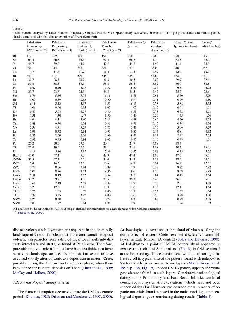
Microprobe analyses were conducted with a CAMECASX100 wavelength dispersive electron probe. Preparation ofpolished thin sections for analysis was done directly fromthe epoxy impregnated blocks. To avoid loss of alkalis,a beam diameter of 10 mm and a beam current of 10 nA wasconsistently applied. Calibration was undertaken against inter-national oxide, mineral and glass standards (Jarosewich et al.,1980). Summary major element EPMA data of four differenttephra samples from Palaikastro are reported in Table 2 andcompared with Minoan tephra from Santorini and other loca-tions with distal ash layers (Keller, 1980b; Druitt et al., 1999;Eastwood et al., 1999), all measured by microprobe point anal-yses of single glass shards. There is excellent agreement be-tween all data (Table 2), proving unequivocally that thevolcanic ash found at the Promontory and excavated parts ofPalaikastro are all derived from the Minoan Santorini eruption.
LA-ICP-MS analyses of single glass shards (Eastwoodet al., 1998; Pearce et al., 2002) were carried out usinga 266 nm UV laser connected to an Element2. Ablation condi-tions included a pulse rate of 5 Hz, a crater diameter of ca.40 mm, and He as carrier gas in the ablation cell (0.39 l/min)with subsequent addition of Ar (1 l/min). Rhyolitic glassATHO-G was used for external calibration with Ca as internalstandard element, and dacitic glass StHs6/80G was regularlyanalyzed as a monitor, using the values by Jochum et al.(2000). Four different tephra samples were analysed fromPalaikastro and one sample from southern Thera of the fourth(ignimbrite) eruption phase (Table 3). The concentrations ofall analyzed trace elements from Palaikastro glass shards per-fectly agree with each other within one standard deviation andalso with the Thera (Santorini) glass shards. There is also ex-cellent agreement between ratios of incompatible trace ele-ments, which are more reliable chemical fingerprints thanabsolute concentrations (Pearce et al., 2002).
7. Dating the geoarchaeological tsunami deposits
The reasons for the divergence between radiocarbon datingand archaeo-historical dating during the mid-second millen-nium BCE in the Eastern Mediterranean and Near East havenot yet been resolved (Warren and Hankey, 1989; Bruinsand Mook, 1989; Manning, 1999; Van der Plicht and Bruins,2001; Bietak, 2003; Bietak and Hoflmayer, 2007; Wiener,2003, 2007; Bruins and Van der Plicht, 2003; Bruins, 2007;Bronk Ramsey et al., 2004; Manning et al., 2006; Friedrichet al., 2006). This problem complicates matters, becausemixing dates from the two principal chronological systems eEgyptian Calendar and radiocarbon dating e may lead to er-roneous correlations and conclusions. The most precise andaccurate calibrated 14C date so far for the Santorini eruptionis 1627e1600 BCE, based on radiocarbon analysis and wig-gle matching of tree rings in an olive tree found covered bytephra on Santorini (Friedrich et al., 2006).
7.1. Geological dating criteria
A geological criterion for dating the geoarchaeological de-posits, characterized by tsunami signatures, is the presence ofreworked Minoan Santorini ash. The fall-out of volcanic ashover eastern Crete during the Santorini eruption was estimatedto have been about 5 cm thick, according to geographicextrapolation of volcanic ash data, mainly from deep-sea sed-iments (Watkins et al., 1978; Thorarinsson, 1978; McCoy,1980). Such a thin layer will not easily remain preserved inthe open landscape, as volcanic ash is susceptible to windand water erosion, particularly in arid and semi-arid hilly re-gions (Inbar et al., 1995). The Palaikastro area in eastern Creteis famous among surfers for its strong winds.
Volcanic ash particles originating from the MinoanSantorini eruption have been found dispersed in Cretan soils(Vitaliano and Vitaliano, 1974; Betancourt et al., 1990). But
Table 2
Major element analyses by electron microprobe (University of Freiburg) of single glass shards, correlated with the Minoan eruption of Thera (Santorini)
Palaikastro
Promontory,
BC5/1 (n¼ 24)
Palaikastro
Promontory,
BC1-9a (n¼ 19)
Palaikastro
Building, 7
North (n¼ 15)
Palaikastro
Trench,
EM-85 (n¼ 14)
Palaikastro,
B (n¼ 72)
SD Therab (Plinian
phase, n¼ 4)
Theraa (Plinian
phase, n¼ 7)
Kosb
(n¼ 3)
Golhisarc
(n¼ 67)
SiO2 73.32 73.20 73.25 73.21 73.25 0.34 73.00 73.44 73.36 73.61
TiO2 0.29 0.29 0.30 0.29 0.29 0.04 0.32 0.31 0.33 0.29
Al2O3 14.13 14.06 14.02 14.14 14.09 0.17 14.13 14.46 14.19 14.02
FeOt 2.08 2.11 2.11 2.15 2.11 0.11 2.13 2.05 2.08 2.04
MnO 0.07 0.07 0.08 0.08 0.07 0.03 0.07
MgO 0.30 0.31 0.30 0.32 0.31 0.03 0.34 0.25 0.32 0.28
CaO 1.42 1.43 1.44 1.45 1.43 0.08 1.48 1.56 1.41 1.40
Na2O 4.78 4.91 4.90 4.76 4.83 0.23 4.79 4.81 4.55 4.76
K2O 3.29 3.30 3.29 3.29 3.29 0.11 3.45 3.16 3.40 3.24
Cl 0.31 0.31 0.31 0.30 0.31 0.03 0.37 0.37 0.30
Sum 100.00 100.00 100.00 100.00 100.00 100.00 100.00 100.00 100.00
All analyses by electron microprobe, results in weight percentages normalised to 100%, volatile-free. FeOt, total Fe calculated as Fe2þ; n, number of point
analyses; SD, standard deviation; blank, not analysed or not detected.a Druitt et al. (1999).b Keller (1980b).c Eastwood et al. (1999).
206 H.J. Bruins et al. / Journal of Archaeological Science 35 (2008) 191e212
Table 3
Trace element analyses by Laser Ablation Inductively Coupled Plasma Mass Spectrometry (University of Bremen) of single glass shards and minute pumice
shards, correlated with the Minoan eruption of Thera (Santorini)
Palaikastro
Promontory,
BC5/1 (n¼ 17)
Palaikastro
Promontory,
BC1-9a (n¼ 8)
Palaikastro
Building 7,
North (n¼ 12)
Palaikastro
Trench,
EM-85 (n¼ 21)
Palaikastro B
(n¼ 58)
Palaikastro
standard
deviation, SD
Thera (Minoan
Ignimbrite phase)
Turkeya
(distal tephra)
Rb 113 109 115 106 110 10.8 108 116
Sr 65.4 66.3 65.9 67.2 66.3 4.70 63.8 56.9
Y 45.7 39.0 44.0 47.7 45.2 4.92 41.4 36.3
Zr 354 314 346 381 357 36.0 340 287
Nb 11.7 11.6 11.2 11.2 11.4 0.92 12.0 10.1
Ba 547 547 509 548 539 47.6 568 461
La 30.7 28.7 29.2 31.8 30.5 2.82 29.9 32.1
Ce 59.8 58.5 55.9 58.8 58.4 5.82 60.9 50.5
Pr 6.47 6.16 6.17 6.52 6.39 0.57 6.51 6.02
Nd 25.7 23.8 24.5 26.5 25.5 2.47 25.2 24.6
Sm 5.76 5.36 5.78 6.15 5.85 0.61 5.80 5.39
Eu 1.00 0.89 0.93 0.90 0.94 0.11 0.96 0.80
Gd 6.11 5.43 5.97 6.51 6.13 0.78 5.88 5.35
Tb 1.06 0.90 0.95 1.07 1.02 0.12 0.98 1.01
Dy 6.80 5.68 6.37 6.86 6.58 0.78 6.32 6.61
Ho 1.51 1.30 1.47 1.56 1.49 0.20 1.45 1.56
Er 4.94 4.31 4.60 5.21 4.88 0.69 4.60 4.52
Tm 0.81 0.70 0.74 0.81 0.78 0.13 0.74 0.74
Yb 5.39 4.71 5.29 5.75 5.41 0.76 5.06 5.29
Lu 0.93 0.72 0.84 0.91 0.87 0.14 0.81 0.92
Hf 9.25 8.09 8.56 9.99 9.21 1.21 8.48 7.05
Ta 0.92 0.93 0.94 1.02 0.97 0.16 0.99 1.01
Pb 20.2 20.0 29.0 20.1 21.7 5.88 18.3
Th 20.4 19.0 20.0 23.1 21.1 2.88 20.2 16.6
U 6.19 5.86 5.85 5.89 5.97 0.88 6.19 5.52
Ba/Nb 47.0 47.4 45.2 48.9 47.4 2.80 47.6 45.7
Zr/Nb 30.5 27.3 30.5 34.0 31.3 3.32 28.6 28.5
Zr/Th 17.4 16.5 17.2 16.6 16.9 0.94 16.9 17.3
Zr/Y 7.77 8.06 7.84 7.99 7.9 0.28 8.22 7.92
Hf/Ta 10.07 8.76 9.03 9.96 9.6 1.20 8.59 6.98
La/Ce 0.51 0.49 0.52 0.54 0.5 0.04 0.49 0.64
La/Lu 33.2 39.9 34.7 35.5 35.3 3.40 36.9 35.0
La/Nb 2.64 2.49 2.57 2.84 2.7 0.23 2.51 3.18
Ce/Yb 11.2 12.5 10.8 10.3 11.0 1.15 12.1 9.54
Th/Nb 1.76 1.65 1.77 2.06 1.9 0.22 1.69 1.64
Th/U 3.32 3.25 3.42 4.00 3.6 0.50 3.28 3.00
Nb/Y 0.26 0.30 0.26 0.24 0.3 0.03 0.29 0.28
Nb/U 1.89 1.97 1.94 1.95 1.9 0.16 1.94 1.83
All analyses by Laser Ablation ICP-MS; single element concentrations in mg/g; element ratios without dimension.a Pearce et al. (2002).
distinct volcanic ash layers are not apparent in the open hillylandscape of Crete. It is clear that a tsunami cannot redepositvolcanic ash particles from a diluted presence in soils into dis-crete intraclasts and strata, as found at Palaikastro. Therefore,pure airborne volcanic ash must have been available as a layeracross the landscape surface. Tsunami action seems to haveoccurred shortly after volcanic ash deposition in eastern Crete,possibly during the third or fourth eruption phase, when thereis evidence for tsunami deposits on Thera (Druitt et al., 1999;McCoy and Heiken, 2000).
7.2. Archaeological dating criteria
The Santorini eruption occurred during the LM IA ceramicperiod (Doumas, 1983; Driessen and Macdonald, 1997, 2000).
Archaeological excavations at the island of Mochlos along thenorth coast of eastern Crete revealed discrete volcanic ashlayers in Late Minoan IA context (Soles and Davaras, 1990).At Palaikastro, a painted LM IA pottery sherd appeared insitu next to a clast of Santorini ash (Fig. 8) in field section 2at the Promontory. This ceramic sherd with a dark-on-light fo-liate scroll is typical also of the pottery found with redepositedSantorini ash in excavated town layers (MacGillivray et al.1992, p. 136, Fig. 15). Indeed LM IA pottery appears the youn-gest element found in such layers. Conclusive archaeologicaldating at the Promontory and East Beach hillocks would ofcourse require systematic excavations, which have not beenscheduled thus far. However, radiocarbon measurements of or-ganic materials found exposed in the multi-modal geoarchaeo-logical deposits gave convincing dating results (Table 4).
207H.J. Bruins et al. / Journal of Archaeological Science 35 (2008) 191e212
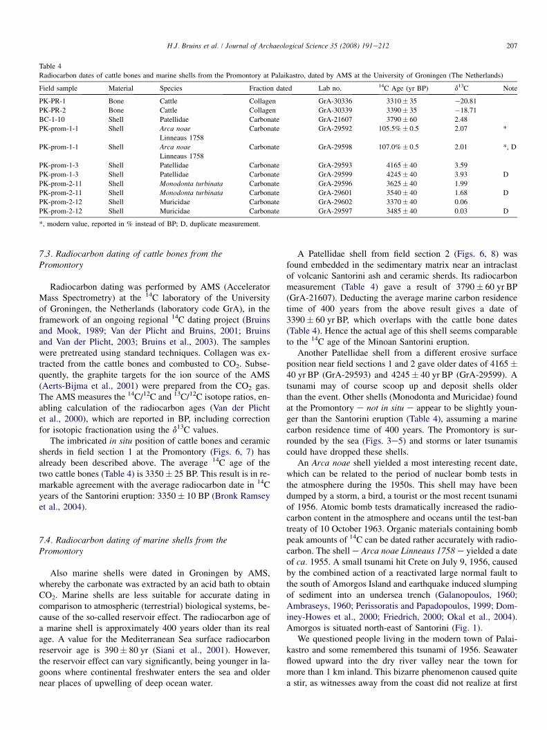
Table 4
Radiocarbon dates of cattle bones and marine shells from the Promontory at Palaikastro, dated by AMS at the University of Groningen (The Netherlands)
Field sample Material Species Fraction dated Lab no. 14C Age (yr BP) d13C Note
PK-PR-1 Bone Cattle Collagen GrA-30336 3310� 35 �20.81
PK-PR-2 Bone Cattle Collagen GrA-30339 3390� 35 �18.71
BC-1-10 Shell Patellidae Carbonate GrA-21607 3790� 60 2.48
PK-prom-1-1 Shell Arca noae
Linneaus 1758
Carbonate GrA-29592 105.5%� 0.5 2.07 *
PK-prom-1-1 Shell Arca noae
Linneaus 1758
Carbonate GrA-29598 107.0%� 0.5 2.01 *, D
PK-prom-1-3 Shell Patellidae Carbonate GrA-29593 4165� 40 3.59
PK-prom-1-3 Shell Patellidae Carbonate GrA-29599 4245� 40 3.93 D
PK-prom-2-11 Shell Monodonta turbinata Carbonate GrA-29596 3625� 40 1.99
PK-prom-2-11 Shell Monodonta turbinata Carbonate GrA-29601 3540� 40 1.68 D
PK-prom-2-12 Shell Muricidae Carbonate GrA-29602 3370� 40 0.06
PK-prom-2-12 Shell Muricidae Carbonate GrA-29597 3485� 40 0.03 D
*, modern value, reported in % instead of BP; D, duplicate measurement.
7.3. Radiocarbon dating of cattle bones from thePromontory
Radiocarbon dating was performed by AMS (AcceleratorMass Spectrometry) at the 14C laboratory of the Universityof Groningen, the Netherlands (laboratory code GrA), in theframework of an ongoing regional 14C dating project (Bruinsand Mook, 1989; Van der Plicht and Bruins, 2001; Bruinsand Van der Plicht, 2003; Bruins et al., 2003). The sampleswere pretreated using standard techniques. Collagen was ex-tracted from the cattle bones and combusted to CO2. Subse-quently, the graphite targets for the ion source of the AMS(Aerts-Bijma et al., 2001) were prepared from the CO2 gas.The AMS measures the 14C/12C and 13C/12C isotope ratios, en-abling calculation of the radiocarbon ages (Van der Plichtet al., 2000), which are reported in BP, including correctionfor isotopic fractionation using the d13C values.
The imbricated in situ position of cattle bones and ceramicsherds in field section 1 at the Promontory (Figs. 6, 7) hasalready been described above. The average 14C age of thetwo cattle bones (Table 4) is 3350� 25 BP. This result is in re-markable agreement with the average radiocarbon date in 14Cyears of the Santorini eruption: 3350� 10 BP (Bronk Ramseyet al., 2004).
7.4. Radiocarbon dating of marine shells from thePromontory
Also marine shells were dated in Groningen by AMS,whereby the carbonate was extracted by an acid bath to obtainCO2. Marine shells are less suitable for accurate dating incomparison to atmospheric (terrestrial) biological systems, be-cause of the so-called reservoir effect. The radiocarbon age ofa marine shell is approximately 400 years older than its realage. A value for the Mediterranean Sea surface radiocarbonreservoir age is 390� 80 yr (Siani et al., 2001). However,the reservoir effect can vary significantly, being younger in la-goons where continental freshwater enters the sea and oldernear places of upwelling of deep ocean water.
A Patellidae shell from field section 2 (Figs. 6, 8) wasfound embedded in the sedimentary matrix near an intraclastof volcanic Santorini ash and ceramic sherds. Its radiocarbonmeasurement (Table 4) gave a result of 3790� 60 yr BP(GrA-21607). Deducting the average marine carbon residencetime of 400 years from the above result gives a date of3390� 60 yr BP, which overlaps with the cattle bone dates(Table 4). Hence the actual age of this shell seems comparableto the 14C age of the Minoan Santorini eruption.
Another Patellidae shell from a different erosive surfaceposition near field sections 1 and 2 gave older dates of 4165�40 yr BP (GrA-29593) and 4245� 40 yr BP (GrA-29599). Atsunami may of course scoop up and deposit shells olderthan the event. Other shells (Monodonta and Muricidae) foundat the Promontory e not in situ e appear to be slightly youn-ger than the Santorini eruption (Table 4), assuming a marinecarbon residence time of 400 years. The Promontory is sur-rounded by the sea (Figs. 3e5) and storms or later tsunamiscould have dropped these shells.
An Arca noae shell yielded a most interesting recent date,which can be related to the period of nuclear bomb tests inthe atmosphere during the 1950s. This shell may have beendumped by a storm, a bird, a tourist or the most recent tsunamiof 1956. Atomic bomb tests dramatically increased the radio-carbon content in the atmosphere and oceans until the test-bantreaty of 10 October 1963. Organic materials containing bombpeak amounts of 14C can be dated rather accurately with radio-carbon. The shell e Arca noae Linneaus 1758 e yielded a dateof ca. 1955. A small tsunami hit Crete on July 9, 1956, causedby the combined action of a reactivated large normal fault tothe south of Amorgos Island and earthquake induced slumpingof sediment into an undersea trench (Galanopoulos, 1960;Ambraseys, 1960; Perissoratis and Papadopoulos, 1999; Dom-iney-Howes et al., 2000; Friedrich, 2000; Okal et al., 2004).Amorgos is situated north-east of Santorini (Fig. 1).
We questioned people living in the modern town of Palai-kastro and some remembered this tsunami of 1956. Seawaterflowed upward into the dry river valley near the town formore than 1 km inland. This bizarre phenomenon caused quitea stir, as witnesses away from the coast did not realize at first
208 H.J. Bruins et al. / Journal of Archaeological Science 35 (2008) 191e212
the tsunami connection. Fish and other marine objects weredeposited inland along the shore. Coastal vineyards and or-chards were salted by seawater, rendering them useless forabout 20 years. Otherwise, the comparatively small 1956 tsu-nami did not cause appreciable damage.
8. Modeling of the Minoan tsunami
Accurate modeling of tsunami inundation involves specifi-cation of an initial condition, detailed bathymetry and coastaltopographic data. Given the uncertainty of the precise natureand size of tsunami triggers during the Minoan Santorini erup-tion, forward modeling by specifying initial conditions (Anto-nopoulos, 1992; Pareschi et al., 2006) is a mute proposition.Modeling ought to be based as much as possible on field evi-dence, as attempted before (McCoy et al., 2000).
Here, we present initial results of inverse modeling basedon the newly discovered tsunamigenic deposits to infer thesize of the initial wave. We used MOST (Titov and Synolakis,1998; Synolakis and Bernard, 2006), a model extensivelyvalidated by laboratory and field data and with analyticalsolutions, to perform tsunami propagation and inundationcalculations. MOST uses a system of three nested rectangularcomputational grids in geophysical coordinates, thus permit-ting efficient numerical solution over a wide area.
Regions far from the area of interest were modeled withcoarser 1200 and 600 m outer grids, but for the specific studyarea near Palaikastro a finer 300 m resolution was used. Finerresolution was possible, as we conducted bathymetric surveysto augment our model. However, given the ill-posed nature ofthe inverse problem and the difficulties of regularizing it (Si-gurdsson et al., 2006), we felt it would have been factitiousto claim tens of meters in model accuracy, in a geophysicalproblem where uncertainties about the initial condition dwarfthe benefits of increased topographic resolution. For example,most existing inundation maps in California were produced ata resolution ranging from 75 to 250 m. Nonetheless, we per-formed full-inundation computations to avoid the well-knownunderestimation issues that plague threshold models, whichstop the calculation at some offshore depth (Synolakis andBernard, 2006).
We considered 9 m as a minimum for run-up, about 300 minland in Palaikastro, which corresponds to the deposits inBuildings 6 and 7. We also constrained the inverse model byrequiring at least 5 m inundation in Amnissos e a conservativeestimate. We then performed a series of over 50 simulations toinfer the size of the initial wave during the eruption, assumingthat the initial wave was generated by pyroclastic flows, whichwe model as sub-aerial landslides (Synolakis et al., 2002). Thelargest wave would have the impact that presents itself in thestratigraphic evidence we described for the coastal Promon-tory and East Beach hillocks.
Our results suggest that the initial wave was two to fourtimes the size of the wave that had been inferred earlier onthe basis of the available evidence before our work. The initialwave that best fits the stratigraphic data is a wave with þ35 to�15 m initial amplitude at the generation region with a crest
length of about 15 km. This size of wave is consistent withrecent findings of massive pyroclastic flow deposits aroundSantorini (Sigurdsson et al., 2006), which suggest that the totalvolume of ejecta was about twice the size of earlierestimations.
For comparison, the tsunami that devastated the north coastof Papua New Guinea in 1998 was triggered by a large under-water landslide. Detailed modeling, based upon existing dataconcerning source and run-up, yielded results suggesting aninitial wave of þ15 to �8 m at generation (Synolakis et al.,2002). The tsunami resulted in 12 m flow depths at Sissano,Papua New Guinea, killing more than 2100 people. Thegeneration of tsunamis by submarine mass failure can beconsidered partially analogous to pyroclastic flows slumpinginto the water.
Our results from Palaikastro for a tsunami generated duringthe Minoan Santorini eruption appear consistent with the 1956Amorgos tsunami, the largest tsunami event in the 20thcentury in the Eastern Mediterranean. The latter tsunamiwas triggered by submarine slumping into a trench near the is-land of Amorgos (Fig. 1), caused by an earthquake (Ms¼ 7.8).Eye witness accounts and measurements (Okal et al., 2004)suggest a 22 m run-up near the epicenter in Amorgos, 2 mrun-up near Amnissos (Crete), and, according to our informa-tion, 4 m run-up in Palaikastro. The source region of the 1956tsunami lies rather close to Santorini from the perspective ofPalaikastro (Fig. 1). Based upon the above Amorgos tsunamidata, one would infer substantial impact in Palaikastro fromthe Minoan Santorini eruption, even without a detailed numer-ical model and without accounting for directivity effects thatare anyway hard to quantify for pyroclastic flows.
9. Discussion and conclusions
All six described field sections along the coastal cliff at thePromontory and East Beach hillocks were shown to havea number of sedimentary features that match tsunami signa-tures (Dominey-Howes, 2004; Dominey-Howes et al., 2006:Scheffers and Kelletat, 2004):
(1) Sharp basal contact with the underlying sediment in thefour field sections along the East Beach cliff e the distinctboundary with the hard basal conglomerate at the Promon-tory is obvious.
(2) Intraclasts of volcanic Santorini ash in the lower part offield section 2 at the Promontory.
(3) Reworked material e building stones e in the lower partof the geoarchaeological layer in field section 4 at theEast Beach.
(4) Presence of individual marine shells in the geoarchaeolog-ical layer at both the Promontory and East Beach.
(5) Marine micro-fauna of coralline algae and foraminifera, aswell as inter-tidal beach-rock and rounded sand grains,present in thin sections from samples of sediment in theupper remaining part of the ‘staircase’ building, belowan apparent stepping stone and above the upper remaining
209H.J. Bruins et al. / Journal of Archaeological Science 35 (2008) 191e212
stone of the western wall e field section 1 at thePromontory.
(6) Imbrication of ceramic sherds, building debris, bones and/or rounded pebbles in field section 1 at the Promontoryand field section 3 at the East Beach cliff.
(7) The geoarchaeological layer shows in all field sections atthe Promontory and East Beach a multi-modal, non-sorted,chaotic particle size composition that includes fine red-dish-brown silt to clay size sediment, sand, gravel,rounded pebbles, building stones, ceramic sherds andcups.
Many of these features cannot be explained in terms of‘‘normal’’ archaeological formation processes (Schiffer,1987), but do fit tsunami signatures, as described above. Themarine shells occur singularly and occasionally in a randomdistribution pattern and not as clusters. Hence their presencecannot be explained in terms of food middens. Stream channeldeposition from the hinterland can be safely excluded to ex-plain rounded pebbles and imbrication in view of the isolatedgeomorphological position of the Promontory and East beachhillocks. It seems that the Bronze Age buildings or building re-mains at these hillocks both influenced tsunami deposition pat-terns and helped to preserve debris from eroding duringtsunami backwash and in later periods.
Considering the highest elevation of these deposits on theEast Beach cliff and the lower sea level in Minoan times,the tsunami wave(s) must have been at least 9 m high, butprobably considerably higher to reach the buildings on theseelevated parts with sufficient destruction force. The backwashseaward flow was probably somewhat less powerful on thePromontory and East Beach hillocks, as compared to the lowerparts of the coastline.
The observed and described features of geoarchaeologicaldeposits in the field sections along the Promontory and EastBeach cliffs do not fit storm sedimentation, except perhapsfor some marine shells e not in situ e at the lower Promon-tory. The distinction between sea storm and tsunami depositshas been precisely and eloquently described by Morton et al.(2007) in relation to the differences in hydrodynamics andsediment-sorting processes during transport: ‘‘Tsunami depo-sition results from a few high-velocity, long-period wavesthat entrain sediment from the shoreface, beach, and landwarderosion zone. Tsunamis can have flow depths greater than10 m, transport sediment primarily in suspension, and distrib-ute the load over a broad region where sediment falls out ofsuspension when flow decelerates. In contrast, storm inunda-tion generally is gradual and prolonged, consisting of manywaves that erode beaches and dunes with no significant over-land return flow until after the main flooding’’ (Morton et al.,2007, p. 184). The authors noted that storm flow depths arecommonly less than 3 m, while ‘‘sediment is transported pri-marily as bed load by traction, and the load is deposited withina zone relatively close to the beach’’ (Morton et al., 2007, p.184). The multi-modal chaotic composition and rather similarappearance of the geoarchaeological layer over a wide areaalong the Promontory and East Beach cliffs, albeit with local
variations as described in the field sections, do fit tsunami butnot storm deposition.
Airborne volcanic ash was already present at the Promon-tory area, when it was reworked by short-lived tsunami actionthat did neither result in total removal nor in homogeneousmixing. Volcanic ash intraclasts became deposited with red-dish-brown fine sediment and coarse material in the lowerpart of the geoarchaeological deposit in section 2 of thePromontory. Micromorphology studies showed that volcanicash particles also occur in low concentration in the redepositedfine red-brown sediment. Short-lived tsunami action did notlead to sorting of particle sizes and distinct layering, but torather sudden dump deposits, mixing various constituentstogether.
The tsunami appeared to have occurred during the MinoanSantorini eruption, possibly in the third or fourth eruptionphase, but after the deposition of airborne volcanic ash overeastern Crete. Geological, archaeological and radiocarbon cri-teria date the geoarchaeological deposits, containing volcanicSantorini ash, to the time of the Minoan eruption. The two datedcattle bones covered by pottery sherds e all imbricated eseem to be food remains from the destroyed coastal houses,perhaps the last meal, before the tsunami struck. It seems thatboth the broken dishes and the bones were deposited togetherby strong currents, causing contact imbrication of flat and elon-gated objects. Indeed, pottery sherds and other flat settlementdebris are well suited, due to their shape, to obtain imbricationpatterns in case of tsunami action. An earthquake could nothave caused such imbrication (Figs. 7, 11). Recognition of geo-archaeological tsunami signatures is a new field that needs to bedeveloped.
The initial results of inverse tsunami modeling, based onthe new field evidence, suggest a wave of þ35 to �15 m initialamplitude and a crest length of about 15 km in the Santorinigeneration region. That is powerful for a tsunami. For examplethe 1998 Papua New Guinea tsunami, which had an initialwave of þ15 to �8 m at generation, roughly half the above di-mensions, caused catastrophic flow depths of 12 m at Sissano.
The tsunami waves at Palaikastro apparently inundated theMinoan town completely, which would explain many puzzlingLM IA deposits encountered during previous excavations(MacGillivray et al., 1987, 1991, 1992, 1998). We have notedsimilar evidence at other Minoan sites, for example at Malia,where the palace ceased to function in LM IA. Chaotic de-posits, including admixtures of LM IA pottery and pumice,analogous in terms of sedimentation fabric to those at Palai-kastro, are visible along coastal cliffs near Malia (see Black-man, 2000, for description of the coast).
But the tsunami did not cause the end of the Minoan civi-lization. There was a building boom characterized by fine ma-sonry during the subsequent LM IB period. Nevertheless, theSantorini eruption and accompanying tsunami seem to havetriggered the beginning of the end for the Minoans, whose ma-jor population centres were un-walled and largely situatedalong the coastline, and whose naval defence was probablydevastated. Invasion and destruction followed in LM IB. Thegradual rebuilding and repopulation of Crete in the subsequent
210 H.J. Bruins et al. / Journal of Archaeological Science 35 (2008) 191e212
LM II and LM IIIA periods were controlled by a military-minded authority that converted the Minoan Linear A scriptto suite the Greek language. This leaves little doubt that theinvaders were Greeks from the mainland, Mycenae in particu-lar, whose navy harboured in the protected Corinthian gulf.
A gradual invasion of Crete from west to east would ex-plain the differences in archaeomagnetic and radiocarbondates from LM IB burnt destruction deposits (Tarling andDowney, 1990) and why these destructions in the east werecontemporary with central Cretan LM II (MacGillivray, 1997).
Acknowledgements
We are most grateful to the late N. Papadakis, Director ofAntiquities for Eastern Crete, and the Greek Ministry of Cul-ture, for their permission and constant support of our research,which was partly funded by the Institute for Aegean Prehis-tory. We thank the Stichting Midbar Foundation for financialsupport of the micromorphology and volcanic ash studies.Our research was undertaken under the auspices of the geolog-ical and geomorphological survey of the Palaikastro Excava-tions of the British School at Athens and under the auspicesof the Institute of Geological and Mineral Exploration(IGME, Greece) to sample coastal sediments throughout Creteas part of the Aegean Tsunamis Research Programme. Wethank J. Moody for discussions in the field that strengthenedour tsunamigenic interpretations. We thank K. Linse for iden-tifying photographed marine shells. The logistical support andhelp of the British Excavations at Palaikastro are acknowl-edged, though the authors alone are responsible for both theresearch and conclusions. The reviewers comments consider-ably improved the final text and lay-out of the article.
References
Aerts-Bijma, A.T., van der Plicht, J., Meijer, H.A.J., 2001. Automatic
AMS sample combustion and CO2 collection. Radiocarbon 43, 293e298.
Ambraseys, N.N., 1960. The seismic sea wave of July 9, 1956, in the Greek
Archipelago. Journal of Geophysical Research 65, 1257e1265.
Antonopoulos, J., 1992. The great Minoan eruption of Thera volcano and the
ensuing tsunami in the Greek Archipelago. Natural Hazards 5, 153e168.
Betancourt, P.P., Goldberg, P., Hope Simpson, R., Vitaliano, C.J., 1990. Exca-
vations at Pseira: the evidence for the Theran eruption. In: Hardy, D.A.,
Renfrew, A.C. (Eds.), Thera and the Aegean World III, vol. 3. The Thera
Foundation, London, pp. 96e99.
Bietak, M., 2003. Science versus archaeology: problems and consequences of
High Aegean Chronology. In: Bietak, M. (Ed.), The Synchronisation of
Civilisations in the Eastern Mediterranean in the Second Millennium
B.C. e II, pp. 23e33.
Bietak, M., Hoflmayer, F., 2007. Introduction: high and low chronology. In:
Bietak, M., Czerny, E. (Eds.), The Synchronisation of Civilisations in
the Eastern Mediterranean in the Second Millennium B.C. e III. Austrian
Academy of Sciences, Vienna, pp. 13e23.
Blackman, D., 2000. Archaeology in Greece 1999e2000. Archaeological Re-
ports 1999e2000. British School at Athens, London.
Bond, A., Sparks, R.S.J., 1976. The Minoan eruption of Santorini, Greece.
Journal of the Geological Society of London 132, 1e16.
Bronk Ramsey, C., Manning, S.W., Galimberti, M., 2004. Dating the volcanic
eruption at Thera. Radiocarbon 46, 325.
Bruins, H.J., 2007. Charcoal radiocarbon dates of Tell el-Dab’a. In:
Bietak, M., Czerny, E. (Eds.), The Synchronisation of Civilisations in
the Eastern Mediterranean in the Second Millennium B.C. e III. Austrian
Academy of Sciences, Vienna, pp. 65e77.
Bruins, H.J., Mook, W.G., 1989. The need for a calibrated radiocarbon chro-
nology of Near Eastern Archaeology. Radiocarbon 31 (3), 1019e1029.
Bruins, H.J., Van der Plicht, J., 2003. Assorting and synchronising archaeolog-
ical and geological strata with radiocarbon: the Southern Levant in relation
to Egypt and Thera. In: Bietak, M. (Ed.), The Synchronisation of Civiliza-
tions in the Eastern Mediterranean in the 2nd Millennium BC e II. Aus-
trian Academy of Sciences, Vienna, pp. 35e42.
Bruins, H.J., Van der Plicht, J., Mazar, A., 2003. 14C dates from Tel Rehov:
Iron-Age chronology, Pharaohs and Hebrew Kings. Science 300 (5617),
315e318.
Bryant, E., 2001. Tsunami � The Underrated Hazard. Cambridge University
Press, Cambridge.
Carey, S., Morelli, D., Sigurdsson, H., Bronto, S., 2001. Tsunami deposits
from major explosive eruptions: an example from the 1883 eruption of
Krakatau. Geology 29 (4), 347e350.
Cioni, R., Gurioli, L., Sbrana, A., Vougioukalakis, G., 2000. Precursory phe-
nomena and destructive events related to the Late Bronze Age Minoan
(Thera, Greece) and AD 79 (Vesuvius, Italy) Plinian eruptions; inferences
from the stratigraphy in the archaeological areas. In: McGuire, W.G.,
Griffiths, D.R., Hancock, P.L., Stewart, I.S. (Eds.), The Archaeology of
Geological Catastrophes. Special Publication 171. Geological Society,
London, pp. 123e141.
Cita, M.B., Camerlenghi, A., Kastens, K.A., McCoy, F.W., 1984. New findings
of Bronze Age homogenites in the Ionian Sea: geodynamic implications
for the Mediterranean. Marine Geology 55, 47e62.
Courty, M.A., Goldberg, P., Macphail, R., 1989. Soils and Micromorphology
in Archaeology. Cambridge University Press, Cambridge.
Dawson, A.G., Shi, S., 2000. Tsunami deposits. Pure and Applied Geophysics
157, 875e897.
Dominey-Howes, D.T.M., 2004. A re-analysis of the Late Bronze Age
eruption and tsunami of Santorini, Greece, and the implications for the
volcano-tsunami hazard. Journal of Volcanology and Geothermal Research
130, 107e132.
Dominey-Howes, D.T.M., Cundy, A.B., Croudace, I., 2000. High energy
marine flood deposits on Astypalaea Island, Greece: possible evidence for
the AD 1956 southern Aegean tsunami. Marine Geology 163, 303e315.
Dominey-Howes, D.T.M., Humphreys, G.S., Hesse, P.P., 2006. Tsunami
and palaeotsunami depositional signatures and their potential value in
understanding the late-Holocene tsunami record. The Holocene 16 (8),
1095e1107.
Doumas, C.G., 1983. Thera: Pompeii of the ancient Aegean. Thames and
Hudson, London.
Doumas, C., Papazoglou, L., 1980. Santorini tephra from Rhodes. Nature 287,
322e324.
Driessen, J., Macdonald, C.F., 1997. The Troubled Island, Minoan Crete
before and after the Santorini eruption. In: Aegaeum 17. Universite de
Liege/University of Texas, Liege/Austin.
Driessen, J., Macdonald, C.F., 2000. The eruption of the Santorini volcano and
its effect on Minoan Crete. In: McGuire, W.G., Griffiths, D.R.,
Hancock, P.L., Stewart, I.S. (Eds.), The Archaeology of Geological Catas-
trophes. Special Publication 171. Geological Society, London, pp. 81e93.
Druitt, T.H., Edwards, L., Mellors, R.M., Pyle, D.M., Sparks, R.S.J.,
Lanphere, M., Davies, M., Barreiro, B., 1999. Santorini Volcano. Geolog-
ical Society, London (Special Memoir, 19).
Eastwood, W.J., Pearce, N.J.G., Westgate, J.A., Perkins, W.T., 1998. Recogni-
tion of Santorini (Minoan) tephra in lake sediments from Golhisar Golu,
southwest Turkey, by laser ablation ICP-MS. Journal of Archaeological
Science 25, 677e687.
Eastwood, W.J., Pearce, N.J.G., Westgate, J.A., Perkins, W.T., Lamb, H.F.,
Roberts, N., 1999. Geochemistry of Santorini tephra in lake sediments
from Southwest Turkey. Global and Planetary Change 21, 17e29.
Flemming, N.C., Webb, C.O., 1986. Tectonic and eustatic coastal changes
during the last 10,000 years derived from archaeological data. Zeitschrift
fur Geomorphologie 62, 1e29.
211H.J. Bruins et al. / Journal of Archaeological Science 35 (2008) 191e212
Friedrich, W.L., 2000. Fire in the Sea: The Santorini Volcano. Cambridge Uni-
versity Press, Cambridge.
Friedrich, W.L., Kromer, B., Friedrich, M., Heinemeier, J., Pfeiffer, T.,
Talamo, S., 2006. Santorini eruption radiocarbon dated to 1627e1600
B.C. Science 312, 548.
Galanopoulos, A.G., 1960. Tsunamis observed on the coasts of Greece from
antiquity to present time. Annali di Geofisica 13, 369e386.
Goff, J., Liu, P.L.F., Higman, B., Morton, R., Jaffe, B.E., Fernando, H.,
Lynett, P., Fritz, H., Synolakis, C., Fernando, S., 2006. Sri Lanka field sur-
vey after the December 2004 Indian Ocean tsunami. Earthquake Spectra
22 (3), 155e172.
Gelfenbaum, G., Jaffe, B., 2003. Erosion and sedimentation from the 17 July,
1998 Papua New Guinea Tsunami. Pure Applied Geophysics 160, 1969e
1999.
Heiken, G.H., McCoy, F.W., 1984. Caldera development during the Minoan
eruption, Thera, Cyclades, Greece. Journal of Geophysical Research 89,
8441e8462.
Heiken, G.H., McCoy, F.W., 1990. Precursory activity to the Minoan eruption,
Thera, Greece. In: Hardy, D.A., Renfrew, A.C. (Eds.), Thera and the Ae-
gean World III, vol. 2. The Thera Foundation, London, pp. 79e88.
Inbar, M., Ostera, H.A., Parica, C.A., Remesal, M.B., Salani, F.M., 1995. En-
vironmental assessment of 1991 Hudson volcano eruption ashfall effects
on southern Patagonia region, Argentina. Environmental Geology 25 (2),
119e125.
Jaffe, B.E., Gelfenbaum, G., 2002. Using tsunami deposits to improve assess-
ment of tsunami risk. In: Conference Proceedings Solutions to Coastal
Disasters. Coasts, Oceans, Ports, and Rivers Institute (COPRI) of the
American Society of Civil Engineers, pp. 836e847.
Jaffe, B.E., Borrero, J.C., Prasetya, G.S., Peters, R., McAdoo, B.,
Gelfenbaum, G., Morton, R., Ruggiero, P., Higman, B., Dengler, L.,
Hidayat, R., Kingsley, E., Kongko, W., LukijantoMoore, A., Titov, V.,
Yulianto, E., 2006. Northwest Sumatra and offshore islands field survey af-
ter the December 2004 Indian Ocean tsunami. Earthquake Spectra 22 (S3),
S105eS135.
Jarosewich, E., Nelen, J.A., Norberg, J.A., 1980. Reference samples for
electron microprobe analysis. Geostandards Newsletter 4, 43e47.
Johansson, C.E., 1976. Structural studies of frictional sediments. Geografiska
Annaler. Series A. Physical Geography 58 (4), 201e301.
Jochum, K.P., Dingwell, D.B., Rocholl, A., Stoll, B., Hofmann, A.W., et al.,
2000. The preparation and preliminary characterization of eight geological
MPI-DING reference glasses for in-situ microanalysis. Geostandards
Newsletter 24, 87e133.
Kayan, I., 1988. Late Holocene sea-level changes on the western Anatolian
coast. Palaeogeography, Palaeoclimatology, Palaeoecology 68, 205e218.
Kayan, I., 1991. Holocene geomorphic evolution of the Besxik plain and chang-
ing environment of ancient man. Studia Troica 1, 79e92.
Keller, J., 1980a. Did the Santorini eruption destroy the Minoan world? Nature
287, 779.
Keller, J., 1980b. Prehistoric pumice tephra on Aegean islands. In: Doumas, C.
(Ed.), Thera and the Aegean World, vol. II. Thera Foundation, London, pp.
49e56.
Keller, J., Ryan, W.B.F., Ninkovich, D., Altherr, R., 1978. Explosive volcanic
activity in the Mediterranean over the past 200,000 yr as recorded in deep-
sea sediments. Geological Society of America Bulletin 89, 591e604.
Keller, J., Rehren, Th., Stadlbauer, E., 1990. Explosive volcanism in the Hel-
lenic Arc: a summary and review. In: Hardy, D., Keller, J., Galanopou-
los, V.P., Flemming, N.C., Druitt, T.H. (Eds.), Thera and the Aegean
World III, vol. 2. The Thera Foundation, London, pp. 13e26.
Liu, P.L.F., Lynett, P., Fernando, H., Jaffe, B.E., Fritz, H., Higman, B.,
Morton, R., Goff, J., Synolakis, C., 2005. Observations by the International
Tsunami Survey Team in Sri Lanka. Science 308, 1595.
MacGillivray, J.A., 1997. The re-occupation of Eastern Crete in the Late
Minoan IIeIIIA1/2 periods. In: Driessen, J., Farnoux, A. (Eds.), La
Crete Mycenienne, (BCH Suppl. 30). Ecole Francaise D’Athenes, Paris,
pp. 275e279.
MacGillivray, J.A., Sackett, L.H., Smyth, D., 1984. An archaeological survey
of the Roussolakos area at Palaikastro. The Annual of the British School of
Archaeology at Athens 79, 129e141 (Plates 8e13).
MacGillivray, J.A., Sackett, L.H., Driessen, J., Smyth, D., 1987. Excavations
at Palaikastro 1986. The Annual of the British School of Archaeology at
Athens 82, 135e154 (Plates 19e24).
MacGillivray, J.A., Sackett, L.H., Driessen, J., Smyth, D., 1991. Excavations
at Palaikastro 1990. The Annual of the British School of Archaeology at
Athens 86, 121e147 (Plates 6e16).
MacGillivray, J.A., Sackett, L.H., Driessen, J., Farnoux, A., Smyth, D., 1992.
Excavations at Palaikastro 1991. The Annual of the British School of
Archaeology at Athens 87, 121e152 (Plates 3e7).
MacGillivray, J.A., Sackett, L.H., Driessen, J., Hemingway, S., 1998. Excava-
tions at Palaikastro 1994 and 1996. The Annual of the British School of
Archaeology at Athens 93, 221e268 (Plates 38e50).
Maheshwari, B.K., Sharma, M.L., Narayan, J.P., 2006. Geotechnical and struc-
tural damage in Tamil Nadu, India, from the December 2004 Indian Ocean
tsunami. Earthquake Spectra 22 (3), 475e493.
Manning, S.W., 1999. A Test of Time e The Volcano of Thera and The Chro-
nology and History of the Aegean and East Mediterranean in the Mid
Second Millennium BC. Oxbow Books, Oxford.
Manning, S.W., Bronk Ramsay, C., Kutschera, W., Higham, T., Kromer, B.,
Steier, P., Wild, E.M., 2006. Chronology for the Aegean Late Bronze
Age 1700e1400 B.C. Science 312, 565e569.
Marinatos, S., 1939. The volcanic destruction of Minoan Crete. Antiquity 13,
425e439.
McCoy, F.W., 1980. The upper Thera (Minoan) ash in deep-sea sediments: dis-
tribution and comparison with other ash layers. In: Doumas, C. (Ed.),
Thera and the Aegean World, vol. II. Thera Foundation, London, pp.
49e56.
McCoy, F.W., Heiken, G., 2000. Tsunami generated by the Late Bronze Age
eruption of Thera (Santorini), Greece. Pure and Applied Geophysics
157, 1227e1256.
McCoy, F.W., Synolakis, C.E., Papadopoulous, G.A., 2000. Tsunami gener-
ated during the LBA eruption of Thera e evidence from modeling and
tsunami deposits. Bulletin of the American Geophysical Union 81 (48)
(San Francisco, California).
McCoy, F.W., Dunn, S., 2002. Modelling the climatic effects of the LBA erup-
tion of Thera: new calculations of tephra volumes may suggest a signifi-
cantly larger eruption than previously reported (abstract). In:
Proceedings of the Chapman Conference on Volcanism and the Earth’s
Atmosphere. American Geophysical Union, Santorini, Greece, pp. 21e22.
McFadgen, B.G., Goff, J.R., 2007. Tsunamis in the New Zealand archaeolog-
ical record. Sedimentary Geology 200, 263e274.
Minoura, K., Imamura, F., Kuran, U., Nakamura, T., Papadopoulos, G.A.,
Takahashi, T., Yalciner, A.C., 2000. Discovery of Minoan tsunami
deposits. Geology 28, 59e62.
Moore, A., Nishimura, Y., Gelfenbaum, G., Kamataki, T., Triyono, R., 2006.
Sedimentary deposits of the 26 December 2004 tsunami on the northwest
coast of Aceh, Indonesia. Earth Planets Space 58 (2), 253e258.
Morton, R.A., Gelfenbaum, G., Jaffe, B.E., 2007. Physical criteria for distin-
guishing sandy tsunami and storm deposits using modern examples. Sed-
imentary Geology 200, 184e207.
Nanayama, F., Satake, K., Shimokawa, K., Shigeno, K., Miyasaka, S., 1998.
Sedimentary characteristics of tsunami deposits: examples from the 1993
Hokkaido Nansei-oki tsunami, Northern Japan. Western Pacific Geophys-
ics Meeting. American Geophysical Union (abstract).
Nanayama, F., Shigeno, K., Satake, K., Shimokawa, K., Koitabashi, S.,
Miyasaka, S., Ishii, M., 2000. Sedimentary differences between the 1993
Hokkaido-nansei-oki tsunami and the 1959 Miyakojima typhoon at Taisei,
southwestern Hokkaido, northern Japan. Sedimentary Geology 135 (1),
255e264.
Nomanbhoy, N., Satake, K., 1995. Generation mechanism of tsunamis
from the 1883 Krakatau eruption. Geophysical Research Letters 22 (4),
509e512.
Okal, E.A., Synolakis, C.E., Yalciner, A.C., 2004. The Amorgos, Greece
Earthquake and Tsunami of 09 July 1956: Focal Mechanism and Field
Survey. American Geophysical Union, San Francisco, California (Fall
Meeting, Session OS23De1358).
Papastamatiou, I., 1959. Geological Map of Crete, Map Sheet 23, Sitia. Geo-
logical Survey and Geographical Service of the Greek Army, Athens.
212 H.J. Bruins et al. / Journal of Archaeological Science 35 (2008) 191e212
Pareschi, M.T., Favalli, M., Boschi, E., 2006. Impact of the Minoan tsunami of
Santorini: simulated scenarios in the eastern Mediterranean. Geophysical
Research Letters 33 (18), L18607.
Pearce, N.J.G., Eastwood, W.J., Westgate, J.A., Perkins, W.T., 2002. Trace
element composition of single glass shards in distal Minoan tephra from
SW Turkey. Journal of Geological Society 159, 545e556.
Perissoratis, C., Papadopoulos, G., 1999. Sediment instability and slumping in
the southern Aegean Sea and the case history of the 1956 tsunami. Marine
Geology 161, 287e305.
Reinhardt, E.G., Goodman, B.N., Boyce, J.I., Lopez, G., van Hengstum, P.,
Rink, W.J., Mart, Y., Raban, A., 2006. The tsunami of 13 Decemebr
A.D. 115 and the destruction of Herod the Great’s harbor at Ceasarea
Maritima, Israel. Geology 34 (12), 1061e1064.
Scheffers, A., 2004. Tsunami imprints on the Leeward Netherlands Antilles
(Aruba, Curacao, Bonaire) and their relation to other coastal problems.
Quaternary International 120, 163e172.
Scheffers, A., Kelletat, D., 2003. Sedimentological and geomorphologic
tsunami imprints worldwide � a review. Earth Science Reviews 63,
83e92.
Scheffers, A., Kelletat, D., 2004. Bimodal tsunami deposits e a neglected
feature in paleo-tsunami research. Coastline Reports 1, 67e75.
Schiffer, M.B., 1987. Formation Processes of the Archaeological Record.
University of New Mexico Press, Albuquerque.
Siani, G., Paterne, M., Michel, E., Sulpizio, R., Sbrana, A., Arnold, M.,
Haddad, G., 2001. Mediterranean Sea surface radiocarbon reservoir age
changes since the last glacial maximum. Science 294, 1917e1920.
Sigurdsson, H., Carey, S., 1989. Plinian and coignimbrite tephra fall from the
1815 eruption of Tambora volcano. Bulletin of Volcanology 51, 243e270.
Sigurdsson, H., Carey, S., Alexandri, M., Vougioukalakis, G., Croff, K.,
Roman, C., Sakellariou, D., Anagnostou, C., Rousakis, G., Ioakim, C.,
Gogou, A., Ballas, D., Misaridis, T., Nomikou, P., 2006. Marine investiga-
tions of Greece’s Santorini volcanic field. EOS, Transactions American
Geophysical Union 87 (24), 337e342.
Simkin, T., Fiske, R.S., 1983. Krakatau 1883: the volcanic eruption and its
effects. Smithsonian Institution Press, Washington, D.C.
Smith, D., 2005. Tsunami: a research perspective. Geology Today 21, 64e68.
Sneh, Y., Klein, M., 1984. Holocene sea level changes at the coast of Dor,
southeast Mediterranean. Science 226 (4676), 831e832.
Soles, J.S., Davaras, C., 1990. Theran Ash in Minoan Crete: New Excavations
on Mochlos. In: Hardy, D.A., Renfrew, A.C. (Eds.), Thera and the Aegean
World III, vol. 3. The Thera Foundation, London, pp. 89e95.
Sparks, R.S.J., Wilson, C.J.N., 1990. The Minoan deposits: a review of their
characteristics and interpretation. In: Hardy, D., Keller, J.,
Galanopoulos, V.P., Flemming, N.C., Druitt, T.H. (Eds.), Thera and the
Aegean World III, vol. 2. The Thera Foundation, London, pp. 89e99.
Synolakis, C.E., Bardet, J.P., Borrero, J.C., Davies, H.L., Okal, E.A.,
Silver, E.A., Sweet, S., Tappin, D.R., 2002. The slump origin of the
1998 Papua New Guinea Tsunami. Proceedings of the Royal Society A:
Mathematical, Physical and Engineering Sciences 458, 763e769.
Synolakis, C.E., Kong, L., 2006. Runup measurements of the December 2004
Indian Ocean tsunami. Earthquake Spectra 22 (3), 67e91.
Synolakis, C.E., Bernard, E.N., 2006. Tsunami science before and beyond Box-
ing Day 2004. Philosophical Transactions of the Royal Society A: Mathe-
matical, Physical and Engineering Sciences 364 (1845), 2231e2265.
Tarling, D.H., Downey, W.S., 1990. Archaeomagnetic results from Late
Minoan destruction levels on Crete and the ‘Minoan’ tephra on Thera.
In: Hardy, D.A., Renfrew, A.C. (Eds.), Thera and the Aegean World III,
vol. 3. The Thera Foundation, London, pp. 146e159.
Thorarinsson, S., 1978. Some comments on the Minoan eruption of Santorini.
In: Doumas, C. (Ed.), Thera and The Aegean World I, Part One: Geoscien-
ces. Thera and the Aegean World, London, pp. 263e275.
Titov, V., Synolakis, C.E., 1998. Numerical modeling of tidal wave runup.
Journal of Waterway, Port, Coastal and Ocean Engineering 124 (4),
157e171.
Todd, S.P., 1996. Process deduction from fluvial sedimentary structures. In:
Carling, P.A., Dawson, M.R. (Eds.), Advances in Fluvial Dynamics and
Stratigraphy. Wiley, Chichester, pp. 299e350.
Van der Plicht, J., Bruins, H.J., 2001. Radiocarbon dating in Near-Eastern
contexts: confusion and quality control. Radiocarbon 43 (3), 1155e1166.
Van der Plicht, J., Wijma, S., Aerts, A.T., Pertuisot, M.H., Meijer, H.A.J.,
2000. The Groningen AMS facility: status report. Nuclear Instruments
and Methods B172, 58e65.
Vitaliano, C.J., Vitaliano, D.B., 1974. Volcanic tephra on Crete. American
Journal of Archaeology 78, 19e24.
Warren, P., Hankey, V., 1989. Aegean Bronze Age Chronology. Bristol
Classical, Bristol.
Watkins, N.D., Sparks, R.S.J., Sigurdsson, H., Huang, T.C., Federman, A.,
Carey, S., Ninkovich, D., 1978. Volume and extent of the Minoan tephra
from Santorini Volcano: new evidence from deep-sea sediment cores.
Nature 271, 122e126.
Wiener, M.H., 2003. Time out: the current impasse in Bronze Age archaeolog-
ical dating. In: Foster, K.P., Laffineur, R. (Eds.), METRON: Measuring
The Aegean Bronze Age. Aegaeum 24. Universite de Liege/University
of Texas, Liege/Austin, pp. 363e399.
Wiener, M.H., 2007. Times change: the current state of the debate in Old
World chronology. In: Bietak, M., Czerny, E. (Eds.), The Synchronisation
of Civilisations in the Eastern Mediterranean in the Second Millennium
B.C. e III. Austrian Academy of Sciences, Vienna, pp. 25e47.
Wilson, L., 1972. Explosive volcanic eruptions e II. The atmosphere trajecto-
ries of pyroclasts. Geophysical Journal of the Royal Astronomical Society
30, 381e392.
Yokoyama, I., 1978. The tsunami caused by the prehistoric eruption of Thera.
In: Doumas, C. (Ed.), Thera and the Aegean World I, Part One: Geoscien-
ces. Thera and The Aegean World, London, pp. 277e283.


![PALAIKASTRO TWO MINOAN WELLS - BY J.M.DRIESSEN erc. [2007].pdf](https://static.fdocuments.net/doc/165x107/577c7ca91a28abe0549b7f48/palaikastro-two-minoan-wells-by-jmdriessen-erc-2007pdf.jpg)