UNIVERSITY OF ADELAIDE COMPLETES 10KM …...2019/02/04 · electrical resistivity of the...
10
Ausmex Mining Group Limited ACN 148 860 299 E | [email protected] T | (02) 8315 3268 W | www.ausmexgroup.com.au A | Level 14, 309 Kent Street, Sydney NSW 2000 4 th February 2019 ASX MARKET RELEASE UNIVERSITY OF ADELAIDE COMPLETES 10KM SPACED MT 3D MODELLING IDENTIFYING SEVEN LARGE CONDUCTIVE STRUCTURES UNDER THE BURRA REGION • MT SURVEY SUCCESSFULLY DELINEATES DEPOSIT SCALE STRUCTURES • AUSMEX (AMG) AND THE UNIVERSITY OF ADELAIDE (UoA) HAVE SUCCESSFULLY COMPLETED THEIR 10 KM SPACED MAGNETOTELLURIC (MT) GEOPHYSICAL SURVEY OVER THE PREVIOUSLY ANNOUNCED LARGE CONDUCTIVE STRUCTURE AT THE AUSMEX CONTROLLED BURRA EXPLORATION TENEMENTS IN SOUTH AUSTRALIA. (Refer to ASX Market Release dated 16 October 2018) • THE 10KM SPACED MT SURVEY SUCCESSFULLY DEFINED PROSPECTIVE STRUCTURAL ALIGNMENT. • THE 2D AND 3D INVERSION MODELLING HAS IDENTIFIED 7 NEW CONDUCTIVE STRUCTURES WHICH WILL BE THE SUBJECT OF A HIGHER RESOLUTION 5 KM SPACED GRIDDED AUDIO-MAGNETOTELLURIC (AMT) SURVEY. • 60 SITES ARE PLANNED FOR THE NEXT STAGE OF THE WORK PROGRAM INVOLVING HIGH FREQUENCY AUDIO-MAGNETOTELLURIC TECHNIQUE (AMT) WHICH FOCUSSES ON DEPOSIT SCALE CONDUCTIVE STRUCTURES IN THE -200 M TO 2 KMS DEPTH RANGE IN THE CRUST. • THIS AMT SURVEY IS SCHEDULED TO BE UNDERTAKEN DURING FEBRUARY/MARCH 2019. • PROFESSOR GRAHAM HEINSON IS VERY PLEASED WITH THE RESULTS OBTAINED FROM THE MT SURVEY AND IS OPTIMISTIC OF THE DEFINITION THAT WILL RESULT FROM THE IMPENDING 5 KMS SURVEY. The Company is pleased to announce that Ausmex and Prof. Graham Heinson’s team from the University of Adelaide (UoA) has successfully completed the 10 kms grid MT Survey and the resultant modelling has identified approximately 7 new conductive structures within the Ausmex controlled tenement suite at Burra, SA. The location and size of these new structures are constrained by the limits of the 10 km Survey grid spacings and the use of MT to define these structures at depth of 2 to 10 kms, however now that AMG is confident that such structures exist and the regional prospectivity is therefore confirmed, AMG has commenced implementation of a regional 5 km spaced grid based Survey using Audio-Magnetotellurics (AMT) which while still on a regional scale will For personal use only
Transcript of UNIVERSITY OF ADELAIDE COMPLETES 10KM …...2019/02/04 · electrical resistivity of the...
Ausmex Mining Group Limited ACN 148 860 299 E | [email protected] T | (02) 8315 3268 W | www.ausmexgroup.com.au A | Level 14, 309 Kent Street, Sydney NSW 2000
4th February 2019
ASX MARKET RELEASE
UNIVERSITY OF ADELAIDE COMPLETES 10KM SPACED MT 3D MODELLING IDENTIFYING SEVEN LARGE CONDUCTIVE STRUCTURES UNDER THE BURRA REGION
• MT SURVEY SUCCESSFULLY DELINEATES DEPOSIT SCALE STRUCTURES
• AUSMEX (AMG) AND THE UNIVERSITY OF ADELAIDE (UoA) HAVE SUCCESSFULLYCOMPLETEDTHEIR10KMSPACEDMAGNETOTELLURIC(MT)GEOPHYSICALSURVEYOVER THE PREVIOUSLY ANNOUNCED LARGE CONDUCTIVE STRUCTURE AT THEAUSMEX CONTROLLED BURRA EXPLORATION TENEMENTS IN SOUTHAUSTRALIA.(RefertoASXMarketReleasedated16October2018)
• THE10KMSPACEDMTSURVEYSUCCESSFULLYDEFINEDPROSPECTIVESTRUCTURALALIGNMENT.
• THE 2D AND 3D INVERSION MODELLING HAS IDENTIFIED 7 NEW CONDUCTIVESTRUCTURESWHICHWILLBETHESUBJECTOFAHIGHERRESOLUTION5KMSPACEDGRIDDEDAUDIO-MAGNETOTELLURIC(AMT)SURVEY.
• 60SITESAREPLANNEDFORTHENEXTSTAGEOFTHEWORKPROGRAMINVOLVINGHIGHFREQUENCYAUDIO-MAGNETOTELLURICTECHNIQUE(AMT)WHICHFOCUSSESON DEPOSIT SCALE CONDUCTIVE STRUCTURES IN THE -200M TO 2 KMS DEPTHRANGEINTHECRUST.
• THISAMTSURVEYISSCHEDULEDTOBEUNDERTAKENDURINGFEBRUARY/MARCH2019.
• PROFESSOR GRAHAM HEINSON IS VERY PLEASEDWITH THE RESULTS OBTAINEDFROMTHEMTSURVEYANDISOPTIMISTICOFTHEDEFINITIONTHATWILLRESULTFROMTHEIMPENDING5KMSSURVEY.
TheCompanyispleasedtoannouncethatAusmexandProf.GrahamHeinson’steamfromtheUniversityofAdelaide(UoA)hassuccessfullycompletedthe10kmsgridMTSurveyandtheresultantmodellinghasidentifiedapproximately7newconductivestructureswithintheAusmexcontrolledtenementsuiteatBurra,SA.
Thelocationandsizeofthesenewstructuresareconstrainedbythelimitsofthe10kmSurveygridspacingsandtheuseofMTtodefinethesestructuresatdepthof2to10kms,howevernow that AMG is confident that such structures exist and the regional prospectivity isthereforeconfirmed,AMGhascommencedimplementationofaregional5kmspacedgridbasedSurveyusingAudio-Magnetotellurics(AMT)whichwhilestillonaregionalscalewill
For
per
sona
l use
onl
y

increasethedataresolutiontofurtherdefinethelocationanddepthofthesedepositscalestructuresinthetop2kmsoftheEarth’scrust.
Inprogressingthiswork,AMGremainsthefirstcompanytoutilisethedataproducedfromthe~50kmspacedAusLAMPMTgridandtousethattohomeinonnewdepositsthroughthesuccessiveapplicationofcloserspacedgridstodevelopexplorationanddrillingtargets.Assuch,thishasproventobeacost-effectivemethodtoexplorefornewconductivestructuresoverlargeareasofpreviouslyunderexploredground.
UoA’sProfessorGrahamHeinsonstated“Iamverypleasedwiththeresultsthathavebeenobtainedandmodelledfromthe10kmgridMTsurvey.ModelsshowthattheregionaroundBurraishighlyprospectiveasshownbyanumberofelectricallyconductivestructures.
The 5 km grid AMT survey being progressed by Ausmex is the most appropriate way toconstrainstructuresinthetop2kms,andIlookforwardtomaintainingourexcellentworkingrelationshipwithAusmexoverthecomingmonths.
Ausmex’swillingnesstoadvancetheirexplorationthroughtheapplicationofcloserspacedgridsisuniqueandhasgreatpotentialtorevolutioniseexplorationforIOCGorebodiesfortheworldexplorationindustry”
AusLAMPistheAustralianLithosphericArchitectureMagnetotelluricProject,whichallowsgeoscientiststounderstandthedeepgeologyofthecrust,includingsignaturesofworld-classmineraldeposits.
Magnetotellurics(MT)isdefinedbyGeoscienceAustraliaasapassivegeophysicalmethodwhichusesnaturaltimevariationsoftheEarth'smagneticandelectricfieldstomeasuretheelectricalresistivityofthesub-surface.
Audio-Magnetotellurics(AMT)isdefinedinGeoscienceAustralia’sdocumentationas“TheAudio-Magnetotelluricmethod(AMT)samplessignalfrequenciesintherangeof20kHzdownto~1HzandprovidesdatapertainingtotheupperfewkilometresoftheEarth'crust.”
For
per
sona
l use
onl
y
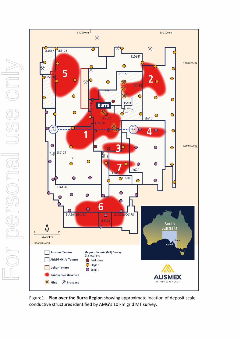
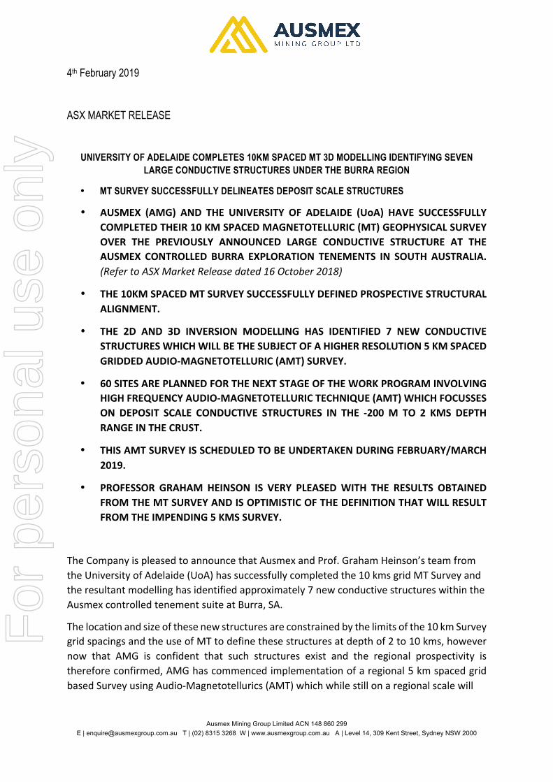
Figure1–PlanovertheBurraRegionshowingapproximatelocationofdepositscaleconductivestructuresidentifiedbyAMG’s10kmgridMTsurvey.
For
per
sona
l use
onl
y
Figure 2 - Cross-section A from the UoA’s MT modelling showing examples of the newconductive structures that have been identified. The 10 km MT Survey was designed toidentify areas of greatest prospectivity and structural alignments, this spacing and thebandwidthuseddoesnotprovideconfidentdatainthetop2kmsofthecrust.ThenextstageutilizinghighfrequencyAMTisspecificallyaimedattargetingthatregion.NBNotopographicalcorrectionshavebeenmadetothissectionasyet.
ManagingDirectorMattMorganStated:
“The University of Adelaide (UoA) have produced an outstanding result for Ausmexshareholders, under the supervision of ProfessorGrahamHeinson. TheUoA has identifiedseven individualconductive targets from3Dmodellingof the10kmMTsurveydata.Eachindividual conductive target has the potential to be the host of a largemineralised fluidsource,similartothosepreviouslyidentifiedunderOlympicDam.UndercontinuedguidancefromtheUoA,thecompanyisnowfocusingonfurtherdefiningpotentialfluidpathwaysfromthese large conductive structures with the aim of identifying near surface mineralisedsignatures.WiththestagetwoAMTsurveyduetocommenceinFebruary2019,Shareholdersmayanticipatesignificantnewsinthesecondquarterof2019.
For
per
sona
l use
onl
y
ForwardLookingStatements
The materials may include forward looking statements. Forward looking statementsinherently involve subjective judgement, and analysis and are subject to significantuncertainties,risks,andcontingencies,manyofwhichareoutsidethecontrolof,andmaybeunknownto,thecompany.
Actualresultsanddevelopmentsmayvarymateriallyfromthatexpressedinthesematerials.Thetypesofuncertaintieswhicharerelevanttothecompanymayinclude,butarenotlimitedto, commodity prices, political uncertainty, changes to the regulatory framework whichapplies to the business of the company and general economic conditions. Given theseuncertainties, readers are cautioned not to place undue reliance on forward lookingstatements.
Anyforward-lookingstatementsinthesematerialsspeakonlyatthedateofissue.Subjecttoanycontinuingobligationsunderapplicablelaworrelevantstockexchangelistingrules,thecompanydoesnotundertakeanyobligationtopubliclyupdateorreviseanyoftheforward-lookingstatements,changesinevents,conditionsorcircumstancesonwhichanystatementisbased.
CompetentPersonStatement
StatementscontainedinthisreportrelatingtoexplorationresultsandpotentialarebasedoninformationcompiledbyMsNicoleGallowayWarland,who isamemberof theAustralianInstituteofGeoscientists (AIG). MsGallowayWarland isa consultantProjectManagerofAusmexMiningGroupLimitedandGeologistwhohassufficientrelevantexperienceinrelationtothemineralizationstylesbeingreportedontoqualifyasaCompetentPersonasdefinedintheAustralianCodeforReportingofIdentifiedMineralresourcesandOrereserves(JORCCode2012).Ms.GallowayWarlandconsentstotheuseofthisinformationinthisreportintheformandcontextinwhichitappears.
For
per
sona
l use
onl
y

Ausmex Mining Group Limited ACN 148 860 299 E | [email protected] T | (02) 8315 3268 W | www.ausmexgroup.com.au A | Level 14, 309 Kent Street, Sydney NSW 2000
Section 1 Sampling Techniques and Data
(Criteria in this section apply to all succeeding sections.)
Criteria JORCCodeexplanation Commentary
Samplingtechniques
• Nature and quality of sampling (eg cut channels, random chips, or specific specialised industry standard measurement tools appropriate to the minerals under investigation, such as down hole gamma sondes, or handheld XRF instruments, etc). These examples should not be taken as limiting the broad meaning of sampling.
• Include reference to measures taken to ensure sample representivity and the appropriate calibration of any measurement tools or systems used.
• Aspects of the determination of mineralisation that are Material to the Public Report.
• In cases where ‘industry standard’ work has been done this would be relatively simple (eg ‘reverse circulation drilling was used to obtain 1 m samples from which 3 kg was pulverised to produce a 30 g charge for fire assay’). In other cases more explanation may be required, such as where there is coarse gold that has inherent sampling problems. Unusual commodities or mineralisation types (eg submarine nodules) may warrant disclosure of detailed information.
• MT Survey with stations arranged on 10km x 10km spaced grid. • Readings/Measurements recorded over 24-48hour period. • Remote station established at start of program with continuous reading for
duration of program.
MT Equipment used: • Recording Unit: Wide Band Magnetotelluric Station LEMI-423 • Magnetic Coils: Induction Coil Magnetometer LEMI-120 • Electrodes: Pb-PbCl2 Calibration: • Each unit is synchronized with universal time clock trough the GPS PPS
signal • Remote station established for calibration at start of program with
continuous reading for duration of program
Readings:
• Recording Unit: Recording at 1000 Hz • Magnetic Coils: Frequency Band --> 0.0001 - 1000 Hz • Electrodes: non polarised Pb-PbCl2
Drillingtechniques
• Drill type (eg core, reverse circulation, open-hole hammer, rotary air blast, auger, Bangka, sonic, etc) and details (eg core diameter, triple or standard tube, depth of diamond tails, face-sampling bit or other type, whether core is oriented and if so, by what method, etc).
• No drilling is being reported
Drillsamplerecovery
• Method of recording and assessing core and chip sample recoveries and results assessed.
• Measures taken to maximise sample recovery and ensure representative nature of the samples.
• Whether a relationship exists between sample recovery and grade and whether sample bias may have occurred due to preferential loss/gain of fine/coarse material.
• No drilling is being reported
Logging • Whether core and chip samples have been geologically and geotechnically logged to a level of detail to support appropriate Mineral Resource estimation, mining studies and metallurgical studies.
• Not Applicable - No drilling is being reported • Readings/measurements collected over 24-48hour period per site.
For
per
sona
l use
onl
y

7
Criteria JORCCodeexplanation Commentary
• Whether logging is qualitative or quantitative in nature. Core (or costean, channel, etc) photography.
• The total length and percentage of the relevant intersections logged. Sub-samplingtechniquesandsamplepreparation
• If core, whether cut or sawn and whether quarter, half or all core taken. • If non-core, whether riffled, tube sampled, rotary split, etc and whether
sampled wet or dry. • For all sample types, the nature, quality and appropriateness of the sample
preparation technique. • Quality control procedures adopted for all sub-sampling stages to maximise
representivity of samples. • Measures taken to ensure that the sampling is representative of the in situ
material collected, including for instance results for field duplicate/second-half sampling.
• Whether sample sizes are appropriate to the grain size of the material being sampled.
• Not applicable – not reporting drilling results. • Remote/base site established for program; with continuous readings for
program duration • Readings/measurements recorded over 24-48hours per site – appropriate for
Survey.
Qualityofassaydataandlaboratorytests
• The nature, quality and appropriateness of the assaying and laboratory procedures used and whether the technique is considered partial or total.
• For geophysical tools, spectrometers, handheld XRF instruments, etc, the parameters used in determining the analysis including instrument make and model, reading times, calibrations factors applied and their derivation, etc.
• Nature of quality control procedures adopted (eg standards, blanks, duplicates, external laboratory checks) and whether acceptable levels of accuracy (ie lack of bias) and precision have been established.
MT Equipment used: • Recording Unit: Wide Band Magnetotelluric Station LEMI-423 • Magnetic Coils: Induction Coil Magnetometer LEMI-120 • Electrodes: Pb-PbCl2 • Calibration: Each unit is synchronized with universal time clock trough the
GPS PPS signal
Verificationofsamplingandassaying
• The verification of significant intersections by either independent or alternative company personnel.
• The use of twinned holes. • Documentation of primary data, data entry procedures, data verification, data
storage (physical and electronic) protocols. • Discuss any adjustment to assay data.
• Not applicable - not reporting on drilling results. • All data is electronically stored, with peer review of data processing and
modelling.
Locationofdatapoints
• Accuracy and quality of surveys used to locate drill holes (collar and down-hole surveys), trenches, mine workings and other locations used in Mineral Resource estimation.
• Specification of the grid system used. • Quality and adequacy of topographic control.
• Each sample site has a Trimble GPS Bullet III antenna for receiving the GPS signal,
• +/- 2-5 m accuracy range per sample site depending on Satellite numbers • Geocentric Datum of Australia (GDA 94) Zone 54
Dataspacinganddistribution
• Data spacing for reporting of Exploration Results. • Whether the data spacing and distribution is sufficient to establish the degree
of geological and grade continuity appropriate for the Mineral Resource and Ore Reserve estimation procedure(s) and classifications applied.
• Whether sample compositing has been applied.
• MT Survey was completed on 10km x 10km spaced grid. This spacing is optimal for level of exploration results reported. F
or p
erso
nal u
se o
nly

8
Criteria JORCCodeexplanation Commentary
Orientationofdatainrelationtogeologicalstructure
• Whether the orientation of sampling achieves unbiased sampling of possible structures and the extent to which this is known, considering the deposit type.
• If the relationship between the drilling orientation and the orientation of key mineralised structures is considered to have introduced a sampling bias, this should be assessed and reported if material.
• Not applicable - not reporting on drilling results. • MT Survey sites extend over full tenure on 10km x 10km spaced grid to
achieve unbiased sampling.
Samplesecurity • The measures taken to ensure sample security. • All readings/geophysical measurements collected and stored on computer USB and transported by AMG/UoA personnel from collection sites to University of Adelaide for processing modelling.
Auditsorreviews • The results of any audits or reviews of sampling techniques and data. • Data collection, processing and modelling protocols aligned with academic and industry best practice.
Section2ReportingofExplorationResults
(Criteria listed in the preceding section also apply to this section.)
Criteria JORCCodeexplanation CommentaryMineraltenementandlandtenurestatus
• Type, reference name/number, location and ownership including agreements or material issues with third parties such as joint ventures, partnerships, overriding royalties, native title interests, historical sites, wilderness or national park and environmental settings.
• The security of the tenure held at the time of reporting along with any known impediments to obtaining a licence to operate in the area.
• The MT Survey was carrying over 15 exploration licences located in the Burra region of South Australia within the Adelaide Geosyncline
• EL6101, EL6102, EL6103, EL6116, EL6158, EL6201 & EL5881 are 100% owned by Ausmex Mining Pty Ltd (a wholly owned subsidiary of Ausmex Mining Group Limited AMG).
• EL5382, EL5411, EL5473, EL5557, EL5874, EL6150, El5910 & EL5918 are held by PNX Metals Ltd – Ausmex Mining Pty Ltd (a wholly owned subsidiary of Ausmex Mining Group Limited) currently has the right to farm in for 60% and ultimately 90% JV with PNX.
• The geophysical survey was completed on freehold pastoral land; Native Title extinguished. Notice of Entry with continuous communication served to all landholders.
• Current land use is agriculture and grazing.
Explorationdonebyotherparties
• Acknowledgment and appraisal of exploration by other parties. • Exploration over the tenure has been conducted by several companies exploring for copper and/or gold in the area since 1845.
• PNX Metals (Phoenix Copper Limited) have held a significant portion of the ground since 2004.
• Princess Royal: PNX Metals Ltd compiled JORC 2004 Inferred Mineral Resource in 2011 based on drilling completed between 2009-2011. Copper Range held the ground 2007-2009.
For
per
sona
l use
onl
y
9
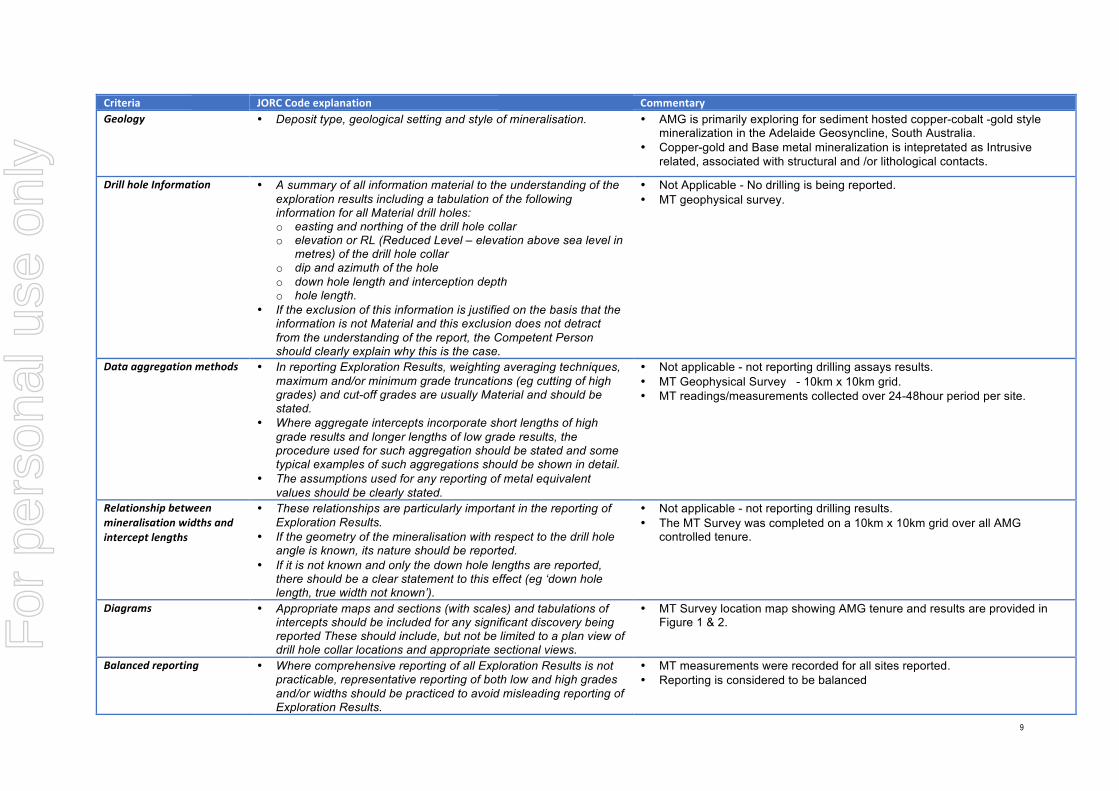
Criteria JORCCodeexplanation CommentaryGeology • Deposit type, geological setting and style of mineralisation. • AMG is primarily exploring for sediment hosted copper-cobalt -gold style
mineralization in the Adelaide Geosyncline, South Australia. • Copper-gold and Base metal mineralization is intepretated as Intrusive
related, associated with structural and /or lithological contacts.
DrillholeInformation • A summary of all information material to the understanding of the exploration results including a tabulation of the following information for all Material drill holes: o easting and northing of the drill hole collar o elevation or RL (Reduced Level – elevation above sea level in
metres) of the drill hole collar o dip and azimuth of the hole o down hole length and interception depth o hole length.
• If the exclusion of this information is justified on the basis that the information is not Material and this exclusion does not detract from the understanding of the report, the Competent Person should clearly explain why this is the case.
• Not Applicable - No drilling is being reported. • MT geophysical survey.
Dataaggregationmethods • In reporting Exploration Results, weighting averaging techniques, maximum and/or minimum grade truncations (eg cutting of high grades) and cut-off grades are usually Material and should be stated.
• Where aggregate intercepts incorporate short lengths of high grade results and longer lengths of low grade results, the procedure used for such aggregation should be stated and some typical examples of such aggregations should be shown in detail.
• The assumptions used for any reporting of metal equivalent values should be clearly stated.
• Not applicable - not reporting drilling assays results. • MT Geophysical Survey - 10km x 10km grid. • MT readings/measurements collected over 24-48hour period per site.
Relationshipbetweenmineralisationwidthsandinterceptlengths
• These relationships are particularly important in the reporting of Exploration Results.
• If the geometry of the mineralisation with respect to the drill hole angle is known, its nature should be reported.
• If it is not known and only the down hole lengths are reported, there should be a clear statement to this effect (eg ‘down hole length, true width not known’).
• Not applicable - not reporting drilling results. • The MT Survey was completed on a 10km x 10km grid over all AMG
controlled tenure.
Diagrams • Appropriate maps and sections (with scales) and tabulations of intercepts should be included for any significant discovery being reported These should include, but not be limited to a plan view of drill hole collar locations and appropriate sectional views.
• MT Survey location map showing AMG tenure and results are provided in Figure 1 & 2.
Balancedreporting • Where comprehensive reporting of all Exploration Results is not practicable, representative reporting of both low and high grades and/or widths should be practiced to avoid misleading reporting of Exploration Results.
• MT measurements were recorded for all sites reported. • Reporting is considered to be balanced
For
per
sona
l use
onl
y

10
Criteria JORCCodeexplanation CommentaryOthersubstantiveexplorationdata
• Other exploration data, if meaningful and material, should be reported including (but not limited to): geological observations; geophysical survey results; geochemical survey results; bulk samples – size and method of treatment; metallurgical test results; bulk density, groundwater, geotechnical and rock characteristics; potential deleterious or contaminating substances.
• Relevant geological information is reported in this announcement
Furtherwork • The nature and scale of planned further work (eg tests for lateral extensions or depth extensions or large-scale step-out drilling).
• Diagrams clearly highlighting the areas of possible extensions, including the main geological interpretations and future drilling areas, provided this information is not commercially sensitive.
• The next phase of exploration will be continuation of MT processing and modelling (figure 1 & 2), closer 5km spaced MT over areas of interest (figure 1), reanalysis and integration of regional geophysics and geology with MT data, with follow up geochemical sampling and infill ground geophysics.
For
per
sona
l use
onl
y


![RESISTIVITY [ ]](https://static.fdocuments.net/doc/165x107/6249524a7a9f6a12787a8128/resistivity-.jpg)