UNITED STATES DEPARTMENT OF THE INTERIOR … · the test site is situated has changed from general...
59
V UNITED STATES DEPARTMENT OF THE INTERIOR GEOLOGICAL SURVEY Federal Center, Denver, Colorado 80225 SUMMARY OF TECTONIC AND STRUCTURAL EVIDENCE FOR STRESS ORIENTATION AT THE NEVADA TEST SITE Open-file Report 74-176 1974 Prepared Under Agreement No. AT(29-2)-474 for the Nevada Operations Office U.S. Atomic Energy Commission This report is preliminary and has not been edited or reviewed for conformity with U.S. Geological Survey standards or nomenclature.
Transcript of UNITED STATES DEPARTMENT OF THE INTERIOR … · the test site is situated has changed from general...
V
UNITED STATESDEPARTMENT OF THE INTERIOR
GEOLOGICAL SURVEY
Federal Center, Denver, Colorado 80225
SUMMARY OF TECTONIC AND STRUCTURAL EVIDENCE FOR STRESS ORIENTATION AT THE NEVADA TEST SITE
Open-file Report 74-176 1974
Prepared Under Agreement No. AT(29-2)-474
for the
Nevada Operations Office U.S. Atomic Energy Commission
This report is preliminary and has not been edited or reviewed for conformity with U.S. Geological Survey standards or nomenclature.
NOTICE
"This report was prepared as an account of work sponsored by the United States Government. Neither the United States nor the United States Atomic Energy Commission, nor any of their employees, nor any of their contractors, subcontractors, or their employees, makes any warranty, express or implied, or assumes any legal liability or responsibility for the accu racy, completeness or usefulness of any information, appara tus, product or process disclosed, or represents that its use would not infringe privately owned rights."

CONTENTS
Page
Abstract----------------------------------------- -------------- 1
Introduction--------- --------------- -_-----_----------------- 1
General tectonic setting of Nevada Test Site region---------- -- 3
Proposed model of stress directions------ ---------------------- 10
Faults and fractures of Quaternary age---- ------------------ -- 12
Faults in alluvium------------------- ----- -----.-------- 12
Fractures in alluvium--------------------------------------- 14
Fractures in tuff----- ------------------------------------ 17
Fractures in playas----------------------------------------- 18
Yucca fault, associated parallel faults, and shape of Yucca
Basin---------------- ------------------------ --._.--.-... 23
Seismic evidence----------------------------------- ------------ 33
Strain measurements---------------- ---------- .-.-------- 37
Stress measurements and estimates--------------------------- 38
Drill-hole enlargement-------------------------------------- 42
Other geologic evidence of extension------------------------ 43
Discussion and conclusions-------------------------------- ------ 44
References cited------------------------------------------------- 49

ILLUSTRATIONS
Page
Figure l,--Map showing distribution of major rock types,
southwestern Great Basin, and system of right- and
left-lateral faults in the Walker Lane------------- 4
2.--Map showing generalized structure of Nevada Test
Site region -------------------------------------- (pocket)
3. Diagram of stress model for Nevada Test Site area,
showing assumed principal stress directions and
sectors within which existing faults can slip in
a right- or left-lateral sense-------------- ----- 11
4 0 --Map showing Quaternary faults and fractures in the
Nevada Test Site region and their relation to
regional topography-------------------------------- 13
5.--Rose diagram showing trends of 70 shot-induced
fractures not related to known faults and not
concentric or radial to shots, Yucca Flat---------- 15
6.--Map of Yucca playa area, showing cracks and detailed
topography------------------------- -------------- 19
7. Tectonic map of Yucca Flat area, showing location of
drill holes intersecting Paleozoic rocks----------- (pocket)
8.--Schematic section across Yucca Flat ---------------- 25
9.--Diagram of shot-induced scarplets along the Yucca
fault--- --- - 28
11
ILLUSTRATIONS--Continued
Page
Figure 10. Gravity contour map showing buried Paleozoic
surface beneath Yucca Flat -- - 30
llo--Map of southern Yucca Flat and Frenchman Flat
areas, showing structural patterns; Quaternary
faults and fractures; and location of earth
quakes, their aftershocks, fault plane solutions,
and pressure axes- - ------- --- - - 34
iii

TABLES
Page
Table 1.--Horizontal gravitational (hydrostatic) and tecto&ic
stress for assumed crack depths- ----------------- 39
2.--Horizontal gravitational (Poisson) and tectonic
stress for assumed crack depths---- -------------- 40
iv
SUMMARY OF TECTONIC AND STRUCTURAL EVIDENCE FOR STRESS ORIENTATION AT THE NEVADA TEST SITE
By
W. J. Carr
ABSTRACT
A tectonic synthesis of the NTS (Nevada Test Site) region, when combined with seismic data and a few stress and strain measurements, suggests a tentative model for stress orientation. This model proposes that the NTS is undergoing extension in a N. 50° W.-S. 50° E. direction coincident with the minimum principal stress direction. The model is supported by (1) a tectonic similarity between a belt of NTS Quaternary faulting and part of the Nevada-California seismic belt, for which northwest-southeast extension has been suggested; (2) historic northeast- trending natural- and explosion-produced fractures in the NTS; (3) the virtual absence in the NTS of northwest-trend ing Quaternary faults; (4) the character of north-trending faults and basin configuration in the Yucca Flat area, which suggest a component of right-lateral displacement and post-10 m.y. (million year) oblique separation of the sides of the north-trend ing depression; (5) seismic evidence suggesting a north- to northwest-trend ing tension axis; (6) strain measurements, which indicate episodes of northwest-southeast extension within a net northeast-southwest compression; (7) a stress estimate based on tectonic cracking that indicates near-surface northwest-southeast-directed tension, and two stress measurements indicating an excess (tectonic) maximum principal compressive stress in a northeast-southwest direction at depths of about 1,000 feet (305 m); and (8) enlargement of some drill holes in Yucca Flat in a northwest-southeast direction.
It is inferred that the stress episode resulting in the formation of deep alluvium-filled trenches began somewhere between 10 and possibly less than 4 m.y. ago in the NTS and is currently active. In the Walker Lane of western Nevada, crystallization of plutons associated with Miocene volcanism may have increased the competency and thickness of the crust and its ability to propagate stress, thereby modulating the frequency (spacing) of basin-range faults.
INTRODUCTION
In 1972 the U.S. Geological Survey began a review and synthesis of
the tectonics and structure of the Nevada Test Site region in order to
estimate the present orientation of the regional stress field. This
report summarizes geologic information that bears on stress orientation
at the test site, including a few stress and strain measurements. Much
of the geologic information is presented in the form of maps--one shows
the structural features of a large area in and around the test site;
the other shows the major structures of the Yucca Flat area, including
an interpretation of subsurface structure.
The structural analysis type of approach to current stress field
determination has definite limitations as pointed out by Donath (1962),
among others, and as recently summarized by Bucknam (1973). A major
problem is that a regional map study of structures provides only a
two-dimensional view. The problems in using tectonic analysis to
determine present stress configuration center in the inhomogeneity of
the rocks resulting from subhorizontal discontinuities or layering
within the geologic section and other structural planes of weakness,
such as faults, folds, and intrusive contacts, some of which may date
back to late Paleozoic time. During this span of perhaps 300 m.y.
(million years), the structural regimen of the Great Basin in which
the test site is situated has changed from general crustal shortening,
resulting in large-scale low-angle thrust faults and folding, to crustal
extension, resulting in basin-range and strike-slip faulting. The
change to dominant regional extension, which produced basin-range
faulting, became evident only about 15-20 m.y. ago (Stewart, 1971,
p. 1036; Ekren and others, 1968). The geology of the Great Basin is
extremely complex and attempts to derive current stress orientation
must necessarily concentrate on very young structural features; but
because older structures profoundly influence the young ones, the older
structural framework must also be well understood. For these reasons
this report also presents a brief review of the tectonic setting of the
Nevada Test Site region.
I appreciate the valuable assistance given in discussions and the
background material provided for this report by colleagues, especially
R. C. Bucknam, R. E. Anderson, W. D.- Quinlivan, and G. E. Brethauer.
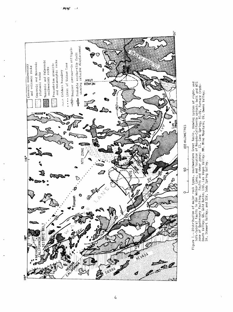
GENERAL TECTONIC SETTING OF NEVADA TEST SITE REGION
The Nevada Test Site lies within the Great Basin, a structural and
physiographic region that consists of generally linear mountain ranges
and valleys lying between the Colorado Plateau on the east and the
Sierra Nevada on the west (fig. 1). The crust of the basin is relatively
thin, averaging about 22 miles (35 km) thick. In Mesozoic time it was
shortened by complex thrusting and folding, and in western Nevada and
eastern California it was extensively intruded by granitic plutons
(fig. 1).
A change to dominant regional extension began in the Tertiary.
Structures of Tertiary and Quaternary age in the Great Basin may be
placed in three general groups that are locally interrelated: (1) horst
and graben or block faulting, (2) major zones of dominantly strike-slip
faulting, and (3) volcano-tectonic structures.
Some geologists relate most of the basin-range faults to regional
lateral shear stresses, and many now believe that the so-called block
faulting is a surficial feature confined to the uppermost part of the
Cen
ozo
ic
sedim
enta
ry
and
volc
anic
ro
cks
Cen
ozo
ic
and
M
eso
zoic
plu
tonic
ro
cks
Mes
ozo
ic
and
P
ale
ozoic
se
dim
en
tary
ro
cks
Pre
cam
bri
an
gra
nit
ic
and
met
amo
rph
ic
rock
s
Cald
era
boundar
y
. . ..
Lim
it
of
Wal
ker
L
ane
-/50-B
ouguer
conto
ur
in m
illi
gals
^- P
robable
str
ike-s
lip
fa
ult
show
ing re
lati
ve
dis
pla
cem
en
t
5010
0 KILOMETRES
Figure 1.--Distribution o
f ma
jor
rock
ty
pes,
southwestern Great
Basin, showing
system o
f right- an
d left-lateral faults in th
e Walker Lane,
and
loca
tion
of
Neva
da-C
alif
orni
a se
ismi
c be
lt an
d NT
S zone of Qu
ater
nary
fa
ulti
ng.
Faults and
shear
zone
s:
CS,
Cane Sp
ring
; FC
-DV,
Furnace
Creek-
Deat
h Valley;
GB,
Gold Bu
tte;
LVV, La
s Vegas
Vall
ey:
MM,
Mine M
ount
ain;
0V
, Owens
Valley;
SV,
Stew
art
Valley;
and
SSV, So
da Spring Valley.

crust. Detailed mapping and modern dating techniques have shown that
much of the middle and late Tertiary structural movement is spatially
and temporally associated with volcanism, particularly in the western
Great Basin (Christiansen and others, 1965).
The generally linear mountain ranges of central Nevada are
interrupted in the western Great Basin by several major northwest-
striking lineaments (fig. 1), which together form a zone of disrupted
topography called the Walker Lane (Locke and others, 1940). These
lineaments mark shear zones locally demonstrated to have as much as
30 miles (50 km) of right-lateral offset (Stewart, 1967; Longwell, 1960),
These structures are associated with complementary northeast-trending
faults, commonly having relatively small left-lateral displacement
and large-scale drag folds or oroclinal bends (Albers, 1967) that strike
east to northeast. In some areas the Walker Lane shear zones are buried
under upper Miocene and Pliocene volcanic rocks; at other places the
shear zones may be present at depth but expressed at the surface only
by oroclinal bending or low-angle faulting.
Volcanism in the Walker Lane mobile belt is predominantly Miocene
in age and tends to be concentrated where the major right-lateral
faults die out or display multiple branches and en echelon arrangement.
An especially favorable locus appears to be wherever the large right-
lateral fault zones step to the right several miles and where their
ends are connected by northeast-trending faults, most of which have a
small component of left-lateral offset. The northeast-trending faults
can be"regarded as rifts or spreading centers; commonly they are
partially obscured by the products of volcanism. This general idea
of rifting and transform faulting has been expressed by Wright and
Troxel (1968). Detailed mapping and study of volcanic centers have
been insufficient to fully document the structural controls of volcanic
centers throughout the Walker Lane, but in the test site area, at least,
I feel that the association of eruptive centers and calderas with the
ends of right-lateral shear zones and northeast-trending faults (figs. 1
and 2, in pocket) strongly suggests a basic relationship between the
volcanism and this structural situation.
In the Walker Lane area large-scale bending and shearing that
probably began prior to the basin-range faulting appear to have
influenced the trend of that faulting and, hence, the trend of the young
basins and ranges. The oroclinal bending (Albers, 1967) associated with
shearing in the Walker Lane has not been precisely dated, but there seems
no doubt that right-lateral bending and shearing continued into the
Pliocene and may still be occurring. At the test site, rocks as young
as 11 m.y. are involved in right-lateral flexing and are offset by
complementary left-lateral faults. Near Beatty a rhyolite lava dated
at 10.8 m»y, (P. P. Orkild, oral commun., 1973) is not displaced by
the left-lateral faults that offset the ll-m.y.-old Ammonia Tanks
Member of the Timber Mountain Tuff. In the Cane Spring quadrangle,
detailed mapping (Poole and others, 1965) has shown that faulting in
the Cane Spring left-lateral zone becomes progressively less in tuffs
ranging from about 14 to 11 m.y. in age. In the Paiute Ridge (Byers
and Barnes, 1967) and Jangle Ridge (Barnes and others, 1965) quadrangles

at the east edge of the test site, mapped relations make it clear
that north-northwest-trending basin-range faults were well developed
prior to the deposition of tuffs older than about 14 nuy.; in many
places these tuffs lap onto prominent fault scarps in the Paleozoic
rocks and show little or no displacement. In the southern test site
the Horse Spring Formation, dated at 29 m.y. in that area, shows
considerable structural disturbance, but probably not quite as much as
the Paleozoic rocks on which it was deposited, suggesting that structural
movements that created the basins of deposition had begun, but perhaps
had not progressed very far by late Oligocene time, Ekren, Rogers,
Anderson, and Orkild (1968, p. 250) concluded that deposition of the
Horse Spring in that area predated structural movements associated with
the Las Vegas Valley shear zone. Albers (1967) felt that the apparent
scarcity of shearing in Jurassic plutons that follow the curves of the
oroclines in Esmeralda County indicates initiation of bending prior to
intrusion. R. C. Speed (oral commun., 1973) suggested that the Dunlap
Formation of Jurassic age in the Pilot Mountains area of the Walker Lane
may record the initiation of transcurrent faulting and bending in the
Walker Lane. The Dunlap is unconformable on older rocks and consists
largely of locally derived clastic material. On the Death Valley fault
zone, McKee (1968) suggested the presence of more than 20 miles (32 km)
of right-lateral offset of a granitic pluton of Middle Jurassic age.
Thus, the onset of structural activity related to shearing in the
Walker Lane is difficult to establish and, whereas much of the movement
may have taken place in Miocene and later time, there are strong hints

of earlier activity having developed a structural grain by the time
of basin-range faulting,
A variety of Tertiary structural styles occurs in the large area
of the Nevada Test Site (fig. 2). The structures seem to be influenced
by rock type as well as by preexisting structural grain. On the west
a dissected volcanic tableland contains three major caldera complexes;
caldera structure is closely associated in time with local north-trending
basin-range faulting (Christiansen and others, 1965), and with northeast-
trending faults having a small component of left-lateral slip. East of
the calderas in the Belted and Eleana Ranges, Tertiary faults are scarce
to absent; the underlying Paleozoic rocks consist mainly of the lower
plates of major thrust faults, which dip steeply westward beneath Rainier
Mesa and the Timber Mountain caldera arid gently southeastward beneath
Yucca and Frenchman Flats. The lower plate Paleozoic rocks, which
consist largely of the thick relatively incompetent Eleana Formation,
are gently folded north and west of Yucca Flat; but south and southeast
of Yucca Flat in the CP and Calico Hills area, low-angle faulting and
local tight folding are present. Farther east, in the carbonate rocks
of the upper plates of the Mesozoic thrust faults, the frequency and
intensity of faulting increases dramatically in the Yucca and Frenchman
Flats area. Near Frenchman Flat a strong system of north to north-
northwest-trending basin-range faults bends southward to a northeast
strike. This bending is in harmony with the regional change in
structural trends that occurs throughout the Walker Lane. Similar
oroclinal bending probably exists northwest of the obvious trends,
8
along the Las Vegas Valley shear zone within and beyond the area of
the Timber Mountain caldera complex, where it is expressed largely
by gravity and topographic trends. Paleozoic rocks appear to be bent
around the southeastern edge of the volcanic field, and the thrust
zone (Barnes and Poole, 1968) along the Belted and Eleana Ranges
probably extends westward in an arc to Bare Mountain. Complicated
structures associated with the zone of oroclinal bending and basin-range
faulting in the southeastern part of the test site consist of two
important structural elements--northeast-trending fault zones of small-
scale left-lateral offset, such as the Cane Spring and Mine Mountain
systems, and northwest-trending fault and flexure zones displaying
right-lateral offset or bending. Detailed mapping (W. J. Carr and
others, unpub. data, 1967) and seismic records described later show
that these two systems mutually offset one another and that they are
both locally active. Significantly, the current structural and seismic
activity within these fault zones is concentrated near areas of deep-
basin formation,,
The deep basins, such as those that underlie Yucca and Frenchman
Flats, have formed relatively recently in what may represent a new
phase of basin-range faulting. The basins consist of deep, relatively
narrow troughs superimposed upon but directionally influenced by older
basin-range structure. In the Yucca-Frenchman Flats area these basins
are mainly post-Miocene in age; they are the sites of thick upper
Tertiary and Quaternary alluvial deposits, including local thin basalt
lava flows. Development of these troughs is continuing at present,
judging from the distribution of seismicity and young fault scarps,
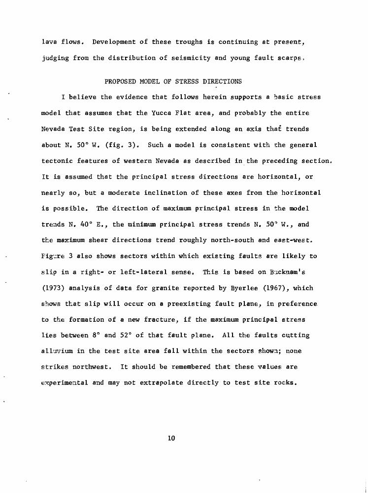
PROPOSED MODEL OF STRESS DIRECTIONS
I believe the evidence that follows herein supports a basic stress
model that assumes that the Yucca Flat area, and probably the entire
Nevada Test Site region, is being extended along an axis that trends
about N. 50° W. (fig. 3). Such a model is consistent with the general
tectonic features of western Nevada as described in the preceding section,
It is assumed that the principal stress directions are horizontal, or
nearly so, but a moderate inclination of these axes from the horizontal
is possible. The direction of maximum principal stress in the model
trends N, 40° E., the minimum principal stress trends N. 50° W., and
the maximum shear directions trend roughly north-south and east-west.
Figure 3 also shows sectors within which existing faults are likely to
slip in a right- or left-lateral sense. This is based on B;icknam°s
(1973) analysis of data for granite reported by Byerlee (1967), which
shows that slip will occur on a preexisting fault plane, in preference
to the formation of a new fracture, if the maximum principal stress
lies between 8° and 52° of that fault plane. All the faults cutting
alluvium in the test site area fall within the sectors shown; none
strikes northwest. It should be remembered that these values are
experimental and may not extrapolate directly to test site rocks.
10
N
W
Figure 3.--Stress model for Nevada Test Site area, showing assumed principal stress directions and sectors within which existing faults can slip in a right- or left-lateral sense.
11

FAULTS AND FRACTURES OF QUATERNARY AGE
Faults in alluvium
Faults of Quaternary age having a northwest trend are not present
in the test site area or along the Las Vegas Valley shear zone, but are
common to the west and northwest along the Furnace Creek, Owens Valley,
and Soda Spring Valley fault zones. Parts of these areas to the northwest
are also the loci of much current seismic activity and of historic large
earthquakes that caused surface displacements. However, available
information (Papanek and Hamilton, 1972; Fischer and others, 1972),
suggests to me that much of the stress relief is occurring not on the
major faults of northwest trend but near them on northeast-trending
faults, particularly where these faults are striking nearly east-west
as they approach the main northwest-trending zones (figs. 1 and 2),
Additional evidence will be given in the section on seismicity.
In the test site region, faults and fractures of Quaternary age
form a zone (fig. 4) flanked on the east and west by areas having very
little Quaternary faulting. Few, if any, of the fault scarps within
this zone are fresh enough to suggest large earthquakes within the last
few thousand years. The scarps nearly all lie in depressed areas that
are mainly below 5,000 feet (1,524 m) in elevation. I suggest that the
scarps are the surface expression of a seismic belt which currently is
relieving stress by fairly numerous small earthquakes but which had been
the site of larger earthquakes prior to the last few thousand years.
The NTS zone of faulted alluvium is strikingly similar in trend and
relative location to part of the Nevada-California seismic belt a zone
12

Figure 4.--Quaternary faults and fractures in the Nevada Test Siteregion and their relation to regional topography. Numbers 1-4indicate playas having cracks similar to those in Yucca Flat.
13
of historic large earthquakes that caused surface breakage (fig. 1).
Both belts bend to a northeast trend as they cross the Walker Ijane,
and both appear to show right-lateral oblique slip in their northerly
trending portions and left-lateral oblique slip in their northeasterly
trending portions. However, at the test site the evidence for left-
lateral slip on the northeast-trending faults is mostly in rocks of
pre-Quaternary age, even though the faults cut Quaternary deposits*
En echelon patterns characteristic of lateral slip seem to be absent
from the younger of these northeast-trending faults, but the scarps
are old and poorly defined.
The Yucca fault is the only youthful-appearing prenuclear testing
fault scarp in the test site area. It will be discussed in detail in
the section on page 23.
Fractures in alluvium
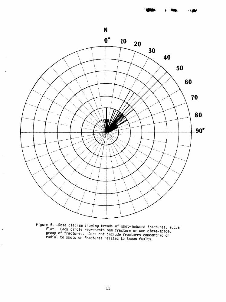
Underground explosions at the test site have produced many fractures
in the alluvium. The average trend of shot-induced fractures in Yucca
Flat is N. 40° E. (fig. 5). This direction is based on 70 occurrences,
including prominent long fractures; fractures that are closely spaced
in a zone were counted as a single occurrence. If individual fractures
had been counted, the frequency of this trend would have been tremen
dously reinforced because fracture swarms having this trend are much
more numerous than those exhibiting other trends* No great difference
in fracture trends seems to exist from one part of Yucca Flat to another,
although there is a tendency for fractures in Area 3 to trend slightly
14
N
3040
50
60
Figure 5.--Rose diagram showing trends of shot-induced fractures, Yucca nl ; Ja£ ClrCle rTesents e fracture or one close-spaced H^I I fr^c^ures - Does not include fractures concentric or radial to shots or fractures related to known faults.
15
more northerly than those in the northern part of Yucca Flat. Fractures
probably lying along faults were excluded from the count as were
fractures that are clearly radial or concentric to shots. There is a
minor maximum-of-fracture-trend frequency near north; it is possible
that fractures having this trend are fault related. Horizontal separation
of an inch or less, normal to the crack, is the usual displacement
associated with these fractures. Significantly, the swarm of northeast-
trending explosion-related cracks in north-central Yucca Flat crosses
the major Yucca fault zone without being obviously affected by it,
Barosh (1968, p. 204-207) showed that in some areas of Paleozoic
bedrock around Yucca Flat a well-developed system of northeast-trending
joints and very small faults is present, nearly paralleling the trend
of shot-induced fractures in alluvium. These joints in Paleozoic rocks
are not explosion related. Analysis of the geologic mapping east of
Yucca Flat also shows an east-northeast-trending system of small faults
in the Paleozoic rocks. No joints or faults of this trend are known
in the tuff outcrops adjacent to the fractured alluvium, but outcrops
of tuff are sparse and irregularly distributed in these areas and no
large underground explosions have been detonated near them. On Banded
Mountain, however, a few basalt dikes of late Tertiary or Quaternary
age intrude the northeast-trending faults, suggesting that northwest-
southeast tensile stress was present at the time of basalt intrusion.
I believe that the described relations indicate that most of the
randomly distributed northeast-trending explosion-produced cracks in
Yucca Flat are basically unrelated to underlying faults and thus
16

probably do not extend downward more than a few hundred £eet 0 Where
they are clustered in a narrow, long linear zone, however, they may
reflect the presence of a buried fault.
In the proposed stress model, most of the northeast-trending
fractures in alluvium in Yucca Flat would be extension cracks parallel
to the direction of maximum principal stress. Alternatively, they could
be conjugate shear fractures associated with right-lateral displacement
on northwest-trending bedrock faults.
The fact that no consistent shearing has been observed on these
cracks and that no significant faults having northwest trends are known
in the area of the cracks argue against the conjugate shear interpretation,
Fractures in tuff
On Pahute Mesa several large underground tests have caused extensive
fracturing and faulting in tuff. Except for the Benham event, nearly all
mapped fractures trend north-northwest to north-northeast and are parallel
to or coincident with exposed or thinly buried basin-range faults. At
Benham a prominent east-west set of fractures formed, extending outward
to a maximum of about 2,300 feet (0.7 km) from ground zero. These
fractures may be related to local jointing in the tuff (Bucknam, 1969,
p. 2213). Most of the prominent long fractures at Benham, however,
are also along northerly trending basin-range faults. According to
Bucknam (1969, p. 2215) most of the explosion-triggered lateral
displacements on these faults were right lateral. Snyder (1973),
however, reported that of 16 target-board measurements of fault creep
17
on basin-range faults on Pahute Mesa, 10 showed left-lateral displacement
and 6 showed right-lateral displacement. Shot-induced vertical displace
ment of several inches to several feet has also commonly occurred on many
faults on Pahute Mesa.
Thus, at Pahute Mesa, most fractures follow the known structural
trend, and it is likely that the movements represent strain release
triggered by the underground nuclear explosions (Dickey, 1968) One
explosion, as pointed out by Bucknam (1969, p. 2215), reactivated a
pre-Thirsty Canyon Tuff (about 7 m.y. old) fault. Possibly in part
because of residual stresses in the tuffs, the fractures and displace
ments on Pahute Mesa cannot be directly related to the stress model
proposed,
Fractures in plavas
Desiccation cracks are a well-known feature of desert playas. They
tend to be irregular or polygonal and relatively narrow and shallow,,
Most of the fractures seen in playas of the test site area, and Yucca
playa (fig* 6) in particular, are probably not due to desiccation for
several reasons; (1) all the cracks of this type identified in this
study trend north to about N. 50° E 0 , regardless of playa shape;
(2) they tend to be curved, not polygonal; (3) in Yucca playa they
trend at right angles to the gravity gradient and to the sides of the
basin, contrary to what would be expected if they were due to shrinkage
resulting from desiccation of the playa sediments; (4) at least one of
the Yucca playa cracks is alined with a small fault in the adjacent
18

FAULT SCARP IN
ALLUVIUM
LAKEEDGE
V.vv -Svv^> 0 500 1000 MET RES ;##
0 3000 FEET Contour interval : I foot
Figure 6.--Map of Yucca Lake playa area showing cracks and detailed topography. Shaded area (-) is apparently depressed with respect to areas marked (+), based on distribution of water in the lake in March 1973; letters identify cracks referred to in text.
alluvium, wfeich in turn trends toward a bedrock fault; (5) topographic
data at hand for Yucca playa indicate no subsidence has occurred in
the immediate area of cracking; (6) water levels (William Thordarson,
oral commun., 1973) in wells B and C (fig. 6) at the edges of the.
playa indicate no significant lowering of the water table, during the
last 10 years; and (7) large quantities of water flow into the cracks
when they are new, indicating that they go to considerable depth,
probably into rocks beneath the alluvium,,
Fractures inferred to be of tectonic origin are present in several
playas of the region. Six fractures of this type are present on or
near the surface of Yucca playa (fig. 6). Four of these (fig. 6, A-D)
are subparallel and concave to the northwest; their trend varies from
about N. 30° E. to N. 50° E. Two older cracks (fig. 6, E and F) beyond
the northwest corner of the playa trend more northerly. The four
parallel cracks in the southern part of the playa are about equally
spaced and are younger from north to south. The youngest crack (D) ?
still a prominent feature but filling rapidly, formed in 1969; the
'^ext crack to the north (C) formed in 1960 and was extended north
eastward in 1966. On the basis of aerial photos and degree of
obliteration, the third crack (B) probably formed prior to 1950. The
fourth and northwesternmost crack (A) is older but of unknown age 0
None of these cracks shows obvious vertical offset, although the pattern
of water distribution on the playa surface suggests that the area
surrounding the younger cracks has been elevated slightly with respect
to adjoining parts of the playa (fig. 6).
20
To further investigate the Yucca playa cracks,, elevations on a
1965 Holmes and Narver NTS map,, scale 1:12,000,, were contoured at 1-foot
intervals (fig. 6). The area of the playa that contains the four
parallel cracks was found to be nearly flat at the time the elevations
were determined,, except at the northeast end of the subsequent 1969
crack (D). Along the east flanks of the playa,, contouring revealed a
peculiar topography in positions approximating the northeastward
projection of the three pre-1965 cracks; whereas no detectable vertical
offset occurred along the cracks on the playa itself, the near flanks
of the playa may have subsided several feet along the projections of
each of the cracks. An aerial photo taken in March 1973 shows con
siderable water standing on the playa. Water extends all the way to
the north edge of the playa, but the western edge of the playa and a
large area around the youngest cracks (B, C,, D) appear to be at or
above water level. Thus it appears that vertical changes of a foot
or so may have taken place since 1964 (fig. 6)--another indication
of tectonic adjustments of the playa surface.
In order to establish a more reliable basis for determining
vertical and horizontal changes in the playa area, level lines have
been requested. These stations will be resurveyed at some future
date. Horizontal distances between stations will be measured with
the geodimeter.
Four other playas in the surrounding region (locations 1-4, fig. 4)
were found to have similar cracks:
21
1. Groom Lake playa, northeast corner. About 5,900 feet (1,800 m)
long,, trends N. 47° E.; pre-1952 in age.
2. Small unnamed playa just northwest of Papoose Range, about
4 miles (6.5 km) east of gate 700. Two very faint cracks about 1,000 feet
(300 m) and 500 feet (150 m) long, both trending about N. 50° E.
3. North end of playa in Indian Springs Valley, about 18 miles
(30 km) north of Indian Springs, 17 miles (27 km) east of Frenchman
Lake. Two cracks about 3,000 feet (900 m) long, trending about N. 20° E.
and No 10° E., appear to be at least 20 years old.
4. Frenchman Flat, northeast corner. Two curving cracks, one about
7,000 feet (2,130 m) long, trending N. 5° W. to N. 60° E., the other
2,000 feet (600 m) long trending north to N. 20° E.; both cracks concave
to southeast. The easternmost crack is distinctly younger than the
western, and looks fresh on photos taken in 1951.
Several other playas in the region were examined on aerial photos
and no cracks of this type were detected. None of the photos were, low
altitude, however, and most were 5-20 years old. Playas on which no
cracks were found include Papoose Lake, playas in Kawich Valley and
Gold Flat, eastern Sarcobatus Flat, and playas in the valley between
the Pintwater and Desert Ranges. The observed cracking in playas
occurs within the previously described zone of faulted alluvium that
extends northward from the Mercury area at least to Sand Springs Valley
north of State Highway 25 (fig. 4).
The playa cracks in the test site region vary somewhat in trend,
but nearly all strike northeast. Details of geologic structure in the
22
adjacent bedrock are available only for the cracks on Yucca and Frenchman
playas. On Yucca playa the major cracks have two distinctively different
trends (fig. 6), suggesting that they may represent two different modes
of failure. Both groups of fractures lie on the projection of the Yucca-
Frenchman flexure, but the southern group of four curving cracks is
nearly at right angles to the northwest trend of the flexure, suggesting
that they could be conjugate shears. The two northerly trending cracks
at the northwest corner of Yucca playa could be extension cracks near
the end of the shear and flexure zone, which appears to be dying out in
that area. The curving cracks on Frenchman playa may have a similar
origin; they may be extension cracks at the opposite end of the shear
and flexure zone.
YUCCA FAULT, ASSOCIATED PARALLEL FAULTS, AND SHAPE OF YUCCA BASIN
The most important Cenozoic structural feature in the central and
eastern Yucca Flat area is a series of north-northwest-trending,
predominantly east-dipping normal faults (fig. 7, in pocket). They are
typical basin-range faults, bounding depressed and elevated blocks in
which the beds dip generally westward. The average dip of these faults
at the surface is about 60°, based on numerous measurements in quad
rangles bordering Yucca Flat and on scattered subsurface information.
Dips in Paleozoic rocks exposed between the faults are variable, but
the average is about 40° westerly or southwesterly on the east side of
Yucca Flat. There is a distinct tendency for dips in the Paleozoic
23
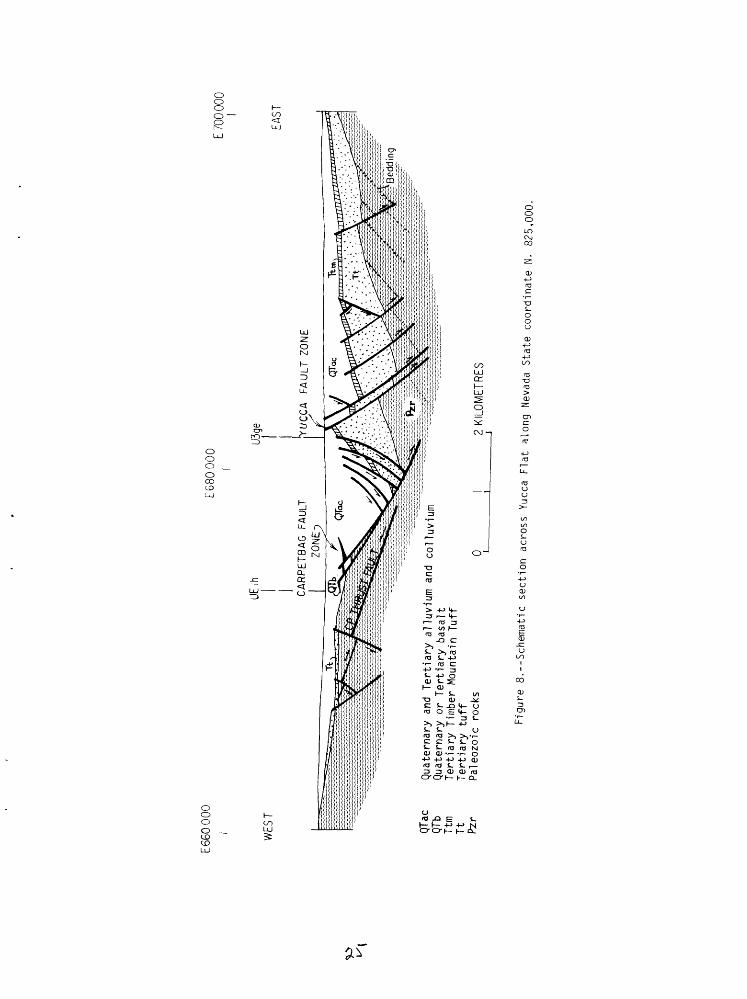
rocks to increase from east to west across a particular fault block
(tig. 8); dips of as much as 60° are present along the east edge of
Yucca Flat.
In general, the Tertiary tuffs dip less steeply (the average dip
in the hills around Yucca and Frenchman Flats is about 20°) but more
erratically than the Paleozoic rocks, because the tuffs tend to drape
across uneven surfaces and fault scarps on the Paleozoic rocks. The
tuffs are commonly less offset by the basin-range faults than are the
Paleozoic rocks. Although there are local exceptions, the tuff units,
particularly ash-flow tuffs, do not thicken appreciably in the deeper
parts of the Yucca Flat basin. The larger exposed faults of the group
are spaced from about 1,500 to 3,000 feet (500-1,000 m) apart, but
subsurface dips in the tuff beneath Yucca Flat range from 10° to about
35°, indicating that fatbits are probably more closely spaced in those
areas where the dips in the tuff are steep. For dips of about 30°
maintained across fault blocks, small faults spaced only about 200 feet
(60 m) apart seem required. If, however, dips in the tuffs steepen
into the main faults, as seems likely, fewer faults are required. A
good case for this phenomenon, called "reverse drag flexing," has
been made by Hamblin (1965) and supported by Anderson (1971). It is
a mechanism for achieving horizontal extension and implies curving or
flattening of the faults with depth. Little evidence of this flattening
exists at the test site because of the lack of deep erosion, but the
Baneberry fault in northwestern Yucca Flat appears to flatten slightly
with depth; at the surface it dips about 65°, and 1,000 feet (300 m)
24
E66
0000
E68
0000
E 70
0 00
0
WES
T
QTac
QTb
Ttm
Tt
Pzr
UEU3
qe
CA
RP
ET
BA
G
FAU
LT
ZO
NE
iU
CC
A
FA
ULT
ZO
NE
Qua
tern
ary
and
Tert
iary
allu
viu
m a
nd
collu
viu
mQ
uate
rnar
y or
Tert
iary
b
asa
ltT
ert
iary
Tim
ber
Mou
ntai
n T
uff
Tert
iary
tu
ffP
aleo
zoic
ro
cks
Q2
KILO
MET
RES
EAST
Figure 8.-S
chem
atic
section
acro
ss Yucca
Flat along
Neva
da St
ate
coor
dina
te N.
82
5,00
0.

lower drill hole information indicates that it is dipping about 58°.
Likewise, the Yucca fault, which at the surface generally dips about
75°-80°, must flatten to 55°-65° in order to fit subsurface geology
in some areas. In southwestern Yucca Flat the Carpetbag fault zone
may have a low dip, possibly approaching the 40° dip of the Paleozoic
surface (fig. 8). Evidence for this will be discussed in a following
section.
The Yucca fault is the youngest natural fault scarp in the test site
region. It was studied carefully for clues to the present stress field.
A large earthquake must have produced the Yucca fault scarp, which
extends in a very narrow zone for a distance of at least 15 miles
(24 km) and probably as much as 20 miles (32 km) (fig. 7). At least
the southern 10 miles (16 km) of the fault scarp shows no evidence of
multiple displacements. Magnetic evidence and surface fracturing show
that in places the present scarp lies several hundred feet east of
older buried parts of the fault zone. No reliable way has been found
to date the formation of the scarp, but degree of erosion in comparison
with scarps of known age in similar climate, such as the 100-year-old
Owens Valley scarps, permits a rough age estimate of between 1,000 and
10,000 years. Erosion has cut down through the scarp in all gullies,
and the scarp has been destroyed completely in a few places. Erosion
has destroyed any evidence of lateral offset.
Under the proposed stress configuration (fig. 3), the north-
northwest-trending faults strike subparallel to a maximum shear
26
direction and should display a component of right-lateral slip.
Evidence for this is summarized in the following discussions,,
The main Yucca fault scarp, though nearly continuous, consists
in detail of numerous close-spaced en echelon breaks that consistently
step to the left (fig. 9), consistent with a component of right-lateral
slip. Much of the en echelon pattern is a result of movement caused
by underground tests, thus providing a general measure of present stress
orientation. Minor departures from the nearly vertical displacements
caused by explosions are, in my opinion, due to shoving and jostling of
the alluvium by ground motion. However, fairly consistent minor right-
lateral offset resulting from testing has been described for at least
one underground test (R. E. Anderson and W. D. Quinlivan, written
commun., 1966), Barosh (1968, p. 215) concluded that fracturing from
another test indicated a slight right-lateral component.
North-trending surface faulting produced by the Carpetbag event
(near UE2b, fig. 7) also shows evidence of right-lateral displacement;
a road northwest of the shot was dextrally offset about 6 inches
(15 cm) across a 4-foot (1.2-m) -high scarp, and en echelon cracking
along the scarp steps to the left in a manner similar to that along
the parallel Yucca fault scarp. The total amount of right-lateral
slip on the Yucca and Carpetbag fault zones is difficult to estimate,
but it could easily equal or exceed the average post-tuff vertical
component, which is about 700 feet (200 m) for the Yucca and 2,000 feet
(600 m) for the Carpetbag fault zone. Right-lateral offset is also
indicated (W. J. Carr, unpub. data, 1972) for the Baneberry fault
27

N yN 885 000
0(-0
1/
1
J
300 M. /i /
1000 FEET /
AREA 10 (AREA 9 ~\ N 8 75 000
E 680 000
Figure 9.--Diagram of shot-induced scarplets alonq part of the Yucca fault
(fig. 7), which trends about N. 20° E. The evidence consists of the
left-stepping of surface fractures along the scarp, northeast-trending
tension cracks near the fault, and mismatch in tuff stratigraphy on
opposite sides of the fault.
Additional observations may be cited in support of right-lateral
slip on north-trend ing faults in the Yucca Flat area: (1) scattered
subsurface data suggest that Paleozoic formations may be displaced
several thousand feet laterally across the northern Yucca and Carpetbag
faults (fig. 7); (2) slickensides on a few fault surfaces of north-
northwest trend in the hills northeast of Yucca Flat show that oblique
right-lateral movement has occurred at some point in the fault's history,
but most of the strike faults east of Yucca Flat seem to have had
principally dip-slip displacement in the geologic past; and (3) the
sides of the medial Yucca Flat depression, as outlined by the buried
Paleozoic surface determined from gravity (fig. 10), fit fairly well
if shoved back together along a line trending about N. 50° Wo
The deep troughs under Yucca Flat (fig. 10) are significant,
relatively young structural features, although they are probably
controlled in trend by older faults. Their youthfulness is supported
by a general lack of thickening of the Pliocene Timber Mountain Tuff
but abrupt thickening of the alluvial deposits in the troughs. The
vertical and horizontal displacements involved are in general much
greater than those recorded by faulting in the tuffs around the edges
of the Yucca basin. Thus, these medial troughs seem to represent a
relatively young episode of localized deep basin formation, possibly
29

CONTOUR INTERVAL
BURIED PALECZOIC SURFACE
N 900 000
N 860 000
N 820 000
0
E 660 000 E 700 000
Figure 10.--Three-dimensional gravity controlled diagram of buried Paleozoic surface, Yucca Flat. Intensity of stippling indicates depth. Arrow shows assumed direction of extension of area.
involving a change in stress orientation and mechanism. This period
of tectonic activity may correspond to one in the western Great Basin
described by Gilbert and Reynolds (1973, p. 2507), which they were
able to date as later than approximately 3-4 m.y. ago. They described
this deformation as characterized by tilted fault blocks and broad
areas of warping; the faults of this episode trend predominantly north
as opposed to earlier northeast and northwest trends. Stewart (1971)
has suggested that these relatively narrow depressed zones in the Basin
and Range province may be due to localized plastic extension in the lower
crust.
The schematic cross section shown in figure 8 is my interpretation
of the general structural character of south-central Yucca Flat. The
Tertiary rocks dip westward into the basin from outcrops along the east
side of the valley. Dips and strikes obtained from scattered drill
holes in Areas 3 and 6 indicate that a westward dip in the tuffs persists
into the main deep trough east of the Carpetbag fault zone. Several
west-dipping faults, such as the Area 3 fault (fig. 7), form the east
walls of the medial trough, but basically the east side of the trough
is a downwarp. Drill holes such as UElh and UElj, located on the west
wall of the trough, go from alluvium directly into Paleozoic rocks.
In these two holes identical upper Pliocene or Pleistocene basalt flows
intercalated in the alluvium are about 600 feet (180 m) lower to the
northwest in UElj than in UElh, suggesting a westerly dip of the basalt
of about 20° toward the rising surface on the Paleozoic rocks. Thus,
a fairly young marker horizon in the alluvium appears to dip westward
31
just west of the Carpetbag fault zone. Dips in the Timber Mountain Tuff
in drill hole U3ge immediately west of the Yucca fault are also unusually
steep, averaging about 32° to the west. These structural attitudes, in
conjunction with the deepest part of the Yucca basin, suggest structural
rotation into a relatively low-angle east-dipping fault zone having the
appearance of a landslide fault. The strong tendency for large range-
front faults in the Basin and Range to be landslidelike or doubly concave,
both upwards and toward the downthrown side, has been pointed out by Moore
(1960). The deep cleft behind the "slide" or "pull-apart" is the site of
deposition of thick alluvium. The basalt intercalated in the alluvium of
Yucca Flat is probably late Pliocene or early Pleistocene in age, judged
from its similarity to basalts exposed east of Yucca Flat. The postulated
structural rotation is, therefore, probably post-late Pliocene in age.
Obviously, other structural explanations are possible, but if this
analysis is correct, displacement on the Carpetbag fault zone alone
could account for as much as 5,000 feet (1,500 m) of horizontal extension.
The parallel Yucca fault may be a more easterly zone of similar deforma
tion that is still forming. The Yucca fault probably has a fairly low
easterly dip of 50°-60°, particularly in its southern half. This is
suggested by the position of the surface trace with respect to subsurface
topography (fig. 10) delineated by gravity. Faults and fractures of the
Yucca fault zone can be seen in drill hole U7z-l (Sargent and others,
1972); they dip from 40° to 60°. If the Yucca fault dips 60°, about
500 feet (150 m) of horizontal extension could be attributed to it, with
the amount increasing greatly if a lower fault dip is assumed.
32

The troughs under Yucca Flat range from 2,000 feet (600 m) to
5,000 feet (1,500 m) across, and the whole group of depressions has
a rather constant total width of about 10,000 feet (3,000 m) under
most of the length of Yucca Flat. The consistent width of the trough
system suggests that some sort of relatively uniform separation has
occurred, and the general shape of the walls, as previously noted,
suggests that the separation has been oblique.
SEISMIC EVIDENCE
Earthquake fault-plane solutions can provide a local measurement
of strain release that bears on the problem of stress orientation. As
seismic data yield two planes on which slip could have occurred, accurate
location of the activity and detailed knowledge of the local geology are
required to make a choice between the two possibilities. Slippage on a
preexisting fault plane is assumed to have occurred. Seismic activity
has been closely monitored at NTS for several years by USGS (U.S. Geological
Survey) and NOAA (National Oceanic and Atmospheric Administration). Fairly
low-level seismic activity has been occurring for some time at Pahute Mesa
in the northwestern part of the test site. Quakes following the Benham
event at Pahute Mesa gave a near-horizontal northwest-trending tension
axis, as inferred from first motion (Hamilton and Healy, 1969).
Two small earthquakes (magnitude 3-4) occurred in the southeastern
part of the test site within recent years, on August 5, 1971, and
February 19, 1973 (fig. 11). The Massachusetts Mountain earthquake of
August 5, 1971, was located by the USGS about a mile (1.6 km) southeast
33
:i6°oo
II5°52'30"
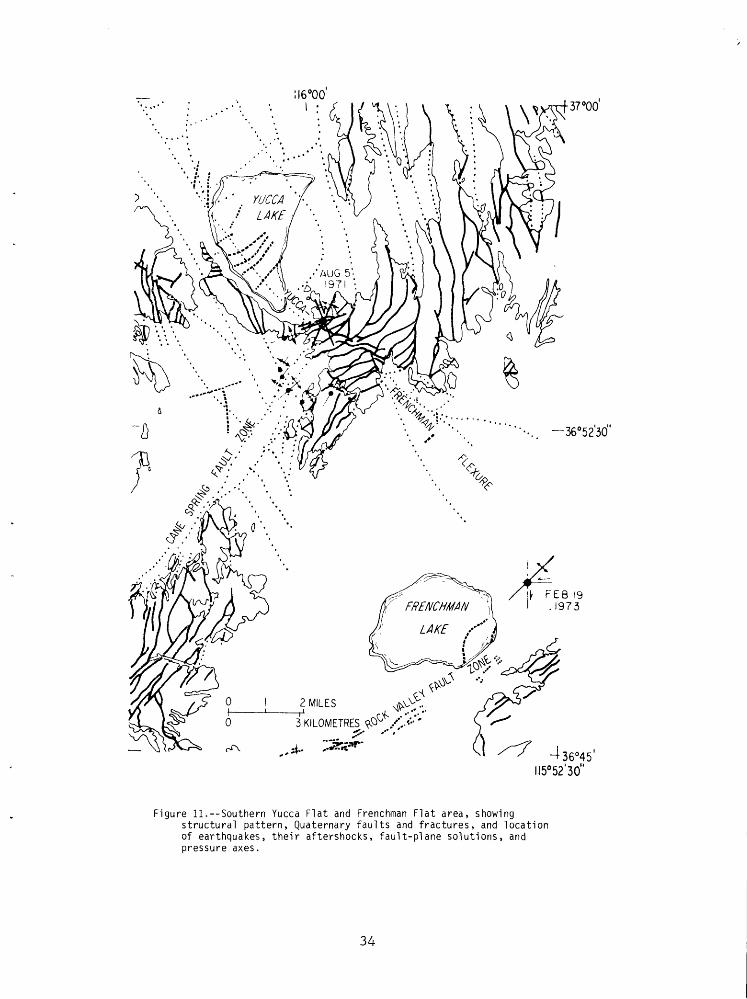
Figure 11.--Southern Yucca Flat and Frenchman Flat area, showingstructural pattern, Quaternary faults and fractures, and location of earthquakes, their aftershocks, fault-plane solutions, and pressure axes.
34
of the southern tip of Yucca playa at a depth of 3 miles (4.6 km)
(Fischer and others, 1972). Aftershocks had somewhat deeper hypocenters
and were nearly all located in a northwesterly trending zone about a
mile and a half (3.2 km) southwest of the main shock. According to
Fischer (1972, p. 13) "the axis that bisects the quadrant of compressional
first motions, the tension axis, has a near-horizontal, west-northwest
orientation for both the main shock and the aftershocks" of the
Massachusetts Mountain earthquake. In the main shock the strike of the
pressure axis was N. 23° E., and the strike of the tension axis was
N. 67° W. For the belt of northwest-trend ing aftershocks, the pressure
axis varied from about N. 30° E. to N. 70° E., the average being about
N. 45° Eo Of the two fault-plane solutions, one trending N. 22° W.
having right-lateral motion, the other trending N. 68° E. showing left-
lateral motion, the plane striking northeast seems the most logical
choice, as it coincides very closely with a prominent set of faults in
the vicinity, many of which have slickensides indicating that the last
movement was left-lateral slip. The trend and fault solutions for the
aftershocks along a northwest-trending belt at depths of 4-6 miles
(6-10 km) fit best with north-northwest-trending faults that cut the
nearby CP hogback, but, significantly, the zone of aftershocks parallels
a feature called the Yucca-Frenchman flexure (fig* 11 and Wo J. Carr
and others, unpub. data, 1967). The main shock and a few aftershocks
were located very near the flexure at its intersection with the Cane
Spring fault zone. The flexure is a right-lateral bend having a
probable offset of about a mile (1.6 km). The flexure does not involve
35
large-scale faulting in the tuffs along its trend, but it is well
expressed in the gravity (W. J. Carr and others, unpub. data, 1967)
and by bending of beds and faults of the Cane Spring system. It is
apparent that both the flexure zone and the Cane Spring fault zone
have been active concurrently and tend to offset one another. The
greater depth of the aftershocks and the fact that most of the belt
of aftershocks does not coincide with a mapped fault suggest that a
subparallel right-lateral flexure zone may exist at depth across the
Cane Spring fault zone but that its strain has not been sufficient to
reach the surface in the form of faulting or bending.
The Frenchman Lake earthquake epicenter of February 19, 1973, was
located by the USGS on alluvium about a mile (1.6 km) northeast of the
Frenchman Lake playa (F. G. Fischer, oral coramun., 1973). Preliminary
data indicate an intensity and focus depth generally similar to the
Massachusetts Mountain quake. Fischer reported the two fault-plane
solutions as striking either east-west and having left-lateral slip
or north-south and having right-lateral slip. Faults having this trend
are not present at the surface in either the alluvium or nearby bedrock,
so a choice between the two directions is difficult. The pressure axis,
however, has the same trend as nearby faults in the alluvium and bedrock,
which trend about N. 50° E. The two cracks in the Frenchman playa are
within 1 1/2 miles (2.4 km) of the epicenter, and both the Massachusetts
Mountain and Frenchman Lake epicenters lie near the intersection of
major northeast-trending fault zones and the Yucca-Frenchman flexure.
36
Earthquake activity in the southern part of the test site (south
of lat 37°) during the last 10 years has been concentrated beneath
alluvial areas; of over 50 epicenters recorded for the period 1961-72
in the southern test site area (data supplied by F. G. Fischer;
reported by E. B. Ekren, unpub. data, 1972) more than three-fourths
of the locations were beneath alluvium, even though bedrock exposures
constitute about two-thirds of the area. Thus, present activity is
occurring in areas of previous subsidence.
Fault-plane solutions for west-central Nevada, about 200 miles (125 km)
northwest of NTS, also suggest a northwesterly oriented minimum principal
stress direction and regional extension in a northwest-southeast direction
(Ryall and Malone, 1971; Gumper and Scholz, 1971).
Strain measurements
Observations of regional strain variations (Smith and Kind, 1972)
from strain meters in the test site region indicate that deformation
over a large area occurred episodically in an 8-month period in 1971.
In each episode the directions of the principal axes remained the
same--northwest and northeast. Although some episodes of northwest
extension were recorded during the interval observed, the net effect
over the 8-month period was northeast-southwest compression. The
apparent lack of correlation of stress relaxation with seismic activity
led Smith and Kind to conclude that substantial strain changes can
occur in the region without earthquakes. They failed to mention,
however, that the Massachusetts Mountain earthquake occurred on
August 5, 1971, precisely at the end of their published strain records.
37

Stress measurements and estimates
The relatively uniform spacing of the four cracks in Yucca playa
provides a means for estimating the amount of stress causing them.
According to Lachenbruch (1961), a relation exists between crack
spacing, crack depth, and amount of stress. Lachenbruch's equations
were rearranged by G. E. Brethauer (written commun., 1973) and used to
calculate horizontal tectonic tensile stress. The gravitational stress
is assumed to be hydrostatic and equal to the weight of the overlying
rock. All stress components of a hydrostatic stress field are equal.
The formula used by Brethauer is:
_ b6 p " 378
where p is the tensile stress in psi, b is the depth of cracking in
feet, and 6 is the density of the medium in grams per cubic centimetre.
Unit conversions are contained in the constant 3.8. The horizontal
tectonic stress necessary to produce cracking is assumed equal to the
tensile stress, p, minus the horizontal gravitational stress.
The results are given in table 1 for several assumed crack depths
arid for two densities, which probably include the actual average value
for the density of the playa section.
Another possible loading condition, according to Brethauer, would
be Poisson's loading criterion, the equation for which would become:
= b* fr) P 3.8 (1-n)
Table 2 summarizes values for the Poisson gravitational stress for
the same crack depth and media densities.
38

Table
! --
Hori
zont
al gr
avit
atio
nal
(hyd
rost
atic
) an
d te
cton
ic st
ress for
assumed
crack
dept
hs
A- indicates
tens
ion/
Crack
(metres)
365
410
455
610
depth
(fee
t)
1,20
0
1,35
0
1,50
0
2,00
0
Dens
ity
1.7
g/cc
Horizontal
tectonic
stre
ss
(kg/cm
2)
(psi)
-38
-537
-42
-604
-47
-671
-63
-895
Hori
zont
algr
avit
atio
nal
stre
ss
(kg/cm
2)
(psi)
34
483
38
544
42
604
56
806
Density 2.
0 g/cc
Horizo
ntal
tectonic
stre
ss
(kg /cm2)
(psi)
-44
-632
-50
-710
-55
-789
-74
-1,0
53
Horizontal
gravitational
stress
(kg/cm
2)
(f*i)
40
568
45
640
50
711
66
*48
US

Table
2.-"Horizontal g
ravitational (P
olss
on)
and
tect
onic
st
ress
fo
r as
sume
d crack
depths
fp I
ndic
ates
tension/
Crack
dept
h (metres)
(feet)
366
1,200
411
1,350
457
1,500
610
2,000
Density
1.7
g/cc
Horizo
ntal
tectonic
stress
(kg/cm
2) (p
si)
-8.5
-121
-9.5
-136
-10.
5 -1
51
-14.0
-201
Horizontal
gravitational
stre
ss
(kg /c
m2)
(psi
)
7.5
109
8.5
122
9.5
136
12.5
181
Density
2.0
g/cc
Horizontal
tect
onic
stress
(kg/cm
2) (psi
)
-10.0
-142
-11.
0 -160
-12.5
-178
-19.0
-272
Horizontal
gravitational
stre
ss
(kg/cm
2) (p
si)
9.0
128
10.0
14
4
11.0
16
0
17.0
245
The spacing between cracks A and B (fig. 6) ranges from 600 feet
(180 m) to 2,000 feet (610 m), averaging about 1,300 feet (400 m);
between cracks B and C from 1,000 to 1,400 feet (305 m to 425 m),
averaging about 1,200 feet (365 m); and between cracks C and D from
1,900 feet (580 m) to 2,500 feet (760 m), averaging about 2,200 feet
(670 m).
If it is assumed from Lachenbruch's study that the crack spacing
is approximately equal to crack depth, an estimate of stress is possible
from the figures in tables 1 and 2. The tectonic tensile stress would
2 2 range from about 42 kg/cm (600 psi) to about 77 kg/cm (1,100 psi) in
2 the hydrostatic condition, and from about 9.1 kg/cm (130 psi) to about
2 15.8 kg/cm (225 psi) if the Poisson loading criterion is used. The
latter method gives distinctly lower values but is considered more
realistic in terms of the physical properties of the medium.
Stress measurements have been made by the USGS and U.S. Bureau of
Mines in two tunnels under Rainier Mesa. In Ul2t.02 at a depth of
1,175 feet (360 m) the principal compressional stress direction is
N. 28° Eo and the maximum excess (tectonic) horizontal stress is
241 kg/cm (586 psi) (H. W. Dodge, Jr., oral commun., 1973). The axis
of maximum principal stress is inclined about 3° from the horizontal.
In Ul2n.07 bypass drift, at a depth of 1,250 feet (380 m) the direction
of maximum principal stress is N. 47° E. and the excess horizontal
2 stress is 68 kg/cm (972 psi) (V. E. Hooker and others, written commun.,
1971). This direction is inclined about 20° from the horizontal.
41
It has been suggested (V. E. Hooker and others, written commun.,
1971) that the stress directions are influenced by the free face of
Rainier Mesa, to which the maximum principal stress direction is roughly
parallel. Such an influence is possible, but perhaps not very likely,
because the measurements were taken more than 2,000 feet (600 m) from
the nearest point on the face of the mesa.
Other stress-measurement data were reported by Obert (1963, 1964)
from tunnels at Rainier Mesa and in the granitic rock of the Climax
stock near the northwest corner of Yucca Flat. These data are being
analyzed by G. E. Brethauer, who reports (oral commun., 1974) variations
of several hundred psi, some of which is probably due to local geologic
effects and some to measurement techniques. Additional data reported
by Wright (1967) for the Climax stock have not been evaluated.
Drill-hole enlargement
Since the discovery that some drill holes in Yucca Flat are
preferentially enlarged, directions of enlargement have been determined
for six holes (R. D. McArthur and W. D. Quinlivan, written commun.,
1972):
U9ck northwest to west
U9lTSw24.5 northwest to west
U9cg N. 20° W. to N. 60° W.
U9ci northwest
UlOax east-west to west-northwest
U2bs N. 60° W. to N. 80° W.
42
In addition, caliper logs show that many other, but not all, holes in
Yucca Flat are enlarged in an unknown direction. Of 96 holes having
six-arm caliper logs, about 40 percent show no preferential enlargement.
The average direction of enlargement for the six holes that have
been determined is roughly N. 60° W., a direction very compatible with
other information assuming that the direction of enlargement represents
the direction of minimum principal stress. In the few cases where the
enlarged hole has been photographed or viewed by downhole television,
the enlargement takes the form of planes of spalling in the northwest
and southeast quadrants of the hole, leaving the northeast and southwest
quadrants virtually undisturbed.
Other geologic evidence of extension
Two additional pieces of evidence may be cited in support of
northwest-southeast extension. W. D. Quinlivan has pointed out an
interesting possible analogy to the enlarged drill-hole phenomenon:
the Timber Mountain caldera complex, which might be comparable to a
huge drill hole in a stress field, has a northwest elongation (fig. 2),
the direction being about N. 55° W. The Timber Mountain caldera
formed about 11 m.y. ago.
A large Tertiary pluton, which probably underlies much of the
northwestern part of the test site area as magnetically defined, has
a very distinct northwest-southeast elongation (fig. 2). Interestingly,
the Cretaceous plutonic rocks, including the connected Climax and Gold
Meadows stocks, trend more nearly east-west, a direction that could
43
have been related to the general development of a Mesozoic structural
grain of the test site area. Possibly the same mechanism of spalling
in the direction of minimum principal stress could operate during
emplacement of a shallow pluton to produce an elongation of the
intrusive body in that direction.
DISCUSSION AND CONCLUSIONS
The evidence for a northwest-southeast axis of minimum principal
stress for the test site appears good. After I had proposed the stress
model for the test site area, a paper was published by Thompson and
Burke (1973) that further strengthens this conclusion. Their paper
discussed the rate and direction of spreading in Dixie Valley, Nev.,
which lies in the Nevada-California seismic belt in west-central
Nevada (about 37 mi., 60 km north of fig. 1) and occupies a position
north of the Walker Lane similar to that of Yucca Flat. Dixie Valley
is one of the large north-northeast-trending basins of western Nevada,
and lies about 40 miles (65 km) north of the north edge of the Walker
Lane. Shawe (1965) has summarized the evidence revealed by historical
faulting for strike-slip control of basin-range structure in western
Nevada. He noted that deformation changed southward toward the Walker
Lane from predominantly dip-slip on the north to strike-slip on the
south.
By study of slickensides on fault planes exposed on the west side
of Dixie Valley, Thompson and Burke (1973) concluded that the spreading
direction for Dixie Valley is N. 55° W. to S. 55° E., and that the
44
north-northeast-trending basin as a whole has a slight right-lateral
component of displacement within it. They commented that this direction
appears to be fairly consistent over a wide region of the Basin and
Range province. Evidence presented in this report strongly supports
this general statement, but it should be remembered that the area being
considered is not the entire Basin and Range, but rather the Walker Lane
and adjacent part of the Great Basin.
There is evidence suggesting that the structural style that probably
began to develop in Pliocene time in the test site area with the formation
of relatively narrow deep troughs is continuing at present, which, if
correct, suggests that the present general stress configuration has
existed for several million years. There is a strong hint that present
seismic activity in the southwestern Great Basin is generally avoiding
Paleozoic and older rocks and is concentrated in areas currently
receiving alluvium. In some areas seismic activity is occurring in
areas of volcanic rocks of Miocene and Pliocene age, in particular, in
areas of volcanic centers or calderas.
Alluvial deposits are very rare, but unconformities are present
within the volcanic section in Yucca Flat and elsewhere in the test
site region, indicating a period of from roughly 17 to 7 m.y. ago, in
which there were few, if any, deep closed basins of the type that now
exist. Conglomerates intertongue with mainly the lower parts of the
volcanic section near the edges of the volcanic fields, but these
gravels are typically fluviatile in appearance and are locally
associated with lacustrine limestones. These sediments are unlike
45

the detritus now accumulating in the basins. In the subsurface in
Yucca and Frenchman Flats is a widespread deposit of very tuffaceous
alluvium postdating the Ammonia Tanks Member of the Timber Mountain
Tuff. This unit is present nearly everywhere in the deeper parts of
the basins. It contains very few Paleozoic clasts and represents a
period of stripping of the tuff from the Paleozoic rocks. In northern
Frenchman Flat on the flanks of the Frenchman basin, part of this alluvium
underlies the Thirsty Canyon Tuff, which is about 7.5 m.y. old. It can
also be shown that most of the highly tuffaceous alluvium was accumu
lated and much of the subsidence and accompanying faulting of the
northern part of the Frenchman basin occurred between about 10 and
2 m.y. ago, because of the presence in the alluvium of nearly flat-lying
basalt lavas above the steeply dipping and faulted volcanic rocks
(W. J, Carr and others, unpub. data, 1967). In southwestern Yucca Flat,
however, there is evidence that deep basin formation may be somewhat
younger, because basalt flows intercalated in the alluvium are apparently
tilted northwestward and faulted (fig. 8). Both Frenchman and Yucca
playas are about 3 miles (4.8 km) southeast of the deepest parts of the
two basins. The site of playa sediment deposition has migrated south
eastward, but young regional tilting of any magnitude seems unlikely
because of the lack of tilting of Pliocene or Pleistocene basalt flows
in some areas.
Although precise relations between the stress pattern and structures
at the Nevada Test Site cannot be demonstrated, much evidence is in
accord with the general idea of northwest-southeast extension, at least
46

along and adjacent to the Walker Lane, and with the idea of the
formation of deep basins, within the last 10 m.y, and locally within
the last 4 m.y. The localization of basin development implies a
fundamental change either in the mechanisms generating the stress or
in the physical character of the crust. Locally these basins are
undergoing extension and subsidence at the present time. The lack of
young faults having a northwest trend in the test site region suggests
that the minimum principal stress lies in the northwest-southeast
direction, and that stress relief is occurring by bending or in small
increments. It is suggested that postvolcanism crystallization of large
plutons of granitic rocks beneath and adjacent to the many volcanic
centers of the central Walker Lane may have played a part in the
initiation of this phase of basin-range development by increasing
the capability of the crust to transmit stress and by "spot-welding"
the upper crust to the infrastructure, thereby better translating the
deep lateral stresses to the surface rocks. The spacing of active
basin-range faults may thus be related to the effective thickness of
competent crust, the effect of the crystalline rocks being to modulate
the spacing of basin-range faults and, hence, basin formation.
None of the very general conclusions of this report should be
taken as obviating the need for stress measurements at the test site
and elsewhere in the Great Basin. Ideally, quantitative stress
measurements should be made in alluvium, tuff, and Paleozoic rocks at
several places in the test site so as to determine what local variations
may exist. Measurements should be made in highly faulted areas, such
47
as along the east side of Yucca Flat, and in areas of minor faulting,
such as the northern Eleana Range and in the southwestern Frenchman
Flat area where the structural grain is different from that farther
north. Measurements should also be made in zones having a history of
right-lateral and left-lateral faulting, such as the Yucca-Frenchman
flexure and Cane Spring fault zone.
48
REFERENCES CITED
Albers, J. P., 1967, Belt of sigmoidal bending and right-lateral faulting
in the western Great Basin: Geol, Soc. America Bull., v, 78,
p. 143-156.
Anderson, R. E., 1971, Thin skin distension in Tertiary rocks of
southeastern Nevada--Reply: Geol. Soc. America Bull., v. 82,
p. 3533-3536.
Barnes, Harley, Christiansen, R. L., and Byers, F. M., Jr., 1965,
Geologic map of the Jangle Ridge quadrangle, Nye and Lincoln
Counties, Nevada: U.S. Geol. Survey Geol. Quad. Map GQ-363.
Barnes, Harley, and Poole, F. G., 1968, Regional thrust fault system
in Nevada Test Site and vicinity, in Nevada Test Site: Geol.
Soc. America Mem. 110, p. 233-238.
Barosh, P. J., 1968, Relationship of explosion-produced fracture
patterns to geologic structure in Yucca Flat, Nevada Test Site,
in Nevada Test Site: Geol. Soc. America Mem. 110, p. 199-217.
Bucknam, R. C., 1969, Geologic effects of the Benham underground nuclear
explosion, Nevada Test Site: Seismol. Soc. America Bull., v, 59,
no. 6, p. 2209-2220.
____1973, Some factors relevant to the determination of in situ stress
by analysis of geological and geophysical data: U.S. Geol. Survey
rept. USGS-474-168, 20 p.; available only from U.S. Dept. Commerce,
Natl. Tech. Inf. Service, Springfield, Va. 22151.
Byerlee, J. C., 1967, Frictional characteristics of granite under high
confining pressure: Jour. Geophys. Research, v. 72, p. 3639-3648.
49

Byers, F. M., Jr., and Barnes, Harley, 1967, Geologic map of the Paiute
Ridge quadrangle, Nye and Lincoln Counties, Nevada: U.S. Geol.
Survey Geol. Quad. Map GQ-577.
Christiansen, R. L., Lipman, P. W., Orkild, P. P., and Byers, F. M., Jr.,
1965, Structure of the Timber Mountain caldera, southern Nevada, and
its relation to basin-range structure, in Geological Survey research
1965: U.S. Geol. Survey Prof. Paper 525-B, p. B43-B48.
Dickey, D. D., 1968, Fault displacement as a result of underground nuclear
explosions, in Nevada Test Site: Geol. Soc. America Mem. 110,
p. 219-232.
Donath, F. E., 1962, Analysis of basin-range structure, south-central
Oregon: Geol. Soc. America Bull., v. 73, no. 1, p. 1-16.
Ekren, E. B., Rogers, C. L., Anderson, R. E., and Orkild, P. P., 1968,
Age of basin and range normal faults in Nevada Test Site and Nellis
Air Force Range, Nevada, in Nevada Test Site: Geol. Soc. America
Mem. 110, p. 247-250.
Fischer, F. G., Papanek, P. J., and Hamilton, R. M., 1972, The Massachusetts
Mountain earthquake of 5 August 1971 and its aftershocks, Nevada Test
Site: U.S. Geol. Survey rept. USGS-474-149, 16 p.; available only
from U.S. Dept. Commerce, Natl. Tech. Inf. Service, Springfield, Va.
22151.
Gilbert, C. M., and Reynolds, M. W., 1973, Character and chronology of
basin development Western margin of the Basin and Range province:
Geol. Soc. America Bull., v. 84, no. 8, p. 2489-2510.
50

Gumper, F. J., and Scholz, Christopher, 1971, Microseismicity and
tectonics of the Nevada seismic zone: Seismol. Soc. America Bull.,
v, 61, no. 5, p. 1413-1432.
Hamblin, W. K., 1965, Origin of "reverse drag" on the downthrown side
of normal faults: Geol. Soc. America Bull., v. 76, no. 10,
p. 1145-1146.
Hamilton, R. M., and Healy, J. H., 1969, Aftershocks of the Benham
nuclear explosion: Seismol. Soc. America Bull., v. 59, p. 2271-2281.
Lachenbruch, A. H., 1961, Depth and spacing of tension cracks: Jour.
Geophys. Research, v. 66, no. 12, p. 4273-4292.
Locke, Augustus, Billingsley, P. R., and Mays, E. B., 1940, Sierra Nevada
tectonic patterns: Geol. Soc. America Bull., v. 51, p. 513-540.
Longwell, C. R., 1960, Possible explanation of diverse structural
patterns in southern Nevada: Am. Jour. Sci., v. 258-A, p. 192-203.
McKee, E. H., 1968, Geology of the Magruder Mountain area, Nevada-
California: U.S. Geol. Survey Bull. 1251-H, p. 36-37.
Moore, J. G., 1960, Curvature of normal faults in the Basin and Range
province of the western United States, in Short papers in the
geological sciences: U.S. Geol. Survey Prof. Paper 400-B,
p. B409-B411.
Obert, Leonard, 1963, Static stress determinations; Shot Hardhat:
W.T. 1804; available from U.S. Dept. Defense, Washington, D.C.
____1964, In situ stresses in rocks, Rainier Mesa, NTS: W.T. 1869;
available from U.S. Dept, Defense, Washington, D.C.
51
Papanek, P. J,, and Hamilton, R. M., 1972, A seismicity study along
the northern Death Valley-Furnace Creek fault zone, California-
Nevada boundary; U.S. Geol. Survey rept. USGS-474-141, 37 p;
available only from U.S» Dept. Commerce, Natl. Tech» Inf, Service,
Springfield, Va. 22151.
Poole, F. G,, Elston, D. P., and Carr, W. J., 1965, Geologic map of the
Cane Spring quadrangle, Nye County, Nevada: U.S. Geol, Survey
Geol. Quad. Map GQ-455.
Ryall, Alan, and Malone ? S. D., 1971, Earthquake distribution and
mechanism of faulting in the Rainbow Mountain-Dixie Valley-Fairview
Peak area, central Nevada: Jour. Geophys» Research, v. 76, no. 29,
p. 7241-7248.
Sargent, K. A., Dixon, G. L., and Spengler, R. W., 1972, Lithologic
logs and stratigraphic identification of exploratory and
emplacement drill holes in Area 7, Nevada Test Site: U.S. Geol.
Survey rept. USGS-474-152, 70 p.; available only from U.S. Dept,
Commerce, Natl. Tech. Inf. Service, Springfield, Va. 22151.
Shawe, D. R., 1965, Strike-slip control of basin-range structure
indicated by historical faults in western Nevada: Geolo Soc.
America Bull., v. 76, p. 1361-1378.
Smith, S. Vil., arid Kind, Rainier, 1972, Observations of regional strain
variations: Jour. Geophys. Research, v. 77, no. 26, p. 4976-4980.
Snyder, R. P., 1973, Recent fault movement on Pahute Mesa, Nevada Test
Site, from May 1970 through June 1973: U.S. Geol. Survey rept.
USGS-474-137, 28 p.; available only from U.S. Dept. Commerce,
Natl, Tech. Inf. Service, Springfield, Va. 22151.
52
Stewart, J. H. , 1967, Possible large right-lateral displacement along
fault and shear zones in the Death Valley-Las Vegas area,
California and Nevada: Geol. Soc. America Bull., v. 78, p. 131-142.
____1971, Basin and range structure: A system of horsts and grabens
produced by deep-seated extension: Geol. Soc. America Bull., v. 82,
no. 4, p. 1019-1044.
Thompson, G. A., and Burke, D. B., 1973, Rate and direction-of spreading
in Dixie Valley, Basin and Range province, Nevada: Geol. Soc.
America Bull,, v. 84, no. 2, p, 627-632.
Wright, F. H., 1967, In situ rock stress, Shot Pile Driver: W.T. 4005;
available from U.S. Dept. Defense, Washington, D.C.
Wright, L, A., and Troxel, B. W., 1968, Evidence of northwestward
crustal spreading and transform faulting in the southwestern
part of the Great Basin, California and Nevada ^abs_._/: Geol. Soc.
America Program, 64th Ann. Mtg. Cordilleran Sec., 1968, Tucson,
Ariz., p. 131-132.
53