Unit 1: Introduction: Thinking Geographically, Basic Concepts · Unit 1: Introduction: Thinking...
34
1 Unit 1: Introduction: Thinking Geographically, Basic Concepts 38:180 Human Geography What does it mean to think like a geographer? • Memorizing places? – Countries, capital cities, rivers, etc… – “School Geography” (or “Jeopardy” Geography) • Detour – Pareidolia
Transcript of Unit 1: Introduction: Thinking Geographically, Basic Concepts · Unit 1: Introduction: Thinking...

1
Unit 1: Introduction:Thinking Geographically,
Basic Concepts
38:180 Human Geography
What does it mean to think like a geographer?• Memorizing places?
– Countries, capital cities, rivers, etc…– “School Geography” (or “Jeopardy”
Geography)• Detour – Pareidolia

2
Pareidolia
Sleeping Giant

3
What does it mean to think like a geographer?
The Meaning of Geography
Roots of the word:• ‘geo’ = world / earth• ‘graphei’ = write• so Geography is writing about the worldIs that too broad?
More specifically, geography is about how and why things differ from place to place on the surface of the earth.
4
The Meaning of Human Geography
Geography encompasses both physical and human dimensions (or the natural and cultural worlds)
Human Geography is the study of people and places
• ‘where?’ ‘why?’ ‘why there?’ and ‘so what?’ of human phenomena on the earth
The Meaning of Human Geography
A complex discipline:• “The human world is not in any sense
preordained” (p. xxiv)• “It is the … product of … human beings …
working within human and institutional frameworks…” (p. xxiv)
5
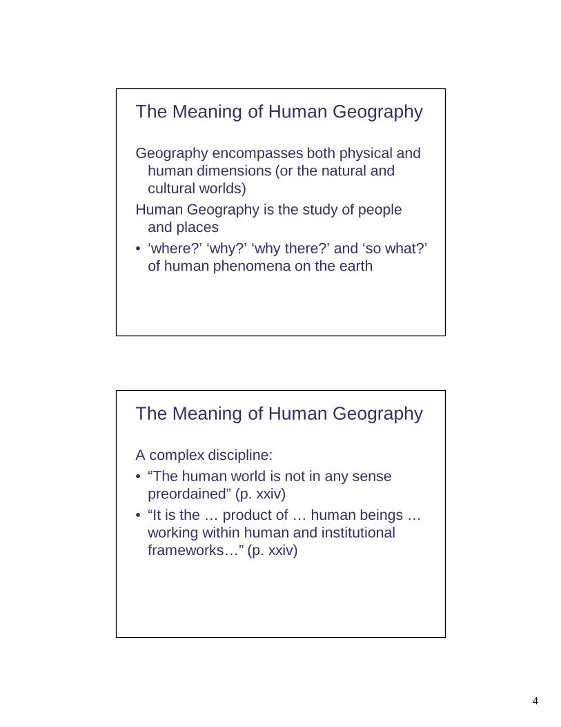
The Meaning of Human Geography
“The central subject matter of human geography is human behavior” (p. xxvii)• always a ‘spatial’ perspective• ‘pattern’ and ‘process’
– spatial variation and changeGeography is about “trying to make sense of the world” (Lewis 2002, in text p. xxvii).
6
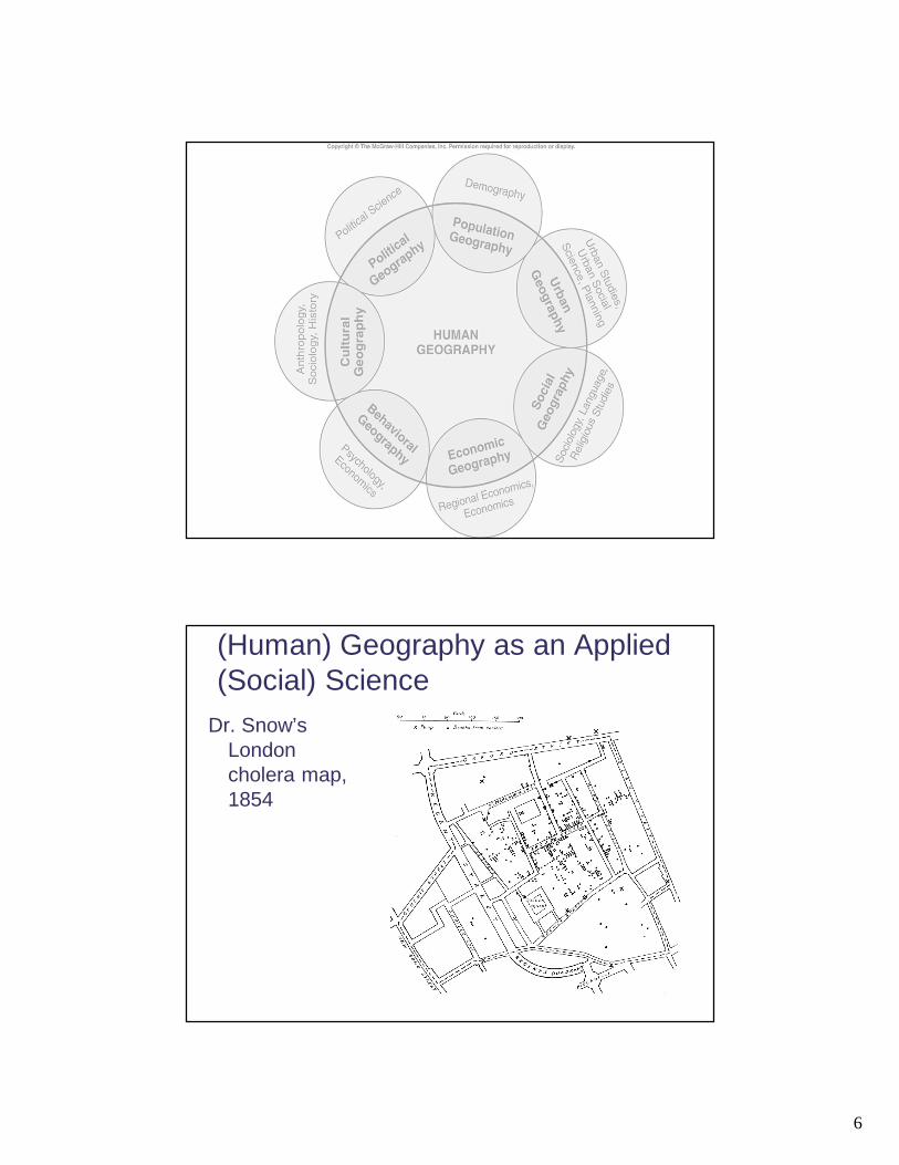
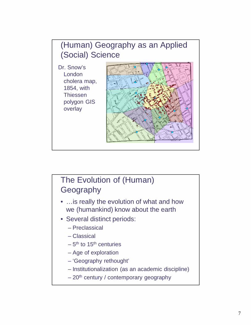
(Human) Geography as an Applied (Social) Science
Dr. Snow’s London cholera map, 1854
7
(Human) Geography as an Applied (Social) Science
Dr. Snow’s London cholera map, 1854, with Thiessen polygon GIS overlay
The Evolution of (Human) Geography• …is really the evolution of what and how
we (humankind) know about the earth• Several distinct periods:
– Preclassical– Classical– 5th to 15th centuries– Age of exploration– ‘Geography rethought’– Institutionalization (as an academic discipline)– 20th century / contemporary geography
8
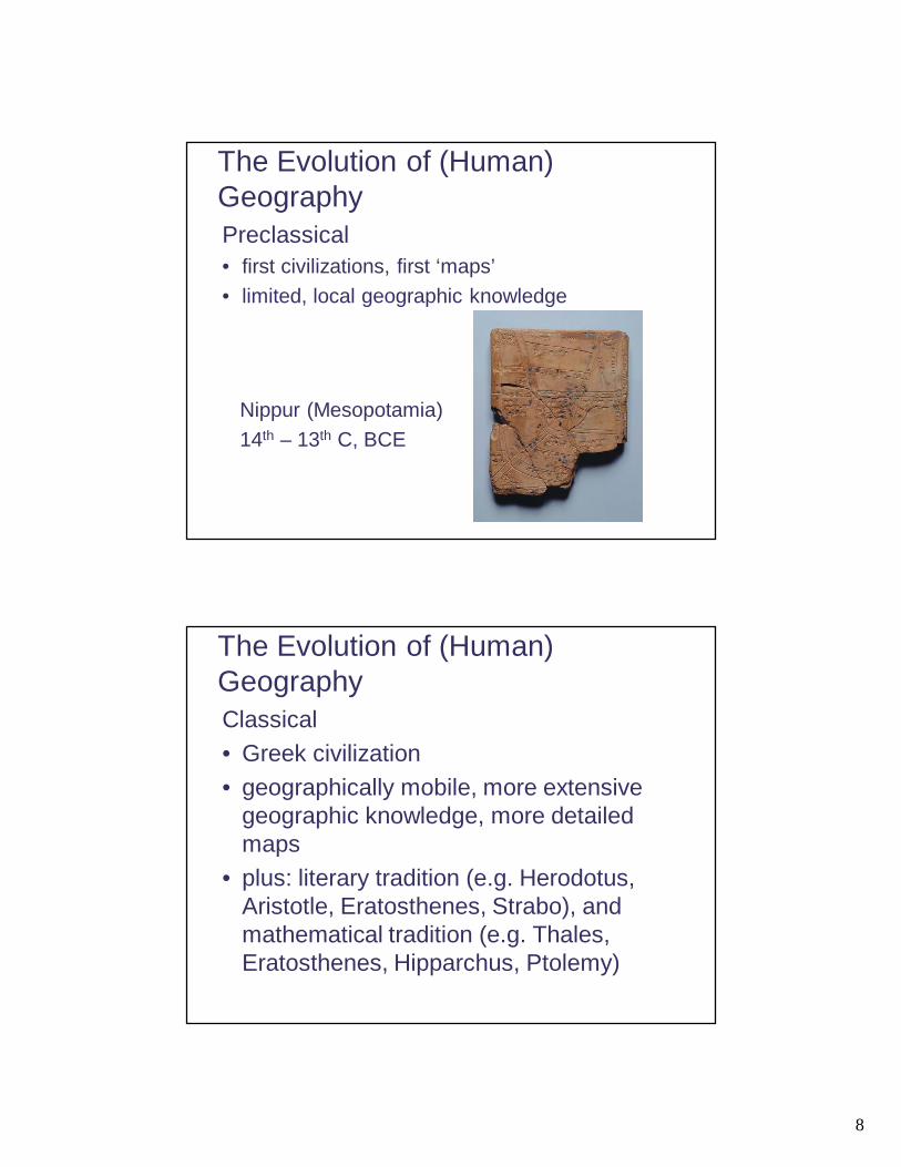
The Evolution of (Human) GeographyPreclassical• first civilizations, first ‘maps’• limited, local geographic knowledge
Nippur (Mesopotamia)14th – 13th C, BCE
The Evolution of (Human) GeographyClassical• Greek civilization• geographically mobile, more extensive
geographic knowledge, more detailed maps
• plus: literary tradition (e.g. Herodotus, Aristotle, Eratosthenes, Strabo), and mathematical tradition (e.g. Thales, Eratosthenes, Hipparchus, Ptolemy)

9

10
The Evolution of (Human) Geography5th to 15th C. – Europe• decline of geography w/ rise in religion• maps as symbolic
e.g. 12th C.‘T-O’ map

11
The Evolution of (Human) Geography5th to 15th C. – China and the Islamic world• China:
– increasingly extensive spatial knowledge of the world (China as a naval power)
– different conceptualization of human relationship with nature
• Islamic world:– another wave of geographic writing and map-making
(e.g. al-Idrisi, ibn-Batata, ibn-Khaldun)

12
The Evolution of (Human) GeographyThe Age of Exploration (European
resurgence)• printing and diffusion of geographic knowledge• state support for the development of geographic
knowledge• major world explorations, leading to rapid
expansion of what constitutes the ‘known world’ and new maps of it (esp. the ‘New World’)
• Mercator’s map as a major cartographic developmentnote: the following image is not Mercator’s map

13
The Evolution of (Human) GeographyGeography Rethought• Varenius
– ‘Universal’ and ‘Special’ Geography– Law building, generalization, geography as ‘science’– Complexity of human-nature relationship
• Humboldt and Ritter– Inter-relation of all things– Description plus laws / theory– Humans as part of nature– Volumes of geographical writing
The Evolution of (Human) GeographyInstitutionalization• First geography departments in universities
– Prussia 1874– U.S. 1903– Canada 1923, 1935
• Plus Geographic “Societies”– Royal Geographical Society 1830– National Geographic Society 1888– Royal Canadian Geographical Society 1929

14
The Evolution of (Human) Geography20th Century Geography• Succession / coexistence of multiple theoretical
approaches:– Environmental Determinism– Landscape School– Possibilism– Regional Studies (aka Areal Differentiation)– Spatial Analysis (Quantitative Revolution)– Humanism– Marxism– Post-modernism– Etc.
Studying (Human) Geography TodayThe ‘5 Themes’ of Geography (1986):1) Location
• ‘absolute’ vs ‘relative’, or ‘site’ vs ‘situation’
2) Human-environment Interaction3) Region4) Place
• ‘sense of place’, ‘perceptions of place’, ‘placelessness’, ‘landscape’
5) Movement• spatial interaction, distance, accessibility, connectivity

15

16
More Concepts
Region • Types:
– Formal– Functional– Vernacular– (there are others)
• Boundaries• Complexity

17
More Concepts
• Space• Distance
– distance decay; friction of distance– distribution: cluster, random, uniform;
agglomeration

18
Distribution
More Concepts• Scale
a) size of area over which a process operatesb) ratio of real world to its representation on a
map

19

20
More Concepts
• Diffusion• contagious / neighbourhood effect,
hierarchical,etc.
• ‘S’-shapedcurve
More Concepts
• Perception• Development
– not just ‘growth’– ‘unevenness’ of geography
• Discourse– language and concepts (of a discipline)– relationship between power and knowledge

21
More Concepts
• Globalization– increasing spatial interaction– increasing homogenization– a multitude of processes– a ‘reworking’ of geography and scale
• Culture– ‘way of life’– ‘Human Geography’ = ‘Cultural Geography’?
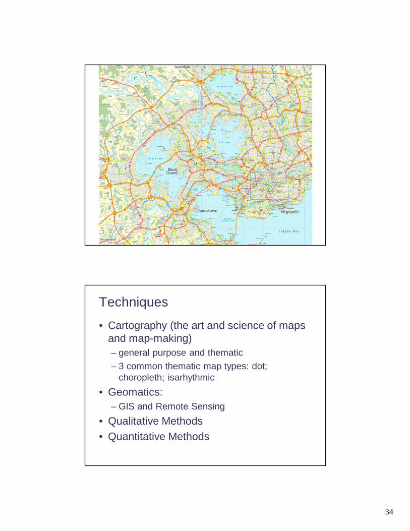
Techniques• Cartography (the art and science of maps
and map-making)– general purpose and thematic– 3 common thematic map types: dot;
choropleth; isarhythmic
22
23

24

25

26

27
28
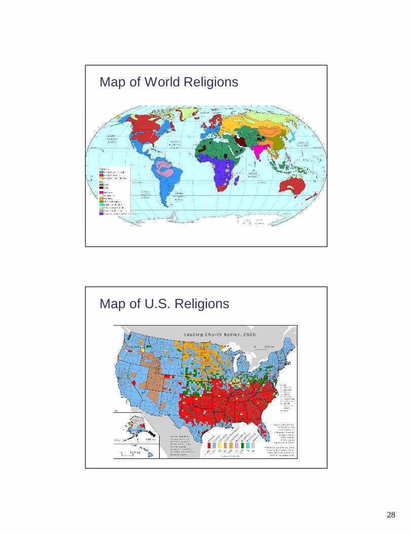
Map of World Religions
Map of U.S. Religions
29

30
31

32

33
34
Techniques
• Cartography (the art and science of maps and map-making)– general purpose and thematic– 3 common thematic map types: dot;
choropleth; isarhythmic• Geomatics:
– GIS and Remote Sensing• Qualitative Methods• Quantitative Methods