Understanding the Gold King Mine Spill v13 preamble final · the, “Understanding the Gold King...
11
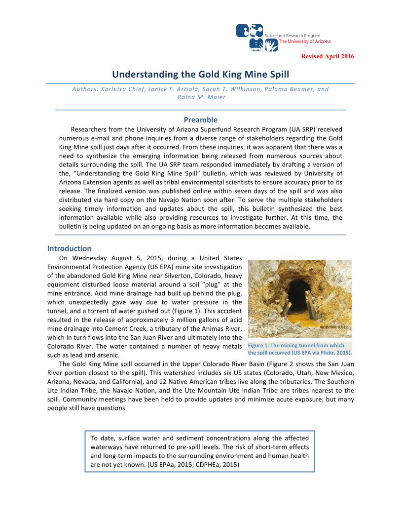
Revised April 2016 Understanding the Gold King Mine Spill Authors: Karletta Chief, Janick F. Artiola, Sarah T. Wilkinson, Paloma Beamer, and Raina M. Maier Preamble Researchers from the University of Arizona Superfund Research Program (UA SRP) received numerous e-mail and phone inquiries from a diverse range of stakeholders regarding the Gold King Mine spill just days after it occurred. From these inquiries, it was apparent that there was a need to synthesize the emerging information being released from numerous sources about details surrounding the spill. The UA SRP team responded immediately by drafting a version of the, “Understanding the Gold King Mine Spill” bulletin, which was reviewed by University of Arizona Extension agents as well as tribal environmental scientists to ensure accuracy prior to its release. The finalized version was published online within seven days of the spill and was also distributed via hard copy on the Navajo Nation soon after. To serve the multiple stakeholders seeking timely information and updates about the spill, this bulletin synthesized the best information available while also providing resources to investigate further. At this time, the bulletin is being updated on an ongoing basis as more information becomes available. Introduction On Wednesday August 5, 2015, during a United States Environmental Protection Agency (US EPA) mine site investigation of the abandoned Gold King Mine near Silverton, Colorado, heavy equipment disturbed loose material around a soil “plug” at the mine entrance. Acid mine drainage had built up behind the plug, which unexpectedly gave way due to water pressure in the tunnel, and a torrent of water gushed out (Figure 1). This accident resulted in the release of approximately 3 million gallons of acid mine drainage into Cement Creek, a tributary of the Animas River, which in turn flows into the San Juan River and ultimately into the Colorado River. The water contained a number of heavy metals such as lead and arsenic. The Gold King Mine spill occurred in the Upper Colorado River Basin (Figure 2 shows the San Juan River portion closest to the spill). This watershed includes six US states (Colorado, Utah, New Mexico, Arizona, Nevada, and California), and 12 Native American tribes live along the tributaries. The Southern Ute Indian Tribe, the Navajo Nation, and the Ute Mountain Ute Indian Tribe are tribes nearest to the spill. Community meetings have been held to provide updates and minimize acute exposure, but many people still have questions. Figure 1: The mining tunnel from which the spill occurred (US EPA via Flickr, 2015). To date, surface water and sediment concentrations along the affected waterways have returned to pre-spill levels. The risk of short-term effects and long-term impacts to the surrounding environment and human health are not yet known. (US EPAa, 2015; CDPHEa, 2015)
Transcript of Understanding the Gold King Mine Spill v13 preamble final · the, “Understanding the Gold King...
Revised April 2016
1
UnderstandingtheGoldKingMineSpillAuthors:KarlettaChief, JanickF.Artiola,SarahT.Wilkinson,PalomaBeamer,and
RainaM.Maier
PreambleResearchersfromtheUniversityofArizonaSuperfundResearchProgram(UASRP)received
numerouse-mailandphone inquiriesfromadiverserangeofstakeholdersregardingtheGoldKingMinespilljustdaysafteritoccurred.Fromtheseinquiries,itwasapparentthattherewasaneed to synthesize the emerging information being released from numerous sources aboutdetailssurroundingthespill.TheUASRPteamrespondedimmediatelybydraftingaversionofthe, “Understanding the Gold KingMine Spill” bulletin, which was reviewed by University ofArizonaExtensionagentsaswellastribalenvironmentalscientiststoensureaccuracypriortoitsrelease.Thefinalizedversionwaspublishedonlinewithinsevendaysof thespillandwasalsodistributedviahardcopyon theNavajoNationsoonafter.Toserve themultiplestakeholdersseeking timely information and updates about the spill, this bulletin synthesized the bestinformation available while also providing resources to investigate further. At this time, thebulletinisbeingupdatedonanongoingbasisasmoreinformationbecomesavailable.
IntroductionOn Wednesday August 5, 2015, during a United States
EnvironmentalProtectionAgency(USEPA)minesiteinvestigationoftheabandonedGoldKingMinenearSilverton,Colorado,heavyequipment disturbed loose material around a soil “plug” at themineentrance.Acidminedrainagehadbuiltupbehindtheplug,which unexpectedly gave way due to water pressure in thetunnel,andatorrentofwatergushedout(Figure1).Thisaccidentresulted in the releaseofapproximately3milliongallonsofacidminedrainageintoCementCreek,atributaryoftheAnimasRiver,whichinturnflowsintotheSanJuanRiverandultimatelyintotheColorado River. Thewater contained a number of heavymetalssuchasleadandarsenic.
TheGoldKingMinespilloccurred intheUpperColoradoRiverBasin(Figure2showstheSanJuanRiverportionclosest to thespill).Thiswatershed includessixUSstates (Colorado,Utah,NewMexico,Arizona,Nevada,andCalifornia),and12NativeAmericantribeslivealongthetributaries.TheSouthernUte IndianTribe, theNavajoNation,and theUteMountainUte IndianTribeare tribesnearest to thespill.Communitymeetingshavebeenheldtoprovideupdatesandminimizeacuteexposure,butmanypeoplestillhavequestions.
Figure1:Theminingtunnelfromwhichthespilloccurred(USEPAviaFlickr,2015).
To date, surfacewater and sediment concentrations along the affectedwaterwayshavereturnedtopre-spilllevels.Theriskofshort-termeffectsandlong-termimpactstothesurroundingenvironmentandhumanhealtharenotyetknown.(USEPAa,2015;CDPHEa,2015)

Revised April 2016
2
Whydidthewaterturnyellow?
Many abandoned mines havedeep tunnels below the water tablethatwerecreatedtomineore.Duringmining, water is pumped out of thetunnels, but after themine is closed,the water table can rise back up,filling the empty tunnels with water.When the ore in the tunnels isexposed to water and air, acid isgenerated and metals from the rockseep into the water. This creates athick,metal-filledmixturecalled“acidminedrainage.”Acidminedrainageisusually a rusty red to orange colordue to thepresenceof iron.When aspill occurs intoawaterway, and theacidminedrainage ismixedwith freshwater, itbecomes lessacidic,whichchanges theway ironandothermetals interactwith thewater andwith solids in thewater. The iron from the red-orangeacidminedrainagesettlesintothewater,turningityellow.Old-timeminersreferredtothisas“yellowboy.”Asmorewaterismixedin, ironandothermetalsbecomeevenmorediluteand/orgetstucktosolids,causing them to drop out of the water and settle into river bottom sediments, and the water colorreturns tonormal.Naturallyoccurring ironpresent in reducing conditions canalso causewater tobeyellow,butdoesnotnecessarilyindicatetheamountofmetalsinthewater.
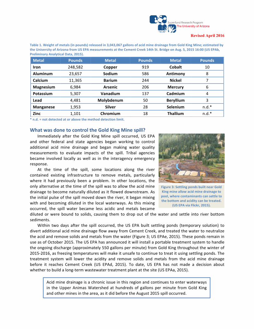
Howbigwasthespillandwhatwentintothewater?Theacidminedrainagereleasedinthespillcontainedanumberofmetalsandsaltstotalingabout
190tonsofsolids, includingseveralformsoftoxicmetalssuchas lead,arsenic,mercuryandcadmium(Table1).Thesesolidsweremixedin3,043,067gallonsofwater.Thisvolumeofwaterisapproximately9.3acre-feet,or9footballfieldsspreadoutatonefootdeep.
WithindaysfollowingtheGoldKingspill,theyellowcolorattheleadingedgeofthe plume was no longer visible, due to the movement and dilution of the river.Withinaweek,theAnimasRiverbeganreturningtoitsusualcolor.(USEPAd,2015)
Thecolor,smell,ortasteofwaterisnotenoughtoknowwhetheritissafeornot.Theonlywaytobesureofthewaterqualityistosampleandtestit.Followstateandfederalnoticesconcerningwaterusefordrinking,agriculture,andrecreation.
Figure2:TheSanJuanRiverportionoftheColoradoRiverBasin.TheredstarindicatesthesiteofGoldKingMinespill.(Adaptedfrom"Sanjuanrivermap"byShannonviaWikimediaCommons.)
GoldKingMine
Revised April 2016
3
Table1.Weightofmetals(inpounds)releasedin3,043,067gallonsofacidminedrainagefromGoldKingMine;estimatedbytheUniversityofArizonafromUSEPAmeasurementsattheCementCreek14thSt.BridgeonAug.5,201516:00(USEPAb,PreliminaryAnalyticalData,2015).
*n.d.=notdetectedatorabovethemethoddetectionlimit.
WhatwasdonetocontroltheGoldKingMinespill?Immediately after the Gold KingMine spill occurred, US EPA
and other federal and state agencies began working to controladditional acid mine drainage and began making water qualitymeasurements to evaluate impacts of the spill. Tribal agenciesbecame involved locally aswell as in the interagency emergencyresponse.
At the time of the spill, some locations along the rivercontained existing infrastructure to remove metals, particularlywhere it had previously been a problem. In other locations, theonlyalternativeatthetimeofthespillwastoallowtheacidminedrainagetobecomenaturallydilutedasitfloweddownstream.Astheinitialpulseofthespillmoveddowntheriver,itbeganmixingwithandbecomingdiluted in the localwaterways.As thismixingoccurred, the spill water became less acidic and metals becamediluted orwere bound to solids, causing them to drop out of thewater and settle into river bottomsediments.
Within two days after the spill occurred, theUS EPA built settling ponds (temporary solution) todivertadditionalacidminedrainageflowawayfromCementCreek,andtreatedthewatertoneutralizetheacidandremovesolidsandmetalsfromthewater(Figure3;USEPAe,2015).ThesepondsremaininuseasofOctober2015.TheUSEPAhasannounceditwillinstallaportabletreatmentsystemtohandletheongoingdischarge(approximately550gallonsperminute)fromGoldKingthroughoutthewinterof2015-2016,asfreezingtemperatureswillmakeitunsafetocontinuetotreatitusingsettlingponds.Thetreatment system will lower the acidity and remove solids and metals from the acid mine drainagebefore it reaches Cement Creek (US EPAd, 2015). To date, US EPA has not made a decision aboutwhethertobuildalong-termwastewatertreatmentplantatthesite(USEPAa,2015).
Metal Pounds Metal Pounds Metal PoundsIron 248,582 Copper 919 Cobalt 10Aluminum 23,657 Sodium 586 Antimony 8Calcium 11,365 Barium 244 Nickel 7Magnesium 6,984 Arsenic 206 Mercury 6Potassium 5,307 Vanadium 137 Cadmium 4Lead 4,481 Molybdenum 50 Beryllium 3Manganese 1,953 Silver 28 Selenium n.d.*Zinc 1,101 Chromium 18 Thallium n.d.*
Figure3:SettlingpondsbuiltnearGoldKingmineallowacidminedrainagetopool,wherecontaminantscansettletothebottomandaciditycanbetreated.
(USEPAviaFlickr,2015).
Acidminedrainageisachronicissueinthisregionandcontinuestoenterwaterwaysin theUpperAnimasWatershed at hundreds of gallons perminute fromGold Kingandotherminesinthearea,asitdidbeforetheAugust2015spilloccurred.

Revised April 2016
4
Wheredoesthewaterflow,andhowmuchwasthespilldiluted?The Gold KingMine spill occurred in the Upper Colorado River Basin (see Figure 2, above). The
approximately9.3acre-feetofacidminedrainagereleasedinthespillbecamedilutedveryquicklyintheflowoftheaffectedwaterways.EstimateddilutionsofthespillatdifferentlocationscanbecalculatedusingdatafromtheUnitedStatesGeologicalSurvey(USGS)NationalWaterInformationSystem(USGS,2015). The following sections trace the flow of thewater inmore detail and describe the estimateddilutionoftheacidminedrainage.
CementCreekandtheAnimasRiverTheGoldKingminespilloccurredinCementCreek,whichflowssouthintotheAnimasRiverthrough
Durango,Colorado,where residents relyon theAnimasRiver for recreation, agriculture, anddrinkingwater.Measureddatashowedthatlevelsofmetalshadalreadydecreasedbyhalfbythetimetheplumehadmoved10milesdownstream(ADEQ,2015).Sixtymilesdownstream,theAnimasRiveratDurangowasflowingat1,414acre-feetperdayonthedayofthespill.Thismeansthatwithintheday,the9.3acre-feet of acid mine drainage would have been further diluted by 1:150, or one part acid minedrainageto150partsofriverwater.TheAnimasRiverflowssouthfromDurangoandjoinstheSanJuanRiveratFarmington,NewMexico.
SanJuanRiverThe San Juan River flows west through the Four Corners, and continues flowing west through
southernUtahuntil itflowsintotheColoradoRiverandLakePowell. It isusedforagriculture,culturaluses,drinkingwater,andrecreation.TheSanJuanRiversupportsthelargestconcentratedareaoflocalNavajofarmingandtheUteMountainUtealsohavelocalfarmsalongtheSanJuan.WhenwaterfromthespillreachedtheSanJuanRiveratFourCorners,itwouldhavebeenfurtherdilutedby1:550,oronepartacidminedrainageto550partsofriverwater.
ColoradoRiverFrom the San Juan confluence, the Colorado River flows south into northern Arizona, and
encountersLakePowell,formedbytheGlenCanyonDam.Thewaterisusedforrecreation,agriculture,anddrinkingwater.
Theleadingedgeoftheplume(nolongervisible)likelyenteredLakePowellonAugust12,2015(USEPAa,2015).LakePowellcontainedmorethan12millionacre-feetofwaterinAugust2015(LakePowellWaterDatabase,2015).Thiswouldhavefurtherdilutedthe9.3acrefeetofacidminedrainagereleasedintheGoldKingMinespillby1:1,200,000,or1partacidminedrainagetomorethanamillionpartsoflakewater. Becauseof the retention time in Lake Powell, biologists estimate theplumemay take 18months to two years to reachGlen CanyonDam (AzEIN, 2015). The sediments (i.e., solidmatter andmetalsmoving inthewater)released inthespill totaledapproximately190tons.Roughly44.4milliontons of sediment produced by river erosion arrives at Glen Canyon Dam each year (Andrews, 1990;Weisheit,2003).Thus,ifallthesedimentfromtheGoldKingMinespillweretoreachGlenCanyonDam,itwouldbedilutedmorethan600timesinonedaybythe121thousandtonsoferosionsedimentthatenterthelakeeachday.
After theGlenCanyonDam inArizona, theColoradoRiverpassesLee’sFerry,Arizona, theofficialdividingpointoftheupperandlowerColoradoRiver.Here,theaverageriverflowis14millionacre-feetperyear (Graf,1997),or38,000acre-feetperday;anywater from the spill thatpassed throughLakePowell and into the lowerColoradoRiverwould thenbedilutedbyanadditional1:4000,oronepartalready-dilutedacidminedrainageto4,000partsofriverwater.

Revised April 2016
5
The Colorado River then flows south towards Nevada at Lake Mead and the Hoover Dam, andcontinuessouththroughArizonauntilitreachesMexico.However,nomeasurableimpactsbeyondLakePowellareexpected.
Whoregulatesabandonedmines?Priortothe1970’s,miningoperationswerenotwellregulatedandasaresult,thereisa legacyof
abandoned mines in the United States. Today, these mining sites are subject to environmentalregulationsinordertoprotecthumanandenvironmentalhealth.TheUSEPAistheagencychargedwithoverseeing abandoned mines, and works to clean up and close such sites. However, this is a largeproblem;therearethousandsofinactiveorabandonedminesonfederal,state,tribal,andprivatelands,especially throughout thewestern US. Thesemines are often abandoned by prospectors andminingcompanieswhotypicallyarenotheldliabletocleaningupthesemines.Thereareapproximately5,105abandonedminesinColorado;3,989inNewMexico;10,697inUtah;and24,183inArizona(BureauofLandManagement, 2015). Some abandonedmines pose little riskwhile others pose larger risks. Thereturnofanabandonedminetoapre-miningstateisnotpossible.Throughreclamationofthesesitesanattemptismadetoalmostreachthispre-miningstate.Reclamationtakesalongtimeanditiscostly.For example, the US EPA Office of Inspector General identified 156 “mega” hard rock mining sitesnationwidethatcouldcost$24billiontocleanupandmaintain,acostmorethan12timestheannualUSEPAbudgetforremediationoflargehazardouswaste(i.e.,Superfund)sites(Lovingoodetal.,2004).
WhatisthehistoryofminingintheUpperAnimaswatershed?TheGoldKingMinewasdiscoveredin1887andoperateduntil
1922(Figure4).Thereareapproximately23,000abandonedminesin Colorado where the Gold King Mine is located (ColoradoDepartmentofNaturalResources,2014).Asaresult, it isonlyoneof many abandoned gold and silver mines located near Silverton,ColoradowithintheUpperAnimaswatershed,reflectingmorethan120 years of gold, silver, lead, zinc, and copper mining, spanningfrom1871to1991.Duringtheseyearsanestimated8.6milliontonsofmill tailingswere discharged into thewaterways (Church et al.,2007). Studies have shown that both natural weathering andcontinuous acid mine drainage generated from the abandonedmineshaveimpactedwaterquality inthearea,wherethewater isoftenacidicandcontaminatedwithheavymetals(Churchetal.,2007;USEPAc,2015).
TheUSEPAconductedaSuperfundsiteassessmentoftheUpperAnimasRiverBasinnearSilvertonin the 1990s, and focused again on the Upper Cement Creek area in the late 2000s-early 2010s, todeterminewhether itshouldbe includedontheUSEPANationalPrioritiesList (ARSG,2015;USEPAc,2015). This label would give US EPA the authority to clean up the area and identify potentiallyresponsible parties (e.g.mine owners) to pay for it. Although the poorwater quality and impacts toaquatic life made the Upper Animas and/or Cement Creek areas eligible for Superfund status, inresponsetocommunityconcernsoverthestigmaattachedtoit(e.g.potentialimpactstorealestateandtourism),thesiteswerenotlisted.MinereclamationandremediationprojectshavebeenundertakenbylocaloraganizationssuchastheAnimasRiverStakeholdersGroup(ARSG,2015;USEPAc,2015).USEPAcontinuestomonitorandinvestigatethearea.
Figure4:GoldKingMinecirca1899(Churchetal.,2007).
Revised April 2016
6
Howaretheimpactsofthespillbeingassessed?Totracktheimpactsofthespill,samplingofdrinkingwater,surfacewater,sediment,andfishtissue
isbeingperformedfromtheGoldKingMinesite,alongtheAnimas,SanJuan,andColoradoRiversdownto Lake Powell and theGlen CanyonDamby local, tribal, and state agencies, aswell as theUS EPA.ArizonaandNevadastateofficialsexpectminimalimpactstothelowerColoradoRiver,butwillcontinuetomonitorrelevantwaterways.Testingisbeingdonetodeterminetheconcentrationofmetalstypicallyfoundinacidminedrainage,aswellastodeterminewaterqualityfactorssuchashardnessandacidity.Results are being compared to pre-spill levels or to historical water quality data. Based on samplingresults,relevantlocal,state,tribal,andfederalagenciesaremakingrecommendationswateruse.
Whatareshort-termimpactsofthespillandrecommendationsforwateruse?AccordingtotheAgencyforToxicSubstancesandDiseaseRegistry,theUSEPA,theColorado
DepartmentofPublicHealthandtheEnvironment,andtheSanJuanBasinHealthDepartment,adversehealtheffectsarenotexpectedfromskincontactorincidental(unintentional)ingestionofthewaterduringtypicalrecreationaluse(USEPAa,2015;CDPHEb,2015).Theriskofhealtheffectsinlivestockthatmayhavebeenexposedisalsolow.
CementCreek
WaterqualitywasdramaticallyaffectedinCementCreekfollowingtheGoldKingMinespill.AlthoughthelevelsofmetalsdeclinedthroughoutAugust2015,asofmid-September2015,thelevelsofmostmetalsremainedabovehistoric/pre-spilllevelsinCementCreek(CDPHEa,2015).CementCreekistypicallyusedforrecreationandagriculture;asofSeptember15,2015,CementCreekwasstillnotmeetingregulatorystandardsforagricultureduetoelevatedcopperandzinc.However,metalsandacidityofwaterandsedimentsdownstreamintheAnimas,SanJuan,andColoradoRivers,aswellasLakePowell,havereturnedtopre-spilllevelsandcanbeusedforrecreation,agriculture,anddrinkingwater(USEPAd,2015;CDPHEb,2015;NPS,2015).
RecreationTheAnimasRiverwasclosedforrecreationfollowingtheGoldKingMinespill,butreopenedfor
recreationwithinaweek.TheSanJuanandColoradoRiversremainopenforrecreation.
AgricultureIntakesforirrigationwaterwereturnedoffalongtheAnimasandSanJuanRiversfollowingthespill,
buthavesincebeenflushedandreopened.Waterqualityalongtheaffectedwaterwayshasreturnedtopre-spilllevelsandcanbeusedforirrigation(CDPHEb,2015).AccordingtotheAgencyforToxicSubstancesandDiseaseRegistry,theUSEPA,theColoradoDepartmentofPublicHealthandtheEnvironment,andtheSanJuanBasinHealthDepartment,cropsgrownduringthespillaresafeforconsumption(CDPHEb,2015).ManylocalNavajofarmersrelyexclusivelyontheSanJuanRiverto
Ingeneral,surfacewaterandsedimentmetalconcentrationsalongtheaffectedwaterwayshave returned tohistoric/pre-spill levels.Thewaterwayshavebeenopened for recreation, agriculture, and drinking water (the latter withappropriatetreatment).Theriskofshort-termeffectsandlong-termimpactstothe surrounding environment and health are not yet known. (US EPAa, 2015;CDPHEa,2015)

Revised April 2016
7
irrigatetheirfieldsandwatertheirlivestock.Manytribalirrigationintakesintheareaclosetothespillwereshutoffforalongtime,followingwater-userestrictionsissuedbytheNavajoNation.TheFruitlandCanalSystem,whichprovidesirrigationwatertothecommunitiesofSanJuan,UpperFruitland,andNenahnezad,wasreopenedweeksafterthewaterwasdeclaredsafeforuse.Adownstreamchapter,ShiprockChapter,votedtonotopentheirirrigationditchesfordiversionforayearafterthespill.Shiprockvotedtore-opentheirditchinApril2016afterreceivingwaterqualitydatafortheirarea.Duetoclosureofirrigationintakes,thecropyieldsofmanyNavajofarmersweredevastated.
LivestockAsofmid-August2015,theColoradoDepartmentofAgricultureStateVeterinarian'sOfficedeclared
thatwaterfromtheAnimasRivercouldbeusedtowaterlivestock(CDPHEa,CDPHEb,2015).However,excesssulfateintheirrigationwatercouldhavedecreasedtheavailabilityofcopperinhayandpastures,thereforecattleranchersandfarmersshouldcheckwiththeirveterinariansonwhethertheyneedtosupplementcattlefeedwithcopper(CDPHEb,2015).Forhelpinterpretingwaterqualitytestresultsforirrigationorlivestockwater,seetheColoradoStateWaterQualityInterpretationTool,https://erams.com/wqtool/.
GardeningTheColoradoDepartmentofPublicHealthandEnvironmentadvisesgardenerswhousewaterfrom
theAnimasRiverandgrowleafyvegetablesandrootcropstocalltheColoradoStateUniversityExtensionofficeat970-382-6463forspecificadvice,asanswerstoquestionsaresite-andcrop-specific(CDPHEa,2015).Somestudieshaveshownthatbothleafyvegetablesandrootcropsmaytakeupmetalseasierthanothertypes.Asaresult,itisgoodtogetinputfromlocalextensionagentsorothersthathaveexperiencewiththistopic.
AquaticLife(Fish,Birds,Mammals)AsofSeptember2,2015,theColoradoDepartmentofPublicHealthandEnvironmentdeclaredthat
troutfromtheAnimasRiveraresafetoeat(CDPHEa,2015).DuetocontinualslowreleasesofacidminedrainageintotheAnimasRiver,therewerealreadyalimitednumberoffishinwaterwaysintheareawherethespilloccurred;followingpassageofthespillwater,nofishkillswereobserved(CDPHEb,2015,EPA,2015).Tofindoutifthespillcouldaffectdeveloping/youngwildfish,108fingerlingrainbowtroutwereplacedincagesintheAnimasRivernearDurangobeforethespillreachedthearea,andkeptintheriverforfivedaysuntiltheplumepassed.Onefishdied,unrelatedtowaterquality,andtheother107remainedhealthy,withnosignsofstress,throughouttheexposure.ThefishweresenttotheColoradoDepartmentofPublicHealthandEnvironmenttotesttheirtissuesandorgansformetals.Metalsinthefishwereeithernotdetectableorwithinarangefoundinfishbeforethespill;allsampleswerebelowshort-termriskthresholds.TherelevantdepartmentsinthestateofColoradowillcontinuetomonitorlevelsofmetalsinfishintheAnimasRiver.Todate,noeffectshavebeenseenonducksorlandmammalsalongtheAnimasRiver(CDPHEb,2015).
DrinkingWaterStatesareworkingwithpublicdrinkingwatersystemstoensuresafedrinkingwater.Sampling
performedbytheColoradoDepartmentofPublicHealthandEnvironmentdemonstratedthatpublicdrinkingwatersystemsdrawingfromgroundwaterwellsneartheAnimasRiver,orevendirectlyfromtheriveritself(withappropriatetreatment),areprovidingsafedrinkingwater(CDPHEa,2015).Contactyourwaterproviderifyouhavequestionsaboutthewaterqualityatyourtap.
TheUSEPAaswellasrelevantstateandlocalagenciesaretestingprivatedrinkingwaterwellsthroughouttheareasaffectedbythespill(CDPHEa,2015;USEPAd,2015).Residentswithwellslocated
Revised April 2016
8
withinamileoftheAnimasRiverareadvisedtohavetheirwellwatertestedbyaprofessional;contacttheSanJuanBasinHealthDepartmentorstatehealthdepartmentforquestionsontestingandunderstandingtestresults.Forgeneralinformationondrinkingwaterwellcontaminantsandhomewatertreatmentoptions,seeUhlmanetal.(2009)andArtiolaetal.(2009).Forhelpinterpretingwaterqualitytestresultsfordrinkingwater,seetheColoradoStateWaterQualityInterpretationTool,https://erams.com/wqtool/.
Whatarepossiblelong-termeffectsoftheGoldKingMinespill?Althoughthereappeartobenoshort-termeffectstohealthortheenvironmentfollowingtheGold
KingMinespill,wewillnotunderstandthelong-termimpactsofthishighlyconcentratedreleaseofmetalsintoourenvironmentforquitesometime.Thislonger-termquestionwilldependonthebehaviorofmetalsdepositedinsediments.Thereisapotentialforsuchsedimentstobestirredupandmetalsreleasedduringhighwatereventsorrecreationaluse.Themetalscouldbecomeconcentratedinfishthatliveintheriverandfeedonthingsthatgrowinthesediments,aswellasotherwildanimalsthatfeedonthingsthatgrowinoralongtheriver.Metalsinthesedimentscouldseepintothegroundwater,resultinginimpactstodrinkingandirrigationwater.Ifthemetal-richsedimentsdepositonrivershores,theycouldpotentiallydryoutandbeblownasdustbythewind,wheretheycouldcontaminatesurroundingsoil,andcouldalsobeinhaled.
Itwilltaketimetoknowwhatthelong-termsedimenteffectsandpossibleexposurelevelswillbeintheUpperColoradoRiverBasin,oriftheseexposureswillbedifferentfromexposurelevelsbeforethespill.Thesedifferenceswilldependonhowpeopleusethewater,andiftheiruseandfrequencyofusehaschangedasresultofthespill.Itwillalsotaketimetodetermineifthesepotentiallevelsofenvironmentalexposurewillbehighenoughtoresultinhumanhealthrisksoraffectfloraandfaunaoverthelongterm.ThechancesofsignificantexposuretometalsfromthespillintheLowerColoradoRiverBasinarenegligible.
TheUSEPAwillbeworkingwithlocalagencies,thestatesofColoradoandNewMexico,andtheNavajoNationtocontinuetomonitortheenvironmentalimpactsalongtheAnimasandSanJuanRivers(CDPHEb,2015).TheArizonaDepartmentofEnvironmentalQualityandGameandFishDepartmentwillcontinuetosampleandtestwaterqualityandfishfromLakePowelltomonitorpotentiallong-termimpacts(AzEIN,2015).TheGlenCanyonNationalRecreationAreawillcontinuetobemonitoredbytheNationalParkService,USEPA,UnitedStatesGeologicalSurvey,BureauofReclamation,andthestatesofUtahandArizona(NPS,2015).LakeMeadinNevadaisnotexpectedtobeimpactedbythespill,buttheSouthernNevadaWaterAuthoritywillsampleandtestwaterinthelakeandwatertreatmentplants(SNWA,2015).Futuremeasurementscanbecomparedtobackgroundlevelsthatweremeasuredinpreviousyears,tobetterunderstandthelong-termimpactoftheGoldKingMinespill.
WhatcanIdotolimitmyexposure?• Itisimportanttoknowwhereyourdrinkingwatercomesfrom(e.g.,doyougetitfromawater
company,ownawell,orhaulyourwater?)andtohaveittestedifitisnotregulatedfordrinkingwaterstandards.
o Watercompaniesarerequiredtotestyourwaterandproduceanannualreport.Ifyouownyourownwellorhaulwaterfromanunregulatedsource,youareresponsiblefortestingandtreatment.
o Forhelpinterpretingwaterqualitytestresultsfordrinkingwater,irrigation,orlivestock,seetheColoradoStateWaterQualityInterpretationTool,https://erams.com/wqtool/.

Revised April 2016
9
• TheColoradoDepartmentofPublicHealthandEnvironmentrecommendsthatpeopledonotdrinkuntreatedwaterdirectlyfromtheriveratall,asitisnotpotable(regardlessofthespill)andshouldbetreated.
o Waterusedforanimals,largeandsmall,shouldbeallowedtostandatleast24hourstoallowanysedimentparticlestosettleoutasmuchaspossible.
• AsofSeptember16,2015,theColoradoDepartmentofPublicHealthandEnvironmentdeclaredtheriskofadversehealtheffectsfromtypicalrecreationalactivitiesorincidentalcontactwithriversedimenttobelow(CDPHEa,2015).However,theydoadvise:
o Avoidcontactwithorange/yellow-coloredriverwater,ororange/yellow-coloredsedimentsaroundcreeksandriverbeds,whetherforrecreationorceremonialpurposes.
o Limitdisturbancestoriversedimentsduringrecreation.o Washhandsandclothesthoroughlywithsoapandwateraftercontactwithsediments.o Youngchildren(<6yearsofage)shouldbesupervisedbyadultswhenvisitingareasalong
theriver,toensuretheydonotconsumeriversediment.
Resourcesformoreinformation• AgencyforToxicSubstancesandDiseaseRegistrywebsite,healthinformationabouttodifferent
contaminants:http://www.atsdr.cdc.gov/toxfaqs/index.asp• ArizonaGeologicalSurvey,mapofearlywaterandsedimentlocations:
http://maps.azgs.az.gov/gold-king-mine-spill/• ColoradoDepartmentofPublicHealthandEnvironment,generalinformationabouttheAnimas
Riverspill:https://www.colorado.gov/pacific/cdphe/animas-river-spill• ColoradoStateUniversityWaterQualityInterpretationTool,waterquality:
https://erams.com/wqtool/• NavajoNationOperationYellowWater,informationabouttheGoldKingMinespill:
http://operationyellowwater.com• NewMexicoEnvironmentDepartment,GoldKingMineWastewaterspill:
https://www.env.nm.gov/riverwatersafety/• SanJuanBasinPublicHealthDepartment,GoldKingMineIncidentUpdates:
http://sjbhd.org/public-health-news/animas-river-health-updates/• USEPA,Hotline(toll-free):1-844-607-9700• USEPA,EmergencyResponsetoAugust2015ReleasefromGoldKingMine:
http://www2.epa.gov/goldkingmine• USEPAEmergencyResponseMonitoringDatafromtheGoldKingMineIncident:
https://www.epa.gov/goldkingmine/emergency-response-monitoring-data-gold-king-mine-incident• USEPAPressReleasesandUpdatesforGoldKingMineResponse:
https://www.epa.gov/goldkingmine/press-releases-and-updates-gold-king-mine-response• USEPA,additionallocal,state,andtribalresources:
http://www2.epa.gov/goldkingmine/gold-king-mine-resources-information• UtahDepartmentofEnvironmentalQuality,GoldKingMineRelease:
http://www.deq.utah.gov/Topics/Water/goldkingmine/
ReferencesADEQ,2015.ArizonaDepartmentofEnvironmentalQuality,Newsroom&PressReleaseArchive.
http://www.azdeq.gov/function/news/.AccessedOctober9,2015.

Revised April 2016
10
Andrews,E.D.,1990.TheColoradoRiver:AperspectivefromLeesFerry,Arizona.Pages304-310inSurface-WaterHydrology.TheGeologyofNorthAmerica,Vol,O-1.SpecialPublication.Boulder(CO):GeologicalSocietyofAmerica.
Artiola,J.,Farrell-Poe,K.L.,andUhlman,K.,2009.Waterfacts:Homewatertreatmentoptions.TheUniversityofArizona,ArizonaCooperativeExtensionAZ1498,September2009.https://extension.arizona.edu/sites/extension.arizona.edu/files/pubs/az1498.pdfAccessedOctober2,2015.
ARSG,AnimasRiverStakeholdersGroup,2015.http://www.animasriverstakeholdersgroup.org/page1.htmlAccessedOctober2,2015.
AzEIN,2015.ArizonaEmergencyInformationNetwork,Game&FishtoMonitorFishatLakePowell,LeesFerry,forMineSpillImpacts.https://ein.az.gov/emergency-information/emergency-bulletin/game-fish-monitor-fish-lake-powell-lees-ferry-mine-spill#sthash.T8iW7szg.dpuf.AccessedOctober9,2015.
BureauofLandManagement,2015.AbandonedMineLandsPortal.http://www.abandonedmines.gov/AccessedOctober2,2015.
CDPHEa,ColoradoDepartmentofPublicHealthandEnvironment,2015.AnimasRiverSpill.https://www.colorado.gov/pacific/cdphe/animas-river-spillAccessedOctober6,2015.
CDPHEb,ColoradoDepartmentofPublicHealthandEnvironment,2015.JointInformationCenterAugust18FrequentlyAskedQuestions.https://www.colorado.gov/pacific/sites/default/files/JIC-FAQs-08-18-15.pdfAccessedOctober6,2015.
Church,S.E.,VonGuerard,P.,andFinger,S.E.,2007.IntegratedInvestigationsofEnvironmentalEffectsofHistoricalMiningintheAnimasRiverWatershed,SanJuanCounty,ColoradoUSGSProfessionalPaper1651.http://pubs.er.usgs.gov/publication/pp1651AccessedOctober2,2015.
ColoradoDepartmentofNaturalResources,2014.InactiveMineReclamationProgram.http://mining.state.co.us/Programs/Abandoned/Pages/impwelcomepage.aspx.AccessedApril26,2016.
Graf,J.B.,1997.TheColoradoRiverinGrandCanyon:Howfastdoesitflow?USGSFactSheetFS-168-97.December1997.http://pubs.usgs.gov/fs/FS-168-97/pdf/fs-168-97.pdfAccessedOctober2,2015.
LakePowellWaterDatabase,2015.http://lakepowell.water-data.com/.AccessedOctober6,2015.Lovingood,T.,Parker,B.,Smith,T.N.,Canes,H.,Fennell,F.,Cofer,D.,andReilly,T.,2004.Nationwide
IdentificationofHardrockMiningSites.ReportNo.2004-P-00005,March31,2004.OfficeofInspectorGeneraloftheUSEPA.
Myers,T.,1998.SedimentHydrologyontheColoradoRiver:theImpactsofDrainingLake Powell.NorthernArizonaUniversity,ColoradoPlateauArchives.
http://archive.library.nau.edu/cdm/ref/collection/cpa/id/61164AccessedOctober2,2015.NPS,2015.NationalParksService,September3,2015UpdateontheGoldKingMinespill.
http://www.nps.gov/glca/learn/news/gold-king-mine-spill-update.htm.AccessedOctober9,2015.
SNWA,SouthernNevadaWaterAuthority,2015.MinespillhasminimalimpactonSouthernNevada'swater.http://www.snwa.com/about/news_mine_spill.html.AccessedOctober9,2015.
Uhlman,K.C.Rock,andJ.Artiola,2009.Arizonadrinkingwaterwellcontaminants.TheUniversityofArizona,ArizonaCooperativeExtensionAZ1498,September2009.
Revised April 2016
11
https://extension.arizona.edu/sites/extension.arizona.edu/files/pubs/az1503.pdfAccessedOctober2,2015.
Weisheit,J.2003.AColoradoRiversedimentinventory.TheConfluence.TheJournalofColorado
PlateauRiverGuides.Number27,December2003.http://www.riversimulator.org/Resources/Hydrology/AcoloradoRiverSedimentInventoryWeisheit2003.pdfAccessedOctober2,2015.
USEPAa,2015.UnitedStatesEnvironmentalProtectionAgency,FrequentQuestionsRelatedtoGoldKingMineResponse.http://www2.epa.gov/goldkingmine/frequent-questions-related-gold-king-mine-response.AccessedNovember2,2015.
USEPAb,2015.UnitedStatesEnvironmentalProtectionAgency,GoldKingMineIncident:PreliminaryAnalyticalDataUpperAnimasRiver(page6),15August2015.http://www2.epa.gov/sites/production/files/2015-08/documents/preliminarydata_08092015.pdf.AccessedOctober2,2015.
USEPAc,2015.UnitedStatesEnvironmentalProtectionAgency,GoldKingMineWatershedFactSheet.http://www2.epa.gov/sites/production/files/2015-08/documents/goldkingminewatershedfactsheetbackground.pdfAccessedOctober2,2015.
USEPAd,2015.UnitedStatesEnvironmentalProtectionAgency,PressReleasesandUpdates.http://www2.epa.gov/goldkingmine/press-releases-and-updates-gold-king-mine-responseAccessedOctober2,2015.
USEPAe,2015.UnitedStatesEnvironmentalProtectionAgency,RolesofEPAandOtherRespondersafterthe2015GoldKingMineRelease.http://www2.epa.gov/goldkingmine/roles-epa-and-other-responders-after-2015-gold-king-mine-releaseAccessedOctober2,2015.
USGS,2015.UnitedStatesGeologicalSurvey,NationalWaterInformationSystem:WebInterface.http://waterdata.usgs.gov/nwisAccessedOctober2,2015.
AuthorsKarlettaChief,Hydrology&TribalExtensionSpecialist,UniversityofArizonaDepartmentofSoil,Water&
EnvironmentalScience,[email protected],(520)222-9801.JanickF.Artiola,AssociateProfessor&WaterQualitySpecialist,UniversityofArizonaDepartmentofSoil,Water&
EnvironmentalScience,[email protected],(520)621-3516.PalomaBeamer,AssociateProfessor,UniversityofArizonaMelandEnidZuckermanCollegeofPublicHealthand
CenterforIndigenousEnvironmentalHealthResearch,[email protected],(520)626-0006.RainaM.Maier,Director,UniversityofArizonaSuperfundResearchProgram,andProfessor,DepartmentofSoil,
Water&EnvironmentalScience,[email protected],(520)621-7231.