Understanding and Responding to Earthquake Hazards Carol A. Raymond Paul R. Lundgren Søren N....
17
Understanding and Understanding and Responding to Earthquake Responding to Earthquake Hazards Hazards Carol A. Raymond Carol A. Raymond Paul R. Lundgren Paul R. Lundgren Søren N. Madsen Søren N. Madsen Jet Propulsion Laboratory Jet Propulsion Laboratory And And John B. Rundle John B. Rundle University of Colorado University of Colorado
-
Upload
aldo-manship -
Category
Documents
-
view
213 -
download
0
Transcript of Understanding and Responding to Earthquake Hazards Carol A. Raymond Paul R. Lundgren Søren N....

Understanding and Understanding and Responding to Responding to
Earthquake HazardsEarthquake HazardsCarol A. Raymond Carol A. Raymond
Paul R. LundgrenPaul R. Lundgren
Søren N. MadsenSøren N. MadsenJet Propulsion LaboratoryJet Propulsion Laboratory
AndAnd
John B. RundleJohn B. RundleUniversity of ColoradoUniversity of Colorado

2
Global Earthquake Satellite System Study
SummarySummary Discuss ongoing Global Earthquake Satellite Discuss ongoing Global Earthquake Satellite
System Study (GESS)System Study (GESS) Objectives of the study are to develop a Objectives of the study are to develop a
linked science and technology program linked science and technology program plan that would lead to understanding of plan that would lead to understanding of faults and fault systems and achieve short-faults and fault systems and achieve short-term, targeted earthquake forecasting by term, targeted earthquake forecasting by 2020. 2020. – Develop detailed science requirements with Develop detailed science requirements with
science community input (EarthScope and science community input (EarthScope and beyond)beyond)
– Develop system architecture concepts for both Develop system architecture concepts for both short term (next 5 years) and long term (next short term (next 5 years) and long term (next 20 years)20 years)

3
Global Earthquake Satellite System StudyObserving Crustal Observing Crustal DynamicsDynamics
Surface change (deformation) is the key Surface change (deformation) is the key observableobservable– Considered the highest priority of the NASA Solid Considered the highest priority of the NASA Solid
Earth Science community (InSAR everywhere, all the Earth Science community (InSAR everywhere, all the time)time)
– Models and seismicity yield third dimension (depth)Models and seismicity yield third dimension (depth)
Electromagnetic, IR/thermal emissions may Electromagnetic, IR/thermal emissions may indicate state of stressindicate state of stress– More research is needed, and systematic data More research is needed, and systematic data
analysis of high resolution data setsanalysis of high resolution data sets– Addressed by ASTER, MODIS, Demeter, swarmAddressed by ASTER, MODIS, Demeter, swarm

4
Global Earthquake Satellite System Study
Future Observing SystemFuture Observing System Seismicity yields information on Seismicity yields information on
the energy released in discrete the energy released in discrete events and illuminates fault events and illuminates fault planesplanes– Need dense digital seismic Need dense digital seismic
network (USGS)network (USGS) Global Positioning System (GPS) Global Positioning System (GPS)
measurements track surface measurements track surface motions on specific points with motions on specific points with high time resolutionhigh time resolution– Need dense, continuous GPS Need dense, continuous GPS
arrays (SCIGN, PBO)arrays (SCIGN, PBO) Interferometric Synthetic Interferometric Synthetic
Aperture Radar (InSAR) measures Aperture Radar (InSAR) measures the deformation of the surface as the deformation of the surface as a continuum, but usually with a continuum, but usually with poor time resolutionpoor time resolution– Need an InSAR constellation to Need an InSAR constellation to
improve temporal resolutionimprove temporal resolution

5
Global Earthquake Satellite System Study
Multi-space-time scale strain monitoringCo-seismic displacements
Fault geometry/slip Complex slip distribution Dynamic rupture parameters
Postseismic motion Afterslip and long-term stress transfer
Highly transient stress fields and postseismic stress redistribution at scale of fault system
Full-resolution postseismic deformation
Slow earthquakes Fault geometry/slip Complex slip distribution
Aseismic slip Fault geometry/slip Complex slip distribution
Interseismic strain accumulation
Identify blind thrusts Identify earthquake precursors and stress transients
Disaster ManagementChanges in Built Environment Decorrelation Maps
Hazard Assessment Postseismic stress redistribution at scale of fault system
Identify earthquake precursors and stress transients
4-8 days < 24 hrs 1 secIncreasing temporal resolution
Surface Deformation Science Surface Deformation Science RequirementsRequirements
Increasing accuracy
Real Aperture Radar

6
Global Earthquake Satellite System StudySurface Deformation Measurement Surface Deformation Measurement
RequirementsRequirements
MinimumMinimum GoalGoalDisplacement accuracyDisplacement accuracy 25 mm 25 mm
instantaneousinstantaneous5 mm 5 mm
instantaneousinstantaneous
3–D displacement 3–D displacement accuracyaccuracy
50 mm (1 week)50 mm (1 week) 10 mm (1 day)10 mm (1 day)
Displacement rateDisplacement rate 2 mm/yr (over 10 2 mm/yr (over 10 y)y)
<1 mm/yr (over 10 <1 mm/yr (over 10 y)y)
Temporal AccessibilityTemporal Accessibility 8–days8–days 1–day or less1–day or less
Daily CoverageDaily Coverage 66101066 km km22 Global (land)Global (land)
Map regionMap region ±60° latitude±60° latitude GlobalGlobal
Spatial resolutionSpatial resolution 100 m100 m 10 m10 m
Geo-location accuracyGeo-location accuracy 25 m25 m 3 m3 m
SwathSwath 100 km100 km 500 km500 km
Data latency in case of Data latency in case of eventevent
1 day1 day 2 hours after acq.2 hours after acq.

7
Global Earthquake Satellite System Study
Observations to PredictionObservations to Prediction
InSARInSAR
Seismicity Seismicity
GPSGPS
electric fieldelectric field
magnetic fieldmagnetic field
thermal IRthermal IR
Community ModelingCommunity ModelingEnvironmentEnvironment
• Model validationModel validation• Model evolutionModel evolution• Forward predictionForward prediction• Grid-based computingGrid-based computing• Data MiningData Mining• General Earthquake General Earthquake
Model (GEM) is Model (GEM) is prototypeprototype
Dynamic Dynamic Earthquake Earthquake Hazard Hazard AssessmentAssessment(monthly? to (monthly? to annual/USGS)annual/USGS)
Physics-based Physics-based models of models of precursory precursory
signalssignals
FEMA, CA OES FEMA, CA OES and Int’l Aid and Int’l Aid CommunityCommunity

8
Global Earthquake Satellite System Study
Responding to EQ HazardsResponding to EQ Hazards Earthquake hazard assessments:Earthquake hazard assessments:
– Prioritize retrofitting of vulnerable structures Prioritize retrofitting of vulnerable structures – Update building codesUpdate building codes– Increase earthquake drills for emergency services Increase earthquake drills for emergency services
and public (schools)and public (schools)– Public education campaignsPublic education campaigns– Increase monitoring of hazardous areasIncrease monitoring of hazardous areas
Disaster:Disaster:– Rapid assessment of damage in all weather via Rapid assessment of damage in all weather via
decorrelation maps received on handheld devicesdecorrelation maps received on handheld devices– Updated hazard assessment due to stress transfer Updated hazard assessment due to stress transfer
and loading of nearby faultsand loading of nearby faults
9
Global Earthquake Satellite System Study
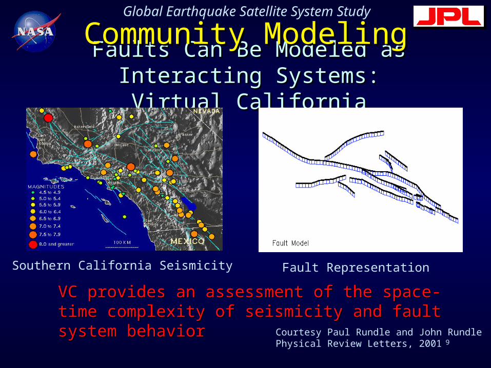
Faults Can Be Modeled as Interacting Faults Can Be Modeled as Interacting Systems:Systems:
Virtual CaliforniaVirtual California
Southern California Seismicity Fault Representation
Courtesy Paul Rundle and John RundlePhysical Review Letters, 2001
VC provides an assessment of the space-time VC provides an assessment of the space-time complexity of seismicity and fault system behaviorcomplexity of seismicity and fault system behavior
Community ModelingCommunity Modeling

10
Global Earthquake Satellite System Study
Pre- minus Post-Seismic Pre- minus Post-Seismic Displacements: Synthetic InSARDisplacements: Synthetic InSAR
The pre-seismic The pre-seismic state is subtracted state is subtracted from the post-from the post-seismic stateseismic state
The differences are The differences are concentrated along concentrated along the portions of the the portions of the San Andreas that San Andreas that are about to initiate are about to initiate earthquakesearthquakes
The observable The observable difference is ~ 3 CMdifference is ~ 3 CM
Stable sliding Stable sliding (stress (stress smoothing) smoothing) preceding preceding earthquakes earthquakes can be can be measuredmeasured
Courtesy John Rundle
11
Global Earthquake Satellite System Study
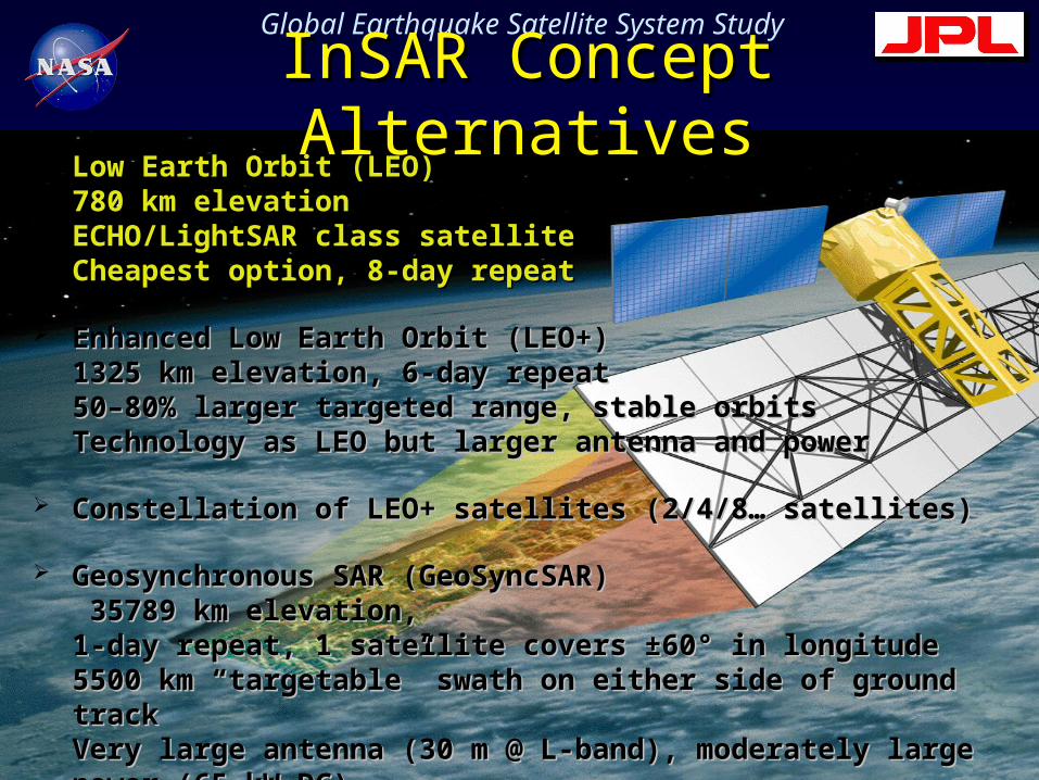
InSAR Concept InSAR Concept AlternativesAlternatives
Low Earth Orbit (LEO) Low Earth Orbit (LEO) 780 km elevation780 km elevationECHO/LightSAR class satellite ECHO/LightSAR class satellite Cheapest option, 8-day repeatCheapest option, 8-day repeat
Enhanced Low Earth Orbit (LEO+)Enhanced Low Earth Orbit (LEO+)1325 km elevation, 6-day repeat1325 km elevation, 6-day repeat50–80% larger targeted range, stable orbits50–80% larger targeted range, stable orbitsTechnology as LEO but larger antenna and powerTechnology as LEO but larger antenna and power
Constellation of LEO+ satellites (2/4/8… satellites)Constellation of LEO+ satellites (2/4/8… satellites)
Geosynchronous SAR (GeoSyncSAR)Geosynchronous SAR (GeoSyncSAR) 35789 km elevation, 35789 km elevation,1-day repeat, 1 satellite covers ±60° in longitude1-day repeat, 1 satellite covers ±60° in longitude5500 km “targetable” swath on either side of ground track 5500 km “targetable” swath on either side of ground track Very large antenna (30 m @ L-band), moderately large power Very large antenna (30 m @ L-band), moderately large power (65 kW DC)(65 kW DC)

12
Global Earthquake Satellite System Study
LEO AccessibilityLEO Accessibility versus versus GEO CoverageGEO Coverage>95% coverage in >95% coverage in 8 hrs with 3 sats8 hrs with 3 sats
>95% access in 8 hrs >95% access in 8 hrs with 8 satswith 8 sats

13
Global Earthquake Satellite System Study
Geosynchronous ModesGeosynchronous ModesHigh-resolutionHigh-resolution::
Stagger bandwidth over consecutive days Stagger bandwidth over consecutive days => 80 MHz bandwidth => 2.5 meter range resolution at 45°=> 80 MHz bandwidth => 2.5 meter range resolution at 45°
Dual-side Scan SARDual-side Scan SAR 11000 km combined swath 11000 km combined swath=>100 meter resolution @ 25 looks=>100 meter resolution @ 25 looks
Scan-SAR with 3 aspect anglesScan-SAR with 3 aspect angles (45° forward, broadside, 45° (45° forward, broadside, 45° backward) of 2800 km swath on both side of nadirbackward) of 2800 km swath on both side of nadir=>100 meter resolution @ 8 looks=>100 meter resolution @ 8 looks
SpotlightSpotlight mode dwelling beam for hours on target, for mode dwelling beam for hours on target, for disaster managementdisaster management

14
Global Earthquake Satellite System Study
3-GEO 3-GEO InstantaneousInstantaneous

15
Global Earthquake Satellite System Study
Technology Challenges Technology Challenges Sub-centimeter (!!) tropospheric water vapor delay Sub-centimeter (!!) tropospheric water vapor delay
correctionscorrections– Radar or radiometer data alone accurate to 2-3 cm level of Radar or radiometer data alone accurate to 2-3 cm level of
range delayrange delay– Co-boresighted IR/microwave sounding may yield 1 cm Co-boresighted IR/microwave sounding may yield 1 cm
accuracy in delayaccuracy in delay– Mesoscale models that ingest sounding and radar data will Mesoscale models that ingest sounding and radar data will
likely deliver the sub-cm correction likely deliver the sub-cm correction – GPS, permanent scatterers and corner cubes all improve the GPS, permanent scatterers and corner cubes all improve the
wet delay correctionwet delay correction
30-m antenna (deployable) for GEO30-m antenna (deployable) for GEO– Analysis and component developmentAnalysis and component development
New processing system for GEONew processing system for GEO
16
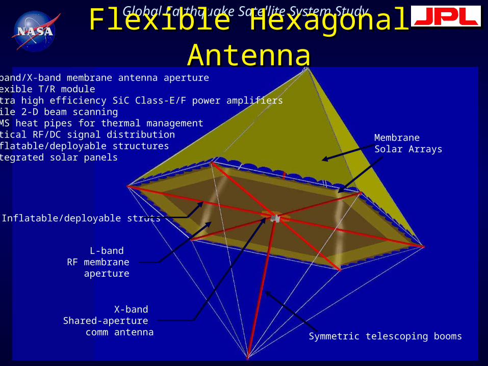
Global Earthquake Satellite System StudyFlexible Hexagonal Flexible Hexagonal AntennaAntenna
• L-band/X-band membrane antenna aperture• Flexible T/R module• Ultra high efficiency SiC Class-E/F power amplifiers• Agile 2-D beam scanning• MEMS heat pipes for thermal management• Optical RF/DC signal distribution• Inflatable/deployable structures• Integrated solar panels
Symmetric telescoping booms
Inflatable/deployable struts
L-band RF membrane
aperture
Membrane Solar Arrays
X-band Shared-aperture
comm antenna

17
Global Earthquake Satellite System Study
GESS RoadmapGESS Roadmap ObservationsObservations
– 2003-06:2003-06: ECHO or ECHO-like InSAR satellite ECHO or ECHO-like InSAR satellite (EarthScope)(EarthScope)
– 2006-2010:2006-2010: 2-3 satellite LEO or LEO+ InSAR 2-3 satellite LEO or LEO+ InSAR constellation; magnetometer constellationconstellation; magnetometer constellation
– >2010:>2010: GEO InSAR constellation? GEO InSAR constellation? TechnologyTechnology
– Large deployable antennasLarge deployable antennas– Processing system for GEO observationsProcessing system for GEO observations– High resolution atmospheric models ingesting High resolution atmospheric models ingesting
radar dataradar data


![Lundgren [Skrivskyddad]](https://static.fdocuments.net/doc/165x107/61fb60d12e268c58cd5d75e9/lundgren-skrivskyddad.jpg)