UNAVCO Annual Facility 2011-submitted · imaging and campaign GPS components. Facility support...
68
UNAVCO Report UNAVCO Community and Facility Support: Geodesy Advancing Earth Science Research UNAVCO Facility Annual Report, September 2011 For period of performance September 2010 – August 2011 NSF Cooperative Agreement EAR-0735156 Also includes the progress report for UNAVCO Facility Support to NASA Submitted to: Russell Kelz David Lambert National Science Foundation, Instruments and Facilities Program And John Labrecque NASA Headquarters Submitted by: Charles Meertens Meghan Miller UNAVCO
-
Upload
hoangthien -
Category
Documents
-
view
212 -
download
0
Transcript of UNAVCO Annual Facility 2011-submitted · imaging and campaign GPS components. Facility support...

UNAVCO Report
UNAVCO Community and Facility Support: Geodesy Advancing Earth Science Research
UNAVCO Facility Annual Report, September 2011
For period of performance September 2010 – August 2011
NSF Cooperative Agreement EAR-0735156
Also includes the progress report for UNAVCO Facility Support to NASA
Submitted to:
Russell Kelz David Lambert
National Science Foundation, Instruments and Facilities Program
And
John Labrecque NASA Headquarters
Submitted by:
Charles Meertens Meghan Miller
UNAVCO

1
Annual Report for 2011 (1 September 2010 - 31 August 2011) EAR-0735156: UNAVCO Community and Facility Support: Geodesy Advancing Earth Science Research
1.0 Executive Summary
This is the 2011 annual report for the 4th year of the 5-year UNAVCO Cooperative Agreement “EAR-0735156 Support of UNAVCO Community and Facility Activities: Geodesy Advancing Earth Science Research”. The Facility, through this Cooperative Agreement (CA), provides engineering, equipment and data services that support research projects for investigators using GPS and other high precision geodetic techniques to conduct scientific investigations that include the study of earthquake processes, mantle properties, active magmatic systems, plate boundary zone deformation, intraplate deformation and glacial isostatic adjustment, global geodesy and plate tectonics, atmospheric science, global change, and polar processes. These projects are NSF-EAR-, NSF-OPP Arctic and Antarctic, and NASA-funded and include individual Principal Investigator (PI) projects, large collaborative projects such as AfricaArray, GNET, COCONet, and POLENET, and the larger multi-disciplinary, multi-agency EarthScope project and its imaging and campaign GPS components. Facility support activities in 2011 for engineering, equipment, and data services has met or exceeded 2010 levels in all major categories. A notable milestone is that this year the archive for first time passed 2,000 current permanent stations. With the full commissioning of UNAVCO’s new Terrestrial Laser Scanning (TLS) pool (one Optech, two Reigl VZ400s and half time on a third VZ400 with Central Washington University, one Reigl 620, and one Leica C-10) the largest growth in field support has been for TLS projects. With support through a supplement through the CA and the EAR INTERFACE project, UNAVCO supported PIs in TLS imaging investigations ranging from landform erosion, landslide monitoring, and geologic and glacier imaging to geyser monitoring, tsunami damage imaging, and training for university field classes. To meet this growing need for engineering support, UNAVCO engaged in a systematic engineer TLS data acquisition training program. Five engineers and project managers are now fully capable of acquiring TLS data in the field and providing current data products to PIs and two are trained in the generation of higher level data products. The further advancement in UNAVCO TLS acquisition and data processing support is being evaluated and will be the subject of an NSF-sponsored TLS workshop in October, 2011, entitled “Community Workshop: Charting the Future of Terrestrial Laser Scanning (TLS) in the Earth Sciences and Related Fields”. At the time of this report over 85 participants are signed up to attend this workshop. Three earthquakes, September 3, 2010, Mw=7.0 Christchurch, New Zealand, August 23, 2011, Mw=5.8 Virginia, and 11 March, 2011, Mw=9.0 Tohoku-oki, initiated UNAVCO Event Response action and the latter the initiation of a new Group of Earth Observation (GEO) Supersite. Supersites is providing open access to relevant datasets including GPS, seismic and InSAR data and is also providing a platform for sharing important initial science results and geophysical models. These results help guide both scientific and emergency event responders. UNAVCO receives NASA funding to manage the Supersite website. A primary focus of Supersites and WInSAR is the acquisition and distribution of SAR data. The availability of SAR

2
data is constantly evolving, with the recent failure of Japan’s ALOS SAR, the end of ESA’s ERS-2 in July, 2011, and the degraded interferometric capabilities of ESA’s Envisat/ASAR. ESA’s Sentinel-1 is scheduled for launch in 2013. In the meantime ESA has opened up access to ERS and Envisat data for no cost. UNAVCO continues work with ESA and the user community to order and distribute data to authorized users via Supersites, WInSAR and EarthScope. UNAVCO is also now tasking TerraSAR-X data from DLR. UNAVCO is currently updating its SAR archive hardware, database, website, and software infrastructure. GNSS support remains our primary core task. UNAVCO supported projects in North America and around the globe to assist PI investigations and to maintain global GNSS infrastructure. Some examples so far this year to date include Antarctica, the Galapagos Islands, Bolivia, Chile, Costa Rica, Panama, Scotland, Greenland, and Africa. UNAVCO and JPL are also worked together to continue to service and upgrade the NASA Global GNSS Network (GGN) stations and add GLONASS capability to selected stations. Activities included project development, field support, operations and maintenance, equipment, and training; details are provided in this report. Preparations were made for installation of new deep drilled-braced monuments for upgrade of the Goddard “Next Generation Geodetic Network” prototype site. These will be installed in November, 2011. Development and Testing activities hit full stride with a range of projects encompassing all aspects of GNSS and data communication technologies. A notable activity is UNAVCO’s participation in the LightSquared Technical Working Group analysis of testing data to evaluate the impact of the proposed LightSquared system on GNSS signal quality. This report also captures activities of the Education and Outreach program at UNAVCO. The E&O team supported the well-attended and well-regarded GPS, TLS and InSAR Short Courses at UNAVCO and instituted a new internal GPS training course for staff and for RESESS interns. With separate NSF funding and generous time and support from many individuals and institutions, the RESESS program attracted a record number of high-quality applicants, recruited a very diverse and talented group of interns for 2011, and enhanced the mentoring, training and local geology exposure aspects of the summer experience. The E&O team supported a thorough and successful external review process of UNAVCO's E&O program, resulting in very positive conclusions from the evaluation-consulting firm, DAH, and from NSF sponsors. NSF and UNAVCO continue to process a set of recommendations from that review. The E&O team contributed to UNAVCO's outreach through web redesign, conference exhibits, and teacher workshops. This annual report presents the highlights and performance metrics including core support as well as summaries of the major projects managed by the Facility. This report provides key quantitative performance metrics following the Facility Work Breakdown Structure (WBS). The Facility uses an 88 element WBS that provides a multi-level framework that organizes and defines the work to be accomplished for core and project tasks. A high level performance summary is given below in Table 1 with comparison to past levels. The WBS contributes to the assessment of our performance toward meeting UNAVCO’s strategic goals. The entries in 2011 are for September 2010 – August 2011.

3
UNAVCO Community Summary
The UNAVCO Community continues to grow as the UNAVCO science disciplines broaden and the technologies used to conduct science evolve. There are currently 169 Member Institutions (98 Full Member Institutions and 71Associate Member Institutions) from around the globe. Science workshops provide important opportunities for focused community scientific, educational, and technological exchange of ideas and for community building. UNAVCO hosts or helps to organize a number of workshops each year. UNAVCO also reaches out to the broader community at national and international meetings including the American Geophysical Union meeting, European Geophysical Union meeting, Polar Technology Conference, EarthScope National meeting, Mexico Workshop (organized in part by UNAVCO) to name a few. Community Project Highlight. COCONet is a five-year Community project funded by an NSF grant for Caribbean-wide regional GNSS observations and is a flagship project for UNAVCO involving all its Programs. The award is based on a community proposal cooperatively developed by an international set of investigators, and forwarded by the UNAVCO and UCAR consortia, with participation by Purdue University and the University of Puerto Rico. COCONet will provide a backbone of high-quality GNSS/meteorological infrastructure with freely available data and data products based on the EarthScope Plate Boundary Observatory (PBO) model to serve as a framework for solid Earth and atmospheric science studies around the entirety of the Caribbean plate and its complex boundaries. The NSF-sponsored COCONet Workshop: “Community Science, Station Siting, and Capacity Building” was held in San Juan, Puerto Rico, February 3-4, 2011. (Figure 1) and attracted more that one hundred scientists representing 25 countries and provided an opportunity for additional input from a broader community of regional stakeholders in the circum-Caribbean, including several institutions and organizations that had not participated in the initial planning for COCONet. Additional support was provided by the United Nations Development Programme (UNDP) to ensure full participation by the Haitian delegation. Local investigators and regional network operators helped modify siting decisions with their detailed local knowledge and full consideration of regional logistics and political feasibility.
Figure 1. (left) Poster sessions provided an opportunity for COCONET workshop participants to share information about their countries and projects. (right) Discussion and presentations on existing geodetic infrastructure throughout the Caribbean. In addition to the new observations and processed data products, the COCONet project will also serve as a focal point for leveraging regional infrastructure, enhancing international research collaboration, and augmenting international partnerships. Three broad themes emerged from presentations and discussions during the COCONet Workshop. The first centered on the need for
4
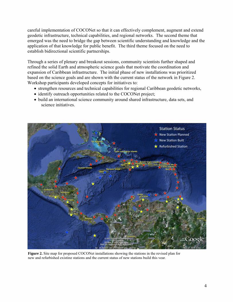
careful implementation of COCONet so that it can effectively complement, augment and extend geodetic infrastructure, technical capabilities, and regional networks. The second theme that emerged was the need to bridge the gap between scientific understanding and knowledge and the application of that knowledge for public benefit. The third theme focused on the need to establish bidirectional scientific partnerships. Through a series of plenary and breakout sessions, community scientists further shaped and refined the solid Earth and atmospheric science goals that motivate the coordination and expansion of Caribbean infrastructure. The initial phase of new installations was prioritized based on the science goals and are shown with the current status of the network in Figure 2. Workshop participants developed concepts for initiatives to:
• strengthen resources and technical capabilities for regional Caribbean geodetic networks, • identify outreach opportunities related to the COCONet project; • build an international science community around shared infrastructure, data sets, and
science initiatives.
Figure 2. Site map for proposed COCONet installations showing the stations in the revised plan for new and refurbished existing stations and the current status of new stations build this year.

5
A follow-up workshop in June was held in Trinidad to meet opportunities and issues that emerged during the first COCONet meeting that was held in Puerto Rico earlier in the year: (1) the identification of numerous existing stations in the Lesser Antilles and Venezuela that were not previously known by NSF investigators; (2) a first stage siting plan for a subset of the new stations and the need for a follow-on siting meeting to identify and finalize existing and new station locations; (3) a request from Caribbean and US investigators to consider a refurbishment option for stations that are of geodetic quality but that may have failing equipment; and (4) further develop plans and identify the resources required to support international partnerships and strengthening the COCONet science community. Supplemental funding was awarded to support this critical follow-up meeting in Port-of-Spain in June, 2011. An international group of 70 Caribbean GPS network operators from 20 countries worked collaboratively to refine and finalize the network design, building on the community resources that were identified at the preceding workshop and COCONet science goals. This was a highly successful meeting; the results are summarized in an EOS article that is currently under revision for length after initial review. The outcomes include a detailed siting plan for 50 existing, 50 new, and a dozen refurbished stations; testing of data flow from existing stations that had not previously been readily accessed; and articulation of an array of goals and pathways to support development of international partnerships and mutual capacity building. UNAVCO Facility Activities Overview The UNAVCO Facility in Boulder, CO, is organized into two primary activities: Engineering and Data. The Facility Engineering Group provides project management, planning, installation, operations and maintenance of continuous GPS networks around the globe. The Engineering Group also provides state-of-the-art equipment for campaigns and semi-permanent surveys and field engineering upon request. Engineers and technicians also undertake technology development, testing, and systems integration to support new project demands. Curation and distribution of data are an important part of the Facility’s responsibilities. The Facility Data Group services include data management and archiving of GPS and InSAR data and data products for future applications. The Facility also contributes significantly to education and outreach supporting the UNAVCO Education and Outreach (E&O) program and PI E&O projects. The Facility is headed by the Director Dr. Charles Meertens who is senior personnel on the Cooperative Agreement and receives direct funding from the Cooperative Agreement. Over most of the reporting period he spent all but 2.5 weeks of effort on the CA. Non-core time was spent on related NASA and NSF projects and Bids and Proposals. An exception, with approval of the NSF Program Officer, is the period July-Sept, 2011. During this time period Dr. Meertens also assumed interim PBO Director duties for half of his time. Support to PIs UNAVCO has the unique and fundamental role of providing solid Earth and cryospheric science researchers with free access to a pooled resource of geodetic technologies, equipment, data, technical support and collaboration that are key enablers of fundamental research being

6
conducted from the equator to the poles. Here we highlight our support of the Panama GPS project.
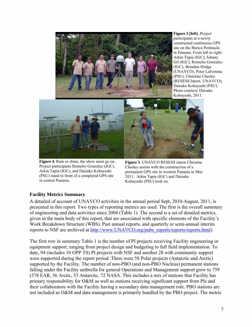
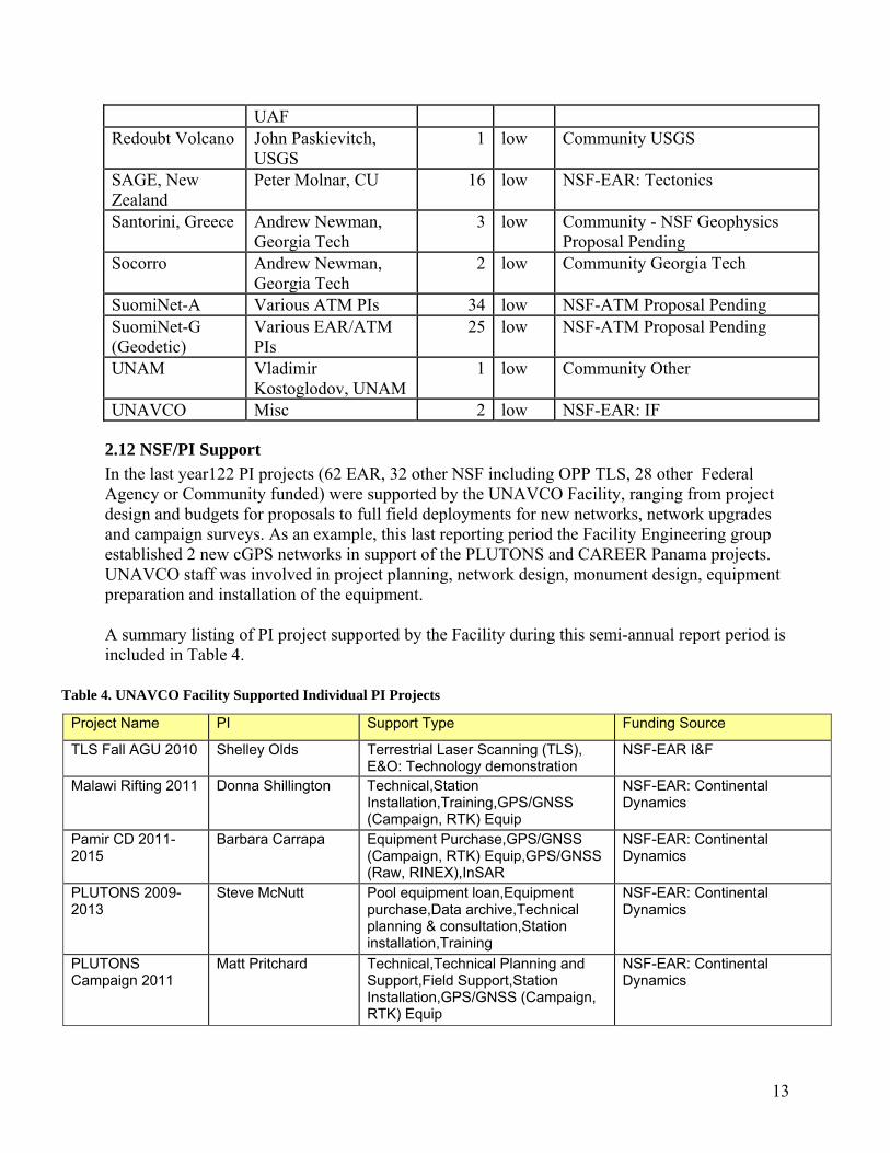
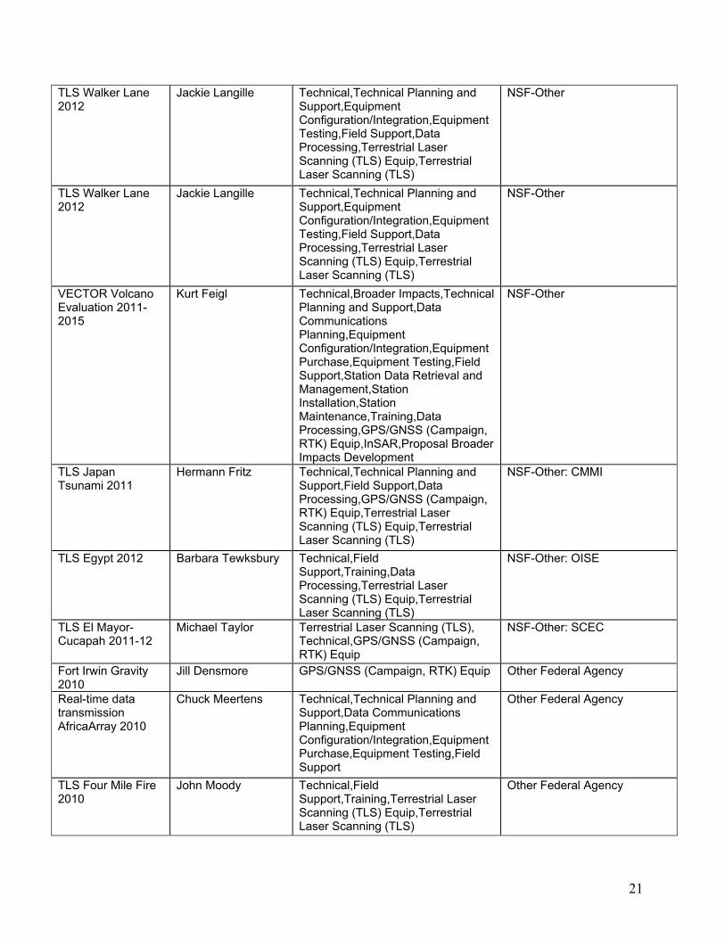
UNAVCO Featured Project Highlight Geodynamics of Ridge Collision: The Cocos and Caribbean Plate. Principal Investigator (PI): Dr. Peter LaFemina (Penn State University) Field Engineers: Brendan Hodge (UNAVCO) Dates: May 2011 Location: Various, Panama Funding Source: NSF The country of Panama resides on an isthmus of land that connects the North American and South American continents. The narrow landmass is part of the Caribbean plate and is influenced by subduction of the Cocos oceanic plate. An oceanic ridge, originating from the Galapagos hotspot, is colliding with the Caribbean forearc in western Panama and may be driving translation and block rotation of the plate boundary zone. Initial geodetic and structural evidence suggests that Panama may also be composed of one or more crustal blocks accommodating complex plate motions between the Cocos, Nazca, Caribbean and South American plates. The goal of this project is to evaluate the geodynamics of ridge collision on fore-arc deformation and strain partitioning on the Caribbean Plate and possible Panama block(s). These new data will also help improve assessment of earthquake hazard on active faults in Panama. UNAVCO has provided support for episodic GPS surveys in Panama for over a decade. The original surveys by PI Pete LaFemina have provided the ground-work to locate and permit five new continuous GPS stations in Panama. During a three week trip in May 2011, a team (Figure 3) consisting of members from Penn State University (PSU), the Instituto de Geociencias at the Universidad de Panama (IGC), and UNAVCO constructed four permanent GPS monuments with power and telemetry systems. Additional reconnaissance for three new monuments on behalf of CocoNet was completed for a future trip. The new installations (Figure 4) have doubled the number of geodetic quality continuous GPS stations in the country and will augment the existing array of semi-continuous GPS measurements. UNAVCO is dedicated to diversity in geosciences and geoscience education. As part of the RESESS internship program, UNAVCO intern Christine Chesley (Figure 5) was able to participate with the GPS installations and field work. Her experience was documented in a popular blog and lead into her internship research with mentor Pete LaFemina. The results of Christine's research will be presented at the GSA meeting this Fall. Future work in Panama will include UNAVCO support for the installation of three new continuous GPS stations as part of CocoNet, with help from colleagues in Panama. UNAVCO will also support a pending proposal by the government of Panama to install an additional five GPS stations for geodetic research.
7
Figure 3 (left). Project participants at a newly constructed continuous GPS site on the Burica Peninsula in Panama. From left to right: Arkin Tapia (IGC), Johnny Gil (IGC), Romelio Gonzalez (IGC), Brendan Hodge (UNAVCO), Peter LaFemina (PSU), Christine Chesley (RESESS Intern, UNAVCO), Daisuke Kobayashi (PSU). Photo courtesy Daisuke Kobayashi, 2011.
Figure 4. Rain or shine, the show must go on. Project participants Romelio Gonzalez (IGC), Arkin Tapia (IGC), and Daisuke Kobayashi (PSU) stand in front of a completed GPS site in central Panama.
Figure 5. UNAVCO RESESS intern Christine Chesley assists with the construction of a permanent GPS site in western Panama in May 2011. Arkin Tapia (IGC) and Daisuke Kobayashi (PSU) look on.
Facility Metrics Summary A detailed of account of UNAVCO activities in the annual period Sept, 2010-August, 2011, is presented in this report. Two types of reporting metrics are used. The first is the overall summary of engineering and data activities since 2004 (Table 1). The second is a set of detailed metrics, given in the main body of this report, that are associated with specific elements of the Facility’s Work Breakdown Structure (WBS). Past annual reports, and quarterly or semi-annual interim reports to NSF are archived at http://www.UNAVCO.org/pubs_reports/reports/reports.html). The first row in summary Table 1 is the number of PI projects receiving Facility engineering or equipment support, ranging from project design and budgeting to full field implementation. To date, 94 (includes 10 OPP TS) PI projects with NSF and another 28 with community support were supported during the report period. There were 58 Polar projects (Antarctic and Arctic) supported by the Facility. The number of non-PBO (and non-PBO Nucleus) permanent stations falling under the Facility umbrella for general Operations and Management support grew to 759 (578 EAR, 56 Arctic, 53 Antarctic, 72 NASA. This includes a mix of stations that Facility has primary responsibility for O&M as well as stations receiving significant support from PIs and their collaborators with the Facility having a secondary data management role. PBO stations are not included as O&M and data management is primarily handled by the PBO project. The metric

8
Table 1. Summary of overall metrics for Facility engineering and data activities 2004-2011
“Total Support Requests” refers to requests for support via our support mail alias ([email protected]), and by direct requests to staff via email and phone calls. The metric “Unique Institutions w/ Project Support Requests” shows that there were 93 unique institutions receiving Project Support. The number of permanent stations currently active and being archived passed the 2,000 mark and stands at 2,025.
2.0 Facility Support Activities The UNAVCO Facility is organized into two primary activities, the Engineering and Equipment Services that handles engineering, network operations and maintenance and equipment support, and the Data Center that handles data management, archiving and data distribution. Projects managed by the Facility include core EAR PI support, OPP PI support, and support of the NASA GGN; the new cross-cutting Development and Testing activity; and Geodetic Imaging activity that include management and archiving of the imagery purchased by EarthScope and management of the INTERFACE Terrestrial Laser Scanning project. The Engineering and Equipment Services group provides comprehensive permanent and campaign project support including planning and budgets, installation, operations, training, technical support, field engineering, and maintenance as well as system testing and development. The group also maintains, tracks, and ships the UNAVCO central pool receivers that are loaned to projects. The group also assembles, tests, and repairs permanent station equipment including the new PBO permanent station and campaign systems. The Data Center handles GPS, SAR, and TLS data management, archiving, and data distribution tasks; and manages a large and diverse assemblage of data handling, data storage and retrieval, database, and backup computer systems. Facility Operations and Infrastructure staff provide a host of information technology resources including computer systems administration, web, application, administrative, and database support.
Activity by FY 2004 2005 2006 2007 2008 2009 2010 2011
NSF PI Projects Supported 48 58 48 52 48 66 51
94 (incl 10
OPP TLS)OPP PI Projects
Supported 37 38 48 48 60 44 47 58
Other Community Projects 22 38 37 49 43 41 20 28
Permanent Stations O&M
(incl. PBO Nucleus, excl. PBO)
555 (209)
593
(209)
621 (209)
730 (209)
793 (209)
643 (no PBO Nucleus)
716 759
Campaigns Archived 71 41 39 55 41 44 35 66
Permanent Stations Archived
380 (Incl. 40
PBO)
681 (Incl. 162
PBO)
1092 (Incl. 373
PBO)
1572 (Incl. 742
PBO)
1786 (Incl. 880
PBO)
1889 (Incl. 1101
PBO)
1965 (Incl. 1101
PBO)
2025 (Incl. 1119
PBO) Total UNAVCO email/telephone
Support Requests 108 157 131 177 228 339 339 252
Unique Institutions w/ Project Support Requests 47 63 46 46 48 57 57 93

9
The Facility’s role in support of the various aspects of a project is depicted in Figure 6. For individual PI projects the Facility support can be quite comprehensive depending on what other resources are available to the project. However for large projects such as EarthScope, UNAVCO and PBO have substantial resources and the Facility role is directed toward engineering support upon request, equipment testing and handling, and archiving.
Figure 6. Typical phases of a project and types of support provided by the UNAVCO Facility.
The implementation of a GPS or TLS project is collaborative involving the Principal Investigators (PIs) and Facility staff and the various phases are depicted in a general fashion in Figure 6. The process can involve: 1) Technical planning and budget development for proposals 2) Pre-deployment Planning, Preparation and Training including UNAVCO Classes. 3) GPS and/or TLS Data Collection and Network Operation and Maintenance. 4) Data Pre-processing. 5) Data Processing and Scientific Analysis. 6) Archiving of Data and Science Products.
2.1 Facility Engineering and Equipment Support
The UNAVCO Facility provides state-of-the-art GPS equipment and engineering services to PI projects. This includes project management, planning, installation, operations and maintenance of continuous, permanent GPS station networks around the globe. Engineers and technicians also undertake technology development, testing, and systems integration to support new project demands. Presented below are highlights of activities during this annual report period as well as associated WBS tasks and performance metrics. Included are core support for NSF-EAR, NASA, and NSF-OPP programs and project management of PBO Nucleus and GeoEarthScope.
2.11 NSF/EAR Program Support Facility NSF-EAR program support is categorized by task and related metrics in Table 2 below and is discussed in the following section.

10
Table 2. Engineering Performance Metrics – NSF CORE
WBS Task Name Metrics Quantity
1.1.1 GPS Engineering and Equipment 1.1.1.2 Permanent Station Operations #Stations on O&M list 578
1.1.1.3 NSF EAR Project Support NSF Other Project Support #Projects 62
321.1.1.4 Community Project Support #Projects 281.1.1.5 Eng. Tech Support #Tech support requests 3281.1.1.6 Development and Testing #D&T projects 71.1.1.7 Pool Equipment Maintenance #Receivers in pool 365
1.1.1.8 PI Equipment Repairs #Repairs completed # New RMAs submitted
208169
1.1.1.9 E&O Support #Meetings, classes, workshops 4
Permanent Station Operations The Facility provides operations and management (O&M) support to 578 continuously operating stations (Table 3). The O&M support includes data downloading, state of health monitoring and reporting, resolving communications and equipment issues, shipping replacement equipment, and working with PIs and local contacts to resolve problems. The UNAVCO Facility, working closely with PIs and their collaborators, provides O&M support at three broad levels:
• High – UNAVCO Facility provides centralized O&M support that may include retrieving the data, monitoring station data flow, and proactively responding to problems with data flow or station hardware. Problems are fixed remotely working with collaborators if necessary. If maintenance trips or materials are required for O&M, these are funded by the PI’s project.
• Medium – PIs or collaborators download the data from the stations, monitor station data flow, and handle most problems themselves. UNAVCO provides engineering and medium-level technical support on a request basis. Any UNAVCO Engineering maintenance trips and materials required for O&M are covered by the PI’s project.
• Low – UNAVCO provides only archiving support and a low-level of technical support. UNAVCO does not monitor or download data from the stations.
Table 3. Current UNAVCO Facility Permanent Station Operations and Maintenance List Network Name or Location
Principal Investigator
No. Active Stations
Level of Effort
Funding Source
Afar Eric Calais, Purdue 16 high NSF-EAR: Geophysics AfricaArray Andy Nyblade, PSU 10 high NSF-EAR: Geophysics Bhutan Roger Bilham, CU 2 high NSF-EAR: IF Calabria Michael Steckler, 9 high NSF-EAR: CD

11
LDEO CALIPSO Glen Mattioli, U of
Arkansas 4 high NSF-EAR: IF
CAP Andes Mike Bevis, OSU 20 high NSF-EAR RAPID Caribbean Hurricane Prediction & Geodetic Network
John Braun, UCAR 10 high NSF-ATM/EAR: IF
Costa Rica - Nicoya
Tim Dixon, U. Miami 21 high NSF-EAR: Tectonics
Galapagos Dennis Geist, U. Idaho
10 high NSF-EAR-PET&GEOCHEM
GPS Soil Moisture
Kristine Larson, CU 12 high NSF-EAR: IF
Haiti Eric Calais, Purdue 5 high NSF-RAPID Las Vegas Geoff Blewitt, UNR 2 high NSF-EAR: Hydrology Mediterranean Rob Reilinger, MIT 8 high NSF-EAR: Tectonics Mid America/ New Madrid
Bob Smalley, U. Memphis
13 high NSF-EAR: IF
Northwest Mexico
Rick Bennett, U. of AZ
2 high NSF-EAR: Tectonics
Pakistan Roger Bilham, CU 5 high NSF-EAR Tectonics Peatland Minnesota
Paul Glaser, U. of Minn.
14 high NSF Geoscience Directorate, Carbon & Water in the Earth System Program, interdisciplinary EAR, ATM and OCE
Puerto Rico Guoquan Wang, U of Puerto Rico
15 high NSF-EAR MRI
Rio Grande Rift Anne Sheehan, CU 25 high NSF-EAR: EarthScope Telica Volcano Peter LaFemina, Penn 2 high NSF-EAR: Petrology and
Geochemistry Alaska Jeff Freymueller,
UAF 4 med NSF-EAR
Andaman Islands Bilham, CU 5 med NSF-EAR: Geophysics Azerbaijan Continuous
Rob Reilinger, MIT 2 med NSF-EAR: Geophysics
Bangladesh Michael Steckler, LDEO
12 med NSF-EAR: Tectonics
BARGEN Brian Wernicke, Caltech
44 med NSF-EAR
Central Asia Tom Herring, MIT 6 med NSF-EAR: CD Central Iceland Rick Bennett, U. of
AZ 14 med NSF-EAR: Geophysics

12
Denali Fault Jeff Freymueller, UAF
2 med NSF-EAR: F/Geophysics
E. Med and Red Sea Continuous
Rob Reilinger, MIT 2 med NSF-EAR: Geophysics
Ecuador Peter LaFemina, Penn 1 med Community Other El Salvador Chuck DeMets, UW-
Madison 4 med NSF-EAR: Geophysics
Ethiopia Tectonics
Roger Bilham, CU 4 med NSF-EAR Tectonics
GULFNET Roy Dokka, LSU 16 med NSF-EAR: IF Hawaii Asta Miklius, HVO,
Paul Segall, Stanford 41 med Community USGS
IAGT Matt Starr, IAGT 1 med Community NASA Jalisco, Mexico Chuck DeMets, UW-
Madison 6 med NSF-EAR: Geophysics
Mauna Loa Ben Brooks, University of Hawaii
22 med NSF-EAR: Geophysics
Oaxaca, Mexico Chuck DeMets, UW-Madison
6 med NSF-EAR: Geophysics
PLUTONS Steve McNutt, Cornell Univ.
5 med NSF-EAR: Continental Dynamics
Southeast Alaska Jeff Freymueller, UAF
6 med NSF-EAR: Geophysics
Tajik-Kyrgyz-Pamir
Becky Bendick, U of Montana
4 med NSF-EAR
Tanzania Eric Calais, Purdue 2 med NSF-EAR Tectonics Uganda Eric Calais, Purdue 2 med NSF-EAR: Geophysics Akutan Volcano Tom Murray, USGS 4 low Community USGS Caltech Andes John Galetzka,
Caltech 15 low NSF-EAR
Caltech Nepal John Galetzka, Caltech
22 low NSF-EAR
Dead Sea Continuous
Rob Reilinger, MIT 4 low NSF-EAR Tectonics
DIVE Tim Melbourne, CWU
1 low Community NASA
EBRY Bob Smith, U. Utah 6 low Community USGS Eritrea Rob Reilinger, MIT 3 low NSF-EAR Tectonics High rate Misc 1 low NSF-EAR: IF Idaho National Laboratory
Suzette Payne, INL 15 low Community INEL
Mt. Spurr Jeff Freymueller, UAF
3 low Community UAF
Okmok Volcano Jeff Freymueller, 4 low Community USGS
13
Table 4. UNAVCO Facility Supported Individual PI Projects
UAF Redoubt Volcano John Paskievitch,
USGS 1 low Community USGS
SAGE, New Zealand
Peter Molnar, CU 16 low NSF-EAR: Tectonics
Santorini, Greece Andrew Newman, Georgia Tech
3 low Community - NSF Geophysics Proposal Pending
Socorro Andrew Newman, Georgia Tech
2 low Community Georgia Tech
SuomiNet-A Various ATM PIs 34 low NSF-ATM Proposal Pending SuomiNet-G (Geodetic)
Various EAR/ATM PIs
25 low NSF-ATM Proposal Pending
UNAM Vladimir Kostoglodov, UNAM
1 low Community Other
UNAVCO Misc 2 low NSF-EAR: IF
2.12 NSF/PI Support In the last year122 PI projects (62 EAR, 32 other NSF including OPP TLS, 28 other Federal Agency or Community funded) were supported by the UNAVCO Facility, ranging from project design and budgets for proposals to full field deployments for new networks, network upgrades and campaign surveys. As an example, this last reporting period the Facility Engineering group established 2 new cGPS networks in support of the PLUTONS and CAREER Panama projects. UNAVCO staff was involved in project planning, network design, monument design, equipment preparation and installation of the equipment. A summary listing of PI project supported by the Facility during this semi-annual report period is included in Table 4.
Project Name PI Support Type Funding Source
TLS Fall AGU 2010 Shelley Olds Terrestrial Laser Scanning (TLS), E&O: Technology demonstration
NSF-EAR I&F
Malawi Rifting 2011 Donna Shillington Technical,Station Installation,Training,GPS/GNSS (Campaign, RTK) Equip
NSF-EAR: Continental Dynamics
Pamir CD 2011-2015
Barbara Carrapa Equipment Purchase,GPS/GNSS (Campaign, RTK) Equip,GPS/GNSS (Raw, RINEX),InSAR
NSF-EAR: Continental Dynamics
PLUTONS 2009-2013
Steve McNutt Pool equipment loan,Equipment purchase,Data archive,Technical planning & consultation,Station installation,Training
NSF-EAR: Continental Dynamics
PLUTONS Campaign 2011
Matt Pritchard Technical,Technical Planning and Support,Field Support,Station Installation,GPS/GNSS (Campaign, RTK) Equip
NSF-EAR: Continental Dynamics

14
STRAIN Campaign GPS 2011-2015
Peter LaFemina Technical,GPS/GNSS (Campaign, RTK) Equip
NSF-EAR: Continental Dynamics
Campaign GPS training for RECESS students 2011
James Normandeau Training,GPS/GNSS (Campaign, RTK) Equip,Research Student Intership (RESESS)
NSF-EAR: Earth Sciences: Instrumentation and Facilities
Chile-Argentina cGPS Network upgrades 2011-2014
Michael Bevis Technical,Technical Planning and Support,Data Communications Planning,Equipment Configuration/Integration,Equipment Purchase,Field Support,Station Installation,Station Maintenance,GPS/GNSS (Campaign, RTK) Equip,GPS/GNSS (Raw, RINEX)
NSF-EAR: Earth Sciences: Instrumentation and Facilities
Cocos Island GPS installation
Megan Miller Technical,Technical Planning and Support,Station Installation
NSF-EAR: Earth Sciences: Instrumentation and Facilities
Low cost GPS for snow sensor 2011
John Braun GPS/GNSS (Campaign, RTK) Equip NSF-EAR: Earth Sciences: Instrumentation and Facilities
Marshall Monumentation Stability Analysis
James Normandeau Data Processing NSF-EAR: Earth Sciences: Instrumentation and Facilities
Nicoya Network upgrade 2011-2012
Timothy Dixon Technical,Technical Planning and Support,Equipment Configuration/Integration,Equipment Purchase,Station Maintenance
NSF-EAR: Earth Sciences: Instrumentation and Facilities
Real-Time Streaming of Puerto Rico / V.I. CGPS
Guoquan Wang Data Processing,Real-time GPS/GNSS,High-rate GPS/GNSS,GPS/GNSS Data Processing Service
NSF-EAR: Earth Sciences: Instrumentation and Facilities
Sierra Negra volcano Phase 2 of upgrade 2009-2010
Bill Chadwick Technical,Technical Planning and Support,Station Installation
NSF-EAR: Earth Sciences: Instrumentation and Facilities
Snow Depth Sensing with GPS 2009-2012
Eric Small Equipment Configuration/Integration,Equipment Purchase,Equipment Testing,Field Support
NSF-EAR: Earth Sciences: Instrumentation and Facilities
Snow Validation Site: Recon in Utah 2011
Eric Small Network or Station Reconnaissance NSF-EAR: Earth Sciences: Instrumentation and Facilities
Tripod mounted radar training 2011
James Normandeau Field Support,Training NSF-EAR: Earth Sciences: Instrumentation and Facilities
Adopt a GPS Site Eric Small Broader Impacts NSF-EAR: EarthScope RAPID-Mineral, VA Earthquake
Seth Stein Technical,Technical Planning and Support,Data Communications Planning,Equipment Configuration/Integration,Station Installation,Data Processing,GPS/GNSS (Campaign, RTK) Equip,GPS/GNSS (Raw, RINEX),GPS Time Series and Velocities
NSF-EAR: EarthScope

15
San Andreas-San Bernardino SAF EarthScope GPS 2011
Sally McGill GPS/GNSS (Campaign, RTK) Equip,GPS/GNSS (Raw, RINEX)
NSF-EAR: EarthScope
TLS: IGCP Silurian Outcrops Kentucky 2011
Carlos Aiken Terrestrial Laser Scanning (TLS) Equip,Terrestrial Laser Scanning (TLS),Pool equipment loan
NSF-EAR: Education and Human Resources
Bijou Creek Erosion Monitoring and Telemetry 2011
Greg Tucker Technical,Technical Planning and Support,Data Communications Planning,Equipment Configuration/Integration,Equipment Testing,Network or Station Reconnaissance,Field Support,Station Installation,Terrestrial Laser Scanning (TLS) Equip,Terrestrial Laser Scanning (TLS)
NSF-EAR: Geomorphology and Land Use Dynamics
Kennicott Glacier sliding 2012
Robert Anderson Technical,GPS/GNSS (Campaign, RTK) Equip,GPS Time Series and Velocities
NSF-EAR: Geomorphology and Land Use Dynamics
Student educational project in GNSS 2011
Robert Anderson Training,Data Processing,GPS/GNSS (Campaign, RTK) Equip,Terrestrial Laser Scanning (TLS) Equip,Terrestrial Laser Scanning (TLS),GPS/GNSS Data Processing Service,Workshop and Short Course Planning and Coordination,Research Student Intership (RESESS)
NSF-EAR: Geomorphology and Land Use Dynamics
TLS Dune Evolution Long Island 2012-15
Dan Davis Technical,Technical Planning and Support,Data Communications Planning,Field Support,Training,Data Processing,GPS/GNSS (Campaign, RTK) Equip,Terrestrial Laser Scanning (TLS) Equip,Terrestrial Laser Scanning (TLS)
NSF-EAR: Geomorphology and Land Use Dynamics
TLS Dune Evolution, Long Island, NY 2011-14
Daniel Davis Technical,Technical Planning and Support,Equipment Configuration/Integration,Equipment Testing,Field Support,Data Processing,Terrestrial Laser Scanning (TLS) Equip,Terrestrial Laser Scanning (TLS)
NSF-EAR: Geomorphology and Land Use Dynamics
TLS Pinatubo Channel Evolution 2011
Karen Gran Technical,GPS/GNSS (Campaign, RTK) Equip
NSF-EAR: Geomorphology and Land Use Dynamics
TLS Sierra Nevada Landslide 2011
Benjamin Brooks Terrestrial Laser Scanning (TLS) Equip,Terrestrial Laser Scanning (TLS)
NSF-EAR: Geomorphology and Land Use Dynamics

16
TLS- Decadal Landscape Evolution (Colorado)
Greg Tucker Terrestrial Laser Scanning (TLS), Pool equipment loan,Technical support,Technical planning & consultation,Field support,Proposal planning, budgeting & letter of support
NSF-EAR: Geomorphology and Land Use Dynamics
Andaman Islands Campaign system LTL 2011-2014
John Puchakayala GPS/GNSS (Campaign, RTK) Equip NSF-EAR: Geophysics
Antenna replacements for MAGNET CGPS Stations
Robert Reilinger GPS/GNSS (Campaign, RTK) Equip NSF-EAR: Geophysics
Arenal cGPS-TLS 2012-2013
Andrew Newman Technical,Technical Planning and Support,Data Communications Planning,Equipment Configuration/Integration,Equipment Purchase,Field Support,Station Installation,Terrestrial Laser Scanning (TLS) Equip,Terrestrial Laser Scanning (TLS)
NSF-EAR: Geophysics
Capturing Mauna Loas Current Reawakening 2011-12
Benjamin Brooks GPS/GNSS (Campaign, RTK) Equip NSF-EAR: Geophysics
Deformation Processes in the Andaman Islands 2011-
John Puchakayala Equipment Testing,GPS/GNSS (Campaign, RTK) Equip,GPS/GNSS (Raw, RINEX)
NSF-EAR: Geophysics
Geophysical investigations in the western branch of the Lake Kivu basin and the Virunga active Volcanoes based on GPS / GNSS and tiltimeters.
Eric Calais Technical, Training, Workshop and Short Course Planning and Coordination, GPS/GNSS (Campaign, RTK) Equip, GPS/GNSS (Raw, RINEX), Real-time GPS/GNSS, GPS/GNSS Data Processing Service
NSF-EAR: Geophysics
GEORGIA cGNSS EQUIPMENT LOAN 2011-2013
Robert Reilinger GPS/GNSS (Campaign, RTK) Equip NSF-EAR: Geophysics
GPS Landslide Monitoring Temp Loan 2011
Guoquan Wang GPS/GNSS (Campaign, RTK) Equip NSF-EAR: Geophysics
Kinematic of Incipinet Continental Rifting 2012-20
Rocco Malservisi Technical,Broader Impacts,Technical Planning and Support,Training
NSF-EAR: Geophysics
Mexico GPS network O&M 2011-2015
Dennis DeMets Technical,Equipment Purchase,Station Maintenance
NSF-EAR: Geophysics
Princes Islands cGPS 2011-2012
Robert Reilinger GPS/GNSS (Campaign, RTK) Equip NSF-EAR: Geophysics

17
Santorini Fall 2011 Andrew Newman Technical,Technical Planning and Support,Equipment Configuration/Integration,Equipment Purchase,Field Support,Station Installation,Station Maintenance
NSF-EAR: Geophysics
Tanzania GPS 2010 Campaign survey
Eric Calais Technical,Technical Planning and Support,Field Support,Station Maintenance,GPS/GNSS (Campaign, RTK) Equip
NSF-EAR: Geophysics
TLS Puerto Rico Landslides 2011
Guoquan Wang Technical,Terrestrial Laser Scanning (TLS) Equip,Terrestrial Laser Scanning (TLS)
NSF-EAR: Geophysics
Trimble Business Office GPS Processing Loan 2011
Chuck DeMets GPS/GNSS (Campaign, RTK) Equip,Other
NSF-EAR: Geophysics
TLS Methane Cycling Northern Peatlands 2011-2013
Lee Slater Technical,Broader Impacts,Terrestrial Laser Scanning (TLS) Equip,Terrestrial Laser Scanning (TLS)
NSF-EAR: Hydrologic Sciences
TLS Indiana University Field Course 2011
Bruce Douglas Field Support,Training,Data Processing,GPS/GNSS (Campaign, RTK) Equip,Terrestrial Laser Scanning (TLS) Equip,Terrestrial Laser Scanning (TLS)
NSF-EAR: I&F
TLS Iceland Pillow Lava 2011
Benjamin Edwards Technical,Technical Planning and Support,Field Support,Data Processing,Terrestrial Laser Scanning (TLS) Equip,Terrestrial Laser Scanning (TLS)
NSF-EAR: Petrology and Geochemistry
Yellowstone Geyser Deformation 2010
Adam Soule Equipment Testing,Field Support,Data Processing,Terrestrial Laser Scanning (TLS) Equip,Terrestrial Laser Scanning (TLS),Pool equipment loan
NSF-EAR: Petrology and Geochemistry
Yellowstone Geyser Deformation 2010
Adam Soule Equipment Testing,Field Support,Data Processing,Terrestrial Laser Scanning (TLS) Equip,Terrestrial Laser Scanning (TLS),Pool equipment loan
NSF-EAR: Petrology and Geochemistry
TLS Jurassic Navajo Sandstone UT 2011-14
Marjorie Chan Technical,Technical Planning and Support,Field Support,Terrestrial Laser Scanning (TLS) Equip,Terrestrial Laser Scanning (TLS)
NSF-EAR: Sedimentary Geology and Paleobiology
TLS surveys of wave ripples 2011-2014
Taylor Perron Technical,Technical Planning and Support,Training,Data Processing,Terrestrial Laser Scanning (TLS) Equip,Terrestrial Laser Scanning (TLS)
NSF-EAR: Sedimentary Geology and Paleobiology
Bangladesh 2007 antenna loan
Michael Steckler GPS/GNSS (Campaign, RTK) Equip NSF-EAR: Tectonics
Bolivia Subandes Benjamin Brooks GPS/GNSS (Campaign, RTK) Equip NSF-EAR: Tectonics

18
2011 Bolivia Subandes BGAN Loan
Benjamin Brooks Other,Pool equipment loan NSF-EAR: Tectonics
Ethiopian Highlands 2011-2016
Rebecca Bendick GPS/GNSS (Campaign, RTK) Equip,GPS/GNSS (Raw, RINEX)
NSF-EAR: Tectonics
GPS Haiti 2011-2014
Eric Calais GPS/GNSS (Campaign, RTK) Equip NSF-EAR: Tectonics
Iceland 2011 Peter LaFemina GPS/GNSS (Campaign, RTK) Equip NSF-EAR: Tectonics Southern San Jacinto Fault 2011
Tom Rockwell Terrestrial Laser Scanning (TLS) Equip,Terrestrial Laser Scanning (TLS)
NSF-EAR: Tectonics
Southern San Jacinto Fault 2011
Tom Rockwell Terrestrial Laser Scanning (TLS) Equip,Terrestrial Laser Scanning (TLS)
NSF-EAR: Tectonics
TLS Iceland Ridge-Transform 2011
Peter LaFemina Terrestrial Laser Scanning (TLS) Equip,Terrestrial Laser Scanning (TLS)
NSF-EAR: Tectonics
Upgrade UTA Geodesy Lab GNSS Kits 2011
Glen Mattioli Equipment Configuration/Integration NSF-EAR: Tectonics
Walker Lane Campaign survey 2011
Kurt Frankel GPS/GNSS (Campaign, RTK) Equip NSF-EAR: Tectonics
TLS KU Polar MRI 2011
Leigh Stearns Technical,Broader Impacts,Terrestrial Laser Scanning (TLS)
NSF-MRI
Urvina Bay Galapagos Experiment 2012
Cindy Ebinger Technical,Equipment Purchase,Equipment Testing,GPS/GNSS (Raw, RINEX),InSAR
NSF-OCE
BanglaPIRE 2011 Michael Steckler Technical,Technical Planning and Support,Equipment Configuration/Integration,GPS/GNSS (Raw, RINEX),GPS/GNSS (Campaign, RTK) Equip
NSF-OISE
TLS Egypt 2012 John Hogan Technical,Field Support,Training,Data Processing,Terrestrial Laser Scanning (TLS) Equip,Terrestrial Laser Scanning (TLS)
NSF-OISE
PBO Vegetation Survey
Eric Small Technical,Technical Planning and Support,Network or Station Reconnaissance,Other
NSF-ASG
Puerto Rico (GEMS) 2011
Jennifer Haase Data Communications Planning,GPS/GNSS (Campaign, RTK) Equip
NSF-ASG
Beacon Valley -Surface processes above buried Ice
Marchant Terrestrial Laser Scanning (TLS) ,Pool equipment loan, Technical support,Data archive,Technical planning & consultation,Field support,Training
NSF-OPP

19
Beardmore/Oliver Bluffs fossil beds
Ashworth Terrestrial Laser Scanning (TLS) ,Pool equipment loan, Technical support,Data archive,Technical planning & consultation,Field support,Training
NSF-OPP
Dry Valleys snow distribution and ecosystems
Barrett Terrestrial Laser Scanning (TLS) ,Pool equipment loan, Technical support,Data archive,Technical planning & consultation,Field support,Training
NSF-OPP
Friis Hills fossil studies
Ashworth Terrestrial Laser Scanning (TLS) ,Pool equipment loan, Technical support,Data archive,Technical planning & consultation,Field support,Training
NSF-OPP
International Tundra Experiment (ITEX)
Tweedie Terrestrial Laser Scanning (TLS) ,Pool equipment loan, Technical support,Data archive,Technical planning & consultation,Field support,Training
NSF-OPP
McMurdo Dry Valleys erosion history
Sletten Terrestrial Laser Scanning (TLS) ,Pool equipment loan, Technical support,Data archive,Technical planning & consultation,Field support,Training
NSF-OPP
McMurdo Dry Valleys LTER
Fountain Terrestrial Laser Scanning (TLS) ,Pool equipment loan, Technical support,Data archive,Technical planning & consultation,Field support,Training
NSF-OPP
McMurdo Dry Valleys LTER
McKnight Terrestrial Laser Scanning (TLS) ,Pool equipment loan, Technical support,Data archive,Technical planning & consultation,Field support,Training
NSF-OPP
Mount Erebus Volcano Observatory
Kyle Terrestrial Laser Scanning (TLS) ,Pool equipment loan, Technical support,Data archive,Technical planning & consultation,Field support,Training
NSF-OPP
Sea Ice surveys Ackley Terrestrial Laser Scanning (TLS) ,Pool equipment loan, Technical support,Data archive,Technical planning & consultation,Field support,Training
NSF-OPP

20
AfricaArray - MRI Andy Nyblade Technical support,Equipment purchase,Data archive,Technical planning & consultation,Station installation,Data communications planning,Equipment configuration/ integration,Training,Proposal planning, budgeting & letter of support, GPS/GNSS (Campaign, RTK) Equi
NSF-OTHER
COCONet Equip Loan 2011
Michael Jackson GPS/GNSS (Campaign, RTK) Equip NSF-Other
GNSS Receiver RF Interference Testing
Frederick Blume Equipment Testing NSF-Other
GPS 101 training course 2011
Shelley Olds Training,GPS/GNSS (Campaign, RTK) Equip,Pool equipment loan
NSF-Other
NSF CAREER Panama-Ecuador 2010-2015
Peter LaFemina Technical support,Equipment purchase,Data archive,Technical planning & consultation,Station installation,Data communications planning,Equipment configuration/ integration,Training,Proposal planning, budgeting & letter of support, GPS/GNSS (Campaign, RTK) Equi
NSF-OTHER
NSF Hazards Event 2011
David Carlson GPS/GNSS (Campaign, RTK) Equip,Terrestrial Laser Scanning (TLS) Equip,Terrestrial Laser Scanning (TLS)
NSF-Other
TLS Dinosaur Trackway Alaska 2011
Tony Fiorillo Terrestrial Laser Scanning (TLS), Technical,Technical Planning and Support,Training
NSF-Other
TLS Ecuador Glacier 2011-2012
Jeff La Frenierre Technical,Field Support,Training,Data Processing,GPS/GNSS (Campaign, RTK) Equip,Terrestrial Laser Scanning (TLS) Equip,Terrestrial Laser Scanning (TLS)
NSF-Other
TLS RESESS 2011 Val Sloan Technical, Training, Research Student Internship (RESESS), Field Support,Data Processing,Terrestrial Laser Scanning (TLS) Equip,Terrestrial Laser Scanning (TLS),Pool equipment loan
NSF-Other
TLS Texas New Mexico 2012 Volcanic Aeolian Bedorm
Ryan Ewing Technical,Field Support,Training,Data Processing,Terrestrial Laser Scanning (TLS) Equip,Terrestrial Laser Scanning (TLS)
NSF-Other
21
TLS Walker Lane 2012
Jackie Langille Technical,Technical Planning and Support,Equipment Configuration/Integration,Equipment Testing,Field Support,Data Processing,Terrestrial Laser Scanning (TLS) Equip,Terrestrial Laser Scanning (TLS)
NSF-Other
TLS Walker Lane 2012
Jackie Langille Technical,Technical Planning and Support,Equipment Configuration/Integration,Equipment Testing,Field Support,Data Processing,Terrestrial Laser Scanning (TLS) Equip,Terrestrial Laser Scanning (TLS)
NSF-Other
VECTOR Volcano Evaluation 2011-2015
Kurt Feigl Technical,Broader Impacts,Technical Planning and Support,Data Communications Planning,Equipment Configuration/Integration,Equipment Purchase,Equipment Testing,Field Support,Station Data Retrieval and Management,Station Installation,Station Maintenance,Training,Data Processing,GPS/GNSS (Campaign, RTK) Equip,InSAR,Proposal Broader Impacts Development
NSF-Other
TLS Japan Tsunami 2011
Hermann Fritz Technical,Technical Planning and Support,Field Support,Data Processing,GPS/GNSS (Campaign, RTK) Equip,Terrestrial Laser Scanning (TLS) Equip,Terrestrial Laser Scanning (TLS)
NSF-Other: CMMI
TLS Egypt 2012 Barbara Tewksbury Technical,Field Support,Training,Data Processing,Terrestrial Laser Scanning (TLS) Equip,Terrestrial Laser Scanning (TLS)
NSF-Other: OISE
TLS El Mayor-Cucapah 2011-12
Michael Taylor Terrestrial Laser Scanning (TLS), Technical,GPS/GNSS (Campaign, RTK) Equip
NSF-Other: SCEC
Fort Irwin Gravity 2010
Jill Densmore GPS/GNSS (Campaign, RTK) Equip Other Federal Agency
Real-time data transmission AfricaArray 2010
Chuck Meertens Technical,Technical Planning and Support,Data Communications Planning,Equipment Configuration/Integration,Equipment Purchase,Equipment Testing,Field Support
Other Federal Agency
TLS Four Mile Fire 2010
John Moody Technical,Field Support,Training,Terrestrial Laser Scanning (TLS) Equip,Terrestrial Laser Scanning (TLS)
Other Federal Agency

22
TLS Mt Rainier 2011
John Pitlick Technical,Field Support,Data Processing,GPS/GNSS (Campaign, RTK) Equip,Terrestrial Laser Scanning (TLS) Equip,Terrestrial Laser Scanning (TLS)
Other Federal Agency
Western Cryospheric Network 2011
Brian Menounos GPS/GNSS (Campaign, RTK) Equip Other Federal Agency
Yakima 2012 Robert McCaffrey GPS/GNSS (Campaign, RTK) Equip Other Federal Agency TLS Everglades 2011
Shimon Wdowinski Terrestrial Laser Scanning (TLS), Pool equipment loan
Other Federal Agency: NASA
Impact of Sea Level on NASA 2012-2105
Steve Nerem Technical,Technical Planning and Support,Field Support,Data Processing,GPS/GNSS (Campaign, RTK) Equip,Terrestrial Laser Scanning (TLS) Equip,Terrestrial Laser Scanning (TLS)
NASA-Other
UAVSAR Soil Moisture Experiment 2010
Cathleen Jones GPS/GNSS (Campaign, RTK) Equip,GPS/GNSS (Raw, RINEX)
NASA-Other
GPS environmental sensing 2011
Eric Small Technical,Broader Impacts NASA-ROSES
NOAA Tide gauge and GNSS 2009
Giovanni Sella Technical support,Station installation,Network or station reconnaissance
NOAA-National Ocean Service or NOAA-NOS-NGS
Banner Summit LiDAR
Hans-Peter Marshall GPS/GNSS (Campaign, RTK) Equip State or Civic
GPS Monument antenna
Jim Dominguez Equipment Purchase, Station Installation, GPS/GNSS (Campaign, RTK) Equip, Real-time GPS/GNSS
State or Civic
Advanced GPS/GNSS RX testing 2012
Dennis Akos GPS/GNSS (Campaign, RTK) Equip University Funds
CU GEOL 4714 2011
Craig H. Jones GPS/GNSS (Campaign, RTK) Equip University Funds
Introductory Geophysics RTK GPS Teaching 2011
Gary Pavlis GPS/GNSS (Campaign, RTK) Equip University Funds
MIT Geophysics Field Camp 2011
Thomas Herring GPS/GNSS (Campaign, RTK) Equip University Funds
Northwestern Basin and Range lidar 2011
Anne Egger GPS/GNSS (Campaign, RTK) Equip,Terrestrial Laser Scanning (TLS) Equip,Terrestrial Laser Scanning (TLS)
University Funds
TLS Green Mountain Reservoir, CO, Slope Stability
Ben Lowry Terrestrial Laser Scanning (TLS) ,Pool equipment loan, Technical support,Data archive,Technical planning & consultation,Field support,Training,Education and Outreach
University Funds

23
Engineering Tech Support During this report period the UNAVCO Facility responded to approximately 252 requests for support via our support mail alias ([email protected]), and by direct requests to staff via email and phone calls.
UNAVCO GPS Receiver Pool The UNAVCO Facility pool now consists of 411 GPS receivers. The last period saw a continued high level of utilization of the UNAVCO receiver pool (Table 5, Figures 7-10). The UNAVCO Facility continues to upgrade the receiver pool. This period UNAVCO added 25 Trimble NetR9 GNSS receivers to the NSF pool.
UMN Hydrogeology Field Camp 2011
Paul Glaser GPS/GNSS (Campaign, RTK) Equip,Workshop and Short Course Planning and Coordination,Curriculum Development
University Funds
UNR equipment campaign cases 2010
Corne Kreemer Equipment Configuration/Integration,Equipment Purchase
University Funds
Yellowstone 2011 Robert B. Smith GPS/GNSS (Campaign, RTK) Equip,GPS/GNSS (Raw, RINEX)
University Funds
BSAE 2012 Matt King Equipment
Configuration/Integration,Equipment Purchase,Equipment Testing,GPS/GNSS (Raw, RINEX)
Foreign
GNSS Meteorological Network in the Amazon 2011
Rick Bennett GPS/GNSS (Campaign, RTK) Equip Foreign
Northern Ellesmere Ice Shelves 2011
Luke Copland GPS/GNSS (Campaign, RTK) Equip Foreign
South Georgia Perm. Station buildout 2011-2012
Norman Teferle Technical,Technical Planning and Support,Data Communications Planning,Equipment Configuration/Integration,Equipment Purchase,Equipment Testing,Station Installation
Foreign
Trinidad seismic hazard survey 2011
Richard Robertson GPS/GNSS (Campaign, RTK) Equip,Pool equipment loan
Foreign
Universidad de Panama cGPS
Peter LaFemina Technical,Technical Planning and Support,Data Communications Planning,Equipment Purchase,Network or Station Reconnaissance,Field Support,Station Installation,GPS/GNSS (Raw, RINEX),High-rate GPS/GNSS
Foreign

24
Figure 7. Trimble R7/5700 receiver usage. Shown are the percentage utilization and the total number in the EAR receiver pool. As of March 2007 OPP receivers are reported separately and are not included in the total.
Figure 8. Trimble NetRS receiver usage. This receiver package is intended for use in semi-permanent and campaign receiver pool.
Figure 9. Trimble NetR8/9 receiver usage. This receiver package is intended for use in semi-permanent and campaign receiver pool.
Table 5. Receiver Utilization (EAR pool)
Receiver Utilization NetR8 NetRS 5700/R7
Topcon (for Earthscope only)
Average 31 88 77 62 Peak 95 99 97 91

25
Figure 10. EarthScope/PBO Topcon receiver usage. Shown are the percentage utilization and the total number in the receiver pool. Use of this pool is restricted to EarthScope or closely associated projects and subject to NSF approval.
PI Equipment Repairs The UNAVCO Facility is an authorized Trimble repair facility. Since the introduction of the Trimble NetRS to the recent release of their latest GNSS product, the NetR9, the UNAVCO community has purchased over 3500 receivers through the twice yearly UNAVCO community purchase program. With this program the receivers come with a five year warranty with the stipulation that the repairs are handled by UNAVCO. This arrangement has brought the costs down for equipment purchases and enables equipment to be used for longer periods of time.
During this annual report period UNAVCO received 169 submissions for equipment repairs and during the same time 208 repairs were completed. This includes repairs for GPS receivers, antennas, radio modems and metrological packages. The repairs ranged from handling RMA submissions to board level repairs.
EarthScope/PBO Project Support The EarthScope-funded pool of 100 Topcon GB-1000 systems was used to support 8 PI-projects during the reporting period: the ongoing EarthScope-funded Rio Grande Rift (A. Sheehan, S. Nerem, U of CO, A. Lowry, U.S.U., and M. Roy, U of NM PI’s), Colorado Plateau (C. Kreemer UNR and R. Bennett, AZ), San Bernardino (S. McGill CSUSB and R. Bennett AZ) and the Oregon GPS (R. McCaffery, Portland State) projects. Non-EarthScope ICECAP (D. Blankenship, U. of TX), GPS for TLS (D. Phillips, UNAVCO), Yellowstone Campaign (R. Smith, Utah) and Chile RAPID Response, were supported with this equipment at the UNAVCO Project Manager’s discretion whenever the UNAVCO Facility’s equipment pool is over-subscribed. The 15-system deployment in response to M8.8 Maule earthquake has been extended through February 2012 in order to seamlessly transition the network to new NSF CD funding. The EarthScope pool was fully subscribed again during July of 2011. The Facility’s Equipment Group continues to provide vital resources to the EarthScope campaign support effort maintaining and shipping the GPS equipment, power controllers, solar panels, batteries, and system cases. The remainder of these activities were supported through the NSF Plate Boundary Observatory MREFC and O&M awards. Absolute Phase Center Calibration of the Topcon PG-A1 GPS antennas included in the EarthScope campaign systems (Figure 11) was completed during the first quarter of 2011 and

type-meaigs_08.athttp://facfurther deengineer vertical oPCV relapreviousluse. The 25-sto run smstaff and network operationdata comof healthUNAVC PerformEarthScDevelopm(Table 8)
UNAVCThe DevBlume aUNAVC A key coanalyze dBernese, its high-rprojects dat the Afr The Africcommuniquickly fnot reliaband as BGideal for will be d The man(http://fac
an results aretx file and oncility.unavcoetails. GAMHenry Berg
offset correctative to the cly published
tation Rio Gmoothly in op
archiving dathrough 201
ns and maintmmunications
monitoring O as a subaw
mance Metope Projectment and T)
CO Facility Dvelopment anand D&T EnO Facility a
omponent of data using hiand GIPSY
rate counterpdetailed belo
fricaArray m
caArray projications solufails over to ble, the systeGAN is robumonitoring eployed in Z
agement andcility.unavco.o
e now publisn the Geo++
o.org/kb/quesMIT processiglund verifieted by the ne
converted reld by the IGS
Grande Rift pperations moata as they a4 has been f
tenance resps to several oand reduce
ward from th
trics 9/201t Support: 8Testing: 8 p
Developmennd Testing engineer Hennd Plate Bou
f GNSS hardwigh-precision. Henry Bergparts TRACKow (Table 6)
meeting in Joh
ject was the ution that useBGAN. Ideem allows thust enough tonetworks to
Zambia or M
d ongoing deorg/kb/) is al
shed in the + website. Sstions/709/ fing by D&T d the 10mm ew absolute lative modelfor commun
project continode, with UNare collectedfunded by Nonsibility foof the stationfield work fhe University
10 – 8/20118 Projects supprojects comp
nt and Testieffort is currnry Berglundundary Obse
ware Develon carrier-phaglund bringsK and TRAC). Berglund hannesburg
catalyst for es low cost c
eal for use inhe more expeo survive eaensure their
Malawi in 201
evelopment lso a primary
ee for
l nity
nued NAVCO’s ro. A follow-
NSF, and the or the stationns, which wifor data downy of Colorad
1 pported, 100pleted (Tabl
ing rently staffedd and also ervatory grou
opment and Tase techniqus a high leveCK-RT (Reawill be co-tein late 2011
an importancellular or la
n Africa wheensive BGANarthquake-indr connectivit12 under NO
of the UNAVy responsibil
Figurfor th
ole one of tra-on proposalUNAVCO F
ns. The awarill allow connloading. Fudo beginning
0 Receivers ile 6), 10 in p
d only by Sreceives maups on an ad
Testing is thes and packa
el of GAMITal-Time) are eaching a GA.
nt developmeand-line as itre new celluN service toduced strongty following OAA funding
VCO Facilitlity of the De
re 11. L2 Phashe PG-A1 Ante
aining and al to continueFacility will rd will conta
ntinuous dataunding will g in Q4 of th
in Pool progress (Ta
r. Project Many contribud-hoc basis.
he ability to pages such as
T expertise tobeing used oAMIT cours
ent project –ts primary coular service i be used onl
g motion, thean event. T
g.
ty’s Online Kevelopment
e Azimuth andenna
dvising the P to operate thassume full
ain funds to aa flow and stcome to
his year.
able 7), 4 pe
Manager Fredutions from
process and s GAMIT, o UNAVCOon many of tse with Bob
– a robust datonduit that is available bly when neede system is a
The first syst
Knowledge Band Testing
d Elevation map
26
PI’s he
add tate-
nding
derick other
O and the King
ta
but ded, also em
Base g
p

27
group. With dedicated support from the Facility’s webmaster, the KB software has been upgraded and is now a UNAVCO-wide resource. Population of the KB with updated material from our website and new articles contributed by UNAVCO staff is ongoing, and Knowledge Base is the primary forum for distribution of Development and Testing project results and other technical information shared within UNAVCO and the Community. A wide variety of Development and Testing projects are currently in progress, encompassing all aspects of GNSS and data communication technologies. Of particular note is Blume’s participation as an advisor to the LightSquared Technical Working Group. LightSquared had received a conditional waiver from the Federal Communications Commission to operate a network of high-powered terrestrial base stations transmitting internet signals in the L-Band immediately adjacent to GPS L1 if it could demonstrate that any resulting interference could be mitigated. The TWG report was released in July and showed that LightSquared transmissions as originally proposed are incompatible with GPS operations with no potential for mitigation. LightSquared has since revised its rollout plan to use only a portion of the MSS band and at lower power, and congressional hearings have been held by the Science and Armed Services committees on the implications of the proposal as a whole. The USGS testified on behalf of UNAVCO and NSF at the Science committee hearing. Further testing on the revised proposals will likely take place in the coming months, and UNAVCO is proactively investigating filters and their effects in anticipation of these tests. Our investigation of filtering techniques as a solution for interference from Iridium data communications systems is also ongoing and has implications for the LightSquared situation as well. Table 6. Development and Testing Projects Completed 9/2010-8/2011
Project Name PI/Requestor Personnel Involved Description
Evaluate effect of L2C Tracking in NetRS on Carrier Phase Positioning
UNAVCO Facility and Plate Boundary Observatory
F. Blume, H. Berglund, PBO Analysis Centers
Document the effects of L2C tracking on carrier phase position due to quadrature modulation. Detailed analysis using GAMIT and TRACK showed no added value to the use of L2C. Results presented at IUGG Assembly.
BGAN Data Communications Failover System
AfricaArray, Plate Boundary Observatory, UNAVCO Facility
F. Blume, H. Berglund
Communications system to allow robust but expensive BGAN service to back up inexpensive services during temporary service interruptions.
BGAN Ranger Terminal Evaluation
Plate Boundary Observatory, NASA, UNAVCO Facility
F. Blume, J. Smith, T. Naish, M. Enders
Evaluate advanced Sabre Ranger terminal with features suitable for very remote, long term deployment with or without VPN/static IP.
Trimble NetRS Receiver Firmware 1.3-1 Acceptance
UNAVCO Plate Boundary Observatory
F. Blume and H. Berglund
Evaluation and approval of minor NetRS firmware update to fix Halloween bug.

28
Development of low-cost RS-232 Temperature sensor
UNAVCO Facility H. Berglund and S. Doelger
Designed $100 temperature sensor for deployment in UNAVCO facility campaign boxes. Logs ambient temperature in GPS receiver files.
North Liberty, Iowa GGN Analysis of Antenna Repositioning
D. Stowers (Jet Propulsion Laboratory), UNAVCO Facility
H. Berglund, V. Andreatta, N. Flores
Acquire and analyze data to determine precise position offset associated with antenna change at NLIB.
Topcon PG-A1 GNSS Antenna Absolute PCV Calibration
J. Freymueller (U. of Alaska), UNAVCO Facility and Plate Boundary Observatory
Geo++, Topcon Positioning Systems.
Verify Phase Center Calibrations for PG-A1 antenna. New robot values consistent with recent NGS relative tests , early results will be deleted.
Evaluate Effects of Receiver Multipath Mitigation Algorithms on Carrier Phase Positioning
UNAVCO Facility, PBO, C. DeMets
H. Berglund, F. Blume
Determine effects of algorithms such as Trimble's Everest® multipath mitigation on carrier phase positions. Many permanent station operators use these for real-time so post-processing effects and suitability must be determined.
Table 7. Prioritized In-Progress Development and Testing Projects
Project Name PI/Requestor Personnel Involved Description
LightSquared RF Interference Analysis UNAVCO Facility
F. Blume, H. Berglund
Participate in Technical Working Group analysis of LightSquared testing data and report preparation, investigation of mitigation techniques.
GNSS Receiver Specification and Evaluation
UNAVCO Facility F. Blume, J. Normandeau (NSF Support Group), V. Andreatta (NASA Support Group), B. Johns (Polar)
Comparative evaluation of “next generation” GNSS receivers from Leica (GR10), Septentrio (PolaRx4), Topcon (Net-G3A), Trimble (NetR9) and others and determine specifications and requirements on behalf of the UNAVCO community.
Trimble NetR9 GNSS Receiver and Firmware Development and Evaluation
UNAVCO Facility and Plate Boundary Observatory
F. Blume, J. Normandeau, L Estey, D. Maggert and (Facility), W. Gallaher, (PBO), S. White (Polar Group), Trimble Engineering Dept.
Evaluate performance and usability of newest Trimble GNSS receiver, including temperature tests, user interface features, data quality, and firmware stability.

29
GNSS Receiver RF Interference Testing
UNAVCO Facility and Plate Boundary Observatory
H. Berglund, F. Blume, W. Gallaher (PBO), S. White and J. Miner (Polar)
Determine magnitude of Iridium interference with tracking on new generation "All Constellation" GNSS receivers, esp. Trimble NetR9, and susceptibility to other RF sources.
TEQC Software Development and Testing Support
UNAVCO Facility H. Berglund, L. Estey
Specialized data acquisition using a variety of receivers to support teqc development. New programming to use teqc output for diagnostic purposes
JAVAD GNSS Sigma G3T USGS Evaluation
M. Lisowski, USGS H. Berglund, F. Blume
Evaluation and testing of Javad Sigma GNSS receiver for use in USGS and UNAVCO projects.
RAPID Chile Data Communications
C. Meertens, F. Blume, B. Brooks
UNAVCO Facility, U. of Hawaii, Memphis, OSU, U. de Cuyo, IGM Chile, U de Concepción staff.
Develop and deploy BGAN and cellular communications systems for EQ response stations in Chile and Argentina. Development is complete and deployment is in progress.
Topcon GB-1000 Firmware Evaluation
UNAVCO Plate Boundary Observatory
F. Blume, H. Berglund
Evaluate new firmware releases 3.03U and 3.5 for
Topcon Net-G3A GNSS Receiver Evaluation
D. Stowers (Jet Propulsion Laboratory), PBO, USGS.
V. Andreatta (NASA Support Group), D. Stowers (JPL), F. Blume, Topcon Software Division.
Evaluate NetG3 receiver for suitability of use in GGN and USGS ARRA projects. L2C and GLONASS data quality have been analyzed, L5 tracking has recently been released by Topcon for our ongoing evaluation.
Trimble NetR8 GNSS Receiver Evaluation using L5 Demonstration
UNAVCO Facility and Plate Boundary Observatory
F. Blume, L. Estey and D. Maggert (Facility Data Group), W. Gallaher PBO), C. Noll (CDDIS), Trimble Engineering Dept.
Evaluate Trimble NetR8 receiver functionality, data quality and robustness, using L5 demonstration signal to test translation and data-flow software. L5 has been tracked and logged successfully after modifications to teqc and data flow. PRN25 – the first IIF satellite - has just started broadcasting L5. Data shared with community via CDDIS.
30
Table 8. Pending and Future Development and Testing Projects
Project Name PI/Requestor Personnel Involved Description teqc Tiltmeter Support
UNAVCO Facility and Plate Boundary Observatory
L Estey (Facility Data Group), F. Blume, W. Gallaher, and J. Smith (PBO).
Modify teqc to elegantly handle tiltmeter data in any format of GPS files as it currently handles MET data. Currently tilt data can only be recovered as raw ASCII strings from BINEX files.
NetRS 7f-05 BINEX Support
Plate Boundary Observatory
F. Blume, Trimble Engineering Department.
Add 7f-05 logging and streaming capability to the NetRS receiver in order to properly handle L2C capability of the receiver. Currently only the RT27 format allows simultaneous L2C and P2 logging, precluding the use of BINEX by PBO.
PBO Radio Frequency Data Communications Evaluation
Plate Boundary Observatory
F. Blume, D. Mencin and W. Gallaher (PBO).
Review, identification and testing of new radio frequency data communications options for PBO. Currently PBO relies entirely on Intuicom RF hardware and is seeking other competitive options.
GPS “Supersite” Monumentation Analysis
UNAVCO Facility and Plate Boundary Observatory
F. Blume, many others from UNAVCO Facility and PBO.
Design, install, and analyze data from co-located GPS monuments of different design in order to assess stability and performance. A PBO Nucleus remonumentation of a 17-year-old Kearey Powerglass monument with a modern DDBM that are currently being operated side-by-side will provide the first opportunity late 2009.
Geodetic Imaging Geodetic imaging activities supported by the UNAVCO Facility this period included engineering support for PI projects, planning support for PI proposals, award extension, proposal submission, community outreach, and UNAVCO resource development and staff training. Funding support for the Geodetic Imaging Project Manager (David Phillips) this period was provided by INTERFACE (EAR-0651566), a TLS MRI award (EAR- 0923539) and a TLS specific supplement to the Facility cooperative agreement. Prior to September 2010 this position was 50% funded by INTERFACE and 50% funded through PBO O&M. Due to this transition in funding and responsibilities, EarthScope imaging activities including airborne LiDAR and satellite InSAR are not presented in this report. Goedetic imaging activities reported here are primarily related to Terrestrial Laser Scanning (TLS). TLS Project Support UNAVCO supported nearly 60 TLS projects this period as summarized in Table 9, including NSF EAR, OPP and community projects. A handful of support requests could not be fulfilled due to lack of instruments and/or field personnel.

31
Table 9. TLS Supported Projects Project Name PI Funding Source
TLS: IGCP Silurian Outcrops Kentucky 2011
Carlos Aiken NSF-EAR: Education & Human Resources
Bijou Creek Erosion Monitoring and Telemetry 2011
Greg Tucker NSF-EAR: Geomorphology and Land Use Dynamics
Student educational project in GNSS 2011 Robert Anderson
NSF-EAR: Geomorphology and Land Use Dynamics
TLS Dune Evolution Long Island 2012-15 Dan Davis NSF-EAR: Geomorphology and Land Use Dynamics
TLS Dune Evolution, Long Island, NY 2011-14
Daniel Davis NSF-EAR: Geomorphology and Land Use Dynamics
TLS Pinatubo Channel Evolution 2011 Karen Gran NSF-EAR: Geomorphology and Land Use Dynamics
TLS Sierra Nevada Landslide 2011 Benjamin Brooks
NSF-EAR: Geomorphology and Land Use Dynamics
TLS- Decadal Landscape Evolution (Colorado)
Greg Tucker NSF-EAR: Geomorphology and Land Use Dynamics
TLS Puerto Rico Landslides 2011 Guoquan Wang NSF-EAR: Geophysics Arenal cGPS-TLS 2012-2013 Andrew
Newman NSF-EAR: Geophysics
TLS Methane Cycling Northern Peatlands 2011-2013
Lee Slater NSF-EAR: Hydrologic Sciences
TLS Iceland Pillow Lava 2011 Benjamin Edwards
NSF-EAR: Petrology and Geochemistry
Yellowstone Geyser Deformation 2010 Adam Soule NSF-EAR: Petrology and Geochemistry TLS El Mayor-Cucapah 2011-12 Michael Taylor NSF-EAR: SCEC TLS Jurassic Navajo Sandstone UT 2011-14
Marjorie Chan NSF-EAR: Sedimentary Geology and Paleobiology
TLS surveys of wave ripples 2011-2014 Taylor Perron NSF-EAR: Sedimentary Geology and Paleobiology
Southern San Jacinto Fault 2011 Tom Rockwell NSF-EAR: Tectonics TLS Iceland Ridge-Transform 2011 Peter LaFemina NSF-EAR: Tectonics TLS KU Polar MRI 2011 Leigh Stearns NSF-MRI Beacon Valley -Surface processes above buried Ice
Marchant NSF-OPP
Beardmore/Oliver Bluffs fossil beds Ashworth NSF-OPP Dry Valleys snow distribution and ecosystems
Barrett NSF-OPP
Friis Hills fossil studies Ashworth NSF-OPP G-074 Lewis TAM Alluvial Fans 2011-12 Jane
Willenbring NSF-OPP
G-080 Levy - TLS Garwood Buried Ice 2011-12
Andrew Fountain
NSF-OPP
G-269 Oden TLS 2011/2012 Stephen Ackley NSF-OPP International Tundra Experiment (ITEX) Tweedie NSF-OPP ITEX SAON 2011 Craig Tweedle NSF-OPP McMurdo Dry Valleys erosion history Sletten NSF-OPP McMurdo Dry Valleys LTER Fountain NSF-OPP McMurdo Dry Valleys LTER McKnight NSF-OPP Mount Erebus Volcano Observatory Kyle NSF-OPP

32
Sea Ice Snow Distribution 2012 Katherine Leonard
NSF-OPP
Sea Ice surveys Ackley NSF-OPP Thermokarst TLS 2011 Benjamin
Crosby NSF-OPP
Toolik GIS 2012 Jason Stuckey NSF-OPP NSF Hazards Event 2011 David Carlson NSF-Other TLS Dinosaur Trackway Alaska 2011 Tony Fiorillo NSF-Other TLS Ecuador Glacier 2011-2012 Jeff La Frenierre NSF-Other TLS Egypt 2012 Barbara
Tewksbury NSF-Other
TLS Fall AGU 2010 Shelley Olds NSF-Other TLS Indiana University Field Course 2011 Bruce Douglas NSF-Other TLS Japan Tsunami 2011 Hermann Fritz NSF-Other TLS RESESS 2011 Val Sloan NSF-Other TLS Texas New Mexico 2012 Volcanic Aeolian Bedorm
Ryan Ewing NSF-Other
TLS Texas New Mexico 2012 Volcanic Aeolian Bedorm
Ryan Ewing NSF-Other
TLS Walker Lane 2012 Jackie Langille NSF-Other Impact of Sea Level on NASA 2012-2105 Steve Nerem Other Federal Agency: NASA TLS Everglades 2011 Shimon
Wdowinski Other Federal Agency: NASA
TLS NASA North Slope Vegetation Structure
Lee Vierling Other Federal Agency: NASA
TLS Mt Rainier 2011 John Pitlick Other Federal Agency: NPS TLS Channel Bed Topography, Reynolds Creek, ID 2011
Joel Johnson Other Federal Agency: USDA, University Funds
TLS Four Mile Fire 2010 John Moody Other Federal Agency: USGS Northwestern Basin and Range Lidar 2011 Anne Egger University Funds TLS Granby Landslide Deformation Mapping
Ben Lowry University Funds
TLS Green Mountain Reservoir, CO, Slope Stability
Ben Lowry University Funds
TLS Ritschard Dam Deformation Scanning Ben Lowry University Funds Photos from some of these projects follow (Figures 12-19).
Figure 12 (left). TLS scan of tsunami inundation site at Kamaishi, Japan. Note stranded ship and tsunami damage on buildings and seawall. (PI: H. Fritz; UNAVCO: D. Phillips).

Figure 13 Phillips). FD. Phillips
Figure 16 and formerYunque Nasurvey in EBonilla. (P
(left). Photo oFigure 14 (rig
s).
(left). Studentr RESESS protational Forest, Everglades NatPI: Wdowinski,
of scanned tsunght). TLS scan
s from Universtégés Arlenys RPuerto Rico. (
tional Park led , Univ. of Miam
nami inudantioof tsunami inu
sity of Puerto RRamirez and F(PI: Guoquan W
by graduate stmi).
on site at Kesenundation site at
Rico Mayaguezernando Martin
Wang, Univ. oftudent and form
nnuma, Japan. t Yuriisohama,
FFBC(PTC
z, led by gradunez, conduct af Puerto Rico Mmer RESESS p
(PI: H. Fritz; U Japan. (PI: H.
Figure 15 (left)Fourmile Fire sBoulder, ColoraCritical Zone OPI: John Mood
Tucker, CIRESColorado).
uate student Fea TLS survey oMayaguez). Fiprotégé Emanu
UNAVCO: D. Fritz; UNAVC
). TLS survey tudy site near ado. Site is wi
Observatory (CZdy, USGS ; Gre University of
lix Rivera Sanf a landslide inigure 17(rightelle Felliciano
33
CO:
of
ithin ZO). eg
ntiago n El ). TLS

Figure 18 (PI: GuoquDam near K
The folloand RiveDeforma10.2478/ TLS FunGeodeticEAR-065TerrestriaINTERFAINTERFApreparatisupported In April 2WorkshoRelated Ffuture nerecommedistributito TLS uZone Obfacilities research At the tim TLS ResThe TLSsystem, o
(left). TLS poiuan Wang, UniKremmling, C
owing relevaera, F.O. (20ation: A Case/v10156-010
nding and Pc imaging act51566 (INTEal Laser ScaACE award ACE funds hion. The MRd by the Fac
2011 UNAVop: Charting Fields” to beeeds of reseaendations forion to all lev
users at all leservatories, such as UNcommunity
me of this re
sources S instrument one Leica Sc
int cloud of faiiv. of Puerto RO. Points are
ant research p11), The Intee Study in Pu0-0004-5.
Proposals tivities at UNERFACE) ananning System
was requesthad been fulRI award concility coopera
VCO submittthe Future o
e held in Fallarchers basedr the advanc
vels of the covels, from inand will be pAVCO, INTnow and in port, there w
pool consistcanStation C
iled retaining wRico Mayaguez)
colored by elev
paper was puegration of Tuerto Rico, J
NAVCO thind EAR-092ms for Earthted and apprlly exhaustedncludes this ative agreem
ted a proposof Terrestriall 2011. The d on the presement of TL
ommunity. Tndividual invparticularly
TERFACE, athe future. T
were approxi
ts of 5 scannC10 system, a
wall at El Yunq). Figure 19 (rvation. (PI: Be
ublished thisTLS and ConJournal of G
s period wer23539 (Collah Science Reoved in earlyd and the finperiod. TLS
ment.
al for a TLSl Laser Scanproposed w
sent state of tLS data acquThe proposedvestigators touseful as str
and Open ToThe workshoimately nine
ners: two Rieand one Opte
que National Fright). TLS po
en Lowry, Colo
s period: Wantinuous GP
Geodetic Scie
re supportedaborative Reesearch). Any 2011. As
nal report forS activities d
S workshop enning (TLS)
workshop wilthe art and w
uisition, procd workshopo large scalerategic aids topography bop will take ty (90) regis
egl VZ400 syech ILRIS 3
orest landslideoint cloud of Worado School o
ang, G., PhilPS to Study Lence, 1(1), 2
d by the folloesearch MRIn extension fof September that projectduring the ne
entitled: “Coin the Earth
ll address thewill provide cessing, analdeliverables
e initiatives sto help NSF est meet theplace Octob
strants for th
ystems, one D system w
e site, Puerto RWolford Mounta
f Mines).
llips, D., JoyLandslide 5-34, doi:
owing award: Acquisitionfor the er 2011, t is in ext year will
ommunity Sciences an
e current and
ysis, and s will be relesuch as Critisupported
e needs of theber 17-19, 20his workshop
Riegl LMS-which is dedic
34
Rico. ain
yce, J.
ds: n of
l be
nd d
evant ical
e 011. p.
-Z620 cated
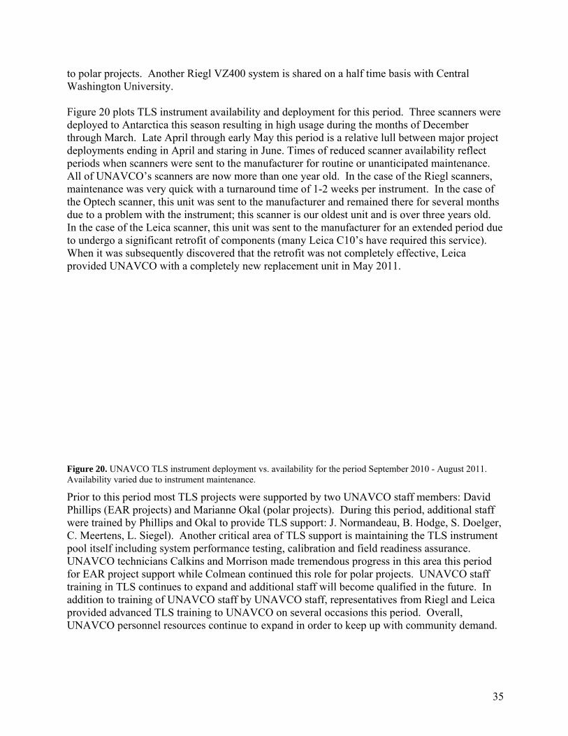
to polar pWashing Figure 20deployedthrough Mdeploymperiods wAll of UNmaintenathe Optecdue to a pIn the casto undergWhen it wprovided
Figure 20.Availabilit
Prior to tPhillips (were traiC. Meertpool itselUNAVCfor EAR training iaddition providedUNAVC
projects. Angton Universi
0 plots TLS d to AntarcticMarch. Lateents ending
when scanneNAVCO’s scance was verch scanner, tproblem withse of the Leigo a significwas subsequ
d UNAVCO
. UNAVCO TLty varied due to
this period m(EAR projecned by Phill
tens, L. Sieglf including O technicianproject supp
in TLS contito training o
d advanced TO personnel
nother Riegl ity.
instrument aca this seasoe April throuin April and
ers were sentcanners are nry quick withthis unit wash the instrumica scanner, ant retrofit o
uently discovwith a comp
LS instrument o instrument m
most TLS procts) and Marilips and Okael). Anothersystem perfons Calkins anport while Cinues to expaof UNAVCOTLS training l resources c
VZ400 syst
availability aon resulting iugh early Mad staring in Jut to the manunow more thh a turnarouns sent to the ment; this scthis unit was
of componenvered that thpletely new r
deployment vsmaintenance.
ojects were sianne Okal (
al to provide r critical areormance testnd Morrisonolmean contand and add
O staff by UNto UNAVC
continue to e
tem is shared
and deploymin high usagay this periodune. Times oufacturer forhan one yearnd time of 1manufactureanner is our s sent to the
nts (many Lee retrofit wareplacement
s. availability f
supported by(polar projecTLS suppor
ea of TLS supting, calibratn made tremetinued this roitional staff
NAVCO stafO on severa
expand in ord
d on a half ti
ment for this ge during thed is a relativof reduced sr routine or ur old. In the -2 weeks peer and remaioldest unit amanufactur
eica C10’s has not compl
unit in May
for the period S
y two UNAVcts). During rt: J. Normanpport is maintion and fielendous progole for polarwill becomeff, represental occasions tder to keep u
ime basis wit
period. Thre months of Dve lull betwecanner avail
unanticipatedcase of the Rr instrumentned there foand is over ter for an extave requiredetely effecti
y 2011.
September 2010
VCO staff mthis period,
ndeau, B. Hontaining the d readiness a
gress in this ar projects. Ue qualified inatives from Rthis period. up with comm
th Central
ree scanners December en major prolability refled maintenancRiegl scannet. In the case
or several mothree years otended period this serviceve, Leica
0 - August 201
members: Davadditional s
odge, S. DoeTLS instrum
assurance. area this peri
UNAVCO stan the future. Riegl and LeOverall, munity dem
35
were
oject ct ce. ers, e of onths old. d due
e).
11.
vid staff elger, ment
iod aff In eica
mand.

36
Figure 21. Map showing GGN stations and a current (September 20, 2011) snapshot of the network status. Green dots indicate stations that are operational, yellow dots are operational and have additional L2C capability with a second receiver; blue dots are operational and have GLONASS capability; pink and white dots are SENH stations; red dots are currently non-operational; and orange dots indicate stations that have been decommissioned.
During the UNAVCO Facility management review by NSF this period, TLS was identified as an area of significant potential growth and recommended that UNAVCO investigate community needs and formulate a comprehensive plan to meet and possibly expand the scope of current TLS support. Deliverables this period resulting from this review included the afore mentioned TLS workhop proposal as well as a strategic plan for evaluating community needs and how UNAVCO support for such requirements can be appropriately incorporated into future funding models including the next Facility cooperative agreement. TLS Community Support and Participation In addition to supporting individual PI projects, UNAVCO engaged in broader community participation and support through meeting presentations, short courses, advisory panels, and RESESS. For the third year in a row, Phillips co-taught a TLS Short Course with INTERFACE collaborators at the 2010 GSA meeting in Denver, CO in October 2010. We are scheduled to provide another TLS course at the 2011 GSA meeting. Phillips co-chaired a ground based geodesy session at the 2010 Fall AGU meeting in San Francisco, CA. Phillips attended the COCONet meeting in Puerto Rico in February 2011 and gave a special session presentation on airborne LiDAR. Phillips served as a member of the Open Topography advisory committee this period that included a meeting at ASU in April 2011. Meertens visited the Riegl headquarters and manufacturing facility in Austria following the 2011 EGU meeting in April. Phillips provided TLS training and experiences for the RESESS program this period.
2.13 NASA/SENH Program Support The UNAVCO Facility with JPL provides support for the NASA GNSS infrastructure through a network of 61 permanent GNSS stations made up of 72 GNSS receivers, called the Global GNSS Network (GGN). These stations represent approximately 16% of the active stations that make up the IGS permanent station network (Figure 21). The GGN provides infrastructure necessary for very accurate GPS orbit determination and terrestrial reference frame control for a wide array of NASA missions. Data from these stations are used to produce highly accurate products that are essential for Earth science research, multidisciplinary applications, and education. Regular fiscal accountability reports and use of the NASA-Statement of Work (SOW) as a living document and discussion/concurrence via regular meetings with JPL/Caltech Product Delivery Manager (David Stowers), help to ensure consistency between NASA-funded IGS efforts, JPL GNSS programs, and the resources and expertise applied to these efforts and programs by UNAVCO. Performance metrics for NASA/SENH program support are given in Table 10.

37
Table 10. Engineering Performance Metrics – NASA CORE (09/01/10– 08/31/11) WBS Task Performance Metrics Numbers
Engineering and Equipment Services
1.2.1.2
Permanent Station Operations
# stations monitored (on O&M list), (* = # receivers) # station troubleshoot events # new stations installed
61 (*72) 570 0
1.2.1.3 Permanent Station Maintenance # field trips or upgrades
10 1.2.1.4.1 Development and
Testing # D&T projects completed
4
1.2.1.4.2 Equipment Repairs # receivers repaired 0
Currently there are 61 receivers that are fully operational and are providing one second data to the geodetic user community. There are a number of stations awaiting repair or waiting for equipment to clear customs. This equipment includes: antennas, receivers, networking hardware, and meteorological sensors. There are six L2C stations consisting of Trimble NetRS receivers which were installed as part of the ‘First demonstration of Global Civil Tracking of the Block II-RM L2C Signal (GCTL2C)’ experiment funded by NASA, and have been running continuously since their deployment in 2006. There are currently fifteen GLONASS receivers deployed globally which will soon double as non-serviceable receivers begin to fail and are swapped out. The GLONASS receivers being deployed are Javad Delta receivers. The network also contains Javad Lexon receivers as well as a few Topcon NetG3-A receivers.
As part of its support, the UNAVCO Facility responded to approximately 570 individual troubleshooting and maintenance issues during the report period (September 1, 2010 through August 31, 2011). These troubleshooting incidents included: communication outages, configuration changes, maintenance trips, as well as various hardware upgrades at a number of stations. NASA also contributes to UNAVCO’s development and testing activities and four D&T projects for NASA were completed or continue to be worked on during this period.
New GGN Installations No new stations were established during the reporting period. Planning is underway to install two deep drilled-braced monuments at the Goddard Geophysical and Astronomical Observatory the first week of November. Plans will also soon get underway to install a new station in Brunei. UNAVCO has been tasked with ensuring that a geodetic quality monument be installed.
Existing GGN Station Upgrades and Development and Testing The Global GNSS Network (GGN) contains some of the longest running GNSS stations to date. A number of these stations are co-located with other space geodetic techniques such as SLR,
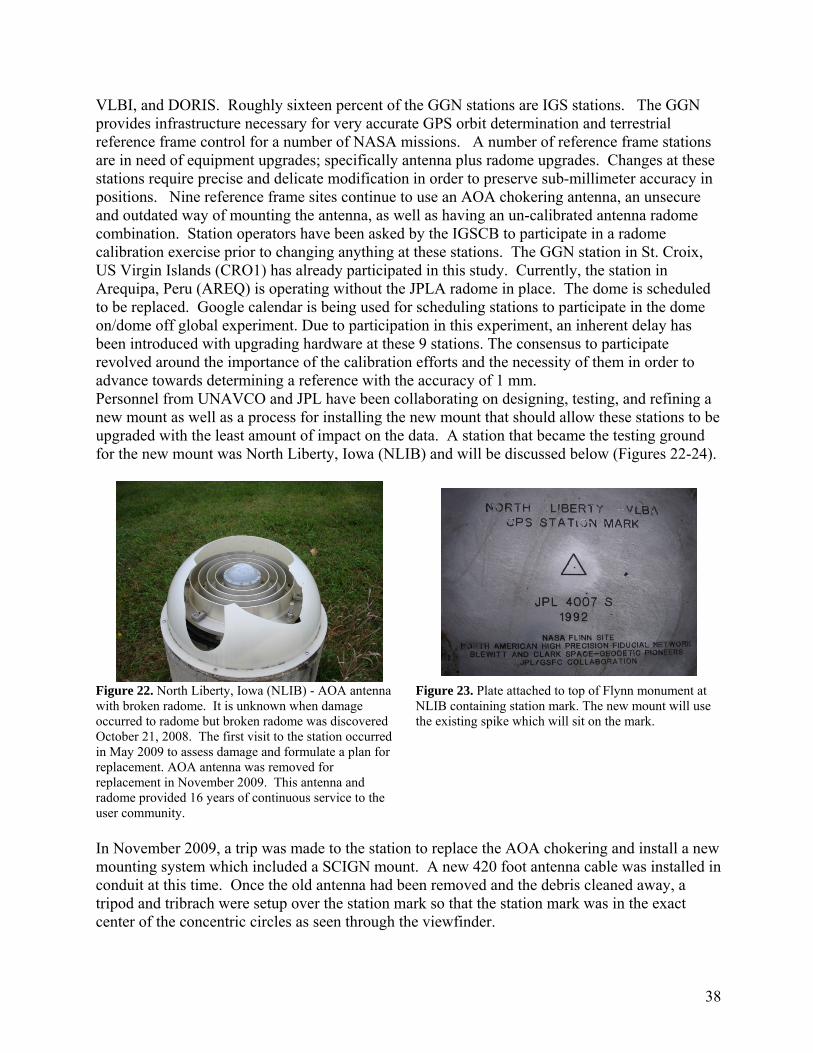
38
VLBI, and DORIS. Roughly sixteen percent of the GGN stations are IGS stations. The GGN provides infrastructure necessary for very accurate GPS orbit determination and terrestrial reference frame control for a number of NASA missions. A number of reference frame stations are in need of equipment upgrades; specifically antenna plus radome upgrades. Changes at these stations require precise and delicate modification in order to preserve sub-millimeter accuracy in positions. Nine reference frame sites continue to use an AOA chokering antenna, an unsecure and outdated way of mounting the antenna, as well as having an un-calibrated antenna radome combination. Station operators have been asked by the IGSCB to participate in a radome calibration exercise prior to changing anything at these stations. The GGN station in St. Croix, US Virgin Islands (CRO1) has already participated in this study. Currently, the station in Arequipa, Peru (AREQ) is operating without the JPLA radome in place. The dome is scheduled to be replaced. Google calendar is being used for scheduling stations to participate in the dome on/dome off global experiment. Due to participation in this experiment, an inherent delay has been introduced with upgrading hardware at these 9 stations. The consensus to participate revolved around the importance of the calibration efforts and the necessity of them in order to advance towards determining a reference with the accuracy of 1 mm. Personnel from UNAVCO and JPL have been collaborating on designing, testing, and refining a new mount as well as a process for installing the new mount that should allow these stations to be upgraded with the least amount of impact on the data. A station that became the testing ground for the new mount was North Liberty, Iowa (NLIB) and will be discussed below (Figures 22-24).
Figure 22. North Liberty, Iowa (NLIB) - AOA antenna with broken radome. It is unknown when damage occurred to radome but broken radome was discovered October 21, 2008. The first visit to the station occurred in May 2009 to assess damage and formulate a plan for replacement. AOA antenna was removed for replacement in November 2009. This antenna and radome provided 16 years of continuous service to the user community.
Figure 23. Plate attached to top of Flynn monument at NLIB containing station mark. The new mount will use the existing spike which will sit on the mark.
In November 2009, a trip was made to the station to replace the AOA chokering and install a new mounting system which included a SCIGN mount. A new 420 foot antenna cable was installed in conduit at this time. Once the old antenna had been removed and the debris cleaned away, a tripod and tribrach were setup over the station mark so that the station mark was in the exact center of the concentric circles as seen through the viewfinder.

39
Without moving the tripod or tribrach, the new mounting system was then installed onto the ring, with the bottom plate of the SCIGN mount attached. The purpose of this exercise was to make sure that the new mounting system was on the mark. This was a way to visually verify how precise the machining was while onsite. The mount that was installed November 2009 introduced a horizontal offset which would have to be removed somehow. Close collaboration with a local machine shop was essential. On December 15, 2010, another trip to the station was conducted in order to remove the mount that had been installed in November of 2009, and replace it with the redesigned mount with the intention of correcting the horizontal offset that had been introduced. The same procedure with the tripod and tribrach was followed. When the new mount was placed onto the ring and viewed through the optical viewfinder of the tribrach, the SCIGN mount mark was directly on top of the station mark thus removing the horizontal offset. Five of these mounts have been fabricated and are waiting to be installed at stations once the dome on / dome off experiment has provided enough data to the IGS Analysis Centers for the radome calibration.
As part of the ongoing task of maintaining the GGN network, computers were purchased and configured with Linux Fedora Core 14 Operating System. A number of GGN stations received some form of replacement hardware/upgrades such as new computer systems, updated receivers. Part of this effort was also to expand GLONASS tracking coverage. The Ambohimpanompo, Madagascar (ABPO) station received a new low power computer when UCSD personnel traveled to the station to install a solar array and move all equipment to a DC based system, including the GPS equipment. The station worked well until it sustained a direct lightning strike which fried the GPS receiver and computer. The station has since been outfitted with surge supressors on every line and consultations were made with UCSD personnel, as their equipment survived the strike, except for the freewave radios. They suspected that there was an arcover from our cable to theirs and this is what destroyed the freewaves. The station is once again producing data, and no modifications or changes to the antenna were necessary.
The GGN Galapagos Station in Ecuador (GLPS) shared a 3.8 meter VSAT dish with the USGS/ASL. The USGS upgraded the VSAT in 2011, but it was determined that the new system did not have the capability to handle the GGN GPS data. The USGS has decided to move their connection over to where their station is located, at that time, UNAVCO/NASA-JPL will be taking over use of the 3.8 meter dish and outfitting it with the hardware necessary to reestablish communications. The upgrade will be completed by MP Integral with travel costs shared between the USGS and UNAVCO. The upgrade of the VSAT system unfortunately did not fix the connection speed and it was determined this was due to the coax cable connecting each building. UNAVCO has sent another shipment containing cat 5 / cat 6 cables which have been pulled
Figure 24. Current configuration of NLIB station with the redesigned replacement mount installed in December,

40
through conduit and will be installed between the buildings in order to be able to utilize the full bandwidth that is being paid for. The Mahe, Seychelles (SEY1) GGN station (Figures 25-26) received upgraded hardware when UCSD personnel traveled to the station to bring their equipment online. The station sits on top of a hill where an old USAF tracking station was located. The hill now contains a palace built by the ruler of the United Arab Emirates, or the Sheik. During this trip, it was discovered that a 220 foot tower had been installed between the data recording room and the seismic vault. The GPS antenna was found damaged as it appeared that something had been dropped onto it. The tower is guy wired into the surrounding area and has been seen twisting and turning in the wind. This has caused issues with the seismic data. The guy wires pass directly over the GPS antenna, which is mounted to the top of the wellhead.
Figure 25. Photo shows truck using station as a turnaround area.
Figure 26. SEY1 station with broken dome and antenna, plus the addition of the 220 tower between the seismic wellhead and data recording room.
A dormitory to house the workers from the palace has also been built just below the station. The workers will come up the hill to the station and use it as a hang out area. The station sits on a relatively flat area, which is the only flat area on the mountain and is thus being used as a vehicle turnaround. Each time this occurs, the GPS antenna cable is driven over. Pete Davis from IDA has stated that he will be requesting that the Sheik pay for the relocation of the station, in the meantime, we have discussed installing a gate which would prevent vehicles from using the station as a turnaround.
Other NASA Support UNAVCO, through the core cooperative agreement, and sponsored by NASA, NSF EAR and NSF OPP, supports the development and maintenance of UNAVCO's TEQC software. This software includes data translation from over 50 receiver formats, data editing and quality checking. TEQC is integral to the GGN and IGS data handling and is widely used by hundreds of US and international GNSS groups. TEQC is in fact one of the most widely accessed parts of the UNAVCO website with over 25 downloads of the software occurring each day. TEQC is an important part of development and testing activities and is a critical part of the GNSS data processing work flow as well as for operations and archiving. UNAVCO staff interacts with international groups defining RINEX and BINEX format specifications and has participated in

41
the IGS Analysis Center workshops where formats and other issues related to GNSS modernization were discussed.
Planned Activities UNAVCO is preparing to install two deep drill braced monuments this fall at Goddard's Geophysical and Astronomical Observatory (GGAO). Construction on the next generation VLBI antenna was completed last fall. Unfortunately due to funding delays, the deep drill braced monuments were not installed prior to the new VLBI installation as we had hoped. Two campaign systems continue to run that are setup over known marks and are located across the road from the NG VLBI antenna. These two systems will continue to provide data until the deep drill braced monuments are installed. The permanent stations GODE/GODZ continue to produce data as well. The GGAO Facility is one of the few locations in the world where four or more space geodesy techniques are co-located, thus providing scientists with a unique opportunity to assess system performance and perform multi-technique analysis.
IGSCB Support UNAVCO provided financial support to the IGS Central Bureau (IGSCB) by arranging accommodations for the International Association of Geodesy (IAG) meeting, and the IGS governing board meeting that took place December 13, 2010 at the fall AGU meeting in San Francisco. UNAVCO also provided participant support funds to bring Mr. Richard Wonnacott to the United States from South Africa for the International Association of Geodesy (IAG) meeting, as well as providing registration fees and his accommodations for the AGU meeting in San Francisco, California. Mr. Wonnacott chairs the committee for the International Association of Geodesy sub commission on Reference Frames for the AFREF initiative. UNAVCO is pleased to be able to provide support for his participation in these meetings. UNAVCO also hosted the IGS / GGOS reception at AGU.
UNAVCO is regularly participating in meetings with personnel from the IGS CB regarding the re-design of the IGS website. A site log manager tool was developed that would allow station logs to be edited via forms. Currently the logs are being imported into the system and any formatting issues being fixed. Then new logs will be generated by the system and will be fed back to the IGS. This will hopefully alleviate any formatting issues moving forward. UNAVCO continues to search for a new developer who will then help to fix other bugs that have been found.
In related IGS activities, UNAVCO Facility Director Dr. Charles Meertens was selected as an At Large member of the IGS Governing Board and he attended the IGSGB meeting in Vienna, Austria, and the European Geophysical Meeting. Dr. Lou Estey, from the UNAVCO Data Group, took his seat on the IGS Infrastructure Committee. Dr. Fredrick Blume, UNAVCO Development and Testing Project Manager, serves on the IGS Antenna Working Group Committee.
2.14 NSF Office of Polar Programs Support More detailed reporting of NSF-OPP is provided in separate program specific reports, available at www.unavco.org/polar. Campaign support efforts this year included equipment, training and technical support provided to 24 Arctic and 34 Antarctic PI projects (Table 11). The Polar equipment pool was heavily committed for much of the Arctic and Antarctic field seasons, and

42
significant effort has gone into meeting project demands in both polar regions. Requests for ground based LiDAR equipment and support have been growing, with 4 TLS projects supported this year in the Arctic and 8 TLS projects supported in Antarctica. During the 2011 Arctic field season, UNAVCO provided gear and engineering support to 24 PI projects in locations ranging from the Shetland Islands to Greenland to Alaska. As part of the Arctic effort, equipment has been directed to Greenland for O&M support of the GNET project where 56 continuous stations are now installed. A total of 25 visits to nineteen Greenland GNET sites were made this year for maintenance and site upgrades. Campaign projects of particular significance included a GPS network of 7 receivers installed in west Greenland (Catania, PI), 22 new receivers installed in a network on the Greenland ice sheet southeast of Ilulissat (Das, PI) and a network of 10 receivers installed at the Sermilic Fjord in east Greenland (Hamilton, PI). Also noteworthy was the wrap up of a three year project with a network of GPS receivers placed in near proximity to the calving front of the Yakutat Glacier (Motyka,PI), three of which collected data well into the boreal winters to monitor significant calving events. Additionally, three terrestrial LiDAR projects were supported in the northern regions this year. The 2010-11 Antarctic campaign season was unprecedented in its breadth of PI project support. A total of 34 separate events were given varying degrees of equipment, training and direct field support. This number was up from an average of 20 supported projects in recent seasons. The entire available Polar GPS campaign equipment pool was deployed, including 45 of the latest generation Trimble NetR8 and NetR9 receivers. UNAVCO supplied instruments to several large Antarctic GPS projects, among them C-520 WISSARD (Anandakrishnan), I-181 Whillans Ice Stream Stick Slip (Winberry), and I-351 Byrd Glacier Dynamics (Stearns). The significant numbers of receivers requested by these groups required the addition of new instruments to the pool. Three Antarctic events, WISSARD, Byrd Glacier Ice Dynamics and ANDRILL involved the deployment of systems designed to operate into the austral winter. A single WISSARD site and the ANDRILL site were provided with Iridium communications for data telemetry. Additionally, UNAVCO supported several large, summer-only arrays of up to 17 GPS receivers during the austral summer. The Antarctic POLENET effort was not without challenges, given the difficulties of weather delays and resource scheduling demands. However, four new sites were installed and a fifth was upgraded to meet current design parameters (Figure 27). Additionally, the team was able to pay maintenance visits to 24 existing sites. At season close, 100% of the Antarctic systems were fully functional. Currently there are 83 POLENET continuous GPS systems deployed in Antarctica.
Figure 27. Field team completes work on the POLENET station BENN, located at the Bennett Nunataks, Antarctica.

43
The Terrestrial Laser Scanner continues to see heavy usage in Antarctica as well as the Arctic, and the Polar group has borrowed resources from the EAR scanner pool to meet the increased demand. The LiDAR scanners have proven themselves capable of operation in the extremes of the polar environment, although care must be taken to keep them running optimally. We expect to see a continued rise in demand for this resource from the grantee community in the future. Project support included two projects in northern Alaska (Tweedie, Shiklamanov, PI’s) and one in the Shetland Islands (Bigalow, PI), plus several locations in Antarctica (Sletten, Fountain, McKnight, Kyle, Ashworth, Ackley, Marchant, Barrett, PI’s). The pursuit of an Iridium technology development contract to develop a scalable and instrument independent Iridium Router-based Unrestricted Digital Internetworking Connectivity (RUDICS) based communications for geodetic GNSS networks and other sensors has been under way. Enhanced features include the ability to host standard ―network appliance devices using an Ethernet interface and TCP/IP protocol, improved bandwidth, reduced power consumption, cold hardening, and improved system control. UNAVCO is currently testing new Xeos Technology modems in a small number of beta installations both in Greenland and in Antarctica. Results from this technology have so far been promising. Meetings attended include the Polar Technology Conference, NSF Autonomous Polar Observing Systems meeting, AGU, Polar Network Science Committee meeting, Polar Technology Conference, and the USAP Communications Workshop and the Polar facility Workshop in Washington DC. Table 11. Engineering Performance Metrics – OPP
1.3.1 GPS Engineering and Equipment - Arctic
1.3.1.2 Permanent Station Ops
# stations monitored (on O&M list) # station maintenance events # unique PIs
56
265
1.3.1.4 PI Project Services # projects# unique PIs
2422
1.3.1.6 Development and Testing # D&T projects 3
1.3.1.7 Pool Equipment Maintenance # receivers in pool 123
1.3.1.8 PI Equipment Repairs # repairs completed See WBS 1.1.1.8
1.4.1 GPS Engineering and Equipment - Antarctic
1.4.1.2 Permanent Station Ops
# stations monitored (on O&M list) # station maintenance events # unique PIs
53
24 9
1.4.1.4 PI Project Services # projects# unique PIs
3432
1.4.1.6 Development and Testing # D&T projects 3

44
1.4.1.7 Pool Equipment Maintenance # receivers in pool 197
1.4.1.8 PI Equipment Repairs # repairs completed See WBS 1.1.1.8 2.2 Data Support
Archiving and Data Management The UNAVCO Boulder Facility provides data management and archiving support for high precision campaign and permanent station GPS data collected by Community investigators at eleven thousand locations around the globe (Figure 28). The Data Group also manages the WInSAR and GeoEarthScope SAR data archives at UNAVCO. The GPS and SAR archives are components of the UNAVCO Data Center, which is developed and maintained by the Facility Data Group. NSF’s significant investment in GPS and SAR data collections reaps its full benefit over time, as new data reveal longterm position changes and velocity trends as well as short-term anomalies. The UNAVCO Data Center plays a key role in longterm GPS and SAR data and data product safe storage and access by the community. The Data Group maintains an extensive collection of computer and storage systems hardware and associated data management software, database tools, and web access tools to manage this important task. During 2011, the Data Group invested in additional RAID storage to support the ongoing growth in GPS data holdings and to further support data discovery and access. Additional storage was configured and installed for the failover ftp server at the offsite location in Socorro, NM.
Figure 28. The red dots show the 11,467 monuments with archived GPS data through 31 August 2011; the dots outlined in black show the 2,870 monuments with data archived during 2011; the remaining dots are monuments with associated data archived during prior years.

45
GPS Data in the UNAVCO Archive GPS data holdings include 910 campaigns and 2,340 permanent stations (Table 12); 2025 permanent stations (non-high-rate) were actively returning data at the end of August, 2011. Data in the Archive are associated with 11,467 globally-distributed monuments as shown in Figure 28. During 2011, data flow management and archiving for 97 additional NSF, NASA or community supported permanent stations were put in place. This number includes 16 new PBO stations, but does not include PBO Cascadia High Rate stations, which are discussed later. An additional 66 campaigns were archived this year. Table 13 shows the Work Breakdown Structure metrics reporting for UNAVCO archiving and data distribution activities for 2011. Detailed lists are given in Table 14 and Table 15. Archived data are held in an online repository enterprise-class RAID system behind the UNAVCO firewall. Copies of this data in RINEX format are available on our anonymous ftp pickup system for permanent stations and selected campaigns. The cumulative data volume of GPS level 0 data in the online repository grew by 34% during 2011 to nearly 22 terabytes (Table 13 and Figure 29). With the completion of PBO construction, the numbers of permanent stations with data in the archive will grow more slowly in the next few years. Including products and additional files required by PBO and the data volume in the ftp pickup public archive, the total GPS archive holdings are 28.4 terabytes (compressed). Table 12. GPS data archiving statistics for 2007-2011 by calendar year.
Permanent Stations Handled (per year) Campaigns Processed (per year) # Archived # Files GBytes #Archived # Files GBytes
2007 1,572 645,931 4,382.1 88 20,060 160.3 2008 1,794 796,626 2,787.9 40 11,556 56.3 2009 1,896 742,114 3,089.9 44 22,795 75.3 2010 1,965 751,547 4092.4 35 20,380 77.0
2011 (part year) 2,025 624,423 4,121.7 66 7,777 22.7
Total (includes pre FY2007)
2,340 w/data 4,900,020 21,291.4 910 200,845 641.1
Table 13. Work Breakdown Structure metrics reporting for UNAVCO GNSS archiving and data distribution activities for 2011.
WBS Report -- GPS – Facility Data Group for the one year period ending August 31, 2011
WBS Element Metric Quantity or gigabytes
Permanent Stations Archived Permanent stations with data 2,340 Permanent stations - active 2,025 PBO/Nucleus stations 1,119

46
High Rate Permanent Stations Archived PBO Cascadia 1-Hz stations 210 Campaigns Archived Campaigns archived 66 All Archived Monuments with data 11,467 1.1.2.2 NSF GNSS Data and Data Products Total data archived 5,756 GB Subdivisions for files archived: Campaign data archived 66 GB Permanent station data archived 5,198 GB PBO/Nucleus data archived 2,833 GB Standard rate data archived (e.g. 15 s sample
interval) 2,866 GB
High rate data archived (1 s sample interval) 2,299 GB Cascadia data archived (1 s sample interval) 1,023 GB High rate data archived (~0.2 s sample interval) 33 GB Met data archived <1 GB Product files archived 935 GB
1.1.2.3 NSF GNSS Data and Data Products Accessed Total files accessed 13,341 GB Number of unique domains (avg per month) 1,626 Subdivisions for files Accessed: Campaign files accessed 163 GB -number of unique domains (avg per month) 11 Permanent station files accessed 11,354 GB -number of unique domains 1,626 PBO/Nucleus files accessed 8,360 GB -number of unique domains (avg per month) 1174 Standard rate files accessed (e.g. 15 s sample
interval) 9,841 GB
-number of unique domains 1,626 High rate files accessed (<=1 s sample interval) 827 GB -number of unique domains 15 Met files accessed 14 GB -number of unique domains 20 Product files accessed 1,694 GB -number of unique domains 95
NSF and NASA Community Software1.1.2.4 and 1.2.2.4 TEQC downloads 9,444 TEQC information requests 1020 NASA Stations Data/Metadata 1.2.2.2 Permanent stations handled 83

Figure 29 (right). Daarchiving rincludes higeophysica
Table 14summary Table 14. ID G3400
G3402
G3404
G3419 G3338 G3264 G3343 G3345 G3422 G3352
Antarcti1.4.2.2 1.4.2.2 Arctic St1.3.2.2 1.3.2.2
(left). UNAVCata volume addramped up andigh rate data aral survey suppo
provides a cy of the perm
Campaigns arPROJECAndaman
Andaman
Andaman
AntarcticaArenal VoArgentinaAzerbaijaAzerbaijaAzerbaijaBering 20
ic Stations/P
tations/Proj
CO GPS archivded to the onlind will contributrchived in assoort data; the vo
complete listmanent statio
rchived durinCT NAME
Islands 200
Islands 200
Islands 201
a Support 20olcano 2010 a 2010 n 2006 n 2008 n 2009
010
Projects PermanenProjects h
jects PermanenProjects h
ve cumulative ne repository eae significantly
ociation with geolume is highly
ting of campon networks
g 2011.
08
09
0
010/2011
nt station dahandled
nt station dahandled
GPS data voluach calendar yto the high rat
eophysical evey variable from
paigns archivcurrently pro
PISmPucSmPucSmPucvarNeSmReiReiReiFre
ata archived
ata archived
ume in the onlinear. In 2010-2te volume in yeents such as them year to year.
ved during 2oviding data
malley, chakayala
malley, chakayala
malley, chakayala rious wman
malley ilinger ilinger ilinger eymueller, K
ne repository b2011, Cascadiaears to come. Pe Tohoku Oki e
2011 and Taba to the archi
FUNNSF
NSF
NSF
NSFComNSFNSFNSFNSF
Kogan NSF
112
52N
by calendar yeaa high rate data PBO high rate dearthquake, or
ble 15 providive.
NDING F-EAR
F-EAR
F-EAR
F-OPP mmunity F-EAR F-EAR F-EAR F-EAR F-EAR
2 GB 1
2 GB N/A
47
ar. data
des a

48
G1000 Caribbean 1986 RINEX Injection Dixon NASA DOSE G3374 Central Baja 2009 Malservisi Community G3305 Costa Rica 2007 LaFemina, Fisher NSF-EAR G3376 Costa Rica 2010 LaFemina, Fisher NSF-EAR G3354 Denali 2010 Freymueller NSF-EAR G3341 Eastern Mediterranean 2007 Reilinger NSF-EAR G3415 Eritrea 2010 Reilinger NSF-EAR G3417 Eritrea 2011 Reilinger NSF-EAR G3262 Ethiopia 2010 Reilinger, Bendick NSF-EAR G3279 Filchner-Ronne & Larsen C Ice Shelf
Tides 2007-2009 King, Clarke Community
G3385 Honduras 2008 DeMets NSF-EAR G3381 Honduras 2009 DeMets NSF-EAR G3387 Honduras 2010 DeMets NSF-EAR G3389 Honduras Semi-Continuous 2009 DeMets NSF-EAR G3392 Honduras Semi-Continuous 2010 DeMets NSF-EAR G3356 IARC 2010 Freymueller Community G3316 Iceland 2007 LaFemina Community G3318 Iceland 2008 LaFemina Community G3321 Iceland 2009 LaFemina Community G3327 Iceland 2010 LaFemina Community G3358 ISEA 2010 Freymueller, Miura,
Sun, Sato Community
G3325 Jamaica 2010 DeMets, Tikoff NSF-EAR G3378 Jamaica Semi-Continuous 2010 DeMets NSF-EAR G3363 Kamchatka 2010 Freymueller,
Eichelberger, West, Izbekov
NSF-ISE
G3361 Kenai 2010 Freymueller, Abers, Christensen
NSF-EAR
G3202 Kuril Continuous 2009 More Data Freymueller, Kogan NSF-EAR G3413 Kuril Continuous 2010 Freymueller, Kogan NSF-EAR G3299 Lewis and Clark 1998 Oldow, Bendick Community G3297 Lewis and Clark 1999 Oldow, Bendick Community G3291 Lewis and Clark 2000 Oldow, Bendick Community G3293 Lewis and Clark 2001 Oldow, Bendick Community G3295 Lewis and Clark 2002 Oldow, Bendick Community G3288 Lewis and Clark 2003 Oldow, Bendick Community G3286 Lewis and Clark 2008 Oldow, Bendick Community G3284 Lewis and Clark 2009 Oldow, Bendick Community G3282 Lewis and Clark 2010 Oldow, Bendick Community G3332 Nicoya 2010 Newman NSF-EAR G3237 North Liberty Tie 2010 Stowers NASA G3365 Okmok 2010 Freymueller USGS G3303 Pakistan 2010 Bendick NSF-EAR

49
G3312 Panama 2008 LaFemina, Fisher NSF-EAR G3314 Panama 2009 LaFemina, Fisher NSF-EAR G3334 Panama 2010 LaFemina, Fisher NSF-EAR G3228 Preliminary Evaluation of GPS Dome
Materials 2010 Agnew, Wyatt Community
G3367 Redoubt 2010 Freymueller USGS G3217 Redoubt Semi-Continuous 2009 More
data Freymueller USGS
G3369 Redoubt Semi-Continuous 2010 Freymueller USGS G3394 San Bernardino Mountains 2007 McGill Community G3396 San Bernardino Mountains 2008 McGill Community G3383 San Bernardino SAF EarthScope 2010 Bennett, McGill NSF-EAR G3336 Santorini 2006 Newman Community G3372 STEEP 2010 Freymueller, Pavlis NSF-EAR G2991 Tajik-Kyrgyz Pamir 2007 More Data Molnar, Bendick NSF-EAR G3323 Tajikistan-Kyrgyzstan 2010 Molnar, Bendick NSF-EAR G3329 Tanzania Madagascar Uganda 2010 Calais NSF-EAR G3301 Yellowstone 2010 Smith USGS TOTAL 66
Table 15. Permanent Station Networks archived at UNAVCO. Network Name or Location Number of Stations
Network Name or Location Number of Stations
Active Inactive/ Retired Active Inactive/
Retired EarthScope/PBO 914 11 Jalisco 6 1Nucleus 209 15 Oaxaca, Mexico 6 1SCIGN USGS 102 6 Southeast Alaska 6 0GGN Core Stations 83 23 Andaman 5 0SuomiNet 59 25 Haiti 5 1Antarctica 58 11 Miscellaneous UNAVCO 5 4Greenland 46 2 Pakistan 5 1Hawaii 41 4 Plutons 5 0CAP Andes 28 0 Akutan Volcano 4 0Rio Grande Rift 25 1 CALIPSO 4 0PBO Analysis Support 23 6 Dead Sea 4 0Mauna Loa 22 1 El Salvador 4 0Caltech Nepal - NEGAR 21 1 Ethiopia Tectonics 4 0BARGEN 20 25 Mt. Spurr 4 0Nicoya Costa Rica 18 2 Okmok Volcano 4 1Afar 16 6 Polar Test 4 23GULFNET 16 4 Tajik-Kyrgyz-Pamir 4 0SAGE New Zealand 16 0 Arctic 3 0Caltech Andes 15 0 Eritrea 3 0Idaho National Lab 15 0 Mexico 3 0Puerto Rico 15 1 Redoubt Volcano 3 0

50
Central Iceland 14 0 Santorini 3 0Peatland Minnesota 14 0 Las Vegas 2 0Mid America 13 0 Panama 2 0Mediterranean 12 4 Socorro 2 1Soil Moisture 12 8 Tanzania 2 0Bangladesh 11 0 Telica Volcano 2 0GGN-L2C/Marshall 11 0 Uganda 2 0Africa Array 10 0 AVO 1 0Caribbean Hurricane Prediction 10 0 Bhutan 1 1Galapagos (Dual Freq) 10 0 DIVE 1 0Calabria 9 1 Ecuador 1 0CORS 8 4 IAGT 1 0Alaska/Denali 6 16 L1 Networks 0 54Central Asia 6 3 Miscellaneous retired 0 45EBRY 6 2 TOTAL 2025 315
EarthScope PBO and Nucleus Data Archiving Support The UNAVCO GPS archive holds all PBO and Nucleus data and products. PBO and Nucleus data account for more than two-thirds of the overall GPS holdings. October, 2008 saw the completion of the MRE construction phase for PBO. During the MRE, Data Group staff coordinated with PBO and Nucleus staff to setup new stations and track changes in station metadata. During the O&M phase, Data Group staff will continue to coordinate with PBO to track changes in station metadata associated with any necessary maintenance.
Cascadia High Rate Data Archiving Support PBO received funding in FY 2010 for upgrading 230 stations in the Pacific Northwest to 1-Hz streaming as part of the PBO Cascadia project. PBO provides support to the Archive for data archiving and ftp access to this data. During the report period, 125 stations were upgraded and set to deliver data to the Archive, for a total of 210 upgraded stations. The data volume for the calendar year is shown in Figure 29 (right - RT Archive). The Cascadia data volume for 2011 so far is about one-third of the volume of all standard rate data, but is expected to eventually exceed that of the 2000-plus active standard rate sites on an annual basis. To handle this data volume without impacting the archiving of all of the normal rate stations, data flow management directs the high rate Cascadia data to separate processing servers for archiving, metadata extraction, RINEXing, and publication to the ftp area.
Permanent Station Data and Metadata Flow The Facility data management process utilizes multiple databases with local and web forms, reports, and map interfaces to manage critical station and file metadata. Databases facilitate network operations and maintenance, and provide for user search capability for access to data and metadata. Data are transferred to the Facility via a variety of data transfer methods (ftp push and pull, LDM-IDD, rsync, and manual data transfers) and are managed via a series of staged computers that automatically pre-process, quality check and translate the data. The core software utilized for the automated archiving process has been developed and is maintained by the Facility. A key component is UNAVCO’s TEQC, an extensive translation, editing and quality checking program for GNSS data that is used by hundreds of processing groups around the

51
world. Station metadata are verified using database cross-checks between equipment, operations and archive databases. Archive personnel interact regularly with NSF investigators to facilitate the flow of data and metadata into the Archive. Permanent station investigators and engineers can submit changes to their site metadata via the operations database web form. That information is validated before being migrated into the Archive metadata database. The operations database generates updated IGS-style logs whenever pertinent database fields are changed. Archive IT Infrastructure The Data Group has implemented a robust, scalable archiving system for automated permanent station data handling and for the manual processes used for campaign archiving. For automated processing, incoming data are segregated based on the need for high throughput. The data with the need for the lowest latency and highest throughput are typically fed into a multi-node processor stack that runs in a master/slave configuration. As data volumes increase through time (due to additional permanent station installations), additional processing nodes can be added to the stack to allow adjustment of throughput to meet project needs. Multiple nodes also ensure continued processing in case of failure of any single component. Additional components of the system are database servers, storage servers and RAID. Each of these functional components are configured with failover servers and storage to avoid single points of failure. A separate stack of processors is used for large volume deliveries of PBO event based high rate data and PBO products. A third stack has been implemented for archiving data from PBO’s Cascadia 1-Hz project. A fourth stack is used for ongoing archiving system software development and testing. As data are archived the export versions for pickup by customers are written to the ftp pickup server. Nearly simultaneously, a second copy is written to an offsite failover ftp server. Additional storage was configured and installed for the failover ftp server at the offsite location at New Mexico Tech in Socorro, NM this year. The archived data are backed up in several ways. Data on the enterprise RAID system are synchronized daily to a secondary copy on an independent system RAID in-house. Once per month the previous month’s long-term archived data are copied to LTO tape. Each month, a second tape copy of the newest data is shipped to the IRIS Data Management Center (DMC) as an offsite copy. Incoming data are also copied over the internet on a daily basis to the offsite server in Socorro; this ensures that no loss of recently archived data happens due to media failure during the interval between archiving and scheduled tape backups. Daily database dumps and transaction records are also copied via the internet to the Socorro server.
GPS Data Discovery and Access The Data Center implemented a number of enhancements to the Data Archive Interface (DAI), our next generation interface for GPS search and data access capability that was originally released in production in 2009 (Figure 30). The DAI is a powerful and flexible Web application and set of Java command line clients for discovery and visualization of UNAVCO's GPS data and metadata holdings. Enhancement releases to the DAI and backend web services in 2011 now allows browsing and download of data for high rate stations only, or filtering out high rate

52
stations to focus on standard rate data. To enable this, a new global options panel was implemented. Users interested in stations with metpacks can now use the DAI to identify these stations. Users can also track the enhancements to the DAI through the Help links.
Figure 30. UNAVCO’s Data Archive Interface web tool for data selection and download; the ability to select high rate data was incorporated during 2011. The image shows PBO stations having 1-Hz or 5-Hz data archived surrounding the Tohoku-Oki event in March, 2011.
UNAVCO’s data holdings are publicly available, subject to UNAVCO/NSF Data Policy, and are made available to users in a number of ways. All permanent station data archived are immediately translated to RINEX and put on the UNAVCO anonymous ftp pickup area. Anonymous ftp pickup of GPS data from the Archive occurs at rate of approximately 4 million files per month, amounting to 14.3 terabytes of annual data delivery. Figure 31 shows the 12-month file count ftp pickup history. As of January 1, 2011, the UNAVCO Data Policy was revised to allow for immediate release of all archived data. This supersedes the earlier policy that allowed a 2-year exclusive use period for the PI for campaign data. Exclusive use periods for any data set can be negotiated with sponsor agreement. Data from campaigns that are anonymously available according to the Data Policy can be accessed directly through the Archive’s campaign search pages. Campaigns that are not anonymously accessible and that are beyond their 2-year grace period can also be accessed through the search pages. In this case the data are available by request to the Data Center staff; 204 such requests for campaign data were completed during 2011.

Figure 31.UNAVCO
SOPAC UNAVCArchive tUNAVCGPS SeaSOPAC-
Data MaUNAVCCheckingfoundatiointernatioTEQC soefforts into this ca As an altTEQC, Radditiona
WInSARManagemthe 12 mall for Wwithout cand NASfunding t
. Over 56 milliO GPS archive d
Archive O supports athrough a suO Archive dmless Archideveloped to
anagement SO continuesg) software pon of data inonally for moftware is doncorporated Gapability are
ternative to iRINEX 2.30 al GNSS obs
R and GeoEment of the Wonths preced
WInSAR (Tabcost from theSA approvedto allow for
on files and 14during the one
archiving of ubcontract. Wdata, and active Center (Gools, and pro
Software s to develop package that
nput and outpajor network
ownloaded aGLONASS oin progress.
incorporatingformat spec
servables.
EarthScope WInSAR Arding August ble 16). All oe European Sd a realignmesignificant in
4.3 terabytes ofyear period en
f GPS data atWithin its exts as an IGS GSAC) throuoviding user
and support t is extensiveput for the Gks such as SCn average oforbit inform A goal is fo
g GNSS obscification is u
SAR Archivchive has be31, 2011, 3,
of the scenesSpace Agencent of WInSAnvestments i
f data were accnding 31 Augu
t the Scrippstensive holdGlobal Dataugh assistancr access tools
the TEQC (ely used by t
GPS archive. CIGN, BARf 25 times pe
mation from nor QC to be f
servables intounder develo
ves een ongoing ,795 scenes s archived ducy under theAR and Eartin the SAR a
cessed through st 2011.
s Orbit and Pdings, SOPAa Center. SOce to GPS das.
(GNSS Tranthe GPS comTEQC is us
RGEN, PANGer day. Durinnavigation mfurther devel
o a new RINopment, with
at the Data Cand 679 GBuring the rep
eir open datathScope Comarchive infra
anonymous ftp
Permanent AAC mirrors co
PAC continuata center pa
slation, Editmmunity andsed nationallGA, and NAng 2011 TEQ
messages. Fuloped for GL
NEX 3.0 formh capability t
Center sinceB of SAR datport period wa policy. In Fmprehensiveastructure at
p pickup from
Array Center opies of ues to suppoarticipation u
ting and Quad remains thely and
ASA’s GGN.QC developm
urther refinemLONASS.
mat within to represent
e 2005. Durita were archiwere availablFebruary, NSe SAR archivUNAVCO.
53
the
ort the using
ality e
. ment ments
ing ived, le
SF ve The

impetus fopen datapurchaseapplicatiodownloadpart of thcapacity work is pimplemenconducteweb sites Seventeefor ongoicredentiapolicy cocomprise Table 16. Wdistributio
WBS
WBS Ele
NSF/NA NSF/NA
for the infrasa policy, wit
e. The WInSAon programmd from UNA
he upgrade pto provide d
progressing wnted, and AP
ed to obtain us.
en terabytes oing InSAR galing that is dompliance ane the archive
Work Breakdon activities fo
S Report – In
ement
ASA/USGS I
ASA/USGS I
structure upgth the correspAR Executivming interfac
AVCO. Upgrplan (Figure 3domain knowwell, with haPI design anusers input p
of SAR datageodesy resedistinct fromnd data usage.
down Structuror 2011. nSAR --Fac
Metric
InSAR DataTotal dat
InSAR DataTotal datNumber o
grade requesponding freeve Committece (API) andrades to hard32). An InSA
wledge for daardware purc
nd implemenprior to overh
a make up thearch for the m the user log
e reporting f
re metrics rep
cility Data GAugust 3
a and Data Pa archived
a and Data Pa accessed of unique us
st was the reeing of fundee requestedd associated dware and thAR specialisatabase imprchases madetation underhauling the o
he EarthScopwestern US
gin method ffor the intern
orting for UN
Group – for 31, 2011
Products
Products Ac
sers (avg per
duced need ing previous
d part of the uclient softw
he UNAVCOst was hired rovements ane, database scrway. In addoverall SAR
pe collection plate boundfor WInSARnational spac
NAVCO InSAR
the one yea
ccessed
r month)
for data fundsly set aside upgrade to in
ware to allowO SAR web pin a temporand the API dchema changition a webs
R information
and will becdary. SpeciaR was devisece agencies w
R archiving a
ar period en
Quangiga
679
886
Figure 32. UNspatial searchallows simultWInSAR, GeSupersites col
ding due to Efor data
nclude an w rapid data
pages are alsary part-timedevelopmentges being
site survey wn and data ac
come the baal user ed to addresswhose data
and data
nding
ntity or abytes
9 GB
6 GB 19
NAVCO’s Weh interface for Staneous search eoEarthScope, allections.
54
ESA
so e t. The
was ccess
sis
s data
eb GUI SAR now of and

55
2.3 University Subawards UNAVCO provides funding, via subawards, to the following Universities:
• Scripps Orbit and Permanent Array Center (SOPAC), at the University of California, San Diego; for support of archiving of continuous GPS data, support of the GPS Seamless Archive, and other efforts that complement the Facility’s archive activities.
• Massachusetts Institute of Technology (MIT) for data processing support and training.
SOPAC Annual Report SOPAC Archiving Support as part of UNAVCO Facilities NSF Grant
Annual Report 2011
Yehuda Bock, PI Scripps Institution of Oceanography
9500 Gilman Drive La Jolla, California 92093-0225
September 25, 2011
SOPAC continued to provide: (1) General maintenance and improvements for the on-line short-term and long-term
archive/database of regional continuous GPS data collected by the UNAVCO community, including data and data products from global tracking stations of the International GNSS Service (IGS) and other groups. These data and associated data products are accessible from http://garner.ucsd.edu/pub/. In the last 12 months (September 2010 – August 2011), SOPAC served 27.2 TB of data, an average of 2.27 TB/month, an factor of ~2 greater than the previous 12 month period. We currently archive RINEX data from nearly 2000 active CGPS stations (http://sopac.ucsd.edu/scripts/showArchiveStats.cgi). The increasing load on the archive has sometimes stretched our current resources and personnel to the limit. We’ve also had problems due to unexpected power outages and diminishing battery life of our aging UPS batteries, and are looking for funds to improve our infrastructure and customer support.
(2) We continued to operate the GPS Seamless Archive (GSAC) in cooperation with the UNAVCO data facility in Boulder and CGPS data wholesalers at other U.S.-based archives, although UNAVCO no longer serves as a retailer/wholesaler as we transition to a modernized GSAC as part of NASA ACCESS project with UNAVCO, CDDIS, and Univ. of Nevada, Reno.
(3) SOPAC also archives a variety of higher order data products and real-time high-rate (1 Hz) GPS RINEX data from nearly 200 stations in California. For example of a data product, as part of a NASA MEaSUREs project and its contribution to EarthScope JPL and SOPAC are producing a combined 24-hour position time series for more than 1000 stations in Western North America based on independent analyses of continuous GPS data at JPL (using GIPSY software) and at SIO (using GAMIT software), using the SOPAC archive as a common source of metadata. Included are all EarthScope/PBO stations as well as stations from other networks still active (SCIGN, BARD and PANGA), and pre-PBO era data some already two

56
decades old (Figure 1). The time series are appended weekly and the entire data set is filtered once a week using a modified principle component analysis (PCA) algorithm. Both the unfiltered and filtered data undergo a time series analysis with JPL’s st_filter and analyze_tseri software. All relevant time series are available through NASA’s GPS Explorer data portal and its interactive Java-based time series utility (http://geoapp03.ucsd.edu/gridsphere/gridsphere).
Publications Noll, C., Y. Bock, H. Habrich, and A. Moore (2009), Development of data infrastructure to support scientific analysis for the International GNSS Service, J. Geod., 83, 309–325, doi:10.1007/s00190-008-0245-6.
Figure 1. GPS Explorer Time Series Java Applet. Overlain detrended time series spanning almost two decades for stations GOLD (blue) and GOL2 (yellow) at NASA Goldstone Complex in the Mojave desert operating on a single antenna; a) receiver change, b) 1999 Mw 7.1 Hector Mine coseismic and c) postseismic, d) change from ITRF2005 to ITRF2008.

57
MIT Annual Report UNAVCO Community and Facility: Geodesy
Robert W King and Thomas A Herring Department of Earth Atmospheric, and Planetary Sciences
Massachusetts Institute of Technology, Cambridge, MA 02139 30 September 2011
Introduction
As part of UNAVCO's goal to promote the acquisition, archiving, distribution, and application of high-precision GPS data, MIT receives a sub-award to maintain and further develop the GAMIT/GLOBK software used by U. S. (and other) investigators to obtain maps of crustal motion from GPS measurements in deforming areas throughout the world.
Through our interactions with GAMIT/GLOBK users over the past ten years, we have identified four primary tasks that provide the most benefit to the community: improving the capabilities and accuracy of the software for a broad spectrum of users; improving the documentation; providing interactive access to global analysis results; and training of investigators and their overseas collaborators. There are currently over 300 research groups worldwide using the software. Over 100 of these are at US institutions, and over 70 of the overseas groups collaborate with NSF-funded US investigators. Since 2002, we have conducted 23 training workshops attended by ~380 data analysts.
Activities in 2011
We released a new version (10.4) of the software in November 2010 and 24 incremental updates to this version during 2011. The most important new feature is the inclusion of a real-time kinematic processing modules (trackRT), whose development was funded by a grant from the USGS and NASA but which will become part of the GAMIT/GLOBK suite for which UNAVCO provides primary support for distribution and training. Another important activity has been to generate for GAMIT/GLOBK users files that account for the hundreds of position offsets that have occurred in PBO and the global (IGS) continuously operating GPS (CGPS) stations due to earthquakes and instrument changes. This file was included in the 10.4 release for use with the reprocessed solution (“h” files (equivalent to SINEX files) generated by our group for over 300 CGS stations between 1996 and the present. Finally, we incorporated the new IERS 2010 models for the Earth's gravity field and for short-period variations in Earth rotation. Throughout the grant period we have updated our tables for new satellites, receivers, and antennas, and provided regular updates in GAMIT-compatible formats of global grid files of atmospheric loading produced by Tonie Van Dam of University of Luxembourg [Tregoning and van Dam, 2005] and of atmospheric mapping functions produced by Johannes Boehm of the Technical University of Vienna [Boehm et al., 2006].

58
About 30% of our efforts under this grant during 2010 have been devoted to direct user support. We conducted three UNAVCO Short Courses during the year, one in Boulder in April which was fully supported by UNAVCO E&O funds, and two abroad (Lima, Peru, and Izmir, Turkey) for which the expenses were borne by the hosting institution. Two more Short Courses are planned in 2011, one at the AfricaArray Workshop in Johannesburg, for which UNAVCO is providing travel support for two instructors, and one at the University of the Philippines Diliman, for which expenses will be borne by the host institution. Notes from these courses are posted on our web site http://www.gpsg.mit.edu/~simon/gtgk/doc.htm . Finally, we have spent 5-10 hours each week responding to questions and problems sent by users via e-mail.
References
Boehm, J. et al., Tropospheric mapping functions for GPS and very long baseline interferometry from European Centre for Medium-Range Weather Forecasts operational analysis data, J. Geophys. Res., 111, B02406, doi:10.1029/2005JB003629, 2006.
Tregoning, P., and T. van Dam, Effects of atmospheric pressure loading and seven-parameters transformations on estimates of geocenter motion and station heights from space geodetic observations, J. Geophys. Res, 110, B03408, doi: 10.1029/2004JB003334, 2005. 3.0 Education and Outreach Activities RESESS RESESS, or Research Experiences in the Solid Earth Sciences for Students, is a summer internship program dedicated to increasing the diversity of undergraduate students entering the geoscience workforce. This program is supported by the National Science Foundation through Grant No. 0917474 GEO-OEDG.
The RESESS internship provides a financially viable opportunity for students who otherwise might not be able to participate.
While most of the 11 summer interns from 2010 had only a vague notion about and interest in graduate school, it is clear from their blogs that their interest in and understanding of science and interest in graduate school has greatly increased over the course of the summer. Three interns have entered graduate school this fall, three will enter in January, and all but one of the others intends to apply to graduate school in the geosciences.
RESESS Recruitment This past year, we undertook a new approach to recruiting applicants to RESESS, broadcasting through websites, university and professional society lists, YouTube and organizational newsletters. We received 100 applications from 60 different institutions; two-thirds of the applicants were from populations that are under-represented in the geosciences.
Sharing of Applications After selecting our interns, we shared the remaining applications with 26 Principal Investigators of the NSF GEO REU programs and to GeoCorps America (GSA and National Parks). Three

59
Figure 33. RESESS Intern, Ashley Grijalva, learning about GPS.
minority applicants ended up participating in internship programs as a result. We hope to promote further sharing of applications, perhaps in a systematic way that could be planned at the GEO REU Workshop in October 2011.
Summer 2011 In summer of 2011, thirteen interns participated, including two returning interns. The cohort included:
• 8 women and 5 men • 5 African Americans (4 from HBCUs) • 5 Hispanics • 3 American Indian
They originated from eleven different institutions from the states of NC, VA, GA, TX, SD, WI, CO, MS, MI, and from Puerto Rico.
Interns worked with scientists at the following organizations to do their summer research:
1. University of Colorado 2. US Geological Survey in Lakewood and Boulder 3. University of Michigan 4. Shell Oil Company, Houston, TX
One student working at the USGS also collaborated with the Denver Museum of Nature and Science. Two interns worked on projects located in Yellowstone National Park and Great Sand Dunes National Park. Topics included hydrology, seismology, geophysics, paleoenvironmental reconstruction from sedimentology, carbonate geology, geomagnetism, glaciology and paleoclimatology.
The 2011 interns have submitted abstracts to the following conferences: NABGG, SACNAS, GSA, and AGU. We will be providing interns with a $3,000 scholarship for this academic year towards tuition. In the meantime, we continue to support interns and provide academic and professional guidance throughout the year via email and phone calls. The interns also provide tremendous support to each other, which is visible through social networking sites like Facebook.
UNAVCO Involvement in RESESS This was a banner year in terms of the number of UNAVCO staff who volunteered to work in the RESESS program. Five UNAVCO staff acted as either primary science or writing mentors, including Adrian Borsa, Dave Carlson, Dave Mencin, Christine Puskas, Blaise Stephanus and Beth Bartel. Eleven staff members were coaches (formerly “community mentors”) for the eleven new interns, providing additional professional and

60
Figure 34. (top center) Academic homes of our new RESESS intern, (middle left) RESESS and SOARS interns 2011, (middle right) redesigned RESESS website and (bottom center) RESESS Interns with Dr. Subra Suresh of the NSF.
personal support for the students. Through those people, some interns thereby had the chance to try snowboarding and mountain biking for the first time.
One “coach”, Jim Normandeau, spent a few hours teaching two interns how to use a GPS (Figure 33; skills that helped them later in the summer while in the field. David Phillips gave the interns an opportunity to use TLS at Dinosaur Ridge to capture images of weathering footprints and gave two excellent workshops on how TLS is used in science. Seven UNAVCO staff acted as judges at the RESESS poster session. If we include the staff supported RESESS operations, a huge portion of the organization played some kind of role in helping to make this program a success.
RESESS Alumni (Figure 34) • Six former interns are working on their Ph.D.s, at UC Santa Cruz, University of Miami,
University of Memphis, UT El Paso, U. Michigan, U. Minnesota at Minneapolis. • One is in a masters program at U. Oklahoma, and three are starting a masters program in
January. • Five completed their BS in 2010 and 2011. • Two are untracked.

61
Community Educators Reached/Engaged Education and outreach staff engages teachers, university faculty, community members, and other education professionals through professional development workshops, short courses, seminars and conference sessions throughout the year. UNAVCO has held or presented at four professional development workshops, six UNAVCO technical short courses, and a variety of presentations and learning sessions from September 2010 through August 2011; see Table 17 below for details. Table 17. Professional Development Workshops, Presentations & Learning Sessions Sep 2010 - August 2011 Short Courses, Professional Development Workshops & Learning Sessions
Dat
e
Nam
e of
eve
nt
Even
t det
ails
Seco
ndar
y-Ed
Fa
culty
Uni
vers
ity
Facu
lty
Scie
ntis
ts/
Com
m M
embe
rs
Oth
er e
duca
tion
prof
essi
onal
s
Gra
duat
e st
uden
ts
Inte
rns
Shor
t Cou
rse
2010
Sep Yellowstone-Snake River EarthScope Interpretive Workshop
1-day of 3 2 5 5 35
National Geoinformatics Community (NGC) E&O Workshop (Denver, ~Sept. 23-24)
1hr of 2-day 3 15 5 5
NABGG: 1 RESESS Intern presentation 1 hr 10
SACNAS: field trip + 3 RESESS Intern presentations
1 hr / intern 30
Oct
TLS: Terrestrial Laser Scanning (Ground-Based LiDAR) Methods and Applications in Geologic Research and Education (GSA Course, Boulder, CO, Oct 30) 8-hr 3 30
GSA: 2 RESESS Intern Presentations 2 hr / intern 20
Nov GAMIT: Processing and Analysis of GPS Data with GAMIT (Miami, FL, Fall 2010) 3-days 4 25
Dec AGU Poster sessions: Teacher training/ RESESS Impact / 4 RESESS intern
2 hr / presentat
ion 10 20 20 20
2011
Jan Google Penrose Conference - poster session
2 hr of 3 days 10 20
Mar NSTA - workshop activities in Earth Science share-a-thon 2 hours 75
NSTA - Advances in Earth and Space Science: Earthquake hazards
4 hrs integrate
d 50 10 20
EarthScope Interpretive Workshop in Central/Eastern U.S. Workshop
1-day of 3.5 1 3 11 25 3
GPS Data Processing Using GAMIT/GLOBK, March 14-18, 2011�Lima, Peru 3.5 days 5 20
Apr
Post-processing and Real Time Kinematic GPS data analysis with track and trackRT 2 days 1 26

62
May
EarthScope National Meeting workshop for teachers: Exploring Geology and Geophysics through EarthScope
.75 of 1.5 days 27 1 8
RESESS internship 3-month 6 20 2 13 Jun GPS Training Day 8-hrs 1 21 8
Jul PIRE Teacher Workshop: Dynamics of Intraplate and Other Earthquakes
3.5 of 9 days 16 4 3 2
Aug
GPS Data Processing Using GAMIT/GLOBK (Dokuz Eylul University, Izmir, Turkey) 2 days 1 15
Illinois EarthScope Workshop 2 of 7 days
InSAR: An introduction to Processing and Applications for Geoscientists 2.5 days 3 26
Total 194 144 90 128 5 21 142 Professional Development Workshops As part of the PIRE US-China Partnership in Research and Education of Intraplate Earthquakes Project, UNAVCO Education & Outreach led multiple sessions during the Dynamics of Intraplate and Other Earthquakes Professional Development Workshop held at the University of Missouri in Columbia, Missouri. During the intensive one-week workshop, UNAVCO, IRIS, and MU faculty trained a cadre of twenty community college, junior high and high school educators from the region encompassing the New Madrid Seismic Zone about plate tectonics, using GPS to study plate motion and earthquakes, earthquake fundamentals, and intraplate earthquakes in the New Madrid and North China seismic zones. Over 40 teachers from Missouri, Arkansas, Illinois, Indiana, Kentucky, Mississippi and Tennessee applied for the workshop. The project team included Dr. Mian Liu, Dr. Marie-Helene Cormier, Dr. Francisco (Paco) Gomez, and Dr. Eric Sandvol and Dr. Randy Keller of the University of Oklahoma; the workshop was organized and led by Dr. Lloyd Barrow and Dane Schaffe from the MU Science Education Center. “It’s essential they have accurate information and a solid background in order to communicate effectively with students and people in their communities,” said Lloyd Barrow, a professor in MU’s College of Education (Figure 35).
Figure 35. (left) Teachers created ‘gum-drop’ GPS stations to model the movement of tectonic plates during the PIRE teacher workshop. (right) Two teachers discuss subduction of the Juan de Fuca plate using a rigid and partially melted lasagna model.

GPS TraIn responRESESSFloyd froresearch UNAVC Thirteen received novel evewho resp
Figure 36.(right) Nureached thr Upcomin
• N• S• M• G• S• A
Upcomin
• In2
• TR
• GU
• GD
aining nse to staff in interns, UN
om MIT, recapplicationsO staff and
of those attvery positivent. The surv
ponded to the
. (left) RESESumber of the corough UNAVC
ng WorkshopNABGG Con
CEC AnnuaMeeting of SoGSA (Minnea
ACNAS CoAGU (San Fr
ng UNAVCOnSAR: An in011
Terrestrial LaResearch & EGPS Data ProUniversity ofGPS Data AnDecember 20
nterest and aNAVCO offecruited as thes, along with8 RESESS i
tendees respove assessmenvey providede survey app
SS intern, Melisommunity (teacCO Education a
ps / Meetingnference (Sanal Meeting (Society of Exapolis, MN,
onference (Sarancisco, De
O Short Countroduction t
aser ScanninEducation, Oocessing Usif Witwatersranalysis and M011, Universi
as part of an ered an Interne instructor, ph a mid-day,nterns attend
onded to a pnt, remarkabd complimenpended this c
ssa Carnicle, pchers, faculty, sand Outreach p
gs with Educn Francisco,Sept 11 – 14
xploration GeOct 9-12)
an José, CA,c 5 – 9)
urses Series:to Processing
ng (Ground bOctober 8, 20ing GAMIT/and, Johanne
Modeling Usity of the Ph
enhanced trnal GPS traiprovided inthands on GPded (Figure
post-event suly positive wnts as well acomment: “a
practices levelinscientists, shorprograms (year
cation & Out, Sept 7-10)
4) eophysicists
, Oct 27 - 30
g and Applic
based LiDAR011, Minneap/GLOBK, 17esburg, Soutsing GAMIThilippines, D
aining progrining day ontroductory mPS deploym36).
urvey (Figurewhen one cons useful sugg
a great class”
ng the tripod brt course particrly through Au
treach contri
(San Anton
0)
cations for G
R) Methods polis, MN (G7-19 Novemth Africa
T/GLOBK/Diliman
ram on geodn 22 June 201material and a
ent session.
e 36). Coursnsiders that gestions. M”.
efore installingcipants, and REugust 2011).
ibution:
nio, TX, Sep
Geoscientists
and ApplicaGSA)
mber 2011
DEFNODE, 2
desy tools for11. Dr. Mikan overview Nineteen
se and instruthis represen
Many particip
g the GPS anteESESS interns)
pt 18-23)
s, August 8 -
ations in Geo
28 Novembe
63
r ke w of
uctor nted a
pants
enna. )
- 10,
ologic
er - 2

64
• GPS Data Processing Using GAMIT/GLOBK, including an introduction to Real Time Kinematic GPS data analysis with track and trackRT, 9-13 January 2012 Monserrat Volcano Observatory, Monstserrat, West Indies
Evaluation The NSF commissioned an evaluation of all components of the UNAVCO E&O Program processes (the evaluation period is 2008-2010) including:
• Assessing the effectiveness, in a summative manner, of the activities, operations, and impacts of the E&O program as a whole.
• Suggesting and developing tools, databases, and mechanisms that would aid future assessments; and
• Suggesting “best/effective practices” for both the extant program and for improving E&O Program activities, operations and impacts.
NSF selected the educational assessment team from DAH Consulting to conduct the evaluation. The DAH team examined multiple pages of documents, spreadsheets, and survey results provided by UNAVCO. Together, DAH and UNAVCO conducted new surveys of recent participants of UNAVCO short courses and workshops. DAH also interviewed a UNAVCO interest group (from UNAVCO staff, the UNAVCO Board, UNAVCO Advisory Committees, and NSF), a group of RESESS interns and mentors, and participants from three recent short courses. DAH also assessed education and outreach activities in similar programs, including IRIS, SOARS and IODP, for comparison with the UNAVCO education and outreach activities.
NSF accepted a final report from DAH. The report includes this conclusion:
UNAVCO is creating an exceptional teaching/learning environment infused by research and scholarship of the highest international standard. Our review of previous evaluation reports, and our own assessments, using multiple audiences, have realized positive reviews on all of the programs including: � Positive reviews on teacher workshops for UNAVCO and its partners, e.g. TOTLE. � The short courses have consistently provided quality information and programming to support UNAVCO technology tool-box of precision technology. Graduate students have reported publishing in the newly learned fields. � Jules Verne Voyager plate motion relative velocity vectors (key to understanding the link between geophysical hazards and tectonics), has become more usable and effective for its use. � UNAVCO’s staff, engineers, and research teams, are creating attractive and appealing documentation of their efforts; creating interest and ultimately visibility for UNAVCO and the science. � The RESESS program in a short time has seen improvements in its visibility and applicant pool.
The Final Report by DAH included seven recommendations. NSF conveyed those recommendations, with comments, to UNAVCO. UNAVCO, with the engagement of the Education and Outreach Advisory Committee, has submitted responses. We expect further guidance from NSF.

65
Outreach In September 2011, two UNAVCO representatives traveled to Washington DC for a showcase of NSF-funded hazards research at the Hart Senate Office building. An interactive demonstration using a large floor map of Southern California's velocity vectors along with a partially assembled GPS station and live demonstrations of the Terrestrial Laser Scanner (TLS) helped illustrate the power and potential of new tools that enable policymakers and response teams on the federal, state, and local levels to better predict, prepare for, and respond to hazards that affect human life and property. UNAVCO was able to connect with Colorado Senator Michael Bennett (Figure 37) as well as other DC politicians, NSF directors, and community members.
Figure 37. Jim Normandeau (far left) and Colorado Senator Michael Bennett at the NSF Hazards Research Showcase at the Hart Senate Office Building Washington D.C.
E&O continues the tradition of bringing the latest science, education, and community stories to the public through web highlights. These highlights offer a chance to share the many stories that come from the UNAVCO community and archive its rich and growing history. In the last four months, E&O has written and/or coordinated 5 Facility highlights that span a range of interests, from the first COCONet installation to the geodynamics of ridge collision on the Caribbean Plate and Panama Block.
E&O uses social networking to connect our community. The number of people who find us on Facebook increases monthly, with a current total of 295 people who "like" us.

66
List of Highlights (Sep. 2010 - Aug. 2011): • Terrestrial Laser Scanning (TLS) Surveys in Everglades National Park • Geodynamics of Ridge Collision on the Caribbean Plate and Panama Black • Shetland Islands Climate and Settlement Project 2011 • First CocoNET Continuously Operating GPS Station Installed • Antarctic Program Support 2010-2011 • Cascadia Project Recognized in “100 Recovery Act Projects” Report • Join UNAVCO at the 2010 AGU Fall Meeting • Caribbean GPS Network to Aid Earthquake and Hurricane Forecasting • The Magnitude 6.3 South Island New Zealand Earthquake, Feb 21, 2011 • UNAVCO Event Response – Mw=9.0 Tohoku, Japan Earthquake and Tsunami, Mar. 11,
2011 • Education and Outreach 2010 Highlights: Summer Internship a Success • TLS Survey of Four-mile Canyon Wildfire Captures Post-fire Terrain Changes – Project
Highlights 2010 • Brewster (BREW) GGN Station Maintenance – Project Highlights 2010 • Sierra Negra GPS Network Upgrade (Final Phase) – Project Highlights 2010 • PLUTONS Project (Part II) – Project Highlights 2010 • Drilling into the San Jacinto Fault • Beta Version of UNAVCO Web Redesign Open for Review • Africa Array GPS Network • Arenal TLS Case Study • POLENET • UNAVCO Event Response – Mw=7.0 Christchurch, New Zealand Earthquake, Sept 3,
2010
Community Involvement E&O maintains a News Room, where media articles concerning UNAVCO and member institutions are collected (Figures 38-39). Recent articles added to the newsroom include Popular Science's rating of the "Universe's Ten Most Epic Projects," in which EarthScope was placed at #1. The News Room also highlights articles from The New York Times and Nature by Jay S. Famiglietti of the University of California Center for Hydrologic Modeling and Andrew V. Newman of the School of Earth and Atmospheric Sciences, Georgia Institute of Technology.
UNAVCO works with the EarthScope National Office to write and edit InSights, a quarterly newsletter of science and news from EarthScope. The Summer 2011 edition has just been released and provides information for the upcoming 2012 UNAVCO Science Workshop as well us updated information about PBO's continuous GPS stations that are part of the El Mayor-Cucapah earthquake response.

Figure 38.month andreflecting t
Figure 39Tand (right)
AcknowlThis repoChuck MNormandediting, w
. A unique visd is counted onlthe recruiting e
These figures s the number of
ledgments ort includes c
Meertens, Vicdeau, Shelleyword process
itor is a host (aly once even ifefforts in the Fa
show (left) the f individual we
contributionctoria Andrey Olds, Joe Psing and gen
a computer) thaf there are multall 2010
total number oeb pages viewe
ns from UNAeatta, MeganPettit, Davidnerally comp
at has made at tiple visits. No
of time the suited.
AVCO staff m Berg, Fredd
d Phillips, Vapiling this rep
least 1 hit on 1tice the increas
te of education
members incdy Blume, Fralerie Sloan.port.
1 page of a webse in traffic to
n and outreach p
cluding Megran Boler, D. Angie Kra
b site during eathe RESESS w
pages were vie
ghan Miller, Dave Carlsonantz helped w
67
ach
website
ewed
n, Jim with