UMM Scriber SCR – 01 Part I. Introducing, the UMM SCRIBING

UMM EL-JIMAL "Gem of the Black
Desert' ,
A brief guide to the antiquities
By Bert de Vries
with photographs by the author
AI Kutba, Publishers Amman. Jordan 1990
I �

G ene ral view of Um m e l ·J imal . Draw n by Randa A. Sayegh.
Cove r p h oto: Doorway wi th c i rc u lar window, H ouse I I I
Copyr ight © 1 990 AI Ku tba, P u b l ishers. All r ights reserved F i rs t Ed i t i on , Depart ment of A n t i q u it i e s of J ordan 1 982 Second Revised E d i t ion, AI K u t ba, P u b l ishers. A m man, Jordan, 1990
Fi rst pub l i shed 1 982 P u b l i shed by AI K u t ba, Publ lshers P.O. Box 9446, Amman, J ordan
No part of t h i s p u b l icat i on may be reproduced by any means, or t rans l ated i n t o a mac h in e lang uage, o r st ored i n a re tr ieval system o r t ran s m i tted i n a n y form or by any means, e lectron ic , mec han i cal, phot oc opyi ng, re cord i n g or ot her· w i se, w i t hou t t he pr ior wr i t ten perm i ss i on of t h e p u b l i s h er.
930, lAS 32 1 3
De Vries, Bert Umm e l ·J lmal · Bert de Vr ies Am man: AI K u t ba, P u b l i shers 1 990 (36pp) Depos i t No (1731311990) 1 . U m m el·J lma l · H istory 2. J ordan · H i story I. T i t l e
Pr inted I n J orda n b y the Econ om ic Press Co. Desig ned by E l len Kettaneh Khou r i .

Double w i nd ow of house XVIII
CONTENTS Out in "the Grey-White Sea" ............................... . ....... .. .... .... ..... . .. 5 On the Edge of the Basalt Plain .. .. ... . . ..... .. ... . . . . . . . . ... . . . . ... . ... ... . ... ... 6
Chronological History .. ............... ........ . ......... ... .. . . ... . .. . . ...... ... ....... . ... 8
Mother of Camels ........................... . . ................................... ........ . ....... 16
An Overview: Gem of the Black Desert .. . ...... ... . . . . . . ... . . . ..... . . ...... 17 A Walking Tour of the Town .. . ..... . .. .. ........ . ......... . ..... . . . . .. . ...... .. . ... . .. 21
Research and Acknowledgements . ... . . . ... . .. . ..... . . .. . ..................... 36
3

4
"Far (lut in the desert, in the midst of the
rol ling plain, beside the dry bed of an
ancient stream, there is a deserted city.
The plain is not a waste of sand, its surface
is composed of dry and exhausted soil,
overgrown with grey lichen, thinly
sprinkled with parched desert plants, and
strewn with rounded bits of black basalt,
from the size of an egg to the size of a
man's head, which are no longer black, as
they were when the peasant's plow-Share
turned them over from time to time; for the
desert mosses have covered them with a
lace-work of white and grey .... The walls of
the ancient deserted city, its half ruined
gates, the towers and arches of its chur
ches, the two and three-story walls of its
mansions, all of basalt, rise black and for
bidding from the grey of the plain. Many of
the buildings have fallen into ruins, but
many others preserve their ancient form in
such wonderful completeness, that to the
traveller approaching them from across
the plain, .. . the deserted ruin appears like a
living city, all of black, rising from a grey
white sea."
-- Howard Crosby Butler, 1913
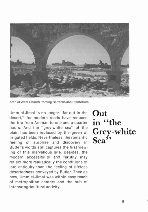
Arch of West Church framing Barracks and Praetorium.
Umm el-Jimal is no longer "far out in the
desert," for modern roads have reduced
the trip from Amman to one and a quarter
hours. And the "grey-white sea" of the
plain has been replaced by the green of
irrigated fields. Nevertheless, the romantic
feeling of surprise and discovery in
Butler's words still captures the first view
ing of this marvellous site. Besides, the
modern accessibility and fertility may
reflect more realistically the conditions of
late antiquity than the feeling of lifeless
deserted ness conveyed by Butler. Then as
now, Umm el-Jimal was within easy reach
of metropolitan centers and the hub of
intense agricultural activity.
Out in "the Grey-white Sea"
5

To reach Umm el-Jimal by car, travel north
from Amman to Mafraq, then take the H-4
Road east for 15 km to the first desert
police post. There turn north for three
kilometers until you reach the site (figure I,
inside back cover). The fastest route is the
four-lane road from King Hussein Sports
City towards Zerqa to the new Amman
Damascus highway that bypasses both
Zerqa and Mafraq on their east sides. The
Mafraq exit puts one directly onto the H-4
Road. Travel time is one and a quarter
hours.
Umm el-Jimal is located in the semi
arid region of north Jordan, on the edge of
the basalt plain created by prehistoric
volcanic eruptions from the slopes of the
Jebel Druze, whose peaks are visible on
clear winter days fifty km to the north in
southern Syria. This plain, called the
On the Edge of the Basalt Plain
UMM El- JIMAl In Ih� THIRD CENTURY UJ 84 ro :poM b
�,
II".
\ .,. (lit 10Mb."
\ lAc.....,
. .1. "''''w,
Figu re 2: drawn by Bert de Vr ies and Randa A. Sayegh.
6

Southern Hauran, is made up of deep basalt bedrock covered
with a fertile layer of reddish volcanic soil that receives about
100mm of rainfall per year. By itself, this rainfall is barely suf·
ficient for an occasional wheat crop, but with careful collec·
tion and storage of the runoff, it is possible to follow the spring
wheat harvest with irrigated crops of produce. Thus it was in
the Late Roman, Byzantine and Umayyad periods, when Umm
el·Jimal was one of dozens of prosperous rural towns and vii·
lages scattered on the plain between Dera'a to the west and
Deir el·Kahf to the east.
The great Roman highway, the Via Nova Traiana cons·
tructed AD 112-14 during Trajan's rule, passes Umm el·Jimal 6
km to the west on its way from Bostra to Philadelphia (Amman).
It is best viewed where it crosses the road between Umm
el·Jimal and Umm es·Surab, at a point about one km west of
Qasr el·Ba'ii, a ten minute drive west of Umm el·Jimal. Umm
el·Jimal itself lay on a side road that left the Via Nova at Qasr
el· Ba'ii, and went on to Umm el·Quttein and Deir el·Kahf to the
east. This side road was part of a network of secondary roads
that connected the Southern Hauran's towns and villages with
major market centers like Bostra and Suweida, and the desert
oasis of Azraq.
On a clear day it is possible to see Qasr Hallabat 25 km to
the south, and even the snowcap of the Jebel Sheikh (Mount
Hermon) shimmering on the horizon beyond the Golan Heights
125 km to the northwest. To the north and northeast the vol·
canic cones of the Jebel Druze and its foothills dominate the
horizon.
Umm el·Jimal nestles in a fork created by the joining of
two wadis (dry riverbeds) that bring the runoff waters from the
lower slopes of the Jebel Druze. T he earlier village was located
on the west bank of the eastern branch, while the standing
town lay on the east bank of the west branch (figure 2).
7

Umm el-Jimal was occupied for 700 years
from the 1 st Century AD to the 8th Cen
tury, and again early in the 20th Century. In
its first 700 years Umm el-Jimal had three
Quite distinct personae.
In the 2nd-3rd centuries it was a rural
village that received its impetus from late
Nabataean sedentarization, but its pros
perity from the incorporation of the region
into the Roman Empire after the peaceful
transformation of the Nabataean heartland
in Jordan into the Provincia Arabia (the
Roman Province of Arabia). Thus from
Trajan (AD 106) to the end of the Severan
Dynasty (AD 235), the village appears to
have had an undisturbed and relatively
prosperous rural life, with an estimated
population of 2,000-3,000 people. We glean
that from the hundreds of tombstone ins
criptions in Greek and Nabataean, most of
which were reused as corbels and stairway
treads in the later, still standing town.
These inscriptions give us the Arabic and
Hellenized names of several generations
of villagers: "Asad, (son of) 'Akrab, age 30"
(in Greek); "Masikh, son of Zabud" (in
Nabataean). All this came to an end in the
middle of the 3rd Century, when the village
became a victim of the wave of turmoil that
ravaged the Roman Mediterranean; a likely
hypothesis is that it was ruined during the
civil war triggered by Queen Zenobia of
Palmyra's rebellion against Rome. Both
the tombstones and the masonry of the
village were despoiled to provide building
materials for the later fortifications and
town. The village's remains are visible
8
Chronological History
Third Century tombstone. Draw n by Randa A. Sayegh. "Mas l k h a l so cal led Suma of t h e Rawah. Al l h is years were 40".

today as a three to four hundred metre diameter oval of
moonscape rubble on the gentle slope two hundred meters
east of the southeast corner of the still standing town.
The second Umm el-Jimal was a military station on the
Limes Arabicus, the 4th-5th Century fortified frontier defensive
system created and constructed by the emperors Diocletian
and Constantine. Already in the 2nd Century, the Roman impe
rial authorities had begun construction of a gate and a wall
next to the village, on the site of the standing town. This is
known from a dedicatory inscription (recorded by Butler from
the ruins of the "Commodus Gate") commemorating the cons
truction of a defensive wall during the coregency of Marcus
Aurelius and his son Commodus. That was followed by the construction of the great reservoir (figure 3, 9) and the Praeto
rium. But after the destruction of the village, Diocletian's
imperial reorganization caused the construction of a major
fortification, the castellum ( 133-4) on the east side of what later
became the town. Now Umm el-Jimal functioned as a stitch in
the blanket of total defensive security in which Diocletian had
attempted to swaddle his empire. You have to imagine the
4th-5th Century site with the Commodus Gate, the Praetorium,
Reservoir 9 and the fort in place, but without the Barracks, the
now standing houses and the churches.
This military security may have enabled or forced the civi
lian resettlement of the site, to set the stage for Umm
el-Jimal's third persona, that of a prosperous rural farming and
trading town of the 5th to 8th Centuries. The transformation
from military station to civilian town was gradual, and is typical
of the general transformation from imperial to late antique
culture that took place in the East Mediterranean in the 4th
Century. This resulted from the failure of Diocletian's system
of massive defenses along the eastern frontier and the reac
tion to the debilitating economic oppression such a system
required. Ironically, as imperial military security weakened and
decentralized, the prosperity of the eastern frontier increased
to reach a peak in the 6th Century.
9

o
o ,.
" II " " " " " " ': " " " I II
I " " " , , "
o
�, " " " " " " I
'. I
,I
... � -,.ltACrM U1rfl CCl#8ICIIOUJ .rut ,.,£ Jalr" we,1 &Me rAJI 'Alt IIOIfr" CAst I,Mt ·IitAMIACMI ,e"""," _ .... -
Figure 3: drawn by Bert de Vries.
10
()
o
• It4A/IfWAlCIt """-lfMI"t • Jl'JUrl4 wal CItUK1'I Q ..... iltAc., CHUI" a 1ICI-.c"1AJIIIU CH4JflC" , c .. ,,..-DlltAt • OIItI.U C� • """,,"c...- CMJIf/ICIf n ItJUIH �"J' at"l1 • WOI�Of
UHH H· JIHAL
'f IO.MIOIAIIOS �'IOf M "'MIA'.U" CMllICtII 1f MOIIJ/'f 0N/ICIf 11 IItIfIJ" r� CMiIICN IJ c..ul Cl#f,lIfCH 1:1 CtlUltC" ... m,."�,,.� OJ,DI 1otGO'-..cD"""'" ,.n ......a�".,
If.C �tL.

At Umm el-Jimal the Tetrarchic (refers to the type of
imperial government inaugurated by Diocletian) castellum lost
its military function in the early 5th Century, and may have
been converted into a market place, to judge from the nature of
the artifacts found in the s treets between its barracks. At the
same time the Barracks (figure 3, 1) was constructed as a
bivouac for the diminished Early Byzantine garrison inside the
now constructed town walls. The last vestige of paganism, a
small Roman temple (8), dated to the earlier Nabataean era by
Butler, was constructed at this time.
This little temple was soon engulfed in a domestic co m
plex constructed by Chris tians (House 49), one of 128 such
complexes that were in use in the 6th Century. The conversion
to Christianity also brought churches; 15 were constructed in
the late 5th and 6 th Centuries. The Barracks building went
through a major remodeling that included the construction of
the sou theast corner tower. Such towers are a function of the
localized defense prevalent during the period of the Ghassanid
phylarchy (the Arabic tribal rule on which Byzantine emperors
depended to buffer the eastern flank of their empire from the
mid-6th Century to the Islamic conquest). Thus the town
enjoyed its moment of greatest prosperity at the time that
centralized imperial controls were at their weakest. Butler's
estimate of 10,000 residents may be high, for he ignored the
use of the bottom floors as stables; however, discounting the
number to 6,000-8,000 would still give a sizable community.
Undoubtedly, the fortunes of Umm el-Jimal were diminish
ing during the rather catastrophic decades of the late 6th
Century, when the east suffered the twin ravages of plague and
Persian wars. Centralized controls returned in somewhat dif
ferent form after the Muslim conquest under the Umayyad
caliphs ruling from Damascus (AD 66 1-750). Occupation at the
site seems to have been uninterrupted to the end of the
Umayyad period. The population continued to occupy at least
the central structures (the Praetorium and House XV I II), and at
11

First and second floor doorways.
least one church (22) was remo
deled in the Umayya d period. The
Praetorium was extensivel y
refloored and decorated with fres
coed plaster, and appeared to be a
pros perous equivale nt of contem
porary desert castles like Qusair
'Amra. However, Umayyad controls
could not stem the tide of depopu
lation that had begun in the pre
vious century. When the earthquake
o f A D 747 hit, neither manpower nor
economic energy remained for the
sort of rebuilding that had been
readily tackled in more prosperous
times.
For more than 1 100 hundred years the city lay virtually
abandoned and untouc hed. Though buildings experienced the
continuous slow crumbling that non-maintenance causes, as
well as occasional earthquake jolts, the durable basalt
masonry and the high quality co nstruction enabled a remar
kable state of preservation. Thus when the Druze were ex pan
ding out of their mountain perch to the north, some of them
found Umm el-Ji mal an attractive place to remodel. Before
1935 a number of buildings had their walls reco nstructed, and
corbeled roofs newly laid on arches set in the Roman style.
When the Druze left to move south to Azraq and Amman, they
abando ned a place that appears even more remarkably pre
served than when travelers and ex plorers like Howard Butler
and Gertrude Bell visited it earlier in this century.
Since 1950 a s izable Jordanian village has grown around
the now protected antiquities of the ancient town. Up to 1975 the villagers continued to depend heavily on the ancient runoff
water collection system, especially for their flocks, which used
to line up four deep to await their turn at the great Roman
12

reservoir. In the last decade deep-well drilling has eliminated
the de pendence on runoff water, and has enabled the redeve
lo pment of the ancient agricultural fields for irrigation-fed
cro ps of produce_ Thus the village is once again sending its
sur plus production to nearby urban markets. Sadly, the
renewed plowing has disru pted the ancient canals, so that the
old reservoirs no longer fill. This shift to a new water techno
logy has a p parently ended a great cha pter in the economic and
cultural history of the region_ However, as Jordan's need for
water increases, it is not unlikely that the ancient system of
water collection will one day provide a model for a renewal of
the runoff technology to su p plement the supply of water from
the deep-wells.
Umm el-Jimal is no Jerash_ No em peror commissioned
monumental buildings here. The place is plain, without frills.
But this has great significance. Whereas Jerash is monu
mental, a symbol of the glory of Rome, Umm el-Jimal is ordi
nary, a symbol of the real life of Rome's subjects. Umm
el-Jimal gives us a glim pse of local peo ple, Arabs, Nabataeans,
Syrians, living ordinary lives. These people were the backbone
of the Roman order and economy. They belonged to the fron
tier tribes who settled at the urging of Nabataean water tech
nology and force of Roman military order. One could say they
benefited from the security Rome brought; one could also say
they suffered under the iron fist of Rome's military might. They
themselves do not tell us how they felt, but their ruined buil
dings tell us that they coped rather well at times.
Whereas Jerash has monuments that awe us with their
majestic beauty, Umm el-Jimal has ordinary houses that give
clues to the habits of their residents. The architecture of these
plain houses makes it clear that the residents were chiefly
farmers. In most the bottom floors were barns and stables; the
enclosed courtyards doubled as living rooms for humans and
pens for animals. Outside, the elaborate water collection
systems of both the 2nd Century village and the 6th Century
town, combined with the terraced fields along the wadis,
13

indicate extensive cul tivation. Both the ruins of the village and
the standing buildings of the town indicate enough economic
surplus from the expor t o f animals and produce to nearby
cities to enable the construction of the no- frills, but sturdy and
com fortable houses that are so charac teristic o f the entire
region.
This income may have been bolstered by caravaneering as
well. Places like Umm el-Jimal and Umm el·Quttein are conve·
nient stopovers for goods in transit from Arabia and the Gulf
via the Wadi Sirhan and Azraq to Bostra and Damascus. To
ex plain the very existence o f these places as "Caravan Cities",
however, is an exaggeration. The backbone o f local economy
and sustenance was the agriculture that flourished from the
twin benefits of superb water engineering and excellent soil.
Who were these residents? It is tempting to call them
Nabataeans, because the site has one of the largest number of
Nabataean inscri ptions anywhere. However, indications are
that Nabataean was an adopted culture. The villagers who
wrote the Nabataean used much more Greek, another second
Roofing arches, reservo i r of H ouse 83.
14

language, if poor grammar and s pelling are any indication; and
practically no ne of the typic;ally Nabataean pottery was used.
The post-3rd Century town people used no Nabataean at all,
only Greek.
The best interpretation is that the earli.er v illage was
settled by local Arab tribes under Nabataeanizing influence
from the nearby capital at Bostra. These villagers probably
spoke an Arabic or Aramaic dialect, and su per-imposed both
Nabataean and Roman cultures on their own desert ways as
they became sedentary. The names on their tombstones,
though writte n in Greek, are mostly Arabic/Aramaic i n ethnic
identity. A fter the destruction of the Nabataeanized village in
the 3rd Century, the builders of the new town were other
regional Arabs who adapted and refined the earlier hydraulic
and architectural technology, but had no i nterest in the Naba
taean language and religion.
It is also a misnome r to call the peo ple of this later town
Roman or Byzant ine. True, the pottery they used was mostly
ty pical of the Roman and Byzantine pottery of the Mediterra
nean. But the architecture and the way of life is indigenous,
with only some Greek and Roman influences. The answer to
the question, therefore, is that the people of Umm el-Jimal
belonged to local Arabic tribes who settled into rural commu
nities in the context of Nabataean, Roman, Byzantine and
Umayyad political and cultural expansion and control.
15

The role that Umm el-Jimal played i n these
historical developme nts is difficult to
determi ne, because its ancie nt name was
unk now n. Butler and others have asso
ciated it with the Tha ntia of the Roma n
Medieval map called the Peutinger Table.
This, however, is a tenuous hypothesis at
best. He nry MacAdam has recently sug
gested the name Surattha, a n u nide ntified
place name of a north Arabia n tow n from
Ptolemy's Geography, as a possib ility. The
mea ning of the modern name, too, is
e nigmatic. Some i nsist it mea ns "Mother
of Beauty", but most tra nslate it as
"Mother of Camels". A nyo ne who has
see n the herd of beautiful, thoroughbred
camels belonging to the sheikh of the
modern village wi ntering among the rui ns,
will agree that the two tra nslatio ns are in
fact compatible. Without the help of lite
rary sources, the role of the settlement has
to be understood from the ruins them
selves.
16
Mother of Camels
Camels with t h e Barracks In the background.

One's first approach to the town is a dra
matic experie nce. As the skyline emerges
from the stark plain, it impresses one first
as a living city, then as a fire-bombed
ghost town and finally as the collection of
amazingly well preserved ancient ruins it
really is. For the best view of the entire
city, stop alongside the modern cemetery.
This is the last spot from which to photo
graph the whole site. Also, to the right of
the standing town you will see a grey
rubble area just beyond the concrete elec
tric poles nestled onto the gradual slope of
a low knoll that peaks about a kilometer
due east (figure 2). This is all tha t remains
of the 2nd-3rd Century village. In the fore
ground, betwee n the village and the road,
randomly strewn basalt boulders are the
surface remai ns of the graves of the ordi
nary village people. The more elaborate
family tombs of the wealthier villagers are
spread all around the environs of the vil
lage and the town. These Roman style
tombs were reused by the people of the
later town.
Driving into the town, one is plunged
Man gers In House 1 1 9.
An Overview: Gem of the Black Desert
Gate of h o u se XVIII . Drawn by Randa A. Sayeg h .
17

into a scene of eerie beauty. Walls run in every direction,
without apparent plan or order. Neatly stacked courses of
stone appear to grow out of the mad confusion of tumbled
upper stories. The blue-gray of basalt everywhere gives a
somber and cool sense of shadow that belies the blaze of
bright desert sun. Here and there, pinnacles of wall reach up
three stories high, their fingers of cantilevered stone sil
houetted against the cloudless sky, defying gravity. Doorways
and alleys lead from room to room, building to building, to
more stone, more walls. The glassy clang of basalt under foot
punctuates the desert silence, and radiates the heat of the sun.
Suddenly, you stumble through a doorway into a room
with an intact corbeled ceiling to luxuriate in real shadow, and
soothing coolness. An adjacent wall holds a row o f mangers. A
stone sink hangs in a corner. The mind's eye restores the bits
of plaster, adds a coat of paint. You can almost hear the cows
tethered at the mangers, and the water splashing in the basin.
Inside these four walls your sense of human scale returns. This
eerie, dark and desolate place turns into the town it was.
Almost all masonry is textured and only roughly finished,
because basalt is very hard and difficult to dress to a smooth
finish. Although excellent carving and dressing of basalt is
evident in more monumental places like Umm Qais and Bostra,
the townspeople of Umm el-Jimal coul d not afford to pay for
the time it took to achieve such finesse, nor did their more
moderate rural tastes demand it. Smoothly dressed masonry is
used only around doors and windows, where the extra load to
be carried required tightly fitting joints. In antiquity at least
some wall surfaces were plastered and painted, so the somber
effect created by the dark basalt was tempered to a degree.
Their remarkable state of preservation testifies to the fact
that most buildings were well built, in spite of the rough finish.
The majority of the walls are of a Simple rubble-filled type, with
the stones dressed only on the exterior face. The two faces
were built independently. with the interior space carefully
18

filled with soi l and stone chips as construction progressed course by course. The two faces of such a wall were tied toge· ther only by ceiling corbels and stairway treads which extend all the way through both faces. The combination of building blocks and rubble formed a solid mass that was kept intact by the plaster coatings on both faces. These walls remained very strong as long as the plaster jOints retained the interior rubble. With the plaster gone, however, the rubble would dribble out over time, leaving the hollow core and the two wall faces standing nearly independently of one another. In this condition, the wall faces are very unstable and tend to pop outward when the equilibr ium in the wall is disturbed through earthquake or roof collapse. This process of decay can be halted by refilling the hollow wall cores with cement, as was done for the Barracks perimeter walls in 1977.
This bu ilding method is far cheaper than the stronger "header·stretcher" wall, in which completely dressed stones
L.----rubble filled core containc?d by plaster Wal l construct ion detail . Drawn by Mark Hamstra .
19

are laid alternately parallel and perpendicular to the face of the wall. The builders knew, however, that with basalt the cheaper method was adequate, even for four to six storey high struc· tures.
The town is 800m long and 500m wide. The plan of figure 3
includes all the town structures still visible above the surface, and is basically that of the late antique town. A catalogue of the more than 150 standing structures can be derived from figure 3. Notice that the town is contained in a thin perimeter wall sufficient for keeping in goats, and for keeping out vaga· bonds, but not armies. Inside are three clusters of buildings separated by rather large open spaces, in which free·standing buildings like the Barracks (1) and the Cathedral (14) were located.
The striking feature of the town plan is its disorder and lack of preconceived design. Whereas Jerash and any formally planned polis is laid out on a rigid "Hippodamic" grid of straight streets which meet at right angles, here there is no plan at all. In fact, there are no streets except the alleys created when various expanding housing complexes grew close to each other. The houses themselves are laid out at all possible angles, with the basic design feature the filling of available space.
One is tempted to see the Jerash grid as the more civilized, and the Umm el·Jimal non·grid as several steps backward in the history of city design. It should be remembered, however, that Jerash was an artificial introduction imposed as a result of military conquest and colonization. Umm el·Jimal, on the other hand, represents the indigenous way of life, in which comfort and familiarity, not clinically arranged order, were desirable. The goal at Umm el·Jimal was not to impress visitors from Rome, but to accommodate people and animals in a compa· tible and comfortable symbiosis. In this sense, Umm el·Jimal's departure from the Hippodamic plan may be seen as a return to normality, rather than as a regression.
20

The town is so large that it is impossible to see everything in one visit, especially in the summer heat. The following walking tour includes an excellent sample of all building types, and may be completed in one to three hours. Though this should not prevent anyone from further exploration, be warned that many walls and roofs are unstable and dangerous. The author knows of at least one broken ankle caused by careless climbing -- his own.
As you approach the city on the paved road from the south take the right fork through the south town wall and park in the open space by the Barracks (1).
When you enter the intact stone door of the Barracks, notice that the doorway is
A Walking Tour of the Town
pieced into the wall in a secondary remo- C orbe l s In H ouse XVI.
deling. Above the door is a machicolation,
U m m el ·J i m a l lown·scape.
21

a window cover that enabled defending soldiers to drop unpleasant things on the enemy without getting shot. The single slab door still moves on its hinges for those with some muscle. Opening onto the large courtyard are rows of rooms to house soldiers, and perhaps, horses. Based on a now lost inscription, the building was constructed as a castel/um under the duke Pelagius in A.D. 412. However, the two very smoothly finished towers and the entry were added in a remodeling of the Late Byzantine period (5th-6th Centuries). The rather crude pathway and platforms in the courtyard are the work of French soldiers who camped here in the transition from World War I to the Mandate.
The well constructed Late Byzantine corner tower has some interesting Greek inscriptions. The four machicolations over the upper windows were each inscribed with a latin cross and the name of one of the four archangels guarding the town in each direction of the compass: Gabriel, Raphael, Michael and Our iel. The inscriptions in the tower b locks combine Christian symbols, allusions to the psalms and a martial spirit. Here are Littmann's translations of some:
o Lord God, judge those who wrong us, and make war against them with thy might (cf. Ps. 35:1).
This sign conquers and aids! (next to a cross)
A vow of Numerianos and Joannes: From (our) mother's womb thou art our god; forsake us not (cf. Ps. 22:9-11).
Peace unto all! (around the Xi-Rho symbol)
As you exit through the door notice the small Chapel (12) attached to the Barracks on the right. It too was added in the Late Byzantine remodeling. Whether the remodeled complex continued to be military or had some ecclesiastical/monastic function is not clear.
2.2

Walk up the path towards House 102. On your left you pass the Numerianos Church (13), built to fulfill a vow by Nume· rianos, Joannes and Maria - the first two probably the same pair who wrote on the Barracks tower. The now badly ruined church was once quite elaborate, with a mosaic floor, later replaced by a simpler plaster one, and an upper level balcony over the side aisles. On the north side is a cloister with a covered cistern in the courtyard. The whole layout is similar to the main church at Umm es-Surab and the ecclesiastical complex at Qasr el-Ba'ij. It is one of five churches at Umm el-Jimal that stood independently; the other ten are all built into domestic housing clusters.
Cross the barbed wire fence and follow the path between Houses 102 and 116, a path created merely as the divider between two clusters of houses. These clusters represent the main social unit of the town, the extended family. Imagine that a cluster like the one on your left, Houses 102,3 and 4, began with the construction of House 103, which was occu· pied by one family. Then in a genera�ion, as the offspring acquired families of their own, expansion resulted in the construction of 102 and 104. Meanwhile, more distant relatives were expanding the adjacent clusters until all the available space in the neighborhood was occupied. On this basis, the entire section of clusters around
F i g u re 4: Linte l relieving methods. D rawn by Bert de V ries.
23

you can be seen as a somewhat separate "village" in the larger town, in which the residents are more closely related to each other than they are to the residents in the other quarters of the town.
Turn left around 104, and enter its gate to get to the entrances of the Double Church (15). The northern one is a well built basilica in which the arches of the partition between the side aisles and the nave rested on columns rather than the more usual piers. This church would have had a sloping wooden trussed roof over the nave, and flat corbeled roofs over the side aisles. The church was paved with a series of fine plaster floors that represent remodelings from the late 5th to the 7th Centuries. The southern hall type church is much more crudely built. It has an unusually large apse and entry door. Because there is no relieving device (figure 4) above the door lintel, it has cracked. To the right of the door an interesting ablution basin protrudes from the wall. This church is a single hall that was covered with a flat corbeled roof supported on transverse arches (figure 5). By looking at the wall joints between the two churches, you can see that this hall church was 'tacked' onto the more elaborate basilica, and is therefore later.
Fi g u re 5: H al l c re ated by combi n i n g arc hed p artit ion s with a corbeled ceil i ng . Draw n by Bert de Vries
24

It is not clear whether this expansion from one to two auditoria represents an increase of worshippers, an act of piety, or a doctrinal split among the families of the neighborhood. What is clear is that these churches were the private domain of the residents of the housing complexes within which they were built. Here is another major change from the imperial cities like Jerash or Pella, where the great temples were public, central and visible. These churches are private and tucked away indistinctly among the houses.
Proceed between Houses 99 and 105 to the entry gate of House XVI, an elaborate gate typical of the more expensively built houses of the town. The exterior doorway was designed for a lockable double door, but the interior way into the courtyard is simply a graceful arched opening. Overhead is one of the finest examples of ceiling corbeling-- the use of cantilevered ceiling and roof supports designed to carry stone beams. Because basalt is strong, these corbels could carry a much larger load than limestone without cracking. This gave a much simpler and cheaper method of roofing than the extensive use of columns, arches and vaults which are necessary where limestone is the common building material. However, because the length of the ceiling beams was limited to about three meters, all rooms roofed in this way tended to be narrow. To create larger interior spaces, such as living rooms or church halls, it was still necessary to use arches to open thi':lgs up.
Leave the gate and cross over to House XVI I I, which can be entered through a breach in the walls of its western rooms. Excavation in the corner of the room through which you are passing determined that the house was used in the Late Byzantine period and remodeled with a cobblestone floor in the Umayyad period. The wall with the opening in the middle of the room is roughly built, but it contains within it the beginnings of an arch at both ends. This arch was being built by the Druze when they abandoned Umm el-Jimal ca. 1935. The rough stones in the middle are merely the temporary supports for the
25

voussoirs of the arch that were to be removed once the keys· tone was in place. Above, on the intact wall, is a very fine example of corbeling, indicative of the excellent quality of this house.
In the courtyard, the expectation of the excellent cons· truction is confirmed. The villagers call this the "Sheikh's House" for its superior quality. The courtyard is large. On the left is a cantilevered stairway of finely cut treads (figure 6), and opposite is a high wall with twin stairways making an interes· ting V pattern. In the wall behind you are two fine examples of lintel relieving (figure 4). The door through which you entered has a little square window above it, and in addition, the window posts have been slotted so that none of their weight rests on the lintel except where it is directly supported by the door· posts. Farther to the right another door has a clever low sprung little arch above its lintel to achieve the same pupose. The slot created by the arch above the lintel was intended to remain open, so that the arch could deflect the weight of the masonry above from the lintel onto the doorposts. On the south side of the court is the charming arch of the single gateway permitting entrance into the courtyard (your own entry was possible due to wall collapse).
This is a fine example of a typical late antique Hauran house. The single entry indicates privacy and security. On the outside these houses are austere and closed off, but once you enter the courtyard you are at the center of private domestic activity. Imagine this courtyard filled with children playing, women cooking, chickens scratching and cows chewing. The stairways take people to their living and bedrooms, the lower doors the animals to their shelters. All the activity centers on this couryard.
Exit through the cleared gate and go left around the buil· ding. Its eastern exterior facade is worth a stop. Three stories up is the arched double window that has become Umm el·Jimal's emblem. Below it to the right is a postern doorway with half of the double stone door still in situ. This door gave
26

access to the fine reservoir, whose arches used to support a stone slab roof to prevent evaporation and soiling of the water supply. The filled arch in the main wall indicates that the reservoir once went under the rooms inside. The southern end of this great wall looks much rougher than the part above the reservoir. That is more of the incompleted work of the Druze earlier this century.
The passage between Houses 93 and XVI I opens onto a secluded little plaza that must
Doorw ay of House XVII with have been a neighborhood beere l ievin g arch. hive. The north face of House
XVII is interesting. The doorway had its relieving arch slot
covered with a lillie porch roof of which the plaster join with the main wall is still visible. To the right of the door is the house's partially standing corner tower. The lower courses of this tower were carefully interlocked to strengthen the masonry and enable the northwest corner to carry the tremendous mass of the tower masonry. Such towers on private houses are indicative of the localizing of the defense as the
imperial forces lost their strength. As watchtowers and forts lost their troops, the residents themselves had to keep watch for approaching strangers. The whole domestic scene gives the impression of self-reliant resourcefulness and preoccupation with private rather than public affairs.
The path continues between Houses 89 and 97, and ends at an open area with an oval reservoir. Such a pool was created by quarrying the basalt bedrock for building stones and then sealing the remaining depression so that water could be stored
27

Figure 6: Stairs , northwest wal l of court XVIII. D rawn by Bert de Vries.
in it. This pool probably received the overflow from the main very large open air birkeh, Reservoir 9. It and others received their water from one ( 10) of two main aqueducts that carried the runoff from the sloping terrain as much as five kilometers to the north. This aqueduct used to fill the reservoir to overflowing until the deep-well drilling of the 1980's brought an agricultural revival that blocked the path of the canal. The reservoir itself was replastered earlier this century. Connected to the north end of House 83 is the best example of a once covered reservoir for domestic potable water. Constant attention to water collection and storage by means of simple but well engineered systems was the key to the successful survival of Umm el-Jimal and its neighbors in this relatively arid envi ronment.
To the northeast of Reservoir 9 is the tetrarchic castel/um
(133-4). Because it was built ca. A.D. 300, and already ruined when the 6th Century town was thriving, the surface remains are not as spectacular as the ruins already visited. The fort has
28

a 100m square defense wall with gates visible in all but the north wall (where excavation would undoubtedly reveal one), and small square outset corner towers and rectangular towers flanking at least the south and west gates. Three of the corners are square, but the southwest corner tower appears to have been "squeezed" in alongside the edge of Reservoir 9. Its oblique tower corner is discernible at ground level just north of the modern sediment basin east of the reservoir. While the ramparts and the barracks blocks are still detectable in the rubble, the principia (the official center of the fort) has been mostly robbed out for the construction of the East Church (23), House 79 and a new street between the west and east gates in the Late Byzantine periods. However, the plaster floor of the aedes (the central ceremonial room of the principia) was found complete with the hole in which the standard of the military unit stood on display.
Thus this area gives one a good sense of chronology. Reservoir 9 was bu ilt before the fort, which dates from the early 4th Century; the fort, after it lost its m ilitary function and was used as a market in the 5th Century, became the ruined quarry for the construction of the 6th Century East Church and adjacent House 79.
Now proceed west from Reservoir 9 through the barbwire fence. Go past the reservoir and courtyard of House 83 and climb through the ruins of House 82 into the courtyard of House XI I I, and enter the north room. This, with the adjacent room on the west side (currently too dangerous to enter), is a
fine example of a typical barn-stable complex. This broad room served to shelter sheep and goats, while the other room, equipped w ith a row of mangers, accommodated larger livestock like cows or horses tethered in stalls. The west wall of the larger room has a very f ine stone screen designed to let fresh air into the adjacent stable. Notice that the large well built arch supporting the corbeled ceiling is built up against the screen wall, partially covering it. A photograph in the publicat ion of
29

A l rvenlS for mangers in H ouse XIII. Photo, taken In 1 905, courtesy of H.C. B utl er archive, Pri nceton U n iversity.
the Princeton Survey taken in 1905 shows that at that time the arch was not there although the ceiling corbels were. This is one of the many arches constructed by the Druze (figure 7),
who moved in after the Princeton Expedition's visits in 1905 and 1909.
The small doorway in the north wall allowed sheep and goats (and also children) to cross into the adjoining complex.
This is a small clue to the interrelationship between residents in adjoining houses of the same cluster. In the northeast corner of the room is a fine example of a latrine, with an adjacent wash basin. There is no evidence of either a water supply or a septic system, however.
Retrace your steps through House 82 and cross the town to the Commodus Gate (3) in the west wall. This gate was
30

identified and dated to the co-regency of Marcus Aurelius and his son Commodus (AD 177-80), from an inscribed stone found lying in the tumble in 1905_ Today the stone is missing.
Past this gate the West Church (18) can be approached fro m the north. Not part icularly well bu ilt, the church is spectacular because the southern partition between the nave and the side aisle is stil l intact, and its four large arches create a dramatic silhouette when seen from a distance, especially against a winter sunset. There are fine Byzantine crosses in the arches and on the doorways next to the apse. The semi-circular apse was partitioned off to create a separate room after the building lost its function as a church_ The tomb and sarcophagus immed iately outside the added entry narthex may indicate that this was a funerary church_ However, probes in the enclosed courtyard failed to reveal additional tombs. The location of the church outside the city wall and its relatively poor construct ion suggest a rather late building date .
Cut across the west town wall and go past the Cathedral (14), with an inscription mentioning Valens, Valentinian and Gratian, who were co-emperors in AD 371, on a stone reused as a lintel in the right doorway. A pier cap inscription dates the construction of this church to AD 556, fairly late_ The 4th Century inscription was added in a later remodeling, when the narthex was "g lued" onto the facade of the church, so that the triple entry actually consists of two cont iguous but unbonded walls. If the date of th is church is correct, the commonly practiced adding of narthexes to the churches of Umm el-Jimal may be dated to the Heraclian (late 6th to the early 7th Century) or Umayyad eras (7th Century).
From the Cathedral cross over to the " Praetorium" (2), so called by But ler because it is the best built structure on the site, and because it has an unusual monumental design. The notion that it was originally an offic ia l public building to represent the Roman imperial presence in the 2nd-3rd Centuries is plausible, but in Late Antiquity it became part of a
31

Chancel screen panel from Northeast C hurch. D rawn by Randa A. Sayeg h .
domestic complex w ith the addition of the rooms on the west side of the large courtyard. The south facade of the building has a monumental triple set of doors. The central one opens onto an atrium that had four Corinthian columns supporting a partial roof that left the middle open to the air. The room was refloored with plaster on a small cobblestone underlayment in the Umayyad period.
Another triple doorway in the west wall of the atrium leads into a large pre-Christian basilica that had a two storey high pitched ceiling. The opposite door leads into a dramat ically constructed cross-shaped room, in which the arms of the cross are roofed with excellent barrel vaults. The central corbeled ceiling, which used to have straight flat beams covering the opening, now has the remnants of cruder beams installed by the Druze. The room was mosaiced and recovered with frescoed plaster in the Umayyad period. Along the back of the
32

building are five ordinary rooms (of fices?), with one ceiling repaired by the Druze. The precisely built surviving arches in these rooms are Roman.
From here, the weary can return to the Barracks, and those w ith more energy may continue through the densely built southwest quarter of the town. Enter the gate opposi te House 54 and into the inner courtyard of House V I, where lies a large inscribed stone Butler identified as a Nabataean altar with a Greek·Nabataean bilingual dedication . The texts were trans· lated as follows by Littmann; Nabataean: "This is the sacred stone which Masik, son of Awidha, made for Dushara; " Greek: " Masechos, son of Aweidanos, to Dousar Aarra. " This links Umm el·Jimal's Nabataean worship d irectly with Bostra, because Aarra is the Dushara (the Nabataeans' leading male deity) of that city, venerated there especially during the reign of the last king, Rabbel I I. Built into the west wall of the courtyard is the reused Nabataean half of another famous
bilingual inscription . Littman translated this:
N abataean funerary I n sc r i p t i on m e n t ioning G ad h l mal .
This is the tomb of Fihr Son of Shullai the tutor of Gadhimat the king of the Tanukh.
33

This inscription is important for two reasons. Dated to the middle of the 3rd Century , it is one of the two latest known Nabataean texts, written in a sty le that shows the transition from Nabataean to Arabic writing. The inscription a lso links the Tanoukhid triba l federation indirect ly to Umm e l-Jima l . This link entices speculation that the 3rd Century vi llage may have been e mbroiled in the wars between Pa lmyra and Rome, in which Gadhimat sided with Rome against Zenobia, who murdered him at one of her dinner parties.
The last stop on the tour is the so-ca l led " Nabataean Temple " (8) , located in the courtyard of House 49. It was named that by Butler, who saw in the triple doorway facade, the columned porch and the style of the column bases, a simple Nabataean temple. However, carefu l stratigraphie analysis by Laurette De Veaux and S. Thomas Parker has shown that bui l ding was founded in the 4th Century, a date that stretches the identification of the bui lding as Nabataean beyond the limits. I t i s rather to be seen as a late Roman (possible) temple, constructed on the eve of the Christianization of the town.
All that remains visib le of the original structure is a portion of the facade, including the three doorways and some of the roof molding. The rest, including the other three walls, the two interior arches and the roof, are Druze reconstruction. The
�" -- , / A "
, , . , I ' --. "
A .,'
... _ - -
Sh��p Barn 01 Hous.� XIH Druu Arch S�c l i o n A-A
o 1 2 11
F i g u re 7: D ruze Arch I n House XI I I . Same view as photo on p. 30. D rawn by B. de Vr ies and R. A. Sayegh .
34

Facade of House II I f rom cou rtyard.
porch is now gone. The building was incorporated into the Chr istian domestic complex of House 49 about a century after its construction.
From here the tour can be completed with a leisurely stroll through the " street" that leads past the Southwest Church ( 1 1 ) and House I. On your way back to the Barracks, detour into the courtyard of House I I I for your parting impress ion. The well preserved north wall has a charming circular window that serves as the relieving device over the lintel of the main doorway.
35

A c knowledge m e nts and Fu rther Read ing Extensive s u rvey work was done b y t h e Princeton U n i vers i ty Exped i t i o n to
South Syria i n 1 904·5 di rected by H .C . But l er. The res u l t was su perb p u b l i ca·
t i o n s of both t h e arc h i t e c t u re and the i n scr ipt ions In t h e Pu bl icat i ons of t h e
Pri nceton U n i versi ty Archaeol og ical Exped i t io n s t o S y r i a I n 1 904·5 and 1 909 (H .
C. B u t ler, A n c i e n t Arc h i tecture in Syria, D iv is ion II , Sect ion A , Part 3, U m m Idj·
D j l m a l , 1 9 1 3; E. L i t t m a n n et aI. , G reek and Lat i n Insc r i pt i ons i n Syria, D i v i s ion
III, Sec t i o n A , Part 3, U m m IdJ·DJ l ma l , 1 9 1 3; E. L i t t mann, S e m i t i c Inscr i pt i ons,
D iv i s i o n IV , Sect ion A, N abataean Insc r ipt ions, " U m m IdJ·DJ l mal ," 1 9 1 3, pp.
34·56). N e lson G l ueck I nc l uded U m m e l .J l ma l I n h i s study of th e extent of
N abataean I nf l uence I n Syria I n E x p lorat i o n s i n Eastern Palest i ne, IV, Part I ,
1951 , pp. 1 ·34. In 1 956 G . U .S. Corbett d id a detai l ed study of the J u l ianos
Ch urch from which h e concl uded convi n c i n g l y t hat B u t l er's nam i n g and dat i n g
of t he c h u rc h I n the 4t h C e n t u ry i s based o n a reused f u n e rary I nscr ipt ion and
t he refore I ncorrect (" I nves t i gat ions at t h e 'J u l i anos' C h u rc h at Umm e l ·J l mal , "
t he Papers of the B r i t i s h S c h o o l at Rome, Vol . XXV, 1 957, pp. 39-66). S i nce 1 972
Bert de Vries has been work i n g on t he s i te , co m p l e t i ng B u t ler's mapp i ng of t h e
t o w n i n 1 972·3 a n d d i re c t i n g t e a m s of excavators I n 1 974, 77, 81 a n d 84 . T h e
work of t hose teams, the Department of A nt i q u i t i e s and A C O R have contr l ·
bu ted great ly to the i n format io n In th is booklet The au thor's prel i m i nary
reports of t he res u l t s of t h i s work are: " R esearch at Umm e l.J l mal, J ordan ,
1 972·77," B i b l ica l Arch aeol og i st , w i nter 1 979, pp. 49·55; "The U m m el·J lmal
P roject , 1 972· 1 977," A n nual of t h e Depart m e n t of A n t i q u i t i e s of J ordan, XXV I ,
1 982, p p. 97·1 1 6 and BASOR, 244, 1 981 , pp. 53·72; " U m m e l ·J lmal I n the F i rst
Three C e n t u ries AD," pp. 227· 4 1 I n t h e Defence of the Roman and Byza n t i n e
East, e d s . P h i l i p F reeman and David Kennedy, BAR Internat ional S e r i e s 297
Ox ford: BAR, 1 986; Umm el ·J i mal , a Roman, Byza n t i n e and U m ayyad C i ty of the
Hauran, J ordan, i s being p u b l i shed I n t h ree vol u m e s in the BAR I nternat ional
Series beg i n n i ng I n 1 990. The f i e ldwork on t h e s i te I s expected to c o n t i n u e for
two more seasons.
Publ i cat ion of t h i s bookl e t was assi sted by a grant f rom the Pet ra Project ,
s u p ported by the U n i ted States Agency for I n t e rnat ional Deve lopment (USAID) .
36

5 Y R I A
... -,
10 20 30 40 I::::cc:::z:::t;;;;;==:;jl:=:====:l' M.
,
b:zz:d:'0;;;;;;::;:::t:=::::J31;;;;;;0 �5,0 K M.
Figure I: Map of N o rt h Jordan. Drawn by Bert de Vries.
,
- '
, ,
, ,
,