UAV-based and low-cost network approaches for Land Cal/Val
17
UAV-based and low-cost network approaches for Land Cal/Val ESA Land Product Validation 2020 Benjamin Brede, Martin Herold (Wageningen University & Research)
Transcript of UAV-based and low-cost network approaches for Land Cal/Val

UAV-based and low-cost network approaches for Land Cal/Val
ESA Land Product Validation 2020
Benjamin Brede, Martin Herold (Wageningen University & Research)

LiDAR for permanent site characterisation
LiDAR for LAI retrieval
UAV for spatial scaling
Low-cost sensors for temporal scaling
Overview
2

CEOS WGCV LPV AGB Product Validation Good Practices Protocol
● TLS & UAV-LS for unbiased estimates of AGB especially for large trees
Defoliation methods for leaf/wood separation developed
LiDAR for permanent site characterisation
3Boni Vicari et al. (2019): DOI:10.1111/2041-210X.13144
TLS-based leaf segmentation

4

LiDAR for permanent site characterisation
5
Automatic individual tree segmentation algorithms for plot-scale analysis
Tree segmentation UAV-LiDAR, Paracou

Theoretical basis for LiDAR LAI retrieval
Wilson (1963): inclined point quadrat method;contact frequency linearly related to LAI
Lovell et al. (2003): first TLS LAI retrieval
Hosoi & Omasa (2004): first voxelised retrieval
Pimont et al. (2018, 2019): theoretical uncertainties of LiDAR LAI estimators
LiDAR for LAI retrieval
6
Wilson (1963): DOI:10.1071/BT9630095Lovell et al. (2003): DOI:10.5589/m03-026
Hosoi & Omasa (2004): DOI:10.1109/TGRS.2006.881743Pimont et al. (2018): DOI:10.1016/j.rse.2018.06.024
Pimont et al. (2019): DOI:10.3390/rs11131580
Pimont et al. (2019)

Flexible platforms for multiple sensors
Mapping at satellite footprint scale (hectares)
UAV for spatial scaling
7
Roosjen et al. (2016)
Roosjen et al (2016): DOI:10.3390/rs8110909
WUR Hyperspectral Mapping SYstem (HYMSY)

Empirical inversion (non-/linear)
RTM inversion (e.g. PROSAIL) from
● Nadir reflectance
● Multi-angle reflectance (Roosjen et al., 2018)
“Flying DHP” (Roth et al., 2018;Brown et al., 2020)
UAV-LiDAR
UAV for spatial scaling
8Roosjen et al (2018): DOI:10.1016/j.jag.2017.10.012
Brown et al. (2020): DOI: 10.1080/2150704X.2020.1802527Roth et al. (2018): DOI:10.1016/j.isprsjprs.2018.04.012
Spectral methods (comparable to LAI retrievals from passive space-borne sensors)
Geometric-optical methods
LPV

UAV for spatial scaling
9
UAV-lidar point cloud

Crop experiment on WUR fields
Field size: 1.2 ha
Direct estimate of LAI from UAV-LiDAR based on Maximum-Likelihood principle (Pimont et al., 2018)
Ground validation in progress
UAV for spatial scaling
10

Needs/requirements for temporal validation:
GCOS temporal requirement: 2-weekly average
Copernicus Global Land Service:10 days
MODIS LAI v6: 4 days
Low-cost sensors for temporal scaling
11Brede et al. (2020): DOI:10.3390/rs12060915
LAI based on TLS + litter trapsBrede et al. (2020)

Low-cost sensors for temporal scaling
12Brede et al. (2018): DOI:10.3390/RS10071032
PASTIS57 in field (opened housing)
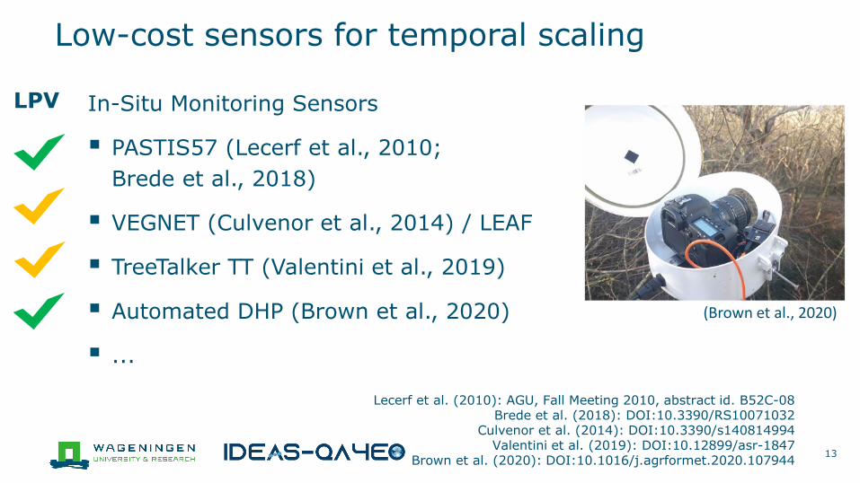
In-Situ Monitoring Sensors
PASTIS57 (Lecerf et al., 2010; Brede et al., 2018)
VEGNET (Culvenor et al., 2014) / LEAF
TreeTalker TT (Valentini et al., 2019)
Automated DHP (Brown et al., 2020)
...
Low-cost sensors for temporal scaling
13
Lecerf et al. (2010): AGU, Fall Meeting 2010, abstract id. B52C-08Brede et al. (2018): DOI:10.3390/RS10071032
Culvenor et al. (2014): DOI:10.3390/s140814994Valentini et al. (2019): DOI:10.12899/asr-1847
Brown et al. (2020): DOI:10.1016/j.agrformet.2020.107944
(Brown et al., 2020)
LPV

Low-cost sensors for temporal scaling
14
PiLAI 1.0 (Vellekoop 2019)
“Community” sensor:• open source/codes • Cost-effective components• DIY community supported
libraries• Use wireless network
technology (IoT)
• keep adoption thresholds low
Vellekoop (2019) https://edepot.wur.nl/517981
PiLAI 2.0 (concept)PiLAI 1.0 image & classification (Vellekoop 2019)

Low-cost sensors for temporal scaling
15
LEAF MkI - In-Situ Monitoring LiDAR
NIR-LiDAR (905 nm)
Comparable with ‘traditional’ methods?
Comparable with other LiDAR (e.g. RIEGL VZ-400 @ 1550 nm)?

Campaigns for site characterisation with TLS/UAV-LiDAR: use synergies with AGB
Intercomparisons: LiDAR vs “traditional” sensors
● LiDAR (UAV + IMS) vs traditional for forests
● Destructive measurements as “gold standard” (litter traps for deciduous forest/harvest for crops)
Intercomparisons: automated/low-costs vs traditional
Include time series parameters: biophysical-based phenology
Recommendations
16

Acknowledgements
IDEAS-QA4EO project under ESA contract
17
Take off! at Paracou, French Guiana
Announcement
IGARSS 2021:UAVs and low cost sensors for land calibration/validation