Tweed Development Control Plan · State Environmental Planning Policy Exempt and Complying...
16
Tweed Development Control Plan SECTION A1 – Residential and Tourist Development Code
Transcript of Tweed Development Control Plan · State Environmental Planning Policy Exempt and Complying...
Tweed Development Control Plan SECTION A1 – Residential and Tourist Development Code
2
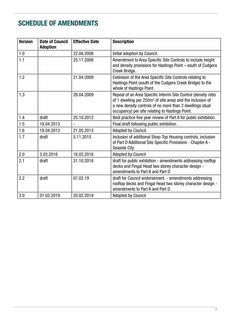
SCHEDULE OF AMENDMENTS
Version Date of Council Adoption
Effective Date Description
1.0 22.04.2008 Initial adoption by Council.1.1 25.11.2008 Amendment to Area Specific Site Controls to include height
and density provisions for Hastings Point – south of Cudgera Creek Bridge.
1.2 21.04.2009 Extension of the Area Specific Site Controls relating to Hastings Point (south of the Cudgera Creek Bridge) to the whole of Hastings Point.
1.3 28.04.2009 Repeal of an Area Specific Interim Site Control (density ratio of 1 dwelling per 250m2 of site area) and the inclusion of a new density controls of no more than 2 dwellings (dual occupancy) per site relating to Hastings Point.
1.4 draft 25.10.2012 Best practice five year review of Part A for public exhibition.1.5 18.04.2013 - Final draft following public exhibition.1.6 18.04.2013 21.05.2013 Adopted by Council.1.7 draft 5.11.2015 Inclusion of additional Shop-Top Housing controls, inclusion
of Part D Additional Site Specific Provisions - Chapter A - Seaside City
2.0 3.03.2016 16.03.2016 Adopted by Council2.1 draft 31.10.2018 draft for public exhibition - amendments addressing rooftop
decks and Fingal Head two storey character design - amendments to Part A and Part D
2.2 draft 07.02.19 draft for Council endorsement - amendments addressing rooftop decks and Fingal Head two storey character design - amendments to Part A and Part D
3.0 07.02.2019 20.02.2019 Adopted by Council
3
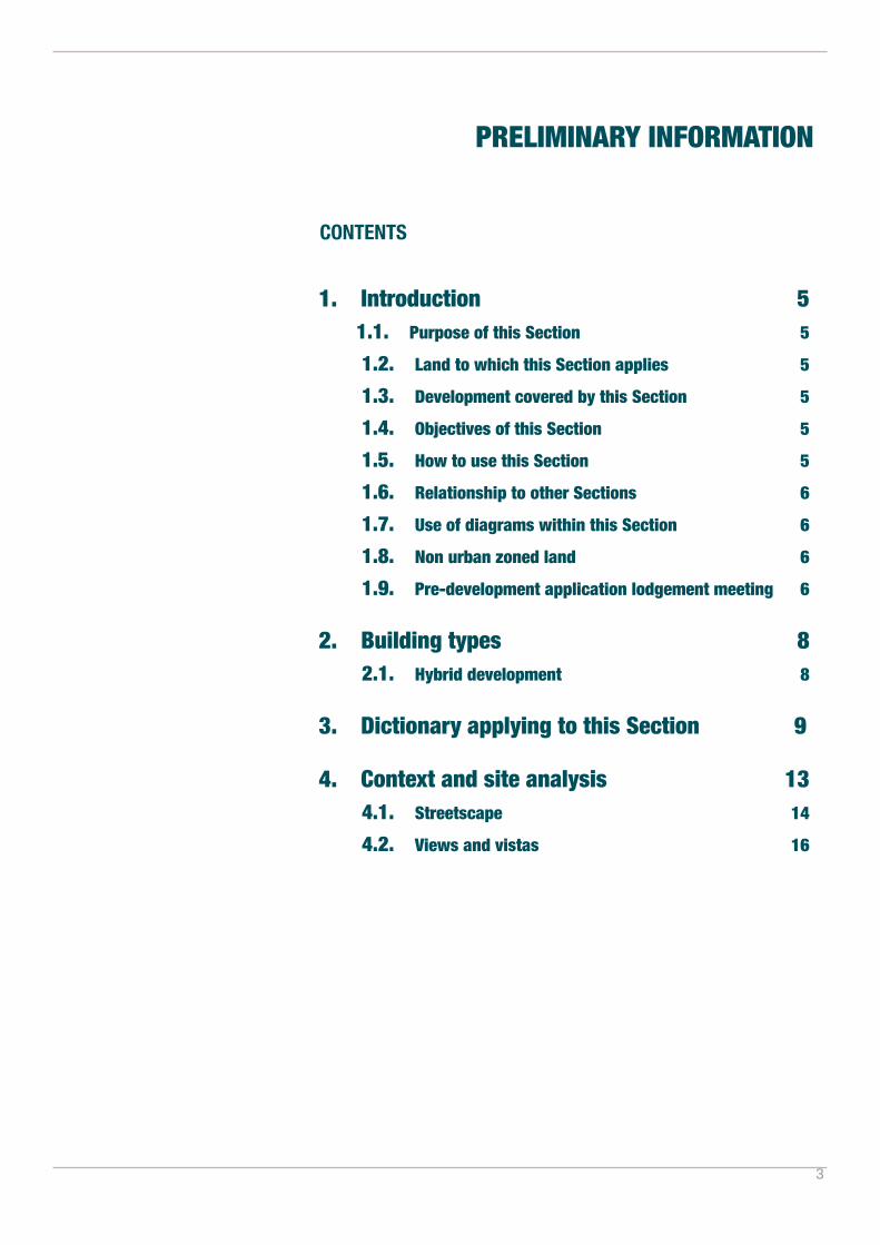
PRELIMINARY INFORMATION
CONTENTS
1. Introduction 5 1.1. Purpose of this Section 5
1.2. Land to which this Section applies 5
1.3. Development covered by this Section 5
1.4. Objectives of this Section 5
1.5. How to use this Section 5
1.6. Relationship to other Sections 6
1.7. Use of diagrams within this Section 6
1.8. Non urban zoned land 6
1.9. Pre-development application lodgement meeting 6
2. Building types 8 2.1. Hybrid development 8
3. Dictionary applying to this Section 9
4. Context and site analysis 13 4.1. Streetscape 14
4.2. Views and vistas 16
4
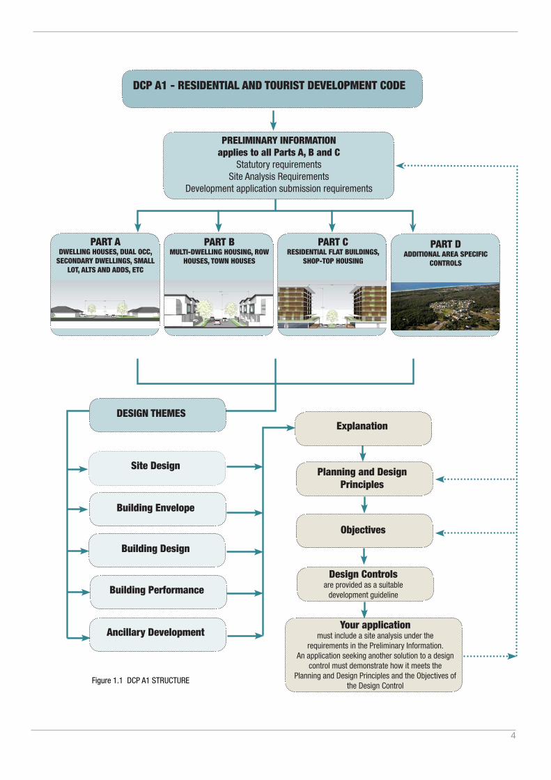
Figure 1.1 DCP A1 STRUCTURE
DCP A1 - RESIDENTIAL AND TOURIST DEVELOPMENT CODE
PRELIMINARY INFORMATION applies to all Parts A, B and C
Statutory requirementsSite Analysis Requirements
Development application submission requirements
Site Design
Building Envelope
Building Design
Building Performance
Ancillary Development
Explanation
Planning and Design Principles
Objectives
Design Controlsare provided as a suitable
development guideline
Your applicationmust include a site analysis under the
requirements in the Preliminary Information. An application seeking another solution to a design
control must demonstrate how it meets the Planning and Design Principles and the Objectives of
the Design Control
DESIGN THEMES
PART B MULTI-DWELLING HOUSING, ROW
HOUSES, TOWN HOUSES
PART A DWELLING HOUSES, DUAL OCC,
SECONDARY DWELLINGS, SMALL LOT, ALTS AND ADDS, ETC
PART C RESIDENTIAL FLAT BUILDINGS,
SHOP-TOP HOUSING
PART D ADDITIONAL AREA SPECIFIC
CONTROLS

5
1. Introduction
1.1. Purpose of this Section
The purpose of this Section is to guide the planning and design of residential and tourist development and development ancillary to residential and tourist development within Tweed Shire.
1.2. Land to which this Section applies
This Section applies to all residential and tourist development within the Tweed Shire, except to the extent of inconsistency with a development provision contained in the Tweed LEP or area specific locality development control plan in Section B.
1.3. Development covered by this Section
This Section is in several Parts and applies to all development associated with the following building types:
PART A applies to dwelling houses, alterations and additions to dwelling houses, dual occupancy, secondary dwellings, garages, carports, outbuildings, swimming pools and tennis courts.PART B applies to multi-dwelling housing and includes: town houses (including villas), and row housing (including terraces).PART C applies to residential flat buildings and includes: shop-top housing, shop-top residential flat buildings, and residential flat buildings. PART D applies to residential, tourist and visitor accomodation within specific areas
1.4. Objectives of this section
The over arching objectives of this section are:
1. Provide for a diversity of types and sizes of residential and tourist related development throughout localities;
2. Ensure that development is compatible with the local natural and built character, scale and amenity;
3. Ensure quality residential and tourist development which responds to the features of the site and the Tweed’s subtropical climate; and
4. Encourage development that incorporates the principles of sustainability in design, materials and lifecycle.
1.5. How to use this Section
The Residential and Tourism Development Code (‘the Code’) is divided into a number of Design Themes relating to the site context, the site, the building envelope controls, building design, building performance and ancillary development.Each Design Theme is structured to include:
• an explanation of the design criteria and why it is important the design criteria is considered and addressed;
• where relevant, over-arching planning and design principles;• a range of objectives to achieve desired outcomes; and• the design controls.
The design controls are a development guideline and represent a possible acceptable solution to meet the design theme objectives and planning and design principles. It is acknowledged that there may be other acceptable solutions. Where a development application seeks an alternative
PRELIMINARY
6
solution to a design control this must be documented within the Statement of Environmental Effects (SEE), and include:
• Identification of the design control being varied; and
• Justification, supported by a detailed site analysis:
- detailing why the design control cannot be met; and
- demonstrating how the alternate proposal achieves the design theme objectives and planning and design principles.
1.6. Relationship to other Sections
All proposals must be designed to meet the requirements of all other relevant Sections contained within this DCP.
1.7. Use of diagrams within this Section
Illustrations provided in this section are indicative only and are provided to illustrate certain aspects of the plan. The diagrams must not be interpreted, used, or referred to as any form of either prescriptive or performance based control.
1.8. Non urban zoned land
Development on non urban land shall not, for the purpose of this Section, be restricted to the deep soil zone, setback and carport, garages and outbuildings controls where it is demonstrated that compliance with a particular control would be unreasonable in the circumstances. A variation under this circumstance will not be required to comply with the requirements of the variation provision of this Plan.
1.9. Pre-development application lodgement meeting
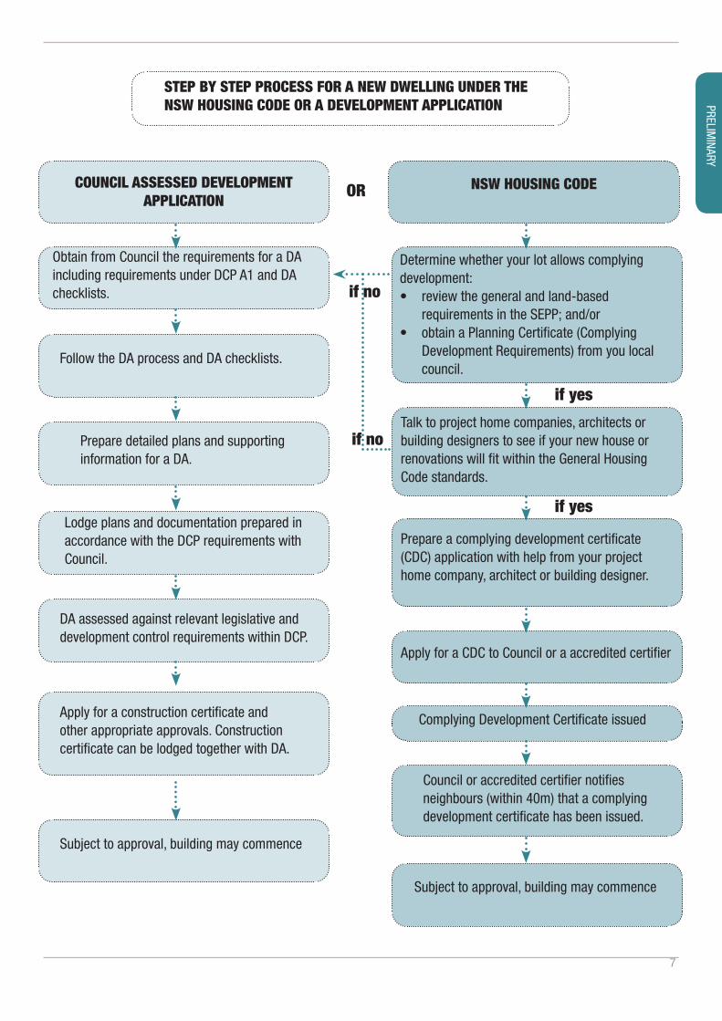
Applications for any development the subject of Part B or C of this Plan, comprising Residential Flat Buildings, Shop-top Housing, Town Housing, Row Housing or any one of these building types for tourist accommodation, that either includes a variation to a control or where the proponent perceives that a design issue may arise, is strongly recommended to arrange and attend a pre-development application lodgement meeting with Council’s Development Assessment Panel (DAP), prior to the lodgement of a development application. The recommended requirements for a pre-development application and development application submission are provided in Appendix 7.1 - Development application submission requirements.The matters arising from a DAP Meeting must be addressed in the development application statement of environmental effects under the heading “DAP – Matters Arising”.
Note: The “Development Application Guide” and a range of development application checklists are available on the Tweed Shire Council website at: http://www.tweed.nsw.gov.au/FormsCouncil encourages the electronic submission of information as outlined in the Development Application (DA) Checklist on Council’s website.The State Government’s State Environmental Planning Policy Exempt and Complying Development Codes (Housing Code SEPP) provides for a range of housing and ancillary development which may be carried out without a development application.Applicants are advised to consult the Housing Code SEPP to determine whether development requires a DA or can be undertaken as Complying development through a Complying development Certificate (CDC).This DCP Part does not apply to development undertaken as a CDC. CDC development is to comply with the Housing Code SEPP requirements.
Note: Addressing these criteria is not a mechanism for an automatic variation but rather a process for enabling an assessment of an alternate solution on its merit.
7
STEP BY STEP PROCESS FOR A NEW DWELLING UNDER THE NSW HOUSING CODE OR A DEVELOPMENT APPLICATION
COUNCIL ASSESSED DEVELOPMENT APPLICATION
OR
if no
if no
if yes
if yes
NSW HOUSING CODE
Determine whether your lot allows complying development:• review the general and land-based
requirements in the SEPP; and/or• obtain a Planning Certificate (Complying
Development Requirements) from you local council.
Talk to project home companies, architects or building designers to see if your new house or renovations will fit within the General Housing Code standards.
Prepare a complying development certificate (CDC) application with help from your project home company, architect or building designer.
Apply for a CDC to Council or a accredited certifier
Complying Development Certificate issued
Council or accredited certifier notifiesneighbours (within 40m) that a complyingdevelopment certificate has been issued.
Obtain from Council the requirements for a DA including requirements under DCP A1 and DA checklists.
Follow the DA process and DA checklists.
Prepare detailed plans and supporting information for a DA.
Lodge plans and documentation prepared in accordance with the DCP requirements with Council.
DA assessed against relevant legislative and development control requirements within DCP.
Apply for a construction certificate and other appropriate approvals. Construction certificate can be lodged together with DA.
Subject to approval, building may commence
Subject to approval, building may commence
PRELIMINARY
8
2. Building types
The Tweed Local Environmental Plan (LEP) defines the permissible uses within a zone.This DCP Section further refines the applicable development controls which may apply to those permitted residential and/or tourist development building types. A building type is used to describe building forms and site layouts with common characteristics. Building types are useful for coordinating the desired character of an area and to ensure buildings achieve dwelling, site and streetscape amenity. Building type is a tool used to ensure building and site design controls are coordinated to suit a range of common site and development types. Building types are important as they guide development to be more specific to the following conditions:
• the site size and allotment proportions;
• the relationship to existing built form, subdivision and block context;
• the relationship to the existing streetscape; and
• the site characteristics such as topography and vegetation.
The residential dwelling types identified in this Section are:• Dwelling Houses (Including ancillary structures) (Part A)
• Dual Occupancy, Secondary dwellings (Part A)
• Town Housing (including villas) (Part B)
• Row Housing (including terraces) (Part B)
• Residential flat buildings (Part C)
• Shop-top Housing (Part C)
2.1. Hybrid development
This plan encourages developments to be comprised of any combination of building types, where the zoning allows. This can occur on larger sites where a range of building types will be proposed or where the design of a building takes on the characteristics of two building types such as a residential flat building layout that is two storeys ie. a town house. In such cases and where it is unclear as to what controls to apply the development, the proponent must automatically work to the most stringent control. In the example above, the residential flat building controls, notwithstanding its two storey design, would apply. It may be at the discretion of Council’s Development Assessment Panel to advise when to use the less stringent controls; exercising its judgement based on the site and its particular circumstances.
Note: It is noted that the LEP provides a range of maximum development standards, including building height and floor space ratio.This DCP section does not seek to restrict development which may be permitted under the LEP. This DCP section does provide additional guidelines for various building types which may be permitted.
9
3. Dictionary
Access handle: a strip of land forming part of a site whether in fee-simple or right of way, which has the principle function of providing a property access.Amenity: the livability or quality of a place which makes it pleasant and agreeable to be in for individuals and the community. Amenity is gained from elements such as sunlight, views, privacy, ambiance and the like.ANEF contour: Has the same meaning as it has within the State Environmental Planning Policy (Exempt and Complying Development Codes) 2008. Reference is also made to Australian Standard AS2021 Acoustics - Aircraft noise intrusion – Building Siting and Design. Articulation Zone: Has the same meaning as it has within the State Environmental Planning Policy (Exempt and Complying Development Codes) 2008.Attached dual occupancy: means two dwelling-houses that are physically attached by way of a common or shared wall (between internal living areas) or garage but does not include carport, breezeway or the like, open or detachable structure.Balcony: an outdoor, open or partially enclosed area that is either partially integrated into or protrudes entirely from the outer enclosing walls of a building as a means of providing private open space.BASIX: introduced as part of the NSW planning system, BASIX (the Building Sustainability Index), is a web-based planning tool that measures the potential performance of new residential dwellings against sustainability indices.Battleaxe: Has the same meaning as within the State Environmental Planning Policy (Exempt and Complying Development Codes) 2008.Building envelope: a three dimensional zone determined by height, width, depth and setbacks that defines the buildable area on a site.Building elevation: the external wall of a building.Building footprint: is area of the building to the extent of the edge of the roof line.Circulation core: common areas within a development that provide pedestrian movement within the building.Climate: in the context of this Plan refers to the climatic zones attributed to the Tweed Shire LGA by the Bureau of Meteorology, comprising subtropical (warm humid) and temperate zones.Communal open space: a designated shared open space area available to the occupants of more than one residential / tourist dwelling and which is under the control of a body corporate or equivalent.Colonnade: a semi enclosed sidewalk (the pedestrian part of a public street) enclosing on the top and one side by buildings. The colonnade generally has columns that support the building over the sidewalk located between the sidewalk and the carriageway (the vehicular part of the street). DCP: refers to a Development Control Plan prepared in accordance with the Environmental Planning and Assessment Act 1979.
Note: Where a term is not defined, the DCP relies on the definitions within the applicable Tweed LEP.
PRELIMINARY
10
Deck: refers to an external platform, usually elevated, located alongside and accessible from an interior space.Deep Soil Zone: means that area of a site with no above ground level or subterranean development, including driveways, paved surfaces, pathways, or like surface, that serves principally for larger tree and landscape plantings.Demolition: refers to the damaging, defacing destruction, deconstruction, pulling-down, removal or the like of a building in whole or in part.Development: has the same meaning as it has in the Environmental Planning and Assessment Act 1979.Double loaded corridor: is a corridor in a Residential Flat Building with apartments on both sides. These buildings have most apartments with one orientation only.External living areas: External living area refers to an external space that extends the living and recreation space of a dwelling to provide private outdoor recreational and relaxation space. These spaces generally take the form of courtyards, decks, terraces and balconies, they can be paved or decked and may be covered. External living areas may be located either on ground or above ground.Floor Area: Has the same meaning as it has within the State Environmental Planning Policy (Exempt and Complying Development Codes) 2008.Front fences and walls: refers to fences and walls situated forward of the building façade or within the nominated front building line (setback), which ever is the greater, that are located on the site.Frontage or primary frontage: refers to the area of abutment between a boundary line between a site and a public street, and in the case of a multi-frontage site the boundary at which the property is addressed.Habitable room: Has the same meaning as the Building Code of Australia.Impervious area: means a surface area that does not allow rainwater to penetrate through into the underlying ground.Indigenous species: refers to a plant or animal species that occurs at a place within its historically known natural range and that forms part of the natural biological diversity of a place.Infill: Infill development is any allotment that is neighboured or adjoins a property that supports a building, including sites within new subdivisions, where that development has already occurred.Operable screening device: refers to sliding, folding or retractable elements on a building designed to provide shade, privacy and protection from natural elements.Outbuilding: Has the same meaning as it has within the State Environmental Planning Policy (Exempt and Complying Development Codes) 2008.Passive solar design: refers to a design or modification to a building to minimise energy consumption by taking advantage of natural heating and cooling methods.Rooftop terraces are defined as unenclosed spaces located above the upper storey of a building or within a building’s roof plane designed and used as private open space.

11
Secondary (road) street frontage: Has the same meaning as it has within the State Environmental Planning Policy (Exempt and Complying Development Codes) 2008.SEPP: refers to a State Environmental Planning Policy.Shadow diagram: refers to a plan illustrating the extent of shadow cast by a specified object or building at predetermined times of the day and year, and that are based on a longitude and Latitude for that site.Standard Instrument: means the standard local environmental planning instrument prescribed by the Standard Instrument (Local Environment Plans) Order 2006.Tweed LEP or TLEP: refers to the Tweed Local Environmental Plan.
PRELIMINARY
12
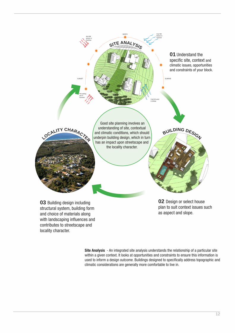
SITE ANALYSIS
Good site planning involves an understanding of site, contextual
and climatic conditions, which should underpin building design, which in turn has an impact upon streetscape and
the locality character.
02 Design or select house plan to suit context issues such as aspect and slope.
03 Building design including structural system, building form and choice of materials along with landscaping influences and contributes to streetscape and locality character.
BUILDING DESIGNLOCALITY CHARACTER
01 Understand the specific site, context and climatic issues, opportunities and constraints of your block.
Site Analysis - An integrated site analysis understands the relationship of a particular site within a given context. It looks at opportunities and constraints to ensure this information is used to inform a design outcome. Buildings designed to specifically address topographic and climatic considerations are generally more comfortable to live in.
SUNRISE
NORTH
SUNSET
Hot NW breeze in Summer
Hot setting sun in Summer
Cool NE breeze in Summer
Cold SE wind in Winter

13
4. Context and site analysis
The first step in good design is to understand the character and attributes of the site and the locality. Site analysis and design comprises two parts:
1. assessment of the site and locality and then,
2. developing or selecting a dwelling design that responds to the characteristics of the site and the locality, the opportunities, constraints, unique features or hazards of the site.
Examples of site analysis showing these two parts is provided in Appendix 7.2.Planning and design principlesBuildings designed to respond to a site and context demonstrate the following key principles:
P1. Demonstrates that the site analysis has been used in preparing or selecting the design for the site and that due consideration has been given to the opportunities and constraints of the site and its context.
P2. The design is climate appropriate and responsive.
P3. Respects the topography and landforms of the site and locality.
P4. Understands that each dwelling built within a street builds up the “character of the Tweed”.
P5. Values, protects and shares views and landscape vistas.
P6. Minimises issues relating to noise transfer, overshadowing and overlooking, safety, access, views and privacy.
Objectives
O1. Ensure the opportunities and constraints of a site and its surroundings are comprehensively considered and inform the proposed dwelling design or selection.
O2. Ensure that development embodies best practice site planning principles and makes a positive and harmonious contribution to its surroundings.
O3. Ensure the proposal results in a dwelling that is sensitive to its built and natural environment context, the unique features and hazards of the site and is of high design quality.
O4. Ensure that the dwelling is designed and sited appropriately for the Tweed’s temperate sub-tropical climate.
Controls
C1. A site analysis, including details as relevant but not limited to the criteria in the Site Analysis Checklist (Appendix 7.2) is required for all dwelling development applications involving external building work, and is to demonstrate how the proposed development responds to the site analysis. Minor development (such as extensions, minor renovations) may only require a partial site analysis for the affected area of the site.
PRELIMINARY
Note: Development that is designed to the site conditions greatly enhances the dwellings amenity, livability and general comfort. On a broader level understanding and responding to the site enhances the sense of place, reinforces the role and character of the Tweed localities, improves the quality of the environment for the community and ensures that the proposed development is the best possible solution and makes the best contribution to its surroundings. Development designed within this context is also cheaper to operate and maintain, reducing reliance on artificial lighting and mechanical heating and cooling.
Note: A site analysis template is available on Council’s website to assist in preparing the site analysis documentation.It is noted the degree of detail required will vary according to the nature, type and scale of the proposed development, its surroundings and potential amenity impacts.

14
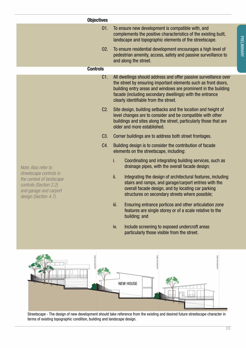
4.1. Streetscape
Designing and constructing a dwelling should not be considered in isolation of understanding the character of its locality. The context relates to those aspects of the urban environment which are enjoyed by the public and include neighbourhood character, streetscape character, public views and vistas.New developments, alterations and additions can contribute positively to the neighbourhood and streetscape character. In established residential areas it is important to recognise and respect the existing qualities and unique characteristics of the place. In locations where the character is either not well established or needs improvement, new development can contribute to strengthening and creating character.Building orientation is also a key aspect in ensuring that development responds to the streetscape, seeks to ensure privacy and outlook for dwellings and to protect the amenity of neighbouring dwellings. Planning and design principlesDwellings which create and contribute positively to streetscape character demonstrate the following key principles:
P1. Dwellings ‘sit’ comfortably within the streetscape by way of integrating design with topography and establishing a strong and engaging address to the street.
P2. Understand and address the relationship between street width and streetscape scale with an appropriate dwelling form and scale.
P3. Understand and respond to the characteristics of existing dwellings within the street including built form rhythm, setbacks, roof forms, materials, point of access, driveway design and prominence of garaging.
P4. In existing residential areas the established orientation of dwellings is to the front and the rear of lots. It is important that new or infill development respects and integrates within this pattern so as to fit within the established context.
P5. Consider the form and impact of the new dwellings size and shape, elevations, setbacks, height, and roof within the streetscape and on the adjoining properties.
P6. Consider the internal and planning to promote spaces and decks that overlook and are orientated towards the street providing a strong street address and passive surveillance opportunity.
P7. Consider the relationship of the dwelling and its yard spaces within the streetscape to ensure a positive contribution of dwelling house and garden materials, front and side fencing and landscaping to the street.
Note: Streetscape refers to the spatial arrangement, extent and appearance of elements within a street, which includes some elements on private properties adjoining the street. Streetscape design seeks to ensure there is consistency in the built and landscape form along streets on private sites, ensure that dwellings and their gardens relate well to each other and to the landscape setting along the street and that residential development integrates with and contributes to the streetscape character.
15
Objectives
O1. To ensure new development is compatible with, and complements the positive characteristics of the existing built, landscape and topographic elements of the streetscape.
O2. To ensure residential development encourages a high level of pedestrian amenity, access, safety and passive surveillance to and along the street.
Controls
C1. All dwellings should address and offer passive surveillance over the street by ensuring important elements such as front doors, building entry areas and windows are prominent in the building facade (including secondary dwellings) with the entrance clearly identifiable from the street.
C2. Site design, building setbacks and the location and height of level changes are to consider and be compatible with other buildings and sites along the street, particularly those that are older and more established.
C3. Corner buildings are to address both street frontages.
C4. Building design is to consider the contribution of facade elements on the streetscape, including:
i. Coordinating and integrating building services, such as drainage pipes, with the overall facade design;
ii. Integrating the design of architectural features, including stairs and ramps, and garage/carport entries with the overall facade design, and by locating car parking structures on secondary streets where possible;
iii. Ensuring entrance porticos and other articulation zone features are single storey or of a scale relative to the building; and
iv. Include screening to exposed undercroft areas particularly those visible from the street.
Streetscape - The design of new development should take reference from the existing and desired future streetscape character in terms of existing topographic condition, building and landscape design.
SIDE BO
UN
DAR
Y
SIDE BO
UN
DAR
Y
SIDE BO
UN
DAR
Y
NEW HOUSE
Note: Also refer to streetscape controls in the context of landscape controls (Section 2.2) and garage and carport design (Section 4.7).
PRELIMINARY
16
4.2. Views and vistas
The wide mountain and river panoramas of Tweed are an integral part of the Tweed character and highly valued by the community. The Tweed Green Cauldron (the Mt Warning Caldera) is recognised by the Australian Government as a ‘National Iconic Landscape’. It is essential that these iconic views and vistas are protected.Public views and vistas are enjoyed from public places such as foreshores, parks and along streets. Views are generally contained by buildings in the streetscape, such as view corridors down a residential street. Vistas are long wide views, generally across a locality. Vistas are generally defined by ridgelines and valleys.View sharing is achieved where new dwellings, alterations and additions are designed so as to achieve views whilst retaining the private views enjoyed from existing dwellings on neighbouring sites. Objectives
O1. To ensure existing public views and vistas particularly those of important natural features such as ridgelines, water or bushland, are retained in so far as it is practical to do so.
O2. To ensure public view corridors, particularly those down streets and between buildings, are not unnecessarily reduced or obliterated.
O3. To ensure public views of important public places or buildings are protected.
O4. To protect the iconic scenic landscapes of the Tweed.
O5. To have regard to the “Tweed Scenic Landscape Evaluation”.
O6. To ensure dwellings respect important views from living areas and rooms within existing neighbouring dwellings and employs the principles of view sharing.
Controls
C1. Building siting and height is, as far as it is practical, to be designed to minimise the impact on views from surrounding properties, and follow the Planning Principles (refer note) of view sharing between properties.
C2. The location and height of new development is not to significantly diminish the public views to heritage items, dominant landmarks, public buildings from public places or unreasonably obscure public district views of major natural features such as the water, ridgelines or bushland.*
Note: *A scenic impact assessment may be required where development intrudes within scenic landscape vistas.Also refer to Planning Principles relating to view sharing and assessment of view impact which can be accessed at:http://www.lawlink.nsw.gov.au/lawlink/lec/ll_lec.nsf/pages/LEC_planningprinciples
Note: The “Tweed Scenic Landscape Evaluation” is available on Council’s website