Tunks Park, Cammeray Civil Engineering Report · Taylor Thomson Whitting (NSW) Pty Ltd, Consulting...
22
Taylor Thomson Whitting (NSW) Pty Ltd, Consulting Engineers | ABN 81 113 578 377 48 Chandos Street, St Leonards NSW 2065 | +612 9439 7288 | ttw.com.au Tunks Park, Cammeray Civil Engineering Report Prepared for EP (NSW) / 30 May 2018 TTW Job No: 171071 Document No: TTW-CV-RP01 Version: 1, Version Date: 05/09/2018 Document Set ID: 7543837
Transcript of Tunks Park, Cammeray Civil Engineering Report · Taylor Thomson Whitting (NSW) Pty Ltd, Consulting...

Taylor Thomson Whitting (NSW) Pty Ltd, Consulting Engineers | ABN 81 113 578 377 48 Chandos Street, St Leonards NSW 2065 | +612 9439 7288 | ttw.com.au
Tunks Park, Cammeray
Civil Engineering Report
Prepared for EP (NSW) / 30 May 2018
TTW Job No: 171071
Document No: TTW-CV-RP01
Version: 1, Version Date: 05/09/2018Document Set ID: 7543837

Tunks Park 171071 Civil Engineering Report 30.05.18
Taylor Thomson Whitting (NSW) Pty Ltd 1 (Copyright 2016)
DOCUMENT REGISTER
PREPARED BY APPROVED BY STATUS ISSUE DATE
Kelvin Holey Paul Yannoulatos Review P1 30.05.18
Version: 1, Version Date: 05/09/2018Document Set ID: 7543837

Tunks Park 171071 Civil Engineering Report 30.05.18
Taylor Thomson Whitting (NSW) Pty Ltd 2 (Copyright 2016)
Contents
1.0 Executive Summary ............................................................................................... 1
2.0 Introduction ............................................................................................................ 1
2.1 The Park ................................................................................................................... 1
3.0 Existing Site ........................................................................................................... 3
3.1 Existing Services ...................................................................................................... 3
3.2 Existing Stormwater ................................................................................................. 4
3.3 Tidal Influences ........................................................................................................ 4
3.4 Climate change / storm surge .................................................................................. 6
3.5 Salinity / Contamination ........................................................................................... 7
3.6 Geological conditions ............................................................................................... 7
3.7 Bushfire .................................................................................................................... 8
4.0 Stormwater Design ................................................................................................ 9
4.1 Hydrology ................................................................................................................. 9
4.2 Hydraulics ............................................................................................................... 10
4.3 Environmental Flows and Onsite Stormwater Detention (OSD) ............................ 11
4.4 Flooding and Climate Change ............................................................................... 11
4.5 Water Sensitive Urban Design (WSUD) ................................................................ 12
4.6 Overland flow ......................................................................................................... 13
4.7 Stormwater Quality ................................................................................................. 13
4.8 Erosion and Sediment Control ............................................................................... 14
4.9 Riparian Zone and Watercourses .......................................................................... 14
5.0 Future Design ....................................................................................................... 15
5.1 Pavement Design ................................................................................................... 15
5.2 Existing Creek ........................................................................................................ 15
6.0 Vehicle Site Access ............................................................................................. 16
6.1 Maintenance ........................................................................................................... 16
6.2 Bush Fire and Ambulance Access ......................................................................... 17
6.3 Oval Use ................................................................................................................. 17
Version: 1, Version Date: 05/09/2018Document Set ID: 7543837

Tunks Park 171071 Civil Engineering Report 30.05.18
Taylor Thomson Whitting (NSW) Pty Ltd (Copyright 2016)
1.0 Executive Summary
This report has been prepared by Taylor Thomson Whitting (TTW) to support the Tunks Park Plan of Management. The Plan of Management is intended to establish an overall vision for the park and to set out how the park will be used and managed by Council for the next five to ten years.
The aim of this report is to provide the following:
� Review and investigate the Water Sensitive Urban Design including stormwater and flooding,
� Identify existing issues in relation to geotechnical and contamination issues around the park.
� Propose potential strategies to mitigate these issues with consideration to the constraints of the park.
This report relates to civil elements and constraints for Tunks Park, Cammeray.
This report will review the civil engineering issues such as: stormwater, earthworks, contamination, and overland flow.
The key issues to be discussed include:
� Flooding and stormwater controls,
� Stormwater Quality, and
� Geotechnical and contamination ground conditions.
2.0 Introduction
Tunks Park, Cammeray is located on the lowest reach of Flat Rock Creek which flows into Middle Harbour.
The park is within North Sydney Council’s Local Government Area (LGA). The embankment on the northern side of the park is located within Willoughby Council’s LGA. The LGA boundary is also the separation of Cammeray and Northbridge suburbs.
2.1 The Park
The park has an area of approximately 7Ha, this includes ovals, parking, the boat ramp, and excludes bush land. The ovals are generally flat but there is fall towards Long Bay of Middle Harbour. There are two existing buildings located on the south side of the site between the oval and the bushland embankment. One building is a canteen and the other is toilets with change rooms and storage. There is a further small storage building on the north side of the oval towards the rear of the ovals.
Flat Rock Creek flows from west to east and has a catchment of about 5km2 over a distance of 4km. Flat Rock Creek continues under Tunks Park ovals in six concrete box culverts which are about 20m wide. Service information indicates the culverts are 3070m wide x 2150 high
Access to Tunks Park is from the main arterial road of Miller Street/Strathallen Avenue and then via residential streets: Lower Cliff Ave, Brothers Ave, Vernon St, and The Boulevarde.
Traversing through the middle of the oval, from north to south, is a heritage listed, suspended concrete Sydney Water sewerage aqueduct. The aqueduct is about 5m above the field level, supported on four abutments which have two piers each abutment.
Close to the water is a carpark which includes boat trailer parking for users of the park and boat ramp.
Version: 1, Version Date: 05/09/2018Document Set ID: 7543837
Tunks Park 171071 Civil Engineering Report 30.05.18
Taylor Thomson Whitting (NSW) Pty Ltd (Copyright 2016)
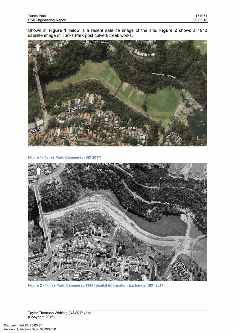
Shown in Figure 1 below is a recent satellite image of the site. Figure 2 shows a 1943 satellite image of Tunks Park post culvert/creek works.
Figure 1- Tunks Park, Cammeray (SIX 2017)
Figure 2 - Tunks Park, Cammeray 1943 (Spatial Information Exchange (SIX) 2017)
NORTH
NORTH
Version: 1, Version Date: 05/09/2018Document Set ID: 7543837

Tunks Park 171071 Civil Engineering Report 30.05.18
Taylor Thomson Whitting (NSW) Pty Ltd (Copyright 2016)
3.0 Existing Site
3.1 Existing Services
Other than the underground culverts and aqueduct, Tunks Park is relatively unencumbered.
Existing services have been investigated through Dial Before You Dig. Service diagrams indicate some stormwater drainage (pits and pipes) in the carpark; a 750mm diameter sewer line runs from the toilet/canteen buildings towards Brothers Avenue and heads south. Ausgrid has an underground power supply on the northern edge of Tunks Park, which runs for the full length. There are no communication or gas services known to exist in the park. Refer diagrams below showing locations of existing services. Sydney Water did not indicate water supply services even though the amenities and canteen buildings, as well as park bubblers indicate there is water supply. The ovals do have field irrigation.
The Northside sewer Storage Tunnel has an overflow point at Tunks Park.
Additional services investigation will be required for any future development.
Figure 3 - Ausgrid cables traverse on the north side of the Park
Figure 4 - Sydney Water aqueduct and southern oval sewer main
Version: 1, Version Date: 05/09/2018Document Set ID: 7543837

Tunks Park 171071 Civil Engineering Report 30.05.18
Taylor Thomson Whitting (NSW) Pty Ltd (Copyright 2016)
3.2 Existing Stormwater
The existing oval buildings roofs collect stormwater and convey the flows to the culverts. The carpark and access road surfaces collect stormwater in pits and convey the flows to the culvert or to the Harbour via two stormwater pipe connections. Figure 5 below shows North Sydney Council stormwater assets.
The culverts convey Flat Rock Creek flows to the harbour. The tide heights affect Flat Rock Creek about 1km upstream.
Figure 5 - North Sydney Council stormwater services
3.3 Tidal Influences
Tunks Park ovals, Flat Rock Creek, including the underground culverts, are affected by tides. The tides affect Flat Rock Creek for a distance of about 1km upstream. During perigean spring tide events, tidal heights around RL2.00 (LAT - Lowest Astronomical Tide datum) (RL1.1 AHD) will cause inundation of the carpark and low lying oval areas. Photos from the high spring tide event on 3/01/2018 around the 9:56am peak, are provided below (permission to include photos in this report has been received from photographer Ronwyn North).
Tide heights have been shown in Figure 6 for reference to the high spring tide event.
Figure 6 – Tide calendar reference (www.rms.nsw.gov.au/documents/maritime/usingwaterways/tides-weather/tide-tables-2017-2018.pdf)
Version: 1, Version Date: 05/09/2018Document Set ID: 7543837

Tunks Park 171071 Civil Engineering Report 30.05.18
Taylor Thomson Whitting (NSW) Pty Ltd (Copyright 2016)
Figure 7 - High spring tide across the carpark (Image permission R North)
Figure 8 - High spring tide above harbour walk (Image permission R North)
Version: 1, Version Date: 05/09/2018Document Set ID: 7543837

Tunks Park 171071 Civil Engineering Report 30.05.18
Taylor Thomson Whitting (NSW) Pty Ltd (Copyright 2016)
Figure 9 - High spring tide sea water back flowing into oval swale (Image permission R North)
3.4 Climate change / storm surge
The Intergovernmental Panel on Climate Change (IPCC) (Fourth assessment Climate Change 2007) has indicated that sea levels will rise in the range of 0.18m to 0.58m by 2100. Increase in sea level rise coupled with high tides will lead to more occasions of inundation and closure of ovals. Impact on the car park, boat ramp, and pedestrian paths will be impacted as well.
As climate change contributes to increased frequency and the intensity of storm events, coupled with rising sea levels, Tunks Park’s availability will be further impacted.
Version: 1, Version Date: 05/09/2018Document Set ID: 7543837

Tunks Park 171071 Civil Engineering Report 30.05.18
Taylor Thomson Whitting (NSW) Pty Ltd (Copyright 2016)
3.5 Salinity / Contamination
Flat Rock Creek interface with Long Bay Middle Harbour was filled to create the ovals circa 1950. It is understood that mudflat silt was used as filling material with reports that some material was building landfill and what is now categorised as General Solid Waste; refer to figure 9 for soils description.
Due to proximity to Middle Harbour with a high water table (relevant to surface levels), with the occasional tidal and storm surge inundation, dry land salinity is relevant. A salinity management plan will be required for future development.
It is likely the oval is contaminated with variable fill and other contaminants. Further environmental testing is required for future development including the production of a Remediation Action Plan (RAP) to deal with contamination should any be found.
Flat Rock Creek culvert is currently silted limiting fish breeding, as well as capturing pollutants from creek flows. The captured pollutants that are not washed into Middle Harbour or degraded are likely to be stored in the benthos layers posing risk flora and fauna as well the public that interact with creek water.
3.6 Geological conditions
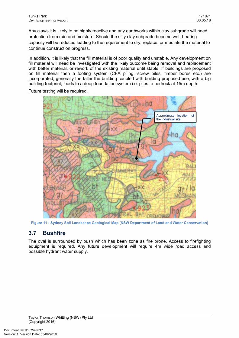
Based on Sydney Soil Landscape Geological Map (NSW Department of Land and Water Conservation), Map can be seen in Figure 11. Sydney Soil map categorises the oval as disturbed land, refer to Figure 10 for the soils description.
Figure 10 - Sydney Soil Landscape Geological Map soil description
As the fill is likely to be variable, to varying depths, future building works are likely to need piled foundation systems.
Sandstone rock outcrops can be seen around the oval, with the depth to rock at the maximum along the former creek alignment.
Further, it is expected the site is fill material is founded over sand/silty clay, over sandstone bedrock improving strength with depth.
Possible batters for work in cutting these materials are given in Table 1.
Table 1 - Minimum Temporary Batter Slopes (Argus 2011)
Material Temporary (H:V)
Sandy silt 3.0:1.0
Very Stiff/ Hard Silty Clay 2.0:1.0
Distinctly Weathered Sandstone 1.0:1.0
Slightly weathered Sandstone or better 0.5:1.0
Version: 1, Version Date: 05/09/2018Document Set ID: 7543837
Tunks Park 171071 Civil Engineering Report 30.05.18
Taylor Thomson Whitting (NSW) Pty Ltd (Copyright 2016)
Any clay/silt is likely to be highly reactive and any earthworks within clay subgrade will need
protection from rain and moisture. Should the silty clay subgrade become wet, bearing
capacity will be reduced leading to the requirement to dry, replace, or mediate the material to
continue construction progress.
In addition, it is likely that the fill material is of poor quality and unstable. Any development on fill material will need be investigated with the likely outcome being removal and replacement with better material, or rework of the existing material until stable. If buildings are proposed on fill material then a footing system (CFA piling, screw piles, timber bores etc.) are incorporated; generally the taller the building coupled with building proposed use, with a big building footprint, leads to a deep foundation system i.e. piles to bedrock at 15m depth.
Future testing will be required.
Figure 11 - Sydney Soil Landscape Geological Map (NSW Department of Land and Water Conservation)
3.7 Bushfire
The oval is surrounded by bush which has been zone as fire prone. Access to firefighting equipment is required. Any future development will require 4m wide road access and possible hydrant water supply.
Approximate location of the industrial site
Version: 1, Version Date: 05/09/2018Document Set ID: 7543837

Tunks Park 171071 Civil Engineering Report 30.05.18
Taylor Thomson Whitting (NSW) Pty Ltd (Copyright 2016)
4.0 Stormwater Design
In general, any new building works, roof stormwater will need to be collected in roof gutters and downpipes and conveyed to the in-ground pipe system. Surface stormwater will be collected in pits. The in-ground stormwater should be connected to Stormwater Quality Improvement Devices (SQIDs) prior to discharge into the Harbour or Flat Rock Creek.
There is no expectation to modify the existing culverts under the oval. The culvert entry should be improved to benefit fish breeding as per the current intention.
4.1 Hydrology
The volume of rain is dependent on the storm duration and storm intensity. Storm duration and intensity data has been obtained from the Bureau of Metrology and can be seen below in Figure 12 and Table 2. This data is used to determine pipe capacities, overland flow rates, and OSD tank volumes.
Figure 12 - Intensity Frequency Duration chart
Version: 1, Version Date: 05/09/2018Document Set ID: 7543837

Tunks Park 171071 Civil Engineering Report 30.05.18
Taylor Thomson Whitting (NSW) Pty Ltd (Copyright 2016)
Table 2 - Intensity Frequency Duration table
4.2 Hydraulics
Any new pipes and pits will need to be designed to satisfy the minimum provisions of AS 3500.2. They should be designed to convey, at least, the 5% Annual Exceedance Probability (AEP) flows.
Pipes 225mm diameter and greater must be class 2 concrete or better, laid at a desirable minimum fall of 1 in 100. As subsidence from the variable nature of the oval fill, slip joint pipes is recommended. Pipes within road ways or affected by service vehicle loads should be class 4.
Where pipe capacity is exceeded i.e. greater than 5% AEP, stormwater will need to be conveyed as overland flow. Overland flow paths are to be designed to convey at the minimum 1%AEP stormwater flows.
New building downpipes will be connected to surface pits. Between the base of downpipe and the top of the in-ground pit it is recommend there be an air void of about 50mm. The air void is to prevent the downpipes surcharging into the building should the in-ground drainage block and also to make any maintenance and access easier.
Version: 1, Version Date: 05/09/2018Document Set ID: 7543837

Tunks Park 171071 Civil Engineering Report 30.05.18
Taylor Thomson Whitting (NSW) Pty Ltd (Copyright 2016)
4.3 Environmental Flows and Onsite Stormwater Detention (OSD)
Catchment management is required to be in accordance with North Sydney Council’s Development Control Plan and Australian Rainfall and Runoff publications.
In addition, due to urbanisation or the replacing of permeable areas with hardstand (roof areas, pavements), stormwater runoff times are reduced which equates to the downstream catchment receiving stormwater sooner thus increasing flooding risk. Usually to remove this risk, slowing down of hard stand surfaces flow is required by the incorporation of Onsite Stormwater Detention. However, due to proximity to the receiving waters of Middle Harbour, stormwater attenuation for any new development at this oval will not mitigate flooding and is unlikely to be necessary.
To protect the downstream ecosystems from pollution, pollution control and pollutant removal is required to be provided. The Stormwater Quality Improvement Devices (SQIDs) should meet or exceed NorBen (Neutral or Beneficial) and Council pollutant removal rates.
4.4 Flooding and Climate Change
During storm events in the Flat Rock Creek catchment, water is conveyed to Middle Harbour under Tunks Park oval in six concrete box culverts. In large storm events, water can overtop the culverts and flow across the oval
Lyall & Associates on behalf of Willoughby Council has produced a draft flood study (Flat Rock Creek Catchment Flood Study and Overland Flow Mapping (Draft for Public Exhibition), June 2017). This draft report indicates that the oval is flood affected in most storms, with around 1m water depth in the 1% Annual Exceedance Probability (AEP) storm event. The draft flood report is found https://www.haveyoursaywilloughby.com.au/flat-rock-creek-flood-study/documents (last accessed 29/05/2018).
The Lyall & Associates flood extent is shown in Figure 13 below. North Sydney Council LGA Flood Study indicates similar levels of flooding for the 1% AEP storm event. The 1% AEP flood map is shown in Appendix A.
Flooding will impact the design of new buildings, as well as for infrastructure like substations. Flood levels need to be taken into consideration for setting of floor levels as well as the incorporation of appropriate freeboard.
Flood events coupled with: sea levels rise, storm surge, and high tides will impact the park leading to field, recreation, and parking area inaccessibility as well as oval use restrictions due to field condition.
Version: 1, Version Date: 05/09/2018Document Set ID: 7543837

Tunks Park 171071 Civil Engineering Report 30.05.18
Taylor Thomson Whitting (NSW) Pty Ltd (Copyright 2016)
Figure 13 - Flat Rock Creek 1% Flood Depth (Lyall & Associates 2017)
4.5 Water Sensitive Urban Design (WSUD)
Water Sensitive Urban Design includes water reuse, pollutant removal via natural systems, and the minimisation of hard structures to control stormwater and improve environmental, aesthetic, and recreational appeal.
Where open space exists, an attempt to incorporate WSUD principles into the stormwater design. Although, as standing water poses waterborne health risk, careful attention to the WSUD type and how it is incorporated is required.
Tunks Park has opportunities for the incorporation of WSUD which includes bioretention swales and basins which can be incorporated into landscaped outcomes as well as the use of salt tolerant vegetation for tidal flushing.
At the end of the Flat Rock Creek open channel is a Council designated fish breeding area. This area has been silted up restricting fish mitigation, breeding, as well as the influence of tidal flushing. At present, due to water depth, this area is accessible and used for recreation further impacting on plant and animal ecology. Figure 14 below shows the current state of the fish breeding area.
Tunks Park
Version: 1, Version Date: 05/09/2018Document Set ID: 7543837

Tunks Park 171071 Civil Engineering Report 30.05.18
Taylor Thomson Whitting (NSW) Pty Ltd (Copyright 2016)
Figure 14 - Existing Fish Breeding Area
4.6 Overland flow
In the event that the piped in-ground stormwater system fails due to blockage, obstruction, or insufficient capacity, stormwater flow will be required to be conveyed as overland flow. The overland flow is to be directed through Tunks Park and towards Middle Harbour. The carpark location is found in the direct path of stormwater overland flow from Flat Rock Creek posing a safety risk to users of the carpark, boat ramp, and other facilities in this area during flood events.
Overland flow paths for any new development will need to be sized to accommodate at least the 1%AEP storm flows.
Figure 15 shows a picture of the end of Flat Rock Creek and the start of the culvert system.
4.7 Stormwater Quality
The oval does not appear to have any water quality devices for collection of pollutants prior to discharge to the harbour.
Stormwater discharged from the development will be treated in accordance with North Sydney Council policy. The site stormwater will pass through suitable pollution control devices to achieve the required water quality removal rates. All inlet pits should have litter screens / traps.
The pollution control devices will require on-going maintenance. Pollutant removal devices will require at least a yearly inspection and maintenance.
Version: 1, Version Date: 05/09/2018Document Set ID: 7543837

Tunks Park 171071 Civil Engineering Report 30.05.18
Taylor Thomson Whitting (NSW) Pty Ltd (Copyright 2016)
Figure 15 - Flat Rock Creek Culvert Entry
4.8 Erosion and Sediment Control
During construction and while the site is disturbed, erosion prevention and sediment control measures will be required. Erosion prevention generally involves managing stormwater by diverting overland flow around construction areas as well as collecting stormwater within the construction zone and directing to sediment control devices. Devices likely to be incorporated are: silt removal like fences, hay bales, and grass lined swales; water flow dissipation and discharge control devices such as sand bags, pollution mattresses, and basins.
Erosion prevention and sediment removal strategies need to be inspected regularly during service and construction works, cleaned and maintained after storm events, and modified to suit construction work progress, decanting and demolition.
Erosion and sediment control is to be provided in accordance with Urban NSW’s publication Managing Urban Stormwater: Soils and Construction by the NSW Department of Housing.
4.9 Riparian Zone and Watercourses
NSW Department of Primary Industries (Water) have proximity restrictions to Riparian zones and watercourses which can be seen in Figure 16.
Version: 1, Version Date: 05/09/2018Document Set ID: 7543837

Tunks Park 171071 Civil Engineering Report 30.05.18
Taylor Thomson Whitting (NSW) Pty Ltd (Copyright 2016)
Figure 16 - Riparian Corridor
Development setbacks to Flat Rock Creek and Middle Harbour are applicable for any future development.
5.0 Future Design
5.1 Pavement Design
Existing pavements will be retained where possible for traffic loading, with re-construction of existing surfaces likely to be required where deterioration is evident. Access roads may need to be upgraded to a new wearing surface.
Any new on-grade carpark is likely to be constructed from asphalt.
Table 3 - Preliminary Pavement Design (1x10⁵ ESAs)
Pavement options based on a 5% CBR for car loading only
Typical flexible pavement would include: Concrete pavement option would be:
40mm thick asphalt on
120mm thick densely graded base on
120mm thick densely graded subbase on proof rolled subgrade
170mm thick 32MPa concrete with SL82 mesh on
100mm thick densely graded base on proof rolled subgrade
Additional subgrade testing will be required to determine that 5% CBR is achievable under any existing buildings.
Should low strength materials be found after demolition and excavation, stabilisation (cement) or material replacement will be required to improve the subgrade bearing capacity.
5.2 Existing Creek
Any new building/structure work will require geotechnical investigation to determine the ground conditions. As we are adjacent to a watercourse the ground conditions are likely to consist of variable fill and soft alluvial material unsuitable for direct bearing. Any construction over variable fill or alluvial material may require suspension with supports outside the alluvial zone, or supports deeper enough to bear on suitable strength bedrock.
Version: 1, Version Date: 05/09/2018Document Set ID: 7543837

Tunks Park 171071 Civil Engineering Report 30.05.18
Taylor Thomson Whitting (NSW) Pty Ltd (Copyright 2016)
6.0 Vehicle Site Access
Access to the site is via residential streets that typically have a speed limit of 50 km/h. Large
vehicles such as semi-trailers will be limited due surface road geometry and widths.
6.1 Maintenance
Oval maintenance vehicles will access the fields via a dedicated driveway off the access
road. The road needs to be able to accommodate heavy ridged vehicles for maintenance,
especially for clean out of the fish breeding zone. Small service vehicle access for Sydney
Water vehicles will be required for the aqueduct as well to other services located within the
park. The existing oval access is shown in Figure 17.
Figure 17 - Existing Oval Access
The existing path that runs through the site has sufficient width and should be able to
accommodate small vehicles as they will visit site irregular. Regular larger vehicles may
cause damage to the existing path.
The existing aqueduct and park path is shown in Figure 18.
Version: 1, Version Date: 05/09/2018Document Set ID: 7543837

Tunks Park 171071 Civil Engineering Report 30.05.18
Taylor Thomson Whitting (NSW) Pty Ltd (Copyright 2016)
Figure 18 - Existing Aqueduct and Park Path
6.2 Bush Fire and Ambulance Access
Access for fire trucks and ambulances is required. NSW Fire and Rescue guidelines
indicates that roads are required to be suitable for all weather access which is 4m wide with
6m zones for set down of vehicle outriggers.
6.3 Oval Use
In the event that Tunks Park is used for fairs, festivals, carnivals, sporting presentations, etc.,
where large vehicles are required to come onto the oval to setup, there will be restriction of
the size of the vehicles due to having to negotiate the residential streets including steep road
gradients down to the oval level. Further, there are height restrictions for vehicles passing
under the aqueduct. In addition, there may be restrictions to the culverts from certain vehicle
loads as well as limitations with loads on the culverts due cranes, rides, or other situations of
a similar nature.
It should be noted that due to the variable ground conditions, amusement rides and other
structures will similar point loads need to be founded on stable ground.
Version: 1, Version Date: 05/09/2018Document Set ID: 7543837

Tunks Park 171071 Civil Engineering Report 30.05.18
Taylor Thomson Whitting (NSW) Pty Ltd (Copyright 2016)
Appendix A – North Sydney Council LGA Flood study 1% AEP
Version: 1, Version Date: 05/09/2018Document Set ID: 7543837

!
!
!
FIGURE 14
RESULTS LAYOUT
J:\
Jo
bs\1
14
03
5\A
rcG
IS\A
rcM
ap
s\R
ep
ort
\Dra
ftR
ep
ort
\Fig
ure
_1
4_
Re
su
lts_
La
yo
ut.
mxd
0 500 1,000 1,500250m
Study Area
Stage Hydrograph Locations
! Cammeray Rd
! Ernest St
! Miller St
Peak Flood Level Profile Locations
Anderson Park Branch
Milson Park Branch
1% AEP Extent
´
Version: 1, Version Date: 05/09/2018Document Set ID: 7543837