Tsunami Mock Drill (IOWave16) Manual -...
56
a Tsunami Mock Drill (IOWave16) Manual Indian Tsunami Early Warning Centre ESSO - Indian National Centre for Ocean Information Services (INCOIS) (Ministry of Earth Sciences, Govt. of India) “Ocean Valley” Pragathi Nagar (B.O), Nizampet (S.O) Hyderabad – 500 090 Tel : 040 23895011 Fax: 040 23895012 Email: [email protected] IOWave16
Transcript of Tsunami Mock Drill (IOWave16) Manual -...

a
Tsunami Mock Drill (IOWave16) Manual
Indian Tsunami Early Warning Centre
ESSO - Indian National Centre for Ocean Information Services (INCOIS) (Ministry of Earth Sciences, Govt. of India)
“Ocean Valley” Pragathi Nagar (B.O), Nizampet (S.O)
Hyderabad – 500 090 Tel : 040 23895011 Fax: 040 23895012
Email: [email protected]
IOWave16

i
TABLE OF CONTENTS
1. Background
2. Indian Tsunami Early Warning System
2.1. Infrastructure
2.2. Capability
2.3. DSS and SOP
2.4. Dissemination
3. International Framework
4. Details of Previous Tsunami Drills
4.1. IOWave09
4.2. IOWave11
4.3. IOWave14
4.4. Mock tsunami drill for Andaman & Nicobar Islands
4.5. Tsunami Mock drill for East Coast of India
4.6. Tsunami Mock drill for Kerala Coast
5. IOWave16
5.1. Overview of IOWave16
5.2. Purpose
5.3. Objective of the Drill
5.4. Drill Scenario Details
5.5. Level of Participation
5.6. Notification Messages and Timelines
5.7. Website Passwords
5.8. Drill Procedure
5.9. Actions in case of a real event
5.10. Preparations of IOWave16
5.11. Resourcing
5.12. Media Involvement
6. Post Drill Evaluation
7. Conclusion
8. References
APPENDICES
APPENDIX I- SAMPLE NOTIFICATION MESSAGE
APPENDIX II- ITEWC REFERENCE BULLETINS FOR 07-SEP-2016 EVENT
APPENDIX III- ITEWC REFERENCE BULLETINS FOR 08-SEP-2016 EVENT
APPENDIX IV- SAMPLE PRESS RELEASE
APPENDIX V- POST DRILL EVALUATION

1
Tsunami Mock drill (IOWave16) Manual
1. Background
The December 26, 2004 Indian Ocean event has raised awareness of tsunami peril in the
Indian Ocean region and demonstrated the extensive damage and disruption to human life,
livelihood, infrastructure and economic activities that such an event can cause. The recent
tsunamis in Samoa (2009), Chile (2010) and Japan (2011) reminded the world, though how
rare the event is, it can be more disastrous in comparison to extreme weather conditions such
as floods, cyclones etc. However, it is evident with experience that the policy makers can
take actions that save lives, reduce losses and speed up response procedures, such as, in the
wake of 2004 tsunami, Government of India has established the Indian Tsunami Early
Warning System (ITEWS) at Indian National Centre for Ocean Information Services
(INCOIS), Hyderabad.
The characteristics of a tsunami such as fast-onset and unpredictability regarding when the
next tsunami will hit and where, make Tsunamis unique from other hazards. However, when
it does happen, it impacts in severe way with little notice and therefore little time to prepare.
This puts a tremendous responsibility on countries like India where 26% of population live
within 100 Km from the shoreline, to prepare ahead of time through planning, development
of agreed-upon Standard Operating Procedures and practice through drills and exercises.
Minimizing future losses to the nation from tsunamis requires persistent progress across the
broad spectrum of efforts: risk assessment, detection and forecasting, disaster mitigation
operations and community awareness and education. Sustained efforts in all these areas will
be needed for communities to prepare for an event through effective emergency response
plans and regular community awareness programmes. Being prepared, including regular
testing, conducting risk assessments and evaluation of the system will enable people to
become more resilient to hazards like tsunami.
This manual provides information on how to plan, conduct and evaluate Tsunami drills. It
has been designed for use by national/state/local disaster management offices who will
participate in these drills to provide a range of practical advice and templates for effective
implementation of the tsunami drill.
2. Indian Tsunami Early Warning System
The Indian Tsunami Early Warning System (ITEWS) is unified system made up of hazard
identification and risk assessment, detection and dissemination, capacity building through
community awareness and preparedness. The system is operational since October 2007 and
providing its services to both national and international stake holders. As part of detection
and dissemination, the Indian Tsunami Early Warning Centre (ITEWC) acts as operations
centre that operates on a 24 × 7 basis. The ITEWC monitors seismic stations for detection of
tsunamigenic earthquakes and issues advisories based on pre-computed simulations.
Subsequently, the tsunami buoys and tide gauge stations are monitored for the confirmation
2
of tsunami generation. Based on severity of tsunami evaluations, advisories are disseminated
to national emergency points of contact for necessary action. Advisories are updated at least
hourly or as conditions warrant to continue till all clear is issued. ITEWC provides services
to national stake holders in its capacity as a National Tsunami Warning Centre and also to
the international stakeholders as one of the Tsunami Service Providers (TSP) for the Indian
Ocean region.
2.1. Infrastructure
The ITEWS comprises a real-time network of seismic stations, tsunami buoys and tide
gauges to detect tsunamigenic earthquakes and to monitor tsunamis. All the real-time data is
collated at INCOIS in collaboration with various national organizations such as the Indian
Meteorology Department (IMD), National Institute of Ocean Technology (NIOT), Survey of
India (SoI), as well as international sources.
2.2. Capability
The centre is able to detect globally occurring earthquakes, of magnitude greater than 5.0
within five to ten minutes of the event. A database of pre-run open ocean propagation
scenarios has been created using TUNAMI N2 model. Arrival times and wave heights at
several coastal forecast points for each scenario are stored in a database. Travel times and
Surge heights on 30 m bathymetry are interpolated to get the values at Coast enabling
provision of tsunami bulletins at a district level. Whenever an earthquake occurs, the closest
scenario to the event is extracted from the scenario database based on magnitude and
hypocenter location to identify the regions at risk.
2.3. DSS and SOP
A Decision Support System (DSS) is a set of rules to be followed for issue of tsunami
bulletins. These rules are appropriately coded in the form of software-rules-engine that
automatically generates bulletins by accessing the real-time data from the observation
network as well as the model scenario database. The Standard Operating Procedure (SOP) is
the set of routine activities to be followed by the staff at the tsunami warning centre for
observation, evaluation, confirmation, and dissemination of bulletins. The DSS has been
built so as to enable the centre to pick up the closest scenario from the scenario database for
generating tsunami advisories, at the time of occurrence of event. Real-time water level data
enables confirmation or cancellation of a tsunami.
ITEWC services for an earthquake event commence whenever earthquakes are recorded with
magnitudes ≥ 6.5 within Indian Ocean and magnitudes ≥ 8.0 outside Indian Ocean. Duty
officers respond immediately and begin their analysis of the event. The analysis includes
automatic and interactive processes for determining the earthquake's epicenter, depth, and
origin time, as well as its magnitude.

3
The criteria for generation of different threat types (WARNING / ALERT / WATCH) for a
particular region of the coast are based on the available warning time (i.e. time taken by the
tsunami wave to reach the particular coast). The threat criteria are based on the premise that
coastal areas falling within 60 minutes travel time from a tsunamigenic earthquake source
need to be warned based solely on earthquake information, since enough time will not be
available for confirmation of water levels from tsunami buoys and tide gauges. Those coastal
areas falling outside the 60 minutes travel time from a tsunamigenic earthquake source could
be put under a Alert/Watch status and upgraded to a Warning/Alert only upon confirmation
from water-level data.
2.4. Dissemination
As per the guidelines issued by the National Disaster Management Authority (NDMA),
ITEWC disseminates all tsunami bulletins to Ministry of Home Affairs (MHA), NDMA,
National Crisis Management Committee (NCMC) and National Disaster Response Force
(NDRF) battalions, National Emergency Operations Centre (NEOC), State Emergency
Operations Centres (SEOC), District Emergency Operations Centres (DEOC), public and
media through all possible modes of dissemination such as SMS, E-mail, Fax, Phone,
Website, FTP, Electronic Display Boards (EDB) and a satellite-based Virtual Private
Network for Disaster Management Support (VPN-DMS), for taking appropriate action.
Wherever public action is needed such as in case of ALERT/WARNING/THREAT
PASSED the information is disseminated to public and media too.
3. International Framework
The UNESCO’s Intergovernmental Oceanographic Commission (IOC) formed the
International Coordination Group for the Tsunami Warning System in the Indian Ocean
(ICG/IOTWMS) on July 2005, as a coordinated international response to the 2004 Tsunami
event. The ICG/IOTWMS is serving as the regional body to plan and coordinate the design
and implementation of an effective and durable tsunami warning and mitigation system. The
system will be fully owned by the 28 member states of the Indian Ocean Tsunami Warning
System (IOTWMS), and is based on international and multilateral cooperation with
governance provided by IOC.
Following the 2004 Tsunami event, UNESCO’s Intergovernmental Oceanographic
Commission (IOC) was requested to establish an Intergovernmental Coordination Group for
the Indian Ocean Tsunami Warning and Mitigation System (ICG/IOTWMS), to provide
warnings for such events, and to coordinate mitigation efforts among its Member States. An
efficient and effective end-to-end warning system was needed, ready to react 24 hours a day
to any potential tsunami threat, alert those at risk along coasts, and motivate them take
immediate and appropriate steps to save their lives.
Under the guidance of the ICG/IOTWMS, Member States collaborated in the development
of the IOTWMS, which was initially tested in the Indian Ocean-wide tsunami warning and

4
response exercise IOWave09 (October 2009), and which then came into operation
immediately following the subsequent IOWave11 (October 2011) exercise and was
exercised again in IOWave14 (September 2014). Since 2011, the three Tsunami Service
Providers (TSPs) of Australia, India and Indonesia have provided real-time tsunami products
to the National Tsunami Warning Centres (NTWCs) of the IOTWMS Member States. The
10th Session of the ICG/IOTWMS in Muscat, Oman established a Task Team to organise
the next Indian Ocean-wide tsunami exercise (IOWave16) in September 2016.
Indian Ocean-wide tsunami drills are effective tools for evaluating the readiness of the
IOTWMS and for identifying changes that can improve its effectiveness. The ICG/IOTWMS
notes the value of basin-wide tsunami exercises and drills such as IOWave16 and also
encourages Member States to conduct further exercises and drills at the national and local
levels.
4. Details of Previous Tsunami Drills
While a tsunami cannot be prevented, its impact can be mitigated through community and
emergency preparedness, timely warnings, effective response, and public education. The
purpose of Tsunami drills is to evaluate the ability of warning centre and national/state/local
disaster offices to respond to a tsunami. The drills not only emphasize the testing of
communications from warning centre to its stakeholders, but also provide an opportunity for
testing national/state/local chains of command and decision-making, including the alerting
and evacuation of people from selected coastal communities. They also provide a prospect to
promote emergency response plans and tsunami preparedness.
The ITEWC, INCOIS actively participates in Tsunami Drills (Indian Ocean Wave
Exercises) conducted by International Coordination Group for the Indian Ocean Tsunami
Warning and Mitigation System (ICG/IOTWMS) of UNESCO. Previously, 3 such exercises
(IOWave09, IOWave11 and IOwave14) were conducted.
The ITEWC has also conducted tsunami mock drill in national level, in collaboration with
MHA, NDMA, NDRF, Navy, Coast Guards and Disaster Management Organisations
(DMOs) of Coastal States/UTs. As of Now, 3 such mock drill conducted (to Andaman &
Nicobar Islands, East Coast of India and Kerala).
4.1. IOWave09
The first tsunami drill (IOWave09) was held on October 14, 2009 to coincide with World
Disaster Reduction Day. A total of 18 Member States: Australia, Bangladesh, India,
Indonesia, Kenya, Madagascar, Malaysia, Maldives, Mauritius, Mozambique, Myanmar,
Oman, Pakistan, Seychelles, Singapore, Sri Lanka, Tanzania and Timor Leste participated in
the drill. Some countries such as Kenya, Indonesia, Sri Lanka, etc. executed it down to the
community level.
5
At national level, two organizations: the INCOIS and the Ministry of Home Affairs (MHA),
participated in the IOWave09 to test their SOP, communication and logistical infrastructure
and the response mechanism. The drill provided an opportunity to evaluate coordination and
exchange of time-critical information during an event between the INCOIS and MHA.
4.2. IOWave11
The IOWave11 drill, conducted on October 12, 2011, was designed to evaluate and improve
the effectiveness of IOTWMS, its operational TSPs, NTWCs, and National Disaster
Management Organisations (NDMOs), in responding to a potentially destructive tsunami. A
total of 22 Member States: Australia, Bangladesh, Comoros, France (La Reunion), India,
Indonesia Kenya, Madagascar, Malaysia, Maldives, Mauritius, Mozambique, Myanmar,
Oman, Pakistan, Seychelles, Singapore, Sri Lanka, Tanzania, Thailand, Timor Leste and
Yemen participated in the drill. Some countries such as India, Kenya, Malaysia and
Mauritius, etc executed it down to the community level.
At the national level, this was a first-of-its-kind tsunami drill that involved evacuation of the
coastal communities. MHA, NDMA, NDRF, Indian Navy, Indian Coast Guard, Disaster
Management Authorities of Andaman & Nicobar, West Bengal, Odisha, Andhra Pradesh,
Tamil Nadu, Maharashtra and Lakshadweep; National Hydrographic Office, Port Authorities
(Chennai, Ennore, Kandla, New Mangalore, Paradeep) and Nuclear Power Stations
(Koodankulam, Madras, Tarapore) participated in the drill. Authorities executed
village/community level evacuation in Maharashtra (Chowk, Arnada, Palm, Chikle, Varsoli,
Chanje, Murud, Srivardhan, Kasop, Deobad), Odisha (Purnabandha, Narasinghpurpatana,
Pipal, Ramnagar, Nuagaon, Krushnagar) and Puducherry (Pillai Chavadi).
4.3. IOWave14
The IOWave14 drill, conducted on September 9 and 10, 2014. A total of 24 Member States:
Australia, Bangladesh, Comoros, France (La Reunion), India, Indonesia, Iran, Kenya,
Madagascar, Malaysia, Maldives, Mauritius, Mozambique, Myanmar, Oman, Pakistan,
Seychelles, Singapore, South Africa, Sri Lanka, Tanzania, Thailand, Timor Leste and
Yemen participated in the drill. Some countries such as India, Seychelles, etc executed it
down to the community level. Exercise IOWave14 comprised, for the first time in Indian
Ocean exercises, two earthquake scenarios conducted on successive days, September 9 and
10, with each scenario run in real-time.
At the national level, this was second tsunami drill that involved evacuation of the coastal
communities. The participant agencies have taken the drill down to different levels,
involving their field units, local officials, line departments and public, as appropriate.
Authorities executed village/community level evacuation in Puducherry (M.Pudukuppam
Village) and Odisha (6 Coastal Districts). A host of last-mile communication systems such

6
as SMS-based alerts, megaphones, etc were used by the local authorities to alert coastal
population.
4.4. Tsunami Mock drill for Andaman & Nicobar Islands (Suraksha Gunj)
Andaman & Nicobar Islands (ANI) are situated right on subduction zone which may cause
major earthquakes followed by tsunamis. A COMMs test and Tsunami mock drill were
conducted for Andaman & Nicobar Islanders on November 20 and 22, 2013 respectively.
These events were jointly organised by ITEWC, INCOIS and Directorate of Disaster
Management, Andaman & Nicobar administration. The drill was conducted at two levels i)
communication test for entire ANI and ii) tsunami mock drill for selected communities in
ANI. All the three districts of ANI participated and took it down to community level.
4.5. Tsunami Mock drill for East Coast of India (September 26, 2015)
In collaboration with Ministry of Home Affairs (MHA) and National Disaster Response
Force (NDRF), Costal States/UTs, INCOIS has conducted tsunami mock drill on September
26, 2015 to East coast of India. DMOs of Andhra Pradesh, Odisha, Puducherry, Tamil Nadu
and West Bengal participated in the drill.
All eastern coastal States/UT of India participated in this mock drill and public were
evacuated from several locations which included 11 villages in Andhra Pradesh (Suryalanka,
West Pattapupalem, Chinnapattapupalem, Patha Meghavaram, Barripeta, Pallipalem, CM
Lanka, PM Lanka, Kanuru, Tallepalem and Vadapalem), 6 Districts in Odisha (Balasore,
Bhadrak, Kedrapara, Jagatsinghpur, Puri and Ganjam), 2 villages in Puducherry (Keezhaiyur
and Pattinacherry), 1 villages in Tamil Nadu (Poombuhar) and 3 villages in West Bengal
(Digha, Dwarirjangal and Kakdwip) A host of last-mile communication systems such as
SMS-based alerts, megaphones, public alert system, door-to-door alerting, etc were used by
the local authorities to alert coastal population. Response time was varying from 15-70
minutes to notify the public and around 8,478 people were evacuated to shelters/safe places
during mock drill.
4.6. Tsunami Mock drill for Kerala Coast (March 11, 2016)
In collaboration with MHA, NDRF and Kerala State Disaster Management Authority,
INCOIS has conducted mock tsunami drill to Kerala Coast on March 11, 2016. All 9 coastal
districts (Thiruvananthapuram, Kollam, Alappuzha, Ernakulam, Thrissur, Malappuram,
Kozhikode, Kannur and Kasaragod ) of Kerala have been participated in the tsunami mock
drill.

7
5. IOWave16
The ICG/IOTWMS during its 10th session held at Muscat, Oman in March, 2015
recommended that the next Indian Ocean wide tsunami drill (IOWave16) is to be conducted
on September 07 & 08, 2016. Three TSPs (Australia, India and Indonesia) of the Indian
Ocean region will be participating in exercises IOWave16 and will disseminate bulletins to
Indian Ocean rim countries. ITEWC will participate in this drill, both in its capacity as
National Tsunami Warning Centre (NTWC) for India as well as one of the TSPs for the
Indian Ocean region.
At National level, the drill is conducting in collaboration with MHA, NDMA, NDRF, Navy,
Coast Guards and Disaster Management Organisations (DMOs) of Coastal States/UTs.
5.1. Overview of IOWave16
The drill will comprise two scenarios on successive days, one in the eastern Indian Ocean
and the other in the North-western Indian Ocean. The first scenario simulates a magnitude
9.2 earthquake Southern Sumatra (1.93S, 99.22E), Indonesia will commence at 0830 hours
IST on 07 September 2016. The second scenario simulates a magnitude 9.0 earthquake in the
Makran Trench south of Iran and Pakistan (24.8N, 62.2E) will commence at 1130 hours IST
on 08 September 2016. The timeline for issuance of bulletins on 07 and 08 September, 2016
are given in Table 1 & 2 respectively. Participants are requested to follow the drill timelines
precisely and refer this manual during the tsunami drill.
5.2. Purpose
The purpose of drill IOWave16 is to evaluate and improve the effectiveness of the
IOTWMS, through its operational Tsunami Service Providers, National Tsunami Warning
Centres and National/State/Local Disaster Management Organisations, in responding to a
potentially destructive tsunami. The drill will provide an opportunity for disaster
management officers to test their operational lines of communications, review their tsunami
warning and emergency response Standard Operating Procedures, and to promote emergency
preparedness. Regular drills are important for maintaining staff readiness for real events.
This is especially true for tsunamis, which are infrequent but require rapid response when
they occur. The pre-drill planning and post-drill evaluation process is as important as the
actual drill, because it brings together all stakeholders to closely coordinate their actions.
Every disaster management agency is encouraged to participate.
5.3. Objectives of the drill
Validate the Warning Centre dissemination process for issuing Tsunami Advisory
Bulletins to national disaster management authorities and other participating
agencies.

8
Evaluate the processes and procedures of agencies receiving and confirming Tsunami
Bulletins.
Hone the organizational decision making process about public warnings and
evacuations.
Identify the proper communication methods that would be used to notify and instruct
the public.
Record and assess the elapsed time until the public would be notified and instructed.
Validate the level of community awareness, preparedness and response
5.4. Drill Scenario Details
Exercise IOWave16 contains, for the first time in Indian Ocean drills, two earthquake
scenarios on successive days, 07 and 08 September, 2016 with each scenario run in real
time for a period of 12 hours. The scenario details are given below:
Scenario 1 – Java Scenario 2 – Makran Trench
Date: Wednesday, 07 September 2016 Thursday, 08 September 2016
Time: 0830 IST 1130 IST
Magnitude: 9.2 M 9.0 M
Depth: 10 km 10 km
Latitude: 1.93 S 24.8 N
Longitude: 99.22 E 62.2 E
Location: Southern Sumatra, Indonesia Off Coast of Pakistan
5.5. Level of Participation
The following levels of participation are possible, with each level requiring different levels
of planning and preparation.
Level I: INCOIS National/State/District Disaster Management Organisations
Level II: INCOIS National/State/District Disaster Management Organisations
Local Communities
All disaster management offices are encouraged to participate in either or both events.
However, the administrators of east coast of India and Andaman & Nicobar Islands are
recommended to participate in the tsunami drill on day 1 (i.e, on 07 September, 2016) where
expected tsunami wave heights will be around 0.5 - 6.0 m from tsunami numerical model
results. The administrators of west coast of India and Lakshdweep Islands are recommended
to participate on day 2 (i.e, on 08 September, 2016) ) where expected tsunami wave heights
will be around 0.5 - 2.7 m from tsunami numerical model results. Due care should be taken
not to inadvertently alarm the public during the mock drill.
Based on your planning and preparedness, you may decide to (i) limit this drill to check the

9
communication links between your institution and ITEWC, INCOIS or (ii) activate your
SOPs and take it further down to your institutional/state/district/community level.
Messages: The bulletins to start the drill will be issued by ITEWC, INCOIS. To avoid any
possible misinterpretation, all bulletins will be in a “dummy” drill message format as given
in Appendix-II & III. Dummy messages will be issued for each simulated real message and
will continue to be issued until the simulated tsunami has crossed the entire Indian Ocean
region and the drill concludes.
5.6. Notification Messages and Timelines
Scenario-1:
The commencement of the test will be announced by the issuing of a message of the
following form at 0830 IST on 07 September 2016:
---------------------------------------------------------------------
TEST TEST TEST TEST TEST TEST TEST TEST TEST
INDIAN TSUNAMI EARLY WARNING CENTRE (ITEWC)
IOWave16 0830 IST 07 September 2016
TO: NATIONAL RECIPIENTS in INDIA
An Indian Ocean Tsunami Drill (IOWave16) of the ITEWC is about to
commence.
Participating National recipients should refer to the ITEWC IOWave16
document for details of the test tsunami bulletin notifications they are
about to receive, and the actions they should take in response to them.
THIS IS A TEST ONLY.
---------------------------------------------------------------------
Scenario-2:
The commencement of the test will be announced by the issuing of a message of the
following form at 1130 IST on 08 September 2016:
---------------------------------------------------------------------
TEST TEST TEST TEST TEST TEST TEST TEST TEST
INDIAN TSUNAMI EARLY WARNING CENTRE (ITEWC)
IOWave16 1130 IST 08 September 2016
TO: NATIONAL RECIPIENTS in INDIA
An Indian Ocean Tsunami Drill (IOWave16) of the ITEWC is about to
commence.
Participating National recipients should refer to the ITEWC IOWave16
document for details of the test tsunami bulletin notifications they are
about to receive, and the actions they should take in response to them.
THIS IS A TEST ONLY.
---------------------------------------------------------------------
Following the announcement message, ITEWC will commence issuing tsunami notification
messages according to the timelines provided in Table 1 & 2. The notification messages will
be issued via email, fax and SMS and will direct recipients to refer to password-protected
INCOIS website for viewing the detailed bulletins.

10
Table 1: Scenario-1 Timeline
Date Time
(IST) Provider
Bulletin
# Detail
07-Sep-16 0830 Test Start Earthquake occurs
07-Sep-16 0835 ITEWC 1 Type-I EQ Bulletin (8.5 M)
07-Sep-16 0840 ITEWC 2 Type-II EQ + Scenario Results (8.8 M)
07-Sep-16 0915 ITEWC 3 Type-III EQ + Scenario Results (9.2 M) + WL
Obs
07-Sep-16 0930 ITEWC 4 Type-III Supplementary 01
07-Sep-16 1030 ITEWC 5 Type-III Supplementary 02
07-Sep-16 1130 ITEWC 6 Type-III Supplementary 03
07-Sep-16 1230 ITEWC 7 Type-III Supplementary 04
07-Sep-16 1330 ITEWC 8 Type-III Supplementary 05
07-Sep-16 1430 ITEWC 9 Type-III Supplementary 06
07-Sep-16 1530 ITEWC 10 Type-III Supplementary 07
07-Sep-16 1630 ITEWC 11 Type-III Supplementary 08
07-Sep-16 1730 ITEWC 12 Type-III Supplementary 09
07-Sep-16 1830 ITEWC 13 Type-III Supplementary 10
07-Sep-16 1930 ITEWC 14 Type-III Supplementary 11
07-Sep-16 2030 ITEWC 15 Type-IV Final Bulletin

11
Table 2: Scenario-2 Timeline
Date Time
(IST) Provider
Bulletin
# Detail
08-Sep-16 1130 Test Start Earthquake occurs
08-Sep-16 1135 ITEWC 1 Type-I EQ Bulletin (8.2 M)
08-Sep-16 1140 ITEWC 2 Type-II EQ + Scenario Results (8.5 M)
08-Sep-16 1215 ITEWC 3 Type-III EQ + Scenario Results (9.0 M) + WL
Obs
08-Sep-16 1230 ITEWC 4 Type-III Supplementary 01
08-Sep-16 1330 ITEWC 5 Type-III Supplementary 02
08-Sep-16 1430 ITEWC 6 Type-III Supplementary 03
08-Sep-16 1530 ITEWC 7 Type-III Supplementary 04
08-Sep-16 1630 ITEWC 8 Type-III Supplementary 05
08-Sep-16 1730 ITEWC 9 Type-III Supplementary 06
08-Sep-16 1830 ITEWC 10 Type-III Supplementary 07
08-Sep-16 1930 ITEWC 11 Type-III Supplementary 08
08-Sep-16 2030 ITEWC 12 Type-III Supplementary 09
08-Sep-16 2130 ITEWC 13 Type-III Supplementary 10
08-Sep-16 2230 ITEWC 14 Type-III Supplementary 11
08-Sep-16 2330 ITEWC 15 Type-IV Final Bulletin
The sample bulletins for scenario-1 are given as Appendix-II and for scenario-2 as
Appendix-III.
5.7. Website Passwords
The user name and password for accessing the ITEWC password-protected website is:
Link: http://www.incois.gov.in/Incois/tsunami/COMM_ntwclogin.jsp
User name: INCOIS
Password: admin@NTWC$
NOTE: Do not give these user names and passwords to anyone outside your Agency. The
website contains technical tsunami threat information requiring expert interpretation, and are
not intended to be viewed by the general public.
Real Time Events: http://www.incois.gov.in/Incois/tsunami/eqevents.jsp

12
5.8. Drill Procedure
The reception of each message from ITEWC, the recipient should do the following:
a) Log the time of reception of the notification message, and how it was received (email,
fax, SMS).
b) Use a web browser to access the password-protected website given in the notification
message, and log the success or otherwise of this access.
c) Scroll through the web bulletins and report whether the information provided is useful to
estimate the tsunami threat level for your coastal region.
d) Take action based on your SOP, to downstream the information to other relevant
agencies or to the public, as applicable.
All the above steps should be performed whenever the notification message arrives.
5.9. Actions in the case of real event
All documentation and correspondence relating to this drill is to be clearly identified as
IOWave16 Exercise and For Exercise Purposes Only. In the case of a real event occurring
during the drill, tsunami warning centre will issue their normal message products for the
event. Such messages will be given full priority and a decision will be made by control room
whether to continue or cease their participation in the drill.
5.10. Preparations for Tsunami mock drill (IOWave16)
ITEWC usually conducts communications tests (COMMs tests), Standard Operating
Procedure (SOP) workshops, Tabletop exercises, etc. to test communication channels and
improve tsunami awareness and preparedness. ITEWC had conducted 3 national level
communication tests, 5 SOP Workshop and Tabletop exercise, so far.
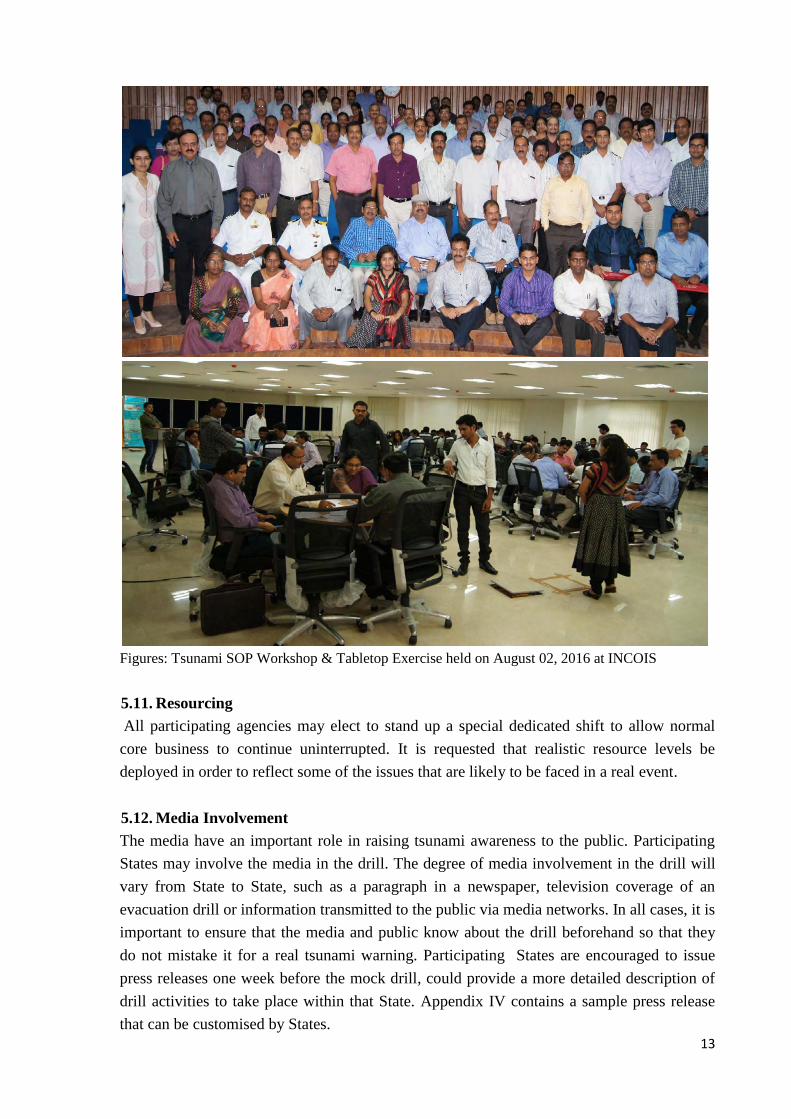
In preparation to the upcoming tsunami mock drill (IOwave16 exercise), INCOIS organised
a tsunami SOP workshop on August 02, 2016 at INCOIS, Hyderabad for the DMOs of
coastal States/UTs, NDRF battalions, Indian Navy and Coast guards. A total of 90 members
from DMOs of all coastal States/UTs, NDRF, Indian Navy, and Coast Guard participated in
the workshop. Tabletop exercise was conducted to the participants to familiarize them with
the tsunami bulletins and to coordinate the mechanism with DMOs and the line departments.
The participants were divided into groups viz., Tabletop coordinators, National/Central
DMOs, State DMOs, District DMOs and NDRF/Navy/Coast guard authorities and Media.
Participants examined the bulletins, conducted group discussions, took decisions in depth
based on their organization’s SOPs with emphasis on slow-paced problem solving, rather
than rapid, real time decision-making.
13
Figures: Tsunami SOP Workshop & Tabletop Exercise held on August 02, 2016 at INCOIS
5.11. Resourcing
All participating agencies may elect to stand up a special dedicated shift to allow normal
core business to continue uninterrupted. It is requested that realistic resource levels be
deployed in order to reflect some of the issues that are likely to be faced in a real event.
5.12. Media Involvement
The media have an important role in raising tsunami awareness to the public. Participating
States may involve the media in the drill. The degree of media involvement in the drill will
vary from State to State, such as a paragraph in a newspaper, television coverage of an
evacuation drill or information transmitted to the public via media networks. In all cases, it is
important to ensure that the media and public know about the drill beforehand so that they
do not mistake it for a real tsunami warning. Participating States are encouraged to issue
press releases one week before the mock drill, could provide a more detailed description of
drill activities to take place within that State. Appendix IV contains a sample press release
that can be customised by States.

14
6. Post Drill Evaluation
The goal of evaluation is to validate strengths and identify opportunities for improvement
within the participating organizations. Evaluation of this drill will focus on the adequacy of
plans, policies, procedures, assessment capabilities, communication, resources and inter-
agency/inter-jurisdictional relationships that support effective tsunami warning and decision-
making at all levels of government. Participants that choose to include additional objectives,
for example by exercising public warning and/or response plans, can expand the evaluation
instrument accordingly.
a) how and when notification messages arrived (email, fax, SMS, etc.)
b) whether or not the recipients are able to access the detailed bulletins on the ITEWC
website,
c) whether or not the recipients could understand the messages properly and estimate
the threat level for their coastal region
d) whether or not the recipients disseminated the bulletins/messages to other
responsible agencies or activated the public warning systems, based on their SOP
Sample Drill Evaluation Forms addressing the respective focus areas and objectives are
included in Appendix-V. At the end of the test, the recipients are requested to forward their
completed Evaluation forms to Mr. B. Ajay Kumar by email ([email protected]) or by Fax:
040 23895012 by September 25, 2016.
7. Conclusion
Tsunami Drills are an effective tool for i) evaluating the readiness of warning centre, ii)
SOPs of the disaster risk reduction agencies, (iii) effectiveness of various logistical and
organizational components and iv) to identify areas for refinement and improvement. The
goal of the drill is to increase community awareness and enhance preparedness. Hence
participation of the all stakeholders in IOWave16 is extremely important.

15
8. References
1. How to Plan, Conduct and Evaluate UNESCO/IOC Tsunami Exercises. IOC Manuals
and Guides No. 58 rev., Paris: UNESCO, 2013 (English)
2. Indian Tsunami Early Warning Centre User Guide, June, 2011
3. Standard Operating Procedures (SOP) Training Manual, 2016
4. Instructions for National IOWave14 on September 09 &10, 2014
5. National Disaster Management Guidelines: Management of Tsunamis, 2010. A
publication of the National Disaster Management Authority, Government of India. 978-
93-80440-06-4, August 2010, New Delhi.
6. Nayak, S. and Srinivasa Kumar, T. 2009, The first Tsunami Early Warning Centre in the
Indian Ocean, RISK WISE Page 175-177.
7. Intergovernmental Oceanographic Commission 2016, Exercise IOWave2016: An Indian
Ocean-wide Tsunami Warning and Communication Exercise, 7-8 September 2016,
Volume 1: Exercise Manual. IOC Technical Series No. 128, Vol. 1. UNESCO.
8. Handbook on Tsunami Early Warning Centre: Systems, Operations & Procedures,
published by INCOIS Pages 1-78.
9. Nayak, S. and Srinivasa Kumar, T. 2008, Addressing the Risk of the Tsunami in the
Indian Ocean, Journal of South Asia Disaster Studies, Vol. 1, No. 1, page 45-57.
10. ICG/IOTWMS-X, 2015, Executive Summary, Tenth Session of the Intergovernmental
Coordination Group for the Indian Ocean Tsunami Warning and Mitigation System
(ICG/IOTWMS-X), Muscut, Oman, March 24-26, 2015.
16
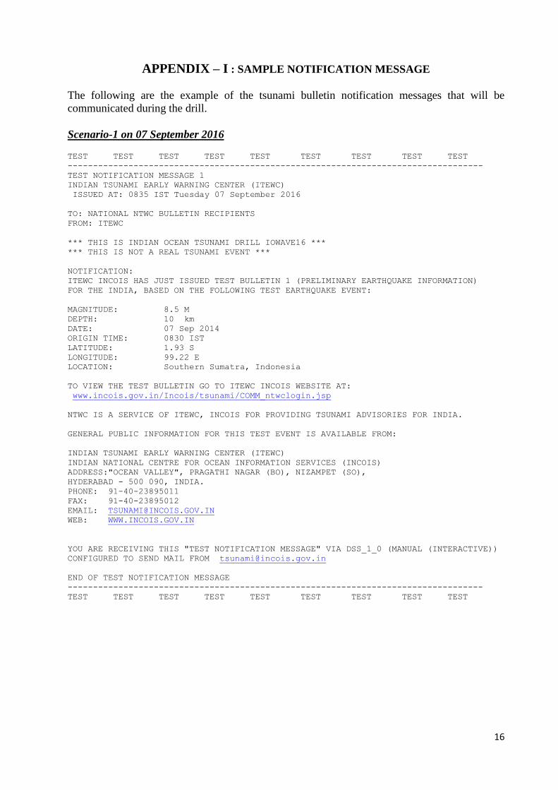
APPENDIX – I : SAMPLE NOTIFICATION MESSAGE
The following are the example of the tsunami bulletin notification messages that will be
communicated during the drill.
Scenario-1 on 07 September 2016 TEST TEST TEST TEST TEST TEST TEST TEST TEST
----------------------------------------------------------------------------------
TEST NOTIFICATION MESSAGE 1
INDIAN TSUNAMI EARLY WARNING CENTER (ITEWC)
ISSUED AT: 0835 IST Tuesday 07 September 2016
TO: NATIONAL NTWC BULLETIN RECIPIENTS
FROM: ITEWC
*** THIS IS INDIAN OCEAN TSUNAMI DRILL IOWAVE16 ***
*** THIS IS NOT A REAL TSUNAMI EVENT ***
NOTIFICATION:
ITEWC INCOIS HAS JUST ISSUED TEST BULLETIN 1 (PRELIMINARY EARTHQUAKE INFORMATION)
FOR THE INDIA, BASED ON THE FOLLOWING TEST EARTHQUAKE EVENT:
MAGNITUDE: 8.5 M
DEPTH: 10 km
DATE: 07 Sep 2014
ORIGIN TIME: 0830 IST
LATITUDE: 1.93 S
LONGITUDE: 99.22 E
LOCATION: Southern Sumatra, Indonesia
TO VIEW THE TEST BULLETIN GO TO ITEWC INCOIS WEBSITE AT:
www.incois.gov.in/Incois/tsunami/COMM_ntwclogin.jsp
NTWC IS A SERVICE OF ITEWC, INCOIS FOR PROVIDING TSUNAMI ADVISORIES FOR INDIA.
GENERAL PUBLIC INFORMATION FOR THIS TEST EVENT IS AVAILABLE FROM:
INDIAN TSUNAMI EARLY WARNING CENTER (ITEWC)
INDIAN NATIONAL CENTRE FOR OCEAN INFORMATION SERVICES (INCOIS)
ADDRESS:"OCEAN VALLEY", PRAGATHI NAGAR (BO), NIZAMPET (SO),
HYDERABAD - 500 090, INDIA.
PHONE: 91-40-23895011
FAX: 91-40-23895012
EMAIL: [email protected]
WEB: WWW.INCOIS.GOV.IN
YOU ARE RECEIVING THIS "TEST NOTIFICATION MESSAGE" VIA DSS_1_0 (MANUAL (INTERACTIVE))
CONFIGURED TO SEND MAIL FROM [email protected]
END OF TEST NOTIFICATION MESSAGE
----------------------------------------------------------------------------------
TEST TEST TEST TEST TEST TEST TEST TEST TEST

17
Scenario-2 on 08 September 2016 TEST TEST TEST TEST TEST TEST TEST TEST TEST
----------------------------------------------------------------------------------
TEST NOTIFICATION MESSAGE 1
INDIAN TSUNAMI EARLY WARNING CENTER (ITEWC)
ISSUED AT: 1135 IST Wednesday 08 September 2016
TO: NATIONAL NTWC BULLETIN RECIPIENTS
FROM: ITEWC
*** THIS IS INDIAN OCEAN TSUNAMI DRILL IOWAVE16 ***
*** THIS IS NOT A REAL TSUNAMI EVENT ***
NOTIFICATION:
ITEWC INCOIS HAS JUST ISSUED TEST BULLETIN 1 (PRELIMINARY EARTHQUAKE INFORMATION)
FOR THE INDIA, BASED ON THE FOLLOWING TEST EARTHQUAKE EVENT:
MAGNITUDE: 8.2 M
DEPTH: 10 km
DATE: 08 Sep 2014
ORIGIN TIME: 1130 IST
LATITUDE: 24.8 N
LONGITUDE: 62.2 E
LOCATION: Off Coast of Pakistan
TO VIEW THE TEST BULLETIN GO TO ITEWC INCOIS WEBSITE AT:
www.incois.gov.in/Incois/tsunami/COMM_ntwclogin.jsp
NTWC IS A SERVICE OF ITEWC, INCOIS FOR PROVIDING TSUNAMI ADVISORIES FOR INDIA.
GENERAL PUBLIC INFORMATION FOR THIS TEST EVENT IS AVAILABLE FROM:
INDIAN TSUNAMI EARLY WARNING CENTER (ITEWC)
INDIAN NATIONAL CENTRE FOR OCEAN INFORMATION SERVICES (INCOIS)
ADDRESS:"OCEAN VALLEY", PRAGATHI NAGAR (BO), NIZAMPET (SO),
HYDERABAD - 500 090, INDIA.
PHONE: 91-40-23895011
FAX: 91-40-23895012
EMAIL: [email protected]
WEB: WWW.INCOIS.GOV.IN
YOU ARE RECEIVING THIS "TEST NOTIFICATION MESSAGE" VIA DSS_1_0 (MANUAL (INTERACTIVE))
CONFIGURED TO SEND MAIL FROM [email protected]
END OF TEST NOTIFICATION MESSAGE
----------------------------------------------------------------------------------
TEST TEST TEST TEST TEST TEST TEST TEST TEST
18
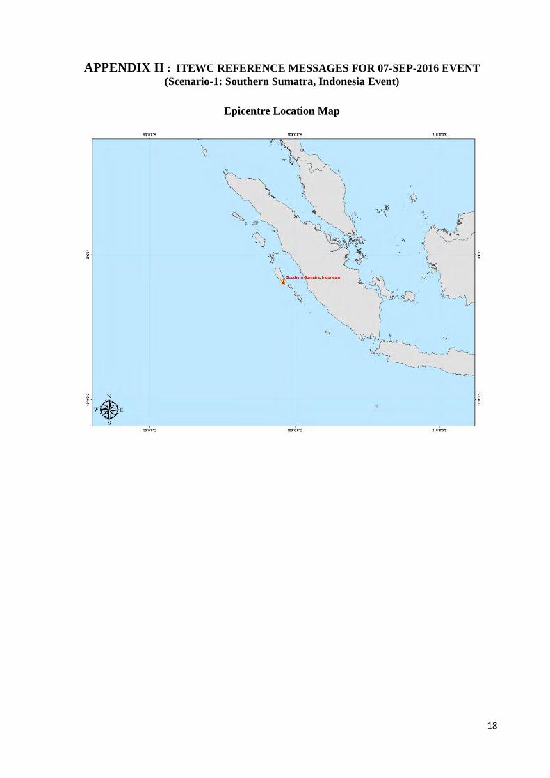
APPENDIX II : ITEWC REFERENCE MESSAGES FOR 07-SEP-2016 EVENT
(Scenario-1: Southern Sumatra, Indonesia Event)
Epicentre Location Map

19
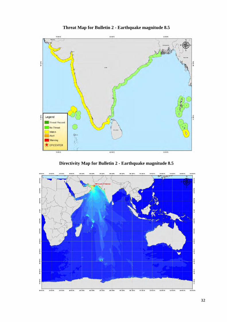
Threat Map for Bulletin 2 - Earthquake magnitude 8.8
Directivity Map for Bulletin 2 - Earthquake magnitude 8.8

20
Travel time Map for Bulletin 2 - Earthquake magnitude 8.8
Threat Map for Bulletins 3 to 14 - Earthquake magnitude 9.2
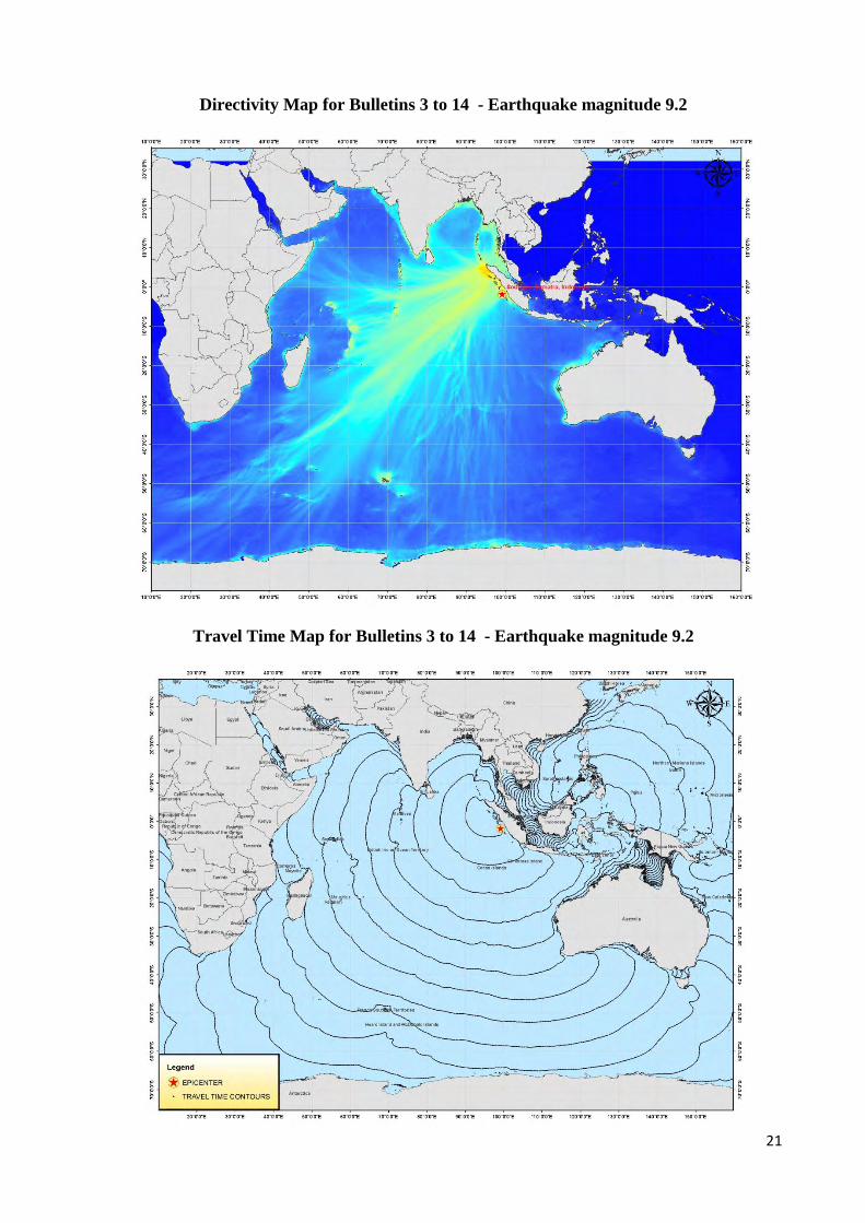
21
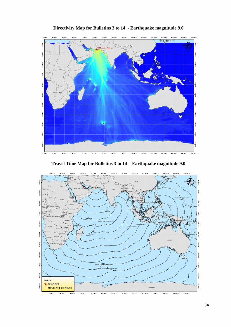
Directivity Map for Bulletins 3 to 14 - Earthquake magnitude 9.2
Travel Time Map for Bulletins 3 to 14 - Earthquake magnitude 9.2
22
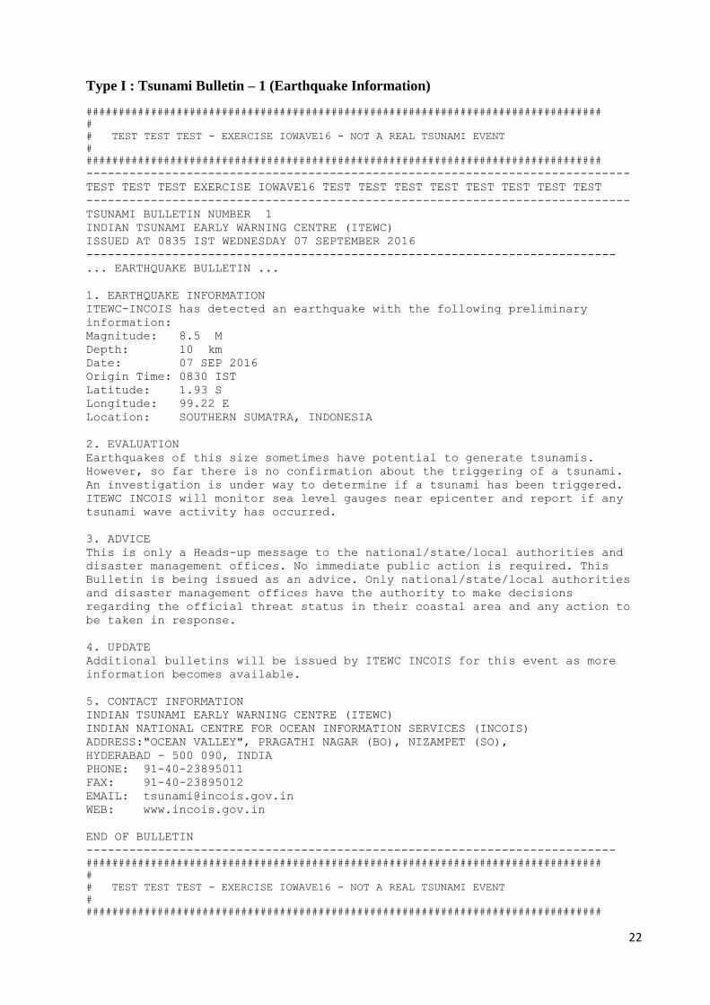
Type I : Tsunami Bulletin – 1 (Earthquake Information)
################################################################################
#
# TEST TEST TEST - EXERCISE IOWAVE16 - NOT A REAL TSUNAMI EVENT
#
################################################################################
----------------------------------------------------------------------------
TEST TEST TEST EXERCISE IOWAVE16 TEST TEST TEST TEST TEST TEST TEST TEST
----------------------------------------------------------------------------
TSUNAMI BULLETIN NUMBER 1
INDIAN TSUNAMI EARLY WARNING CENTRE (ITEWC)
ISSUED AT 0835 IST WEDNESDAY 07 SEPTEMBER 2016
--------------------------------------------------------------------------
... EARTHQUAKE BULLETIN ...
1. EARTHQUAKE INFORMATION
ITEWC-INCOIS has detected an earthquake with the following preliminary
information:
Magnitude: 8.5 M
Depth: 10 km
Date: 07 SEP 2016
Origin Time: 0830 IST
Latitude: 1.93 S
Longitude: 99.22 E
Location: SOUTHERN SUMATRA, INDONESIA
2. EVALUATION
Earthquakes of this size sometimes have potential to generate tsunamis.
However, so far there is no confirmation about the triggering of a tsunami.
An investigation is under way to determine if a tsunami has been triggered.
ITEWC INCOIS will monitor sea level gauges near epicenter and report if any
tsunami wave activity has occurred.
3. ADVICE
This is only a Heads-up message to the national/state/local authorities and
disaster management offices. No immediate public action is required. This
Bulletin is being issued as an advice. Only national/state/local authorities
and disaster management offices have the authority to make decisions
regarding the official threat status in their coastal area and any action to
be taken in response.
4. UPDATE
Additional bulletins will be issued by ITEWC INCOIS for this event as more
information becomes available.
5. CONTACT INFORMATION
INDIAN TSUNAMI EARLY WARNING CENTRE (ITEWC)
INDIAN NATIONAL CENTRE FOR OCEAN INFORMATION SERVICES (INCOIS)
ADDRESS:"OCEAN VALLEY", PRAGATHI NAGAR (BO), NIZAMPET (SO),
HYDERABAD - 500 090, INDIA
PHONE: 91-40-23895011
FAX: 91-40-23895012
EMAIL: [email protected]
WEB: www.incois.gov.in
END OF BULLETIN
--------------------------------------------------------------------------
################################################################################
#
# TEST TEST TEST - EXERCISE IOWAVE16 - NOT A REAL TSUNAMI EVENT
#
################################################################################
23
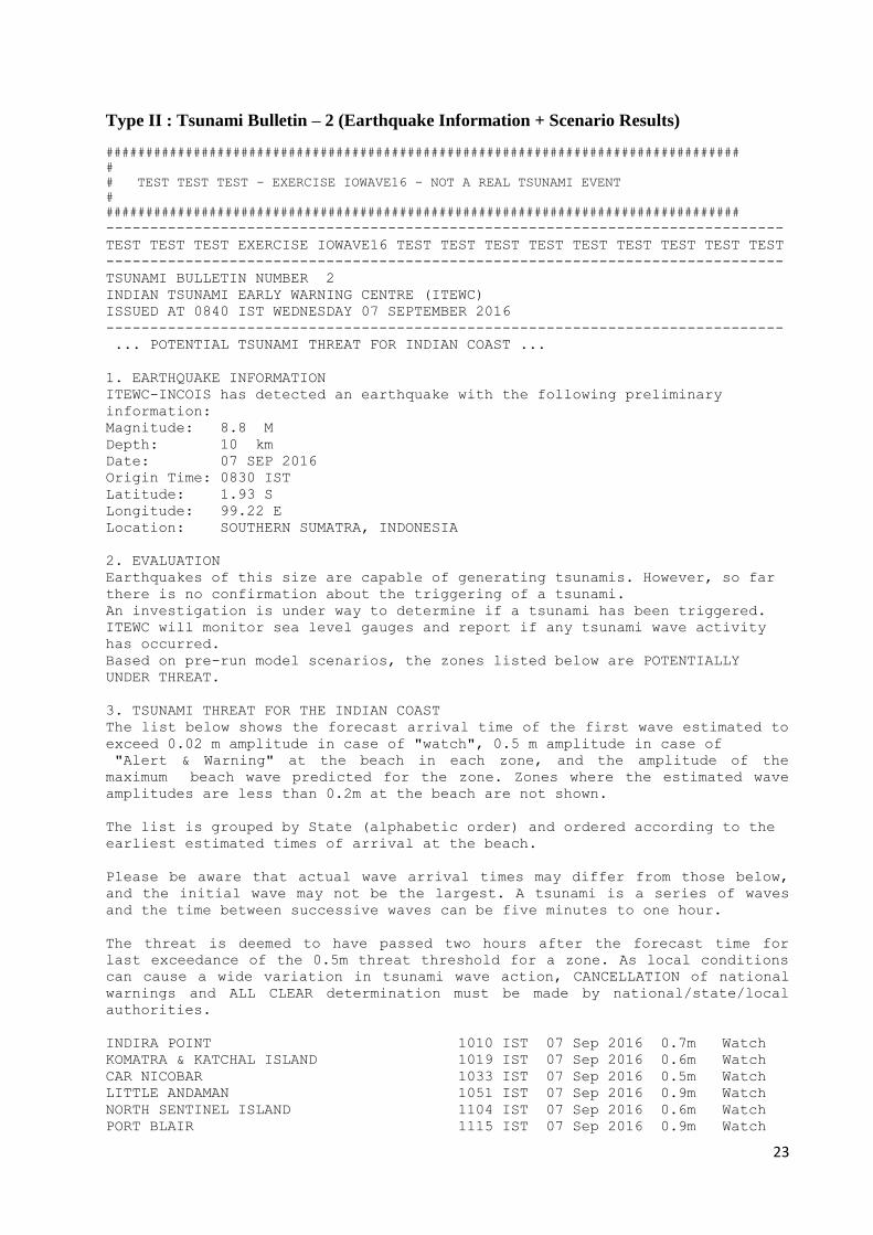
Type II : Tsunami Bulletin – 2 (Earthquake Information + Scenario Results)
################################################################################
#
# TEST TEST TEST - EXERCISE IOWAVE16 - NOT A REAL TSUNAMI EVENT
#
################################################################################
-----------------------------------------------------------------------------
TEST TEST TEST EXERCISE IOWAVE16 TEST TEST TEST TEST TEST TEST TEST TEST TEST
-----------------------------------------------------------------------------
TSUNAMI BULLETIN NUMBER 2
INDIAN TSUNAMI EARLY WARNING CENTRE (ITEWC)
ISSUED AT 0840 IST WEDNESDAY 07 SEPTEMBER 2016
-----------------------------------------------------------------------------
... POTENTIAL TSUNAMI THREAT FOR INDIAN COAST ...
1. EARTHQUAKE INFORMATION
ITEWC-INCOIS has detected an earthquake with the following preliminary
information:
Magnitude: 8.8 M
Depth: 10 km
Date: 07 SEP 2016
Origin Time: 0830 IST
Latitude: 1.93 S
Longitude: 99.22 E
Location: SOUTHERN SUMATRA, INDONESIA
2. EVALUATION
Earthquakes of this size are capable of generating tsunamis. However, so far
there is no confirmation about the triggering of a tsunami.
An investigation is under way to determine if a tsunami has been triggered.
ITEWC will monitor sea level gauges and report if any tsunami wave activity
has occurred.
Based on pre-run model scenarios, the zones listed below are POTENTIALLY
UNDER THREAT.
3. TSUNAMI THREAT FOR THE INDIAN COAST
The list below shows the forecast arrival time of the first wave estimated to
exceed 0.02 m amplitude in case of "watch", 0.5 m amplitude in case of
"Alert & Warning" at the beach in each zone, and the amplitude of the
maximum beach wave predicted for the zone. Zones where the estimated wave
amplitudes are less than 0.2m at the beach are not shown.
The list is grouped by State (alphabetic order) and ordered according to the
earliest estimated times of arrival at the beach.
Please be aware that actual wave arrival times may differ from those below,
and the initial wave may not be the largest. A tsunami is a series of waves
and the time between successive waves can be five minutes to one hour.
The threat is deemed to have passed two hours after the forecast time for
last exceedance of the 0.5m threat threshold for a zone. As local conditions
can cause a wide variation in tsunami wave action, CANCELLATION of national
warnings and ALL CLEAR determination must be made by national/state/local
authorities.
INDIRA POINT 1010 IST 07 Sep 2016 0.7m Watch
KOMATRA & KATCHAL ISLAND 1019 IST 07 Sep 2016 0.6m Watch
CAR NICOBAR 1033 IST 07 Sep 2016 0.5m Watch
LITTLE ANDAMAN 1051 IST 07 Sep 2016 0.9m Watch
NORTH SENTINEL ISLAND 1104 IST 07 Sep 2016 0.6m Watch
PORT BLAIR 1115 IST 07 Sep 2016 0.9m Watch

24
HAVELOCK 1123 IST 07 Sep 2016 0.5m Watch
WEST & LANDFALL ISLAND 1124 IST 07 Sep 2016 0.4m Watch
FLAT ISLAND 1125 IST 07 Sep 2016 0.5m Watch
RANGATH BAY 1135 IST 07 Sep 2016 0.5m Watch
DIGLIPUR 1141 IST 07 Sep 2016 0.3m Watch
KOLUVERI 1207 IST 07 Sep 2016 0.9m Watch
CUDDALORE 1208 IST 07 Sep 2016 1.1m Watch
NAGAPATTINAM 1208 IST 07 Sep 2016 1.0m Watch
PUDUCHERRY 1211 IST 07 Sep 2016 1.1m Watch
MAHABALIPURAM 1214 IST 07 Sep 2016 0.8m Watch
NAGAPATTINAM-THANJAVUR 1215 IST 07 Sep 2016 0.8m Watch
PONNERI 1215 IST 07 Sep 2016 0.9m Watch
KARAIKAL 1218 IST 07 Sep 2016 0.7m Watch
TUTICORIN 1219 IST 07 Sep 2016 0.8m Watch
RAMESWARAM 1219 IST 07 Sep 2016 0.6m Watch
SRIHARIKOTA 1221 IST 07 Sep 2016 0.9m Watch
CHENNAI 1221 IST 07 Sep 2016 0.8m Watch
MACHILIPATNAM 1225 IST 07 Sep 2016 0.8m Watch
KAKINADA 1227 IST 07 Sep 2016 0.6m Watch
NIJAMPATTANAM 1231 IST 07 Sep 2016 1.0m Watch
KOODANKULAM 1236 IST 07 Sep 2016 0.8m Watch
KOTTAPATNAM 1236 IST 07 Sep 2016 1.0m Watch
KOYYAM 1240 IST 07 Sep 2016 0.6m Watch
VISAKHAPATNAM 1243 IST 07 Sep 2016 0.6m Watch
TRIVANDRUM 1244 IST 07 Sep 2016 0.6m Watch
KANYAKUMARI 1244 IST 07 Sep 2016 0.9m Watch
QUILON 1247 IST 07 Sep 2016 0.5m Watch
PURI 1248 IST 07 Sep 2016 0.5m Watch
PARADIP 1249 IST 07 Sep 2016 0.4m Watch
GOPALPUR 1256 IST 07 Sep 2016 0.5m Watch
ALLEPPEY ALAPPUZHA 1300 IST 07 Sep 2016 0.6m Watch
RAJNAGAR 1305 IST 07 Sep 2016 0.4m Watch
AGATTI 1322 IST 07 Sep 2016 0.4m Watch
MANATTALA 1323 IST 07 Sep 2016 0.6m Watch
COCHIN 1326 IST 07 Sep 2016 0.6m Watch
KAVARATTI 1326 IST 07 Sep 2016 0.2m Watch
NAIKANIDIHI 1330 IST 07 Sep 2016 0.4m Watch
TIRURANGADI 1338 IST 07 Sep 2016 0.4m Watch
SAGAR & KAKDWIP 1339 IST 07 Sep 2016 0.5m Watch
BALESHWAR 1344 IST 07 Sep 2016 0.4m Watch
BEYPORE 1344 IST 07 Sep 2016 0.4m Watch
MADAYI KANNUR 1354 IST 07 Sep 2016 0.5m Watch
CHANDRAGIRI FORT 1355 IST 07 Sep 2016 0.5m Watch
MANGALORE 1412 IST 07 Sep 2016 0.5m Watch
UDUPI 1425 IST 07 Sep 2016 0.5m Watch
KARWAR 1446 IST 07 Sep 2016 0.6m Watch
PANAJI 1502 IST 07 Sep 2016 0.4m Watch
MALVAN BAY 1511 IST 07 Sep 2016 0.4m Watch
ANJANWEL 1531 IST 07 Sep 2016 0.4m Watch
PORBANDAR 1609 IST 07 Sep 2016 0.3m Watch
DWARKA 1612 IST 07 Sep 2016 0.3m Watch
VERAVAL 1617 IST 07 Sep 2016 0.3m Watch
ALIBAG PORT 1627 IST 07 Sep 2016 0.4m Watch
MANDVI 1647 IST 07 Sep 2016 0.3m Watch
MUMBAI 1648 IST 07 Sep 2016 0.2m Watch
VIRAR 1708 IST 07 Sep 2016 0.3m Watch
AMRELI 1731 IST 07 Sep 2016 0.2m Watch
MAHUVA 1734 IST 07 Sep 2016 0.3m Watch
BORSI 1737 IST 07 Sep 2016 0.2m Watch
DAMAN 1755 IST 07 Sep 2016 0.3m Watch
25
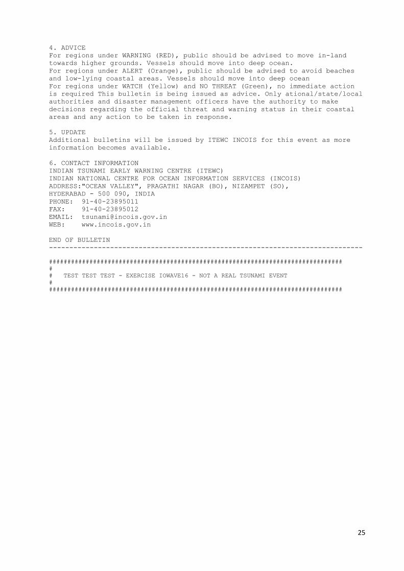
4. ADVICE
For regions under WARNING (RED), public should be advised to move in-land
towards higher grounds. Vessels should move into deep ocean.
For regions under ALERT (Orange), public should be advised to avoid beaches
and low-lying coastal areas. Vessels should move into deep ocean
For regions under WATCH (Yellow) and NO THREAT (Green), no immediate action
is required This bulletin is being issued as advice. Only ational/state/local
authorities and disaster management officers have the authority to make
decisions regarding the official threat and warning status in their coastal
areas and any action to be taken in response.
5. UPDATE
Additional bulletins will be issued by ITEWC INCOIS for this event as more
information becomes available.
6. CONTACT INFORMATION
INDIAN TSUNAMI EARLY WARNING CENTRE (ITEWC)
INDIAN NATIONAL CENTRE FOR OCEAN INFORMATION SERVICES (INCOIS)
ADDRESS:"OCEAN VALLEY", PRAGATHI NAGAR (BO), NIZAMPET (SO),
HYDERABAD - 500 090, INDIA
PHONE: 91-40-23895011
FAX: 91-40-23895012
EMAIL: [email protected]
WEB: www.incois.gov.in
END OF BULLETIN
-----------------------------------------------------------------------------
################################################################################
#
# TEST TEST TEST - EXERCISE IOWAVE16 - NOT A REAL TSUNAMI EVENT
#
################################################################################

26
Type III : Tsunami Bulletins – 3 to 14 (Earthquake Information + Scenario Results +
Water level Observations)
################################################################################
#
# TEST TEST TEST - EXERCISE IOWAVE16 - NOT A REAL TSUNAMI EVENT
#
################################################################################
-----------------------------------------------------------------------------
TEST TEST TEST EXERCISE IOWAVE16 TEST TEST TEST TEST TEST TEST TEST TEST
-----------------------------------------------------------------------------
TSUNAMI BULLETIN NUMBER 3
INDIAN TSUNAMI EARLY WARNING CENTRE (ITEWC)
ISSUED AT 0915 IST WEDNESDAY 07 SEPTEMBER 2016
-----------------------------------------------------------------------------
... CONFIRMED TSUNAMI THREAT FOR THE INDIAN COAST ...
1. EARTHQUAKE INFORMATION
ITEWC-INCOIS has detected an earthquake with the following preliminary
information:
Magnitude: 9.2 M
Depth: 10 km
Date: 07 SEP 2016
Origin Time: 0830 IST
Latitude: 1.93 S
Longitude: 99.22 E
Location: SOUTHERN SUMATRA, INDONESIA
2. EVALUATION
The real time water level Observations from sea level network are reported as
following:
Padang(INDONESIA) 1.00 S 100.37 E 0846IST 07 Sep 2016 5.1m
Enggano(INDONESIA) 5.35 S 102.28 E 0903IST 07 Sep 2016 2.9m
3. TSUNAMI THREAT FOR THE INDIAN COAST
The list below shows the forecast arrival time of the first wave estimated to
exceed 0.02 m amplitude in case of "watch", 0.5 m amplitude in case of "Alert
& Warning" at the beach in each zone, and the amplitude of the maximum beach
wave predicted for the zone. Zones where the estimated wave amplitudes are
less than 0.2m at the beach are not shown.
The list is grouped by State (alphabetic order) and ordered according to the
earliest estimated times of arrival at the beach.
Please be aware that actual wave arrival times may differ from those below,
and the initial wave may not be the largest. A tsunami is a series of waves
and the time between successive waves can be five minutes to one hour.
The threat is deemed to have passed two hours after the forecast time for
last exceedance of the 0.5m threat threshold for a zone. As local conditions
can cause a wide variation in tsunami wave action, CANCELLATION of national
warnings and ALL CLEAR determination must be made by national/state/local
authorities.
INDIRA POINT 0851 IST 07 Sep 2016 6.0m Warning
KOMATRA & KATCHAL ISLAND 0910 IST 07 Sep 2016 4.2m Warning
CAR NICOBAR 0924 IST 07 Sep 2016 3.2m Warning
LITTLE ANDAMAN 0945 IST 07 Sep 2016 5.6m Warning

27
PORT BLAIR 0959 IST 07 Sep 2016 3.6m Warning
NORTH SENTINEL ISLAND 1007 IST 07 Sep 2016 2.4m Warning
BARREN ISLAND 1007 IST 07 Sep 2016 0.9m Alert
HAVELOCK 1007 IST 07 Sep 2016 3.0m Warning
RANGATH BAY 1018 IST 07 Sep 2016 2.4m Warning
DIGLIPUR 1023 IST 07 Sep 2016 2.5m Warning
NARCONDAM ISLAND 1032 IST 07 Sep 2016 0.8m Alert
FLAT ISLAND 1036 IST 07 Sep 2016 2.3m Warning
WEST & LANDFALL ISLAND 1045 IST 07 Sep 2016 1.8m Alert
KOLUVERI 1108 IST 07 Sep 2016 2.7m Warning
CUDDALORE 1109 IST 07 Sep 2016 2.1m Warning
NAGAPATTINAM 1111 IST 07 Sep 2016 3.3m Warning
PUDUCHERRY 1113 IST 07 Sep 2016 2.0m Warning
PONNERI 1115 IST 07 Sep 2016 2.4m Warning
MAHABALIPURAM 1116 IST 07 Sep 2016 3.6m Warning
NAGAPATTINAM-THANJAVUR 1119 IST 07 Sep 2016 3.5m Warning
SRIHARIKOTA 1121 IST 07 Sep 2016 2.6m Warning
MACHILIPATNAM 1122 IST 07 Sep 2016 2.8m Warning
CHENNAI 1122 IST 07 Sep 2016 3.6m Warning
KARAIKAL 1122 IST 07 Sep 2016 2.8m Warning
KAKINADA 1123 IST 07 Sep 2016 2.9m Warning
NIJAMPATTANAM 1129 IST 07 Sep 2016 3.2m Warning
KOTTAPATNAM 1135 IST 07 Sep 2016 4.2m Warning
VISAKHAPATNAM 1140 IST 07 Sep 2016 3.2m Warning
KOYYAM 1142 IST 07 Sep 2016 4.1m Warning
RAMESWARAM 1142 IST 07 Sep 2016 1.8m Alert
PURI 1148 IST 07 Sep 2016 1.9m Alert
TUTICORIN 1150 IST 07 Sep 2016 2.4m Warning
GOPALPUR 1152 IST 07 Sep 2016 2.7m Warning
PARADIP 1152 IST 07 Sep 2016 1.8m Alert
KOODANKULAM 1156 IST 07 Sep 2016 1.8m Alert
KANYAKUMARI 1203 IST 07 Sep 2016 2.5m Warning
MINICOY 1204 IST 07 Sep 2016 0.3m Watch
RAJNAGAR 1208 IST 07 Sep 2016 1.6m Alert
AMINI 1235 IST 07 Sep 2016 0.5m Watch
NAIKANIDIHI 1238 IST 07 Sep 2016 2.1m Warning
SAGAR & KAKDWIP 1241 IST 07 Sep 2016 1.8m Alert
ANDROTH 1241 IST 07 Sep 2016 0.4m Watch
TRIVANDRUM 1245 IST 07 Sep 2016 1.8m Alert
BALESHWAR 1251 IST 07 Sep 2016 1.8m Alert
ALLEPPEY ALAPPUZHA 1304 IST 07 Sep 2016 1.5m Alert
QUILON 1308 IST 07 Sep 2016 1.2m Alert
AGATTI 1334 IST 07 Sep 2016 0.9m Alert
COCHIN 1603 IST 07 Sep 2016 1.3m Alert
MANATTALA 1631 IST 07 Sep 2016 1.2m Alert
TIRURANGADI 1647 IST 07 Sep 2016 1.4m Alert
MADAYI KANNUR 1652 IST 07 Sep 2016 1.3m Alert
BEYPORE 1652 IST 07 Sep 2016 1.6m Alert
CHANDRAGIRI FORT 1717 IST 07 Sep 2016 1.7m Alert
KAVARATTI 1719 IST 07 Sep 2016 0.8m Alert
UDUPI 1810 IST 07 Sep 2016 1.4m Alert
KARWAR 1835 IST 07 Sep 2016 1.1m Alert
PANAJI 1842 IST 07 Sep 2016 1.0m Alert
MALVAN BAY 1917 IST 07 Sep 2016 0.8m Alert
ANJANWEL 1921 IST 07 Sep 2016 1.0m Alert
ALIBAG PORT 2019 IST 07 Sep 2016 0.8m Alert
DWARKA 2026 IST 07 Sep 2016 0.8m Alert
VERAVAL 2041 IST 07 Sep 2016 0.8m Alert
MANGALORE 2046 IST 07 Sep 2016 1.5m Alert
MUMBAI 2207 IST 07 Sep 2016 0.5m Watch
MANDVI 2259 IST 07 Sep 2016 0.6m Alert
BORSI 0210 IST 08 Sep 2016 0.6m Alert

28
MAHUVA 0211 IST 08 Sep 2016 0.7m Alert
VIRAR 0237 IST 08 Sep 2016 0.9m Alert
DAMAN 0259 IST 08 Sep 2016 0.7m Alert
PORBANDAR 0403 IST 08 Sep 2016 0.7m Alert
AMRELI 0607 IST 08 Sep 2016 0.5m Watch
4. ADVICE
For regions under WARNING (RED), public should be advised to move in-land
towards higher grounds. Vessels should move into deep ocean.
For regions under ALERT (Orange), public should be advised to avoid beaches
and low-lying coastal areas. Vessels should move into deep ocean.
For regions under WATCH (Yellow) and NO THREAT (Green), no immediate action
is required This bulletin is being issued as advice. Only ational/state/local
authorities and disaster management officers have the authority to make
decisions regarding the official threat and warning status in their coastal
areas and any action to be taken in response.
5. UPDATE
Additional bulletins will be issued by ITEWC INCOIS for this event as more
information becomes available.
6. CONTACT INFORMATION
INDIAN TSUNAMI EARLY WARNING CENTRE (ITEWC)
INDIAN NATIONAL CENTRE FOR OCEAN INFORMATION SERVICES (INCOIS)
ADDRESS:"OCEAN VALLEY", PRAGATHI NAGAR (BO), NIZAMPET (SO),
HYDERABAD - 500 090, INDIA
PHONE: 91-40-23895011
FAX: 91-40-23895012
EMAIL: [email protected]
WEB: www.incois.gov.in
END OF BULLETIN
-----------------------------------------------------------------------------
################################################################################
#
# TEST TEST TEST - EXERCISE IOWAVE16 - NOT A REAL TSUNAMI EVENT
#
################################################################################

29
Type IV : Tsunami Bulletin – 15 (Final Bulletin)
################################################################################
#
# TEST TEST TEST - EXERCISE IOWAVE16 - NOT A REAL TSUNAMI EVENT
#
################################################################################
----------------------------------------------------------------------------
TEST TEST TEST EXERCISE IOWAVE16 TEST TEST TEST TEST TEST TEST TEST TEST
----------------------------------------------------------------------------
TSUNAMI BULLETIN NUMBER 15
INDIAN TSUNAMI EARLY WARNING CENTRE (ITEWC)
ISSUED AT 2030 IST WEDNESDAY 07 SEPTEMBER 2016
----------------------------------------------------------------------------
... FINAL TSUNAMI BULLETIN FOR INDIAN COAST ...
1. EARTHQUAKE INFORMATION
ITEWC-INCOIS has detected an earthquake with the following preliminary
information:
Magnitude: 9.2 M
Depth: 10 km
Date: 07 SEP 2016
Origin Time: 0830 IST
Latitude: 1.93 S
Longitude: 99.22 E
Location: SOUTHERN SUMATRA, INDONESIA
2. EVALUATION
Data from sea-level gauges confirmed that a tsunami was generated.
The expected period of significant tsunami waves is now over for all
threatened Indian coastal areas, based on ITEWC INCOIS modelling.
Because local conditions can cause a wide variation in tsunami wave action,
CANCELLATION of national warnings and ALL CLEAR determination must be made by
national/state/local authorities. Please be aware that dangerous currents can
continue for several hours after the main tsunami waves have passed.
Padang(INDONESIA) 1.00 S 100.37 E 0846IST 07 Sep 2016 5.1m
Enggano(INDONESIA) 5.35 S 102.28 E 0903IST 07 Sep 2016 2.9m
Meulaboh(INDONESIA) 4.13 N 96.13 E 0928IST 07 Sep 2016 2.4m
Christmas Island(AUSTRALIA) 10.4 S 105.67 E 0945IST 07 Sep 2016 0.9m
Campbell Bay(INDIA) 7.00 N 93.93 E 1000IST 07 Sep 2016 1.9m
56001(AUSTRALIA) 13.9 S 110.00 E 1041IST 07 Sep 2016 0.1m
Portblair(INDIA) 11.6 N 92.77 E 1054IST 07 Sep 2016 0.9m
Colombo(SRILANKA) 6.95 N 79.85 E 1142IST 07 Sep 2016 2.6m
Chennai(INDIA) 13.1 N 80.30 E 1156IST 07 Sep 2016 1.9m
Male(MALDIVE ISLANDS) 4.19 N 73.53 E 1223IST 07 Sep 2016 2.0m
Visakhapatnam(INDIA) 17.6 N 83.28 E 1230IST 07 Sep 2016 1.5m
Hanimaadhoo(MALDIVE ISLANDS) 6.77 N 73.17 E 1237IST 07 Sep 2016 2.4m
Chittagong(BANGLADESH) 22.2 N 91.82 E 1305IST 07 Sep 2016 0.6m
New Mangalore(INDIA) 12.9 N 74.80 E 1350IST 07 Sep 2016 0.7m
Rodrigue(MAURITIUS) 19.6 S 63.42 E 1416IST 07 Sep 2016 3.9m
Marmagao(INDIA) 15.4 N 73.80 E 1437IST 07 Sep 2016 0.9m
Pt.LaRue(SEYCHELLES) 4.67 S 55.53 E 1536IST 07 Sep 2016 2.6m
Masirah(OMAN) 20.6 N 58.87 E 1555IST 07 Sep 2016 1.3m
JNPT(INDIA) 18.9 N 72.75 E 1619IST 07 Sep 2016 0.3m
Thevenard(AUSTRALIA) 32.1 S 133.64 E 1630IST 07 Sep 2016 0.1m
Jask(IRAN) 25.6 N 57.77 E 1643IST 07 Sep 2016 0.5m
Lamu(KENYA) 2.27 S 40.90 E 1718IST 07 Sep 2016 0.6m
Aden(YEMEN) 12.7 N 44.98 E 1740IST 07 Sep 2016 0.7m

30
Zanzibar(TANZANIA) 6.16 S 39.19 E 1750IST 07 Sep 2016 0.6m
Inhambane(MOCAMBIQUE) 23.9 S 35.50 E 1830IST 07 Sep 2016 0.4m
Durbin(ZA) 29.8 S 31.03 E 1909IST 07 Sep 2016 1.2m
Masirah(OMAN) 20.6 N 58.87 E 1935IST 07 Sep 2016 0.4m
3. ADVICE
This bulletin is being issued as advice. Only national/state/local
authorities and disaster management officers have the authority to make
decisions regarding the official threat and warning status in their coastal
areas and any action to be taken in response.
4. UPDATE
No further bulletins will be issued by ITEWC INCOIS for this event unless
other information becomes available.
5. CONTACT INFORMATION
INDIAN TSUNAMI EARLY WARNING CENTRE (ITEWC)
INDIAN NATIONAL CENTRE FOR OCEAN INFORMATION SERVICES (INCOIS)
ADDRESS:"OCEAN VALLEY", PRAGATHI NAGAR (BO), NIZAMPET (SO),
HYDERABAD - 500 090, INDIA
PHONE: 91-40-23895011
FAX: 91-40-23895012
EMAIL: [email protected]
WEB: www.incois.gov.in
END OF BULLETIN
-----------------------------------------------------------------------------
################################################################################
#
# TEST TEST TEST - EXERCISE IOWAVE16 - NOT A REAL TSUNAMI EVENT
#
################################################################################

31
APPENDIX III : ITEWC REFERENCE MESSAGES FOR 10-SEP-2014 EVENT
(Scenario-2: Off Coast of Pakistan, Makran Event)
Epicentre Location Map
32
Threat Map for Bulletin 2 - Earthquake magnitude 8.5
Directivity Map for Bulletin 2 - Earthquake magnitude 8.5

33
Travel Time Map for Bulletin 2 - Earthquake magnitude 8.5
Threat Map for Bulletins 3 to 14 - Earthquake magnitude 9.0
34
Directivity Map for Bulletins 3 to 14 - Earthquake magnitude 9.0
Travel Time Map for Bulletins 3 to 14 - Earthquake magnitude 9.0

35
Type I : Tsunami Bulletin – 1 (Earthquake Information)
################################################################################
#
# TEST TEST TEST - EXERCISE IOWAVE16 - NOT A REAL TSUNAMI EVENT
#
################################################################################
NTWC-INCOIS-20140910-1130-001 (TYPE - I)
----------------------------------------------------------------------------
TEST TEST TEST EXERCISE IOWAVE16 TEST TEST TEST TEST TEST TEST TEST TEST TEST
-----------------------------------------------------------------------------
TSUNAMI BULLETIN NUMBER 1
INDIAN TSUNAMI EARLY WARNING CENTRE (ITEWC)
ISSUED AT 1135 IST THURSDAY 08 SEPTEMBER 2016
----------------------------------------------------------------------------
... EARTHQUAKE BULLETIN ...
1. EARTHQUAKE INFORMATION
ITEWC-INCOIS has detected an earthquake with the following preliminary
information:
Magnitude: 8.2 M
Depth: 10 km
Date: 08 SEP 2016
Origin Time: 1130 IST
Latitude: 24.8 N
Longitude: 62.2 E
Location: OFF COAST OF PAKISTAN
2. EVALUATION
Earthquakes of this size sometimes have potential to generate tsunamis.
However, so far there is no confirmation about the triggering of a tsunami.
An investigation is under way to determine if a tsunami has been triggered.
ITEWC INCOIS will monitor sea level gauges near epicenter and report if any
tsunami wave activity has occurred.
3. ADVICE
This is only a Heads-up message to the national/state/local authorities and
disaster management offices. No immediate public action is required. This
Bulletin is being issued as an advice. Only national/state/local authorities
and disaster management offices have the authority to make decisions
regarding the official threat status in their coastal area and any action to
be taken in response.
4. UPDATE
Additional bulletins will be issued by ITEWC INCOIS for this event as more
information becomes available.
5. CONTACT INFORMATION
INDIAN TSUNAMI EARLY WARNING CENTRE (ITEWC)
INDIAN NATIONAL CENTRE FOR OCEAN INFORMATION SERVICES (INCOIS)
ADDRESS:"OCEAN VALLEY", PRAGATHI NAGAR (BO), NIZAMPET (SO),
HYDERABAD - 500 090, INDIA
PHONE: 91-40-23895011
FAX: 91-40-23895012
EMAIL: [email protected]
WEB: www.incois.gov.in
END OF BULLETIN
--------------------------------------------------------------------------
################################################################################ #
# TEST TEST TEST - EXERCISE IOWAVE16 - NOT A REAL TSUNAMI EVENT
################################################################################

36
Type II : Tsunami Bulletin – 2 (Earthquake Information + Scenario Results)
################################################################################
#
# TEST TEST TEST - EXERCISE IOWAVE16 - NOT A REAL TSUNAMI EVENT
#
################################################################################
----------------------------------------------------------------------------
TEST TEST TEST EXERCISE IOWAVE16 TEST TEST TEST TEST TEST TEST TEST TEST TEST
-----------------------------------------------------------------------------
TSUNAMI BULLETIN NUMBER 2
INDIAN TSUNAMI EARLY WARNING CENTRE (ITEWC)
ISSUED AT 1140 IST THURSDAY 08 SEPTEMBER 2016
----------------------------------------------------------------------------
... POTENTIAL TSUNAMI THREAT FOR INDIAN COAST ...
1. EARTHQUAKE INFORMATION
ITEWC-INCOIS has detected an earthquake with the following preliminary
information:
Magnitude: 8.5 M
Depth: 10 km
Date: 08 SEP 2016
Origin Time: 1130 IST
Latitude: 24.8 N
Longitude: 62.2 E
Location: OFF COAST OF PAKISTAN
2. EVALUATION
Earthquakes of this size are capable of generating tsunamis. However, so far
there is no confirmation about the triggering of a tsunami.
An investigation is under way to determine if a tsunami has been triggered.
ITEWC will monitor sea level gauges and report if any tsunami wave activity
has occurred.
Based on pre-run model scenarios, the zones listed below are POTENTIALLY
UNDER THREAT.
3. TSUNAMI THREAT FOR THE INDIAN COAST
The list below shows the forecast arrival time of the first wave estimated to
exceed 0.02 m amplitude in case of "watch", 0.5 m amplitude in case of
"Alert & Warning" at the beach in each zone, and the amplitude of the maximum
beach wave predicted for the zone. Zones where the estimated wave amplitudes
are less than 0.2m at the beach are not shown.
The list is grouped by State (alphabetic order) and ordered according to the
earliest estimated times of arrival at the beach.
Please be aware that actual wave arrival times may differ from those below,
and the initial wave may not be the largest. A tsunami is a series of waves
and the time between successive waves can be five minutes to one hour.
The threat is deemed to have passed two hours after the forecast time for
last exceedance of the 0.5m threat threshold for a zone. As local conditions
can cause a wide variation in tsunami wave action, CANCELLATION of national
warnings and ALL CLEAR determination must be made by national/state/local
authorities.
PORBANDAR 1357 IST 08 Sep 2016 0.6m Watch
MANDVI 1357 IST 08 Sep 2016 0.9m Watch
DWARKA 1358 IST 08 Sep 2016 0.7m Watch
VERAVAL 1410 IST 08 Sep 2016 0.6m Watch
AGATTI 1434 IST 08 Sep 2016 0.3m Watch
37
AMINI 1442 IST 08 Sep 2016 0.3m Watch
MALVAN BAY 1455 IST 08 Sep 2016 0.4m Watch
PANAJI 1503 IST 08 Sep 2016 0.6m Watch
ANJANWEL 1505 IST 08 Sep 2016 0.5m Watch
KARWAR 1513 IST 08 Sep 2016 0.6m Watch
MANGALORE 1532 IST 08 Sep 2016 0.4m Watch
CHANDRAGIRI FORT 1534 IST 08 Sep 2016 0.4m Watch
UDUPI 1535 IST 08 Sep 2016 0.6m Watch
ALIBAG PORT 1537 IST 08 Sep 2016 0.5m Watch
MADAYI KANNUR 1541 IST 08 Sep 2016 0.4m Watch
ALLEPPEY ALAPPUZHA 1543 IST 08 Sep 2016 0.4m Watch
MANATTALA 1545 IST 08 Sep 2016 0.5m Watch
MUMBAI 1548 IST 08 Sep 2016 0.5m Watch
TIRURANGADI 1549 IST 08 Sep 2016 0.5m Watch
BEYPORE 1550 IST 08 Sep 2016 0.5m Watch
VIRAR 1550 IST 08 Sep 2016 0.6m Watch
COCHIN 1551 IST 08 Sep 2016 0.5m Watch
QUILON 1552 IST 08 Sep 2016 0.4m Watch
AMRELI 1558 IST 08 Sep 2016 0.5m Watch
TRIVANDRUM 1602 IST 08 Sep 2016 0.4m Watch
MAHUVA 1603 IST 08 Sep 2016 0.5m Watch
BORSI 1606 IST 08 Sep 2016 0.5m Watch
KANYAKUMARI 1611 IST 08 Sep 2016 0.5m Watch
DAMAN 1625 IST 08 Sep 2016 0.5m Watch
TUTICORIN 1643 IST 08 Sep 2016 0.5m Watch
RAMESWARAM 1646 IST 08 Sep 2016 0.2m Watch
KOODANKULAM 1647 IST 08 Sep 2016 0.3m Watch
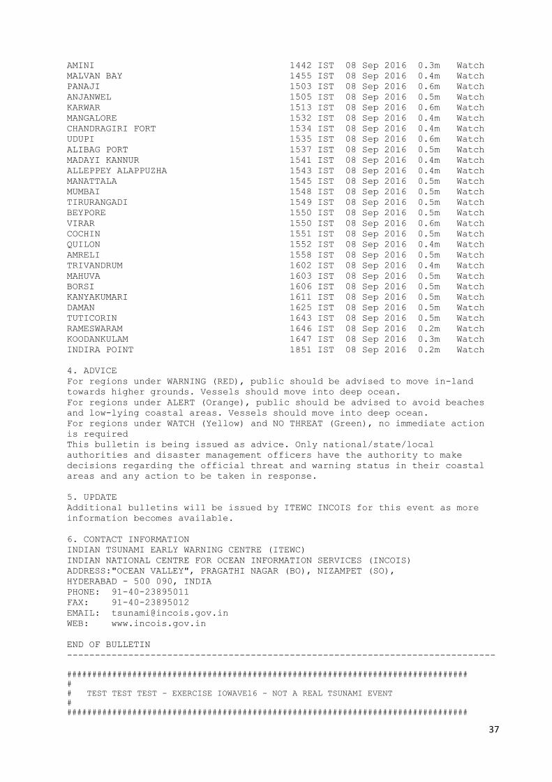
INDIRA POINT 1851 IST 08 Sep 2016 0.2m Watch
4. ADVICE
For regions under WARNING (RED), public should be advised to move in-land
towards higher grounds. Vessels should move into deep ocean.
For regions under ALERT (Orange), public should be advised to avoid beaches
and low-lying coastal areas. Vessels should move into deep ocean.
For regions under WATCH (Yellow) and NO THREAT (Green), no immediate action
is required
This bulletin is being issued as advice. Only national/state/local
authorities and disaster management officers have the authority to make
decisions regarding the official threat and warning status in their coastal
areas and any action to be taken in response.
5. UPDATE
Additional bulletins will be issued by ITEWC INCOIS for this event as more
information becomes available.
6. CONTACT INFORMATION
INDIAN TSUNAMI EARLY WARNING CENTRE (ITEWC)
INDIAN NATIONAL CENTRE FOR OCEAN INFORMATION SERVICES (INCOIS)
ADDRESS:"OCEAN VALLEY", PRAGATHI NAGAR (BO), NIZAMPET (SO),
HYDERABAD - 500 090, INDIA
PHONE: 91-40-23895011
FAX: 91-40-23895012
EMAIL: [email protected]
WEB: www.incois.gov.in
END OF BULLETIN
-----------------------------------------------------------------------------
################################################################################
#
# TEST TEST TEST - EXERCISE IOWAVE16 - NOT A REAL TSUNAMI EVENT
#
################################################################################

38
Type III : Tsunami Bulletins – 3 to 14 (Earthquake Information + Scenario Results +
Water level Observations)
################################################################################
#
# TEST TEST TEST - EXERCISE IOWAVE16 - NOT A REAL TSUNAMI EVENT
#
################################################################################
---------------------------------------------------------------------------
TEST TEST TEST EXERCISE IOWAVE16 TEST TEST TEST TEST TEST TEST TEST TEST
-----------------------------------------------------------------------------
TSUNAMI BULLETIN NUMBER 3
INDIAN TSUNAMI EARLY WARNING CENTRE (ITEWC)
ISSUED AT 1215 IST THURSDAY 08 SEPTEMBER 2016
----------------------------------------------------------------------------
... CONFIRMED TSUNAMI THREAT FOR THE INDIAN COAST ...
1. EARTHQUAKE INFORMATION
ITEWC-INCOIS has detected an earthquake with the following preliminary
information:
Magnitude: 9 M
Depth: 10 km
Date: 08 SEP 2016
Origin Time: 1130 IST
Latitude: 24.8 N
Longitude: 62.2 E
Location: OFF COAST OF PAKISTAN
2. EVALUATION
The real time water level Observations from sea level network are reported as
following:
Jask(IRAN) 25.6 N 57.77 E 1144IST 08 Sep 2016 7.2m
3. TSUNAMI THREAT FOR THE INDIAN COAST
The list below shows the forecast arrival time of the first wave estimated to
exceed 0.02 m amplitude in case of "watch", 0.5 m amplitude in case of
"Alert & Warning" at the beach in each zone, and the amplitude of the maximum
beach wave predicted for the zone. Zones where the estimated wave amplitudes
are less than 0.2m at the beach are not shown.
The list is grouped by State (alphabetic order) and ordered according to the
earliest estimated times of arrival at the beach.
Please be aware that actual wave arrival times may differ from those below,
and the initial wave may not be the largest. A tsunami is a series of waves
and the time between successive waves can be five minutes to one hour.
The threat is deemed to have passed two hours after the forecast time for
last exceedance of the 0.5m threat threshold for a zone. As local conditions
can cause a wide variation in tsunami wave action, CANCELLATION of national
warnings and ALL CLEAR determination must be made by national/state/local
authorities.
MANDVI 1334 IST 08 Sep 2016 2.7m Warning
DWARKA 1338 IST 08 Sep 2016 2.0m Warning
PORBANDAR 1339 IST 08 Sep 2016 1.8m Alert
VERAVAL 1352 IST 08 Sep 2016 1.9m Alert
AGATTI 1426 IST 08 Sep 2016 2.0m Warning
AMINI 1433 IST 08 Sep 2016 1.2m Alert
KAVARATTI 1441 IST 08 Sep 2016 1.0m Alert

39
MINICOY 1444 IST 08 Sep 2016 0.5m Watch
MALVAN BAY 1444 IST 08 Sep 2016 1.7m Alert
PANAJI 1452 IST 08 Sep 2016 1.6m Alert
ANJANWEL 1454 IST 08 Sep 2016 1.7m Alert
KARWAR 1503 IST 08 Sep 2016 1.8m Alert
ANDROTH 1518 IST 08 Sep 2016 0.8m Alert
MANGALORE 1525 IST 08 Sep 2016 1.5m Alert
CHANDRAGIRI FORT 1526 IST 08 Sep 2016 1.4m Alert
ALIBAG PORT 1526 IST 08 Sep 2016 1.4m Alert
UDUPI 1527 IST 08 Sep 2016 1.8m Alert
MADAYI KANNUR 1534 IST 08 Sep 2016 1.2m Alert
ALLEPPEY ALAPPUZHA 1535 IST 08 Sep 2016 1.3m Alert
MUMBAI 1536 IST 08 Sep 2016 1.4m Alert
MANATTALA 1538 IST 08 Sep 2016 1.3m Alert
VIRAR 1541 IST 08 Sep 2016 1.7m Alert
TIRURANGADI 1541 IST 08 Sep 2016 1.2m Alert
BEYPORE 1543 IST 08 Sep 2016 1.3m Alert
COCHIN 1544 IST 08 Sep 2016 1.3m Alert
AMRELI 1544 IST 08 Sep 2016 1.3m Alert
QUILON 1546 IST 08 Sep 2016 1.1m Alert
MAHUVA 1550 IST 08 Sep 2016 1.5m Alert
BORSI 1555 IST 08 Sep 2016 1.4m Alert
TRIVANDRUM 1556 IST 08 Sep 2016 1.2m Alert
KANYAKUMARI 1607 IST 08 Sep 2016 1.4m Alert
DAMAN 1620 IST 08 Sep 2016 1.7m Alert
KOODANKULAM 1642 IST 08 Sep 2016 1.2m Alert
TUTICORIN 1722 IST 08 Sep 2016 1.3m Alert
KOLUVERI 1756 IST 08 Sep 2016 0.3m Watch
NAGAPATTINAM 1757 IST 08 Sep 2016 0.3m Watch
CUDDALORE 1757 IST 08 Sep 2016 0.3m Watch
PUDUCHERRY 1801 IST 08 Sep 2016 0.3m Watch
MAHABALIPURAM 1804 IST 08 Sep 2016 0.3m Watch
NAGAPATTINAM-THANJAVUR 1804 IST 08 Sep 2016 0.2m Watch
KARAIKAL 1807 IST 08 Sep 2016 0.2m Watch
PONNERI 1810 IST 08 Sep 2016 0.3m Watch
CHENNAI 1816 IST 08 Sep 2016 0.3m Watch
SRIHARIKOTA 1819 IST 08 Sep 2016 0.4m Watch
CAR NICOBAR 1830 IST 08 Sep 2016 0.4m Watch
NIJAMPATTANAM 1831 IST 08 Sep 2016 0.3m Watch
KOMATRA & KATCHAL ISLAND 1831 IST 08 Sep 2016 0.5m Watch
INDIRA POINT 1832 IST 08 Sep 2016 0.4m Watch
KOTTAPATNAM 1835 IST 08 Sep 2016 0.3m Watch
LITTLE ANDAMAN 1837 IST 08 Sep 2016 0.4m Watch
NORTH SENTINEL ISLAND 1839 IST 08 Sep 2016 0.3m Watch
WEST & LANDFALL ISLAND 1853 IST 08 Sep 2016 0.2m Watch
FLAT ISLAND 1854 IST 08 Sep 2016 0.3m Watch
PORT BLAIR 1857 IST 08 Sep 2016 0.4m Watch
VISAKHAPATNAM 1858 IST 08 Sep 2016 0.2m Watch
KOYYAM 1903 IST 08 Sep 2016 0.4m Watch
HAVELOCK 1914 IST 08 Sep 2016 0.2m Watch
PURI 1923 IST 08 Sep 2016 0.2m Watch
GOPALPUR 1925 IST 08 Sep 2016 0.3m Watch
RAMESWARAM 1956 IST 08 Sep 2016 0.7m Alert
NAIKANIDIHI 2014 IST 08 Sep 2016 0.2m Watch
BALESHWAR 2029 IST 08 Sep 2016 0.2m Watch
SAGAR & KAKDWIP 2032 IST 08 Sep 2016 0.2m Watch
4. ADVICE
For regions under WARNING (RED), public should be advised to move in-land
towards higher grounds. Vessels should move into deep ocean.

40
For regions under ALERT (Orange), public should be advised to avoid beaches
and low-lying coastal areas. Vessels should move into deep ocean
For regions under WATCH (Yellow) and NO THREAT (Green), no immediate action
is required.
This bulletin is being issued as advice. Only national/state/local
authorities and disaster management officers have the authority to make
decisions regarding the official threat and warning status in their coastal
areas and any action to be taken in response.
5. UPDATE
Additional bulletins will be issued by ITEWC INCOIS for this event as more
information becomes available.
6. CONTACT INFORMATION
INDIAN TSUNAMI EARLY WARNING CENTRE (ITEWC)
INDIAN NATIONAL CENTRE FOR OCEAN INFORMATION SERVICES (INCOIS)
ADDRESS:"OCEAN VALLEY", PRAGATHI NAGAR (BO), NIZAMPET (SO),
HYDERABAD - 500 090, INDIA
PHONE: 91-40-23895011
FAX: 91-40-23895012
EMAIL: [email protected]
WEB: www.incois.gov.in
END OF BULLETIN
-----------------------------------------------------------------------------
################################################################################
#
# TEST TEST TEST - EXERCISE IOWAVE16 - NOT A REAL TSUNAMI EVENT
#
################################################################################

41
Type IV : Tsunami Bulletin – 15 (Final Bulletin)
################################################################################
#
# TEST TEST TEST - EXERCISE IOWAVE16 - NOT A REAL TSUNAMI EVENT
#
################################################################################
----------------------------------------------------------------------------
TEST TEST TEST EXERCISE IOWAVE16 TEST TEST TEST TEST TEST TEST TEST TEST
-----------------------------------------------------------------------------
TSUNAMI BULLETIN NUMBER 15
INDIAN TSUNAMI EARLY WARNING CENTRE (ITEWC)
ISSUED AT 2330 IST THURSDAY 08 SEPTEMBER 2016
----------------------------------------------------------------------------
... FINAL TSUNAMI BULLETIN FOR INDIAN COAST ...
1. EARTHQUAKE INFORMATION
ITEWC-INCOIS has detected an earthquake with the following preliminary
information:
Magnitude: 9 M
Depth: 10 km
Date: 08 SEP 2016
Origin Time: 1130 IST
Latitude: 24.8 N
Longitude: 62.2 E
Location: OFF COAST OF PAKISTAN
2. EVALUATION
Data from sea-level gauges confirmed that a tsunami was generated.
The expected period of significant tsunami waves is now over for all
threatened Indian coastal areas, based on ITEWC INCOIS modelling.
Because local conditions can cause a wide variation in tsunami wave action,
CANCELLATION of national warnings and ALL CLEAR determination must be made by
national/state/local authorities. Please be aware that dangerous currents can
continue for several hours after the main tsunami waves have passed.
Jask(IRAN) 25.6 N 57.77 E 1144IST 08 Sep 2016 7.2m
Jask(IRAN) 25.6 N 57.77 E 1144IST 08 Sep 2016 7.2m
Karachi(PAKISTAN) 24.8 N 66.97 E 1212IST 08 Sep 2016 5.2m
Masirah(OMAN) 20.6 N 58.87 E 1242IST 08 Sep 2016 4.7m
Salalah(OMAN) 16.9 N 54.01 E 1347IST 08 Sep 2016 2.7m
Hanimaadhoo(MALDIVE ISLANDS) 6.77 N 73.17 E 1505IST 08 Sep 2016 2.6m
Cochin(INDIA) 9.97 N 76.27 E 1523IST 08 Sep 2016 2.2m
Male(MALDIVE ISLANDS) 4.19 N 73.53 E 1536IST 08 Sep 2016 2.5m
Aden(YEMEN) 12.7 N 44.98 E 1554IST 08 Sep 2016 1.9m
Colombo(SRILANKA) 6.95 N 79.85 E 1612IST 08 Sep 2016 1.0m
Denis Island(SEYCHELLES) 3.80 S 55.67 E 1652IST 08 Sep 2016 1.8m
Agalega(MAURITIUS) 10.3 S 56.59 E 1725IST 08 Sep 2016 0.9m
Mombasa(KENYA) 4.07 S 39.65 E 1742IST 08 Sep 2016 1.0m
Zanzibar(TANZANIA) 6.16 S 39.19 E 1814IST 08 Sep 2016 1.5m
Pemba(MOCAMBIQUE) 12.9 S 40.49 E 1834IST 08 Sep 2016 0.9m
Visakhapatnam(INDIA) 17.6 N 83.28 E 1843IST 08 Sep 2016 0.2m
Rodrigue(MAURITIUS) 19.6 S 63.42 E 1844IST 08 Sep 2016 1.3m
seblat(INDONESIA) 3.22 S 101.60 E 1953IST 08 Sep 2016 0.7m
Sittwe(MYANMAR) 20.1 N 92.90 E 2000IST 08 Sep 2016 0.3m
Christmas Island(AUSTRALIA) 10.4 S 105.67 E 2026IST 08 Sep 2016 0.6m
Cilicap(INDONESIA) 7.75 S 109.01 E 2106IST 08 Sep 2016 0.5m
Sadeng(INDONESIA) 8.19 S 110.80 E 2119IST 08 Sep 2016 0.5m
Prigi(INDONESIA) 8.28 S 111.73 E 2134IST 08 Sep 2016 0.5m
Point Murat(AUSTRALIA) 21.8 S 114.19 E 2235IST 08 Sep 2016 0.6m

42
3. ADVICE
This bulletin is being issued as advice. Only national/state/local
authorities and disaster management officers have the authority to make
decisions regarding the official threat and warning status in their coastal
areas and any action to be taken in response.
4. UPDATE
No further bulletins will be issued by ITEWC INCOIS for this event unless
other information becomes available.
5. CONTACT INFORMATION
INDIAN TSUNAMI EARLY WARNING CENTRE (ITEWC)
INDIAN NATIONAL CENTRE FOR OCEAN INFORMATION SERVICES (INCOIS)
ADDRESS:"OCEAN VALLEY", PRAGATHI NAGAR (BO), NIZAMPET (SO),
HYDERABAD - 500 090, INDIA
PHONE: 91-40-23895011
FAX: 91-40-23895012
EMAIL: [email protected]
WEB: www.incois.gov.in
END OF BULLETIN
-----------------------------------------------------------------------------
################################################################################
#
# TEST TEST TEST - EXERCISE IOWAVE16 - NOT A REAL TSUNAMI EVENT
#
################################################################################

43
APPENDIX IV: SAMPLE PRESS RELEASE
INDIAN OCEAN-WIDE TSUNAMI DRILL SET FOR SEPTEMBER 2016
(insert state name) will participating in Indian Ocean wide tsunami mock drill on 7th and 8th
September 2016. (insert state name) will exercise the Sumatra scenario on 7th September and/or
Makran Trench scenario on 8th September (select appropriate scenario(s)).
The purpose of this Indian Ocean-wide drill is to increase tsunami preparedness, evaluate
response capabilities in each country and improve coordination throughout the region. The aim
is to exercise all levels of the tsunami warning and response chain, with a primary focus on the
local coastal community level.
“The 2004 Indian Ocean tsunami and subsequent events in the Indian and Pacific Oceans have
brought to the attention of the world the urgent need to be more prepared for such events,” said
(insert name of appropriate official). “This important drill will test the current procedures of the
Indian Ocean Tsunami Warning and Mitigation System and help identify operational strengths
and weaknesses in each state and country.”
The drill, titled Exercise Indian Ocean Wave 2016 (IOWave16), will simulate Indian Ocean
countries being put into a Tsunami Warning situation requiring government decision making.
It builds on previous Indian Ocean exercises conducted in 2009 (IOWave09), 2011 (IOWave11)
and 2014 (IOWave14) and on prior national tsunami warning drills carried out to Andaman
Islands in November 2013, to East of India in September 2015, to Kerala Coast in March 2016.
During the drill the Indian Tsunami Early Warning Centre (ITEWC) at Indian National Centre
for Ocean Information Services (INCOIS), Hyderabad will provide simulated tsunami threat
information to all coastal states of India and to other countries in the Indian Ocean region. Each
State/District will then evaluate the information and will be disseminated to the disaster response
agencies and coastal communities participating in the drill. Due care will be taken to ensure the
public is not inadvertently alarmed.
Insert paragraph tailored for specific State. Could identify participating agencies and specific
plans.Could describe current early warning programme, past evacuation drills (if any), ongoing
mitigation and public education programmes, etc. Could describe tsunami threat, history of
tsunami hazards, if any.
The exercise is in the Work Plan of the Intergovernmental Coordination Group of the Indian
Ocean Tsunami Warning and Mitigation System (ICG/IOTWMS). ICG/IOTWMS is a body of
UNESCO’s Intergovernmental Oceanographic Commission.

44
APPENDIX V: POST DRILL EVALUATION form for Scenario I
TSUNAMI MOCK DRILL: 07 SEPTEMBER, 2016
Please fill up the details in this form and return it to INCOIS by Fax (040-23895012) of
email ([email protected])
NAME OF THE RECIPIENT :_____________________________________________
ORGANIZATION NAME :______________________________________________________
ADDRESS :______________________________________________________
_______________________________________________________
_______________________________________________________
EMAIL :______________________________________________________
PHONE NO :______________________________________________________
1. Validate the Dissemination/Receipt of Notifications between the Tsunami Warning
Centre and your agency and access to the Website
(a) Complete the following table with the ITEWC notification message receipt times
Message Sent
Time
(IST)
Received
Time
(IST)
How
Received
ITEWC
Website
Accessible?
(Y/N)
Comments
08:30
Test Start
Fax
SMS
08:35
Bulletin 1
Fax
SMS
08:40
Bulletin 2
Fax
SMS

45
09:15
Bulletin 3
Fax
SMS
09:30
Bulletin 4
Fax
SMS
10:30
Bulletin 5
Fax
SMS
11:30
Bulletin 6
Fax
SMS
12:30
Bulletin 7
Fax
SMS
13:30
Bulletin 8
Fax
SMS
14:30
Bulletin 9
Fax
SMS
15:30
Bulletin 10
Fax
SMS
16:30
Bulletin 11
Fax
SMS
17:30
Bulletin 12
Fax
SMS
18:30
Bulletin 13
Fax
SMS
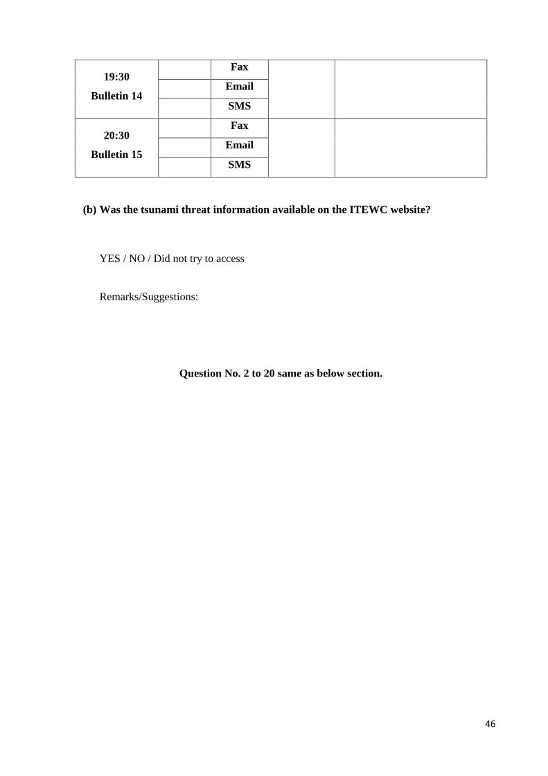
46
19:30
Bulletin 14
Fax
SMS
20:30
Bulletin 15
Fax
SMS
(b) Was the tsunami threat information available on the ITEWC website?
YES / NO / Did not try to access
Remarks/Suggestions:
Question No. 2 to 20 same as below section.
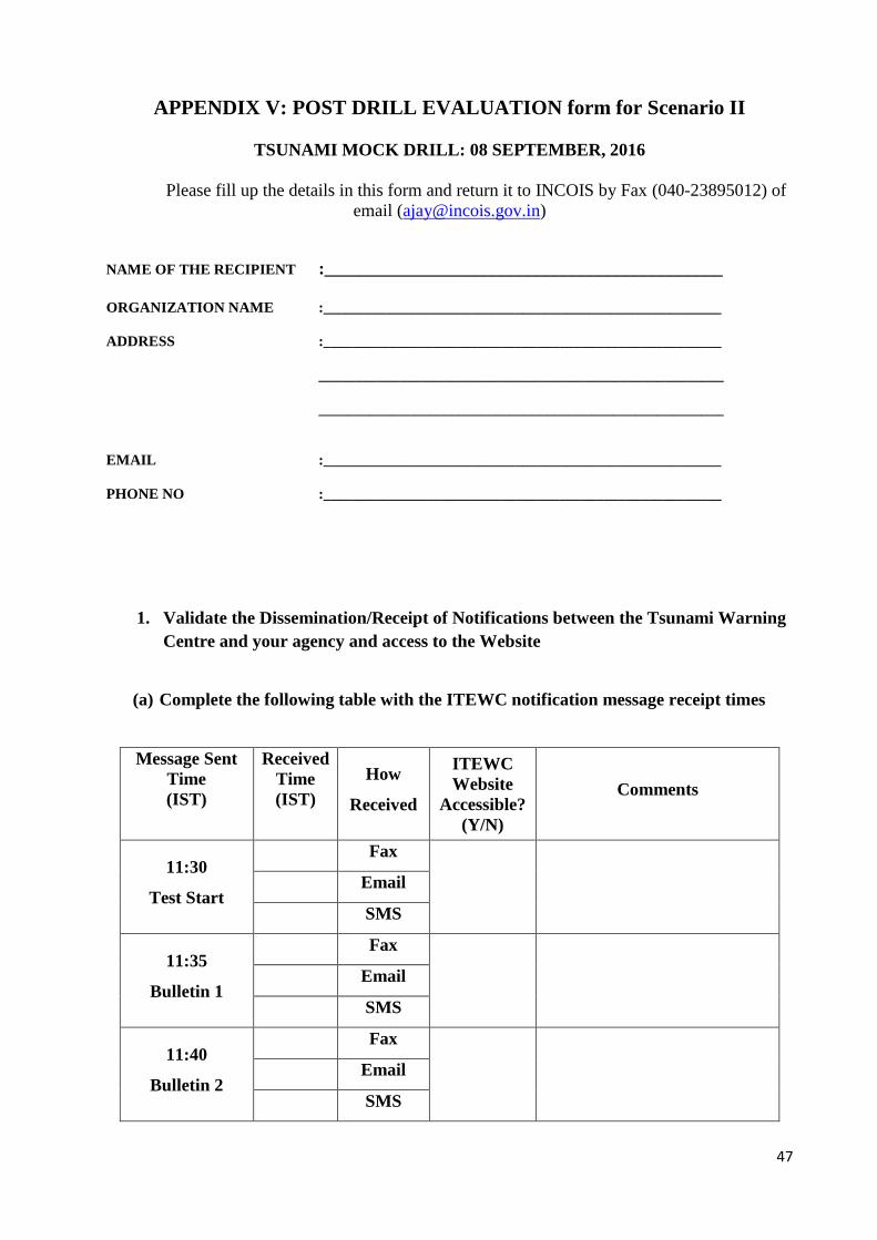
47
APPENDIX V: POST DRILL EVALUATION form for Scenario II
TSUNAMI MOCK DRILL: 08 SEPTEMBER, 2016
Please fill up the details in this form and return it to INCOIS by Fax (040-23895012) of
email ([email protected])
NAME OF THE RECIPIENT :_____________________________________________
ORGANIZATION NAME :______________________________________________________
ADDRESS :______________________________________________________
_______________________________________________________
_______________________________________________________
EMAIL :______________________________________________________
PHONE NO :______________________________________________________
1. Validate the Dissemination/Receipt of Notifications between the Tsunami Warning
Centre and your agency and access to the Website
(a) Complete the following table with the ITEWC notification message receipt times
Message Sent
Time
(IST)
Received
Time
(IST)
How
Received
ITEWC
Website
Accessible?
(Y/N)
Comments
11:30
Test Start
Fax
SMS
11:35
Bulletin 1
Fax
SMS
11:40
Bulletin 2
Fax
SMS
48
12:15
Bulletin 3
Fax
SMS
12:30
Bulletin 4
Fax
SMS
13:30
Bulletin 5
Fax
SMS
14:30
Bulletin 6
Fax
SMS
15:30
Bulletin 7
Fax
SMS
16:30
Bulletin 8
Fax
SMS
17:30
Bulletin 9
Fax
SMS
18:30
Bulletin 10
Fax
SMS
19:30
Bulletin 11
Fax
SMS
20:30
Bulletin 12
Fax
SMS
21:30
Bulletin 13
Fax
SMS

49
22:30
Bulletin 14
Fax
SMS
23:30
Bulletin 15
Fax
SMS
(b) Was the tsunami threat information available on the ITEWC website?
YES / NO / Did not try to access
Remarks/Suggestions:
2. Were you able to understand the bulletins, assess status of the threat to your coastal
areas and make decisions regarding public response?
YES / NO
Remarks/Suggestions:
3. Was any other information available to support local decision making?
YES / NO
Remarks/Suggestions:
4. Do you have a formal Standard Operating Procedure (SOP) for tsunami response?
YES / NO
Remarks/Suggestions:
If yes, How well did your SOPs perform for generating and disseminating tsunami
warnings.
Extremely well/ Very Well/ Well/ Poor
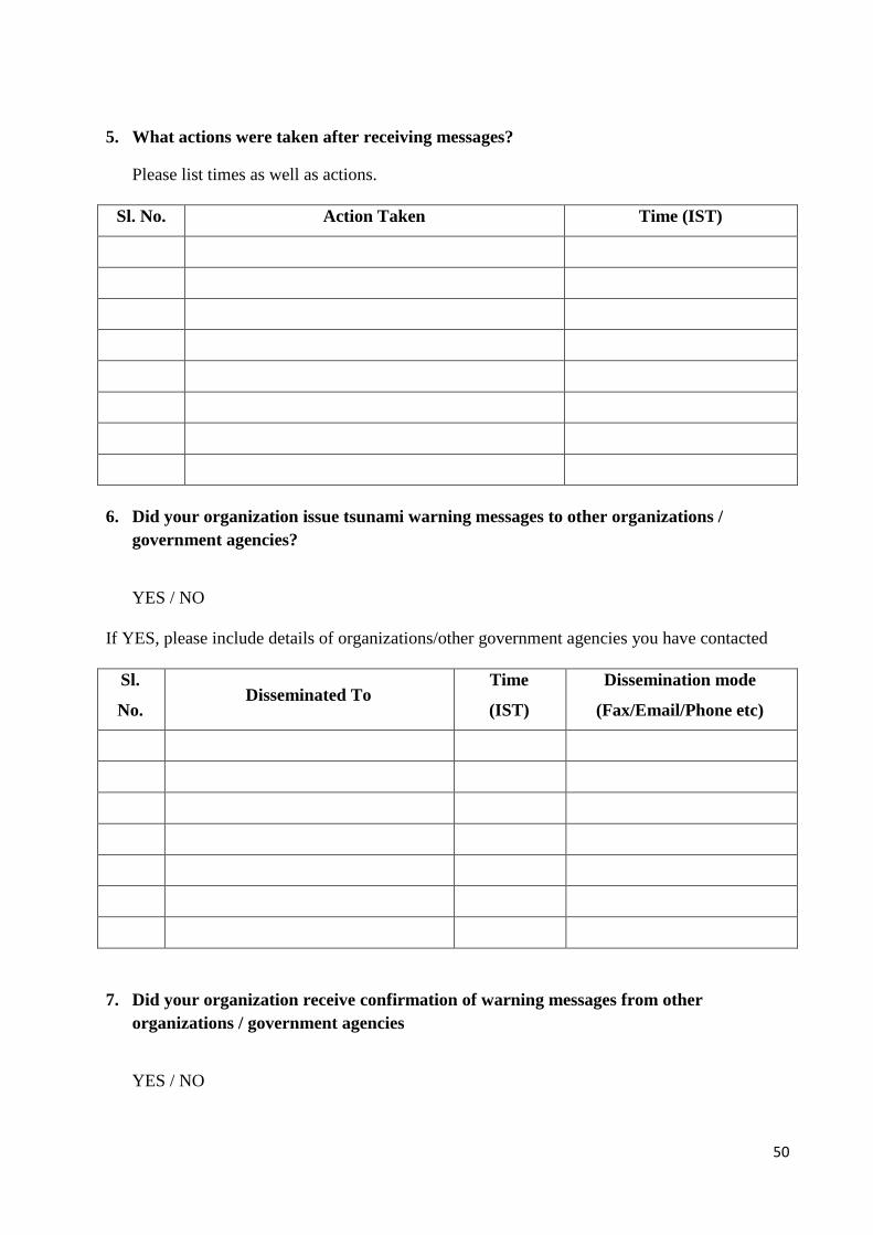
50
5. What actions were taken after receiving messages?
Please list times as well as actions.
Sl. No. Action Taken Time (IST)
6. Did your organization issue tsunami warning messages to other organizations /
government agencies?
YES / NO
If YES, please include details of organizations/other government agencies you have contacted
Sl.
No. Disseminated To
Time
(IST)
Dissemination mode
(Fax/Email/Phone etc)
7. Did your organization receive confirmation of warning messages from other
organizations / government agencies
YES / NO

51
If YES, please include details of organizations /other government agencies
Sl.
No. Received From
Time
(IST)
Information
Received
Reception mode
(Fax/Email/Phone
etc)
8. Did your organization issue tsunami warning messages to public?
YES / NO
If YES, please identify the modes that were employed to notify and instruct the public?
Method used to disseminate information to
public Yes/No
Arrangements Exists
Yes/No
Telephone
SMS
Public Radio
TV
Website
Sirens
Public announcement system
Public call centre
Police
Door-to-door announcements
Other (specify)
9. Did your organization communicate with Media during the event?
YES / NO
Remarks/Suggestions:

52
10. If tsunami warning was issued, at what time was the warning cancelled? What was the
reason for cancellation?
Time of Cancellation:
Reason for Cancellation:
Remarks/Suggestions:
11. Did your organization maintain communication with the Tsunami Warning Centre
throughout the event?
YES / NO
Remarks/Suggestions:
12. Assessment of the elapsed time until the public were notified:
Activity Elapsed Time (e.g. 1hr 15mins)
Making a decision on public warning
(From time of receipt of warning)
Formulation/compilation of public
Notification (From time of decision)
Activation of public notification systems
(After formulation of public notification)
Total Time
13. Were any areas evacuated?
YES / NO
(a) If YES, please provide details in the following table:
Area Evacuated Time
(IST) People were moved to
Estimated No. of
People Evacuated

53
(b) If an evacuation occurred, did the process happen smoothly?
YES / NO
If NO, please provide details of problems encountered:
14. Were tsunami evacuation maps available?
YES / NO
Remarks/Suggestions:
15. The Level of Community awareness of the local tsunami risk
None/ Low/ High/ Very High
Remarks/Suggestions:
16. Have community members received any prior evacuation training?
YES/ NO
Remarks/Suggestions:
17. Did the community receive an all-clear message?
YES/ NO
If Yes, at what time:
Remarks/Suggestions:
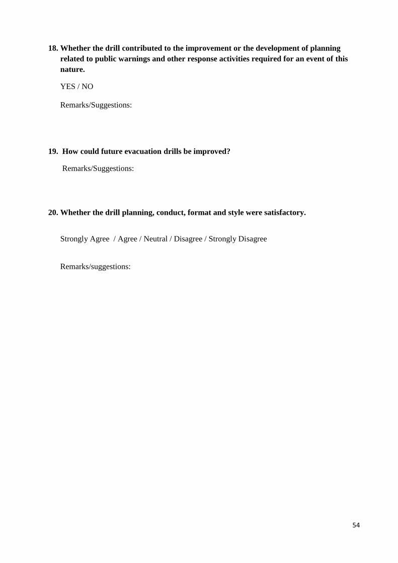
54
18. Whether the drill contributed to the improvement or the development of planning
related to public warnings and other response activities required for an event of this
nature.
YES / NO
Remarks/Suggestions:
19. How could future evacuation drills be improved?
Remarks/Suggestions:
20. Whether the drill planning, conduct, format and style were satisfactory.
Strongly Agree / Agree / Neutral / Disagree / Strongly Disagree
Remarks/suggestions:


![CIRCLE LEVEL FLOOD MOCK DRILL - sdmassam.nic.in flood_drill.pdf · [CIRCLE LEVEL FLOOD MOCK DRILL] 2016 1 | ASDMA ... the year 2016-17. Dates for the drill were decided in consultation](https://static.fdocuments.net/doc/165x107/5a9e196e7f8b9a39338cf1d1/circle-level-flood-mock-drill-flooddrillpdfcircle-level-flood-mock-drill-2016.jpg)