Treasure Coast Scenic Highway 5-Year Corridor … Coast Scenic Highway 5‐Year CMP Update 1...
24
Treasure Coast Scenic Highway 5‐Year CMP Update 1 Treasure Coast Scenic Highway 5-Year Corridor Management Plan Update
Transcript of Treasure Coast Scenic Highway 5-Year Corridor … Coast Scenic Highway 5‐Year CMP Update 1...

Treasure Coast Scenic Highway 5‐Year CMP Update
1
Treasure Coast Scenic Highway
5-Year
Corridor Management Plan Update
Treasure Coast Scenic Highway 5‐Year CMP Update
2
October 1, 2011

Treasure Coast Scenic Highway 5‐Year CMP Update
3
2300 Virginia Avenue Fort Pierce, FL 34982-5652 Telephone: 772/462-1593 Facsimile: 772/462-2549
Clint C. Eliason TranSystems 101 Southhall Lane, Ste. 355 Maitland, FL 32751
Dear Mr. Eliason, This report contains the five-year Corridor Management Plan Update for the Treasure Coast Scenic Highway (TCSH).The Florida Scenic Highway Program Manual Procedure #650-050-0055 Section 4.3.2 states that this five-year update is to be submitted in place of the annual report. If you have any questions please contact me at 772-462-1533 or St. Lucie TPO Executive Director Mr. Peter Buchwald at 772-462-1593. Sincerely, Edward DeFini Bicycle/Pedestrian Program Manager St. Lucie Transportation Organization 2300 Virginia Ave. Fort Pierce FL. 34982
Treasure Coast Scenic Highway 5‐Year CMP Update
4
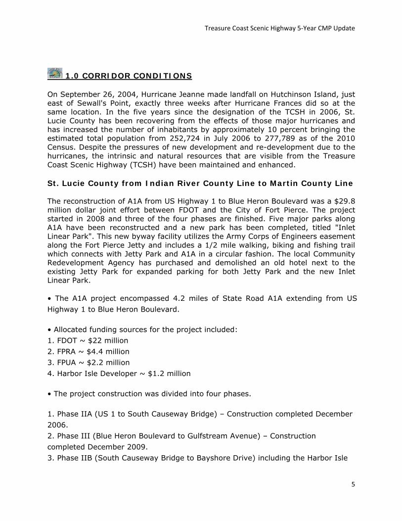
II Table of Contents
1.0 Corridor Conditions 5‐6
2.0 Corridor Resources 7‐10
3.0 Corridor Usage 10‐11
4.0 Corridor Vision After 5 Years 11‐14
5.0 Corridor Story 14‐15
6.0 Corridor Community Participation Program 15‐17
7.0 Corridor Local Support 17
8.0 Corridor Evaluation and Protection Techniques 17‐19
9.0 Corridor Funding 19
10.0 Corridor Promotion Measuring Success
11.0 Local Government Comprehensive Plan 19
12.0 Corridor Partnerships 19
13.0 Corridor Problem Areas 21‐22
13.0 Corridor Action Plan 23
A. Corridor Improvements/Enhancements
B. Promotional/Community Participation
C. Administration/Coordination
D. Funding Entities and Entities Responsible for Action Items
Treasure Coast Scenic Highway 5‐Year CMP Update
5
1.0 CORRIDOR CONDITIONS
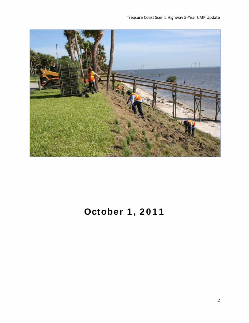
On September 26, 2004, Hurricane Jeanne made landfall on Hutchinson Island, just east of Sewall's Point, exactly three weeks after Hurricane Frances did so at the same location. In the five years since the designation of the TCSH in 2006, St. Lucie County has been recovering from the effects of those major hurricanes and has increased the number of inhabitants by approximately 10 percent bringing the estimated total population from 252,724 in July 2006 to 277,789 as of the 2010 Census. Despite the pressures of new development and re-development due to the hurricanes, the intrinsic and natural resources that are visible from the Treasure Coast Scenic Highway (TCSH) have been maintained and enhanced.
St. Lucie County from Indian River County Line to Martin County Line The reconstruction of A1A from US Highway 1 to Blue Heron Boulevard was a $29.8 million dollar joint effort between FDOT and the City of Fort Pierce. The project started in 2008 and three of the four phases are finished. Five major parks along A1A have been reconstructed and a new park has been completed, titled "Inlet Linear Park". This new byway facility utilizes the Army Corps of Engineers easement along the Fort Pierce Jetty and includes a 1/2 mile walking, biking and fishing trail which connects with Jetty Park and A1A in a circular fashion. The local Community Redevelopment Agency has purchased and demolished an old hotel next to the existing Jetty Park for expanded parking for both Jetty Park and the new Inlet Linear Park.
• The A1A project encompassed 4.2 miles of State Road A1A extending from US Highway 1 to Blue Heron Boulevard.
• Allocated funding sources for the project included: 1. FDOT ~ $22 million 2. FPRA ~ $4.4 million 3. FPUA ~ $2.2 million 4. Harbor Isle Developer ~ $1.2 million
• The project construction was divided into four phases.
1. Phase IIA (US 1 to South Causeway Bridge) – Construction completed December 2006. 2. Phase III (Blue Heron Boulevard to Gulfstream Avenue) – Construction completed December 2009. 3. Phase IIB (South Causeway Bridge to Bayshore Drive) including the Harbor Isle
Treasure Coast Scenic Highway 5‐Year CMP Update
6
Roundabout – Completed August 2010. 4. Phase I (Bayshore Drive to Gulfstream Avenue) – Construction Completed 2011
The A1A improvements include the total reconstruction of the roadway complete with bike lanes, on-street parking, curb and gutter, sidewalks, drainage facilities, landscaping, irrigation, decorative street lighting, underground electric/cable/phone, and water and sewer utility upgrades.
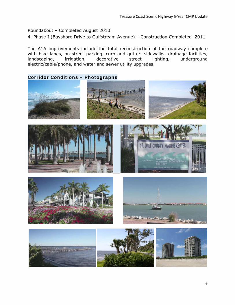
Corridor Conditions – Photographs

Treasure Coast Scenic Highway 5‐Year CMP Update
7
Photos Courtesy of St. Lucie TPO
2.0 Corridor Resources
Resource Name Description Special Circumstances
Avalon State Park Beach access w/facilities. Lagoon access w/limited facilities
Avalon has more than a mile of increasingly rare undeveloped beachfront. The park provides habitat for many species of wildlife. Threatened and endangered sea turtles such as the loggerhead, Atlantic green and leatherback nest on the beach during the spring and summer. Dune crossovers protect the fragile dune ecosystem.
Jack Island
Nature Preserve with 5 mile trail and observation tower. Used often for school trips to demonstrate native vegetation and wildlife, specifically mangrove and tropical beach hammock ecosystems
Actually divided into several separate areas, the 340-acre recreation area is loaded with beach, dunes, and coastal hammock. Its most interesting hiking, however, is Jack Island State Reserve located in the Intracoastal Waterway. Jack Island is a 641-acre impoundment of coastal hammock and dense mangrove. It is one of the state’s best birding areas, home to thousands of egrets, herons, and ibis. As many as 200 different species winter here.
Pepper Park
Beach access w/ various facilities. Lagoon access w/various facilities, including fishing pier and canoe launching
None
Urca De Lima Underwater Archeological Preserve
Shipwreck of Spanish merchant ship. National Register of Historic Places
None
Navy Seal Museum Mementos, books and videos of Seal involvement in World War II and conflicts
Recently nationally designated as the only Navy Seal Museum
Fort Pierce State Recreation Area
340 Acre State Park with extensive facilities, beach access and Lagoon access
None
Manatee Center Manatee Viewing year round, built on Indian River None
AE Backus Gallery 5,000 sf public visual arts facility None
Seven Gables House
Historic home staffed by St. Lucie County Chamber of Commerce as a visitor welcome center
None
Indian River Memorial Amphitheater
Open-air venue hosts music events, religious services, and civic events. Part of Veteran's Memorial Park
None

Treasure Coast Scenic Highway 5‐Year CMP Update
8
Fort Pierce Inlet State Park
Atlantic beaches, dunes, coastal hammocks, and mangroves are found in this park on the north shore of the Fort Pierce Inlet. mangroves.
Gulls, terns, and shorebirds are common on the beach. Migrating warblers may be spotted along the nature trail. Dynamite Point, a sheltered, mangrove-fringed cove, provides year-round opportunities to observe laughing gulls, royal terns, black skimmers, brown pelicans, and double-crested cormorants. Semi-palemated and black-bellied plovers, willets, sanderlings, and ruddy turnstones appear in winter.
St. Lucie County Historical Museum
Artifacts, exhibits and dioramas on the Spanish treasure fleets, the Seminole War, and the turn of the century industries in St. Lucie County
The Smithsonian Institute once described the St. Lucie County Historical Museum as “an unusually fine historical museum.” Located along the Indian River Lagoon, the Historical Museum features silver and gold from a fleet of 11 Spanish ships that sank during a 1715 hurricane. That and other sunken treasure helped the area earn the reputation as Florida’s “Treasure Coast.” The museum also features equipment from turn-of-the-century industries that help shape St. Lucie County, such as fishing, pineapple, cattle and citrus, as well as artifacts from the 1838 Seminole War.
St. Lucie County Marine Center
Educational facility with a classroom and recreational display
Smithsonian Marine Station
Provides marine research facilities to scientists actively studying the ocean and Indian River Lagoon
The Smithsonian Marine Station (SMS) at Fort Pierce, Florida is a research center specializing in marine biodiversity and ecosystems of Florida. Research focuses on the Indian River Lagoon and the offshore waters of Florida's east central coast, with comparative studies throughout coastal Florida. Free public tours are available.
Coast Guard Barracks/ IRSC Marine Center
Used by Indian River State College for marine classes and also as a "hospital" facility for marine life which later are transferred to the St. Lucie County Marine Center (above)
None
Bear Point Sanctuary Lagoon access and trails, fishing pier None
Blind Creek Park Lagoon access, beach access, trails, canoe launching None
Turtle Beach Nature Trail One mile boardwalk loop with observation points, beach access
None
FPL Energy Encounter
Florida Power and Light education center, designed to teach children and adults about electricity.
None
Frederick Douglass Memorial Park
Beach access, visitor's facilities, Guided horseback riding
None
PP Cobb Building Historic Downtown Building, one of the first trading posts on the Treasure Coast
None
John Brooks Park Beach access, lagoon access, trails None
Ocean Ray Beach Access Beach access, trails None

Treasure Coast Scenic Highway 5‐Year CMP Update
9
Waveland Beach Access Beach access, boardwalk, public facilities None
Herman’s Bay Beach Access Beach access None
Normandy Beach Access Beach access None
Savannas State Preserve
Educational Center, biking, hiking, horseback riding, canoeing, fishing
The Savannas Education Center has live exhibits, a gift shop, self guided tour booklets, and information on many of Florida's State Parks. Interpretive guided tours and canoe/kayak trips are offered by the Friends of Savannas Preserve State Park (a nonprofit citizen's support organization). A calendar of events and newsletter may be picked up at the Education Center.
Savannas Recreation Area (County Park)
County Park which encourages camping.
http://www.stlucieco.gov/parks/savannas.htm
Edgartown Historic District Locally designated historic district - primarily residential in nature
1,050 historic structures exist inside and outside the city's six historic districts: Avenue D, Downtown, Edgartown, Oakland Park, River's Edge and Sample Oaks. Structures outside the downtown area are eligible for historic designation, which she said would bring both benefits and responsibilities to the property owners
Downtown Historic District Locally designated historic district - primarily commercial in nature
River's Edge Historic District Locally designated historic district - primarily residential in nature
Structures outside the downtown area are eligible for historic designation,
Eden Cemetery Oldest Cemetery in St. Lucie County None
The Boston House Also known as Cresthaven, National Register of Historic Places
None
The Governor's House The childhood home of one of Florida's elected governors. Demolished by owner
Old Fort Park Site of the original Fort Pierce, for which the municipality was named.
This facility is proposed to be renovated.
Riverwalk Pathway and Observation Stations along lagoon None
Jetty Park Beach access, fishing pier on Atlantic and Inlet
Jetty Park is expanding to almost three times its size with help from a Scenic Byway Grant. Parking will be more than doubled. Connecting with new Inlet Linear Park (below) 2011
Veterans Memorial Park
Major open area along Indian River Drive. Site of several festivals, including annual July 4th fireworks.
Veteran's Memorial Park is slated for upcoming renovations
Fort Pierce Community Public facility open for events None

Treasure Coast Scenic Highway 5‐Year CMP Update
10
Center and rentals
City Marina Located on Indian River, holds an average of 10 fishing tournaments annually
Fort Pierce City Marina is the only downtown marina serving the Treasure Coast. Conveniently located along the beautiful Indian River Lagoon, the marina is one of Florida's best all-weather inlets and offers 284 slips.
Marina Square
Public open space on Indian River, used for events such as Farmer's Market (weekly) and Friday Fest (monthly)
None
Kimberly Bergalis Memorial Park Ocean access w/facilities Kimberly Bergalis Memorial Park is currently
undergoing renovations
Causeway Park River Access w/facilities Causeway Park was renovated by the local municipality
South Beach Park Ocean Access w/facilities South Beach Park was renovated by Fort Pierce
Jaycee Park River Access with playground, boat ramps, and park facilities
Jaycee Park was renovated by the City of Fort Pierce
Inlet Linear Park Complete 2010
Plants and Animals in the Indian River
The Indian River Lagoon is the most biologically diverse estuary in North America with more than 4,000 species of plants and animals. It is home to one-third of the endangered manatees which you can frequently see swimming. You’ll also see the native mangrove trees thriving in the wetlands. The mangrove trees provide an important ecosystem for the Indian River Lagoon for fish, crustaceans, mollusk, and wading birds. This is where many of their lives begin, thrive, and reproduce providing 75% to 90% of the habit for the source of all commercial fishing.
Fishing Spot - Local Favorite
At the intersection of Indian River Drive and Walton Road there is a small parking area that is popular with locals. If you want to wade in the river and fish one of the biggest challenges is finding a place to park so the Walton Road parking area is a local favorite.
3.0 Corridor Usage
Since its designation in 2006, it is estimated that Average Daily Vehicle Trips on both State Road A1A and the Indian River Drive portion of the TCSH have increased by approximately 15% (approximately 1,400 trips) 2006-2011. Both roads are operating at a Level of Service “C” and both have a capacity to carry approximately 6,000 additional trips. YEAR Count site Treasure Coast Scenic Highway (STATE ROUTE A1A) AADT
2009 890157 SR A1A/MARTIN ‐ ST LUCIE CO LINE 13300
2009 940719 SR A1A / S ‐ S OF FPL POWER PLANT (COUNTY 719) 4200

Treasure Coast Scenic Highway 5‐Year CMP Update
11
2009 940711 SR A1A/S ‐ E OF SR 5/US 1 (COUNTY 711) 11600
2009 940709 SR A1A / N ‐ E OF SR 5/US 1 (COUNTY 709) 3500
2009 940705 SR A1A/N ‐ N OF N BRIDGE CAUSWAY (COUNTY 705) 6600
2009 940703 SR A1A/N ‐ S OF REGAL RD (COUNTY 703) 5500
2009 940123 SR 5/US 1 ‐ S END OF TAYLOR CREEK BRIDGE (COUNTY 123) 25000
2009 940116 SR A1A / S ‐ S OF BLUE HERON BLVD,FT PIERCE (COUNTY 116) 3600
2009 940115 SR A1A / S ‐ E END OF S BRIDGE 12400
2009 940114 SR A1A / N ‐ E END OF ICWW BR,ST LUCIE CO 7100
2009 945016 SR A1A/S ‐ S OF SEAWAY DR (COUNTY 5016) 7500
YEAR Count Site Treasure Coast Scenic Highway (INDIAN RIVER DRIVE) AADT
2009 940004 INDIAN RIVER DR ‐ 707 S OF A1A / BRIDGE (COUNTY 4) 7100
2009 940003 CR 707/INDIAN RIVER DR ‐ N OF ORANGE AVE (COUNTY 3) 5800
2009 947092 ON INDIAN RIVER DR ‐ N. OF SAVANNAH RD (COUNTY 501) 4200
2009 947022 ON INDIAN RIVER DR ‐ N. OF MARTIN COUNTY LINE (COUNTY 127) 5700
2009 947020 ON INDIAN RIVER DR ‐ N. OF MIDWAY RD EAST (COUNTY 123) 4100
2009 945151 CR 707/INDIAN RIVER DR. ‐ N. OF WALTON RD. (COUNTY 125) 4000
2009 945029 SR 707/INDIAN RIVER DR ‐ N OF CITRUS AVE (COUNTY 5029) 6200
4.0 Corridor Vision After 5 Years
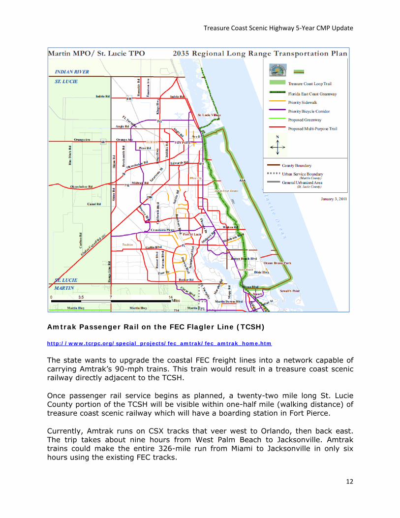
The vision of the corridor has been maintained over the five year period through the diligence and through the cooperation of businesses, citizens, homeowner associations and governments, among others. The Old Florida rural beach atmosphere, historical preservation, Coastal Greenways, and beach recreational access are being maintained within the vision. These ideas still represent the community’s desire for the scenic corridor. The Treasure Coast Scenic Highway is a unique river to sea experience that encompasses exceptional natural, scenic, cultural, archeological, historical, educational and recreational resources. It runs through St. Lucie County and joins Florida’s East Coast Greenway to Indian River County in the north with the Scenic & Historic A1A Scenic Highway. Traveling south along A1A in St. Lucie County, the A1A portion of the TCSH is proposed to become a 21 mile portion of what is known as the “Treasure Coast Loop Trail (TCLP).” The TCLP is a cost feasible 44 mile long loop trail proposed in the 2035 Joint Martin/St. Lucie Regional Long Range Transportation Plan.
Treasure Coast Scenic Highway 5‐Year CMP Update
12
Amtrak Passenger Rail on the FEC Flagler Line (TCSH)
http://www.tcrpc.org/special_projects/fec_amtrak/fec_amtrak_home.htm
The state wants to upgrade the coastal FEC freight lines into a network capable of carrying Amtrak’s 90-mph trains. This train would result in a treasure coast scenic railway directly adjacent to the TCSH.
Once passenger rail service begins as planned, a twenty-two mile long St. Lucie County portion of the TCSH will be visible within one-half mile (walking distance) of treasure coast scenic railway which will have a boarding station in Fort Pierce.
Currently, Amtrak runs on CSX tracks that veer west to Orlando, then back east. The trip takes about nine hours from West Palm Beach to Jacksonville. Amtrak trains could make the entire 326-mile run from Miami to Jacksonville in only six hours using the existing FEC tracks.

Treasure Coast Scenic Highway 5‐Year CMP Update
13
In addition to rail upgrades, new Amtrak stations would be built in Stuart, Fort Pierce, Vero Beach, Melbourne, Cocoa, Titusville, Daytona Beach and St. Augustine. The project would also include construction of a key rail interconnection between the CSX and FEC tracks in West Palm Beach that could allow Tri-Rail service to be extended north to Jupiter. Once passenger rail service begins, the St. Lucie County portion of the TCSH will be within walking distance of the treasure coast scenic railway station in Fort Pierce.
Last year, the Florida Department of Transportation applied for $268 million in federal stimulus dollars, but the project wasn’t far enough along to qualify for funding. The Amtrak/FEC corridor project will create an estimated 2,100 new jobs.
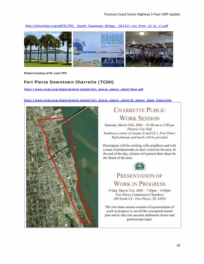
Photos Courtesy of St. Lucie TPO
The South Causeway Bridge Re-configuration Study (TCSH) http://stlucietpo.org/pdf/SLTPO__South_Causeway_Bridge__061311_rev_from_12_to_11.pdf The TPO and the City of Fort Pierce are engaging the public in an effort to enhance the TCSH. In accordance with USDOT policy, integrating bicycle and pedestrian accommodations on new, rehabilitated, and/or limited-access bridges with connections to streets or paths is encouraged. The South Causeway Bridge on South State Route A1A (the TCSH in Fort Pierce) is being considered for such accommodations as the current configuration is inadequate for both bicycles and pedestrians. An improvement may encourage a connected walking/bicycling environment from Downtown Fort Pierce to the beach. A study is being completed which evaluates the current configuration and includes the feasibility of a change, permitting and regulatory requirements, a public workshop with community members and other stakeholders, and an implementation plan. A consultant is being utilized for the study.

Treasure Coast Scenic Highway 5‐Year CMP Update
14
South Causeway Bridge (A1A Treasure Coast Scenic Highway)
Existing 4 Lanes bike/ped 5’ sidewalk 2 Lanes with Bike/Ped Enhancements
Photos Courtesy of St. Lucie TPO
5.0 Corridor Story On September 29, 2006, Members of The Indian River Lagoon - Treasure Coast Scenic Highway Corridor Advocacy Group officially celebrated the designation of St. Lucie County Florida Scenic Highway during Friday Fest in Downtown Fort Pierce. The Florida Department of Transportation approved portions of Indian River Drive and State Road A1A as part of Florida's Scenic Highway program in January. The Indian River Lagoon-Treasure Coast Scenic Highway corridor is approximately 42 miles in length and travels along SR A1A from the Indian River/St. Lucie County line, south along North Hutchinson Island, crossing over the Indian River Lagoon to U.S. 1. The scenic highway continues south on U.S. 1 to South A1A (Seaway Drive) to the St. Lucie County Martin County line. Indian River Drive (SR 707) is also part of the scenic highway, beginning at the Martin/St. Lucie County line continuing north to downtown Fort Pierce, ending at Seaway Drive.

Treasure Coast Scenic Highway 5‐Year CMP Update
15
Members of the Corridor Advocacy Group, which consisted of county staff members, elected officials, as well as residents and business representatives from the scenic highway, were stationed at an information booth, handing out balloons, pencils and information about St. Lucie County’s Scenic Highway.
A1A is an historical coastal highway traveling through a nationally recognized ecosystem that captures ―Old Florida from the time of Native American dominance to colonists and settlers, to movie producers, to tourists and to the residents who gravitate to Florida's East Coast. This river to sea corridor combines the changeable beauty of the ocean and beaches with the peacefully relaxing vistas of the river, separated by magnificent moss-laden oaks. It combines educational enrichment opportunities with a changing environment; it is simply a soothing, rejuvenating experience down a road to "Old Florida."
Facilities such as one-of-a-kind military and historical museums to environmental education centers will be easily identified as part of the 42-mile corridor that makes up the Indian River Lagoon - Treasure Coast Scenic Highway. But the corridor’s best feature isn’t its bricks and mortar. What makes the Indian River Lagoon - Treasure Coast Scenic Highway extraordinary is the view from the sandy, coastal dunes that drift out into the Atlantic Ocean to the mangrove-covered banks of the Indian River Lagoon – home to more than 4,000 species of plants and animals, including 50 species that are endangered or threatened.
This corridor is more than a paved path that takes you from Point A to Point B. It’s an educational experience designed to enhance St. Lucie County’s remarkable historical, cultural, and environmental resources.
Even though you are surrounded by Florida’s natural beauty, it’s the things you can’t see that make this Scenic Highway truly unique, from the ghosts of World War II veterans, who stormed the beaches of Hutchinson Island before arriving in Normandy, to artists such as landscape painter A.E. Backus, Highwaymen Alfred Hair, and Harlem Renaissance author Zora Neale Hurston. It’s the trace remnants of pineapple farms, fishing villages, Indian mounds, and military forts that rest along the banks of the Indian River that make this corridor worth designation. This watershed has been, and always will be, the lifeline of the community that surrounds it in the present and for the future generations to come.
6.0 Community Participation Program
Unfortunately CME meetings have dropped off. However, the TPO is a County wide agency responsible for transportation planning, programming, and financing of State and Federal Transportation Funds. The TPO’s community participation program, through its many boards and committees, provides businesses, citizens, homeowner associations and local governments, among others, opportunities to provide input concerning the TCSH. For example, the South Causeway (A1A) Bridge Reconfiguration Study Public Input Meeting.
Treasure Coast Scenic Highway 5‐Year CMP Update
16
http://stlucietpo.org/pdf/SLTPO__South_Causeway_Bridge__061311_rev_from_12_to_11.pdf
Photos Courtesy of St. Lucie TPO
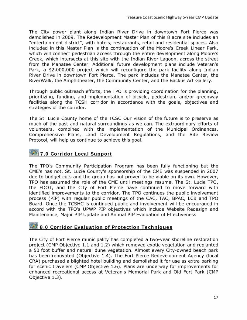
Fort Pierce Downtown Charrette (TCSH) http://www.tcrpc.org/departments/studio/fort_pierce_power_plant/flyer.pdf http://www.tcrpc.org/departments/studio/fort_pierce_power_plant/fp_power_plant_home.htm
Treasure Coast Scenic Highway 5‐Year CMP Update
17
The City power plant along Indian River Drive in downtown Fort Pierce was demolished in 2009. The Redevelopment Master Plan of this 8 acre site includes an "entertainment district", with hotels, restaurants, retail and residential spaces. Also included in this Master Plan is the continuation of the Moore's Creek Linear Park, which will connect pedestrian access through the entire development along Moore's Creek, which intersects at this site with the Indian River Lagoon, across the street from the Manatee Center. Additional future development plans include Veteran's Park, a $2,000,000 project which will reconfigure the park facility along Indian River Drive in downtown Fort Pierce. The park includes the Manatee Center, the RiverWalk, the Amphitheater, the Community Center, and the Backus Art Gallery. Through public outreach efforts, the TPO is providing coordination for the planning, prioritizing, funding, and implementation of bicycle, pedestrian, and/or greenway facilities along the TCSH corridor in accordance with the goals, objectives and strategies of the corridor. The St. Lucie County home of the TCSC Our vision of the future is to preserve as much of the past and natural surroundings as we can. The extraordinary efforts of volunteers, combined with the implementation of the Municipal Ordinances, Comprehensive Plans, Land Development Regulations, and the Site Review Protocol, will help us continue to achieve this goal.
7.0 Corridor Local Support The TPO’s Community Participation Program has been fully functioning but the CME’s has not. St. Lucie County's sponsorship of the CME was suspended in 2007 due to budget cuts and the group has not proven to be viable on its own. However, TPO has assumed the role of the CME until meetings resume. The St. Lucie TPO, the FDOT, and the City of Fort Pierce have continued to move forward with identified improvements to the corridor. The TPO continues the public involvement process (PIP) with regular public meetings of the CAC, TAC, BPAC, LCB and TPO Board. Once the TCSHC is continued public and involvement will be encouraged in accord with the TPO’s UPWP PIP objectives which include Website Redesign and Maintenance, Major PIP Update and Annual PIP Evaluation of Effectiveness
8.0 Corridor Evaluation of Protection Techniques The City of Fort Pierce municipality has completed a two-year shoreline restoration project (CMP Objective 1.1 and 1.2) which removed exotic vegetation and replanted a 50 foot buffer and natural dune vegetation. Almost every City-owned beach park has been renovated (Objective 1.4). The Fort Pierce Redevelopment Agency (local CRA) purchased a blighted hotel building and demolished it for use as extra parking for scenic travelers (CMP Objective 1.6). Plans are underway for improvements for enhanced recreational access at Veteran's Memorial Park and Old Fort Park (CMP Objective 1.3).

Treasure Coast Scenic Highway 5‐Year CMP Update
18
St. Lucie County is now a certified “Green County,” joining the ranks of only five other Florida counties to receive this prestigious recognition from the Florida Green Building Coalition (FGBC).
“Receiving the Green County designation is a proud moment for St. Lucie County,” said Board of County Commissioners Chairman Charles Grande. “I’m especially proud of all the County employees who came together and worked cooperatively to find ways we could operate more efficiently and save taxpayer dollars.”
The FGBC uses a standard of criteria to evaluate performance in implementing policies and programs in the areas of energy, water, air, land, waste and education/awareness. St. Lucie County submitted a several-hundred-page application to the FGBC in September 2009. It was evaluated using a point system, with St. Lucie County achieving gold level certification for its exceptional stewardship and sustainability initiatives. St. Lucie County is currently tied with Indian River County for the third highest score in the FGBC application process.
Many of the policies and programs that led to St. Lucie County’s gold level score had already been in place for some time prior to initiating the certification process, including the environmentally significant lands program, innovative land planning codes and policies and numerous educational and community outreach programs. Additional credits were earned from recently adopted policies and programs, including the County’s implementation of environmentally preferred purchasing standards, green cleaning and landscaping policies, databases to track green certified buildings, and an energy and water manager position to coordinate green programs and track resultant cost savings.
The recommendation to pursue green local government certification came from the St. Lucie County Sustainability Advisory Committee (SAC), an advisory board commissioned by the St. Lucie County Board of County Commissioners.
“Becoming a Green County is much more than developing a stewardship mindset within county government,” said SAC Chairman Alan Gilbert, executive director of Facilities and Maintenance for the St. Lucie County School District. “It has to be embraced by business people and individual citizens to be truly successful. This initiative being driven by the business people, industry representatives, and citizen ambassadors that make up the Committee speaks volumes to the commitment of our community.”
May 20, 2010: FORT PIERCE Sand Dollar Shores resident Peter Degen, who watched hurricanes erode his beach, said he’s ready for a restoration project to begin as early as the summer of next year. “If you look at the beaches there,” he said, “there is no beach. High tide brings water up to the dune level.” As a member of the condominium’s board of directors since 2003, Degen joined more than 50 people Wednesday night at a public meeting in St. Lucie County Commission Chambers about the Environmental Impact Statement for the South Beach and Dune Restoration Project. Five buildings of Degan’s condominium are in the project’s 3.8-mile stretch from the Walton Road area to the St. Lucie/Martin county

Treasure Coast Scenic Highway 5‐Year CMP Update
19
line. “The preservation of the beaches is a must,” Degen said. The meeting is the first step in the Environmental Impact Statement process meant to identify issues related to the project. St. Lucie County submitted applications for the project to the state and the U.S. Army Corps of Engineers, which determined the need for the statement. Corps project manager Garett Lips explained the project would consist of dredging sand less than three miles offshore from the project site and moving it to the shore to restore the beach and dune. The project was predicted to cost about $10 million split nearly even between the county and the state. The estimated environmental impact is to 1.08 acres of hard bottom habitat, which may affect endangered species like nesting and swimming turtles, manatees and smalltooth sawfish. At the meeting, people voiced concerns about the animals and the environmental impact of the project. Comments and questions from the public were recorded to be taken into consideration.
South Ocean Drive resident Robert Wolfe was concerned how the dredging would affect ocean swells. He asked them to include a wave study analysis in the statement process. As president of a committee representing 38 homeowner associations on Hutchinson Island called the President’s Council, Pat Pacitti said the beach needs its sand back. No vegetation or beach remained after the 2004 hurricane season, she said. Residents would get up at 4:30 a.m. to help disoriented baby turtles. “The people that live on the island really do care about the environment,” Pacitti said. “They actually live it.”
Source: http://www.tcpalm.com/news/2010/may/20/corps-of-engineers-takes-public-comment-on-st/
9.0 Corridor Funding Funding sources for maintenance and enhancements of the TCSH are obtained from a variety of sources and by a variety of agencies. Mostly from the FDOT, FHWA and from various local government offices of those communities which have passed resolutions supporting the program. April 21, 2010 FORT PIERCE — The U.S. Environmental Protection Agency awarded the Fort Pierce Redevelopment Agency with $600,000 in grants as part of an effort to help communities revitalize contaminated properties. http://cityoffortpierce.com/pdf/Arial_of_HD_King_Power_Plant_Property.pdf FPRA Director Jon Ward said the money would be used to clean up the former H.D. King Power Plant site on Indian River Drive. The grants will cover the entire cost of the cleanup, Ward said. The Redevelopment Agency already has spent $100,000 on the cleanup with a grant it received from the Treasure Coast Regional Planning Council. City officials want to see a hotel built on the property. In all, the EPA awarded eight communities in Florida with $3 million in Brownfield grants. Fort Pierce was the only government agency on the Treasure Coast to receive grant money. Brownfields are parcels of land where their reuse may be complicated by the presence or potential presence of a hazardous substance.

Treasure Coast Scenic Highway 5‐Year CMP Update
20
10.0 Corridor Promotion and Measuring Success http://www.floridascenichighways.com/sights-sounds/ir-treasure-gallery/
11.0 Local Government Comprehensive Plan Relationship Existing policies in the Coastal Element and Conservation Element of the St. Lucie Comprehensive Plan provide measurable targets (through the site plan review process) to encourage preservation of scenic views and intrinsic qualities unique to the Treasure Coast Scenic Highway (Indian River Drive and A1A). http://www.stlucieco.gov/pdfs/EAR_Adopted_10-28-08_(2).pdf
12.0 Corridor Partnershipships
http://harbourisleflorida.com/
Treasure Coast Scenic Highway 5‐Year CMP Update
21
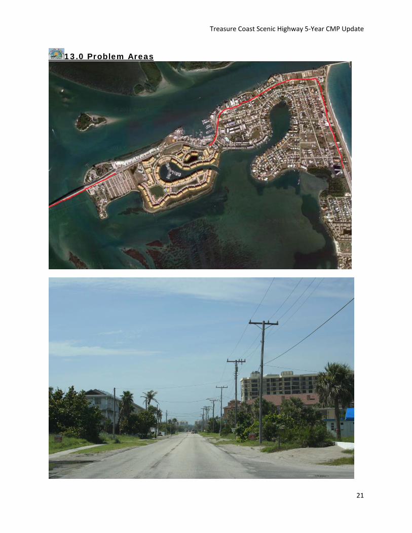
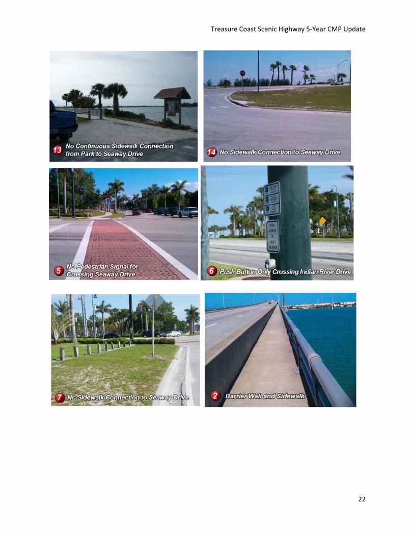
13.0 Problem Areas
Treasure Coast Scenic Highway 5‐Year CMP Update
22

Treasure Coast Scenic Highway 5‐Year CMP Update
23
13.0 Corridor Action Plan The action plan is a prioritized list of activities and tasks to be accomplished. The TPO CME has updated the original CMP plan by reviewing the goals, objectives, and strategies and determining reasonable completion schedules. The TCSH action plan consists of a five year action plan. Action items in each of these categories range from the highest priority to medium and lower priority projects. The acronyms to the items listed in the table below are shown following the table. A. Corridor Improvements/Enhancements
No Action Linkages: Goals,
Objective, Strategies
Responsibility Potential Funding
Sources and Partners
Product Year
1
Road Resurfacing Pedestrian Crossing
Enhancements
FDOT FDOT adding 5 proposed pedestrian
crossings within the limits of
project 423034-1-52-01
2011-2012

Treasure Coast Scenic Highway 5‐Year CMP Update
24
SLC County/City Parks and Recreation DEP Department of Environmental Protection ECG East Coast Greenway ESL Environmentally Sensitive Land Program FP City of Fort Pierce FBG FDOT Beautification Grant FBIP Florida Boating Improvement Program SLC St. Lucie County FCMP Florida Coastal Management Programs FCT Florida Communities Trust FDOT Florida Department of Transportation FRDAP Florida Recreation and Development Assistance Program GOS Goals, Objectives, and Strategies HR Division of Historic Resources MS Museum PR Private Parties SFWMD South Florida Water Management District SHG Scenic Highway Grant SPS State Parks Services TDC Tourist Development Council
Visit Florida