
Transylvanian Composite Total Petroleum System of the ... · Transylvanian Composite Total...
15
U.S. Department of the Interior U.S. Geological Survey Bulletin 2204–E Transylvanian Composite Total Petroleum System of the Transylvanian Basin Province, Romania, Eastern Europe
Transcript of Transylvanian Composite Total Petroleum System of the ... · Transylvanian Composite Total...

U.S. Department of the InteriorU.S. Geological Survey
Bulletin 2204–E
Transylvanian Composite Total Petroleum System of the Transylvanian Basin Province, Romania, Eastern Europe

Transylvanian Composite Total Petroleum System of the Transylvanian Basin Province, Romania, Eastern Europe
By Mark Pawlewicz
Bulletin 2204–E
U.S. Department of the InteriorU.S. Geological Survey

U.S. Department of the InteriorGale A. Norton, Secretary
U.S. Geological SurveyP. Patrick Leahy, Acting Director
U.S. Geological Survey, Reston, Virginia: 2005
Posted online August 2005, version 1.0
This publication is only available online at: http://pubs.usgs.gov/bul/2204/e
For more information about the USGS and its products: Telephone: 1-888-ASK-USGS World Wide Web: http://www.usgs.gov/
Any use of trade, product, or firm names in this publication is for descriptive purposes only and does not imply endorsement by the U.S. Government.
Although this report is in the public domain, permission must be secured from the individual copyright owners to reproduce any copyrighted materials contained within this report.
Suggested citation:Pawlewicz, Mark, 2005, Transylvanian Composite Total Petroleum System of the Transylvanian Basin Province, Romania, Eastern Europe: U.S. Geological Survey Bulletin 2204–E, 10 p.

Contents
Foreword ……………………………………………………………………………………… 1Abstract ……………………………………………………………………………………… 2Introduction …………………………………………………………………………………… 2Province Geology …………………………………………………………………………… 2
Structural Setting ……………………………………………………………………… 2Stratigraphy ……………………………………………………………………………… 2
Hydrocarbons in the Transylvanian Basin …………………………………………………… 5Hydrocarbon Source Rocks ……………………………………………………………… 5Seals …………………………………………………………………………………… 7Reservoirs ……………………………………………………………………………… 7Traps …………………………………………………………………………………… 7Burial History and Generation and Migration of Hydrocarbons ………………………… 7
Assessment Results and Summary …………………………………………………………… 8References Cited ……………………………………………………………………………… 9
Figures
1. Map showing location and structural features of the Carpathian Mountains region, eastern Europe ……………………………………………………………………… 3
2. Map showing location of Transylvanian Composite Total Petroleum System in Romania, eastern Europe …………………………………………………………… 4
3. Events chart for the Transylvanian Basin Neogene Suprasalt Gas Assessment Unit ………………………………………………………………………………… 5
4. Cross sections showing stratigraphic relation of Upper Cretaceous through Pliocene rocks for the Transylvanian Basin, central Romania, eastern Europe ……………………………………………………………………… 6
5. Cross section showing stratigraphic relation and basement configuration of Jurassic through upper Miocene sediments, central Romania, eastern Europe …… 6
6. Events chart for Transylvanian Basin Neogene Suprasalt Gas Assessment Unit, central Romania, eastern Europe …………………………………………………… 7
7. Graph showing undiscovered field size distribution for the Transylvanian Neogene Suprasalt Gas Assessment Unit of the Transylvanian Composite Total Petroleum System …………………………………………………………… 8
Table
1. Transylvanian Composite Total Petroleum System assessment results …………… 9
iii

Multiply By To obtainkilometer (km) 0.6214 milesquare kilometer (km²) 0.3861 square milemeter (m) 3.281 footcubic feet 0.02832 cubic meters
Vertical coordinate information is referenced to the North American Vertical Datum of 1988 (NAVD 88).
Conversion Factors
iv

Transylvanian Composite Total Petroleum System of the Transylvanian Basin Province, Romania, Eastern Europe
By Mark Pawlewicz
number and sizes of undiscovered fields is applicable. A TPS might equate to a single AU or it may be subdivided into two or more AUs such that each is sufficiently homogeneous in terms of geology, exploration considerations, and risk to assess individually. Assessment units are considered established if they contain more than 13 fields, frontier if they contain 1–13 fields, and hypothetical if they contain no fields.
A graphical depiction of the elements of a TPS is pro-vided in the form of an events chart that shows: (1) the times of deposition of essential rock units; (2) the times that pro-cesses, such as trap formation, necessary to the accumulation of hydrocarbons took place; (3) the critical moment in the total petroleum system; and (4) the preservation time, if any.
A numeric code identifies each region, province, TPS, and AU; these codes are uniform throughout the project and will identify the same item in any of the publications. The code is as follows:
Example
Region, single digit 4Province, three digits to the right of the
region code 4057Total Petroleum System, two digits to the
right of province code 405701Assessment unit, two digits to the right of
petroleum system code 40570101
The codes for the regions and provinces are listed in Klett and others (1997).
Oil and gas reserves quoted in this report are derived from Petroleum Exploration and Production database (Petro-consultants, 1996) and other areas reports from Petroconsul-tants, Inc., unless otherwise noted.
Boundaries of TPSs, AUs, and pods of active source rocks were compiled using geographic information system (GIS) software. Political boundaries and cartographic repre-sentations were taken, with permission, from Environmental Systems Research Institute’s ArcWorld 1:3 million digital coverage (1992), have no political significance, and are dis-played for general reference only. Oil and gas centerpoints are reproduced, with permission, from Petroconsultants (1996).
Foreword
This report was prepared as part of the World Energy Project of the U.S. Geological Survey. In the project, the world was divided into 8 regions and 937 geological provinces. The provinces have been ranked accordingly to the discovered oil and gas volumes within each (Klett and others, 1997). Then, 76 “priority” provinces (exclusive of the United States and chosen for their high ranking) and 26 “boutique” provinces (exclusive of the United States and chosen for their anticipated petroleum richness or special regional economic importance) were selected for appraisal of oil and gas resources. The petroleum geology of these priority and boutique provinces is described in this series of reports. A detailed report containing the assessment results is available separately (U.S. Geological Survey World Energy Assessment Team, 2000).
The purpose of this effort is to aid in assessing the volumes of oil, gas, and natural gas liquids that have the potential to be added to reserves within the next 30 years. These volumes either reside in undiscovered fields whose sizes exceed the stated minimum-field-size cutoff value for the assessment unit (variable, but must be at least 1 million barrels of oil equivalent) or occur as reserve growth of fields already discovered.
The total petroleum system (TPS) constitutes the basic geologic unit of the oil and gas assessment. The TPS includes all genetically related petroleum that occurs in shows and accumulations (discovered and undiscovered) that has been generated by a pod or by closely related pods of mature source rock and which exists within a limited mappable geologic space, together with the essential mappable geologi-cal elements (source, reservoir, seal, and overburden rocks) that control the fundamental processes of generation, expul-sion, migration, entrapment, and preservation of petroleum (Magoon and Dow, 1994). The minimum petroleum system is that part of a TPS encompassing discovered shows and accu-mulations together with the geologic space in which the vari-ous essential elements have been proved by these discoveries.
An assessment unit (AU) is a mappable part of a TPS in which discovered and undiscovered fields constitute a single relatively homogeneous population such that the chosen meth-odology of resource assessment based on estimation of the

Abstract
The Transylvanian Composite Total Petroleum System and the Transylvanian Neogene Suprasalt Gas Assessment Unit were identified in the Transylvanian Basin Province (4057), which lies entirely within the country of Romania. The assessment unit is composed of middle Miocene (Badenian) to Pliocene strata. Gas from the assessment unit is biogenic and originated from bacterial activity on dispersed organic matter in shales and siltstones. Gas migration is believed to be minimal, both vertically and laterally, with gases trapped in local stratigraphic traps and in structural traps (most likely domes and anticlinal folds created by salt diapirism) in the central part of the basin. For this reason, the gas fields also are concentrated in the central part of the basin. Reservoirs are isolated and composed of vertically stacked sandstones and siltstones sealed by shales and possibly by evaporite layers. Traps result from stratigraphic and facies changes within the entire assessment unit stratigraphic section. Some gas fields contain as much or more than a trillion cubic feet, but in most, the estimated resources are between 6 billion and 96 billion cubic feet. Petroleum exploration in the province is in the mature stage, which, combined with the geologic complex-ity of the region, is considered to limit future discoveries to a relatively few small fields. The undiscovered resources for the Transylvanian Basin Neogene Suprasalt Composite AU in the Transylvanian Hybrid Total Petroleum System (4057) are, at the mean, 2.083 trillion cubic feet of gas. No oil is produced in the basin. Rocks underlying the salt layers were not assessed for hydrocarbon potential.
Introduction
The Transylvanian Basin lies entirely within the country of Romania in eastern Europe (fig. 1). The basin is a middle Miocene to Pliocene sag basin that covers an area of about 20,000 km2 in the central part of the Transylvanian intra-Carpathian depression (Popescu, 1995). Surrounding the basin are the Carpathian Mountains on the north, east, and south and the Apuseni Mountains on the west.
The Transylvanian Basin Province (4057) contains the Transylvanian Composite Total Petroleum System (TPS 405701), within which a single assessment unit (AU) (with a boundary coincident with that of the TPS), the Transylva-nian Neogene Suprasalt Gas AU, is identified (fig. 2). The AU includes all rocks above the base of the Neogene strati-graphic sequence, where there is a basinwide evaporite layer. Potential petroleum resources in rocks below this layer were not assessed due to a lack of exploration and production and limited geologic and seismic data.
The results of USGS World Energy 2000 assessment ranked the Transylvanian Basin Province (4057) as the 56th largest in the world, exclusive of the United States, with 0.2 percent of the world’s oil and gas resources. This ranking is
based on the volume of known reserves plus cumulative pro-duction (Klett and others, 1997). The assessment results are summarized in the USGS Digital Data Series DDS–60 (U.S. Geological Survey World Energy Assessment Team, 2000).
Province Geology
Structural Setting
The Transylvanian Basin is a depression superimposed on the Cretaceous nappe system of eastern Europe and the Romanian Carpathian Mountains (fig. 1). The basin began to form in Late Cretaceous time, and the present morphology and structure of the Carpathian (and Pannonian) region is the result of Cretaceous to Miocene convergence and collision of the European plate with several small continental blocks to the south (Royden and Baldi, 1988). Following the Cretaceous, the inner Carpathian zone, including the Transylvania area, became rigid while the outer zone remained mobile (Visarion and Veliciu, 1981).
The lowest structural units in the eastern Carpathian Mountains consist of a continuous belt of Upper Cretaceous to Miocene flysch that was deformed into north- and east-verging thrust and fold nappes in Tertiary time (Royden and Baldi, 1988). Flysch sedimentation proceeded diachronously from west to east, ending in early Miocene time in the western Car-pathians, whereas sedimentation of molasse facies continued until Pliocene time in the eastern Carpathians (Royden and Baldi, 1988). The basin was subjected to intensive Neogene subsidence and molasse sedimentation (Visarion and Veliciu, 1981), resulting in middle Miocene to Pliocene molasse over-lying the Upper Cretaceous and Paleogene.
The Apuseni Mountains, forming the western bound-ary of the Transylvanian Basin (fig. 1), are an agglomeration of autochthonous and allochthonous rocks of Precambrian to Mesozoic age, with lithologies ranging from medium- to high-grade schist, granite, and gneiss to limestone (Burchfiel, 1976). In Pliocene to Holocene time, these mountains, along with the eastern and southern Carpathians, were uplifted, which probably resulted in the overall shape of the present-day Transylvanian Basin (Huismans and others, 1997).
Geophysical data show that an estimated 7.5 to 8 km of sediments accumulated in the two deepest parts of the basin, one near the geographical center and the other near the north-east margin (Burchfiel, 1976). The structure of the sedimen-tary-rock terrain was strongly influenced by salt tectonics, which created salt domes 10–15 km in diameter in the central part of the basin and diapiric folds with a north-south orienta-tion along the basin perimeter (Mocanu and others, 1996).
Stratigraphy
The Transylvanian basement consists of two distinct sequences: (1) a lower sequence of folded and thrusted
� Transylvanian Composite Total Petroleum System of the Transylvanian Basin Province, Romania, Eastern Europe

Province Geology �
Figure 1. Location and structural features of the Carpathian Mountains region in eastern Europe. After Roca and others (1995). Inset map after Ciulavu and others (2000). A,A’ and B, B’: location of cross sections in figure 4; C, C’: location of cross section in figure 5.
Germany
Poland
CzechRepublic
Slovakia
Ukraine
Austria
Romania
Yugoslavia Bulgaria
BlackSea
Moldavia
HungaryDan
ubeR.
0 300 600KILOMETERS
Belarus
0 100 KILOMETERS
16° 18° 20° 22° 24° 26° 28°
44°
45°
46°
47°
48°
49°
50°
Thrust fault edge covered
Thrust fault teeth in upper unit
VIENNA
KRAKOW
CLUJ
BELGRADE
ZAGREB
BRATISLAVA
BUDAPEST
LVIV
BUCHAREST
AUSTRIA
POLAND
SLOVAKIA UKRAINE
HUNGARY
MO
LDAVIA
ROMANIA
BULGARIA
Alpine inner zones
Ophiolites
Pieniny klippen belt
Alpine units Alpine outer units
Magura and Transcarpathian flysch units
Outer Carpathian flysch units
Buried flysch units
Foredeep
Neogene volcanism
EXPLANATION
CentralEuropeanPlatform
EasternEuropean Platform
Moesian Platform
Transylvanian Basin
Dinarides
Miechow
Depression
Lublin-LvivDepression
InnerCarpathians
ApuseniMtns.
Southern Carpathians
InnerCarpathians
PannonianBasin
Stebnik
Stebnik
StebnikBorislav-Pokut
Skole
Silesian
Chornagora
Magura
Dukla
A
A'
B
B'
C
C'

crystalline rocks, Triassic to Lower Cretaceous sedimentary strata, and pre-Upper Cretaceous volcanic rocks, all of which represent an extension of Carpathian flysch stacked in nappes emplaced during Late Cretaceous compression; and (2) an upper sequence forming the post-tectonic basin fill composed of Upper Cretaceous to Tertiary formations, with thicknesses as much as 8 km (Ciulavu and others, 2000) (fig. 3). Paleo-gene to lower Miocene deposits are mostly confined to the northwestern part of the Transylvanian Basin and an area just
to the north-northwest. Middle Miocene–Pliocene strata are restricted to the central and southern parts of the basin (Gyorfi and others, 1999), and middle to upper Miocene volcanic rock overlies the Paleogene to lower Miocene strata in the eastern and northern parts.
Early Miocene sedimentation in the Transylvanian Basin changed to mainly coarse-grained siliciclastics. North-south transpressional contraction between tectonic blocks caused uplift of the lower Miocene rocks and created a wedge-shaped
Figure �. Location of Transylvanian Composite Total Petroleum System (TPS) in Romania, eastern Europe. Red dots are gas-field centerpoints. Boundaries for TPS and Neogene Suprasalt Assessment Unit are coin-cident.
� Transylvanian Composite Total Petroleum System of the Transylvanian Basin Province, Romania, Eastern Europe
Transylvanian Composite Total Petroleum System (405701)
Transylvanian Basin Province (4057)
EXPLANATION
Gas-field centerpoint
LVIV
BELGRADE
BUCHAREST
ROMANIA
SERBIAAND
MONTENEGRO
HUNGARY
SLOVAKIA
POLAND
UKRAINE
BULGARIA
0 100 200 KILOMETERS

Hydrocarbons in the Transylvanian Basin �
configuration—that is, the rocks thin markedly from north to south (fig. 4). In late early Miocene (late Burdigalian), basin deformation and erosion were followed by deposition of volcanics represented by the Dej Tuff, at the base of which is a regional unconformity (fig. 3). In turn, the tuff is overlain by thick evaporites that form diapirs in the central part of the basin (fig. 4) (Huismans and others, 1997).
Badenian strata encompass two distinct facies: a sandy marlstone facies in the western and southwestern parts of the basin and a pelitic facies the central part. Both facies con-tain dacitic tuffs and evaporites (Visarion and Veliciu, 1981). Basinwide Badenian to Pliocene claystones and sandstones overlie the evaporites and form continuous layers as much as 4 km thick (fig. 5).
Sediments in the northwestern part of the Transylva-nian Basin can be separated into three depositional cycles:
(1) Eocene continental, brackish, evaporitic, and shallow-marine sequences; (2) lower Oligocene continental brackish-water deposits and marine deposits; and (3) lower Miocene siliciclastic deposits. During these depositional intervals, the direction of transgression shifted clockwise from northwest to south-southeast (Gyorfi and others, 1999).
Volcanism occurred during Late Cretaceous–Paleocene time on the west side of the basin, whereas within the basin proper, volcanic activity started during the Badenian. Volcanic activity, represented primarily by calc-alkaline tuffs, reached a peak in the Pliocene, and the final episode of volcanism was in the form of basaltic eruptions in the late Pliocene and Pleisto-cene (Visarion and Veliciu, 1981).
Sedimentary strata in the Transylvanian Basin were strongly affected by salt tectonics, which created domes 10–15 km in diameter in the central part of the basin and diapiric folds with a north-south orientation in the marginal areas (Mocanu and others, 1996).
Hydrocarbons in the Transylvanian Basin
The Transylvanian Basin is the main gas-producing region in Romania, with about two-thirds of the total gas reserves and four-fifths of the gas fields. Dinu and others (1996) reported the distribution of gas pools in the basin as follows: Badenian res-ervoirs, 54 pools; Sarmatian, 45 pools; and Pliocene, 2 pools. Gas composition is 98 percent methane (CH
4), with negligible
amounts of CO2 and N
2 (Dinu and others 1996).
Popescu (1995) reported that most of the gas within the Transylvanian Composite TPS and the Neogene Transylva-nian Composite Suprasalt AU is biogenic, although there may be some early thermogenic gas intermixed with the biogenic gas. There is speculation, prompted by the presence of gas accumulations with high concentrations of CO
2 (as much as
90 percent) and N2 (as much as 40 percent), that gases in sev-
eral fields close to Neogene volcanic rocks in the central and eastern parts of the basin may have originated from a higher heat flow.
Hydrocarbon Source Rocks
Nonmarine and brackish-water shales of Miocene (Bad-enian) to Pliocene age are recognized as the source rocks for the hydrocarbon (all gas, no oil) in the Transylvanian Compos-ite TPS (fig. 6); these rocks cover about 12,000 km2 (Popescu, 1995) in the Transylvanian Basin. Total organic carbon content (TOC) is as much as 1.2 percent, averaging 0.5 percent C
org
that is reported to consist of Types II and III kerogen (Ciulavu and others, 2000; Dinu and others, 1996).
Rock Eval data from 10 samples of drill cuttings col-lected from one well at depths ranging from 950 to 2,250 m show that the rocks are thermally immature and thus have low source potential. The TOC values range from 0.21 to 0.85
Figure �. Stratigraphic column for the Transylvanian Basin, cen-tral Romania, eastern Europe. After Ciulavu and others (2000).
5
10
12.2
16.5
22
24
30
36
40
43.55055
100
140
230
2,000
3,000
1,500
3,000
3,000
1.8
Hadareni Tuff
Salt
Dej Tuff Fm
Hida Beds
Ileanda Beds
Jibou Fm
? ?
S
EXPLANATION
limestone
conglomerate
tuff layers
metamorphics
salt
shale unconformity
sandstone
siltstone
S
Strong upliftin north partof basin and salt diapirism
Basin beginsto assume present-daymorphology
?W-E foreland basin
West-eastsubsidingbasins
North-southpiggybackbasins
North-southsubsidingbasins
North-southsubsidingbasins
Inner Dacides
Transylvanides
Middle D
acides
Basin
fillB
asemen
t
Eoce
neO
ligoc
ene
Mio
cene
Quaternary
Pontian
Pannonian
Sarmatian
Badenian
Burdigalian
Aquitanian
Chattian
Rupelian
Priabonian
Bartonian
LutetianYpresian
UpperCretaceous
LowerCretaceous
JurassicTriassic
Metamorphics
Pliocene
Ma Geologicage Lithology
Thick max. (m)
Selectedformation
names
Regionalvolcanism
Basin tectonicunits
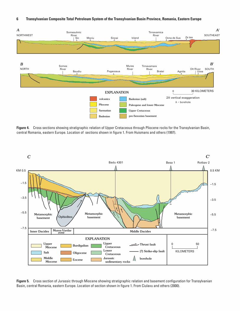
Figure �. Cross sections showing stratigraphic relation of Upper Cretaceous through Pliocene rocks for the Transylvanian Basin, central Romania, eastern Europe. Location of sections shown in figure 1. From Huismans and others (1997).
Figure �. Cross section of Jurassic through Miocene showing stratigraphic relation and basement configuration for Transylvanian Basin, central Romania, eastern Europe. Location of section shown in figure 1. From Ciulavu and others (2000).
� Transylvanian Composite Total Petroleum System of the Transylvanian Basin Province, Romania, Eastern Europe
-
Metamorphicbasement
Metamorphicbasement
Metamorphicbasement
Inner Dacides Mures-Vardar zone Middle Dacides
Ophiolites
Besa 1 Rotbav 2 Badu 4301
C C'
Upper Miocene
Salt
Middle Miocene
Burdigalian
Oligocene
Eocene
Upper Cretaceous Lower Cretaceous Jurassic sedimentary rocks
EXPLANATION
Thrust fault
(?) Strike-slip fault
borehole
KM 0.5
−3.5
−1.5
−5.5
−7.5
0.5 KM
−1.5
−3.5
−5.5
−7.5
0 50
KILOMETERS

Hydrocarbons in the Transylvanian Basin �
percent, S2 ranges from 0.14 to 0.48 mgHC/g (milligrams of
hydrocarbon per gram of rock), and Tmax
(temperature corre-sponding to the maximum of hydrocarbon generation during pyrolysis used mostly for evaluation of the maturation stage of the kerogen) ranges from 423° to 436°C (Popescu, 1995).
Seals
Huismans and others (1997) described Badenian through Pliocene strata as forming a relatively monotonous succession of mainly claystones and sandstones. A thick evaporite layer within the Badenian rocks separates the Transylvanian Basin Neogene Suprasalt AU from any hydrocarbons that may be migrating upward from older strata.
Reservoirs
Reservoirs for the Transylvanian Basin gas are in sand-stone and marly sandstone units of the middle Miocene to Pliocene formations (fig. 6). Some fields can have as many as 22 individual gas-bearing sandstones (Popescu, 1995), either in elongate, lenticular, or sheetlike bodies. Reservoir porosities are 25 to 30 percent, and permeabilities range from 10 to 100 millidarcies (Dinu and others, 1996).
Traps
Hydrocarbon traps in the Neogene Suprasalt AU are formed by dome and domelike anticlines as well as by stratigraphic traps. The domes were created by salt diapir-ism, which was probably induced by the rapid burial of the evaporite layer at the base of the middle Miocene sedimen-tary sequence. The stratigraphic traps are the result of facies changes related to molasse sedimentation that is characterized by a thick sequence of ungraded, crossbedded sandstone, shale, and marlstone.
Burial History and Generation and Migration of Hydrocarbons
The burial history for the Transylvanian Neogene Supra- salt AU is one of gradual subsidence during deposition. Fig-ures 4 and 5 show that sedimentation during Late Cretaceous time was in north-south-trending grabens (Huismans and others, 1997), a pattern that continued generally through early Miocene time. Thereafter, deposition was into a continually subsiding basin in which as much as 5.5 km of molasse depos-its (middle Miocene to Pliocene) was deposited (Cranganu and Deming, 1996). This depositional period of approximately 17 m.y. was followed by the accumulation of upper Miocene sediments ranging in thickness from more than 1 km near the perimeter of the basin to more than 3 km in the basin interior.
The heat flow within the Transylvanian Basin ranges from about 60 mW/m2 in the northern part to about 40 mil-liwatts per square meter (W/m2) in the southern part. Cranganu and Deming (1996) reported an average surface heat flow of 38 mW/m2 compared to 88 mW/m2 in the adjacent Pannonian Basin (fig. 1). Thus, the Neogene strata in the Transylvanian Basin are cool compared to surrounding areas. Reasons sug-gested by Huismans and others (1997) to explain this differ-ence are (1) the rapid sedimentation rate near the central part of the basin, (2) the relatively thick crust, and (3) the high topography of the area. Cranganu and Deming (1996)
Figure �. Events chart for the Transylvanian Basin Neogene Suprasalt Gas Assessment Unit (40570101), illustrating the relative timing of critical geologic events in the evolution of the assess-ment unit. Plio, Pliocene; Mio, Miocene; Olig, Oligocene; Eoc, Eocene; Pal, Paleocene; L, Late; E, Early; Ma, million years.

interpreted the lower-than-expected present-day heat flow numbers to be a probable reflection of the rapid sedimentation during the Miocene.
Cranganu and Deming (1996) considered numerous burial-history scenarios. Their work showed a possible correla-tion between gas-field location and higher heat-flow values, and they concluded that the basin entered the oil window at 13 to 5 Ma, at depths ranging from 4.4 to 8.8 km. Popescu (1995) believed that thermogenic gas generation began in early Pliocene time in the central and eastern parts of the basin, pos-sibly as a result of a higher geothermal gradient induced by the relatively high thermal conductivity of salt.
Thermogenic gas may be widespread, but biogenic gases are commonly present at shallower depths than those required for generation of thermogenic gas. Biogenic gases, on the other hand, can also persist to a considerable depth; Kotarba and oth-ers (1998), for example, showed that generation of biogenic gas in Miocene strata of the Carpathian foredeep in Poland could occur to a depth of about 3.3 km. Even at that depth, however, the organic matter is still immature and has a vitrinite reflec-tance of only 0.6 percent (Kotarba and others, 1998).
Gas in the Transylvanian Basin Neogene Suprasalt AU, primarily of a biogenic origin as previously indicated, is
generated from organic matter that is dispersed throughout the Miocene sandstones and siltstones and not from a single rich source-rock unit. Popescu (1995) suggested that the gas migrated only a short distance vertically and laterally into domelike structures and (or) stratigraphic traps. Timing of gas movement is estimated to be late middle Miocene (early Sarmatian).
Figure 6, the events chart for the Transylvanian Neogene Suprasalt AU, illustrates the relative timing of critical geologic events in the evolution of the assessment unit.
Assessment Results and Summary
The gas for the Transylvanian Neogene Suprasalt AU is wholly contained within the upper Badenian to Pliocene sandstones and siltstones. Field-size distribution ranges from 6 billion cubic feet (BCF) to as much or more than a trillion cubic feet (TCF) (fig. 7), with the great majority of the fields between 6 BCF and 96 BCF. Petroleum explora-tion in the Transylvanian Basin is in a mature stage, and this circumstance, combined with the geologic complexity of the
Figure �. Undiscovered field size distribution for the Transylvanian Neogene Suprasalt Gas Assessment Unit of the Transylvanian Composite Total Petroleum System. (BCFG, billion cubic feet of gas.)
� Transylvanian Composite Total Petroleum System of the Transylvanian Basin Province, Romania, Eastern Europe

References Cited �
region, is considered to limit the number of fields yet to be discovered.
Estimated resources for the Transylvanian Neogene Suprasalt AU of the Transylvanian Composite TPS are as fol-lows: at the mean, 2,083 BCFG; at the 95-percent confidence level, 460 BCFG; at the 50-percent confidence level, 1,846 BCFG; and at the 5-percent confidence level, 4,490 BCFG (table 1).
References CitedBurchfiel, B.C., 1976, Geology of Romania: Geological Soci-
ety of America Special Paper 158, 82 p.
Ciulavu, D., Dinu, C., Szakacs, A., and Dordea, D., 2000, Neogene kinematics of the Transylvanian Basin (Romania): American Association of Petroleum Geologists Bulletin, v. 84, no. 10, p. 1589–1615.
Cranganu, C., and Deming, D., 1996, Heat flow and hydro-carbon generation in the Transylvanian Basin, Romania: American Association of Petroleum Geologists Bulletin, v. 80, no. 10, p. 1641–1653.
Dinu, C., Morariu, D. C., and Mocanu, V. I., 1996, Hydrocarbon resources of Romania—An overview, in Wessely, G., and Liebl, W., eds., Oil and gas in alpidic thrustbelts and basins of central and eastern Europe: European Association of Geo-scentists and Engineers Special Publication no. 5, 456 p.
Environmental Systems Research Institute Inc., 1992, Arc-World 1:3M digital database: Environmental Systems Research Institute, Inc., (ESRI), available from ESRI, Red-lands, CA, scale: 1:3,000,000.
Gyorfi, I., Csontos, L., and Nagymarosy, A., 1999, Early Tertiary structural evolution of the border zone between the Pannonian and Transylvanian Basins, in Durand, D., Hor-vath, F., and Seranne, M., eds., The Mediterranean Basins—Tertiary extension within the Alpine Orogen: Geological Society, London, Special Publication 156, 570 p.
Huismans, R.S., Bertotti, D., Ciulavu, D., Sanders, C.A.E., Cloetingh, S., and Dinu, C., 1997, Structural evolution of the Transylvanian Basin (Romania)—A sedimentary basin in the bend of the Carpathians: Tectonophysics, no. 272, p. 249–268.
Klett, T.R., Ahlbrandt, T.S., Schmoker, J.W., and Dolton, G.L., 1997, Ranking of the world’s oil and gas provinces by known petroleum volumes: U.S. Geological Survey Open-File Report 97–463, 1 CD–ROM.
Kotarba, M. J., Wilczek, T., Kosakowski, P., Kowalski, A., and Wieclaw, D., 1998, A study of organic matter and habitat of gaseous hydrocarbons in the Miocene strata of the Polish part of the Carpathian Foredeep: Przeglad Geologiczny, v. 46, p. 742–750.
Magoon, L.B., and Dow, W.G., 1994, The Petroleum System, in Magoon, L.B., and Dow, W.G., eds., The petroleum system—From source to trap: American Association of Petroleum Geologists Memoir 60, p. 3–24.
Mocanu, V.I., Dinu, C., Radulescu, F., Diaconescu, M., Dia-conescu, C., and Pompilian, A., 1996, Seismogeological features of the crust in Romania, in Wessely, G., and Liebl, W., eds., Oil and gas in alpidic thrustbelts and basins of cen-tral and eastern Europe: European Association of Geoscien-tists and Engineers Special Publication no. 5, p. 289–299.
Code and field type MFS Prob.
(0-1)
Undiscovered resources
Oil (MMBO) Gas (BCFG) NGL (MMBNGL)
F95 F50 F5 Mean F95 F50 F5 Mean F95 F50 F5 Mean
Oil fields 11.00
0 0 0 0 0 0 0 0 0 0 0 0
Gas fields 6 460 1,846 4,490 2,083 1 6 15 6
Total 1.00 0 0 0 0 460 1,846 4,490 2,083 1 6 15 6
40571 Transylvanian Hybrid Total Petroleum System40570101 Transylvanian Neogene Suprasalt Gas Assessment Unit (100 percent of undiscovered oil fields and 100 percent of undiscovered
gas fields allocated to ONSHORE province 4057)
Table 1. Transylvanian Composite Total Petroleum System assessment results.
[MFS, minimum field size assessed; Prob., probability of at least one field equal to or greater than the MFS; MMBO, million barrels of oil. BCFG, billion cubic feet of gas. MMBNGL, million barrels of natural gas liquids. Results shown are fully risked estimates. For gas fields all liquids are included under the NGL (natural gas liquids) category. F95 denotes a 95-percent chance of at least the amount tabulated. Other fractiles defined similarly. Fractiles are additive under the assumption of perfect positive correlation. Gray shade indicates not applicable]

Petroconsultants, 1996, Petroleum exploration and production database: Houston, Texas, Petroconsultants, Inc. [database available from Petroconsultants, Inc.,P.O. Box 740619, Houston, TX 77274–0619 USA].
Popescu, B.M., 1995, Romania’s petroleum systems and their remaining potential: Petroleum Geoscience, v. 1, p. 337–350.
Roca, E., Bessereau, G., Jawor, E., Kotarba, M., and Roure, F., 1995, Pre-Neogene evolution of the Western Carpathians—Constraints from the Bochnia-Tatra Mountains section (Pol-ish Western Carpathians): Tectonics, v. 14, no. 4, p. 855–873.
Royden, L.H., and Baldi, T., 1988, Early Cenozoic tecton-ics and paleogeography of the Pannonian and surrounding regions: American Association of Petroleum Geologists Memoir 45, p. 1–16.
U.S. Geological Survey World Energy Assessment Team, 2000, Geological Survey World Petroleum Assessment 2000—Description and results: U.S. Geological Survey Digital Data Series DDS–60, 4 CD–ROMs.
Visarion, M., and Veliciu, S., 1981, Some geological and geo-physical characteristics of the Transylvanian Basin: Earth Evolution Sciences, v. 1, no. 3–4, p. 212–217.
10 Transylvanian Composite Total Petroleum System of the Transylvanian Basin Province, Romania, Eastern Europe


