TRANSPORTATION OPERATION STUDY for Second … Opera… · · 2014-12-01TRANSPORTATION OPERATION...
29
TRANSPORTATION OPERATION STUDY for Second Line West Neighbourhood December 1, 2014
Transcript of TRANSPORTATION OPERATION STUDY for Second … Opera… · · 2014-12-01TRANSPORTATION OPERATION...

TRANSPORTATION OPERATION STUDY
for
Second Line West Neighbourhood
December 1, 2014

Transportation Operation Study City of Mississauga
1
1. INTRODUCTION
This Transportation Operation Study (transportation review) has been undertaken to address
traffic operation and safety concerns raised by the residents who attended a public meeting on
November 16, 2011 to discuss updates on the Highway 401 widening project and proposed
impacts to the surrounding network including removal of the Second Line West vehicle bridge
(vehicle bridge) over Highway 401. The purpose of this transportation review is to document
public concerns and to identify mitigation measures to respond to the existing transportation
needs and potential impacts to the study area in the future.
As a separate exercise, the City has completed a Class Environmental Assessment study (EA
study) for a pedestrian/cyclist overpass structure on Second Line West, across Highway 401.
The public engagement process for the EA study included two Public Information Centres (PICs)
held on Wednesday April 16 and Thursday, June 5, 2014 both in Meadowvale Village Hall in
Mississauga. The public consultation process for the EA study provided the City the opportunity
to also consult with the public on the transportation review.
2. BACKGROUND
In 1982, the Ministry of Transportation (MTO) completed a Preliminary Design study for
Highway 401 from Renforth Drive to Second Line West. This study identified the need for
significant capacity improvements to accommodate growing travel demands, including the
need for an express/collector system west of Highway 410/403 as well as the removal of the
vehicle bridge to support these improvements. Mississauga Council subsequently adopted a
recommendation for the closure and removal of the vehicle bridge at the time of the future
Highway 401 widening.
As part of the process related to the future highway expansion, and for the protection of the
Old Meadowvale Village, the City constructed the Mavis Road/Highway 401 Interchange in
1999. As well, the Derry Road bypass was constructed which directed through traffic away from
Old Derry Road and the village.
Residential subdivisions adjacent to Second Line West, as well as the local road network north
and south of Highway 401, were planned and constructed anticipating the removal of the
vehicle bridge. This included the construction of key connecting streets such as Sombrero Way,
Donway Drive and Bancroft Drive, which are all identified as Minor Collectors in the City Official
Plan, in the residential subdivisions.

Transportation Operation Study City of Mississauga
2
In August 2005, the MTO completed a Preliminary Design and EA study for Highway 401 from
the Highway 410/403 Interchange westerly to east of the Credit River to review and update
previous work and look for opportunities to integrate High Occupancy Vehicle (HOV) facilities
within the corridor. Amongst many items associated with the expansion works for Highway 401,
the permanent removal of the vehicle structure over Highway 401 was identified to
accommodate the highway widening works.
As part of MTO’s study process, local residents and businesses were informed of the EA study
and invited to participate by means of newspaper advertisement and the circulation of
approximately 5500 and 8000 brochures for the first and second PICs, respectively. The EA
study was approved in 2007 with conditions that included the re-vegetation of the existing
right-of-way available upon the removal of the vehicle bridge, to enhance the sensitive natural
features within the Meadowvale Station Woods property.
In 2013, MTO held a pre-construction PIC showing the detailed design of Highway 401 widening
project from east of Mavis Road interchange to the east of Credit River structure.
Based on the current MTO schedule for the Highway 401 widening project, the MTO initiated
the work for improvements to the Mavis Road Interchange in early 2014 and the Highway 401
mainline construction is anticipated to commence in 2015.
3. STUDY APPROACH
The study approach was to review the existing traffic operation conditions based on the public
comments that were initially received on November 16, 2011 and during the formal PICs held
on April 16, 2014 and June 5, 2014 for the Second Line West Pedestrian/Cyclist Crossing of
Highway 401 (Pedestrian Crossing) Class EA study. Based on this investigation, a corresponding
mitigation strategy was identified.
In addition, this study reviewed the potential traffic volume and pattern changes associated
with the removal of the vehicle bridge as this was a concern expressed during the course of the
project.

Transportation Operation Study City of Mississauga
3
4. PUBLIC COMMENTS RECIEVED
Public comments were initially received on November 16, 2011 and during the formal PICs held
on April 16, 2014 and June 5, 2014 for the Pedestrian Crossing EA study.
Inquiries brought forward by members of the public for the most part pertained to the existing
operations of streets within the neighbourhood such as Sombrero Way, Bancroft Drive and
Boyer Boulevard. The following is a summary of key comments received:
Concern associated with the current traffic conditions of Sombrero Way including the
operating conditions of the Mavis Road intersection from a queuing and safety
perspective, the high volume of school buses using the street and the current parking
provisions.
Concern associated with the heavy left turn volume and resulting long delays from
eastbound Bancroft Drive to northbound Mavis Road.
Concern associated with the heavy left turn volume and resulting long delays from
eastbound Boyer Boulevard to northbound Mavis Road.
Based on the City’s review of the inquiries, it was evident that many of the concerns expressed
by the public were regarding the existing traffic operations that occur in the morning and
afternoon peak periods. As part of this review, the City was able to immediately address some
of the concerns that were identified such as improving the signal timing at the Sombrero
Way/Mavis Road intersection and relocation of some of the school bus routes from Sombrero
Way. Other improvements, such as potential intersection improvements at the Sombrero
Way/Mavis Road intersection, which will improve intersection operations and address some of
the parking issues, will be investigated for implementation in the short-term (i.e. prior to
vehicle bridge removal). In addition, the City has identified a monitoring program for the area,
which includes monitoring of the operating speeds of streets in cooperation of the Peel
Regional Police.
Appendix A includes a comprehensive list of the public’s comments and the corresponding City
response. As part of the response, the City has identified if the comment has already been
addressed, if further monitoring is required, is to be investigated in the short-term (i.e. prior to
vehicle bridge removal) or to be investigated in the long-term (i.e. subsequent to vehicle bridge
removal).
Concern was also expressed regarding the potential for increases in vehicle traffic on local
roads, such as Sombrero Way, with the removal of the vehicle bridge. This issue in discussed
further in Section 5.

Transportation Operation Study City of Mississauga
4
Copies of the material presented at the public meetings is included in Appendix B.
5. ANALYSIS OF REMOVAL OF SECOND LINE WEST BRIDGE
As noted in the previous section, the public expressed concern regarding the potential for
increases in vehicle traffic on local streets, such as Sombrero Way, with the removal of the
vehicle bridge. As a result the City undertook an analysis to understand the implications of the
vehicle bridge removal. This exercise identified potential traffic volume and pattern changes
associated with the removal of the bridge considering the traffic conditions today and in the
future. The street network analysis consisted of Second Line West, Sombrero Way, and other
local roads within the study area. The following scenarios were considered in the analysis:
existing traffic volumes and road network (i.e. vehicle bridge in place)
opening day with modified traffic patterns and road network (i.e. vehicle bridge
removed)
future traffic patterns with and without the vehicle bridge
5. 1 Existing Traffic Volumes and Road Network
An existing conditions review was undertaken considering the existing volumes and road
network including maintaining the vehicle bridge. A diagram of the existing volumes is included
in Appendix B as part of the April 16, 2014 public meeting material. The intersection operations
were analyzed for the morning peak hour, which indicated some operational issues including
some of the challenges that were noted by the public (Appendix A). Many of these operational
challenges have been addressed (e.g. signal timing improvements) or can be addressed in the
short term with measures such as the proposed geometric improvements at the Sombrero Way
and Mavis Road intersection.
5. 2 Opening Day with Modified Traffic Patterns and Road Network (i.e.
removal of the vehicle bridge)
It has been assumed that upon removal of the vehicle bridge, 50% of the existing southbound
traffic will continue to go southbound on Second Line West to the intersection of Second Line
and Sombrero Way, and will choose to take Sombrero Way, which is similar to the travel
patterns today. The remaining 50% of southbound traffic that would have originally continued
south of Sombrero Way to the bridge will divert and distribute to streets north of the Second
Line and Sombrero Way intersection. Furthermore, a reduction of approximately 170 vehicles

Transportation Operation Study City of Mississauga
5
per hour that would have travelled north from Donway Drive approaching Sombrero Way will
be diverted to other routes due to the removal of the bridge. A diagram of the traffic volumes is
included in Appendix B as part of the April 16, 2014 public meeting material.
Changes in travel patterns on the local streets including Sombrero Way are expected to be
marginal. As an example, it is expected that there will be an increase of approximately 70
vehicles during the morning peak hour in the eastbound direction on Sombrero Way, which
represents on average 1 additional vehicle per minute. However, there will be a decrease of
approximately 70 vehicles during the morning peak hour in the westbound direction on
Sombrero Way, which represents on average 1 less vehicle per minute.
5. 3 Future Traffic Patterns (with and without the vehicle bridge)
Further analysis was undertaken to get an understanding of future traffic volume changes
within the study area. The study area has a built out condition with little opportunity for new
development. However, it is anticipated that traffic volumes would increase over time within
the study road network, which is generally typical for the City.
A high level review of future traffic volume changes was conducted considering removal of the
vehicle bridge. In general, the analysis indicates that traffic volumes for the future scenarios
(i.e. with and without the vehicle bridge) would be similar with a marginal increase with the
removal of the bridge. As an example, it is expected that there will be an increase of
approximately 60 vehicles during the morning peak hour in the eastbound direction on
Sombrero Way, which represents on average 1 additional vehicle per minute. However, there
will be a decrease of approximately 80 vehicles during the morning peak hour in the westbound
direction on Sombrero Way, which represents on average 1 less vehicle per minute. As
mentioned, while it is anticipated that traffic volumes would increase within the study area in
the future, the overall road capacity of the network is expected to carry the volumes typical of
this type of street.
Although there is generally limited opportunity for new development in the area, the City is
aware that there is potential for the development of 1 property in the area; however, no
application has been received. Any future development applications received by the City, will
be subject to providing a comprehensive Transportation Impact Study for the study area,
including impacts and mitigation measures.

Transportation Operation Study City of Mississauga
6
6. CONCLUSION
It is recognized that that there are currently some traffic operational issues during the peak
periods in the vicinity of Second Line West neighbourhood, which exist today with the bridge in
place. In order to address these operational issues, the City has identified a number of
mitigation measures, which are outlined in Appendix A. Some of the mitigation measures have
already been addressed, some of the issues identified will be continuously monitored and other
issues will be reviewed in both the short and long-term.
Based on the analysis of the removal of the vehicle bridge, changes in traffic patterns are
expected and the impacts on existing streets will be marginal when the bridge is removed. As
noted, the City will continue to monitor traffic conditions, including when the vehicle bridge has
been removed by the MTO. It is assumed that the drivers’ behavioral adjustments to road
network changes will take time; therefore, the City will review the traffic patterns
approximately 6 months following the removal of the vehicle bridge to compare any changes in
traffic pattern observed and the City will implement appropriate mitigation measures, if
required, through a consultation process with the public.

Transportation Operation Study City of Mississauga
7
APPENDICES

APPENDIX A Public Comments and Response Table

Public Comments and Response Table Public Comment City Response Status of Review
Mavis Road/Sombrero Way Intersection
1 Heavy eastbound right turn movement and limited storage Heavy right turn traffic volumes and limited auxiliary lane storage have been observed to be the main contributors to queuing eastbound on Sombrero Way. Potential opportunity for geometric improvement has been identified. The following conceptual drawing has been developed to provide additional right turn storage.
Tentative plan showing additional storage at Sombrero Way/Mavis Road intersection.
The improvements should allow for better accommodation of large right turning volumes, leading to a reduction in vehicle queuing at the intersection and improved driveway access/egress. To accommodate the additional right turn storage, shifting of the road centre line slightly to the north is required, which will result in the loss of some parking spaces. In addition, to allow for this improvement, the eastbound left turn lane would be reduced by 10 m. However, this change would not impose an operational impact due to the low left turning vehicle volumes. This plan will be further reviewed for confirmation.
Short-term (i.e. prior to bridge removal)
2 Inadequate signal timing for the eastbound right turn movement The existing signal timing plan meets standards; however, as part of a recent arterial review program by the City for Mavis Road, an increase to the split time for eastbound movement was implemented. In addition, signal timing plans are updated on a periodic basis in response to changes to traffic demand, travel pattern, etc.
Addressed
3 Inadequate signal timing for pedestrians to cross east/west across Mavis Rd Further adjustments have been made to allow for a longer pedestrian crossing time, provided Addressed

Public Comment City Response Status of Review
pedestrians press the push button before crossing.
4 Pedestrian conflict with eastbound right turning traffic. High risk of collisions Enhanced crosswalk pavement markings were installed in 2013 to improve pedestrian visibility and soothing conflicts. A preliminary review using 5-year collision history illustrates no major issues; however, further safety review of the intersection will be undertaken.
Addressed and will be monitored in the future
5 Request for eastbound left turn signal phase. Currently westbound left turn traffic off Courtneypark Drive has exclusive signal
A recent arterial review conducted by the City indicated an eastbound left-turn phase was not warranted. However, observations revealed that additional green time for the general eastbound movement is required. As a result, an increase to the green time for the eastbound movement was implemented.
Addressed
6 Line of sight issue for eastbound right turn movement due to the bus shelter of the north-west corner of intersection
The sight lines were reviewed at this intersection and adequate sight distance is available. Addressed
Sombrero Way
7 (Perceived) High risk of collision A review of the 5-year collision history was undertaken. A total of 16 Property Damage Only collisions have been observed, with 47% rear end collisions. This is considered a typical collision frequency for a minor collector road.
Addressed
8 Long queues: difficulty for motorists exiting driveways in the AM peak hour Enhanced pavement markings and other improvements (e.g. additional eastbound right turn storage at the Sombrero Way and Mavis Road intersection) are expected to enhance driveway operation and safety along the road. In addition, the City’s Transportation & Works Department will continuously monitor the traffic operations upon removal of the Second Line West vehicle structure.
Addressed and will be monitored in the future
9 School buses stop for passenger pick up on Sombrero Way – relocate pick-up/drop-off There have been on-going discussions with Student Transportation of Peel Region. As a result the bus stops at Sombrero Way & Nimbus Gate for the two schools with highest load counts (St. Julia & Meadowvale Village) have been relocated to side streets effective September 2014. There will be two other buses, which will continue picking up on Sombrero Way; however, those are for specialized programs and only pick up a limited number of students (one to five students).
Addressed
10 Parking challenges on the northwest corner of the Mavis Road/Sombrero Way Intersection. Suggestion of removing existing parking provisions or implement parking restrictions for the entire stretch of Sombrero Way.
The City is currently reviewing the option to restrict parking during peak hours. In addition, as part of the proposed intersection improvements included in response 1, some parking will be removed.
Long-term (i.e. following bridge removal)
11 Propose roundabouts/traffic circles at all intersections Implementation of roundabouts has extensive property implications which could be very challenging considering the built-out residential conditions along Sombrero Way. This option will not be further pursued.
Addressed
12 Remove sidewalk on the south side to make more room for additional travel lanes Pedestrian sidewalks need to be maintained on both sides for safety purposes. Additional right turn storage is proposed by other means (See Response 1).
Addressed
Second Line West
13 Second Line is a speedway north and south of the bridge - can speed studies be arranged?
The City reviewed the operating speeds on Sombrero Way, Second Line West, and Donway Drive and observed operating speeds which were typical given the nature of these roadways. That said, staff have noted some periodic speeding. Staff will continue to monitor operating speeds and have requested the cooperation of the Peel Regional Police in monitoring the area.
Addressed and will be monitored in the future
14 Request for weekend traffic counts on Second Line W. Recent counts have been collected. The information indicates that the weekday AM peak hour traffic volume is significantly higher than weekend peak hour; this study analysis was undertaken for weekday AM peak hour only. The data for the internal intersections show typical volumes, much more consistently spread out throughout the day, with significantly less on weekends.
Addressed
15 Request for weekend traffic counts on Mavis Road in vicinity of Heartland Centre Recent counts have been collected. Weekend traffic volumes are very similar to weekday traffic volumes. Industrial side streets show significant volume decreases compared to weekday volumes,
Addressed

Public Comment City Response Status of Review
while residential side streets show similar traffic volumes when compared to weekday volumes. Regardless of volume increases along Mavis Road on weekends, traffic volumes on residential side streets are typical and are consistent with other similar neighbourhoods in the City.
16 Second Line W should connect to Derry Road West A high level review for this connection was undertaken. This connection can’t be achieved within a short horizontal distance, due to the significant difference in elevation between the existing Derry Road West and Second Line West. This measure will not be pursued as a feasible solution. Please refer to the image below which illustrates the significant difference in elevation between the two streets.
Addressed
Dorway Drive
17 Excessive speeding on Donway Drive - can this be monitored? The City reviewed the operating speeds on Donway Drive and observed operating speeds which were typical given the nature of the road. That said, staff have noted some periodic speeding. Staff will continue to monitor operating speeds and have requested the cooperation of the Peel Regional Police in monitoring the area.
Addressed and will be monitored in the future
Bancroft Drive
18 Heavy left turn volume and long delays from eastbound Bancroft Drive to northbound Mavis Road - can signal timing be reviewed? – need for a second left turn lane.
A second left turn lane is not recommended as it requires a fully protected left turn phase, which will only provide benefits to 2 hours a day only while impacting off-peak hour operations (majority of the day). Additional green time has been allocated to the eastbound left turn phase during all time periods.
Addressed
19 Staff have earlier investigated traffic infiltration in the Bancroft Drive/ Donway Drive neighbourhood south of the highway – what were the results and mitigation measures (if any required)?
There are a number of destinations within the subject neighbourhoods i.e. schools, churches, conservation centres, parks, etc., which attract trips from the outside boundary of these neighbourhoods. These are not considered cut through trips. The long and circuitous route through the neighbourhoods would not offer a faster alternative compared to the arterial roads and, therefore, is not considered attractive to cut through traffic.
Addressed
Boyer Boulevard/Mavis Road Intersection
20 Is there capacity on Boyer Boulevard for the left turn from eastbound Boyer The existing signal timing plan meets current traffic needs. A second left turn lane is not Addressed and will
Second Line West (cul-de-sac)
Derry Road
Significant difference in elevation
Source: Google Earth

Public Comment City Response Status of Review
Boulevard to northbound Mavis Road? recommended as it requires a fully protected left turn phase which will only provide benefits to 2 hours a day only while impacting off-peak hour operations (majority of the day). With the removal of the vehicle structure on Second Line West over Highway 401, traffic patterns will change. As a result, certain movements can expect to see an increase in volume. Staff will monitor the surrounding signalized intersections, including upon removal of the Second Line West vehicle structure, and optimize the signal timing plans as well as implement, if warranted, any left turn phasing.
be monitored in the future
Brass Winds Place/Sombrero Way Intersection
21 Request for an all-way stop. The City has undertaken a review of the Brass Winds Place / Sombrero Way Intersection and an all-way stop is not warranted at this time.
Addressed
Sombrero Way/Viola Court Intersection
22 Line of sight - traffic exiting Viola Court experiences line of sight issues with respect to eastbound traffic on Sombrero Way.
The sight lines were reviewed at this intersection and adequate sight distance is available. Addressed
Other Issues
23 Old Derry Road/Mavis Road – Proposal of a Right-out ONLY from Old Derry Road to Mavis Road
A high level review for this connection was undertaken. This connection can’t be achieved within the short horizontal distance, due to the significant difference in elevation between the two streets and increased safety concerns associated with sight line challenges at the proposed new connection. In addition, the proposed new connection would result in significant utility impacts. This measure will not be pursued as a feasible solution. Please refer to the image below which illustrates the significant difference in elevation between the two streets.
Addressed
24 Brass Winds Place/Mavis Road - Proposal of a Right-Out ONLY from Brass Winds Place to Mavis Road
A high level review for this connection was undertaken. This connection can’t be achieved within a short horizontal distance, due to the difference in elevation between the two streets and increased safety concerns associated with sight line challenges at the proposed new connection. In addition, the proposed new connection would result in significant utility impacts. This measure will not be pursued
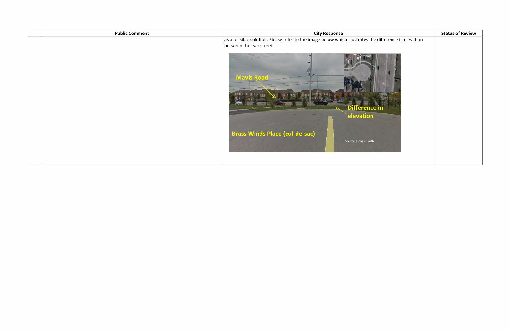
Addressed
Source: Google Earth
Significant difference in elevation
Old Derry Road (cul-de-sac)
Mavis Road
Public Comment City Response Status of Review
as a feasible solution. Please refer to the image below which illustrates the difference in elevation between the two streets.
Source: Google Earth
Difference in elevation
Brass Winds Place (cul-de-sac)
Mavis Road

APPENDIX B Public Meeting Material

Second Line W. Neighborhood Traffic Study
WELCOME Public Information Centre
Second Line W. Neighbourhood Traffic Study
Wednesday, April 16, 2014 | 5:30 – 8:00pm
Please sign in and fill in a comment sheet.
Direct any questions/comments to Study Team
Members.

Second Line W. Neighborhood Traffic Study
Study background and purpose BACKGROUND: In 1982, City of Mississauga Council adapted a recommendation for the removal of
Second Line W. vehicular crossing over Highway 401 to accommodate the Ministry of
Transportation Ontario (MTO)’s Highway 401 widening project.
In 2005, the MTO documented the need for the removal of the crossing in a
Transportation Environmental Study Report for the ultimate widening of Highway 401
from the Highway 403/410 interchange to the Credit River.
On November 16, 2011, City of Mississauga staff met with the members of the public to
discuss updates on Highway 401 widening project including the permanent removal of
Second Line W. vehicular crossing.
In the 2011 public meeting, the members of the public raised a number of concerns
related to the existing transportation operation conditions in the surrounding
neighborhood and Second Line W. vehicular crossing removal proposal by the MTO.
The City of Mississauga has initiated a Municipal Class Environmental Assessment for a
cyclist/pedestrian crossing over Highway 401.
PURPOSE: To provide a summary of the public comments collected at the 2011 public meeting
and the proposed actions to respond to the existing and future conditions upon
removal of Second Line W. vehicular crossing.

Second Line W. Neighborhood Traffic Study
Issues Potential Mitigation/Opportunity
Mavis Rd/Sombrero Way Intersection
Heavy eastbound right turn movement and
limited storage
- Potential for implementation of right turn lane subject to warrant analysis and consultation with the public and
agencies.
- See conceptual design on the slide 7 (For Discussion Purposes ONLY).
Inadequate signal timing for the eastbound
right turn movement
- The existing signal timing meets standards; however it will be reviewed upon removal of the vehicular crossing to
identify opportunities for optimization.
Inadequate signal timing for pedestrians to
cross east/west across Mavis Rd.
- The existing signal timing meets standards; however it will be reviewed upon removal of the vehicular crossing to
identify opportunities for optimization.
- Pedestrians are expected to apply pedestrian push button and wait for the right signal in advance of crossing.
Pedestrian conflict with eastbound right turning
traffic. High risk of collisions.
- Enhanced crosswalk pavement markings (Spring/Summer 2014)
- 5-year collision history has been reviewed. A total of 98 collisions have been observed, majority of the collisions
relate to north-south movements, with 10% of the collisions associated with the eastbound direction. One fatal
collision (May 2013) is observed with a rear-end initial impact, involving two southbound vehicles. Further in-depth
safety review of the intersection will be undertaken to identify appropriate mitigation measures.
Sombrero Way
High risk of collision - 5-year collision history has been reviewed. A total of 16 Property Damage Only collisions have been observed, with
47% rear end collisions. This is a typical frequency for a minor collector road.
Long queues: difficulty for motorists exiting
driveways in the AM peak hour
- Enhanced pavement markings and other improvements (as identified above) could enhance driveway
operation and safety along the road.
- Continuous monitoring of operations upon removal of the vehicular structure.
School buses stop for passenger pick up on
Sombrero – relocate pickup/dropoff
- On-going discussions with Student Transportation of Peel Region – Peel District School Board i.e. The opportunity for
school bus stop consolidation is being considered.
Parking challenges the northwest corner - Opportunity to enhance parking restriction in the intersection proximity
Second Line West
Second Line is a speedway north and south of
the bridge - can speed studies be arranged?
- Speed studies have been scheduled for Spring/Summer 2014 and findings could be made available in PIC 2 of the
Class EA study for the Active Transportation crossing
Request for weekend traffic counts on Second
Line W.
- Recent counts have been collected. AM Peak Hour traffic volume is significantly higher than weekend peak hour;
thus analysis was undertaken for AM Peak Hour only.
- Internal intersections show typical volumes, much more consistently spread out throughout the day, with
significantly less on weekends.
Request for weekend traffic counts on Mavis
Road in vicinity of Heartland Centre.
- Recent counts have been collected. Weekend traffic volumes tend to be identical to weekdays.
- Industrial side streets show significant volume decreases compared to weekdays, while residential side streets
show similar traffic volumes compared to weekdays.
- Regardless of volume increases along Mavis Road on weekends, traffic volumes on residential side streets are
typical and are consistent with other similar neighbourhoods in the City.
Comments Received and Actions

Second Line W. Neighborhood Traffic Study
Issues Potential Mitigation/Opportunity
Donway Dr
Excessive speeding on Donway - can this be monitored?
- Speed studies have been scheduled for Spring/Summer 2014 and findings
could be made available in PIC 2 of the Class EA study for the Active
Transportation crossing.
Bacroft Drive
Heavy left turn volume and long delays on Bancroft E/B left to
N/B Mavis - can signal timing be reviewed – need for a second
left turn lane.
- Investigate opportunity for signal timing improvements
- Investigate opportunity for implementation of dual left turn phase subject to
feasibility, operational impacts and consultation with the public.
- Please see conceptual design on the slide 7 (For Discussion Purposes ONLY).
Staff have earlier investigated traffic infiltration in the Bancroft /
Donway neighbourhood south of the highway – results and
mitigation measures (if any required)
- There are a number of destinations within the subject neighbourhoods i.e.
schools, churches, conservation centres, parks, etc which are assumed to
attract trips from the out side boundary of these neighbourhoods. These are not
considered cut through trips.
- The long and circuitous route through the neighbourhoods would not offer a
faster alternative compared to the arterial roads.
Boyer Boulevard
Is there capacity on Boyer for the left turn E/B to N/B Mavis Rd?
- Investigate opportunity for signal timing improvements
- Investigate opportunity for implementation of dual left turn phase subject to
feasibility, operational impacts and consultation with the public.
- Please see conceptual design on the slide 7 (For Discussion Purposes ONLY).
Other measures to alleviate traffic pressure off Sombrero Way
To investigate opportunities to distribute traffic demand across
the network via other new horizontal accesses to Mavis Road i.e.
Right-in-right-out (R-I-R-O) opportunities at Brass Winds Place, Old
Derry Rd and Crawford Mill Ave.
- Significant implications are expected.
- The implementation of these network changes require further
discussion/consultation with the members of the public.
Comments Received and Actions

Second Line W. Neighborhood Traffic Study
Traffic Patterns (With and Without Vehicular Crossing)
Existing Traffic Volumes | With 2nd Line connection
130
480
180 300
62
46
50
120
280
800
Sombrero Way Ma
vis R
d
Se
co
nd
Line
W
Lamplight Way
Donwa
y
Bancroft
Avg Veh/AM Peak Hour
150
250
* These movements have
been eliminated due to the
removal of the vehicular
crossing. Traffic volumes
have been redirected to
other routes.
200
410
170 250
166
220 310
150
100
90
250
280
800
Craig Carrier Ct.
Sombrero Way Ma
vis R
d
Se
co
nd
Line
W
Lamplight Way
Donwa
y
Bancroft
Avg Veh/AM Peak Hour
180 260
288
95
76
85
190
197
421
Modified Traffic Volumes | Without 2nd Line connection
70
150
Silverthorn Mill 100
90
75
150
Silverthorn Mill 100
80
Craig Carrier Ct.
Elimination of northbound vehicle traffic from the south and southbound vehicle traffic from the north of
Highway 401
Increase of ~70 vehicles during the morning peak hour in the eastbound direction on Sombrero Way
decrease of ~70 vehicles during the morning peak hour in the westbound direction on Sombrero Way
When accounting for the trips re-distribution/re-assignment due the removal of the vehicular crossing, the
modified traffic volumes have been estimated based on the existing travel patterns which considered to be
the worst case scenario when determining impacts on Sombrero Way.
Changes in travel patterns on Sombrero Way are marginal; however, as a Minor Collector, Sombrero Way
remains within the acceptable traffic volume thresholds.
0
0
0
0*
0
0
0
0*
0
28
102
40

Second Line W. Neighborhood Traffic Study
The study area has a built out condition with little opportunity for new development. Should a
development application be received, it will be subject to comprehensive Transportation Impact
Studies for the immediate study area, including impacts and mitigation measures.
A high level review of future traffic volume changes was conducted, in association with the removal
of the vehicular Second Line West crossing.
The future trip distributions have been estimated based on the existing travel patterns which are
considered to be the more accurate representation of the future traffic movement on the road
network.
In general, it is anticipated that traffic volumes would increase in the future for both future scenarios
i.e. with and without the vehicular crossing. The high level analysis of the future conditions shows that
the removal of the vehicular crossing on Second Line W would lead to:
Elimination of northbound vehicle traffic from the south and southbound vehicle traffic from the north of Highway 401
Decrease of ~80 vehicles during the morning peak hour in the westbound direction on Sombrero Way
Increase of ~60 vehicles during the morning peak hour in the eastbound direction on Sombrero Way
While it is anticipated that traffic volumes would increase within the study area(accounting for any
future developments), yet the overall road capacity is expected to remain within an acceptable
threshold.
Future Traffic Patterns (With and Without Vehicular Crossing)

Second Line W. Neighborhood Traffic Study
Potential Geometric Improvements when Warranted
The presented
conceptual designs are
for information purposes
only and subject to
further review.
Drivers’ behavioral
adjustments to road
network changes take
time (~ 6 months). The
City will monitor the
traffic patterns after the
removal of the vehicular
crossing. The post
removal traffic volumes
and patterns will then be
assessed and
appropriate mitigations
will be undertaken
subject to warrants,
consultation with the
members of the public
and agencies and
funding availability.
Sombrero Way/Mavis – Improved eastbound RT storage
Bancroft/Mavis – Eastbound dual left-turn movement
Boyer/Mavis – Eastbound dual left-turn movement
Brass Winds Place – Right-In

Second Line W. Neighborhood Traffic Study
It is anticipated that the proposed improvement measures would be
implemented in stages to respond to existing traffic conditions.
The City will further review concerns and address issues i.e. on-street parking,
enhanced pavement markings, school bus stop consolidation, etc. prior to the
removal of the vehicular crossing.
A monitoring program will be developed to measure operations and safety
conditions after the removal of the vehicular crossing.
The monitoring program will investigate new traffic conditions and patterns and
conduct warrant analysis for improvements, subject to public consultation.
Next Steps
Thank you for participating in the study process. We encourage you to fill out the
comment sheet provided and drop it off in the comment box. Alternatively, you can mail
or email your comments by April 30, 2014 to:
Farhad Shahla, M. Eng., P. Eng.
Project Manager
City of Mississauga 201 City Centre Drive, Suite 800
Mississauga, ON L5B 2T4
Phone: (905) 615-3200 Ext. 3377
Email: [email protected]

Second Line W. Neighborhood Traffic Study
WELCOME Public Information Centre
Second Line W. Neighbourhood Traffic Study
Thursday, June 5, 2014 | 5:30 – 8:00pm
Please sign in and fill in a comment sheet.
Direct any questions/comments to Study Team
Members.

Second Line W. Neighborhood Traffic Study
Study background and purpose
BACKGROUND: In 1982, City of Mississauga Council adapted a recommendation for the removal of
Second Line W. vehicular crossing over Highway 401 to accommodate the Ministry of
Transportation Ontario (MTO)’s Highway 401 widening project.
In 2005, the MTO documented the need for the removal of the crossing in a
Transportation Environmental Study Report for the ultimate widening of Highway 401
from the Highway 403/410 interchange to the Credit River.
On November 16, 2011, City of Mississauga staff met with the members of the public to
discuss updates on Highway 401 widening project including the permanent removal of
Second Line W. vehicular crossing.
On April 16, 2014 the City met with members of the public to:
- provide updates on the Municipal Class Environmental Assessment for
cyclist/pedestrian crossing over Highway 401,
- review existing transportation inquiries and introduce a mitigation plan.
PURPOSE: To provide an updated summary of public comments received and responses since
the April 16, 2014 meeting
To provide an update on the work completed to address deficiencies in traffic
operations in the Second Line W. neighborhood.

Second Line W. Neighborhood Traffic Study
Comments Responses
Mavis Road / Sombrero Way Intersection
Heavy eastbound right turn movement and
limited storage
- Heavy right turn traffic and limited auxiliary lane storage have been observed to be the main contributors to
queuing eastbound on Sombrero Way.
- A plan has been developed to provide additional right turn storage.
- See conceptual design on the ‘Potential Geometric Improvements’ slide (For Discussion Purposes ONLY).
Inadequate signal timing for the eastbound
right turn movement
- The existing signal timing plan meets standards; however, as part of a recent arterial review program for Mavis
Road, an increase to the split time for eastbound movement was implemented.
Inadequate signal timing for pedestrians to
cross east/west across Mavis Rd.
- Further adjustments have been made to allow for a longer pedestrian crossing time, provided pedestrians press
the push button before crossing.
Pedestrian conflict with eastbound right turning
traffic. High risk of collisions.
- Enhanced crosswalk pavement markings are now scheduled for implementation by the end of June 2014.
- A preliminary review using 5-year collision history illustrates no major issues; however, further safety review of the
intersection will be undertaken.
Line of sight – NW corner bus shelter - Under review.
Sombrero Way
High risk of collision - 5-year collision history has been reviewed. A total of 16 Property Damage Only collisions have been observed,
with 47% rear end collisions. This is a typical frequency for a minor collector road.
Long queues: difficulty for motorists exiting
driveways in the AM peak hour
- Enhanced pavement markings and other improvements (as identified above) is expected to enhance driveway
operation and safety along the road.
- Continuous monitoring of operations upon removal of the vehicular structure.
School buses stop for passenger pick up on
Sombrero – relocate pickup/drop-off
- On-going discussions with Student Transportation of Peel Region
- the bus stops at Sombrero Way & Nimbus for the two schools with highest load counts (St. Julia & Meadowvale
Village) will be relocated to side streets – effective September 2014.
- There will be two other buses which continue picking up on Sombrero Way, however, those are for specialized
programs and only pick up a limited number of students (one to five students).
Parking challenges the northwest corner
Parking restrictions along Sombrero Way (no
stopping no parking)
- Recommendation to extend parking restrictions on Sombrero Way, west of Mavis Road.
- See conceptual design on the ‘Potential Geometric Improvements’ slide (For Discussion Purposes ONLY).
Roundabouts/traffic circles at all intersections - Implementation of roundabouts requires extensive property implications which could be challenging or
impossible considering the built-out residential conditions along Sombrero Way.
Remove sidewalk on the south side to make
more room for additional travel lanes
- Pedestrian sidewalks need to be maintained on both sides for safety purposes. Additional right turn storage is
proposed by other means.
Comments Received and Responses

Second Line W. Neighborhood Traffic Study
Comments Responses
Second Line West
Second Line is a speedway north and south of
the bridge - can speed studies be arranged?
- Speed studies have been scheduled. We will continue to monitor operating speeds and request police
enforcement when required.
Request for weekend traffic counts on Second
Line W.
- Recent counts have been collected. AM Peak Hour traffic volume is significantly higher than weekend peak
hour; thus analysis was undertaken for AM Peak Hour only.
- Internal intersections show typical volumes, much more consistently spread out throughout the day, with
significantly less on weekends.
Request for weekend traffic counts on Mavis
Road in vicinity of Heartland Centre.
- Recent counts have been collected. Weekend traffic volumes tend to be identical to weekdays.
- Industrial side streets show significant volume decreases compared to weekdays, while residential side streets
show similar traffic volumes compared to weekdays.
- Regardless of volume increases along Mavis Road on weekends, traffic volumes on residential side streets are
typical and are consistent with other similar neighbourhoods in the City.
Donway Drive
Excessive speeding on Donway - can this be
monitored?
- Speed studies have been scheduled. We will continue to monitor operating speeds and request police
enforcement when required.
Bancroft Drive
Heavy left turn volume and long delays on
Bancroft E/B left to N/B Mavis - can signal timing
be reviewed – need for a second left turn lane.
- A second left turn lane is not recommended as it requires a fully protected left turn phase – benefits 2 hours a
day only – leads to disadvantages during the off-peak hours.
- Additional green time has been allocated to the eastbound left turn phase during all time periods.
Staff have earlier investigated traffic infiltration
in the Bancroft / Donway neighbourhood south
of the highway – results and mitigation
measures (if any required)
- There are a number of destinations within the subject neighbourhoods i.e. schools, churches, conservation
centres, parks, etc. which attract trips from the outside boundary of these neighbourhoods. These are not
considered cut through trips.
- The long and circuitous route through the neighbourhoods would not offer a faster alternative compared to the
arterial roads.
Boyer Boulevard / Mavis Road Intersection
Is there capacity on Boyer for the left turn E/B to
N/B Mavis Rd?
- The existing signal timing plan meets current traffic needs.
- A second left turn lane is not recommended as it requires a fully protected left turn phase – benefits 2 hours a
day only – leads to disadvantages during the off-peak hours.
- With the removal of the bridge structure on Second Line West over Highway 401, traffic patterns will change. As
a result, certain movements can expect to see an increase in volume. Staff will monitor the surrounding
signalized intersections and optimize the signal timing plans as well as implement, if warranted, any left turn
phasing.
Brass Winds Place / Sombrero Way Intersection
Request for an all-way stop. - A study will be undertaken to determine if an all-way stop control is justified.
Comments Received and Responses

Second Line W. Neighborhood Traffic Study
Potential Geometric Improvements
The presented conceptual designs are for information purposes only and subject to
further review. Some of the proposals could be implemented prior to the bridge removal.
Sombrero Way/Mavis – Improved eastbound RT lane
- A high level feasibility review was completed.
- Additional eastbound right turn storage can be
achieved.
- The improvements should allow better handling of
large right turning volumes, leading to a reduction
in vehicle queuing and improved driveway
access/egress.
- The shifting of the road centre line slightly to the
north would lead to some loss of parking spaces.
- To allow for this improvement, the EB LT lane was
reduced by 10m. This change would not impose an
operational impact, due to the low LT vehicle
volumes.
Old Derry Road/Mavis – Right-out ONLY
A high level feasibility review was completed.
Due to the significant grading challenges and
utility relocations, this access will not be pursued. Brass Winds Place – Right-out ONLY
- Under review – could be problematic.
Bancroft/Mavis – Eastbound dual left-turn
movement
Boyer/Mavis – Eastbound dual left-turn
movement
No further consideration
A second left turn lane is not recommended at
the following locations as it requires a fully
protected left turn phase – benefits 2 hours a day
only – leads to disadvantages during the off-
peak hours.

Second Line W. Neighborhood Traffic Study
Some of the proposed improvements could be implemented prior to the bridge
removal – residents will be consulted.
Speed data will be collected and police enforcement will be requested to address
any speeding concerns.
Drivers’ behavioral adjustments to road network changes take time (~ 6 months).
The City will monitor traffic operations after the removal of the vehicular crossing.
Additional improvements will be considered in the future to address potential post
bridge removal traffic operation deficiencies.
Next Steps
Thank you for participating in the study process. We encourage you to fill out the
comment sheet provided and drop it off in the comment box. Alternatively, you
can mail or email your comments by June 20, 2014 to:
Farhad Shahla, M. Eng., P. Eng., PTOE
Project Manager
City of Mississauga 201 City Centre Drive, Suite 800
Mississauga, ON L5B 2T4
Phone: (905) 615-3200 Ext. 3377
Email: [email protected]