
Transport NSW
34
SYDNEY LIGHT RAIL EXTENSION STAGE 1 – INNER WEST EXTENSION Volume 2 - Technical Reports Transport NSW 2106703 OCTOBER 2010
Transcript of Transport NSW

SYDNEY LIGHT RAIL EXTENSION STAGE 1 – INNER WEST EXTENSION
Volume 2 - Technical Reports
Transport NSW
2106
703
OC
TOBE
R 20
10

TECHNICAL PAPER
ECOLOGY
4
Ecological assessment:Sydney Light Rail Extension– Stage 1
September 2010
Transport NSW
Parsons Brinckerhoff Australia Pty LimitedABN 80 078 004 798
Level 27, Ernst & Young Centre680 George StreetSYDNEY NSW 2000GPO Box 5394SYDNEY NSW 2001AustraliaTelephone +61 2 9272 5100Facsimile +61 2 9272 5101Email [email protected]
Certified to ISO 9001, ISO 14001, AS/NZS 4801
A+ GRI Rating: Sustainability Report 2009PR_2849

ECOLOGY B-W
Revision Details Date Amended By
00 Original August 2010 Lukas Clews
A Incorporation of Transport NSW comments 10 September 2010 Lukas Clews
B Finalisation 29 September 2010 Lukas Clews
©Parsons Brinckerhoff Australia Pty Limited (PB) [2010].
Copyright in the drawings, information and data recorded in this document (the information) is the property of PB. Thisdocument and the information are solely for the use of the authorised recipient and this document may not be used, copied orreproduced in whole or part for any purpose other than that for which it was supplied by PB. PB makes no representation,undertakes no duty and accepts no responsibility to any third party who may use or rely upon this document or the information.
Author: ..................................................... Lukas Clews, Selga Harrington
Signed: ........................................................................................................
Reviewer: ............................................................................. Martin Predavec
Signed: ........................................................................................................
Approved by: ............................................................................. Martin Predavec
Signed: ........................................................................................................
Date: ....................................................................... 29 September 2010
Distribution: ................................................................ Transport NSW, PB File
Please note that when viewed electronically this document may contain pages that have been intentionally left blank. Theseblank pages may occur because in consideration of the environment and for your convenience, this document has been set upso that it can be printed correctly in double-sided format.

Ecological assessment: Sydney Light Rail Extension – Stage 1
PARSONS BRINCKERHOFF ECOLOGY B-W Page i
ContentsPage number
Glossary v
1. Introduction 1
1.1 Project description 1
1.2 Ecological studies completed for the project 8
1.3 Aims 9
2. Legislative and statutory framework 11
2.1 State assessment framework 11
2.2 Commonwealth assessment framework 13
3. Methods 15
3.1 Personnel 15
3.2 Nomenclature 15
3.3 Literature and database review 15
3.4 Survey 16
3.4.1 Flora 173.4.2 Condition of vegetation communities 173.4.3 Fauna 183.4.4 Fauna habitats 18
3.5 Likelihood of occurrence 19
3.1 Significance assessments 19
3.2 Limitations 21
4. Existing environment 23
4.1 Landscape context 23
4.1.1 Site location and description 234.2 Vegetation communities and habitats within the study area 24
4.2.1 Bushcare sites 304.2.2 Parklands, gardens and street plantings 354.2.3 Weed growth 414.2.4 Developed areas 43
4.3 Species of plant 51
4.4 Species of animal 51
5. Threatened biodiversity and migratory species 53
5.1 Threatened ecological communities 53
5.2 Endangered populations 55

Ecological assessment: Sydney Light Rail Extension – Stage 1
Page ii ECOLOGY B-W PARSONS BRINCKERHOFF
5.2.1 Long-nosed Bandicoot, inner western Sydney population 565.2.2 White-fronted Chat Population in the Sydney Metropolitan Catchment Management
Authority Area 565.3 Threatened species 56
5.3.1 Flora 565.3.2 Fauna 57
5.4 Migratory species 57
5.5 Other key biodiversity values - corridors and connectivity 58
6. Potential impacts 59
6.1 Impacts during construction 59
6.1.1 Vegetation clearing 596.1.2 Removal of fauna habitats 606.1.3 Habitat fragmentation 606.1.4 Direct mortality to plants and less mobile animals 616.1.5 Proliferation of weeds 616.1.6 Noise and other human disturbance 62
6.2 Impacts during operation 62
6.2.1 Noise 626.2.2 Light 626.2.3 Light rail collision with fauna 636.2.4 Barrier effects 636.2.5 Changed hydrology/surface run-off 63
6.3 Cumulative and consequential impacts 64
6.4 Key threatening processes 64
6.5 Species specific impacts 65
6.6 Positive impacts to biodiversity 66
7. Mitigation 67
7.1 Management of the mitigation process 67
7.2 Mitigation measures 67
8. Impact assessment 71
9. Residual impacts and compensatory measures 73
9.1 Compensatory measures 73
10. Conclusion 74
11. References 77

Ecological assessment: Sydney Light Rail Extension – Stage 1
PARSONS BRINCKERHOFF ECOLOGY B-W Page iii
List of tablesPage number
Table 2-1 Legislation and guidelines relevant to biodiversity 11Table 3-1 Contributors and their roles 15Table 3-2 Database searches 16Table 3-3 Site inspections 16Table 3-4 Likelihood of occurrence of threatened species 19Table 4-1 Site locality 24Table 4.2 Man made habitats within the study area 45Table 4.3 Noxious weeds within the study area 51Table 4-4 Summary of species of animal identified in the Study Area 52Table 5-1 Threatened ecological communities listed on Threatened Species Conservation Act 1995
and Environment Protection and Biodiversity Conservation Act 1999 predicated to occurin the locality 53
Table 5-2 Endangered populations predicted to occur in the Sydney Metro CMA, Pittwater A andCumberland sub-catchment 55
Table 6-1 Potential loss of vegetation within the study area 60Table 6-2 Key Threatening Processes relevant to the project 65Table 6-3 Potential impacts on Threatened biodiversity 66Table 7-1 Proposed mitigation measures 68Table 8-1 Summary of likely impacts to Threatened biodiversity 72
List of figuresPage number
Figure 1-1 Key features of the project 2Figure 4-1 Vegetation communities and habitats within the study area 25
List of photographsPage number
Photo 4.1 An example of a Bushcare site at Richard Murden Reserve Haberfield 30Photo 4.2 The Bushcare site at Lords Road Lewisham 31Photo 4.3 The edge of the Cadigal Reserve Bushcare site at Lewisham 32Photo 4.4 The Davis Street Bushcare site at Dulwich Hill 33Photo 4.5 The Piggot Street Bushcare site at Lewisham 34Photo 4.6 The Waratah Mills Bushcare site at Dulwich Hill 35Photo 4.7 Planted Eucalyptus spp. and Lophostemon confertus at Blackmore Oval 36Photo 4.8 Planted Trees at Richard Murden Reserve Haberfield 37Photo 4.9 Planted Melaleuca quinquenervia along Darley Road 38Photo 4.10 Current pathway adjacent to the Hawthorne Canal with planted Ficus microcarpa 39Photo 4.11 Planted Syncarpia glomulifera and Phoenix canariensis* at Johnson Park Dulwich Hill 40Photo 4.12 Planted Lophostemon confertus at Hoskins Park Lewisham 40Photo 4.13 Plantings at Jack Shanahan Park Dulwich Hill 41Photo 4.14 An example of dense weed growth between the Hawthorne Canal and the rail line 42

Ecological assessment: Sydney Light Rail Extension – Stage 1
Page iv ECOLOGY B-W PARSONS BRINCKERHOFF
Photo 4.15 Dense growth of herbaceous and grass weeds within the rail corridor 43Photo 4.16 An example of the developed areas within the locality 44Photo 4.17 A cat recorded within the rail corridor near Waratah Mills 52
Appendices
Appendix ASpecies recorded in the study areaAppendix BThreatened species of plant predicted to occur within the localityAppendix CThreatened species of animal predicted to occur within the localityAppendix DSignificance assessments
Ecological assessment: Sydney Light Rail Extension – Stage 1
PARSONS BRINCKERHOFF ECOLOGY B-W Page v
Glossary
Biodiversity
The biological diversity of life is commonly regarded as being made up of thefollowing three components:
genetic diversity — the variety of genes (or units of heredity) in anypopulationspecies diversity — the variety of speciesecosystem diversity — the variety of communities or ecosystems.
Bioregion (region)A bioregion defined in a national system of bioregionalisation. For this study thisis the Sydney Basin bioregion as defined in the Interim BiogeographicRegionalisation for Australia (Thackway & Cresswell 1995).
Critical Habitat
The whole or any part or parts of an area or areas of land comprising the habitatof an Endangered species, an Endangered population or an Endangeredecological community that is critical to the survival of the species, population orecological community (Department of Environment and Conservation 2004).Critical habitat is listed under either the Threatened Species Conservation Act1995 or the Environment Protection and Biodiversity Conservation Act 1999 andboth the state (Department of Environment, Climate Change and Water) andFederal (Department of the Environment, Water, Heritage and the Arts)Directors-General maintain a register of this habitat. Capitalisation of the term‘Critical Habitat’ in this report refers to the habitat listed specifically under therelevant state or Commonwealth legislation.
Department ofEnvironment andClimate Change
The former name for the NSW Department of Environment, Climate Changeand Water.
Department ofEnvironment, ClimateChange and Water
Broadly, the Department of Environment, Climate Change and Water workstowards a healthy environment cared for and enjoyed by the whole NSWcommunity; manages the state’s natural resources, including biodiversity, soilsand natural vegetation; manages natural and cultural heritage across the state’sland and waters; acts to minimise the impacts of climate change; promotessustainable consumption, resource use and waste management; regulatesactivities to protect the environment; and conducts biodiversity, plant,environmental and cultural heritage research to improve decision making.
Department of theEnvironment andHeritage
The former name for the Commonwealth Department of the Environment,Water, Heritage and the Arts.
Department of theEnvironment andWater Resources
The former name for the Commonwealth Department of the Environment,Water, Heritage and the Arts.

Ecological assessment: Sydney Light Rail Extension – Stage 1
Page vi ECOLOGY B-W PARSONS BRINCKERHOFF
Department of theEnvironment, Water,Heritage and the Arts
The department develops and implements national policy, programs andlegislation to protect and conserve Australia’s natural environment and culturalheritage and administers the Environment Protection and BiodiversityConservation Act 1999. The Commonwealth Department of the Environment,Water, Heritage and the Arts changed their name from the Department of theEnvironment and Water Resources in 2007, which was previously theDepartment of the Environment and Heritage.
Industry andInvestment NSW Formerly the Department of Primary Industries.
Ecological community An assemblage of species occupying a particular area.
Environmental weed Any plant that is not native to a local area that has invaded native vegetation.
EPBC Act Commonwealth Environment Protection and Biodiversity Conservation Act 1999
FM Act Fisheries Management Act 1994
GPSGlobal Positioning System - a navigational tool that uses radio receivers to pickup signals from four or more special satellites to provide precise determinationof location.
HabitatAn area or areas occupied, or periodically or occasionally occupied, by aspecies, population or ecological community, including any biotic or abioticcomponents.
Key ThreateningProcesses
A process that threatens, or could threaten, the survival, abundance orevolutionary development of native species, populations or ecologicalcommunities (Department of Environment and Conservation 2004). Keythreatening processes are listed under the Threatened Species ConservationAct 1995, the Fisheries Management Act 1994 and the Environment Protectionand Biodiversity Conservation Act 1999. Capitalisation of the term ‘KeyThreatening Processes’ in this report refers to those processes listedspecifically under the relevant state and Commonwealth legislation.
Likely Taken to be a real chance or possibility (Department of Environment andConservation 2004).
Local population
The population that occurs within the site, unless the existence of contiguous orproximal occupied habitat and the movement of individuals or exchange ofgenetic material across the boundary can be demonstrated as defined byDepartment of Environment and Climate Change (2007b).
Locality The area within a 10 km of the site.
Migratory species
Species listed as Migratory under the Environment Protection and BiodiversityConservation Act 1999 relating to international agreements to which Australia isa signatory. These include Japan-Australia Migratory Bird Agreement, China-Australia Migratory Bird Agreement, Republic of Korea-Australia Migratory BirdAgreement and the Bonn Convention on the Conservation of Migratory Speciesof Wild Animals. Capitalisation of the term ‘Migratory’ in this report refers tothose species listed as Migratory under the Environment Protection andBiodiversity Conservation Act 1999.

Ecological assessment: Sydney Light Rail Extension – Stage 1
PARSONS BRINCKERHOFF ECOLOGY B-W Page vii
Noxious weedAn introduced species listed under the Noxious Weeds Act 1993. Under the Act,noxious weeds have specific control measure and reporting requirements.
NSW New South Wales
Priorities ActionStatements (PAS)
Priorities Action Statements outline the broad strategies and detailed priorityactions to be undertaken in NSW to promote the recovery of Threatenedspecies, population and ecological communities and manage key threateningprocesses (Department of Environment and Climate Change 2007a)
Protected speciesThose species defined as protected under the National Parks and Wildlife Act1974. Includes all native animals, as well as all native plants listed on Schedule13 of the National Parks and Wildlife Act 1974.
Recovery plan
A plan prepared under the Threatened Species Conservation Act 1995, theFisheries Management Act 1994 or the Environment Protection and BiodiversityConservation Act 1999 to assist the recovery of a Threatened species,population or ecological community.
Significant Important, weighty or more than ordinary as defined by Department ofEnvironment, Climate Change and Water (2007b).
Study AreaThe extent of indirect impacts, which may occur outside of the subject site asconsequence of impacts within the subject site. This is taken to be an area of upto 100 m from the edge of the construction footprint
Subject SiteThe extent of direct impacts that will be affected as a consequence of theproject. This includes the construction footprint of the project, associated withproposed infrastructure and potential construction work sites.
Threatenedbiodiversity
Threatened species, populations or ecological communities as listed under theThreatened Species Conservation Act 1995, the Fisheries Management Act1994 or the Environment Protection and Biodiversity Conservation Act 1999.
Threatened species,populations andecologicalcommunities
Species, populations and ecological communities listed as Vulnerable,Endangered or Critically Endangered (collectively referred to as Threatened)under the Threatened Species Conservation Act 1995, the FisheriesManagement Act 1994 or the Environment Protection and BiodiversityConservation Act 1999. Capitalisation of the terms ‘Threatened’, ‘Vulnerable’,‘Endangered’ or ‘Critically Endangered’ in this report refers to listing under therelevant state and/or Commonwealth legislation.
TSC Act NSW Threatened Species Conservation Act 1995.
Viable local populationA population that has the capacity to live, develop and reproduce under normalconditions, unless the contrary can be conclusively demonstrated throughanalysis of records and references (2007b).


Ecological assessment: Sydney Light Rail Extension – Stage 1
PARSONS BRINCKERHOFF ECOLOGY B-W Page 1
1. IntroductionTransport NSW are undertaking an assessment under Part 3A of the EnvironmentalPlanning and Assessment Act 1979 for the proposed Sydney Light Rail Extension Stage 1project (the Project). The Project consists of construction of 5.6 km of light rail along theRozelle goods line, from Lilyfield to Dulwich Hill. The SLRE will be integrated with the CooksRiver to Iron Cove GreenWay. The proposed GreenWay is approximately 5.6 km longextending from the Cooks River at Earlwood in the south to Iron Cove in the north, followingthe line of the disused Rozelle freight corridor. This ecological assessment has beenprepared as part of the broader environmental assessment and is concerned with impacts ofthe Project on biodiversity and ecological values.
1.1 Project description
In February 2010, the New South Wales (NSW) Government announced, as part of theMetropolitan Transport Plan, a $500 million commitment to extend the existing Sydney lightrail system in the Inner West along the disused Rozelle goods line corridor from Lilyfield toDulwich Hill and in the central business district (CBD) from Haymarket to Circular Quay viaBarangaroo. This comprised:
Stage 1 — an Inner West extension of 5.6 km along the disused Rozelle goods linecorridor from Lilyfield to Dulwich Hill.
Stage 2 — a Central Business District western corridor extension from Haymarket toCircular Quay via Barangaroo with consideration of a future light rail option from CircularQuay to Central via George Street.
Collectively these two stages are known as the Sydney Light Rail Extensions (SLRE).
In the 2010-11 NSW Budget, funding has been allocated to start construction on the SLREStage 1 (the Inner West extension) following an environmental assessment process, as wellas to undertake pre-construction work on Stage 2.
In finalising the scope of work for the SLRE Stage 1 (the Inner West extension), the NSWGovernment took into account the many practical suggestions received from the communityfollowing the public release of the Sydney Light Rail - Inner West Extension Study (GHD2010).
The community strongly favoured the inclusion of a walking and cycling shared path in thecorridor, along with a number of Bushcare sites – termed a "GreenWay" - from the CooksRiver to Iron Cove. On 19 July 2010, the NSW Government announced that the GreenWaywould be included in the SLRE Stage 1 (the Inner West extension) project.
SLRE Stage 1 (the Inner West extension) including the GreenWay forms the project and isthe subject of this ecological assessment.
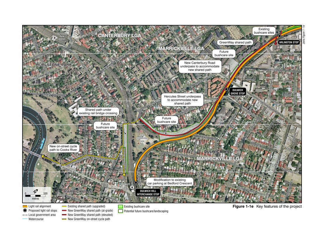
An overview of the key features of the project is shown on Figures 1-1a to 1-1f andcomprise:
A 5.6 km extension of the light rail between the existing Lilyfield light rail stop and theproposed Dulwich Hill Interchange stop. The extension would be located within theexisting disused Rozelle goods line corridor.

Potential substation location
LILYFIELD STOP
LEICHHARDTNORTH STOP
0 100
metres
N
Joins Figure 1-1b
Figure 1-1a Key features of the projectLight rail alignmentCity West Link rail corridor tunnel
Existing light rail stopProposed light rail stops
Modifications to infrastructuretie-in project to existing light
rail line
Light rail alignment inexisting disused Rozelle
goods line corridor Overhead wiring andother infrastructure upgrades
along the alignment
Potential substation site
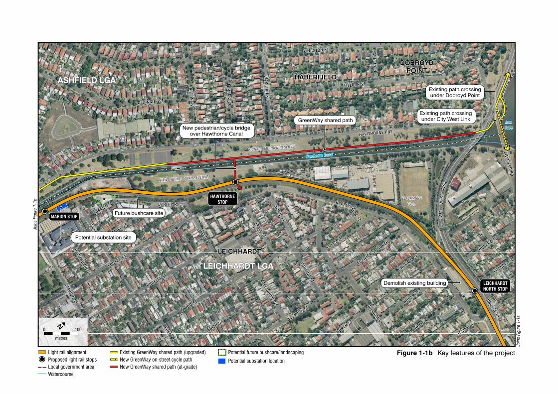
Potential substation site
HAWTHORNESTOP
MARION STOP
LEICHHARDTNORTH STOP
0 100
metres
N
Join
s Fi
gure
1-1
c
Join
s Fi
gure
1-1
a
Figure 1-1b Key features of the projectLight rail alignmentProposed light rail stopsLocal government areaWatercourse
Existing GreenWay shared path (upgraded)New GreenWay on-street cycle pathNew GreenWay shared path (at-grade)
Potential future bushcare/landscaping
Potential substation location
Demolish existing building
Existing path crossingunder Dobroyd Point
Existing path crossingunder City West Link
New pedestrian/cycle bridgeover Hawthorne Canal
Future bushcare site
GreenWay shared path

Potential substation site
Potential substation site
LEWISHAMWEST STOP
TAVERNERSHILL STOP
MARION STOP
0 100
metres
N
Figure 1-1c Key features of the project
Join
s Fi
gure
1-1
d
Join
s Fi
gure
1-1
b
Light rail alignmentProposed light rail stopsLocal government areaWatercourse
Existing GreenWay shared path (upgraded)New GreenWay shared path (at-grade)New GreenWay shared path (elevated)
New shared path crossingover Parramatta Road
Existingbushcare site
Raise existing rail bridge over Parramatta Road
New shared path crossingunder Longport Street
through existing structure
New shared path crossingunder railway bridge
through existing structure
GreenWay shared path
New signalised pedestriancrossing on Marion Street
Existing bushcare site
Potential future bushcare/landscaping
Potential substation location

ARLINGTON STOP
LEWISHAMWEST STOPWARATAH
MILLS STOP
0 100
metres
N
Figure 1-1d Key features of the project
Join
s Fi
gure
1-1
e
Join
s Fi
gure
1-1
c
Light rail alignmentProposed light rail stopsLocal government areaWatercourse
Existing shared path (upgraded)New GreenWay shared path (at-grade)New GreenWay shared path (elevated)New GreenWay on-street cycle path
New shared path connectionto Longport Street and
Lewisham Station
Future urbanrenewal sites
FutureBushcare sites
Old Canterbury Roadunderpass to accommodate
new shared pathDavis Street underpassto accommodate new
shared path
Existingbushcare sites
Existingbushcare site New on-street cycle path
along Weston Street
Constitution Roadunderpass to accommodate
new shared path
Futurebushcare
site
GreenWay shared path
Existing bushcare site
Potential future bushcare/landscaping
Potential substation location
Future urbanrenewal sites
Potential substation site
DULWICH HILLINTERCHANGE STOP
DULWICHGROVE STOP
ARLINGTON STOP
0 100
metres
N
Figure 1-1e Key features of the projectLight rail alignmentProposed light rail stopsLocal government areaWatercourse
Existing bushcare sitePotential future bushcare/landscaping
Joi
ns F
igur
e 1
-1d
Existing shared path (upgraded)New GreenWay shared path (at-grade)New GreenWay shared path (elevated)New GreenWay on-street cycle path
New Canterbury Roadunderpass to accommodate
new shared path
Futurebushcare site
Existingbushcare sites
Hercules Street underpassto accommodate new
shared path
Shared path underexisting rail bridge crossing
Futurebushcare site
Futurebushcare site
Modification to existingcar parking at Bedford Crescent
New on-street cyclepath to Cooks River
GreenWay shared path

0 100
metres
N
Figure 1-1f Key features of the projectConstruction footprint
Extension of one siding (rail track) by approximately
30 metres
Monorail maintenance facility
Maintenance facility and operationscentre for light rail
Additional security features to be installed

Ecological assessment: Sydney Light Rail Extension – Stage 1
Page 8 ECOLOGY B-W PARSONS BRINCKERHOFF
Nine new light rail stops — Leichhardt North, Hawthorne, Marion, Taverners Hill,Lewisham West, Waratah Mills, Arlington, Dulwich Grove and Dulwich Hill Interchange.
Minor modifications to the existing Lilyfield stop and surrounding track to tie-in new trackand overhead wiring infrastructure with the existing light rail.
Modifications to the existing northern car park at Bedford Crescent to accommodate theDulwich Hill Interchange stop.
Raising of the existing bridge over Parramatta Road which will carry the light rail.
Provision of the GreenWay, a shared pedestrian and cycle path from Iron Cove atDobroyd Point to the northern bank of the Cooks River.
Provision of pedestrian linkages (access pathways) to surrounding neighbourhoods toenable access to the GreenWay shared path and light rail stops.
Modification of the existing road bridge structures to accommodate the GreenWayshared path – namely at Hercules Street, Old Canterbury Road, Constitution Road,Davis Street and Longport Street.
New pedestrian/cycle bridge at Parramatta Road adjacent to the light rail overbridge.
New pedestrian/cycle bridge across the Hawthorne Canal near Hawthorne stop.
New infrastructure to ensure accessibility and connectivity between the shared path,local streets and light rail stops.
Provision of sites for Bushcare and vegetation remediation areas in order to provide forexisting, and an increase in, local habitat for fauna.
Appropriate safety fencing or separation of shared path and light rail operations, and thelight rail operations and the heavy passenger rail operations at Dulwich Hill.
Provision of overhead wiring, substation and utilities infrastructure.
1.2 Ecological studies completed for the project
A number of ecological studies have been completed with regard the Project. The SydneyLight Rail – Inner West Extension Study (GHD 2010) has been prepared and exhibited forthe project focusing on the rail corridor. However, the ecology assessment was only a deskbased review and did not include any field surveys. This review suggested that the impactsof the project would be of moderate significance due to vegetation removal resulting in lossof habitat for Threatened fauna as well as increased risk of collision during operation.Ecological surveys were recommended to form part of the environmental assessment forearly works in order to ground truth vegetation communities, determine the likelihood orpresence of Threatened species and the conservation values of the study area (GHD 2010).
A one day flora and fauna survey was undertaken for the Rozelle Goods Line- rail trackmaintenance and reconstruction, Review of Environmental Factors (Transport NSW 2010b)on 8 June 2010 by Biosis Research (Biosis Research 2010b). This survey was largelyhabitat based and included:
incidental observations of flora and fauna

Ecological assessment: Sydney Light Rail Extension – Stage 1
PARSONS BRINCKERHOFF ECOLOGY B-W Page 9
general habitat assessment
vegetation and fauna habitat condition assessment
active searching and listening for fauna
looking for indirect evidence of Long-nosed Bandicoots, such as diggings and scats.
The preliminary ecological assessment failed to detect Threatened ecological communities,Threatened species of plant or their habitats. No Threatened or migratory fauna wererecorded, however the site was considered to provide potential habitat for 12 threat-listedspecies of animal (Biosis Research 2010b). This study recommended further surveysincluding targeted surveys for:
Grey-headed Flying-fox – spotlighting
Long-nosed Bandicoot – including infra-red camera surveys with trapping and hairtubing undertaken if individuals are recorded.
The additional surveys for the Long-nosed Bandicoot were conducted by Biosis Research inJuly 2010 and presented in an assessment of significance (Biosis Research 2010a). Thesurveys, conducted using remote cameras, did not locate any Long-nosed Bandicoots. Themost frequently recorded animal was the domestic cat with 15 different individuals recordedincluding rats, European Red Foxes, domestic dogs, Australian White Ibis, and AustralianMagpie. The high incidence of feral predators recorded may suggest that the Long-nosedBandicoot population may be suffering high predation stress. Surveys for indirect evidencedid not record any signs of Long-nosed Bandicoot activity (Biosis Research 2010a).
The preliminary environmental assessment (Transport NSW 2010c) concluded that theEnvironmental Assessment for the project would include:
identification of vegetation and potential habitat in and around the project that may bedirectly or indirectly affected during construction or operation
consideration of the potential impacts to threatened fauna and habitat during operation
presentation of a strategy to avoid, mitigate or offset impacts on vegetation, habitat andbush regeneration areas.
1.3 Aims
This ecological assessment aims to meet the Director-General’s requirements namely, toconsider:
flora, fauna and habitat, with specific consideration of threatened and vulnerable flora,fauna and populations, including the Long-nosed Bandicoot (Perameles nasuta),Eastern Bentwing-bat (Miniopterus schreibersii oceanensis) and the Eastern FalsePipistrelle Bat (Falsistrellus tasmaniensis) and the protection of urban bushland
vegetation clearing (and resultant foraging, nesting, roosting habitat loss; fragmentation,connectivity and edge effects) and operational impacts
ecological surveys commensurate within the biology/ecology of species and the extentof suitable habitat within and adjacent to the rail corridor
Ecological assessment: Sydney Light Rail Extension – Stage 1
Page 10 ECOLOGY B-W PARSONS BRINCKERHOFF
take into account the:
Draft guidelines for Threatened species assessment (Department of Environmentand Conservation & Department of Primary Industries 2005)
Threatened biodiversity survey and assessment: guidelines for developments andactivities (Department of Environment and Conservation 2004).
Specifically, this report provides:
a description of the existing environment and identification of the significance ofbiodiversity within the proposed freight rail corridor and GreenWay
identification of flora and fauna habitats and Threatened ecological communities,populations and species that may be affected by the Project
assessments of the potential construction and operational impacts of the Project inaccordance with Part 3A Environmental Planning and Assessment Act 1979 guidelinesfor species, populations and communities listed under the Threatened SpeciesConservation Act 1995
assessments for species listed under the Environment Protection and BiodiversityConservation Act 1999 following the EPBC Act Policy Statement 1.1 Significant ImpactGuidelines (Department of the Environment and Heritage 2006)
maps of the location of threatened flora and fauna and the location of any significantvegetation and habitats on site including significant trees
recommendations regarding the need for more detailed study, monitoring or mitigationmeasures.
Ecological assessment: Sydney Light Rail Extension – Stage 1
PARSONS BRINCKERHOFF ECOLOGY B-W Page 11
2. Legislative and statutory frameworkThis section outlines the state and Commonwealth legislation and statutory frameworkrelevant to the assessment of biodiversity for the project.
2.1 State assessment frameworkThe project will be assessed under Part 3A of the Environmental Planning and AssessmentAct 1979, which is the principle strategic planning and approval instrument in NSW. Part 3Aoutlines the approval framework for major infrastructure, or other development that in theopinion of the Minister for Planning, is of state or regional environmental planningsignificance.
Legislation relevant to biodiversity and the project is summarised in Table 2.1.
Table 2-1 Legislation and guidelines relevant to biodiversity
Legislation (governingauthority) Objectives Relevance to current project
Environmental Planning andAssessment Act 1979(Department of Planning)
To encourage the propermanagement, developmentand conservation of naturaland artificial resources forthe purpose of promoting thesocial and economic welfareof the community and abetter environment.
As the principle planninginstrument in NSW, this Actdictates the assessment andapproval pathway for theproposal and thereby the factorsfor consideration for assessmentof the significance tobiodiversity, and therequirements to consider orseek authorization under otherNSW legislation and planningpolicies.
National Parks and Wildlife Act1974(Department of the Environment,Climate Change and Water)
The objects of this Act arethe conservation of natureand objectives, places orfeatures of cultural value.This Act contains provisionsthat relate to the protectionof native terrestrial fauna andsome flora and endangeredecological communities inaddition to indigenouscultural heritage.
Penalties relating to causingharm to native flora and fauna(including Threatened species,populations and communities)are outlined in this Act.Actions approved under Part 3Aof the Environmental Planningand Assessment Act 1979 areexempt from prosecution as longas the impact is within the levelsapproved.

Ecological assessment: Sydney Light Rail Extension – Stage 1
Page 12 ECOLOGY B-W PARSONS BRINCKERHOFF
Legislation (governingauthority) Objectives Relevance to current project
Threatened SpeciesConservation Act 1995(Department of the Environment,Climate Change and Water)
To conserve biologicaldiversity and prevent theextinction and promote therecovery of threatenedspecies, populations andecological communities.To ensure that the impact ofany action affectingthreatened species,populations and ecologicalcommunities is properlyassessed.
Threatened biodiversity arelisted under this Act. These listsprovide a trigger of anassessment of threatenedspecies that are known or likelyto occur and are likely to bedirectly or indirectly affected bythe proposal.Significance assessments forprojects assessed under Part 3Aof the Environmental Planningand Assessment Act 1979 arecompleted in accordance withthe heads of considerationoutlined in Draft guidelines forthreatened species assessment(Department of Environment andConservation & Department ofPrimary Industries 2005).
Fisheries Management Act 1994(Industry and Investment NSW)
The objectives of this Act areto conserve, develop andshare the fishery resourcesof the state for the benefit ofpresent and futuregenerations.Included in this objective isto conserve Threatenedspecies, populations andecological communities offish and marine vegetation.
Threatened aquatic biodiversityare listed under this Act.Significance assessments mustbe completed for all Threatenedecological communities,populations and species listedunder this Act that are recordedin the study area, or likely tooccur, and which will be directlyor indirectly affected by theProject. Significanceassessments for projectsassessed under Part 3A of theEnvironmental Planning andAssessment Act 1979 arecompleted in accordance withthe heads of considerationoutlined in Draft guidelines forthreatened species assessment(Department of Environment andConservation & Department ofPrimary Industries 2005).Under s.205 of this Act, a permitis required to harm any harmmarine vegetation, includingmangroves or seagrasses.However, an action approvedunder Part 3A of theEnvironmental Planning andAssessment Act 1979 is exemptfrom requiring a s.205 permit.

Ecological assessment: Sydney Light Rail Extension – Stage 1
PARSONS BRINCKERHOFF ECOLOGY B-W Page 13
Legislation (governingauthority) Objectives Relevance to current project
SEPP19 – Bushland in UrbanAreas
SEPP 19 – Bushland inUrban Areas applies to allbushland within the SydneyMetropolitan area that iszoned or reserved as publicopen space. The aim ofSEPP19 is to preserveremnant vegetation withinurban areas and for retentionof bushland areas to begiven priority overdevelopments. Thedetermining authority mustconsider what impact theclearing of bushland mighthave on soil erosion, siltationof streams and the spread ofexotic weeds and plants.
Although SEPP19 only appliesto projects assessed under Part4 of the Environmental Planningand Assessment Act 1979 thatare approved by Local Council,the highly urbanised nature ofthe study area necessitates thatany remaining patches ofbushland have inherent value.As the GreenWay is a large areaof urban bushland that existswithin an otherwise urbanisedenvironment, the objectives ofSEPP19 have been taken intoaccount in this assessment.
Part 3A of the Environmental Planning and Assessment Act 1979 makes provisions for thestreamlining of the assessment and carrying out of actions to which it applies (refer section75U and 75V of the Act). Under this NSW approval pathway, the project is therefore affordedthe following exemptions that relate to biodiversity:
A permit under Sections 201 (dredging or reclamation work), 205 (Marine vegetation—regulation of harm) or 219 (Passage of fish not to be blocked) of the FisheriesManagement Act 1994.
Approvals under sections 89 (water use approvals), 90 (water management workapprovals) and 91 (activity approvals) under the Water Management Act 2000.
Furthermore, only the Minister or the Director General can issue enforcement orders underthe Environmental Planning and Assessment Act 1979 to actions approved under Part 3A ofthe Act.
Section 75R of the Environmental Planning and Assessment Act 1979 also provides thatenvironmental planning instruments, other than State Environmental Planning Policies(SEPPs), do not apply to or in respect of a Part 3A project (including Local EnvironmentPlans). Under Section 75J however, the Minister may (but is not required to) take intoaccount the provisions of any environmental planning instrument that would not (because ofSection 75R) apply to the project if approved.
2.2 Commonwealth assessment frameworkApproval of an action under the Environmental Planning and Assessment Act 1979 does notnegate the requirement to consider the provisions of the Commonwealth EnvironmentProtection and Biodiversity Conservation Act 1999. The Environment Protection andBiodiversity Conservation Act 1999 relates to projects that involve or impact upon matters ofNational Environmental Significance (NES) and addresses Australia’s commitments tointernational environmental law and treaties. The Environment Protection and BiodiversityConservation Act 1999 identifies eight matters of NES:
world heritage properties
wetlands of international importance (listed under the Ramsar convention)

Ecological assessment: Sydney Light Rail Extension – Stage 1
Page 14 ECOLOGY B-W PARSONS BRINCKERHOFF
Commonwealth marine areas
listed Threatened species and ecological communities
Migratory species protected under international agreements
national heritage places
The Great Barrier Reef Marine Park
nuclear actions (including uranium mines).Where a project or action has potential to impact on a matter of NES, it should be referred tothe Commonwealth Department of the Environment, Water, Heritage and the Arts (DEWHA)to determine whether the development is a controlled action under the EnvironmentProtection and Biodiversity Conservation Act 1999. If the Minister determines that theproposed action is controlled under the Environment Protection and BiodiversityConservation Act 1999, a formal assessment process is required.

Ecological assessment: Sydney Light Rail Extension – Stage 1
PARSONS BRINCKERHOFF ECOLOGY B-W Page 15
3. MethodsThis ecological assessment included both desk-based assessment of the literature andrelevant databases, as well as field survey of the study area and surrounding landscape.
3.1 PersonnelThe contributors to the preparation of this report, their qualifications and roles are listed inTable 2.1.
Table 3-1 Contributors and their roles
Name Qualifications Role
Lukas Clews BSc, GradCertAppSci, MSciStud Ecological assessment
Selga Harrington BSc (Hons) Ecological assessment
Martin Predavec PhD, BSc (Hons) Technical review
All work was carried out under the appropriate licences, including a scientific licence asrequired under Clause 22 of the National Parks and Wildlife Regulations 2002 and Section132C of the National Parks and Wildlife Act 1974, and an Animal Research Authority issuedby the Industry and Investment NSW (Agriculture).
3.2 NomenclatureNames of plants used in this document follow Harden (Harden 1992, 1993, 2000, 2002) withupdates from PlantNet (Royal Botanic Gardens 2010). Scientific names are used in thisreport for species of plant followed by the common names in brackets. Scientific andcommon names of plants are listed in Appendices A and B. Introduced species are identifiedwithin the text with an asterisk following the name, for example Lantana camara*.
Names of vertebrates follow the Census of Australian Vertebrates (CAVS) databasemaintained by the Department of the Environment, Water, Heritage and the Arts(Department of the Environment Water Heritage and the Arts 2009a). Common names areused in the report for species of animal. Scientific names are included in species lists foundin Appendix A and C.
3.3 Literature and database reviewRecords of Threatened species known or predicted to occur within the locality of the studyarea were obtained from a range of databases as detailed in Table 2.2. Available literaturewas reviewed including regional assessments as well as ecological surveys of the site, suchas:
Sydney Light Rail - Inner West extension study (GHD 2010)
Preliminary ecological assessment: Sydney Light Rail Extension, Stage 1 (BiosisResearch 2010b)
Assessment of significance: Rozelle goods line track maintenance and reconstruction(Biosis Research 2010a).
GreenWay- Cooks River to Iron Cove. Flora and fauna literature review (Ward 2010)
Cooks River to Iron Cove GreenWay master plan and coordination strategy (GreenWayCoordination Strategy Working Group 2009)

Ecological assessment: Sydney Light Rail Extension – Stage 1
Page 16 ECOLOGY B-W PARSONS BRINCKERHOFF
Rozelle Goods Line- rail track maintenance and reconstruction, Review ofEnvironmental Factors (Transport NSW 2010b)
Preliminary Environmental Assessment report (Transport NSW 2010c)
Light rail and GreenWay integration plan (Transport NSW 2010a)
GreenWay Bushcare management plan, preliminary report (ecological 2010)
Fauna study, Marrickville LGA (AMBS 2007)
Yuppie bandicoots of inner west Sydney - in hiding or urban renewal? (Leary et al.unpublished).
Table 3-2 Database searches
Database Search date Search area Source
Threatenedspecies,populations andcommunitiesdatabase
9 August 2010 Sydney Metro CatchmentManagement Area (PittwaterPart B sub catchment)
Department of Environmentand Climate Change (2010b)
Atlas of NSWWildlife
9 August 2010 10 km radius centred on thestudy area.
Department of EnvironmentClimate Change and Water(2010a).
Protected MattersSearch Tool
March 2010 10 km radius centred on thestudy area.
Department of theEnvironment, Water, Heritageand the Arts (2010b).
3.4 Survey
Previous surveys of the study area have been conducted by Biosis Research (2010a;2010b). Flora surveys and habitat based fauna surveys for the preliminary ecologicalassessment were conducted in June 2010 with supplementary targeted Long-nosedBandicoot surveys undertaken via remote cameras over a two week period from 8 – 22 July2010 and habitat searches conducted on the 8 and 26 July 2010. The survey found noevidence of the Long-nosed Bandicoot in the study area, with little additional informationprovided on how Long-nosed Bandicoots use the rail corridor or adjacent lands or howsignificant the habitat is for the species (Biosis Research 2010a).
The surveys conducted within the study area for this assessment build upon the datacollected to provide a more comprehensive ecological assessment.
Site inspections were undertaken on 18 and 24 August and 2 September 2010 to determinethe nature and condition of vegetation within the study area and the presence of faunahabitats (Table 3-3). The location of vegetation and habitats identified during the desktopreview was ground-truthed. The location of significant habitat features were recorded andmapped including foraging resources, habitat trees, and vegetation community boundaries.
Table 3-3 Site inspections
Date Team members Nature of inspection
18 August Martin Predavec Daytime inspection of GreenWay andinspection of corridor from outside.
24 August Lukas Clews Daytime inspection of GreenWay and

Ecological assessment: Sydney Light Rail Extension – Stage 1
PARSONS BRINCKERHOFF ECOLOGY B-W Page 17
Selga Harrington inspection of corridor from outside.Spotlighting within Greenway
2 September Lukas ClewsMartin Predavec
Daytime inspection from within railcorridor.
Particular attention was paid to species of conservation concern identified from the desktopanalysis including Threatened and migratory species or locally significant species.The potential presence of Threatened species of animal was determined based on a habitatassessment rather than targeted survey as this is a more conservative approach likely toinclude species that are difficult to detect.
Areas containing remnant vegetation and dense weed growth were searched for crypticThreatened species and populations. This included searches for Grey-headed Flying-foxroosts and indirect evidence of Long-nosed Bandicoots. The undersides of bridges wereinspected for signs of roosting activity by microchiropteran bats.
3.4.1 Flora
The floristic diversity and possible presence of Threatened species was assessed usingrandom meander surveys in accordance with the NSW Threatened Biodiversity Survey andAssessment: Guidelines for Developments and Activities (Working Draft) (Department ofEnvironment and Conservation 2004).
Due to the linear nature of the project, random meander surveys were completed along theentire length of the project corridor. Random meander surveys are a variation of the transecttype survey and were completed in accordance with the technique described by Cropper(1993), whereby the recorder walks in a random manner throughout the site recording allspecies observed, boundaries between various vegetation communities and condition ofvegetation. The time spent in each vegetation community was generally proportional to thesize of the community and its species richness.
3.4.2 Condition of vegetation communities
The condition of vegetation was assessed through general observation and comparisonagainst this benchmark data as well as using parameters such as intactness, diversity,history of disturbance, weed invasion and health. Three categories were used to describethe condition of vegetation communities:
Good: Vegetation still retains the species complement and structural characteristicsof the pre-European equivalent. Such vegetation has usually changed very little overtime and displays resilience to weed invasion due to intact groundcover, shrub andcanopy layers.Moderate: Vegetation generally still retains its structural integrity, but has beendisturbed and has lost some component of its original species complement. Weedinvasion can be significant in such remnants.Low: Vegetation that has lost most of its species and is significantly modifiedstructurally. Often such areas have a discontinuous canopy of the original tree cover,with very few shrubs. Exotic species, such as introduced pasture grasses or weeds,replace much of the indigenous ground cover. Environmental weeds are often codominant with the original indigenous species.
Following the biometric methodology (NSW Department of Environment and Conservation2007), woody vegetation, is considered in low condition vegetation when:

Ecological assessment: Sydney Light Rail Extension – Stage 1
Page 18 ECOLOGY B-W PARSONS BRINCKERHOFF
overstorey percent foliage cover is <25% of the lower values of the overstorey per centfoliage cover benchmark for that vegetation type, AND either
less than 50% of vegetation in the ground layer is indigenous species, OR
greater than 90% is ploughed or fallow.
3.4.3 Fauna
Survey effort considered the methodology detailed in the NSW Threatened BiodiversitySurvey and Assessment: Guidelines for Developments and Activities (Working Draft)(Department of Environment and Conservation 2004). However, as much of the subject sitewas already largely disturbed, fauna habitat assessments were completed to assess thelikelihood of Threatened species of animal occurring in the study area. Habitat assessmentsincluded the assessment and identification of habitat features, hollow tree surveys, targetedhabitat searches and random meanders.
During habitat assessments and random meanders, opportunistic recordings of species weremade through incidental sightings, aural recognition of calls and observations of indirectevidence of species’ presence (i.e. Long-nosed Bandicoot diggings). This providedsupplementary information on faunal species presence. Collected hairs were analysed foridentification by Georgiana Story (Scats About Australia).
Spotlighting was used primarily to target the Long-nosed Bandicoot. However, thespotlighting technique was also used to locate arboreal, flying, and other ground-dwellingmammals, and nocturnal birds. Spotlighting was performed after dusk at four sites (JohnsonPark, Hoskins Park, Blackmore Oval and Richard Murden Reserve). The rail corridor wasalso surveyed by spotlight from the road overpasses at Constitution Road (near theArlington Stop) and Davis Street (near the Waratah Mills Stop). At least one person hour ofsurvey effort, per site, was completed on foot using two 100 watt vari-beam spotlights.The speed of the spotlight surveys was approximately 1 km per hour. The spotlight surveysconcentrated on areas that contained suitable habitat for the Long-nosed Bandicoot.
Fauna species recorded during the fauna surveys were documented and combined into atotal species list (Appendix B).
3.4.4 Fauna habitats
Fauna habitats were assessed generally by examining characteristics such as the structureand floristics of the canopy, understorey and ground vegetation, the structure andcomposition of the litter layer, and other habitat attributes important for feeding, roosting andbreeding. The following criteria were used to evaluate habitat values:
Good: A full range of fauna habitat components are usually present (for example,old-growth trees, fallen timber, feeding and roosting resources) and habitat linkagesto other remnant ecosystems in the landscape are intact.
Moderate: Some fauna habitat components are missing (for example, old-growth treesand fallen timber), although linkages with other remnant habitats in the landscape areusually intact, but sometimes degraded.
Poor: Many fauna habitat elements in low quality remnants have been lost, including oldgrowth trees (for example, due to past timber harvesting or land clearing) and fallentimber, and tree canopies are often highly fragmented. Habitat linkages with other
Ecological assessment: Sydney Light Rail Extension – Stage 1
PARSONS BRINCKERHOFF ECOLOGY B-W Page 19
remnant ecosystems in the landscape have usually been severely compromised byextensive past clearing.
3.5 Likelihood of occurrenceFor this study, likelihood of occurrence of Threatened species recorded or predicted to occurin the locality is defined in Table 3-4.
Table 3-4 Likelihood of occurrence of threatened species
Likelihood Description
Low
Species considered to have a low likelihood of occurrence include species notrecorded during the field surveys that fit one or more of the following criteria:
Have not been recorded previously in the study area and surrounds and forwhich the study area is beyond the current distribution range.Rely on specific habitat types or resources that are not present in the study area.Are considered locally extinct.Are a non-cryptic perennial flora species that were specifically targeted bysurveys and not recorded.
Moderate
Species considered to have a moderate likelihood of occurrence include speciesnot recorded during the field surveys that fit one or more of the following criteria:
Have infrequently been recorded previously in the study area and surrounds.Use habitat types or resources that are present in the study area, althoughgenerally in a poor or modified condition.Are unlikely to maintain sedentary populations, however, may seasonally useresources within the study area opportunistically during variable seasons ormigration.Are cryptic flowering flora species that were not seasonally targeted by surveysand that have not been recorded.
High
Species considered to have a high likelihood of occurrence include species notrecorded that fit one or more of the following criteria:
Have frequently been recorded previously in the study area and surrounds.Use habitat types or resources that are present in the study area that areabundant and/or in good condition within the study area.Are known or likely to maintain resident populations surrounding the study area.Are known or likely to visit the site during regular seasonal movements ormigration.
Present Any Threatened species recorded during field surveys.
3.1 Significance assessmentsThe impact assessments followed the definitions in the Glossary and the proposaldescription provided in Section 1.1. Tests for significance were completed for Threatenedspecies, populations or ecological communities considered to have a moderate or higherlikelihood of occurrence.
For Threatened biodiversity listed under the Threatened Species Conservation Act 1995,significance assessment consider the heads of consideration for Threatened speciesassessment as suggested in the Department of Environment and Conservation/ Departmentof Primary Industries draft Guidelines for Threatened Species Assessment (Department ofEnvironment and Conservation & Department of Primary Industries 2005).
For Threatened biodiversity listed under the Environment Protection and BiodiversityConservation Act 1999 significance assessment have been completed in accordance with

Ecological assessment: Sydney Light Rail Extension – Stage 1
Page 20 ECOLOGY B-W PARSONS BRINCKERHOFF
the EPBC Act Significant Impact Guidelines (Department of the Environment and Heritage2006).
For species, populations or communities listed under both Acts, both assessments werecompleted.
Ecological assessment: Sydney Light Rail Extension – Stage 1
PARSONS BRINCKERHOFF ECOLOGY B-W Page 21
3.2 LimitationsOn all sites, varying degrees of non-uniformity of flora and fauna habitats are encountered.Hence, no sampling technique can entirely eliminate the possibility that a species is presenton a site (e.g. species of plant present in the seed bank). The conclusions in this report arebased upon data acquired for the site and the field survey conducted over one day and night.Therefore, the results are merely indicative of the environmental condition of the site at thetime of survey, including the presence or otherwise of species. It should also be recognisedthat site conditions, including the presence of Threatened species, can change with time.However, a precautionary approach was taken and assessments have been undertakenbased on the presence of suitable habitat and known occurrences of species even if aspecies wasn’t recorded.
Due to the rail corridor being an active rail line at the time of the assessment, night timeaccess, and hence survey, was not allowed due to safety concerns. However night timesurveys were undertaken by Biosis Research as part of the early works REF and the resultshave been mentioned in the text where relevant.

Ecological assessment: Sydney Light Rail Extension – Stage 1
Page 22 ECOLOGY B-W PARSONS BRINCKERHOFF


