Transmission Line Management Plan - Centennial Coal · 3.2 TransGrid Transmission Line No. 24...
67
Transmission Line Management Plan TransGrid Towers TL24 / 45-46 Longwalls 24 and 24A Mandalong Mine MEMS-EP-9000-TLMP-9053 December 2017
Transcript of Transmission Line Management Plan - Centennial Coal · 3.2 TransGrid Transmission Line No. 24...
Transmission Line Management Plan
TransGrid Towers TL24 / 45-46
Longwalls 24 and 24A
Mandalong Mine
MEMS-EP-9000-TLMP-9053
December 2017
Transmission Line Management Plan LW24-24A
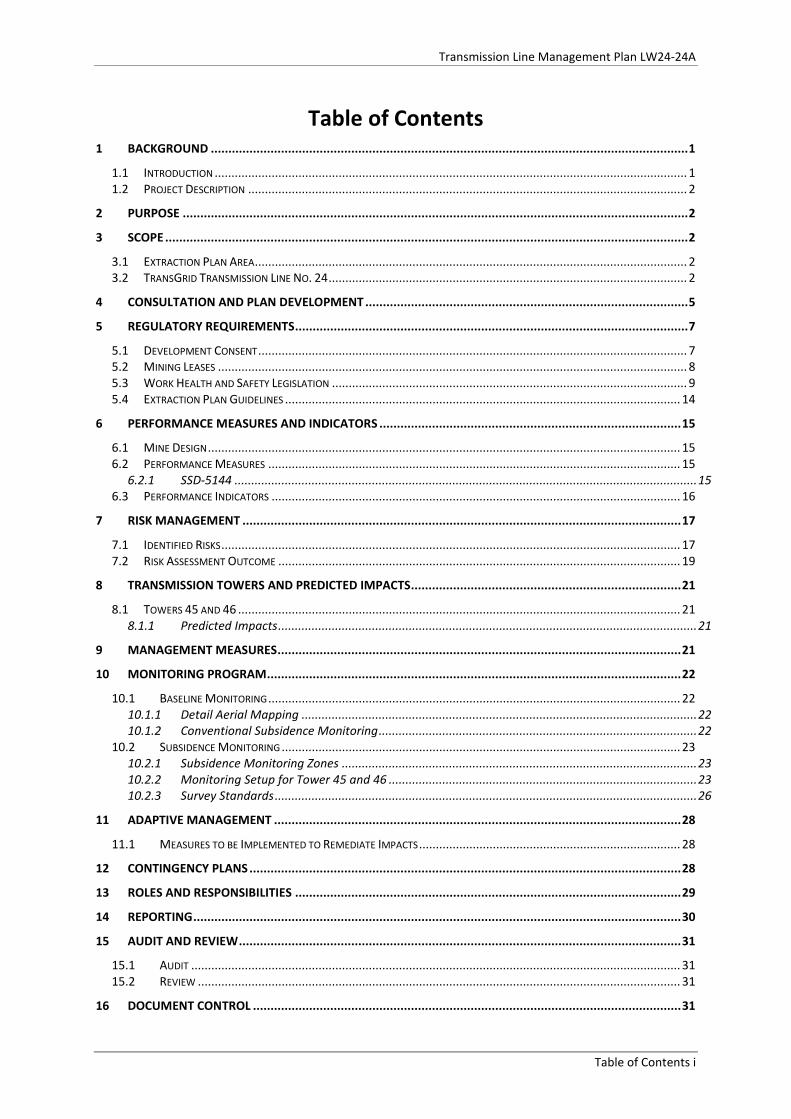
Table of Contents 1 BACKGROUND ........................................................................................................................................ 1
1.1 INTRODUCTION ............................................................................................................................................. 1 1.2 PROJECT DESCRIPTION ................................................................................................................................... 2
2 PURPOSE ................................................................................................................................................ 2
3 SCOPE ..................................................................................................................................................... 2
3.1 EXTRACTION PLAN AREA ................................................................................................................................. 2 3.2 TRANSGRID TRANSMISSION LINE NO. 24 ........................................................................................................... 2
4 CONSULTATION AND PLAN DEVELOPMENT ............................................................................................ 5
5 REGULATORY REQUIREMENTS ................................................................................................................ 7
5.1 DEVELOPMENT CONSENT ................................................................................................................................ 7 5.2 MINING LEASES ............................................................................................................................................ 8 5.3 WORK HEALTH AND SAFETY LEGISLATION .......................................................................................................... 9 5.4 EXTRACTION PLAN GUIDELINES ...................................................................................................................... 14
6 PERFORMANCE MEASURES AND INDICATORS ...................................................................................... 15
6.1 MINE DESIGN ............................................................................................................................................. 15 6.2 PERFORMANCE MEASURES ........................................................................................................................... 15
6.2.1 SSD-5144 .......................................................................................................................................... 15 6.3 PERFORMANCE INDICATORS .......................................................................................................................... 16
7 RISK MANAGEMENT ............................................................................................................................. 17
7.1 IDENTIFIED RISKS ......................................................................................................................................... 17 7.2 RISK ASSESSMENT OUTCOME ........................................................................................................................ 19
8 TRANSMISSION TOWERS AND PREDICTED IMPACTS ............................................................................. 21
8.1 TOWERS 45 AND 46 .................................................................................................................................... 21 8.1.1 Predicted Impacts ............................................................................................................................. 21
9 MANAGEMENT MEASURES ................................................................................................................... 21
10 MONITORING PROGRAM ...................................................................................................................... 22
10.1 BASELINE MONITORING ........................................................................................................................... 22 10.1.1 Detail Aerial Mapping ...................................................................................................................... 22 10.1.2 Conventional Subsidence Monitoring ............................................................................................... 22
10.2 SUBSIDENCE MONITORING ....................................................................................................................... 23 10.2.1 Subsidence Monitoring Zones .......................................................................................................... 23 10.2.2 Monitoring Setup for Tower 45 and 46 ............................................................................................ 23 10.2.3 Survey Standards .............................................................................................................................. 26
11 ADAPTIVE MANAGEMENT .................................................................................................................... 28
11.1 MEASURES TO BE IMPLEMENTED TO REMEDIATE IMPACTS .............................................................................. 28
12 CONTINGENCY PLANS ........................................................................................................................... 28
13 ROLES AND RESPONSIBILITIES .............................................................................................................. 29
14 REPORTING ........................................................................................................................................... 30
15 AUDIT AND REVIEW .............................................................................................................................. 31
15.1 AUDIT .................................................................................................................................................. 31 15.2 REVIEW ................................................................................................................................................ 31
16 DOCUMENT CONTROL .......................................................................................................................... 31
Table of Contents i
Transmission Line Management Plan LW24-24A
17 REFERENCES ......................................................................................................................................... 33
List of Figures
FIGURE 1 – TRANSGRID TRANSMISSION LINE NO.24 AND MINE WORKINGS WITHIN EXTRACTION PLAN AREA ........... 3 FIGURE 2 – TL24 TOWER 45 WITH RETROFITTED CONCRETE CRUCIFORM FOOTING ................................................ 4 FIGURE 3 – VERTICAL SUBSIDENCE ALONG TRANSGRID TL24 AT THE END OF EACH LONGWALL PANEL .................... 18 FIGURE 4 – MAXIMUM PREDICTED VERTICAL SUBSIDENCE, TRANSMISSION TOWERS AND MINE PLAN .................... 20 FIGURE 5 – LOCATION OF SURVEY PINS IN CONCRETE CRUCIFORM ON TOWER 46 ................................................. 24 FIGURE 6 – LOCATION OF GROUND PEGS FOR TOWER 46 ................................................................................. 25 FIGURE 7 – LOCATION OF SURVEY MARKS (GROUT TUBES) IN CONCRETE CRUCIFORM FOOTING ON TOWER 45 .......... 25
List of Tables TABLE 1 – OVERVIEW OF STAKEHOLDERS CONSULTED SPECIFICALLY FOR THE MANAGEMENT PLAN........................... 5 TABLE 2 - DEVELOPMENT CONSENT CONDITIONS SSD-5144 ............................................................................. 7 TABLE 3 – SUMMARY OF ML1443 AND ML1543 CONDITIONS RELATING TO TRANSMISSION LINES .......................... 8 TABLE 4 - SUMMARY OF WHS LEGISLATION RELATING TO MINE SUBSIDENCE ....................................................... 9 TABLE 5 – EXTRACTION PLAN GUIDELINE REQUIREMENTS FOR KEY COMPONENT PLANS ....................................... 14 TABLE 6 - SUBSIDENCE IMPACT PERFORMANCE MEASURES SSD-5144 .............................................................. 15 TABLE 7 – PERFORMANCE INDICATORS ......................................................................................................... 16 TABLE 8 – PREDICTED MOVEMENTS AT EACH TOWER AT END OF EACH LONGWALL PANEL ..................................... 17 TABLE 9 – SUBSIDENCE SENSITIVITIES ........................................................................................................... 18 TABLE 10 – SUBSIDENCE SENSITIVITY ANALYSIS FOR TL24 TOWER 46 LOCATED OVER LONGWALL 24 ..................... 19 TABLE 11 – SUBSIDENCE SENSITIVITY ANALYSIS FOR TL24 TOWER 45 LOCATED OVER LONGWALL 24A ................... 19 TABLE 12 – TRANSGRID TL24 TOWERS 45 AND 46 SUBSIDENCE MONITORING SUMMARY ................................... 27 TABLE 13 – ROLES AND RESPONSIBILITIES ...................................................................................................... 29 TABLE 14 - REPORTING REQUIREMENTS ........................................................................................................ 30
Appendices APPENDIX 1 TRIGGER ACTION RESPONSE PLANS APPENDIX 2 KEY PERSONNEL LIST APPENDIX 3 INSPECTION CHECK LIST APPENDIX 4 CORRESPONDENCE
Table of Contents ii
Transmission Line Management Plan LW24-24A
DOCUMENT CONTROL DOCUMENT DETAILS
Name: Transmission Line Management Plan LW24-24A Author: Phil Enright Number: MEMS-EP-9000-TLMP-9053 Revision No.: 1 Document Status Final
APPROVAL DETAILS
Revision No.
Date Sent Details of Approval Approved By Approval Date
0 28/9/2017 Draft for TransGrid review
Phil Enright 28/09/2017
0 15/11/2017 Draft for DRE / DRG consultation
Phil Enright 15/11/2017
1 27/11/2017 Final for Submission J. Turner 5/12/2017
CIRCULATION DETAILS
Name Department Circulation Date Mrs Shahpar Ahmed Project Manager | Works Delivery
TransGrid 28/9/2017 (Rev. 0) 5/12/2017 (Rev. 1)
Mr Alex Love Project Coordinator
Royalties and Advisory Services, Division of Resources and Geoscience (DRG), NSW Department of Planning and Environment
15/11/2017 (Rev. 0) 5/12/2017 (Rev. 1)
Mr Howard Reed Director Resource Assessments
Department of Planning and Environment (DPE) – Resource Assessment’s
5/12/2017 (Rev. 1)
Mr Matthew Montgomery Manager Infrastructure
Subsidence Advisory NSW (SA NSW)
5/12/2017 (Rev. 1)
Document Control Details iii
Transmission Line Management Plan LW24-24A
1 BACKGROUND 1.1 Introduction Mandalong Mine is a modern underground longwall operation located on the western side of Lake Macquarie near Morisset and west of the M1 Motorway. The Mine is situated approximately 130 km north of Sydney and 50 km from the Port of Newcastle, suppling approximately six million tonnes of coal to the domestic power and export markets. Centennial Mandalong Pty Ltd (Centennial Mandalong) is the operator of Mandalong Mine and is a wholly owned subsidiary of Centennial Coal Company Limited which is also a wholly owned subsidiary of by Banpu Public Company Limited. Mandalong Mine commenced longwall mining in 2005 and operates narrow longwall panels in the West Wallarah Seam that utilise the bridging effect of the overlying massive strata to provide reduced levels of subsidence. This design is proven and provides subsidence impacts below safe, serviceable and repairable (SSR) criteria for dwellings and minimises the impacts to the Mandalong valley flood plain, natural features and built features. Centennial Mandalong comprises the underground workings and surface infrastructure of:
• The Mandalong Mine underground workings including longwall panels, development units and surface infrastructure located near Morisset;
• The Cooranbong Entry Site, consisting of the Cooranbong Colliery underground workings and surface infrastructure located near Dora Creek;
• The Delta Entry Site, which encompasses an entry and coal delivery system, located near Wyee at the Vales Point Rail Unloader Facility; and
• The proposed new surface facilities site, referred to as the Mandalong South Surface Site located off Mandalong Road.
Mandalong Mine operates under Development Consent SSD-5144 which was granted on 12 October 2015 by the NSW Planning Assessment Commission under Part 4, Division 4.1 of the NSW Environmental Planning and Assessment Act 1979 (EP&A Act), and provided for extension of the mining area with a production limit of 6.5 million tonnes per annum of thermal coal from the West Wallarah and Wallarah-Great Northern Seams. This Transmission Line Management Plan has been developed in accordance with the current requirements of Condition 6, Schedule 4 of SSD-5144 for the extraction of Longwalls 24 and 24A (LW24-24A), and in accordance with Mining Leases (ML1443 and ML1543) requirements issued under the Mining Act 1992 to extract longwall panels within the West Wallarah Seam. The Extraction Plan and Transmission Line Management Plan have been prepared generally in accordance with the Department of Planning & Environment, Draft Guidelines for the Preparation of Extraction Plans V5 (2015) and the Department of Industry - Resources Regulator, Managing Risks of Subsidence Guide: WHS (Mines and Petroleum Sites) Legislation (2017). The area applicable to this extraction plan is defined in detail in Section 3.1
1
Transmission Line Management Plan LW24-24A
1.2 Project Description The topography of the Mandalong valley and the Extraction Plan area ranges from the broad flat floodplain of Tobins Creek and Morans Creek to the foothills of the Watagan Mountain range. The land affected by longwall mining is a combination of natural bushland of the Watagan Ranges together with cleared areas of the floodplain. Properties located within the valley and Extraction Plan area are typically 17 ha rural residential properties, although a number of small properties less than 4 ha are also located within the area. Within the Extraction Plan area there are 19 private properties and two properties owned by Centennial Coal. The privately owned properties and seven affected dwellings are managed by individual Property Subsidence Management Plans (PSMP) as required by SSD-5144 Schedule 4 Condition 6 (h). Local roads, power lines, transmission lines, telecommunication networks and other associated infrastructure are also included in the area of potential subsidence influence. This infrastructure is managed by the Built Features Management Plan and supporting individual infrastructure management plans developed for Public Roads, Telstra Communications, Ausgrid Powerlines and TransGrid Transmission Lines.
2 Purpose The purpose of the TransGrid Management Plan is to provide the management strategies, controls and monitoring programs to be implemented for the management of potential subsidence impacts on TransGrid 330kV transmission Line No. 24 Towers 46 and 45 affected by the extraction of LW24 and LW24A respectively.
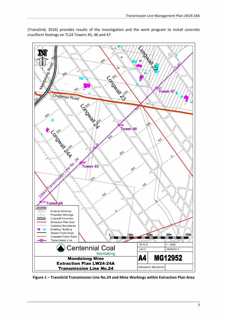
3 Scope 3.1 Extraction Plan Area The Transmission Line Management Plan applies to the management of risks relating to the development of subsidence from the extraction of LW24-24A, located within Centennial Mandalong Mining Leases (ML1443 and ML1543) and Development Consent SDD-5144. The Extraction Plan Area is defined by the 26.5⁰ angle of draw from the limit of proposed extraction as shown in Figure 1.
3.2 TransGrid Transmission Line No. 24 Transmission lines and towers within the Extraction Plan Area are under the care and control of TransGrid. The transmission line network location and mine workings are shown in Figure 1. The Vales Point to Eraring 330 kV Transmission Line No. 24 is 30.5km long and is constructed in a steel lattice tower structure arrangement. The line was originally constructed in 1967 as a Vales Point power station to Newcastle feeder and was later redirected into Eraring power station in 2008. Transmission Line No. 24 (TL24) now acts as a link between the two power stations, to provide redundancy in the network, with no direct customers. TL24 Towers 45 and 46 are directly located above LW24 and LW24A. TransGrid were engaged by Centennial Mandalong to investigate, design and install mitigation measures for the affected towers. The TransGrid, Report – Scoping Study into Mine Subsidence Mitigation (Structures 45-48 of TL24
2
Transmission Line Management Plan LW24-24A
(TransGrid, 2016) provides results of the investigation and the work program to install concrete cruciform footings on TL24 Towers 45, 46 and 47.
Figure 1 – TransGrid Transmission Line No.24 and Mine Workings within Extraction Plan Area
3
Transmission Line Management Plan LW24-24A
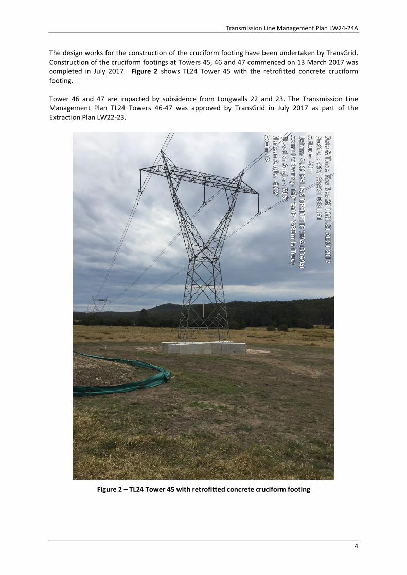
The design works for the construction of the cruciform footing have been undertaken by TransGrid. Construction of the cruciform footings at Towers 45, 46 and 47 commenced on 13 March 2017 was completed in July 2017. Figure 2 shows TL24 Tower 45 with the retrofitted concrete cruciform footing. Tower 46 and 47 are impacted by subsidence from Longwalls 22 and 23. The Transmission Line Management Plan TL24 Towers 46-47 was approved by TransGrid in July 2017 as part of the Extraction Plan LW22-23.
Figure 2 – TL24 Tower 45 with retrofitted concrete cruciform footing
4
Transmission Line Management Plan LW24-24A
4 Consultation and Plan Development The Communications Management Plan has been prepared and developed in consultation with key stakeholders as required by Development Consent SSD-5144. The Transmission Management Plan and the completed cruciform footing mitigation works has been prepared and developed in consultation with TransGrid, DRE and Subsidence Advisory NSW. A summary of the consultation for the Transmission Line Management Plan TL24 Towers 45-46 is presented in Table 1 and copy of the correspondence included in Appendix 4. The process for consultation, communication and the provision of information pertaining to this management plan will be managed according to Centennial Mandalong’s HSMC-SC-Information and Communications Arrangements and HSMS-SE-6592-Consultation Arrangements.
Table 1 – Overview of Stakeholders Consulted Specifically for the Management Plan
Stakeholder Date Consultation Type and Summary of Aspects/Issues
Section Addressed
DRE 26/07/2017 Centennial Mandalong had phone conversation with Mr Phil Steuart – Mine Subsidence Inspector to discuss subsidence monitoring on Transmission Towers 45 to 47. Towers 46 and 47 in the approved Extraction Plan LW22-23 and Tower 45 and 46 in Extraction Plan LW24 – 24A. Standard subsidence monitoring for transmission towers has been established on Towers 46 and 47. Tower 45 is located on private property and Centennial has been unable to gain an access agreement with the landowner to date. Monitoring points have been established on tower 45 cruciform footing and peak earthwire, but unable to install ground pegs. Centennial to continue negotiations with landowner to seek access to land for monitoring purposes. DRE did not raise any issues with the proposed monitoring.
Section 4 Section 10.2.2
TransGrid 28/07/2017 TransGrid provided letter to Centennial Mandalong to inform that the works under the ‘Transmission Line Modification Agreement’ for modification works relating to the installation of concrete cruciform footings on Transmission Line 24 (Towers 45-47) has now been completed.
Section 4 Appendix 4
TransGrid 28/09/2017 Centennial Mandalong provided the Draft Transmission Line Management Plan LW24-24A by email to Mrs Shahpah Ahmed – Project Manager and Mr Sanu Maharjan - Senior Structural Engineer for their review.
Section 4 Appendix 4
TransGrid 24/10/2017 Phone call from Mr Sanu Maharjan - Senior Structural Engineer to discuss subsidence monitoring program and TARPS. Centennial agreed to conduct one additional surveys and correct strain and tilt values in TARP.
Section 4 Section 10.2.2
TransGrid 24/10/2017 Mrs Shahpar Ahmed provided email with Mr Sanu Maharjan - Senior Structural Engineer requested changes to the management plan. TransGrid Asset Management Group is still reviewing the remainder of the document.
Section 4 Appendix 4 Appendix 1 Section 10.2.2
TransGrid 25/10/2017 Centennial Mandalong made TransGrid’s requested Section 4
5
Transmission Line Management Plan LW24-24A
Stakeholder Date Consultation Type and Summary of Aspects/Issues
Section Addressed
changes to management plan and provided the revised copy to TransGrid (Draft 1).
Appendix 4 This plan.
DRE 2/11/2017 Meeting at Mandalong Mine with Dr Gang Li (Principal Subsidence Engineer & Principal Inspector) and Mr Ray Ramage (Mine Subsidence Inspector) to provided and overview and consult on the development of Extraction Plan LW24-24A, Public Safety MP, Subsidence Monitoring Program and other infrastructure including the Transmission Line Management Plan. No specific issues with the Transmission Line Management Plan were raised. A site inspection of the EP area would be arranged following the submission of the HRA. Meeting minutes to be provided.
Section 4 Appendix 4
TransGrid 3/11/2017 Centennial Mandalong sent email to Mrs Shahpar Ahmed requesting an update on progress with the Asset Management Group review of the management plan.
Section 4 Appendix 4
DRE 10/11/2017 Centennial Mandalong emailed meeting minutes from meeting held with DRE on 2/11/2017 at Mandalong Mine. Mr Ray Ramage (Mine Subsidence Inspector) confirmed meeting minutes.
Section 4 Appendix 4
DRG 10/11/2017 Phone call from Centennial Mandalong to Mr Alex Love (Project Coordinator Royalty and Advisory Services) to provide and update and overview of the Development Consent consultation requirements, the preparation of Extraction Plan LW24-24A and current status, including infrastructure management plans and expected submission date. Mr Love detailed the consultation process between DPE, DRE and DRG. Centennial Mandalong provided email summarising phone call. Centennial Mandalong will provide DRG with relevant management plans for consultation in the following week.
Section 4
TransGrid 13/11/2017 TransGrid Endorsement of Management Plan Mrs Shahpar Ahmed – Project Manager endorsed the TransGrid Management Plan TL24 Towers 45-46 on 13/11/2017. Refer email in Appendix 4.
Section 4 Appendix 4
DRG 13/11/2017 Phone call to Alex Love (DRG) to advise management plans requiring DRE review to be sent to DRE on 14/11/17. All management plans have been endorsed by infrastructure owner except Ausgrid. Alex Love confirmed that only Built Features MP, Public Safety MP and the Subsidence Monitoring Program require DRE consultation following a review of SSD-5144. Suggested sending all plans following endorsement of Powerline MP.
Section 4
DRG 15/11/2017 Final draft provided to DRG for consultation. Section 4 Appendix 4
DRG 5/12/2017 No comments on the Transmission Line Management Plan were received from DRG by the submission date.
Section 4
6
Transmission Line Management Plan LW24-24A
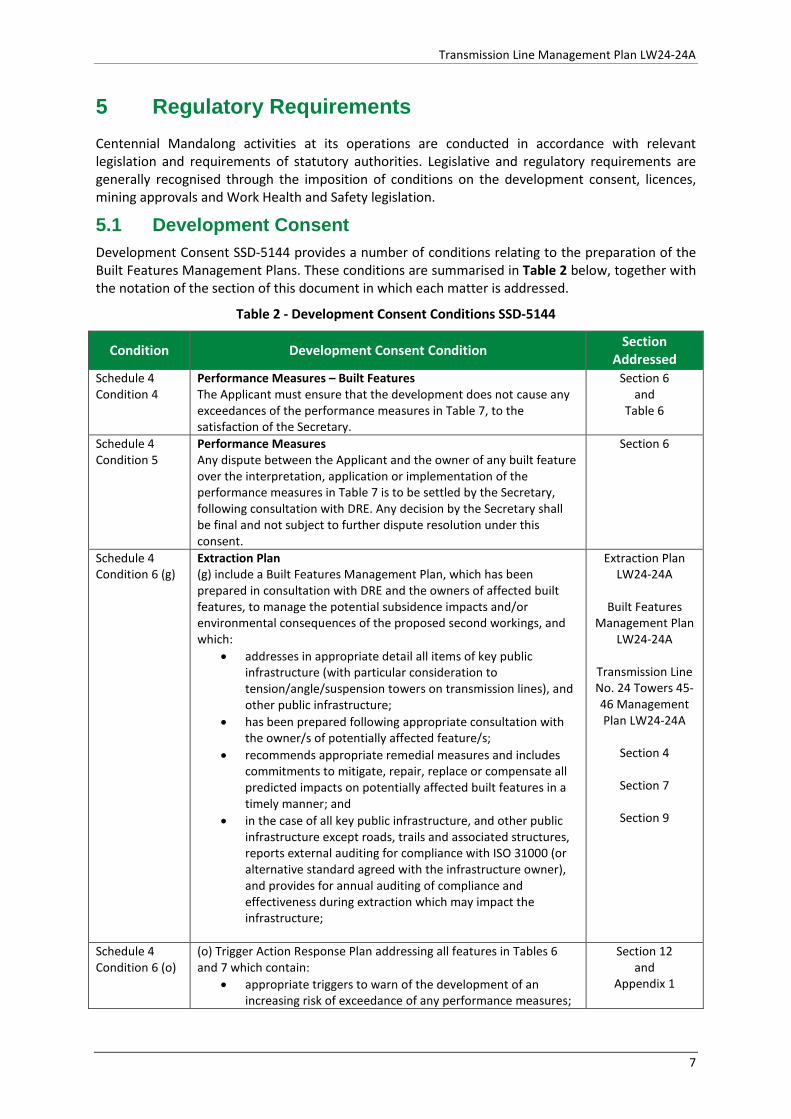
5 Regulatory Requirements Centennial Mandalong activities at its operations are conducted in accordance with relevant legislation and requirements of statutory authorities. Legislative and regulatory requirements are generally recognised through the imposition of conditions on the development consent, licences, mining approvals and Work Health and Safety legislation.
5.1 Development Consent Development Consent SSD-5144 provides a number of conditions relating to the preparation of the Built Features Management Plans. These conditions are summarised in Table 2 below, together with the notation of the section of this document in which each matter is addressed.
Table 2 - Development Consent Conditions SSD-5144
Condition Development Consent Condition Section Addressed
Schedule 4 Condition 4
Performance Measures – Built Features The Applicant must ensure that the development does not cause any exceedances of the performance measures in Table 7, to the satisfaction of the Secretary.
Section 6 and
Table 6
Schedule 4 Condition 5
Performance Measures Any dispute between the Applicant and the owner of any built feature over the interpretation, application or implementation of the performance measures in Table 7 is to be settled by the Secretary, following consultation with DRE. Any decision by the Secretary shall be final and not subject to further dispute resolution under this consent.
Section 6
Schedule 4 Condition 6 (g)
Extraction Plan (g) include a Built Features Management Plan, which has been prepared in consultation with DRE and the owners of affected built features, to manage the potential subsidence impacts and/or environmental consequences of the proposed second workings, and which:
• addresses in appropriate detail all items of key public infrastructure (with particular consideration to tension/angle/suspension towers on transmission lines), and other public infrastructure;
• has been prepared following appropriate consultation with the owner/s of potentially affected feature/s;
• recommends appropriate remedial measures and includes commitments to mitigate, repair, replace or compensate all predicted impacts on potentially affected built features in a timely manner; and
• in the case of all key public infrastructure, and other public infrastructure except roads, trails and associated structures, reports external auditing for compliance with ISO 31000 (or alternative standard agreed with the infrastructure owner), and provides for annual auditing of compliance and effectiveness during extraction which may impact the infrastructure;
Extraction Plan LW24-24A
Built Features
Management Plan LW24-24A
Transmission Line No. 24 Towers 45-46 Management Plan LW24-24A
Section 4
Section 7
Section 9
Schedule 4 Condition 6 (o)
(o) Trigger Action Response Plan addressing all features in Tables 6 and 7 which contain:
• appropriate triggers to warn of the development of an increasing risk of exceedance of any performance measures;
Section 12 and
Appendix 1
7
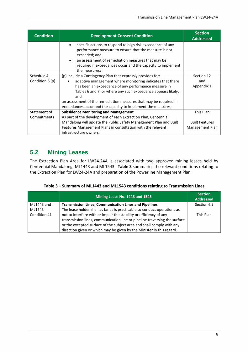
Transmission Line Management Plan LW24-24A
Condition Development Consent Condition Section Addressed
• specific actions to respond to high risk exceedance of any performance measure to ensure that the measure is not exceeded; and
• an assessment of remediation measures that may be required if exceedances occur and the capacity to implement the measures;
Schedule 4 Condition 6 (p)
(p) include a Contingency Plan that expressly provides for: • adaptive management where monitoring indicates that there
has been an exceedance of any performance measure in Tables 6 and 7, or where any such exceedance appears likely; and
an assessment of the remediation measures that may be required if exceedances occur and the capacity to implement the measures;
Section 12 and
Appendix 1
Statement of Commitments
Subsidence Monitoring and Management As part of the development of each Extraction Plan, Centennial Mandalong will update the Public Safety Management Plan and Built Features Management Plans in consultation with the relevant infrastructure owners.
This Plan
Built Features Management Plan
5.2 Mining Leases The Extraction Plan Area for LW24-24A is associated with two approved mining leases held by Centennial Mandalong; ML1443 and ML1543. Table 3 summaries the relevant conditions relating to the Extraction Plan for LW24-24A and preparation of the Powerline Management Plan.
Table 3 – Summary of ML1443 and ML1543 conditions relating to Transmission Lines
Mining Lease No. 1443 and 1543 Section Addressed
ML1443 and ML1543 Condition 41
Transmission Lines, Communication Lines and Pipelines The lease holder shall as far as is practicable so conduct operations as not to interfere with or impair the stability or efficiency of any transmission lines, communication line or pipeline traversing the surface or the excepted surface of the subject area and shall comply with any direction given or which may be given by the Minister in this regard.
Section 6.1
This Plan
8
Transmission Line Management Plan LW24-24A
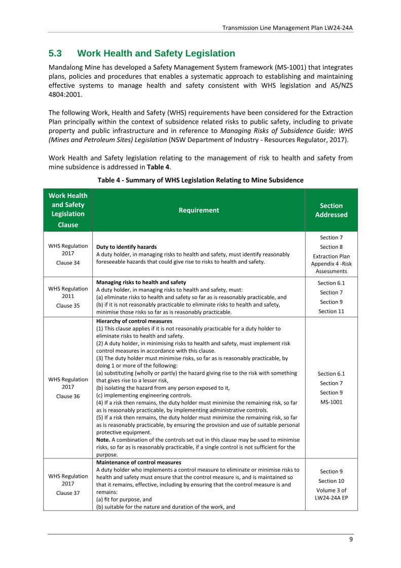
5.3 Work Health and Safety Legislation Mandalong Mine has developed a Safety Management System framework (MS-1001) that integrates plans, policies and procedures that enables a systematic approach to establishing and maintaining effective systems to manage health and safety consistent with WHS legislation and AS/NZS 4804:2001. The following Work, Health and Safety (WHS) requirements have been considered for the Extraction Plan principally within the context of subsidence related risks to public safety, including to private property and public infrastructure and in reference to Managing Risks of Subsidence Guide: WHS (Mines and Petroleum Sites) Legislation (NSW Department of Industry - Resources Regulator, 2017). Work Health and Safety legislation relating to the management of risk to health and safety from mine subsidence is addressed in Table 4.
Table 4 - Summary of WHS Legislation Relating to Mine Subsidence
Work Health and Safety Legislation
Clause
Requirement Section Addressed
WHS Regulation 2017
Clause 34
Duty to identify hazards A duty holder, in managing risks to health and safety, must identify reasonably foreseeable hazards that could give rise to risks to health and safety.
Section 7 Section 8
Extraction Plan Appendix 4 -Risk
Assessments
WHS Regulation 2011
Clause 35
Managing risks to health and safety A duty holder, in managing risks to health and safety, must: (a) eliminate risks to health and safety so far as is reasonably practicable, and (b) if it is not reasonably practicable to eliminate risks to health and safety, minimise those risks so far as is reasonably practicable.
Section 6.1 Section 7 Section 9
Section 11
WHS Regulation 2017
Clause 36
Hierarchy of control measures (1) This clause applies if it is not reasonably practicable for a duty holder to eliminate risks to health and safety. (2) A duty holder, in minimising risks to health and safety, must implement risk control measures in accordance with this clause. (3) The duty holder must minimise risks, so far as is reasonably practicable, by doing 1 or more of the following: (a) substituting (wholly or partly) the hazard giving rise to the risk with something that gives rise to a lesser risk, (b) isolating the hazard from any person exposed to it, (c) implementing engineering controls. (4) If a risk then remains, the duty holder must minimise the remaining risk, so far as is reasonably practicable, by implementing administrative controls. (5) If a risk then remains, the duty holder must minimise the remaining risk, so far as is reasonably practicable, by ensuring the provision and use of suitable personal protective equipment. Note. A combination of the controls set out in this clause may be used to minimise risks, so far as is reasonably practicable, if a single control is not sufficient for the purpose.
Section 6.1 Section 7 Section 9 MS-1001
WHS Regulation 2017
Clause 37
Maintenance of control measures A duty holder who implements a control measure to eliminate or minimise risks to health and safety must ensure that the control measure is, and is maintained so that it remains, effective, including by ensuring that the control measure is and remains: (a) fit for purpose, and (b) suitable for the nature and duration of the work, and
Section 9 Section 10
Volume 3 of LW24-24A EP
9
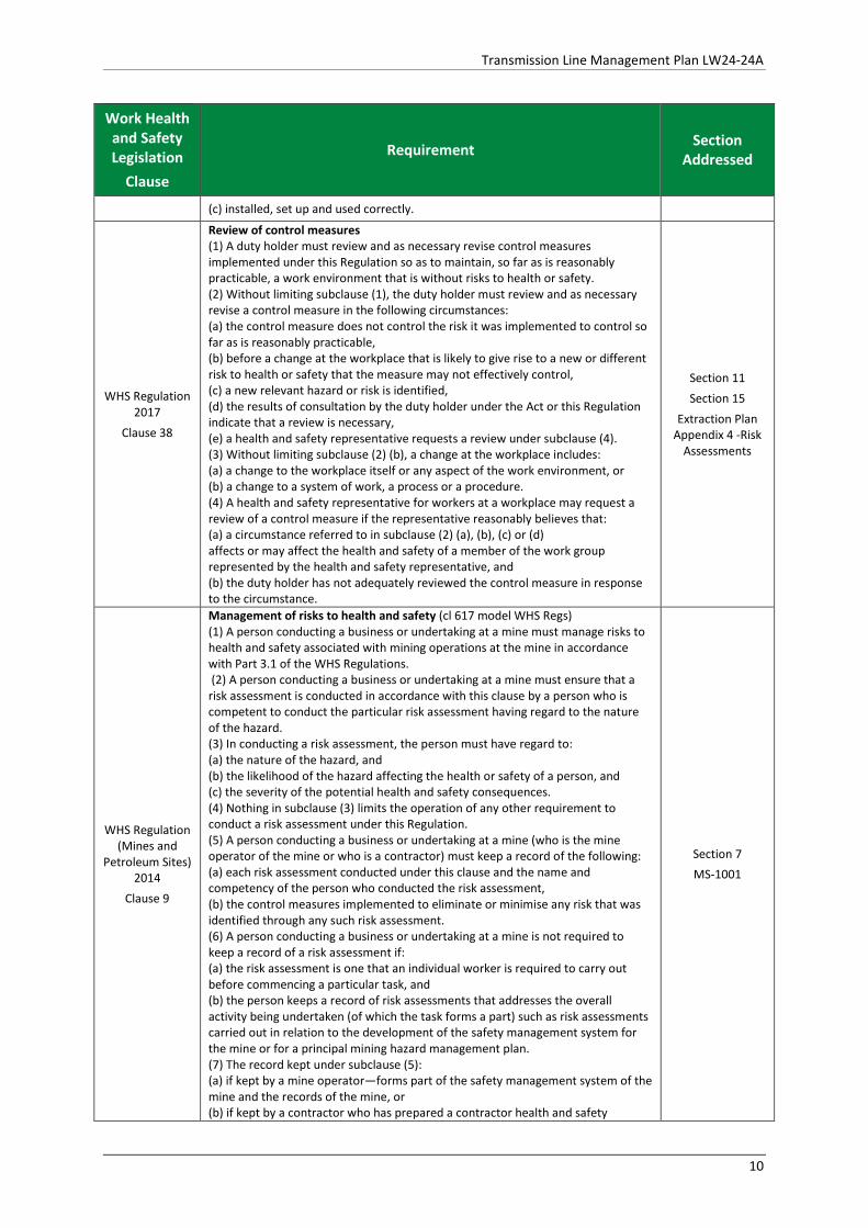
Transmission Line Management Plan LW24-24A
Work Health and Safety Legislation
Clause
Requirement Section Addressed
(c) installed, set up and used correctly.
WHS Regulation 2017
Clause 38
Review of control measures (1) A duty holder must review and as necessary revise control measures implemented under this Regulation so as to maintain, so far as is reasonably practicable, a work environment that is without risks to health or safety. (2) Without limiting subclause (1), the duty holder must review and as necessary revise a control measure in the following circumstances: (a) the control measure does not control the risk it was implemented to control so far as is reasonably practicable, (b) before a change at the workplace that is likely to give rise to a new or different risk to health or safety that the measure may not effectively control, (c) a new relevant hazard or risk is identified, (d) the results of consultation by the duty holder under the Act or this Regulation indicate that a review is necessary, (e) a health and safety representative requests a review under subclause (4). (3) Without limiting subclause (2) (b), a change at the workplace includes: (a) a change to the workplace itself or any aspect of the work environment, or (b) a change to a system of work, a process or a procedure. (4) A health and safety representative for workers at a workplace may request a review of a control measure if the representative reasonably believes that: (a) a circumstance referred to in subclause (2) (a), (b), (c) or (d) affects or may affect the health and safety of a member of the work group represented by the health and safety representative, and (b) the duty holder has not adequately reviewed the control measure in response to the circumstance.
Section 11 Section 15
Extraction Plan Appendix 4 -Risk
Assessments
WHS Regulation (Mines and
Petroleum Sites) 2014
Clause 9
Management of risks to health and safety (cl 617 model WHS Regs) (1) A person conducting a business or undertaking at a mine must manage risks to health and safety associated with mining operations at the mine in accordance with Part 3.1 of the WHS Regulations. (2) A person conducting a business or undertaking at a mine must ensure that a risk assessment is conducted in accordance with this clause by a person who is competent to conduct the particular risk assessment having regard to the nature of the hazard. (3) In conducting a risk assessment, the person must have regard to: (a) the nature of the hazard, and (b) the likelihood of the hazard affecting the health or safety of a person, and (c) the severity of the potential health and safety consequences. (4) Nothing in subclause (3) limits the operation of any other requirement to conduct a risk assessment under this Regulation. (5) A person conducting a business or undertaking at a mine (who is the mine operator of the mine or who is a contractor) must keep a record of the following: (a) each risk assessment conducted under this clause and the name and competency of the person who conducted the risk assessment, (b) the control measures implemented to eliminate or minimise any risk that was identified through any such risk assessment. (6) A person conducting a business or undertaking at a mine is not required to keep a record of a risk assessment if: (a) the risk assessment is one that an individual worker is required to carry out before commencing a particular task, and (b) the person keeps a record of risk assessments that addresses the overall activity being undertaken (of which the task forms a part) such as risk assessments carried out in relation to the development of the safety management system for the mine or for a principal mining hazard management plan. (7) The record kept under subclause (5): (a) if kept by a mine operator—forms part of the safety management system of the mine and the records of the mine, or (b) if kept by a contractor who has prepared a contractor health and safety
Section 7 MS-1001
10
Transmission Line Management Plan LW24-24A
Work Health and Safety Legislation
Clause
Requirement Section Addressed
management plan—forms part of the plan.
WHS Regulation (Mines and
Petroleum Sites) 2014
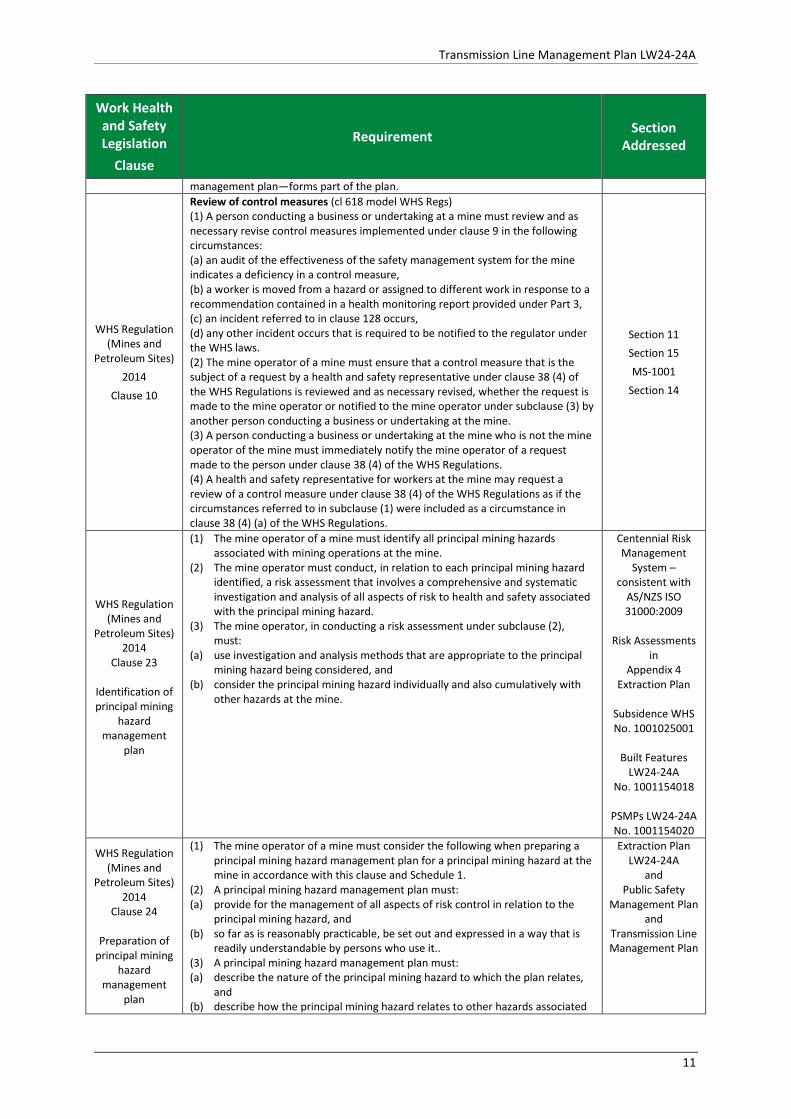
Clause 10
Review of control measures (cl 618 model WHS Regs) (1) A person conducting a business or undertaking at a mine must review and as necessary revise control measures implemented under clause 9 in the following circumstances: (a) an audit of the effectiveness of the safety management system for the mine indicates a deficiency in a control measure, (b) a worker is moved from a hazard or assigned to different work in response to a recommendation contained in a health monitoring report provided under Part 3, (c) an incident referred to in clause 128 occurs, (d) any other incident occurs that is required to be notified to the regulator under the WHS laws. (2) The mine operator of a mine must ensure that a control measure that is the subject of a request by a health and safety representative under clause 38 (4) of the WHS Regulations is reviewed and as necessary revised, whether the request is made to the mine operator or notified to the mine operator under subclause (3) by another person conducting a business or undertaking at the mine. (3) A person conducting a business or undertaking at the mine who is not the mine operator of the mine must immediately notify the mine operator of a request made to the person under clause 38 (4) of the WHS Regulations. (4) A health and safety representative for workers at the mine may request a review of a control measure under clause 38 (4) of the WHS Regulations as if the circumstances referred to in subclause (1) were included as a circumstance in clause 38 (4) (a) of the WHS Regulations.
Section 11 Section 15 MS-1001
Section 14
WHS Regulation (Mines and
Petroleum Sites) 2014
Clause 23
Identification of principal mining
hazard management
plan
(1) The mine operator of a mine must identify all principal mining hazards associated with mining operations at the mine.
(2) The mine operator must conduct, in relation to each principal mining hazard identified, a risk assessment that involves a comprehensive and systematic investigation and analysis of all aspects of risk to health and safety associated with the principal mining hazard.
(3) The mine operator, in conducting a risk assessment under subclause (2), must:
(a) use investigation and analysis methods that are appropriate to the principal mining hazard being considered, and
(b) consider the principal mining hazard individually and also cumulatively with other hazards at the mine.
Centennial Risk Management
System – consistent with
AS/NZS ISO 31000:2009
Risk Assessments
in Appendix 4
Extraction Plan
Subsidence WHS No. 1001025001
Built Features
LW24-24A No. 1001154018
PSMPs LW24-24A No. 1001154020
WHS Regulation (Mines and
Petroleum Sites) 2014
Clause 24
Preparation of principal mining
hazard management
plan
(1) The mine operator of a mine must consider the following when preparing a principal mining hazard management plan for a principal mining hazard at the mine in accordance with this clause and Schedule 1.
(2) A principal mining hazard management plan must: (a) provide for the management of all aspects of risk control in relation to the
principal mining hazard, and (b) so far as is reasonably practicable, be set out and expressed in a way that is
readily understandable by persons who use it.. (3) A principal mining hazard management plan must: (a) describe the nature of the principal mining hazard to which the plan relates,
and (b) describe how the principal mining hazard relates to other hazards associated
Extraction Plan LW24-24A
and Public Safety
Management Plan and
Transmission Line Management Plan
11
Transmission Line Management Plan LW24-24A
Work Health and Safety Legislation
Clause
Requirement Section Addressed
with mining operations at the mine, and (c) describe the analysis methods used in identifying the principal mining hazard
to which the plan relates, and (d) include a record of the most recent risk assessment conducted in relation to
the principal mining hazard, and (e) describe the investigation and analysis methods used in determining the
control measures to be implemented, and (f) describe all control measures to be implemented to manage risks to health
and safety associated with the principal mining hazard, and (g) describe the arrangements in place for providing the information, training and
instruction required by clause 39 of the WHS Regulations in relation to the principal mining hazard, and
(h) refer to any design principles, engineering standards and technical standards relied on for control measures for the principal mining hazard, and
(i) set out the reasons for adopting or rejecting each control measure considered.
(4) The mine operator of a mine must consider the following when preparing a principal mining hazard management plan for a principal mining hazard at the mine:
(a) the matters set out in Schedule 1 in respect of the principal mining hazard, and
(b) any other matter relevant to managing the risks associated with the principal mining hazard at the mine.
WHS Regulation (Mines and
Petroleum Sites) 2014
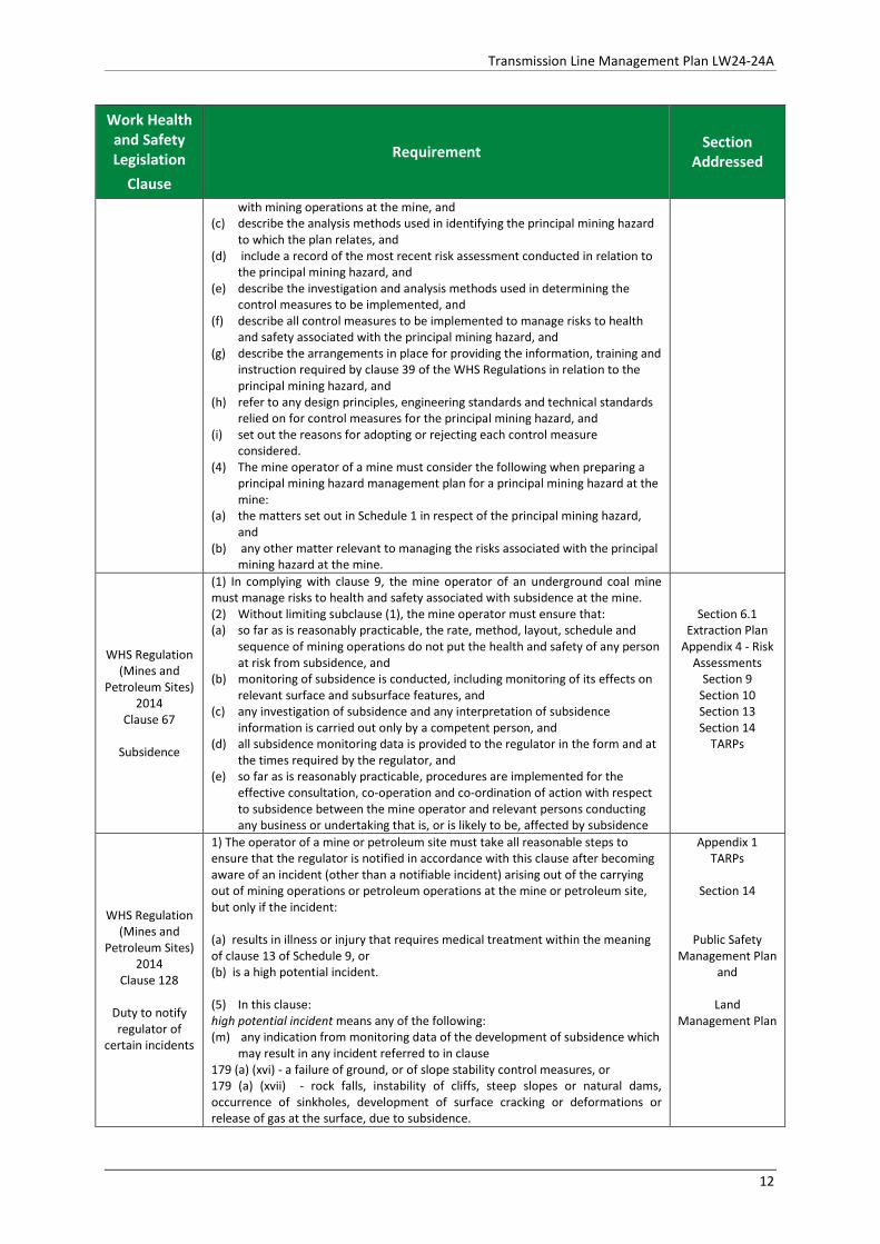
Clause 67
Subsidence
(1) In complying with clause 9, the mine operator of an underground coal mine must manage risks to health and safety associated with subsidence at the mine. (2) Without limiting subclause (1), the mine operator must ensure that: (a) so far as is reasonably practicable, the rate, method, layout, schedule and
sequence of mining operations do not put the health and safety of any person at risk from subsidence, and
(b) monitoring of subsidence is conducted, including monitoring of its effects on relevant surface and subsurface features, and
(c) any investigation of subsidence and any interpretation of subsidence information is carried out only by a competent person, and
(d) all subsidence monitoring data is provided to the regulator in the form and at the times required by the regulator, and
(e) so far as is reasonably practicable, procedures are implemented for the effective consultation, co-operation and co-ordination of action with respect to subsidence between the mine operator and relevant persons conducting any business or undertaking that is, or is likely to be, affected by subsidence
Section 6.1 Extraction Plan
Appendix 4 - Risk Assessments
Section 9 Section 10 Section 13 Section 14
TARPs
WHS Regulation (Mines and
Petroleum Sites) 2014
Clause 128
Duty to notify regulator of
certain incidents
1) The operator of a mine or petroleum site must take all reasonable steps to ensure that the regulator is notified in accordance with this clause after becoming aware of an incident (other than a notifiable incident) arising out of the carrying out of mining operations or petroleum operations at the mine or petroleum site, but only if the incident: (a) results in illness or injury that requires medical treatment within the meaning of clause 13 of Schedule 9, or (b) is a high potential incident. (5) In this clause: high potential incident means any of the following: (m) any indication from monitoring data of the development of subsidence which
may result in any incident referred to in clause 179 (a) (xvi) - a failure of ground, or of slope stability control measures, or 179 (a) (xvii) - rock falls, instability of cliffs, steep slopes or natural dams, occurrence of sinkholes, development of surface cracking or deformations or release of gas at the surface, due to subsidence.
Appendix 1 TARPs
Section 14
Public Safety Management Plan
and
Land Management Plan
12

Transmission Line Management Plan LW24-24A
Work Health and Safety Legislation
Clause
Requirement Section Addressed
WHS Regulation (Mines and
Petroleum Sites) 2014
Schedule 1 Subsidence Clause 3C
Principal hazard
management plans –
additional matters to be
considered
Subsidence The following matters must be considered in developing the control measures to manage the risks of subsidence: (a) the characteristics of all relevant surface and subsurface features, (b) the characteristics of all relevant geological, hydrogeological, hydrological, geotechnical, topographic and climatic conditions, including any conditions that may cause elevated or abnormal subsidence or the formation of sinkholes, (c) the characteristics of any previously excavated or abandoned workings that may interact with any proposed or existing mine workings, (d) the existence, distribution, geometry and stability of significant voids, standing pillars or remnants within any old pillar workings that may interact with any proposed or existing mine workings, (e) the predicted and actual nature, magnitude, distribution, timing and duration of subsidence, (f) the rate, method, layout, schedule and sequence of mining operations.
Extraction Plan - Appendix 1 (Seedsman
Geotechnics, 2015)
(Seedsman Geotechnics,
2017) Extraction Plan and Volume 3 (Component
Plans)
WHS Regulation (Mines and
Petroleum Sites) 2014
Schedule 3 Clause 16 High Risk Activities
Secondary extraction or pillar extraction, splitting or reduction (1) The following are identified as high risk activities: (a) secondary extraction by longwall mining, shortwall mining or miniwall mining, (b) pillar extraction, (c) pillar splitting, (d) pillar reduction. (2) The waiting period for any such activity is 3 months. (3) The information and documents that must be provided in relation to any such activity are as follows: (a) details of the authoritative sources used in determining that the proposed method of work can be done safely, (b) engineering plans showing the manner and sequence of extraction, endorsed by the individual nominated to exercise the statutory function of mining engineering manager at the mine, (c) information about the land above or in the vicinity of the proposed activity including land use and details of who owns or occupies any land that may be affected by subsidence, (d) in the case of a pillar extraction, details of the procedures for the recovery of buried and immobile mining plant in or around a goaf, (e) details of how the risks to the health and safety of workers and other persons from subsidence caused by the activity will be managed.
Extraction Plan LW24-24A
High Risk Activity Notification for
LW24-24A
13
Transmission Line Management Plan LW24-24A
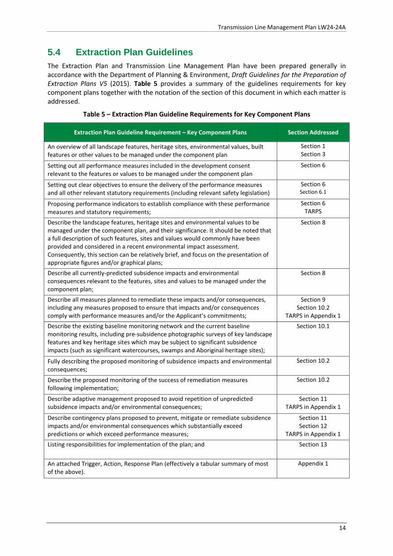
5.4 Extraction Plan Guidelines The Extraction Plan and Transmission Line Management Plan have been prepared generally in accordance with the Department of Planning & Environment, Draft Guidelines for the Preparation of Extraction Plans V5 (2015). Table 5 provides a summary of the guidelines requirements for key component plans together with the notation of the section of this document in which each matter is addressed.
Table 5 – Extraction Plan Guideline Requirements for Key Component Plans
Extraction Plan Guideline Requirement – Key Component Plans Section Addressed
An overview of all landscape features, heritage sites, environmental values, built features or other values to be managed under the component plan
Section 1 Section 3
Setting out all performance measures included in the development consent relevant to the features or values to be managed under the component plan
Section 6
Setting out clear objectives to ensure the delivery of the performance measures and all other relevant statutory requirements (including relevant safety legislation)
Section 6 Section 6.1
Proposing performance indicators to establish compliance with these performance measures and statutory requirements;
Section 6 TARPS
Describe the landscape features, heritage sites and environmental values to be managed under the component plan, and their significance. It should be noted that a full description of such features, sites and values would commonly have been provided and considered in a recent environmental impact assessment. Consequently, this section can be relatively brief, and focus on the presentation of appropriate figures and/or graphical plans;
Section 8
Describe all currently-predicted subsidence impacts and environmental consequences relevant to the features, sites and values to be managed under the component plan;
Section 8
Describe all measures planned to remediate these impacts and/or consequences, including any measures proposed to ensure that impacts and/or consequences comply with performance measures and/or the Applicant’s commitments;
Section 9 Section 10.2
TARPS in Appendix 1 Describe the existing baseline monitoring network and the current baseline monitoring results, including pre-subsidence photographic surveys of key landscape features and key heritage sites which may be subject to significant subsidence impacts (such as significant watercourses, swamps and Aboriginal heritage sites);
Section 10.1
Fully describing the proposed monitoring of subsidence impacts and environmental consequences;
Section 10.2
Describe the proposed monitoring of the success of remediation measures following implementation;
Section 10.2
Describe adaptive management proposed to avoid repetition of unpredicted subsidence impacts and/or environmental consequences;
Section 11 TARPS in Appendix 1
Describe contingency plans proposed to prevent, mitigate or remediate subsidence impacts and/or environmental consequences which substantially exceed predictions or which exceed performance measures;
Section 11 Section 12
TARPS in Appendix 1 Listing responsibilities for implementation of the plan; and Section 13
An attached Trigger, Action, Response Plan (effectively a tabular summary of most of the above).
Appendix 1
14
Transmission Line Management Plan LW24-24A
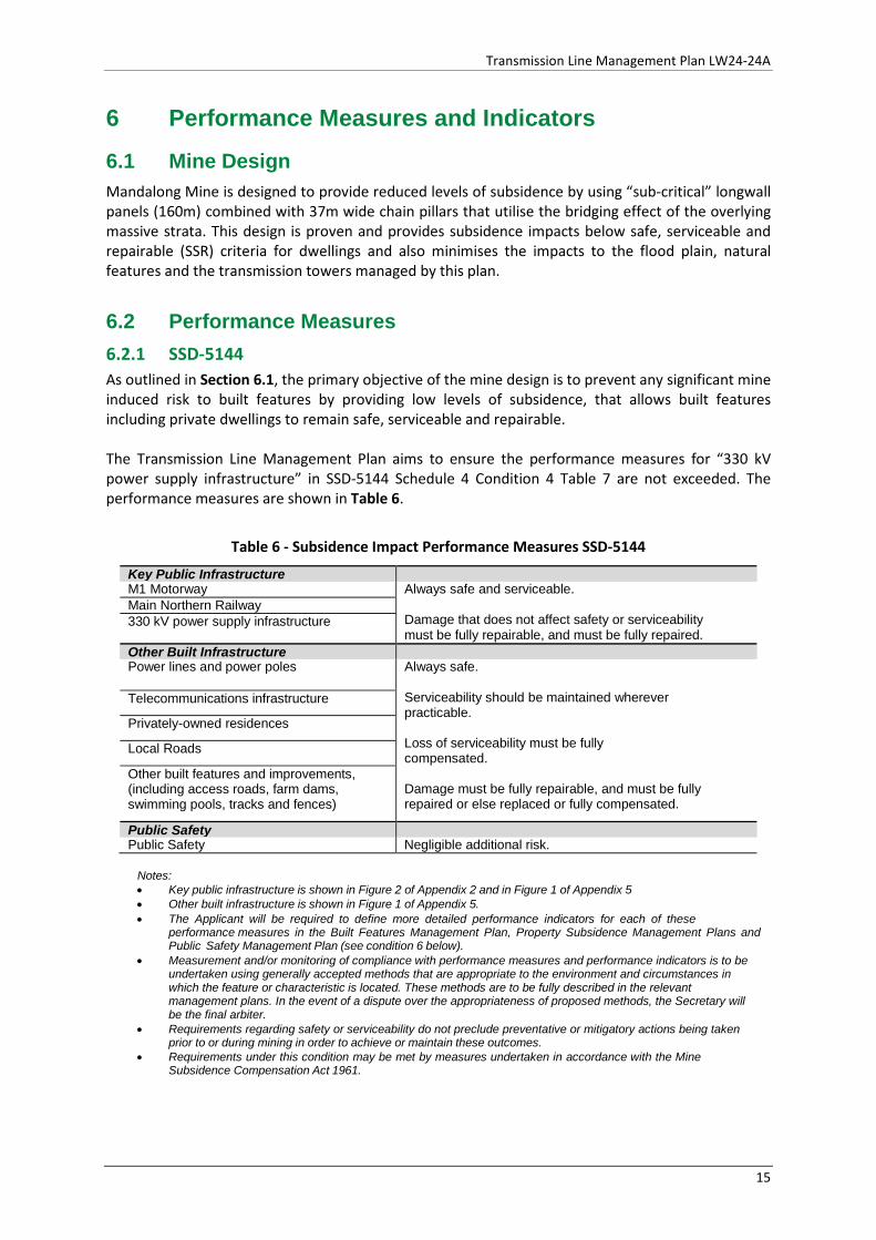
6 Performance Measures and Indicators 6.1 Mine Design Mandalong Mine is designed to provide reduced levels of subsidence by using “sub-critical” longwall panels (160m) combined with 37m wide chain pillars that utilise the bridging effect of the overlying massive strata. This design is proven and provides subsidence impacts below safe, serviceable and repairable (SSR) criteria for dwellings and also minimises the impacts to the flood plain, natural features and the transmission towers managed by this plan.
6.2 Performance Measures 6.2.1 SSD-5144 As outlined in Section 6.1, the primary objective of the mine design is to prevent any significant mine induced risk to built features by providing low levels of subsidence, that allows built features including private dwellings to remain safe, serviceable and repairable. The Transmission Line Management Plan aims to ensure the performance measures for “330 kV power supply infrastructure” in SSD-5144 Schedule 4 Condition 4 Table 7 are not exceeded. The performance measures are shown in Table 6.
Table 6 - Subsidence Impact Performance Measures SSD-5144
Key Public Infrastructure M1 Motorway Always safe and serviceable.
Damage that does not affect safety or serviceability must be fully repairable, and must be fully repaired.
Main Northern Railway 330 kV power supply infrastructure
Other Built Infrastructure Power lines and power poles Always safe.
Serviceability should be maintained wherever practicable.
Loss of serviceability must be fully compensated.
Damage must be fully repairable, and must be fully repaired or else replaced or fully compensated.
Telecommunications infrastructure
Privately-owned residences
Local Roads
Other built features and improvements, (including access roads, farm dams, swimming pools, tracks and fences)
Public Safety Public Safety Negligible additional risk.
Notes: • Key public infrastructure is shown in Figure 2 of Appendix 2 and in Figure 1 of Appendix 5 • Other built infrastructure is shown in Figure 1 of Appendix 5. • The Applicant will be required to define more detailed performance indicators for each of these
performance measures in the Built Features Management Plan, Property Subsidence Management Plans and Public Safety Management Plan (see condition 6 below).
• Measurement and/or monitoring of compliance with performance measures and performance indicators is to be undertaken using generally accepted methods that are appropriate to the environment and circumstances in which the feature or characteristic is located. These methods are to be fully described in the relevant management plans. In the event of a dispute over the appropriateness of proposed methods, the Secretary will be the final arbiter.
• Requirements regarding safety or serviceability do not preclude preventative or mitigatory actions being taken prior to or during mining in order to achieve or maintain these outcomes.
• Requirements under this condition may be met by measures undertaken in accordance with the Mine Subsidence Compensation Act 1961.
15
Transmission Line Management Plan LW24-24A
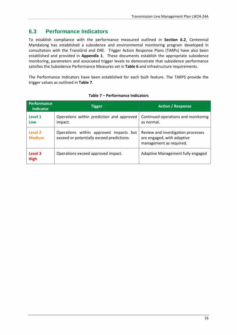
6.3 Performance Indicators To establish compliance with the performance measured outlined in Section 6.2, Centennial Mandalong has established a subsidence and environmental monitoring program developed in consultation with the TransGrid and DRE. Trigger Action Response Plans (TARPs) have also been established and provided in Appendix 1. These documents establish the appropriate subsidence monitoring, parameters and associated trigger levels to demonstrate that subsidence performance satisfies the Subsidence Performance Measures set in Table 6 and infrastructure requirements. The Performance Indicators have been established for each built feature. The TARPS provide the trigger values as outlined in Table 7.
Table 7 – Performance Indicators
Performance Indicator Tigger Action / Response
Level 1 Low
Operations within prediction and approved impact.
Continued operations and monitoring as normal.
Level 2 Medium
Operations within approved impacts but exceed or potentially exceed predictions.
Review and investigation processes are engaged, with adaptive management as required.
Level 3 High
Operations exceed approved impact. Adaptive Management fully engaged
16
Transmission Line Management Plan LW24-24A
7 Risk Management Centennial Mandalong has adopted the Stature Risk Assessment Program which was developed to ensure consistency in all risk assessments across the Centennial Coal operations. The Stature Risk Assessment Program sets out a consequences table and risk ranking matrix for managing identified risks consistent with AS/NZS ISO 31000:2009. All operational processes undertaken at the Centennial Mandalong operations are subject to the risk assessment process prior to implementation. The process for risk and change management is undertaken according to the methodology and tools contained within HSMS-SE-1024-Risk Management Arrangements and HSMS-SE-1082- Change Management System. Centennial Mandalong completed a WRAC Risk Assessment (No. 1001154018) for Built Features affected by subsidence from the secondary extraction of LW24-24A, including TransGrid 330kV transmission lines. A full copy of the risk assessment is included within the Extraction Plan LW24-24A Appendix 4.
7.1 Identified Risks Mandalong Mine has well established Infrastructure Management Plans, which have been developed and refined since the commencement of longwall mining in 2005. Potential hazards to public safety and the TransGrid power supply network from the impact of mine subsidence can include:
• Potential for increased or decreased tensions in various spans which could cause tower or conductor failure due to tilting or horizontal movement of towers;
• Potential for buckling of the tower or induced stresses in the tower members lessening the tower’s ability to carry the normal transmission line loads due to differential movement of tower legs;
• Potential reduction of clearance between line conductors and tower which could place line at risk of tripping under extreme conditions due to tilting; and
• Potential interruption of service to customers.
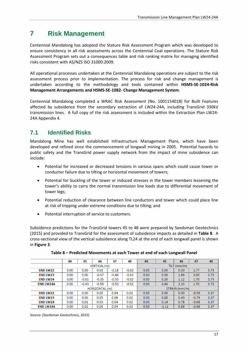
Subsidence predictions for the TransGrid towers 45 to 48 were prepared by Seedsman Geotechnics (2015) and provided to TransGrid for the assessment of subsidence impacts as detailed in Table 8. A cross-sectional view of the vertical subsidence along TL24 at the end of each longwall panel is shown in Figure 3.
Table 8 – Predicted Movements at each Tower at end of each Longwall Panel
Source: (Seedsman Geotechnics, 2015)
17
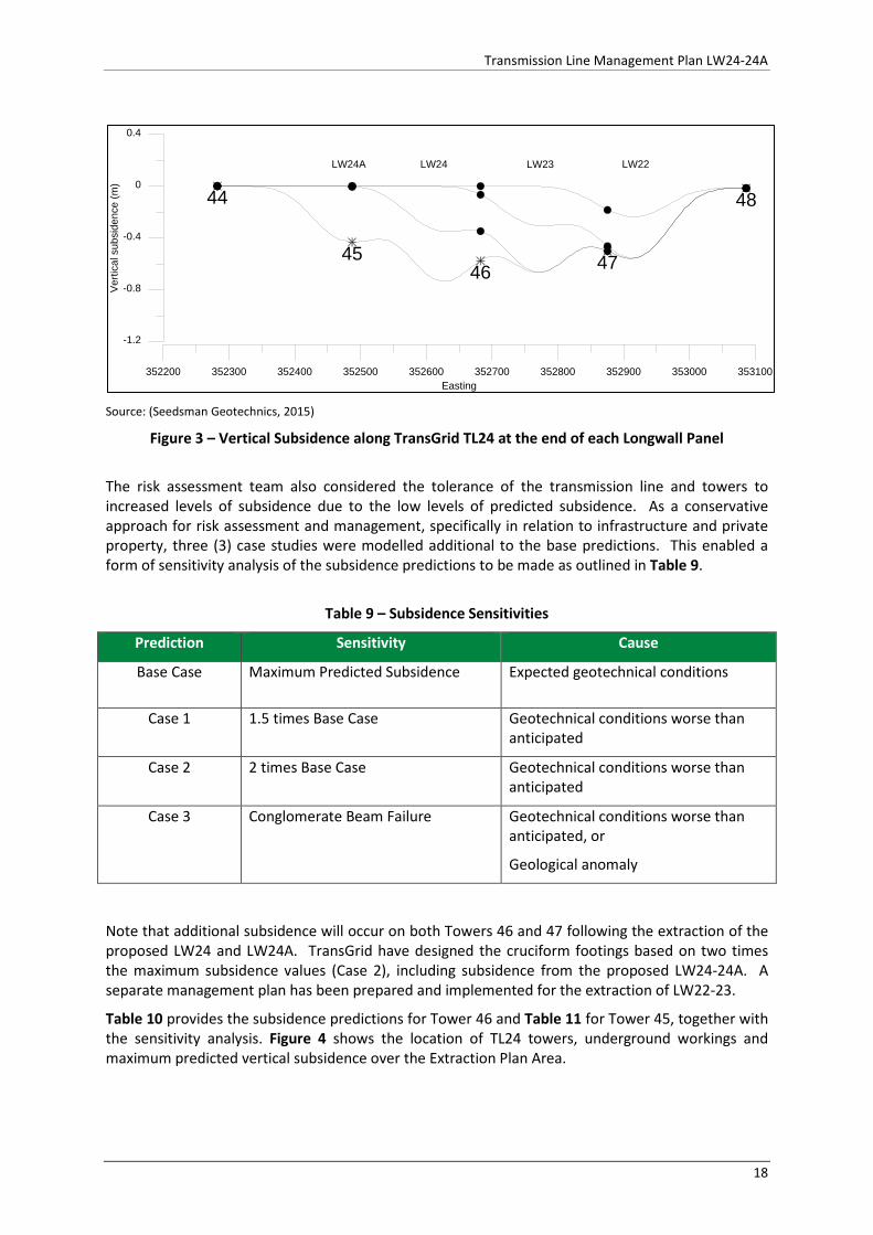
Transmission Line Management Plan LW24-24A
Source: (Seedsman Geotechnics, 2015)
Figure 3 – Vertical Subsidence along TransGrid TL24 at the end of each Longwall Panel
The risk assessment team also considered the tolerance of the transmission line and towers to increased levels of subsidence due to the low levels of predicted subsidence. As a conservative approach for risk assessment and management, specifically in relation to infrastructure and private property, three (3) case studies were modelled additional to the base predictions. This enabled a form of sensitivity analysis of the subsidence predictions to be made as outlined in Table 9.
Table 9 – Subsidence Sensitivities
Prediction Sensitivity Cause
Base Case Maximum Predicted Subsidence Expected geotechnical conditions
Case 1 1.5 times Base Case Geotechnical conditions worse than anticipated
Case 2 2 times Base Case Geotechnical conditions worse than anticipated
Case 3 Conglomerate Beam Failure Geotechnical conditions worse than anticipated, or
Geological anomaly
Note that additional subsidence will occur on both Towers 46 and 47 following the extraction of the proposed LW24 and LW24A. TransGrid have designed the cruciform footings based on two times the maximum subsidence values (Case 2), including subsidence from the proposed LW24-24A. A separate management plan has been prepared and implemented for the extraction of LW22-23.
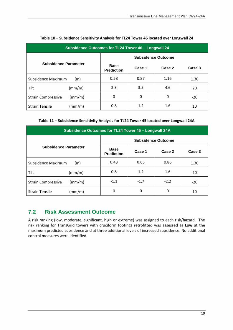
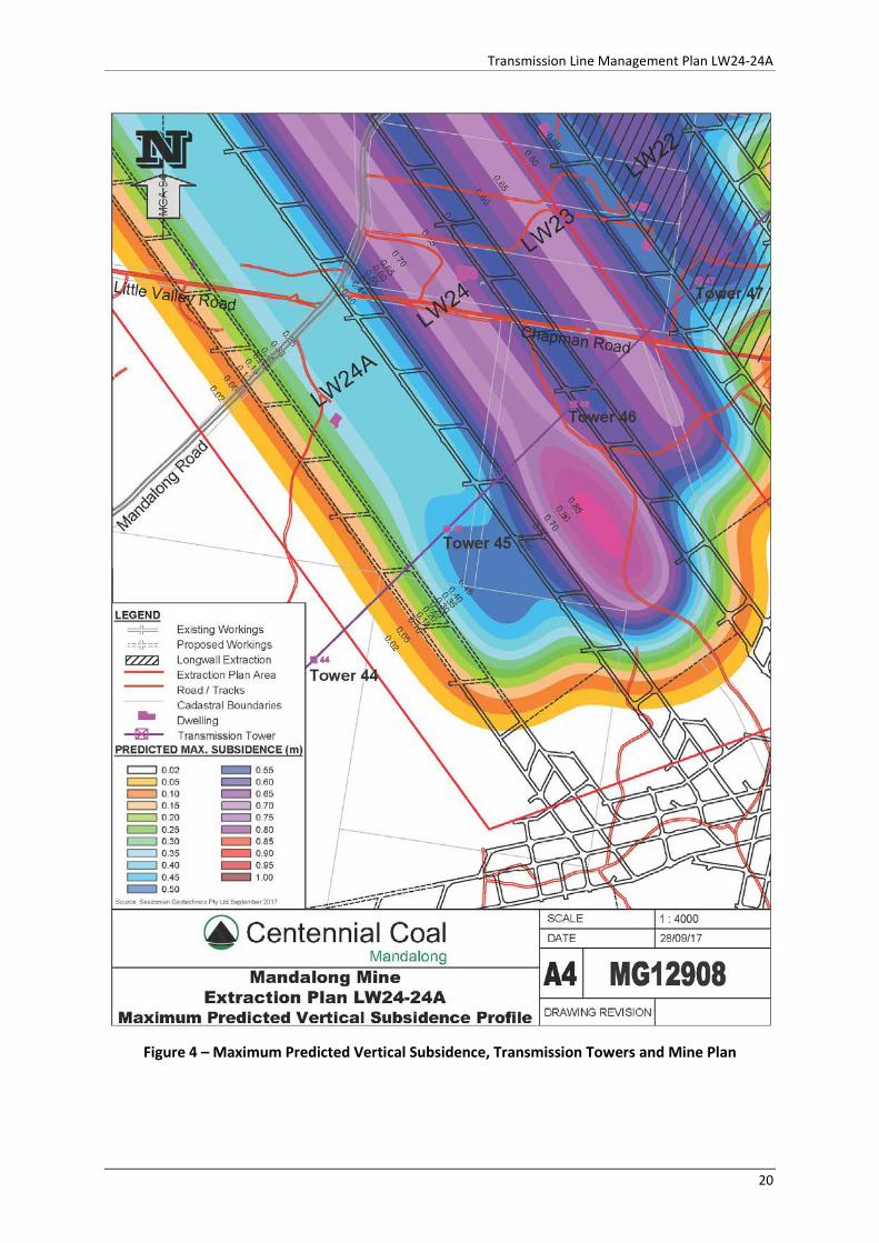
Table 10 provides the subsidence predictions for Tower 46 and Table 11 for Tower 45, together with the sensitivity analysis. Figure 4 shows the location of TL24 towers, underground workings and maximum predicted vertical subsidence over the Extraction Plan Area.
352200 352300 352400 352500 352600 352700 352800 352900 353000 353100Easting
45
44 48
4746
-1.2
-0.8
-0.4
0
0.4
Verti
cal s
ubsi
denc
e (m
)
LW24A LW24 LW23 LW22
18
Transmission Line Management Plan LW24-24A
Table 10 – Subsidence Sensitivity Analysis for TL24 Tower 46 located over Longwall 24
Subsidence Outcomes for TL24 Tower 46 – Longwall 24
Subsidence Parameter Subsidence Outcome
Base Prediction Case 1 Case 2 Case 3
Subsidence Maximum (m) 0.58 0.87 1.16 1.30
Tilt (mm/m) 2.3 3.5 4.6 20
Strain Compressive (mm/m) 0 0 0 -20
Strain Tensile (mm/m) 0.8 1.2 1.6 10
Table 11 – Subsidence Sensitivity Analysis for TL24 Tower 45 located over Longwall 24A
Subsidence Outcomes for TL24 Tower 45 – Longwall 24A
Subsidence Parameter Subsidence Outcome
Base Prediction Case 1 Case 2 Case 3
Subsidence Maximum (m) 0.43 0.65 0.86 1.30
Tilt (mm/m) 0.8 1.2 1.6 20
Strain Compressive (mm/m) -1.1 -1.7 -2.2 -20
Strain Tensile (mm/m) 0 0 0 10
7.2 Risk Assessment Outcome A risk ranking (low, moderate, significant, high or extreme) was assigned to each risk/hazard. The risk ranking for TransGrid towers with cruciform footings retrofitted was assessed as Low at the maximum predicted subsidence and at three additional levels of increased subsidence. No additional control measures were identified.
19
Transmission Line Management Plan LW24-24A
Figure 4 – Maximum Predicted Vertical Subsidence, Transmission Towers and Mine Plan
20
Transmission Line Management Plan LW24-24A
8 Transmission Towers and Predicted Impacts 8.1 Towers 45 and 46 TransGrid is responsible for the care and maintenance of the 330kV and high voltage power supply network within Mandalong. The Transmission Line Management Plan TransGrid Towers TL24/45-46 (MEMS-EP-9000-TLMP-9053) has been prepared for LW24-24A Extraction Plan and developed in consultation with TransGrid, based on the Seedsman Geotechnics (2015) subsidence predictions as detailed in Table 8. The 2015 predictions are consistent with the updated subsidence predictions provided by Seedsman Geotechnics for the Extraction Plan LW24-24A (Centennial Mandalong LW24 and LW24A Subsidence Predictions and Impacts - MAND17-08, 2017).
8.1.1 Predicted Impacts Subsidence impact to TL24 Towers 45, 46 and 47 from mining Longwalls 22 to 24A are mitigated by the retro fitting of concrete cruciform footings. The cruciform footings have been engineered and designed by TransGrid to allow the towers to remain always safe and serviceable and be repairable as specified in SSD-5144 subsidence performance measures as shown in Table 6.
9 Management Measures The management strategy is the retro-fitting of concrete cruciform footings on TL24 Towers 45, 46 and 47 prior to mining beneath the towers. The cruciform footings have been designed and engineered by TransGrid to minimise the impacts of subsidence on the towers, allowing the transmission line and towers to remain safe and always serviceable as required the performance measures detailed in Table 6 - Subsidence Impact Performance Measures SSD-5144 . Subsidence monitoring and visual inspections will be conducted at the towers before, during and after the completion of mining as detailed in Section 10.2.
21
Transmission Line Management Plan LW24-24A
10 Monitoring Program The Mandalong Mine Subsidence Monitoring Program consists of conventional subsidence monitoring, visual inspections and aerial LIDAR surveys, developed in order to:
• Demonstrate mine development and extraction is undertaken as per approved designs;
• Provide information to demonstrate statutory compliance and obligations are satisfied;
• Targeted monitoring of sensitive surface and built features;
• Meet stakeholder monitoring requirements to minimise impact to infrastructure;
• Provide data to manage the risks associated with both conventional and non-conventional subsidence.
• Provide appropriate and timely subsidence information to assess against triggers established in the TARPs, including data for trend analysis to inform adaptive management;
• To provide data for future monitoring systems for ongoing mining within Mandalong mining leases.
The Subsidence Monitoring Program is scheduled in the Centennial Compliance Database. The compliance database allows for surveys, inspections and notifications to be scheduled on either time or productions schedule (longwall face position). The required actions are assigned to the relevant role to ensure the subsidence monitoring program is achieved.
10.1 Baseline Monitoring 10.1.1 Detail Aerial Mapping An aerial LIDAR survey was undertaken in December 2015, providing the pre-mining landform for the Extraction Plan area and post mining landform for Longwalls 1 to 17. The LIDAR surveys provide surface mapping with a vertical accuracy of 0.15m. Aerial LIDAR surveys of the whole mining area are conducted approximately every three years.
10.1.2 Conventional Subsidence Monitoring Centennial Mandalong has a well-established conventional subsidence line monitoring program, with currently over 66km of crosslines and centrelines established over the whole mining area beyond LW24A. The monitoring lines typically consist of buried star pickets with cast iron covers, nominally spaced at 10m intervals. Within the Extraction Plan area, crosslines have been established and included
• Crossline 8 (Mandalong Rd easement); • Crossline 19 (Tobins Rd pavement); and • Morans Creek
The monitoring point spacing, survey methods and scheduled visual inspections allow for the detection of both conventional and non-conventional subsidence movements due to any potential changes in geological conditions and mining within steep slope areas within the Extraction Plan Area. Subsidence monitoring on TL24 Tower 47, located over LW23 has shown that measured subsidence values have been well within the predicted values.
22
Transmission Line Management Plan LW24-24A
10.2 Subsidence Monitoring 10.2.1 Subsidence Monitoring Zones Mandalong Mine has developed three subsidence monitoring zones to accommodate the development of subsidence from the narrow longwall panels and the bridging effect of the overlying massive strata that provides the reduced levels of subsidence. Unique to Mandalong Mine and as a result of the bridging massive strata, subsidence develops later than in typical longwall operations, with the majority of subsidence realised after the longwall face has retreated approximately 500m. Additional subsidence also develops over the longwall panel following the extraction of the next adjacent longwall panel. This is due to the compression of the intervening chain pillar and strata. The additional subsidence contributed is typically in the order of 0.15m to 0.30m and is dependent on the geotechnical conditions and the depth of cover. Tilts and strains typically remain relatively unchanged and may be reduced as a result of the decreased vertical subsidence differential between the maingate chain pillar and the centre of the longwall panel. In areas with higher depth of cover over 300m some additional minor settlement may occur following the extraction of the adjacent two to three longwall panels. Accordingly, with 21 longwall panels now completed, Mandalong has developed three subsidence monitoring zones which define required monitoring activities in actively subsiding and stable areas of the mine as follows below. Full details of proposed monitoring activities within each zone are described within the Subsidence Monitoring Program for each Extraction Plan progressively approved by the mine. 10.2.1.1 Active Subsidence Zone for Visual Monitoring The “Active Subsidence Zone” for visual monitoring inspections is defined as:
• 100m in advance of the current longwall face position; and • the following 500m of longwall extraction (i.e. 500m behind the face position).
10.2.1.2 Active Longwall Zone for Crossline Monitoring The “Active Longwall Subsidence Zone” includes the nominated crosslines for the current longwall panel and the three previous longwall panels. 10.2.1.3 Stable Longwall Subsidence Zone for Crossline Monitoring The “Stable Longwall Subsidence Zone” represents the stable non-subsiding areas beyond the three previous longwall panels, defined as being from the start of the nominated crosslines up to the Active Longwall Subsidence Zone.
10.2.2 Monitoring Setup for Tower 45 and 46 Monitoring is to include:
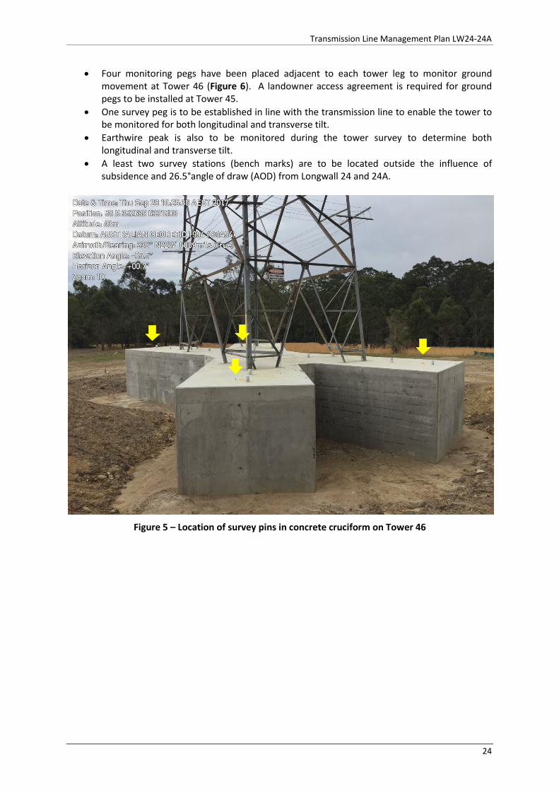
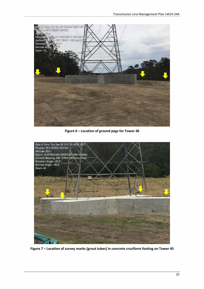
• A survey mark has been placed at each end of the concrete footing (four points). Measurements will be recorded to determine level, tilt and strain. Figure 5 shows location steel pins at Tower 46. A landowner access agreement to enter private property is required to access Tower 45 site and is being pursued by Centennial Mandalong. Alternate monitoring has been established, with drill hole marks placed in four grout tubes within the cruciform footing as shown in Figure 7 (painted blue). Measurements will be made from the adjacent Centennial property.
• The strain measurements are to be measured between each adjacent leg (within the footing).
23
Transmission Line Management Plan LW24-24A
• Four monitoring pegs have been placed adjacent to each tower leg to monitor ground movement at Tower 46 (Figure 6). A landowner access agreement is required for ground pegs to be installed at Tower 45.
• One survey peg is to be established in line with the transmission line to enable the tower to be monitored for both longitudinal and transverse tilt.
• Earthwire peak is also to be monitored during the tower survey to determine both longitudinal and transverse tilt.
• A least two survey stations (bench marks) are to be located outside the influence of subsidence and 26.5°angle of draw (AOD) from Longwall 24 and 24A.
Figure 5 – Location of survey pins in concrete cruciform on Tower 46
24
Transmission Line Management Plan LW24-24A
Figure 6 – Location of ground pegs for Tower 46
Figure 7 – Location of survey marks (grout tubes) in concrete cruciform footing on Tower 45
25
Transmission Line Management Plan LW24-24A
10.2.2.1 Monitoring Schedule Tower 46 Monitoring of Tower 46 (Longwall 24) will be undertaken using conventional surveys. These surveys will consist of:
• Installation of monitoring has been completed; • Initial survey at Longwall 24 AOD chainage 570m • Resurvey at Longwall 24 chainages 300, 200, 0m and one month after longwall completion
or after no further changes in monitoring data; • Resurvey at Longwall 24A chainage 100m and 0m; and • Additional surveys as requested by TransGrid or required by TARP.
10.2.2.2 Monitoring Schedule Tower 45 Monitoring of Tower 45 (Longwall 24A) will be undertaken using conventional surveys. These surveys will consist of:
• Installation of monitoring prior to Longwall 24A chainage 450m (AOD); • Initial survey at Longwall 24A AOD chainage 450m • Resurvey at Longwall 24A chainages 100, 0m and one month after longwall completion or
after no further changes in monitoring data; • Additional surveys as requested by TransGrid or required by TARP.
Table 12 provides the monitoring program summary for Towers 45 and 46.
10.2.3 Survey Standards All surveys are to be carried out in accordance with the LW24-24A Subsidence Monitoring Program.
Standard 1 – EDM differential levelling and strain measurement
• EDM differential levelling will be conducted with reference to the quality as defined in SP1 of 6mm * √k (km)
• EDM strain measurements will be conducted with reference to the quality as defined in SP1, relative uncertainty target accuracy + 2mm per strain bay distance.
• Survey equipment specification - 1” total station theodolite, distance measurement + 2mm + 2 ppm.
Standard 2 – Digital Level differential levelling and strain measurement
• Digital Level differential levelling will be conducted with reference to the quality as defined in SP1 of 6mm * √k (km)
• Strain measurements by standardised steel band. Target accuracy + 2mm per strain bay distance.
26
Transmission Line Management Plan LW24-24A
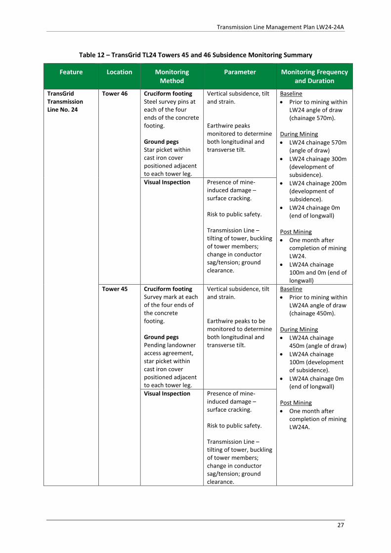
Table 12 – TransGrid TL24 Towers 45 and 46 Subsidence Monitoring Summary
Feature Location Monitoring Method
Parameter Monitoring Frequency and Duration
TransGrid Transmission Line No. 24
Tower 46
Cruciform footing Steel survey pins at each of the four ends of the concrete footing. Ground pegs Star picket within cast iron cover positioned adjacent to each tower leg.
Vertical subsidence, tilt and strain. Earthwire peaks monitored to determine both longitudinal and transverse tilt.
Baseline • Prior to mining within
LW24 angle of draw (chainage 570m).
During Mining • LW24 chainage 570m
(angle of draw) • LW24 chainage 300m
(development of subsidence).
• LW24 chainage 200m (development of subsidence).
• LW24 chainage 0m (end of longwall)
Post Mining • One month after
completion of mining LW24.
• LW24A chainage 100m and 0m (end of longwall)
Visual Inspection
Presence of mine-induced damage – surface cracking. Risk to public safety. Transmission Line –tilting of tower, buckling of tower members; change in conductor sag/tension; ground clearance.
Tower 45 Cruciform footing Survey mark at each of the four ends of the concrete footing. Ground pegs Pending landowner access agreement, star picket within cast iron cover positioned adjacent to each tower leg.
Vertical subsidence, tilt and strain. Earthwire peaks to be monitored to determine both longitudinal and transverse tilt.
Baseline • Prior to mining within
LW24A angle of draw (chainage 450m).
During Mining • LW24A chainage
450m (angle of draw) • LW24A chainage
100m (development of subsidence).
• LW24A chainage 0m (end of longwall)
Post Mining • One month after
completion of mining LW24A.
Visual Inspection
Presence of mine-induced damage – surface cracking. Risk to public safety. Transmission Line –tilting of tower, buckling of tower members; change in conductor sag/tension; ground clearance.
27
Transmission Line Management Plan LW24-24A
11 Adaptive Management In addition to the conservative narrow longwall panel design specifically to provide reduced levels of subsidence and impact, Centennial Mandalong developed an adaptive management approach designed to avoid repetition of any unpredicted subsidence and or environmental consequences. This system involves the monitoring and evaluation of impacts to the transmission line against the performance indicators defined in Section 6.3 and contingency plan (TARP) in the event that a performance indicator is exceeded.
11.1 Measures to be Implemented to Remediate Impacts Concrete cruciform footings have been established on the Transmission Line No. 24 Towers 45, 46 and 47 to manage the impact of subsidence. Sheaves have also been installed on the earthwires and optical fibre cables.
12 Contingency Plans Trigger Action Response Plans (TARP) have been developed using performance indicators for the TransGrid 330kV transmission line towers. In the event that subsidence monitoring and or visual inspections identify that a performance indicator has been exceeded, Centennial Mandalong will implement the contingency measures as detailed in the TARP in Appendix 1.
28
Transmission Line Management Plan LW24-24A
13 Roles and Responsibilities The responsibility for implementation, monitoring and review of the Transmission Line Management Plan lies with the Mining Approvals Coordinator. The roles and responsibilities for the Transmission Line Management Plan are outline in Table 13.
Table 13 – Roles and Responsibilities
Position Responsibility
Mine Manager • Authorisation of the Transmission Line Management Plan • Ensuring that sufficient resources are available to implement this plan.
Mining Approvals Coordinator
Implementation, monitoring and review of this plan, including: • Ensure that the Subsidence Monitoring Program, required inspections,
mining notifications are scheduled into the Centennial Compliance Database prior to the commencement of each longwall panel.
• Ensuring subsidence monitoring and inspections are conducted at the required schedule and persons conducting monitoring/inspections are trained in the requirements of this plan.
• Consulting with the landowners, infrastructure owners and relevant government departments including TransGrid, DPE, DRE, DRG and SA NSW.
• Review and assess the subsidence monitoring results against the performance measures.
• Notification of any exceedance of performance indicators in accordance with the TARPs and management plan.
• Coordinating any remedial work as required. • Preparation and submission of formal reporting requirements outlined
in this plan. • Review and audit of the Transmission Line Management Plan.
Subsidence Surveyor
• Establishment of subsidence monitoring in accordance with the Subsidence Monitoring Program.
• Ensure all subsidence surveys are conducted in accordance with the approved Subsidence Monitoring Program.
• Review and assess subsidence monitoring results. • Notify the Mining Approvals Coordinator of any identified public safety
issues. • Provide the monitoring results to the Mining Approvals Coordinator,
DRE, TransGrid, SA NSW and Seedsman Geotechnics.
Survey Department
• When required, conduct inspections within the applicable subsidence zone to the standard required, using the subsidence inspection checklist.
• Promptly notify the Mining Approvals Coordinator of any issue identified during a subsidence inspection.
29
Transmission Line Management Plan LW24-24A
14 Reporting Reporting will be completed in accordance with the Guidelines for the Preparation of Extraction Plans (NSW Department of Planning & Environment, 2015), as summarised in Table 14.
Table 14 - Reporting Requirements
Report Trigger Requirements Stakeholders
Six Monthly Report
Every six months during mining of LW24 to 24A.
• Summary of all impacts; • Any revisions to the TARP; • Assessment of compliance with
performance measures and indicators; and
• Summary of environmental monitoring results.
DRE
DRG
DPE
TransGrid
Seedsman Geotechnics
SA NSW
CCC
Incident Reporting
Any occasion or incident in accordance with consent condition, WHS Regulations or TARP.
In accordance with requirements of: • Development Consent Schedule 6
Condition 10; or • WHS Regulation (Mines and
Petroleum Sites) Clause 128; or • TARP.
Bi-Monthly Subsidence Impact Reporting
If a new impact is identified, compile after monthly subsidence.
Distinguish impact: • within predictions; • those which exceed predictions but
remain within performance measures and/or performance indicators; and
• those which exceed performance measures and/or performance indicators.
Report to include: • full description; • location identification using aerial
photos with longwall layout superimposed;
• photos of the impact; and • preliminary characterisation of the
impact in accordance with the relevant TARP(s).
Annual Review
Annual Report required under development consent SSD-5144.
Report to include: • six-monthly reports of impacts and
environmental monitoring results; • monitoring results; and • summary of subsidence impacts.
DRE
DRG
DPE
CCC Community Consultative Committee (CCC)
CCC meetings are typically held three times per year.
Subsidence and environmental performance is included as an agenda item at each meeting.
CCC
Mining Notifications
One month prior to mining beneath Transmission towers 45 and 46.
Scheduled date that the transmission towers will be affected by subsidence and within the Active Subsidence Zone.
TransGrid
Landowner
30
Transmission Line Management Plan LW24-24A
15 Audit and Review Audit and review procedures are outlined in Centennial Mandalong’s Safety Management System that comply with the NSW Work Health and Safety (Mines and Petroleum Sites) Regulations. These procedures are utilised to manage audit and review functions of the Built Features Management Plan. Refer Document HSMS-SE-1028- System Evaluation.
15.1 Audit The requirements of the TransGrid Management Plan are to be audited annually for compliance and effectiveness during the extraction of LW24-24A. Any non-conformances or deficiencies found during the audit are to be brought to the attention of the System Coordinator so that corrective actions can be outlined. These corrective actions are to be allocated and carried out accordance with HSMS-SE-1029 - Corrective Action Procedure.
15.2 Review The Transmission Line Management Plan will be reviewed every three years or in the event that one of the following occurs:
• Stakeholders raise issues that necessitates a review;
• Where unpredicted impacts or consequences have required implementation of contingency actions under this plan;
• Monitoring, incident or audit processes demonstrate a review is required;
• Where triggered by a TARP;
• With each new Extraction Plan;
• Where triggered by circumstances in either Clause 10 or Clause 128 of WHS (Mines and Petroleum Sites) Regulation or Clause 38 WHS Regulation; and
• Change in mine design or layout.
16 Document Control An integrated Document Control Procedure is incorporated into Centennial Mandalong’s Safety Management System. Documents, data and records pertaining to this plan will be managed according to HSMS-SE-1025-Information Control.
31
Transmission Line Management Plan LW24-24A
17 References NSW Department of Industry - Resources Regulator. (2017). Managing Risk of Subsidence, Guide:
WHS(Mines and Petroleum Sites) Legislation.
NSW Department of Planning & Environment. (2015). Draft Guidelines for the Preparation of Extraction Plans V5.
Seedsman Geotechnics. (2015). Subsidence Prediction and Visualisation from LW18 to LW24A - MAND15-04 November 2015.
Seedsman Geotechnics. (2017). Centennial Mandalong LW24 and LW24A Subsidence Predictions and Impacts - MAND17-08.
TransGrid. (2016). Report – Scoping Study into Mine Subsidence Mitigation (Structures 45-48 of TL24).
33

Transmission Line Management Plan LW24-24A
Appendix 1 Trigger Action Response Plans

Transmission Line Management Plan LW24-24A
Transmission Line 24 Vales Point to Earring - 330kV Single Circuit – Tower 46 Management Period Monitoring Trigger Response
Baseline studies prior to mining
• Survey of ground and cruciform footing monitoring marks
• Survey of tower legs on TL24 - Tower 46
• Earth Peaks Monitoring
• Documentation of pre- mining conditions.
• Document and Report to: o TransGrid; o Principal Subsidence Engineer – Department of Industries
During mining
Level 1 – LOW Operations with prediction and approved impact • Survey of ground and cruciform
footing monitoring marks • Survey of tower legs on TL24 -
Tower 46 • Earth Peaks Monitoring
• No observable surface deformations • <4 mm separation between tower legs • Vertical subsidence < 0.58m • Tilt < 2.2mm/m
• Centennial to provide subsidence monitoring to: o TransGrid o Principal Subsidence Engineer - DRE
Level 2 – ADVISORY Operations within approved impact but exceed or potentially exceed predictions • Survey of ground and cruciform
footing monitoring marks • Survey of tower legs on TL24 -
Tower 47 • Earth Peaks Monitoring
• Observable surface deformations; and / or
• Separation between tower legs (4 to 8 mm);
• Subsidence twice predicted maximum • Vertical subsidence 0.58m to 1.16m • Tilt 2.3mm/m to 4.6mm/m
• Notify the following Key Stakeholders, as appropriate, within 24hrs of becoming aware of the trigger/s: o TransGrid o Principal Subsidence Engineer - DRE
• Continue consultation with TransGrid.
Level 3 – HIGH Operations exceed approved impact • Survey of ground and cruciform
footing monitoring marks • Survey of tower legs on TL24 -
Tower 47 • Earth Peaks Monitoring
• Observable surface or tower deformations; and / or
• Separation between tower legs (>8mm);
• Subsidence greater than twice predicted maximum.
• Notify Key Stakeholders, as appropriate, immediately following awareness of the trigger/s being met: o TransGrid; o Principal Subsidence Engineer – Department of Industries
• Undertake additional 3D survey and check against pre-mining monitoring data and review against predictions;
• TransGrid and Centennial to undertake visual inspections accordingly; • Liaise with TransGrid regarding any remediation action/s plan • Report monitoring data to Principal Subsidence Engineer - DRE within 48 hrs • Centennial to review mining options and Extraction Plan
Post mining
• Survey of monitoring lines/points • Survey of tower legs on TL24 -
Tower 46 • Earth Peaks Monitoring
• Check against subsidence predictions and baseline survey
• Centennial to provide subsidence monitoring to: o TransGrid o Principal Subsidence Engineer - DRE
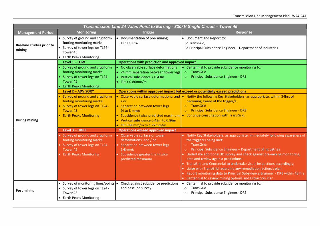
Transmission Line Management Plan LW24-24A
Transmission Line 24 Vales Point to Earring - 330kV Single Circuit – Tower 45 Management Period Monitoring Trigger Response
Baseline studies prior to mining
• Survey of ground and cruciform footing monitoring marks
• Survey of tower legs on TL24 - Tower 45
• Earth Peaks Monitoring
• Documentation of pre- mining conditions.
• Document and Report to: o TransGrid; o Principal Subsidence Engineer – Department of Industries
During mining
Level 1 – LOW Operations with prediction and approved impact • Survey of ground and cruciform
footing monitoring marks • Survey of tower legs on TL24 -
Tower 45 • Earth Peaks Monitoring
• No observable surface deformations • <4 mm separation between tower legs • Vertical subsidence < 0.43m • Tilt < 0.86mm/m
• Centennial to provide subsidence monitoring to: o TransGrid o Principal Subsidence Engineer - DRE
Level 2 – ADVISORY Operations within approved impact but exceed or potentially exceed predictions • Survey of ground and cruciform
footing monitoring marks • Survey of tower legs on TL24 -
Tower 45 • Earth Peaks Monitoring
• Observable surface deformations; and / or
• Separation between tower legs (4 to 8 mm);
• Subsidence twice predicted maximum • Vertical subsidence 0.43m to 0.86m • Tilt 0.86mm/m to 1.72mm/m
• Notify the following Key Stakeholders, as appropriate, within 24hrs of becoming aware of the trigger/s: o TransGrid o Principal Subsidence Engineer - DRE
• Continue consultation with TransGrid.
Level 3 – HIGH Operations exceed approved impact • Survey of ground and cruciform
footing monitoring marks • Survey of tower legs on TL24 -
Tower 45 • Earth Peaks Monitoring
• Observable surface or tower deformations; and / or
• Separation between tower legs (>8mm);
• Subsidence greater than twice predicted maximum.
• Notify Key Stakeholders, as appropriate, immediately following awareness of the trigger/s being met: o TransGrid; o Principal Subsidence Engineer – Department of Industries
• Undertake additional 3D survey and check against pre-mining monitoring data and review against predictions;
• TransGrid and Centennial to undertake visual inspections accordingly; • Liaise with TransGrid regarding any remediation action/s plan • Report monitoring data to Principal Subsidence Engineer - DRE within 48 hrs • Centennial to review mining options and Extraction Plan
Post mining
• Survey of monitoring lines/points • Survey of tower legs on TL24 -
Tower 45 • Earth Peaks Monitoring
• Check against subsidence predictions and baseline survey
• Centennial to provide subsidence monitoring to: o TransGrid o Principal Subsidence Engineer - DRE

Transmission Line Management Plan LW24-24A

Transmission Line Management Plan LW24-24A
Appendix 2 Key Personnel List
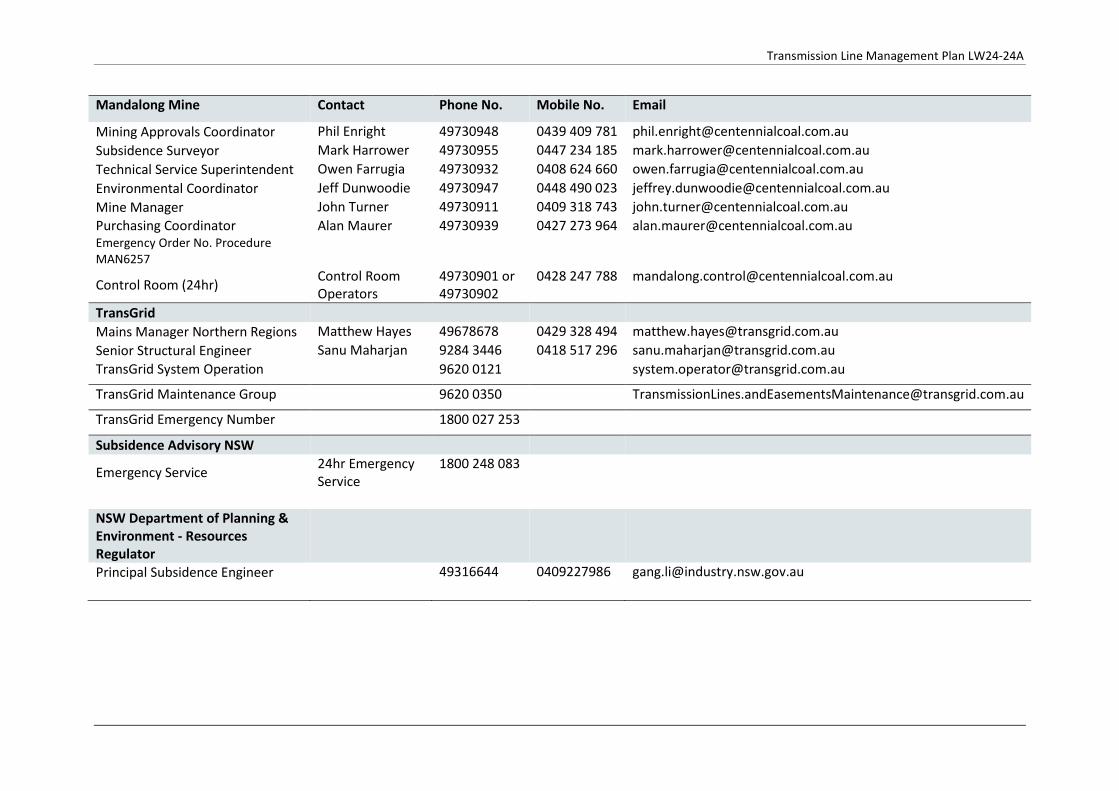
Transmission Line Management Plan LW24-24A
Mandalong Mine Contact Phone No. Mobile No. Email
Mining Approvals Coordinator Phil Enright 49730948 0439 409 781 [email protected] Subsidence Surveyor Mark Harrower 49730955 0447 234 185 [email protected] Technical Service Superintendent Owen Farrugia 49730932 0408 624 660 [email protected] Environmental Coordinator Jeff Dunwoodie 49730947 0448 490 023 [email protected] Mine Manager John Turner 49730911 0409 318 743 [email protected] Purchasing Coordinator Emergency Order No. Procedure MAN6257
Alan Maurer
49730939 0427 273 964
Control Room (24hr) Control Room Operators
49730901 or 49730902
0428 247 788 [email protected]
TransGrid Mains Manager Northern Regions Matthew Hayes 49678678 0429 328 494 [email protected] Senior Structural Engineer Sanu Maharjan 9284 3446 0418 517 296 [email protected] TransGrid System Operation 9620 0121 [email protected]
TransGrid Maintenance Group 9620 0350 [email protected]
TransGrid Emergency Number 1800 027 253
Subsidence Advisory NSW
Emergency Service 24hr Emergency Service
1800 248 083
NSW Department of Planning & Environment - Resources Regulator
Principal Subsidence Engineer 49316644 0409227986 [email protected]
Transmission Line Management Plan LW24-24A
Appendix 3 Inspection Check List
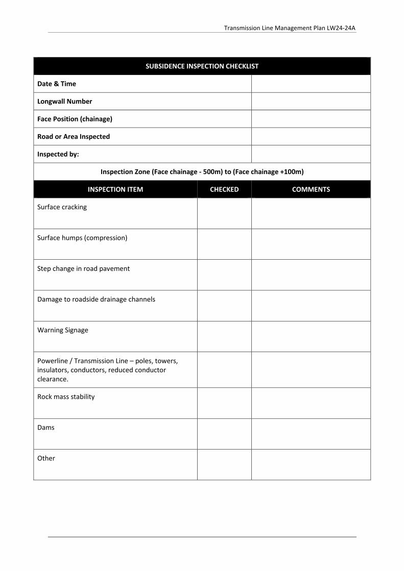
Transmission Line Management Plan LW24-24A
SUBSIDENCE INSPECTION CHECKLIST
Date & Time
Longwall Number
Face Position (chainage)
Road or Area Inspected
Inspected by:
Inspection Zone (Face chainage - 500m) to (Face chainage +100m)
INSPECTION ITEM CHECKED COMMENTS
Surface cracking
Surface humps (compression)
Step change in road pavement
Damage to roadside drainage channels
Warning Signage
Powerline / Transmission Line – poles, towers, insulators, conductors, reduced conductor clearance.
Rock mass stability
Dams
Other
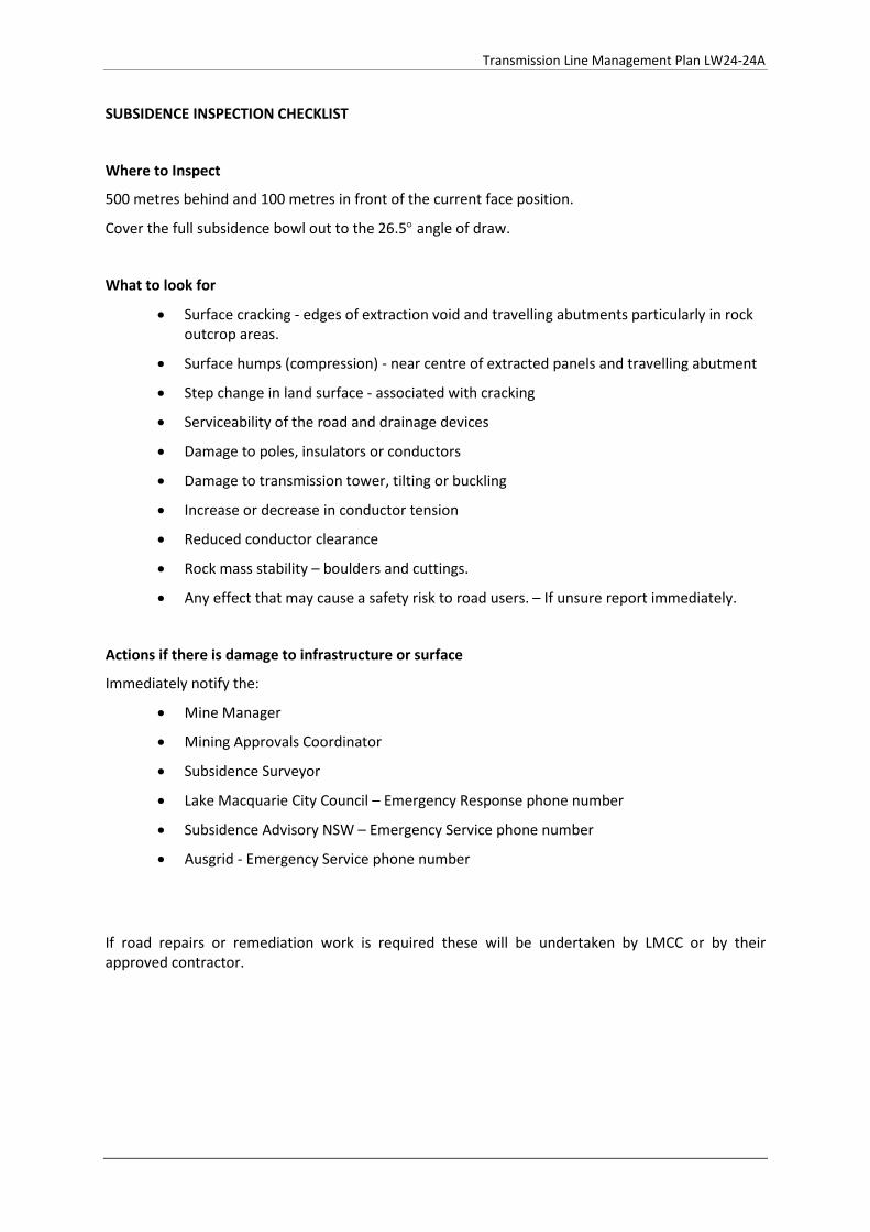
Transmission Line Management Plan LW24-24A
SUBSIDENCE INSPECTION CHECKLIST
Where to Inspect
500 metres behind and 100 metres in front of the current face position.
Cover the full subsidence bowl out to the 26.5° angle of draw.
What to look for
• Surface cracking - edges of extraction void and travelling abutments particularly in rock outcrop areas.
• Surface humps (compression) - near centre of extracted panels and travelling abutment
• Step change in land surface - associated with cracking
• Serviceability of the road and drainage devices
• Damage to poles, insulators or conductors
• Damage to transmission tower, tilting or buckling
• Increase or decrease in conductor tension
• Reduced conductor clearance
• Rock mass stability – boulders and cuttings.
• Any effect that may cause a safety risk to road users. – If unsure report immediately.
Actions if there is damage to infrastructure or surface
Immediately notify the:
• Mine Manager
• Mining Approvals Coordinator
• Subsidence Surveyor
• Lake Macquarie City Council – Emergency Response phone number
• Subsidence Advisory NSW – Emergency Service phone number
• Ausgrid - Emergency Service phone number
If road repairs or remediation work is required these will be undertaken by LMCC or by their approved contractor.


Transmission Line Management Plan LW24-24A
Appendix 4 Correspondence

Transmission Line Management Plan LW24-24A
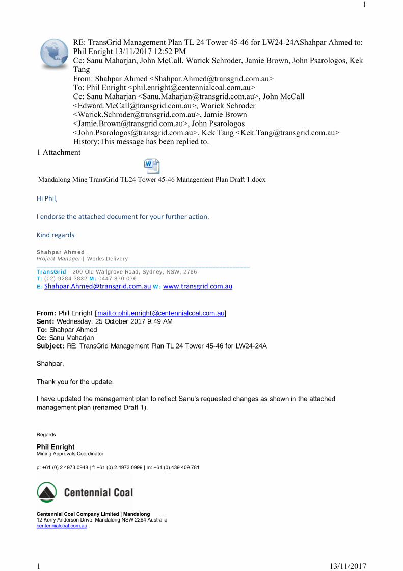
1 Attachment
Hi Phil,
I endorse the attached document for your further action.
Kind regards
Shahpar AhmedProject Manager | Works Delivery______________________________________________________________TransGrid | 200 Old Wallgrove Road, Sydney, NSW, 2766T: (02) 9284 3832 M: 0447 870 076E: [email protected] W: www.transgrid.com.au
From: Phil Enright [mailto:[email protected]] Sent: Wednesday, 25 October 2017 9:49 AMTo: Shahpar AhmedCc: Sanu MaharjanSubject: RE: TransGrid Management Plan TL 24 Tower 45-46 for LW24-24A
Shahpar,
Thank you for the update.
I have updated the management plan to reflect Sanu's requested changes as shown in the attached management plan (renamed Draft 1).
Regards
Phil EnrightMining Approvals Coordinator
p: +61 (0) 2 4973 0948 | f: +61 (0) 2 4973 0999 | m: +61 (0) 439 409 781
Centennial Coal Company Limited | Mandalong12 Kerry Anderson Drive, Mandalong NSW 2264 Australiacentennialcoal.com.au
RE: TransGrid Management Plan TL 24 Tower 45-46 for LW24-24AShahpar Ahmed to: Phil Enright 13/11/2017 12:52 PMCc: Sanu Maharjan, John McCall, Warick Schroder, Jamie Brown, John Psarologos, Kek TangFrom: Shahpar Ahmed <[email protected]>To: Phil Enright <[email protected]>Cc: Sanu Maharjan <[email protected]>, John McCall <[email protected]>, Warick Schroder <[email protected]>, Jamie Brown <[email protected]>, John Psarologos <[email protected]>, Kek Tang <[email protected]>History:This message has been replied to.
Mandalong Mine TransGrid TL24 Tower 45-46 Management Plan Draft 1.docx
1
13/11/20171
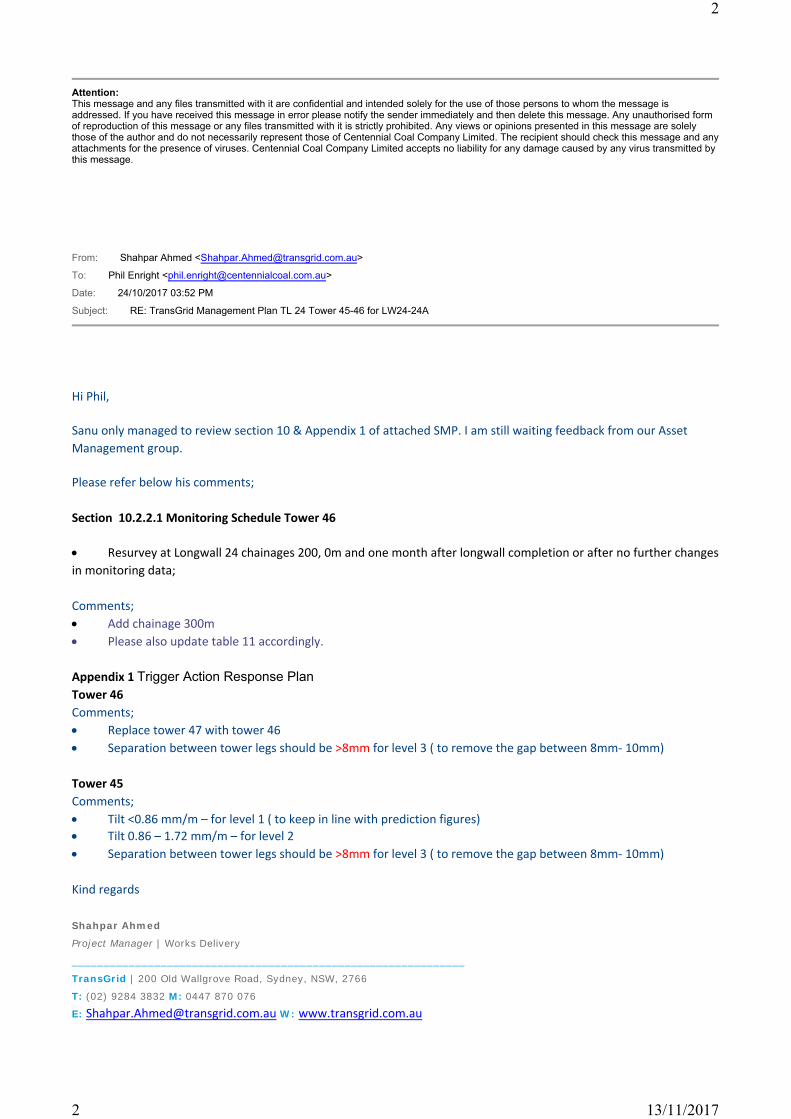
Attention:This message and any files transmitted with it are confidential and intended solely for the use of those persons to whom the message is addressed. If you have received this message in error please notify the sender immediately and then delete this message. Any unauthorised form of reproduction of this message or any files transmitted with it is strictly prohibited. Any views or opinions presented in this message are solely those of the author and do not necessarily represent those of Centennial Coal Company Limited. The recipient should check this message and any attachments for the presence of viruses. Centennial Coal Company Limited accepts no liability for any damage caused by any virus transmitted by this message.
From: Shahpar Ahmed <[email protected]>
To: Phil Enright <[email protected]>
Date: 24/10/2017 03:52 PM
Subject: RE: TransGrid Management Plan TL 24 Tower 45-46 for LW24-24A
Hi Phil,
Sanu only managed to review section 10 & Appendix 1 of attached SMP. I am still waiting feedback from our Asset Management group.
Please refer below his comments;
Section 10.2.2.1 Monitoring Schedule Tower 46
Resurvey at Longwall 24 chainages 200, 0m and one month after longwall completion or after no further changes in monitoring data;
Comments; Add chainage 300m Please also update table 11 accordingly.
Appendix 1 Trigger Action Response PlanTower 46Comments; Replace tower 47 with tower 46 Separation between tower legs should be >8mm for level 3 ( to remove the gap between 8mm- 10mm)
Tower 45Comments; Tilt <0.86 mm/m – for level 1 ( to keep in line with prediction figures) Tilt 0.86 – 1.72 mm/m – for level 2 Separation between tower legs should be >8mm for level 3 ( to remove the gap between 8mm- 10mm)
Kind regards
Shahpar Ahmed
Project Manager | Works Delivery
______________________________________________________________
TransGrid | 200 Old Wallgrove Road, Sydney, NSW, 2766
T: (02) 9284 3832 M: 0447 870 076
E: [email protected] W: www.transgrid.com.au
2
13/11/20172
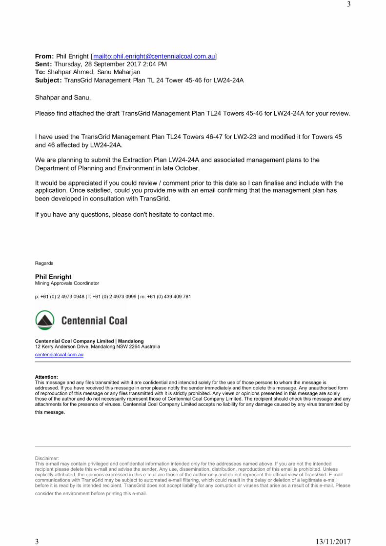
From: Phil Enright [mailto:[email protected]] Sent: Thursday, 28 September 2017 2:04 PMTo: Shahpar Ahmed; Sanu MaharjanSubject: TransGrid Management Plan TL 24 Tower 45-46 for LW24-24A
Shahpar and Sanu,
Please find attached the draft TransGrid Management Plan TL24 Towers 45-46 for LW24-24A for your review.
I have used the TransGrid Management Plan TL24 Towers 46-47 for LW2-23 and modified it for Towers 45 and 46 affected by LW24-24A.
We are planning to submit the Extraction Plan LW24-24A and associated management plans to the Department of Planning and Environment in late October.
It would be appreciated if you could review / comment prior to this date so I can finalise and include with the application. Once satisfied, could you provide me with an email confirming that the management plan has been developed in consultation with TransGrid.
If you have any questions, please don't hesitate to contact me.
Regards
Phil EnrightMining Approvals Coordinator
p: +61 (0) 2 4973 0948 | f: +61 (0) 2 4973 0999 | m: +61 (0) 439 409 781
Centennial Coal Company Limited | Mandalong12 Kerry Anderson Drive, Mandalong NSW 2264 Australiacentennialcoal.com.au
Attention:This message and any files transmitted with it are confidential and intended solely for the use of those persons to whom the message is addressed. If you have received this message in error please notify the sender immediately and then delete this message. Any unauthorised form of reproduction of this message or any files transmitted with it is strictly prohibited. Any views or opinions presented in this message are solely those of the author and do not necessarily represent those of Centennial Coal Company Limited. The recipient should check this message and any attachments for the presence of viruses. Centennial Coal Company Limited accepts no liability for any damage caused by any virus transmitted by this message.
Disclaimer:This e-mail may contain privileged and confidential information intended only for the addressees named above. If you are not the intended recipient please delete this e-mail and advise the sender. Any use, dissemination, distribution, reproduction of this email is prohibited. Unless explicitly attributed, the opinions expressed in this e-mail are those of the author only and do not represent the official view of TransGrid. E-mail communications with TransGrid may be subject to automated e-mail filtering, which could result in the delay or deletion of a legitimate e-mail before it is read by its intended recipient. TransGrid does not accept liability for any corruption or viruses that arise as a result of this e-mail. Please consider the environment before printing this e-mail.
3
13/11/20173

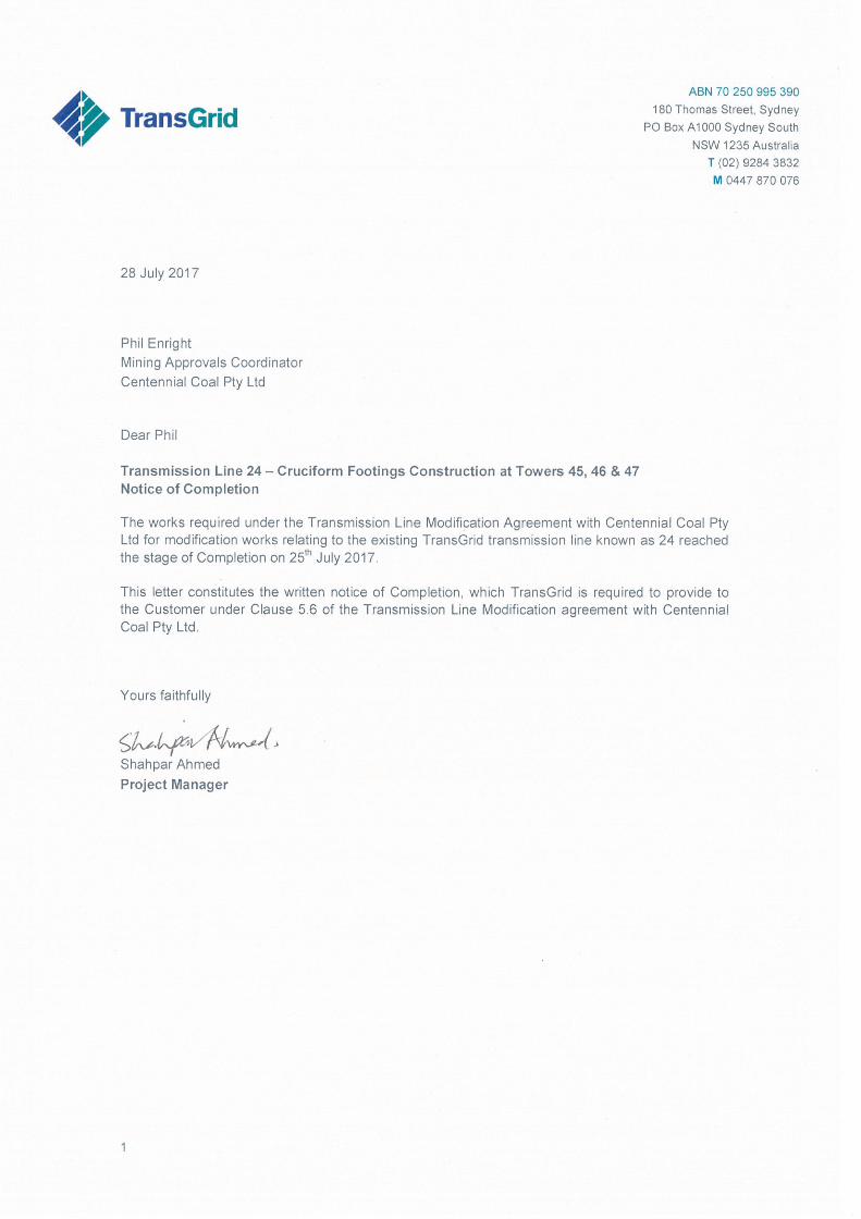

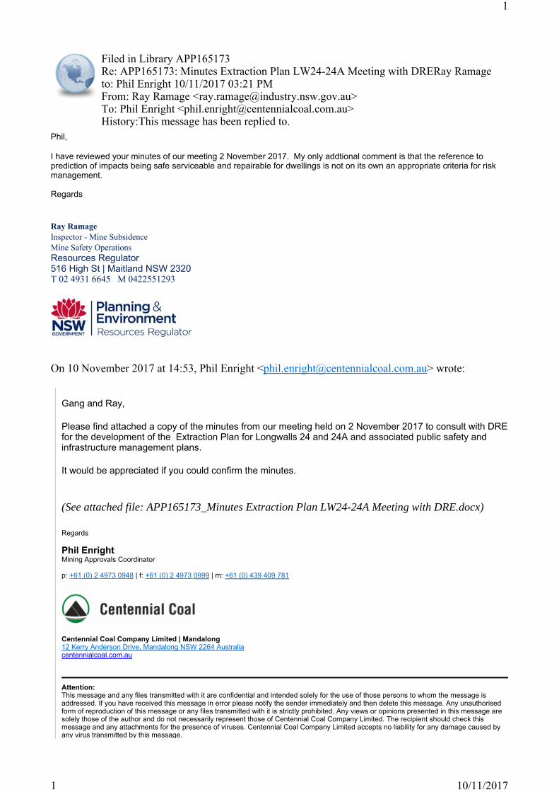
Phil,
I have reviewed your minutes of our meeting 2 November 2017. My only addtional comment is that the reference to prediction of impacts being safe serviceable and repairable for dwellings is not on its own an appropriate criteria for risk management.
Regards
Ray RamageInspector - Mine SubsidenceMine Safety OperationsResources Regulator516 High St | Maitland NSW 2320T 02 4931 6645 M 0422551293
On 10 November 2017 at 14:53, Phil Enright <[email protected]> wrote:
Gang and Ray,
Please find attached a copy of the minutes from our meeting held on 2 November 2017 to consult with DRE for the development of the Extraction Plan for Longwalls 24 and 24A and associated public safety and infrastructure management plans.
It would be appreciated if you could confirm the minutes.
(See attached file: APP165173_Minutes Extraction Plan LW24-24A Meeting with DRE.docx)
Regards
Phil EnrightMining Approvals Coordinator
p: +61 (0) 2 4973 0948 | f: +61 (0) 2 4973 0999 | m: +61 (0) 439 409 781
Centennial Coal Company Limited | Mandalong12 Kerry Anderson Drive, Mandalong NSW 2264 Australiacentennialcoal.com.au
Attention:This message and any files transmitted with it are confidential and intended solely for the use of those persons to whom the message is addressed. If you have received this message in error please notify the sender immediately and then delete this message. Any unauthorised form of reproduction of this message or any files transmitted with it is strictly prohibited. Any views or opinions presented in this message are solely those of the author and do not necessarily represent those of Centennial Coal Company Limited. The recipient should check this message and any attachments for the presence of viruses. Centennial Coal Company Limited accepts no liability for any damage caused by any virus transmitted by this message.
Filed in Library APP165173Re: APP165173: Minutes Extraction Plan LW24-24A Meeting with DRERay Ramage to: Phil Enright 10/11/2017 03:21 PM From: Ray Ramage <[email protected]>To: Phil Enright <[email protected]>History:This message has been replied to.
1
10/11/20171
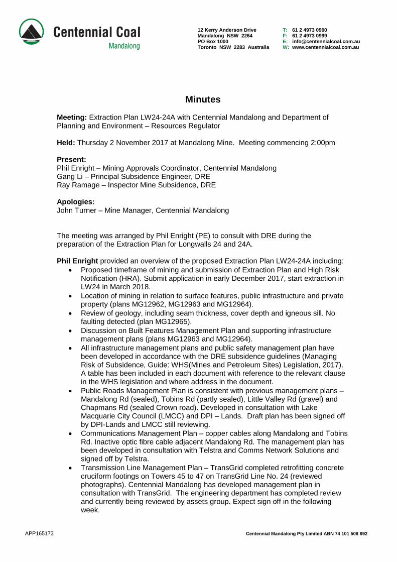
12 Kerry Anderson Drive Mandalong NSW 2264 PO Box 1000 Toronto NSW 2283 Australia
T: 61 2 4973 0900 F: 61 2 4973 0999 E: [email protected] W: www.centennialcoal.com.au
Minutes Meeting: Extraction Plan LW24-24A with Centennial Mandalong and Department of Planning and Environment – Resources Regulator Held: Thursday 2 November 2017 at Mandalong Mine. Meeting commencing 2:00pm Present: Phil Enright – Mining Approvals Coordinator, Centennial Mandalong Gang Li – Principal Subsidence Engineer, DRE Ray Ramage – Inspector Mine Subsidence, DRE Apologies: John Turner – Mine Manager, Centennial Mandalong The meeting was arranged by Phil Enright (PE) to consult with DRE during the preparation of the Extraction Plan for Longwalls 24 and 24A. Phil Enright provided an overview of the proposed Extraction Plan LW24-24A including:
• Proposed timeframe of mining and submission of Extraction Plan and High Risk Notification (HRA). Submit application in early December 2017, start extraction in LW24 in March 2018.
• Location of mining in relation to surface features, public infrastructure and private property (plans MG12962, MG12963 and MG12964).
• Review of geology, including seam thickness, cover depth and igneous sill. No faulting detected (plan MG12965).
• Discussion on Built Features Management Plan and supporting infrastructure management plans (plans MG12963 and MG12964).
• All infrastructure management plans and public safety management plan have been developed in accordance with the DRE subsidence guidelines (Managing Risk of Subsidence, Guide: WHS(Mines and Petroleum Sites) Legislation, 2017). A table has been included in each document with reference to the relevant clause in the WHS legislation and where address in the document.
• Public Roads Management Plan is consistent with previous management plans – Mandalong Rd (sealed), Tobins Rd (partly sealed), Little Valley Rd (gravel) and Chapmans Rd (sealed Crown road). Developed in consultation with Lake Macquarie City Council (LMCC) and DPI – Lands. Draft plan has been signed off by DPI-Lands and LMCC still reviewing.
• Communications Management Plan – copper cables along Mandalong and Tobins Rd. Inactive optic fibre cable adjacent Mandalong Rd. The management plan has been developed in consultation with Telstra and Comms Network Solutions and signed off by Telstra.
• Transmission Line Management Plan – TransGrid completed retrofitting concrete cruciform footings on Towers 45 to 47 on TransGrid Line No. 24 (reviewed photographs). Centennial Mandalong has developed management plan in consultation with TransGrid. The engineering department has completed review and currently being reviewed by assets group. Expect sign off in the following week.
APP165173 Centennial Mandalong Pty Limited ABN 74 101 508 892
• Powerline Management Plan – Ausgrid were provided with the draft management plan and following modelling have advised some mitigation work is required on approximately 10 timber poles (replace one pole, add rollers and change termination fittings). Ausgrid is seeking the regulators approval to conduct the mitigation works, otherwise will need to go to private enterprise. Management plan has been updated with proposed mitigation and currently being reviewed by Ausgrid.
• Gangl Li confirmed that the mitigation work on the Ausgrid poles will need to be completed prior to being influenced by subsidence from LW24-24A.
• Public Safety Management Plan – developed with reference to WHS legislation and subsidence guidelines.
• Gang Li stated that WHS legislation requires a risk assessment for the principal hazard plan. Phil Enright confirmed that the risk assessment has been completed and will be included in the extraction plan and public safety management plan.
• Reviewed plans MG12966 and MG 12968 showing land ownership, location of dwellings and surface contours. Reviewed for the potential impact of steep slopes in relation to public safety ie roads and dwellings.
• Phil Enright advised the meeting that a steep slope assessment was conducted by Seedsman Geotechnics in 2016 covering the area from LW22-24A. While some slopes were greater than 1:3, there were no cliffs and the assessment concluded that the potential that landslip and rock roll out was extremely low. No dwellings are located in the vicinity of steep slopes, with most located within the flood plain. There has been no evidence of subsidence impact from previous mining at Mandalong, in particular within Olney State Forest.
• Gang Li stated that he and Ray would arrange a surface inspection following the submission of the HRA in December.
• 14 Property Subsidence Management Plan (PSMP) have been developed in consultation with landowners and majority have been provided with draft PSMP and review meetings held. Subsidence predictions for the seven affected dwellings are below safe, serviceable and repairable (SSR) criteria. Pre-mining structural assessments have been conducted by ACOR Consultants and no structural issues were identified. Most SA NSW pre-mining inspections have also been completed.
Meeting closed at 3:30pm.
Page 2 of 2

APP165410 Consultation DRG Extraction Plan LW24-24A v1 Final Printed 05/12/2017 by Phil Enright/Centenn
(attachment converted to Managed Attachment APP165410_2542_001.pdf)~~~~~~~~~~~~~~~~~~~~~~~~~~~~~~~~~~~~~~~~~~~~~~~~~~~~~~~~~~~~~~~~~~~~~~~~~~~Appended Attachments Only by Phil Enright on 15/11/2017 12:15:49 PM~~~~~~~~~~~~~~~~~~~~~~~~~~~~~~~~~~~~~~~~~~~~~~~~~~~~~~~~~~~~~~~~~~~~~~~~~~~
Consultation DRE - Mandalong Mine Extraction Plan LW 24-24A - Built Features MP, Public Safety MP and Subsidence Monitoring ProgramPhil Enright to: industry.coordination 15/11/2017 02:08 PM
Show Details
Alex,
As recently discussed, Mandalong Mine is preparing an Extraction Plan for Longwalls 24 and 24A. It is a requirement of SSD-5144 to consult with DRE for the preparation of the Built Features Management Plan, Public Safety Management Plan and Subsidence Monitoring Program.
Please find attached letter and copies of the management plans for your review.
Note that all four infrastructure management plans supporting the Built Features Management Plan have been approved by each infrastructure owner.
Due to file size, I will forward the management plans in a number of emails.
(attachments converted to Managed Attachments APP165410_Built Features Management Plan LW24-24A Final Draft.pdf, APP165410_Mandalong Mine Powerline Management Plan LW24-24A Final Draft.pdf)~~~~~~~~~~~~~~~~~~~~~~~~~~~~~~~~~~~~~~~~~~~~~~~~~~~~~~~~~~~~~~~~~~~~~~~~~~~Appended Contents by Phil Enright on 15/11/2017 2:09:25 PM~~~~~~~~~~~~~~~~~~~~~~~~~~~~~~~~~~~~~~~~~~~~~~~~~~~~~~~~~~~~~~~~~~~~~~~~~~~
Fw: Consultation DRE - Mandalong Mine Extraction Plan LW 24-24A - Built Features MP, Public Safety MP and Subsidence Monitoring ProgramPhil Enright to: industry.coordination 15/11/2017 02:11 PM
Show Details
Email No 2.
----- Forwarded by Phil Enright/CentennialCoal on 15/11/2017 02:09 PM -----
From: Phil Enright/CentennialCoalTo: [email protected]: 15/11/2017 02:08 PMSubject: Consultation DRE - Mandalong Mine Extraction Plan LW24-24A - Built Features MP, Public
Safety MP and Subsidence Monitoring Program
APP165410 Consultation DRG Extraction Plan LW24-24A v1 Final Printed 05/12/2017 by Phil Enright/Centenn
Alex,
As recently discussed, Mandalong Mine is preparing an Extraction Plan for Longwalls 24 and 24A. It is a requirement of SSD-5144 to consult with DRE for the preparation of the Built Features Management Plan, Public Safety Management Plan and Subsidence Monitoring Program.
Please find attached letter and copies of the management plans for your review.
Note that all four infrastructure management plans supporting the Built Features Management Plan have been approved by each infrastructure owner.
Due to file size, I will forward the management plans in a number of emails.
[attachment "Consultation DRG Extraction Plan LW24-24A.pdf" deleted by Phil Enright/CentennialCoal] [attachment "Built Features Management Plan LW24-24A Final Draft.pdf" deleted by Phil Enright/CentennialCoal] [attachment "Mandalong Mine Powerline Management Plan LW24-24A Final Draft.pdf" deleted by Phil Enright/CentennialCoal]
(attachments converted to Managed Attachments APP165410_Communications Managment Plan LW24-24A Final Draft.pdf, APP165410_Mandalong Mine Public Roads Management Plan LW24-24A Final Draft.pdf)~~~~~~~~~~~~~~~~~~~~~~~~~~~~~~~~~~~~~~~~~~~~~~~~~~~~~~~~~~~~~~~~~~~~~~~~~~~Appended Contents by Phil Enright on 15/11/2017 2:11:59 PM~~~~~~~~~~~~~~~~~~~~~~~~~~~~~~~~~~~~~~~~~~~~~~~~~~~~~~~~~~~~~~~~~~~~~~~~~~~
Fw: Consultation DRE - Mandalong Mine Extraction Plan LW 24-24A - Built Features MP, Public Safety MP and Subsidence Monitoring ProgramPhil Enright to: industry.coordination 15/11/2017 02:13 PM
Show Details
Email No. 3
----- Forwarded by Phil Enright/CentennialCoal on 15/11/2017 02:12 PM -----
From: Phil Enright/CentennialCoalTo: [email protected]: 15/11/2017 02:11 PMSubject: Fw: Consultation DRE - Mandalong Mine Extraction Plan LW24-24A - Built Features MP,
Public Safety MP and Subsidence Monitoring Program
Email No 2.
[attachment "Communications Managment Plan LW24-24A Final Draft.pdf" deleted by Phil Enright/CentennialCoal] [attachment "Mandalong Mine Public Roads Management Plan LW24-24A Final Draft.pdf" deleted by Phil Enright/CentennialCoal]
----- Forwarded by Phil Enright/CentennialCoal on 15/11/2017 02:09 PM -----
From: Phil Enright/CentennialCoalTo: [email protected]: 15/11/2017 02:08 PMSubject: Consultation DRE - Mandalong Mine Extraction Plan LW24-24A - Built Features MP, Public
APP165410 Consultation DRG Extraction Plan LW24-24A v1 Final Printed 05/12/2017 by Phil Enright/Centenn
Safety MP and Subsidence Monitoring Program
Alex,
As recently discussed, Mandalong Mine is preparing an Extraction Plan for Longwalls 24 and 24A. It is a requirement of SSD-5144 to consult with DRE for the preparation of the Built Features Management Plan, Public Safety Management Plan and Subsidence Monitoring Program.
Please find attached letter and copies of the management plans for your review.
Note that all four infrastructure management plans supporting the Built Features Management Plan have been approved by each infrastructure owner.
Due to file size, I will forward the management plans in a number of emails.
[attachment "Consultation DRG Extraction Plan LW24-24A.pdf" deleted by Phil Enright/CentennialCoal] [attachment "Built Features Management Plan LW24-24A Final Draft.pdf" deleted by Phil Enright/CentennialCoal] [attachment "Mandalong Mine Powerline Management Plan LW24-24A Final Draft.pdf" deleted by Phil Enright/CentennialCoal]
(attachments converted to Managed Attachments APP165410_Public Safety Managment Plan LW24-24A Final Draft.pdf, APP165410_Mandalong Mine TransGrid TL24 Tower 45-46 Management Plan Final Draft.pdf)~~~~~~~~~~~~~~~~~~~~~~~~~~~~~~~~~~~~~~~~~~~~~~~~~~~~~~~~~~~~~~~~~~~~~~~~~~~Appended Contents by Phil Enright on 15/11/2017 2:13:57 PM~~~~~~~~~~~~~~~~~~~~~~~~~~~~~~~~~~~~~~~~~~~~~~~~~~~~~~~~~~~~~~~~~~~~~~~~~~~
Fw: Consultation DRE - Mandalong Mine Extraction Plan LW 24-24A - Built Features MP, Public Safety MP and Subsidence Monitoring ProgramPhil Enright to: industry.coordination 15/11/2017 02:15 PM
Show Details
Email No. 4 - Final
----- Forward
ed by Phil Enright/CentennialCoal on 15/11/2017 02:14 PM -----
From: Phil Enright/CentennialCoalTo: [email protected]: 15/11/2017 02:13 PMSubject: Fw: Consultation DRE - Mandalong Mine Extraction Plan LW24-24A - Built Features MP,
Public Safety MP and Subsidence Monitoring Program
Email No. 3
[attachment "Public Safety Managment Plan LW24-24A Final Draft.pdf" deleted by Phil Enright/CentennialCoal] [attachment "Mandalong Mine TransGrid TL24 Tower 45-46 Management Plan Final Draft.pdf" deleted by Phil Enright/CentennialCoal]
----- Forwarded by Phil Enright/CentennialCoal on 15/11/2017 02:12 PM -----
APP165410 Consultation DRG Extraction Plan LW24-24A v1 Final Printed 05/12/2017 by Phil Enright/Centenn
From: Phil Enright/CentennialCoalTo: [email protected]: 15/11/2017 02:11 PMSubject: Fw: Consultation DRE - Mandalong Mine Extraction Plan LW24-24A - Built Features MP,
Public Safety MP and Subsidence Monitoring Program
Email No 2.
[attachment "Communications Managment Plan LW24-24A Final Draft.pdf" deleted by Phil Enright/CentennialCoal] [attachment "Mandalong Mine Public Roads Management Plan LW24-24A Final Draft.pdf" deleted by Phil Enright/CentennialCoal]
----- Forwarded by Phil Enright/CentennialCoal on 15/11/2017 02:09 PM -----
From: Phil Enright/CentennialCoalTo: [email protected]: 15/11/2017 02:08 PMSubject: Consultation DRE - Mandalong Mine Extraction Plan LW24-24A - Built Features MP, Public
Safety MP and Subsidence Monitoring Program
Alex,
As recently discussed, Mandalong Mine is preparing an Extraction Plan for Longwalls 24 and 24A. It is a requirement of SSD-5144 to consult with DRE for the preparation of the Built Features Management Plan, Public Safety Management Plan and Subsidence Monitoring Program.
Please find attached letter and copies of the management plans for your review.
Note that all four infrastructure management plans supporting the Built Features Management Plan have been approved by each infrastructure owner.
Due to file size, I will forward the management plans in a number of emails.
[attachment "Consultation DRG Extraction Plan LW24-24A.pdf" deleted by Phil Enright/CentennialCoal] [attachment "Built Features Management Plan LW24-24A Final Draft.pdf" deleted by Phil Enright/CentennialCoal] [attachment "Mandalong Mine Powerline Management Plan LW24-24A Final Draft.pdf" deleted by Phil Enright/CentennialCoal]
(attachment converted to Managed Attachment APP165410_Subsidence Monitoring Program LW24-24A Final Draft.pdf)~~~~~~~~~~~~~~~~~~~~~~~~~~~~~~~~~~~~~~~~~~~~~~~~~~~~~~~~~~~~~~~~~~~~~~~~~~~Appended Contents by Phil Enright on 15/11/2017 2:16:14 PM~~~~~~~~~~~~~~~~~~~~~~~~~~~~~~~~~~~~~~~~~~~~~~~~~~~~~~~~~~~~~~~~~~~~~~~~~~~
Acknowledgement of Correspondence - Royalties & Advisory Services Unit (Industry Coordination ) Re: Consultation DRE - Mandalong Mine Extraction Plan LW24-24A - Built Features MP, Public Safety MP and Subsidence Monitoring ProgramIndustry Coordination to: phil.enright 15/11/2017 02:14 PM
Show Details
APP165410 Consultation DRG Extraction Plan LW24-24A v1 Final Printed 05/12/2017 by Phil Enright/Centenn
Thank you for contacting the Division of Resources & Geoscience (DRG) - Royalties & Advisory Services Unit.
This is an acknowledgement that your correspondence has been received and a response, if required, will be sent in due course.
All correspondence or advice required of DRG in relation to SSD projects is to be sent to: [email protected]
The Royalties and Advisory Services Unit facilitates responsible mineral development in NSW.
The Unit coordinates:
Royalty Administration activities undertaken to effectively manage the NSW royalty regulation in
collaboration with NSW Revenue through industry education and support, data management, royalty calculation and payment.
Technical and regulatory input during the Mineral Exploration and Development Assessment
Process.
Technical consideration within DRG for new mining proposals/modifications at the Conceptual Project
Development Plan stage.Strategic projects to enhance sustainable mineral investment and development in NSW.
Acquisition of statistical data and analysis related to the NSW minerals industry.
Resource & Economic assessments for inclusion in the assessment and approvals process for major mineral
projects.Acquisition and interpretation of market intelligence.
Assessment process for Subsidence Management Plans and the provision of advice to the Department of
Planning and Environment for Extraction Plans as part of the approval process for underground mining operations in NSW.
DRG Unit contact details and advice:
Royalties & Advisory Services: +61 (0)2 4931 6422 or [email protected] or [email protected]
Titles Services: +61 (0)2 4931 6500 or [email protected]
Mining & Exploration Assessment: +61 (0)2 4931 6698 or [email protected]
Land Use Assessment: +61 (0)2 4931 6714 or [email protected]
Geoscience Information: +61 0(2) 4931 6592 or [email protected]
Strategic Resource Assessment & Advice: +61 (0)2 4931 6689 or [email protected]
Environmental Sustainability: +61 (0)2 4931 6590 or [email protected]
Available Geoscience Information Systemshttp://www.resourcesandenergy.nsw.gov.au/miners-and-explorers/geoscience-information--
APP165410 Consultation DRG Extraction Plan LW24-24A v1 Final Printed 05/12/2017 by Phil Enright/Centenn
Royalties & Advisory Services Unit - Industry Coordination
Division of Resources & Geoscience
516 High Street Maitland NSW 2320 | PO Box 344 HRMC NSW 2310
T: +61 2 4931 6616 | F: +61 2 4931 6776
W: www.resourcesandenergy.nsw.gov.au
This message is intended for the addressee named and may contain confidential information. If you are not the intended recipient, please delete it and notify the sender. Views expressed in this message are those of the individual sender, and are not necessarily the views of their organisation.
~~~~~~~~~~~~~~~~~~~~~~~~~~~~~~~~~~~~~~~~~~~~~~~~~~~~~~~~~~~~~~~~~~~~~~~~~~~Appended Contents by Phil Enright on 15/11/2017 3:12:44 PM~~~~~~~~~~~~~~~~~~~~~~~~~~~~~~~~~~~~~~~~~~~~~~~~~~~~~~~~~~~~~~~~~~~~~~~~~~~


Centennial Mandalong 12 Kerry Anderson Drive Mandalong NSW 2264 PO Box 1000 Toronto NSW 2283 Telephone 1800 730 919 Facsimile 49 730 999