Transit corridors, growth areas and activity centres · Transit corridors, growth areas and...
6
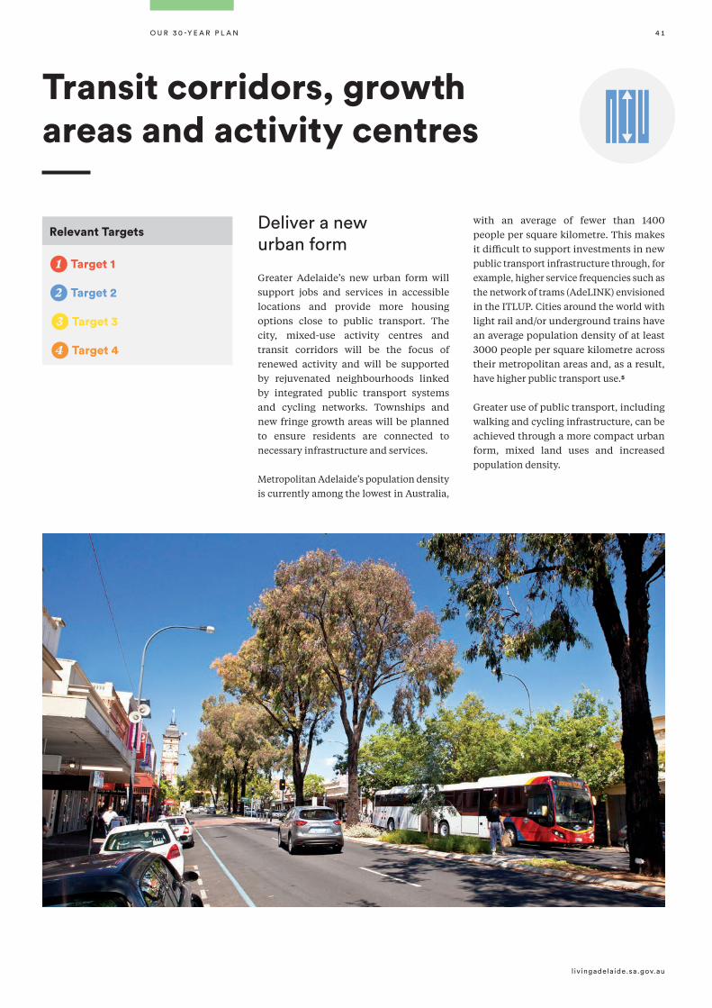
livingadelaide.sa.gov.au OuR 30-YEAR PLAn 41 Relevant Targets 1 Target 1 2 Target 2 T3 Target 3 T4 Target 4 Deliver a new urban form Greater Adelaide’s new urban form will support jobs and services in accessible locations and provide more housing options close to public transport. The city, mixed-use activity centres and transit corridors will be the focus of renewed activity and will be supported by rejuvenated neighbourhoods linked by integrated public transport systems and cycling networks. Townships and new fringe growth areas will be planned to ensure residents are connected to necessary infrastructure and services. Metropolitan Adelaide’s population density is currently among the lowest in Australia, with an average of fewer than 1400 people per square kilometre. This makes it difficult to support investments in new public transport infrastructure through, for example, higher service frequencies such as the network of trams (AdeLINK) envisioned in the ITLUP. Cities around the world with light rail and/or underground trains have an average population density of at least 3000 people per square kilometre across their metropolitan areas and, as a result, have higher public transport use. Greater use of public transport, including walking and cycling infrastructure, can be achieved through a more compact urban form, mixed land uses and increased population density. Transit corridors, growth areas and activity centres 5
Transcript of Transit corridors, growth areas and activity centres · Transit corridors, growth areas and...
l iv ingadelaide.sa.gov.au
O u R 3 0 -Y E A R P L A n 4 1
Relevant Targets
1 Target 1
2 Target 2
T3 Target 3
T4 Target 4
Deliver a new urban form
Greater Adelaide’s new urban form will support jobs and services in accessible locations and provide more housing options close to public transport. The city, mixed-use activity centres and transit corridors will be the focus of renewed activity and will be supported by rejuvenated neighbourhoods linked by integrated public transport systems and cycling networks. Townships and new fringe growth areas will be planned to ensure residents are connected to necessary infrastructure and services.
Metropolitan Adelaide’s population density is currently among the lowest in Australia,
with an average of fewer than 1400 people per square kilometre. This makes it difficult to support investments in new public transport infrastructure through, for example, higher service frequencies such as the network of trams (AdeLINK) envisioned in the ITLUP. Cities around the world with light rail and/or underground trains have an average population density of at least 3000 people per square kilometre across their metropolitan areas and, as a result, have higher public transport use.
Greater use of public transport, including walking and cycling infrastructure, can be achieved through a more compact urban form, mixed land uses and increased population density.
Transit corridors, growth areas and activity centres
5

Transit corridors, growth areas and activity centres
T H E 3 0 - Y E A R P L A N F O R G R E AT E R A D E L A I D E - 2 0 1 7 U P D AT E4 2
P1. Deliver a more compact urban form by locating the majority of Greater Adelaide’s urban growth within existing built-up areas by increasing density at strategic locations close to public transport. (Map 2)
P2. Increase residential and mixed use development in the walking catchment of:
• strategic activity centres*
• appropriate transit corridors
• strategic railway stations.
P3. Increase average gross densities of development within activity centres and transit corridor catchments from 15 to 25 dwellings per hectare to 35 dwellings per hectare.
P4. Ensure that the bulk of new residential development in Greater Adelaide is low to medium rise with high rise limited to the CBD, parts of the Park Lands frame, significant urban boulevards, and other strategic locations where the interface with lower rise areas can be managed.
P5. Encourage medium rise development along key transport corridors, within activity centres and in urban renewal areas that support public transport use.
P6. Promote urban renewal opportunities and maximise the use of government-owned land to achieve higher densities along transit corridors.
P7. Focus government services in higher-order activity centres that are well-serviced by public transport to support viable clusters of activities and minimise car trips.
P8. Provide retail and other services outside designated activity centres where they will contribute to the principles of accessibility, a transit-focused and connected city, high quality urban design, and economic growth and competitiveness.
P9. Develop activity centres as vibrant places by focusing on mixed-use activity, main streets and public realm improvements.
P10. Allow for low-impact employment activities in residential areas, such as small-scale shops, offices and restaurants, where interface issues can be appropriately managed.
P11. Ensure new urban fringe growth occurs only within designated urban areas and township boundaries and outside the Environment and Food Production Areas, as shown on Map 3.
Policies
P12. Ensure, where possible, that new growth areas on the metropolitan Adelaide fringe and in townships are connected to, and make efficient use of, existing infrastructure, thereby discouraging “leapfrog” urban development.
* In Inner and Middle Metropolitan Adelaide this could include all activity centres well serviced by frequent public transport. In Outer Metropolitan Adelaide this would focus on Regional and District centres serviced by high frequency public transport (Map 2 and Map 15).

4 3
l iv ingadelaide.sa.gov.au
O u R 3 0 -Y E A R P L A n
Map 2 — Activity centres and mass transit routes

Glenelg
Elizabeth
Adelaide
PortAdelaide
Modbury
MawsonLakes
MunnoPara
Virginia
Seaford
MorphettVale
Stirling
Population Densityper km2 (2014)
2,500 - 2,999
2,000 - 2,499
1,500 - 1,999
1,000 - 1,499
500 - 999
1 - 499
0
PLN ID: 5052
© Government of South Australia 2016
Transit corridors, growth areas and activity centres
T H E 3 0 - Y E A R P L A N F O R G R E AT E R A D E L A I D E - 2 0 1 7 U P D AT E4 4
We have abundant opportunities to increase population density to support transit. Our densest suburbs are some of our most desirable, liveable and vibrant.
Tram-based cities have a minimum of around 3000 people per km2
1000
2000
3000
4000
5000
6000People
Per Km2
Adelaide
San Francisco
St. Petersburg
Extensive Tram CitiesCities with an underground
Warsaw
Moscow
Tokyo
LondonBerlin
Munich
Manchester
Paris
Milan
Stockholm
Rome
Budapest
Prague
Public Transport - Cost Recovery Ratios
20% 170% 70%
Figure 2.1 Density - people per km2
5

4 5
l iv ingadelaide.sa.gov.au
O u R 3 0 -Y E A R P L A n
Map 3 — Designated urban areas and township boundaries

Transit corridors, growth areas and activity centres
T H E 3 0 - Y E A R P L A N F O R G R E AT E R A D E L A I D E - 2 0 1 7 U P D AT E4 6
k Other key levers to unlock opportunity
Deliver new public transport infrastructure through:
• $4 million investment into the
planning of the future extended
AdeLInK tram network.
• $160 million investment into the
O-Bahn City Access project, which
will extend the O-Bahn guided bus
way from Hackney Road into the
cross-city priority bus lanes on
Grenfell Street.
• $55 million investment to extend the
tram network along north terrace to
the Old Royal Adelaide site.
A1. Develop transitional plans to assist in the establishment of the Planning and Design Code.
A2. Undertake local area planning for strategic transit corridors, train stations, activity centres and growth areas that implement the strategic directions of this Plan, including:
• identifying how individual areas can contribute to Greater Adelaide’s growth scenario
• identifying opportunities to implement the dwelling density guidelines needed to support the economic viability of public transport, activity centres and walkable neighbourhoods
• linking development to support infrastructure investment and public realm improvements
• managing interfaces with existing land uses.
A3. Prepare an urban renewal policy to be delivered through the new planning system - to ensure infill development is sensitively interfaced with existing suburbs.
A4. Rezone strategic sites to unlock infill growth opportunities that directly support public transport infrastructure investment.
A5. Better integrate transport and land-use planning by strategically considering land-use development opportunities from infrastructure investment at the project scoping stage.
A6. Rezone government-owned land where it implements the strategic directions of this Plan, taking account of public value and economic prosperity.
Making it happen - the planning systemIn the short term
Dwelling density guidelines
• Walking catchments to fixed line transit stations should generally be within 800m,
and within 400m to high frequency bus stops. N.B. catchments of individuals centres
may vary depending on specific local context such as the geography and the diversity
of services available.
• Gross densities within these catchments should look to increase in these locations to
an average of 35 dwellings per hectare over the life of this Update, with net densities
in the medium to high density range.
• Individual catchments may vary in their scope and density and their spatial application
will be informed by local area planning.