TRAILS OF THE PAST: Historical Overview of the … · Final report of a Historic Overview prepared...
373
TRAILS OF THE PAST: Historical Overview of the Flathead National Forest, Montana, 1800-1960 By Kathryn L. McKay Historian 1994 Final report of a Historic Overview prepared under agreement with the United States, Flathead National Forest, Kalispell, Montana (Contract #43-0385-3-0363). Submitted in fulfillment of agreement by Kathryn L. McKay, Consulting Historian, 491 Eckelberry Dr., Columbia Falls, Montana, 59912.
Transcript of TRAILS OF THE PAST: Historical Overview of the … · Final report of a Historic Overview prepared...
TRAILS OF THE PAST:
Historical Overview of the Flathead National Forest, Montana, 1800-1960
By
Kathryn L. McKay Historian
1994
Final report of a Historic Overview prepared under agreement with the United States, Flathead National Forest,
Kalispell, Montana (Contract #43-0385-3-0363). Submitted in fulfillment of agreement by Kathryn L. McKay,
Consulting Historian, 491 Eckelberry Dr., Columbia Falls, Montana, 59912.

TABLE OF CONTENTS
Introduction
Acknowledgements
Previous Work
Methodology
Physical Environment
Abbreviations Used in Text
Introduction
The Fur Trade
Introduction
The Fur Trade
Missionary Activity and Early Exploration
Introduction
Missionary Activity
Railroad Surveys
International Boundary Surveys
Other Early Explorations
Mining
Introduction
Oil Fields
Coal Deposits
Placer and Lode Mining
General
Prospector's Life
Placer and Lode Mining in the Flathead
Settlement and Agriculture
Introduction
Settlement Up to 1871
1871-1891
1891 to World War II
World War II to Present
Forest Reserves

Introduction
Forested Land on the Public Domain up to 1891
Creation of the Forest Reserves
GLO Administration of the Forest Reserves, 1898-1905
Forest Supervisors and Rangers on the Flathead and Lewis & Clarke Forest Reserves, 1898-1905
Forest Service Administration, 1905-1960
Introduction
Qualifications of Early Forest Service Workers
Daily Work of Early Forest Service Employees
Forest Service Food
Winter Work
Families
Injuries
Special-Use Permits
Forestry Research and Education
World Wars
Administrative Sites
Boundaries
Northern Pacific Railroad
Glacier National Park
Glacier View and Other Proposed Dams
Hungry Horse Dam
Transportation
Introduction
Early Trails
Wagon Roads
Railroads
Automobiles
Forest Service Trails
Forest Service Trail Construction and Maintenance
Forest Service Use of Pack Animals
Forest Service Roads
Communications
Introduction
Telephone
Radio
Fire Detection and Suppression

Introduction
Fire Behavior and History
Early GLO and Forest Service Fire Policy
1910 Fires in the Northern Rockies
Fire Detection
Fire Suppression
Cooperative Fire Efforts
Timber Harvesting
Introduction
1800s to 1905
Timber Trespasses
Logging on Private Lands, 1905-1942
Railroad Ties
Forest Service Logging, 1905-1942
General
Swan Valley
Middle Fork
South Fork
North Fork and North of Columbia Falls
Logging During and Shortly After World War II
Insect, Disease, and Windstorm Damage to Timber
Logging in the 1950s
Logging Methods
Timber Cruising and Scaling
Harvesting
Skidding and Hauling
River Drives
Mechanization of Logging
Logging Camps
The IWW Strikes
Multiple Use-Sustained Yield Act of 1960
Forest Homesteads
Introduction
Forest Homestead Act of 1906
Stillwater Area Homesteads
North Fork Homesteads
Middle Fork Homesteads
South Fork Homesteads
Swan Valley Homesteads
Grazing and Other Commodities

Introduction
Grazing in the Flathead Valley
General Forest Service Grazing
Grazing on the Flathead National Forest
Other Commodities
Hunting, Fishing, Trapping, and Wildlife Managment
Introduction
Hunting
Fishing
Trapping
Forest Service Wildlife Management
The Civilian Conservation Corps (CCC) Era
Introduction
CCC
Blister Rust
Recreation and Wilderness Areas
Introduction
General Recreation
Recreation in the Lake McDonald Area
Flathead National Forest Recreation up to World War II
Downhill Skiing
Flathead National Forest Recreation after World War II
Creation of Primitive and Wilderness Areas
Bob Marshall Wilderness
Mission Mountains
Jewel Basin
Conclusion
Timeline
Glossary
Bibliography
Index (omitted from the online edition)

LIST OF FIGURES
Figure 1. Map of Flathead National Forest and vicinity
Figure 2. Fur trading posts in northwestern Montana and vicinity
Figure 3. Locations of Native American tribes, ca. 1853
Figure 4. Fort Connah on the Flathead Indian Reservation, 1865
Figure 5. John Palliser
Figure 6. Placing an international boundary marker
Figure 7. Historic mining districts in northwestern Montana and vicinity
Figure 8. Kintla oil well, 1904
Figure 9. Star Meadow mining district, showing locations of mines
Figure 10. Nick Moon, ca. 1895
Figure 11. Post offices in the Flathead Valley area
Figure 12. Towns that have had post offices in the Flathead Valley area
Figure 13. Counties in western Montana: 1889, 1904, 1918, 1925
Figure 14. Street scene in Kalispell, ca. 1895
Figure 15. McCarthysville, 1918
Figure 16. Lewis & Clarke Forest Reserve boundaries in 1898
Figure 17. Flathead Forest Reserve boundaries in 1898
Figure 18. Supervisors of Flathead and Blackfeet National Forests, 1898 to present
Figure 19. William Brennen, first supervisor of the Blackfeet National Forest
Figure 20. Frank Liebig standing on rock cairn at Swiftcurrent Pass, 1906

Figure 21. Frank Geduhn at foot of Logging Lake, ca. 1907
Figure 22. Flathead and Blackfeet National Forest ranger districts ca. 1954
Figure 23. Cartoon drawn in 1930
Figure 24. Jack Clack wearing the packframe that he designed
Figure 25. Winter camp near Calbick Creek, 1936
Figure 26. Echo Ranger Station, 1924
Figure 27. Flathead National Forest cartographic survey, 1960
Figure 28. Administrative sites on the Flathead National Forest
Figure 29. Big Prairie Ranger Station, 1913
Figure 30. Elk Park packers' camp, ca. 1924
Figure 31. Drawing of Moran Ranger Station, ca. 1918
Figure 32. Construction at Spotted Bear Ranger Station, 1925
Figure 33. Big Prairie Ranger Station complex, ca. 1917
Figure 34. Big Prairie Ranger Station complex, 1990
Figure 35. Location of proposed Glacier View dam and reservoir
Figure 36. Location of proposed Spruce Park dam, reservoir, and tunnel
Figure 37. Map of reported Native American trails in Flathead Valley area
Figure 38. Major roads and trails in Montana after 1850
Figure 39. Freighter on Fort Steele-Kalispell trail
Figure 40. Mary Ann and State of Montana at Demersville, 1891
Figure 41. Map of Flathead County ca. 1905
Figure 42. Railroad routes in Montana, 1887, 1898, 1910
Figure 43. Primary roads and trails in Flathead National Forest area, 1898

Figure 44. Primary roads and trails in Flathead National Forest area, 1908 and 1912
Figure 45. Primary roads and trails in Flathead National Forest, 1928 and 1927
Figure 46. Fitting the abutment timbers on the Big Prairie bridge, 1922
Figure 47. Equipment for a five-man Forest Service trail crew in 1935
Figure 48. The Beatty trail grader
Figure 49. Theodore W. (Toad) Paullin and a "short string," 1967
Figure 50. Toussaint Jones packing a hot water heater
Figure 51. South Fork road near Upper Twin Creek, 1926
Figure 52. Trails and roads in the Trail Creek area, 1912
Figure 53. Trails and roads in the Trail Creek area, 1928
Figure 54. Trails and roads in the Trail Creek area, 1948
Figure 55. Trails and roads in the Trail Creek area, 1963
Figure 56. Fool Hen Bridge on North Fork Road (west side), 1953
Figure 57. Bulldozer working on Martin Creek access road, 1946
Figure 58. Harry Gisborne using a heliograph, 1915
Figure 59. Forest Service worker in the Spotted Bear Lookout
Figure 60. Alidade stand and iron mine phone on Six Mile lookout, ca. 1920
Figure 61. Forest Service worker repairing telephone line, 1926
Figure 62. South Fork Road near Wounded Buck Creek, 1926
Figure 63. List of some of the major fires in the Flathead National Forest area
Figure 64. Areas burned on the Blackfeet and Flathead National Forests, 1910
Figure 65. Areas burned by major fires on the Flathead National Forest, 1889-1949
Figure 66. Railroad speeder, 1921

Figure 67. List of emergency fire-season rations, 1914
Figure 68. "Seen area" photograph taken from Standard Lookout
Figure 69. Spotted Bear Lookout, 1923
Figure 70. Locations of all known lookout sites on the Flathead National Forest
Figure 71. Hornet Peak Lookout, 1923
Figure 72. LA-style lookout, Flathead National Forest
Figure 73. C. J. Hash taking a reading on Salmon lookout, 1926
Figure 74. Portable water pump in use on Wolf Creek fire, 1924
Figure 75. Putting final touches on fire line, Tango Creek fire, 1953
Figure 76. Half Moon fire burning over Teakettle Mountain, 1929
Figure 77. Half Moon fire of 1929, acres burned and fire suppression costs
Figure 78. Sawmill on Whitefish Lake
Figure 79. Butte & Montana Commercial Company mill, ca. 1895
Figure 80. Interior of State Lumber Company sawmill, LaSalle, Montana, 1898
Figure 81. List of some of the sawmills in Flathead County in 1907
Figure 82. Timber types in the Flathead River drainage, 1922
Figure 83. Production of small mills vs. large mills in Montana, 1921-1948
Figure 84. Annual production of Christmas trees in Montana, 1936-49
Figure 85. Original Somers sawmill, built 1901
Figure 86. Somers Lumber Company workers and triangular railroad ties
Figure 87. Annual production of sawed cross ties in Montana, 1925-47
Figure 88. McMillan & Kerr tie mill in Patrick gulch near Kalispell 1930
Figure 89. Hauling railroad ties by truck, Eureka, 1929

Figure 90. Location and relative production sawmills in northwest Montana, 1948
Figure 91. Working circles on the Flathead National Forest, ca. 1960
Figure 92. 1924 estimates of timber on the Blackfeet and Flathead National Forests
Figure 93. Timber sales on Flathead National Forest, May 1926-January 1929
Figure 94. Location of Coram Experimental Forest
Figure 95. Hypothetical timber sale in the Bob Marshall Wilderness
Figure 96. Volume of timber cut on Flathead National Forest, 1935-1960
Figure 97. Number of sawmills and lumber production in Montana
Figure 98. Relation of allowable cut to annual cut, 1916-1957
Figure 99. Scaling logs
Figure 100. Sawyers felling a Douglas-fir with a cross-cut saw
Figure 101. Larch butts discarded on ACM sale, Seely Lake, Montana, 1908
Figure 102. Frank Motichka and logging crew, ca. 1910
Figure 103. Loading logs on to GNRR 40 miles west of Kalispel, 1939
Figure 104. Logging railroads in Flathead Valley area
Figure 105. Shay locomotive
Figure 106. Logs in Stillwater River near Olney, 1924
Figure 107. Splash dam on outlet of Whitefish Lake
Figure 108. Log drive on Middle Fork of the Flathead
Figure 109. Wannigan on Stillwater River near the end of a log drive
Figure 110. Willis March logging truck, 1920s
Figure 111. Floor plan of railroad cars used at a logging camp, ca. 1934
Figure 112. Logging camp known as Camp 3, Fortine, Montana

Figure 113. Loggers standing in front of load of logs
Figure 114. Interior of kitchen at the State Mill logging camp
Figure 115. Map of a homestead in the upper Swan Valley
Figure 116. Extensive classification of land along Bear Creek, 1910s
Figure 117. Homestead of Ralph and Esther Day in the North Fork
Figure 118. Percentage of alienated land within the Flathead National Forest
Figure 119. Bill and Emma Adair in front of their cabin, ca. 1940
Figure 120. Theo and Anna Christensen
Figure 121. School near Polebridge, ca. 1921
Figure 122. Grazing on the national forests, 1905-1956
Figure 123. Grazing permits on Montana national forests, 1942
Figure 124. Grazing permits on the Flathead National Forest, 1901-1956
Figure 125. North Fork homesteader Mae Sullivan with dead grizzly bear, ca. 1930
Figure 126. North Fork homesteaders holding up a string of fish, prior to 1910
Figure 127. Trappers with pelts, 1934
Figure 128. Chaunce Beebe, Biological Survey trapper and hunter
Figure 129. Estimates of big-game animals, Flathead National Forest, 1919-1941
Figure 130. Rangers on winter elk survey in the South Fork, 1927
Figure 131. Sun River and Spotted Bear Game Preserves
Figure 132. CCC camps on Flathead National Forest and state forests, 1933-1942
Figure 133. Elk Park (Bridgehead) CCC camp, 1935
Figure 134. Flathead CCC camp, ca. 1940
Figure 135. Auto camping in western Montana, ca. 1920

Figure 136. Camp Tuffit, Lake Mary Ronan
Figure 137. Boaters on Holland Lake, 1936
Figure 138. Trail Riders on meadow below Danaher Ranger Station, 1946
Figure 139. Belton (West Glacier) seen from the south, ca. 1914
Figure 140. Glacier National Park visitation, 1911-1957
Figure 141. Recreational use on Flathead and Blackfeet National Forests, 1930
Figure 142. View southwest across Big Salmon Lake from the outlet, 1934
Figure 143. Primitive areas on Flathead and Lewis & Clark National forests, 1936
Figure 144. Mission Mountains, ca. 1922

ACKNOWLEDGEMENTS
Many people provided generous assistance with this project. Their help locating documents and
their thoughtful comments made the process of pulling together the information much easier and
more enjoyable than it otherwise would have been. The enthusiasm of many Flathead National
Forest employees and retirees about the project and its findings was very encouraging and
sustaining.
Flathead National Forest personnel were extremely cooperative throughout the project. Gary
McLean, Forest Archaeologist, provided unlimited access to his considerable files and research
materials collected over the years, and he suggested contacts for specific research questions.
Gerry Bergerson provided work space and gave cheerful assistance whenever requested. The
contract administrator, Jacqueline Jensen, was a pleasure to work with. Employees on the various
ranger districts provided access to their historical material and answered questions with good
cheer. These included Bryan Nichols, Howard McMillan, Ted Richardson, Arne Brosten, Dale
Jorgenson, Fred Flint, Jane Packer, Don Hauth, Menno Troyer, Dave Miller, Doug Law, and
others.
Jud Moore, public information officer at the Forest Service Regional Office in Missoula, was
very generous with his time and knowledge about the extensive historic files and photographs
kept at the Regional Office.
Librarians and archivists provided invaluable assistance in tracking down obscure documents. At
the top of the list are the librarians and staff in the reference department of the Flathead County
Library, especially Rita, Barbara, Nancy, and Kim. They processed pages of Inter-Library Loan
requests, allowed me easy access to the Montana files and the microfilm collection, and strove to
answer my obscure questions. Their good cheer and persistence make it a pleasure to do research
in the library.
Other librarians, archivists, and curators were also very helpful. These include Dale Johnson and
Chris Mullin at the University of Montana Mansfield Library; Derryll White at the Fort Steele
Archives in British Columbia; Brian Shovers at the Montana Historical Society library; Deirdre
Shaw at Glacier National Park; and Nathan Bender at the Special Collections division of the
Renne Library, Bozeman. Various staff members at the Federal Records Center in Seattle and the
National Archives in Suitland, Maryland, were surprisingly uncomplaining about requests for
boxes of papers stored in high, remote corners of their warehouses.
Local historian and retired teacher Henry Elwood provided invaluable support in a number of
ways. He graciously shared his historic photograph collection with me. He also answered
"history trivia questions" with great care and posed thoughtful questions that led me in new
directions. Mark White, Libby District Archaeologist on the Kootenai National Forest,
generously shared his relevant research material, leads on sources he has identified, and his
enthusiasm for the history of northwestern Montana. Frank Gregg of Whitefish, President of the
Stumptown Historical Society, generously allowed me to look through the society's excellent

photograph collection. Lee Downes, long-time resident of the North Fork, provided information
on historic trapping, grazing, and other topics in the area.
And finally, I owe unlimited gratitude to the five people who volunteered to review and
comment on the first draft of the overview. Their comments and queries improved the final
product tremendously, although quite a few of their excellent questions remain - alas -
unanswered in this document. These five brave souls were George Wilson (retired from the
Glacier View Ranger District), Henry Elwood (historian in Kalispell, Montana), Nancy Renk
(historian in Sandpoint, Idaho, and co-author of the Kootenai National Forest overview), Mark
White (Libby District Archaeologist), and Pat Bik (historian in Helena, Montana). To each of
these reviewers, thank you, thank you, thank you!

PREVIOUS WORK
Cultural resource surveys of the Flathead National Forest have been conducted since 1974. The
inventory forms and site records that have been prepared over the years provide excellent
material on the history of the Flathead National Forest. The surveys have been conducted by both
Forest Service cultural resource specialists and by private consultants. Most of the Forest's
cultural resource surveys have been project specific and performed in order to comply with
federal laws. This has tended to bias the known information somewhat.
In 1991 Historical Research Associates completed a large study of Forest Service administrative
sites in Region One. The document and the associated National Register nominations (Caywood
et al. 1991) proved very helpful for this project. Historic overviews of other Forests also aided in
developing the context for the Flathead National Forest. The recently completed history of the
Northern Region of the Forest Service (Baker et al. 1993) is also helpful for providing a broader
context for local developments. Particularly relevant will be the historical overview of the
Kootenai National Forest (not yet completed when this overview was prepared).
Some of the local histories of the Flathead Valley contain a great deal of information not
available elsewhere. These include books and articles by Henry Elwood (particularly Elwood
1976, 1980) and the articles and other material in the 10 volumes compiled by Samuel Johns
(Johns 1943)
Other sources that provide invaluable information include Charlie Shaw's history of the Flathead
National Forest (Shaw 1967), Flora Mae Bellefleur Isch's thesis on the upper Flathead Valley
(Isch 1948), Patricia Bick's history of homesteading on the east side of the North Fork (Bick
1986), the collection of reminiscences by Region One Forest Service retirees (USDA FS 1944-
76), Pat Taylor's written descriptions of work on the Flathead National Forest in the 1930s
(Taylor 1986), and a number of the interviews (oral histories) conducted by the Flathead
National Forest and the Montana Historical Society.
The Montana files at the Flathead County Library are arranged by subject and fill several file
cabinets. These include a great variety of published and unpublished information on the area's
history. The library also is the repository for many of the articles cited in the Flathead River
Basin Bibliography that otherwise would be difficult to find.

METHODOLOGY
Kathryn L. McKay was the project historian and principal investigator for the project. She holds
an M. A. from the University of Delaware in American History, specializing in the History of
Technology. She has extensive prior research experience in the project area through the
following projects: National Register nominations for four historic districts and 50 individually
eligible properties in Kalispell, Montana; three seasons working as an archaeological technician
on the Flathead National Forest; teaching classes on the history of the North Fork of the Flathead
for Glacier Institute and Elderhostel; and miscellaneous smaller research projects on Flathead
Valley history.
The project historian conducted research at a wide variety of repositories. Sources consulted
included books, articles, government documents, unpublished manuscripts, oral history tapes and
transcripts, maps, and photographs. All sources used in the overview have been compiled into an
annotated bibliography included with the overview. The repositories of sources that are relatively
difficult to find are noted in the bibliography.
The project historian visited the following libraries and archives:
Forest Service
Region One Archives, Missoula
Flathead National Forest Supervisor's Office, Kalispell
Bigfork Ranger Station, Bigfork
Glacier View Ranger Station, Columbia Falls
Hungry Horse Ranger Station, Hungry Horse
Spotted Bear Ranger Station, Spotted Bear
Tally Lake Ranger Station, Whitefish
Libraries
Flathead County Library, Kalispell
Glacier National Park Library and Archives, West Glacier
Mansfield Library, University of Montana, Missoula
Renne Library, Montana State University, Bozeman
Montana Historical Society Library, Helena
National Archives, Suitland, MD
Photograph Collections
Flathead National Forest, Kalispell
USDA Forest Service, Region One, Missoula
Stumptown Historical Society, Whitefish

Glacier National Park, West Glacier
University of Montana, Missoula
Montana Historical Society, Helena
Henry Elwood (private), Kalispell
Sources such as newspapers could not be researched in depth because of time constraints,
although local newspapers were searched under specific dates in order to learn more about
certain events. Some historic themes have not been covered much in the existing literature, so
there is less material available on these subjects (for example, grazing and trapping on the
Flathead National Forest, or strikes at Flathead Valley sawmills other than IWW-led strikes).
This document is an overview; uneven treatment of the various subjects is likely to exist. This
can be remedied by more intensive research at a later date.
No fieldwork was conducted for the overview. The author, however, is familiar with the historic
sites on the Forest; this knowledge supplemented the written documentation available from
reports, site files, and other research materials.
The research and writing of the overview were done by the project historian between October
1993 and June 1994. It took approximately 200 person-days to prepare the overview.

ENVIRONMENT
General Setting
The Flathead National Forest today occupies over 2.3 million acres in the northern Rocky
Mountains of northwestern Montana. The Canada/United States boundary is the northern border.
Approximately 130 miles of boundary are shared with Glacier National Park along the North and
Middle Forks of the Flathead River. The Flathead Indian Reservation lies west of the southern
end of the Forest. The Forest is also bounded by the Lewis and Clark National Forest on the east,
the Lolo National Forest on the south, and the Kootenai National Forest on the west. The
Stillwater, Coal Creek, and Swan River State Forests are located within the area of this study,
and it also includes portions of Flathead, Lake, Lewis and Clark, Lincoln, Missoula, and Powell
counties. The Flathead National Forest manages 51% of the land in Flathead County.
The natural resources of the project area have attracted people to the area and have both limited
their efforts and contributed to their successes. Major communities in the area include Kalispell,
Columbia Falls, and Whitefish.
Climate
The weather in the project area is cool and maritime-influenced. Annual precipitation varies from
16" in the valley bottoms to more than 100" on the mountain tops. On the valley bottoms about
half of the precipitation falls as snow, whereas at the higher elevations up to 80% is snow. Air
temperatures range from -40° F to over 100° F. The growing season ranges from over 90 days to
less than 60 days, depending primarily on elevation and exposure.
Topography
The topography typifies that of glaciated lands, featuring high alpine basins and broad U-shaped
valleys. All three types of glaciation - continental, alpine, and valley - occurred in the project
area. The highest mountain peaks in the area are just over 10,000' in elevation; the elevation of
the Flathead Valley is approximately 3,000'. The major mountain ranges generally run north-
south.
Glaciation from the last ice age, which ended approximately 10,000 years ago, influenced the
shape of the land as well as the composition of the soil. The bedrock is mostly metasedimentary
argillites, quartzites, and limestones from the Precambrian era. Most of the mountain ranges have
been formed by block faults. The Rocky Mountain Trench extends from British Columbia
southeast through today's towns of Eureka, Kalispell, and St. Ignatius. The soils in the project
area are young and silty in texture. A volcanic ash surface mantle ranges from 4" to 8" in
thickness.
Flathead Lake is the largest natural freshwater lake west of the Mississippi. Five major stream
systems feed the Flathead River drainage, which eventually flows into the Columbia River
system. The three forks of the Flathead River (North, South, and Middle) drain a major portion

of the project area. The Stillwater River empties into the main stem of the Flathead River a short
distance north of Flathead Lake. The Swan River flows north and also empties into Flathead
Lake. The Hungry Horse Darn has created the Hungry Horse reservoir on the lower end of the
South Fork of the Flathead River. There is also a dam on the Swan River near its mouth.
Much of the terrain in the project area has slopes greater than 60%. Generally, the lands with
gentle slopes are lower in elevation and have a longer growing season. There are no known
geothermal features in the project area.
Vegetation
Elevation, precipitation, topography, and temperature extremes have resulted in diverse plant
communities that support a wide variety of plant and animal life. In the wooded areas, the
subalpine fir series is the dominant habitat type, but the forest vegetation ranges from the warm-
dry ponderosa pine/bunchgrass type to the cool-moist whitebark pine type. Most of the land
below 7,000' in elevation is capable of supporting tree cover. The occasional exceptions are bogs
and wet meadows, dry meadows, shrub fields, talus slopes, rock outcrops, and avalanche chutes.
The existing vegetation shows the influence of wildfire. Extensive stands of even-aged lodgepole
pine are prevalent throughout the Forest. Fire's influence is also shown in vegetative mosaics,
affecting species composition, age class, and life form.
Wildlife and Fish
The Flathead National Forest provides habitat for approximately 250 species of wildlife and 22
species of fish. Wildlife that inhabits the Forest includes elk, mule deer, whitetailed deer, moose,
Rocky Mountain goat, grizzly bear, black bear, cougar, gray wolf, wolverine, lynx, coyote, gray
squirrel, pileated woodpecker, bald eagle, peregrine falcon, and various fur-bearing mammals.
Native fish species include bull trout, cutthroat trout, mountain whitefish, and several others.
Introduced species include rainbow and brook trout, arctic grayling, kokanee salmon, and
northern pike.
Minerals
The dominant mineral activity on the Flathead National Forest today is oil and gas leasing.
Approximately 1.2 million acres are either leased or under lease application. There are no known
active mining operations on the Forest.
(compiled from FNF "Forest Plan" 1985; Alt 1986)

ABBREVIATIONS USED IN TEXT
ACM Anaconda Copper Mining Company (also known as the Amalgamated Copper
Company)
BF board feet
BM Butte & Montana Commercial Company
CCC Civilian Conservation Corps
GLO General Land Office
GNRR Great Northern Railway
HBC Hudson's Bay Company
IWW Industrial Workers of the World
MBF thousand board feet
MMBF million board feet
NMFA Northern Montana Forestry Association
NPRR Northern Pacific Railroad
USGS United States Geological Survey

INTRODUCTION
(Northern Region News banner, 7 March 1938)
The history of the Flathead National Forest is closely tied to that of the Flathead Valley. This
historic overview attempts to place developments on the Flathead National Forest into the
broader context of developments in the Flathead Valley and beyond, both within and outside the
Forest Service. The changing uses of Flathead National Forest lands reflect larger social and
technological changes occurring in the United States at the same time. This overview does not
address Native American use of the land in any detail because that important topic is to be the
subject of a prehistoric overview of the Flathead National Forest.
In 1897 the U. S. Congress created the two forest reserves that later became known as the
Flathead National Forest. Until the 1940s, the major management activities on the Forest
centered on fire detection and suppression, trail building, the installation of an extensive
backcountry telephone network, running big-game surveys, and the administration of forest
homestead applications and a limited number of commercial timber sales. World War II marked
a turning point in the management of the Flathead and other national forests. Subsequently,
timber sale volumes increased dramatically, as did the public demand for recreation, and the
system of fire detection changed from its previous emphasis on manned lookouts to the use of
aerial patrols.
In the past several decades, competing interests in the resources of the national forests have led
to conflicts over how best to manage the natural and man-made resources within the Forests. The
public has become increasingly involved in the decision-making process as the various "multiple
uses" of the national forests are weighed and day-to-day and long-term management decisions
are made. The term "ecosystem management" has recently become popular to describe the
agency's broader perspective on managing the land for which it is responsible. Change, as usual,
is in the wind, due to relatively recent federal laws and to a new generation of professionals
working within the Forest Service.
An understanding of human attitudes, policies, and actions on the land in the past improves
decisions made today. This overview relies heavily on written documents to provide an
understanding of the impacts of humans on the land in the Flathead Valley area from the years
1800 to 1960. Much can also be learned from the land itself, its vegetation and topography, and
the physical remains of past human activity.

The physical evidence of the history of the Flathead National Forest is varied, and it is often
fascinating to visit on site. Although some cultural resources have been destroyed by wildfire
and many others by natural deterioration or intentional demolition, other resources remain to
enlighten us today. Some of these are described briefly in the chapter introductions that follow.
In addition, many names of mountains, creeks, and other natural features reflect earlier uses of
the area, while others memorialize specific people.
It is difficult, in today's world of highway transportation, prepared foods, and computers, to
comprehend the world of a Forest Service ranger in, say, 1915. The Flathead National Forest
provides some of the best opportunities in the nation to enter this world of the past. Travel into
the remote backcountry on foot or by horse, be sure to bring your imagination, and gain a sense
of the challenges and privileges experienced by these early custodians of the national forests. But
most important, get a sense of the land; the history of the Flathead National Forest is, after all,
firmly rooted in the land itself.
The Flathead National Forest encompasses several million acres of land in northwestern
Montana. The changing management of these public lands has played a significant role in the
development of the Flathead Valley over the years, particularly in the fields of fire management,
timber management, and recreation. Some Flathead National Forest employees spent their entire
careers on the Flathead; others worked on many different national forests. The story of these
workers - their evolving goals, their challenging working conditions - follows. But above all, the
story of the Flathead National Forest is the story of the land. The history of the Flathead Valley
has been shaped by its topography, the limitations the land imposes, and the opportunities it
affords to the humans in the area.
Note on the Various Names of the Flathead National Forest
The land managed by the Forest Service in the northern Rockies just south of the international
boundary has been known by several different names over the years, as follows:
The north portion (Stillwater, North Fork) has been called:
1897-1903 Flathead Forest Reserve
1903-1907 Lewis & Clarke Forest Reserve North
1907-1908 Lewis & Clark National Forest North
1908-1933 Blackfeet National Forest
1933-present Flathead National Forest
The south portion (South Fork, Middle Fork) has been called:
1897-1903 Lewis & Clarke Forest Reserve
1903-1907 Lewis & Clarke Forest Reserve South
1907-1908 Lewis & Clark National Forest South
1908-present Flathead National Forest

Throughout this historical overview, the appropriate name of the forest reserve or national forest
is used when discussing an event at a specific date and location. The name "Flathead National
Forest" is used when discussing general events on the Forest; in these cases, it implies the
present boundaries and thus would include both the north and south halves of the Forest but not
the lands transferred during the historic period to other agencies or national Forests.
The boundaries of the Flathead National Forest have changed greatly over the decades. The
current (1985) boundaries are shown in Figure 1.
Figure 1. Map of Flathead National Forest and vicinity (FNF "Forest Plan" 1985).

THE FUR TRADE
Introduction
Northwestern Montana was one of the last regions of the lower 48 states to be settled by
Euroamericans. A fashion in gentlemen's hats made of beaver skins led Europeans to the
northwestern reaches of the continent, including the area now known as Montana. Fur traders
entered the northern Rockies wilderness to make profits for capitalist companies chartered by the
governments of western Europe. Along the western slope of the northern Rockies, British
companies were the dominant force in exploiting the fur-bearing resources. By the 1830s,
however, due to the whims of fashion in Europe and to the depletion of the beaver, the fur trade
was declining. Settlers had not yet entered the Inland Empire in any considerable numbers.
Despite the decline, in 1847 the Hudson's Bay Company (HBC) founded a trading post in the
Mission Valley called Fort Connah. They also operated a seasonal post in the Tobacco Plains
area for about 15 years, and possibly one near the head of Flathead Lake for a short time (see
Figure 2). Kootenai and other Native Americans traded furs and buffalo products at these posts
(see Figure 3). While they were active in the area, the fur traders discouraged Euroamerican
settlement in western Montana.
Figure 2. Approximate locations of fur trading posts in northwestern Montana and vicinity.

Figure 3. Approximate geographic locations of Native American tribes in northwestern
Montana and vicinity ca. 1853, based on a map prepared under the direction of Governor
Isaac I. Stevens (from Fahey 1974:52).
Physical remains of the fur trade era are difficult to verify on the Flathead National Forest. To
the south, in the Mission Valley, the site of Fort Connah is well documented, and sites of other
trading posts have been tentatively identified, such as Fort Kootenai near Eureka.
The Fur Trade
In the early 1800s, President Thomas Jefferson sent two American explorers, Meriwether Lewis
and William Clark, on a cross-country journey west to the Pacific Ocean. The Lewis and Clark
expedition of 1804-1806 did not pass through the Flathead Valley, but their trip influenced its
later development. The journey of these men and their companions helped ensure American
control of the entire area by strengthening U. S. claims to the Pacific Northwest and by
establishing relations with many powerful Indian tribes. It also ended speculation about a
possible Northwest Passage. Attention soon turned to the abundant natural resources in the area
traversed and described by Lewis and Clark. Entrepreneurs and adventurers alike were attracted
to this newly "discovered" region (Baker et al. 1993:18, 22).
The hostility of the Blackfeet and others on the plains east of the Rocky Mountains led to a
relatively slow exploration of northwestern Montana by the large fur companies and independent
trappers. Seeking a safer route, the Canadian-based fur companies reached Oregon Territory by
crossing the mountains north of the border and traveling up the Columbia and Kootenai Rivers
from Canada, avoiding the hostile Blackfeet. As a result, the fur trade first entered the western

slopes of the northern Rockies from British territory in the north (Athearn 1960:32; Sheire
1970:66, 68-69).
Two British companies, the Hudson's Bay Company (HBC) and the North West Company, had
been competing for the fur trade east of the Rockies since about 1784. Each had continually
expanded westward across what is now Canada. The latter company reached the Rocky
Mountains by 1799 (Biggar 1950:39; Schaeffer 1966:1).
In 1807 Manuel Lisa built the first fur post in what is now Montana, at the junction of the
Yellowstone and Big Horn Rivers, for the Missouri Fur Company. The first American post west
of the Rockies was established two years later on the north fork of the Snake River but was
abandoned soon after. American fur traders on the Missouri River did not penetrate the northern
Rockies, however (Toole 1959:43-45).
In the 1800s these large fur companies obtained furs by several methods. One method was
trading overseas goods for furs with Native Americans. Another was employing hunters and
trappers who worked for fixed wages. The third was to trade for furs from free hunters and
trappers at trading posts, rendezvous, or in St. Louis. "Free hunters" and "free trappers" worked
as private individuals, generally dealing only in the finer kinds of fur.
It did not take the British fur traders long to discover the resources of the upper Columbia River
drainage, which includes present-day northwestern Montana. Two French-Canadian traders
working for the North West company were reportedly the first to cross the Rocky Mountains into
the western interior. They spent the winter of 1800-1801 with a number of Kootenai, probably in
the Tobacco Plains area (Schaeffer 1966:1, 9). According to fur trade historian Hiram
Chittenden, the upper Columbia River was a profitable region for the North West Company and
the HBC. The Flathead Lake area, he commented, had "hundreds of the finest streams in the
mountains. It was the home of those staunch friends of the whites, the Flathead Indians, and was
a favorite haunt of the hunter and trapper" (Chittenden 1954:787).
The North West Company was managed by a group of Scottish men who employed French
traders. The company hired Welsh geographer David Thompson to explore the country in the
vicinity of the 49th parallel (now the international boundary) and to identify suitable locations
for the company's trading posts. Thompson traveled up the Kootenai River into Montana several
times between 1808 and 1812, establishing his first trading post in the vicinity of present-day
Libby, Montana. In 1811, he returned to the Columbia River headwaters to recruit a few "free
hunters" who were already operating in the Rockies. Most were Iroquois, but some were of
mixed French-Canadian and Native American descent or of European descent. Iroquois traders
were in the region by 1800 or so; they may have been the first traders to anger the Blackfeet by
taking arms across the Rockies into Flathead-Kootenai country. Some of Thompson's men
remained in the area that later became Montana. Jocko Finlay, for example, later traded in the
Mission Valley (Chittenden 1954:89; Bergman 1962:12, 15; Rich 1959:239; O. Johnson
1969:49).
Although the Columbia River fur trade was dominated by the British companies, some
Americans attempted to compete in the region. John Jacob Astor's men established a trading post

at the mouth of the Columbia River in 1812, but the War of 1812 forced the sale of the fort to the
rival North West Company. Astor's Pacific Fur Company also established competing trading
posts in the interior near Spokane and among the Kootenai and Flatheads, but soon the North
West Company bought out the Pacific Fur Company (M. C. White 1950:149-150; Historical
Research Associates 1977:4).
The rival fur companies watched each others' movements closely. In 1810 the HBC sent clerk
Joseph Howse to report on David Thompson's movements (and the North West Company
likewise sent a man to shadow Howse). The location of Howse House, built by Howse and
occupied 1810-1811, has not been confirmed. Some argue that it was located at the head of
Flathead Lake, based on an 1814 map, but other evidence points elsewhere. The cabin (the first
HBC post west of the Rockies) was probably built in the vicinity of Lake Pend Oreille in Idaho,
on the Kootenai River near the later town of Jennings, or along the Clark Fork River in Montana.
After Joseph Howse's trip into the area, the HBC abandoned the western slope of the Rockies to
the North West Company (Biggar 1950:46; O. Johnson 1969:214 fn; Braunberger & White
1964:29; Campbell 1957: 182).
In 1812 David Thompson ascended the terminal moraine that dams Flathead Lake near Polson.
After looking across the lake, which he called Saleesh Lake, he wrote, "all the ranges have many
hollows, swellings - & Lawns more or less sloping." Thompson retired later that year to
Montreal and never returned to the Pacific Northwest (Thompson 1985:25).
Although Thompson was the first Euroamerican of record to see Flathead Lake, it is likely that
others had visited it before him. Finan McDonald spent the winter of 1808-09 on the Kootenai
River above Kootenai Falls and the summer of 1810 on the Flathead River near the mouth of the
Jocko. One of the earliest recorded trips into northwestern Montana was that of Finan McDonald,
two French-Canadians, and 150 Flatheads. McDonald later became an important HBC fur trader
in the lower Flathead Valley. In 1810 the large group crossed the Rockies at a "wide defile of
easy passage" (probably Marias Pass) from the west and hunted buffalo on the plains. They were
attacked by Piegans but held their position with firearms. The McDonald party would have
traveled along Flathead Lake to reach the pass (M. C. White 1950:214; Buchholtz 1976a: 17, 19;
Robinson 1960:8).
In 1821 the two rival companies in the area, the HBC and the North West Company, combined
under the name of the former. This merger invigorated the fur trade in the Flathead area. Before
the combination, the North West Company had had a highly organized transportation system
from the mouth of the Columbia River but had not shown profits in proportion, and the HBC
"had little to its credit west of the mountains" (Rich 1959:563).
American companies again moved into the Rocky Mountain west and challenged British
interests by 1820. Only a few Americans came into the lower Flathead, however, and they were
just traveling through. Most traveled along the Flathead-Jocko River trail. In 1828 the Missouri
Fur Company, an American company, sent Joshua Pilcher and others to the lower Flathead. They
probably wintered at Flathead Lake, but in the spring of 1829 they left the area because of
unsuccessful trading; the British were too firmly entrenched in the area. In addition, by this time

the fur trade in the Northwest was beginning to decline (Biggar 1950:53-54; M. C. White
1950:149-150; Buchholtz 1976a: 19).
Competition was further reduced in 1833 when the HBC and the American Fur Company each
agreed to limit their areas of activity. In 1834 the Rocky Mountain Fur Company went out of
business, but American adventurers continued to invade the lands west of the mountains and
force more liberal treatment of both Native American and Euroamerican trappers (Lewis &
Phillips 1923:46).
Between 1813 and 1823 the British companies practiced the brigade system of trapping, sending
out groups of at least 50 men to trap entire areas. After the merger with the HBC in 1821, the
new HBC discouraged American intrusion in the area by expanding the brigade system in the
northern Rockies to create a buffer zone free of beavers. HBC company agent John Work led the
"Flathead Brigade" during the 1820s and trapped much of the area west of the Divide in today's
Montana, hoping to deplete the beaver resource and discourage Americans from entering the area
(Biggar 1950:51; Baker et al. 1993:24-25; Buchholtz 1976a: 19).
The North West Company, on the other hand, used Native Americans rather than voyageurs to
trap furs. The Native Americans of the area were considered to be "not vigorous fur hunters."
The North West Company brought in some Iroquois to teach the local population how to hunt
and trap (Burlingame 1957:I, 81; Chittenden 1954 I:xvi).
The HBC enjoyed a good trade relationship with the Flathead, Pend d'Oreille, and Kootenai.
These tribes hunted buffalo regularly and received a fair trade for buffalo products. The latter
half of October generally marked the opening of beaver trapping season (if taken in the summer,
the pelt would be inferior). In the 1820s the trade with the Native Americans in Flathead and
Kootenay country was mostly in guns, ammunition, kettles, knives, and tobacco. Other items
traded included cloth, buttons, beads, vests, axes, flour, salt, pepper, coffee, tobacco, and liquor
(Wright 1966:13; Partoll 1939:405; Alexander Ross' Flathead Journal, B.69/a/1, HBC; Robbin
1985:18).
The HBC operated a trading post in the Mission Valley called Fort Connah from 1847 until 1871
(see Figure 4). The post replaced the Flathead Post near today's Thompson Falls; it was located
farther east in order to counter competition with American fur traders. Like other trading posts, it
was strategically placed at the junction of major travel routes where aboriginal territories
overlapped. The British company opened the post on American territory the year after the 1846
treaty was signed defining the international boundary as the 49th parallel. It took many years,
however, to arrange for the post to be closed and the HBC to be compensated for its property on
American soil. For a number of years Fort Connah supplied the Colvile (Washington) district
with certain products not easily obtained elsewhere, including dried buffalo meat, pemmican,
buffalo fat, tallow, horse accessories, par-fleches, saddle blankets, dressed skins, and rawhide
and buffalo hair cords. These items were important since they were necessary for travel on
horseback and were not easily available elsewhere (Partoll 1939:402-404; Biggar 1950:57).

Figure 4. Reproduction of Peter Peterson Tom's water color of Fort Connah on the Flathead
Indian Reservation, 1865 (courtesy of Mansfield Library, University of Montana, Missoula).
When Fort Connah was established in the lower Flathead, the population of the area was
relatively low and was almost totally Native American. In 1846 a clerk at Fort Connah noted that
the Euroamerican population in the region was about 15, and the Native Americans in the
Flathead Confederacy included about 450 Flatheads, 600 Kalispels, and 350 Kootenais. Trade,
however, was brisk. Duncan McDonald reported that Fort Connah annually purchased about
5,000 beaver pelts, plus other skins such as otter, badger, fisher, and buffalo products. In 1834
the beaver harvest from HBC domains totaled 57,393 pelts, of which about 21,000 came from
the Columbia River system (Robbin 1985:17; McCurdy 1976:75; Lewis 1923:47).
Within a few years, Fort Connah faced competition and increased settlement of the area, both
damaging to the fur trade. In fact, the HBC actively opposed settlement of the areas in which
they traded. In 1850 John Owen established a trading post in the Bitterroot at the site of St.
Mary's Mission (which had been closed largely due to Blackfeet hostility). Fort Connah became
less secluded because of the Stevens railroad survey of 1853-1854 and the founding of St.
Ignatius Mission about six miles south of the fort in 1854. The 1855 treaty with various tribes
reduced the tribes' dependence on hunting and trapping. The building of the Mullan Road 40
miles to the south and the founding of Hellgate in 1860 and Frenchtown in 1862 also reduced
Fort Connah's isolation. In the 1860s the discovery of gold in British Columbia brought miners
through the lower Flathead Valley and revived trade, but only briefly. The HBC claims were
settled in 1869, and Fort Connah closed its doors permanently in 1871 (Partoll 1939:403, 405-
409, 412).

The HBC operated one other trading post in the area, about 90 miles north of Fort Connah. Fort
Kootenai was only open seasonally, and it operated late in the fur trade period. The company
traders operated in various places in Tobacco Plains just south of the Canadian boundary
beginning in approximately 1846. The post was moved north of the line in 1860, where it served
the Wild Horse miners in British Columbia until it closed in 1871. An HBC trader would come
in from Fort Colvile in the fall, trade throughout the winter, and return to Colville (a 16-day
journey with packs) in the spring. The post was quite isolated in the winters; during the winter of
1858-59 trader Scotty Linklater reported seeing only 3 parties of Euroamericans in the area. In
1859, about 300 Kootenai were reportedly living in the Tobacco Plains area, and about 700
elsewhere (Partoll 1939:405; Blakiston 1859:334; "Diary" 1940:329).
In 1859 Fort Kootenai trader Linklater transported to Fort Colvile the skins of 220 bear, 800
marten, 500 beaver, and 2,000 muskrats, plus moose, elk, and buffalo hides. The Kootenai, every
spring and fall and sometimes in late winter as well, would cross the mountains to the plains to
hunt buffalo. Some examples of the exchanges at Fort Kootenai are as follows: a three-point
blanket for 3 bear skins or 12 marten skins, one charge of powder and ball for a muskrat skin, a
file or knife for a beaver skin, and 40 charges of powder and ball for a buffalo skin. Linklater
reported that the net profit for the trading at his post was about 90% ("Diary" 1940:328-329;
Blakiston 1859:334).
Other short-lived HBC trading posts have been reported in the Flathead Valley. These include
one located on the lower west side of the upper Flathead (operated in 1844 by Angus McDonald
and later transferred to Fort Connah) and another at Red Meadow in the North Fork. In 1867
Laughlin McLaurin was reportedly running a trading post on Ashley Creek (near today's
Kalispell) for the HBC (Flathead County Superintendent 1956:17; Schafer 1973:2; Shaw
1967:3). Although the fur traders tended to discourage settlement of western Montana by
Euroamericans, they could not, in the end, prevent the exploration and gradual settlement of the
area by miners, ranchers, and others.

MISSIONARY ACTIVITY AND EARLY EXPLORATION
Introduction
Jesuit missionaries and early explorers of the upper Flathead Valley such as railroad and
government surveyors provided some of the first written descriptions of the area. The Louisiana
Purchase of 1803 gave the United States possession of the Missouri Valley, but the Columbia
River Basin, including northwestern Montana, was occupied jointly by British and Americans
until the Oregon Treaty of 1846 gave the United States undisputed title to land south of the 49th
parallel. Oregon Territory was created in 1848. Later subdivisions of this vast land meant that
northwestern Montana at various times was part of Oregon Territory, Washington Territory,
Idaho Territory, and then Montana Territory (created in 1864). Montana became a state in 1889.
Many of the early scientific expeditions to the area were first and foremost boundary surveys.
The various railroad and government surveyors provided written descriptions of northwestern
Montana, but settlement remained low because of the great difficulties of access and
discouraging reports about the long winters.
The original St. Ignatius Mission in the Mission Valley no longer exists to recall the Jesuit
influence, but the more recent church is still in use.
Missionary Activity
Four Iroquois had come to live among the Flatheads in the early 1820s and had passed along
their Catholic instruction. Beginning in 1831, the Flatheads sent several delegations east to St.
Louis requesting Christian teachings. Pierre-Jean DeSmet was the first Jesuit in Montana,
arriving in the Bitterroot Valley in 1840. St. Mary's Mission, located in the Bitterroot Valley,
closed in 1850 due to Blackfeet hostility, and the missionaries sold the property to John Owen,
an American trader. In 1866 a new mission opened there again. The St. Ignatius Mission,
founded south of Flathead Lake in 1854, served Flathead, Kootenai and Pend d'Oreilles. In 1855,
over 1,000 Native Americans of various tribes settled in the vicinity of the mission in the lower
Flathead Valley, and many took up an agriculture-based way of life (Schoenberg 1960:5, 19, 21,
24-25; Toole 1959:57).
The Jesuit missionaries extended their influence throughout the area that is now western
Montana. For example, in 1842 Father DeSmet visited a camp of 30 lodges northwest of
Flathead Lake (in the area of today's Kila). Missionaries regularly visited the Kootenai living in
the Tobacco Plains area, and in the spring of 1857 the Kootenai constructed a chapel near Fort
Kootenai, the HBC trading post. The Jesuits abandoned this chapel a few years later, however
(O. Johnson 1950:12-14).
Railroad Surveys
Some of the early government surveys in northwestern Montana were associated with the
building of railroad lines across the United States and Canada. Spurred by increasing western
settlement, the United States government hoped to build a transcontinental railroad in the 1850s.
Governor Isaac Stevens of Washington Territory was in charge of the northernmost railroad
survey from the headwaters of the Mississippi to Puget Sound (Hamilton 1957:94).
Stevens detached Assistant Engineer A. W. Tinkham to explore a route from the Blackfoot River
west to the Jocko. Tinkham and his party missed their intended route and followed the Swan
River north instead. They then turned west and "chopped" their way over the Missions into the
Flathead Valley, where they headed south. Tinkham was next assigned to find a suitable pass
through the Rockies. In 1853 he and a small party traveled up the Flathead River to Flathead
Lake and along its western shore. North of Flathead Lake, he reported:
we...emerge upon an open prairie bottom of good soil...Trail on the right bank of the
river, but not in sight of it. High, nearly level ground, partly prairie, partly wood land,
extends to where Flathead river issues from the mountain ridge on its eastern side [Bad
Rock Canyon]. Good road to this point. Winding on the base of the mountain, the trail is
rocky and very rough, but after a short distance the mountains again recede from the
river. The same nearly level upland is renewed. Henceforward, to the prairie east of the
Rocky mountains, the trail is absent; always woods. Trail to camp much obstructed by
fallen timber (from US Explorations and Surveys, 1853-56, part one of vol. I:372, in
Vaught Papers 1/11).
Tinkham and his party followed the Middle Fork up Nyack Creek and over Cut Bank Pass, and
then they continued on east to Fort Benton thinking they had crossed the pass known as Marias
Pass, which was actually farther south. The next year railroad surveyor John Doty approached
Marias Pass from the west but did not cross over it because of a shortage of time (Hamilton
1957:94-95, 112-116; Sheire 1970:76-78; Buchholtz 1976a:23).
In 1854 John Mullan set out to find a practical route from the north end of the Flathead Valley
via the Kootenai River to the Spokane area. He and his companions traveled up the west shore of
Flathead Lake and continued north along the Stillwater River (which he called the Maple. River)
to the divide between the Flathead and Kootenai drainages. In his report, Mullan commented on
the "Rugged, snow-capped mountains" to the east and north and the "excessively thick forest"
through which they proceeded north. Mullan felt this was not a favorable route, but years later, in
1904, the Great Northern Railway was relocated to this route (Hamilton 1957:124-125; I.
Stevens 1860:179).
Despite these 1850s surveys through the Flathead Valley, the first American transcontinental
railroad was built far to the south (it ran through Utah). The Central Pacific Railroad, as it was
called, was not completed until 1869 (Thompson 1985:84).
In 1882 professor and world explorer Raphael Pumpelly visited the area on behalf of Henry
Villard, a railroad magnate who was interested in the resources of the areas contiguous to the
Northern Pacific Railroad line being built to the south of Flathead Lake. The party was stopped
by heavy snows. Pumpelly returned in 1883 with a group that included William Logan (later the
first superintendent of Glacier National Park). The group crossed Cut Bank Pass and helped to

publicize the region made more accessible by the railroad line to the south (Buchholtz 1976a:32;
Sheire 1970:103-105).
The British were also searching in the 1850s for railroad passes through the Rockies. John
Palliser, an Irish country gentleman who delighted in buffalo hunting and explorations, led an
expedition that explored the British prairies north of the border looking for practical passes
across the Rockies (see Figure 5). His magnetic observer, Lt. Thomas Blakiston, crossed North
Kootenay Pass in 1858, following the Wigwam to the Kootenai River. On his return trip he
crossed the Whitefish Divide via Trail Creek, along the way naming Waterton Lakes for a
celebrated British naturalist, Charles Waterton (Spry 1964:2, 164, 169, 174; Thompson 1985:72-
73, 76-78; Blakiston 1859:320-321, 327-334, 337, 339). Blakiston was one of the first recorded
travelers through the North Fork of the Flathead on the U. S. side of the boundary.
Figure 5. John Palliser (from watercolor by Mary
Severn, reproduced in Spry 1964).
International Boundary Surveys
Between 1857 and 1860, British and American crews surveyed the international boundary (the
49th parallel) traveling east from the Pacific Ocean to the Rockies and west from Lake of the
Woods, Minnesota, to the summit of the Rockies. The crews included specialists such as
astronomers, surveyors, naturalists, geologists, surgeons, artists, and interpreters who all helped
describe the area to outsiders. The survey parties cleared a 40' swath along much of the
boundary, sometimes in parallel lines when their astronomical observations differed. While in
the headwaters of the Columbia River, the British used the Kootenai River as its main source of
supplies. The Americans used the Grave Creek trail from Tobacco Plains and also traveled along
the North Fork (Thompson 1985:96-97, 99-101).
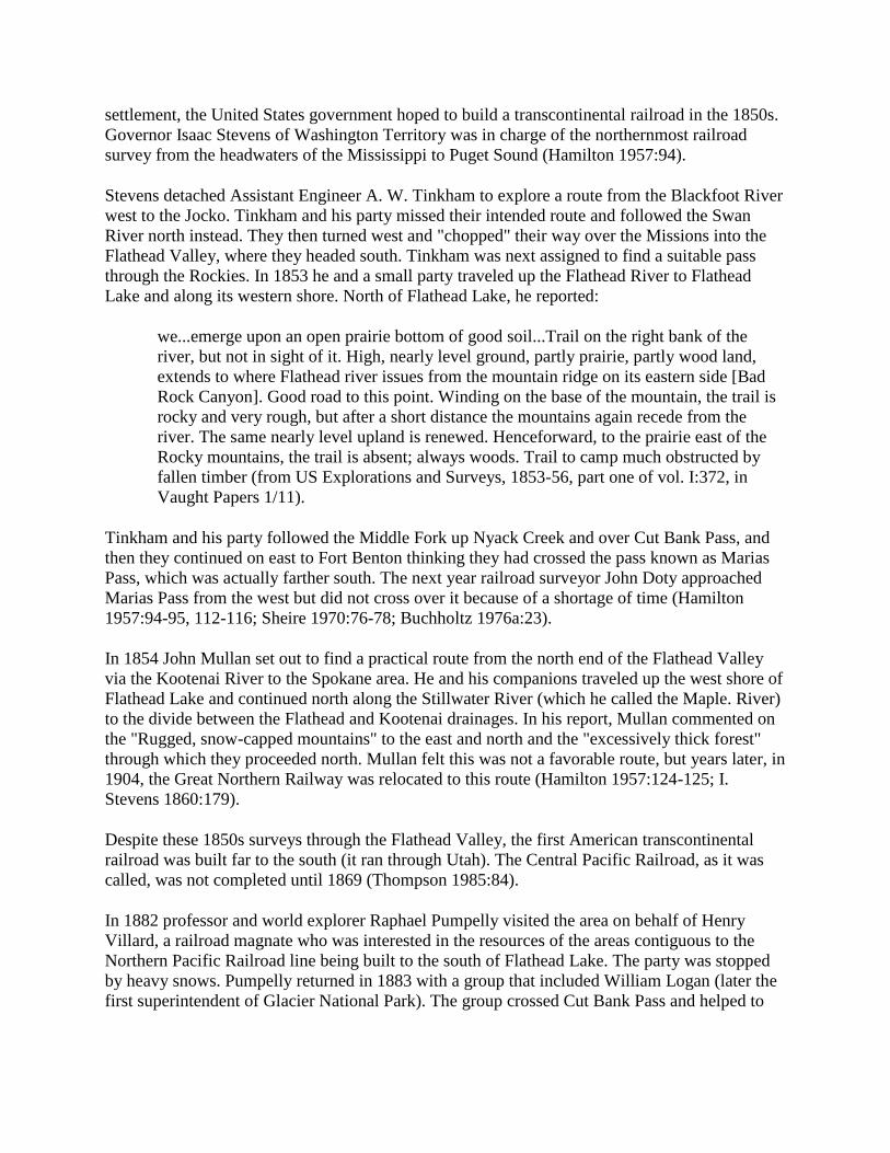
In the early 1900s the international boundary line was resurveyed and new concrete monuments
replaced the original piles of stones (see Figure 6). Joe Eastland, a guide for the United States
Geological Survey (USGS) survey crew under a man named Chapman, described the survey as
follows:
Chapman was a good man but he seemed to be out to make a record. He had the finest bunch of
pack mules I ever saw - seventeen hands high and they were supposed to jump anything they
could see over; we paid no attention to trails. Besides carrying the grub and camp equipment,
these mules carried the transits and other instruments, oats for feed, and cement and water to
make altitude monuments on all the highest peaks. The pack bags for carrying cement and water
were made of heavy solid leather. We usually worked from daylight to dark (O. Johnson
1950:264).
Figure 6. Placing of concrete boundary monument in area now within Glacier
National Park (courtesy of Glacier National Park, West Glacier).

Other Early Explorations
In 1873 Lt. Charles A. Woodruff and Lt. John T. Van Orsdale returned from a military
reconnaissance to Fort Colville via the Flathead Valley. They traveled up the Middle Fork to the
mouth of Nyack Creek, probably crossing over Pitamakin Pass. On their trip they named Lake
Terry - now known as Lake McDonald - in honor of a well-known western general named Alfred
Terry. In 1883 Van Orsdale published a letter in a Fort Benton newspaper describing the scenery
of the area and recommending that it be set aside as a national park. He was the first to do so in
writing (Sheire 1970:97-98).
In 1890 an Army detachment of African-American soldiers under Lt. George P. Ahern explored
the mountains along the Canadian border. They traveled up the Belly River, crossed Ahern Pass,
and continued to the Camas Creek Valley of the North Fork of the Flathead. With axemen
cutting out the way ahead of them, they covered a total of about 370 miles on foot or in the
saddle. At the end of their trip they emerged into the Flathead Valley, which one of the travelers
described as follows: "Dense forests of pine, spruce, hemlock, etc., crowd the valley of the
Flathead and those of its tributaries on the east down nearly to Flathead lake. Here on the prairie-
like openings a few ranches have been established" (Culver 1891:188-193).

MINING
Introduction
The Flathead Valley has never experienced a major mining boom. In the early years, the area
was most closely connected to the rush to the diggings at Wild Horse Creek in British Columbia
in 1864 (see Figure 7). The development of mining districts in the Flathead was hampered by
transportation and marketing challenges. The only mining district to ship significant quantities of
ore was Hog Heaven, which operated in the late 1920s through 1946.
Figure 7. Historic mining districts in northwestern Montana and vicinity.
During the 1930s there was a resurgence of interest in mining among unemployed people
looking for ways to supplement their incomes. Local men and women prospected in the
mountains of the Flathead National Forest, but as in earlier decades they generally had little
success. Only one mining claim on the Flathead National Forest has been patented (the Baptiste

claim with copper values near Baptiste Mountain). Other claims have been staked, but the land is
still within the national forest system.
Evidence of mining activity on the Forest is not as rich as it is in other parts of Montana,
generally because the Flathead did not experience an extensive mining boom. Prospectors' pits
and cabins can still be found, however, and remains of mine development in the Hog Heaven and
Star Meadow mining districts exist today. Most of the evidence of the coal mining in the North
Fork is now gone.
Oil Fields
The founding of Columbia Falls in 1891 and the arrival of the Great Northern Railway in the
Flathead Valley that same year led to increased interest in the natural resources, particularly
mineral, up the North Fork of the Flathead. In 1892 prospectors filed the first oil claims in
Montana, which were located in the Kintla Lake area of the North Fork within what is now
Glacier National Park. Although Native Americans and fur trappers had reportedly known of oil
seeps in the area for some time, these prospectors were alerted by bear hides sold at Tobacco
Plains that smelled of kerosene. In 1892 a local newspaper reported that the North Fork valley
had been taken up by settlers hoping to find oil beneath their homesteads and waiting to hear of a
railroad coming up the valley. Neither happened. A shortage of capital combined with the
financial panic of 1893 and the subsequent depression led to the temporary abandonment of the
oil district in the 1890s ("Flathead Coal" 1892:1; DeSanto 1985:26-28; Willis 1901:782; Bick
1986:5).
In 1900 interest in the Kintla oil fields revived. A group of Butte businessmen organized the
Butte Oil Company and the next year filed a claim on land near Kintla Lake. This area was
practically inaccessible at the time; it was reached from Tobacco Plains via a trail over the
Whitefish Divide, along the "coal trail" on the west side of the North Fork, or along the
"Canadian trail" on the east side of the river from Belton (now West Glacier). The Butte Oil
Company therefore hired men to build a road north from Belton to the Kintla area. Workers
completed a rough 8'-wide wagon road in 1901, and drilling machinery from Pennsylvania was
hauled up to Kintla Lake along the road. Drilling began in 1901, other oil companies formed, and
the Kintla oil boom was on (see Figure 8) (DeSanto 1985:28, 30, 31; J. B. Collins to John O.
Bender, 10 August 1901, entry 13, box 5, RG 95, NA). Out-of-state boomers and oil promoters
were putting "their ears to the ground listening for the sloshing of oil," and speculators (including
local people) filed oil claims in the area (Kalispell Bee, 2 July 1901). In 1901 a magazine writer
summed up the excitement over the Kintla oil fields as follows:
perhaps there is no more beautiful region in the whole northwest than this virgin
wilderness, which the enterprise of man will soon convert into a populous and busy
territory with all of the industries of a great oil field in full blast (quoted in Bick
1986:10).

Figure 8. Kintla oil well, located near mouth of Kintla Creek, 1904 (in today's Glacier
National Park) (courtesy of the Mansfield Library, University of Montana, Missoula).
The first oil well on the shore of Kintla Lake reached a final depth of 1400', but in the winter of
1902-03 almost the whole plant burned. The wells never reached a profitable pocket of oil. In
1912 all claims of the Butte Oil Company were declared void. Another company built a derrick
near the North Fork River several miles below Kintla Creek, but it stopped drilling in 1903 due
to a lack of capital (DeSanto 1985, 34-36).
Canadians also got involved in oil exploration and drilling in the area. In late 1901 a Canadian
company began drilling a few miles from the townsite of Waterton. In 1913 there was another
boom of coal and oil exploration in the area as more geological surveys were conducted. A
wagon road was built from Corbin over Flathead Pass south to the boundary, and a survey for a
railroad line paralleled the road. By 1930 three oil and gas companies were once again active on
the Canadian side of the North Fork, and at least three oil derricks were built. Exploration was
spasmodic and was abandoned in the late 1930s, however, because the drilling did not define
sizeable pockets of oil (Ringstad 1976:5).
Oil was discovered in the Swiftcurrent area on the east side of the Rockies in 1903, and a short-
lived boom occurred there. After a few years production declined, however, as the wells were
lost to penetrating water. As of 1911, there were over 200 mining claims in newly created
Glacier National Park. Most of the valid claims were in the Kintla Lake area on the west side and

the Swiftcurrent and Lake Sherburne areas on the east side (Douma 1953:20-21; Buchholtz
1969: 13).
One Flathead Valley resident did do well on oil claims, but the claims were not in the Flathead.
Charlie Emmons homesteaded in the Truman Creek area and later worked as a forest ranger for
the Blackfeet National Forest. Emmons was a self-made practical geologist. With several other
Kalispell residents he raised the money to bring experts from California to examine the Kevin-
Sunburst oil and gas field, and then he gathered leases in the area. His company ended up
realizing great profits (Kalispell Times, 4 December 1941).
In the late 1940s and early 1950s oil and gas companies pressured the Forest Service for leases in
the Bob Marshall Wilderness. No leases were granted because they were seen as incompatible
with wilderness preservation. Exploratory oil and gas work has been done on other drainages and
on private land in various Flathead drainages (Shaw 1967:74, 121).
Coal Deposits
Another early boom in the North Fork of the Flathead revolved around the coal fields located
near Coal Creek. Raphael Pumpelly on his 1883 trip through the northern Rockies identified the
coal beds on west side of the North Fork, and local prospectors promoted and developed the
beds. The Great Northern Railway (GNRR) needed coal for fuel but found the lignite coal in the
North Fork unfit for railroad use. The Anaconda Copper Mining Company (ACM) also
investigated, hoping the coal could be converted to coke and used in its smelting operations, but
found the coal too low-grade for such use (Sheire 1970:195).
In 1887 seven men located coal claims on the Coal Banks at the urging of Marcus Daly of the
ACM. They sold their holdings three years later to James Talbott and others of Columbia Falls'
Northern Improvement Company for $50,000. Talbott had a steamboat built to bring out the coal
via the North Fork of the Flathead. In early 1892 the Oakes set out on its maiden (and only)
voyage; it wrecked in rapids near the mouth of Canyon Creek, short of its destination. The next
year Talbott brought out some coal on a raft, but after the second raft also wrecked he gave up on
this method (Inter Lake, 5 December 1890; Johns 1943 III:38; Rognlien ca. 1940:1-7).
By 1892 the 102' Emerson tunnel had been drive into the bank, exposing about 30' of coal, and
by 1906 several 20-50' tunnels had penetrated a number of outcrops. Eventually the First
National Bank of Butte purchased the coal mine. After the county built the road to Coal Creek in
the 1910s, Claude Elder leased the holdings. He operated the coal mine until 1942, selling coal
as a heating fuel to hotels, hospitals, individuals, and so on in the Flathead Valley. At the start of
World War II, when the demand for low-grade coal decreased, war-time labor shortages
interfered with production, and the mine was shut down (Rowe 1906:49; "Flathead Coal"
1892:1; Glacier View Ranger District 1981:2, 5; Sundborg 1945:9).
Coal beds were also located in the South Fork drainage. In the summer of 1891 William Curran
camped at the coal fields and used the coal for fire and blacksmithing. He and others also found
gold- and silver-bearing quartz in the area. In 1892 Frank Linderman drove a tunnel on his coal
claim in the South Fork and reported, "Men are going in, in great numbers, some with and some

without provisions." The Flathead National Forest's Coal Banks Ranger Station, 35 miles from
Coram near the junction of the Echo Lake and the main South Fork trails, occupied land that had
been claimed as coal lands since 1898. Beyond sinking a shaft about 10' in depth and relocating
each year, however, no significant development work had been done by 1918. The Forest
Service reported that the coal was low-grade lignite, lying in a small strata, and that even if a
railroad were built, coal mining there would not be profitable ("New Mining Country" 1891;
Johns 1943 VII: 115; Flathead National Forest "General Report" 1918).
Prospectors wandered all over the Flathead country in the 1890s. Coal was found on the first
creek above Nyack (then known as Coal Creek), and in approximately 1910 the Ralston brothers
attempted to a develop a coal mine on the Middle Fork within the area that is now the Bob
Marshall Wilderness (Vaught ca. 1943:281; Merriam 1966:21).
On the Canadian side of the international boundary, in the early 1900s a major outcropping
located about 12 miles north of the border in the North Fork was mapped, but there was little
development. The town of Fernie was founded in 1889 when a company was formed to mine
coal in the area. By 1903 six mines had been developed in the Fernie area, and at least one other
was still in operation in 1967 (Ringstad 1976:5; Fernie Historical Association 1967:25, 41).
Placer and Lode Mining
General
For almost a decade after the California gold rush started in 1848, mining was carried on
extensively only within that state. In the 1860s, however, the industry expanded eastward into
the Rockies. Fort Colvile, for years the chief inland post of the HBC, became the first important
center for mining development in the Inland Empire. Walla Walla, another important center, was
founded in 1856 (Trimble 1914:7, 10-11, 15, 21).
The first gold in the future state of Montana was discovered in the early 1850s, but no rush of
miners came into Montana until the strikes at Bannack City (1862), Alder Gulch (1863), and
Last Chance Gulch (1864). From these mining towns prospectors ventured out looking for new
lodes. Mining dramatically hastened the pace of development in the region. The large population
increases led to increased demands for timber, transportation, and goods and services. Placer
gold started the early rushes because it was easily recognizable and it could be extracted without
large investments of capital.
The first gold stampede that directly affected the upper Flathead Valley was the rush to the Wild
Horse diggings in British Columbia in 1864. The previous year two men had brought gold dust
and nuggets found in what became known as Finlay Creek to the trader at Fort Kootenai in
Tobacco Plains. Prospectors flooded into the area the next year, and a rich mining town sprang
up. Most of the miners came from the United States, coming in from Walla Walla and the Idaho
panhandle, but some traveled north through Montana. In 1865 there were over 5,000 miners in
the area. This rush had the secondary effect of familiarizing some people with the upper Flathead
country, and a number returned to the area to prospect after the profits at Wild Horse declined
(Isch 1948:64; Graham 1945:126, 131, 132; Ivorson n.d.:42).

There was also some mining activity to the west of the Flathead Valley during this period. By the
fall of 1867 over 500 miners were working on Libby Creek (a second rush in that area began in
1885). A placer mining stampede reportedly occured on Grave Creek on the west side of the
Whitefish Divide in the early 1860s. The most productive mine in the Whitefish Divide was
Independence, which yielded chalcopyrites of copper (a mineral consisting of copper-iron
sulfide, an important ore of copper). Twelve men were working the mine in 1894 and shipping
the ore by boat to Jennings (M. J. White 1993a:3; O. Johnson 1950:35-36; Wolle 1963:287).
Many of the professional miners left the area in the late 1890s, however, pulled to the far north
by the Klondike gold rush.
By 1870 the population of Montana territory was declining and so was its mining output. Fifteen
years later, however, all had changed; the mines in the Anaconda-Butte area were so productive
they were influencing world prices. Mining in Montana then took on a new form based on
industrial centers and company towns (Paul 1963:143, 148).
Prospector's Life
The General Mining Act of 1872 made mineral lands a distinct class of public lands subject to
sale under prices and requirements different from other lands. Any citizen finding a valuable
mineral deposit on public land was entitled to the mineral without paying the government royalty
or rent. He obtained title to the minerals by staking a claim and reporting the location to county
officials. He was required to spend at least $100 a year on labor and improvements. Each locator
was allowed to claim 20 acres of placer ground. For lode claims, miners could claim 1500' along
the vein and up to 300' on either side of the contour of the ledge. Miners and prospectors were
granted free-use permits to log timber to develop their claims. Once the property was producing
ore for shipment, however, they had to pay for this privilege (Dana 1980:27; Stuart 1913:157-
58).
In Montana, the discoverer of a claim was entitled to one claim for discovery and one for
preemption (all others were allowed only one claim). The miner had to mark the boundaries and
post notices giving information on the claim. If locating a lode claim, the miner also had to sink a
discovery shaft at or near the point of discovery going at least 10' vertically and/or horizontally.
According to the 1872 law, a miner could obtain a patent for his claim by having it surveyed,
completing at least $500 in assessment work, filing appropriate notices, and paying $5 per acre
for a lode claim or $2.50 per acre for placer ground.
Prospectors generally traveled in small, organized parties of between 5 and 50 men, and they
were often experienced miners from California. The prospected seasonally, because they could
not work when the streams froze (Trimble 1914:97, 223-224). Once prospectors located a claim,
they generally sold it before development work began, lacking the money needed to develop
mines themselves.
The most common source of placer gold found in Montana was the creek placer. In creek
placers, the movement of water concentrated the gold on bedrock or in the gravels just above
bedrock. A prospector panning for gold checked streambeds all along his route, panned the
gravel in streambeds, and pecked at rock outcroppings and examined old streambeds. When he

found placer gold (versus "fool's gold," or iron pyrite) he staked a claim and recorded it. Then he
might build rockers (long cradles in which the gravel and sand were rocked, the gold sinking to
the bottom as water flowed through). Or, he might build sluices, long connected troughs with
cleated bottoms that caught the gold particles. A sluice required large amounts of water (and thus
ditches) and a crew of several men to operate.
Once the placer gold was exhausted from his claim, the miner would work his way upstream
looking for the source of the gold. He would find lodes in the hills and stake off claims to
outcrops, then dig prospect holes. He would also construct drifts by digging a tunnel into the
bank of a gulch to reach pay gravel. Lode miners used hand drills and jacks to drill into rock.
This was followed by blasting, with powder packed into each drill hole. Various technological
changes improved the drilling and blasting operations.
Gold from lode mines had to be recovered by grinding or stamping to pulverize the rock. If the
ore was refractory (if threads or small particles were imbedded in other rock), the valuable gold
or silver had to be released by chemicals or by roasting in a smelter (Wolle 1963:15-16, 18).
The simplest way to crush the ore was by using an arrastra. The arrastra was a shallow circular
pit paved with flat stones. A horse pulled a sweep attached to a heavy dragstone across the
chunks of ore. When ground to a powder, the ore was mixed with water and mercury for further
processing. Another method of crushing the ore was the stamp mill, which pounded the ore with
iron-bottomed stamps. Silver combines readily with other minerals in its natural state, so it
required a more difficult processing method than gold. After crushing, silver ore was
amalgamated or roasted to form chlorides that were treated through pan amalgamation and
further refined by smelting. Stamp mills and smelters required ready access to capital; lode
mining is much larger in scale and capital requirements than placer mining.
Like trappers' cabins, a miner's cabin was not always very comfortable. As one old-timer put it:
As housekeepers the prospectors varied. On many a claim the cabin was as neat as a wild
flower, but on some the mine tunnel was more livable than the cabin - where the dirt floor
might be deep in discarded tin cans and clothing, the table never cleaned except to add a
new layer of newspaper on top of the old, and the sour-dough jar green with mold (O.
Johnson 1950:39).
The miner's life was often quite difficult. For example, a group of prospectors traveled to the
North Fork of the Flathead from Missoula in 1867. Their leader, E. K. Jaques, was accidentally
shot through both legs by one of his companions. The party camped through the winter while he
healed, returning in the spring to the Flathead Valley (Buchholtz 1976a:28).
Placer and Lode Mining in the Flathead
The evidence of late-1800s prospecting and mining in the Flathead is scattered. "Dutch Lui"
(also known as Luis Meyers) prospected in the northern Rockies beginning in 1885. In 1889, at
the head of Copper (now Valentine) and Quartz creeks, he located a vein carrying gold, silver,

copper, and some lead. This started a minor boom as footloose prospectors came in to investigate
(Buchholtz 1976a:31; Vaught ca. 1943:256, 366).
Another early trip into the region took place in 1876, when Texan William Veach and four other
men headed to the North Fork to prospect. They prospected and trapped in the Logging Lake
area, finding a 30-ounce nugget of gold near Quartz Lake and building a cabin there. Veach was
the hunter and cook for the group; subsequently he returned to Texas (Veach 1939).
Evidence of very early prospecting was found in the area of Doris Creek off the South Fork,
where hunters in 1898 found an old cabin with an adit nearby and piles of quartz studded with
wire gold. Early prospectors also set up an arrastra to crush the ore on Fawn and Wounded Buck
Creeks (there were probably others) (Green 1972 IV:122, 129, 131).
There has been quite a bit of mining activity northwest and southwest of Kalispell over the years.
A sluice box and a diversion dam were installed on Herrig Creek west of Ashley Lake, for
example. The Flathead Mine in the Hog Heaven district southwest of Kalispell was discovered in
1913 but remained idle until lessees discovered the main ore body in 1928. The Anaconda
Copper Mining Company soon took over the lease and shipped high-grade ore intermittently,
with most of the value in silver (they did not ship between 1930 and 1934 because of low silver
prices). In the mid-1940s the mine was employing about 75 men. Three or four other mines were
operating sporadically at that time, including the Ole Mine, about a mile directly west of the
Flathead Mine, which had values in gold, silver, and lead (this was later developed again in the
1960s). The mine that produced more than 90% of the ore in the district, the Flathead Mine,
closed in 1946 (Johns 1970:85, 137, 141; Sandvig 1947:35, 38; Sundborg 1945:59-60).
Several productive mines during the historic period were located in the Star Meadow mining
district (see Figure 9). The Sullivan mine, which opened in the early 1890s, was located about 10
miles from Tally Lake. The copper ore was packed out by horses, but eventually the promising
lead was cut off by a fault. In 1925 Glen Sucetti re-opened this mine and found a new lead of
ore, and by 1934 he had constructed some buildings at the site ("Flathead's Mining" 1931:5;
"Development" 1934:8).

Figure 9. Star Meadow mining district, showing locations of mines (Johns 1970:132).
Other mines in the Tally Lake area were located in the vicinity of Logan Creek (named for miner
and attorney Sidney Logan) and Sanko Creek (named for miner Fred Sanko). The Foolsberg and
the West Virginia Mines were located on the ridge between Sullivan and Griffin Creeks. The
former was developed in 1920, the latter in the 1890s. The Blacktail prospect was discovered
after the 1936 Sanko Creek fire burned the vegetation that had been obscuring the copper-
containing vein. A few other claims in the Star Meadow district produced some ore in the 1920s
and 1930s. The valuable ore contained copper with some gold and silver. Many other mines were

developed but never went into production ("Tally Lake RD List of Names "in TLRD; Johns
1970:131-37).
The South Fork of the Flathead also had numerous mining claims for a time. In 1892 a local
newspaper boasted that the South Fork "is now supposed to be one of the richest mineral regions
in the State." In 1891 Baptiste Joyal and William Curran toured the South Fork, finding copper,
silver, and gold, plus coal beds. By 1898, however, no ore had been shipped from the valley, and
a surveyor passing through noted only about six cabins that were occupied seasonally by
prospectors doing their assessment work. In 1913 another boom hit the South Fork, this time
because of a copper strike about 35 miles south of Coram, with Felix Creek running through the
center of the claims (Johns 1943 VII:39; Ayres "Lewis & Clarke" 1900:73; "Flathead Copper"
1913:1).
Baptiste Joyal (also known as XJoyal, Zeroyal, Zeroyle) trapped in the South Fork and was one
of the first Euroamericans to live in the area. Like other prospectors, Joyal sometimes earned
extra cash by working as a guide for miners. He guided two prosperous California miners across
the Rockies by going up the South Fork and down the Sun River (Opalka 1983; Shaw 1967:46).
Joyal died in the winter of 1909 in his cabin on Hoke Creek.
Another French-Canadian South Fork prospector was Felix Drollette. He worked Felix Basin and
was the original prospector in Silver Basin, at the head of Logan Creek. A man named Harris had
a cabin at the junction of Felix and Harris Creeks, and he had mine shafts at least 8 miles up the
creek. Harris set up a tent camp in the Coram area, built a bunkhouse and a messhall in the area
of the mine, and hired men to prospect the Hoke/Baptiste area, but he found only copper stain, no
ore (Opalka n.d.; Opalka 1983; Martin 1983; Green 1972 IV: 133).
Farther up the South Fork, Levi Gaustadt filed a barite claim in 1958 on Black Bear Creek.
Although the material was assayed as highly productive, the claim was never patented (Shaw
1967:22).
Prospectors spent long weeks searching the drainages of the Middle Fork of the Flathead for
valuable minerals with little success. In 1899 there were reportedly several new claim stakes
between Bear Creek and Java, and some copper claims were staked in 1898 on Summit Creek
not far above Java. Several miners staked claims near Bear Creek on the Middle Fork, including
Kalispell attorney Sidney Logan and nearby homesteaders Louise and Philip Giefer. Some
mining claims were also located in the Belton and Essex areas (in fact, Almeda Lake may be
named for a woman named Almeda who was listed as a mine claimant) (Ayres "Lewis & Clarke"
1900:37; Ayres "Flathead" 1900:313; Holterman 1985:19-20, 45).
Two French-Canadians named Pauket prospected in the 1890s all over the Flathead area. They
located claims on Deerlick creek near Nyack in the Middle Fork, driving an adit in the face of a
cliff. They spent a winter in Butte, as many Flathead miners did, and the next year sold out for
$8,000. In 1934 a claim near Garry Lookout above Nyack was worked, causing a minor rush of
prospectors to the area, but most abandoned their prospects (Green 1972 IV: 134, 141).

Northeast of Eureka, prospectors staked several copper-silver-lead claims in the 1890s in the
Bluebird Basin. During the summer of 1894, 12 men worked on the mine and shipped ore to
Great Falls for processing. Profits were low over the years, and development plans were curtailed
with the coming of World War I. In 1912 a mining claim was located near Upper Whitefish Lake
with men digging a prospect tunnel 155' deep into the mountain. A little earlier, in 1905, the
Lupfer Mining Company had claims eight miles northwest of Whitefish, but this company
disappeared within a year. Charlie Oettiker, who homesteaded on Oettiker Creek, claimed to
have found gold, silver, platinum, and uranium in an outcrop behind his cabin (O. Johnson
1950:37-38; Shea 1977:117; "Prospect Tunnel" 1912; Schafer 1973:67; Boettcher 1974:221).
Other miners started excited rumors about finds, but the real money was actually made in real
estate.
Very little prospecting or development work was ever done in the Swan Valley. In 1899, H. B.
Ayres reported that there was no mining work or prospecting in the Swan. In 1908 Joe
Waldbillig filed a mining claim at the mouth of Holland Lake, but he probably never worked it.
There are a tunnel and track east of Owl Creek and abandoned mines on the west slopes of the
Swan Range farther north, in the Lake Blaine area and on Columbia Mountain. One prospector
who spent every summer in the Missions for 30-some years, reported that "all I got is a sore
back" (Ayres "Lewis & Clarke" 1900:80; Wolff 1980:53; Beck 1981).

SETTLEMENT AND AGRICULTURE
Introduction
Since the flow of miners through the area in the 1860s, the location and growth of communities
in northwestern Montana have depended on the location of the railroad and other transportation
routes, the topography, the development of markets, and government land policies. The most
significant influence on the settlement of the Flathead Valley was the coming of the Great
Northern Railway to the valley in 1891. The Forest Homestead Act of 1906 encouraged
settlement of agricultural land within national forests. These "forest homesteads" are discussed in
a separate chapter.
Settlement Up to 1871
The original inhabitants of northwestern Montana were, of course, Native Americans. One of the
centers of Kootenai activity was the Tobacco Plains along the Kootenai River. Prior to 1850 the
Kootenai hunted seasonally at Flathead Lake, competing with the Pend d'Oreilles, but after that
time they lived there permanently, replacing or intermixing with the original population (Malouf
1952:2). The fur trade brought to the Native Americans of northwestern Montana an influx of
trade goods along with the replacement of the aboriginal economy with new materials, the
hunting and trapping of game for material gain over long-term subsistence, and disease,
oppressive government policies, and restrictions of their movements.
The only way to earn a living in the early 1850s was by hunting, trapping, or trading, or by
working for someone else who hunted, trapped, or traded. In those years many people of French-
Canadian, Scottish, and Iroquois heritage lived in western Montana, a legacy from the fur trade
(Weisel 1955:xxiv, 48).
The Hellgate Treaty of 1855 established the Flathead Indian Reservation in the lower Flathead
Valley for the Flathead (or Salish), Pend d'Oreille (or Kalispel), and Kootenai tribes. Most of the
bands of these tribes slowly moved onto the Reservation. The creation of the Reservation opened
the door to permanent non-Native American settlement of the valleys of western Montana. In
1887 the Dawes Act divided the rich bottomlands of the Reservation into individual allotments,
and the land considered surplus was given to Euroamerican settlers (Historical Research
Associates 1977:6-7).
John Owen established Fort Owen in the Bitterroot in 1850, and for a few years he traded with
Native Americans, people of mixed descent, and the few Euroamericans in the area, all of whom
paid mostly in livestock, furs, or labor. According to Owen's ledger and other sources, in 1851
the only Euroamericans in western Montana were a few Jesuits, HBC men, and about 15 others,
including two mountain men. In 1860 Owen faced his first trading competition, when Frank
Worden and Christopher Higgins built a trading post at Hellgate on the Mullan Road. From then
on, Fort Owen was no longer the center of trade in the area (Weisel 1955:xxiii, xxx).

In 1858, the resident non-Native American population of Missoula County (all of northwestern
Montana at that time) was approximately 200 people. Because the Oregon trail lay 200 miles
south of western Montana, most emigrants never saw the region. The early settlement of western
Montana was overshadowed by placer gold mining beginning in the early 1860s. The Mullan
Road, built from 1859-62 between Fort Benton and Walla Walla, enabled the mining
development of western Montana. During the 1860s, western Montana was not self-sufficient.
Local flour and lumber and some agricultural products were available in the Missoula area, but
all manufactured items had to be brought in. In 1870 the population of Missoula County was just
over 2,500, but by 1880 it had hardly changed (these figures do not include the gold miners
passing through the area) (Coon 1926:49-50, 53, 56-57, 68, 71).
The W. W. DeLacy map published in 1870 showed a "half-breed" settlement located north of
Flathead Lake, where a Native American trail crossed Ashley Creek. The small settlement had
been established several decades earlier. In 1845 two French Canadians joined the Kootenai
living at the north end of the lake and built a cabin on Ashley Creek, spending most of a year
there. Two years later, four more French Canadians arrived, including Louis Brun, a Quebequois,
and his Kalispel wife Emily. When gold was discovered in California, they and other families,
including a man named Benetsee Finley, left for the gold fields. Most of them returned to the
Ashley Creek area in 1850, but the Bruns moved to the Jocko area and then Frenchtown. Men
who came and returned to the Flathead in 1850 may have included Joe Ashley and Francois
Grevelle, both of whom are mentioned often in histories of the early settlement of the Flathead
Valley. When Lt. John Mullan passed through the upper Flathead Valley in 1854, he reported
that "Our camping ground — was represented — by the Indians as a great resort of their tribe
and the half-breeds of the country some years ago" (Holterman 1985:25; Shea 1977:37-38, 41; T.
White 1964:27).
Joe Ashley, for whom Ashley Creek is named, had come to the Flathead in the mid-1840s. He
and Angus McDonald (an HBC trader), Peter Irvine (a Shetlander), Francois Finley, and
Laughlin McLaurin and several others farmed in a small way at the head of the lake. McLaurin
(also spelled McLaughlin, McLaren, or McGauvin) was among the first traders at a post near the
head of Flathead Lake. Ashley succeeded McLaughlin as trader, under the supervision of Angus
McDonald of Fort Connah. In the late 1860s several of the families living at Ashley Creek left
the area because of Blackfeet raiding, some only temporarily. Ashley stayed on, later moving to
the foot of Flathead Lake and then selling out in the 1880s and leaving the area (Shea 1977:39-
40; McCurdy 1976:71-72; Johns 1943 1:35).
There are reports of a few Euroamericans coming through the Flathead Valley in the 1860s
besides those who settled at the head of the lake and those heading to the mines in southeastern
British Columbia. Some traveled into Montana from the north. Carpenter Esna D. Dashiell
arrived at Flathead Lake in August of 1864. Frank Normandie came to Montana from the Fraser
River in Canada and continued on to the Deer Lodge Valley via Flathead Lake in 1862 (Johns
1943 IX: 149).
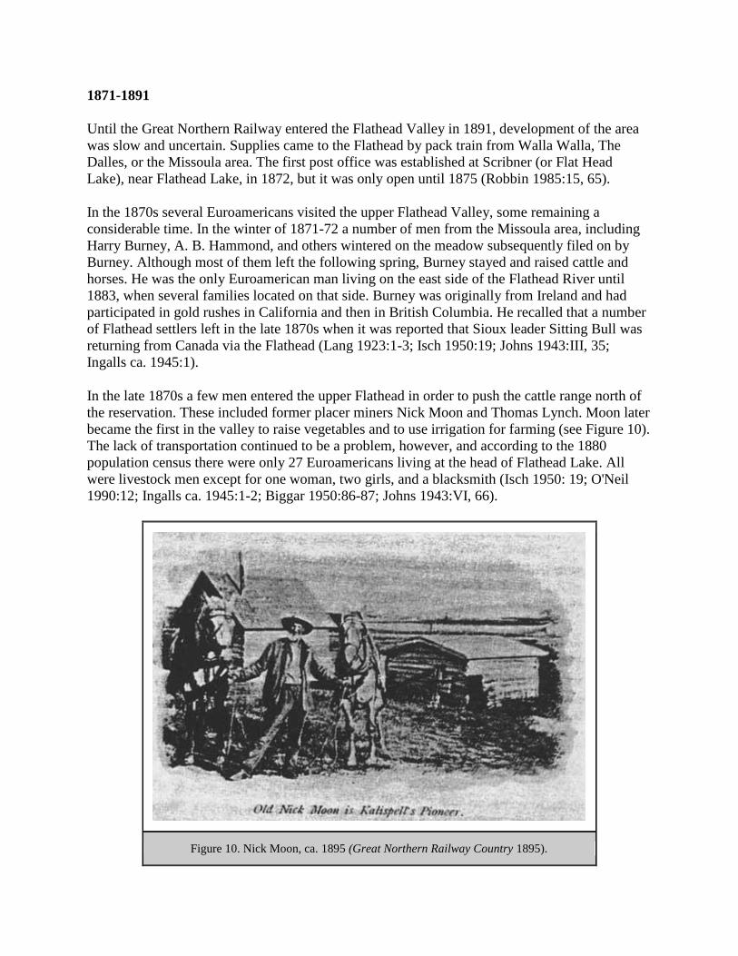
1871-1891
Until the Great Northern Railway entered the Flathead Valley in 1891, development of the area
was slow and uncertain. Supplies came to the Flathead by pack train from Walla Walla, The
Dalles, or the Missoula area. The first post office was established at Scribner (or Flat Head
Lake), near Flathead Lake, in 1872, but it was only open until 1875 (Robbin 1985:15, 65).
In the 1870s several Euroamericans visited the upper Flathead Valley, some remaining a
considerable time. In the winter of 1871-72 a number of men from the Missoula area, including
Harry Burney, A. B. Hammond, and others wintered on the meadow subsequently filed on by
Burney. Although most of them left the following spring, Burney stayed and raised cattle and
horses. He was the only Euroamerican man living on the east side of the Flathead River until
1883, when several families located on that side. Burney was originally from Ireland and had
participated in gold rushes in California and then in British Columbia. He recalled that a number
of Flathead settlers left in the late 1870s when it was reported that Sioux leader Sitting Bull was
returning from Canada via the Flathead (Lang 1923:1-3; Isch 1950:19; Johns 1943:III, 35;
Ingalls ca. 1945:1).
In the late 1870s a few men entered the upper Flathead in order to push the cattle range north of
the reservation. These included former placer miners Nick Moon and Thomas Lynch. Moon later
became the first in the valley to raise vegetables and to use irrigation for farming (see Figure 10).
The lack of transportation continued to be a problem, however, and according to the 1880
population census there were only 27 Euroamericans living at the head of Flathead Lake. All
were livestock men except for one woman, two girls, and a blacksmith (Isch 1950: 19; O'Neil
1990:12; Ingalls ca. 1945:1-2; Biggar 1950:86-87; Johns 1943:VI, 66).
Figure 10. Nick Moon, ca. 1895 (Great Northern Railway Country 1895).
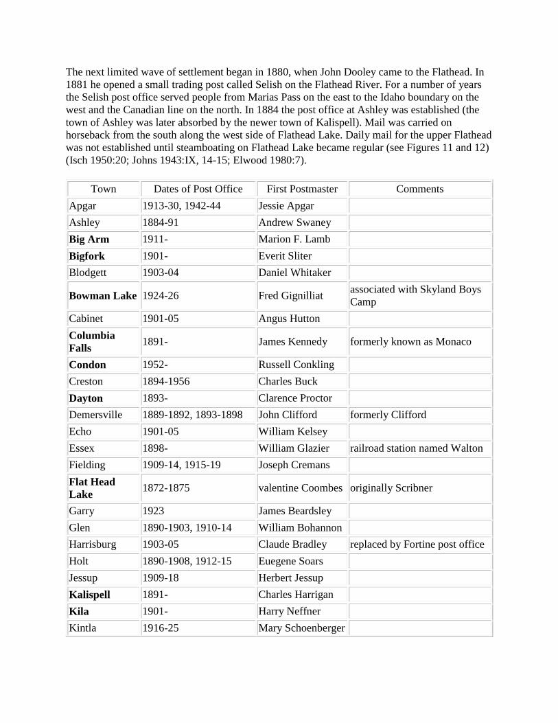
The next limited wave of settlement began in 1880, when John Dooley came to the Flathead. In
1881 he opened a small trading post called Selish on the Flathead River. For a number of years
the Selish post office served people from Marias Pass on the east to the Idaho boundary on the
west and the Canadian line on the north. In 1884 the post office at Ashley was established (the
town of Ashley was later absorbed by the newer town of Kalispell). Mail was carried on
horseback from the south along the west side of Flathead Lake. Daily mail for the upper Flathead
was not established until steamboating on Flathead Lake became regular (see Figures 11 and 12)
(Isch 1950:20; Johns 1943:IX, 14-15; Elwood 1980:7).
Town Dates of Post Office First Postmaster Comments
Apgar 1913-30, 1942-44 Jessie Apgar
Ashley 1884-91 Andrew Swaney
Big Arm 1911- Marion F. Lamb
Bigfork 1901- Everit Sliter
Blodgett 1903-04 Daniel Whitaker
Bowman Lake 1924-26 Fred Gignilliat associated with Skyland Boys
Camp
Cabinet 1901-05 Angus Hutton
Columbia
Falls 1891- James Kennedy formerly known as Monaco
Condon 1952- Russell Conkling
Creston 1894-1956 Charles Buck
Dayton 1893- Clarence Proctor
Demersville 1889-1892, 1893-1898 John Clifford formerly Clifford
Echo 1901-05 William Kelsey
Essex 1898- William Glazier railroad station named Walton
Fielding 1909-14, 1915-19 Joseph Cremans
Flat Head
Lake 1872-1875 valentine Coombes originally Scribner
Garry 1923 James Beardsley
Glen 1890-1903, 1910-14 William Bohannon
Harrisburg 1903-05 Claude Bradley replaced by Fortine post office
Holt 1890-1908, 1912-15 Euegene Soars
Jessup 1909-18 Herbert Jessup
Kalispell 1891- Charles Harrigan
Kila 1901- Harry Neffner
Kintla 1916-25 Mary Schoenberger

Lake
McDonald 1905-55, 1946-66 George Snyder head of Lake McDonald
Lakeside 1948- John Stover formerly Chautauqua
LaSalle 1900-05 Walter Jellison
Leona 1896-1899 Frank Strycker
Lupfer 1917, 1924-25, 1930-34 Hubert Herman
Marion 1892-1894, 1904-06,
1930-34 Charles Mitchell also called Swan
Marston 1895-1907 Cyrus Marston
Martin City 1947- Clara Frederick
Mock 1921-39 Peter B. Wiggen
Montford 1900-10 Arthur Lindsey
Murray 1900 Isaac Murray
Nyack 1912-42 George Robertson railroad station called Red
Eagle
Olney 1907-08, 1914-17, 1918- Elizabeth
Dickerhoof
Paola 1914-19, 1920-28 Marie Cameron
Pleasant Valley 1892-1895, 1901-05 George Allen formerly Richland and
Meadow
Polebridge 1920- Benjamin Hansen
Polson 1898- Henry Therriault
Proctor 1910- Clarence Proctor
Rollins 1904- Rehenault Rollins
Selish 1881-1891 John Dooley
Sheldon 1887-1903 Sarah Sheldon
Somers 1901- John Sawyer
Trail Creek 1921-54 Benjamin Price
Trego 1911-19 Charles Miller
West Glacier 1900- Edward Dow formerly Belton
Whitefish 1903- John Skyles
Figure 11. Post offices in the Flathead Valley area. Towns in bold type still
have post offices; the rest do not (Cheney 1983: passim).

Figure 12. Locations of most of the towns that have had post offices in the Flathead Valley
area.
Although some settlers were moving in, the relatively few residents of the Flathead in the early
1880s were mostly quartz miners from Butte and other areas, a few trappers, some buffalo
hunters, and a number of French Canadians. According to Frank Linderman, "Without the least
knowlege of farming these men, many of them confirmed bachelors, took up claims and became
farmers as though they had reached the realization of a lifelong dream." Many family men found
it necessary to leave their wives and children behind in the Flathead to prove up on their 160-

acre homestead claims while the men worked in the mines in Butte, lumber mills, and so on.
Others would live on their claims for the shortest time required and then make cash entry proof
and return to their jobs (Linderman 1968:45; Mauritson 1954; Duncan ca. 1923:5).
The early stockmen tried to discourage farming in the upper Flathead, telling newcomers tales of
early frosts, low rainfall, and vicious mosquitos. Until the late 1880s, in fact, very few
agricultural products were raised in the area; most were brought in from Missoula. Since the
early market for produce was local only, many farmers also spent much of their time logging
(Mauritson 1954; Elwood 1980:6).
In the 1880s the Flathead Valley was largely wooded. Scattered through the dense forest were
natural prairies, occasional groves of ponderosa pine, and small lakes. The first area settled was
the high ground to the north and northwest of Kalispell because it was dry and not heavily
timbered; some of the areas that are now good farmland, such as the Creston area, were too wet
and swampy to till in the early years (Murphy 1983:142).
After the Northern Pacific Railroad reached Missoula in 1883, more and more people began
coming to the upper Flathead Valley, some of them railroad construction workers looking for a
place to settle. By 1890 the upper Flathead Valley reportedly had 3,000 occupants. Walkup and
Swaney established a trading post on Ashley Creek along the Fort Steele-Kalispell Trail in 1883.
At that time, the round trip from the post to Missoula took about three weeks. In the early years
of settlement of the Flathead Valley, various bands of Native Americans camped in the valley
tanning hides and selling moccasins and other products to settlers. According to a woman who
lived in the Flathead in 1883, "except for the nomadic Indians, life for the most part, centered
around the trading posts, a few ranches, and an occasional trapper's cabin" (Isch 1950:20-21;
Patterson n.d.: Ch. 15, p. 2; Beck 1981).
Relations between the Native Americans and the incoming settlers were generally peaceful in the
Flathead Valley. Two Kootenai were lynched in Demersville in 1887, however, and three
prospectors were killed on Wolf Creek by Native Americans that same year. African-American
soldiers from Fort Missoula were sent to the Flathead in 1890 as peacekeepers for several
months, but they were not really needed and spent most of their time clearing trails and roads
(Isch 1948:72; Elwood 1980:10-11).
In 1885, when the first school census was taken in the area, only 95 children lived west of the
Flathead River, north of the Flathead Indian Reservation, and south of the Canadian boundary.
Three years later, according to Flathead Valley old-timer George Stannard, there were about 100
families living on valley ranches (Johns 1943:III, 115; Vaught Papers 1/IJ).
T. J. Demers founded the town of Demersville in 1887, located at the head of navigation on the
Flathead River. For a few years, until the rise of Kalispell in the early 1890s, Demersville was
the largest town in the upper Flathead. The first newspaper in northwestern Montana, theInter
Lake, began publishing there in 1889. Settlers flowed in and out of Demersville, most of them
trying to reap profits from the Flathead's abundant resources or from each other (McKay 1993).

Montana Territory, established in 1864, became a state in 1889, primarily because of concern
over the lack of local political control. By this time, settlement of the upper Flathead had begun
in earnest. A few early settlers of the upper Flathead Valley even decided that settlement was
getting "too thick." For example, George Hall, a prospector, hunter and trapper, left the Flathead
in 1889 to move to Alaska (Vaught Papers 1/K).
Flathead County was created out of Missoula County in 1893 because of the long distance to
Missoula. The county originally had about 8,500 square miles, but subsequent additions and
losses (due to the formation of other counties) reduced its size substantially (see Figure 13).
Kalispell became the county seat in 1894.
Figure 13. Counties in western Montana: 1889, 1904, 1918, 1925 (from Cheney 1983).

1891 to World War II
When the Great Northern Railway was deciding where to lay its route through the valley,
Demersville boasted of its navigable waters, Ashley that it was at the valley's natural outlet to the
west, and Columbia Falls that it was where the tracks had to emerge from Bad Rock Canyon
(Elwood 1980:30). But the GNRR chose none of these existing towns as its headquarters;
instead, the new town of Kalispell became the division point.
When the railroad was known to be coming through the Flathead, old prospectors and ranchers
came in to homestead the land. They were speculators on a small scale; they obtained title until
other settlers came to purchase their land. Soon after the railroad arrived, experienced farmers
followed ("Kalispell and the Famous Flathead" 1894:6). For several decades the GNRR operated
an extensive advertising campaign to attract settlement to towns along its railroad line, including
towns and agricultural areas in western Montana.
Several existing towns in the Flathead were founded directly because of the railroad coming
through the valley. One of these was Columbia Falls, which was platted by a group of Butte
business men as a speculative venture. Kalispell was established in 1891, soon replacing
Demersville four miles to the southeast, to serve as the division point for the railroad (see Figure
14). In 1904 the main line of the Great Northern was moved to the north end of the valley, and
the town of Whitefish was platted and carved out of the woods to serve as the new division point
(the previous settlement in the area had been located at the foot of Whitefish Lake). Whitefish
grew rapidly, and by spring of 1905 it boasted 950 residents, many of them railroad workers
(Macomber 1976:3; Schafer 1973:2, 6, 27). The town of Essex (formerly called Walton) was
established as a railroad town, and it too housed many railroad workers (the helper engines that
bring trains over Marias Pass have always been based out of Essex).
Figure 14. Street scene in Kalispell, ca. 1895 (Great Northern Railway Country 1895).

The Japanese who worked for the railroad were hired and cared for by an employment agency
called the Oriental Trading Company, which opened a Kalispell branch in 1899. Two years later
the company had about 750 men working on the Kalispell division (McKay 1993:18).
The NPRR hired 15,000 Chinese to help construct its line through Washington, Idaho, and
Montana in the early 1880s, but very few if any Chinese appear to have worked on the GNRR.
Instead, Chinese in the Flathead Valley provided a variety of goods and services, owning or
working in laundries, restaurants, and stores and working as servants, cooks, and gardeners. In
the mid-1880s an anti-Chinese movement throughout the West caused many to flee to urban
centers. The first Chinese Exclusion Act was passed in 1882, prohibiting Chinese labor
immigration. A 1902 act banned all Chinese from entering the United States for temporary
settlement purposes. In 1895 Kalispell labor organizations launched a boycott against businesses
employing or buying from Chinese. Both Chinese men and opium (after it became illegal) were
smuggled across the border from Canada at Gateway and along the North Fork of the Flathead in
the 1890s and following years. The Chinese community in Kalispell, as elsewhere, eventually
disappeared because of laws prohibiting immigration and because the group was
overwhelmingly male (McKay 1993:20-21; Elwood 1980:61).
Between 1910 and 1934 more than 61,000 acres of the Flathead Indian Reservation passed out of
Native American ownership. Some Euroamericans bought summer home sites on Flathead Lake,
but more commonly they registered for land in 1909 and selected homesteads when the
Reservation was opened for settlement (Bergman 1962:85-89; Biggar 1950:131, 134, 137-138).
The first cash crops grown in the upper Flathead were oats (largely for home feed), wheat, and
potatoes. The financial panic of 1893 led to very low agricultural prices for a time, but soon
prices and demand rose. There was such a demand for labor that a delegate was sent East to
induce laborers to come to the Flathead, and reportedly several thousand did come to the
Flathead to live and work. In 1897 a number left for the Klondike gold rush, but that same gold
rush created a demand for food and other products that aided the Flathead. Similarly, the
Spanish-American War of 1898 slowed the general economy some, but the war demand for
horses and supplies helped the local economy (Mauritson 1954).
In the early 1900s in the Flathead, farmers were raising spring and winter wheat, oats, rye,
timothy hay, clovers, vegetables, dairy cattle, and various fruits. The population of the Flathead
boomed in the 1910s because of high agricultural prices and high yields. The agricultural
drought started in the spring of 1917, and 1918 was "unrelievedly grim" in Montana. The
Flathead was not seriously affected by the drought until 1919, however (Read 1904:49-50; Toole
1972:71-72).
Apple orchards and other fruits were being raised along Flathead Lake by the 1890s. The first
commercial cherry orchard on the east shore of Flathead Lake was planted in 1930, and a cherry
growers' cooperative was organized in 1935 (the year of a freeze that killed many trees) (Robbin
1985:, 73-74, 77).
In the 1930s farm families from drought-stricken eastern Montana moved to the Flathead, but
many of these settled on unsuitable land. By the spring of 1939 there were 1,150 farm families in

Flathead County who were classified as migratory or stranded, living on submarginal or cut over
lands and unable to earn a living. Flathead County had far more destitute farmers at that time
than any other county in Montana. After peaking in 1938, the county's population declined in the
early 1940s. Flathead County furnished more men per capita to the armed services in World War
II than any other county in the United States (Sundborg 1945:11).
Tractors were first used in the Flathead in 1905, but they were not widely employed until World
War I and later. The mechanization of logging in the 1930s led to the end of the market for
horses and horse feed. Extension work started in the county in 1914, and the Northwestern
Montana Branch Experiment station was established in Creston in 1946 (Mauritson 1954).
In 1940, less than 3% of the agricultural land in the county was irrigated. In 1945, the principal
crops of Flathead County farms were field crops, livestock, and dairy products (Sundborg
1945:39, 48). Peppermint oil, now an important Flathead agricultural crop, had not yet been tried
in the Flathead Valley.
The more inaccessible valleys of the Flathead were not settled as early as the main valley. The
Middle Fork, for example, had only a few squatters in 1899, but in 1923 a school was built in
Nyack to accommodate settlers' children. Essex had a number of residents early on because of
the railroad work there, but the other railroad stations were section houses only. Coram (also
known as Citadel) was not founded until 1905, when it was established as a logging town. By the
late 1890s there were a few prospectors' cabins in the South Fork (one, belonging to "Batti," was
probably that of Baptiste Joyal) (Sztaray 1994:14; Ayres "Lewis & Clarke" 1900:55, 68;
newspaper article in FNF CR).
Bigfork was platted in the early 1900s by Everit Sliter, who had a large orchard there. The
hydroelectric plant in Bigfork was built in 1901 to serve the valley. In the early 1900s there was
great excitement about a pulp mill that was believed to be coming to Bigfork but never
materialized. Near Bigfork was a ferry on the Flathead River, Holt Ferry, that was not replaced
by a bridge until 1942 (Robbin 1985:59; Elwood 1980:198; Flint 1957:7).
Kila was originally a station stop on the Great Northern known as Sedan. The town was platted
in 1914 and was named for William Kiley, a partner in the Enterprise Lumber Company mill
located there (Elwood 1980:209).
The upper Swan Lake area was first settled in the early 1890s by people living around Goat and
Lion Creeks. In 1899 there were only about 10 houses (all unoccupied) between the head of
Swan Lake and Holland ranch at the mouth of Holland Creek. Ben Holland sold his ranch to the
Gordons in 1905 (he had earlier named Gordon Pass for his friend Dr. Gordon). There was also a
trapper's cabin at the foot of Elbow (Lindbergh) Lake at that time (Flint 1957:30; Ayres 1900
"Lewis & Clarke":55; Wolff 1980:53).
One of the most colorful, if short-lived, towns in the area was McCarthysville, located on a tract
of level ground between Summit (Marias Pass) and Essex (see Figure 15). The town was
founded by a timber cruiser, Eugene McCarthy, while he was inventorying the timber resources
along the proposed railroad right-of-way through the area in 1890. The town was located on one

side of Bear Creek and the railroad construction camp on the other side (the latter housed up to
4,000 workers). The resident population of McCarthysville peaked at about 1,000 people, and
during this period one passer-through labeled it a "seething Sodom of Wickedness." The
construction camp was moved when the railroad reached the Flathead Valley in 1891, and the
headquarters was relocated to Kalispell, Most of McCarthysville was destroyed by fire in 1921
(Murphy 1993; Hidy 1988:81; Atkinson 1985:16).
Figure 15. The town of McCarthysville, located along the Great Northern
Railway line near Bear Creek, ca. 1918 (courtesy of Glacier National Park,
West Glacier).
World War II to Present
The establishment of new communities in the Flathead Valley after World War II was directly
linked to the building of the Hungry Horse Dam, completed in 1953. The towns of Martin City
and Hungry Horse were created because of the dam project, and all the settlements in and near
the Canyon grew (and declined) accordingly. Columbia Falls' population continued to grow in
the 1950s due to the construction and opening of the Anaconda Aluminum Company plant.
Populations of Selected Towns, 1940-1960
1940 1950 1960
Coram 200 500 300
Martin City 0 1,000 300
Hungry Horse 0 1,335 300
Columbia Falls 637 1,232 2,500
Kalispell 8,245 9,737 10,151
(FNF "Timber Management, Coram" 1961:42)

The construction of the Hungry Horse Dam between 1948 and 1952 gave work to as many as
2,550 men. Legislation offering industries located within 15 miles of the dam a lower electricity
rate was a key factor in the ACM decision to build the aluminum plant in Columbia Falls. The
first production of aluminum at the plant was in 1955, when it employed over 600 men.
Following a period of unusually high economic activity in the valley because of Hungry Horse
Dam, the construction and operation of the aluminum plant maintained or increased the activity
in the valley (M. C. Johnson 1960:2-3; Ruder 1967:2).

FOREST RESERVES
Introduction
Public land policy in the United States can be divided into three periods: disposition (converting
the land to private ownership and thus removing it from the public domain), reservation, and
management. The disposition period lasted from approximately 1776 until 1891, when the Forest
Reserve Act was passed. The public land was then reserved (withheld) until 1905, when the
Forest Service took over the management of the forest reserves. From then until the present,
national forest lands have been actively managed (Dana 1980:10).
The two forest reserves, portions of which later became the Flathead National Forest, were the
Flathead Forest Reserve and the Lewis & Clarke Forest Reserve. They were created in 1897
amidst much local protest. Forest rangers under the General Land Office worked in challenging
conditions with little instructions and low financial rewards. Many of these rangers were men
who already lived in the area and possessed the required skills needed for the varied outdoors
work.
Forested Land on the Public Domain up to 1891
In the 1870s scientists were proclaiming dire warnings about a coming "timber famine "in
America. The growing fear that the nation's white pine supply was being depleted raised public
awareness of the dangers of passing public lands into private ownership as quickly as possible,
which had been federal policy up to that time (Gates 1968:563).
Support for forest conservation arose in the late 1800s in response to the destruction of timber by
fire and the wasteful timber harvesting practices of the day, combined with the growing belief
that forests were important for the protection of watersheds and prevention of floods. Groups that
supported the creation of forest reserves included preservationists seeking parks, sportsmen
seeking game habitat protection, western farmers and urban dwellers seeking watershed
protection, and professional foresters in the Department of Agriculture concerned about forest
depletion from fire, insects, disease, and non-sustained-yield forestry practices (T. West 1992:3,
29). The views of Native Americans on the creation of forest reserves in northwestern Montana
have not been identified, but their rights to use and occupy the land being considered for forest
reserves were not discussed in the debates.
In 1875 the American Forestry Association was organized as a citizens' group to promote "forest
conservation" and timber culture. The association supported the drive to obtain congressional
authority to reserve as public forests those government-owned timberlands in the West that had
not already passed into private ownership. The first technical forester in America was Dr.
Bernhard E. Fernow, a Prussian who came to the United States in 1876. He served as chief of the
Division of Forestry in the U. S. Department of Agriculture from 1886-1898. Fernow stressed
principles of sustained-yield management that he had learned in Europe. Professional forestry
education in the United Sates began with the opening of the College of Forestry at Cornell in

1898 and at Yale in 1900 (Winters 1950:2, 3, 7; Clepper 1971:21; Dana 1980:52-53). Until then,
all professional foresters had been educated abroad.
Congress had forbidden the removal of timber from the public domain as early as 1831. By 1854
the GLO was given the responsibility of protecting the public domain but little funding to do so.
Westerners who were determined to "tame the wilderness" considered the regulations
unreasonable and foisted upon them by outsiders. In the 1800s many lumbermen bent and broke
the timber trespass laws. Often they genuinely believed they were acting in the public interest,
based on the prevalent doctrine of progress: they were, after all, turning resources into capital,
opening new areas, and helping to found new communities (Steen 1976:6-7; Cox 1985:142).
The Timber and Stone Act of 1878 represented an attempt by the government to control
wholesale timber cutting and quarrying on public lands while at the same time allowing people
with particular needs, such as miners, access to timber. Each claimant could obtain up to 160
acres for $2.50 an acre. The land had to be unfit for cultivation and valuable chiefly for timber or
stone. Miners, ranchers, and farmers could cut timber for improvements on their land but were
not supposed to export or sell it. Before this act there had been no legal way for anyone to
harvest timber. The act soon led to fraud, however. Corporations and wealthy individuals
obtained timber fraudulently for large-scale logging operations or held land for speculation;
some even hired gangs of men to make entries on behalf of others. It proved to be almost
impossible to protect the public timber supply by this act because the few investigating agents
faced hostile westerners, including the local press, politicians, and juries. In 1892 the act was
amended to include Montana. Because of this act, 663,552 acres of Montana forest land passed
into private ownership (mostly large lumber companies) (Dunham 1970:61; Hudson et al. ca.
1981:216; Gates 1968:550-551, 561; Toole 1968:357).
By 1891 the pineries of the upper midwestern states had largely disappeared, future exhaustion
of the timber supply of the south was becoming apparent, and vast areas of land along the Pacific
coast had been transferred to private individuals and corporations. At that time, according to
forester (and later Forest Service Chief) Gifford Pinchot, the stealing of government resources
was "a common and perfectly normal occupation, freely and openly pursued by the most
respectable members of the community... The job was not to stop the ax, but to regulate its use"
(Kinney 1917:244; Pinchot 1947:24, 29).
Creation of the Forest Reserves
The 1891 Forest Reserve Act authorized the President to establish forest reserves as part of a
broader effort to revise the public land laws. President Harris created the first forest reserve, the
Yellowstone, that year. The act had as its first purpose the protection of watersheds; it was only
secondarily concerned with the maintenance of a permanent supply of timber (Pyne 1982:185).
The 1891 legislation lacked provisions for the administration or protection of the forests from
trespass and fire. Under the act, no timber could be cut, no forage grazed, no minerals mined, and
no roads built in the forest reserves. The closing of the reserves to entry or utilization infuriated
western stockmen, settlers, miners, and lumbermen.

As Gifford Pinchot stated in 1907, the forest reserves were created because forests of the West
were being destroyed by fire and reckless cutting. The setting aside of the land was intended to
"save the timber for the use of the people, and to hold the mountain forests as great sponges to
give out steady flows of water for use in the fertile valleys below." Much of the early support for
setting aside forest reserves came from western irrigators. Watershed protection would help them
because forests absorbed rainfall, retarded stream run-off, increased ground-water levels, slowed
snow melt, and lessened soil erosion (Pinchot 1907:7; Hays 1959:22-23).
When the forest reserves were first created, the boundaries were delineated without much on the-
ground information, so agricultural land frequently was included and timbered land excluded.
After 1900 money and manpower became available for field examinations, and many
boundaries, including those in northwestern Montana, were subsequently adjusted (Pinchot
1907:8).
Since the 1870s it had been proposed to reserve lands at the headwaters of the Missouri and
Columbia Rivers in order to control the quality and rate of flow of these rivers. In September of
1891, an Inter Lake article mentioned that the American Forestry Association had proposed a
6,106-square-mile forest reserve in the northern Rockies. General Land Office (GLO) special
agent A. F. Leach examined the lands involved. The proposed boundary ran from midway
between the 112th and 113th degrees of longitude in Choteau County, from there south to the
head of Elk Creek in Lewis and Clark county, then northwest to the head of Flathead Lake, then
directly north to the boundary line and back east to the starting point. The surveyor general of
Montana, George Eaton, opposed the setting aside of this reserve, and the State Board of Land
Commissioners also protested the request (Huffman 1977:253; Inter Lake, 27 September, 19
October, and 4 December 1891).
A. F. Leach himself commented to a reporter that "he has as yet to find a single man who is in
sympathy with the scheme, and that every man with whom he has conversed is bitterly opposed
to any such reserve," particularly because it would injure miners and prospectors (Inter Lake, 4
December 1891). The Surveyor General of Montana submitted a stronger comment in November
of 1891:
As for the contingently suggested idea of extending this Reservation westerly to the
Kootenai river, with the consequent annihilation of all prospects of material advancement
of Northern Missoula county, I can only say that I regard such suggestions as emanating
from the brain of a mad man" ("Montanans Oppose It!", Inter Lake 27 November 1891).
Plans for a forest reserve in the northern Rockies were temporarily shelved.
On February 22, 1897, just days before he left office, President Cleveland established 13 new
forest reserves in the west, including the first four in Region One: Flathead, Lewis & Clarke,
Bitterroot, and Priest River. The creation of these 21 million acres of "Washington's Birthday
reserves" was based on the recommendations of the Forest Commission. (In 1896 the National
Academy of Sciences had appointed a National Forest Commission, which included Gifford
Pinchot as a member, to present a plan for forest management.) The Commission also
recommended creating an administrative agency to oversee the reserves, to create fire prevention

programs, and to regulate grazing, mining, and timber harvesting (Huffman 1977:262; Steen
1976:31; Robinson 1975:7).
When established, the Lewis & Clarke Forest Reserve covered 2,926,000 acres (see Figure 16).
The Flathead Forest Reserve included 1,382,400 acres (see Figure 17) (Ayres "Lewis & Clarke"
1900:36; Pinchot 1947:108). Portions of the Flathead and the Lewis & Clarke Forest Reserves
created in 1897 are now much of the land managed by the Flathead National Forest.
Figure 16. Lewis & Clark Forest Reserve boundaries in 1898 (drawn by Todd
Swan, based on map in Ayres "Lewis & Clarke" 1900).

Figure 17. Flathead Forest Reserve boundaries in 1898 (drawn by Todd Swan, based on map
in Ayres "Flathead" 1900).
The Flathead Forest Reserve included the land that is now Glacier National Park until the Park
was created in 1910.
The Forest Reserve Act of 1897 (also called the Organic Act) directed the Secretary of the
Interior to protect the forest reserves against fire and depredations (timber trespasses, for
example) and authorized him to make regulations for the administration of the reserves. This act
represented a compromise between western interests and conservationists. It suspended the
actual withdrawal of the "Washington's Birthday reserves" until March 1, 1898. The Pettigrew
Amendment, approved by the President in June 1897, allowed the exclusion of agricultural or
mineral lands located within the reserves, permitted free timber and stone to settlers, authorized
the sale of mature or dead timber at or above appraised value, and retained the clause for lieu
land. By the latter provision the government lost millions of acres of its best lands as railroads,
private concerns, and individuals exchanged their worthless land within the forest reserves for
valuable land elsewhere. Individuals and corporations abused this act freely, even relinquishing
land that they had already cut over in exchange for forested acreage (Clepper 1971:27; Robinson
1975:7; Kerlee 1962: 14-15; Steen 1976:35-36; Ise 1920:141-142, 176).
The 1897 Forest Reserve Act, or the Pettigrew Amendment, formed the basis of federal forest
reserve management until it was supplemented in 1960 by the Multiple Use-Sustained Yield Act.
The 1897 act defined the purposes of the forest reserves as follows: to "preserve and protect the
forest within the reservation... for the purpose of securing favorable conditions of water flows...
[and] to furnish a continuous supply of timber for the use and necessities of the people of the
United States." This reflected a compromise between preservation (non-use) and conservation
(use), and a number of the amendments listed above greatly reduced the local antagonism
towards forest reserves. The GLO administered the reserves in a custodial manner through the
regulation of use and occupancy (Dana 1980:62; Steen 1976:36).
One of the proponents of a forest reserve in the Flathead area was well-known preservationist
John Muir. He accompanied Gifford Pinchot on his trip to the Flathead Valley area for the
National Forest Commission in the late 1890s (Steen 1976:49). In 1898, shortly after the creation
of the forest reserve, Muir wrote:
if you are business-tangled, and so burdened with duty that only weeks can be got out of
the heavy-laden year, then go to the Flathead Reserve; for it is easily and quickly reached
by the Great Northern Railway. Get off the track at Belton Station [West Glacier], and in
a few minutes you will find yourself in the midst of what you are sure to say is the best
care killing scenery on the continent...Give a month at least to this precious reserve... [it]
will lengthen your life (Muir 1898:22-23).
Gifford Pinchot himself remembered the area as the place where he first learned how to throw
the diamond hitch (a method of tying down loads on pack animals) and where he successfully
hunted deer, bear, elk, goat, and mountain sheep. "This region holds some of the pleasantest
memories of my life," he later maintained ("Memorial Dedicated" 1931:214-218). Commenting
on an 1896 trip he and Jack Monroe and his bear dogs took up the Swan Valley, from which trip
the Lewis & Clarke Forest Reserve was created, Pinchot wrote:
To me it was a fairy land, in spite of the mosquitoes, which were so bad that I wore
gloves, a flour sack across my shoulders, and a handkerchief over my ears and neck. The
only chance we had to sleep was when the cold of the short July nights moderated their
zeal. But the country more than made up for everything....It was a gorgeous trip - the best
I ever made on foot (Pinchot 1947:98-99).
Soon after the Montana forest reserves were created in 1897, the state legislature passed a
resolution requesting that the order be rescinded, declaring that the forest reserves "would
seriously cripple and retard [Montana's] development." President Cleveland had established the
reserves in 1897 without any notice to those affected. Many western congressmen became
"permanent enemies of the reserves." Many county governments were also resistant to the
reserves because they reduced future tax income (Schutza 1975:59; Kerlee 1962:14, 27). In 1897
Montana forestry professor George Ahern made the revealing comment that "Two companies
dominate the state, and all opposition to the reserves is inspired by these companies...The milling
companies know that their logging methods will receive some supervision, and they do not want
any supervision" (Helena Independent, 3 May 1897, SC 1533, MHS).
In the late 1890s Ahern showed slides on the effects of deforestation throughout the state. He
served as a local enthusiast for national forest reserve policy (Rakestraw 1959:40, 43). A few
weeks after the Montana forest reserves were created in 1897, Ahern wrote a letter promoting
this act and stated that "it would be wiser to give the timber away than to let this indiscriminate
slaughter continue." He had outlined the Lewis & Clarke forest reserve three years earlier,
mapping "a reserve that did away with every reasonable objection. No agricultural land was

included; no mines (one exception); the timber land is not an immediate necessity; there are no
settlers to be disturbed" (Helena Independent, 19 & 23 March 1897, SC 1533, MHS).
Another published supporter of the Montana forest reserves was Mrs. T. J. Walsh, although she
was somewhat misinformed as to their purposes. In 1901 she wrote the following about her visit
to Lake McDonald in the Flathead Forest Reserve:
It is a matter of sincere congratulation that this whole region...is included within the
Flathead Forest Reserve, ensuring to this and future generations its preservation in native
beauty and sublimity...the correlative duty devolves upon [the government] of
constructing roads and trails to the many points of interest for the tourist and scientists,
that are hidden in these solitudes. They could be constructed and maintained under the
supervision of the forest rangers, at trifling cost" (Walsh 1901:330).
Before President Theodore Roosevelt left office in 1907, he had tripled the total area of forest
reserves in the country. In 1907 the authority of the president to create new forest reserves in
Montana and other states was revoked, not to be reinstated for Montana until 1939 (R. Robbins
1976:349; G. Robinson 1975:9).
GLO Administration of the Forest Reserves, 1898-1905
The GLO administered the forest reserves from 1897 until 1905, when the Forest Service was
created. The GLO was staffed not with foresters but with politically oriented men who were
influenced by lumbermen, timber speculators, railroad men, and stockmen. In 1897 the forest
reserves in the country totalled only a little over 30 million acres (by 1905 the acreage had
increased to almost 86 million). The reserved land was mostly mountainous areas in the Pacific
Coast states and in the central and northern Rockies. The most prevalent use at that time was
grazing, not timber harvest (Gates 1968:571, 573; Clary 1986:3).
Forest supervisors did not receive much financial reward for their labors. In these early years,
they were paid $1,000 per year and had to furnish their own horses, subsistence, and camp
equipment out of that amount. They apparently worked seasonally. On April 2, 1901, Lewis &
Clarke Forest Reserve supervisor Gust Moser wrote to his superior, J. B. Collins, "Have you
heard anything about season's work - I am getting rather discouraged - With the most rigid
economy I find myself going in debt each month from $25 to $35 and it will take about all
summer on a Supervisor salary to get even with the world." In 1906, supervisor Page S. Bunker
also reported that he was unable to pay his expenses out of his salary even "with utmost
economy" (Shaw 1967:15; 2 April 1901, Lewis & Clarke pressbook, FNF CR; Elers Koch, 28
November 1906, "Report of the Section of Inspection," entry 7, box 4, RG 95, NA).
Forest supervisors in 1899 were required to be familiar with all the conditions in their forests,
especially forest fires. They had to make sure that cloth notices of the forest fire act of 1897 were
posted and that people within the reserves were warned about being careless with campfires.
Supervisors also had to make sure the rangers did their assigned tasks. They had to fill out
weekly and monthly work reports, plus detailed reports on any forest fires and associated
expenses, including the probable market value of the timber burned and the effects on the forest

cover and water supply. Rangers, the field men, were required to patrol their districts, extinguish
fires, report all fires, and make monthly reports of their daily work (Hermann 1899:196, 199).
The early rangers were hampered by their lack of funding and authority and by the fact that the
forest reserves were not adequately surveyed for several years. Although the rangers wore round
nickel badges to show their authority, until 1905 they had no power of arrest without a court
warrant (Pyne 1982:232).
In the early GLO days, very few rangers worked on the Forests. In mid-September, 1901, for
example, there were 13 rangers on the Flathead Forest Reserve, 16 on the Lewis & Clarke, 6 on
the Bitter Root, and 1 on the Gallatin. Even so, these rangers were a new and often unwelcome
presence in the woods. Clarence B. Swim, a ranger on the Yellowstone Forest Reserve in
Wyoming, recalled a westerner commenting in 1904, "Are you a forest ranger? God, rangers are
getting thicker than fiddlers in hell!" (J. B. Collins to F. N. Haines, 17 September 1901, RG 95,
NA; USDA FS "Early Days" 1944:185).
The bureaucracy - in the form of written reports - was fairly extensive even in the early years. In
1901 Supervisor Moser attempted to interpret GLO requirements to ranger Ernest Bond of Holt:
"When you state in your report that it rains or storms, you must state the duration and extent of
same, to say it 'rained' won't do, the Department wants to know how hard it rained etc." But on
the same day Moser wrote another letter to his superior complaining: "I am astonished, at the
same time it seems that the Department thinks we are so endowed, that in a period of 5 months in
the year, we can become thoroughly acquainted with a wild and undeveloped country and sit at
our desks and make reports." Rangers were also required to report where they were on Sundays,
even though they were not expected to work for the government on that day (J. B. Collins to F.
N. Haines, 17 September 1901, entry 13, box 5, RG 95, NA; 12 June 1901, Lewis & Clarke
pressbook, FNF CR).
Adding to the difficulties, communications between rangers and the forest supervisor were often
delayed (telephones and radios were not yet available). For example, on the Lewis & Clarke
reserve in 1901 it often took 10-14 days for a letter to make a round trip to the rangers. It could
be very complicated and time-consuming to obtain needed supplies, too. For example, when
Gust Moser needed four cross-cut saws he had to request them from Superintendent J. B. Collins
in Missoula, who received authorization for the purchase from the GLO Commissioner in
Washington, D. C. Collins then purchased the saws and had them shipped to Ovando, and Moser
had to advise Collins of their receipt (24 May 1901, Lewis & Clarke pressbook, FNF CR; J. B.
Collins to Gust Moser, entry 13, box 2, RG 95, NA).
Early forest rangers were given little or no training or instructions. The first U. S. forest ranger,
Bill Kreutzer, was hired in Denver in August of 1898. He was instructed to "take horses and ride
as fast as the Almighty will let you and get control of the forest fire situation on as much of the
mountain country as possible. And as to what you should do first, well, just get up there as soon
as possible and put [the fires] out" ("Wiliam R. Kreutzer" 1947:765).
Gifford Pinchot worked hard for the transfer of responsibility from the Department of Interior
under the GLO to the Department of Agriculture. In 1898 he became the Chief of the Division of

Forestry, and after 1900 he served as the head of the new Bureau of Forestry in the Department
of Agriculture (Hays 1959:29). Pinchot changed the name of the Bureau of Forestry to the Forest
Service in 1905 to show that the administration was a service, and he changed the name of the
forest reserves to national forests in 1907 to show that land was not actually withdrawn.
Yet in 1905 it was difficult for Pinchot to hire foresters to work for the Bureau of Forestry. In
that year, only about 75 foresters had graduated from a college offering professional forestry
training. When the forest reserves came under his supervision, Pinchot made the young foresters
who had been doing boundary surveys in 1903 and 1904 into inspectors; their job was to weed
out the "worst incompetents" among the political appointees and replace them with new men.
According to Elers Koch, one of the inspectors in Region One, "It was like a fresh wind blowing
through an old, corrupt, and hide-bound organization. We went to it with the enthusiasm of
youth" (Randall 1967:28; Elers Koch, 11 June 1940 memo, 1680 History, "Region One History
and History of the Forest Service," RO; Koch ca. 1940).
Gifford Pinchot helped shape the conservation movement of the late 1890s and early 1900s.
Professionals set the tone, and the focus was on rational planning to promote the efficient
development and use of all natural resources. The emphasis on saving trees from destruction
shifted to sustained-yield forest management over the long term. Both private and public forest
leaders promoted a stable and permanent lumber industry (Hays 1959:28-29, 35).
In 1903 Pinchot declared, "The object of our forest policy is not to preserve the forests because
they are beautiful...or because they are refuges for the wild creatures of the wilderness...but...the
making of prosperous homes" (Hays 1959:42). In 1905 Pinchot wrote a letter (signed by the
Secretary of Agriculture) that stated the objectives of forest reserve administration as follows:
it must be clearly borne in mind that all land is to be devoted to its most productive use
for the permanent good of the whole people and not for the temporary benefit of
individuals or companies. All the resources of forest reserves are for use, and this use
must be brought about in a thoroughly prompt and businesslike manner...where
conflicting interests must be reconciled, the question will always be decided from the
standpoint of the greatest good of the greatest number in the long run (1 February 1905
letter, 1680 "Region One History and History of the Forest Service," RO).
In 1910 Gifford Pinchot was replaced by Henry Graves because of a political controversy at the
national level, but Pinchot's ideas continued to guide Forest Service management of the national
forests for decades to come.
Forest Supervisors and Rangers on the Flathead and Lewis & Clarke Forest Reserves,
1898-1905
The director of the GLO appointed J. B. Collins as the superintendent (with headquarters in
Missoula) of the new forest reserves in Montana and Idaho. Major F. A. Fenn replaced him in
1903. Gust Moser was the first supervisor of the Lewis & Clarke Forest Reserve (out of
Ovando), and William J. Brennen the first supervisor of the Flathead Forest Reserve (out of
Kalispell) (see Figure 18). In June of 1899, 9 rangers were assigned to the latter and 6 to the

former. In July, 9 additional rangers were assigned for the state (Baker et al. 1993:46-47;
Hermann 1899:199).
Flathead National Forest Blackfeet National Forest
1898-1903 Gust Moser 1898-1903 William J. Brennen
1904-1905 Adelbert M. Bliss 1904-1910 Fremont N. Haines
1905-1913 Page S. Bunker 1911 John F. Preston
1913-1914 F. A. Fenin, Acting 1911-1919 Robert P. McLaughlin
1914-1915 Donald Bruce 1920-1921 E. H. Myrick
1916-1919 Joseph D. Warner 1922-1924 Leslie F. Vinal
1920-1922 Kenneth Wolfe 1925-1927 James E. Ryan
1923-1930 Lloyd G. Hornby 1928-1932 William Nagel
1931-1934 Kenneth Wolfe 1933 Ralph Space, Acting
1935-1945 James C. Urquhart
1945-1962 Fred J. Neitzling
1962-1971 Joseph M. Pomajevich
1971-1977 Edsel L. Corpe
1977-1984 John L. Emerson
1984-1990 Edgar B. Brannon, Jr.
1990- Joel Holtrop
Figure 18. Supervisors of Flathead and Blackfeet National Forests, 1898 to
present. The two Forests were combined under the name of the former in 1933
(17 April 1958 memo, FNF - FS Personnel, RO; Shaw 1967:31; FNF records).
Binger Hermann served as Chief of the GLO in the late 1890s, and he saddled the Division of
Forestry with many inefficient political appointees. During this period (1898-1905), "Politicians
considered the position of forest supervisor as a patronage plum...and bitterly criticized the
General Land Office when it selected trained men for the post" (Kerlee 1962:16; Hays 1959:38).
Not a man to mince words, Pinchot described the GLO's field force on the forest reserves as
"enough to make angels weep," noting that the political appointees were full of "human rubbish"
(Pinchot 1947:167). In defense of the GLO, however, at the time the reserves were created a pool
of men technically and administratively trained to manage the public forest reserves did not yet
exist.
Gust Moser, the first supervisor of the Lewis & Clarke Forest Reserve, had close political ties to
Montana lumber company interests. He had previously served as secretary for the Montana
Improvement Company, a large early lumber company in Montana associated with the Anaconda
Mining Company (ACM). In 1895 powerful lumberman A. B. Hammond, with the help of
Northern Pacific Railroad officials, tried to have Moser appointed the federal Mineral Land

Selector so he could serve their interests (Butcher 1967:76-77). It is likely that Moser's
appointment as supervisor of the Lewis & Clarke Forest Reserve had political implications.
Gust Moser was one of the GLO appointees who was replaced because of incompetence.
According to inspector Koch:
It is alleged that he [Moser] and his wife used to meet the rangers coming in for their
monthly paychecks and mail, and that her wiles and other attractions, together with Gus'
superior skill at poker, usually resulted in separating the rangers from most of their pay
(USDA FS "Early Days" 1944:101)
In 1904 the GLO commissioner agreed with Koch's negative evaluation of Moser,
recommending that he be dismissed. The Commissioner stated that Moser was "an habitual
drunkard; that he indulges in prolonged seasons of drunken and disreputable conduct and refuses
to satisfy his honest financial obligations, and that he had accepted compensation to which he
was not entitled to for official favors; that he has shown favoritism to some of the forest rangers
serving under him, to the detriment of the service, and knowingly approved false service reports
submitted" (W.A. Richards to Secretary of Interior, 16 April 1904, entry 17, box 1, RG 95, NA).
Adelbert M. Bliss, Moser's successor, according to Koch, was "a nice old man, but quite
incompetent, and his only excursions to the forest were drives in a buckboard over the only road
in the reserve, to Holland Lake." Bliss had attended law school, served as a clerk in various
government agencies, and had been a miner. His appointment was recommended by Senators
Joseph Dixon, Thomas Carter, and others. His political connections were not strong enough for
him to keep his job when the Forest Service took over, however; Bliss was removed in 1905 and
his head ranger, Page Bunker, was made supervisor (31 May 1904, entry 17, box 1, RG 95, NA;
Koch ca. 1940).
The first supervisor of the Flathead Forest Reserve, William J. Brennen, was considered "one of
the most picturesque and best known men in public life in the state," and he also reportedly had
close ties to the ACM (see Figure 19). A native of Watertown, New York, he worked for the
Northern Pacific Railroad, coming to Montana in the early 1880s. In 1889 he opened a law office
in Helena, but he moved to Kalispell in 1891. He was nicknamed "Tin Plate Bill" in 1896
because of his support of the McKinley tariff measure. President McKinley appointed him
supervisor of the Lewis & Clarke Forest Reserve (North) in 1898, to receive $5 per day and
$1.50 for subsistence. Brennen had useful political connections; he counted as friends Theodore
Roosevelt, President McKinley, and Senator Thomas H. Carter of Montana. Brennen resigned as
supervisor in the early 1900s, although he later served as a state forester from Flathead County.
From 1904 until 1908 he was a state senator from the Flathead, and in 1913 he returned to law
practice in Kalispell (Stout 1921: III, 822-23; "Brennen's Plum,"Flathead Herald-Journal, 21
July 1898; "W. J. Brennen Pioneer of State Dead," Flathead Monitor, March 15, 1928:1;
"Senator W. J. Brennen Crosses Great Divide," Kalispell Times,15 March, 1928; Ingalls ca.
1945).

Figure 19. William J. Brennen, first supervisor of the Blackfeet National Forest
(Stout 1921).
Fremont N. Haines replaced Brennen in 1901, after a senator offered Haines the choice of
working as a postmaster in the East or as a forest supervisor in Montana. Early ranger Joe
Eastland commented that Haines at first "would have got lost in a big orchard." But, he worked
hard and was well liked. Haines resigned in 1910 and settled with his family in Kila (O. Johnson
1954:12-14; Kalispell Bee 25 September 1901:3; Kalispell Journal 17 November 1910; Flathead
Monitor 7 July 1938).
The early rangers were usually western men familiar with the outdoors. Often they had worked
on ranches, been miners, worked in a lumber camp, or served in a war (particularly the recent
Spanish-American War). Rangers under the GLO did not have to undergo a field test before
being hired, as they did after 1905. The multitude of difficulties facing early rangers, no matter
their experience, are described eloquently in this letter Belton (West Glacier) ranger George R.
Rhodes wrote to supervisor A. M. Bliss in Ovando in 1904:
I have no Manual of Instructions for Rangers neither have I a Badge and I would be very
thankful to you to Forward them to me as it will save a good lot of dispute that may arise
from various sources in the Line of duty which I have to Perform (17 July 1904, FNF
Class).
One Region One employee described his job in 1899 as follows. He said, "No equipment was
furnished in the early days except a small amount of letterheads and a few franked
envelopes...As we did not receive any, or but few, instructions, we did about as we pleased." He
was told to patrol his district and familiarize himself with the topography of the country. In 1900
he and his coworkers began to retrace and cut out the down timber blocking the old Native
American trails, then locate and mark the forest boundaries. They also started administering the
free use of timber and grazing and prosecuting timber and grazing trespassers. Distinguishing the
valid timber claims, established before the forest reserves were designated, from the invalid
claims "made much unpleasant work" (Than Wilkerson, "Some of the Things Done and
Conditions Under Which They Were Accomplished," 1680 History - Region One History and
History of the FS, RO).
The rangers often met with local hostility since they had to sell the forest reserve idea to a
suspicious public. The first ranger in the North Fork had a rough start, according to homesteader
Eva Beebe. "They didn't want rangers up there," she said, so some of the homesteaders
challenged him while hiding behind trees and forced him to drop his gun. Ironically, one of those
men may have been Chaunce Beebe, who by 1917 was working as a ranger in the National Park
Service (Beebe 1974).
One ranger, Jasper B. Seeley, was considered "a hard and tough man with a good sense of
justice, but inclined to enforce regulations up to the hilt." One time he caught a man in the act of
setting a forest fire. He arrested him and brought him to Ovando. When Supervisor Moser
proved unwilling to bring the case to trial, Seeley started back with his prisoner. On the way he
decided that "if the law would not act he would see that justice was done himself, stopped the
horses, jerked the man off his saddle, and proceeded to half flay him with a black snake whip he
carried" (Koch ca. 1940).
Some of these original Flathead rangers were personal friends of Teddy Roosevelt's. In 1900
President Roosevelt appointed Fred Herrig to patrol the country drained by the North Fork; he
was stationed in the Indian (Akokala) Creek area. Herrig served as ranger of the Fortine District
from 1901 until 1919. When he retired from the Forest Service in 1925, he had served at one
station longer than any other man in the Forest Service up to that time. Herrig was originally
from Europe; he came to the United States in 1875 when 15. For about five years, Herrig worked
for Teddy Roosevelt at his ranch near Medora, North Dakota, and he served as Roosevelt's
orderly in the Spanish-American War (Robinson & Bowers 1960:51; M. J. White ca. 1990; O.
Johnson 1950:262).

According to the state forester in the area, Herrig "would do what he pleased, when he pleased,
as he pleased, but there had to be plenty of Schnapps around to keep him going." Many stories
are told about this colorful ranger. Herrig patrolled his domain on a black saddle horse
accompanied by a Russian wolf hound. He wore silver spurs, his horse sported a silver-studded
bridle and martingale, he carried a rifle in his saddle scabbard, and he wore a .38 revolver given
him by Roosevelt (Cusick 1986:41; Yenne 1983:13).
In 1900, according to ranger Joe Eastland, rangers would do most of their work on foot, carrying
their food and tools. Their tools included their badge, a marking axe, a notebook, a pencil, and a
book of regulations. "And there was no use to lay off during bad weather, as the grub would play
out." Also on the subject of food, ranger Frank Liebig in 1900 commented that while in the Lake
McDonald area, "Bear meat was my main diet, as I had to declare war on these animals as they
broke into my camps very often and destroyed my grub" (O. Johnson 1950:260; L. Wilson
1986).
According to the 1899 log books of Lewis & Clarke Forest Reserve rangers, their time was
primarily occupied with travelling, cutting timber from trails and roads, patrolling, posting fire
warnings, clearing and piling brush and tree tops, and other similar activities. They generally
worked from 8 a.m. to 6 or 7 p.m., did not take Sundays off, and came "out" once a month to
report to the forest supervisor. For example, on June 12, 1899, Thomas Danahar [sic] wrote,
"went to White River 12 miles down the South Fork of Flathead worked on trails." The next day
he recorded, "Came back, met Indians they were camped opposite Gordon Cr. six of them, came
up to the mouth of N. Fork of S. Fork distance 12 miles." Danaher had a ranch in the area now
known as Danaher Basin. In 1904 Forest Superintendent F. A. Fenn recommended that Danaher
be dismissed because he "occupied his time attending to personal affairs when he should have
been performing the duties connected with his position as forest ranger." Perhaps ranch work
kept him from his ranger duties (1899 log book, FNF CR; 19 May 1904, entry 17, box 1, RG 95,
NA).
Some of the jobs assigned to early rangers were unusual, such as when the forest supervisor
instructed Belton ranger George Rhodes in 1905 to monitor the amount of liquor sold by E. E.
Dow in his Belton business. Two weeks later Rhodes was told to walk 8 miles to and from work
each day in order to work on making the old railroad tote road passable, "even though snow will
hinder the work" (14 January 1905, "Rangers 1-1-05 to 6-30-05" pressbook, FNF CR; 24 January
1905, "Rangers 1-1-05 to 6-30-05" pressbook, FNF CR).
Two of the early rangers on the Flathead Forest Reserve told the same amusing (and probably
exaggerated) story about their supervisors' lack of comprehension of their daily work. Frank
Liebig and W. H. Daugs each claimed that the Washington Office sent him a leaf rake to clean
the forest floor and a leather bucket for carrying water to put out fires (Myrick 1929:2).
Frank Liebig moved to the Flathead area after working as a foreman on a cattle ranch in eastern
Montana (see Figure 20). Educated in forestry in Germany, he left Europe to escape military
service. In 1900 he was hired to survey oil claims in the Kintla Lake area for a Butte company.
He then took up oil claims on his own in the Belly River drainage. In early spring of 1902, F. N.
Haines offered him a job as forest ranger for $60 a month, if he furnished his own horses and

boarded himself. Liebig took the job because he was offered the chance of a promotion. He was
assigned a half a million acres on which to build trails and to patrol for fires, timber thieves,
fraudulent miners, poachers, squatters, and game violators. That first year he had only two men
to help him during the fire season. Haines gave him a double-bitted axe, a one-man crosscut saw,
and a box of ammunition, and told him, "go to it, and good luck." Liebig covered the area from
Belton north to Canada, including the land east of Lake McDonald all the way to the Blackfeet
Indian Reservation. He worked in that area until the Park was designated in 1910, then continued
to work for the Flathead National Forest until he retired in 1935. Liebig was also well-known for
his skill as a taxidermist (many of his specimens are now in the Glacier National Park collection)
(USDA FS "Early Days" 1944:129-130; Flathead County Superintendent 1956:14; "Winston and
Liebig Retire" 1935:1; Vaught Papers 1/L).
Figure 20. Frank Liebig standing on rock cairn at Swiftcurrent Pass, Lewis & Clarke Forest
Reserve (North), 1906 (now part of Glacier National Park) (courtesy of Glacier National
Park, West Glacier).
Many of the early rangers were homesteaders or squatters on land within the reserve. One
example was Frank Geduhn, who lived at the head of Lake McDonald (see Figure 21). In 1896
he wrote," I have been here six years, working up trade with summer tourists, when there were
any; trapping for marten and other furs in the winter. It has been a continual fight for a bare
existence; but loving these romantic surroundings and hoping for better times, I keep battling
on." Geduhn's "battle" was aided by an appointment as ranger of the North Fork and Camas
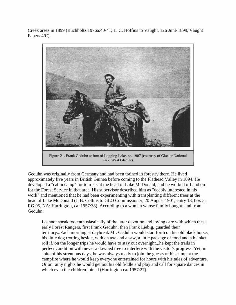
Creek areas in 1899 (Buchholtz 1976a:40-41; L. C. Hoffius to Vaught, 126 June 1899, Vaught
Papers 4/C).
Figure 21. Frank Geduhn at foot of Logging Lake, ca. 1907 (courtesy of Glacier National
Park, West Glacier).
Geduhn was originally from Germany and had been trained in forestry there. He lived
approximately five years in British Guinea before coming to the Flathead Valley in 1894. He
developed a "cabin camp" for tourists at the head of Lake McDonald, and he worked off and on
for the Forest Service in that area. His supervisor described him as "deeply interested in his
work" and mentioned that he had been experimenting with transplanting different trees at the
head of Lake McDonald (J. B. Collins to GLO Commissioner, 20 August 1901, entry 13, box 5,
RG 95, NA; Harrington, ca. 1957:38). According to a woman whose family bought land from
Geduhn:
I cannot speak too enthusiastically of the utter devotion and loving care with which these
early Forest Rangers, first Frank Geduhn, then Frank Liebig, guarded their
territory...Each morning at daybreak Mr. Geduhn would start forth on his old black horse,
his little dog trotting beside, with an axe and a saw, a little package of food and a blanket
roll if, on the longer trips he would have to stay out overnight...he kept the trails in
perfect condition with never a downed tree to interfere with the visitor's progress. Yet, in
spite of his strenuous days, he was always ready to join the guests of his camp at the
campfire where he would keep everyone entertained for hours with his tales of adventure.
Or on rainy nights he would get out his old fiddle and play and call for square dances in
which even the children joined (Harrington ca. 1957:27).

Other early Flathead rangers were perhaps not the best representatives of the federal government
available. One of these was "Slippery Bill" Morrison, who had come west as a brakeman on a
GNRR construction train, quoted Shakespeare freely, and had a "tongue like a two-edged
sword." Morrison was appointed forest ranger in the early 1900s, and at the same time he ran a
saloon at Summit that catered to railroad passengers and featured "gambling and other
accessories on the side" (Johns 1943:V, 6; Atkinson 1985:15). According to forest ranger E. A.
Woods:
Slippery Bill told me how he would stand in the door of the saloon, gaze at the distant
landscape, return to the shelf where he kept the Government records, and write in his
official diary, 'Looking over the Forest.' One of his contentions was that a good healthy
porcupine could destroy more timber than a Forest ranger could save (USDA FS "Early
Days" 1944:213).
In 1906 inspector Elers Koch discussed the pros and cons of John Sullivan, assistant ranger at
Spotted Bear. Koch described John Sullivan, or 'The Bull of the Woods,' as an:
ex-prizefighter, ex-lumberjack, [who] is an ignorant, illiterate, ill-tempered native of the
state of Maine. On account of his temper he is a difficult man for some of the rangers to
get along with, and is somewhat addicted to going on a spree occasionally, though he has
been much better in that respect in the past year. In spite of all these bad qualities he is an
excellent man for a certain class of work on this reserve. He possesses almost a genius for
laying out trails, and a bad grade or a poorly cut out piece of trail will never let him rest
easy. He is an excellent axeman, and a good man at cabin construction. He is an
experienced woodsman, and will make his way alone with his pack horses into the
roughest kind of a country... While his illiteracy will prevent his ever rising above the
grade of assistant ranger, he is decidedly a man worth keeping for work on this particular
reserve, though he would be worse than useless on a reserve like the Big Belt (Elers
Koch, 28 November 1906," Report of the Section of Inspection," entry 7, box 4, RG 95,
NA).
Another early ranger was Albert Reynolds, appointed in 1901 at the age of 53. He was stationed
near the foot of Lake McDonald; he had retired from supervising the Butte & Montana lumber
mill operations near Kalispell to escape the "nervous strain" of that work. Like many woodsmen
of the time, he seldom wore a coat in the woods; for warmth, he relied on physical exertion. If
caught out overnight in the woods without shelter, he would build a fire and sleep beside it
(Buchholtz 1985:50; O'Neil 1955:71).
Joe Eastland started work in 1900 for $60 a month. He checked mining claims, helped cut a
boundary line along the west edge of the reserve, and constructed trails (including a 46-mile trail
across the Whitefish Divide at Grave Creek). Eastland reminisced:
Well, in those days we worked out in all kinds of weather, winter and summer, long
hours and short pay, and almost no equipment. But the country was fresh and unspoiled,
and resting by the campfire was good enough after a hard day. We weren't served any
fancy store food - but what else could equal the blue grouse and dumplings we used to

have so often, or a frying pan of fresh trout, or a venison steak broiled over the open
coals. We lived pretty high at that (O. Johnson 1954:12-14).

FOREST SERVICE ADMINISTRATION, 1905-1960
Introduction
Soon after its establishment in 1905, the Forest Service achieved a reputation for bureaucratic
efficiency and extraordinary esprit de corps. This was due to the relative youth of most of the
field personnel, the personal dynamism of Gifford Pinchot, and the emphasis on decentralized
authority (Caywood et al. 199 1:22). The daily work of pre-World War II forest rangers on the
Flathead National Forest varied greatly, but almost all spent most of their time in the field.
Besides managing timber sales, fighting forest fires, building trails, and issuing grazing permits,
Flathead employees established administrative sites in the backcountry, issued special-use
permits, sent foresters to join forest regiments in both World War I and World War II, negotiated
complicated land exchanges, and participated in the planning of access roads and timber salvage
related to the new Hungry Horse Dam.
As administrative needs changed, some of the land on the Flathead and Blackfeet National
Forests was transferred to other Forests, primarily the Kootenai to the west and the Lewis &
Clark to the east. In 1910 the designation of Glacier National Park removed a large amount of
land from Forest Service jurisdiction.
The creation of the Bob Marshall Wilderness in 1940 has done much to preserve the
administrative buildings - and way of life - of the Flathead National Forest of the 1930s era. The
historic Big Prairie Ranger Station complex is an evocative, living reminder of a way of life that
has vanished on most other national forests. Supplies are still brought in by pack strings, about
40 miles of the old telephone system is still in use, and workers still wield crosscut saws and
other non-motorized tools within the Wilderness. The major change is the almost complete
dismantling of the extensive fire lookout network that once had such an important role to play.
The Spotted Bear Ranger Station, also in the South Fork but accessible by road, has several well-
maintained historic buildings at its complex, plus a number of artifacts relating to the Forest's
history on display for visitors.
Qualifications of Early Forest Service Workers
The Forest Service's 1907 Use Book described the requirements for being hired as forest rangers
as follows:
[Forest rangers] must thoroughly know the country, its conditions, and its people...The
Ranger must be able to take care of himself and his horses under very trying conditions;
build trails and cabins; ride all day and all night; pack, shoot, and fight fire without losing
his head. He must know a good deal about the timber of the country and how to estimate
it; he must be familiar with lumbering and the sawmill business, the handling of
livestock, mining, and the land laws. All this requires a very vigorous constitution...It is
not a job for those seeking health or light outdoor work (Pinchot 1907:33).

In short, as Gifford Pinchot himself said, forest rangers needed to combine the skills of a
naturalist with those of a business man (Steen 1976:83).
Because of western resistance to the new land use policies enforced by the Forest Service, the
Transfer Act of 1905 (which changed the administration of the forest reserves from GLO control
to the Forest Service) required administrators to hire local men whenever possible. In 1905
inspector Elers Koch conducted three ranger examinations in the region. These tests included
two days of field events and a one-day written exam. The field exam covered rifle and pistol
shooting at a target, riding a horse, putting on a pack, compass surveying and pacing, use of an
axe, and cruising a block of timber. The last field exam in Missoula took place in the spring of
1910 (Caywood et al. 1991:18; USDA FS "Early Days" 1944:109-110).
The badge and uniform served as outward symbols of forest rangers' authority. When the Forest
Service was created in 1905, Gifford Pinchot organized a contest among Washington Office
employees to create a unique Forest Service badge to replace the nickel one worn during the
GLO period of administration. The resulting tree emblem came from this contest, and the shield
shape was thought to convey a sense of authority. The original solid-bronze badge was reduced
to half its size in 1915. The Forest Service introduced a uniform for its workers in 1906; the
style, color, and materials have varied greatly over the years, alternating between a quasi-military
and a quasi-civilian appearance. For a long time, most field workers wore whatever they found
most comfortable (generally blue jeans). No uniform allowance was provided until 1955. In
1934, according to new regulations, Region One permanent personnel had to wear the Forest
Service dress uniform, even in the field (although forest guards could eliminate the standard
coat). Permanent employees could wear work clothes (of similar color and design) only when the
work would cause their clothes to become badly soiled within a short period or if they had no
contact with the public. No "off-shape or off-color hats, shirts, or ties" were allowed (Harmon
1980:188, 190-191, 194; Silcox 1935:3-4).
Early Forest Service salaries were generally low compared to similar government work. in the
early 1920s, according to inspectors, the Flathead National Forest was paying less than other
Forests, with the result that:
less than half the guards are experienced, self-reliant woodsmen. Too great a number may
be described as 'kids' - that is young fellows whose age and lack of experience has not
fitted them for the pioneer work required of them. Some of them are absolutely useless;
they can't chop, can't cook, can't start out alone and get to a fire (Flathead 1920-23
Inspection Reports, RG 95, FRC)
This problem apparently persisted on the Flathead. In 1937, an inspector reported that some of
the young men working on a trail crew were "pool-hall punks from Kalispell" (Inspection
Reports, Region One, 1937-, RG 95, FRC). The inspectors recommended revising the salary
schedule so that the Forest could hire two good men rather than three poor ones.

Daily Work of Early Forest Service Employees
The jobs of early rangers and forest guards were varied. Most personnel, especially those on the
local level, helped in all aspects of forest management. When the forest reserves were transferred
in 1905, Pinchot gave highest priority to boundary surveys (adjusting existing reserves and
examining proposed reserves). Major programs involved protecting the forests from fire, insects,
and disease; inventorying the timber; posting boundary and fire notices; reseeding or replanting
timber already cut; and managing grazing resources. On the Flathead, those employees who were
proficient surveyors worked all over the Forest surveying administrative and homestead sites.
They also constructed buildings, corrals, trails, and roads as needed (Steen 1976:84;
"Miscellaneous Work 1905" pressbook FNF CR).
As had been the case under the GLO, the early Forest Service expected much of its employees
but gave little support in the field. The men were expected to be self-reliant and thoroughly
capable. In November 1905, for example, Forest Supervisor A. M. Bliss wrote to deputy ranger
John Sullivan:
Get your supplies in for the winter to some point to which you can most readily reach all
points along the South Fork Valley. Will trust to your judgment. You will find a store at
Bear Creek. / Burn all the brush you can. Go to Columbia Falls the last of December for
mail and further instructions. / Prepare yourself for snowshoeing ("Misc Work 1905"
pressbook, FNF CR).
Rangers also patrolled to prevent trespass of various sorts, from timber trespass to poaching to
the illegal use of Forest Service buildings. For example, in 1915 forest guard Charles Emmons
found that someone (probably trappers) had lived in the Lake Roger Ranger Station cabin for
several weeks and had stolen cooking utensils and tin dishes. He reported, "The cabin was left in
a condition of filth almost beyond description" (FNF Lands).
The tasks in the early years were primarily custodial, and much energy was put into developing
the transportation network. Most of the field work was done in the name of "presuppression,"
including mapmaking and developing communication systems, roads, and trails. The ranger's
year was divided into fire season and non-fire season. Rangers and summer guards were spread
thin over the backcountry. For example, in 1907 each Lewis & Clark National Forest ranger
district covered about 600,000 acres, and each ranger had about five guards working for him
during the summer. More specialists' jobs were created in the 1920s (Clack 1923a:7).
The Forest Service hired relatively few office workers during the early years. In 1905 Supervisor
Page S. Bunker asked for a clerk to remain in the office during his absence and noted that he
would prefer a man who could use a typewriter. As the work load increased, so did the number
of employees, both in the office and in the field. In 1905, each forest reserve averaged about 8
employees, including clerks and stenographers. By 1939, the Flathead National Forest employed
19 year-round and 200 seasonal employees. This had increased dramatically to 121 year-round
employees by 1964 (Shaw 1967:2, 5; Winters 1950:9).
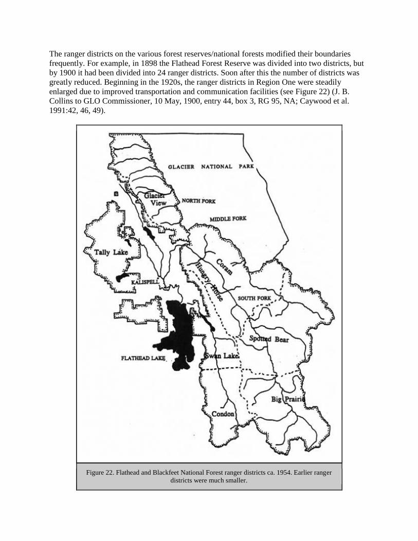
The ranger districts on the various forest reserves/national forests modified their boundaries
frequently. For example, in 1898 the Flathead Forest Reserve was divided into two districts, but
by 1900 it had been divided into 24 ranger districts. Soon after this the number of districts was
greatly reduced. Beginning in the 1920s, the ranger districts in Region One were steadily
enlarged due to improved transportation and communication facilities (see Figure 22) (J. B.
Collins to GLO Commissioner, 10 May, 1900, entry 44, box 3, RG 95, NA; Caywood et al.
1991:42, 46, 49).
Figure 22. Flathead and Blackfeet National Forest ranger districts ca. 1954. Earlier ranger
districts were much smaller.

In 1908 Pinchot established field headquarters in six Districts (now called Regions), one of
which was in Missoula. Previously, the nation's Forests had been divided into three Districts. The
Forest Service used inspections by men from the Washington or regional offices to assist officers
in their duties. These inspections were very detailed. For example, an inspector who visited
Hemlock Lookout in 1937 "stressed the importance of having more system in the filing of his
food supplies in the cupboards" (Steen 1976:77, 80; Inspection Reports, Region One, 1937-, RG
95, FRC).
In 1905 the Forest Service issued a pocket-sized Use Book, with a brief summary of Forest
regulations, for field personnel and the general public. Not all employees read this manual
promptly upon being hired. Jack Clack, hired to work on the Lewis & Clarke National Forest in
1907, met Gifford Pinchot there. Pinchot asked if he had read his book of instructions, and Clack
replied honestly, "Hell, no. I haven't received any mail for three months" (Caywood et al.
1991:22; Bloom 1933:3).
Time spent in the office was minimal in the early years. According to Flathead National Forest
retiree Pat Taylor, "The Ranger would only get a thin manilla envelope a week from the S. O. He
would usually stay in Saturday afternoons or perhaps all day to do his office work. The rest of
the time he was in the field" (see Figure 23). Some of the work kept the ranger station operating
smoothly. For example, in 1924 Ralph Thayer spent one day in September at Moran Ranger
Station splitting wood, cleaning the barn and root house, picking up tools, and washing dishes
(Taylor 1981; Thayer 1924).

Figure 23. Cartoon drawn in 1930 by Viggo Christensen, a Montana Forest Service
employee (from Randall 1967:28).
In the early 1920s a number of Flathead National Forest employees undertook an inventory of
three "activities" on the forest: silviculture, grazing, and fire. The men carried their supplies and
tools on backpacks, making maps as they went. Frank Liebig described these as follows:
It is a man's job all right, and he has to have an eagle eye, climb like a billy goat, swim
like a fish, and run over the windfalls like a squirrel, but, 'Oh, joy,' when you do hit the
headwaters and climb the mountains peaks, what a wonderful scenery a man can get"
(Liebig 1924:8).
Liebig and others covered 1,001 acres per man-day on the Middle Fork survey, and he casually
mentioned that the work was done on contributed time, available because the fire season was
easy (Liebig 1924:9).
Forest ranger Clyde Fickes described how he traveled on the Lewis & Clark National Forest in
1908. He rode a saddle horse followed by a packhorse on a lead rope with canvas pack bags. His
load of 180 pounds included two frying pans, three tin plates, a coffee pot, table knives, forks,
spoons, a hunting knife, an ax, a shovel, a cross-cut saw, a rifle, a camp bed, clothing, a rain
slicker, and food. He spent about half his time traveling in this manner, cutting logs out of the
trail as he went. When he arrived at his destination he would unsaddle the horses and turn them
out to graze. He would then collect dry wood, get a fire started, pitch his 7'x 9' tent, and spread
his bedroll over fir boughs. After eating, he would wash the dishes, smoke a pipe or cigarette,
check the horses, and tie them up for the night (Fickes 1973:32-33).
Clyde Fickes started his Forest Service career on the Lewis & Clark National Forest. In 1907 he
was appointed forest guard at a salary of $720 per year. His early work was to survey and plat
administrative site withdrawals and homestead claims. Near Swan Lake he met ranger Jack
Clack (see Figure 24) (Fickes 1973:3, 5, 7). He described Clack as follows:
He was a tall, well-built man, brown as an Indian, sitting on a long-legged bay horse and
leading a packhorse. Bareheaded, his hat on the saddle horn, he ran his hand back over
his bald head; it came away covered with mosquitos and blood, which he nonchalantly
shook off as he greeted us" (Fickes 1973:7).

Figure 24. Jack Clack wearing the packframe that he designed (from Swan 1968).
Not all Forest Service workers enjoyed being alone in the field so much of the time, especially
those who had girlfriends in town. One seasonal employee wrote in his diary of August 1908:
Gosh but I am lonesome wish I had someone to talk to have made up my mind that I don't
want to be alone much in the mountains. I am going to Java tomorrow where I can talk to

the miners and Japs. I am still thinking of Mary (28 August 1908, FNF employee log,
FNF CR)
By the 1930s the Forest Service had developed three types of backcountry camps for
employees: permanent, such as guard stations; tent camps; and the more temporary
"gypsy camps." Tent camps were usually 6-10 miles apart and located at trail
intersections with a good water supply.
Most of the field workers were in their 20s, and although whiskey was available (despite
Prohibition), the low wages controlled the drinking. According to Pat Taylor, "Among the crews
there was lots of joking, bantering and good natured practical jokes." Evening conversation, he
recalled, generally revolved around the merits of various boots and guns (Taylor 1986; Taylor
1988).
At a typical trail crew camp, the person assigned to be cook would get up an hour early to build a
fire in the wood stove and make the coffee. He would carry in buckets of water from the creek
and whittle shavings if he had not done so the night before. Unless they were on a fire, men on
backcountry crews worked six days and spent Sundays washing clothes. The men were on call
24 hours a day. No one went to town from June 15 until September unless there was an
emergency (defined as a death in the family or a toothache). Pat Taylor commented, "I have
known some fellows who got off to attend funerals of 6 or 8 grandmothers" (Taylor 1981).
Generally the members of a small backcountry crew would take turns cooking. "It was
understood that no one would complain unless he wanted to take over the cooking job,"
remembered Pat Taylor. If a crew member was a terrible cook, he would haul wood and water
and wash dishes instead. Employees were expected to sweep and mop the cabins in which they
stayed, in addition to shaving once or twice a week. "It was said that to qualify for a Ranger's
job, one must shave every day and be able to spell 'approximately.'" There was an unwritten law
that firewood and kindling and a full gas lantern should be left in camps for the next occupant.
Employees would work late to finish a job or leave early if done. On cruising or scaling jobs,
evening work was done voluntarily to compile cruise notes or to add scale book volumes. No
overtime was paid in the 1930s; wages remained the same even if one was on a fire more than
100 hours in one week. In the 1930s seasonal employees took home $77 a month for a standard
work week of 44 hours (five 8-hour days plus Saturday mornings). As a small benefit, seasonal
employees were usually allowed to use a Forest Service cabin as headquarters for winter trapping
(USDA FS "Early Days" 1976:109; Taylor 1988; Taylor 1981; Owens 1989).
Backcountry crews were also hosts to the public. When anyone rode or walked into camp, the
first rule was to inquire if they had eaten and to offer visitors a cup of coffee. The Forest Service
employees stayed up until the visitors and their horses were settled (Worf 1989).
The commissary clerk (later known as the dispatcher) answered the phone, cooked for the
station, kept employees' work records, and dispatched men to fires. He also ordered the weekly
supplies, mowed lawns, took weather measurements, issued gasoline, and did the paper work on
timber sales. In 1931 the cook at Tally Lake was required to prepare breakfast and supper for the
workers and in between to hike up a steep 3-1/2—mile trail with a fire pack and look for fires
until it was time to cook supper. "In a short time he quit and we 'batched' for several years,"
recalled Pat Taylor (Taylor 1981; Taylor 1986).
Forest Service Food
In the early years of the Forest Service, employees provided their own food (generally game
supplemented with supplies they packed in for themselves). The Forest Service did not supply its
employees with food and bedding until 1917. As packers were hired to supply remote ranger
stations, employees had to rely on the food brought in by the government or fish and meat that
they procured for themselves while in the field (USDA FS "Early Days" 1944:217).
As late as the 1930s some of the backcountry Forest Service food was left over from World War
I military rations. These included 5-pound cans of lunch meat "stacked like cordwood" which no
one would eat after their first try. Another was evaporated eggs, also unpopular. Other food
regularly used in 1930 on the Blackfeet National Forest included smoked ham and slabs of
bacon, canned roast beef and salmon, condensed evaporated milk, lard and butter in cans, canned
apples and dried fruit, beans, rice, macaroni, corn meal, rolled oats, and tapioca ("To my
knowledge no tapioca was ever cooked," commented Pat Taylor). There was no fresh bread, so
biscuits known as "Dough Gods" took its place. Pancakes were made from sourdough; the starter
was carefully maintained all summer and protected in the mule packs (Taylor 1986; Taylor
1981).
After the coming of the CCCs, Forest Service food improved greatly because the agency learned
by observing how the Army supplied food. Fresh meat began to be supplied to permanent camps
and fresh bread to all crews. Canned peaches, pears, apricots, pineapple, grapefruit, and even
strawberry jam made their appearance (Taylor 1986).
In 1939, typical food for a trail crew included a breakfast of hotcakes with canned ham or bacon,
a lunch of a small can of fruit and sandwiches made with baking powder biscuits (carried in a
sugar sack tied to the back of the worker's belt), and a supper of baking powder biscuits, canned
ham or tin willy (or canned stew), spuds, and a canned vegetable followed by canned fruit. Trail
crew workers supplemented their diets with fish caught from nearby streams (USDA FS "Early
Days" 1976:110; Montgomery 1982).
Winter Work
Timber cruisers inventorying the forest's timber resources routinely worked in the winters,
sometimes in deep snow. R. L. Woesner worked on a timber sale in what is now Glacier National
Park some time between 1905 and 1910: "When we left the cabin we always set up a pole in
order to be sure to find it when we returned, as we often had to dig down in the snow to find the
cabin" (USDA FS "Early Days" 1944:21).
During the winters of the 1920s through the 1940s, the rangers worked out of the Federal
Building in Kalispell (247 1st Avenue East). When in the field, they marked timber sales, put up
ice, and did game counts and snow surveys. Much of their work was accomplished on snowshoes
(see Figure 25). When possible, crews of rangers and a few key men would be transported to the

job site in cars; if not they used a toboggan and later snow cats (the first snow cat was introduced
in 1951 (Taylor 1981; Baker et al. 1993:180).
Figure 25. Winter camp near Calbick Creek, winter game studies, 1936. When cabins were
unavailable, workers stayed in tents (courtesy of Flathead National Forest, Kalispell).
Snow surveys were designed to measure winter snowpack and to forecast spring runoff. They
were tried to a limited extent in Montana between 1918 and 1935, then expanded with federal
assistance. In 1935 the Corps of Engineers installed 15 snow courses along the Continental
Divide, and in the early 1940s more courses were added in the Columbia and Missouri River
basins. The earliest snow courses reported in the Flathead National Forest area were established
in 1937 on the Flathead River, Logan Creek, and Desert Mountain. Snow surveys were done by
one man alone until 1943 or 1944, when two men were sent out together for added safety (Taylor
1981; Monson 1961:5-6, 26).
Pat Taylor described doing snow surveys on the Tally Lake Ranger District, which had three
snow courses. He carried a light canvas bag with one shoulder strap that weighed about 10 lbs. It
generally took him five days to travel slightly over 90 miles. He commented, "Under good
traveling conditions the trips were not too tough. Otherwise they were man killers. I would hit
the trail at 5 AM to take advantage of the best snow conditions. Sometimes it was after dark
before returning to camp" (Taylor 1988).
The Forest Service cooperated with Glacier National Park on occasion. One example was a
timber survey of the area burned on national park and forest lands by the 1929 Half Moon fire,
done during the winter on snowshoes ("Another Emergency Job" 1930:4).

Families
Many rangers living in remote areas had their wives and children with them. For the children,
this could be an idyllic life, as they often were allowed to accompany their father on his rounds.
Tally Lake ranger Paul Redlingshafer, for example, took his children with him in the early 1920s
on trail trips; each child had his own horse to ride (Redlingshafer 1988).
The wives of Forest Service rangers often assisted their husbands for no pay. They helped with a
great variety of jobs, including dispatching, surveying, fire fighting, cooking for crews, meeting
the public, taking care of office duties, tending the stock, and marking timber stands for sale.
For example, Mary and Ed Thompson were married in 1909 and were stationed at the Echo
Ranger Station until he retired in the 1930s. At first they lived in a small cabin in the woods that
had been built by a homesteader, but later they added a large log house, barn, blacksmith shop,
bunkhouse, outhouse, and other outbuildings (see Figure 26). Mary, like many rangers' wives,
raised a vegetable garden, chickens, and pigs and kept a Jersey cow for milk and cream. She
served as ranger alternate without pay when her husband was absent. The family shopped in
Kalispell, 26 miles away, but in the winter the only way out was by horse-drawn sled. They
provided meals to anyone who came to work or visit, and their nearest neighbors (and their mail
box) were six miles away (Glazebrook 1980:18-19; 24FH110, FNF CR; Hornby 1932:6-7).
Figure 26. Echo Ranger Station, 1924 (courtesy of Flathead National Forest, Kalispell).
Some forest rangers met their future wives as a result of their duties in the woods. For example,
Ray Trueman, ranger at Big Prairie, eventually married a woman named Ruby Kirchbalm who
operated a 30-horse pack string between Coram and Big Prairie after World War I (USDA FS
"Early Days" 1962:17; Shaw 1967:27-28).
Injuries
Flathead National Forest rangers and forest guards and other employees have always done much
of their work alone in the field in sometimes dangerous situations. Not surprisingly, some have
died on the job. The causes of death have included railroad accidents, dynamite blasts, lightning,
automobile accidents, heart attacks, falling trees and logs, plane crashes, and even exhaustion
from running during a fire. In 1924 the daughter of a man looking after stock wintering at Big
Prairie on the South Fork became ill. She died and was buried there before her father was able to
snowshoe to Missoula and back for medicine (Shaw 1967:62, 98-99).
In 1930 a smokechaser on Nasukoin Mountain in the North Fork was mauled by a grizzly. In
1928 Ralph Thayer was mauled while locating a trail, also in the North Fork. Both lived to tell
their stories (Shaw 1967:117; Yenne 1983:52).
Special-Use Permits
Special-use permits were issued on the Flathead National Forest for such diverse activities as
cutting wild hay, growing a garden and flowers along the Middle Fork, building hunting cabins,
establishing logging camps, running a commercial packing business, and building summer
homes on various lakes (Holland Lake, Lake McDonald, Swan Lake, and others). Dude ranches
were also operated under special-use permits. For example, the Diamond R Ranch at Spotted
Bear was started in 1927 by Guy Clatterbuck, who had been located the previous year at Spotted
Bear Lake. Private hotels were also under special-use permit, such as the Belton Chalet in West
Glacier (the Glacier Park Hotel Company was issued a permit for this hotel in 1914) (Opalka
1983; FNF "General Report" 1918)
One spectacular summer home was the Rock House, built in 1930 through a special-use permit
on the west shore of Swan Lake for the L. O. Evans family (Evans was president of the board of
ACM for a time). In 1937, a forest inspector commented that the management situation at Swan
Lake was different from many places because most of the land around the lake was privately
owned. He added that wealthy people had moved in over 25 years ago seeking privacy and had
"pretty much dominated Swan Lake for 25 years." The ranger tried to protect the public's interest
in recreation in the area and at the same time avoid appearing "bureaucratic or spiteful and so
retain the good will and cooperation of private owners" ("Rock House" 1984; 18 December 1937
memo, Inspection Reports, Region One, 1937-, RG 95, FRC).
In 1930 the Flathead National Forest maintained 13 residential permits in Essex, which had a
population of 200 at the time, of which 90% were railroad employees. In Belton and Essex many
of the homes, and the school, were built on federal land under permit (W. I. White, 1/28/30
"Report on Municipal Watershed," 2510 Surveys, Watershed Analyses, 1927-29, RO; Shaw
1967:28).

Forestry Research and Education
The Department of Agriculture offered technical aid and advice to private landowners since
1898. In 1924 Congress passed the Clarke-McNary Act, which among other things provided for
federal funds to match state and private funds in supporting cooperative fire protection,
distribution of seedlings for reforestation, and other programs. The act also broadened the
authorization for the purchase of forest land to permit the government to acquire land for
national forests regardless of whether or not it was located on watersheds of navigable rivers.
Research in forestry greatly expanded after 1905. The first forest experiment station was
established in 1908 in Arizona. The Forest Products Laboratory was established in Madison,
Wisconsin, in 1910, and a research branch was created within the Forest Service in 1915 (Gates
1968:595, 597; Winters 1950:14; Randall 1967:62). Forestry education also was becoming more
widely available; the Montana State University School of Forestry was established in 1913.
By the early 1920s the Forest Service was encouraging its employees to become involved in
public relations and educational efforts. In 1921, for example, the Blackfeet National Forest
publicized its work and philosophy through articles in local newspapers, talks to school groups
and Boy Scouts, signs and posters in local businesses, and window displays. In 1926, Frank
Liebig set up a large display in a big show window of the Kalispell Mercantile that featured all
the different kinds of fungi that grow in the forest, plus a variety of fire signs. Another display
showed a slice from a Douglas-fir tree that was almost 450 years old, with cards marking the
years of historic events, including large fires in the area (Northern District Bulletin 5 (May
1921): 34; Liebig, "Flathead Fungi" and "An Historian" 1926: 13, 14).
World Wars
The Forest Service contributed to the World War I war effort in various fields, including those of
national defense, military intelligence, and the wood products industry. The mobilization of the
war industries led to larger timber harvests and increased road development in Region One, and
the prices of labor and construction materials rose. The Forest Service organized and equipped a
forestry regiment in the Army Corps of Engineers that was sent to France to log and mill behind
the front. Many Flathead Valley residents joined this regiment. During World War I, because the
wages in private industry were so high, many Forest Service employees left their jobs to earn
more money elsewhere. A few women worked as lookouts during World War I because of labor
shortages (Caywood et al. 1991:33-34; Cusick 1981; James 1990:8-9).
Key individuals in the Forest Service were removed to serve in the military during World War II.
The total budget of the Forest Service was cut nearly in half in 1943 and 1944 because of the war
and because so much money went into the rubber tree plantations in California, part of the Forest
Service war effort. The Forest Service faced a manpower shortage as CCC camps were phased
out in 1942 and as employees joined the armed forces. In Region One, all road and trail
development was stopped except where the government wanted access to strategic metals such
as chrome and tungsten. Quite a few lookouts were no longer manned, and the Forest Service
hired women to be stationed at some of the others and high school students to work in
firefighting, blister rust control, and slash disposal. Before World War II, only 13 women had

been hired as professional foresters, and the CCC did not include women in its program (Gray
1982:187; Caywood et al. 1991:60; Baker et al. 1993:160; James 1990:8-9).
After World War II had focused attention on Forest Service mapping and surveying abilities, the
Forest Service was designated one of the standard mapping agencies of the Government. The
agency received increased funding and training to produce topographic maps for standard
coverage of the United States (see Figure 27) (USDA FS "History of Engineering" 1990:7, 445).
Figure 27. Flathead National Forest surveys, 1960. Fred Kyle, cartographic aid, calls out
readings he has obtained from tellurometer. William Markham, cartographic aid, records in
notebook (photo by Peyton Moncure, courtesy of USDA Forest Service, Region One,
Missoula).
Administrative Sites
Early forest rangers under the GLO either rented buildings or used their own homes as ranger
stations. There was no funding in the early years for constructing any administrative buildings in
the woods. Soon modest amounts of money were allocated for building and maintaining Forest
Service "administrative sites." According to an inspection report, in the year 1906 more cabins
and pastures were built and fenced on the Lewis & Clark forest reserve than in all previous years
combined (1898-1905). The cabins built then averaged 17' x 26' and generally cost $200-350 for
labor and $50-75 for materials. All were supplied with a light-weight sheet steel stove (Ise
1920:261; 28 November 1906, "Reports of the Section of Inspection," entry 7, box 4, RG 95,
NA).

In 1912 an amendment was passed forbidding the use of homesteaders' cabins as ranger stations.
After funds became available, the number of buildings constructed for various purposes on the
national forests grew rapidly. In 1939, there were 147 lookout buildings and 247 other buildings
on the Flathead National Forest (Figure 28) (Ise 1920:261; FNF, "Informational Report" 1939).
Figure 28. Map of known ranger stations and other administrative sites on the Flathead
National Forest (many of these are no longer in use). This map does not show lookout sites.
The Forest Service began to "withdraw" plots of land for actual or potential administrative sites
soon after the Forest Homestead Act was passed in 1906. The men selecting the sites tried to
choose locations that were generally spaced about a one-day's horse ride apart. These
withdrawals protected the land from being claimed by a homesteader, a real consideration since
the qualities that made a site attractive to a homesteader - water, available pasture, relatively flat
land - were also necessary for guard and ranger stations. The sites could not conflict with prior
mineral or homesteading claims. Many withdrawals were made before the land had been
formally classified; later some of these were once again made available to homesteaders.
Between 1898 and 1918, forest rangers and guards designed and built most of the permanent
improvements in the national forests. Because the ranger drew up the plans, these buildings often
resembled homestead cabins of the same period. Sometimes their building or re-building
attempts were not very successful. In 1922, for example, the regional forest inspector commented
that "Buildings on the Blackfeet are surely a worthless lot of shacks." A 1914 act limited the cost
of any building for Forest Service use to $650 without special congressional authority. Flathead
National Forest supervisor Page Bunker recommended as early as 1910 that standard types of
buildings be adopted for each Forest, but a Region-wide standardized planning effort was not to
come until the 1930s (Caywood et al. 1991:67, 69; Flathead 1920-23 Inspection Reports, RG 95,
FRC; Kinney 1917:251; "Report of Supervisors' meeting, 3/21-26/1910, 1360 Meetings -
Historical - Early Supervisor Meetings, RO:47).

Some of the early ranger stations, and the year of construction of the first building on the site, are
listed below. A number were originally the residences of rangers; others were the cabins of
homesteaders, prospectors, etc., that the rangers used for a time as headquarters. Most of these
early ranger stations were later abandoned or demolished in favor of better locations as the needs
of the Forest Service changed (see Figure 29). Some are no longer within the boundaries of the
Flathead National Forest since the sites are now in Glacier National Park or the Kootenai
National Forest.
1899 head of Swan Lake
1902 Cedar Creek near foot of Lake McDonald
1902 Coram
1904 Big Prairie
1905 Hahn Creek
1905 Riverside (South Fork)
1906 Black Bear (burned in 1910)
1906 Spotted Bear Lake
1906 Danaher
1908 Star Meadow
1908 Swan Lake
1908 Tally Lake
1909 Bear Dance
1909 Holland Lake
1909 Hungry Horse
1910 Belton
1910 Three Forks
(Shaw 1967:7, 49; FNF "General Report" 1918; Wolff 1980:53; site files, FNF CR; Blake
1936:1; Mitchell 1973).

Figure 29. Big Prairie Banger Station, 1913. This cabin was located closer to the South Fork
of the Flathead than the current administrative complex (courtesy of Flathead National
Forest, Kalispell).
Many administrative sites that were withdrawn were never actually used for anything more
permanent than as summer camping and pasture grounds for forest employees passing through
the area. These were strategically located at trail junctions with sources of water and good
pasture. Some were withheld specifically to prevent speculation by private parties, such as the
River Side Administrative Site selected in 1912, located about 10-12 miles above Henshaw Ford
at "the most natural crossing on the North Fork" (FNF "General Report" 1918).
An administrative site was withdrawn in the Belton (West Glacier) area partly in order to "bring
the greatest competition against the monopoly of the Belton Mercantile Company," which owned
all the land within 1/4 mile of the railroad depot except for the Forest Service site. A seasonal
employee lived in a house hidden behind a steep hill because the Forest Service felt the agency
did not have enough funding to build a station along the road "that would conform in architecture
to the Great Northern Chalets" and that the traffic on the road (which did not yet go over Marias
Pass) did not warrant such an expense (FNF "General Report" 1918).
The Coram Bridge Station, located at the village of Coram along the railroad tracks, was
withdrawn as a banking ground for timber. In 1913 a cabin and storehouse were built to store
government supplies loaded at that site. The Forest Service also administered special-use permits
at this location in the 1910s for three stores, a barber shop, and a residence (FNF "General
Report" 1918). South of Coram, along the South Fork, was the Elk Park administrative site, also
known as the "Elk Park packers' camp" (see Figure 30).
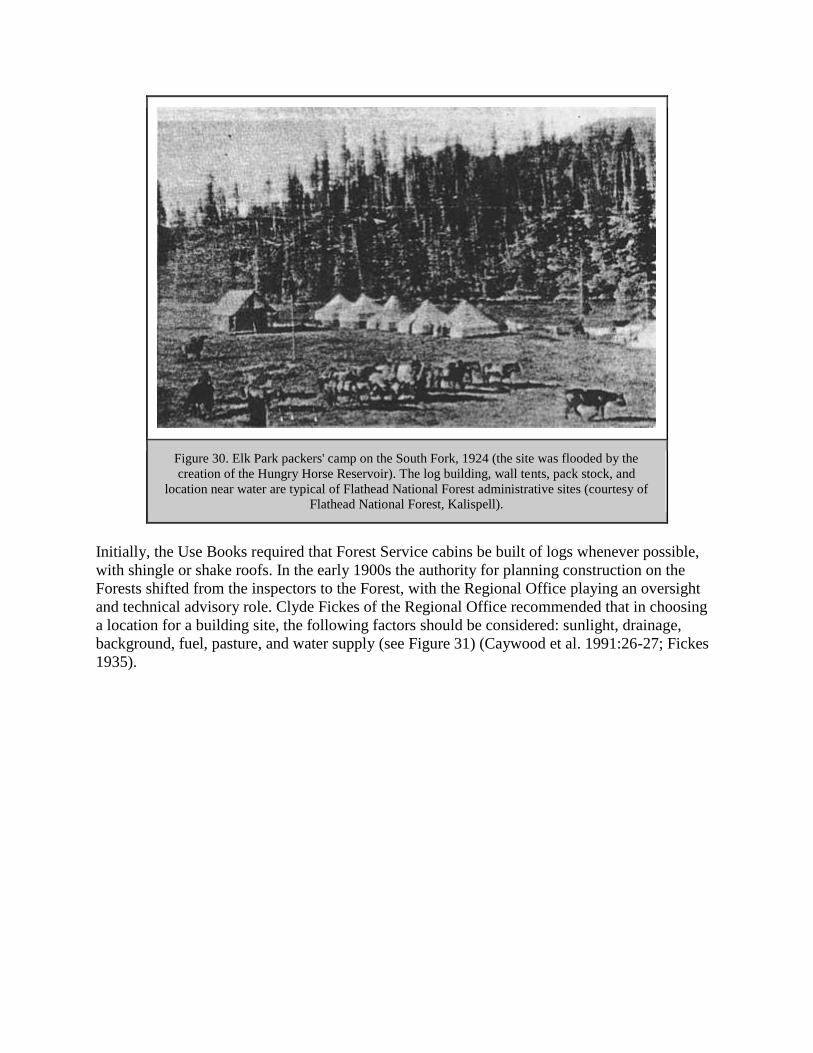
Figure 30. Elk Park packers' camp on the South Fork, 1924 (the site was flooded by the
creation of the Hungry Horse Reservoir). The log building, wall tents, pack stock, and
location near water are typical of Flathead National Forest administrative sites (courtesy of
Flathead National Forest, Kalispell).
Initially, the Use Books required that Forest Service cabins be built of logs whenever possible,
with shingle or shake roofs. In the early 1900s the authority for planning construction on the
Forests shifted from the inspectors to the Forest, with the Regional Office playing an oversight
and technical advisory role. Clyde Fickes of the Regional Office recommended that in choosing
a location for a building site, the following factors should be considered: sunlight, drainage,
background, fuel, pasture, and water supply (see Figure 31) (Caywood et al. 1991:26-27; Fickes
1935).

Figure 31. Drawing of Moran Ranger Station, ca. 1918. Notes accompanying the map
indicate that the house and barn were built of logs. The log chicken coop was originally a
trapper's cabin built in 1890. The compound was enclosed with 1-3/4 miles of buck and rail
fence. The river shown to the east of the compound is the North Fork of the Flathead. This
ranger station was discontinued and the buildings subsequently destroyed (from FNF
"General Report" 1918).
From 1918 until 1928 the Forest Supervisor usually reviewed the building's design and
placement. The architectural style continued to be similar to that of local vernacular buildings. In
the 1920s and 1930s, buildings that were near supply points generally were built in the bungalow
style with Craftsman features such as exposed rafter tails, dormers, and roof brackets. These
were of Forest Service design or followed a generally available pattern-book plan. In general,
Forest Service buildings were utilitarian, "rustic" in appearance, and reflected local designs and
materials (Caywood et al. 1991:73, 95).
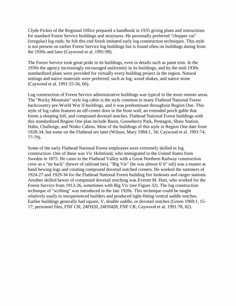
Clyde Fickes of the Regional Office prepared a handbook in 1935 giving plans and instructions
for standard Forest Service buildings and structures. He personally preferred "chopper cut"
(irregular) log ends; he felt this end finish imitated early log construction techniques. This style
is not present on earlier Forest Service log buildings but is found often on buildings dating from
the 1930s and later (Caywood et al. 1991:99).
The Forest Service took great pride in its buildings, even in details such as paint trim. In the
1930s the agency increasingly encouraged uniformity in its buildings, and by the mid-1930s
standardized plans were provided for virtually every building project in the region. Natural
settings and native materials were preferred, such as log, wood shakes, and native stone
(Caywood et al. 1991:55-56, 66).
Log construction of Forest Service administrative buildings was typical in the more remote areas.
The "Rocky Mountain" style log cabin is the style common to many Flathead National Forest
backcountry pre-World War II buildings, and it was predominant throughout Region One. This
style of log cabin features an off-center door in the front wall, an extended porch gable that
forms a sleeping loft, and compound dovetail notches. Flathead National Forest buildings with
this standardized Region One plan include Basin, Gooseberry Park, Pentagon, Shaw Station,
Hahn, Challenge, and Ninko Cabins. Most of the buildings of this style in Region One date from
1928-34, but some on the Flathead are later (Wilson, Mary 1984:1, 34; Caywood et al. 1991:74,
77-79).
Some of the early Flathead National Forest employees were extremely skilled in log
construction. One of these was Vic Holmlund, who immigrated to the United States from
Sweden in 1875. He came to the Flathead Valley with a Great Northern Railway construction
crew as a "tie hack" (hewer of railroad ties). "Big Vie" (he was almost 6' 6" tall) was a master at
hand hewing logs and creating compound dovetail notched corners. He worked the summers of
1924-27 and 1929-34 for the Flathead National Forest building fire lookouts and ranger stations.
Another skilled hewer of compound dovetail notching was Everett M. Hart, who worked for the
Forest Service from 1913-26, sometimes with Big Vic (see Figure 32). The log construction
technique of "scribing" was introduced in the late 1920s. This technique could be taught
relatively easily to inexperienced builders and produced tight-fitting ventral saddle notches.
Earlier buildings generally had square, V, double saddle, or dovetail notches (Green 1969:1, 15-
17; personnel files, FNF CR; 24FH20, 24FH428, FNF CR; Caywood et al. 1991:78, 82).

Figure 32. Garage/blacksmith shop under construction at Spotted Bear Ranger Station, 1925.
Master log carpenters Vic Holmlund and Everett Hart probably helped build these buildings,
which are currently known as the fire cache and the old office (photo by Everett Hart,
courtesy of Flathead National Forest, Kalispell).
An excellent example of a typical backcountry Forest Service administrative complex is the Big
Prairie Work Center (formerly the Big Prairie Ranger Station), located along the South Fork
(now within the Bob Marshall Wilderness). In 1937 a forest inspector described Big Prairie as
"delightful - so delightful that it cannot be forgotten." At that time the buildings at the complex
included a "nice log cabin" ranger dwelling, a combination office/kitchen/dining room and
warehouse, a bunkhouse, and a blacksmith shop (see Figures 33 and 34). The Big Prairie airfield
was completed in 1931 (27 December 1937 memo, Inspection Reports, Region One, 1937-, RG
95, FRC; "History of the Use of Aircrafts," n.d., FNF CR).

Figure 33. Big Prairie Ranger Station complex, ca. 1917 (FNF "General Report" 1918).
Figure 34. Big Prairie Ranger Station complex, 1990. This shows the variety of buildings
needed at a typical backcountry ranger station (24PW1003, FNF CR).
In 1918 the Flathead National Forest (south half) had ten ranger districts: Echo, Lower Swan,
Upper Swan, Upper South Fork, Spotted Bear, Lower South Fork, Coram, Belton, Essex, and
Big River (now called Middle Fork). These varied in size from 46,200 acres (Coram) to 547,800
acres (Upper South Fork). In 1918, Echo, Lower Swan, Coram, Belton, and Essex were year-
round ranger stations. The other stations were "chiefly protective" in purpose and so were not
manned during the winters. All but two of the stations were connected to the Forest Service
phone system; from Belton and Essex the rangers had to use the Western Union telegraph system
to get messages in and out. The latter two stations were the only ones at which the ranger and the
government did not have horses; the railroad was the main means of transportation instead (FNF
"General Report" 1918).

By 1923 Flathead National Forest supplies were coming in from Central Purchase and being
checked out to camps. Beginning in approximately 1928, supplies, materials, and equipment
were shipped direct from the Spokane Warehouse to the site where they were to be used. The
Flathead National Forest in 1938 was one of the few forests that still ordered in bulk, shipped to
Kalispell, and then distributed on order to the field rather than having orders shipped directly
from Spokane (7 April 1924 memo, Flathead 1920-23 Inspection Reports. RG 95, FRC; 13
September 1938, Flathead Inspection Reports Region On, RG 95, FRC).
The abandonment of isolated sites close to the field and their replacement by centrally located
district headquarters is typical of Forest Service development during the 1930s. This centralizing
trend depended on the expansion of the Forest Service road system, which improved access to
work areas. The administrative sites that are still in use today in the backcountry were generally
established after World War I.
In 1905 Flathead National Forest headquarters were moved from Ovando to a room in the
Conrad Bank building in Kalispell. When the Federal Building was constructed in Kalispell in
1917, both the Flathead and the Blackfeet National Forests had their supervisor's offices on the
second floor (the first floor was devoted to the post office). This building now houses the
Flathead County Library and School District 5 offices. Some years additional space was rented
in Kalispell. For example, for two winters in the 1930s the engineering crew was located in
offices over Jack's Tavern and in the Eagles Hall on 1st Avenue West in Kalispell (Shaw 1967:5;
Helseth 1981).
Boundaries
The boundaries of what is now the Flathead National Forest have changed greatly over the years
since 1898. When the forest reserve was originally mapped, its boundaries were drawn roughly,
tending to follow section lines, because there was not enough funding for ground surveys. The
1898 boundaries were quite different than those of today, extending east of the Rockies but not
including much of the area now part of the Tally Lake Ranger District. A few years after the
forest reserves were proclaimed in 1897, foresters began surveying and reviewing the lands. As a
result, some lands were excluded from the forest reserves because they turned out to be
submarginal in timber growth potential or else agricultural in nature (Pinchot 1907:8).
On June 9, 1903, the area bordering the Great Northern Railway along the Middle Fork was
added to the Flathead National Forest by presidential proclamation. In 1903 the Flathead and the
Lewis & Clarke forest reserves were consolidated into one reserve, the Lewis & Clark, but they
were separated again in 1908 and re-named the Blackfeet and the Flathead National Forests (see
chart of all the names of the Forest at the end of the Introduction). The Kootenai National Forest
was designated in 1906. Four years later, the land in the eastern part of the Blackfeet National
Forest was transferred to establish Glacier National Park. The Blackfeet National Forest was then
consolidated with the Flathead and the Kootenai National Forests in 1933 (62% of its land was
subsequently administered by the Flathead). When the Blackfeet National Forest was combined
with the Flathead, making it almost 2.6 million acres, a Forest Service publication commented,
"If there is a National Forest area of similar size in the United States, under one Supervisor's
jurisdiction, with more deep-downs and higher-ups and more units of inaccessibility, it has never

yet been discovered" ("Establishment and Modification" 1973: passim; "Blackfeet Forest
Reports" 1934:8).
For several years prior to 1923 the Spotted Bear and White River areas were administered by the
Lewis & Clark National Forest, but in 1924 they were turned back to the Flathead. The Island
Unit (formerly referred to as the "Floater") was managed by either the Blackfeet National Forest
or the Flathead National Forest until 1918, when it was transferred to the Flathead National
Forest (15 December 1923, Flathead 1920-23 Inspection Reports, RG 95, FRC; 1918
Presidential Proclamation, 3 June 1918; FNF Lands). All forest reserves around the country were
called national forests beginning in 1907, and in that year the spelling of "Clarke" was changed
to "Clark."
The General Exchange Act of 1922 gave the Forest Service authority to exchange nonmineral
national forest land or timber for private or state-owned lands of equal value within the forest.
This act was critical for the consolidation of Forest Service ownership. The basis of the exchange
was equal value, not equal area. During the Depression, many companies such as the ACM had
large holdings of cutover lands on which they were paying taxes but earning no income. Some
donated these lands to the Forest Service, adding to the Forests or to primitive areas. This federal
acquisition of cutover timber land was thought to help the lumber industry by stabilizing land
ownership and promoting reforestation (Steen 1976:147; W. Robbins 1982:208).
Private landowners within the national forests could essentially sell their land to the Forest
Service; under the 1922 act they obtained cash for their land by collecting the revenue earned
from Forest Service timber sales elsewhere. The timber sale and the land to be exchanged did not
have to be on the same Forest. For example, in 1927 the receipts from a timber sale on the
Blackfeet National Forest were used to pay for land that the Kootenai National Forest obtained
under the land exchange act (Baker et al. 1993:123; FNF Lands).
Companies based in the Flathead Valley that donated land to the Flathead National Forest via
land exchanges included the Empire Lumber Company of Kila and the Brooks-Scanlon Lumber
Company of Eureka. In 1939 the F. H. Stoltze Land and Lumber Company donated about 10
acres of land to the Flathead National Forest for the site of the Whitefish Lookout. In 1935 the J.
Neils Lumber Company of Libby exchanged over 8,000 acres for timber (cash) (1928 report,
Flathead Inspection Reports Region One, 1928 report, RG 95, FRC; FNF Lands).
When Montana became a state in 1889, the Constitution granted it approximately 5,100,000
acres, consisting of sections 16 and 36 in each township. Those sections with timber on them
provided the base for the state forest system. By 1916 Montana had a permanent official board of
forestry. Since much of the land granted to the State was within national forest boundaries, a
trade was arranged whereby the state would receive blocks of commercially valuable national
forest land, or public grasslands in eastern Montana, in exchange for state-owned timber lands
within national forests (Kinney 1917:217; Burnett 1982:11, 13; Cusick 1986:10).
In 1918 President Wilson conveyed the land for the Stillwater and Swan River state forests to
Montana. The land was selected in lieu of unsurveyed school land sections within national
forests. In 1925 the Stillwater, Swan River, and Coal Creek state forests were designated and

mapped. Reportedly, the state forester had planned a second land exchange to include the Sunday
Creek, LaBeau Creek, and Good Creek drainages to increase the acreage of the Stillwater State
Forest to approximately 200,000 acres, but after he left office the land exchange was no longer
considered (Moon 1991:66; Conrad 1964:29; Cusick 1986: 10).
The large block of private land that still exists within the Stillwater State Forest was reportedly
created as a result of a "land steal," revealing the power at the turn of the century of the major
lumber companies in the area. Some time before 1907 the State Land Board authorized the sale
of nearly 50,000 acres of timberland (averaging 10,000 board feet per acre) that the state had
selected in that area. The sale required a large deposit (eliminating small operators), and it went
to three large lumber companies for $14 an acre. The deal was reportedly engineered by the
Northwestern Lumber Company of Kalispell, and the state lost millions of dollars in the sale
(Moon 1991:22-23).
Only rarely did the threat of lawsuits or violence occur in relation to land exchanges, but such an
event did take place in Belton in 1909. Section 36, bordering Belton on the south, was claimed
by both the state and the Forest Service, the latter because the land had not been surveyed for the
state when the forest reserve was created in 1897. In 1909 the state sold 40 acres of the section to
the Great Northern Railway as a chalet site. Flathead National Forest supervisor Page Bunker
sent ranger Jack Clack and a crew to Belton to fence the area and station a fire guard there as
evidence of the federal government's claim to ownership. For one day Clack hastily prepared to
defend the 40 acres against the state militia expected to arrive on the Great Northern. The
anticipated troops did not arrive, and later a federal court decided in favor of the Forest Service
(USDA FS "Early Days" 1944:3-4).
Northern Pacific Railroad
When the territory of Montana was created in 1864, the federal government granted the Northern
Pacific Railroad approximately 13 million acres of land in Montana. This vast amount of land
included every other section in a strip 80 miles wide along its line, plus lieu selection privileges
within 10 miles of the outer limit of the original grant. This huge land grant led to the
checkerboard ownership pattern still evident in the Swan Valley and other areas. Some 69,000
acres of NPRR sections lay within what is now known as the Bob Marshall Wilderness. The
NPRR made lieu selections within the adjacent indemnity limits to make up for land already
claimed for homesteads, mining, Native American reservations, and so on (later Congress
authorized the railroad to acquire lands beyond even those boundaries). By 1927 the NPRR had
sold over 35 million of the 39 million acres it had been granted, but it had not yet sold or traded
the land within the Flathead National Forest (Conrad 1964:26; Merriam 1966:18; Schwinden
1950:90, 121; Cotroneo 1966:147).
In 1922, a party of NPRR and Forest Service representatives traveled together into the previously
unexplored eastern slopes of the Mission Mountains. When the Mission Mountains Primitive
Area was established in 1931, 30% of the land was still owned by the railroad. In the late 1940s
and early 1950s the NPRR traded most of its land holdings at higher elevations inside the
primitive area boundaries for Forest Service lands elsewhere in the Swan Valley. By 1963, all

but 2,800 acres of NPRR lands in the Missions had been traded, and by the early 1970s all of the
NPRR lands in the Missions had been exchanged (Wright 1966:16-17; FNF "Guide" 1980).
In general, the NPRR managed its lands to maximize profits for company stockholders. Some of
the land was managed for recreation, however, including the leasing of summer home sites on
Holland Creek (this program was started in the early 1960s) (Wright 1966:59-60).
Glacier National Park
By the early 1900s a schism had developed within the American conservation movement.
Conservationists such as Gifford Pinchot favored the utilization of natural resources on forest
reserves and the opening of national parks to grazing, timber harvest, and general development.
Preservationists such as John Muir and George Bird Grinnell, on the other hand, favored
maintaining national parks in a natural state, preserved for their beauty, recreation possibilities,
and scientific potential (Buchholtz 1969:3).
On the local level, as early as 1906 the Inter Lake of Kalispell was warning its readers to keep an
eye on the movement to create a national park out of a portion of the forest reserve and to "be
ready to get in an emphatic protest" (Daily Inter Lake 7 September 1906). Some Kalispell
residents and a few politicians did oppose the creation of Glacier National Park. Kalispell
attorney Sidney Logan objected to the park proposal because of the anticipated regulations. He
wrote Senator Carter:
While the name "National Park" may have an alluring sound to the observation car
tourist, the words "public domain" ring sweeter to the ears of the average Montanan...
[who] loves to commune with nature unhampered and unwatched. The sight of cotton bed
sheet nailed to a tree and covered with regulations telling him what will happen [to] him
if he does not toe the mark, is exceedingly obnoxious and detracts from his enjoyment of
the scenery ("Protests" 1907).
But many would have agreed with Senator Dixon of Montana, who approved of creating Glacier
National Park because it was "an area of about 1,400 square miles of mountains piled on top of
each other...Nothing is taken from anyone" (quoted in Oppedahl 1976:48).
The act creating Glacier National Park in 1910 reflected this division. Timber harvests for
revenue, the hunting of predators, existing homesteads, one-acre plots for private summer homes,
railroads, and existing reclamation projects - all were allowed in the newly designated Park. The
first superintendent's job was to convert the forest reserve into a park that was more accessible to
the public (Buchholtz 1969:4).
Fremont N. Haines, supervisor of the Blackfeet National Forest, remained as acting
superintendent of Glacier National Park until August 5, 1910. He and the first Park
superintendent William Logan spent almost all their time dealing with the 1910 fires that burned
through the Forests and Park that summer. The next year the Forest Service moved its offices
from the Indian (Akokala) Creek Ranger Station, located within the new Park, to the west side of

the river, where Blackfeet National Forest employees and various homesteaders built a new
ranger station on Moran Creek (Buchholtz 1969:5; USDA FS "Early Days" 1976:140).
Waterton Lakes National Park was created just across the border in Canada in 1911 out of the
Kootenai Lakes Forest Reserve. In 1932 the Waterton-Glacier International Peace Park was
dedicated.
Glacier View and Other Proposed Dams
Since 1899 Congress has had the right to authorize the damming of navigable streams, primarily
for flood control. In approximately 1920 the Regional Forester proposed several power sites
along the Flathead River as part of a Forest Service effort to attract the pulp and paper industry to
the area. The proposed dam sites were on the Flathead River near the confluence of the South
Fork, on the North Fork not far north of the Forest Service boundary, at the outlet of Swan Lake,
and at the outlet of Flathead Lake (Winters 1950:13; USDA FS "Possibilities" ca. 1920:10-11).
In 1942 a proposal to raise Flathead Lake by several feet to increase the capacity of the Polson
power plant led to a storm of public protest. Preliminary surveys were then made of various dam
sites in the North Fork. In the mid-1940s test drilling was carried on at Fool Hen Hill and at
Glacier View Mountain. As early as 1943 the Army Corps of Engineers began talking about a
proposed dam called the Glacier View Dam to be used for both flood control and power
generation. The dam would have been located just north of the Big Creek Ranger Station on the
North Fork of the Flathead River. The reservoir would have flooded thousands of acres of
Glacier National Park and of the Flathead National Forest (see Figure 35) (Robinson & Bowers
1960:100; Buchholtz 1976a:71).
Figure 35. Location of proposed Glacier View dam and reservoir (courtesy of
Flathead National Forest, Columbia Falls).

In 1948 the proposed Glacier View Dam received national attention as a result of public hearings
in Kalispell. Most of the testimony was against the dam, including that of the National Park
Service and major conservation groups. North Fork residents opposed being "drowned out,"
many people did not want to see so much of the Park flooded, and others talked about the
destruction of wildlife habitat. Some people argued that reforestation of cut-over and burned
areas would be a better way to help with flood control and that the reservoir would increase the
problems of fire protection. Some Kalispell groups, however, supported the dam because of
anticipated economic benefits. It was agreed to set the project aside until studies indicated that it
was needed by the nation and that there were no feasible substitutes (Glacier National Park, "The
Glacier View Dam Project" 1955:1; Atwood 1949:15-16, 18; "Proposed Glacier View Dam"
1948).
In 1949, the North Fork Ranger District of the Flathead National Forest was renamed the Glacier
View Ranger District. This was due to the confusion caused by the existence of the similarly
named North Fork Ranger Station in Glacier National Park, and to the local and national
recognition of the name Glacier View due to the proposed Glacier View Dam (Fred Neitzling to
Forest officers, 11 March 1949, GVRD).
After the public debate in 1948, the Army Corps continued to advocate other North Fork sites
that would flood less Park land. The National Park Service built Camas Creek Road through the
area to show its recreational intentions in the disputed area. In 1949 Senator Mike Mansfield
tried to revive the Glacier View dam project, saying it "would not affect the beauty of the park in
any way but would make it more beautiful by creating a large lake over ground that...has no
scenic attraction" (Buchholtz 1976a:71; Oppedahl 1976:120).
Two other proposed dam sites were the Smoky Range Dam, which would have been located five
miles south of the Big Creek Ranger Station, and the Canyon Creek Dam, about 6 miles south of
Big Creek, both on the North Fork of the Flathead River. The Spruce Park dam site was located
about 6 miles upstream from the confluence of the Middle Fork and Bear Creek. Proposed in
1957, the Bureau of Reclamation planned to connect it via a transmountain tunnel to a generating
plant on the bank of the Hungry Horse Reservoir near Hoke Creek (see Figure 36). The dam, if
built, would have required the clearing of about 3,000 acres. By about 1960 the Spruce Park
Dam was low priority, and it was never built (FNF, "Timber Management, Glacier View"
1959:23; Burk 1977:107; FNF "Timber Management, Coram" 1961:17).
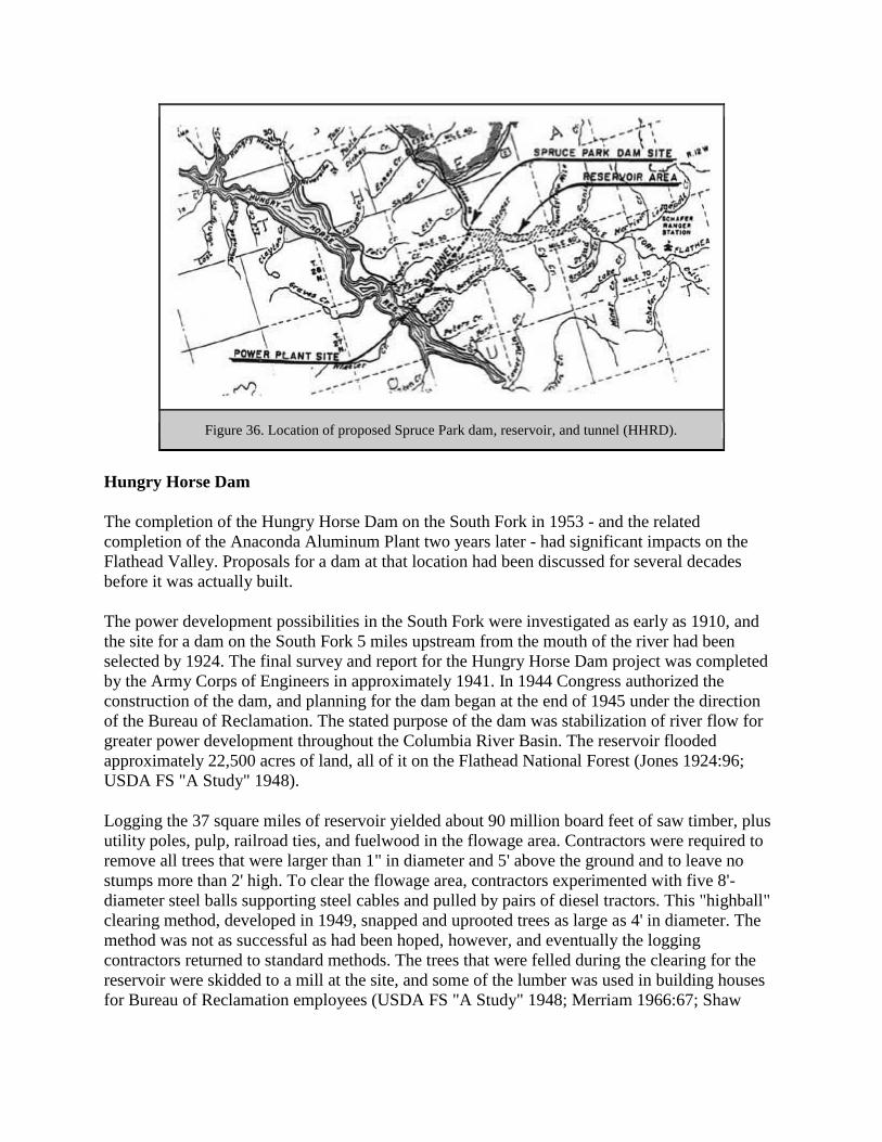
Figure 36. Location of proposed Spruce Park dam, reservoir, and tunnel (HHRD).
Hungry Horse Dam
The completion of the Hungry Horse Dam on the South Fork in 1953 - and the related
completion of the Anaconda Aluminum Plant two years later - had significant impacts on the
Flathead Valley. Proposals for a dam at that location had been discussed for several decades
before it was actually built.
The power development possibilities in the South Fork were investigated as early as 1910, and
the site for a dam on the South Fork 5 miles upstream from the mouth of the river had been
selected by 1924. The final survey and report for the Hungry Horse Dam project was completed
by the Army Corps of Engineers in approximately 1941. In 1944 Congress authorized the
construction of the dam, and planning for the dam began at the end of 1945 under the direction
of the Bureau of Reclamation. The stated purpose of the dam was stabilization of river flow for
greater power development throughout the Columbia River Basin. The reservoir flooded
approximately 22,500 acres of land, all of it on the Flathead National Forest (Jones 1924:96;
USDA FS "A Study" 1948).
Logging the 37 square miles of reservoir yielded about 90 million board feet of saw timber, plus
utility poles, pulp, railroad ties, and fuelwood in the flowage area. Contractors were required to
remove all trees that were larger than 1" in diameter and 5' above the ground and to leave no
stumps more than 2' high. To clear the flowage area, contractors experimented with five 8'-
diameter steel balls supporting steel cables and pulled by pairs of diesel tractors. This "highball"
clearing method, developed in 1949, snapped and uprooted trees as large as 4' in diameter. The
method was not as successful as had been hoped, however, and eventually the logging
contractors returned to standard methods. The trees that were felled during the clearing for the
reservoir were skidded to a mill at the site, and some of the lumber was used in building houses
for Bureau of Reclamation employees (USDA FS "A Study" 1948; Merriam 1966:67; Shaw

1967:136; "Contractors High-Ball" 1950:14-15; W. Elwood 1994; Kalispell News, 18 March
1948).
The Hungry Horse Dam, completed in November of 1953, is 564' high. It backs up water as far
as 34 miles away, with a maximum depth of 500'. In addition to generating electricity, it
regulates the flow of the South Fork and aids in flood control (Montana Conservation Council
1954:33-34). It also increases the production capacities of the Kerr and Thompson Falls power
plants and others downstream on the Columbia River Basin system.
As mitigation for the flooding of Forest Service administrative sites, the Flathead National Forest
requested that the Bureau of Reclamation replace the four work centers within the flowage area
with two identical work centers (Betty Creek and Anna Creek), one on each side of the reservoir;
reestablish pasture; relocate phone lines; replace Riverside Lookout and its communication
facilities with a lookout on Firefighter Mountain; and replace the road along the South Fork
River with a road on each side of the reservoir. After the dam was completed, the Forest Service
obtained the Bureau of Reclamation buildings to use for administration and housing, including
13 dwellings, a dorm, a conference hail, a cement-testing lab, and the building that is now the
Hungry Horse Ranger District office (USDA FS "A Study" 1948; Shaw 1967:137, 139).
The ACM decided to build an aluminum plant just outside of Columbia Fails in order to obtain
favorable electric rates. The company obtained contracts for large blocks of power from the
Bonneville Power Administration, and construction of the aluminum plant began in 1953. The
plant converts alumina into primary aluminum by an electrolytic process in pot rooms (Springer
1976:51-52; Montana Conservation Council 1954:40). The aluminum plant employs hundreds of
people and has had a major effect on settlement patterns and the economy of the upper Flathead
Valley.

TRANSPORTATION
Introduction
Travel along the western slopes of the northern Rockies was quite difficult and time-consuming
until recent years. Dense forests, steep slopes, and extreme weather conditions prevented easy
travel. The earliest travel routes through northwestern Montana were trails developed by Native
Americans. By the 1880s, a handful of wagon roads had been built in the Flathead, and soon a
few ferries and bridges, plus steamboats on Flathead Lake, improved the transportation network.
The coming of the Great Northern Railway to the valley in 1891 offered greatly improved access
to points along the line. By the 1920s, there was political pressure and funding available for
improved roads for automobile use.
The Flathead National Forest continued to rely heavily on the use of pack animals and trails after
the introduction of automobiles in the early 1900s because so much of its land was otherwise
inaccessible. The Forest was one of the earliest to use airplanes regularly, because of its
unusually large backcountry. Many Forest Service workers helped with trail construction and
maintenance, and each ranger district employed packers to move supplies by horses or mules
where needed. After World War II, however, the Forest Service began receiving funding to build
roads, many of them designed for accessing timber-sale areas and some designed also with
recreational use in mind. As the mileage of roads on the Flathead National Forest grew, the
mileage of maintained trails dropped significantly.
Early Flathead National Forest trails that are no longer maintained can often still be followed
through the woods, with the help of the worn tread and occasional blazes. Some of the early
roads have been blocked off, but these can still be easily followed on the ground.
Early Trails
Native Americans traveled through the mountains by conforming to the natural routes of travel.
If time, distance, and elevation changes were not determining factors, they followed high, open
ridges, the edges of high river terraces, or game trails. Many trails regularly used by the Kootenai
in the Flathead Valley originated near the mouth of Ashley Creek (a few miles southeast of
today's Kalispell). Native American trails in the area did not receive a great deal of use in the
1800s because their population was not very high. The number of Kootenai in both divisions and
all bands was probably about 1,000 in 1800, just before Euroamericans came into the area
(Fredlund 1971:43: Braunberger & White 1964:57: Smith 1984:55).
In the 1800s the Salish and Kootenai traversed the Flathead area on their semi-annual bison-
hunting expeditions, until the buffalo were nearly exterminated. They traveled both on horses
and unmounted, and in the winter they traveled on snowshoes. Plains groups, particularly the
Blackfeet, crossed from east to west to raid for horses. All groups also made trips into the
mountains for hunting, fishing, and gathering (Fredlund 1971:43; Malouf 1952:46). They
favored camping areas such as Schafer Meadow and Gooseberry Park that provided both horse
feed and game to hunt (see Figure 37).

Figure 37. Map of reported Native American trails in Flathead Valley area (Vaught Papers
1/L; Braunberger & White 1964:plate 19; Graetz 1985:83).
The length of time the verified Native American trails were in use is unknown. A 1900
description of trails existing in the area's mountains before 1898 is as follows:
There are old blazes in the mountains indicating old trails that must be 40 years old and
while they are all blown over, still are a certain guide in going through the country. The
South Fork country about 40 or 50 years ago, was the through route of the Hudson Bay
Company from the North-west to the South-east. The Indians have also been through this

country for years and while their trails are not open and very hard to follow yet in a pinch
a man can work his way through (J. B. Collins to GLO Commissioner, 24 August 1900,
entry 44, box 4, RG 95, NA).
The routes of various trails changed along with variations in the timber and wildlife conditions.
According to a Blackfeet tribal leader in 1853, Marias Pass had not been used for many years,
but formerly it was almost the only thoroughfare used by Native Americans in crossing the
Continental Divide. Frank Liebig reported that Marias Pass was used very little by Native
Americans because the area from the pass west to Fielding and Java was a "poor country for
game" for a long time. Nyack Creek, on the other hand, had "all kinds of elk and sheep." He said,
"I think the abundance of game lured the Indians across these passes." From Java down to
Belton, before the railroad tote road was built in 1891, "it was a hard Canyon to get through, no
game no horse feed, no trail, and a trail hard to maintain in a rough and cliffy country." The route
was also practically obliterated with downed timber (Sheire 1970:75-76; Vaught papers 1/L).
Wagon Roads
For many years the main routes for people and supplies into what is now Montana were from the
south through Salt Lake City, from the east by wagon trains, or by pack trains from Walla Walla,
Fort Colville, or even San Francisco. In the early 1860s travelers began to use the Missouri River
seasonally. The first steamboat had navigated the river from St. Louis to Fort Benton by 1859.
The arrival of the Great Northern Railway in Montana heralded the end of steamboat travel on
the Missouri River (Paul 1963:54). Travel within the state for many years centered on pack
horses. As roads were carved through the woods of western Montana, travel by team and wagon
began to be possible, although often still challenging.
The Mullan Road was built as a wagon road from Fort Benton to Fort Walla Walla. The road
was finished in 1862, just as the gold rush got under way; miners and a few settlers travelling to
Oregon Territory kept it busy. Soon, roads were built from the south. The northern offshoot of
the Oregon Trail was the Bozeman Trail, which extended from a fort in Wyoming to Virginia
City, Montana, and was popular beginning in 1864. The Fisk wagon road was the northern
overland route, used first in 1862 (see Figure 38) (Athearn 1960:87-88, 91; Toole 1959:85, 88-
89).

Figure 38. Major roads and trails in Montana after 1850. Steamboats traveled up the Missouri
River from St. Louis, Missouri, to Fort Benton (from Toole 1959).
In 1865 Governor Edgerton signed an act incorporating the Fort Benton and Kootenai Wagon
Road Company, which planned to build a wagon road from Fort Benton to Marias Pass and on to
the intersection with the Fort Steele-Kalispell Trail. Blackfeet hostility, however, led to the toll
road project being dropped, and the charter was later cancelled (Elwood 1980:22).
A number of the early wagon roads were built over Native American trails, as they were already
somewhat cleared and were often the best route to take through an area. One of these was the
Fort Steele-Kalispell Trail (also called the Tobacco Plains Trail or Road), used by miners going
from the Missoula area to mines in British Columbia (see Figure 39). That route had been used
for a long time by Native Americans traveling between the Bitterroot Valley and the Tobacco
Plains area (O. Johnson 1950:16).

Figure 39. Freighter on Fort Steele-Kalispell trail (courtesy of Mansfield Library, University
of Montana, Missoula).
In 1891 early settler Henry Bierman traveled this route with a team and wagons from Spring
Prairie, near today's Kalispell, to Tobacco Plains in 1891. "By going ahead with an ax and
cutting timber and brush and then following up with the teams, we made Ant Flats in 13 days.
Some places we had to let the wagons down with ropes." In 1893 he was hired to be the
supervisor of a road improvement crew on this rough road (Bierman ca. 1939:41-43).
During the construction of the Great Northern Railway, vast amounts of freight were brought to
the Flathead Valley via the Northern Pacific Railroad to Ravalli, by wagon to the foot of
Flathead Lake, and then by steamboat to Demersville. Supplies for Canadian Pacific Railroad
workers in British Columbia were also brought by freighters along this route and then taken by
wagon to Canada. This freighting to Fort Steele continued long after the railroad reached
Kalispell (Elwood 1980:107).
Until the late 1880s and the rise of Demersville, Flathead Valley residents bought many of their
supplies at trading posts south of Flathead Lake or in Missoula. Until steamboat travel on the
lake, all travelers followed a rough trail along the west side of Flathead Lake. By 1885,
steamboats connected the foot of the lake with the upper Flathead Valley and points between
(see Figure 40). The first boat, the Swan, sometimes took as long as a week to travel the length
of the lake. Steamboat activity on the lake peaked in 1915, when more than 20 boats were
operating. The steamboats on Flathead Lake were used as a connecting link between the

Northern Pacific Railroad on the south and the Great Northern Railway on the north (see Figure
41) (Biggar 1950:115; Elwood 1976:60-61).
Figure 40. Mary Ann and State of Montana at Demersville, 1891 (courtesy of Mansfield
Library, University of Montana, Missoula).

Figure 41. Map of Flathead County, ca. 1905, showing towns along the railroad lines,
boundaries of the Flathead Indian Reservation, steamboat routes, and the proposed route of
the Milwaukee & Great Northern Railway along the east shore of Flathead Lake (map in
"Montana - Flathead County - Maps," Flathead County Library). The original route of the
GNRR is shown as a spur line from Columbia Falls to Kalispell and Lakeview.
The completion of the Northern Pacific line into Polson in 1917, and the increased use of
automobiles, greatly reduced the demand for lake transportation, and passenger steamboat travel
on Flathead Lake ended about 1925. Lumber company tugboats continued operating on the lake
into the 1940s, however (Bergman 1962:78-79; Elwood 1976:61).
By 1888 a mail and passenger stage line connected Ravalli with Demersville. The trip took four
days round trip and was popular during cold weather when the steamboats could not make their

runs. The road along the east shore of Flathead Lake was built by convict and settler labor in the
1910s, although a rough wagon road had existed before then (Bergman 1962:64; Robbin
1985:28).
Travel in the Flathead Valley in the 1880s is described vividly by Margaret Rising, who had a
ranch near Bad Rock Canyon in 1887. "There were no fences or roads at all and we just went the
best way we could find across the bunch grass and through the heavy timber. We had a blazed
trail through the timber so that we could get a team through and not hit too many trees and
stumps" (Johns 1943:III, 41).
Gradually, settlers built bridges or operated ferries at river crossings. The Holt ferry was the first
on the Flathead River, and it was not replaced by a bridge until 1942. A number of important
bridges were built in the 1890s, including the Old Steel Bridge near Kalispell (1893), the Red
Bridge near Columbia Falls (1896), and the Middle Fork bridge at Belton (1897) (Flint 1957:7;
Robinson & Bowers 1960:62; Blake 1936:2).
The Flathead Valley was not directly accessible from the east until 1890, when Great Northern
Railway contractors began building a wagon road known as the "tote road" from Bad Rock
Canyon to the summit at Marias Pass for hauling their supplies. By the spring of 1891 a stage
line was running between McCarthysville, near the summit, and Demersville. This was probably
short-lived because the railroad came through later that year and the town of McCarthysville
soon faded away. Henry Bierman reported that it took him 10 days to travel from McCarthysville
to Columbia Falls with his team in 1891. During the summer of 1891 John Kennedy furnished
the beef for the construction camps. Cattle were driven from Two Medicine and herded in corrals
along the route. The cattle were slaughtered near the regular camps and the remains left there.
Grizzly bears would be attracted to these piles of hides and offal, so people would hunt bear at
these locations (Inter Lake, 14 November 1890 and 27 March 1891; Bierman ca. 1939:40-42).
The men at railroad construction camps denuded the surrounding hillsides of timber, consumed
vast quantities of wild game, and started numerous forest fires. They also attracted all kinds of
entrepreneurs and dealers to the area, including smugglers. For example, when the railroad was
being built through the Flathead, the North Fork provided a route for horse thieves, smugglers,
and for Chinese and opium to cross the border (DeSanto 1985:26).
Some of the valleys in the Flathead had difficult access for many decades. To travel to the Swan
Valley in 1918, for example, one followed a 7-mile wagon road from Bigfork to the foot of Swan
Lake and then took a boat up the lake (in the summer) or a 13-mile pack trail along the east shore
(in the winter). From the south, a road/trail led from Ovando to Swan Lake. Early trips from the
Swan Valley to Missoula generally took five days by wagon (Flathead National Forest "General
Report" 1918; Wolff 1980:54).
Railroads
The transcontinental railroads had a tremendous influence on the development of the West (see
Figure 42). With the coming of the Great Northern Railway to the Flathead Valley in 1891,
residents enjoyed national rather than local markets for their products. During the Klondike gold

rush of the late 1890s, business boomed throughout the Pacific Northwest as supplies for
stampeders were shipped by railroad to jumping-off points like Seattle.
Figure 42. Railroad routes in Montana, 1887, 1898, 1910. The new Great
Northern Railway route built 1903-1904 and still in use is shown on the 1910
map. The main line of the Canadian Pacific Railway passed through Calgary
and over Kicking Horse Pass far to the north (from Alwin 1972).

By 1889 the Great Northern Railway had reached Havre, east of the Rockies, but the company
still did not know exactly what route it would take across the Continental Divide. James J. Hill
asked location engineer John F. Stevens to find out whether Marias Pass existed and could be
used as a railroad route, as it was the most direct of all proposed (it was shown on an 1887 GLO
map of Montana). Besides the Marias Pass route, railroad officials considered three other
possible paths across the Rockies: along the North Fork of the Sun River; west from Butte across
the Bitterroots; and along the South Fork of the Sun River over Rogers Pass to Missoula. Stevens
traveled to the top of Marias Pass with a Kalispel (Native American) guide and reported
favorably on the pass's potential. Meanwhile, Charles F. B. Haskell examined the western
approaches, including the route west of Kalispell across what is now known as Haskill [sic] Pass
into Pleasant Valley. In 1925 the Great Northern erected a bronze statue of Stevens at Marias
Pass, commemorating his 1889 winter trip to the summit (he did not himself claim to have been
the first Euroamerican to have crossed the pass) (Hidy 1988:74; J. Stevens 1935:672, 674;
Haskell 1948:3).
For a variety of terrain and economic considerations, the Great Northern Railway chose the route
across Marias Pass for crossing the Divide. On January 6, 1893, the last spike was driven on the
Great Northern transcontinental line between Minnesota and the Pacific Ocean (Hidy 1988:74,
83).
In 1904 the Great Northern Railway relocated its main line between Columbia Falls and Jennings
(near Libby). The division point was moved from Kalispell to the new town of Whitefish,
creating a shift in population and to some extent in economic activity in the valley. At least one
Flathead Valley old-timer grumbled that guides and trappers had recommended that route back
in 1891 to James Hill, but "the wise boys in St. Paul said it was too far north." Some people with
businesses along the abandoned main line sued the railroad. Stock raisers west of Kalispell and a
Pleasant Valley lumber mill owner settled for damages to their businesses with the railroad
company (City of Kalispell 1921:42-43; O'Neil 1955:151; "Old-Time Flathead Tales" 1939).
Between 1910 and 1916 several different schemes to connect the upper and lower valleys by
railroad were seriously considered. The Northern Pacific did build tracks to Polson in 1917, but a
line along Flathead Lake never materialized. In the early 1890s A. B. Hammond of Missoula
promoted the idea of a railroad line that would compete with the Great Northern Railway. He
hoped for a branch line of the Northern Pacific that would extend to the northern end of Flathead
Lake, and the company agreed to build it if private interests could raise $100,000. The money
was not raised, and the line was never built (Biggar 1950:122; Coon 1926:129).
Other railroad routes that did not materialize included one connecting the North Fork of the Sun
River with Bowl Creek, the Middle Fork, and Coram; the Flathead Interurban Railway which
would have connected the major communities in the Flathead Valley (ground was broken for this
in 1911); a line from Bonner through the Swan Valley and up the North Fork to Fernie, B. C.
(two routes were actually surveyed in the North Fork in 1909); and a line to run from Ravalli to
Demersville to the coal fields in the North Fork (Elwood 1980:147; Graetz 1985:90; Ingalls ca.
1945:5). These projects were generally aimed at reaching particular natural resources that might
offer the chance of bringing in great revenue.

The Canadian Pacific Railroad reached Calgary in 1885. Before the main line was built, most of
the mail addressed to the Kootenay area of British Columbia went through the United States with
American postage. A spur line from Fernie to Coal Creek was built in 1898 and ran until the
mines closed in 1958. The railroad proposed building all the way south to the international
boundary but never did so (Beals 1935:19; Fernie Historical Association 1967:39, 41).
Automobiles
The first cars were delivered to the Flathead Valley ca. 1905. In 1910, 60 Kalispell residents
owned autos, and in 1919 the Flathead Valley could boast of about 2,000 automobile owners.
Through the 1920s automobile driving in the Flathead Valley was still primarily a recreational
activity, although doctors and other businesspeople used cars and trucks for their work. Building
good roads was rationalized initially for the economic benefits and for the contributions to
national defense, but recreational benefits underlay much of the early demand for highway
improvement. In fact, the Good Roads Movement had been established in 1888 by the League of
American Wheelmen (bicyclists) (McKay 1993:14; Jakle 1985:120).
Early county road construction mostly involved short-haul dirt roads built without the advice of
engineers. Most of these roads were impassable during periods of heavy snow or spring thaws.
Taxpayers could either pay cash to support the roads, or they could work on the roads themselves
in lieu of payments (Wyss 1992:13).
The State Highway Commission first met in 1913, and until 1917 it was restricted from
cooperating financially with the counties in a road construction program because of a lack of
funds. The Commission did allow a limited amount of money to counties for road construction,
and it purchased and equipped eight teams for use by prison forces on road construction
(Montana State Highway Commission 1943:11, 12).
In 1917 the Montana legislature initiated a uniform system for construction and improvement of
the main highways of the state. Early State Highway Commission contracts required a 22'
roadway. In 1927 the state assumed the responsibility for snow removal (Wyss 1992:25, 31, 35).
In the 1920s the federal government spent unprecedented amounts on road and highway
development. The completion of several automobile roads greatly affected transportation
patterns in the Flathead Valley. These included the highway over Marias Pass (1930), the Going-
to-the-Sun Road in Glacier National Park (1932), and the Swan Valley highway (1958) (see
Figures 43-48).

Figure 43. Primary roads and trails in area of present Flathead National Forest, 1898.

Figure 44. Primary roads and trails in area of present Flathead National Forest, 1908
(Blackfeet National Forest) and 1912 (Flathad National Forest).

Figure 45. Primary roads and trails in area of present Flathead National Forest, 1928
(Blackfeet National Forest) and 1927 (Flathead National Forest).
Forest Service Trails
An early, overriding job of forest rangers and guards on the Flathead National Forest was the
creation of an effective transportation system. Because of budget constraints and the steep,
rugged terrain, they generally built trails rather than roads. Until 1905, while the forest reserves

were still administered by the GLO, supervisors did not bother to develop plans for road and trail
systems; instead, rangers constructed trails to meet immediate needs. Some of the early "trails"
were just blazes hacked through the woods. As ranger Jack Clack commented about traveling in
the South Fork in 1907, "Trails... were considered a luxury anyhow, something very nice to have
if you could afford it but not an absolute necessity." H. B. Ayres reported in 1900 that on the
Lewis & Clarke Forest Reserve (south of the Middle Fork) the underbrush was generally not
dense and that one could ride horses anywhere except in damp ravines with abundant yew
(Caywood et al. 1991:20; Clack 1923a:6; Ayres "Lewis & Clarke" 1900:45).
Forest Service trails generally were designed to follow the shortest route between two points
with a minimum of elevation change (usually along river bottoms through thick lodgepole and
undergrowth). The best location for trails was debated over the years. In 1929 a Flathead
National Forest employee argued that trails should not be built along creek bottoms but should
be located on ridges because ridge trails would give a smokechaser more chance of spotting and
then finding fires. Ridge trails also cost less to construct than river trails, although spur trails to
water were required (Fredlund 1971:43; Wiles 1929: 5-6).
The purposes of Forest Service trails were fire control, administration, grazing, and recreation.
According to a 1935 manual, "Well-balanced work, not polish, is wanted." The manual
recommended locating trails on southern exposures, ridges, benches, natural openings, open
timber, and in light stands of brush whenever possible (USDA FS "Forest Trail Handbook"
1935:5, 7-8, 11, 14). Crews built bridges to eliminate difficult stream crossings (see Figure 46).
Figure 46. Fitting the abutment timbers on the Big Prairie bridge over the South Fork, 1922
(courtesy of Flathead National Forest, Kalispell).
Although most trails were originally built for fire protection purposes, some - especially in the
Lake McDonald area - were built specifically to open up the backcountry for tourist use. Trails
were constructed to different standards depending on their anticipated use. Glacier View Ranger

District packer Bill Yenne described a "way trail," the lowest level of construction, as "scarcely
passable for a jackrabbit" (Liebig 1936:15; Yenne 1983:32).
In 1900 there were about 200 miles of old but passable trails on the South Fork and its
tributaries. The regional supervisor reported that "Our forest force have taken a great many of
these old trails and changed them, making shorter cuts, or avoiding swamps and steep hills. In
making this estimate I cannot call them open trails, but trails that can be followed through the
country" (J. B. Collins to GLO commissioner, 24 August 1900, entry 44, box 4, RG 95, NA).
Travel remained slow at best, even in areas no longer considered remote.
One of the early official trails in the Flathead National Forest went 21 miles from Ovando to the
Danaher Basin. It was completed in 1903. In 1906, rangers were stationed for the first time at the
head of the Spotted Bear and White Rivers, creating a need to build trails up those streams. In
that year, rangers "pushed a trail of sorts up river as far as Spotted Bear, and from the head of the
river down to Black Bear," but there was no trail between the two. This South Fork trail was the
main route through the early forest reserve south of the Middle Fork. In 1900 there were about
135 miles of trail on the Swan River, plus about 12 shorter trails ranging from 10 to 30 miles in
length (Flathead National Forest, "Informational Report" 1939; "Reports of the Section of
Inspection," Elers Koch, 28 November 1906, RG 95, NA; USDA FS "Early Days" 1944:101; J.
B. Collins to GLO commissioner, 24 August 1900, entry 44, box 4, RG 95, NA).
In 1920 a forest inspector felt that the trail mileage on the Flathead National Forest was still
"surprisingly low" and that vast areas still had no trails. He said much of the trail money was
spent on the main river trails instead of on lateral trails and criticized the rangers for building two
and even three trails along the South Fork in an unplanned "process of evolution." He mentioned
that although 1,000 trail signs had been painted they were not yet posted, leaving some major
intersections unmarked (Elers Koch, 19 July 1920, Flathead 1920-23 Inspection Reports, RG 95,
FRC).
By 1936, the Flathead National Forest had constructed 4,500 miles of trail. At that time there
were only 360 miles of highway and Forest Service development roads on the Forest. In the
1930s, according to Pat Taylor, "Everything was walking. Men walked on these trails. The
assistant ranger and the ranger rode and the packer rode but the rest walked" (Blake 1936:2;
Taylor 1981).
For years after 1918, a large portion of road and trail funds were used in Region 1 to build trails
into the backcountry (USDA FS "History of Engineering" 1990:20; R. West 1938:1). Trail
mileage on the Flathead National Forest was declining by the 1950s, however. In 1955, trail
mileages were as follows:
Big Prairie: 485 miles
Condon: 278 miles
Coram: 402 miles
North Fork: 421 miles
Schafer: 405 miles
Spotted Bear: 543 miles

Swan Lake: 263 miles
Tally Lake: 261 miles plus 92 more on Northern Montana Forestry Association
protection area on Tally Lake RD
(FNF "Transportation System Inventory" 1955).
The total mileage was 3,150 miles. Thirty years later the trail mileage on the Flathead National
Forest had dropped to 2,146 miles (FNF "Forest Plan" 1985:S-15).
The Middle Fork trail (along the railroad tracks) was also an early priority; by 1906 Forest
Service workers had cut it out except for three miles just below Java, but its completion was
delayed by the deaths of rangers McElroy and Harbin in a railway accident. Professor Morton
Elrod of the University of Montana filed a complaint about the condition of this trail, but the
inspector commented that "no one but a very nervous man or one unaccustomed to the mountains
would give the trail a second thought in going over it with a pack outfit" ("Reports of the Section
of Inspection," Elers Koch, 28 November 1906, RG 95, NA).
By far the easiest transportation route for early forest rangers was the Great Northern Railway
tracks, and rangers used gas speeders along the tracks to cover the area from Summit all the way
to Eureka. In the Middle Fork, fire crews were ordered by wire from Kalispell and sent in by
train to the closest point (USDA FS "Early Days" 1955:73-74).
In the early years, some Forest Service workers attempted to use rivers for transportation
corridors, as some of the early trappers had done. In 1915, for example, several timber cruisers
decided to return to Coram from the Riverside Ranger Station on the South Fork by raft. One
went over a waterfall and ended up snowshoeing the rest of the way out (USDA FS "Early Days"
1955:81-82).
An attempt at alternative transportation methods was made in 1923, when rangers Henry Thol
and Ray Trueman tested sled dog teams in the backcountry. On their first trip, they traveled from
Coram up the South Fork with 250 pounds of supplies, including two blankets for each man,
coming out six weeks later at Holland Lake. The dogs proved unsatisfactory on sidehill trails in
rough terrain (USDA FS "Early Days" 1962:209; Thol 1936: 13).
Because of its remote districts, the Flathead National Forest used airplanes regularly by the
1930s. In 1932, one hundred thousand pounds of freight was delivered to a Flathead National
Forest landing field at less cost than using a combination of railroad, trucks and pack trains. By
1939, the Flathead National Forest had 10 airplane landing fields. Helicopters came into local
use in 1954. They were practical both in regular forest duties and in bringing sick or injured
people out of the backcountry (Headley 1932:183; Flathead National Forest, "Informational
Report" 1939; Shaw 1967:99).
Forest Service Trail Construction and Maintenance
Early Forest Service trail crews consisted of 10-12 men, including a cook, while later crews
generally consisted of 3-5 men who did their own cooking. Trail crews typically lived in tent

camps, which they moved every 7-10 days (see Figure 47). The men were trained and kept
available for fighting fires (Swan River Homemakers Club 1993:339; Taylor 1986).
4 axes
1 5—gallon man-pack bag
2 2-1/2—gallon water bags
1 crow bar (where needed)
12' log chains (where needed)
medicine chest
cap crimpers (where needed)
4 8" files
4 10" files
1 U.S. flag
Beatty trail grader (where needed)
claw hammer
4-lb falling hammer
axe handle
2 mattock handles
2 saw handles
1 brush hook
1 timekeeper's kit
1 mattock
1 cobbler outfit
1 saw-filing outfit
2 complete smokechaser's outfits
1 peavy
2 mattock picks
1 trail plow (where needed)
1 pack frame
5 1/2' crosscut saws
2 LHRP shovels
3 pocket carborundum stones
2 falling wedges
2 wash basins
1 wash board
1 2—gallon boiler
4 granite soup bowls
1 10—quart canvas water bucket
1 can opener
1 alarm clock
2 medium bread pans
1 bread dish
7 nested cups
1 8' canvas table top
8 table forks
1 pancake griddle
2 2—quart kettles
2 4—quart kettles
1 6—quart kettle
1 butcher knife
1 paring knife
8 table knives
6 lbs assorted nails
3 yards 46"-wide white oilcloth
6 dessert spoons
1 mixing spoon
8 table spoons
1 complete telephone
3 pie tins
8 50-lb flour sacks
dish toweling
wash tub
1 cake turner
1 10x12' fly
2 10x12' tents
30 wool blankets
extra bed (for forest officer)
5 tarps
1 Lang or sheep cook stove
5 stovepipe joints
1 3—quart dish-up pan
3 2—quart dish-up pans
1 medium fry pan
2 large fry pans
8 enamel plates
1 coffeepot
12 cloth lunch sacks
1 meat saw
4 yards cheesecloth screen
1 salt shaker
Figure 47. Equipment considered necessary for a five-man Forest Service trail
crew in 1935 (Fickes 1935:T-13-15)

In the 1930s, the main job of trail crews was logging out trails. One man would go in front with
an ax and cut out the trees up to 6-8" in diameter, and two more would follow with a cross-cut
saw. They would cut standing and down "pack bumpers" (trees that mules carrying loaded packs
might bump into), clear brush, remove snags left by fires, do minor drainage work, kick rocks
out of the trail, and freshen up trail blazes (Taylor 1981).
Some trail crew workers did get injured on the job. One compensation case report submitted by a
trail foreman featured poor grammar but was succinct: "Please fix this man up with comp. Has
fell and hurt his knee. Slick shod. Bad stuff" (Fremming 1931:8).
By 1930 the Blackfeet National Forest was using "gyppo" (contract) trail crews as well as day
crews, and they found that the gyppo system cost 1/3 less with no difference in quality. Pat
Taylor remembered a trail crew of five German immigrants working on the Tally Lake Ranger
District in the 1930s. This crew was unusual because the men furnished their own saws (bow
saws, or Swede fiddles) ("Gyppo Work" 1930:7; Taylor 1986).
Way trails, built to the lowest standard, were designed for extreme fire emergencies, not for
everyday use. Way trails were cleared to the minimum width required to allow a pack string to
pass through, and the maximum grade was 15% (which trail crews checked with a level). Tread
work was held to a minimum because pack animals would establish it, and few bridges were
built because the stock could ford most waterways. In 1928 the Flathead National Forest built 10
miles of primary trails, 81 miles of secondary trails, and 312 miles of way trails, for a cost of
$522, $178, and $113 respectively. Way trails were clearly the cheapest and easiest to construct
but certainly not the best for traveling (Taylor 1986; USDA FS "Forest Trail Handbook"
1935:15; Wiles 1929: 6-7).
The Forest Service blaze in the 1930s had a 4"-high mark on top, and then 4" below it was a
lower blaze 8" in height. Workers cut the blazes 30' apart at eye level facing both directions on
the trail. Early trail signs were made of enamel and had black letters on white backgrounds. By
the 1950s the Forest Service was using imprinted aluminum or routed wood signs. The Forest
Service used to post mile boards on the trails (Taylor 1986; 1956 inspection report in 24PW1003,
FNF CR; Howard 1984).
The Forest Service experimented with a number of mechanized tools for trail building and
maintenance and even helped sponsor some industrial development work for particular
machinery. For example, in 1923 the Flathead and Blackfeet National Forests performed field
tests of the Wolf power saw (a forerunner of the chain saw). They concluded that the saw had
"very real possibilities for use in areas where heavy sawing jobs exist," but that it was not
suitable for light work. In 1950 chain saws were not being used extensively for trail work
because they were only needed intermittently; they were more practical in heavy blowdowns.
The cutter bars at that time ranged in size from 14" to 6' in length (Frank J. Jefferson, 3 August
1932, Flathead Inspection Reports, RG 95, FRC; USDA FS "Trail Handbook" 1950).
In 1925 the Blackfeet National Forest bought six of the "new model" Beatty trail graders, which
they used for trail and road construction, and they also tested horse-drawn plows (seeFigure 48).
They determined that the horse-drawn plow-and-grader system could be used in all terrain

except solid rock, even in heavy beargrass. The cost of construction of over 75 miles of trail built
with these plows and graders was 1/5 to 1/4 the cost of hand labor. The Flathead National Forest
reached similar conclusions despite "considerable opposition" to the new tools. Popular for many
years, the Beatty trail grader was last manufactured in 1952 (USDA FS "Trail Handbook"
1950:34-35; "Use Horses" 1925:14-16; Mendenhall 1926:4).
Figure 48. The Beatty trail grader (courtesy of Flathead National Forest, Kalispell).
Eventually trail maintenance within the Forest Service became the responsibility of the
Recreation department, reflecting the shift away from the original purpose of improved
transportation networks for Forest protection (Caywood et al. 1991:66).
Forest Service Use of Pack Animals
Since most of the Flathead National Forest was accessible only by trails for many years, the
Forest Service relied heavily on pack animals. At first, rangers were required to furnish their
own saddle and pack horses.
The first pack animals purchased by the Forest Service for use in the Northwest were
reportedly eight head of horses that Jack Clack brought to Big Prairie on the South Fork in
1907 or 1908. The experiment in breeding these horses failed, and the government
subsequently purchased all of its stock. In those early years, according to one Flathead
National Forest employee, the pack animal was generally a cayuse that "could be had for a
song - even an off-tune song" (Frohlicher 1930:456-457; Caywood et al. 1991:25).
Jack Clack probably brought the horses to Big Prairie because of an inspection report in
which Elers Koch commented that rangers on the South Fork spent 6-10 days on every trip

out of their district for supplies. Koch recommended hiring one man to constantly deliver
supplies with a government pack train from Columbia Falls to Ovando via the South Fork.
This basic concept is still being followed in the Bob Marshall Wilderness between Spotted
Bear and the Big Prairie and Schafer Work Centers (Elers Koch, 28 November 1906, "Report
of the Section of Inspection," entry 7, box 4, RG 95, NA).
In many ways, packers and their stock were the lifeblood of the Forest Service. As Flathead
National Forest employee John Frohlicher commented in 1930, "If a lookout, ranger, or
firefighter is without tobacco, coffee, or even his mail, he is a discontented human being. The
mule packs in whatever is necessary for his peace of mind and body" (Frohlicher 1930:456-
457).
Horses were initially the pack animal of preference. In the early years, two men with 15-20
head of horses would work together on long pack trips. They usually herded them down the
trail instead of stringing them together (Shaw 1967:23). During the 1910s, almost all Forest
Service employees learned to pack a horse; horses were more tolerant of poor packers than
mules. According to one Flathead National Forest employee:
mule packers are born, not made...The old heads couldn't stand the mules. They are
now found somewhere out in civilization, cursing the animals that chased them from
their jobs...The new packers [who used mules]...were better than smokechasers and
rangers and lookouts. They admitted it, even though the lesser lights frequently
rounded the mules up. Packers' heels are too high to allow much walking. Anyway, a
smokechaser should have practice looking for mean things, like fires and mules, the
packers reasoned (Frohlicher 1930:457).
According to long-time Flathead National Forest employee Charlie Shaw, packers generally
preferred mules to horses for packing because they were more sure-footed, required less
feed, could carry heavier loads, had a smoother gait, stayed with the bell mare at night, and
would not try to rub their packs off against trees along the trail. On the other hand, mules
tended to hide out when wanted, to bog down in muddy trails, and to do poor work logging
and trailmaking (Benson 1980:22; Frohlicher 1930:458).
In the spring, pack animals destined for the Flathead National Forest were driven from their
winter range near Flathead Lake. The Holt Ferry brought them across the Flathead River,
with their destination the Echo Ranger Station corral. There the South Fork and Echo stock
were cut from the herd, and the rest of the stock headed up the Swan the next morning.
During the winter, employees at the station did all the tack and saddle repair for the Forest
(Swan River Homemakers Club 1993:339).
"Main line" packers supplied workers in isolated districts so that they did not have to travel
out of their area themselves. Each district also had its own packer, and all employees learned
to pack short strings (up to five head). Backcountry ranger districts relied on the packers for
food. The cook at Big Prairie in 1926, for example, recalled running low on food; he served
ham with the mold washed off until the packer arrived. Most ranger districts had a large
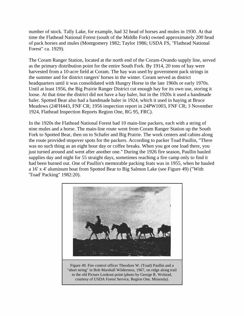
number of stock. Tally Lake, for example, had 32 head of horses and mules in 1930. At that
time the Flathead National Forest (south of the Middle Fork) owned approximately 200 head
of pack horses and mules (Montgomery 1982; Taylor 1986; USDA FS, "Flathead National
Forest" ca. 1929).
The Coram Ranger Station, located at the north end of the Coram-Ovando supply line, served
as the primary distribution point for the entire South Fork. By 1914, 20 tons of hay were
harvested from a 10-acre field at Coram. The hay was used by government pack strings in
the summer and for district rangers' horses in the winter. Coram served as district
headquarters until it was consolidated with Hungry Horse in the late 1960s or early 1970s.
Until at least 1956, the Big Prairie Ranger District cut enough hay for its own use, storing it
loose. At that time the district did not have a hay baler, but in the 1920s it used a handmade
baler. Spotted Bear also had a handmade baler in 1924, which it used in haying at Bruce
Meadows (24FH443, FNF CR; 1956 inspection report in 24PW1003, FNF CR; 3 November
1924, Flathead Inspection Reports Region One, RG 95, FRC).
In the 1920s the Flathead National Forest had 10 main-line packers, each with a string of
nine mules and a horse. The main-line route went from Coram Ranger Station up the South
Fork to Spotted Bear, then on to Schafer and Big Prairie. The work centers and cabins along
the route provided stopover spots for the packers. According to packer Toad Paullin, "There
was no such thing as an eight hour day or coffee breaks. When you got one load there, you
just turned around and went after another one." During the 1926 fire season, Paullin hauled
supplies day and night for 55 straight days, sometimes reaching a fire camp only to find it
had been burned out. One of Paullin's memorable packing feats was in 1955, when he hauled
a 16' x 4' aluminum boat from Spotted Bear to Big Salmon Lake (see Figure 49) ("With
'Toad' Packing" 1982:20).
Figure 49. Fire control officer Theodore W. (Toad) Paullin and a
"short string" in Bob Marshall Wilderness, 1967, on ridge along trail
to the old Picture Lookout point (photo by George R. Wolstad,
courtesy of USDA Forest Service, Region One, Missoula).

The packer would generally start out about 4 a.m. to locate his stock; he had to be a good tracker.
The saddle horse would be picketed or hobbled, and the bell mare was usually hobbled, belled,
and turned loose with the rest. Once he had wrangled the horses and mules, the packer would
halter and curry the animals and put on feed bags. He would then take off the nose bags and
saddle the mules. If he had not done so the night before, he would "manty up" the load, dividing
the articles into side packs and tying them into packs with cargo ropes (see Figure 50) (Taylor
1988; Taylor 1986).
Figure 50. Toussaint Jones packing a hot-water heater to a Flathead National Forest
administrative site (courtesy of Flathead National Forest, Kalispell).
By 1924, the Flathead National Forest was putting into effect the "Idaho plan" of replacing
horses with mules and adopting the Decker saddle. The Decker packsaddle replaced the sawbuck
and the diamond hitch (the last diamond hitch in the Forest Service was thrown in 1928). As Pat
Taylor commented, "The 'Diamond Hitch' was being forgotten as fast as possible." The Decker
saddle originated in Idaho during the turn-of-the-century mining boom there and was popular
because a load that hit an obstacle would shift back into position. With the new system, eight
mules to a string with a bell mare and the packer's saddle horse became the norm. The sawbuck
saddle and diamond hitch continued to be used in Glacier National Park for a while longer (3
November 1924 memo, Flathead Inspection Reports Region One, RG 95, FRC; USDA FS "Early
Days" 1976:43; Taylor 1988; Taylor 1986; Yenne 1983:6, 54; Shaw 1967:23).
During the 1929 fire season, an unusually bad year, Region One did not have enough mules to
supply the need. The Forest Service hired 2,000 extra horses and used them to pack tools, food,
and bedding to fire crews, working a total of 45,000 horse days. Part of the reason for the
shortage of pack animals was that the stock that was formerly available for hire in the region was

being replaced by automobiles and trucks (Frohlicher 1930:457; USDA FS, "Flathead National
Forest" ca. 1929).
After the fire season of 1929, Clyde Fickes proposed establishing a Remount Depot for the
region. In 1930 the Forest Service leased a ranch 30 miles west of Missoula, and that summer
hired stock was sent out to the various Forests as needed. Soon the Remount Depot purchased its
own stock. In 1934 the Forest Service bought a ranch, and the CCC constructed buildings at the
new Remount Depot. The Flathead, Blackfeet, and Kootenai National Forests had been wintering
their stock in the Big Draw near Flathead Lake for several years; the Remount took over that
contract. The Remount also trained and sent out plow units (teams of draft horses used to cut a
fireline with a plow). Each 10-mule pack string sent out by the Remount Depot supplied a 25-
man fire crew plus a cook and packer, and the supplies included cooking utensils, canned goods,
sides of beef and other food, and firefighting tools. Some of the canned food had inspirational
slogans on them such as "Less Food in the Refuse Pail - Fewer Pack Mules on the Trail" (USDA
FS "Early Days" 1944:56-60, 62; Benson 1980:4-7, 21; Howard 1984).
The Remount Depot was phased out beginning in 1953. Some of the reasons for its
discontinuation included the use of smokejumpers (resulting in fewer large, remote fires), the
much more extensive road system on the national forests, airplane cargo delivery, and the
reduced use of lookouts (Benson 1980:31).
While the Remount Depot operation was a success for many years, aiding in the fire and general
work of the region, other ideas from the regional office were not so popular on the district level.
For example, in 1926 Regional Forester Evan Kelley hired a couple of bronc riders to break the
mules at Big Prairie for riding (Kelley was trying to save firefighters the 40-mile walk from
Spotted Bear to Big Prairie). The bronc riders "plowed up sections of the Prairie with their faces"
until they quit. Only two mules could be ridden, and the firefighters continued to walk in
(Frohlicher 1986:98-99).
Another time-saving idea of Kelley's also ended in failure. He wanted to reduce the time it took
for packers to balance, manty, and load mules. To this end, he had a loading dock built at Spotted
Bear with a pole, pulley, and rope to joist the packs up over the mules and lower them to the
packsaddles. But, the mules "had to see two legs under the pack when it was coming towards
them"; otherwise they broke into frenzied bucking. Even so, an experienced packer with a helper
could reportedly load tools, bedding, and two days' rations for 30 men in about 20 minutes
without the use of a loading dock (Frohlicher 1986:99-101; R1 PR 798, 29 May 1937).
Forest Service Roads
The lack of roads significantly limited the Flathead National Forest's ability to develop an area
(i.e., to use the natural resources such as timber). As early as 1906, forest inspector Elers Koch
wrote, "There is an excellent opportunity on this reserve to open up to sale large bodies of timber
by the construction of roads up the main valleys. The Swan River and the South Fork of the
Flathead are the two best propositions for work of this sort." In the early years, Forest Service
workers helped on county road construction. In 1908, for example, Jack Clack was in charge of
road reconstruction through Bad Rock Canyon, which required blasting through 1/2 mile of solid

rock. Rangers worked on the job on "contributed time" (Elers Koch to The Forester, 18
November 1906, "Reports of the Section of Inspection," entry 7, box 4, RG 95, NA; Bloom
1933:2).
Before automobiles came into common use, there was little demand for the development of
mountain roads. The improvement of Forest recreation roads was initially promoted by the
federal government. In Montana, the Bureau of Public Roads supervised all major forest
construction projects. The 1910 fires led the Forest Service to push for funding for more roads
and other improvements such as trails and telephone lines. The general consensus was that poor
transportation and communication systems allowed the fires to get so big (Wyss 1992:43-44;
Baker et al. 1993:224).
In the 1920s the Forest Service adopted motorized transport, resulting in the consolidation of
many ranger districts and aiding in moving men and supplies for firefighting. Region One bought
its first automobile in 1917 (for the Custer National Forest). By 1940 the Flathead National
Forest had approximately 32 forest trucks, pickups and cars, 10 pieces of road machinery, and
fire pumpers (Baker et al. 1993:73; CCC: Inspection: General: Montana State: Camp S-208, RG
95, FRC).
Before 1912 the Forest Service did not have the authority or the funds to construct, maintain, or
manage roads. In 1913 Congress gave the Forest Service the authority to spend 10% of the
national forest receipts on roads and trails; the money had to be spent in the state in which it
originated. For three years before the Federal Road Act of 1916 was enacted, the federal
government provided funds in small amounts for the improvement of roads within the national
forests. The Public Roads Administration, the Forest Service, and the State Highway Department
combined to develop the forest highway system. The Federal Highways Act of 1916 defined
forest roads and provided additional financing. This was the first money available for Montana's
Forest roads; it was spent on the Bitterroot Big Hole Road. Beginning in 1921, Forests also
received money for roads from the Federal Highway fund (Montana State Highway Commission
1943:59; Burnell 1980:1; Bolle 1959:139).
As defined in 1924, forest highways are sections of state, county, and other important public
roads in and adjacent to the national forests that provide primary access to the Forest. They
receive federal funds authorized for Interstate Highways, plus funds authorized especially for
forest highways. Forest roads, on the other hand, are needed primarily for the protection,
development, and administration of national forest lands. Forest roads fall into one of three
categories: arterial roads (paved, two-lane: 5% of Region One roads); collector roads (1- or 2-
lane roads used for access to timber or recreation: 20% of Region One roads); and local roads
(minimum standard, single-lane roads used for a specific purpose such as timber or fire control:
75% of Region One roads). Forest highways on the Flathead National Forest in 1943 included
the roads from Fortine to Olney, from the Forest boundary east of Columbia Falls to Glacier Park
Station, from the Forest boundary south of Bigfork to the south Forest boundary, and from the
Forest boundary at Swan Lake to the Forest boundary at Seeley Lake (Bolle 1959:138; Burnell
1980:1; Baker et al. 1993:225; Montana State Highway Commission 1943:58F).

One of the early forest road projects in Montana was the west side North Fork road. In 1917,
Hartley Calkins located the road for some 30 miles, surveying across private ownership almost
the entire way. In 1919 the county finished the work on the road from Columbia Falls as far as a
couple of miles north of Polebridge, with local settlers working on the road in lieu of paying road
taxes. The lower part of the road was built with four two-horse teams, plows, scrapers, and
dynamite, and men threw the rocks out of the roadway with pitchforks (this was typical of road
construction at the time). Forest Service construction work on the upper stretch of the road took
place in 1921, and a new post office was established at Trail Creek. The county used a steam
shovel to side-cast material on road widening projects until about 1931, when the steam shovel
went over the bank and into the river near the mouth of Canyon Creek. After World War II the
Forest Service began to maintain the west-side North Fork road for logging purposes, and in
1949 an agreement was signed providing for the county to maintain the road to Deep Creek and
the Forest Service from there north to the Canadian boundary (Glacier View Ranger District
1981; Peterson 1977:6; USDA FS "History of Engineering" 1990:24, 47-48; Burnell 1980:3).
The roads through the Swan Valley and along the Stillwater River were also located in the
summer of 1917 using the newly available funding. Settlers in the Swan Valley had been
pressing authorities for some time for a road through the valley linking Swan and Seeley Lakes.
In 1917 the Regional Forester considered the project "one of the most important in the state."
The Somers Lumber Company had built roads between Swan Lake and Cilly Creek, and in 1917
a road was built between Lion Creek and Swan Lake. In 1922 the Swan River road was
described as "a wagon track winding through the timber... impassable for an automobile,
although cars have with great difficulty reached Holland Creek from the south." From Holland
Creek to Goat Creek it was a "circuitous wagon track cut through the timber by settlers," with
grades exceeding 20% in many places and with creek crossings made by dropping logs across
the streams and flooring them with poles. The road had been developed largely by donation work
from the settlers, with a small amount of financial aid from the counties and the Forest Service
(F. A. Silcox to the Forester, 10 May 1917, in 1380 Reports - Historical - District 1, RO:5;
Conrad 1964:27-29).
Until the road from Coram to Spotted Bear was built in the mid-1920s, it was a 90-mile, 5-day
pack trip from Coram to Big Prairie. The road was built with horses hauling the materials and
supplies, and road construction camps were located every three miles. The road to Spotted Bear
was designed to be 9' wide but, according to a 1927 inspection report, it was actually built to an
average width of 15' (see Figure 51) (USDA FS "Early Days" 1962:289; Green 1971:III, 108;
Flathead Inspection Reports, Region One, RG 95, FRC).

Figure 51. South Fork road near Upper Twin Creek, 1926 (courtesy of Flathead National
Forest, Kalispell).
A general road-building boom hit Montana from 1921 until the start of World War II, stimulated
by massive federal spending on roads and highway development. The new roads allowed more
recreation on the Forests and increased the value of the timber and mineral resources by bringing
them closer to market. After the Federal Highway Act of 1921, roads were a separate line item in
the Forest Service annual budget, which allowed the road construction program to expand in the
1920s (Wyss 1992:64; Caywood et al. 1991:35-37).
The first transportation planning on the national forests occurred in the late 1920s. At that time
the focus was on fire control, but the uses of roads soon expanded. The transportation plans
contained detailed information with economic justifications, plus a key to priorities for
construction. Because there were few Forest Service timber sales then, logging roads were
almost always of low standard aimed at serving proposed small sales. The Washington Office
favored low-cost roads that worked well for fire control but were reportedly "useless" for
logging. Eight-foot widths and steep grades were the rule (USDA FS "History of Engineering"
1990:21, 321).
From 1920-27 roads were constructed by first building a horse trail with pick and shovel. A draft
horse pulling a two-way plow followed, then a horse-drawn Martin ditcher, which provided the
tread for a small tractor pulling a grader. After repeated passes, the roadbed was built (USDA FS
"History of Engineering" 1990:24).
At the beginning of the 1930s, Forest Service policy changed to building fewer trails in favor of
building a great number of low-class, low-cost fire control roads known as "truck trails." The
invention of the bulldozer allowed roads to be built cheaper than hand-built trails. Winter work at

many CCC camps consisted of building roads along drainages, and this allowed Forest Service
engineering to take on a larger role within the organization. Major Evan Kelley, a strong
opponent of better roads, retired from the Forest Service in 1944. His retirement, combined with
the growing demand for national forest timber, led to more construction of improved forest roads
(USDA FS "History of Engineering" 1990:23-24).
Still, it took a long time for roads to reach the more remote areas of the Forest. Tally Lake
Ranger District, for example, did not have any motor vehicles in 1931, and the only passable
road on the district went from Whitefish on Highway 93 and then via the old Tally Lake Road to
Star Meadow. In 1933 the CCCs extended this road to about 1/4 mile beyond Taylor Creek (a
few miles south of Star Meadow) (Pat Taylor, 1975 interview, in 24FH41, FNF CR).
The Red Meadow Road in the North Fork was built about 1937 by CCC enrollees. As
justification for the road, J. C. Urquhart explained that it crossed the Whitefish Divide "at a point
from which there are numerous radiating trails; also a considerable mileage of telephone line is
maintained from this point. In the event of fires firemen, firefighters, equipment and supplies,
etc. can be routed in either direction along the Whitefish Divide (from the top) and dropped onto
fires in the heads of drainages much more readily than would be possible without the road"
(Urquhart to Regional Forester, 13 April 1938, Inspection Reports, Region 1, 1937-, RG 95,
FRC). Forest Service inspectors, however, criticized that particular road for not being wide
enough for buses and truck trailers, for lacking spur roads every mile leading to fire
campgrounds, and for lacking turn-arounds for about 9 miles above the former CCC camp. It
was built on a steep sidehill rather than in the creek bottom, where they felt it would have had
greater timber and recreation value (27 December 1937 memo, Inspection Reports, Region One,
1937-, RG 95, FRC).
After World War II, the rising demand for timber, recreation, and more efficient fire control
increased the demand for Forest roads in Region One, and as the road mileage increased, the
mileage of maintained trails decreased (see Figures 52-55). Road and bridge construction
became a major post-war effort, aided by new congressional appropriations and by an
accumulation of county road funds. Regional Engineer Fred Thieme, described as a man who
"always wanted bridges, roads, and buildings bigger and better than the design called for," was
the regional engineer from 1936-1951. The new roads did help provide access to forest fires, but
they also ironically increased the risk of human-caused fires (Baker et al. 1993:165; USDA FS
"History of Engineering":77, 397).

Figure 52. Trails and roads in the Trail Creek and part of the Whale Creek
drainages in the North Fork, 1912.
Figure 53. Trails and roads in the Trail Creek and part of the Whale Creek
drainages in the North Fork, 1928.

Figure 54. Trails and roads in the Trail Creek and part of the Whale Creek
drainages in the North Fork, 1948.
Figure 55. Trails and roads in the Trail Creek and part of the Whale Creek
drainages in the North Fork, 1963.

The construction of the Hungry Horse Dam flooded the original road that followed the South
Fork. Mountainside timber-hauling roads had to be substituted for the more easily maintained
valley haul road. The Forest Service negotiated successfully with the U. S. Bureau of
Reclamation for "replacement in kind" grades, width and curvature so that the new roads would
better serve logging objectives. The main haul road on the east side of Hungry Horse reservoir
was completed in 1952 and the west side road in 1954 (USDA FS "History of Engineering"
1990:86; FNF "Timber Management, Coram" 1961:39). These two roads were critical to the
future development of the many miles of roads up the side drainages of the South Fork.
In 1952 Congress appropriated $4.25 million for road construction in Region One. Forest
engineers subsequently upgraded many of the older roads and built new ones. In 1959, the
Flathead National Forest road system claimed 1,139.5 miles. In 1985, the road mileage had risen
dramatically to 3,941 (Baker et al. 1993:225; Charles Tebbe, Jan 1960, "Basic Facts, National
Forests in Montana," 1380 reports - Historical - NF Facts, RO; FNF "Forest Plan" 1985:S-20).
Between 1952 and 1955, the North Fork road was rebuilt from Canyon Creek to Big Creek, and
improvements were made to Whale Creek (see Figure 56). Roads into side drainages throughout
the North Fork were also constructed during this period. This work was done to aid in the
logging to control the spruce bark beetle epidemic in the area. As a result, in 1955 the southern
terminus of the mail route was moved from Belton to Columbia Falls (where it still is). Much of
the road system in the Swan Valley was also developed to salvage insect-infested timber. The
location and construction standards were low (Burnell 1980:3; FNF "Timber Management,
Swan' 1960:28).
Figure 56. Fool Hen Bridge on North Fork Road (west side), 1953 (photo by W. E.
Steuerwald, courtesy of USDA Forest Service, Region One, Missoula).

Region One continued to push for timber access road construction funding through the 1950s. At
congressional hearings in 1959, the agency projected reconstructing 987 miles of timber roads
and constructing 7,021 miles of timber roads, plus reconstructing and constructing another 179
miles of roads for other purposes (Baker et al. 1993:247).
The National Park Service built the highway from Apgar down Camas Creek to the North Fork
Road in Glacier National Park in 1964. A major bridge was built across the North Fork of the
Flathead River just downstream from the mouth of Camas Creek. Prior to the construction of this
road, and partly in response to the proposed Glacier View Dam, the National Park Service
pushed for the construction of a "loop road" that would connect West Glacier with the road to
Waterton Lake via the North Fork (Burnell 1980:3; Bolle 1959:210). The loop road to Waterton
Lake was never constructed to highway standards.
The technological advance that permitted the wide-scale construction of roads on national forests
was the development of crawler tractors with angled blades (now known as bulldozers). During
the 1920s, Forest Service challenges provided much of the initial impetus for the development of
the bulldozer. Forest Service engineers conceived the idea and worked in collaboration with
industry to develop the first practical bulldozer to replace the horse-drawn plow, Martin ditcher,
and grader. Region One helped with the design and financing, and the new "trail builders" were
tested in the northern Rockies in 1929. Major manufacturers did not produce bulldozer blades
until after World War II; before then they were supplied by independent companies as separate
attachments for the major brands of tractors (see Figure 57) (Young 1987:122; USDA FS
"History of Engineering":25, 322, 324; Pyne 1982:43).
Figure 57. Bulldozer clearing brush and pushing dirt and boulder,
Martin Creek access road, 1946 (photo by K. D. Swan, courtesy
of USDA Forest Service, Region One, Missoula).
Important features of bulldozers were the hydraulic-powered raising and lowering of the dozer
blade (replacing the cable lift) and the setting of the blade at an angle for side casting of
excavated material. The Forest Service contracted for 11 of these trail builders in 1930; the
agency used them primarily for building trails. The impact of the bulldozer-equipped tractor on
the logging industry was profound in the 1930s (Young 1987:129-131).

COMMUNICATIONS
Introduction
The 1910 fires emphasized the need for better backcountry communications. In the following
decades, the Forest Service accelerated its phone line construction program and looked into other
methods of communication. By 1939, the Flathead National Forest had 1,675 miles of phone line
(Shaw 1967:2). As early as the 1930s, however, the Forest Service was beginning to use radios
for backcountry communications. Region One set up a high-powered short-wave radio network,
but this was shut down in 1941 in favor of portable radios.
Other communications methods that the Forest Service experimented with early on were not
nearly as successful as phones. The agency experimented with carrier pigeons until 1922. The
heliograph was tried in many places in the 1910s, including the Flathead National Forest. The
system used one or two tripods, two mirrors, and a shutter to flash a message in code, and it
could reportedly be seen as far as 50 miles away (see Figure 58). Problems encountered included
the need for sunlight, the confusion caused by heat waves, the necessity of someone to be
watching for the signal, and the difficulties of remembering the code and adjusting the mirrors
for signaling (USDA FS "Early Days" 1976:148; Gray 1982:11-13).
Figure 58. Harry Gisborne using a double-tripod heliograph to send a message from a high
ridge on the Wenatchee National Forest, 1915 (from Hardy 1983:2).

Poignant reminders of an earlier communications era are the occasional phone-line insulators and
the coils or strands of #9 telephone wire found in the woods, often leading to lookout points that
no longer have lookout buildings on them. Thirty-nine miles of backcountry telephone line are
still in use within the Bob Marshall Wilderness along the South Fork of the Flathead; this is
probably the longest section of Forest Service phone line in working order in the country.
Telephone
Because forest rangers and guards traveled so much in the backcountry, the Forest Service had to
develop methods of communicating in remote areas. The telephone was the first method of
communication. The first Forest Service phone line was built in 1906 on a forest reserve in
Wyoming, and the agency soon developed the unusual practice of entering into private phone
contracts. Residents were allowed to use Forest Service phone lines in exchange for working as
per diem fire patrol personnel. Forest Service rangers maintained and also built the private phone
lines that they used (Gray 1982:8).
Settlers did not always cooperate as well as the Forest Service would have liked. For example, in
1922 a settler in Good Creek had his phone removed for abuse of the privilege, and the next year
he was accused of "maliciously" cutting the line (27 April 1924 memo, Flathead 1920-23
Inspection Reports, RG 95, FRC).
Most of the Forest Service phone-related equipment for field use was either based on American
Telephone and Telegraph Company equipment or was purchased from that company. At first, the
Forest Service used single-wire grounded-circuit phone lines with split tree insulators. R. B.
Adams of Region One designed a hand-held portable phone that could be clipped on the phone
line in the woods, and a "howler" that notified crews someone was trying to reach them. In the
1910s the national forests concentrated on building main trunk and spur lines connecting ranger
stations, supervisor's offices, lookouts, and guard stations. Region One had a telephone engineer
by 1915, and the Telephone Handbook was published that year (Gray 1982:v, 10; Coats 1984:2,
4).
The first phone line on the Flathead National Forest was built in 1908 to connect Kalispell and
Coram (there was no commercial phone service between Kalispell and Columbia Falls then). In
1910 the line was completed to Spotted Bear, and in 1912 it was extended to Big Prairie (FNF
"General Report" 1918). The 39-mile phone line along the South Fork from Black Bear cabin to
Danaher cabin is today probably the longest operating backcountry Forest Service phone system
in the United States.
The Spotted Bear Ranger Station soon became the center of the Flathead National Forest
telephone system. Five lines terminated there, converging from Swan Lake, Kalispell via Coram,
Big Prairie, Three Forks, and the Spotted Bear Lookout (see Figure 59). In 1910 a phone line
from Swan Lake to Spring Slide Mountain on the Swan Range was built, and two years later the
line was extended up the Swan Valley. (In 1906, construction of the phone line up the Swan
River was given up on account of a shortage of rangers who could be spared to do the work.) In
1913 and 1914 the first phone line along the Middle Fork was built. Officials in the newly
designated Glacier National Park were making similar efforts; in 1911 the Park reported 42-1/2

miles of phone line and 9 phones (FNF "General Report" 1918; 28 November 1906, "Reports of
the Section of Inspection," entry 7, box 4, RG 95, NA; Clack 1923b; Logan 1911:9).
Figure 59. Forest Service worker talking on the telephone in the Spotted Bear
lookout (courtesy of Flathead National Forest, Kalispell).

The Forest Service first used a fine, insulated wire for telephone lines, but this proved to be too
easily broken. For decades after, the Forest Service used No. 9 galvanized wire, mounted in
insulators that broke free when a tree fell across the line. Some sites were served with "outpost
wire" (steel and copper wire from World War I that could be tossed onto bushes and low limbs).
Emergency wire was strung to fires, the route blazed from the fire to the nearest phone line. At
the fire camp there would be a wall phone mounted in a wooden box or an iron mine phone and a
ground rod with clamp (Caywood et al. 1991:38; Taylor 1986).
The Forest Service used a variety of phones, including wooden wall phones, Adams portable
phones, and iron mine phones. All the phone lines were located and built along trails or roads so
they would be easier to patrol and maintain. Patrol points and strategic locations that required an
outside telephone used iron mine phones (see Figure 60). Temporary camps could hook into a
line by twisting the phone wire around the phone line and hooking the other end to a ground (an
old Army bayonet was often used as the temporary ground). Grounded lines at lookouts often
had to be strung down to a stream, because the ground needed to be damp where it was
grounded. New batteries were installed in the phones about once a season. The lines could have
windfall limbs lying on them, or even be under 14" of snow, and still work (Taylor 1986; Coates
1984:5-6, 13).
Figure 60. Alidade stand and iron mine phone at Six Mile
lookout, Flathead National Forest, ca. 1920 (courtesy of
Flathead National Forest, Kalispell).

Every spring a major job on each ranger district was telephone line maintenance (see Figure 61).
Some of the terrain in the Flathead National Forest presented particular challenges to phone
crews. For example, in the Middle Fork the line ran through 7 miles of snowslide area on a steep
south slope, averaging about one mile above the river, in a twice-burned area with only scattered
trees along the rim. Line maintenance there was a real problem, as winter slides wiped out the
line regularly. In 1936 the district tested a new method, after deciding that going underground
was too expensive. They used long spans averaging 500' in length on poles that were hand-
logged into place and then guyed. The line was hung 30-50' above the ground in the most severe
slide areas. As a result, many fewer lines went down over the winter (Root 1937:34-35).
Figure 61. Forest Service worker repairing telephone line after Hay Creek fire,
1926 (courtesy of Flathead National Forest, Kalispell).

Three men were used for building a phone line. The line locator blazed the route. Another man
selected and blazed the hang trees, and the third man marked which side of the hang tree the wire
should go on. The 80-pound rolls of wire were then dropped along the route about every 1/4
mile. Two men strung the wire, pulling it along the route, while the third man tended the reel.
Two men then climbed and trimmed the branches off the hang trees up to about 20', and the
ground man put on the split tree insulators (two insulators wrapped with tie wire) and fastened
them to a light rope on the climber's belt. Then they cut the trees and branches to give about 3'
clearance on each side of and above the line. Solid white insulators were used until the late
1920s, but wire had to be cut to replace them and splices would hang up in them. All through the
1930s the solid white insulators were replaced with brown split tree insulators. When a tree fell
onto the line, the slack in the span (ideally about 1/4 the height of the hangs) would allow the
tree to fall without pulling the insulators out. In the 1940s nicopress splices came into use: these
were 3-4" lead tubes that were crimped against the wire (Taylor 1981; Coates 1984: 13).
In 1937 the conversion of the grounded line to metallic line composed of two more circuits was
debated. Forest supervisor Urquhart was opposed to this plan. He felt that falling trees would put
metallic line out of commission easily, and that, unlike metallic circuits, "Almost any hillbilly
can repair a grounded circuit in a manner which will make conversation possible." CCC labor
was used to build several metallic (two-wire) lines, which had better tonal quality, but after the
program ended the Forest Service had trouble maintaining the lines. Some were sold, others torn
down (13 April 1938, Inspection Reports, Region 1, 1937-, RG 95, FRC; Coates 1984:122-23).
Forest Service phone lines fell out of use because of the end of the CCC program, the coming of
FM radio systems, and the conversion of many commercial telephone exchanges to dial (which
most Forest Service lines could not adapt to). As wages and the cost of phone lines increased due
to increasing labor costs, radio became relatively cheap (Coates 1984:35-36, 41). The switch to
radio released many men from the spring task of maintaining the phone lines, and unlike phones,
radio could be used with aircraft and with people on the fireline.
Radio
Region One strongly favored aerial observation of fires, and R. B. "Ring Bell" Adams of the
regional office made the first efforts to demonstrate the usefulness of radio on air patrols on a
large scale. During the summer of 1919 the practicality of radio was demonstrated, although
several problems had not yet been solved (Gray 1982:16, 25-27). The Forest Service tested the
radio in air patrols in the 1920s to eliminated the need for planes to land or drop a parachute with
a message.
By 1922, Adams was able to talk on a radio from the Spotted Bear Ranger Station to Missoula (a
distance of 138 miles), and one time he reached Missoula from Coram (a distance of 200 miles).
Although these demonstrations were impressive, by agreement with AT&T the Forest Service
was required to use commercial phone lines whenever they were available. (In fact, the radio
network set up between the Supervisors' Offices and Missoula may have been illegal.) (Clack
1922:9; Gray 1982:99).

In 1928 a forester near Missoula demonstrated his homemade wireless transmitter-receiver to the
Chief Forester. This led to the establishment of the Forest Service Radio Laboratory in Portland,
Oregon. For the next 20 years a small group of men designed highly effective portable radio sets
for the use of Forest Service workers on the fireline (Gray 1982:v).
Dwight Beatty, a Forest Service employee, designed a portable radio, a semiportable radio, and a
temporary or field-base station. His radios were designed to be simple to operate, rugged, and
reliable. By the fall of 1930 he had convinced the Forest Service of the benefits of his radio. The
radio was developed by the Forest Service because the agency's needs were different from those
in other sectors, and the market was small so industry did not pursue it. Radios had several
advantages for the Forest Service over phones, including lack of reliance on fixed lines,
relatively private conversations, and the elimination of delays caused by a backlog of calls at the
local switchboard. Also, phone lines were often destroyed by fire. Beatty's SP 1930 was
economical and portable, and the early models used Morse code rather than voice transmission
(Gray 1982:11, 34-35, 44-46, 108).
The Radio Lab in Portland favored low-power portable radios, but Region One instead
established point-to-point contact via interforest networks, emphasizing high-power fixed-base
stations and redefining semiportable radios. Common transmission distances in Region One were
50-100 miles. Men were not expected to carry radios on the fireline, but they relied instead on
the more expensive system of network radio with semiportable sets in ranger stations, lookout
buildings, and guard locations. During the 1930s, Region One hired ham radio operators from
Missoula, Spokane, and other areas to work the radios on large fires on an emergency basis
(Gray 1982:149, 156, 175; R1 PR 683, 22 January 1936).
In 1936, the Region One short-wave radio network handled 2,700 communications in 92 days.
The network covered all of Montana, Idaho north of the Salmon River, and northeastern
Washington. That year was the first time in the Region that an aerial observer could report his
findings directly to the ground and receive instructions (R1 PR 757, 24 October 1936; R1 PR
760, 31 October 1936).
In 1941 the Washington Office ordered Region One to shut down its network radio system in
favor of portable radios for fire control. World War II and new technological developments made
the issue moot, however. After the war, the Region had a mix of both network and portable
radios, and it was required to obtain approval from Portland before operating on its own. In 1946
the Forest Service converted to FM (Gray 1982:183, 191, 205, 207, 210).
Some areas did not receive radios until relatively late. For example, the Spotted Bear lookout did
not use radios until 1947 or 1948. Radios apparently did not provide reliable service at all
locations. A 1956 inspection report on the Big Prairie Ranger District mentioned the recent
construction of a phone line to Pendant Lookout plus other older lines and commented, "Since
radio is uncertain and scattered, it appears as if these lines are justified" (Funk 1981; 24PW1003,
FNF CR).

FIRE DETECTION, SUPPRESSION, AND PREVENTION
Introduction
By the turn of the century Americans had lived through - and remembered - several wildfire
complexes that caused tremendous devastation. For example, the 1871 fires in Wisconsin burned
256,000 acres and killed at least 1,000 people. The 1889 fires in Montana burned an estimated
88,020 acres, but much of the area had not yet been settled and so the effects were not so
dramatic (Ensign 1889:82). The 1910 fires, in contrast, swept over approximately 3 million acres
in Montana and Idaho, causing great destruction of property and loss of human lives.
Wildfires in the mountains and foothills of the northern Rockies are a regular summer
occurrence, and the signs of their passage mark burn areas for many years (see Figure 62). For
many Flathead National Forest employees, the work year has always been divided into "fire
season" and "the rest of the year." After the 1910 fire season, the Forest Service went on the
offensive, setting up fire detection points on high peaks and ridges, aerial patrols, and better
transportation and communication systems.
Figure 62. South Fork road near Wounded Buck Creek, 1926, Great Northern Mountain in
background (courtesy of Flathead National Forest, Kalispell).
Fire detection efforts focussed on ground patrols from the many lookout points established in the
area and even from railroad speeders. Fire suppression efforts involved large numbers of men
working on the firelines, smokejumpers dropping from planes into remote areas, and a variety of

firefighting techniques and tools. The Flathead National Forest cooperated with the state forests,
Glacier National Park, lumber companies, and the railroads. An association of private forest
landowners, the Northern Montana Forestry Association, also cooperated with the Forest Service
and other agencies in detecting and fighting fires in northwestern Montana.
All these efforts at fire control resulted in dramatically reduced acreages burned by wildfire since
1910. This has led to subsequent problems with fuel build-up due to unnatural conditions, and
Forest Service fire policy is now shifting away from the earlier "fight all fires at all costs" policy.
The vegetation of the Forest has changed greatly due to decades of fire suppression. Above
5,000', the suppression of the frequent lightning-caused fires has changed the age class of the
trees over the years. At lower elevations, frequent low-intensity fires that burned the
undergrowth but did not kill the larger trees have been replaced by higher-intensity, less frequent
fires that often end up replacing a ponderosa pine/western larch forest, say, with even-aged
lodgepole pine. According to a Forest Service report, the Flathead National Forest today has
"old-growth" conditions on only 2.8% of the Forest land below 5,000' in elevation that is capable
of producing old growth. The total old growth for the Forest (including higher elevations) is
17.6% (FNF "Summary" 1992).
The evidence of historic wildfires is everywhere on the Forest, in the form of snags, changed
vegetation, fire camp sites, old firelines. Fire detection has changed dramatically over the
decades. Today, only a few lookouts on the Forest are regularly manned, and many have been
destroyed; all that remains is often the dump, concrete pylons, phone wire, and depressions
indicating locations of buildings and structures. Several fire lookouts from the historic period are
still in good condition and can evoke the time when lookouts would play music to each other at
night over the phone system. One of these is Hornet Lookout in the North Fork, which has been
restored and is listed in the National Register of Historic Places. This log lookout with a cupola
dates from 1923, and it has recently been opened to the public as a part of the cabin rental
program. Three structures on Coal Ridge in the North Fork - a cabin, a lookout building on a
pole tower, and a platform - are still standing and provide a unique reminder in the area of the
variety of lookout structures in use over the years.
Fire Behavior and History
Over the years, the great majority of fires on the Flathead National Forest have been caused by
lightning rather than by human activities. In the northern Rockies, about one lightning stroke in
25 has the characteristics needed to start a fire (Pyne 1982:9). Major fires have burned large
areas of northwestern Montana. Large fires in 1910, 1919, 1926, 1929, and more recent years
have replaced much of the Forest's vegetation (see Figure 63).
1885 Lake Blaine to Doris Mt. (7,000)
1889 various locations
1903 Crossover Mountain
1903 Limestone Cabin area, and Milk, Whitcomb, and Upper Twin Creek
1903 Hart Basin
1910 Schafer (120,000-150,000)
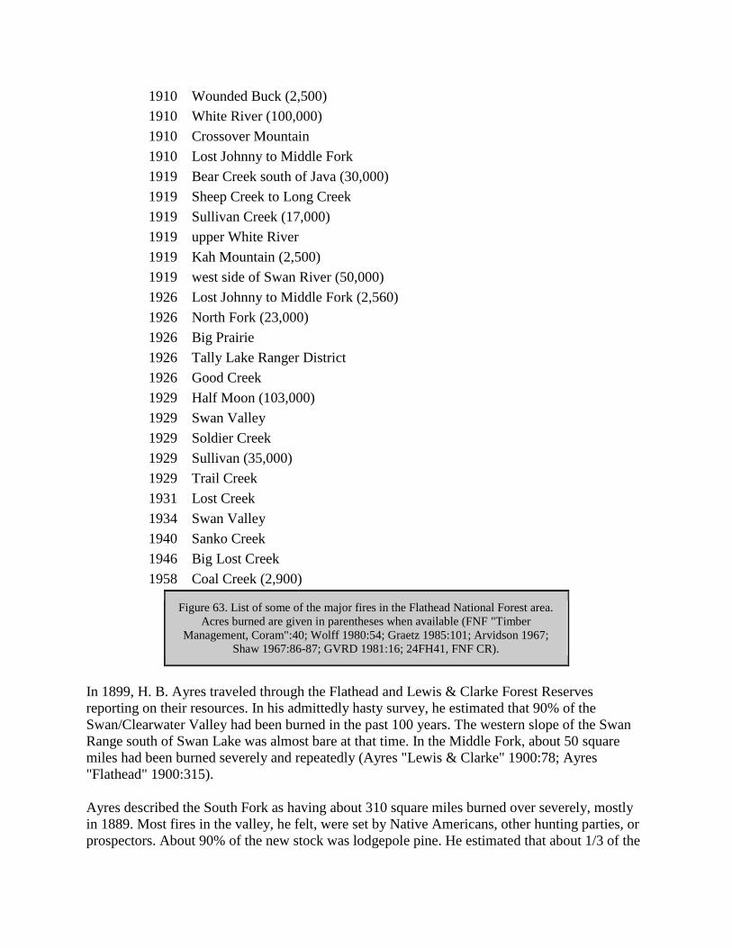
1910 Wounded Buck (2,500)
1910 White River (100,000)
1910 Crossover Mountain
1910 Lost Johnny to Middle Fork
1919 Bear Creek south of Java (30,000)
1919 Sheep Creek to Long Creek
1919 Sullivan Creek (17,000)
1919 upper White River
1919 Kah Mountain (2,500)
1919 west side of Swan River (50,000)
1926 Lost Johnny to Middle Fork (2,560)
1926 North Fork (23,000)
1926 Big Prairie
1926 Tally Lake Ranger District
1926 Good Creek
1929 Half Moon (103,000)
1929 Swan Valley
1929 Soldier Creek
1929 Sullivan (35,000)
1929 Trail Creek
1931 Lost Creek
1934 Swan Valley
1940 Sanko Creek
1946 Big Lost Creek
1958 Coal Creek (2,900)
Figure 63. List of some of the major fires in the Flathead National Forest area.
Acres burned are given in parentheses when available (FNF "Timber
Management, Coram":40; Wolff 1980:54; Graetz 1985:101; Arvidson 1967;
Shaw 1967:86-87; GVRD 1981:16; 24FH41, FNF CR).
In 1899, H. B. Ayres traveled through the Flathead and Lewis & Clarke Forest Reserves
reporting on their resources. In his admittedly hasty survey, he estimated that 90% of the
Swan/Clearwater Valley had been burned in the past 100 years. The western slope of the Swan
Range south of Swan Lake was almost bare at that time. In the Middle Fork, about 50 square
miles had been burned severely and repeatedly (Ayres "Lewis & Clarke" 1900:78; Ayres
"Flathead" 1900:315).
Ayres described the South Fork as having about 310 square miles burned over severely, mostly
in 1889. Most fires in the valley, he felt, were set by Native Americans, other hunting parties, or
prospectors. About 90% of the new stock was lodgepole pine. He estimated that about 1/3 of the

Lewis & Clarke forest reserve had been recently and severely burned, and said there was a little
less than 1,000 board feet per acre of merchantable timber on the reserve (Ayres "Lewis &
Clarke" 1900:15-16, 72).
Several early reports mention Native Americans setting fires, presumably to drive out game or to
keep meadows open. One Kalispell resident claimed that he saw Native Americans set 25 fires in
the Swan Lake area (W. H. Griffin to Gust Moser, 14 August 1900, entry 44, box 4, RG 95,
FRC).
The coming of the railroads to Montana dramatically increased the number of fires all along the
railroad lines. According to Ayres, in 1898 the hills along the Middle Fork were almost barren
because of fires, most of which were started during the Great Northern Railway construction or
from sparks, cinders, or campfires along the line since. Less than 20% of the extensive burns had
restocked with any species of trees (Ayres "Lewis & Clarke" 1900:67).
Early GLO and Forest Service Fire Policy
In 1901 the Secretary of the Interior issued a statement outlining management practices for forest
reserves, mentioning that "the first duty of forest officers is to protect the forest against fires." In
that era, however, the only models of efficient wildland fire protection in the United States were
the fire warden system in New York and the military patrol system in the national parks. Until
the 1910s, fire protection on the national forests was limited by inadequate manpower and
relatively poor transportation and communication facilities. The Forest Service had to rely on
permittees, settlers, and railroad section gangs for temporary firefighting manpower. The
equipment was minimal by today's standards; a typical early fire guard patrolling in Montana
carried a canteen, a canvas water bucket, a shovel, and a carrying case with some food (Pyne
1982:231-232, 236).
In a classic example of the Washington Office's misunderstanding of the job facing western
forest rangers, the GLO stated in 1902 that supervisors and rangers would be held personally
responsible for any fires they allowed to escape on their forest reserves without adequate
explanation. In 1907 on the Lewis & Clark National Forest, each forest guard covered about
120,000 acres (Clack 1923a7). The 1902 letter stated:
It is not understood why forest fires should get away from the rangers, or rather why they
do not find them and extinguish them more promptly. It seems reasonable that a ranger
provided with a saddle horse and constantly on the move, as is his duty, should discover a
fire before it gains much headway. This statement is made knowing that some of the
rangers' districts are extremely large ("Sixty Years Ago" 1963:533).
In 1908 the Forest Service prepared systematic fire plans, appropriations increased available
manpower, and an act allowed for deficit spending to cover the cost of fire emergencies (Pyne
1982:236). These measures were not nearly enough, however, to prepare for the 1910 fire
season.

1910 Fires in the Northern Rockies
The 1910 fires laid waste to some 3 million acres of land in Idaho and Montana (see Figure 64).
The devastation left behind by these fires in northern Idaho and Montana marked a turning point
in Forest Service management of the national forests. As fire historian Stephen Pyne put it, "The
Northern Rockies fires of 1910 left a burned swath across the memory of a generation of
foresters." Fire protection immediately assumed a prominent, overwhelming role within the
Forest Service (Pyne 1982:239).
Figure 64. Areas burned on Blackfeet and Flathead National Forests In 1910 fires
(from Cohen 1978).
The 1910 fires, fanned by hurricane-force winds, killed at least 85 people. None of these
fatalities was on the Flathead fires, but four firefighters died on the nearby Cabinet National
Forest. One 30-man fire crew under the supervision of ranger Peter DeGroot was trapped by
flames west of Olney. The fire camp burned, but the men managed to find an escape route by

wading through the hot ashes of a burned area (Cohen 1978:v, 76; Kalispell Bee, 23 August
1910).
The first fire of 1910 started on the Blackfeet National Forest on April 29, and by late June fires
were burning in all the Forests of Region One (Cohen 1978:11). The 1910 fires took on
frightening dimensions on August 20 and 21, when gale winds (the "Big Blowup") created fast-
moving crown fires. According to Pyne:
Winds felled trees as if they were blades of grass; darkness covered the land; firewhirls
danced across the blackened skies like an aurora borealis from hell; the air was electric
with tension, as if the earth itself were ready to explode into flame. And everywhere
people heard the roar, like a thousand trains crossing a thousand steel trestles (Pyne
1982:246).
In 1910, 65% of the fires were caused by railroad operations, the rest by slash burning, lightning,
campers, prospectors, and perhaps arsonists. Only one lumber company in Flathead County
helped fight the fires. Glacier National Park estimated that as many as 75% of the fires in the
Park were set by "hoboes and others who want work" (Moon 1991:42, 44; Pyne 1982:243).
The most damage, however, resulted from fires that started in remote locations, ignited by
lightning (Pyne 1982:243). This was certainly the case in the Flathead and Blackfeet National
Forests in 1910. Fires that started in low ground, along railroads and trails, or in inhabited areas
were easier to control promptly. Other fires, mostly started by lightning, could not be reached
quickly, and when the wind began to blow those fires "swept down in solid fronts miles in extent
and destroyed the work of weeks of fighting." One writer described his frustration at fighting the
fires in 1910 in the Swan Valley:
A trail must either be cut out to a point near enough to reach the fire from camp or the horses
taken slowly and painfully through country covered with tangles of down timber and dense
thickets, with the risk that in case the fire got well started there might be some difficulty in
getting out again. Meanwhile the fire is gaining headway, and the ranger finds on reaching it that
he can make no impression on it and needs 20 to 50 men to control it. He proceeds to the nearest
telephone station and the men are sent in from some town, or in rare circumstances they may be
recruited from settlers nearby. Their beds, provisions and cooking outfit are packed in 20 to 75
miles on animals hired for the purpose, and after a delay of from 3 to 7 days they reach the fire.
By this time it is so large that they cannot entirely subdue it (Chapman 1910:638).
Fire crews on the national forests were supplemented with men from Missoula, Spokane, and
Butte until the supply of floating labor had been exhausted. Kalispell's two militia companies
were under the jurisdiction of the state forester. The Forest Service also received help from the
regular Army. Three companies were dispatched to the Flathead National Forest, others to the
Coeur d'Alene and Lolo National Forests. They worked on fires along the South Fork, the
Middle Fork (Stanton Lake area), and in Glacier National Park. They provided medical supplies,
surgeons, and pack trains as well as firefighters. The Region had no reserve of fire equipment

then, so new equipment was purchased as crews were sent out until the supplies in many stores
were exhausted (Kalispell Bee, 16 and 23 August 1910; Pyne 1982:244; Koch ca. 1942:2).
Local settlers did help fight the 1910 fires. In the North Fork, for example, Forest Service ranger
Frank Liebig was able to recruit virtually all the settlers to help with a fire in the McGee
Meadow area, but even so half a dozen of them lost their homes and possessions to fire. He also
received help from the Army and the militia. That particular fire was finally put out by rain
(Vaught Papers, 1/L).
Many forest rangers in the Flathead area talked about the shortage of men, horses, and supplies
in the 1910 fires. For example, R. L. Woesner was assigned to an area near Stryker and faced
continual fires along the railroad tracks. He was sent about 60 men and then a company of
soldiers from Fort Harrison, but the crew only had two old government pack horses with sprung
knees to move their fire camp, located about five miles from a road (O. Johnson 1950:266).
Glacier National Park was created in 1910 and its new administrators immediately faced the
disastrous fire season of that summer. Forest Service rangers continued to work in the Park
during that summer. In mid-July firefighters from the Flathead and Blackfeet National Forests
were sent to help the Park, which had no money appropriated to protect its forests from fires.
Nineteen thousand acres burned in the Park that summer (Buchholtz 1976b:26; Cohen 1978:11-
12).
Firefighters in the Park faced the same difficulties of transportation, communication, and
shortage of supplies as did those in the Forest. In July of 1910, forest ranger Liebig spotted two
fires in the new Park. According to his own account, he:
marked the fires down as close as I could and thence went back to the Ranger camp on
the head of Lake McDonald [from Lincoln Peak], had just time to send a message with
the big boat to Sup. Haines in Kalispell to inform him of the fire in and around Harrison
Lake, thence, had a bite to eat, and went to the pasture on Johns' Lake and got two more
horses (Liebig 1910:9).
Sometimes there was conflict over jurisdiction, and the interagency spirit of cooperation faded.
When a fire in the Essex area was reported to the forest ranger at Essex, he remarked that it was
"out of his jurisdiction"; it took several days before any effort was made to put that fire out
(Logan 1911).
In August of 1910, Supervisor F. N. Haines of the Blackfeet National Forest was sounding close
to despair:
We have made a hard fight, but it looks now like we have lost. There is absolutely no
show to even control the fires, and the best we can do is to check them here and there as
best we can and wait for rain (Elwood 1980:150).

Rain and cooler temperatures ended the disastrous fire season of 1910. As late as February of
1911 snags were still smoking from the previous season, sticking up through 5' of snow (USDA
FS "Early Days" 1962:195).
The 1910 fires destroyed an estimated 7-8 billion feet of marketable timber. Subsequent timber
management consisted of fire salvage sales (although much of the burned timber was too remote
to log), replanting burned sites, control of insect and disease outbreaks, reducing erosion, and
snag felling as a fuel modification measure. Many surveys had to be redone because the witness
trees had burned. Subsequent efforts to develop the woods to prevent future similar destruction
made the Forest Service, particularly Region One, a national leader in fire protection (Pyne
1982:249-250; Koch ca. 1942:22-23).
A 1910 Forest Service report stated:
It has been accepted generally as true that one of the main reasons for the disastrous
forest fires of the past season was that they started in inaccessible places or portions of
the forests which were not regularly patrolled. Also, that had the Forest Service been
given a sufficient amount of money for the construction of the necessary trails and
telephone lines and for a better patrol, many of the fires would not have spread (quoted in
Baker et al. 1993:224).
Fear of an imminent timber famine, heightened by the 1910 fires, led the Forest Service to push
for more funding and support for its fire control program. The needs of fire detection and
suppression (roads, trails, telephones, etc.) were a large factor in settling the remote mountainous
areas of the northern Rockies. The winter following the 1910 fires, a fire plan was developed,
and it became policy on the Flathead National Forest that all forest guards were to be used
primarily on fire protection work in July and August (Clack 1923b).
Another result of the 1910 fires were a number of technological innovations, some of which are
still in use. The new equipment included the Osborne fire finder, the Pulaski (combination ax
and mattock), and a railroad speeder car equipped with a bicycle seat, pedals, and rubber tires
(Caywood et al. 1991:28).
Because of increased efforts at fire detection and suppression, the acreage burned in Montana
declined dramatically after 1910. Even so, much of the Flathead National Forest burned between
1889 and 1949 (see Figure 65). In the 1940s, the amount burned was only 3% of that burned in
the 1910s, as shown below:
1910-1919: 1,834,000 acres
1920-1929: 364,000
1930-1939: 150,000
1940-1949: 53,000
(Montana Conservation Council 1954: 10)

Figure 65. Areas burned by major fires on the Flathead National Forest, 1889-1949 (base
map 1939, FNF CR).
Fire Detection
In the early years of the forest reserves/national forests, fire patrols were woefully inadequate.
For example, forest ranger George Rhodes at Belton wrote to his supervisor in Ovando in 1904:

I will keep a very sharp look for fires I assure you[.] as there is only about 12 miles of my
district in which I can use a Saddle Horse at present I have to make the trip on foot from
Belton to Nyack[.] there is a Trail along the Rail Road but it has not been open for years
and it will require a good lot of work to open it up but it can be done when there is no
danger from Fire (Elsethagen, FNF Class).
Every means possible for fire patrol was tried. Even boats on Flathead Lake and Tally Lake (and
perhaps others) were used for fire patrol and for smokechasing, but this was a slow method and
the fire guard could not go out in lightning storms due to rough water. On the east side of
Flathead Lake, the fire guard stationed at Upper Beardance for many years would travel to
various observation points in a Model A Ford coupe. Boys even patrolled in buggies; Joe Opalka
was hired in 1917 at the age of 15 to patrol the road between Bad Rock Canyon and Coram by
horseback or by horse and buggy for $4.00 a day (FNF Lands; Fred Hartson interview, 23
December 1991, TLRD; Robbin 1985:113-114; Opalka reminiscences, FNF CR).
The most effective method of fire patrol along the Middle Fork was the railroad speeder, used by
forest rangers and guards in the area for many years. In 1906, Forest Service inspector Elers
Koch commented that the speeder was "an unqualified success. One man on a speeder can patrol
several times the area that he could on foot or horseback, and can have his tools and camp
equipment with him at all times" (see Figure 66) (28 November 1906, "Reports of the Section of
Inspection, entry 7, box 4, RG 95, FRC).
Figure 66. Railroad speeder in use by Forest Service workers near Warland, Montana, 1921
(photo by K. D. Swan, courtesy of USDA Forest Service, Regional Office, Missoula).

The established method of fire patrol in the fall of 1907 was to patrol the trails, roads, ridges, and
railroad lines and to station men as near as possible to the bases of high peaks so they could
climb the mountains each day. Six forest guards worked in the South Fork from Coram to Big
Prairie. They patrolled the main South Fork trail looking for fire "and incidentally cutting out
fallen timber." In a meeting that fall everyone agreed that this system did not work because
guards needed to climb to a high point each day. So, beginning in 1908 men were stationed
where they could climb to lookout points, sometimes moving between two different peaks on
alternate days (Clack 1923a:7; Clack 1923b).
In 1909 the Lewis & Clark National Forest was divided into eight ranger districts, and each was
allotted about three men. Forest officials felt they were getting prepared for any fire situation.
But in 1910, with virtually no communication system, this force of men proved to be "totally
inadequate." On the Bunker Creek fire in 1910, for example, the ranger augmented his force of
three men by riding to Coram for 10 more men, but by the time they got to the fire they needed
100 men (Clack 1923b).
At a supervisors' meeting held in 1910 (before that year's disastrous fire season), the men
discussed selecting lookout points and patrol routes and coordinating these between ranger
districts and Forests to aid in locating fires. Also discussed were the ideas of building "shot gun"
trails of minimal standard, just enough for pack horses to travel, and building temporary phone
lines to the lookout points so that patrolmen could get help more easily in case of fire. They also
planned to distribute tool caches throughout the forests for fire use and to provide men in remote
districts with supplies and food so they did not have to leave the Forest to obtain needed
supplies. The main objection to putting men on lookout points in 1910 was "the difficulty of
securing a man who would put up with the monotony and isolation incident to such a position."
Region One supervisors thought it would be best to alternate the lookout men with those doing
ridge and trail patrol work ("Report of Supervisors' Meeting, 3/21-26/1910," 1360 meetings -
Historical - Early Supervisor Meetings, RO).
Some early Flathead forest rangers promoted the idea of lookouts and lookout points before their
supervisors approved of the idea. According to Joe Eastland, an early forest ranger along the
Whitefish Divide, a Sir J. C. Davis came to the national forest from London to collect seeds of
ponderosa pine, white pine, and alpine larch. He told Eastland about the fire lookouts in Scotland
and England, and Eastland subsequently tried to convince forest officials of the advantages of
posting lookouts along the Whitefish Range. Frank Liebig, stationed in the Lake McDonald area
beginning in 1902, reported climbing Mount Stanton to look for fires and being kidded by his
fellow workers for doing so (O. Johnson 1954:12-14; Vaught Papers 1/L).
In 1912, Montana forest rangers located fires with field glasses, plotted them on a map, and then
phoned other guards. By that time the Forest Service also had "watch stations" (or lookout
points) from which signals could be made by waving flags, flashing the sun's rays from mirrors,
or using gasoline torches. Some were provided with a railed platform, perhaps enclosed. The
"forest watchers" were provided with field glasses and a signal mirror (probably a heliograph)
and were located so they could be seen from a ranger or guard station, where a ranger was
"continually on duty during the day to look for signals." These watch stations reportedly had a
range of 25-50 miles (Willey 1912:57).

In the early years, lookout points had no improvements built on them. The lookout man would
camp in the nearest sheltered place below the lookout point and would hike up to make his
observations. Sometimes the lookout man would travel between two different points to observe
more area; he would then be following a patrol route, with special emphasis on high-danger areas
such as the railroad right-of-way, camp sites, lightning zones, etc. (USDA FS "Early Days"
1962:1; "Report on Felix Creek Fire, 1914" 1914 Fires Flathead, RO:4).
The difficulty of fire detection and fire control in the early 1910s is exemplified by the efforts to
control the Felix Creek fire in 1914 on the Flathead National Forest. In that year, the few fire
guards scattered throughout the forest were equipped with a map of the Ranger District, a
compass, and a pair of field glasses. No map boards or alidades had yet been set up, and the few
lookout points had no improvements. A lookout stationed on Mount Aeneas first reported the
Felix Creek fire to the Echo Ranger Station by phone. The ranger then rode 4 miles to the nearest
phone to call the Supervisor's Office, which called the ranger at Coram because they could not
reach the ranger on the lower South Fork. Coram got the message through to the guard at
Riverside at suppertime, and the guard found the ranger at a campsite. At about 8 p.m. the guard
at Coal Banks was called and told to go to the fire. The guard could not find the fire, but a
trapper reported the location. Sixty hours elapsed between the time the first men were ordered
and any actual firefighting began. All food for the fire camps was ordered by phone through the
Supervisor's Office (see Figure 67). Cars were rented in Kalispell to rush supplies as close as
possible to the fire camp, and local merchants provided supplies based on emergency lists they
had been given at the beginning of the fire season ("Report on Felix Creek Fire, 1914" 1914
Fires Flathead, RO:4).
100 lbs. flour
5 lbs. baking powder
10 pounds salt
2 5-cent packages yeast
1 lb. soda
10 lbs. cornmeal
20 lbs. rice
80 lbs. ham
20 lbs. bacon
25 lbs. potatoes
10 lbs. onions
20 lbs. beans
10 lbs. coffee
1 lb. tea
48 cans milk
40 lbs. gran. sugar
10 lbs. brown sugar
5 lbs. dried peaches
5 lbs. dried apples
5 lbs. dried prunes
5 lbs. raisins
12 lbs. canned butter
1 gallon vinegar
12 cakes ivory soap
2 dozen candles
0.5 pint vanilla extract
0.5 pint lemon extract
0.25 lb. pepper
0.25 lb. mustard
15 lbs. lard
10 lbs. oatmeal
5 boxes matches
Figure 67. List of emergency rations ordered by the Flathead National Forest
during the 1914 fire season. These figures are the supplies ordered for a 10-man
crew for 10 days. The total weight was reported to be 575 pounds ("Report on
Felix Creek Fire, 1/1411915," 1914 - Fires - Flathead, RO:12).

Lookouts were located so as to maximize the "seen area" of the forest. In 1929, 15% of the fires
on the Flathead National Forest started in unseen areas (35% of the forest was considered unseen
at that time) (see Figure 68) (Hornby 1931:5).
Figure 68. "Seen area" photograph taken from Standard Lookout (Glacier View Ranger
District). These photographs were taken in the early 1930s from improved and unimproved
lookout points. "Seen area" maps were used to determine which combination of points
afforded the greatest area of detection coverage. They also helped in determining the need for
and height of a lookout tower (courtesy of Flathead National Forest, Columbia Falls).
Crow's nest lookouts were an early, relatively easy-to-build form of lookout. They were built all
over the Flathead National Forest, from Yellow Bay Mountain on Flathead Lake to Reid Divide
in the Stillwater area. The observatory was a platform accessed by a ladder up a tree. "Lookout
trees" were used into the 1930s. On the Tally Lake ranger district, for example, in 1930 they
were spaced 1-1/2 miles apart and featured 12" spikes driven into either side to act as a ladder for
smokechasers, with climbing branches above. Sometimes three or four trees growing close
together would support a platform and map stand, but generally lookout trees were single trees
(Robbin 1985:114; Taylor 1981; Taylor 1986).
The first Forest Service lookout was built on the Cabinet National Forest. The earliest lookouts
were small, crude log cabins used to house the men stationed there. If no suitable trees were
available for a crow's nest, the men built a tower out of poles (Caywood et al. 1991:28; USDA
FS "Early Days" 1962:2). The 10' x 10' lookout platform on Coal Ridge in the North Fork is one
of the few lookout platforms still standing in Region One.
The first permanent lookout building on the Flathead National Forest was built on Spotted Bear
Mountain in 1914 (this was replaced in 1933) (see Figure 69). The Forest Service did not have
enough funds for more than a few high lookout cabins until the 1920s (trails, roads, and phone
lines had a higher priority in the early years). The Forest built more and more lookouts,
especially during the 1930s, until in 1939 there were 147 lookouts and towers on the Flathead
National Forest (see Figure 70). By 1930, approximately 800 peaks or points were occupied in
Region One (Caywood et al. 1991:30, 38; "Transportation - Fire" 1931:13; Shaw 1967:7; FNF
"Informational Report" 1939).
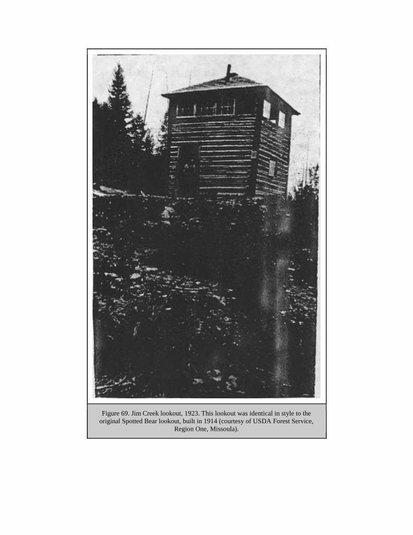
Figure 69. Jim Creek lookout, 1923. This lookout was identical in style to the
original Spotted Bear lookout, built in 1914 (courtesy of USDA Forest Service,
Region One, Missoula).
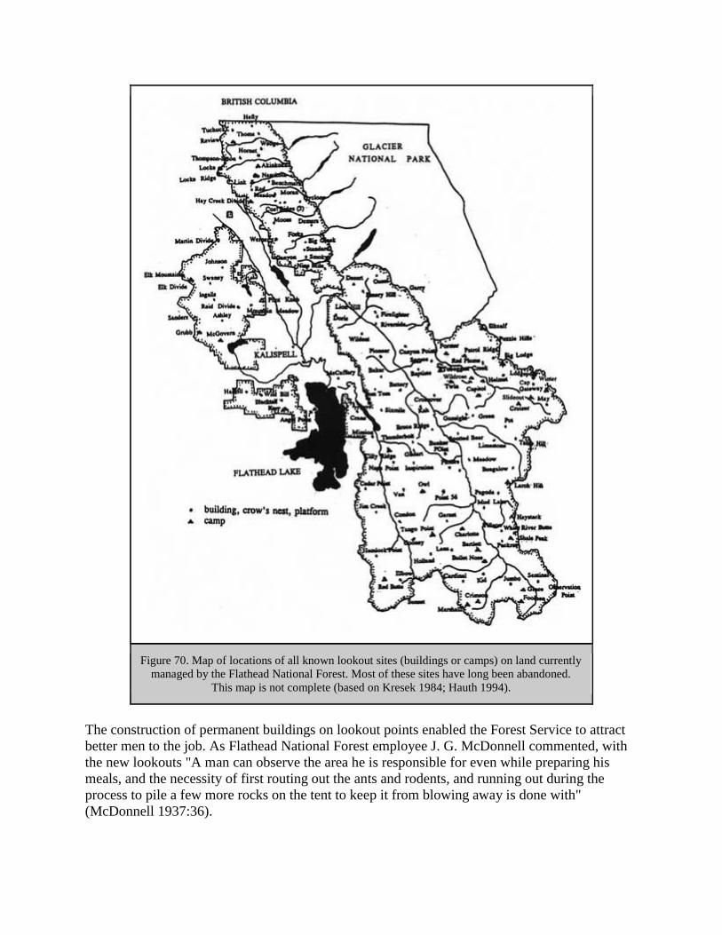
Figure 70. Map of locations of all known lookout sites (buildings or camps) on land currently
managed by the Flathead National Forest. Most of these sites have long been abandoned.
This map is not complete (based on Kresek 1984; Hauth 1994).
The construction of permanent buildings on lookout points enabled the Forest Service to attract
better men to the job. As Flathead National Forest employee J. G. McDonnell commented, with
the new lookouts "A man can observe the area he is responsible for even while preparing his
meals, and the necessity of first routing out the ants and rodents, and running out during the
process to pile a few more rocks on the tent to keep it from blowing away is done with"
(McDonnell 1937:36).

The first standard Forest Service lookout was the D-6 pyramidal-roofed cabin with cupola,
developed in 1915 and popular until the mid-1920s. In 1922 the Flathead National Forest
developed the D-1 cupola house, designed by Dwight L. Beatty, which was 14' x 14' instead of
12' x 12', built of logs, and had a gabled roof (the lookout building on Hornet Mountain, built in
1923 and still standing, is a good example of this design) (see Figure 71) (Caywood et al.
1991:107; Kresek 1984:11-12).
Figure 71. Hornet Mountain lookout, 1923. The log cabin with the cupola was new and soon
replaced the earlier platform and cabin shown in the photo (courtesy of USDA Forest
Service, Region One, Missoula).
Clyde Fickes and architects at the Regional office were assigned the job of designing a tower and
lookout house combination that would allow a lookout to be at his post 24 hours a day. Plans
developed by other Forest Service regions were too expensive for Region One to use. In the
spring of 1928 Fickes built a sample 12' x 12' lookout with a cupola on the Lolo National Forest.
The materials weighed approximately 6,000 pounds (if fir and pine were used), and it took 25
man-days to build. It was designed to be built by a couple of men who could read instructions
and who had a hammer, screwdriver, and level ("New Type Lookout" 1928:14; Fickes 1973:83-
84).
Fickes developed standard plans for a lookout building with a gable roof and windows on all
sides known as the L-4 (see Figure 72). The popular model offered improved efficiency because
the lookout did not have to climb up and down the ladder to the cupola. The earlier versions have
gabled roofs, those dating from 1933-53 have hipped roofs. In 1930, the Forest Service invited
bids for enough lumber to build 100 L-4 lookout houses, which would be cut and bundled for
packing in Spokane and delivered from the Spokane warehouse. The pre-cut cabs generally cost
$500 (the towers were built from pole cut on the site). The Superior Building Company of

Columbia Falls began providing the Flathead National Forest with pre-cut materials for 14' x 14'
L-4 lookouts in 1929. In 1930 three were assembled on the Forest (Bruce Ridge, Desert
Mountain, and Ingalls Mountain), and they reportedly could be set up by two men in just three or
four days. The company's lookouts were assembled almost entirely without nails, similar to the
ready-cut garages and small houses the company provided for the housing market (USDA FS
"Early Days" 1976:3; "Lookout Houses" 1930:9; Fickes 1973:84; "New Ready-Cut" 1930:10;
"New Ready-Cut" 1929:2).
Figure 72. L-4-style lookout on Flathead National Forest peak (photo by Toussaint Jones,
courtesy of Flathead National Forest).
Between 1934 and 1941 Region One also used a prefabricated 7' square cab with sheet metal
walls on steel towers. The lookout did not live in the building; he or she used it for observations
only. Other standard plans modified the size and design of the L-4 slightly. Heavy galvanized
steel towers were introduced in the 1930s; Aermotor of Chicago, a windmill company, was the
main provider. Since 1953 standard Region One lookouts have been built with flat roofs, and
road access has allowed many to have concrete or cinder block foundations. Other Forest Service
regions and other agencies developed their own designs (Caywood et al. 1991:107; Kresek
1984:11-12).
Some lookouts were built in response to bad fire years, such as the Holland Lookout built after a
1919 fire complex burned approximately 50,000 acres in the Swan Valley. In 1920, however, a
Forest Service inspector reported that the fire detection system on the Flathead National Forest
was still "casual." Not one smokechaser on the South Fork had a fire pack ready to go, he wrote.
Some of the maps at lookouts could not be permanently oriented, men did not know the country

or the locations of other lookouts, fire tools were dull, and some "seen areas" had no maps
available (Wolff 1980:54; 19 July 1920, Flathead 1920-23 Inspection Reports, RG 95, FRC).
The Forest Service provided the food for the lookouts, almost all of which had to be
nonperishable. A typical supply included: flour, baking powder, salt, sugar, coffee, beans, rice,
dried apricots, prunes, raisins, ham, bacon, canned corned beef, dehydrated potatoes, canned
corn, tomatoes, milk, and syrup. The later addition of canned fruit and apple butter was
considered "high living." Lookouts routinely supplemented their diet with fish and huckleberries,
when accessible, and with grouse (USDA FS "Early Days" 1962:2).
Most of the rations at a lookout were packed in small cans. Lookouts considered it amusing to
post a fire slogan reading "Stay With It 'Til It's Out" inside the outhouse door. In the early 1930s
lookout rations were packed in wooden boxes, each holding about 125 pounds of food, in units
for 30, 45, or 60 man days. The packer supplemented these pre-packed rations with potatoes,
bacon, eggs, and onions just before leaving for the lookout. Tally Lake lookout Norm
Schappacher recalled that in the 1930s "There was this brown bread that came in a can - we'd
usually throw it at the bears. But the butter in cans, you could eat almost anything with that
butter in it" (Howard 1984; Taylor 1981; "Lightning" 1987).
In the mid-1930s it was realized that all lookouts came out of their towers at about the same time
to cook meals, during which time there were practically no observations being made. So, each
lookout was then assigned a 15-minute intensive observation period per hour, staggered to keep
the area under constant observation. Lookouts had to record lightning strikes day or night, and
they were not paid overtime (Taylor 1981).
Lookouts were required to be within hearing distance of the phone during the day. If they needed
to haul water, they would do this before 6 a.m. in a 5-gallon water bag with shoulder straps. The
only reasons a lookout was allowed to leave his post were a bad toothache or a death in the
family. Lookouts received $70 a month in 1930 and were on the point 24 hours a day between
June 15 and September 15. They reported to the smokechaser or ranger station three times a day.
A packer would bring mail and supplies just once or twice a summer. The days could quickly
become routine in a slow fire season. A typical diary entry of a lookout on the Flathead is as
follows: "Saw a bear this morning. Washed clothes this afternoon" (Taylor 1986; Taylor 1981;
USDA FS "Early Days" 1962:2).
The life of a lookout was lonely at best. With good communication by phone, many dispatchers
opened the lines at night so that the lookouts could talk to each other with their phones hung
around their necks. On the Big River Ranger District (the Middle Fork), playing checkers over
the phone was a favorite evening pastime among lookouts. In the North Fork, men would sing or
play music over the open line (harmonicas were popular, even a trumpet); one man was an
excellent yodeler. In the Star Meadow area, half a dozen lookouts would have "bull sessions"
together over the phone lines in the evenings (Howard 1939:7; Yenne 1983:30; Anne Clark, "It's
Lonely at the Top," Daily Inter Lake, n.d., FNF CR; Taylor 1986).
John Frohlicher, who worked as a smokechaser five summers on the Flathead National Forest in
the early 1920s, advised his brother Steven, a new lookout on the Spotted Bear Ranger District:

take time to fix a comfortable camp. Bear grass cut and dried makes a fine bed; it won't
take much ingenuity to contrive an icebox in your spring hole to keep butter in; and build
a good chair. Better build two, so you'll have one to sit in when the ranger comes to see
you (Frohlicher 1929:9).
The first firefinder was a compass. The alidade was soon developed, an improvement because it
gave a longer sight axis. The alidade would be mounted over a map board, allowing the lookout
to give relatively accurate readings of the direction of a fire to the dispatcher. The mapboard and
firefinder evolved through the Koch Board and the Bosworth Firefinder to the Osborne
Firefinder (see Figure 73). All these firefinders allowed one to determine the direction of a fire,
not the distance to the fire or its location. Dispatchers could pin down the location of a fire if
several lookouts observed the same smoke; the intersection of the lines from each lookout drawn
on a map would mark the location (Taylor 1986).
Figure 73. Assistant supervisor C. J. Hash taking a reading on Salmon lookout,
1926 (courtesy of Flathead National Forest, Kalispell).

Lookouts sometimes confused fog, reflections from ponds, etc., with smoke from fires. In 1941,
for example, the lookout on Puzzle Mountain thought he saw a fire and traveled 9 miles to the
site. Instead, he found a sheepherder's camp with a Kimmel stove, and about 3,000 sheep in the
meadow (Kresek 1984:362).
Until about 1930 many lookouts were manned by two men: a lookout who spotted the smoke and
a smokechaser who hiked to the fire and put it out. After 1930 on the Flathead National Forest
men were generally stationed alone on a lookout. They would report the fire, go to the fire to
begin suppression efforts, and return to their station only after help had arrived (Anne Clark, "It's
Lonely at the Top," Daily Inter Lake, n.d., FNF CR).
A smokechaser's "rag camp" included a 10' x 12' tent, a Kimmel stove, quilted bedding known as
a sougan, and food. They would use a phone to talk with the lookout and would wait for calls
reporting fire. Until the early 1930s, lookouts did not have lightning rods. The men were
supposed to go out in a tent during a lightning storm so the Forest Service would not be liable for
them, while watching for lightning strikes at the same time. These tent camps did not provide
much shelter from storms. Nevertheless, those staying in tents had to pay $5 a month for quarters
(Magone 1970; Anne Clark, "It's Lonely at the Top," Daily Inter Lake n.d., FNF CR; Howard
1984).
Smokechasers were on call, night or day, ready to leave within five minutes of receiving a report
of a fire. The smokechaser was responsible for Class A fires, those under 1/4 acre in size. He was
required to stay out three days; if a lookout called back ten minutes later to say it was a false
alarm, there was no way to prevent the smokechaser from a three-day search. After 1940
smokechasers were no longer sent out alone to fires because of safety concerns. Sometimes it
could be quite difficult to find a fire on the ground. At least one ranger station on the Flathead
kept some old-timers around, trappers who "knew the area like a book," to lead young men to a
fire. When the smokechaser found the fire, he noted the time, put his fire pack in a safe place,
and knocked down the flames with dirt and cut the limbs hanging into the fire area. Eventually, it
successful, he would encircle the fire with a fire line. Then he "mopped up," crawling on his
hands and knees feeling the ground for hot spots and checking the area for spot fires. When the
smokechaser had finished mopping up, according to Pat Taylor, the ground looked like a
"cultivated garden." He then made out his report, watched for smokes until 4 p.m. to make sure
the fire was out, and then blazed a line to the nearest trail (Taylor 1986; Helseth 1981; Magone
1970).
The smokechaser's 35-pound pack in the 1920s contained a compass, map, pulaski, shovel, file,
whetstone, and three days' emergency rations. The rations were packed in cloth bags and
typically contained hardtack left over from World War I, a can of bacon, a can of cheese, rice, a
can of milk, oatmeal, and coffee. After World War II smokechasers ate Army K rations. There
was no bedding because the men were supposed to keep working until the fire was out.
Smokechasers cooked their food on their shovel blade. They made a palouser to use for working
at night (this was a lard bucket with a candle and a wire handle that cast a light about 8')
(Magone 1970; Taylor 1981; Taylor 1986).

Flathead National Forest lookout Steven Frohlicher was the lookout on Bruce Ridge in 1930.
Charles Hash, assistant forest supervisor, spent the night in Frohlicher's tent on an inspection
trip. The rattling of the canvas fly and the squealing of the ropes in the wind kept Hash awake. In
the morning, "He came out of bed swearing, and he could make a mule-skinner turn green with
envy: Any God-damned outfit that would ask a man to live and work in places like this! I'm
gonna raise Hell until we get some cabins on these peaks!" Soon a ready-cut lookout from
Columbia Falls was delivered to the lookout point by mules. This was the first Superior Building
Company lookout on the Forest (Frohlicher 1986:78-81).
Many of the lookouts did not have #9 wire phone lines. Instead, outpost wire was strung to them
in the spring and picked up in the fall. When Roy Davis arrived at Tuchuck Mountain in 1930,
the first season it was used as a lookout, the trail crew had built a phone line to the point but
there were no other improvements. Davis built a map and alidade stand, then hooked up the
portable telephone. He next cut and hauled up a ridge pole and tent supports. Later that summer
pre-cut lumber for a lookout building and blueprints arrived, and two men came up to build it.
Davis spent one night in the new lookout building before heading down the mountain at the end
of the season (Howard 1984; Davis 1980).
Obtaining water for drinking and washing was always a concern on a lookout, which was usually
a fair distance from a water source. Some of the water sources, a spring or an intermittent creek,
were a couple of miles down the mountain. Melted snow was often used for wash water to save
hauling the water on one's back. At Spotted Bear Lookout, the closest water was at the ranger
station several thousand feet below. The lookout would fill a snow tank with snow in the spring
and once again before the snow drifts melted. The meltwater was used for washing windows,
scrubbing floors, and bathing. The packer brought up drinking water in four 10-gallon cans in the
spring and replaced them a couple of times a season (Funk 1981).
Sanitation on a lookout was sometimes not all that could be desired. At Jumbo Lookout in 1956,
for example, garbage was dumped over the cliff to the west of the lookout. The Forest Service
inspector recommended discontinuing this practice "since some dudes visit the point. Surely we
can set a better example than this even though the point is solid rock" (24PW1003, FNF CR).
During World War II the Flathead National Forest, like others around the country, hired women
to work on a few lookouts because of the shortage of men during the war. The Flathead had four
lookouts occupied by women then: Nine Mile, Mission, Crane Mountain, and Jim Creek. The
Forest Service had hired women earlier as lookouts, at least by the 1920s, but there was
resistance because much of the heavier work fell on the rangers, such as phone line maintenance,
clearing trail, repairing buildings, and fire fighting (Walter Kasberg to Regional Forester, 2
February 1967, 5100 Fire Management - Historical - Women Lookouts, RO; "Last Women"
1926:701-702).
As of the mid-1960s, no one working inside a Flathead National Forest lookout had been injured
by lightning, but a phone line worker was struck and killed by lightning in 1937. In 1929, a fire
that started just east of Thompson-Seton lookout reportedly burned the lookout building there.
The Review Mountain camp, also in the North Fork, burned that same year, and Huckleberry
Mountain Lookout in Glacier National Park burned in both 1929 and 1967. In the 1950s, most of

the lookouts built in the 1930s (which had been built to last 15 to 20 years) were in need of
replacement or repair (Shaw 1967:96; Yenne 1983:30-32; Kresek 1984:357; Ralph Hand,
"History of Region 1 Lookout System," 8/23/54, 5100-Lookouts - Historical, RO).
Beginning in 1945 parts of the Flathead, Lolo, Lewis & Clark, and Helena National Forests
greatly reduced the number of manned lookouts in favor of regular air patrols. Between 1945 and
1956 the number of lookouts in Region One were reduced from 800 to 200. From 147 lookouts
on the Flathead National Forest in 1939, in 1954 the Flathead National Forest only had 40
positions. In 1966, only 21 lookouts were occupied on the Flathead National Forest during the
fire season. These were McCaffery, Mission, Cooney, Jim Creek, Elbow, Desert, Baptiste,
Firefighter, Spotted Bear, Bungalow, Red Plume, Mud Lake, Jumbo, Kah Mountain, Pioneer,
Nine Mile, Cyclone, Thoma, Johnson, Ashley, and Whitefish. By the early 1990s, fewer than 5
lookouts were regularly occupied (3 October 1956, 1380 Reports - Historical - Reports to the
Chief, RO; Ralph Hand, "History of Region 1 Lookout System," 8/23/54, 5100-Lookouts -
Historical, RO; Walter Kasberg to Regional Forester, 2 February 1967, 5100 Fire Management -
Historical - Women Lookouts, RO).
Aerial photography was initiated in Region One in 1925, and it provided the first reliable maps
for many areas of the Flathead National Forest, such as the upper South Fork where the cost of
mapping by other methods had been prohibitive. Even in the early 1930s, the maps of many
areas were inaccurate (trails were shown on maps as much as one mile from their actual
locations, for example). Another mapping project that helped with fire control was fuel-type
mapping, which began in 1933. These maps helped determine the number of men to send to a
fire in a particular area. The Region-wide project statistically analyzed over 12,000 fires in the
1920s and determined the appropriate level of response for each type of fuel in the region
(USDA FS "History of Engineering" 1990:25-26; Taylor 1981; "History of the Use of Aircrafts",
n.d., FNF CR:3; Taylor 1986; Caywood et al. 1991:57).
The first air patrols in Region One occurred in 1925 out of Spokane. The planes flew when
lookout visibility was low and during lightning storms, and they also did scouting flights on large
fires. Until 1927 the Forest Service used military planes and pilots, but after that the agency
contracted with commercial air services for fire patrols. The Flathead National Forest began
marking its lookout points in 1929 so that they could be more readily located and identified from
the air (Gray 1982:24-25).
The first use of air patrol on the Flathead National Forest was in 1929 (a message to "save
Spotted Bear Ranger Station at any cost" was dropped from the plane to the fire control staff
officer below). In 1930, construction began on seven backcountry landing fields in Montana and
northern Idaho. The airfield at Big Prairie was one of the two first airstrips, completed by the
1931 fire season. Four airplane landing fields were being maintained in 1941 to administer the
Bob Marshall Wilderness in the interest of fire control; they were not open to the public. In 1946
an aerial patrol plane was stationed at Spotted Bear Ranger Station (Baker et al. 1993:74; Shaw
1967: 134; Caywood et al. 1991:39; Gaffney 1941:429).
The Continental Unit, created in 1945, was the first experimental aerial forest fire control area in
the world. It was set up on 2 million acres of roadless wilderness, including part of the Flathead

National Forest. The network relied on fire detection from airplanes and fire suppression by
smokejumpers primarily instead of ground crews. The Continental Unit radio network included
Monture Ranger Station, North Fork Cabin, Fall Pint Lookout, Basin Creek Station, Sentinel
Lookout, Big Prairie Ranger Station, Kidd Mountain, Salmon Forks, Brushey Park, Bungalow
Lookout, Pentagon Cabin, Schafer Ranger Station, Grizzly Park, West Fork Cabin, Gates Park,
Pretty Prairie, Prairie Point, Prairie Reef, Benchmark Station, and Lincoln Ranger Station. The
network operated for three experimental seasons, and then the responsibility for fire control was
returned to each of the Forests. Based on the experiment, several national forests then put in a
system of combined air-ground detection and suppression, and other agencies, states, and Canada
later modified the system to meet their needs (24FH431, FNF CR; Clepper 1971:183).
By 1951, over 80% of the fires on the national forests were reported within 30 minutes after
discovery. The Flathead National Forest had a greater average distance of fires from roads than
the average for the Region. Between 1931 and 1945 the average fire on the Flathead was just
over 4 miles from a road. Almost 16% of the lightning fires on the Forest were over 8 hours'
travel time from a road (Barrows 1951:174, 187, 195-196).
In 1940, one key smokechaser was selected from each of seven Forests in Region One to
participate in the Forest Service's experimental smokejumper program (Dick Lynch was the
Flathead representative). In 1941 the smokejumpers were based at Nine Mile near Missoula, Big
Prairie on the Flathead, and Moose Creek on the Nez Perce. In that year there were three squads
totalling 26 men. In 1942 there were four squads, one of which was stationed again at Big
Prairie. From 1943 until the end of the war the smokejumper program was kept going by
volunteers from the Civilian Public Service program (conscientious objectors), and a crew of
these men was stationed at Big Prairie during the war. Johnson Flying Service of Missoula was
contracted to fly jumpers in Region One. The company purchased its first Ford Tri-Motor plane
in 1935, which by then had become obsolete for commercial use. The last Tri-Motor had been
built in 1933, but they were used over 30 years by Johnson and were a familiar sight in the skies
over the Flathead National Forest during fire season. The first smokejumpers (13 in number) to
jump on a Flathead National Forest fire were dropped into the Dean Creek drainage in 1941
(Cohen 1983:13, 26-27, 30, 38, 42, 64, 68-69; Baker et al. 1993:163; "History of
Smokejumping," 1959, FNF CR: 1-8; Shaw 1967:134).
By 1944 smokejumping was standard practice, no longer experimental in Region One. In 1945
there were about 235 smokejumpers in the program, and some national forests had reduced their
ground forces to depend more on smokejumpers. The fire season of 1945 demonstrated that
smokejumpers combined with air detection could save money ("History of Smokejumping,"
1959, FNF CR:9).
Smokejumpers experienced tragedy in fires, as did ground crews. In 1949 the Mann Gulch Fire
on the Helena National Forest killed 12 smokejumpers and a district guard. Two of the
smokejumpers who died in the fire were from Kalispell; one was the son of long-time Flathead
National Forest employee Henry Thol.

Fire Suppression
As discussed above, early efforts at fire control on the forest reserves were severely limited by
lack of money, transportation, and communication systems. One of the earliest descriptions of
fire suppression on the Lewis & Clarke Forest Reserve was written by forest supervisor Gust
Moser. Moser and about five men built 26 miles of fire line, a tremendous accomplishment.
Moser reported, "with the limited force I have had, better results have never been attained in
fighting forest fires....Am satisfied that our work has saved enough timber to pay the full expense
of running the Lewis & Clarke Forest Reserve for the next 10 years. We were entirely out of
provisions for three days, all we had was bread and venison, I had a lot of provisions 25 miles up
the river but did not have a man to spare to send after it" (16 August 1900, entry 44, box 4, RG
95, FRC).
The "genius" of early fire protection lay in the organizational skills of the Forest Service,
including the standardizing and coordinating of tools. The Forest Service developed special tools
for fire control beginning about 1910. Innovations included the Osborne firefinder (ca. 1910), the
brush hook, the smokechaser pack frame or "Clack board" (developed by Jack Clack, who had
worked on the Flathead National Forest), the Koch tool (a combination shovel and hoe
developed by Elers Koch of the Regional Office in Missoula), the portable water pump, special
rakes, and the Pulaski (a combination ax and mattock developed by Ed Pulaski after the 1910
fires) (see Figure 74). The development of a sleeping bag with shoulder straps, filled with kapok
fibers, was a significant innovation. The 9-pound bag replaced the 23-pound bag used
previously, allowing three pack horses to be eliminated from a pack string moving a 25-man
outfit. Bill Nagel, supervisor of the Blackfeet National Forest, owned the first sleeping bag used
in the area in the early 1930s. Within a few years "kapoks" were in fire caches and then in
general use on the Blackfeet and Flathead National Forests (Pyne 1982:425-526, 429-430, 432;
Bradeen 1931:5; Taylor 1981).
Figure 74. Portable water pump in use on Wolf Creek fire, 1924 (courtesy of
Flathead National Forest, Kalispell).

Pat Taylor described the on-the-ground men working for the Forest Service in the 1930s as
dedicated and hard-working. "I saw men work on fires in those times until they would be so
exhausted they would just fall over and lay there in the fire trench trying to get their
breath...They got 35 cents an hour and their board, if they could find anything to eat around the
fire camp" (see Figure 75) (Taylor 1981).
Figure 75. Putting final touches on fire line, Tango Creek fire, 1953 (photo by W. E.
Steuerwald, courtesy of USDA Forest Service, Region One, Missoula).
Other Forest Service workers had different experiences. As John F. Preston commented after his
experience with large fire crews on the Big River (Middle Fork) fires in 1914:
Some cripples are sent who it is perfectly apparent cannot be of much service. A one
armed man, and an old fellow who was so stiff he could hardly walk, were sent to the
Vinegar fire (John F. Preston, Report on Big River Fires, 1914, 1914 Fires Flathead,
RO:2/7).
Other supervisors complained that some fire crews felt that if they got a fire under control they
would lose their job. Foremen often preferred to hire local men who were personally interested in
stopping the fire because it was burning near their own homes or because they had other work to
get to (27 September 1919, 5100-Fire Management - 1919 Fire Season - General, RO).
In the 1929 season, approximately 241,000 acres burned (67 of the fires were on the Flathead
National Forest, including the Half Moon fire that burned over 100,000 acres). Some of the large

fires in 1929 burned in the Java area and on the South Fork near Spotted Bear Ranger Station
(Baker et al. 1993:150; Whitefish Independent, 16 August 1929).
The Half Moon fire of 1929 that burned east from Columbia Falls to Lake McDonald tested the
Flathead and Blackfeet National Forests' ability to fight large, fast-moving fires. The fire burned
103,400 acres (29,400 on Forest Service land) (see Figure 76). Slash, brush, and downed timber
from a 1924 windstorm fueled the flames, and the fire destroyed buildings, ranches, privately
owned timber, and logs and ties piled in decks. Thirty men at a logging camp north of Columbia
Falls were trapped by fire but later rescued. One man escaped death near today's Blankenship
Road by lying in an irrigation ditch ("Appraisal" 1930; Whitefish Independent, 23 August 1929).
Figure 76. Half Moon fire burning over Teakettle Mountain near Columbia Falls, 1929
(photo by K. D. Swan, courtesy of Flathead National Forest, Kalispell).
The fire traveled more than 30 miles in runs on two successive days, and it crossed three
mountain ranges and the Flathead River. It took about 1,000 men a week plus nearly 100 miles
of fire line to bring the fire under control (see Figure 77). A total of 5,208 man days were spent
on the fire. Help was provided the two national forests by the Northern Montana Forestry
Association, the State Lumber Company, and the J. Neils Lumber Company. Forest officers were
flown in from as far away as Arizona and New Mexico to work on the management team (box
16, folder 1, "Number of Men Employed," NMFA Papers, UM; USDA FS "Early Days"
1955:38).

Area burned:
Glacier National Park 50,000 acres
Blackfeet National Forest 1,700
Flathead National Forest 27,700
non-federal land 24,000
total 103,400
Suppression costs (estimated):
Glacier National Park $119,162
other agencies 75,000
total cost $194,162
Figure 77. Half Moon fire of 1929, acres burned and fire suppression costs ("Appraisal" 1930).
The Half Moon fire was started by sparks from a logging railroad locomotive. In order to sue the
lumber company for damages, it was necessary to cruise the burned area. This was done on
snowshoes in the spring of 1930. According to one participant, 25 men from Region One were
detailed to help with the cruising. He said, "The Park personnel claimed they knew nothing about
cruising and as a result they sat around nice warm fires while Forest Service employees tackled
the job." In 1932 the government apparently filed a suit against the State Lumber Company for
property damage and the cost of suppression, but the result of the case is not known (USDA FS
"Early Days" 1976:206; "Half Moon" 1932:12).
The Half Moon Fire burned on J. Neils land north of Columbia Falls. At that time Neils was
logging in the Coram area. The company had 345,000 cedar poles at the logging site and no fire
insurance. Although the logging camp and a Shay Locomotive burned, the cedar yard was saved.
The company then salvaged the valuable burned white pine and spruce. They had two railroad
logging camps operating within three weeks, with tractors and about 200 men from Libby, and
they shipped up to 40 cars of logs a day. By next spring much of the spruce was not
merchantable, but the white pine was good through 1930. The Douglas-fir and western larch
were not salvaged because there were not enough tie mills available to harvest the timber both in
the Columbia Falls area and along the Flathead River (P. Neils 1971:59-60).
During World War II the Forest Service experienced a drain of experienced personnel to military
service and the war industries, and the CCC program ended. Various programs, such as the
Forest Fire Fighters Service and the Civilian Air Patrol, helped provide personnel, and a special
fund was established to employ and train standby firefighting crews towards the end of the war.
Students (16- and 17-year-olds) were recruited for firefighting and to work on slash disposal.
Shortly after World War II, Region One, in cooperation with Fire Control, designed and put
together the disposable mess gear that was soon generally used and accepted by all western
regions and stocked at the Spokane warehouse (W. Robbins 1982:162-163; Baker et al.
1993:160; 3 October 1956, 1380 Reports - Historical - Reports to the Chief, RO).

Airplanes allowed for a variety of new fire-suppression techniques. The first fire camp was
dropped in on Bunker Creek in 1939. In 1947 water bombs were dropped on a fire on the
Deerlodge, and the use of chemical fire retardants followed in 1958 on the Flathead. Helicopters
were first used in the Flathead National Forest in 1957, for fire control and administrative use
(Shaw 1967:9, 134).
By 1935 fire control officers in Region One were prepared to implement the new Forest Service
"10 a.m. policy," which was to aim to control every fire that was detected by at least 10 a.m. of
the following day. This policy standardized firefighting for the first time, and it was not
superseded by a wholly new policy until 1978. Continuing alarm over the phenomenon of mass
fire encouraged the support of the tough 10 a.m. policy that guided Forest Service suppression
tactics. A 1934 fire on the Selway led to a major debate over the virtue of fighting every fire, but
the previous policy of suppressing all fires won out. At that time the Forest Service also began
allocating presuppression budgets as determined by fire danger (Pyne 1982:176, 282-83, 290;
Hardy 1983:22).
As early as the summer of 1910, men in the California lumber industry were arguing the benefits
of light burning (prescribed burns to reduce fuel and thus fire hazard), and the Forest Service did
study the issue. After the 1910 fires in Montana and Idaho, however, the Forest Service could not
even consider the thought of intentionally setting fires. It was not until Lyle Watts, the last of
those who had been through the 1910 fires, succeeded Earl Clapp as Chief Forester in 1943 that
the Forest Service approved the concept of light burning (Pyne 1982:251; Steen 1976:135-36).
Cooperative Fire Efforts
Fires started along railroad tracks have always been a major concern in the northern Rockies, and
various laws have tried to reduce the chance of such fires getting started. An 1881 Montana act
required railroads to keep their right-of-ways clear of all combustible material on each side of the
track for the whole width of land owned by the railroad up to a distance of 100'. In 1901 the law
required plowing a 6' firebreak on both sides of the track, but it did not apply to mountain
districts or routes next to cultivated fields. Beginning in 1907, monetary damages could be
collected for any actual loss resulting from a railroad fire. The development of a practical
centrifugal spark arrester for railroad locomotives in 1930 was an important technological
innovation in fire prevention (Kinney 1917:28; Moon 1991:21-22, 96; Headley 1932:184).
Railroad companies often contributed men to fight fires along their lines. For example, on a 1900
fire started by a railroad locomotive, the Great Northern Railway sent 70 men to fight the fire at
no charge to the government (July 1904 fire report, entry 44, box 4, RG 95, FRC).
In 1919 the first state slash law was passed requiring all logging debris to be burned within a
year to reduce the fire hazard. In that year the state also regulated railroad exhaust systems,
skidders, loaders, locomotives, and portable engines for the first time (Moon 1991:62).
In 1887 the Territory of Montana passed a law making the careless or intentional starting of a
forest fire punishable by fine or imprisonment. For example, a Belton man was convicted of
leaving a brush-burning fire unattended which spread to Flathead National Forest land. He was

convicted and fined $100 plus costs. The government also won a suit against the Great Northern
Railway in 1917 over fire damage to the Flathead National Forest and Glacier National Park
which started on the railroad right-of-way. In 1939 the state legislature required all private
owners of land classified as forest land to be assessed for forest fire protection ("Government"
1920:4; Moon 1991:8, 99).
The Montana state board of forestry was established in 1909, and its duties included fire
protection on state lands. Federal forest rangers were to serve as state fire wardens on state land.
The new state forester began working out cooperative programs with the Forest Service for fire
protection. In 1911 the Montana State Forester designated volunteer firewardens for the first time
(Moon 1991:44; Little 1968:18-19). The Weeks Law of 1911 greatly helped cooperative fire
protection by providing funds for the Forest Service to patrol state land.
In 1908 the first national conference on the conservation of natural resources was held at the
White House. One result of the belief in an imminent timber famine was that greater attention
was given to fire detection and control, especially by states. Private timber-protection
organizations formed first in the northwestern part of the country because of the need to organize
men and facilities to act quickly. In most states outside of the northern Rockies, the Forest
Service, private landowners, and the states had separate firefighting organizations that normally
did not work together. In northern Idaho, protective associations were organized by 1906, and
other associations were organized in Montana, Oregon, and Washington (Clepper 1971:29, 45,
48; Winters 1950:33; Baker et al. 1993:301).
One of the positive responses to the 1910 fires was the formation of a cooperative association in
Montana to help with fire protection. The Northern Montana Forestry Association (NMFA) was
organized in 1911 by a group of forest landowners in order to provide forest fire protection as a
group. The main office was located in Kalispell; the chief fire warden for many years was A. E.
Boorman. The initial levy was 1/2 cent per acre owned, and the money was used for organizing
and equipping fire patrolmen and fire suppression crews. Over the years the organization also
began protecting private forest lands from loss by disease and other causes. The organization was
very active in the area until approximately 1935. Then its importance declined as firefighting
techniques and equipment became more costly, as depression-era timber income dropped, and as
the Forest Service got more money and help from the CCC. The NMFA operated until 1969,
when the Montana state forestry department took over the fire control duties of the association
(Moon 1991:44-45; NMFA Papers, UMA; Baker et al. 1993:303).
By 1920 the NMFA had 910,000 acres under its jurisdiction, and it was the only association of
private owners in Montana. At that time, most of the Weeks Law funds were paying for the
Forest Service to patrol state land. In 1921 the Blackfoot Forest Protective Association formed.
In 1927 a Montana law required every landowner to be responsible for the control of fires
burning on his land, so large numbers joined the two associations ("Co-operative Fire Protection
in Montana," 3000 State and Private Forestry - General Corr, RO).
By 1929 the NMFA boundaries included approximately 2,250,000 acres of federal, state and
private lands, 90% of which were listed with the association. The NMFA also built its own
lookouts. For example, they built the original lookout on Haskill Mountain in 1926 and replaced
it in the late 1950s, later giving it to the state. The assessment charged landowners at that time
was 2 cents per acre. The various national forests reimbursed the NMFA the cost of suppressing
fires within Forest boundaries. The Forest Service helped solicit new members to the association,
saying that the agency would like to have all standing timber and young growth on land that
would not be in demand for agriculture well protected against fire. In some years the Forest
Service and the NMFA did not work together because of disagreements over rates per acre
(October 1929 letter, box 5, folder 19, NMFA Papers, UM; 30 March 1926, folder 17, box 9,
NMFA Papers, UM; "20th Annual Report of the NMFA, 1930," box 35, folder 3, NMFA Papers,
UM:4).
According to one Flathead National Forest employee, the NMFA was quite cooperative with the
Forest Service, although there was some grumbling that the association did not act efficiently on
fires if no merchantable timber was involved. Much Forest Service land was actually given over
to them to protect. If a fire was located near a national forest boundary, the Forest Service would
send crews in, but if it was inside the NMFA boundaries the Forest Service would report it and
the NMFA would send in its own crews (Helseth 1981;7 February 1924, Flathead 1920-23
Inspection Reports, RG 95, FRC).
The Clarke-McNary Act of 1924 made federal matching funds available to qualified state
protection agencies for fire control, reforestation, and other purposes. In 1926 the state of
Montana was still paying the Forest Service to protect the Stillwater State Forest from fire. After
the Stryker fire and another by Keith Mountain blew up (with state workers claiming that the
Forest Service had not fought the fires hard enough), the state decided to get into firefighting
itself, and in 1928 the state became solely responsible for fires on its land (Steen 1976:190;
Moon 1991:69; Cusick 1986:10).
The state built its first permanent lookout in 1914 on Werner Peak, a log cabin with a glass
cupola on top. That year, Montana had 282 fire patrolmen walking and riding the woods, each
man covering an average of 63,000 acres. Most of the patrolmen worked for the federal
government, but some were employed by the state, the Northern Pacific Railroad, J. Neils
Lumber Company, ACM, Bonner's Ferry Lumber Company, and the NMFA (Moon 1991:60-
61).
In 1956 the State Board of Forestry approved the formation of the Swan River State Fire
Protection District. The state forestry department then began providing fire protection on the
state, federal, and private lands within the district, and the buildings at Goat Creek in the Swan
Valley were constructed in the next few years (Conrad 1964:32).
Some lumber companies, such as the F. H. Stoltze Land Company and the ACM, cooperated
with the Flathead National Forest by donating land for lookout sites. The City of Whitefish also
cooperated with the Forest Service by paying the salary of a Forest Service lookout on Whitefish
Lookout (FNF Lands; 26 November 1937 memo, Inspection Reports, Region One, 1937-, RG
95, FRC).
The Flathead Indian Reservation had no established fire lookouts until 1931, but their forestry
officials communicated by phone with six Forest Service lookouts near them. They also provided

men to fight fires under cooperative agreements with the Forest Service, the state, and private
forestry associations (Historical Research Associates 1977:241-242).
The Forest Service assisted on the 1910 fires in Glacier National Park and on other fires in the
Park, including the large 1936 Heavens Peak fire. In 1923 the Park agreed to build a lookout on
Elk Mountain that would chiefly be of help to the Flathead National Forest, and in return the
Forest agreed to build one on Nyack Mountain to help the Park. In 1923, the Park developed
lookouts near Bowman Lake and on Huckleberry Mountain in return for detection from Forest
Service lookouts. The Forest Service selected, trained, supervised, and inspected these positions.
By 1923 the two agencies had a direct phone line to aid in cooperative fire detection and
suppression efforts (Shaw 1967:91; 15 December 1923 and 7 February 1924, 1920-23 Inspection
Reports, RG 95, FRC; Schene 1990:69-70).
Even in the early (GLO) years, the Forest Service was actively trying to educate the public about
preventable fires, if only by posting the national forests with fire warnings and notices to
campers. After the 1910 fires, the publicity campaign increased until notices were provided in
phone directories, railroad timetables, hotels, and so on (Woolley 1913:763-764).
Smokey Bear was created in 1944 because of concern over the nation's timber supply. The
Advertising Council wrote ads and posters to encourage citizens to participate in fire prevention.
The most popular slogan, "Only You Can Prevent Forest Fires," was created in approximately
1947. This and other advertising techniques resulted in a marked decrease in man-caused forest
fires (Morrison 1988:3, 7-8, 10).

TIMBER HARVESTING
Introduction
For many years the U. S. lumber industry was migratory. Centered in the Northeast and upper
Midwest until the 1890s, the industry next moved to the Southeast and then to the West Coast.
The Rocky Mountain states were the last to develop. The shortage of good white pine in the
Great Lakes states led the logging industry to relocate to the West. The construction of railroad
lines, plus increased mining, agriculture, and fruit-growing in the West all helped create a
demand for and a way to market timber (Bolle 1966:14; Hudson et al. ca. 1981:184).
The lumber industry was active in the Flathead Valley on a small scale beginning in the 1880s,
increasing greatly when the Great Northern Railway reached the valley. Timber trespasses - the
stealing of timber from the public domain - were common in the 1890s in the accessible wooded
valleys of the Flathead. Although there was generally a large number of sawmills in the Flathead,
a handful of the largest companies tended to dominate the market, notably the Somers Lumber
Company (1901-1948). One of the main timber products of Flathead County were railroad
crossties, generally cut from Douglas-fir or western larch and either hewn in the woods or milled
in portable or permanent sawmills.
Flathead National Forest timber sales were infrequent and small-scale until after World War II
(the major exception was the 1913-19 sale of almost 90 million board feet in the Swan Valley to
the Somers Lumber Company). Logging on national forests around the country increased
dramatically in the 1940s and 1950s, and the Flathead National Forest was no exception.
Until the 1930s, most logging in the Flathead was done by men who lived in the woods in
logging camps. Horses, logging railroads, and river drives were used to transport logs in the early
years, later supplemented or replaced with tractors and trucks. Similarly, the two-man crosscut
saws gave way to chainsaws. There were a number of labor strikes among woodworkers and
sawmill workers in the Flathead Valley in the early years. The most notable of these strikes were
organized by the I. W. W. (the Wobblies).
Over the decades, the timber industry in northwestern Montana has changed dramatically. The
locations of sales have shifted to less accessible areas, the species harvested have changed,
harvesting methods have been mechanized, the number and size of mills have varied, and
contract logging has replaced company crews.
Although there was generally not much logging on the Flathead National Forest until the 1950s,
evidence of earlier sales can be found. Good examples are the logging railroad grade and remains
of logging camps in the Swan Valley, which were built by the Somers Lumber Company in the
1910s. High stumps with springboard notches carved in them in the more accessible parts of the
Forest evoke the era of the crosscut saw.
1800s to 1905

In the 1860s eastern Montana had more logging activity than western Montana. There were,
however, a number of early mills in the Missoula area and in the Bitterroot Valley, mostly
associated with gold camps. In the 1870s and early 1880s many small mills failed. They
recovered within five years, though, due to large-scale quartz hardrock mining replacing smaller
placer operations and the construction of railroads through the area (the Utah Northern came to
Butte in 1881 and the NPRR crossed Montana in 1883) (Moon 1991:4-5).
By 1884, mills west of the Divide were supplying the Anaconda Copper Mining Company
(ACM) with 300,000 cords of wood a year for smelter fuel alone. In the mid-1880s, the ACM's
Anaconda mine was the most productive copper mine in the United States, and the company was
influential for decades in state politics and media. In 1888, the ACM was using 4,000 board feet
of timber a day in its mines. Once the importance of timber to mining was recognized, mining
corporations formed their own sawmilling operations. For example, the ACM bought the Big
Blackfoot Milling Company to stabilize its lumber supply (Moon 1991:5; Toole 1968:353;
Schutza 1975:54).
Railroad construction and maintenance created a tremendous demand for lumber. In the early
1900s the nation's railroads consumed about 1/5 of the timber harvest. Railroads needed over
2,500 crossties per mile to support their tracks. They also needed timber for bridges, pilings,
telegraph poles, snow fences, fuelwood for the camps, cribbing, tunnel timbers, fuel, corduroy
roads, and railroad buildings. Many small sawmills sprang up along railroad routes. By the late
1800s, huge permanent and also portable mills were operating 24 hours a day all over
northwestern Montana to meet the demand (Olson 1971:4; Moon 1991:5).
In the Flathead Valley, the construction of the Great Northern Railway led to a great deal of
logging along the line. In 1891, while the railroad was being built across the Divide, portable
saw mills were set up at McCarthysville and at the junction of Summit Creek and the Middle
Fork to saw Douglas-fir timbers for bridges. Several million feet of dimension timber were used
for bridges and tunnels. The benchlands along the line were cut over, some extensively. The
construction crew cleared the line for the tracks, using that timber for ties, and then cut the
remaining ties needed from nearby stands of timber. Several hundred thousand hewed ties were
used. In the Summit and Bear Creek areas, over 100 buildings were constructed for the grading
camps. In building the tote road paralleling the line, the path had to be cleared and 122 bridges
and several corduroy roads were made (Inter Lake 13 March 1891; Ayres "Flathead" 1900:312,
315-16; Green 1969:I, 16; Ayres "Lewis & Clarke" 1900:47).
The coming of the Great Northern to the Flathead Valley encouraged the conversion of small
mills to larger steam plants using circular saws. The first large mills in the area were built when
the railroad came through. The Great Northern did not receive a government land grant in
Montana, but it did purchase enough timber land in the Flathead to make it one of the largest
landowners in the valley. Montana lumbermen had a difficult time competing effectively with
eastern lumber until the GNRR arrived and introduced lower freight rates (Bolle 1959:63-64, 68;
Burlingame 1957:11, 6).
One of the first sawmills in western Montana was built in 1856 by the Jesuits at St. Ignatius.
Foy's Mill was one of the earliest mills in the upper Flathead. The water-powered mill was built

in 1884 and had a capacity of 10,000 board feet a day. Another relatively small early mill was
the Jessup mill located on the east side of the valley. Other sawmills were built in the late 1880s
and early 1890s. The largest mill in the valley for many years was that built by the John O'Brien
Lumber Company, which began operating in 1901. Many small mills near the Great Northern
line produced only railroad timbers (Schutza 1975:28-29, 31, 55; McDonald 1936:5).
The early mills generally depended on water for power and for transporting the logs to the mills,
but this shifted as steam-powered mills and railroad lines were established.
Whitefish Lake was logged in the late 1880s. The Baker Brothers Company built a mill at the
outlet of the lake to saw lumber that was floated down the lake or hauled by sled across the ice.
This mill was later sold to the John O'Brien Lumber Company, and the Somers Lumber
Company operated the business until 1918 (see Figure 78) (Schafer 1973:2, 13-14).
Figure 78. Sawmill on Whitefish Lake (courtesy of Stumptown Historical Society,
Whitefish).
The early small mills of the 1880s in the Flathead Valley had very little effect on the "vast
forests" of the valley. In the late 1880s, much timber was available free to the small mills as
many settlers were glad to have it taken off their land. Some homesteaders even girdled the trees
on their land and left them to die standing (Johns 1943:IX, 157; Flathead County Superintendent
1956:22).
Lumber was the first product exported from the Flathead Valley after the railroad was completed
in 1891. The ACM's Butte & Montana Company (BM) mill was built at the mouth of the
Stillwater and Whitefish Rivers east of Kalispell in the early 1890s; its main purpose was to
produce lumber and fuel for the mines and smelters in Silverbow County. It sawed and planed

lumber floated in on the Stillwater, then sold it for shipment on the railroad to the east. Flathead
timber was also shipped by railroad to Great Falls to supply fuel for the smelter there. The
Flathead operations were competitive with Missoula mills because the GNRR kept its rates the
same as the NPRR. The BM also exported lumber to eastern Montana and to North Dakota for
sale. In 1904 the GNRR increased its freight rate, and the BM could no longer compete for the
Butte market; the ACM sold it at a loss (see Figure 79) (Butcher 1967:73-74; O'Neil 1955:70,
82).
Figure 79. Butte & Montana Commercial Company mill yard, ca. 1895 (Great Northern
Railway Country 1895).
One of the early logging sales on land that later was included in the Flathead Forest Reserve took
place the winter of 1890-1891. George Chilson, a former buffalo hunter, ran a logging camp on
Logging Creek (on the east side of the North Fork of the Flathead River). As many as 30 men
were paid $50 a month to work on the sale. Under contract with the Columbia Falls Mill
Company, they cut several hundred thousand board feet of ponderosa pine, but Chilson ran out
of money by February. Some of the logs were decked along Logging Creek but never driven
down the river to a mill; others rotted on skids in the woods (Ayres "Flathead" 1900:283; Vaught
Papers, 1/UV; Vaught ca. 1943:385-389).
After the financial panic of 1893 and the accompanying low agricultural prices, the economy of
the Flathead improved. There was such a great demand for lumber and for labor in logging and
sawmilling that residents sent a delegate East to recruit laborers, and several thousand reportedly
came as a result. At that time a train load of lumber left the area daily. In 1898, according to a

national survey, Montana had only 24 stationary sawmills, 3 portable sawmills, and 11 shingle
mills. At that time there was only one logging railroad in the state (Mauritson 1954:5D; Fernow
1899:119).
In approximately 1899 the prices for lumber were still low. Some of the "best timber" -
ponderosa pine - within two miles of Columbia Falls sold for $1 per thousand board feet on the
stump; it sold from the mill for $7. By 1908, however, rough lumber was worth $11-12 per
thousand board feet (Ayres "Flathead" 1900:258; Elwood 1980: 158).
By 1900 the mines and the railroads dominated Montana's timber industry. Beginning in 1900 a
timber boom hit the state. The first big sale of public-land timber was from the Bitterroot
National Forest ca. 1910. In general there was a low demand for national forest timber because
the more accessible bottomlands were privately owned and because the larch and Douglas-fir on
the higher land (such as on national forests) were not considered desirable species. The market at
the time was for white pine and ponderosa pine (Bolle 1966:17).
Timber Trespasses
When Montana Territory became a state in 1889, federal grants of land from the public domain
were given to the state to sell or use in support of schools, usually sections 16 and 36 of each
township. Granville Stuart came to the Flathead in the summer of 1890 to select the lands
granted to the state. At that time, the Flathead Valley, which he described as having few natural
meadows, was being cleared of its timber and the cutover lands converted to agricultural use (1
August 1891, vol. 2, RS 29, MHS). Much of the land had already been conveyed to settlers,
railroads, and so on, so the state had to choose lieu lands instead of sections 16 and 36 where
appropriate. Granville Stuart recommended that the state survey timbered sections that had not
yet been too heavily settled. In the process, he reported on the state-related timber trespass
activities going on in the Flathead Valley at that time.
For example, Stuart reported on a steam mill cutting western larch, ponderosa pine, and Douglas-
fir on a school section by men who "well knew it was school land." Stuart estimated they had cut
between 2 and 2.5 million board feet of logs on the section. He continued, "It is high time the
cupidity and reckless disregard of law of these timber thieves received a check." He mentioned
that a man representing the Butte & Montana Commercial Company, which had a sawmill in the
area, was requesting a permit to cut 80 square miles of selected state land around Whitefish
Lake. Stuart commented, "Verily these sawmill men have their gall with them all the time." He
recommended they should be limited to cutting only two sections (1,280 acres) at any one time
(24 July 1891, vol. 2, RS 29, MHS).
Stuart also recorded many examples of farmers who were leasing State land and cutting timber
on the State sections which they then hauled to sawmills and sold. He commented that the people
were mostly poor and were struggling to make ends meet but felt that efforts should be made to
stop the trespasses (May 1897, vol. 1, RS 29, MHS). As historian John Ise said, "fraud was a
frontier way of life" (quoted in Steen 1976:25).

Much of the land in the Flathead Valley was turned over to private ownership through the
Timber and Stone Act of 1878. Sometimes the claimants were fairly obvious about their
fraudulent intentions. For example, seven members of the Eckelberry family filed on separate
tracts of land north of Ashley Lake in the early 1900s. James Eckelberry stated that he did not
have an interest in a sawmill, but that he bought the timber as an investment. He patented 320
acres of land in 1906 and the next month sold the land to C. I. O'Neil, owner of a lumber
company in Kalispell. Those acres are now owned by Stoltze Land and Lumber Company. At the
same time, Eckelberry was purchasing outright many hundreds of acres in the area and selling
them to lumber companies. In that same section, Louretta and Emma Eckelberry each patented
160 acres in 1912, sold the land the same year to the Conrad National Bank, and the land later
passed to the American Timber Company. This half-section is now once again national forest
land (FNF Class; Flathead County plat records).
In 1908 three Flathead Valley lumber companies (J. Neils Lumber, Somers Lumber Company,
and the Northwestern Lumber Company) were brought before a hearing for using "dummies" in
securing title to timber claims. Somers and Northwestern were asked to return to the state certain
lands for which they had negotiated (Schutza 1975:67; Morrow n.d.:37).
The government generally won timber depredation cases in the lower courts and lost on appeal;
it was more successful in prosecuting small individual trespassers who could not afford to hire
well-paid lawyers to appeal the cases to higher courts. According to historian K. Ross Toole,
"timber depredation in Montana is more typical than extraordinary." In total, nearly 64,000 acres
of Montana forest land passed into private ownership through the Timber and Stone Act (Toole
1968:360; Butcher 1967:110; Schutza 1975:67-68).
One of the major timber trespass cases in the Flathead Valley involved the ACM-owned Butte &
Montana Commercial Company. In December of 1890 the BM started building a dam at the
outlet of Whitefish Lake to have enough water to drive logs to a sawmill in the area of what later
became Kalispell. The dam raised the level of the lake by 8'. The company purchased forested
land in the Whitefish Lake area, and in the fall of 1891 it contracted with Taylor & Fogg for
logs. The loggers cut only the good timber and skidded it to the lake, and the larch lumber was
sold in Great Falls. The next year the federal government brought action against the company for
timber trespass. In the spring of 1894 a special agent came to the area, and settlers estimated the
company had cut a little over 6 million board feet from the public domain rather than land they
owned. The case was dropped, however, when the company declared bankruptcy (Schafer
1973:12-13; Whitefish Pilot 20 October 1960; O'Neil n.d.; Schutza 1975:67).
Logging on Private Lands, 1905-1942
By 1914 the two largest landholders in Montana were the NPRR and the ACM, and they earned
revenue from the land by their logging operations. In approximately 1900 the ACM began to buy
large tracts of timberland from the NPRR and from private holders. Eventually it owned more
than 1.1 million acres. In 1905 the ACM bought the Montana Improvement Company (including
its land and resources) and converted it into the lumber division of the ACM. Over the next ten
years the ACM cut nearly half of the timber cut in Montana (Morrow n.d.:32-33; Baker et al.
1993:43).

In 1917 the Somers Lumber Company owned 60,000 acres and the Northern Pacific Railroad
owned 140,000 acres in Flathead and Lincoln Counties. In fact, only four owners controlled 51%
of the private holdings ("General Summary of Timber Situation," 2400 - Timber - Historical -
General Corr, RO:4-5, 13).
The ACM had permits to cut free timber for its mines in Butte for many years, but the company
also used these permits to cut timber for retail sale of lumber throughout the state. The ACM was
operating in Columbia Falls under the name of Daly & Co. by 1897. In 1898 it was the ACM,
Lumber Dept., of Columbia Falls, and soon the business went under the name of the Big
Blackfoot Milling Company, the timber subsidiary of the ACM. The ACM bought enormous
tracts in northwestern Montana in the 1890s as a timber source for the Butte mines; in 1910 the
Big Blackfoot Milling Company owned over 176,000 acres of land in Flathead County. The
ACM purchase of timber at Seeley Lake in 1905 was the first stumpage sale that the Forest
Service made to that company (Kerlee 1962:37; box 5, folder 5, MC 169, MHS; box 51, folder
18, MC 169, MHS; Bolle 1966:15; Coon 1926:105; Sanders County Ledger, 25 March 1910:2).
In approximately 1909 there were 30 sawmills tributary to Kalispell, with an annual cut of 150
million board feet of lumber (see Figure 80). At that time the lumber mills were shipping about
3,500 railroad cars of lumber per year (see Figure 81). Most of the companies, like ACM, owned
large tracts of timbered land along rivers that could be used for driving logs to the mills (Great
Northern Railway, ca. 1909:21).
Figure 80. Interior of State Lumber Company sawmill, LaSalle, 1898 (courtesy
of the Mansfield Library, University of Montana, Missoula).

Mill Name Mill Location Daily Capacity
(BF)
Number of Men
Employed
Northwestern Lumber Co. Kalispell 70,000 100
Boorman Lumber Co. 35,000 40
Enterprise Lumber Co. 35,000 40
Kalispell Lumber Co. Athens 45,000 30
Kalispell Lumber Co. planing
mill Kalispell - - - 55
T. B. Farrow (2 mills) Marion 35,000 50
W. F. Kelsey Marion 20,000 25
McMannamy 30,000 25
John O'Brien Lumber Co. Somers 240,000 300
GNRR tie preserving plant Somers - - - 75
Jessup Doe Milling Co. (3
mills) Montford 70,000 105
John O'Brien Lumber Co. Whitefish 75,000 50
Hutchison Lumber Mill Whitefish 35,000 30
lath mill east of
Whitefish 30,000 lath
Gussenhoven Fortine 25,000 35
Eureka Lumber Co. Eureka 40,000 60
State Lumber Co. Columbia Falls 500,000 65
Hunt Tripet Lumber Co. Columbia Falls 30,000 40
John Olson Lumber Co. Columbia Falls 35,000 30
Parker Zorzie Lumber Co. Columbia Falls 180,000 30
A. O. Westberg Columbia Falls 25,000 20
Figure 81. list of some of the sawmills in Flathead County in 1907, with daily
capacity and number of employees ("Montana Beautiful" 1907:65, 69, 71).
Much of the timbered land around the Stillwater River was logged in the early years because the
river was drivable. A large block of private timber land that was harvested along the Stillwater
River was later acquired by the Forest Service. The Northwestern Lumber Company mill outside
of Kalispell sawed timber from the Stillwater until its mill burned in 1911. In 1916 the Somers
Lumber Company bought all of its holdings (millsite, flowage, and almost 15,000 acres of timber
on the upper Stillwater River). Another large mill during this period was the State Lumber
Company, located on the Whitefish River northwest of the airport (in 1923 the mill was moved
to Half Moon) (Taylor 1986; Elwood 1980:156, 158).

The Somers Lumber Company often had several large sales going at one time. For example, in
1912 the company contracted with Henry Good to harvest 35 million board feet of logs over the
next two years on the Stillwater River, mostly on land owned by Good. This job employed about
300 men and 50 teams in a line of camps ("Somers Lumber Company" 1912.1).
The Empire Lumber Company bought up timber claims and homesteads in the Truman Creek
drainage near Kila. One of the logging camps had a narrow-gauge railroad, the tracks following
Wild Bill and Emmons Creeks. The company used V-shaped log chutes and a flume. When the
mill closed, the equipment was moved to the mill at Half Moon (Elwood 1980:162).
Montana lumber mills have survived many cycles of economic depression and revival. From
1913 until 1915 Montana mills generally operated at less than half their capacity. In 1914, less
than 50% of the lumber manufactured in Montana was used or marketed within the state. The
main market outside Montana was in the prairie states west of the Mississippi River (Schutza
1975:55; Moon 1991:54).
In 1921, due to an agricultural depression, higher freight rates, and a glutted market, 38% of all
the mills in Montana closed, but the post-war building boom led to the return of small mills. The
peak of logging in northwestern Montana before World War II came in 1925, declining until
1927 and then rising again until 1929. Beginning in 1932 production in northwestern Montana
began to rise, although nationally the timber industry remained low until World War II
(Burlingame 1957:11, 8-9; Sundborg 1945: 14; Steen 1976:197).
Some timber harvested in Canada was milled in the United States. In approximately 1925 a semi-
portable sawmill was set up in the Akamina Pass area just north of the international boundary,
and some wood products were shipped east of Waterton Lake. The mill supplied timbers to the
oil companies in the area for derrick construction in the early 1930s. There was also some
logging in the North Fork north of the boundary with access to mills in the United States to the
south. Poor transportation facilities and low market demands for small timber restricted logging
activity north of the border until the 1960s, when timber was harvested extensively in response to
the spruce bark beetle epidemic. The policy of sustained-yield management did not come into
use on Crown-owned lands in British Columbia until the 1950s (Ringstad 1976:6; Fregren
1960:12).
The market for various species of trees changed over the years; this greatly affected which areas
in the Flathead Valley were logged during which decades. Western white pine was for many
years the most desirable species in the northern Rockies, but it was not well represented on the
Flathead (see Figure 82). In 1926, ponderosa pine represented about 33% of the total cut in
Montana. Western larch and Douglas-fir represented about 50% combined, and lodgepole pine
over 10%. At that time, 64% was cut from private lands, 19% from state forests, and only 17%
from national forests. Sixty per cent of Montana's timber was on national forest land, but it was
less accessible than the private land, and only 11% of the timber was ponderosa pine. As one
observer commented in the 1920s, "the cream is being skimmed at this time." He recommended
developing markets for the less desirable species such as larch and lodgepole. Ponderosa pine
was the mainstay of the large mill operators in the Flathead Valley, while railroad ties were the

mainstay of the small mill operators. As the supply of ponderosa pine declined, the mills had to
rely on a mixed species product (Cunningham 1926:21, 54, 58; Ibenthal 1952:52a).
Scientific Name Common Name Composition (%) Elevation Range
Pinus monticola White pine 3.5-11.0 3000-5000
Pinus ponderosa Ponderosa pine 2.0 3000-4000
Pinus contorta var. latifolia Lodgepole pine 1.0-14.0 3000-6500
Pinus albicaulis Whitebark pine 0.5-1.0 4000-7000
Larix occidentalis Western larch 35.0-50.0 3000-5000
Larix lyallii Subalpine — 5000
Picea engelmannii Engelmann spruce 20.0-23.0 3000-6000
Tsuga heterophylla Western hemlock 1.0 3100-
Pseudotsuga menziesii var. glauca Douglas-fir 11.0-17.0 3000-6000
Abies grandis Grand fir 1.0 3000
Abies lasiocarpa Subalpine fir 1.0 3000-7000
Thuja plicata Western red cedar 17.0 3000-5500
Juniperus scopulorum Rocky Mountain juniper — 3000
Juniperus communis Common juniper — 3000-6500
Taxus brevifolia Pacific yew — 3000-6000
Figure 82. Timber types in the Flathead River drainage, 1922. White spruce
(Picea glauca) was not listed in the 1922 chart (Kirkwood 1922:85).
During the Depression the demand for timber plummeted, and many mills shut down. Demand
rose slowly in the late 1930s. The Somers Lumber Company continued to decline, marking a
shift away from a virtual monopoly towards the leadership of several independent mills. Small
mills continued to produce rough lumber for local use, and medium mills expanded somewhat
because of the availability of public land. Montana sawmill production did not reach pre-
Depression levels, however, until 1942 (see Figure 83) (Bolle 1966:18; Morrow n.d.:64).

Figure 83. Production of small mills relative to large mills in Montana, 1921-1948 (Kemp
1950:6).
Planed and kiln-dried finished lumber began to replace rough lumber as a Flathead export
product in the 1930s. The demand for Douglas-fir and western larch products was rising.
According to a 1934 report, the main forest products in western Montana were saw logs for
lumber, railroad cross ties (western larch, Douglas-fir and ponderosa pine), poles (cedar), piling
(Douglas-fir and western larch), mine timbers (western larch, Douglas-fir, and ponderosa pine),
cordwood, local farm timbers, and pulpwood (white fir, Engelmann spruce, and western
hemlock). Unemployed men often cut cordwood, bringing it in to sell at a designated area on
Kalispell's west side known as Wood or Market Street (Bolle 1959:70-71; Brown 1934:217;
Swan River Homemakers Club 1993:69; H. Elwood 1994).
Some mill owners found their own markets for "undesirable" tree species. For example, B. J.
Boorman built a sawmill in 1899 west of Kalispell in a stand of western larch. He found a new
and profitable market for this "unmarketable" timber in New York City, where it was used for
finishing lumber. John O'Brien of the O'Brien Lumber Company promoted the use of larch for
molding and siding. He used it in the interior of his own home and boasted that "Flathead larch is
the best larch in the west" (Johns 1943:IX, 13; 1905 article in Flathead County Supt 1956:96).
Sawed mine timbers were used in the early years, but by the early 1950s round timbers were
more in use because they were cheaper. In approximately 1916 the copper market of World War
I created such a high demand for mine timbers that local suppliers could not provide enough, so
some of the companies entered the larch/Douglas-fir forests for timber. ACM, for example,
harvested most of its round timbers in western Montana (Hutchison 1952:31-32).
The needs of the building industry also affected area logging. Kalispell logging contractor
George Slack returned from World War I to a building boom, and because the least available
item was wood lath, he immediately began manufacturing lath (used in buildings for plaster-and-
lath walls and for snow fences). Until then lath had been cut from slabs and waste material at the
large mills. Slack set up two dedicated lath mills, one at Coram and one where Martin City now
is (that mill later moved to Lake Five) (Green 1971:III, 128-129).

One of the companies that continued to produce lumber during the Depression was the J. Neils
Lumber Company. Julius Neils founded the J. Neils Lumber Company in 1899 in Cass Lake,
Minnesota. In 1906 the company began purchasing timber lands in Flathead County, buying
even-numbered sections among the odd-numbered NPRR land-grant sections that were held
largely by the ACM. They hoped to consolidate their holdings later by land exchanges with the
ACM. Because of a rumor that a railroad line was going to be built up the east side of Flathead
Lake, J. Neils purchased a mill site on Flathead Lake, but it was never used for that purpose. In
1914 the company bought the Dawson Lumber Company in Libby, moved there, and began to
consolidate their timber holdings (P. Neils 1971:17, 25; Burlingame 1957:11, 9; Moon 1991:21).
By 1915 J. Neils' holdings in the Flathead included 12,640 acres in the Columbia Falls area and
22,496 acres east of Flathead Lake. According to George Neils, the company owned about
150,000 acres in the Flathead area, mostly on the North Fork, the main fork of the Flathead, and
east of Kalispell. The company sawed its last lumber at Minnesota in 1923; this led its managers
to try to manage the timberlands in their western operations so as to have permanent operations
and stable communities (P. Neils 1971:28, 40; G. Neils 1976:10).
In the 1930s J. Neils got the contracts to log the white pine around Echo Lake (most local mills
were not familiar with logging or marketing white pine). In 1935 a Forest Service inspector
reported that the company was delivering 5 million board feet of white pine in 32' logs on trucks
to the railroad. He commented that "the company is making an honest effort to get the most out
of the timber," and that the white pine on the Flathead should all be salvaged immediately
because the Forest was not included in the proposed blister rust control plans (G. Neils 1976: 14;
Elers Koch, 26 August 1935, Flathead Inspection Reports Region One, RG 95, FRC).
The northwestern Montana Christmas tree industry was a product of the Depression and a
welcome source of cash (see Figure 84). The trees in the area held their needles better than those
in other parts of the country. During the Depression, 12% of the Christmas trees used in the
United States came from Flathead or Lincoln County. In the early 1930s the first sale of
Christmas trees on Forest Service land in the area took place on the Blackfeet National Forest.
By 1954 Flathead County was producing about a million trees, mainly Douglas-fir. Some was
grown on national forests; harvesting the trees was felt to improve the composition of the forest.
In 1955, however, the amount of Christmas trees harvested on national forest land in the
Flathead was negligible (just over 3% from federal land in 1955) (Cusick 1986:61; 31 March
1933, Flathead Inspection Reports Region One, RG 95, FRC; Montana Conservation Council
1954:51-52; "Area Lumber Output" 1956:4).
Year Number of Trees
1936 1,242,500
1937 1,534,500
1938 1,676,000
1939 1,967,350
1940 2,338,350
1941 3,082,650
1942 2,203,750

1943 3,102,480
1944 2,755,750
1945 2,723,500
1946 3,299,400
1947 2,515,640
1948 3,098,886
1949 3,256,956
Figure 84. Annual production of Christmas trees in Montana, 1936-1949
(Kemp 1950:32).
The shifting centers of the lumber industry from the Lake states to the South to the Pacific Coast
led to concern about a timber famine, the fear that there was no new area (except Alaska) to
which the industry could move. Professional foresters and citizens alike called for regulation of
logging practices and the application of sound management practices on public and private lands
(Cox 1985:191, 193-194).
During the 1910s and 1920s the country moved away from the government regulations common
to the previous years and focused instead on developing a cooperative approach between public
and private sectors. With the Depression, government regulations returned and federal programs
increased in importance. The Weeks Law of 1911 marked the beginning of extensive cooperation
among federal, state, and private industry to protect the timber in the country's forests (Cox
1985:193-194).
The Weeks Law encouraged state participation by providing matching funds if a state set up a
system to protect the forested watersheds of navigable streams. Under a general land
administration act of 1909, a Montana state forestry board was created to manage the state
forests on forestry principles, to encourage private owners to preserve and grow timber, and to
conserve forest tracts on watersheds of the streams of the state. The Clarke-McNary Law of 1924
provided for federal-state cooperation in a variety of activities, including production and
distribution of forest planting stock, cooperation in farm forestry education, and the federal
purchase of lands necessary for the production of timber (Cox 1985:194; Kinney 1917:69;
Winters 1950:16).
The Copeland Report, written under the authority of the Forest Service and completed in 1933,
provided a blueprint for reorganizing the forestry practices of federal, state, and private owners.
It also represented a rededication of the Forest Service to the principles of conservation and
public welfare promoted by Gifford Pinchot. The report stressed public ownership of forest land
and cooperation with private forest owners in managing private lands. Among other things, the
Copeland Report addressed the modern concept of multiple use (Gates 1948:598; Steen
1976:202).
During the 1930s the concept of sustained yield changed to the need to coordinate public and
private timber supplies to create a stable market. Article X of the National Recovery Act was
mandatory for just one year (1934-35), but it was subsequently maintained voluntarily by

industry and the Forest Service as a guide for good forest management. The Lumber Code was
intended to revive the industry by reducing production quotas and requiring higher wages and a
shorter work week. Article X prescribed sustained yield, a comprehensive fire prevention
program, protection of young growth, and replanting after logging (Baker et al. 1993:123, 144-
145).
Railroad Ties
Cutting railroad ties was a big business in the Flathead for decades, with the preferred species
being Douglas-fir and western larch. Railroads used an average of 2,640 crossties per mile, with
a varying rate of replacement. Between 1894 and 1898, after the completion of the Great
Northern Railway line, 10,000 railroad ties and 1,000 telegraph poles were reportedly cut along
the GNRR line in the Flathead area (Olson 1971:12; 1905 claim, 1905 Trespass Book, FNF CR).
Lumberman John O'Brien contracted with the railroad in 1901 to build a sawmill at the head of
Flathead Lake with an annual capacity of 40 million board feet of lumber; he agreed to saw and
deliver to the tie-treating plant 600,000 ties each sawing season for 20 years (see Figure 85). In
return, the railroad built a spur track to the sawmill and agreed to loan the money and to place a
certain amount of orders. The original tie plant was built in 1901 and was replaced by a new
plant in 1927. The mill took in ties from Flathead logging operations, treated them, and then
shipped them out as needed along the GNRR line. In 1906 John O'Brien sold his interest in the
company to the GNRR, which became the sole owner, and in 1907 the name was changed to the
Somers Lumber Company after the town (Somers was named for a Great Northern agent who
looked out for the railroad company's interests in connection with the lumber company). Somers
was a company town. In 1937 the mill employed 250-375 people, and it owned 122 dwellings
that it rented to employees, providing the water and electricity. Many of the workers were
immigrants from Italy, Germany, and Norway. The company also had retail yards in North
Dakota, in Havre and Conrad, Montana, and ran a sawmill on Whitefish Lake from 1906-13 and
a retail yard there until 1928 ("Corporate History" n.d.:1-3, 10; Elwood 1976:6-7).
Figure 85. Original Somers sawmill, built 1901 (courtesy of Henry Elwood).

By the winter of 1904-05 the O'Brien mill was manufacturing 60 million board feet of lumber,
half of which were made into railroad ties and treated with creosote. The operation included a
sawmill, planing mill, box factory, and a sash and door plant, and the mill could manufacture
about 5,000 triangular ties a day (1905 article in Flathead County Superintendent 1956:95-96).
The railroad tried to save money and lumber by making the ties last longer. Between 1900 and
1915 the wood preserving industry grew dramatically, and the proportion of ties treated
increased from less than 5% to about 30% of all ties. During this period the railroads switched
from using zinc chloride to creosote as the preservative. Railroad ties treated after 1910 probably
had an average life of 15-20 years. The average use of ties by all railroads began declining about
1908 (Olson 1971:44, 104, 122).
James J. Hill brought the idea of "self-tamping" three-cornered ties to the United States from
Germany. Triangular ties had a 12" face and were 8" deep. These ties were sawed in the Somers
mill and were used on the Great Northern line until the early 1920s (see Figure 86) (1905 article
in Flathead County Superintendent 1956:95-96; Elwood 1976:24; Elwood 1994). The triangular
ties were replaced by four-sided, rectangular ties.
Figure 86. Somers Lumber Company workers sitting in front of triangular railroad ties
(courtesy of Henry Elwood).
"Tie hacks," the men who worked in the woods hewing cross ties, included many homesteaders
who hewed ties for cash income. Often they lived in the woods during the week, returning home
only on weekends. After falling the tree, the sawyer would cut the tree into 8' or 8-1/2' sections,
depending on the desired length of the tie. An 11" diameter section would make one tie. A 24"
diameter section would yield four ties. Teams of sawyers would follow the strip blazed by the
cruisers. Some sawyers would work alone in order to earn more money (they were paid per tie).
In order to be able to handle the two-man crosscut saw without a partner, the sawyer would use a

makeshift tool called a "rubber man." He would drive a rod into the ground opposite his position
by the tree and then would secure a "rubber band" made from an inner tube to the rod and to one
end of the saw. The "rubber man" would pull the saw from one side, less efficient than another
sawyer but workable. Tie hacks would then stand on the log and hew two sides, then peel the
bark off the two sides that had not been hewed. A good tie hack could reportedly hew 20-25
cross ties a day (24FH466, FNF CR; Green 1969:I, 15-16; Swan River Homemakers Club
1993:54; Downes 1994).
Most of the railroad tie cutting in the Flathead was done on private land; the Forest Service often
turned down tie sales. In 1907 Edward Dickey applied to cut 40,000 ties from an area near the
railroad at Paola. The sale area was on gentle terrain, close to the railroad, and had good timber.
The local administrators favored the sale, but the Washington Office rejected it because Dickey
would be letting the larger trees stand (the large trees were not harvested for hewed railroad ties).
In 1917, however, with the increased demand due to World War I, the tie timber was harvested,
and in 1944 the larger trees were sold to a lumber company (Shaw 1967:123).
Railroad ties became a big item of production in Montana sawmills in the mid-1920s (see Figure
87). Most ties cut before then were hewn by tie hacks. In 1925 about 900,000 hewn ties were
being cut annually, a little more than 40% of the total tie output. By 1931 hewn ties composed
only about 1% of the total; all the rest came from sawmills. The shift to sawed ties brought a
concentration of tie production to Flathead, Lake, Lincoln and Sanders counties, which had
concentration yards, preservation plants, and good stands of larch and Douglas-fir, the preferred
species for railroad ties in the West. Many railroad lines tried Douglas-fir and other species in
order to avoid crosshauling railroad timber (Hutchison 1952:30; Olson 1971:124).
Year
No. of sawed
railroad ties
1925 1,225,000
1926 1,054,796
1927 959,175
1928 915,895
1929 824,515
1930 613,143
1931 670,000
1932 525,000
1933 - - -
1934 - - -
1935 - - -
1936 - - -
1937 - - -
1938 554,540
1939 - - -
1940 1,237,668
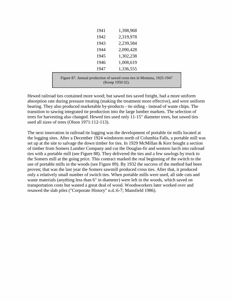
1941 1,398,968
1942 2,319,978
1943 2,239,584
1944 2,090,428
1945 1,302,238
1946 1,008,619
1947 1,336,555
Figure 87. Annual production of sawed cross ties in Montana, 1925-1947
(Kemp 1950:32).
Hewed railroad ties contained more wood; but sawed ties saved freight, had a more uniform
absorption rate during pressure treating (making the treatment more effective), and were uniform
bearing. They also produced marketable by-products - tie siding - instead of waste chips. The
transition to sawing integrated tie production into the large lumber markets. The selection of
trees for harvesting also changed. Hewed ties used only 11-15" diameter trees, but sawed ties
used all sizes of trees (Olson 1971:112-113).
The next innovation in railroad tie logging was the development of portable tie mills located at
the logging sites. After a December 1924 windstorm north of Columbia Falls, a portable mill was
set up at the site to salvage the down timber for ties. In 1929 McMillan & Kerr bought a section
of timber from Somers Lumber Company and cut the Douglas-fir and western larch into railroad
ties with a portable mill (see Figure 88). They delivered the ties and a few sawlogs by truck to
the Somers mill at the going price. This contract marked the real beginning of the switch to the
use of portable mills in the woods (see Figure 89). By 1932 the success of the method had been
proven; that was the last year the Somers sawmill produced cross ties. After that, it produced
only a relatively small number of switch ties. When portable mills were used, all side cuts and
waste materials (anything less than 6" in diameter) were left in the woods, which saved on
transportation costs but wasted a great deal of wood. Woodsworkers later worked over and
resawed the slab piles ("Corporate History" n.d.:6-7; Mansfield 1986).

Figure 88. McMillan & Kerr tie mill in Patrick gulch near Kalispell, on Flathead National
Forest, 1930 (photo by I. V. Anderson) (courtesy of USDA Forest Service, Region One,
Missoula).
Figure 89. Hauling railroad ties by truck, Eureka, 1929 (courtesy of the Mansfield Library,
University of Montana, Missoula).
Flathead logger Clarence Saurey remembered the effect of the stock market crash of October
1929 on the portable tie mills in the Flathead, which were salvaging timber burned in the Half
Moon fire of 1929:
Everything was a-running, you know, you could hear them sawmills a-singin' all over the
woods. And it shut down overnight...Next morning there wasn't a thing running at all
(Saurey 1983).
The change to sawed ties greatly increased the number of small portable circular mills in the
Flathead; their number peaked at the height of tie cutting during World War II (see Figure 90). In
the Kalispell Working Circle at that time, about 100 circular mills were in operation, plus three
band mills. By the late 1950s, however, the market for ties was reduced because of improved
preservative treatment and the reconstruction of railroad roadbeds (Ibenthal 1952:48->49).
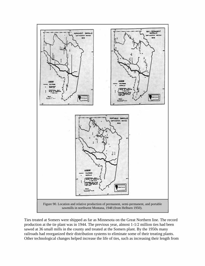
Figure 90. Location and relative production of permanent, semi-permanent, and portable
sawmills in northwest Montana, 1948 (from Helburn 1950).
Ties treated at Somers were shipped as far as Minnesota on the Great Northern line. The record
production at the tie plant was in 1944. The previous year, almost 1-1/2 million ties had been
sawed at 36 small mills in the county and treated at the Somers plant. By the 1950s many
railroads had reorganized their distribution systems to eliminate some of their treating plants.
Other technological changes helped increase the life of ties, such as increasing their length from

8' to 8-1/2' or 9' (Elwood 1976:34; Olson 1971:165, 167). The demand for railroad ties,
therefore, declined significantly.
The main companies cutting railroad ties in the Flathead were Somers Lumber Company, the
Kinshellas, and the Olson Brothers. Some tie contractors had quite a large business in the
Flathead. For example, in 1912 George Slack had a contract with the Great Northern to deliver
hewn ties, and in the first year he delivered to the right-of-way 700,000 ties. In 1931 the
Kinshella brothers and their father signed a 7-year contract to cut railroad ties and sawlogs on
Somers Lumber Company land from Lupfer north. The 150 men at the camp received
approximately 13 cents per tie (a little more for the larger ones). Workers earned $2 a day and
were charged 90 cents a day board. The ties and logs went to the Somers sawmill and tie-treating
plant (24FH466, FNF CR; "Personal Experience Record of Capt. George W. Slack," SC 126,
MHS; "Large Logging Project" 1931; Cusick 1986:61).
Many railroad ties were cut in the late 1930s and through World War II in the Pleasant Valley
area, which had literally dozens of portable tie mill sites. The Forest Service did not issue
permits for mill sites on the national forest, but sometimes sales on private land trespassed onto
national forest land (24FH154, FNF CR).
In the late 1940s, western larch and Douglas-fir railroad ties accounted for almost 20% of the
total sawmill output of Montana. Small portable mills, with 6-8 men on their crews, were typical.
They cut 2,500-12,000 ties a setting and moved rapidly from one tract to another. For each 1000
board feet of ties sawn, they could cut nearly 250 board feet of lumber. When prices for larch
and fir boards were low, the tie siding went into the slab pile (Hutchison 1952:31).
Forest Service Logging, 1905-1942
General
Until World War II, timber sales on the Flathead National Forest were generally small scale.
Most of the timber was harvested in those years from private lands, not federal lands, near rivers
or in accessible areas. The main exceptions were sales designed to harvest scarce species, such as
a sale of white pine on the lower North Fork and a cedar sale on Good Creek in the Stillwater
area. In 1908, no national forest in Region One had an estimated timber harvest of more than 1%
of the total amount of standing timber. Commercial sales of national forest timber did not exceed
a billion board feet annually until 1924, but even then it still represented only 1% of the national
timber market (Baker et al. 1993:65; Clary 1986:40).
In 1905, Forest Service policy held that the timber on the national forests was supplemental to,
not competing with, private holdings, and that the timber should be harvested to meet local needs
only. In 1907 early Forest Service timber sales peaked, but these sales represented only 2% of
the 44 billion board feet total. Pinchot later claimed that the national forests existed for public
welfare purposes, to stabilize local industry and to encourage development (Steen 1976:90-91).
The first administrative manual for the forest reserves was issued in 1902 by the Department of
Interior. The section on timber began with regulations on the free use of timber. For sales, local

demand had preference. After a potential purchaser requested a timber sale, the government
would inspect it, mark the trees or area to be cut, and then advertise the sale to the public for
bids. The Forest Service believed strongly in its mission to promote the wise use of forest
resources. In a 1907 handbook, the Forest Service stated clearly, "The timber is there to be used,
now and in the future...National Forests are made, first of all, for the lasting benefit of the real
home builder. They make it impossible for the land to be skinned" (Steen 1976:59; Pinchot
1907:11, 17).
The first manual provided no appraisal formulas, but timber prices at that time were seldom over
$2 per thousand board feet (the first appraisal manual was issued in 1914). Before 1910 the
reproductive capacity of a forest was essentially a matter of guesswork. Then the Forest Service
adopted allowable cutting levels in order to protect against over-cutting. The allowable cut
represented the amount that would produce sustained-yield harvests (Wiener 1982:2; Clary
1986:30, 34).
In the early years, the Forest Service issued free-use permits for cutting timber. Settlers, miners,
residents, and prospectors could harvest $100 worth of timber annually from forest reserves each
year, provided it was used for domestic purposes, firewood, fencing, buildings, or mining. For
example, in 1906 on the Lewis & Clark Forest Reserve one man was granted 10 cords of dead
standing and down lodgepole near the junction of Upper Twin Creek and the South Fork to build
a cabin in the vicinity. In 1905 the forest reserve issued 131 free-use permits that granted about
34,000 board feet and 215 cords of green wood, plus 71,000 board feet and 1,500 cords of dead
wood (Wiener 1982:3; "Free Use of Timber, 1905" FNF CR).
Up to 1907 most of the timber harvested on the Flathead National Forest was on land that is now
in Glacier National Park, mostly fuelwood and timber for building homes in the Lake McDonald
area. The early timber sales on the Forest, few in number, were usually for $1 per thousand board
feet, 3 cents for 30-foot poles, and 15 cents per cord for fuel wood. When the Park was
designated in 1910, logging for revenue continued to be allowed within the Park. In 1911, the
Park ordered a sawmill and shingle machine, and superintendent Logan stated "the cutting of
fully matured timber will not in the least mar the beauty of the park, but will benefit the growing
timber...Numerous inquiries for lumber have been received, and in a short time it is believed
lumber will rank first among the sources of revenue" (Shaw 1967:1, 12; Logan 1911: 10).
The 1910 fires killed 5-10 billion board feet of mature timber in Idaho and western Montana and
led to a glut of timber on the market in Montana. Salvage sales were offered, but only 1 billion
board feet were actually sold and cut. The Forest Service even approved the cancellation of
current contracts to allow firekilled timber to be used instead (Wiener 1982:33).
By 1923 each national forest had been divided into "working circles" to aid in timber
management planning. The boundaries of these divisions were based on topography,
transportation networks, management objectives, stand composition and condition, ownership,
and the area needed to support local forest-based industries. The boundaries were reviewed and
modified as needed. The allowable cuts were determined within that area, consistent with
sustained yield over the working circle. Timber management plans were prepared on 10-year
cycles (see Figure 91) (Preston 1923:582-585; G. Robinson 1975:62).
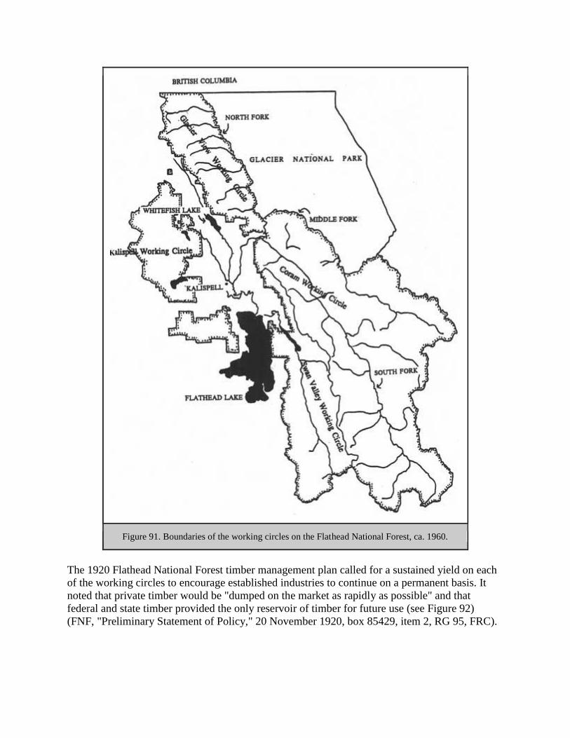
Figure 91. Boundaries of the working circles on the Flathead National Forest, ca. 1960.
The 1920 Flathead National Forest timber management plan called for a sustained yield on each
of the working circles to encourage established industries to continue on a permanent basis. It
noted that private timber would be "dumped on the market as rapidly as possible" and that
federal and state timber provided the only reservoir of timber for future use (see Figure 92)
(FNF, "Preliminary Statement of Policy," 20 November 1920, box 85429, item 2, RG 95, FRC).

Species Blackfeet National Forest Flathead National Forest
western white pine 74 260
ponderosa pine 102 270
lodgepole pine 151 379
Douglas-fir 483 1120
western larch 1113 1500
Engelmann spruce 1079 769
white and alpine fir 81 321
limber and whitebark pine 4 34
cedar 3 85
hemlock — 12
total saw & tie timber 3090 4750
cedar poles 12000 35000
Figure 92. 1924 estimates of timber on the Blackfeet and Flathead National
Forests. Figures are in million board feet ("Forest Statistics for Region One,
approximately 1925," RO).
In the fiscal year ending June 30, 1916, the Flathead and Blackfeet National Forests combined
sold 46.5 million board feet of timber, and the sawmills in the same area and same period cut
191.0 million board feet. The percentage of the cut coming from the national forests was fairly
significant at that time, and at least one local lumberman complained that the government, by
putting the timber on the market, was depressing an already overloaded stumpage market. One of
the reasons timber was logged more on private lands in the early years was because of the more
stringent regulations on Forest Service sales, such as requirements to leave a 16" stump, dispose
of brush, and so on (Charles I. O'Neil to H. H. Chapman, 9 February 1917, 2400 - Timber -
Historical - Genl Corr, RO; Hannon 1970).
In 1917 there were complaints in the Kalispell area that the Forest Service was selling its timber
at too low a rate ($1.25 per thousand board feet) to the Eureka Lumber Company, thus reducing
the stumpage value of all private timber land holdings in the area. Forest Service competition, it
was feared, would prevent private profits. Senator Myers, in response, introduced legislation that
would prohibit the sale of any national forest timber for less than $3 per thousand. This conflict
was apparently resolved by a consolidation of private land ownership, as in 1920 a Flathead
National Forest report stated that the complaints had largely been silenced by "the absorption of
a large part of the small holdings by larger owners who contemplate early exploitation" (Semi-
annual report to the Forester, 1 May 1917, 1380 Reports - District 1, 1917; "Public Sentiment,"
18 November 1913, in 1380 Reports - Historical - Public Sentiment, RO; FNF, "Preliminary
Statement of Policy," 20 November 1920, box 85429, item 2, RG 95, FRC).
According to a contemporary Forest Service report, people were complaining about national
forest stumpage prices because they speculated on timber lands and thought the value would go

up, but they had actually paid too much for the land in the first place. If the federal government
were to put a high price on the stumpage, then the opportunities of the small operator would be
eliminated ("General Summary of Timber Situation," 2400 - Timber - Historical - General Corr,
RO:4-5, 13). During the late 1920s, prices for Flathead and Blackfeet National Forest timber
sales rarely were higher than $2 per thousand board feet (see Figure 93).
Buyer Date MBF Timber type Price/MBF Total Sale
L. R. Smith 2,000 white pine 2.00 4,000.00
F. Calkins 3/10/26 72 larch & fir 2.17 156.24
J. Oxender 5/18/26 970 larch & fir 1.75 1,697.50
Nyack T&T 1/8/27 1,931 larch & fir 2.14 4,132.34
Nyack T&T 1/8/27 1,677 spruce 2.14 3,588.78
H. Good 4/25/27 200 larch & fir 1.50 300.00
Johnson & Ramlow 12/21/27 250 larch & fir 1.65 412.50
Julius Berg 8/4/27 55 larch & fir 1.50 82.50
Johnson & Ramlow 1/28/28 1,012 larch & fir 1.70 1,720.40
Julius Berg 8/11/28 80 larch & fir 1.50 120.00
Julius Berg 1/16/29 200 larch & fir 1.50 300.00
Julius Berg 1/15/29 20 larch & fir 1.50 30.00
11 tie sales 8,467 larch & fir 1.94 16,540.26
Figure 93. All timber sales on Flathead and Blackfeet National Forests, May
1926-January 1929 ("Appraisal" 1930:11).
World War I had a significant effect on the demand for lumber and on Forest Service resources.
At the start of the war in 1914, foreign purchase orders were canceled, but then demand
increased greatly because the Allies lacked the manpower to harvest timber in Europe. Under the
War Powers Act, the Forest Service was permitted to sell timber without competition, and price
ceilings were imposed. During World War I the U. S. Army required a great deal of lumber in
Europe. Instead of shipping it overseas, the Army organized a regiment of experienced foresters
and lumbermen, many of them Forest Service employees, to be stationed in Europe. In France,
the regiment cut about 300 million board feet of lumber plus poles and firewood, operating about
90 sawmills. More than 30,000 American foresters, woodsmen, and mill men served in Europe,
many returning home with a new respect for the conservation methods practiced in France and
for the frustration with government controls felt by industry in the U. S. The war strengthened
industrial trade associations and increased industry-wide cooperation necessary to allow the
lumber industry to deal with the government on more equal terms (Cox 1985:205; Wiener
1982:112; Clary 1986:68-69).
Region One of the Forest Service helped out in the 1919 fuel emergency by allowing officials to
obtain wood from the national forests for the use of those in need under free-use permits. The

consumer paid only the actual cost of cutting and delivery (16 December 1919, 2400 Timber -
Historical - General Corr, RO).
Commercial sales on the national forests remained low during the interwar period. In 1921, for
example, the Flathead National Forest sold only 8 million board feet of timber in commercial
sales ("Timber Sales Business" 1921:6-7).
In approximately 1929, the Flathead National Forest was still making "no effort...to push the sale
of national forest timber. It is considered better management of public resources to preserve and
protect this timber until such time as the private timber has been cut and a new source of supply
is needed to perpetuate existing industries and meet the demand for forest products." At that time
only about 10% of the annual production of 75 million board feet of lumber in the Flathead
Valley came from the Flathead National Forest (USDA FS "Flathead National Forest" ca. 1929).
In 1931, during the Depression, President Hoover restricted national forest timber sales because
of overproduction. The Forest Service prohibited timber sales over $500 except to supply mills
dependent on the national forests, to supply domestic paper mills, or to salvage damaged timber
(W. Robbins 1982:143).
As the prices for paper products rose, the Forest Service fielded inquiries about the possibilities
of a pulp industry in Region One. The Forest Service considered the Engelmann spruce stands on
the Flathead and Blackfeet National Forests as the most accessible timber of the kind desired by
the Wisconsin pulp mills. The Blackfeet National Forest, under the supervision of supervisor
Robert McLaughlin, did an extensive study in the late 1910s of the pulpwood resources of
northern Montana, hoping to encourage the establishment of a paper industry there ("Robert P.
McLaughlin" 1929:4; Silcox to the Forester, 10 May 1917, 2 Semi-annual Report, 1380 Reports
- Historical - District 1, RO).
The Forest Service study focussed on Big Creek, Deep Creek, and Canyon Creek in the North
Fork. The report indicated that 75% of the timber in that area was good for pulpwood, with a
reserve supply to the north and south. It recommended a pulp and paper mill on or near Flathead
Lake, with the fluming of logs down tributary streams to the North Fork. The report also stated
that the Forest Service would establish new stands after harvest, as it was practicing forestry on
the basis of sustained yield. In the 1930s Forest Service officials in the area were still
recommending a pulp or paper operation in the Flathead that would be supported by 95 million
board feet of spruce and subalpine fir annually. The controlling factor, they believed, would be
developing a market for the associated western larch and Douglas-fir ("Possibilities" ca. 1920:3-
6, 11-12; Ibenthal 1936:14).
Some flathead timber was shipped out of the area for pulp, although the proposed pulp mill was
not built. In 1927 subalpine fir and spruce were being shipped in the log from Nyack to a
Spokane pulp mill because the Somers Lumber Company would not accept the logs (Wilfred W.
White memos, 11 & 15 August 1927, Flathead Inspection Reports, Region One, RG 95, FRC).
Montana's first pulp mill was built in the Missoula area in 1956 (Bolle 1964:11). Pulp and
plywood mills helped stabilize the income of lumber mills. The industry, traditionally cyclic, was

affected by ups and downs in the building industry and by fluctuations in the demand for and
price of lumber.
Swan Valley
The public land in the Swan Valley was recognized early as an excellent "logging chance." At
the turn of the century, when no commercial timber harvesting had yet been done in the Swan, H.
B. Ayres recommended using an electric railway to log the Swan Valley, with a sawmill located
at the mouth of the Swan River. In 1906, a Forest Service inspector commented that the Swan
and the South Fork both offered excellent opportunities for the construction of roads to make
large bodies of timber available for harvest (Ayres "Lewis & Clarke" 1900:79; 28 November
1906, entry 7, box 4, "Reports of the Section of Inspection," RG 95, NA).
The first large (and still the largest ever) timber sale on the Flathead National Forest took place
in 1913, when the Forest sold timber in the Swan Valley to the Somers Lumber Company. The
sale led to the first railroad logging on the Flathead National Forest (most railroad logging was
done on private holdings). The 1913 and 1917 sales represented a total cut of 87 million board
feet of sawlogs and 302,000 board feet of railroad ties. The logging took place between October
1914 and July 1919 (Shaw 1967:1, 123-124; J. C. Urquhart to Regional Forester, 4 February
1937, FNF Lands; Wiener 1982:35).
The Somers Lumber Company sale in the Swan Valley was located on over 9,000 acres in the
Swan River drainage on the east side and at the head of Swan Lake. The Forest Service intended
to list much of the land for settlement as soon as the timber had been removed, as it was
considered of high agricultural value. The timber in the 1913 sale consisted of about 51%
western larch, 25% Douglas-fir, 12% Engelmann spruce, 10% western white pine, and 2% red
cedar. The company paid $2 per thousand board feet, regardless of species, which the Forest
Service considered a good price ("100,000,000 Feet," 1913:418; F. A. Silcox to Thomas Cooper,
23 January 1917, entry 70, box 7, RG 95, NA; Wiener 1982:35).
The Somers Lumber Company called for bids from logging contractors on the Swan Valley sale
in 1913, but none were accepted. Instead, the company hired James E. Craney and his complete
logging outfit to run the operation (Craney had built the spur railroad line from Kalispell to
Somers). Several logging camps were set up, including one made of modular units on skids
located on the logging railroad line and another made up mainly of tents. The land was clearcut
and slash was burned on the sale. After the logging slash was broadcast burned, according to a
Forest Service report, the small streams in the area went dry regularly in the summer (Craney
1978; Seattle RG 95, Flathead 1920-23 Inspection Reports, 9/11/22 memo; 18 December 1937
memo, Inspection Reports, Region One, 1937-, RG 95, FRC).
The Forest Service ranger stationed at Swan Lake scaled timber the winter of 1914-15 and spent
subsequent winters looking after free-use permits and the government horses. About 150 men
were working in the camps near the head of Swan Lake in 1918. Twelve families lived near the
post office at the head of the lake, using boats to travel the lake in the summer and the "ice road"
in the winter. The rest of the year a 7-mile wagon/automobile road provided the main access to
the Flathead Valley (24LA149, FNF CR; Elwood 1980:200).

In 1919 a lunch fire broke out and burned over the entire sale area. Only about 5,700 acres of the
9,000 sold had been harvested; the rest of the timber burned in the fire (Stevens & Westphal
n.d.:1).
Middle Fork
In 1899 H. B. Ayres wrote that an electric railroad might be feasible in the Middle Fork for
hauling logs. Despite a growing demand for lumber east of the Divide, he felt that at that time
none of the timber on the Middle Fork could be sold "at any price on the stump" because of
transportation difficulties (Ayres "Lewis & Clarke" 1900:51, 67).
One early cordwood sale on Flathead Forest Reserve land was at Summit. The government sold
approximately 253 cords to the Cut Bank Mercantile Company for 55.5 cents per cord. Timber
sales continued slow but steady in the area. By 1918, small timber sales kept one man employed
almost exclusively year-round out of Coram Ranger Station (14 February 1905 and 5 June 1905,
"Rangers 1-1-05 to 6-30-05" pressbook, FNF CR; FNF "General Report" 1918).
Before 1908, the Forest Service offered small sales of cordwood, fence posts, and house logs to
settlers along the railroad line up the Middle Fork. Timber was also harvested for administrative
use as well. Timber harvest peaked in 1917 and then dropped again by 1920. In 1920, according
to a report, "The area around Belton and Coram, adjacent to the Great Northern Railway and the
river...has been cut over several times for logs, ties, poles, and finally for dead poles and
cordwood. At present these lands are practically clear cut of merchantable timber and support
only a partial stand of production." On the Coram Working Circle through 1959, 957,000 board
feet were logged (FNF "Timber Management, Coram" 1961:40-41).
South Fork
In the early years, no contractor would buy stumpage above Devil's Elbow on the South Fork of
the Flathead (approximately where the Hungry Horse Dam is now located) because the river
flowed through a Z formed by sheer rock walls. Any logs that floated through the canyon would
be battered and thus unfit for lumber (Frohlicher 1986:29).
In 1933 the Forest Service established the Coram Experimental Forest in the South Fork
drainage, 7,460 acres dedicated to research. This was one of only two experimental forests at the
time (see Figure 94). Active research began in 1946 to study harvesting methods and the
restocking of cutover land; later other resource management issues in western larch/Douglas-fir
stands were also studied. The Flathead National Forest has remained responsible for fire
protection, road maintenance, and timber sales within the experimental forest (Sneck 1977:7;
"Facts about Coram Experimental Forest," box 3, folder 5, MSS 84, UM; Baker et al. 1993:149).

Figure 94. Location of Coram Experimental Forest.
In the early 1960s a feasibility study of a timber sale in the Bob Marshall Wilderness concluded
that the area should remain a wilderness because of high costs of road construction and low
timber demand (see Figure 95) (Merriam 1966:91, 96)

Figure 95. Hypothetical timber sale in the Bob Marshall Wilderness Area, mapped in 1960
(Merriam 1966:123).
North Fork and North of Columbia Fails
The accessible timber on the private land in the south part of the North Fork was cut out in the
early 1920s. The ranger district wrote the first timber management plan in 1925, but no
development occurred (FNF "Timber Management, Glacier View" 1959:4).
One of the early timber sales on the Forest occurred in 1909 in the Canyon Creek area. The logs
were hauled by four- and six-horse wagons to Columbia Falls. In a typical timber sale, the J.

Neils sale on Cedar Creek north of Columbia Falls, the company cut the best and most accessible
timber and then asked to be relieved of cutting the rest. A Forest Service inspector commented
that "Neils has this habit" (Thayer 1979; 27 December 1937 memo, Inspection Reports, Region
One, 1937-, RG 95, FRC).
Two mill sites selected in 1912 and withdrawn by the Blackfeet National Forest included one on
Hay Creek (a small water-powered mill had been built there some years ago) and one on Red
Meadow Creek (which had no value then because there were "no timber sale activities in this
region"). In 1916 the Hay Creek site was recommended to be released because no mill man could
be convinced to establish a mill there (FNF "General Report" 1918; FNF Lands)
Logging During and Shortly After World War II
The national timber industry expanded rapidly at the end of World War II. Overcutting on many
private lands compelled private timber owners to turn to the national forests; the Forest Service
entered the market economy. The public and Congress both pressured the Forest Service to
produce more timber. In 1940 national forests still provided only 3.2% of the nation's timber, but
by 1970, Forest Service lands accounted for 18% of the national harvest. During the war, the
standards of forest practice declined because of the pressure for more lumber. The national
forests were not ready to meet the demand and spent most of the war years rushing to get into
production. Meanwhile, industry overcut its stands. By the end of the war, though, the Forest
Service was oriented towards commercial timber sales on a scale larger than ever before (W.
Robbins 1982:237; Dana 1980:175).
The Flathead National Forest's timber harvest increased dramatically during and after World War
II. During the Depression, almost no timber had been sold. Shortly after the Depression, the
Forest sold about 3-4 million board feet annually, but in 1944 the Flathead National Forest sold
31 million board feet. In 1955 the Forest sold 102 million board feet, representing just over 50%
of the timber sold in the valley (see Figure 96) (Bolle 1959:73-74).

Figure 96. Volume of timber cut on the Flathead National Forest, 1935-1960. The prices of
Douglas-fir and Englemann spruce lumber per thousand board feet are also shown (from
Bolle 1959:120f).
Much of the valley bottom lands had been cleared of timber and planted to agricultural crops.
From approximately 1900-1920 railroad logging and river driving brought logs to the large mills
from the relatively flat benchlands of the larger drainages. The development of tractor skidding
and truck hauling directly to the mill ponds allowed logging to be done on private lands all over
the valley. At the same time, national forest stumpage came into demand, and the purchase of
government timber to keep operating became accepted by all mill operators after the end of
World War II (Ibenthal 1952:49, 52a).
As in other periods, desirable species shifted with availability and changing marketing and
building construction techniques. In 1934 the value of various species was: western white pine,
$8 per thousand board feet; ponderosa pine, $2-5 per thousand board feet; lodgepole pine, $1-4
per thousand board feet; other species, $0.25-2.50 per thousand board feet. In 1940 larch
provided only 2.9% of the total cut of sawlogs in Region One, largely because of its weight and

high shipping costs compared to Douglas-fir. By 1946 it was providing 21.9%; larch was used
mostly in framing and concrete forms and had been approved for transmission line poles for the
REA. By the 1940s, western larch was the leading species in northwestern Montana, and
ponderosa pine had been increasing since 1935. Most of the ponderosa was being shipped to the
midwest to be remanufactured into sash and doors. In 1946 the Forest Service announced a large
sale of lodgepole from the Lewis & Clark National Forest. Before then it had been virtually
unmarketable, but the demand grew (Brown 1934:209; R1 PR 963, 25 February 1946; Winters
1950:97; Sundborg 1945:14, 24; Baker et al. 1993:165).
During the war, the Forest Service offered timber sales in excess of normal sustained-yield
limitations where forest products were needed to satisfy wartime requirements. To aid in the war
effort, Congress made provisions for new access roads to open up new supplies of timber.
Timber access roads built during 1943 and 1944 in Region One included two on the Flathead
National Forest. The Emery Creek Project involved building 6 miles of road to gain access to a
stand of white pine and larch. The road, built in 1944, allowed the harvesting of 10 million board
feet of lumber in 1945; it was designed to run above the elevation of the flowage line of the
proposed Hungry Horse Reservoir. The Skyland Road near Summit was also built in 1944 to
harvest timber to meet wartime needs (Granger 1943:113; USDA FS "History of Engineering"
1990:420, 422).
The war-time boom led to the establishment of new small mills in the Flathead, many of them
producing railroad ties because of the increased use of the railroads during the war (see Figure
97). The American Timber Company, for example, built a permanent mill on state land in the
Lower Stillwater Lake area and cut ties during the war over a vast area. When the war was over,
the portable mills switched back to cutting lumber (Cusick 1986:17).
Year Number of mills Total reported production
1869 - 13,000
1879 - 21,000
1889 - 94,000
1899 69 255,685
1904 36 236,430
1905 23 189,291
1906 84 328,727
1907 130 343,814
1908 173 311,533
1909 179 308,582
1910 140 319,089
1911 126 228,416
1912 118 272,174
1913 109 357,974
1914 124 317,842

1915 94 324,333
1916 103 383,884
1917 122 347,496
1918 98 335,811
1919 125 287,378
1920 124 409,667
1921 120 213,989
1922 100 303,458
1923 117 426,917
1924 100 350,335
1925 120 388,854
1926 122 378,698
1927 127 398,267
1928 119 387,879
1929 126 388,711
1930 114 296,990
1931 86 158,213
1932 72 111,048
1933 89 125,126
1934 105 171,841
1935 116 233,633
1936 126 295,233
1937 146 335,045
1938 140 221,579
1939 168 271,096
1940 168 325,338
1941 265 373,970
1942 249 433,089
1943 228 423,520
1944 256 448,498
1945 253 341,749
1946 401 413,859
1947 407 499,959
1948 434 597,944
Figure 97. Number of sawmills and lumber production in Montana, selected
years 1869 to 1948 (from Kemp 1950:6).

Over 700 Region One Forest Service employees served in World War II. As in World War I,
companies of Forest Engineers were sent overseas to provide timber for the troops they served.
The Forest Service and other agencies contributed technical knowledge and personnel (Baker et
al. 1993:163; Winters 1950:23-24).
World War II touched ground on Flathead National Forest land in a rather strange way in
December of 1944. Two woodcutters working 17 miles southwest of Kalispell found a Japanese
balloon on the ground containing a bomb that had failed to explode (Webber 1984:261).
On the home front, woods work was considered essential work, so local logging contractors did
not face a shortage of workers during the war. Camps for conscientious objectors were located
on various national forests. In the Flathead, conscientious objectors were based in Glacier
National Park.
The building boom following World War II led to pressure for the increased harvesting of timber
on national forest lands. After the war, the home construction industry boomed. Consumers'
purchasing power had accumulated, and rehabilitating war-torn Europe also led to a market for
American lumber. Timber management ceased to be largely custodial. At the end of the war,
57% of the commercial forest land in Flathead County was national forest land, and much of it
was targeted for harvesting. As historian Harold Steen put it, "Following the war there was broad
agreement for the need to step up the tempo of logging on national forests" (Steen 1976:280;
Sundborg 1945, appendix 7).
The significant growth in the Montana timber industry began in 1946. The increase in logging
was due to a national backlog of demand for housing, price increases for stumpage and lumber,
and the depletion of timber in other regions. Five plywood mills moved into Montana between
1955 and 1964, three of them to the upper Flathead, partly because of the growing interest in
western larch as a veneer species. The post-war timber boom ended at the end of 1956. In 1957,
the number of operating mills dropped from 104 to 60 in one year (Bolle 1966:19-20).
The Flathead National Forest, like national forests around the country, increased its annual cut
following World War II. The Forest reached the allowable cut it had set for itself of 60 thousand
board feet for the first time in 1947. The allowable cut remained at this level until 1957, although
it was exceeded some of those years. This allowable cut figure was later more than doubled due
to better inventories and improved silvicultural and utilization practices. The timber program
dominated the agency's workday as it never had before (Merriam 1966:70; Shaw 1967:124;
Clary 1986:122, 125).
Roads had traditionally been amortized out of stumpage. The Forest Service gave priority to
access road construction and later encouraged logging companies to construct access roads in
return for discounts on the price of timber sales. The outbreak of war in Korea in the summer of
1950 intensified the demands for lumber and roads. Congress began to increase appropriations
for road construction. In Region One, small operators could not afford to build even spur roads.
The Forest Service argued that with an established road system, timber sales could be fair to
large and small purchaser alike (Caywood et al. 1991:62; Steen 1976:283-84; Clary 1986:113,
117, 119).

In 1950, 40% of the sawmills in northwestern Montana depended on national forest timber in
part or in whole. Generally they bought timber sales that supplied them for less than two years.
The portable mills at the time moved once every 1-3 months. Most of the mills could be moved
by truck or skidded by tractor and were usually located on 10-20° slopes (this helped with
loading ties and lumber on trucks and allowed the waste piles to be bigger). Until 1941 they
produced railroad ties only, but with World War II they all began cutting and selling lumber
from the thick slabs (tie siding) that had previously been casually thrown away (Helburn
1950:31-35, 65, 68).
The Sustained Yield Management Act of 1944 authorized the establishment of sustained-yield
units under which the rate, manner, and time of timber harvest would be managed in a
coordinated way according to approved silvicultural practices. Mills could be provided with a
constant supply of timber without resorting to competitive bidding, if required for community
stability. Although much of the timber industry supported the idea, much of the public was
opposed. The pressure of war-time demands for timber helped the act get enough support to be
passed, but there never were any cooperative sustained-yield units in Montana (R. Robbins
1976:438; W. Robbins 1982:239; Steen 1976:250-252; Clepper 1971:284, 286).
In 1936 the Kootenai National Forest recommended that the Forest Service help support the J.
Neils Lumber Company in Libby. A plan for a long-term agreement was drawn up, using
national forest and private land, but it never went into effect. The J. Neils Company was one of
the first to institute selective logging designed to perpetuate its forests, beginning in 1939.
Because the Flathead Valley did not represent a monopoly situation similar to the J. Neils
Company case in Libby, a sustained-yield unit based on the Libby example was never seriously
proposed for the upper Flathead (Baker et al. 1993:145; Neils 1971:87; Bolle 1959: 172).
Insect, Disease, and Windstorm Damage to Timber
From 1910-1944 Montana's forests lost 25.6 billion board feet annually, half due to insects, one
quarter to fire, and the rest to disease, windstorms, etc. The loss exceeded the cut during these
years by 26%. The most severe insect infestation was that of the mountain pine beetle, first noted
on the Flathead National Forest (in the Swan Valley) in 1909. It killed much lodgepole pine and
also ponderosa pine. The infestation spread rapidly south, being found at Seeley Lake by 1913.
This reportedly started the 1910-1918 epidemic in the Blackfoot River drainage that did a great
deal of damage there (Hutchison 1952:42; Cunningham 1926:55; Moon 1991:85).
In the early 1910s the Forest Service did insect control work on the west side of Swan Lake.
Ranger Baigrie Sutherland hired 14 lumberjacks for the project. They built their camp and cut
and piled for burning 25,300 lodgepole trees. The infestation covered about 3,000 acres, and the
cost was shared by the Forest Service, the State, and the ACM. A third of the crew were rangers
who had been furloughed due to lack of funds; the rest were seasonal forest guards. They were
paid $40 a month and board (Koch 1931:1; Clack 1931:13).
A 1928 infestation of mountain pine beetle in the Canyon Creek area destroyed about 70%, or
several million board feet, of the white pine there. In the early 1930s, the Forest Service planned
to offer white pine in the Nine Mile Lake area as a salvage sale because of the mountain pine

beetle damage ("Insect Damage" 1931:6; "Result of Bark-Beetle" 1935:5; FNF "Timber
Management, Glacier View" 1959:40).
In 1925 the mountain pine beetle was also damaging lodgepole pine on the upper South Fork. In
1927 Douglas-fir bark beetle had reached almost epidemic proportions east of Columbia Falls
and a long way up the Middle Fork in the vicinity of a December 1924 blowdown. Mountain
pine beetle was also present in the white pine north of Elk Park Ranger Station on the South Fork
("Summary of Forest Reports" 1926:21; Wilfred W. White memo, 15 August 1927, Flathead
Inspection Reports, Region One, RG 95, FRC).
In the early 1930s large volumes of mature spruce were infested by insects and lost in Gregg and
Alder Creeks, and some lodgepole pine was lost to mountain pine beetle in other years. Diseases
took their toll too. By the late 1950s, white pine blister rust was killing white pine and whitebark
pine in the Kalispell working circle. Also, Douglas-fir needle cast caused losses to the Christmas
tree industry. Dwarf mistletoe was present in almost every pole and sawtimber stand in the
working circle and causing serious losses (FNF "Timber Management, Kalispell" 1960:39;
Ibenthal 1952:42).
Western spruce budworm affected the Swan Valley and the South Fork some between 1948 and
1971, but the damage was not as extensive as elsewhere in the northern Rockies. The host
species are primarily Douglas-fir, Engelmann spruce, and western larch. The earliest outbreak on
the Flathead National Forest was on Coram Ranger District in 1933. Some other forests were
aerially sprayed to control spruce budworm, but the Flathead National Forest was not (Johnson
& Denton 1975:1, 17, 26, 46, 89-90, 141-143).
There had been a number of severe windstorms on Flathead National Forest lands prior to World
War II, such as one in 1923. The hardest-hit districts then were the Lower Swan and Lower
South Fork, where trails, phone lines, and roads were blocked. In some areas, such as a 220-acre
stand near Emma Creek, less than 5% of the timber was left standing. At that time, the Forest
Service stated that it was simply impossible to salvage the timber because of the great expense.
A successful salvage sale did occur in 1906 when the John O'Brien Lumber Company cut almost
1 million board feet along the east and west shores of Flathead Lake on the Flathead Indian
Reservation. The sale had resulted from a blowdown earlier that year (Wolfe 1924:12; Historical
Research Associates 1977:30-31).
By 1949, however, a number of conditions limiting blowdown salvage had changed, and after a
severe windstorm in that year the Forest Service initiated a huge salvage logging program. On
November 9, 1949, an event occurred that was soon known to foresters as "the '49 blow." High
winds ripped through the forests of western Montana, northern Idaho, and eastern Washington,
blowing over millions of board feet of sawtimber, mostly Engelmann spruce, Douglas-fir, and
western larch. In the Lindbergh Lake area alone, for example, the trees on about 700 acres were
blown down (Montana Conservation Council 1954:23).
In the summer of 1950 a salvage logging program got underway, aided by the slowing down of
work on the Hungry Horse Dam. The Forest Service located blowdown areas by plane, mapped
and cruised the affected areas, and scouted access routes on the ground. By that fall roads were

being built. Timber was sold to the highest bidder, usually for less than the going price for
standing timber. Logging companies found that Engelmann spruce that had been blown down in
the 1949 windstorm was good lumber which - because of its lighter weight - could be shipped
cheaper than fir and larch (Montana Conservation Council 1954:23; Whitney 1983).
The 1949 blowdown led directly to a severe spruce bark beetle epidemic in the northern Rockies.
About 80% of the threatened spruce was on federal land. The first hints of the epidemic came in
July 1951, when Fred Burnell was sent to Canyon Creek in the North Fork to locate roads for a
proposed sale of spruce there. He found that about 25% of the mature trees were dead or dying.
An entomologist reviewed the situation and "determined we were in trouble," finding that the
spruce bark beetle had infested all mature spruce stands in Region One. As a result, said Burnell,
"we in the West spent the next 2 or 3 years locating, designing, and constructing spruce bark
beetle roads" ("Loggers Intensify" 1953:4; USDA FS "History of Engineering" 1990:538).
The Forest Service controlled the beetle by large-scale logging. Logging as a control method was
based on the fact that beetle broods drowned in sawmill ponds or burned in slab fires. This
logging led in turn to a flood of spruce on the market. The Forest Products Laboratory and the
lumber associations helped obtain consumer acceptance of spruce by testing spruce and
recommending it. The marketing of spruce was successful; the Flathead National Forest reported
that the large mills in the valley were competing for spruce to "sweeten their larch-Douglas-fir
diet." By 1959 spruce was competing with white pine and was being marketed as suitable for
decking and "knotty pine" paneling (R1 PR 1114, 29 August 1952; Montana Conservation
Council 1954:24; FNF "Timber Management, Kalispell" 1960:49; Bolle 1959:74, 128).
In 1953 Congress appropriated over $8 million to build roads to access stands of insect-infested
or threatened spruce in northern Idaho and western Montana. Contracts under this program
included 35.5 miles on the North Fork of the Flathead, 18 miles on Whale Creek, 6.5 miles on
Teepee Creek, 6 miles on Coal Creek, 18.4 miles on Tally Lake, and 9 miles along Good Creek,
all on the Flathead National Forest. By March of 1954 the Flathead National Forest was offering
120 million board feet of spruce in 18 sales at prices "set to expedite logging." By the fall of
1956 Region One, in cooperation with private industry, the U. S. Bureau of Entomology, and
state foresters, had logged approximately 2 billion board feet of spruce and had constructed 437
miles of roads as part of the salvage program. The Engelmann Spruce Bark Beetle Salvage
Program operated on the Kootenai, Flathead, Lolo, Kaniksu, and other national forests in
cooperation with the wood-products industry. One participant felt that the program "welded the
people in the Forest Service into a 'family' mode that...created an esprit de corps very seldom
seen in public-sector organizations" (R1 PR 1141, 28 August 1953; R1 PR 1148, 11 March 1954;
3 October 1956, 1380 Reports - Historical - Reports to the Chief, RO; Baker et al. 1993:320-
321).
In the North Fork, the spruce bark beetle reached epidemic levels between 1952 and 1957.
Engelmann spruce in the North Fork represented 12% of the total spruce available in the state of
Montana. In 1949 about 1.9 million board feet were cut on Glacier View Ranger District. In
1955 the harvest was 54.2 million board feet, but by 1956 it had declined to 33.1 million,
reflecting the decline of the spruce bark beetle operations. In the North Fork, Ford Work Station
and Ninko Cabin were used by timber cruisers in the winter of 1954-55 as part of the logging

program there. Men worked 10-day hitches on snowshoes (Bolle 1959:23, 33; "North Fork
History," GVRD, ca. 1981; Hutchens 1989).
The spruce bark beetle control logging program led to timber harvests well above the sustained-
yield figures for districts. On Glacier View Ranger District, for example, the sustained yield was
set at 14 million board feet a year, but in 1955 the district cut over 54 million board feet (see
Figure 98) ("Area Lumber" 1956:4). The district had harvested well below the allowable cut,
however, through the 1940s.
Figure 98. Relation of allowable cut to annual cut, Glacier View Working Circle, 1916-1957.
Sharp increase in annual cut reflects salvage and insect control logging after 1949 blowdown
(from Bolle 1959:53f).
The increase in the allowable cut in the North Fork in the 1950s was due to the reduction of the
minimum merchantable diameter from 14" to 11", the development of markets for spruce,
subalpine fir, lodgepole, and whitebark pine, technological advances in logging machinery, and
adjustments in timber type acreages combined with changes in forested areas from non-
commercial to commercial forest ("North Fork History," ca. 1981, GVRD).
At the first North Fork sale of dead spruce, only a few large operators were allowed to bid, and
they were reportedly in collusion to submit no bids and force the government to let them take the
spruce at zero stumpage just to haul it away. One of the operators did bid, however. He got the
first sale, and after that there was a strong market for salvage spruce (Bolle 1959:75, 125).
In the late 1960s another spruce bark beetle infestation spread through most of the remaining
stands of Engelmann spruce in the North Fork. Units that had been left standing along major
stream bottoms were included in timber sales, often bordering clearcuts from the previous

infestation. These blended together to look like continuous clearcuts. In addition, adjacent
windthrows often converted units into clearcuts.
The spruce bark beetle program led to record-breaking timber sales on other Flathead National
Forest districts besides the North Fork. For example, the Sullivan Creek sale on Hungry Horse
Ranger District, completed in the late fall of 1958, was for 21 million board feet. On the
Kalispell Working Circle, roads were built into many drainages to salvage blowdown after the
1949 storm and remove insect-infested timber. In the early 1950s insect control was tried by
spraying the spruce bark beetle, but the results were inadequate. Trap trees also were ineffective.
Control by logging worked best, except for occasional localized outbreaks (Arvidson 1967; FNF
"Timber Management, Kalispell" 1959:4, 39-40).
Approximately 1,000 acres on the east slope of the Mission Mountains were also severely
affected by the 1949 windstorm. Salvage logging operations were authorized, but the logging
companies did not think it an economically viable proposition. By 1952 the spruce bark beetle
was epidemic and was spreading to live trees in the area. The Forest Service and the Northern
Pacific Railroad then carried out joint control-logging operations within the Primitive Area and
along its eastern boundary. Eight roads entered the primitive area and were blocked after the
logging was completed in 1958. The completion of Highway 209 through the Swan in 1959, and
the development of a cost-share road construction agreement between the Forest Service and the
Northern Pacific, led to increased timber harvesting and road development throughout the Swan.
In the 1950s, the annual cut in the Swan averaged 14.6 million board feet per year. The beetle
epidemic was under control by 1957, partly due to natural enemies (Wright 1966:18, 51-52;
Craney 1978; FNF "Timber Management, Swan" 1960:14, 32, 40).
Logging in the 1950s
During the 1940s, small- and medium-sized mills continued to gain in importance relative to the
large mills. In 1941 the Somers Lumber Company changed its name to Glacier Park Company,
Somers Lumber Division. The mill was shut down and dismantled in 1948 or 1949. The
president of the Great Northern at the time said it closed due to a diminishing supply of timber
on company lands and the need to conserve remaining standing timber for the future production
of ties and lumber (they had a 75,000-acre tree farm on cutover lands in the Flathead Lake area).
After a few years the DeVoe Lumber Company started a mill cutting dimension material in the
Glacier Park Company buildings, but the mill was destroyed by fire in 1957 (Elwood 1976:26-
27, 36; FNF "Timber Management, Kalispell" 1960:49).
In 1952 the wood resources industry accounted for 12-15% of the total economy of the Flathead
Valley. The small mills in the Flathead were cut off from the public timber by the cost of
building access roads and the high cost of purchasing equipment to log the timber. With large
sales, the government could capitalize the cost of construction out of the stumpage of the sale.
The small mills depended on small private woodlots and on the limited local market for rough
lumber, selling their excess to the large mills. The large mills, on the other hand, depended on
sales of public timber and on buying from large private land owners, such as railroad companies,
and some small land owners. Small mills were typically portable, operated in the summers only,

used old equipment, and produced ties, 2 x 4s, and rough lumber for the local market or to sell to
the larger mills for finishing (Bolle 1959:71-73; Ibenthal 1952:15).
The decline in lumber prices in the fall of 1957 closed down most of the portable mills. In 1959
the headsaw capacity of the sawmills in the Flathead was more than the computed sustainable cut
for the timber lands. Lumber prices rose in the spring of 1959, and logging activity
correspondingly increased. In 1960, the sawmill capacity was about twice that of the allowable
cut on the Flathead National Forest. There were 36 sawmills and four plywood plants in the
Flathead National Forest area in 1964 (Bolle 1959:8; FNF "Timber Management, Kalispell"
1960:49; Shaw 1967:1; FNF "Timber Management, Swan" 1960:14).
Logging Methods
Timber Cruising and Scaling
In the late 1890s timber inventories were done quickly in order to cover large areas of ground. In
1908 Region One issued instructions for reconnaissance work. "Extensive reconnaissance"
selected areas for logging units and roughly calculated growth. "Intensive reconnaissance," on
the other hand, provided data for future timber sales and working plans (Baker et al. 1993:61-
62).
During and after World War I, rangers "cruised" (inventoried) potential timber sales on
snowshoes in the winter. Cruising involved estimating the volume-per-acre, the age and quality
of the timber, drawing a drainage map, and selecting locations for river landings, log chutes, and
possibly flumes. Once truck hauling had been developed, cruisers started locating logging roads
instead of river-drive features (Shaw 1967:126).
In the 1930s and 1940s, cruisers worked individually. Most used the line-plot method with a
10% coverage. The cruiser would pace his line, measuring tree diameters and estimating the
number of 16' logs to an 8" top in each plot. He would also compile a map showing natural
features, slope, timber types, etc. Cruisers were expected to finish their strips of 40-80 plots
before coming in at the end of the day; many came in late. At night the cruiser computed his
cruise data by using volume tables and completed his map to agree with the maps of other strip
lines. In 1949, a Region One forester commented that the cruisers in the Swan Valley were
"literally festooned with equipment" (Taylor 1981; FNF Lands).
Three-man crews were used for marking trees. One man did the blazing, using a tool with an axe
blade on one side and a US stamp on the other. On trees to be cut, he would make a blaze 5'
above the ground and another about 1' above the ground (the lower one was branded). Another
man carried the diameter tape and called out the species and diameter. The third man was the
recorder; he helped select the trees and estimated the number of 16' logs in each one. Later, one
recorder worked with two measuring and blazing teams (Taylor 1981).
Tree scaling involved determining the board foot volume in standing trees (measuring the
diameter at breast height and estimating heights). By the mid-1940s logging had increased so
much that there was a shortage of scalers, so the Forest Service began doing some sales by the

"tree scale" method. After the trees had been felled and bucked, 10% of the trees were checked.
Scalers would add up their scale book by hand either in slack times or in the evening. Scalers
recorded the tree species, log length, net scale, and deductions for defects in order to determine
the price to charge for harvested timber. They worked where the tree fell before it was skidded,
at the landing while the chokers were being unhooked, or on the slip at a mill deck. Later, some
scaling was done on trucks, and then at the mill yards (see Figure 99) (Taylor 1981, 1986).
Figure 99. Scaling logs (courtesy of Henry Elwood).
When tree scale sales began, the trees had to be numbered the same as the recorders' numbers so
that a random scale of 10% of the logs could be done. Marking methods evolved from writing on
the trees with a lumber crayon, writing on the upper blaze, writing on waxed cardboard milk
bottle caps and nailing them to trees, and using aluminum tags with embossed tree numbers, to
the use of the paint gun beginning in the 1950s. Companies branded the logs with an identifying
mark - the Somers Lumber Company brand was the Diamond N - and with the year (Taylor
1981; Elwood 1976:30; "Flathead Logger" 1978:16).
Harvesting
On private land, clearcutting was the general harvesting method. A writer in 1934 commented
that traditional practices were generally "based upon immediate profits and the exploitation of
the forest with little or no thought to the future." He cited the disadvantages of selective logging
as: there was no marked advantage in cutting only the largest trees for some products (cross ties,
poles, etc.); more care was needed to remove the timber; the immature timber had to be protected
and taxes paid on it; it was not useful in even-aged forests or dense forests; and it could not be
practiced in areas cut under enforced liquidation of standing timber assets. Heavy taxation
encouraged liquidation of standing timber assets (Brown 1934:104, 111, 206).

On the national forests, selective cutting was practiced at first, largely because there were no
markets for small trees. At the turn of the century, the waste of timber in the woods and in the
sawmills was extremely high, as the emphasis was on sawlogs, not small-dimension material.
Loggers then shifted to clearcutting because some species were shade intolerant - they would not
reproduce under selective cutting - and were susceptible to windthrow because of shallow roots.
In 1939, the Forest Service required contractors to leave behind trees no less than 15" in diameter
in order to encourage reproduction and make a second cut possible in later years. Clearcutting
was favored, however, when an area was being cleared of insect or disease, and to help with
slash disposal. Clearcutting became the dominant method after World War II on private lands
and by the mid-1960s on Forest Service land (Winters 1950:71, 93; G. Robinson 1975:76, 83;
FNF "Informational Report" 1939).
Under its Chief, Gifford Pinchot, the Forest Service became a consulting agency working with
lumber firms on matters relating to efficient usage of forest products. From the beginning, the
Washington Office told the Regions to manage with a view toward subsequent harvests. The
question of harvesting method (selective cutting versus clearcutting) was debated from the
beginning. The reforestation of cutover and burned lands was given high priority because of the
fear of timber famine and the belief that "wood was the foundation of civilization" (Little 1968:6;
Clary 1986:47, 50, 52).
In 1915, Region One forest examiner Donald Brewster made the following recommendations for
timber harvesting methods by species:
white pine - clearcut mature stands, shelterwood immature stands
larch/Douglas-fir - heavy selection or seed-tree clearcut
ponderosa pine - selection cut
Douglas-fir - clearcut with seed trees
cedar, hemlock, white fir - not merchantable (Wiener 1982:35)
Foresters advocated removing logging debris from timber sales early on because the removal
would reduce fire danger. A 1913 logging manual recommended piling and burning the slash.
Contractors were required to burn slash on most sales (Bryant 19 13:26, 28; FNF "Informational
Report" 1939).
Dozer skidding of logs led to dozer piling of slash because dozers produced much more slash
than did horses. It was learned that the scarification caused by dozer piling improved
regeneration. Reportedly Art Whitney, who worked for the Flathead National Forest in the Swan
Valley, discovered this by noticing that loading areas torn up by horses had good regeneration. In
1947 he first tried scarification as a deliberate technique, and soon it was being practiced all over
the Region (Whitney 1983).
Planting trees after logging was first attempted on the Flathead National Forest in 1909, but it
was not done to any great extent or very successfully until the 1930s with the influx of CCC
labor. Most stands were reforested by natural seeding following selective cutting. Thinning also
helped productivity and was practiced on the Flathead (Shaw 1967:2).

In 1907, Supervisor Bunker of the Lewis & Clark South National Forest held a ranger meeting at
which one of the topics of conversation was a proposal from the Washington Office that old
burns be seeded or replanted. According to one participant, "It was discussed all right, generally
without the 'dis,'" and the rangers voted down the proposal. Despite this early protest, in 1908
five-year planting programs began on national forests, and in 1909 the first trees were planted at
Essex. This planting consisted of 297,000 seedlings on 655 acres. By 1917, Region One was
planting slightly more than 4,000 acres per year (Clack 1923a:7; Shaw 1967:3; Montana Fish &
Game 1975:51; Clary 1986:52; Silcox to the Forester, 10 May 1917, 1380 Reports - Historical -
District 1, RO).
Under the Knutson-Vandenberg Act of 1930, the Forest Service could require purchasers of
timber to make cash deposits to cover the cost of planting, seeding, or thinning in order to
improve the future timber stand. This helped with reforestation and improved silvicultural
practices in the national forests. "KV funds" could only be used on the sale areas from which
they were collected. The plan for reforestation or stand-improvement work was determined for
each sale area as part of the presale planning (G. Robinson 1975:74-75).
In 1938 the first Federation of Women's Clubs tree planting in Region One took place on the
Flathead National Forest on some 40 acres of burned area along Highway 2 west of Belton. The
Savenac nursery provided the trees and any planting funds not contributed by the Women's
Clubs ("Planting Progress" 1938:6).
Sawyers working in the woods had a variety of tools at their disposal, from felling axes and
broadaxes to crosscut saws, wedges, mauls, and sledges. Sawyers working with cross-cut saws
were paid relatively well for their skill, either by the amount cut or by the day. In the 1920s, a
cross-cut team needed to cut 10,000 board feet a day to make good wages (see Figure 100)
(Montgomery 1982).
Figure 100. Sawyers felling a Douglas-fir with a cross-
cut saw, standing on springboards (Brown 1934:11).

On logging sales where the logs were destined to float down rivers to a mill, western larch
was "long butted." The stumps were often left 3' high or higher because the butts were heavy
and logs would sink otherwise (see Figure 101). Leaving a long butt by cutting from a
springboard also eliminated the twisted grain, pitch pockets, and heavy sap that were more
prevalent in the first few feet above the trunk (7 January 1924 memo, Flathead Inspection
Reports Region One, RG 95, FRC; letter from Al Reid to Gary McLean, January 1985, FNF
CR).
Figure 101. Larch butts discarded on ACM sale, Seely Lake, Montana, 1908 (photo by W. J.
Lubken, courtesy of USDA Forest Service, Region One, Missoula).
Sawyers would first decide which direction they wanted to fall the tree. They would then cut two
notches large enough to hold a springboard in place on each side of the tree at a 90° angle from
the direction of fall, would make an undercut notch to guide the tree's fall, and then would fall
the tree using a two-man crosscut saw. The use of the springboard eliminated at least one cut. As
chainsaws came into use in the 1940s and 1950s, springboards were no longer used (24FH466,
FNF CR). After the sawyers felled and cut the trees into shorter lengths, "swampers" would trim
and limb the short logs with axes.
Skidding and Hauling
In the northern Rockies, a variety of methods were used to skid logs from the felling site to the
railroad, river, truck, etc. In the 1930s, these methods included tractors, horse skidding, hand

logging, cable skidding, chutes, flumes, and combinations. From there, the logs were transported
to the mill via railroads, horse-drawn sleighs, "big wheels," drays, river driving and towing,
trucks, chutes, flumes, and combinations (Brown 1934:119; "Personal Experience Record of
Capt George W. Slack," SC 126, MHS). Logging was generally done during the fall and winter
months. In the Flathead, logging companies typically could expect 40-60 days of good sleighing
conditions per year.
At first mills were built near steep wooded slopes and the timber was slid down long chutes to
the saw teeth; the mill was moved when the supply was exhausted. Next, the mills relied on log
drives. Logging railroads gave access to more remote areas.
Log chutes were used to a great extent on private land, and some were built for national forest
timber sales. The chutes were generally made of two hewed logs and were kept greased with axle
grease, lard, water, ice, or snow. Chutes transported logs from skidways to a landing at or in a
stream or to a railroad landing or log dump. They generally ran along the bottom of draws rather
than cutting across sidehills. The logs were moved by gravity or trailed by horses and tractors on
more level ground. Chutes were used extensively in the steep gulches common in western
Montana, Idaho, and British Columbia. In other parts of Montana flumes with water running
through them were often used to transport logs. At least one Flathead Valley operation used a
flume, that of the Empire Lumber Company in the Smith Valley in the 1920s. In the early 1920s
the Montana Lath Company reportedly used a 6'-wide flume between Half Moon Lake and Lake
Five to move logs to their mill on Lake Five. By the end of World War II the use of flumes and
chutes in the northern Rockies had almost disappeared (Brown 1936: 132, 134; Elwood
1980:162; Sztaray-Kountz Planning 1994:12; Winters 1950:95).
Slides, or channels used to transport logs, crossties, firewood, etc., were used frequently in
Montana. They were built down the valleys of streams or down the slopes of mountains. Earth
slides were used for short distances on steep grades (these were basically a furrow in the
ground). Timber slides were made of round or sawed timbers supported on cross-skids. On low
grades a path for the animals towing the logs would be cleared. Chutes were used as the terminus
of a skid or pole road where the logs were dumped into a body of water (Bryant 1913:230-231,
235).
Sometimes the chutes were used for unanticipated purposes. In 1891, on a Butte & Montana
Commercial Company sale, Frank Miles and two other men were cutting ties and sawlogs on a
mountainside. One of the men was killed by a falling tree. The only way to get his body out was
to put it in a coffin and run it down a log chute (Johns IV:118).
Horses were used almost exclusively in the woods in the Flathead, but there were some ox teams
in the early years (see Figure 102). For example, the Baker brothers used both oxen and horses in
the Trego area in the early 1900s. The bull skinner could talk to the oxen and simply tap them on
the horn or head with a stick to direct them. Jim Sullivan drove an ox team to log in a swamp in
the Swan in the winter of 1909-10 because horses could not work there. Horses seldom lasted as
many as 10 years on a logging job. Ruts for the sleigh runners were watered so the resulting ice
would help the sleigh move more easily. On corduroy roads, the logs were generally greased
with axle grease. Horses also "snaked" logs over crude trails or skid roads to their destination.

The use of horses persisted in the Inland Empire longer than elsewhere in the northwest, into the
1920s and 1930s (Wilke 1983; Simpson 1967:114; Elwood 1976:27; Craney 1978; Hudson et al.
ca. 1981:189). Mules were not used because they were not big enough for logging.
Figure 102. Frank Motichka and logging crew, ca. 1910 (courtesy of Stumptown Historical
Society, Whitefish).
Sleighs averaged about 10,000 board feet to a load, about 8-9 logs high. The longest logs hauled
were 24'. In the early years, crosshaul teams pulled logs up into decks ready for loading on
sleighs or railroad cars. They also loaded the logs onto the sleighs or cars. A good crosshaul team
needed very little direction; they were trained to voice commands (see Figure 103). Sidejammers
began to be used for loading in approximately 1913 (Wilke 1983; Craney 1978).

Figure 103. Loading logs on to GNRR 40 miles west of Kalispell, operation of Edwin
Conrad, Somers Lumber Company contractor, 1939 (photo by E. F. Rapraeger, courtesy of
USDA Forest Service, Region One, Missoula).
Logs were generally hauled in the winters over snow. Loggers hauled some logs in the summers,
mainly on flat land using "big wheels." The big-wheel drivers, known as foggle knockers, used
slip-tongue wheels, 8-12' in diameter, to haul the logs with the back ends dragging to the river
(Elwood 1976:28).
On the Somers Lumber Company 1910s sale in the Swan Valley, horses skidded logs out of the
woods. They hauled logs in small groups on one set of runners ("hot logging"). Cross-haul teams
then decked the logs for loading on to a sleigh or a railroad car. Once at Swan Lake or the Swan
River, the logs were decked along the shore or on the ice. Boom logs encircled the decks of logs
when the lake opened, and they were then towed to the foot of the lake. From there, they floated
16 miles to the pond above the dam in Bigfork, were helped over the top, and then were boomed
and hauled by barges to the mill at Somers (Steel 1981:4-5B).
One of the first logging railroads in Montana, built around 1900, was located in the Bonner area.
Rather than relying on the weather (enough snow for hauling, enough water for river drives) to
provide the mills with logs seasonally, railroads could deliver logs year-round. Railroads gave
access to areas without streams, and the logs were delivered clean and unbattered (versus via
chutes and river drives). By 1910 there were approximately 2,000 logging railroads in the United
States with about 30,000 miles of track (Morrow n.d.:70; Hudson et al. ca. 1981:193-194).
The Somers Lumber Company sale in the Swan was the first sale on the Flathead that used non-
horse power for skidding - the contractor used a Lidgerwood skidder for skidding logs and
loading them onto the railroad. The Lidgerwood at Swan Lake was mounted on a flatcar. It

carried a boiler that supplied the steam for two steam engines. One engine hauled logs in from
1000', while the other loaded logs on railroad cars. The loader used cables attached to spar trees
and could log a circle 2000' in diameter (Craney 1978).
The topography of the Flathead National Forest generally did not lend itself to railroad logging.
Private forest lands were generally on less steep terrain. In the 1910s and 1920s, the Stillwater,
Whitefish, Smith Valley, and Swan drainages were logged by railroad. At least ten lumber
companies in the Flathead Valley used a logging railroad. The J. Neils Lumber Company in
Libby and its predecessor had approximately 25 miles of logging railroad track (see Figure 104)
(Bolle 1959:48; Linrude 1981; Adams 1961:161).
Lumber Company Location of
Sawmill
Miles of
Track Dates of Operation
W. H. Best Bigfork 28 1937-47
Columbia Lumber Co. Columbia Falls 1 1917
Empire Lumber Co. Kalispell 3 1926-30
Enterprise Lumber Co. Kalispell 2 1913 (possibly other
years)
Hutchinson Brothers Lumber
Co. Whitefish 2 1909-28
Isaacs Lumber & Lath Co. Kalispell - - 1928-29
Somers Lumber Co. Somers 47 1914-42
John O'Brien Lumber Co. Somers 12 1901-1906
F. H. Stoltze Land & Lumber
Co. Columbia Falls 20 1933-46
State Lumber Co. Columbia Falls 20 1913-33
A. O. Westburg Lumber Co. Columbia Falls 3 (1915)-1932
Dawson Lumber Co. Libby 8 (1910)-1911
Libby Lumber Co. Libby 23 1911-1918
J. Neils Lumber Co. Libby 25 1918-56
Figure 104. Logging railroads in Flathead Valley area. The miles given are the
highest of record (from Adams 1961:161).
The Shay engine was the most popular geared engine in the West for logging railroads (see
Figure 105). The company built 2,761 engines between 1880 and 1945. The Shay locomotive
was favored in the Flathead because of its excellent pulling power. It ran well on poor tracks, it
operated at about 6-12 miles an hour, and it carried about 6,000 BF of logs per car. According to
Emmanuel Buck, who worked in the early 1920s on the Half Moon logging railroad, it took 6
men to load the cars pulled by the Shay: an engineer, a fireman, a brakeman, two "hookers"
manipulating the jammer (loader), and the jammer engineer. The derrick-like jammer was

skidded up and down the tracks loading one car at a time (Elwood 1980:160; Bryant 1913:308;
Montgomery 1982; "Trains" 1987).
Figure 105. A Shay geared locomotive (Bryant 1913:309).
The Somers Lumber Company used a 42-ton Shay engine built in 1904 and flat cars on its large
sale in the Swan Valley on national forest land. The engine was later used for logging at Dayton,
then by Stoltze, and is now on display at the head of Nucleus Avenue in Columbia Falls (Stevens
& Westphal n.d.:1-3; Kehoe 1982; Craney 1978).
During the Depression railroad logging almost disappeared because it was so expensive to
operate. Bottomlands had been cut over, and the technology was still inadequate to log
mountainous terrain. Horse logging continued to be popular in the Flathead up to World War II,
however (Bolle 1966:18; Morrow, n.d.:72; Whitney 1983).
By 1913 several companies in Montana owned steam donkeys, which used steam power and
cables to haul logs onto landings, sleighs, and rivers, but they were not used in the Flathead until
1923. Donkey engine is the term for all kinds of power logging machines (cable, high lead, etc.).
Compared to horses, they had more speed and power, could work on rougher slopes, and could
work in extreme heat and cold, but skidding with donkey engines was difficult on steep ground
(letter from Al Reid to Gary McLean, January 1985, FNF CR; Morrow, n.d.:72; Hudson et al. ca.
1981:189-90: Brown 1936:34, 80; Elwood 1980:160).
River Drives
River drives in the Flathead area ranged anywhere from 10 to 100 miles in length (see Figure
106). The cost of stumpage varied according to the distance to driving streams and to mills. Mills
such as Somers Lumber Company that were dependent on river drives would shut down for a
time during the winter until breakup in the spring. There was generally no logging during the
summers in the Flathead because the heat and hauling over bare ground would have killed the
stock ("Personal Experience Record of Capt. George W. Slack," SC 126, MHS; "Corporate
History" n.d.:4; Elwood 1976:27; Suchy 1978:11).

Figure 106. Logs in Stillwater River near Olney, 1924 (photo by K. D. Swan, courtesy of
USDA Forest Service, Region One, Missoula).
When there was not enough snow (or water) for a river drive, splash dams were used to hold
back the natural flow of water on the headwaters of streams. Splash dams used for logging were
generally built of logs. Crib dams were built of buttresses and wings (which were usually filled
with stone to hold them down). They had sluiceways designed to allow the complete drainage of
the reservoirs in one big "splash" controlled by lift gates raised and lowered by prybars (see
Figure 107) (Bryant 1913:350-351).

Figure 107. Splash dam on outlet of Whitefish Lake (courtesy of Stumptown Historical
Society, Whitefish).
The splash dam at the outlet of upper Stillwater Lake was made of cribbed logs 8-14" in
diameter. Logs would get stuck in the canyon below and block the stream, so men would be
stationed along the canyon to release any log jams. They would use a phone to call the man at the
boom to shut off the flow of logs, call the dam to shut it down, and then "blow out the log jam
and then start swishing logs down through there again." Mother splash dam located on North
Lost Creek in the Swan Valley was used during the Somers Lumber Company timber sale in that
area in the 1910s. Splash dams on Good Creek (Trixie Dam) and on Tally Lake were built for
Stillwater log drives. Dickey Creek below Essex had several splash dams to carry logs to the mill
near the railroad crossing on Dickey Creek (24FH48, FNF CR; Cusick 1981; Shaw 1967: 126;
Taylor 1986).
In 1905 the Northwest Lumber Company had logs lining the banks of the Stillwater River for
125 miles but did not have enough water to finish the river drive. The company increased the
height of the dam at Tally Lake's outlet. To get the logs to the mill they ended up building
another splash dam about 20 miles up the Stillwater. After this, company men scouted the
Stillwater River, bought 320 acres near the mouth of the lower lake, and built a large dam there
to ensure that they would have enough water on future river drives (C. I. O'Neil, "Kalispell,
Montana" (1947), MSUA:30-31).
During the spring highwater river drives, "river pigs" would snake, blast, and guide the logs
downnver. River pigs followed the drives every spring all over the area. Once the logs reached
the millpond, they were sorted according to the bark marks stamped on the side of each log. On
Flathead Lake each company's logs were sorted into a boom and then pulled to the mill by steam
tugboats. The men used peaveys for rolling the logs. Other tools included a pike pole, used to

guide the logs in a pond or river. In 1909 men working on Flathead area log drives received $3
and four meals a day (Hudson et al. ca. 1981:192; Wilke 1983; Elwood 1980:159-160).
One former river pig, John Huggins, wrote the following about his experiences on river drives in
the Flathead:
Tent camps were used on the drives and an average day's work was 16 hours. We once
drove 10,800 poles from [the] North Fork to Columbia Falls in 1924. They are harder to
drive than short logs as the danger of a snag is increased. The longest drive I've ever been
on [started] three miles above Nyack in 1916 (Huggins 1961).
A description of a 1916 river drive on the Middle Fork for the Somers Lumber Company
mentioned that the men camped in a railroad boxcar while falling the trees. They started the log
drive in May, using 32' bateaux with a boatman in each end and four 11' oars. The men in the
boats kept the logs out of sloughs, off rocks, and away from the shore (see Figure 108). The
drive from Nyack to Somers took 96 days. After the water went down, horses hauled any
remaining logs back into the river (and some were gotten out with the high water of 1917)
("Tell" 1963:12).
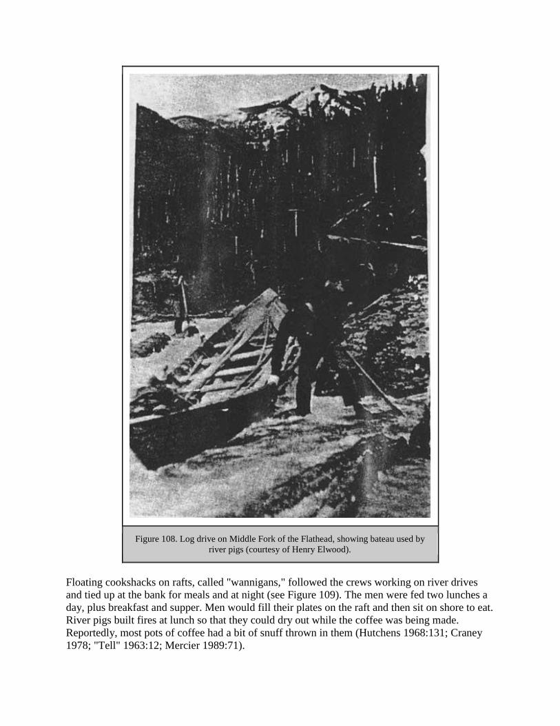
Figure 108. Log drive on Middle Fork of the Flathead, showing bateau used by
river pigs (courtesy of Henry Elwood).
Floating cookshacks on rafts, called "wannigans," followed the crews working on river drives
and tied up at the bank for meals and at night (see Figure 109). The men were fed two lunches a
day, plus breakfast and supper. Men would fill their plates on the raft and then sit on shore to eat.
River pigs built fires at lunch so that they could dry out while the coffee was being made.
Reportedly, most pots of coffee had a bit of snuff thrown in them (Hutchens 1968:131; Craney
1978; "Tell" 1963:12; Mercier 1989:71).
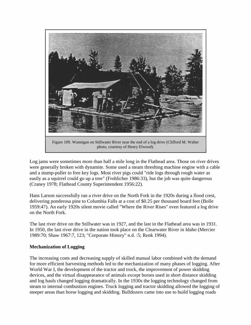
Figure 109. Wannigan on Stillwater River near the end of a log drive (Clifford M. Walter
photo, courtesy of Henry Elwood).
Log jams were sometimes more than half a mile long in the Flathead area. Those on river drives
were generally broken with dynamite. Some used a steam threshing machine engine with a cable
and a stump-puller to free key logs. Most river pigs could "ride logs through rough water as
easily as a squirrel could go up a tree" (Frohlicher 1986:33), but the job was quite dangerous
(Craney 1978; Flathead County Superintendent 1956:22).
Hans Larson successfully ran a river drive on the North Fork in the 1920s during a flood crest,
delivering ponderosa pine to Columbia Falls at a cost of $0.25 per thousand board feet (Bolle
1959:47). An early 1920s silent movie called "Where the River Rises" even featured a log drive
on the North Fork.
The last river drive on the Stillwater was in 1927, and the last in the Flathead area was in 1931.
In 1950, the last river drive in the nation took place on the Clearwater River in Idaho (Mercier
1989:70; Shaw 1967:7, 123; "Corporate History" n.d. :5; Renk 1994).
Mechanization of Logging
The increasing costs and decreasing supply of skilled manual labor combined with the demand
for more efficient harvesting methods led to the mechanization of many phases of logging. After
World War I, the development of the tractor and truck, the improvement of power skidding
devices, and the virtual disappearance of animals except horses used in short distance skidding
and log hauls changed logging dramatically. In the 1930s the logging technology changed from
steam to internal combustion engines. Truck logging and tractor skidding allowed the logging of
steeper areas than horse logging and skidding. Bulldozers came into use to build logging roads

and to skid logs in the 1930s, greatly increasing the areas accessible for timber harvest. By 1940
the transition from horse logging and river driving to tractor skidding and truck hauling had
occurred (Brown 1936:10; Bolle 1959:70; Hudson et al. ca. 1981:195; FNF "Timber
Management, Swan" 1960:39).
Tractors and trucks replaced log chutes. The first tractor with full-length tracks appeared in 1911,
and logging companies throughout the Northwest began using them instead of horses for
skidding operations. World War I developed the tractor for reliable use. Trucks were first used
experimentally for logging in 1913. By 1930 trucks were hauling 6% of the logs in the country.
Trucks were used more frequently after 1932 because of the development of inexpensive, light,
and powerful pneumatic-tired trucks and detached trailers. Contract ("gyppo") haulers would
haul the logs from skidways, decks, or landings or directly from the woods to the destination at a
flat price per thousand feet (Brown 1936:10, 135, 177, 181; Hudson et al. ca. 1981:195). The use
of trucks allowed loggers to haul logs to the mills year-round, and they proved faster than
railroads.
The earliest logging trucks in the Flathead Valley were used in the 1920s, but they were not
common until about 1948. In 1924 truck logging began on a J. Neils sale of damaged timber
north of Columbia Falls. Tie mills set up in the woods cut fir and larch railroad ties, which were
then trucked to Columbia Falls. The company also cut white pine and spruce into logs, loaded
them onto railroad cars in Columbia Falls, and shipped them to Libby. One of the earliest trucks
used for logging in the Flathead was a 5-ton GMC that hauled lumber from Truman Creek to the
Stoltz mill in Kila (see Figure 110). In the summer of 1923 a Flathead logger was hauling long
poles in a surplus World War I army truck with a homemade trailer. J. Neils did its first hauling
of long logs in 1933 on a sale in the Echo Lake area, and tractors were used to skid the logs.
Despite these early examples, logging through the 1920s was done almost completely by horses
in the Flathead, and logging trucks were not used to any great extent until World War II (Elwood
1980:160; P. Neils 1971:69; March 1981; Green 1971:III, 129; G. Neils 1976; Cusick 1986:21).

Figure 110. Willis March logging truck, 1920s (courtesy of Henry Elwood).
In 1956, logging in Region One was generally done by tractor skidding and hauling of logs to the
road with winches and cables. Another less common method used mobile "jammers" that
operated from a truck road. Jammer logging was usually supplemented by horse or small tractor
skidding. Almost all the timber was skidded uphill (USDA FS "Watershed" 1956:51).
An important technological development was the gas-powered chainsaw. In 1937 the Flathead
National Forest and others tested the Wolf Portable Timber Sawing Machine on fires. The unit
weighed 85 pounds, much less than other models of power saws at that time. On the Flathead, it
doubled the speed of a 25-man crew clearing a fire line through heavy windfalls, and it was used
clearing trail between camp and fire line and on mop-up work. According to the Forest Service
analysis, the new saw, improved by Region One, cost about 25 cents per cut versus about 61
cents per cut for a cross-cut saw gang (G. Duncan 1937:15).
Power saws came into common use in the area in approximately 1945. They allowed sawyers to
make more money and reduced the number of men on a crew. During the construction of Hungry
Horse Dam, sawyers used two-man chainsaws. One end weighed about 100 pounds; the other
was so light the sawyer just had to balance it. By 1954, according to a Spokesman Review article,
no one was using crosscut saws in the woods anymore (MacKenzie 1972:31-32; "Lumber Folks"
1954:69; 24FH466, FNF CR).
Logging Camps
One of the largest-volume logging contractors in the Flathead Valley was Henry Good, who
often operated many separate logging camps at one time. Good became the main contractor for

the Somers Lumber Company in approximately 1909. He logged 20-30 million board feet
annually, mostly 16'-long saw logs from his own land in the Stillwater delivered to the river
bank. His main camp was at Olney on Dog Creek. Between 1929 and 1935, during the
Depression, he still took large contracts but gyppoed them all out. Another logging contractor,
George Slack, reported that in the 1910s he usually established camps of about 80 men each that
would produce about 5-6 million board feet per camp (Schafer 1973:5; Elwood 1980:166-167;
"Personal Experience Record of Captain George W. Slack," SC 126, MHS).
Workers at a logging camp were housed in anything from tents, log cabins, railroad boxcars, or
frame buildings (see Figure 111). Many camps were portable and would be moved as needed. A
typical logging camp in the Flathead included a bunkhouse, office and store, cookhouse, stable,
root cellar, and a shack for the foreman, sawfiler, and timekeeper (see Figure 112). The buildings
were generally low log structures. The bunkhouse would be lined with two-story bunks with
straw mattresses (loggers provided their own bedrolls in the early years). A barrel stove was
located in the middle of the room, and wires stretched across the room on which the men hung
their wet socks, mittens, and so on. The stock at a lumber camp was very well cared for. As one
observer put it, "Horses cost money - but you always could get lumberjacks" (Frohlicher
1986:29-30; Bryant 1913:60).
Figure 111. Floor plan of railroad cars used at a logging camp in the Northwest,
ca. 1934 (from Brown 1934:62).

Figure 112. Logging camp known as camp 3, Fortine, Montana (photo courtesy of Henry
Elwood).
Crews went to work long before daylight, traveling along paths in the deep snow. They earned
$30-75 a month plus board. The typical work-week was 10 hours a day, six days a week. The
men usually played poker at night until lights out at 9 p.m. (10 p.m. on Saturday nights). Every
camp had a chore boy who cleaned the buildings, cut firewood, built fixes, and carried water for
the camp (Wilke 1983; Bryant 1913:68; Linrude 1981).
Many workers in logging camps were unmarried. In the Flathead, many of the early loggers were
of Scandinavian, German or French-Canadian descent (and "foreigners" were often segregated
from the "locals" in the bunkhouses). The loggers typically wore heavy wool shirts, a narrow-
brimmed felt hat, long underwear, heavy wool pants cut off ("stagged") at the boot tops, and
greased leather or rubber boots with caulks (spikes) in the soles (see Figure 113).

Figure 113. Loggers standing in front of load of logs (courtesy of Henry Elwood).
Many of the lumberjacks would stay in camp until the end of the season; others would go in to
town after each payday. The lumberjacks wore their caulked boots in town; some stores had to
replace their wooden floors every few years because of this (Frohlicher 1986:33; Suchy 1978:11;
Montgomery 1982).
Many logging camp workers were footloose and migratory. Food was a critical item at a logging
camp, and if a cook (often called the "belly robber") had a reputation for good cooking, workers
would try to get jobs at his or her camp (see Figure 114). Logging camp cooks were generally
men, although a few women cooked in Flathead camps. Cooks would generally get up at 4:30
a.m. to get the fire going and water heating for coffee. Breakfast featured bacon, sourdough
hotcakes, eggs, hot cereal, and cornflakes. Some logging camps in the early years (before deer
limits or hunting seasons) had a hunter who supplied the cook with venison. Many camps
supplied fresh meat by keeping pigs to eat the garbage. At the Somers Lumber Company camp
on Swan Lake, cattle were driven to the head of the lake from Flathead Valley, fattened, and then
slaughtered. The company also raised potatoes and pigs and had a slaughter house. At a camp in
the Trego area, there were pigs, beef cattle, and about 10 milk cows. According to logging camp
rules, the men ate their meals in silence except to request the passing of food. If the work site
was far from the camp, hot lunches were sometimes delivered to the workers by train, wagon, or
sleigh to keep the men going during their 10-hour work day.

Figure 114. Interior of kitchen at the State Mill logging camp (courtesy of Henry Elwood).
Forester Bob Marshall studied 40 loggers in a northern Idaho camp. He determined that the
average man ate breakfast in 10 minutes, lunch and supper in 12 minutes each (Mercier 1989:72-
73; Saurey 1983; Simpson 1967:110; Craney 1978; Elwood 1980:164, 201; Suchy 1978:11;
Marshall 1926: 15).
As soon as breakfast was finished the cook started preparing dinner, grinding his own sausage,
baking bread, and making soap. With a crew of 15 men, a cook would have one flunkey. With
between 80 and 100 men, there would be a head cook, a dishwasher, and two flunkies. In the
early days few canned foods were used. The cooks relied on dried foods, beef, and pork
products. All camps had root cellars to store their food, and meat houses. During Prohibition,
moonshiners supplied some loggers with liquor (Elwood 1980:163-164; Montgomery 1982).
Logging camps were not known for their exemplary sanitary conditions. Garbage was usually
dumped just outside the cookhouse door. Dry open toilets were located near the cookhouses, and
in the early years there were no bath or laundry facilities (Elwood 1976:39-40; USDA FS "Early
Days" 1976:199). One retail lumber yard owner commented, "It gagged me to eat at some
camps, with flies on the food and in the coffee" (C. I. O'Neil, "Kalispell, Montana," 1947,
MSUA). A Forest Service check scaler remembered that "the only time it was safe to go to the
latrine was at mealtime, when all the flies were in the cook house" (Koch ca. 1940:82).
Some logging camp cooks prepared special foods for particular ethnic groups. For example,
Mordy Johnson made pickled herring at an all-Scandinavian camp, and "they'd pin back their
ears and they'd wade into that pickled herring and boiled potatoes...No use to put anything else
on 'cause they didn't eat it" (Mercier 1989:73).

Elers Koch, long-time Forest Service employee, commented that:
years of work in the big timber do something to a man. The atmosphere in a logging
camp is not a cheerful one. The lumberjack is rarely a light-hearted individual, but
inclined to be silent if not morose, and the foremen take on pretty much the same
characteristics as the men. One hears little of laughter or jokes in a logging camp. The
men eat their enormous meals silently, and sit in the bunkhouses or outside them, tired
from the heavy work (Koch ca. 1940:146-147).
There were still some logging camps in the Flathead in the 1930s. In 1936, however, it was
reportedly "not uncommon" for lumberjacks to drive 15-20 miles to work and return home each
night. During World War II, it proved cheaper to transport crews from their homes by bus than to
maintain logging camps (Whitney 1983; McDonald 1936:6; Ibenthal 1952:16).
The IWW Strikes
The Industrial Workers of the World, also known as the Wobblies, was founded in 1905 in
Chicago as a labor union that appealed to seasonal, low-paid workers. Its members and
organizers preached working-class solidarity and class warfare. Their program was based on an
anti-political Marxism, and in the Pacific Northwest they were most active among woodsworkers
and sawmill workers. In 1905 the newly formed International Brotherhood of Woodsmen and
Sawmill Workers was granted jurisdiction over all loggers and sawmill workers. This union at its
peak had only 1,200 members (most in western Montana), and in 1911 it was disbanded (Tyler
1967:4, 88).
The Wobblies early on organized free speech fights. They would converge on a town that did not
allow street meetings and encourage their own arrest. Free speech fights in Missoula and
elsewhere were also a good way to spread the word about the union to western workers. IWW
organizers were active in Kalispell as early as 1906 among the loggers and millworkers.
Elizabeth Gurley Flynn, an American communist and an IWW agitator, came to Kalispell in
1909 during the lumber strike there. She reported the strike as successful, although she
commented that the IWW organizer, Fred Heslewood, was embarrassed by an IWW music band
wearing red uniforms that had set up camp in town "like gypsies." IWW union halls served as
meeting places, social clubs, dormitories, mess halls, and mail drops. Kalispell and other towns
in the Flathead had their own IWW halls (Tyler 1954:8; Dubofsky 1969: 174; Elwood 1980:161;
Flynn 1955:101; Hudson et al. ca. 1981:200; Polk City Directories).
The Flathead Lumberman's Board of Trade organized in 1902 to prevent any attempt to organize
sawmill workers or loggers. Some of the lumber mill owners and operators included in this group
were the Smith Valley Lumber Company, State Lumber Company, Lake View Sawmills, B. J.
Boorman Lumber Company, Flathead Valley Lumber Company, Enterprise Lumber Company,
Northwestern Lumber Company, Kalispell Lumber Company, Athens Saw Mills, and the BM.
The mill owners resolved not to recognize any labor union. At the same time, the Federal Labor
Union No. 175 of Kalispell, with about 1100 members in the county in 1902, passed a resolution
demanding $2.50 per day, overtime and Sunday pay, and 9-hour days (Elwood 1980:60, 161).

Many of the woods and mill workers in the Kalispell area in the early 1900s were transients.
Often they found work through private employment companies who split the fee for finding a job
with the foremen or employers. The Somers Lumber Company reportedly hired 3,000 men one
winter in order to maintain a crew of 50 men. According to a 1910 writer, "As soon as a man had
worked long enough to pay the shark's fee, the hospital dollar, poll tax, and a few other grafts, he
was discharged to make room for more slaves, so that the fleecing process could continue. The
different fees are split, or cut up with the bosses" (Elwood 1976:39; Venn 1971:19).
The first strike at the Somers Lumber Company mill occurred in 1906, with leadership from the
Allied Workers of America. The 1906 strike at Somers lasted five days, and the wages of
common laborers were subsequently raised from $2.00 to $2.25 a day. In the fall of 1906, after
this strike, an IWW organizer from Missoula organized the workers in Somers. By 1907 IWW
membership at the Somers Lumber Company was 250 (20 men were listed as non-union). On
February 11, 1907, strikers shut the plant down, citing grievances such as the "overbearing
manner" of the plant superintendent and protesting the required trading at the company store. On
April 1, 1907, a compromise was reached whereby the foreman resigned and the mill was made
an open shop. As a result, a number of Flathead Valley sawmill operators increased their wages
(Elwood 1976:39-41).
Perhaps as a result of the IWW strikes, in 1907 the woodsworkers and Kalispell-area lumber
manufacturers signed an agreement, one of the few at that time. The agreement, to last one year,
gave the workers the right to unionize, with IWW workers to return to work at the wage scale
recently adopted by the lumber manufacturers of western Montana. These wages ranged from
$45 (common laborers) to $85 (cooks for more than 20 men) per month. A Forest Service
employee in Kalispell commented to a Washington Office official, "Notice the high wages.
Wouldn't they break the heart of a Maine lumberman?" (Item 7, Box 74590, RG 95, FRC).
The May 1909 strike that shut down the Somers Lumber Company mill was aimed at getting a
50 cent wage increase. This strike led to more bitterness and frustration among workers than the
1907 strike. Workers at the State Mill in Columbia Falls also struck for a short time, but the
company soon banned IWW organizers from the plant. By the next month nearly all the Somers
Lumber Company workers had returned to work, having won a 15% wage increase and other
benefits such as lower rent and fuel costs. River pigs and log drivers stayed off the job in large
numbers, however, and reportedly 15 million board feet of logs were left on the river banks that
summer. Judge Erickson issued an injunction to send the men back to work, and this plus the
threat of eviction from the company town of Somers caused the workers to return to their jobs
(Elwood 1976:41-43; Kalispell Bee, 21 May 1909).
The IWW had difficulty reaching isolated lumber workers, so organizers went out on the job as
camp delegates. Lumber mills, however, hired detectives and screened employees. The U. S.
entry into World War I in the spring of 1917, however, aided the IWW cause because the labor
market became suddenly tighter (Dubofsky 1969:334-335, 346).
In the spring and summer of 1917, IWW workers organized strikes in the wheat fields, the
forests, and the copper mines, all industries essential to the war effort. IWW crews in the
Northwest began striking intermittently in April of 1917 for an 8-hour day and higher wages. In

July the IWW declared an industry-wide walkout, emphasizing passive resistance. This large
strike partially paralyzed the lumber industry. That same month, lumber employers established
the Lumbermen's Protective Association. The lumber men proclaimed that the strikes were
caused by foreigners, pro-Germans, and thugs, and they refused to grant the 8-hour day. When
the strike occurred, the nation needed lumber for army cantonments, railroad freight cars, and
cargo ships, but the mills were operating at only 60-65% capacity. The lumber industry created a
new organization, the Loyal Legion of Loggers and Lumbermen, pledged to support the United
States in wartime (Dubofsky 1969:359, 362-63, 365; Hudson et al. ca. 1981:202).
In fact, the 1917 strikes in the lumber industry resulted from factors such as low wages, long
days, no baths, plentiful bed bugs, and no clothes-drying facilities. The lumber industry in
western Montana, always highly unstable, had just been through a four-year depression (between
1913 and 1915 the mills in the northwest were generally operating at less than half their
capacity). About 150 small mills in Montana worked on contract with the ACM and the NPRR,
and they paid relatively poorly for long hours. There was a high rate of labor turnover, reflecting
discontent (Hudson et al. ca. 1981:202; Toole 1972:157, 160; Rader 1967:192).
The northwest lumber strike began in the Flathead National Forest area, in Eureka, just a few
days after World War I was declared and just when the ice had broken on the rivers. About 100
men began the wildcat strike against the Eureka Lumber Company. In response, the Secretary of
War ordered federal troops to Eureka to protect properties and the railroad. Troops were used as
strikebreakers in Whitefish, Libby, and Columbia Falls. This represented the first use of federal
troops in a labor dispute after the nation's declaration of war, creating a precedent for the use of
troops to intimidate workers striking for a variety of trade union goals. The Eureka strike quickly
ended, but its failure ignited a general lumber strike throughout the Inland Empire. The strike
spread in the summer of 1917 to Washington, Idaho, and Oregon sawmill and woods workers. Of
the 70,000 men working in the lumber industry, 50,000 were idle because of the strike;
approximately 20,000 took an active part in the strike. The main force of the 1917 strikers were
migrant workers, who were generally single, did not vote, and were often recent immigrants
(Gutfeld 1979:34-35; Toole 1972:164; Rader 1967:193, 195, 197-198).
Federal troops raided the IWW hall in Whitefish and held Wobblies in the city jail for several
weeks without charges. In Columbia Falls, troops forced IWW members to work on city streets,
without charges being placed against them. The Kalispell City Council passed a sweeping
sedition ordinance that made it illegal to advocate or incite disrespect for any law or city
ordinance. Citizens' committees even drove IWW members from the area (Rader 1967:205).
In May of 1917 Region One Forester F. A. Silcox wrote the Forest Service Chief in Washington:
I am reliably informed that 90 to 95% of the lumberjacks in this region now belong to the
I. W. W. organization. It is my personal opinion that there is a considerable amount of
social justice in some of their demands. As in all movements of this kind there are
extremists and ultra-radicals. There has been a decided tendency on the part of the
lumbermen to judge the whole movement from the action of the radicals.

Silcox reported that the lumbermen were urging the Forest Service to help them suppress the
"menace" of the IWW by not hiring any firefighters who belonged to the IWW. Silcox declined
from taking such an action and commented that he saw it as a labor problem in which the Forest
Service should not be involved (Silcox to the Forester, 10 May 1917, 1380 Reports - Historical -
District 1, RO).
Silcox commented that the causes of the 1917 strikes were partly due to the conditions of the
logging camps, which he described as "dirty, badly drained, poorly ventilated, crowded,
unsanitary and generally vermin-ridden, with no facilities for bathing or for washing clothes,
combined with long hours, comparative low pay, and an atmosphere of distrust and suspicion."
He commented that the men were treated less well than work horses, "for usually there was more
ventilation in the barns than in the bunk house." He called upon employers to deal with the
workers' legitimate grievances. Other foresters in western Montana filed similar reports. Silcox
later became Chief of the Forest Service, even though he had been accused of being a Wobbly
himself (Gutfeld 1979:36; Koch ca. 1940:82).
The hysteria of the war led vigilantes, local governments, and the federal government to step in
and interfere with the lumber strike of 1917. The strike stimulated intolerance in the state,
represented by criminal sedition and syndicalism measures enacted by the state legislature. The
public considered Wobblies pro-German sympathizers, and many were arrested and imprisoned.
IWW organizer Frank Little was lynched in Butte as part of this general hysteria. The 1917
strikes were broken by the fall in Montana by a combination of the presence of federal troops,
federal and state prosecutions, the patriotic mania infecting many Montanans, a newspaper
campaign, and the isolation of the lumber workers (Tyler 1954:25, 27, 85; Gutfeld 1979:36;
Rader 1967:206-07).
After the 1917 strike had formally ended, IWW members continued striking "on the job," using
slow-downs and other methods to hinder production. In 1918, the government established the 8-
hour day for Montana lumber workers, uniform wages for the industry, provision of bedding and
regular changes of linen, and so on. The public tended to credit the industry-sponsored Loyal
Legion with the reforms, however (Tyler 1967: 101, 107; Hudson et al. ca. 1981:202).
Montana lumbermen attracted men back to work by improving camp conditions, such as
installing bathing facilities, steel bunks and springs, providing standardized menus and reading
facilities, and so on. In 1923, however, practically every logging camp in the Flathead again
went on strike. The strike began against the Somers Lumber Company and the Henry Good
camps but soon spread (Rader 1967:206; McKay 1993:38).
For the Forest Service, the striking lumberjacks provided a large labor pool available for fighting
fires in the bad fire years of the late 1910s. Elers Koch described the strength of their influence
in fire camps in 1919 as follows: "Along the fire lines the fresh cut log ends were decorated with
a big I. W. W. or a crude picture of a black cat sitting on the axe handle. Men were forced to take
out a red card or get out of camp" (Koch ca. 1940:82). According to Silcox, the 1917 fire crews,
most of them strikers, were the best the Forest Service had ever had. Silcox reportedly persuaded
workers at IWW headquarters that it was in their interest to fight fires on public lands (Rader
1967:203; Baker et al. 1993:112).

Dissatisfaction was high among woods and sawmill workers in 1919 because there was not much
work available in the lumber industry. Many men hired had worked for higher wages during the
war, and they continued to feel that "their services were almost invaluable." Concerning IWW
members, one writer mentioned that "a considerable and influential minority had and have no
intention of giving value received for the wages paid." In some cases fire patrolmen "slowed
down" on the job, letting the fire creep across the line. Men also would hire on to fight fire in
order to get free transportation to some point along the railroad route and then would disappear
(5100 Fire Management, 1919 Fire Season - General, RO:8-12).
Multiple Use-Sustained Yield Act of 1960
In the 1950s the administration of the national forests changed from custodial to intensive
management. The volume of recreation on the national forests tripled, timber sales climbed from
4 to 9 billion board feet, and so on. After decades of Forest Service propaganda talking about
timber famine and devastation in order to justify federal regulation of logging, now the Forest
Service was logging on a large scale (Clawson 1983:32, 38; Steen 1976:302).
The Forest Service acknowledged other responsibilities besides timber when it was established in
1905, as had its predecessor, the GLO. These non-timber resources included watershed,
recreation, grazing, and mining. Multiple use developed out of legislative intent to broaden the
mandate of the Forest Service and from a need to broaden public support for forestry. Most
foresters, however, concentrated on increasing timber supplies, rather than on multiple use
(Clary 1986:40).
In the 1950s the Forest Service defined the allowable cut as the upper limit of logging permitted
during short periods. The sustained yield, on the other hand, set quotas over longer time spans.
Sustained-yield units were based on economic and social factors. Conservationists viewed the
post-war increase in logging as a shift to the poor land management practices that the Forest
Service had been denouncing over the years in the name of impending timber famine (Steen
1976:285).
The Forest Service definition of sustained yield did not take into account the price of land, the
value of the location, or other factors affecting the price of wood from year to year. It
emphasized supply rather than demand, and efficient growth of wood rather than efficient use
and service. Analysis in terms of multiple use, on the other hand, required analysis in terms of
values, costs, and benefits (Olson 1971:189-190, 192, 198).
Before World War II, management of the national forests had revolved around allocating
benefits. During the post-war boom, however, the agency had to assess and balance competing
interests in a finite amount of land. The Forest Service wrote and lobbied for the passage of the
Multiple Use-Sustained Yield Act of 1960, which reflected the transitions taking place in the
postwar years. The act reflected the intention to manage the national forests for a variety of uses,
including outdoor recreation, range, timber, watershed, and wildlife (Cox 1985:240; Dana
1980:201).

The Forest Service defined multiple use as managed forests under sustained yield on the basis of
multiple use. The term multiple use had been used by the Forest Service since its creation in
1905, but it became in vogue in the 1950s. Every acre did not have to sustain every use, and
watershed protection ordinarily had first priority. The 1950s set the stage for the Multiple Use-
Sustained Yield Act passed on June 12, 1960. District rangers were required to weigh the various
pressures on the Forests' resources and allocate the resources such as timber, water, range,
recreation, and wildlife in a consciously balanced manner, consistent with the public interest
(Steen 1976:278, 301).
The act gave the Forest Service legislative authority to provide recreation facilities on the
national forests. The act did not, however, provide clear guidelines for establishing priorities
among resources. It only stated that it was not necessary to produce every good or service on
every acre, and that economic yield was not to be the sole criterion for evaluating competing
uses (Dana 1980:204).
During the 1950s public opinion began a shift away from conservation and use toward
preservation, and the Forest Service, previously supported by conservationists, "began to lose
some of its luster" (Steen 1976:277). In the 1950s, recalled retired Forest Service employee Bud
Moore, "the public was really interested in their national forests but they had such trust in the
Forest Service that they just almost worshipped it. They'd say, 'We know that you know what
you're doing.' The big thing that changed this was the Forest Service pushing commercial timber
at the expense of a lot of other things" (Moore 1989).

FOREST HOMESTEADS
Introduction
One of the principal reasons for opposition to the creation of forest reserves was the inclusion of
agricultural lands within forest boundaries (Kerlee 1962:6). The "closing of the frontier,"
announced in 1892, led settlers to look for unoccupied land in areas such as deserts, cancelled
railroad grants, Indian reservations, state and school grants, reclamation projects, and agricultural
lands inside the national forests. The Forest Homestead Act of 1906 was passed in order to make
this agricultural land available for settlement.
The original Homestead Act of 1862 allowed a settler 160 western acres free if he or she lived on
it for at least five years, cultivated a certain number of acres, paid a small filing fee, and built
improvements on it. The law allowed the settler to commute his entry and purchase the land at
$1.25 an acre (in 1891 Congress changed the minimum period before commutation from 6 to 14
months) (Dunham 1970:6, 155).
Land for homesteads had to be surveyed first by the General Land Office (GLO). Once the land
had officially been surveyed, "squaters" had the first right to file a claim on the land they
occupied. The Flathead guide meridian was run by the GLO in 1892. Almost all squatters filed a
declaration of occupancy, and in the summer of 1893 a complete survey was made. The settlers
then could file on the claims if they had located before March 3, 1891, when the pre-emption law
was repealed. Most proved up in the fall of 1893 for $1.25 an acre, with an additional cost of
about $50.00 (Robbin 1985:19: Schafer 1973:10).
The Forest Homestead Act of 1906 allowed U. S. citizens to file for homesteads within national
forest borders. This law resulted in some settlement in the Flathead and Blackfeet National
Forests, but many of the homesteads eventually reverted back to the Forest Service.
Administering the provisions of the act took much of the forest ranger's time in the early 1900s.
Forest homesteads are represented on the ground by homesteaders' cabins, barns, outhouses, etc.,
some in good condition and still in use by private owners (mostly for recreation) and others
standing only a few logs high.
Forest Homestead Act of 1906
The Forest Homestead Act of June 11, 1906, allowed people to settle on land primarily suited for
agriculture located within the national forests. The act was intended to quiet the protests of those
unhappy with the inclusion of non-forest lands within the forest reserves and also to attract "a
superior type of homesteader" to the Forest who would help protect its resources. Many settlers
within the Forests had not yet filed homestead claims because the areas had not been surveyed by
the GLO, so they had no way to secure title. They received preference in establishing a claim, if
they had not located on land containing valuable timber or mineral resources. The government
was required to survey and list for settlement all agricultural lands within the national forests.
Once surveyed and approved, these "June 11th claims" could be homesteaded. The claimant had

to pay a per-acre filing fee, occupy the claim for several years, cultivate the land, construct a
house and outbuildings, and within five years file the required proof of residence and cultivation.
As with non-forest homesteads, settlers could sell their land once they had "proved up" on their
claim (Hudson et al. ca. 1981:216-217; Gates 1968:512; Kerlee 1962:115, 158).
This act significantly lessened the opposition to the forest reserves. As a 1910 Daily Inter
Lakeeditorial commented, the "almost universal opinion" about forest reserves in the Flathead in
1897 was that they would retard the development of the country. The inclusion of good
agricultural and fruit land was especially objectionable, but since then the Forest Service was
"constantly becoming more liberal in its dealings with prospective settlers." Local people felt
land should be classified according to its soil, not the standing timber, and believed that "a
family engaged in raising foodstuffs contributes more to the general good, than would come
from the tract of timber in its natural state." The opposition to the forest reserves themselves, the
article continued, "has largely disappeared" (Daily Inter Lake 1910:3).
Until 1905, the owners of patented land inside forest reserves could exchange their land for land
outside the reserves. The chief beneficiaries of this lieu-land provision were the railroads and the
states, however, not individual homesteaders as had been intended (Peffer 1951:47).
The Three-Year Homestead Act was passed in 1912 to encourage claimants to complete their
residency requirements on forest homesteads rather than commuting their claim and moving off.
The act reduced the residency requirements; claimants could obtain patent if they lived on their
claim at least 7 months a year and met the minimum cultivation requirements (Hudson et al. ca.
1981:218; Dana 1980:22).
Beginning in 1912, in an effort to systematize the approach to evaluating potential forest
homesteads, the Forest Service was required to open all lands classified as agricultural to
settlement. This resulted in the opening of many small tracts that otherwise would have been
retained by the Forests. These later homesteads were generally smaller (the national average was
70 acres), of poorer quality, and more isolated than the earlier ones. One example of this was an
11.58-acre homestead on Swan Lake that today would be a summer home site (Kerlee 1962:75-
77).
The Forest Service soon realized that it needed to make its own withdrawals in order to keep
suitable sites available for administrative and other needs. Rangers recommended and surveyed
these withdrawals (which on many national forests covered more than were ever used). By 1912,
the Forest Service had established one ranger station for each 60,000 acres of Forest. The
government also withdrew sites for recreation areas, sawmills, log banking, water power sites,
rights of way, etc. (Kerlee 1962:52, 56).
Some Forest Service officers were occasionally overzealous in rejecting homestead applications.
If rejected, the claimant had to pay for a hearing. Much land judged agricultural by would-be
settlers was rejected as such by the Forest Service; the rangers were trying to ensure "prosperous
homes." Another reason the Forest Service may have been slow in granting homestead claims
was that no extra funds were appropriated to administer the Act. Much potential homestead land

had not yet been officially surveyed and classified (Cameron 1928:282; Peffer 1951:65; FNF
Class; Kerlee 1962:51, 54).
By 1917 the Flathead and Blackfeet National Forests had conducted extensive land
classifications to define the areas that were chiefly valuable for agriculture. The potentially
agricultural lands were then intensively classified, and appropriate lands were listed for opening
to settlement. On the Flathead National Forest, most of the agricultural land was confined to
stream terraces and gently sloping glacier upland. Some land initially rejected was later
reexamined and listed, but many requests were turned down. Rangers frequently denied such
requests on the Flathead and Blackfeet National Forests because the applicant had selected land
that the Forest Service considered chiefly valuable for timber, although it was not yet marketable
due to access problems. Rather than defer action on a request for years, while waiting for the
timber to be harvested, the Forest decided to reject such requests (see Figure 115) (M. H. Wolff
1925:67, 99; FNF Class).
Figure 115. Map era homestead in the upper Swan Valley applied for by Rudie
Kaser, showing irregular boundaries following a streambed. In this case, the
applicant requested the larger outline but the Forest Service rejected the
majority of the land because it had timber estimated at 2-5 MBF per acre and
thus was not primarily valuable for agriculture. The 32.5 acres were opened to
settlement in 1922 (FNF Class).

Applicants accompanied examiners whenever possible. The report on a proposed homestead
addressed markets, transportation, topography, soil cover, and economic possibilities. The
homestead boundaries were typically quite irregular in shape because the survey lines followed
the contour of the mountains and took in natural clearings, springs, and creeks and avoided
timber as much as possible. Most were surveyed by metes and bounds based on a common
corner. By the end of 1924, approximately 465,000 acres in Montana and northern Idaho national
forests had been listed for settlement (Kerlee 1962:77-78; M. H. Wolff 1925:110).
The isolation of forest homesteads was a barrier to social and economic activity. Many
homesteaders raised cattle and horses that could be driven to market in good weather. Many if
not most men worked in the logging industry, for the Great Northern Railway or for the Forest
Service (or the National Park Service in the Middle and North Forks). Working for the Forest
Service was considered partial fulfillment of the residency requirements even though the person
might be absent, and the employment was at a busy time of year for a farmer. Homesteaders
were required to report trespass of any kind on the reserves (grazing, timber cutting, and so on).
Typical crops raised included hay, oats, and other grains for stock feed, plus vegetables for home
use, fruit, and berries (Kerlee 1962:80-83). Typical outbuildings on a forest homestead included
a log barn, an outhouse, a chicken house, sheds, and corrals.
From 1906 until 1912, approximately 60% of forest homestead applications were disallowed or
voluntarily withdrawn. Government officials never believed that much of the land in the Flathead
and Blackfeet National Forests was truly agricultural (see Figure 116). The first inspector sent
through the newly created Lewis and Clarke Forest Reserve in 1899 stated clearly that the
reserve had no "strictly agricultural land" except for some in the Birch Creek area (on the east
side of the Divide). He continued, "In each of the main valleys some vegetables and hay could be
grown, but the product could not compete successfully with that produced under more favorable
conditions." He mentioned several favorable locations for small ranches but noted that they were
isolated (Kerlee 1962:55; Ayres "Lewis & Clarke" 1900:3940).

Figure 116. Tracing of a map drawn during extensive classification of Flathead National
Forest lands in the 1910s. Note that the only potential land for homesteading was grouped
along streambeds (this is typical on the Forest). Almost all of the land marked "H" on the
map is today privately owned (FNF "Extensive Reconnaissance" 1914).
The Forest Service could protest the issuance of a patent if the amount of land cultivated did not
meet the requirements. Many homesteaders filed for a reduction of these requirements, and some
were granted. In 1917 Frank Fisher of the North Fork applied for a reduction, stating:
I have worked with a desperation the last three years to accomplish these results but with
little progress more than to open up the claim and establish a place to live. I have built a
road of 3-1/2 or 4 miles cutting it through the thick timber... [but] without means and
[with] the necessity of earning my living as I go along as well as improve my claim, my
progress must of necessity be slow and unless I can get relief will surely fail in meeting
the requirements of the law though I may exhaust my life in my efforts (FNF Adj)
The Blackfeet National Forest rejected Fisher's request, saying that he had "not been very
diligent in clearing and cultivating the land." In 1918 the GLO overturned this decision, both
because Fisher had built a long road and because he was so poor (FNF Adj).
The Forest Service rejected another claim because the applicant, Thomas Arneson, did not meet
the residency requirement; the family lived in Missoula 9 months of the year so their children
could attend school there. The case was heard before the register of the U. S. Land Office in
Kalispell, and in 1923 the applicant was issued final proof (FNF Adj).
In 1912 Henry Graves defended the Forest Service policy on homesteads in a Saturday Evening
Post article. In explaining the reasons for refusing to open for entry all lands requested by
claimants, he talked about the Swan Valley as a case in point:
The Swan River Valley contains upward of 30,000 acres of amble lands bearing a virgin
forest of yellow pine of 15,000 to 40,000 board feet to the acre. Its value under present
conditions is $2.50 a thousand, averaging $50 per acre. The timber on an average claim
would be worth $80,000 (quoted in Kerlee 1962:68).
In 1913, the Regional Office reported that "the general sentiment around the Flathead Forest is
not as a whole very favorable. There has been a general feeling that there has been considerably
too much delay on the part of the Forest Service in opening up agricultural lands in the Swan
River Valley estimated to be approximately 34,000 acres, and the South Fork of the Flathead,
estimated to be approximately 82,000 acres, to entry" ("Public Sentiment in District 1," 18
November 1913, 1380 Reports - Historical, RO:26). (The delay in the Swan was due to waiting
for the GLO survey of the area to be completed.)
On the Blackfeet National Forest in 1913, opposition to the Forest Service focussed on the issue
of agricultural land that was to be opened to entry as soon as the timber was removed. Some
timber owners who were "genuine speculators trying to pose as persecuted homesteaders,"
according to a Forest Service report, wanted the Forest Service to keep its stumpage prices high
Historical, RO:19).
Some homesteaders took their appeals of Forest Service decisions directly to politicians. James
Wiltse Walker, for example, a successful Kalispell businessman, supported a proposed bill
reducing the requirements for proving up on a forest homestead. He appealed to Secretary Lane,
who had defeated this bill, and Lane sent a personal representative to visit Walker's homestead.
The representative was reportedly "amazed" at the amount of clearing that had to be done and
told Walker he had done enough work for his patent (FNF Class).
Some cases brought out a great deal of personal information. Ora Rainwater of Spokane filed for
proof of claim on a homestead on the Flathead National Forest and was rejected. The forest
ranger reported that he had heard Rainwater was married and said, "I have seen several strange
women going to and coming from his place. It got to be so notorious one time that I dubbed the
place 'The Happy Hollow Harem.'" Nevertheless, Rainwater was issued patent on his claim just a
mile southeast of Belton in 1922 (FNF Adj).
The greatest abandonment of patented and unpatented homesteads on the national level happened
between 1912 and 1930. Many lands that were filed on were too small to succeed as farms or
ranches. In the Blackfeet National Forest, 198 homesteads had been listed and entered on by
1930. In 1930, 121 (60.6%) of these were abandoned or not in use. According to the rangers in
the area, the reasons were as follows:

5 too far from market
50 greater economic advantages elsewhere
58 poor soil
5 sold to adjoining ranches
2 disappearance of local markets
1 old age
On the Flathead National Forest, only 148 of 267 claims were still in the hands of the original
claimants or their heirs in 1930. In 1930, 94 of the 267 claims were unoccupied or not being
farmed. Of the 119 on the Forest that were not under their original ownership, rangers gave the
following explanations:
48 sold after patented
6 muskrat farmers
7 bought for hotels, resorts, or summer homes
4 cancelled after entry, found to be on NPRR land, settler refused re-entry
3 reverted to county for taxes
5 leased to tenant farmers but not by original patentee
1 occupied by logger
4 owned by bank or loan company
26 entered, abandoned, succeeding entrymen
2 occupied by laborers
1 reverted, rented by Forest for fox farm (Kerlee 1962:92-93)
As described above, many of the forest homesteads filed on in the Flathead Valley were
submarginal, and the residents sooner or later drifted away (see Figure 117). In the 1930s,
following the drought in eastern Montana and the Dakotas, many of the old homesteads "were
again occupied by people who were delighted to see something green." Between 1929 and 1941,
about 500 farm families moved into the Flathead Valley from east of the mountains. In a
program that lasted from the 1930s until 1952, many homesteads and tax-delinquent properties
were consolidated into the national forests. Other homesteads were again abandoned during
World War II. The Flathead National Forest estimated that by 1962, 50% of its homesteads had
been returned to the Forest (see Figure 118) (FNF "Timber Management, Kalispell" 1960:48;
Kerlee 1962:94-95; Skeels 1941:4-5).
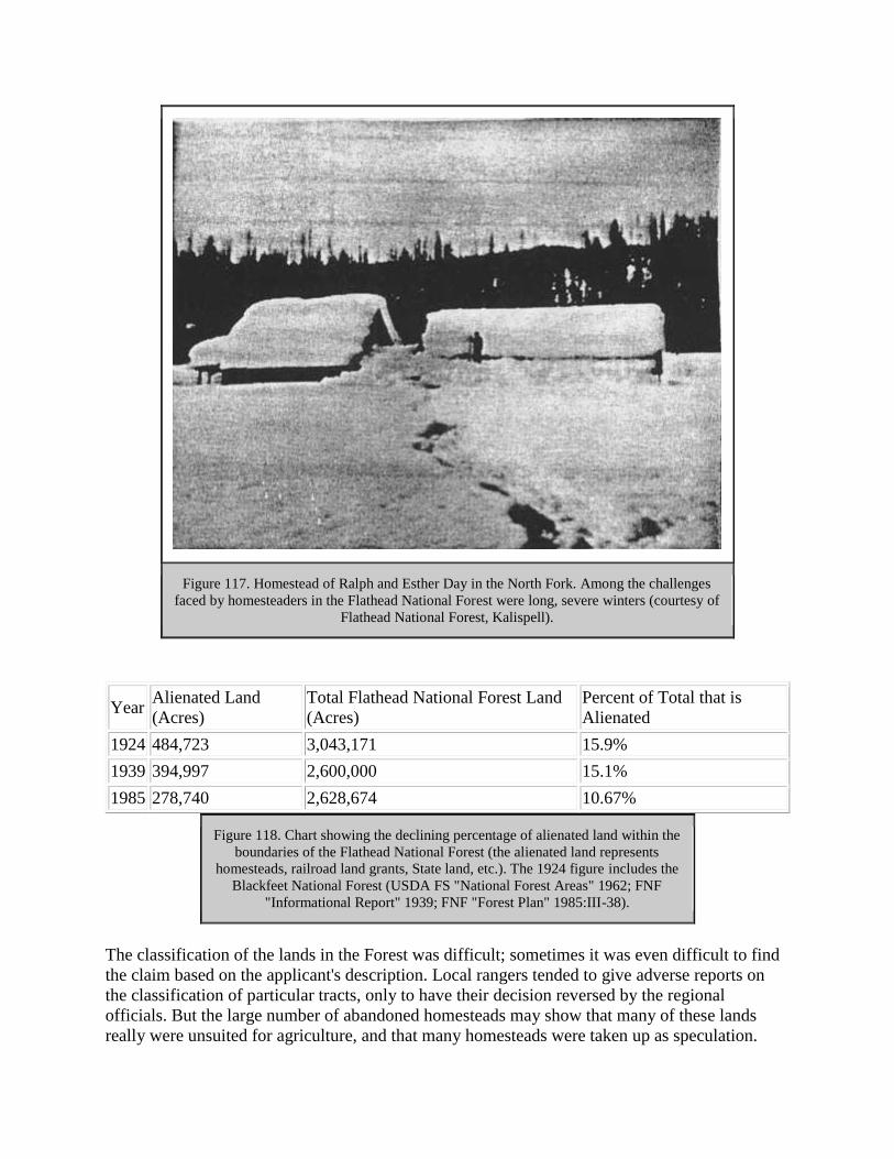
Figure 117. Homestead of Ralph and Esther Day in the North Fork. Among the challenges
faced by homesteaders in the Flathead National Forest were long, severe winters (courtesy of
Flathead National Forest, Kalispell).
Year Alienated Land
(Acres)
Total Flathead National Forest Land
(Acres)
Percent of Total that is
Alienated
1924 484,723 3,043,171 15.9%
1939 394,997 2,600,000 15.1%
1985 278,740 2,628,674 10.67%
Figure 118. Chart showing the declining percentage of alienated land within the
boundaries of the Flathead National Forest (the alienated land represents
homesteads, railroad land grants, State land, etc.). The 1924 figure includes the
Blackfeet National Forest (USDA FS "National Forest Areas" 1962; FNF
"Informational Report" 1939; FNF "Forest Plan" 1985:III-38).
The classification of the lands in the Forest was difficult; sometimes it was even difficult to find
the claim based on the applicant's description. Local rangers tended to give adverse reports on
the classification of particular tracts, only to have their decision reversed by the regional
officials. But the large number of abandoned homesteads may show that many of these lands
really were unsuited for agriculture, and that many homesteads were taken up as speculation.

Regional officers were more lenient in granting homesteads than local officers, perhaps because
they wanted to foster good public relations, because they believed the local officers were not
competent in their decisions, or because they found it politically expedient to release the tracts
(Kerlee 1962:103-04).
In the 1930s the Forest Service ordered rangers to burn abandoned cabins and outbuildings on
the homesteads that had reverted to the Forests in order to restore the Forests to their natural
settings (Kerlee 1962:83). In fact, many of the homestead lands now have greater value for
recreation than for agriculture or timber.
Stillwater Area Homesteads
Early settlements in the Stillwater area concentrated along the Fort Steele-Kalispell road (also
known as the Tobacco Plains Road or Trail). Along this road within the forest reserve in 1899,
forest inspector Ayres found five occupied houses, four with gardens and fields. David Stryker
had about 80 acres under cultivation. Some of these ranchers supplemented their farm income by
boarding travelers (Ayres "Flathead" 1900:254).
A 1924 Forest Service inspection report claimed that the homesteads along Good Creek were "an
economic blunder" that should never have been listed for agricultural use. The inspector
continued, "Grazing cattle, venison, moonshine, and possible summer work with the Forest
Service or on the County road constitute the only evident immediate resources of Good Creek.
There is little doubt that the settlers have made some use of all of these resources, although there
are but few cattle in the locality." At least one Good Creek homesteader found a creative way to
make a living; he did the laundry for the logging camps in the area. As if to verify the above
comment about moonshining as a source of income, long-time Stillwater State Forest employee
Maurice Cusick commented, "When the bootlegging days were on, that Olney was a regular
depot!" (7 February 1924, Flathead 1920-23 Inspection Reports, RG 95, FRC: Cusick 1986:31:
Cusick 1981).
Some homesteaders were colorful characters who claimed to have exciting pasts. According to
one account, the Gergen brothers, who homesteaded up Good Creek, appeared to fear for their
lives. They wore guns strapped to their waists and walked 20-30' apart. By another account,
however, the Gergens were simply farmers from North Dakota who wintered in Olney and ran
cattle on their homestead in the summers, returning to their home in North Dakota in the 1930s
("Tally Lake RD List of Names," TLRD; Cusick 1986:31).
Other homesteaders lived in self-imposed exile. Two bachelors who lived separately on Qettiker
Creek, Albert Jones and Charles Oettiker, were each university graduates and "meticulous
housekeepers." Jones had reportedly been released from a government job for gambling, and
Oettiker had left Austria to escape military service. Both trapped for the money they needed and
lived on their garden produce, game, and fish (Hutchens 1968:65-66).
Some homesteaders were well-to-do professionals who either wanted a second home or simply
liked living in the woods. An example of this is provided by Alba Tobie and Frances Jurgens
Kleinschmidt, who had adjacent claims in the Tally Lake area and soon were married. Tobie was
an assistant cashier at Conrad National Bank in Kalispell, and after he and Kleinschmidt were
married in 1910, he visited the claim every Saturday night while she lived there continuously. In
1912, according to a Blackfeet National Forest employee, their furnishings were those "found
only in a modern home" and included carpets, bedding, fixtures, porcelain bath tub, wood shed,
tools, gasoline engine, a "patent wood saw," and 200 jars of fruit and jellies. There was also a
spring house, fences, and a one-acre garden. The Tobies "are people who would rather live in the
country than in town, not because of any financial difficulties, but because they like the claim"
(FNF Adj).
Claim jumpers appeared in the Flathead Valley as elsewhere. One documented case was on a
Stillwater River homestead claim of Kalispell businessman McClellan Wininger. He found
several men building a house on his homestead. Following a fight that resulted in gun and ax
wounds, the defendant (Wininger) was acquitted (Johns 1943:IX, 23).
Schools were established in the more remote valleys to serve the children of forest homesteaders.
For example, a school was built at Tally Lake in 1910. A school at Patrick Creek in the early
1920s had 10-12 students (Kalispell Bee, 11 October 1910:3; Cusick 1981).
North Fork Homesteads
After the initial coal mining boom in the early 1890s, settlement in the North Fork was
abandoned for a time. Some of the miners cleared homesteads on the Home Ranch Bottoms to
raise cattle, but the poor range and severe winters drove them out of the North Fork. One who
did live in the North Fork in the late 1890s was Aaron Long, who worked as a packer in 1901 for
geologist Bailey Willis. Willis said Long had lived five years on Logging Lake, that he had a
dugout canoe made from a cottonwood log, and was "almost the last of the race of woodsmen,
trappers, and hunters, whose occupation is nearly gone in this region" (FNF "Timber
Management, Glacier View" 1949:40; Willis 1938).
In 1899 H. B. Ayres noted about 30 unoccupied cabins in the North Fork Valley, many in
"tumble-down condition," plus two occupied cabins at Bowman Creek and at the Coal Banks. He
felt that the North Fork could support agriculture, but only if there were a road and if the reserve
were protected from fire, for it "would furnish good locations for forest rangers who by some
farming on such lands could occupy their time when not employed on the reserve" (Ayres
"Flathead" 1900:253-254, 284).
Homesteaders in the North Fork were attracted by the timber, wildlife, hopes of coal, oil, and
railroad development, and natural meadows. The first permanent settlement was in Sullivan
Meadow on the east side of the river, about a day's trip north of Belton by wagon. Early
settlement concentrated on the east side of the river because the road was located there (at that
time, both sides of the river were part of the Blackfeet National Forest). By 1910, only 14
homestead claims had been filed on the west side, whereas 44 had been filed on the east side.
Following the designation of Glacier National Park in May of 1910, however, the concentration
of settlement abruptly shifted to the west side of the river, and about 100 more homestead claims
were taken up on that side in following years (Bick 1986:1, 3-4).

In 1908 Charlie Wise, Chaunce Beebe, and Fletcher Stein established the first three homesteads
on the west side of the North Fork. According to Eva Beebe, wife of Chaunce, "They
homesteaded because it was a hunter's and trapper's paradise. And they felt they were in heaven
there. No rangers...nobody to bother them, you know. They made their own laws. That's what
they wanted" (Beebe 1975).
Construction on the west side road began in 1912, and in 1914 Bill Adair moved his business out
of Sullivan Meadow on the east side of the river, where he had built a store in 1904 and opened a
hotel in 1907, to the west side of the river near Hay Creek. The store is now known as the
Polebridge Mercantile (see Figure 119). Adair built a log house in 1912 on his homestead claim
near Hay Creek (this is currently the Northern Lights Saloon next to the Polebridge Mercantile).
Improvements by May 1917 included a house, log barn, log chicken house, and the mercantile,
plus a well and fence and 20 acres of crops (Bick 1986:14; FNF Adj).
Figure 119. Bill and Emma Adair standing in front of their cabin next to the Polebridge
Mercantile, ca. 1940 (the cabin is now the Northern Lights Saloon) (courtesy of Glacier
National Park, West Glacier).
A 1917 Forest Service examination of the homesteads on the upper west side of the North Fork
concluded that the land was best suited to forage crops in conjunction with livestock raising
because of the severity of the climate. Most of the homesteaders by then were devoting most of
their time to outside work and had only a few acres prepared for cultivation (Lewis 1917:14-15).
By 1910 there were 30 year-round residences on the upper west side of the North Fork. More
than 40 properties were proved up and became private inholdings within Glacier National Park
after it was created in 1910. By 1922, more than 150 homesteads were located in the valley, and

there were twice as many families as single men. In 1920 homesteader Ben Hensen opened a
store, gas station, and new post office near Adair's store. He gave the post office the name
Polebridge after a nearby bridge, and the community in that area has been called Polebridge
since (Burnell 1980:2; Bick 1986:1; Walter 1985:11; "New Store" 1920:1).
Besides the bridge near the mercantiles, settlers built two "flying dutchmen," or hand-pulled
cable cars, to cross the North Fork, and there was a bridge just north of the Canadian border until
the flood of 1964. Other amenities included a phone system; most of the settlers were connected
to one of the single-strand phone lines put in by the Forest Service or the National Park Service.
A weekly stage served the North Fork, plus several post offices (three at one time in 1922).
Settlers could send in their orders on credit to Adair's store via the mailman (and after 1920 to
Hensen's store also). Adair made a weekly trip to Kalispell, and then the mailman delivered the
orders to the customers. Homesteaders could order anything from "horsedrawn hay rakes to
upholstery tacks to baby shoes to English teas." Prohibition (1918-34) did not stop all from
indulging in alcohol; during this period some settlers regularly ordered 100-pound sacks of sugar
(Hamor 1975:9; Walter 1985:12, 14-15).
Blackfeet National Forest officials seemed to interpret the forest homestead regulations rather
liberally at times. In 1906 Edward R. Gay of Kalispell applied for land in the Camas Creek
Valley. He owned the Kalispell Malting & Brewing Company, and the Forest Service employee
reporting on the application noted that "as he is a brewer by trade and profession and has a very
comfortable home in Kalispell - a more comfortable one than he can make of the tract - it would
seem that speculation was his reason for applying." Nevertheless, Gay was offered 115 acres on
which to file (the other 45 were considered chiefly valuable for timber) (FNF Class).
The growing season in the North Fork was 70-75 days. Homesteaders generally built a root cellar
and raised a garden; because of the long winters, root vegetables were an important part of the
diet. Most had a dairy cow and a few chickens, plus some horses. As was true elsewhere, hay
was the main cash crop, which homesteaders sold to government agencies, tourists, or
neighboring ranchers. There was no machinery for harvesting wheat until the 1920s, when a
thresher was brought in. Many grazed stock at Home Ranch Bottoms south of Polebridge, but
venison remained the primary source of meat. A higher percentage of married couples chose
home sites with scenic views than did bachelors (Bick 1986:18, 31-34, 36; Walter 1985: 13).
The early North Fork homestead residences, outhouses, hay sheds, barns, root cellars, and even
fences were all built of logs with some purchased items such as doors and windows. The earliest
log residences were generally one- or two-room cabins with steeply pitched gable roofs covered
with cedar shakes. As they had more time and money, many built new residences that were
larger, 1-1/2 or 2 stories, with bigger windows and more milled lumber. The outhouses often had
dovetail corner notching, more difficult to construct, which allowed them to be relocated as
needed. The barns were generally used for horses in the winter; most of the cattle was sold in the
fall or wintered elsewhere (Bick 1986:50, 53-56).
The off-the-farm occupations of North Fork homesteaders varied greatly. Many worked for the
Forest Service or Glacier National Park for years, usually doing seasonal work such as trail
location and construction, packing, or serving as fire lookouts (see Figure 120). Some helped

build the Going-to-the-Sun Road in Glacier National Park in the 1920s. Some lived on military
pensions, worked for the CCC in the 1930s, ran traplines in the winter, worked on the
construction of the west side road, constructed log buildings for other settlers, worked in the
summer tourist trade at Lake McDonald, or were employed at the oil fields in Canada. Others
spent the winters in town. For example, Orville Cody worked in a bakery and George Steppler as
a barber in Kalispell. Raising rabbits and knitting angora socks was tried, as was raising elk and
training them for racing at fairs (the latter project ended abruptly when the state legislature
passed a law prohibiting the fencing in of wild animals) (Bick 1986:36; Walter 1985:12;
24FH470, FNF CR; Vaught ca. 1943:394).
Figure 120. Theodore Christensen and Anna Neitzling (later his wife). Theo Christensen
worked for the Forest Service in the early years (courtesy of Glacier National Park, West
Glacier).
Some of the North Fork homesteaders, according to historian Jerry DeSanto, were "silent
residents who were often very colorful, often very handy on the trail and in the mountains, and
very reticent about their past." One of these was "Uncle Jeff" (Thomas Jefferson), who lived at
Sullivan Meadow until 1915. He had been a gold miner in California, a Pony Express rider, and a
scout for General Nelson A. Miles. Once in the North Fork, he made money by selling his coal
claim, and he worked as a guide for scientists and tourists. His home served as the welcome
stopover place for non-paying guests traveling up the North Fork (DeSanto 1982:16-19).
Andy Vance was another of these intriguing settlers. He had hunted buffalo, sold elk meat in
Livingston, been a guide for big-game hunters through the Rockies from Colorado to Canada,
and participated in the Klondike gold rush before coming to the North Fork. Others found
homesteading in the North Fork too tame and even too crowded to remain; Paul Abbot left his

homestead on Trail Creek to seek more solitude in Alaska. Another notable North Forker was
Jack Reuter, an early squatter on the east side of the river. He had worked on Teddy Roosevelt's
ranch in North Dakota and was reportedly the Wannigan of Roosevelt stories (USDA FS
"History of Engineering" 1990:48; Hamor 1975:16; Vaught Papers 1/UV).
The North Fork is a good example of the power of word-of-mouth in attracting settlers to an
area. Many of the homesteaders were related; one member of a family would settle and then
others would visit and later file on a homestead claim themselves. Some experienced family
tragedy while living in this remote area. For example, Charlie Wise's daughter died after
swallowing a button, and then his wife passed away during the 1918 Spanish influenza epidemic
(Bick 1986:17; "Ralph Thayer" 1972).
Providing an education for one's children presented a challenge in the North Fork. There were
several schools in the valley over the years; the locations changed somewhat as the concentration
of settlers shifted. The schools included a tent on Indian (Akokala) Creek and facilities at various
times on Big Prairie, Red Meadow, Trail Creek, and just north of Polebridge (see Figure 121).
Some children rode horses to school, crossed the river in a rowboat, or boarded with neighbors or
at the Adair store (Hamor 1975:4-6).
Figure 121. School near Polebridge, ca. 1921 (courtesy of Glacier National Park, West
Glacier).
In 1911 and 1912, soon after the creation of Glacier National Park, residents of the east side of
the North Fork signed a petition asking that it be excluded from the Park. They asserted that it
contained at least 50,000 acres of agricultural land and that the rest was valuable timber land
"with no particular scenic value." In 1915 they again appealed, claiming that "it is more
important to furnish homes to a land-hungry people than to lock the land up as a rich man's
playground which no one will use." They claimed that the area had not been and never would be
visited by tourists. The homesteader's petition was not granted, and after 1954 there were no
year-round residents on the east side of the river (Kauffman 1954:4, 7; Bick 1986:49).
[text missing in printed edition] cultivated land, "not even a garden." He did note three or four
trappers' cabins and the home of Daniel Dooty, one of the forest rangers for the new forest
reserve (Ayres "Flathead" 1900:253, 316).
Relations among homesteaders were sometimes strained. According to Middle Fork homesteader
Louise Giefer, she was induced to come west by Philip Giefer to file on a homestead; he
promised to make his own home on a mining claim. In several lengthy letters to the Forest
Service, she stated her case for obtaining the title to the homestead, located near Fielding at the
mouth of Bear Creek. She said that she had done all the work on it since settling there in 1906. In
July 1912, she reported, her husband "shot at me and put me in fear of my life." She had been
unable to live on the land because he had refused to leave. As the Forest Supervisor commented,
"the domestic relations of the Giefer family are decidedly complicated." In the summer of 1915,
39 people sent a petition to the U. S. Land Office requesting an investigation of Philip Giefer
who, they claimed, was a "habitual trouble-maker" and was responsible for at least six
homesteaders deserting their land (FNF Class).
The hopes of the neighboring homesteaders and of Louise Giefer were apparently not realized,
however, for in 1923 Philip Giefer was still living on the homestead he had first claimed in 1900.
He was doing relatively well, too, for at that time he had a two-story log cabin, a barn, a tool
shed, four small outhouses, two miles of fencing, 51.25 acres under cultivation (40 acres of
which were irrigated), 22 sheep, two work horses, and harvesting machinery and agricultural
tools (FNF Class).
Some homesteaders in the Middle Fork (and possibly other areas as well) turned their anti
German sentiment during World War I on their neighbors, and the Forest Service had to mediate
their disputes and evaluate the "patriotism" of certain homesteaders as a result. Immediately after
the United States entered World War I in the spring of 1917, the regional forester wrote all forest
supervisors asking them to report alien sympathizers to law enforcement officers and to list
points that might need protection (bridges, tunnels, and so on) (Baker et al. 1993:113).
The National Espionage Act was being used to suppress sedition at this time. In February 1918 a
bill intended to suppress free speech became law in Montana, making it a crime to utter, print, or
write any disloyal language about the government, Constitution, or U. S. Armies. A person could
be fined or jailed for showing disrespect or contempt toward the military, the flag, or the
government. The federal Sedition Act, closely modeled on the Montana act, was passed in 1918
and repealed in 1921. According to historian K. Ross Toole, "Montana raised the level of general
hysteria higher than any other state." Anyone with a foreign accent or German ancestry was
suspect (Toole 1972:139-40; Gutfeld 1979:39, 43).

For example, Nick Badanjak's request for a homestead in the Middle Fork was rejected because
the land was more valuable for timber. He protested this ruling, but then neighbors wrote the
Forest Service accusing Badanjak of being disloyal. In 1918 assistant district forester F. A. Fenn
asked the forest supervisor for more information on why Badanjak did not buy liberty bonds
from Mrs. Kruse, the wife of the ranger at Nyack. Badanjak had reportedly told her that he did
not have the money and would not "give one cent to help this Government, it's just a bunch of
crooks," and that he planned to return to Austria when the war was over. In 1918 the Department
of Justice investigated the case, concluding after the war ended that he was indeed disloyal, but
that the land could be listed for homesteading without a preferred applicant (FNF Class).
Nyack homesteader Harry F. Davis caused a great deal of trouble for the Forest Service between
1911 and 1914. According to a thick file, Davis wanted to file a homestead claim on land that
had been withdrawn for the Deer Lick Ranger Station. He eventually was given some of the land
so he could have access to water and a building site. Davis took his case to prominent Flathead
Valley citizens and to a lawyer named Thomas. Some light is shed on his motives, perhaps, by a
letter from the Kootenai National Forest supervisor, written in 1912 and included in the Davis
file:
Mr. Thomas is a shyster lawyer who has made it a point for several years to stir up a
feeling of discontent against the Forest Service and especially to encourage litigation
between the Government and homesteaders. He makes it his especial business to solicit
cases of this kind usually making the prospective client any kind of a wild promise in
order to get his small retaining fee. He has been a continual thorn in the flesh to the
administrative officers of this Forest as well as to those of the Flathead and Blackfeet
(FNF Class)
Harry Davis was also involved in trying to prevent a neighbor, John Edward Warner, from
obtaining final proof on his claim in Nyack. Davis wrote the Forest Service claiming that Warner
was a fugitive from Colorado and that "his conduct during the war was of a very unAmerican
type...He is somewhat of a leader of a community of unAmerican Swedes and is a very
undesirable class of citizen." The office of the solicitor decided that there was no basis for these
allegations, and Warner obtained the patent (FNF Class).
Other homesteaders took the time to write the Forest Service appreciative letters, such as Essex
homesteader Thomas E. Dickey. In 1914 he wrote, "I am very thankful to you for the kindly
interest you have taken in assisting me to secure a title to my Homestead here. I have received
only the most uniform kindness from all connected with Forestry Department in all the years I
have been here, and I am thankful to all" (FNF Class).
South Fork Homesteads
Thomas Danaher and A. McCrea established 160-acre homesteads in the upper basin of the
South Fork (Danaher Meadows) in 1897 or 1898. They seeded 60 acres to timothy hay for their
160 or so head of cattle and 20 head of horses. They also harvested about 70 tons a year of wild
hay. The distance to market and low crop yields led McCrea to abandon his land and Danaher to
sell out to the Missoula Hunt Club in 1907. The latter attempted to raise horses on the land, but

that endeavor also failed. In 1913 four claims in the Danaher Basin were filed, but none were
ever occupied. As with much of the South Fork, long winters and distance to market over a
rough trail made farming and stock raising uneconomical (Merriam 1966:20; 2 March 1901
letter, 1901 Lewis & Clarke pressbook, FNF CR; Shaw 1967:5, 74; FNF, "Extensive" 1914:6-7).
Another well-known homesteader of the South Fork was Mickey Wagner (real name
Skubinznck), who was living on his land at the start of the trail up the South Fork near Coram by
1910. Like other homesteaders, he earned cash and met his residency requirements by working
seasonally for the Forest Service. He worked as a cook at Big Prairie, and he helped locate and
build many trails in the Coram area (Opalka 1983; "S. Fork" 1967).
Swan Valley Homesteads
Homesteading in the Swan Valley was relatively late; most claims there were established
between 1916 and 1920. One reason for the delay was that the Forest Service had to wait until
the survey was completed within the primary limits of the land grant to the Northern Pacific
Railroad. This created a "perplexing administrative difficulty," especially concerning a 24-mile
block of unsurveyed land in the Swan Valley. Until the GLO completed the surveys,
homesteaders had to pay the high cost of surveying when applying for patent (W. B. Greeley to
The Forester, 31 March 1910, 2300 Rec and Lands - General Corr 1910, RO).
In 1924 T. M. Wiles analyzed the homesteading situation in the Upper Swan Ranger District. He
said, "many of the claimants wanted a homestead but it is doubtful if they really intended to
make homes of them," and reported that many had returned to their railroad jobs that they held
while performing their "so-called homestead duties." Of a total of 112 claims on the district,
there had already been 247 filings. He classified the claims as follows: 61 abandoned or deserted
after issue of patent; 8 actual homes of owners, from which livelihood was principally derived;
10 temporary stopping places of owners while unemployed; 11 homes of families whose owners
worked elsewhere; 15 apparently abandoned prior to final proof; and 7 unperfected entries on
which families resided but the livelihood came mainly from outside work. Obstacles included
much more work clearing than the settlers realized, poor crops, and no available market. Willis
reported that most of the claimants did as little work on their claim as possible, got a reduction in
the area required to be cultivated, made final proof, and moved elsewhere, "thus defeating the
intent and purpose of the homestead law in at least eight-five percent of the cases" (Wiles 1924:
5).
A number of Swan Valley homesteaders worked during the 1910s for the Somers Lumber
Company on the large timber sale in the valley while living on their claims. After that sale,
several small sawmills in the Swan in the 1920s and 1930s provided a number of jobs. Some
people had taken up homesteads in order to get away from mill work, but they had to return to it
in order to survive. By 1919, at least 70 homesteads had been located. Social events included
Saturday night dances and fourth of July parties at the guard station at Holland Lake (24LA202,
FNF CR; Beck 1981; Wolff 1980:54).
One of the well-known homesteaders in the Swan was Ernest Bond, who came to the Upper
Swan Valley in 1894 to improve his health. He was an early forest ranger in the area, and he and

his wife lived in the Swan Lake community for many years. Many of the early settlers of the
Flathead Valley were Civil War veterans. "Old Man" Morley was a Union soldier who
homesteaded at Morley Point on Swan Lake. Up the Swan River six or eight miles there lived a
Confederate soldier named Gildart. When the two veterans met, they never spoke (Flint 1957:30;
Craney 1978).
A good example of a proposed homestead that the Forest Service rejected because it was
nonagricultural was the application of Joseph Ducett. The land was located in the lower Swan
and was under water most of the time. Ducett, a taxidermist and trapper, owned adjacent land on
which he raised muskrats, and the forest supervisor felt that the land was well-adapted to muskrat
farming and that Ducett planned to sell it to a company that was developing the area's fur
industry (FNF Class).
One woman's claim to a Swan Valley homestead was rejected because the Forest Service was
able to show that she did not reside on the homestead. The woman, Anna Lambert, owned an
abstract company in Missoula, and the government obtained abstracts she had signed as proof
that she lived in Missoula. In 1919 she relinquished her claim in the Swan (FNF Adj).

GRAZING AND OTHER COMMODITIES
Introduction
On many national forests in the United States, grazing permits provided the largest source of
revenue. The Flathead National Forest, however, had relatively few areas suitable for grazing
cattle or sheep, although conditions varied as fires and timber sales changed the vegetation.
Another commodity on the Flathead that has long been popular is the summer huckleberry crop.
The Flathead National Forest did not issue permits to commercial huckleberry pickers during the
historic period, but the agency did attempt to monitor and manage the harvests.
The physical evidence of past grazing is found in the vegetation of grazed areas and in the
occasional presence of old drift fences.
Grazing in the Flathead Valley
The first sheep were brought to western Montana, probably by Jesuit missionaries, in the late
1850s. The discovery of gold in Montana and the rise of mining camps provided an immediate
market for cattle. Stockmen established themselves along the Mullan Road. The railroad
construction crews and new settlements also created new markets. Cattle were trailed to Montana
from Texas, Oregon, Washington, and California. The severe winter of 1886-87 eliminated many
of the speculators from the northern plains cattle industry (Burlingame 1942:264, 271, 284, 286).
As rangeland to the south of the upper Flathead Valley became inadequate for the demand,
cattlemen came north to Pleasant Valley and Lost Prairie from the Flathead Indian Reservation in
the early 1880s. Stockmen drove their herds to winter in these areas after the fall round-ups, but
there were no permanent camps there until Charles Lynch settled in the area in 1882. The
Thomas Lynch ranch in Pleasant Valley grew to cover about 1,200 acres, with 1,300-1,500 cattle
and 300 horses. He sold his stock to markets in Canada and later contracted with the Great
Northern Railway to supply beef to their construction camps. Lynch sold the ranch in 1900
(Williams 1940:1-2).
Another cattle rancher in the Pleasant Valley was A. W. Merrifield, who had worked on Teddy
Roosevelt's North Dakota ranch. He raised about 2,000 head of stock at peak. During the winter
of 1889-1890 Lynch and others lost many cattle. Lost Prairie was settled later by ranchers, in the
early 1900s. Two other large stockowners in the general area were Tom and Maurice Quirk, who
raised cattle in the Tobacco Plains Valley beginning in 1878. Their operation grew to about
1,500 acres, with 2,000 cattle and many horses, and their markets were western mining camps in
the United States and Canada (Williams 1940:1-3).
The first cattle in the lower Flathead were brought in by fur traders in 1850 to trade for horses
with Native Americans in the Jocko Valley. In 1855 the Jesuits imported cattle. In the 1870s the
nearest major cattle market was in Ogden, Utah, but some ranchers took their stock to Cheyenne
to prime fatten the cattle and get them closer to the Chicago market (Bergman 1962:41, 43).

In the late 1880s, cattle and horses were the best cash crop the settlers in the upper Flathead
could raise. The stock ran on the open range. There were four large cow outfits at that time, in
the Pleasant Valley, the Smith Valley, and in the north valley. The stock lived on slough grass in
the winter. Early Flathead Valley settlers had to fence to keep the range cattle out. A severe
winter in 1892-1893 killed many cattle in the Flathead. Local cattlemen then realized they had to
supplement natural forage during the winter with hay they raised during the summer (Vose
1964:5-6, 12; O. Johnson 1950:73-74).
General Forest Service Grazing
Before the creation of the Forest Reserves, grazing on the public range operated on a first come,
first-served basis, with overgrazing common due to unrestricted numbers of cattle. Cattlemen did
very well on the western ranges from the years after the Civil War until the disastrous winter of
1886-1887. Sheepmen typically owned 160 acres with water and good hay land, and in the
summer they grazed in more remote ranges. By 1900, sheep were outnumbering cattle in the
western mountain states (Baker et al. 1993:70; Rowley 1985:16-17).
In 1894, a federal act prohibited all driving, feeding, grazing, pasturing, or herding of livestock
on the forest reserves. Public reaction against this act was strong. Western livestock interests
pushed for a way to use forage in the Forests, and there was blatant violation of the act because
the GLO could not enforce it (Rowley 1985:24; Winters 1950:116).
The 1897 Forest Reserve Act did not mention grazing, but an 1897 order allowed grazing on
forest reserves if there was no injury to the forest. In 1899 a permit system was introduced. In
1902 the first manual on administrative procedures for the reserves allowed cattlemen to apply
for grazing permits, and sheepmen could receive their allotment from a woolgrowers'
association. Sheep had to be kept together in flocks, but cattle were allowed to roam at large
(Rowley 1985:5, 31-32; Steen 1976:58-59, 67).
Typically one herder would be assigned to each flock of sheep, who stayed with the flock at all
times. Sheepmen were assigned specific allotments (the area permitted), as were some large
cattle outfits that dominated certain ranges. Many cattle allotments, however, were assigned in
common, and sheep and cattle were not segregated in the early years (Roberts 1963:57, 67, 93).
The Forest Service grazing permit system gave preference first to nearby landowners, then to
longtime users, then to "itinerants." Its stated purposes were to protect and use all national forest
land adapted to grazing, to protect the settler and home builder against unfair competition in the
use of the range, and to help the livestock industry through proper care and improvement of the
grazing lands. Under the GLO, maximum numbers of stock to be grazed in each forest reserve
were established. These numbers changed over the years on the national forests based on range
surveys. Beginning in 1906 a small charge was made for grazing on the national forests, but the
charge was less than 1/3 the actual value (Rowley 1985:54, 60; Winters 1950:119).
In the early years of the Forest Service, grazing use was the major activity of most western
forests. Even though the grazing fees were low, they exceeded timber fees collected by the
national forests until 1910 and then periodically for 10 more years (see Figure 122). Until 1917,

range management on the national forests continued to improve through measures such as
reductions in the numbers of livestock allowed to graze and redistributions to alleviate
overgrazing (Rowley 1985:64; Roberts 1963:35, 111).
Figure 122. Domestic livestock and big-game animals grazing on the national forests, 1905-
1956 (Clawson & Held 1957:59).
The entry of the United States into World War I led to higher wartime stock prices and higher
allowable numbers of stock in the national forests. The demand for meat, wool, and leather rose,
and many fully stocked ranges were increased by 1/3. The Forest Service was directed to make
every acre of grazing lands available, and the War Finance Board extended money to banks to
make loans to stockmen to increase their herds. This resulted in damaged resources and did not
lead to the anticipated increase in livestock output because the feed was not sufficient to support
the increased numbers of animals (Rowley 1985:95, 115; Clawson and Held 1957:58-59).
In 1919 Congress began to press for grazing permit rates to be increased to market rental value;
fees on many forests were still barely half of the amount private and state owners asked. Many
stock owners outside the national forests felt that those operating inside were getting a subsidy.
Low fees decreased the revenue not just of the Forest Service but also of local school and road
funds, which were given a percentage of Forest Service revenues. In 1924 the Forest Service
completed a range appraisal and evaluation of national forest grazing fees, and the fees were
increased. In 1932, however, because of the Depression, the Forest Service reduced fees by half
and deferred payment until the end of the season (Rowley 1985:120, 149-150; Roberts 1963:130-
132).

Stability in the livestock industry was helped some by long-term permits introduced in the mid-
1920s, but the main cause of instability was the possibility of growing demands for national
forest permits. In 1936 the Forest Service offered stockmen some protection from competition,
including protection from arbitrary reduction of allotments and the establishment of 10-year
permits. These concessions were made in response to the threat of the transfer of the Forest
Service range to the Department of Interior or to a new department (Rowley 1985:129, 154-155).
Stockmen approved of predator control but saw game such as deer and elk as competing with
their forage (animals that fell into neither category were ignored). During the Depression,
pressures for grazing rose, but at the same time the carrying capacities were declining because of
the regeneration of forests in old burn areas and an increase in wildlife populations (Rowley
1985:77, 79; Baker et al. 1993:147).
During World War II the Forest Service generally did not allow greatly increased grazing
allocations as it had during World War I. Region One was an exception: during the 1930s it had
continued to reduce its allotments, so in the mid-1940s the Region announced increases in
permitted stock (Rowley 1985:198).
The vast public lands outside the forest reserves did not come under government supervision
until the passage of the Taylor Grazing Act in 1934. That act provided for millions of acres of
the public grasslands to be organized into grazing districts under the control of the Department of
Interior. In 1935 the entire 166 million acres of remaining public domain was withdrawn in
preparation for a nation-wide conservation program (Rowley 1985:21; R. Robbins 1976:421-
422).
Drift fences were built to prevent the natural drift of unpermitted cattle and horses onto the
Forest. The fences kept cattle within assigned allotments and others out and divided winter and
summer range, protected winter forage, etc. By the end of 1912 the Forest Service had built 650
miles of drift fences and granted many permits for the maintenance of existing fences built in
cooperation with the stockmen. The Forest Service granted free use of posts and poles and
furnished wire and staples for drift fences and general-use pastures, and the stockmen bore the
remaining costs. Because cattle concentrated in accessible areas and watering places, salt
grounds and salt blocks were used to move them around (Roberts 1963:101, 103-104).
Grazing on the Flathead National Forest
The Flathead National Forest generally had the lowest numbers of permitted livestock grazing on
its land of any national forest in Montana (the other forests with relatively low use were the
Gallatin, Cabinet, and Kootenai National Forests) (see Figure 123). About 1929, a Flathead
National Forest publication stated that "the demand for grazing privileges...is very light. Then,
too, the density of the timber growth renders most of the land unsuited to the handling of
domestic stock." On large parts of the Forest, including all of the Primitive Areas, no grazing
other than pack stock was allowed, partly to protect the winter range of deer and elk. Local
settlers were allowed to graze up to 10 head of animals free. Fees had to be paid on all others,
including stock owned by dude ranchers ("Cumulative Grazing and Wildlife Statistics" 1954,
2200 Range Management, RO; USDA FS, "Flathead National Forest" ca. 1929; FNF,
"Informational Report" 1939).
National
Forest
Cattle & Horses
(#)
Cattle & Horses
(AMGU)
Sheep & Goats
(#)
Sheep & Goats
(AMGU)
Absaroka 5,174 18,688 34,742 64,764
Beaverhead 28,227 116,875 150,860 350,617
Bitterroot 2,938 16,703 8,607 30,607
Cabinet 1,034 3,950 7,285 19,890
Custer 24,014 157,511 23,668 48,695
Deerlodge 12,330 46,589 19,892 36,715
Flathead 955 1,542 4,350 13,050
Gallatin 4,371 16,998 26,656 58,323
Helena 9,021 37,390 44,737 79,381
Kootenai 1,712 8,480 1,300 5,850
Lewis &
Clark 12,864 48,800 66,223 136,722
Lolo 1,708 7,929 10,390 34,210
AMGU = animal months grazing use.
Figure 123. Livestock permitted to graze on Montana national forests, 1942
("Cumulative Grazing Statistics, National Forests of Montana, 1919 to 1941"
(1942), 2270 - Range Management - Records & Reports, RO).
Although the land considered suitable for grazing changed over time as vegetation changed due
to fires, logging, and so on, the Flathead National Forest has never been primarily suited to
grazing (see Figure 124). In 1933, the Flathead National Forest listed 158,378 acres as usable
grazing land, the Blackfeet National Forest 206,166 acres ("Net Usable" 1933:10).
Year Cattle & Horses
(#)
Cattle & Horses
(AMGU)
Sheep & Goats
(#)
Sheep & goats
(AMGU)
1901 0 0 0 0
1902 323 0 0
1909 88 250
1910 61 250
1911 79
1912 47
1913 366
1914 82

1915 93
1916 116
1917 527
1918 901 18,588
1919 487 9,825
1920 581 6,650
1921 316 585
1922 249 244
1923 209 972
1924 163 1,385 1,292 3,875
1925 174 1,677 2,527 5,631
1926 564 2,162 3,320 10,253
1927 579 2,370 2,064 4,840
1928 324 1,905 986 2,582
1929 580 2,215 5,131 13,779
1930 1,347 2,272 5,143 12,954
1931 1,280 3,422 9,375 24,795
1932 1,413 3,488 10,933 28,518
1933 1,353 3,359 7,244 16,999
1934 1,456 3,536 14,605 36,636
1935 1,290 2,338 14,000 45,175
1936 1,431 2,876 8,900 20,519
1937 1,546 2,924 6,950 19,975
1938 1,867 2,108 4,615 9,238
1939 1,069 1,439 3,250 9,875
1940 1,423 2,750 4,650 13,950
1941 1,467 2,262 4,650 13,908
1942 955 6,542 4,350 13,050
1943 936 1,622 3,750 8,125
1944 1,415 2,244 0 0
1945 1,999 2,654 0 0
1946 1,968 2,577 0 0
1947 1,980 3,057 0 0
1948 2,430 3,092 0 0
1949 2,080 2,163 0 0

1950 1,800 2,614 0 0
1951 1,968 2,515 0 0
1952 1,985 2,910 0 0
1953 2,011 3,096 0 0
1954 1,990 3,084 0 0
1955 2,122 2,426 0 0
1956 1,220 2,742 0 0
AMGU = animal months grazing use.
Figure 124. Livestock permitted to graze on the Flathead National Forest, 1901-
1956 (includes statistics for the portion of the Blackfeet National Forest
consolidated with the Flathead in 1935) (Bolle 1959:254; "Cumulative Grazing
Statistics, National Forests of Montana, 1919 to 1941" (1942), 2270 - Range
Management - Records & Reports, RO; Rowley 1985:51; Shaw 1967:128).
One of the areas favored for grazing in the Flathead was the Swan Valley, where grazing was
closely tied to homesteading. In the late 1880s a stockman from the Flathead wintered his cattle
at the head of Swan Lake, and another at the head of the Swan River. The Flathead National
Forest later designated this area (after logging by Somers Lumber Company) and adjacent
timbered slopes as a sheep allotment, but in 1922 there was no local demand. Local settlers
grazed cattle and horses in the Swan Valley in a strip 6-10 miles wide in the valley, only using
about 25% of the carrying capacity of the land. The alienated land in the valley complicated
grazing administration, so that permits were issued based on the proportion of grazing done on
government lands. In 1930, the stock grazing in the Swan River watershed was 221 cattle and
horses. The estimated capacity would provide for 800 cattle and horses for a 5-1/2 month season.
A report commented that "Withdrawal of the grazing privilege would probably result in about a
50% evacuation of the valley by its present inhabitants and deter any further settlement" (Johns
1943:111, 82; 11 September 1922 memo, Flathead 1920-23 Inspection Reports, RG 95, FRC;
"Report on Big Fork Watershed," 28 January 1930, in 2510 Surveys, Watershed Analyses -
Analyses of Municipal Watersheds, RO).
Sheep allotments in the Flathead National Forest included areas of the Whitefish Range, the
Swan Range east of Swan Lake (including Quintonkon Creek on the South Fork), Bruce
Mountain, the Mission Range, the Echo-Coram area, the area between the Middle Fork and Bear
Creek, and a few others. Sheep use peaked in 1917 with a total of 18,000 head, and in 1939 it
was down to 8,830 head of sheep (Shaw 1967:128; FNF "Informational Report" 1939; 15
September 1927, 2230 - Permits - Historical, RO).
Permits for grazing sheep on the Flathead were never in high demand, largely because of
windfalls and the absence of desirable plants. In 1934 a Forest Service inspector commented that
local residents were "very bitter against the sheep on account of the fact that the winter deer
range is depleted by the sheep, although they do not report any unusual losses in deer from
starvation." The ranger in the Swan and the forest supervisor recommended no sheep permits in
the Swan, although at that time there were allotments on the Swan/South Fork divide (Baker et
al. 1993:71; 8 March 1934 memo, Flathead Inspection Reports Region One, RG 95, FRC).

One of the allotments in the North Fork was on Shorty Creek below Nasukoin in the 1930s.
Paths of snow slides there provided good forage. The head of Red Meadow Creek also supported
one band of sheep. In the Tally Lake area in the 1930s, Island Meadows issued a small grazing
permit, and cattle grazed Star Meadow beginning in 1935. Several bands of sheep were driven
over what is now the Big Mountain Ski Area to summer range in the early 1930s (Yenne
1983:52; 19 September 1930 memo, Flathead Inspection Reports Region One, RG 95, FRC;
24FH41, FNF CR).
In 1952, a Flathead National Forest report recommended grazing cattle in ponderosa pine woods
to trample the soil and encourage ponderosa reproduction. Until then grazing in the Tally Lake
area had been confined to small herds of locally owned cattle using natural meadows during a
short summer period (Ibenthal 1952).
The Flathead National Forest has traditionally received much use by pack animals, and the
Forest Service regulated their grazing. For example, in 1941 about 200 horse-months of forage
were required on the Big Prairie Ranger District for the use of visitors' stock, and another 200 for
government stock. By 1958 Big Prairie was supporting an average of about 500 animal months
of grazing of commercial pack stock (and private stock was about equal in use) (Gaffney
1941:429; 24PW1003, FNF CR).
After World War I ended in 1920, many stockmen in Montana, especially cattlemen, faced a
sudden and sharp decline in livestock prices and went bankrupt. During the early 1920s prices
climbed, but then the drought and the Depression beginning in 1929 led to forced liquidations of
both cattle and sheep herds. By 1927 Montana had organized state grazing districts that
combined private, state, and federal lands into a grazing commons, with grazing rights allocated
to district members. The 1940s were good years for stock in Montana, and the range recovered.
During World War II beef cattle were raised at record levels, but the production of sheep
declined due to a shortage of experienced labor and high cattle prices (Winters 1950:120;
Burlingame 1957:I, 329-330).
The grazing allotments on the Flathead National Forest have changed over the years as
conditions and market demand have changed. For example, an allotment in the Nyack area along
the Middle Fork and a small area north of Essex were not grazed under permit until 1959, when
24 animal months were permitted. Grazing was prohibited when the South Fork Primitive Area
was created, and commercial grazing was also not allowed in the Mission Mountains Primitive
Area because of the lack of forage and the rough terrain. Generally the grazing allotments were
not overstocked (grazing files, HHRD; 24LC923, FNF CR; Wright 1966:54).
The charges for grazing permits were generally quite low on the Flathead National Forest, as on
other Forests. In 1927, Supervisor Hornby recommended that rates for grazing on the Flathead
range from 1 to 10 cents per head per month for sheep (it varied depending on the quality of the
range and difficulty of access). He recommended that the commercial packers' rates for horses be
12-1/2 cents per horse month, a reduction from 14 cents (15 September 1927, in 2230 - Permits -
Historical, RO).
Other Commodities

One of the early-recognized commodities of the Flathead National Forest was the summer
huckleberry crop. Many early settlers of the Flathead Valley traditionally picnicked or camped in
the mountains during huckleberry season, picking large quantities and then canning them for
home use or selling them for income (Flathead County Superintendent 1956:25).
Forest Service employees were involved in huckleberry management early on. For example, in
the 1930s the lookout on Desert Mountain spent considerable time with huckleberry pickers in
that area to aid in fire prevention and to distribute them so as to better use the crop (his wife
manned the lookout while he was on other jobs) (18 December 1938 memo, Inspection Reports,
Region One, 1937-, RG 95, FRC).
During the Depression, picking huckleberries provided needed cash for many Flathead Valley
residents, and Forest Service campgrounds such as the one near Echo Ranger Station filled with
berry pickers. In 1932, the Flathead National Forest (not including the Blackfeet) estimated that
20,000 gallons of huckleberries were picked on the Forest. At that time there was a debate over
whether or not huckleberries in some areas of the Forest might be a more profitable use of the
land than timber. By the early 1930s labor-saving devices for commercial huckleberry picking
had been developed, such as a beater that gathered 50 gallons a day versus 5 by hand or 12-15 by
scooper, and a new cleaner that used wire-bottom troughs, replacing the blanket (Swan River
Homemakers Club 1993:339; Hammatt 1933:6-7).
HUNTING, FISHING, TRAPPING, AND WILDLIFE MANAGEMENT
Introduction
The Flathead has long been renowned for its abundant wildlife; it is still a favorite area of
hunters, fishermen, trappers, and admirers of wildlife. Before game laws, many early settlers
killed great numbers of animals and fish for personal use or for sale. The Flathead National
Forest has been involved in big-game management since the 1920s, when it began trying to
regulate the population of the South Fork elk herd. The agency was also involved early on in fish
plantings and in monitoring fur trapping.
Trappers have left reminders of their activities in the form of cabins and other shelters in remote
drainages of the Forest. These have been affected by time and severe weather and are often
almost melted into the ground. Notches cut into trees for holding a sloping log and marten bait
can still be found on many of the high ridges of the Forest.
Hunting
The first significant effort to protect wildlife in the United States was aimed at game species.
After 1850, legislation to protect game against uncontrolled hunting was enacted in all the states
and territories. The Lacey Act of 1900 prohibited shipment across state lines of game and non-
game species contrary to the laws of the state where taken, and migratory birds were given extra
protection by the 1913 Weeks-McLean Law. The early years of wildlife conservation focussed
largely on protection rather than active management of wildlife and their habitat (G. Robinson
1975:225-226).
Many well-born hunters and fishermen in the 1870s and 1880s supported the "code of the
sportsman" and were concerned over dwindling game and habitat. Their concern helped fuel the
conservation movement. The dramatic decline of passenger pigeons, of nongame birds, and of
buffalo led many people to question whether the country's resources were truly inexhaustible
(Reiger 1975:31-32, 50, 64).
Before the State Fish & Game Commission began regulating hunting, many people travelling
through the northern Rockies hunted with great abandon. Professional hunters were hired to
provide game to railroad construction crews working their way across the state. By the early
1890s hunting and fishing parties were moving to the Flathead Valley to take advantage of the
area's wildlife resources. In 1890 the editor of a local newspaper commented on the industry of
two Demersville residents who killed 1,500 deer in three months between the mouths of the
Swan and Flathead rivers for 30 cents a skin. One upper Flathead Valley resident reported that
"the early setler [sic] here in the Flathead made a regular practice of waiting until real cold
winter weather set in and then killing as many deer as they thought they could use" (Vose
1964:12). (Elk was not then hunted very often because it was located in more remote areas, such
as the South Fork.) (Frohlicher 1986:12; "Old-Time Flathead Tales" 1938).

Native Americans also hunted in the area until they were forcibly driven out. Forest ranger Frank
Liebig reported that Cree came down every summer from Canada along the east side of the
North Fork to hunt, bringing dogs trained to run down moose. They generally went as far south
as Big Prairie, sometimes a little farther. The last group of Cree he saw, in 1905, reported
dragging out 15 to 20 moose every year. Liebig "chased the last band out" in approximately
1905, continuing:
Settler[s] began to take up Homesteads in the Valley, and were complaining, that all the
game was being killed off. So we had orders to take them [the Cree] back across the line.
The[y] didn't wanted [sic] to go at first, but after we killed about 7 or 8 dogs, and the[y]
saw we meant business, the[y] packed up and went back across the line, and never came
back, except 2 years later 2 tepees came 4-5 miles across the line, but the[y] were there
only a few days, when we heard about it, and we got them speedily back across the line
again (Liebig, ca. 1940, in Vaught Papers 1/LO).
Louis Sommers recalled that the Stonies came down from Canada along the North Fork hunting
in the falls of 1891, 1892, and 1893. "The latter year the ranchers organized and drove them out,"
he stated (Vaught papers 1/UV).
In 1895 the first Board of Fish and Game Commissioners was established in Montana. The 1895
game law limited each hunter to 8 deer per season and established seasons for various wildlife,
including birds and fur-bearers. The use of dogs to chase wildlife or of dams or poison
explosives to kill fish were prohibited ("The New Game Law," Inter Lake, 24 May 1895). Over
time, the hunting seasons and bag limits were restricted further.
The heavily timbered forests of western Montana were traditionally relatively poor in game
compared to the plains and open valleys. When David Thompson traveled through northern
Idaho and western Montana between 1808 and 1812, he found game scarce (although this was
partly due to the game not using the river bottoms at the time of year he traveled there). Big
game populations dropped to a historic low in the 1890s and early 1900s. Numbers began to rise
again due to the creation of the forest reserves, the enforcement of game laws, and later the
establishment of numerous game refuges. In the days before many settlers had arrived in
Montana, deer and elk were found mainly on the prairies and in the mountain valleys. In
approximately 1875 they began moving into the mountains and forests, due to heavy hunting
pressure, agricultural expansion, heavy logging, and fires (Koch 1941:359-360, 368-369; Carter
1951: 1).
The Whitefish Divide was at one time considered the best bear country in the state. Hunters
killed many black and grizzly bear there each year (see Figure 125). The population of elk in the
Flathead Valley area in the 1890s was apparently quite low. Most accounts mention seeing elk
only rarely. Forest Service employee and North Fork homesteader Ralph Thayer mentioned a
planting of elk in the North Fork in 1910 and said that trappers reported seeing them only rarely
before that (Butler 1934:233; "Ralph Thayer" 1972).

Figure 125. North Fork homesteader Mae Sullivan posing with dead grizzly bear, ca. 1930
(courtesy of Glacier National Park, West Glacier).

GLO forest rangers acted as game wardens within the forest reserves. Lucius Hoffius, stationed
at the head of Lake McDonald, in 1899 wrote to L. O. Vaught, summer resident of Lake
McDonald, that locals were accusing Vaught of killing 10 deer under Hoffius' nose:
Now my policy has been not to pry into the doings of visitors too closely, and while your
party may have violated the game laws, I do not believe it.
Hoffius asked Vaught for a statement denying the charge "that I may use it if necessary in
closing their mouths" (Vaught Papers 2/O).
In 1900, Native Americans were still setting fires in some areas to aid in hunting. Forest ranger
Benjamin Holland in the Swan Valley reported catching three different Native Americans setting
fires (and he counted 64 deer and elk in their camps). As a forest ranger, he could only report the
incident to the Supervisor. By 1905, however, all forest reserve employees had the authority to
arrest people violating laws and regulations relating to the reserves. In 1908 Forest Service
officials were asked to aid in the enforcement of state laws regarding stock, fish, game, and
forest fires (31 July 1900, entry 13, box 4, RG 95, FRC; Kinney 1917:248).
The enforcement of game laws always presented a problem, and apparently some forest rangers
even violated the game laws themselves. As Forest Service inspector Elers Koch commented in
1906 after visiting the Lewis & Clark Forest Reserve:
There seems little doubt that some of the rangers in the interior districts sometimes kill
game out of season...It is undoubtedly a great temptation to a man to live on bacon, bread
and beans for two months at a stretch with fat deer and elk practically in his door yard,
and fool hens sitting beside the trail, to be had for throwing a stone, but if the rangers are
to do anything toward enforcing the game laws they will have to comply with them
absolutely themselves (28 November 1906, "Reports of the Section of Inspection," entry
7, box 4, RG 95, FRC).
This suspicion is confirmed by an account of a 1907 rangers' meeting along the White River.
Forest Supervisor Bunker "nearly brought on a riot" when he told his men that they would be
fired if caught violating the game laws. In fact, said one participant, they had venison at the
meeting and would have had venison even if the game season had not been open. The rangers
were used to living in the mountains and killing game when they needed it (Clack 1923a:7).
In later years, however, Flathead National Forest officials handled a number of game-law
violation cases, and in almost all cases brought to trial the defendants were found guilty. For
example, between 1921 and 1927 the Flathead handled 26 cases, the second highest number after
the Kootenai ("Game Law" 1929:26).
Fishing
As with big game, early fishing practices were often wasteful. Many fish were caught in nets and
then sold, and in 1929 the legal catch for trout was still high (40 fish per day). In 1889, for
example, three Flathead residents returned to town from a fishing trip on the Middle Fork with

over 600 pounds of mountain and salmon trout (Inter Lake, 1 January 1889). According to a
1900 report, all the streams in the area were "remarkably full of trout," with the most abundant
about 12" long and weighing 1-2 pounds (Ayres "Lewis & Clarke" 1900:55). In 1901 Gust
Moser opposed an application to establish a fish hatchery at Crystal Lake, saying that people
used hatcheries as "clear subterfuge" to get around state fish and game laws, taking trout by the
net to get spawn but not returning trout to the lakes (Shaw 1967:131; 20 March 1901 letter,
Lewis & Clark pressbook, FNF CR).
Recreational fishing has a long tradition in Flathead National Forest waters (see Figure 126). The
three principal natural species of game fish in the 1890s in the Flathead were Rocky Mountain
spotted trout (cutthroat), Dolly Varden (bull trout), and native whitefish. Since then, other
species have been introduced, including grayling, rainbow trout, German brown, various species
of whitefish, and salmon. Kokanee salmon were introduced into Flathead Lake in 1916 (Shaw
1967: 131; Baker et al. 1993:99).
Figure 126. North Fork homesteaders holding up a long string of fish, prior to 1910 (courtesy
of Glacier National Park, West Glacier).
Stocking of the streams was done by the Forest Service, the state, sportsmen 's associations, and
others. For example, in 1939 Flathead National Forest officials, in cooperation with the State
Fish and Game Commission, planted several hundred eggs and fingerling trout. By the terms of a
cooperative agreement, Forest Service pack and saddle stock were used for planting whenever
possible. The eggs' average hatch was about 75%. The area's fish population had declined
because of inadequate fish ladders on the Bigfork power dam and on two Stillwater River dams;
the presence of large numbers of cull fish detrimental to trout; the introduction of exotic species;
unscreened irrigation ditches; silting from erosion in the agricultural areas of the valley; and

inadequate fishing regulations and enforcement. The cooperating agencies planned to plant every
"stream of importance" every two years and to stock as many lakes as possible by packing eggs
to them (FNF, "Informational Report" 1939; R. West 1938:4-6).
By 1936 Region One of the Forest Service was doing water surveys, determining available fish
food supplies, improving the streams for fish, and extending its fish stocking program. In 1938,
of the 28 species of fish in the upper Flathead Valley drainage, only 10 were native. The streams
and lakes were fished in direct proportion to their access by road. In 1938, the Forest Service
prepared a plan to improve the fishing opportunities in the Flathead by stocking streams with the
entire output of the Somers and Station Creek State Fish hatcheries (ca. 5 million fry) and to
improve habitat, to construct rearing ponds, to regulate the annual catch, and to restore natural
conditions (R1 PR 767, 30 November 1936; R. West 1938:2-3).
Trapping
Independent and often illiterate fur trappers leave few records, so it is difficult to know how
heavily trappers were exploiting the resources of the Flathead Valley in the late 1800s. Some
men stayed in the area after the fur trade era of the early to mid-1800s had ended. One fur
trapper, a man named Upton, reportedly worked in the Swan Valley in 1866. A Douglas-fir tree
at the site of today's Spotted Bear Ranger Station (at the confluence of the South Fork and the
Spotted Bear Rivers) was found with two bullets that had been shot into it in approximately
1862, presumably by a trapper (Conrad 1964:26; Mendenhall 1925:15).
Early Flathead settler George Stannard reported on the Flathead fur trade of the late 1800s. He
came to the Flathead Valley in 1888 and worked as a bookkeeper for storekeeper T. J. Demers.
He reported that 30-50 other men, independent American trappers, came from the north each
year to sell their furs, bringing them in on pack horses. They traded mink, marten, beaver, fisher,
coyote, fox, and some bear, wolverine, and otter at Demers' store. New York fur buyers would
come out and ship the furs to New York by the Northern Pacific Railroad (Vaught Papers 1/IL).
A winter's collection of furs could be large. For example, six French Canadians spent the winter
of 1896-97 trapping the Big Salmon Lake area in the South Fork. They brought out 2,700 marten
pelts and other furs in the spring (Shaw 1967:129).
Trappers' cabins of the late 1800s and early 1900s were typically built of logs chinked with
quarter-rounds and had a dirt floor and a low ceiling. Usually the door was low, and there was
only one window or none at all. The cabins were small, averaging about 10' x 12' in size. They
generally were located near a source of water. According to long-time Forest Service ranger
Charlie Shaw, at one time the remains of trapper's cabins could be found in nearly every drainage
of the interior of the Forest (site files, FNF CR; Shaw 1967:129).
These small cabins could be far from comfortable, even in the summertime. One Forest Service
worker described his despair while spending a night alone in a trapper's cabin on the Middle
Fork in 1908:

as I write this I am sitting on the floor of this shack and have my book on the door sill the
cabin is about twelve by nine with out any window the door is twenty inches wide and
four feet high I can just stand straight up under ridgepole. I am going to hang up my
shoes tonight I am afraid the rats will eat the patch off of the one they cut a hole in last
night. I have killed one darned old rat allready [sic] and am looking for more with Blood
in my eye good night (8/28/1908, diary in FNF CR).
Author and politician Frank Linderman described how he trapped beaver along the Swan River
in the 1880s. He used "Beaver medicine" to attract the beaver to his traps. This was a mixture of
castor oil, cinnamon, allspice, and cloves in equal parts, mixed with beaver oil from the glands.
He used a special blaze to mark where he had set his traps. Before winter set in, he killed meat,
saving the heads, necks, and offal for bait (these and other bait meat were often dragged along
the traplines to attract fur-bearing animals). After trapping beaver, he would skin the hides out
and then flesh them. The hides were then stretched and sewed into round willow hoops and hung
up to dry. To attract martens, trappers mostly used fish entrails and heads for bait, plus anise oil
(Linderman 1968:12-13; Downes 1994).
Japanese immigrant Ichinojo Sakurai trapped the Whitefish Divide after coming to the Flathead
with a Great Northern construction crew. One of his cabins was an abandoned Forest Service
cabin in China Basin (inappropriately named for him). He died near his cabin in the China Basin
in 1918 during the Spanish influenza epidemic, and his body was cremated the next summer next
to the cabin. According to at least one person, Sakurai was mapping the Whitefish Divide for
Japanese intelligence. Sakurai also used a cabin now located close to the Danny On trail on Big
Mountain; two other trappers trapped intermittently from that cabin until 1931 (24FH50 in FNF
CR; Cusick 1986:23).
Some of the area's trappers were quite well known. For example, "Soup Creek Harry" Johnson,
an early trapper and Forest Service ranger in the South Fork, was reputed to be the "Mad Trapper
of Rat River" of Canadian legend, who had led the Royal Canadian Mounted Police on a long
and bloody manhunt. Scotty McDougall was another trapper who achieved more than local
renown. He had a cabin near Mountain Meadow on Grave Creek up the North Fork. McDougall
was killed in his cabin by an avalanche in 1897. Writer Ernest Thompson Seton wrote a story
about this event, and Krag Peak and Krinklehorn Peak are named for a large ram that McDougall
killed and had mounted in his cabin (24FH28 in FNF CR; O. Johnson 1950:260-61).
Joe Bush, a German immigrant, trapped in the Upper Whitefish Lake area. He had two cabins
along his trapline, plus a ranch on Whitefish Lake. Bush's real name was Rudolph J. Werner
(Werner Peak was named for him), but he reportedly obtained his name by telling people "I am
Joe and live in the bush." Bush came to the Flathead Valley after working for the Northern
Pacific Railroad from 1881-83. Besides trapping, he also worked as a packer for the Forest
Service, and he reportedly burned the cabins of rival trappers when he came upon them. Trapper
Charles H. "Dad" Lewis also lived at the head of Whitefish Lake. Lewis had been a buffalo
hunter, had participated in the Oklahoma land rush, and was a Spanish-American War veteran
(24FH109 in FNF CR; Schafer 1973:7, 9).

Another trapper whose name was adopted as a place name was "Old Man Tally," the man for
whom Tally Lake was named. According to various people who knew him, he was a HBC
trapper who stayed in the area and "discovered" Tally Lake in 1892 while prospecting for
valuable minerals. Tally lived in various camps near the lake, such as a cabin at the inlet that had
only a canvas blanket for a door. He was a short man with poor eyesight. As he aged, he could
not see well enough to kill game, so he used a set gun to kill deer. He came out to town twice a
year to buy supplies, mainly salt and snuff. An 1896 newspaper description of Tally is as
follows: "The old man is 67 years of age and notwithstanding this he plunges in to the mountain
fastnesses and lives alone for months at a time. He can't walk as far as he used to but still
manages by the seductive display of alluring baits to catch all the coyotes, lynx, etc., that come
his way" (Vose 1952; "The Very Interesting Story of How Tally Lake Got It's
Name" [sic], 1896, in TLRD).
A number of Flathead Valley trappers died violent deaths, some deliberately killing themselves
in their cabins. One, a man named Slim Link, did so accidentally. He trapped in the North Fork
on both sides of the international boundary and was reportedly a deserter from the Canadian
Navy. In 1907 he attempted to kill a grizzly bear that had been bothering his cabin on Kishenehin
Creek. Link arranged a set gun to kill the bear, but somehow he tripped it and was shot and killed
by his own gun (Green 1969:I, 88; USDA FS "Early Days" 1962:209; Gregg 1991).
Trappers sometimes earned cash in the woods by unusual methods. For example, a trapper in the
Tally Lake area raised a small garden of monkshood and rhubarb in a clearing by his cabin, both
of which could be sold at that time on the drug market (Hutchens 1968:878-88).
A minor industry in the Flathead related to furs was the raising of fur-bearing animals on
ranches. Several companies in the 1920s raised muskrats and blue foxes on natural sloughs, such
as one near the Swan River that stocked 2,400 muskrats. In the mid-1920s the value of the
annual muskrat catch was 1/3 that of the entire annual fur trade in the Flathead Valley (City of
Kalispell 1926:44, 48).
Pelt prices for wild furs rose to high levels in the late 1920s, and then they dropped with the
Depression beginning in 1929. Trapping in the Flathead Valley gradually tapered off after the
1930s. One trapper, Glenn Johnston, reported that his best year trapping was in 1915, when he
caught 800 muskrats, five otter, coyotes, mink, and weasel. He felt that "trappers caught then
more for the pleasure and challenge rather than strictly commercial as it is now" (in 1950) (Hash
n.d.; "Glenn Johnston" 1950:3)
During the Depression of the 1930s, many Flathead residents earned cash by trapping in the
winters (see Figure 127). They trapped high in the mountains for marten and weasel and in lower
areas for mink and otter. In 1941 the Forest Service estimated that there were about 200 trappers
operating on the national forests of Flathead, Lake, Lincoln, and Sanders counties. Fur values
rose in the 1940s and have been fairly stable from the 1950s to the present (Craney 1978:
Sundborg 1945:67; Hash n.d.).

Figure 127. Charlie Wise and Levi Ashman with beaver, squirrel, marten, mink, coyote, and
weasel pelts, Akamina Valley, British Columbia, 1934 (courtesy of Glacier National Park,
West Glacier).
Forest Service Wildlife Management
Teddy Roosevelt, responding to the slaughter of game he saw in the West, founded the Boone
and Crockett Club in 1887. This organization worked to preserve big-game habitat and animals.
By 1900 there was a growing sentiment for wildlife restoration. By 1905, when the Bureau of
Biological Survey was established, the policy of control or repression of undesirable wildlife was
being emphasized. Wildlife conservation laws and enforcement led to increasing populations of
big game. Gradually heavier winter kills and damage to the forage were noted, and in some areas
elk were reported to be replacing deer (T. West 1992:11; Winters 1950:139-141; Carter 1951:1).
The Forest Service's wildlife department emphasized predator control. Beginning in 1915,
Congress began appropriating money for destroying wolves, coyotes, and other animals
considered injurious to grazing and agriculture. The government agency responsible for wildlife,
the Biological Survey, was directed more by economic pressures than by scientific research. In
1939 Congress consolidated the Bureau of Fisheries and the Biological Survey into the U. S.
Fish and Wildlife Service (Steen 1976:87; Swain 1963:44-45, 49).
Wildlife was first protected against hunting in a national park in 1894 in Yellowstone. In the
early years in the national parks, the primary concern was for deer, antelope, and bighorn sheep,
so they were protected by killing their predators. By 1939 this method was used only to prevent
the extermination of vanishing prey species. The control methods included poison (strychnine
was used in Glacier National Park), steel traps, shooting, and trailing with dogs for cougars (G.
Robinson 1975:226; Cahalane 1939:229, 232-233).

The states first tried the bounty system for controlling predators. In 1914, the Biological Survey
began to experiment with other control methods. By the 1930s, selected men worked as salaried
hunters for the Survey (see Figure 128). In the 1930s control of porcupines was instituted
because they ate the terminal buds of young trees being planted in national forests (Connery
1935:85, 98; Baker et al. 1993:96).
Figure 128. Chaunce Beebe, Biological Survey trapper and hunter (courtesy of Flathead
National Forest, Kalispell).
The movement of settlers into mountain valleys of the Flathead resulted in the near extinction of
the mountain lions in the area. One winter Charlie Ordish, said to be the best lion hunter in the
United States, killed 97 lions on the Swan Range near Echo Lake (Flint 1957: 18).
Besides predator control, the state also tried transplanting desirable species to areas in which
they had once lived or that had suitable habitat. One game transplant manager trapped about 75
mountain goats on the South Fork in approximately 1949 and then floated them downriver in a
rubber boat about 9 miles to Black Bear Ranger Station. Many of these goats were relocated in
the Gates of the Mountains area near Helena (Gildart 1985:101-102).
Until the World War I era, Montana depended on law enforcement to manage the game in the
state, not on science. Soon after the war, game preserves were seen as the solution. Many game
preserves were established on national forests to protect deer, elk, and other game. The Sun
River Game Preserve, covering about 200,000 acres east of the Continental Divide, was
established by the state legislature in 1912 because of concern about the elk population. This
game preserve, however, did not provide critical winter range for the elk and deer. In time, game
preserves proved to be less successful in game management than were bag limits and other

hunting regulations (Burlingame 1957:11, 23-24; Cox 1985:230; Graetz 1985:60; Shaw
1967:72).
In 1936 the Division of Wildlife Management was established in the Forest Service. The
National Wildlife Federation was founded that same year. By 1950, Forest Service policy was
concerned more with game management than with preservation. Planes were first used to help in
estimating wildlife populations in 1931. In 1936 Region One had 240 men carrying out a big-
game study to use in a scientific approach to the management of big game, enabling them to
regulate hunting on a sustained-yield basis. In 1932, the Forest Service dropped hay to starving
deer for the first time (Winters 1950:144; R1 PR 675, 11 January 1936; Clepper 1971:184).
The 1937 federal Wildlife Restoration Act imposed excise taxes on guns and ammunition for the
restoration of native wildlife. This had a significant effect in Montana. The funds raised were
used to finance the restoration of game animals and birds (Burlingame 1957:11, 24; Rowley
1985:166).
During the Depression, big-game herds increased. Although there was more poaching during
those years, the pressure of sportsmen on big game was reduced. Populations of other animals in
1967 were as follows: 250 grizzly bear, 1,200 black bear, and 450-500 moose. Some areas of the
Flathead National Forest may have at one time been open grassland with buffalo herds in the
summers. A buffalo horn was found beneath four feet of gravel up spotted Bear Creek while
digging a root cellar at Limestone Station (Rowley 1985:166; Shaw 1967:114-116; Thol
1936:12).
The number of mule deer in the Flathead National Forest has not fluctuated as much as whitetail
deer and elk populations. Whitetail deer wintered in large herds and in some years great numbers
died of malnutrition. In general in Region One, deer populations rose significantly after World
War II because of new state hunting regulations and predator control (Shaw 1967:113; Baker et
al. 1993:90).
Deer herds on the Flathead National Forest have varied greatly in population (see Figure 129).
Extensive fires on the Forest prior to 1930 created a great deal of favorable browse growth and
resulted in large deer herds. Since then the transition to timber led to the starvation of large
numbers of deer (for example, approximately 1,000 died in the Swan Valley during the winter of
1956-57). The Flathead National Forest began clear-cutting in small blocks to provide varied
habitat to deer and help with browse growth within winter range areas (FNF "Timber
Management, Swan" 1960:17-18; FNF "Timber Management, Coram" 1961:16).
Year Black Bear Grizzly Bear Deer Elk Moose Mt Goat Mt Sheep
1919 5,385 1,500 1,100 515
1920 5,420 1,450 520 1,015 20
1921 640 235 5,114 1,200 480 1,075 30
1922 474 140 4,229 757 242 416
1923 567 155 8,380 905 175 610
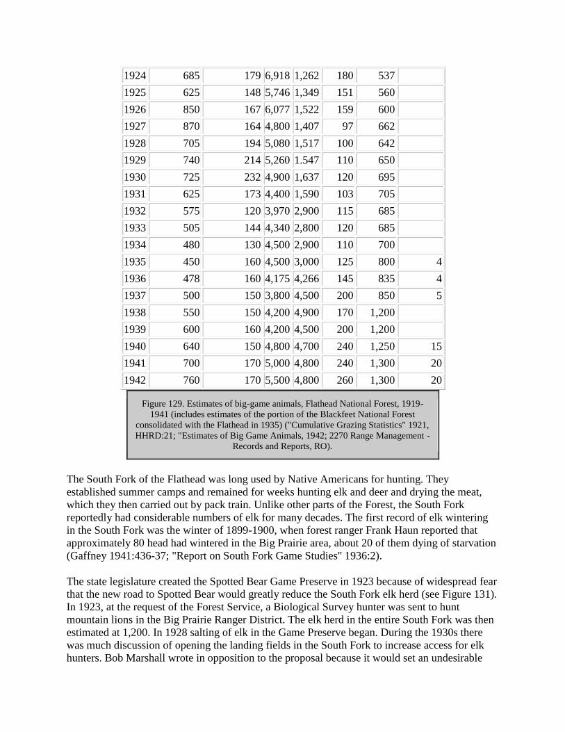
1924 685 179 6,918 1,262 180 537
1925 625 148 5,746 1,349 151 560
1926 850 167 6,077 1,522 159 600
1927 870 164 4,800 1,407 97 662
1928 705 194 5,080 1,517 100 642
1929 740 214 5,260 1.547 110 650
1930 725 232 4,900 1,637 120 695
1931 625 173 4,400 1,590 103 705
1932 575 120 3,970 2,900 115 685
1933 505 144 4,340 2,800 120 685
1934 480 130 4,500 2,900 110 700
1935 450 160 4,500 3,000 125 800 4
1936 478 160 4,175 4,266 145 835 4
1937 500 150 3,800 4,500 200 850 5
1938 550 150 4,200 4,900 170 1,200
1939 600 160 4,200 4,500 200 1,200
1940 640 150 4,800 4,700 240 1,250 15
1941 700 170 5,000 4,800 240 1,300 20
1942 760 170 5,500 4,800 260 1,300 20
Figure 129. Estimates of big-game animals, Flathead National Forest, 1919-
1941 (includes estimates of the portion of the Blackfeet National Forest
consolidated with the Flathead in 1935) ("Cumulative Grazing Statistics" 1921,
HHRD:21; "Estimates of Big Game Animals, 1942; 2270 Range Management -
Records and Reports, RO).
The South Fork of the Flathead was long used by Native Americans for hunting. They
established summer camps and remained for weeks hunting elk and deer and drying the meat,
which they then carried out by pack train. Unlike other parts of the Forest, the South Fork
reportedly had considerable numbers of elk for many decades. The first record of elk wintering
in the South Fork was the winter of 1899-1900, when forest ranger Frank Haun reported that
approximately 80 head had wintered in the Big Prairie area, about 20 of them dying of starvation
(Gaffney 1941:436-37; "Report on South Fork Game Studies" 1936:2).
The state legislature created the Spotted Bear Game Preserve in 1923 because of widespread fear
that the new road to Spotted Bear would greatly reduce the South Fork elk herd (see Figure 131).
In 1923, at the request of the Forest Service, a Biological Survey hunter was sent to hunt
mountain lions in the Big Prairie Ranger District. The elk herd in the entire South Fork was then
estimated at 1,200. In 1928 salting of elk in the Game Preserve began. During the 1930s there
was much discussion of opening the landing fields in the South Fork to increase access for elk
hunters. Bob Marshall wrote in opposition to the proposal because it would set an undesirable

precedent, and the project was dropped the next day. In 1936 the Spotted Bear Game Preserve
was eliminated, which helped the excess elk problem somewhat. Since 1936, hunters had been
killing more elk because of the re-opening of the Spotted Bear Game Preserve, the presence of
large numbers of elk, and a longer hunting season. Even so, ranger Gaffney felt the kill was still
lower than the number that should have been removed (Gaffney 1941:437-438; FNF "Report on
South Fork Game Studies" 1936:4; Merriam 1989:83; Merriam 1966:29).
Figure 131. Sun River and Spotted Bear Game Preserves ("Montana's Largest" ca. 1923).
Factors that played a role in the increasing population of elk in the Big Prairie area included the
inaccessibility of the area to hunters, the establishment of the Spotted Bear Game Preserve, the

almost complete extermination of the mountain lion, and the decreasing numbers of Native
Americans hunting in the area since hunting regulations were instituted. The winter range was
first recognized as overbrowsed in the South Fork in 1935, and since then the damage spread
from the hillsides and upper benches to the flats and stream bottoms. In 1936 the elk population
in the South Fork was estimated at 4,100 but the carrying capacity of the winter range was only
2,600 (and decreasing). Predator and natural losses in the herd were about 250 per year. By 1941
the Flathead National Forest elk population had reached approximately 4,500 head, the largest in
Region One, and most were concentrated in the South and Middle Fork drainages of the Flathead
River (Gaffney 1941:427, 439, 451).
Beginning in 1923 Forest Service employees took annual winter trips through the elk winter
range in the South Fork (see Figure 130). They counted the game in the areas they passed
through and recorded the condition of the wildlife and the winter range, also checking for
poaching or illegal trapping. An intensive game program began in the fall of 1933, and within a
few years studies included the Swan and Middle Fork drainages. The intensive winter studies
lasted four winters and determined the amount of big game wintering in the South Fork, the
forage used, the influence of snow depth and temperature, the carrying capacity, game losses,
migrations, and so on. These studies were followed by annual winter game patrol trips until the
winter of 1941-42. After that, Montana Fish and Game put crews into the area for winter studies
(Space 1936:6-7; Shaw 1967:106, 108; FNF, "Report on South Fork" 1936:1).
Figure 130. Rangers Mendenhall, Thol, and Hutchinson on winter elk survey in the South
Fork, having lunch at Meadow Creek, February 1927 (photo by Henry Thol, courtesy of
Flathead National Forest, Kalispell).

For some people, winter game surveys were very serious; for others, the job had its light
moments. Pat Taylor of the Flathead National Forest recalled:
With Henry [Thol], when we were snow shoeing, we were snow shoeing, while Bill
[Gaffney] and I, if we were snow shoeing and jumped a coyote we'd take after it a
hollering and yelling and having a lot of fun (Taylor 1981).
Pat Taylor noted that game patrol was considered a "romantic" job at that time. The public
thought the rangers were making sure the game was not being poached, which was not actually
their main job. Instead, they were performing such necessary tasks as dissecting all dead animals
they found, washing a sample of the stomach content, cooking it in their camp stove, and
identifying the contents and parasites. Taylor noted that when the Forest Service began calling
the winter work game study instead of game patrol, "then the people thought all I was doing was
sitting in the office writing memos or something" (Taylor 1981).
In 1952, Flathead National Forest officials commented that they foresaw no conflicts between
wildlife and timber management objectives. Although construction of new roads might lead to
more hunting of big game, logging on a sustained-yield basis would improve habitat for game
animals and birds by creating fringe conditions. In addition, winter logging provided coniferous
foliage and moss for wintering deer herds. The report also mentioned the need to control or
prohibit logging along stream bottoms because it damaged the streambed conditions favorable
for fish growth and propagation (Ibenthal 1952:18).
CIVILIAN CONSERVATION CORPS (CCC)
Introduction
The Civilian Conservation Corps (CCC) had lasting effects both on the national forests and on
the enrollees who worked in the program between 1933 and 1942. The forests obtained large
numbers of workers and were able to accomplish many projects, such as road building and snag
removal that required a ready pool of labor. The men within the program gained a job and, often,
skills that led to subsequent employment. The Flathead National Forest benefitted from several
permanent and "spike" CCC camps located on the forest. Another New Deal-era program was
the blister rust control program. Although western white pine, limber pine, and whitebark pine
were killed on the Flathead by blister rust, the Flathead National Forest was not included within
the official control program's boundaries.
Physical remains of the CCC camps on the Flathead National Forest are limited because the
camps themselves were systematically dismantled after their period of use ended. Foundations
can be seen at several sites, however. The CCC program involved building many roads, trails,
recreation facilities, buildings, and so on, and some of these stand today as lasting testimony to
the efforts of those young men of the 1930s.
CCC
Soon after Franklin D. Roosevelt became President, he established the Transient Service, a
forerunner of the CCC program that was intended to get homeless men off the streets and out of
the railroad jungles. One such camp was located on Forest Service land near the Blankenship
Bridge and the junction of the North and Middle Forks of the Flathead. It opened in July 1932
and soon had about 150 men working there. They salvaged logs and sawed timber to build the
camp and then worked on clearing snags from the 1929 fire. The men received $1-$3 per week
wages, plus food, clothes, and shelter. The camp ran for two summers and then was shut down.
In 1937 ranger Thol started construction of a mess hall and cook's quarters, using ERA labor and
salvaging lumber from the old Coram "transient camp" (Green 1972:IV, 21, 23, 25; 24
November 1937 memo, Inspection Reports, Region One, 1937-, RG 95, FRC; "Coram Camp"
1933).
The act creating the Civilian Conservation Corps (CCC) was passed by Congress on March 31,
1933. Over the next 9 years the CCC employed almost 3 million young men, local experienced
men, veterans, Native Americans, and territorials in conservation work around the nation. CCC
enrollees were typically between 17 and 23 years old, single, came from families on relief, and
were unemployed. World War I veterans could also enroll but were housed separately. The Army
ran the national forest camps, but the Forest Service developed the operating plans and work
schedules. The program peaked in 1935 with more than 1/2 million men in over 2,500 camps in
every state and several territories. After 1936 the number of men wanting CCC jobs dropped,
and by the end of 1940 there were more positions available than men to fill them. Congress voted
to end the CCC program in June of 1942 (Throop:2, 11; Salmond 1967:36, 216; Cohen 1980:18;
Otis 1986:17).
CCC enrollees received a minimum of $30 a month in pay, and $22-25 of the wages were sent
directly to the enrollee's family. Many of these men were away from home for the first time and
working at their first steady jobs. Camp life was quite regimented. The men wore Army khaki
and blue denim clothes provided from military supplies. They were allowed to leave camp on
weekends, although the camps were really self-contained cities; they offered dances, cultural
events, sports activities, arts and crafts, and so on. More than 25,600 men from Montana were
enrolled in the CCC, and over 40,800 men served in the state. The officers from the military
sometimes were frustrated with their civilian charges. One officer was overheard exclaiming to a
group of enrollees at Coram, "I know you guys are not in the Army - but I wish to God you
were" (Cohen 1980:25, 46-47, 151).
According to long-time Forest Service employee Elers Koch, a critic of the CCC program, it cost
about $1200 a year to keep a CCC boy in camp but the work he accomplished equaled only
about $300-400 in regular appropriations. He felt that the CCC, because of the low results for the
money, lowered the morale and principles of regular Forest Service employees. He claimed that
many foremen were "permanently ruined," and that "After these years of plenty, the organization
has never gone back to its stem principles of economy and frugality" (Koch ca. 1940:169, 172).
The food provided at CCC camps was reportedly terrible (it never was as good as at logging
camps, according to one participant). The Forest Service argued for months with the Army about
supplying the enrollees with adequate footwear. The Army supplied regular Army leather-soled
shoes, but the work required caulks (spikes in the soles) or at least hobnails to provide traction in
the woods. This reduced the efficiency of the crews by 20-25% and led to some accidents (Koch
ca. 1940:166-167).
During the first year of operation, the Army set up camps without standard plans. The CCC had
three basic types of camp: tent camps, rigid camps, and portable camps. All had a flagpole, with
an office or administration building directly behind it. A 200-man camp usually required 36 tents
with board floors and wood-burning stoves. In 1937, a standard CCC camp contained four
barracks, a mess hall and kitchen, forestry agents' quarters, officers' quarters, headquarters,
storehouse, welfare building, dispensary, school, lavatory, bathhouse, and latrine (Otis 1986:72,
78-80).
In 1934 the CCC adopted portable camp buildings, and two years later the buildings became
standardized and available pre-cut. Spike camps were limited to 20 or 25 people who were
usually absent from the main camp on weekdays only. They were supervised by Forest Service
rather than Army personnel and had a generally high level of production (Otis 1986:8-9, 73, 77;
Cohen 1980:26). When a Forest Service CCC camp was relocated, the materials were salvaged
or the buildings moved, and the Forest Service was given the first chance to obtain them.
The first CCC camp in Montana was built in 1933 for the Stillwater State Forest. At that time
there were no roads on the state forest except Highway 93; CCC crews built a road from Olney
to Upper Whitefish Lake and built the first state lookout (on Dog Mountain). They also felled
snags left from a late-1920s fire. The state also later had a camp on the Swan River State Forest.
Both state forest camps worked mainly on road construction, bridges, phone lines, horse trails,
buildings, lookouts, recreational campgrounds, hazard reduction, and fire suppression. In 1939

the Stillwater State Forest got its second CCC camp, near Stryker, which was active until 1942.
The men at this camp removed snags and opened roads (Cusick 1986:5-6, 9; Moon 1991:94;
Sharp 1988:59).
During the years of the Depression, when logging was slow in the Flathead, many local men
experienced in woods work or in carpentry were hired to serve as CCC camp foremen and
logging superintendents. The Forest Service was also authorized under the Emergency Relief Act
to recruit men as supervisory personnel. Many of these were graduates of forestry schools, which
helped to professionalize the Forest Service. "Local experienced men" furnished their own
clothing but lived with the employees. Many served as truck and tractor operators, as drillers and
dynamite handlers, or directed construction work (Koch ca. 1940:169; Caywood et al. 1991:52;
Sharp 1988:3).
Flathead residents, like people in other parts of the country where CCC camps were located,
were not initially welcoming to the enrollees. Small-town residents were concerned about local
job displacement, family safety, and other issues. Before the first New Yorkers arrived in the
Flathead, the Daily Inter Lake mentioned that residents were skeptical about the "street-slum
foreigners" being sent to the Flathead (11 April 1933). Generally, after the CCC camps were
established the locals recognized that they helped the local economy and became much more
supportive of the program (Otis 1986:2).
African-American CCC enrollees were segregated from Euroamerican enrollees as a matter of
policy. Glacier National Park and the Kootenai National Forest each had at least one African-
American camp, but the Flathead National Forest apparently did not (Otis 1986:7; Renk 1994).
CCC camps offered educational programs to enrollees, featuring both vocational and academic
courses. For some, working in a CCC camp opened the way to a career. Carl Wetterstrom, for
example, was a CCC enrollee in Washington state. He later worked as an assistant ranger, then
as a CCC foreman on the Flathead National Forest, and later as a district ranger on the Forest
(Salmond 1967:53; Baker et al. 1993:128).
By the end of 1940, nearly 105,000 men had served in Region One national forest CCC camps,
providing approximately one million worker-days of labor. All CCC men who worked in the
Flathead Valley were within the Ninth Corps area (this included eight western states), which in
general sent about half the enrollees to other areas during the winter. The Missoula District
included western Montana, Glacier National Park, and Yellowstone, and Fort Missoula was the
training, supply, and dispersal point. When the CCC program peaked in Montana, there were 32
camps in the state (see Figure 132) (Otis 1986:17; Ober 1976:32; Caywood et al. 1991:50).

Camp name and designation Camp location
Red Meadow (F-6) North Fork
Flathead (F-77) north of Columbia Falls
Citadel (F-15) Coram
Elk Park/Bridgehead (F-48) Coram
Tally Lake (F-5) Logan Creek
Olney (SF-207) Olney
Goat Creek (SF-206) Swan Lake
Figure 132. CCC camps on Flathead National Forest and Stillwater and Swan
River State Forests, 1933-1942. Glacier National Park had 16 CCC camps
during this period, including several in the Belton (West Glacier) area ("CCC
Information," Intaglio Collection, UMA).
CCC enrollees on the Flathead National Forest worked on a great variety of projects. Their jobs
included removing snags left by the 1929 fires, widening and maintaining roads and building
campgrounds, picnic tables, roads, fences, phone lines, bridges, and lookouts. Many of the CCC
projects completed on the Flathead National Forest might not have been done otherwise for years
to come (Otis 1986:19; Taylor 1981; McDonnell 1937:36). The men also served as a readily
available labor pool in case of forest fires.
CCC enrollees on the Flathead National Forest, like elsewhere, were required to live up to Army
expectations. After an inspection of detached crews working on trail construction and
maintenance that were run by Forest Service district employees, the inspector commented:
The enrollees generally like these detachments because the forests generally feed better
than the Army. They are not under as strict army rule such as standing retreat...keeping
neat and clean, and making their beds, polishing their shoes etc. The camps that the
detach crews maintain are not up to any army standard (CCC: Inspection: General:
Flathead: Camp F-77, 19/3, RG 95, FRC).
Some Forest Service officials evidently did not maintain Army standards satisfactorily either, as
evidenced by the following quote from a 1938 inspection of the Flathead Camp: "The Forestry
employees are neat at the evening meal, but they should wear ties in consideration of the Army
responsibility in requiring the enrollees to do so" (CCC: Inspection: General: Flathead: Camp F-
77, 19/3, RG 95, FRC).
The first CCC camp on the Flathead National Forest was set up on the Desert Mountain Road in
1933 and was the only one in the Region occupied by a Montana CCC company. Ranger Tom
Wiles of Coram Ranger District was the first superintendent of the "Citadel" camp. The 200-man
camp worked on building a 12-mile road to Desert Mountain Lookout. Crews (often in spike
camps) did trail maintenance, constructed buildings, and set up water systems, fences, and phone
lines. In 1934 or 1935 the camp was moved to Elk Park on the South Fork (see Figure 133).

From this camp, named Bridgehead for the pack bridge they built, enrollees constructed the first
west-side road on the South Fork, the Spotted Bear landing field, and other projects. The men
wintered at Nine Mile and returned to the camp several summers (Shaw 1967: 135; Sharp
1988:25-26).
Figure 133. Elk Park (Bridgehead) CCC Camp (F-48), 1935 (courtesy of Flathead National
Forest, Kalispell).
The large CCC camp northeast of Columbia Falls was built by CCC labor in the summer of 1938
on land obtained through an exchange with the Somers Lumber Company (see Figure 134).
Company 952 moved into it from Elk Park in the fall of 1938. From then until it closed in April
of 1942, it was the only year-round CCC work center on the Flathead National Forest. It
generally had between 150 and 200 enrollees. They worked mostly in hazard reduction, felling
and removing the large snags and windfalls on 127,000 acres left by the Half Moon fire of 1929.
They also worked on a cooperative project with the Montana Fish and Game Department
building a dam for a fish-rearing pond, and on development of the ski area on Big Mountain. In
the summer, a few worked on road and phone line construction and maintenance and on other
projects as needed. The camp was located so as to be in a good location to clean up the snags
from the 1929 fire (the government had recently acquired about half the land burned by the fire
through a land exchange with the J. Neils Company). The CCC crews felled the timber, built fire
lines, and then burned the area and planted trees on it. Although New Yorkers originally lived at
the camp, by the early 1940s a company from Pennsylvania had moved in (FNF, "Informational
Report" 1939; 29 June 1933 memo, Flathead Inspection Reports Region One, RG 95, FRC;
Sharp 1988:27; CCC: Supply: Camp Property: Buildings: Flathead, 9/6, RG 95, FRC; CCC:
Plans: Camp Programs/Work Projects: Flathead, 40/4, RG 95, CCC).

Figure 134. Flathead CCC camp (F-77), located north of Columbia Falls, ca. 1944) (courtesy
of Flathead National Forest, Kalispell).
In 1939, according to an inspection report, Flathead National Forest CCC enrollees worked
mostly on hazard reduction and running a shingle mill operation. About 25 enrollees worked on
phone maintenance in small crews. At Big Prairie men worked on the water system and the
bunkhouse and maintained a fence; at Spotted Bear on the phone line and fencing; at Big Creek
Ranger Station on various improvements; at Coram on farming at Tally Lake on road
maintenance, and so on (29 November 1939 memo, Flathead Inspection Reports Region One,
RG 95, FRC).
On the Tally Lake Ranger District, a 200-man seasonal CCC camp was located during the
summers of 1933 and 1934 on a bench above Logan Creek. The men there, mostly from New
York and New Jersey, built sections of the Logan Creek and Shepard Creek Roads, including
several bridges. There was also a tent camp at Star Meadow that had a New York CCC company
(F-5). A tent camp (F-6) was located at Red Meadow in the North Fork, also with enrollees from
New York City. In 1933 Camp F-15 was a tent camp located at Coram Ranger Station (24FH64,
FNF CR; Sharp 1988:5).
The men at the CCC camp at Big Creek Ranger Station built many of the improvements there in
1936, including the barn, fence, mangers, water trough and pipe line, shop/garage, dwelling and
administration building, and general grounds improvement including the lawn and flagstone
walks. They also worked on hazard reduction and fuelwood cutting. The "rustic architecture" of
the Depression-era Forest Service buildings and structures represent a design philosophy aimed
at non-intrusive expression, the use of natural and native materials, and labor-intensive building
methods. The rustic style grew out of the 19th century romanticism about nature and the western

frontier. Textural richness was achieved by juxtaposing materials and shapes (Throop:3, 31;
Foltz 1937:25-26).
The CCC program allowed engineering in the Forest Service to take on a greater role. Because of
the Depression, many engineers were available to help with CCC projects. The Forest Service
developed a system for designing and building "truck trails" for fire protection, including the
contour method of road staking (USDA FS "History of Engineering" 1990:5).
Some CCC enrollees on the Flathead National Forest were injured or killed while in the CCC.
One Columbia Falls enrollee was killed when struck by a falling snag on a fire, and one drowned
in the South Fork and another in the North Fork (Shaw 1967:98).
Glacier National Park had almost 1,300 CCC enrollees assigned to it between 1933 and 1941. In
the Apgar area they worked on removing snags from the 1929 fire, graded roads, built trails,
fought fires, and cleared campsites. A sawmill in Apgar produced lumber, fence posts, and phone
poles (Ober 1976:30, 34-35).
When the CCC program ended in 1941, the various CCC camp buildings on the Flathead
National Forest were either salvaged for rough lumber or declared surplus. Red Meadow (F-6),
for example, was salvaged and the material given to the Forest Service in 1934. It consisted of a
log recreation hall, a frame mess hall, a frame officers' bath and latrine, a frame latrine, and a
frame shower and wash building. With the start of World War II, Camp F-77, Flathead Camp,
was considered for the use of conscientious objectors or student fire crews but was rejected
because of the cost of snow removal (CCC: Supply: Camp Property: Buildings: Flathead, 9/6,
RG 95, FRC).
Blister Rust
The fungus known as blister rust came to America from Europe in 1909 in a shipment of nursery
stock. It requires two hosts for survival: gooseberries or currants (Ribes plants), and white or
sugar pine, and it almost always kills the latter. By 1923 blister rust was infecting trees in
northern Idaho. The first blister rust camp was established there in 1924, and soon many more
were set up to remove Ribes plants. Between 1933 and 1941 as many as 12,000 people worked
on blister rust crews in the national forests (Guth 1991:32-33).
In northwestern Montana, western white pine, limber pine, and whitebark pine are affected by
blister rust (Benedict 1981:23). The Flathead National Forest, however, lay on the eastern edge
of the area included in the blister rust control program, so CCC and other crews on the Forest
were not used to pull Ribes plants.
During World War II, emergency programs did not operate and the blister rust infection spread.
Only the highest priority areas were treated. In 1948 a Forest Service study determined that the
rust could be controlled, and the attempt to eradicate host Ribes plants continued. Fungicides
were used beginning in 1957, but by the mid-1960s these sprayings were shown to be
ineffective; control was being achieved by natural factors. In 1967, the blister rust control
program in the northern Rockies officially ended (Benedict 1981:40-42).

RECREATION AND WILDERNESS AREAS
Introduction
Pioneers in America, with few exceptions, regarded wilderness with "defiant hatred," and they
battled the wilderness in the name of their nation, race, and God. Early Americans defined
"progress" as the conquering of wilderness, the disappearance of wild country. By the late 19th
century, in contrast, many Americans appreciated the aesthetic and recreational aspects of nature
(Nash 1982:24, 40; Tweed 1980:1).
Some early outdoor clubs were established in the 1800s, such as the Sierra Club in 1873 and the
Mazama Club in 1894. Even so, the possibility of forest recreation remained remote to the
general population in the 1880s. At the turn of the century, the outdoor movement appealed
primarily to city people. Wealthy people, intellectuals, and those with the leisure time and the
money to travel were the only Americans able to visit natural wonders like Yosemite or
Yellowstone or to hunt big game in the West. In general, nineteenth-century resorts developed
around mineral springs, scenic curiosities, mountains, or seashores. Resort hotels were generally
built for the upper class by railroad and steamship interests (Nash 1982:153; Ellison 1942:630;
Jakle:53, 60).
The center of recreation in the Flathead Valley in the 1890s was Lake McDonald, which between
1897 and 1910 was administered by the GLO and then the Forest Service. Recreationists soon
discovered the attractions of the South Fork, although that area required time (and usually pack
animals) for a successful visit. The sport of downhill skiing had captivated some local
enthusiasts by the late 1930s, and Big Mountain was developed in the 1940s on Flathead
National Forest land. As the popular demand for recreation boomed after World War II, so did
the recreational use of the national forests, and road construction improved access within the
Forests.
General Recreation
Early outdoor recreation in the Flathead Valley focussed on resource-oriented activities such as
hunting, fishing, huckleberrying, and some mountain climbing. As the transportation system
improved, more remote areas became popular. For example, in 1900 a local newspaper
commented that Tally Lake, which had been almost unknown until then, "is this year coming in
to favor as a fishing and pleasure resort" (Flathead Monitor 11 May 1900). Some early settlers,
particularly those with property on lakeshores, built tourist accommodations and thus
supplemented their income seasonally. Charles Ramsey, for example, constructed a rooming
house near his cabin on Whitefish Lake by 1891 to attract hunters and fishermen (this eventually
also housed railroad workers, surveyors, and construction workers). In 1892 Ramsey's "fine
summer resort" featured housekeeping apartments, a dining room and kitchen, and row boats
(Schafer 1973:11; Inter Lake 4 March 1892).
Car camping was cheaper than using motels and restaurants, and it offered freedom of action and
ways to get close to nature relatively easily. As the popularity of car camping increased after

World War I, campgrounds were established to control and direct the crowds (see Figure 135).
Campgrounds became more and more luxurious. In the 1920s many towns provided free
municipal campgrounds, but by 1930 private campgrounds had taken over and fees were charged
at city campgrounds to keep out poor people. Cabin camps, the forerunner of motels, became
more and more popular and were built throughout the country (Jakle: 152, 160, 163).
Figure 135. Auto camping in western Montana, ca. 1920 (courtesy of the Mansfield Library,
University of Montana, Missoula).
Tourist camps catered to Flathead Valley residents and out-of-town visitors. Camp Tuffit and
Babcock's, for example, had cabins for rent by the day, week or month on Lake Mary Ronan (see

Figure 136). The camps offered meals, rowboats, and free camping (Tuffit even had rough bunks
filled with hay for beds). Their patrons came from not only Missoula and Kalispell but also from
various eastern states. In 1924, the Forest Service considered giving slide programs to guests at
the camps (14 August 1924 memo, Flathead Inspection Reports Region One, RG 95, FRC).
Figure 136. Camp Tuffit, Lake Mary Ronan (courtesy of USDA Forest Service, Region One,
Missoula).
Dude ranching in the United States expanded briefly after World War II but has declined since.
The concept originated with Howard Eaton and his brothers, who began charging eastern visitors
to stay at their ranch in North Dakota. Outfitter and guide Dick Randall established the industry
in Montana. He began taking paying customers at his ranch near Gardiner in 1905. When the
Dude Ranchers Association was formed in 1925, about 50 people attended from Montana and
Wyoming. The industry boomed through the 1930s (there were 38 Montana members in 1937).
In many cases, the dude business kept cattle operations from going under during the Depression
(Sullivan 1971:4, 11, 13-15, 17).
Some forest homesteaders had well-established businesses guiding and outfitting and serving as
dude ranches for visitors. Matt Brill and his wife started a guest ranch at their place in the North
Fork in approximately 1920, taking guests on pack trips. By 1931 the Brills had created a
complex there that included guest cabins, a lodge, a garage, a cookhouse, a chicken coop, a
washroom/laundry facility, a barn, and so on. The site served as a guest ranch until
approximately 1950. The clientele here, as at most other dude ranches, was mostly out-of-state
wealthy families that returned year after year. They fished, hunted, picked berries, and relaxed
(24FH105, FNF CR; L. Wilson 1988).
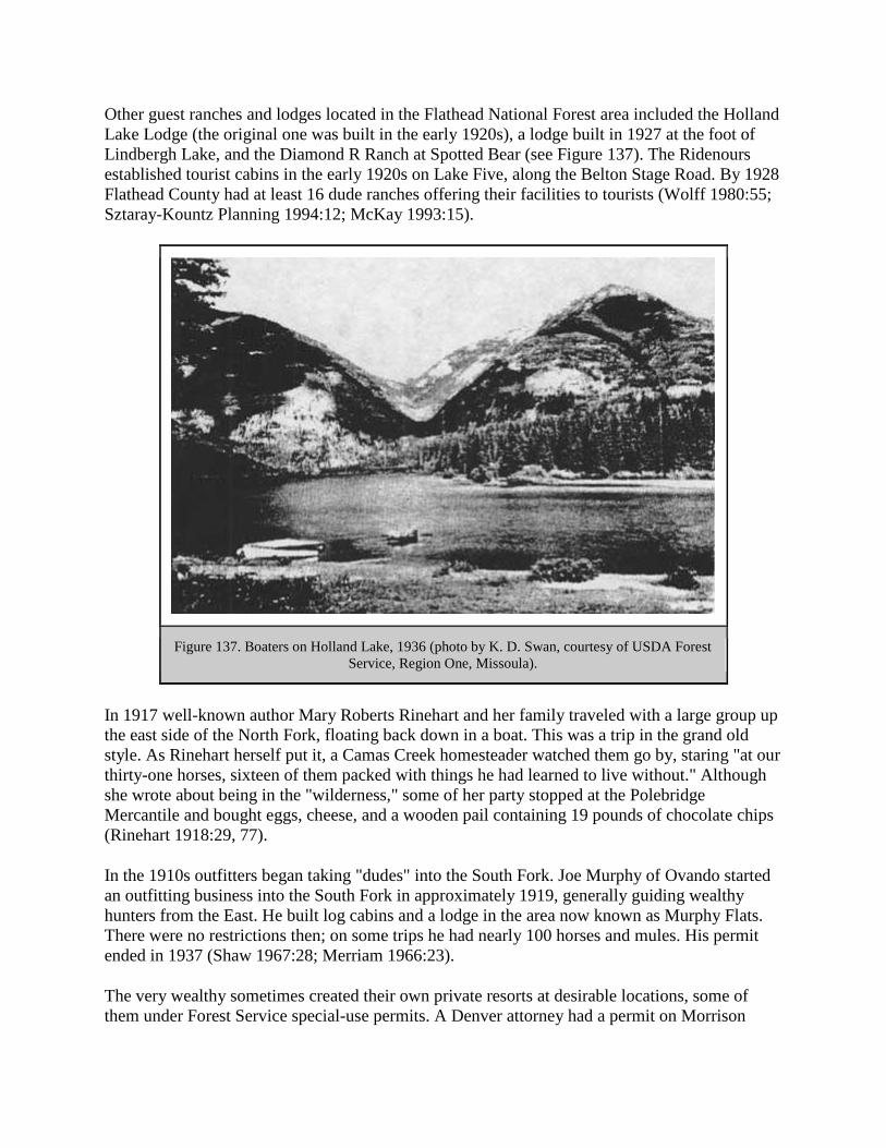
Other guest ranches and lodges located in the Flathead National Forest area included the Holland
Lake Lodge (the original one was built in the early 1920s), a lodge built in 1927 at the foot of
Lindbergh Lake, and the Diamond R Ranch at Spotted Bear (see Figure 137). The Ridenours
established tourist cabins in the early 1920s on Lake Five, along the Belton Stage Road. By 1928
Flathead County had at least 16 dude ranches offering their facilities to tourists (Wolff 1980:55;
Sztaray-Kountz Planning 1994:12; McKay 1993:15).
Figure 137. Boaters on Holland Lake, 1936 (photo by K. D. Swan, courtesy of USDA Forest
Service, Region One, Missoula).
In 1917 well-known author Mary Roberts Rinehart and her family traveled with a large group up
the east side of the North Fork, floating back down in a boat. This was a trip in the grand old
style. As Rinehart herself put it, a Camas Creek homesteader watched them go by, staring "at our
thirty-one horses, sixteen of them packed with things he had learned to live without." Although
she wrote about being in the "wilderness," some of her party stopped at the Polebridge
Mercantile and bought eggs, cheese, and a wooden pail containing 19 pounds of chocolate chips
(Rinehart 1918:29, 77).
In the 1910s outfitters began taking "dudes" into the South Fork. Joe Murphy of Ovando started
an outfitting business into the South Fork in approximately 1919, generally guiding wealthy
hunters from the East. He built log cabins and a lodge in the area now known as Murphy Flats.
There were no restrictions then; on some trips he had nearly 100 horses and mules. His permit
ended in 1937 (Shaw 1967:28; Merriam 1966:23).
The very wealthy sometimes created their own private resorts at desirable locations, some of
them under Forest Service special-use permits. A Denver attorney had a permit on Morrison

Creek, where he built a summer home in the early 1920s. Cornelius (Con) Kelley, president and
then chairman of the board of the ACM from 1918-55, and Lewis Orvis Evans (also an ACM
man) were partners in an estate located on Swan Lake. Evans discovered the area while on a
fishing trip and bought a small cabin there in 1908. Eventually they owned as much as 7,000
acres. Most of the building at their estate was done in the 1920s; the complex grew to include 31
buildings. Visitors were usually ACM officials and business associates from Butte and New
York City. They hosted huge formal parties and often employed over 20 servants at one time
(Shaw 1967:27; Pepe 1971:24-25; 24LA18, FNF CR).
Some guided trips in the Flathead were arranged by private organizations. For example, for a
number of years the Trail Riders of the Wilderness offered annual trips in the South Fork of the
Flathead and the Sun River, sponsored by the American Forestry Association (see Figure 138)
(R1 PR 797, 27 May 1937). Visitors on these and other trips helped publicize the Flathead
National Forest.
Figure 138. Trail Riders on meadow below Danaher Ranger Station, 1946 (photo by K. D.
Swan, courtesy of USDA Forest Service, Region One, Missoula).
Recreation in the Lake McDonald Area
The main area of attraction for recreational visitors within the Flathead Valley for many years
was Lake McDonald (earlier called Terry Lake), located within the Flathead Forest
Reserve/Blackfeet National Forest from 1897 until 1910 and since then within Glacier National
Park. The lake area was well-publicized in the 1890s, although visitation was quite low at first
(Buchholtz 1976a:46).

Homesteaders were filing claims to the land around Lake McDonald by 1892. The first hotel in
Belton was built in 1892-93 near the railroad depot. In 1895 George Snyder built a hotel near the
head of the lake, and Frank Geduhn began building summer cabins at the head of the lake. Until
1910 local residents provided most of the visitor housing, mostly cabins to rent to summer
tourists or friends from the Flathead. Many of the names of natural features in the area were
named after these early settlers or summer visitors, such as Snyder Ridge, Howe Ridge, and
Mount Vaught. Stanton Mountain was named for Lottie Stanton, the wife of a livery stable
keeper at Demersville (Ober 1973:13, 16-19; Vaught Papers 1/R).
Hunting and fishing expeditions were being guided on the east side of what is now Glacier
National Park by the 1880s. The early tourists were wealthy people, including scientists such as
George Bird Grinnell. In 1894 professor Lyman Sperry came to Lake McDonald looking for
glaciers, encouraged by the general passenger agent of the Great Northern Railway, who saw
glaciers as an attraction to rail passengers. The GNRR appropriated money to help Sperry have
some horse trails built in the Lake McDonald area.
By the late 1890s Lake McDonald had places to stay, guided horse and mountain-climbing trips,
and a steamer that plied the lake. The hotel proprietors there favored small-scale service and
remained stubbornly independent from the railroad (Buchholtz 1976a:31, 39; Ober 1973:13).
Some of the early visitors to the Lake McDonald area climbed mountains or walked on glaciers
with the help of local guides. Others had unusual adventures. For example, Frank Miles of
Kalispell led a group of people in three boats on the Middle Fork. They reportedly "sometimes
shot like a fish" through canyons and over rapids, fished at Lake McDonald, and eventually
floated on to Demersville (Johns 1943:VII, 127).
Although publicly promoted as early as the 1880s, the designation of Glacier National Park had
to wait until mining interests in the area proved a failure. The Great Northern Railway, chambers
of commerce, and various outdoorsmen and scientists promoted the creation of the Park. The
first bill to create the Park was introduced in 1907. The final bill of 1910 contained numerous
provisions protecting special users; in reality, it was more like a modified national forest.
Nevertheless, the creation of Glacier National Park fulfilled the ideals of wilderness preservation,
recreational land, scientific laboratory, and nationalistic symbol (Buchholtz 1976a:47, 49).
When Lake McDonald was under GLO and then Forest Service jurisdiction, potential settlers
had to obtain a permit from the government to build cabins. For example, in 1900 L. O. Vaught,
an Illinois attorney, obtained permission to build a cabin on the lake for private use by himself
and friends during the summer months. A Forest officer had to supervise the location and
designate where the timber, stone, and other building materials were to be obtained (see Figure
139) (Vaught papers 2/F).

Figure 139. Belton (West Glacier) seen from the south, ca. 1914 (R. E. Marble Collection,
courtesy of Glacier National Park, West Glacier).
In 1899 Flathead Forest Reserve ranger L. C. Hoffius wrote a series of letters to Lyman Sperry
informing him of the situation in the Lake McDonald area. He built a trail that year from the foot
of the lake to Hotel Glacier, worked on other trails, and patrolled for fire. He commented, "Will
do all I can to keep the trails in good order for tourists. Also will endeavor to open up new
country for tourists" (Vaught Papers 3/C).
The first superintendent of the Park, William Logan, planned for the new Park to be opened and
used. He insured the protection of private landowners' rights, encouraged the investigation of
existing mining claims to determine their validity, established a sawmill, and encouraged major
construction projects. Logan and many others managing national parks at that time saw national
parks as playgrounds meant for the enjoyment of the public. As Stephen Mather, head of the
National Park Service, later put it, "Scenery is a hollow enjoyment if the tourist starts out after an
indigestible breakfast and a fitful sleep on an impossible bed" (Buchholtz 1976a:53).
From June-October 1911, approximately 4,000 visitors entered Glacier National Park, most
coming through Belton. The road from Belton to the lake was greatly improved in 1910,
encouraging more tourists to visit the area. By the end of 1911 there were 199 miles of trail in
fair condition in the new Park, 50 miles of which were completely new. The railroad soon built
the chalet complex at Belton and planned hotels, tent camps, roads, trails, and chalets for the east
side (Logan 1911:8-9; Buchholtz 1976a:56). In 1914 John Lewis' hotel on Lake McDonald (now
known as the Lake McDonald Lodge) opened for visitors, and visitation to the Park gradually
rose (see Figure 140).

Figure 140. Glacier National Park visitation, 1911-1957 (from Bolle 1959:178ff).
The efforts of the Forest Service and then of the National Park Service to develop Lake
McDonald were slow indeed compared to those of the Great Northern, largely because of
extremely low budgets. As ranger/homesteader/outfitter Frank Geduhn commented in 1912,

"The Gov'ts doing here seem in comparison [with the railroad] like the efforts of a tenderfoot, I
should say an imbecile" (Vaught Papers 2/E).
Flathead National Forest Recreation up to World War II
GLO regulations issued in 1902 permitted recreational use of the forest reserves in the form of
building and maintaining sanitariums and hotels, camping, and travel for pleasure. In 1905,
summer residences were added to the list. The 1907 Forest Service Use Book referred to national
forests as "great playgrounds for the people" (Tweed: 1-2; Pinchot 1907:24). Even so, early
recreation management was largely incidental to the other work of the forest rangers and guards.
Forest Service recreation policy grew out of its desire to prevent the creation of a separate parks
bureau in the Department of the Interior. In 1909, according to agency figures, over 400,000
people recreated on national forests. After the National Park Service was created in 1916, the
Forest Service went on the defensive (Robbins 1976:110; Kalispell Bee, 26 August 1910).
Recreational use of the national forests gave political support for Forest development and helped
keep the National Park Service from being the only agency managing land for recreation. Early
Forest Service recreation plans aimed at preserving scenery. In 1917, Forest Service Chief Henry
S. Graves wrote that the Forest Service did not intend to protect the national forests "for a few
wealthy persons who can afford to take long trips on the railroad, buy expensive pack outfits, and
so on. We have a very practical problem of opening up and making available the public
properties for as wide a use as possible by people of little means as well as by those better-to-do"
(Graves 1917:134).
The National Park Service was created in 1916 over Forest Service protest. The next year, the
Forest Service began an intensive study of its recreation facilities, commissioning a landscape
architect to survey the Forests for their recreation potential. The landscape architect
recommended continuing national forest recreation development separate from the national parks
and hiring professional landscape architects. As soon as World War I ended the Forest Service
hired its first landscape architect, Arthur Carhart, to work in the Rocky Mountain District. This
was followed in 1924 by the start of the National Conference on Outdoor Recreation, which
initiated recreation planning on all federal lands. In the 1920s and 1930s the Forest Service
shifted to wilderness concerns, due to pressures from the public and industry and agency
employees and to competition with the National Park Service for recreational budgets and land
(Steen 1976:12; Tweed 1980:6-7; Baker et al. 1993:202; Roth 1984:113).
In the 1920s, the Forest Service sought to prevent the loss of large areas to the National Park
Service, which was trying to preserve areas of outstanding beauty, many of them within the
nation's national forests. The Forest Service moved towards a policy of wilderness preservation
as a result. When Forest Service chief Ferdinand A. Silcox proclaimed in 1935 that the national
forests must be managed by the principle of multiple use, he was not stating a new policy; he
was presenting an argument that would prevent recreational lands from being transferred to the
National Park Service. Although the Forest Service said it could manage timber and recreation
together, the first purpose of the national forests was still to harvest timber. Sustained yield was

the management prescription wherever there was timber, and multiple use wherever there was no
timber (Swain 1963:21; Clary 1986:100-101).
Federal funding for recreation on the national forests remained very low in the 1920s. The first
appropriation for Forest Service recreation was in 1923 ($10,000 earmarked for sanitation).
Money was provided to build toilets, fireplaces, and so on, based on fire prevention and
sanitation rather than recreational needs. In 1925 the national forests around the country had
about 1,500 campgrounds, 1/3 with facilities of some sort. The Depression slowed funding even
further (G. Robinson 1975:121; Tweed 1980:11-13, 15).
In the 1910s the Forest Service generally looked upon campers and picnickers with disfavor -
they increased the fire hazard - but favored summer home permittees, who helped with fire
control and brought in needed revenue. Beginning in 1920, the agency shifted to giving camping
and picnicking priority over cottages. Designated camping and picnic areas were first established
to minimize fire hazard and stream pollution rather than to serve the public (Ellison 1942:635-
636).
The first Forest Service developed campground was built in 1916 on the Oregon National Forest.
It offered camp tables, toilets, a check-in station, a ranger station, and a scenic trail. One of the
benefits of issuing camping permits, as had been discussed even in the early 1900s, was that it
provided a way to alert campers to the possibility of their starting fires by being careless with
their campfires (Tweed:4; letter to District Forester, 16 February 1911, 1300 Management -
Historical, Material Relating to District One Activities, RO).
The first Forest Service campground on land that is now in the Flathead National Forest was
approved in 1922. The campground covered 33 acres and was located about 2 miles north of
Coal Creek in the North Fork. The 1922 justification commented that more and more people
were using the North Fork for recreation every year, and that the Forest Service needed to
reserve tracts just for that use. In 1922, a regional official suggested a survey of the recreational
possibilities and requirements in the area, noting that other sites might be desirable to reserve as
well. In 1925, however, approval of that campground was cancelled because of high water in the
area (FNF Lands).
From the CCC era until the building of access roads for the spruce salvage program, the main use
of the North Fork was recreational. The CCC built three campgrounds there: Big Creek 1, Big
Creek 2, and Tuchuck (Bolle 1959:200).
In 1932, public campgrounds were located at Fielding and Elbow (Lindbergh) Lake. The Elbow
Lake camp had tables, stoves, latrines and garbage pits built that year. In 1939 the Flathead
National Forest had a developed campground at Beardance on Flathead Lake that featured
stoves, tables, and spring water. By the late 1930s there were also campgrounds at Hungry Horse
Creek with stoves, tables, and outhouses, and at Felix Creek and Elk Park (3 August 1932 memo,
Flathead Inspection Reports Region One, RO; Work Projects Administration 1939:241-42).
In 1925 the Flathead National Forest withdrew land in the Nyack area for a public campground
for travellers on the highway being built through the area. Mentioned in the request was a rumor

that Nyack would some day become an entrance to Glacier National Park. In 1930, a report on
the Essex area commented that there were about 300 man-days of recreational use in the Marion
Lake area (a good fishing lake). The report called the area "unattractive" (because of large fires
in the area) but commented that the new highway was bringing an end to its seclusion (FNF
Lands; 28 January 1930, "Report on Municipal Watershed," in 2510 Surveys, Watershed
Analyses, 1927-29, RO).
Another 1920s campground tied to new road construction was located north of Elk Park on the
east side of the South Fork. According to the Flathead National Forest, the area had "always been
used by campers. New road will make it very popular. Is a beautiful spot and only one desirable
along river on road for 14 miles north and 15 miles south. It is planned to set aside a Public
Service site here." By 1927, the South Fork was being used more and more by tourists as a side
trip from Glacier National Park (FNF Lands; 17 August 1927 memo, Flathead Inspection
Reports Region One, 1920-1923 Inspection Reports, RO). Almost all of the recreationists on the
Flathead National Forest arrived by car (see Figure 141).
Type of Use Flathead National Forest Blackfeet National Forest
total number visitors 25,000 9,600
special-use permittees and guests 100 50
hotel and resort guests 1,300 450
campers 2,200 900
picnickers 6,700 4,200
transient tourists 14,700 4,000
Mode of Travel
automobile 23,500 9,200
railroad 100 100
hikers 200 200
Figure 141. Recreational use on Flathead and Blackfeet National Forests,
1930 (Northern Region News (10 March 1931):14).
Beginning in 1933, funding for recreation on the national forests increased tremendously through
various New Deal programs. Under the CCC, the recreation program broadened to include
bathhouses, shelters, amphitheaters, and playgrounds. Recreation facilities built by the CCC for
the Forest Service had to be inexpensive and simple. In 1934, each Region was authorized to hire
technical personnel to oversee recreation improvements. In the late 1930s Bob Marshall, as Chief
of the Division of Recreation and Lands, helped bring stronger central guidance and review, but
facilities were not standardized until the late 1950s (Tweed 1980: 16-18, 20-21, 24).
According to a 1938 handbook, Forest Service managers felt that their job was to make outdoors
recreation more accessible to the public with the least possible evidence of disturbance. It
recommended that camps be well screened from the highway and that man-made improvements
be screened by trees or shrubbery, that they be located at or near a natural attraction, make
provisions for trailer use, and provide a small supply of tent poles (USDA FS, "Campground
Improvement" 1935:1, 3-4, 30).
Approximately 65,000 visitors a year were using the national forests of the four northwestern
Montana counties for recreation in the late 1930s. Most of the national forest visitors during the
Depression lived in towns adjacent to the Forests; they had free time but little money to travel
far. Campgrounds reached by roads were heavily used on weekends by townspeople and area
farmers. In 1935 30% of the visitors fished, 25% enjoyed rest and relaxation, and 9% hunted.
Eighty-one per cent preferred developed campsites with tables and stoves. At that time, 62% of
the Region One visitors used tents, 1.3% house trailers, and 17% auto trailers. Most people
expressed a desire not to have organized camps like those in the national parks (Sundborg
1945:64; Clark 1936:840-843; Wiles 1936:16).
By 1936 the national forests of Region One recognized the damage to meadows near
campgrounds due to overgrazing. In the 1930s, 50 head of stock in one dude outfit was not
unusual, some of them staying as long as a week in one place. Because of the damage,
commercial packers and dude ranchers were required to tell rangers of their plans and routes and
to limit stock use at any one feeding area to five days. By the 1930s the Flathead National Forest
was collecting damages from campers who left their camps in poor condition. For instance, in
1932 the Forest Service billed a hunter for the cost of cleaning up his camp (3 August 1932
memo, Flathead Inspection Reports Region One, RO; Inspection Reports, Region One, 1937-,
RG 95, FRC; R1 PR 703, 31 March 1936).
Downhill Skiing
The new sport of downhill skiing caught on in the United States in the mid-1930s, and most of
the country's early ski areas were established on Forest Service land. The first winter sport area
on a national forest was built in 1936 at Sun Valley, Idaho. The Forest Service generally relied
on private initiative for developing ski areas (Guth 1991:181; G. Robinson 1975:126).
In the Flathead, ski parties first used Big Mountain slopes in 1935. The members of the
Whitefish Hell-Roaring Ski Club built a cabin to house skiers. In 1938 members of the club
persuaded J. C. Urquhart, supervisor of the Flathead National Forest, to build a two-mile road to
the cabin. The Forest Service road officially opened in November 1939, with a 600' tow, and the
Great Northern Railway began advertising the mountain. After World War II, veterans trained in
skiing returned to the United States and skied recreationally. In 1947 Winter Sports, Inc., was
incorporated and the clearing of slopes and lifts and lodge sites began. The new chalet was built
in 1949, and the old cabins were burned in 1950 as fire hazards. The Big Mountain chairlift
began serving summer visitors as well as winter visitors in 1951. In that first season of 1947-48,
Big Mountain had 6,900 visitors. Twenty-four years later, visitation had grown to 218,400 (Shaw
1967:30; Schafer 1973:159-166; Sundborg 1945:65).
Nearly all the early ski trails and about 3/4 of the lifts at Big Mountain were located on national
forest land. The runways were cleared by timber sales. The Forest Service worked together with
Winter Sports, Inc., to select trail locations and to establish rules for use of the area, safety
precautions, and lift charges (Montana Conservation Council 1954:54).

A small ski area was operated on national forest land just outside of Belton. It had opened by
1941. In 1959, Ed Nordtome was operating the Silver Buckle Ski course about three miles south
of Kalispell with a small ski tow. A family near Creston had a commercial ski slope with a tow
rope for a few years in the 1950s (Guth 1991:181; 5340 Exchange, FNF Lands file; Elwood
1994).
Flathead National Forest Recreation After World War II
When World War II began in 1941, public works recreation allotments ended, but half the
Regions retained a professional recreation planner through the war period. After World War II,
pent-up buying power and increased leisure time led to the flooding of United States highways
with vacationers. Many resorts had been closed during the war because gas and tire rationing had
limited traveling for pleasure. After the war, workers had shorter work weeks and longer
vacations (Tweed 1980:26; Jakle 1985:185).
Between 1944 and 1956, recreational use of Forest Service lands in Region One increased
tenfold, largely due to out-of-state vacationers. The Forest Service was largely unprepared for
this enormous public demand for recreation; recreation planning and plans for the repair or
expansion of facilities had been eliminated during the war. Visitation to Glacier National Park
also increased dramatically, reaching half a million by 1951 (3 October 1956, 1380 Reports -
Historical - Reports to the Chief, RO; Buchholtz 1976a:72; Baker et al. 1993:164, 214).
On the Flathead National Forest, recreational use climbed dramatically in the 1940s and 1950s.
In 1947 the Forest recorded 40,078 recreational visitor-days. This had reached 258,000 by 1958.
In 1952, for example, the Tally Lake ranger district was reporting "constant use" of the Big
Mountain ski area, the Tally Lake campground, and Martin Creek Falls (Merriam 1966:77;
Ibenthal 1952).
In 1949 the Forest Service was authorized to establish fee camping areas operated by private
people or by the agency. Soon, larger and more luxurious accommodations appeared. Private
operations generally featured motor inns instead of tourist courts (Baker et al. 1993:207; Jalde
1985:198).
The flooding of Hungry Horse Reservoir in the early 1950s replaced a high-quality trout stream
with a reservoir with fluctuating levels "and dubious recreational shoreline values," according to
a Flathead National Forest report. Nevertheless, the Forest Service felt that the reservoir would
lead to greatly increased use of the area. At that time, annual use was approximately 7,400 (most
fishermen, hunters, and campers in that order). In 1948 there were six partially developed
campgrounds in the area. Forest Service officials projected needing 15-20 campgrounds to
accommodate 75 family units total, plus several picnic grounds and public boat landings and
swimming areas. The first summer homesites were leased in the Hungry Horse Reservoir area in
1956. By 1958, Hungry Horse had two campgrounds, Lost Johnny and Lakeview, each with four
units. In 1959, there were 14 summer homesites under special-use permit on the ranger district
(USDA FS "A Study" 1948:31-32; Great Falls Tribune 20 November 1955:9; Arvidson 1967;
"Comparison of the Major Volume of Business," HHRD).

In the late 1950s, the Forest Service and the National Park Service began major competitive
planning efforts, recognizing the greatly increasing demand for outdoor recreation. In 1957 the
Forest Service established Operation Outdoors, a national program to provide recreation
opportunities throughout the national forests. Each Forest developed recreation plans for the next
5 years under the program. In 1959 the Forest Service also initiated a recreation survey designed
to examine the needs expected by the year 2000 (G. Robinson 1975:15, 121; Baker et al.
1993:214-215). This planning movement was similar to the National Park Service's Mission 66,
a 10-year program to develop recreational facilities.
As transportation facilities improved in the area, recreational use increased. The completion of
the Swan Valley Forest Highway in the late 1950s, for example, created a "boom in recreation
use" in the Swan Valley (FNF "Timber Management, Swan" 1960:16).
Recreational use also increased greatly in the Coram area after the completion of the Hungry
Horse dam. Between 1952 and 1960 recreation visits increased nearly 5 times in the Coram
Working Circle. On other working circles it was less: from 1955-60 recreation on the Kalispell
Working Circle went up 9% yearly. Recreational visits to the Glacier View Ranger District in
1958 were estimated at 56,500 (FNF "Timber Management, Coram" 1961:15; FNF "Timber
Management, Kalispell" 1961:22; FNF "Timber Management, Glacier View" 1959:21).
Forest Service campgrounds were typically less developed and had fewer campsites than those in
the national parks. In 1958 the Flathead National Forest had 70 campsites available, whereas
Glacier National Park had the same number of campgrounds but 581 sites. In 1961, the Flathead
National Forest maintained 16 developed campgrounds (the largest had 23 tables), 6 boat
launching sites, and 5 commercial public service recreation resorts under special use permits
(Peters 1958:95; "Areas" 1961:E5).
Creation of Primitive and Wilderness Areas
Yellowstone National Park was created in 1872, the first example in the United States of large
scale wilderness preservation in the public interest. Automobiles and the building of a national
highway system, the "See America First" campaign, the conservation movement, and the
advertisement of national parks as the people's playground all led to increasing outdoor
recreation in America. By about 1920 many people felt that the country was being criss-crossed
by a network of roads; the first wilderness areas were created at this time (Nash 1982:108;
Ellison 1942:632, 634).
As recreation became more and more a recognized forest product, the national forests began
surveying their recreational potential. The first deliberate commitment of national forest land to
wilderness was in 1919, when Trappers Lake in Colorado was protected from development. In
1924 the Forest Service designated 574,000 acres of the Gila National Forest as roadless area
devoted to wilderness recreation. This was policy, not law, and few commercial activities were
actually prohibited (Nash 1984:6-8).
In the 1920s the Forest Service lacked a definite policy for the undeveloped areas that it
managed. The agency was unwilling to make irreversible decisions that would prevent future

generations from using needed resources. In 1929 the agency defined primitive areas as places
that would provide the "nature lover and student of history a representation of conditions typical
of the pioneer period" (Steen 1976:156).
The 1929 "L-20 Regulations" covered national forest primitive areas. The regulations suggested
limitations on unplanned development in untouched areas, but they allowed regulated use of
timber, forage, or water resources. These regulations served to discourage field personnel from
initiating unnecessary development and to slow the transfer of more land to the National Park
Service (most national parks since 1916 had been carved out of Forest Service land) (Roth
1984:115; Merriam 1989:82).
The U Regulations supplanted the L-20 Regulations and were implemented in 1939. These
regulations gave much greater protection to wilderness areas. They prohibited logging, road
construction, and special-use permits for hotels, stores, resorts, summer homes, organization
camps, and hunting and fishing camps. Most motorboat and aircraft use was prohibited.
Livestock grazing, however, was permitted because of political pressure, as were improvements
necessary for fire protection. The areas were also still subject to existing mining and leasing laws
and to the possibility of reservoir and dam construction, again in response to the protests of
commercial users of national forest lands. The wilderness areas created by the Forest Service
such as the Bob Marshall Wilderness appealed to a new clientele, out-of-state visitors, not the
usual national forest users (Roth 1984:116; Merriam 1966:113).
The rising importance placed on amenity values in the American conservation movement after
World War II increased the importance of aesthetic considerations associated with quality of life.
The federal wilderness bill was debated and rewritten for a number of years until its passage in
1964 (Nash 1984:8-10).
Bob Marshall Wilderness
In 1917, the Chicago, Milwaukee & St. Paul Railroad was considering promoting the Swan and
the head of the South Fork of the Flathead as a potential national park. Regional forester Silcox
met with railroad officials to persuade them that recreational development under national forest
regulations had distinct advantages and included such activities as pack trips, camping, and
boating (10 May 1917, 1380 Reports - Historical - District 1, RO). The two areas remained under
Forest Service jurisdiction.
Much of the South Fork had not been explored much by recreationists by 1920. That year, K. D.
Swan and a companion traveled from Holland Lake over Gordon Pass to Big Prairie, to Big
Salmon Lake (which they called "far off the main lines of travel") and out by the Monture trail to
Ovando (see Figure 142). The only recreationists they saw on the trip was a honeymooning
couple camping at the mouth of Salmon Creek (Swan 1921:245, 247).

Figure 142. View southwest across Big Salmon Lake from the outlet, 1934 (photo by K. D.
Swan, courtesy of USDA Forest Service, Missoula).
The Flathead National Forest did designate "primitive areas," however. The Forest Service
established the South Fork Primitive Area in 1931 (see Figure 143). It included about 584,000
acres in the South Fork, White River, and tributaries of the Spotted Bear drainages. Citing
considerable public support for the designation, the Forest Service commented that the timber in
the area was commercially inaccessible for at least 30 years, that the area was not important as a
water source for power or irrigation, and that there were no permanent mining claims inside the
boundaries. Administrative issues included private lands within the wilderness: 69,000 acres
owned by the Northern Pacific Railroad and tracts owned by two individuals. The Forest Service
acquired the railroad land between 1950 and 1955 and the private tracts in 1935 and 1940.
Missoula attorney Howard Toole and others outside the agency actively pushed for the land
exchange through political channels in order to save the South Fork for recreational purposes
(Merriam 1966:26-27; FNF Lands).

Figure 143. Primitive areas on the Flathead and Lewis and Clark National Forests, 1936
(from 1936 base map, HHRD).
Two years later, in 1933, the Forest Service designated the Pentagon Primitive Area. At first this
95,000-acre region did not include a strip along the headwaters of the Spotted Bear River
because of the possibility of water power or road construction from Spotted Bear across the
Divide to Bench Mark on the Sun River. In 1939 this 31,000-acre strip was added to the
primitive area. The Forest Service designated the Sun River Primitive Area in 1934. The block of
240,000 acres was located east of the Divide (on the Lewis & Clark National Forest) (Merriam
1966:28).
The first designated wilderness in Region One was the Bob Marshall Wilderness, created on
August 16, 1940, by combining and reclassifying the South Fork, Pentagon, and Sun River
Primitive Areas. Most of the new wilderness lay within the boundaries of the Flathead National
Forest, and approximately 8% of the acreage was still alienated in the southwest portion (it was
owned by the NPRR). The 950,000-acre area was named to honor Bob Marshall, a forester who
had passed away at the age of 38 the previous year. Originally it was planned to name the
Selway-Bitterroot Primitive Area for Marshall, but Regional Forester Evan Kelley argued that
Marshall's personal interest in the South Fork and its attractiveness made it the more appropriate
honor. He felt that Marshall "was largely instrumental in its continuance in primitive condition"
(USDA FS "Bob Marshall" 1940; Merriam 1966:32; Graetz 1985:74).
Bob Marshall was a conservationist, a forester, one of the founders of the Wilderness Society,
and a Forest Service employee who devoted much of his considerable energy and talent to the
development of the national forest wilderness system. He worked for the Forest Service in Idaho
and Montana from 1925-28, and in 1937 he became the Chief of Recreation and Lands in the
Washington Office. In 1927 or 1928 Marshall trekked through the area that later carried his

name. Marshall was possibly the first high-level Forest Service official to protest discrimination
in recreational policies. He argued that summer-home development, "elaborate" resorts, and high
fees for ski lifts were exclusionary and should not be allowed on public lands. In the 1950s,
when Communist-baiting was fashionable, the American Legion of Montana proposed renaming
the Bob Marshall Wilderness for a Montana colonel who had served in World War I. The Forest
Service rejected the proposal (Glover 1986:84, 253; Merriam 1989:83, 85).
As recreational and timber use in the Flathead Valley grew, frictions between the two began to
be felt. One of the earliest controversies in Region One between advocates of resource use and
environmentalists occurred in 1954 when the Flathead National Forest announced plans to offer
for sale 23 million board feet of timber (primarily Engelmann spruce damaged by spruce bark
beetle) on the upper Bunker Creek drainage just outside the Bob Marshall Wilderness.
Harvesting the insect-infested timber would have required building a road parallel to the
wilderness boundary for about 5 miles, plus another 30 miles to connect with the road at Spotted
Bear. A local outfitter sparked opposition to the plan. The Forest Service dropped the plans for
the sale, largely because an analysis showed the sale would be economical only if there were
additional timber or road monies. Meanwhile, the Flathead Lake Wildlife Association petitioned
for an extension of the wilderness boundary to the north and other groups for an extension to the
south as well. Eventually the road was built up Bunker Creek, and the wilderness boundary was
not extended in that area. But, the debate strengthened support for the 1964 Wilderness Act and
the creation of additional wilderness areas in vicinity of the Bob Marshall Wilderness. The
Scapegoat Wilderness was designated in 1972, the Great Bear in 1978 (Bolle 1959:8; Merriam
1989:84-85, 87; Shaw 1967:74-76).
By the time the Wilderness Act was passed in 1964, the Forest Service had already set aside 9
million acres that it managed as wilderness on its own administrative authority. Almost two
million of those acres were in Montana (950,000 acres in the Bob Marshall Wilderness at that
time) (Steen 1976:156; Baker et al. 1993:269). Forest Service management of the Bob Marshall
Wilderness in the early 1960s was essentially pragmatic. In other words, three airfields were
regularly used for supply, fire control, and emergencies, 6 lookouts were manned, and 14
administrative cabins were used within the wilderness.
Outfitter camps often "looked like tent cities"; in 1960 there was not yet a limit on the number of
animals per party. The use of the Bob Marshall by commercial and private packers was still
unregulated other than requiring the payment of grazing fees. Heavy over-use had developed. A
Forest Service inspector recommended requiring permits for commercial packers, encouraging
voluntary regulation, installing garbage pits and latrines at the main campgrounds, and
developing more natural openings (Merriam 1989:85; 24PW1003, FNF CR).
Visitation to the Bob Marshall Wilderness increased about ten-fold between 1943 and 1959,
going from approximately 500 to 5,000 visitors. More than 90% of the visitors continued to
come on horses. The Bob Marshall was often called the "crown jewel" of the country's
wilderness system (Merriam 1966:35; "Historical Look" ca. 1982:2-3; Gaffney 1941:429).
Mission Mountains

The first organized trip into the Mission Mountains was made in 1922 by a Northern Pacific
Railroad and Forest Service group (see Figure 144). The railroad wanted to obtain photographs,
films, and articles about the area so they could advertise it better. Forest Service employees
Theodore Shoemaker and Jack Clack accompanied the group. They traveled from Holland Lake
across the valley and up Glacier Creek into the high country. In 1923 and 1924 Shoemaker led
groups of the Montana Mountaineers into the area. Soon he made the first map of much of the
high country in the Missions. Northern Pacific officials and members of the Mountaineers named
many of the lakes and mountains in the area (Theodore Shoemaker, 28 January 1955 memo,
Classification of Mission Mountains Wilderness Area, RO; Shoemaker 1923:222).
Figure 144. Mission Mountains, ca. 1922 (photo by K. D. Swan, courtesy of the Mansfield
Library, University of Montana, Missoula).
In 1931 the Forest Service classified some 67,000 acres on the east slopes of the Missions as the
Mission Mountains Primitive Area, adding 8,500 acres in 1939 (the high country from Piper
Lake to just north of Fatty Lake). In more recent years the Confederated Salish and Kootenai
Tribes have designated the west slopes of the Missions as a tribal wilderness area. The Mission
Mountain Primitive Area was changed to a Wilderness Area in 1975 (FNF "Guide" 1980;
"Historical Look" ca. 1980:3).
When the primitive area was classified, the NPRR owned 30% of the land. In the late 1940s and
early 1950s the railroad exchanged much of the land in the higher elevations of the area for land
elsewhere in the Swan Valley. Then, in November of 1949, a windstorm blew down the trees on
over 1,000 acres in the drainages intersecting the southeast boundary of the area. By 1952 spruce
bark beetles had become epidemic and were spreading to adjoining stands. The Forest Service
and the Northern Pacific decided to log the infested stands adjacent to the primitive area to

prevent the spread of the insects. Roads were constructed into the primitive area and then were
blocked once the logging of about 2,000 acres within the boundary had been completed. In 1967,
the NPRR still owned approximately 2,860 acres within the wilderness, but it has since
exchanged this land (FNF "Guide" 1980; Shaw 1967:80).
Jewel Basin
For many years Cliff Merritt and other Flathead Valley residents had urged that the area now
known as the Jewel Basin be designated as wilderness. The public had conflicting interests in the
area, ranging from trail-only recreational use to more roads for recreational use to logging of
spruce in the lower basins. The Flathead National Forest arranged a trip to the area for
lumbermen, ranchers, sportsmen, and others, and as a result the group recommended that the best
use of the area was for wilderness-type recreation. In 1970 the Forest Service classified the Jewel
Basin as a Special Roadless Area (Cooney 1964:7-8; FNF "Forest Plan":S-15).

CONCLUSION
A Flathead National Forest employee of 1915, if transported to the Flathead National Forest of
today, might have difficulty recognizing the agency and much of the land it manages, so great
have been the changes over the decades. For example, most of the drainages with roads would
have been reached in his time only by several days' travel on horseback or on foot. No longer in
a custodial role, the Forest is now actively managing timber sales, developed campgrounds, and
other resources. Many of the forest homesteads established in the early 1900s have reverted back
to the agency; some of those that are still private are now summer homes.
The era of the fire lookout has come and gone, replaced by airplanes. Instead of small crews of
local men hired to fight fires, large crews of men and women are often flown in from all over the
country to fight fires. Radios, commercial telephone systems, and computers dominate agency
communications. Some similarities with 1915 remain, however, particularly within the Bob
Marshall Wilderness Complex. There, pack strings still supply backcountry administrative sites,
and much of the work is still done by hand. But the presence of the agency - in the form of guard
stations, trails, and the number of employees - is more apparent than it would have been in the
early 1900s, when funding and other resources were quite low.
Finally, the hypothetical 1915 worker would be astonished at the changes in the Flathead Valley
communities. Cars and trucks have practically replaced the railroad, and the population of the
valley has grown greatly over the past several decades. Many people, including Forest Service
employees, commute great distances to their jobs. Local businesses provide goods and services
that were unheard of in 1915.
The history of the Flathead Valley and of the Flathead National Forest is summarized in the
paragraphs that follow. This broad-brush summary gives some idea of the patterns of change and
continuity - for better and for worse - that have taken place in the Flathead Valley since the
arrival of the first Euroamerican in approximately 1800.
The Flathead Valley remained difficult and hazardous to access for decades after the first
Euroamericans came through the area. This was due to topographical factors such as the
surrounding rugged mountains and Flathead Lake, the hostility of the Blackfeet to the east, and
the long, hard winters. Independent fur trappers and fur company employees ventured into the
upper Flathead Valley in the early 1800s. At that time, bands of Kootenai were the main
occupants of the the area. The center of the fur trade in the region was farther south, in the
Mission Valley. A small group of Euroamericans joined a number of Kootenai at a traditional
camping ground near the head of Flathead Lake in the 1840s to form the first tentative (and
short-lived) Euroamerican settlement in the upper Flathead Valley. At approximately the same
time, the Hudson's Bay Company established a seasonal trading post in the Tobacco Plains
Valley. Settlement in the upper Flathead, however, remained temporary and very low in numbers
until the 1870s, despite several government and private surveys and explorations that traveled
through and reported on the area in the 1850s through the 1870s. The establishment of the
Flathead Indian Reservation in the lower Flathead Valley in 1855 further insulated the region.

In the 1860s hopeful prospectors and miners passed through the Flathead Valley on their way
north to the mines in the Wild Horse Creek area of British Columbia. After that boom had
slowed, some of these men returned to the Flathead Valley to prospect, a few even to settle.
Gradually, the outside world was learning about the abundant natural resources of the Flathead
Valley.
The real influx of permanent settlers to the Flathead did not occur until 1883, when the Northern
Pacific Railroad reached Missoula over 100 miles to the south. Blackfeet hostility had lessened
by this time, and transportation improvements such as steamboat travel on Flathead Lake
reduced the earlier obstacles to settlement and exploration of the area. During the 1880s, settlers
cleared land in the valley floor for agriculture and began exploring the surrounding mountains
for mineral and other resources. Major fires in the summer of 1889 burned thousands of acres in
the surrounding forests; there was not yet an organized firefighting system in the area. The town
of Demersville, founded in 1887, was the largest town in the valley for a time.
With the arrival of the first Great Northern Railway train in the Flathead Valley in 1891, most of
the barriers to travel into the Flathead were removed overnight. Markets for agricultural and
timber products suddenly became national rather than strictly local. More and more people
moved into the area. Some of the towns founded along the railroad line are still major
communities in the valley, such as Kalispell and Columbia Falls; many others no longer exist.
In the early 1890s, prospectors ventured into the more remote valleys and believed they had
discovered promising signs of coal, oil, and mineral resources, particularly in the drainages of
the North and South Forks of the Flathead River. The financial panic that began in 1893 slowed
the development of the valley, but the economy picked up again when the Klondike gold rush
began in 1897 and created vast new markets for products of northwestern Montana. Prospectors
continued to search the mountains and creeks for wealth, and some trails and roads were built to
promising sites. None of these deposits, however, led to much development work or to the
production and shipping of valuable resources.
The U. S. government, meanwhile, had begun setting aside "forest reserves" to protect
watersheds on the public domain from devastation by lumbermen and fire. In 1897, President
Cleveland created the two forest reserves that later became known as the Flathead National
Forest: the Flathead Forest Reserve extending along the international boundary from Tobacco
Plains on the west to the Blackfeet Indian Reservation on the east, and the Lewis &
Clarke [sic] Forest Reserve, extending along the South Fork of the Flathead from the Middle
Fork almost to Ovando. Despite much initial local protest about "locking up" valuable lands, the
General Land Office hired rangers to protect the forest reserves from fire and timber trespass
beginning in 1898.
The Forest Service was created in 1905, and its employees took over the management of the
forest reserves that year. The headquarters for the Flathead National Forest (south half) were
moved from Ovando to Kalispell, where the Supervisor's Office still is today. In the Flathead,
these men (and they were all men) who patrolled the several million acres of the two national
forests were faced with great difficulties of transportation and communication in the steeply
sloped, heavily wooded reaches of the forests. Early rangers and other employees devoted most
of their time and energy to building trails and stringing telephone lines through the woods,
always worried about wildlfires burning out of control and destroying the public timber
resources being held for future needs. The first phone line on the Forest was built in 1908
between Kalispell and Coram (private companies did not yet serve that route).
In 1910, fires raged throughout northwestern Montana and northern Idaho. The Forest Service
was unprepared to suppress such firestorms, and over 3 million acres were destroyed by fire.
Immediately after these fires, Forest Service budgets increased and lookout points were
established on high peaks and ridges to aid in early fire detection. The Forest Service became the
lead firefighting agency in the country. That same year, 1910, Glacier National Park was created
out of the eastern portion of the Blackfeet National Forest.
Eventually, the Flathead and Blackfeet National Forests built several thousand miles of trails
throughout the two Forests and established systems for supplying workers in remote areas by
pack animals. The Forest Service Remount Depot, established near Missoula in 1930, provided
stock and equipment to the Region One Forests for many years. Administrative buildings such as
ranger stations and guard stations were built along the main trails, which branched off from the
few wagon or automobile roads in the area. In 1935 the two Forests were combined into one
administrative unit under the name of the Flathead National Forest.
Other agencies and private organizations were also involved in fire protection. The Northern
Montana Forestry Association formed in 1911 as an association of private owners of forested
land. The group hired fire patrolmen and firefighting crews to protect their lands. In the late
1910s and early 1920s, the Stillwater, Swan River, and Coal Creek state forests were carved out
of Flathead National Forest lands and the state assumed the responsibility for managing and
protecting these lands.
But the Forest Service was not just a fire-oriented agency in the early years. The Flathead
National Forest has also managed a number of other forest resources. Beginning in 1906, the
national forests opened to settlement land within their boundaries that had been determined to
have agricultural value. Homesteaders settled many areas of the Flathead under this program,
and although a large number of the homestead tracts eventually reverted back to the U. S. Forest
Service, others remain in private ownership to this day. Homesteaders and others obtained
permits to graze livestock on national forest land, but grazing was never a large program on the
Flathead National Forest.
The Flathead Valley has been one of the centers of the lumber industry in the state since the
1890s, but the timber on national forest land was not harvested to any great extent until World
War II. Private lands in the valley bottoms were on more level ground and were thus much more
profitable to log, so the lumber companies concentrated on these areas until the mid-1900s.
Timber products in the Flathead Valley during this period included sawlogs, railroad crossties,
cedar poles, shingles, and lath. The one very large timber sale on the Flathead National Forest
prior to World War II was the sale of almost 90 million board feet of timber in the Swan Valley,
which the Somers Lumber Company logged between 1914 and 1919. The Somers Lumber
Company was a subsidiary of the Great Northern Railway, and it produced railroad ties and
lumber at its plant in Somers from 1901 until the 1940s.
Many Flathead Valley residents worked in the woods, often staying in logging camps during the
winters. The major IWW-led lumber strikes of 1917 started in Eureka and shut down the mills in
the Flathead Valley for several months, leading eventually to improved working conditions and
wages for loggers and mill workers. Logging camps declined, however, as trucks replaced horses
and river drives. The last river drive of logs in the Flathead Valley occurred in 1931.
World War II created a large demand for the country's timber resources, and the post-war
building boom led to an unprecedented demand for timber that could not be met by logging
private lands only. The Forest Service shifted from custodial, protective management of the
national forests to the development and intensive use of the resources. The agency accelerated
timber harvests greatly in order to meet the new demand, and roads were built into many
drainages previously accessible only on foot or horseback. At the same time, the Forest Service
began to use aerial fire patrol and smokejumpers to detect and fight fires in remote areas, which
included much of the Flathead National Forest.
On the Flathead National Forest, the after-effects of a severe November 1949 windstorm
emphasized this shift in management techniques. Previously, the blowdown of mature trees left
by windstorms had generally been left unsalvaged because of difficult access and relatively low
prices for timber. In the early 1950s, however, the Flathead National Forest built roads to salvage
the downfall and used mechanized methods of logging to get the timber out. Spruce bark beetle
epidemics developed and spread from the dead timber to live trees, and "control logging" was
instituted to reduced the spread of the infestations.
The Flathead National Forest, with its excellent hunting and fishing and its magnificent scenery,
has long been recognized as an important recreational area. In the early 1900s, recreational use
on the forest reserves centered in the Lake McDonald area (which became part of Glacier
National Park in 1910). The South Fork of the Flathead became increasingly popular, primarily
among people traveling with pack animals. The Flathead National Forest also began to study and
then manage the wildlife in the area, particularly big-game species such as deer and elk and
"desirable" species of fish. The Spotted Bear Game Preserve was created in 1923 to protect big-
game populations on the South Fork (it was eliminated in 1936). The large Bob Marshall
Wilderness was designated in 1940 to protect land with exceptional scenic and wilderness
values. This wilderness area, which has been enlarged in recent years, is today one of the largest
and best-loved components of the nation's wilderness system.
Beginning in the 1920s, the Flathead National Forest began to build roads into the Forest to
provide better access, primarily to aid in fire detection and suppression, but the roads also
improved access for other Forest users, such as recreationists. The recreation program was also
aided by workers enrolled in the Civilian Conservation Corps (1933-1942), who were based at
several camps on the Forest during the Depression years. They built campgrounds, roads, and
trails, and worked on numerous other projects on the Forest. In 1936, the Flathead National
Forest could boast of 4,500 miles of trail. Trail mileage on the Forest was declining by the 1950s,
however, until in 1985 there were only about 2,100 miles in the trail system. Meanwhile, road
mileage had risen from 360 miles in 1936 to almost 4,000 miles in 1985.

The economy of the Flathead Valley changed in the 1950s, with the construction of Hungry
Horse Dam and the Anaconda Aluminum plant and the rise in tourism. In the 1950s conflicts
developed between the users of various national forest resources, particularly recreation and
timber. The demands for both increased sharply after World War II, and the debate over the
proposed Bunker Creek timber sale in 1954 heralded many others to come as the Flathead
National Forest intensified its management and use of the Forest resources. The Multiple Use-
Sustained Yield Act of 1960 attempted to provide a means of balancing the needs of various
groups that used the national forests, but it actually offered little specific guidance to Forest
managers.
The story of the decades following 1960 is also a story of change, with major events and trends
including the passage of the Wilderness Act of 1964, the greatly increased road density (and thus
resource use) on the non-wilderness sections of the Forest, and increased public participation in
land-management decisions. The policies of Flathead National Forest employees today have
been affected by decisions made by their predecessors beginning in 1898, and before that by the
Native Americans and early non-Indian settlers of the area. As described in this historic
overview, the changing management of the Forest reflects changing priorities and resource needs
of the American public. Decisions made in the past will continue to inform decisions made in the
future.
TIMELINE
1803 Louisiana Purchase
1804-06 Lewis & Clark expedition
1808 David Thompson travels on Kootenai River.
1810 Finan McDonald party crossed the Rockies (probably at Marias Pass)
1810-11 Joseph Howse built Howse House for the HBC
1812 General Land Office created, initiates survey of the west
1813 Pacific Fur Company sells to North West Company
1821 merger of HBC and North West Company
1828-29 Joshua Pilcher party wintered in Flathead Lake area
1830s decline of fur trade in Pacific Northwest
1845 settlement on Ashley Creek begun
1846 Oregon Treaty of 1846 signed
1846 HBC traders began operating in Tobacco Plains
1847 Fort Connah, HBC post, opened in the Mission Valley
1848 Oregon Territory created
1849 U. S. Department of Interior created
1850 John Owen established a trading post in the Bitterroot
1852 Benetsee Finlay found gold in Montana
1853 Tinkham party passes through Flathead Valley

1853-54 Stevens railroad surveys in western Montana
1854 John Mullan party passes through Flathead Valley
1854 St. Ignatius Mission founded
1855 Hellgate Treaty passed establishing Flathead Indian Reservation
1857-60 British and American boundary surveys along 49th parallel
1858 Thomas Blakiston party passes through North Fork
1859 first steamboat traveled from St. Louis to Fort Benton by this year
1859-62 Mullan Road built
1860 Hellgate founded (Missoula area)
1860 Fort Kootenai in Tobacco Plains moved north of the boundary
1862 Homestead Act passed
1862 Gold discovered at Bannack
1862 U. S. Department of Agriculture established
1863 Idaho Territory formed, including what is now Montana
1863 Gold discovered at Alder Gulch
1864 Montana Territory formed
1864 Gold discovered at Last Chance Gulch and Butte
1864 Montana Territory created
1864 start of gold rush to Wild Horse in British Columbia
1864 federal government granted NPRR approximately 13 million acres in Montana
1867 rush to Libby Creek
1867 Gold discovered on Libby Creek
1871 Fort Connah, HBC post, closed in the Mission Valley
1871 fires in Wisconsin burned 400 square miles, killed over 1,000 people
1872 General Mining Act of 1872 passed
1872 first upper Flathead Valley post office established, at Scribner
1875 American Forestry Association organized
1877 Dawes Act opened reservations to white settlement
1878 Timber and Stone Act passed
1870s a few stock raisers lived in upper Flathead a few years
1881 Division of Forestry created within U. S. Department of Agriculture
1883 Northern Pacific Railroad reached Missoula
1883 Lt. John Van Orsdale recommended northern Rockies be a national park
1884 Ashley post office established
1884 Foy's Mill, water-powered sawmill, built in the Flathead
1885 first steamboat on Flathead Lake
1885 Canadian Pacific Railroad reached Calgary
1887 coal claims located on the Coal Banks in the North Fork

1887 Demersville founded
1889 forest fires burn large areas of northwest Montana
1889 Montana became a state
1889 Inter Lake first published
1890 Lt. Ahern and soldiers crossed the North Fork
1891 Great Northern Railway reached Flathead Valley
1891 coal discovered in the South Fork
1891 Kalispell founded
1891 Columbia Falls founded
1891 Forest Reserve Act passed
1891 Yellowstone Forest Reserve, first in the country, created
1893 Flathead County formed out of Missoula County
1893 Great Northern Railway transcontinental line completed
1895 Old Steel Bridge built over Flathead River east of Kalispell
1895 Montana State Fish and Game Commission formed
1897 Forest Reserve Act of 1897 passed
1897 Flathead and Lewis & Clarke Forest Reserves created
1897 start of Klondike gold rush
1898 Spanish-American War
1898 first American college of forestry opened at Cornell
1901 John O'Brien Lumber Company began production
1901 wagon road up east side of North Fork of Flathead built
1901 oil drilling in the Kintla Lake area
1902 Flathead Lumberman's Board of Trade organized
1903 oil drilling in the Swiftcurrent area
1904 Whitefish founded
1904 Great Northern Railway line relocated in Flathead Valley to the north end of the valley
1905 Administration of Forest Reserves transferred to Department of Agriculture
1905 Bureau of Forestry renamed Forest Service
1905 Forest Service Use Book issued
1905 Flathead National Forest headquarters moved from Ovando to Kalispell
1905 I. W. W. organized
1906 Forest Homestead Act opened some national forest lands to homesteaders
1906 Agricultural Appropriation bill passed
1906 first Forest Service phone line built (in Wyoming)
1907 Congress passed act prohibiting creation of additional forests from public domain
within Montana and other states
1907 term forest reserves replaced by national forests

1907 I. W. W. strike at Somers Lumber Company mill
1907-08 first pack animals bought by FS for use in the northwest, brought to Big Prairie
1908 phone line between Kalispell and Coram built, first on Flathead National Forest
1909 Montana state board of forestry established
1909 I. W. W. strike at Somers Lumber Company mill
1910 Glacier National Park created by Congress
1911 Weeks Act, federal purchase of Forest lands to protect navigable streams
1911 Northern Montana Forestry Association formed
1912 Federal government mandated land classification of all national forest land
1913-19 90 MMBF Forest Service timber sale in Swan Valley
1914 first fire lookout built on Flathead National Forest, on Spotted Bear Mountain
1917 IWW strike among loggers in the Pacific Northwest
1917 Loyal Legion of Loggers and Lumbermen formed
1917 U. S. involvement in World War I
1917 Northern Pacific Railroad line completed to Polson
1917 first automobile purchased for a Region One national forest
1917 I. W. W. strike among woodsworkers and mill workers in Pacific Northwest
1918 Prohibition began in Montana
1918 Sedition Act passed in Montana
1918 Stillwater, Swan River, and Coal Creek State Forests created
1920s first logging trucks used in the Flathead
1923 Spotted Bear Game Preserve created
1924 Clarke-McNary Act passed giving funds for cooperative fire protection
ca. 1925 steamboat passenger travel on Flathead Lake ended
1925 first aerial fire patrol in Region One
mid-
1920s road from Coram to Spotted Bear built
mid-
1920s sawed railroad ties began to replace hewn ties
1922 first campground on Flathead National Forest land approved
1926 McSweeny-McNary Forest Research Act, provided for grazing fee reductions for
allotment improvement
1928 Flathead Mine began production
1929 Half Moon fire
1929 stock market crash
1929 Superior Lumber Company of Columbia Falls began providing ready-cut lookouts
1930 Region One established a Remount Depot
1930 Knutson-Vandenberg Act passed allowing for cash deposits for timber stand
improvement work
1931 last river drive in the Flathead
1931 South Fork Primitive Area established
1933 Flathead and Blackfeet National Forests consolidated
1933 Civilian Conservation Corps (CCC) established
1933 Prohibition repealed
1933 Pentagon Primitive Area established
1934 Taylor Grazing Act passed as a means to administer grazing on public lands
1934-35 Article X of the National Recovery Act mandatory
1936 Spotted Bear Game Preserve eliminated
1938 Fair Labor Standards Act mandated 40-hour work week
1939 President once again had authority to create forest reserves in Montana
1939 Flathead National Forest built first road up Big Mountain
1940 Bob Marshall Wilderness area designated
1942 CCC program ended
1942 coal mine in North Fork closed
1942 U. S. involvement in World War II
1940s lumber company tugboats on Flathead Lake ceased operation
1944 Sustained Yield Management Act passed
1944 smokejumping standard practice in Region One
1945 end of World War II
1945 Continental Unit (aerial forest fire control area) created
1945 first reduction in number of lookouts on Flathead National Forest
ca. 1945 significant growth in Montana timber industry
1946 Flathead Mine closed
1947 Big Mountain Winter Sports incorporated
1948 hearings in Kalispell about proposed Glacier View Dam
late 1940s Somers Lumber Company sawmill ceased operations
1949 severe windstorm damages much timber on Flathead National Forest
1949-53 Hungry Horse Dam constructed
early
1950s
insect infestation on Flathead National Forest timberlands resulting from blowdown
of 1949
1953 Region One Remount Depot began to be phased out
1955 Anaconda Aluminum Company plant went into production
1956 Montana's first pulp mill built, in Missoula area
1957 Forest Service established Operation Outdoors
1960 Multiple Use - Sustained Yield Act passed
1969 Northern Montana Forestry Association ceased operations

GLOSSARY
adit - A horizontal drift or passage from the ground surface into a mine.
administrative site - Term used by Forest Service to denote an area reserved for administrative
use of the agency, such as the site of a guard station, pasture for government stock, lookout, or
camping area.
alidade (firefinder) - A sighting apparatus used by lookouts to determine the horizontal bearing
and sometimes the vertical angle of a fire from a lookout.
alienated land - Land within the boundaries of a national forest that is not managed by the
Forest Service. It might be owned by an individual or by a large lumber company, for example.
allotment - The area covered under a grazing permit.
allowable cut - Amount of timber that a district, forest, or region is allowed to cut in one year,
generally calculated by volume.
arrastra - A drag-stone mill for pulverizing ores containing valuable minerals.
aspect - The direction a slope is facing (its exposure in relation to the sun).
backcountry - Area that does not have road access and thus is relatively remote.
bed - A horizontal seam or deposit of mineral.
big wheels - Special wagon used for hauling logs in the summers, with two very large wheels
(one end of the log would be supported on the wagon, the other would drag behind it).
blaze - Mark made on a tree trunk with an axe to identify a trail.
blowdown - Timber blown over in a windstorm.
blowup - Sudden increase in fire intensity or rate of spread sufficient to prevent direct control or
to upset existing control plans.
board foot - The unit in which the volume of a log is measured. A board-foot is a volume
equivalent to a piece of wood one foot square and one inch thick.
brigade - During the early 1800s, a large group of men who would be sent into an area to trap all
the fur-bearing animals in the region.
bucking - The process of sawing a downed tree into sections of the length desired for
transportation. Bucking converts a tree into a log.

chute - A log track or trough or ditch used to transport logs from one location to another by
sliding them with the help of gravity or of draft animals.
Continental Unit - Experimental aerial forest fire control area created in 1945 on 2 million acres
of roadless wilderness, including part of the Flathead National Forest. The network relied on fire
detection by airplane and on fire suppression by smokejumpers (primarily).
contributed time - Hours of work that a Forest Service employee does for the agency at no
charge. The free work often occurs in the early morning or in the evening.
crosscut saw - A two-man saw for cutting trees in the woods.
crow's nest - A platform built high up in a tree (or trees) to provide greater visibility to lookouts.
cruise timber - To estimate the amount and species of standing timber in a given area.
cutover land - Land on which the timber has been harvested (also known as "stumpland").
deck of logs - A temporary pile of logs awaiting transfer to another location via log chutes,
hauling roads, river drive, logging railroad, etc.
Decker packsaddle - Replaced the sawbuck and diamond hitch used on pack animals in the
Forest Service in the 1920s.
diamond bitch - Method of tying a load on a pack animal that was replaced in the 1920s by the
Decker packsaddle.
dispatcher - Person employed to receive reports of discovery and status of fires, confirm fire
location, take action promptly to provide fire fighters and equipment likely to be needed to
control a fire in initial attack, send them to the proper location, and support them as needed.
downfall - Trees that have fallen down (generally used referring to obstacles on a trail).
drift fence - Fence built to prevent the wandering of unpermitted cattle and sheep onto national
forest grazing allotments.
emergency phone - Temporary phone wire and phone set up for a fire camp or other temporary
situation.
enrollees - Term used for men enrolled in the Civilian Conservation Corps, 1933-1942.
entryman - Person applying for or proving up on a national forest homestead claim.
extensive land classification - Broad classification of possible land uses on Forest Service land.
fallers - The men who cut down trees.

fire danger - A general term used to express an assessment of fixed and variable factors such as
fire risk, fuels, weather, and topography, which influence whether fires will start, spread, and do
damage and the expected difficulty controlling the fire.
firefinder - see "alidade."
firefinder map - A map, generally mounted on a wood or metal base, that is provided with an
azimuth circle, at the center of which is pivoted a firefinder.
fireline - The part of a fire control line that is scraped or dug to mineral soil.
flume - A long trough filled with running water used to transport logs from one place to another.
Forest highway - Sections of state, county, and other important public roads in and adjacent to
the national forests that provide primary access to the Forest.
Forest road - Roads needed primarily for the protection, development, and administration of
national forest lands.
free hunter - Independent fur trapper who sold furs to the fur companies but was not an
employee.
grazing allotments - Specific area assigned to stock under a grazing permit.
guard station - Complex of buildings located at a Forest Service administrative site. Typically
includes a cabin, outhouse, barn, and other outbuildings.
gyppo - Contract worker instead of employee, as in gyppo logger or gyppo trail crew.
heliograph - Device used in 1910s by Forest Service workers to send messages from lookouts to
ranger stations. Used mirrors to reflect the sun's rays in code.
intensive land classification - Forest Service program of the 1910s to determine which land in
the national forests could be listed for homesteading.
KV funds - The Knutson-Vandenberg Act of 1930 allowed the Forest Service to require
purchasers of national forest timber sales to make cash deposits to cover the cost of planting,
seeding, or thinning the sale area to improve the future timber stand.
local experienced men (LEM) - Locally hired men who worked as foremen and supervisors of
CCC enrollees.
lode - Aggregations of mineral matter containing ores in fissures.
long-butted - A tree that is cut with a high (often over 4') stump.

lookout - Site of a fire detection site, the fire tower or building used to detect fires, or or the
person looking for fires.
main-line packer - Packer who provided supplies along the main trail through a ranger district.
mantying up - Preparing a load to be carried by pack animals by wrapping it in canvas and tying
it with rope.
map board - Board mounted on a stand on a lookout point that was used as a support for a map
when surveying the area for fire.
MBF - Thousand board feet.
millpond - The pond in which the logs for the mill are contained, whether it be an artificial pond
or a boom within an existing body of water, such as Flathead Lake.
miner's phone - A heavy iron telephone used by the Forest Service on its backcountry phone
lines.
MMBF - Million board feet.
mopping up - Final stage of fire suppression (checking for smoke, turning over logs, etc.).
outfitter - Person who takes recreationists into the backcountry for a fee.
pack animals - Animals used to haul supplies, generally horses and mules in the United States.
pack string - At least two pack animals trailed or roped together and led by a packer riding a
saddle horse.
packer - Person in charge of packing and delivering supplies to backcountry workers.
peavey - A lever used in logging that is similar to a cant hook but has a strong sharp spike on the
end.
placer - A placer where gold is found. Includes all forms of mineral deposits except veins in
place (hard-rock lodes).
prescribed burning - The burning of forest or range fuels on a specific area under
predetermined conditions so that the fire is confined to that area to fulfill forestry, range, wildlife
management, sanitary, or hazard reduction objectives.
presuppression - Work done to aid in fire suppression before a fire started, such as trail
construction or phone line maintenance.
pulaski - Combination chopping and trenching tool widely used in fireline construction which
combines a single-bitted axe blade with a narrow trenching blade (resembling an adze hoe) fitted
to a straight handle.
rag camp - Camp where the worker(s) stayed in a canvas tent.
railroad ties - Crossties on a railroad track.
Regional Office (RO) - Administrative headquarters of each Forest Service region. The
Regional Office for Region One is in Missoula.
Remount Depot - Forest Service ranch located near Missoula that provided pack animals to the
various Forests as needed and wintered the stock.
river drive - Method of transporting logs by which the logs were floated down a river or stream
to the millpond.
river pig - A man who works on a river drive, preventing log jams and keeping the logs moving.
rocker - A long cradle that uses a rocking motion to separate placer gold from sand and gravels.
scaling timber - Determining the amount of board feet in a log.
school section - Sections 16 and 36 of every township, granted to the states to raise money for
schools.
seen area - Literally, the area visible from a lookout point.
shaft - A well-like excavation in the earth.
skidding - The process of pulling logs over skid trails, using draft animals harnessed to single
logs or strings of logs, or to sledges carrying logs, or using tractors.
slash - The debris left after trees have been felled and trimmed for logs.
sluice - Long connected troughs through which gold-bearing earth is washed; the cleated bottom
catches the gold particles.
smokechaser - Forest Service worker assigned to go to a fire as soon as it was detected and
begin fire suppression work.
smokejumper - Person who parachutes out of a plane to a remote fire and then works on fire
suppression.
snag - A standing dead tree or part of a dead tree from which at least the leaves and smaller
branches have fallen.

special-use permit - Permits issued by the Forest Service for such uses of Forest Service land as
summer home sites, commercial outfitting, and dam sites.
spike camps - Small, temporary camp located in a remote area to accommodate workers.
splash dam - A dam built on a stream normally too small to accommodate a log drive. The dam
was used to create a flood that enabled logs to be driven further downstream. The flood was
released by dynamiting the splash dam, or by opening a sluice through which water and logs
could be allowed to pass.
springboard - Pieces of wood that sawyer stood on while long-butting a tree.
stamp mill - Machinery for crushing ores.
steam donkey - A winch used to pull logs in from the loads, for loading. etc. Originally steam
powered with a vertical boiler mounted on a sled made of logs.
Supervisor's Office (SO) - The main administrative office of a national forest. On the Flathead
National Forest, this is now located in Kalispell (the south half was originally administered out
of Ovando).
suppress a fire - Extinguish a fire or confine the area it burns within fixed boundaries.
sustained yield - A yield of forest products that can be sustained in perpetuity, with an
approximately even annual yield. The purpose is to achieve an approximate balance between net
growth and harvest.
10% funds - The percentage of Forest Service receipts that is given to the counties for use on
schools and roads.
tie hacks - Men who hewed railroad crossties in the woods.
timber cruiser - Person who estimates the volume and value of marketable timber on a tract of
land and maps it out for logging.
timber trespass - Stealing timber from the public domain.
timber famine - Term used in the 1800s and early 1900s to describe the anticipated shortage of
timber in the United States.
truck trails - Forest Service road built to a minimum standard, often to allow truck access
during a fire.
voyageur - Man employed by a fur company to transport goods and men to and from remote
areas, principally by boat.

wannigan - Floating cook shack used on a river drive.
way trail - Trail built to a minimum standard.
windfall - Trees uprooted or snapped off by high winds.
withdrawal - Forest Service term for reserving land within a national forest for a specific
purpose, such as an administrative site.
working circle - Management unit of a national forest that included non-Forest Service land for
planning purposes (primarily for timber sales).
yard - The location of a group of log decks.

ANNOTATED BIBLIOGRAPHY
Abbreviations used in bibliography and citations:
FCL Flathead County Library, Kalispell, Montana
FNF Flathead National Forest
FNF Adj Adjustments files, Cultural Resources, Supervisor's Office, Flathead National Forest,
Kalispell, Montana
FNF Class classification files, Cultural Resources, Supervisor's Office, Flathead National Forest,
Kalispell, Montana
FNF CR Cultural Resources files, Supervisor's Office, Flathead National Forest, Kalispell,
Montana
FNF Lands Lands files, Supervisor's Office, Flathead National Forest, Kalispell, Montana
FRC Federal Records Center, Seattle, Washington
FSA Fort Steele Archives, Fort Steele, British Columbia, Canada
GNP Glacier National Park library, West Glacier, Montana
GNPA Glacier National Park archives, West Glacier, Montana
GVRD Glacier View Ranger District files, Columbia Falls, Montana
HBC Hudson's Bay Company archives, Winnipeg, Manitoba
HHRD Hungry Horse Ranger District files, Hungry Horse, Montana
MHS Montana Historical Society library, Helena, Montana
MSU Montana State University library, Special Collections, Bozeman, Montana
NA National Archives, Washington, DC
NMFA Northern Montana Forestry Association papers, MSS 85, Mansfield Library,
University of Montana, Missoula, Montana
R1 PR Northern Region press releases, 1936-61, USDA Forest Service
RG record group
RO Regional Office history files, USDA Forest Service, Missoula, Montana
RS record series
SBRD Spotted Bear Ranger District files, Spotted Bear Ranger Station, Montana
SKCC Salish-Kootenai Community College library, Pablo, Montana
SLRD Swan Lake Ranger District files, Bigfork, Montana
TLRD Tally Lake Ranger District files, Whitefish, Montana
UM Mansfield Library general collection, University of Montana, Missoula, Montana
UMA Mansfield Library archives, University of Montana, Missoula, Montana
USDA FS United States Department of Agriculture, Forest Service
Note: Known repositories of the relatively difficult-to-find materials are listed at the end of the
citations in square brackets.

Adams, Kramer A. Logging Railroads of the West. Seattle, WA: Superior Publishing Co., 1961.
[FCL].
General history with excellent photographs. Has a list of logging railroads in Montana,
including quite a number in the Flathead Valley, with years of operation and miles of
track.
Alt, David and Donald W. Hyndman. Roadside Geology of Montana. Missoula, MT: Mountain
Press Publishing Co., 1986.
Includes an illustrated chapter on the geology of northwest Montana.
Alwin, John. "Patterns of Montana's Towns, 1860 to 1920." M. A. thesis, University of Montana,
1972. [UM].
______. "Anaconda Copper Mining Company Records, 1876-1974." MC 169, MHS.
______. "Another Emergency Job Completed." Northern District News 11 (10 April 1930):4.
______. "Appraisal of Damage Values, Halfmoon Fire." 1930, typewritten. F. H. Stoltze Land &
Lumber Company files, Columbia Falls, MT.
______. "Area Lumber Output at New Record." Hungry Horse News, 13 January 1956:4.
______. "Areas for Our Use and Enjoyment." Daily Inter Lake, 23 April 1961:E5.
Arvidson, Alfred C. "History of the Hungry Horse Ranger District." 1967. [HHRD].
Athearn, Robert G. High Country Empire. New York: McGraw-Hill, 1960.
Overview of the history of the Missouri River region, from the time of the first
Euroamerican explorers to the 1950s.
Atkinson, Gail Shay and Jim. "Izaak Walton Inn." Copyright by authors, 1985. [FCL].
History of Essex and the Izaak Walton Inn, with some information on notables such as
Slippery Bill Morrison.
Atwood, Wallace W. "Glacier National Park in Danger." National Parks Jan-March 1949:10-19.
Article by past president of the National Parks Association protesting the proposed dam
at Glacier View, followed by a letter from the Association to the Army Corps of
Engineers.
Ayres, H. B. "The Flathead Forest Reserve." Included in Twenty-First Annual Report of the U. S.
Geological Survey, U. S. Department of the Interior, part 5, Forest Reserves. Washington, DC:
U. S. Government Printing Office, 1900:245-316. [UM].
Detailed report on the newly designated Flathead Forest Reserve. Includes maps,
photographs, and a narrative description of the natural resources of the area (which
includes the area that is today Glacier National Park).
Ayres, H. B. "The Lewis and Clarke Forest Reserve, Montana." Included in Twenty-First Annual
Report of the U. S. Geological Survey, U. S. Department of the Interior, part 5, Forest Reserves.
Washington, DC: U. S. Government Printing Office, 1900:27-80. [UM].
Detailed report on the newly designated Lewis & Clarke Forest Reserve. Includes
photographs and a narrative description of the natural resources of the area (which covers
the area now considered the south half of the Flathead National Forest).
Baker, Robert D., et al. The National Forests of the Northern Region: Living Legacy. College
Station, TX: Intaglio, Inc., 1993. [FNF CR].
History of Forest Service activities in the Northern Region. Primarily an administrative
history, but also includes information on the general development of the northern
Rockies. Some specific information on the Flathead National Forest, but most useful for
putting developments on specific Forests into a larger perspective.
Barrows, J. S. Forest Fires in the Northern Rocky Mountains. Northern Rocky Mountain Forest
& Range Experiment Station, Paper No. 28, 1951. [UM].
Contains maps and statistics concerning fires in Region 1, with the most information on
1931-1945. Good statistical information on the Flathead National Forest compared to
other forests in the region.
Beals, Ralph L. "History of Glacier National Park with Particular Emphasis on the Northern
Developments." Berkeley, CA: US Department of the Interior, 1935. [GNP].
Emphasis on fur trade history, with attempts to identify when trappers and traders first
reached the area that is now Glacier National Park.
Beck, Ed, interview 31 March 1981. [FNF CR].
Beebe, Eva, "Summary of Interviews with Mrs. Eva Beebe in March, 1975, and an interview
with her Grandson in 1974." [GNP].
Eva Beebe's husband Chaunce homesteaded on the west side of the North Fork of the
Flathead beginning in 1908 and later worked for the National Park Service.

Benedict, Warren V. "History of White Pine Blister Rust Control - a Personal Account"
(Washington, DC: USDA FS, 1981. [RO].
Good overview history of the white pine blister rust control effort from 1909 until 1967.
Benson, Jane Reed. "Thirty-Two Years in the Mule Business." Missoula, MT: USDA Forest
Service, 1980. [UM].
History of the Remount Depot and winter range of Region One.
Bergman, Sharon. The Fabulous Flathead. Polson, MT: Treasure State Publishing Company,
1962. [FCL].
History of the Flathead Indian Reservation, prepared by the Reservation Pioneers, Inc., of
Polson.
Bick, Patricia. "Homesteading on the North Fork in Glacier National Park." West Glacier, MT:
Glacier National Park, 1986. [GNP].
Excellent study of homesteading in the North Fork, with descriptions of the physical
remains. Covers the east side only of the North Fork valley.
Bierman, Henry. "Reminiscence." Ca. 1939. SC 30, MHS.
Biggar, Hugh J. "The Development of the Lower Flathead Valley." M. A. thesis, University of
Montana, 1951. [FCL].
______. "Blackfeet Forest Reports." Northern Region News 6 (6 June 1934): 8.
Blake, C. D., "Flathead." Northern Region News 9 (21 September 1937):24.
Blake, C. D. "The Flathead National Forest and the Flathead Valley Then and Now." Northern
Region News 8 (6 May 1936): 1-2.
Blakiston, Capt. Thomas. "Capt. Blakiston's Explorations in the Rocky Mountains." Occasional
Papers of the Royal Artillery Institution 12 (May 1859):320-345. [FCL].
Bloom, C. P. "Jack Clack." Northern Region News 5 (6 July 1933): 1-4.
Boettcher, 'Packrat Arthur.' "A Prospector's Perspective on the Kootenai-Flathead Area." In Rock
Mechanics. University Park, PA: Pennsylvania State University Press, 1974. [FCL].
Bolle, Arnold William. "The Basis of Multiple Use Management of Public Lands in the North
Fork of Flathead River, Montana." Ph. D. dissertation, Harvard University, 1959.

Important study of the North Fork of the Flathead, with good information on the timber
industry and recreational use in the area.
Bolle, Arnold W. et al. The Economics of the Montana Forest Products Industry. Missoula, MT:
Montana State University, Midwest Economic Study, 1964. [UM].
Bolle, Arnold W. "History and Development of the Forest Products Industry In
Montana." Montana Business Quarterly 4 (summer 1966): 14-24.
Excellent summary of Montana's timber industry.
Bradeen, O. C. "New Fire-fighter's Bed." Northern Region News 3 (31 January 1931):5.
Braunberger, A. Barry and Thain White. "Joseph Howse's Journeys West of the Rocky
Mountains." Washington Archaeologist 8 (April and July 1964):2-89.
Discusses the probable route of Hudson's Bay Company trader Joseph Howse the winter
of 1810-11. Concludes that he did not build a trading post at the head of Flathead Lake.
______. "Brennen's Plum." Flathead Herald-Journal, 21 July 1898.
Brown, Nelson Courtlandt. Logging: Principles and Practices in the United States and
Canada. New York: John Wiley & Sons, 1934. [UM].
Excellent summary, with photographs, of logging methods in 1934.
Brown, Nelson Courtlandt. Logging Transportation. New York: John Wiley & Sons, 1936.
[UM].
Well-illustrated, detailed discussion of logging transportation methods in use in the
United States and Canada in the 1930s.
Bryant, Ralph Clement. Logging: the Principles and General Methods of Operation in the
United States. New York: John Wiley & Sons, 1913. [UM].
Comprehensive treatment of logging methods in use in 1913 around the country. Well
illustrated.
Buchholtz, Curtis W. "The Last Summer at Lake McDonald." Montana the Magazine of Western
History 26 (autumn 1976):22-24. 1976b.
Buchholtz, C. W. Man In Glacier. West Glacier, MT: Glacier Natural History Association, 1976.
1976a.
Well-illustrated history of Glacier National Park, well-illustrated. Covers the early
explorations of the area as well as the administrative history of the Park itself.

Buchholtz, Curtis W. "W. R. Logan and Glacier National Park." Montana the Magazine of
Western History 19 (summer 1969):3-17.
Discussion of the tenure of Logan as first superintendent of Glacier National Park, 1910-
1911, and the conflicting mandate of both use and preservation of the new Park.
Buchholtz, C. W. "The Diary of Albert 'Death-on-the-Trail' Reynolds, Glacier National Park,
1912-1913." Montana the Magazine of Western History 35 (winter 1985):49-59.
Brief mention of Reynolds' early years as a Flathead Forest Reserve ranger.
Burk, Dale A. Great Bear, Wild River. Eureka, MT: Stoneydale Press, 1977.
Book advocating designation of the Great Bear Wilderness. Gives some history of the
area.
Burlingame, Merrill G. The Montana Frontier. Helena: State Publishing Company, 1942.
Burlingame, Merrill G. and K. Ross Toole. A History of Montana. New York: Lewis Historical
Publishing Company, Inc., 1957.
Good general history of Montana, beginning with geology and continuing on through
post-World War II culture, education, etc.
Burnell, Fred. "History of Development of North Fork Flathead Road No. 210." Missoula, MT:
USFS Region 1, 1980. [FNF CR].
Burnett, G. Wesly. "The Montana Forest Land Exchange: 1909-1918." Western Wildlands (fall
1982):11-13.
Butcher, Edward Bernie. "An Analysis of Timber Depredations in Montana to 1900." M. A.
Thesis, University of Montana, 1967. [UM].
Excellent study of the large-scale illegal cutting of timber on public lands in Montana up
to 1900. Includes some information on the Flathead Valley, although most concerns the
Montana Improvement Company and Daly's operations in the Bitterroot Valley.
Butler, Ovid M. Rangers of the Shield: A Collection of Stories Written by Men of the National
Forests of the West. Washington, DC: American Forestry Association, 1934.
Cahalane, Victor H., "The Evolution of Predator Control Policy in the National Parks." Journal
of Wildlife Management 3 (July 1939):229-237.
Although it focuses on National Park Service policy, the article discusses popular
attitudes and beliefs about predator control.

Cameron, Jenks. The Development of Governmental Forest Control in the United States.
Baltimore, MD: Johns Hopkins University Press, 1928. [UM].
Overview of the history of federal policy towards forested lands. Good section on the
General Land Office and its relations with the Forest Service.
Campbell, Marjorie Wilkins. The North West Company. New York: 1957.
Overview of the history of the North West Company, useful for putting their fur trading
activities in Montana into a larger perspective.
Carter, Richard L. "An Environmental Analysis of Winter Game Range in Western Montana."
M. S. thesis, Montana State University, 1951. [UM].
Gives some historical information on the changing range and populations of elk and deer
in western Montana.
Caywood, Janene, Theodore Catton, and James McDonald. Evaluation of Region 1 Forest
Service-Owned Buildings for Eligibility to the National Register of Historic Places. Missoula,
MT: Historical Research Associates, prepared for USDA Forest Service, 1991.
This report includes an overview of the history of Region One of the Forest Service,
focussing on the administrative history, and an overview of the architectural trends
represented by Forest Service buildings in the region. As part of the project, 31 properties
on the Flathead National Forest were evaluated for eligibility to the National Register,
and the necessary documentation was prepared for the 18 properties recommended as
eligible for listing. This documentation contains excellent material on the history of the
Forest and its buildings, some gleaned from interviews and from archival materials.
Chapman, Herman H. "Fires on the Flathead Forest in Montana." American Forestry 16
(November 1910):657-658.
Describes firefighting efforts in the Swan Valley and the South Fork during the 1910 fire
season.
______. "Charles Jackson Hash." Northern Region News 4(21 July 1932): 1.
Cheney, Roberta. Place Names on the Face of Montana: the Story of Montana's Place
Names.Missoula, MT: Mountain Press Publishing Company, 1983.
Chittenden, Hiram Martin. The American Fur Trade in the Far West. Stanford, CA: Academic
Reprints, 1954.
Originally published in 1902. Classic account of the American fur companies of the
Missouri Valley and the Rocky Mountains. Very little specific mention of the northwest
Montana area, as it was primarily Hudson's Bay Company (British) territory.

City of Kalispell. "8th Annual Water Department Annual Report." 1921. [FCL].
City of Kalispell. "13th Water Department Annual Report." 1926. [FCL].
Clack, John H. "The Long Talk." District One Bulletin 6 (January 1922):9.
Clack, John H. "An Old Time Ranger Meeting." District One Bulletin 7 (February 1923):6-8.
1923a.
Clack, John H. to Lloyd Hornby, 15 December 1923, Flathead National Forest. [FNF CR].
1923b.
Very informative letter describing the years 1907-1913 on the Flathead National Forest,
from the point of view of one of the first rangers in the area.
Clack, Jack. "More Bugs." Northern Region News 3 (20 February 1931):13.
Clark, F. G. "Some Preferences of Forest Visitors." Journal of Forestry 34 (September 1936):
840-843.
Discusses a 1935 survey of campground visitors on Montana's national forests.
Clary, David A. Timber and the Forest Service. Lawrence, KS: University Press of Kansas,
1986. [FCL].
This book covers the Forest Service's changing attitudes and policies towards timber
management on the national level, with specific examples from various regions.
Clawson, Marion and Burhell Held. The Federal Lands: Their Use and Management. Baltimore,
MD: Johns Hopkins Press, 1957. [UM].
Includes detailed discussion of trends in national forest management of resources such as
grazing, timber sales, revenues, expenditures, etc.
Clepper, Henry. Professional Forestry in the United States. Baltimore, MD: Johnson Hopkins
Press, 1971.
Provides an excellent summary of fire control development, as well as legislation
affecting national forests and information on how the federal government interacted with
private and state foresters. Also traces the history of the conservation movement.
Coats, J. H. "Bud." "Communications in the National Forests of the Northern Region: a History
of Telephone and Radio." Region One, USDA Forest Service, Missoula, MT, 1984. [RO].

This booklet provides excellent accounts from retirees of the benefits and disadvantages
of the backcountry telephone lines and various radios. Good information on how the
phone lines were built and maintained.
Cohen, Stan, and Miller, Don. The Big Burn: The Northwest's Forest Fire of 1910. Missoula,
MT: Pictorial Histories Publishing Co., 1978.
Cohen, Stan. A Pictorial History of Smokejumping. Missoula, MT: Pictorial Histories Publishing
Company, 1983.
Well-illustrated account of the development of the smokejumping program. Much
information on Region One, some specifically related to the Flathead National Forest.
Cohen, Stan. The Tree Army: A Pictorial History of the Civiilian Conservation Corps, 1933-
1942. Missoula, MT: Pictorial Histories Publishing Co., 1980.
Excellent illustrations. Some good specific information on the CCC on the national level.
Connery, Robert H. Governmental Problems in Wild Life Conservation. New York: AMS Press,
1935.
Discussion of the various state and federal agencies involved in wildlife conservation.
Conrad, Ralph Marlin. Recreational Use and the 'Renewable' Resources, Swan River State
Forest, Montana. M. S. thesis, Montana State University, 1964. [UM].
Contains a chronology of the petitions for and development of the Swan River Highway,
and an explanation of the creation of the Swan River State Forest.
______. "Contractors High-Ball Clearing At Hungry Horse." Montana Treasure (August
1950):14-15. [FCL].
Article describing a new method contractors tried in clearing the timber on the Hungry
Horse Dam reservoir.
Coon, Shirley Jay. "The Economic Development of Missoula, Montana." Ph. D. dissertation,
University of Chicago, 1926. [UM].
This dissertation discusses Missoula's history in great detail. The early years (up to the
1890s) are particularly relevant for understanding the development of the Flathead
Valley.
Cooney, Robert F. "Wild Area in the Making: Jewel Basin." Living Wilderness 28 (winter spring
1964):7-9.

Description of a trip to the Jewel Basin by some of the leaders of the movement to make
it a wilderness area.
______. "Coram Camp One of Kind in Montana." Flathead Monitor, 24 January 1933:1.
______. "Corporate History." Ca. 1938, typewritten. [FCL].
Ten-page typewritten history of the Somers Lumber Company. Includes an excellent
description of the logging practices and lumber production methods from 1900 until
1937.
Cotroneo, Ross Ralph. The History of the Northern Pacific Land Grant, 1900-1952. Ph. D.
dissertation, University of Idaho, 1966.
Detailed discussion of the NPRR land-grant policies, primarily relating to land sold to
settlers. Very little on land within forest reserves.
Cox, Thomas R., et al. This Well-Wooded Land: Americans and their Forests from Colonial
Times to the Present. Lincoln, NB: University of Nebraska Press, 1985.
Excellent overview of the changing uses of and attitudes toward forests in the United
States.
Craney, Edmund B., and Martha Craney Wiberg. "Swan Lake, Montana, 1914-1919."
Typewritten, 1978. [FCL].
Excellent history of the large Somers Lumber Company timber sale in the Swan Valley
written by two of the children of the supervisor of the logging operations. Many
photographs (photocopied) and good descriptions of logging methods.
Cultural Resource Site Files, Flathead National Forest (referred to by site numbers).
Culver, G. E. "Notes on a Little Known Region in Northwestern Montana." Trans. Wisconsin
Academy Sciences, Arts & Letters 8 (1891): 187-205. [FCL].
Account of Lt. George Ahern's 1890 exploratory trip through the area that is now Glacier
National Park and the North Fork.
Cunningham, R. N., S. V. Fullaway, Jr. and C. N. Whitney. Montana Forest and Timber
Handbook. Missoula, MT: State University of Montana, 1926.
This forestry handbook gives a detailed description of the status of the state's timber
industry and timber stands in the 1920s. Also includes a directory of sawmills and
logging contractors throughout the state.
Cusick, Maurice. "History of the Stillwater State Forest." Typewritten, 1986. [FNF CR].

Maurice Cusick worked for the State forestry department from 1928 until 1952 and 1954
until 1975. This is an excellent personal account of his experiences on the Stillwater and
Swan River Valley State Forests.
Cusick, Maurice, and Ruth Guinard. Interview with Gary McLean, 16 March 1981. [FNF CR].
Dana, Samuel Trask and Sally K. Fairfax. Forest and Range Policy: Its Development in the
United States. New York, NY: McGraw-Hill Book Company, 1980. [FCL].
Indispensable, clearly written work on public land policy in the United States, much of it
dealing with the Forest Service in the West.
Davis, Roy M., to Raymond Karr, 29 August 1980. [FNF CR].
DeSanto, Jerome. "Drilling at Kintla Lake: Montana's First Oil Well." Montana the Magazine of
Western History 35 (winter 1985):24-37.
Detailed description of the oil companies and drilling in the Kintla Lake area of the North
Fork of the Flathead.
DeSanto, Jerome S. "Uncle Jeff: Mysterious Character of the North Fork." Montana the
Magazine of Western History 32 (winter 1982): 14-23.
______. "Development of Ora Star Meadows Mine." Flathead Monitor, 5 July 1934:8.
_____. "Diary of Dr. Augustus J. Thibodo of Northwest Exploring Expedition, 1859." Pacific
Northwest Quarterly 31 (1940):287ff.
Douma, Don. "The History of Oil in Montana." Montana Magazine of Western History 3 (1953):
18-30.
Describes the Kintla Lake area oil boom of 1901.
Downes, Lee. Personal communication to Kathy McKay, 13 July 1994.
Dubofsky, Melvyn. We Shall Be All: A History of the Industrial Workers of the World. Chicago:
Quadrangle Books, 1969. [UM].
A detailed history of the Wobblies from ca. 1905-1945. Because it is an overview, it does
not go into the lumber industry strikes in great detail.
Duncan, G. W. "Power-Driven Saw." Northern Region News 9 (21 January 1937):15-16.
Duncan, Tyson D. Untitled. Ca. 1923. [FCL].
Typewritten history of Duncan's experiences in the Flathead beginning in 1883.

Dunham, Harold H. Government Handout: A Study in the Administration of the Public Lands,
1875-1891. New York: Da Capo Press, 1970.
Discussion of public land laws before the creation of the first Forest Reserves in 1891.
Uses court records and newspapers, etc. Documents specific examples of fraud relating to
the Timber and Stone Act (as well as other public land laws).
Ellison, Lincoln. "Trends of Forest Recreation in the United States." Journal of Forestry 40
(August 1942):630-638.
Elwood, Henry. Somers, Montana: The Company Town. Kalispell, MT: Thomas Printing, 1976.
[FCL].
Detailed history of the Somers Lumber Company and the community it created. Also
narratives about the IWW strikes in the area and about steamboat travel on Flathead
Lake.
Elwood, Henry. Kalispell, Montana and the Upper Flathead Valley. Kalispell, MT: Thomas
Printing, 1980. [FCL].
Standard, detailed history of the Flathead Valley, with good illustrations.
Elwood, Henry. Personal communication to Kathy McKay, 17 June 1994.
Elwood, Warren. Personal communication to Kathy McKay, 19 August 1994.
Ensign, Edgar T. "Report on the Forest Conditions of the Rocky Mountains." Washington, DC:
USDA Forestry Division, Bulletin 2, 1889. [UM].
Report covering Montana and other Rocky Mountain states and territories. Fairly general,
but some good information on dominant species and uses of timber in the territory.
Fahey, John. The Flathead Indians. Norman, OK: University of Oklahoma Press, 1974.
Federal Writers' Project of the Work Projects Administration. Montana: A State Guide
Book.Helena, MT: Department of Agriculture, Labor and Industry, 1939.
Gives some information on public campgrounds on the Flathead National Forest.
Fernie Historical Association. "Backtracking with Fernie Historical Association." Lethbridge,
Alberta: Lethbridge Herald, 1967. [FSA].
History of Fernie, B. C., with discussion of the coal fields.
Fernow, Bernhow Eduard. "Forestry Investigations and the Work of the Department of
Agriculture, 1877-1899." 55th Cong., 3d sess. House doc. 181, v. 71, 1900.

Fickes, Clyde P. "Construction and Maintenance of Forest Improvements, Region One." USDA
Forest Service, 1935. [FNF CR].
This book served as a guide for design of Region One buildings, and some of the plans
were used by Flathead National Forest ranger districts.
Fickes, Clyde P. "Recollections." Missoula, MT: USDA, 1973.
Fickes worked on the Lewis and Clark and then the Flathead National Forests from 1907
until 1916. Good anecdotes about these early years on the Forests. Also some explanation
of how he began to design ready-cut lookouts.
______. "The Flathead Coal." Missoula Gazette, 9 July 1892:1.
______. "Flathead Copper Mines." Whitefish Pilot, 29 May 1913:1.
______. "Flathead County, A Mighty Young Commonwealth." Inter Lake, 3 February 1893.
Flathead County Plat Room Records, Flathead County Courthouse, Kalispell, Montana.
Flathead County Superintendent of Schools. Sagas of Our Pioneers. Typewritten, 1956. [FCL].
A collection of essays on the history of the Flathead Valley and other areas of Montana.
Some are reprints of articles written earlier, some are compiled from interviews with old-
timers.
______. "Flathead Logger." Missoulian, 21 June 1978:16.
Flathead National Forest, Adjustments files. FNF CR.
Forest records on adjustments of boundaries of forest homesteads, 1910s through 1930s.
Flathead National Forest, Classification files. FNF CR.
Records on classification of Forest land as agricultural or better suited for other purposes.
Includes case files on particular homesteads, ca. 1906-1935.
______. Flathead National Forest, employee log book, July 9, 1907 - February 1909.
Photocopied, author not identified. [FNF CR].
Unlike many other log books, this one sometimes becomes more of a personal diary than
a recitation of tasks accomplished and is therefore very useful for shedding light on the
daily lives of early Forest Service employees. The employee worked on the Middle Fork
and in the Swan Valley.

Flathead National Forest. "Extensive Reconnaissance, Flathead National Forest." 1914. [FNF
CR].
Flathead National Forest. Forest Plan, Flathead National Forest: EIS on the Flathead National
Forest Land and Resource Management Plan. Kalispell, MT: Flathead National Forest, 1985.
Flathead National Forest. "General Report Covering Administrative Sites on Flathead National
Forest." 1918. [FNF CR].
Invaluable report with detailed information on each of the 10 ranger districts and their
administrative sites on the Flathead National Forest as of 1918. Maps and information on
improvements (buildings, fences, etc.) included. Number of people working at each site
detailed and justified.
Flathead National Forest. "Guide to the Mission Mountains Wilderness." Typewritten, June
1980. [FCL].
Gives a fairly detailed history of the area.
Flathead National Forest. "Informational Report, Flathead National Forest." 1939. [FNF CR].
This typewritten report was written to familiarize Forest Service guards with the answers
to questions commonly asked by tourists. Contains information on the past and current
management of national forests lands, specifically the Flathead.
Flathead National Forest, Lands files. FNF.
Files on land exchanges and boundary questions through the 1950s.
Flathead National Forest. "Report on South Fork Game Studies, 1935-1936." Flathead National
Forest, 1936. [FNF CR].
Detailed description of findings of game studies based at Big Prairie and Spotted Bear
Ranger Stations. Photographs included.
Flathead National Forest. "Summary of Proposed Amendment 16, Draft Environmental Impact
Statement." Kalispell: Flathead National Forest, June 1992.
Flathead National Forest. "Timber Management Plans." 1949-1961. [FNF CR].
These management plans for the working circles on the Forest give excellent historical
information. Each working circle developed its own plan(s), generally about 100 pp.
long. The years of the plans are as follows: Coram Working Circle (1955 and 1961);
Glacier View Working Circle (1949 and 1959); Kalispell Working Circle (1960); and
Swan Working Circle (1960).

Flathead National Forest. "Transportation System Inventory Record, Forest Development Roads
and Trails." Revised June 30, 1955. [FNF CR].
______. "Flathead's Mining Development." Flathead Monitor, 18 June 1931:5.
Flint, Kedric W. and Nona D. Paul. "Early History of Bigfork and Surrounding Communities."
Typewritten, 1957. [FCL].
Local history, mostly short statements about early settlers, where they lived, and "firsts."
Flynn, Elizabeth Gurley. The Rebel Girl: An Autobiography. NY: International Publishers, 1955.
[UM].
Autobiography of Flynn, a Communist organizer. Brief mention of a visit to Kalispell
during the IWW 1909 lumber strike.
Foltz, Frank. "Ranger Station Headquarters." Northern Region News 9 (21 May 1937):25-26.
Fredlund, Dale E. and Lynn B. "Archaeological Survey of the Three Forks of the Flathead River,
Montana." Archaeology in Montana 12 (April-September 1971): 1-58.
Fregren, Donald Harvey. "Timber Policies of Canada." Montana State University, M S. thesis,
1960. [UM].
Describes current (ca. 1960) forestry practices in each of Canada's provinces.
Fremming, R. W. Untitled. Northern Region News 3 (28 February 1931):8.
Frohlicher, John C. "The Mule Express." American Forests 36 (1930):456-458.
Description of the replacement of packhorses by mules in Region One, written by a
Flathead National Forest employee.
Frohlicher, John C. "A Letter from an Ex-Smokechaser to His Brother." District One Bulletin 13
(August 1929):9-10.
Frohlicher, S. V. Driftwood from the Flathead. Great Falls, MT: Licini's Print Shop, 1986.
[FCL].
Anecdotes from the early days in the Flathead Valley told by the son of two early settlers.
Includes description of Forest Service activities in the South Fork.
Funk, Adam, interview with Gary McLean, 2 April 1981. [FNF CR].
______. "G. W. Slack Founded Early Mill." Hungry Horse News, 29 July 1987:11.
Gaffney, William S. "The Effects of Winter Elk Browsing, South Fork of the Flathead River,
Montana." Journal of Wildlife Management 5 (October 1941):427-453.
Excellent information on the elk population in the South Fork and reasons for the
increase in the 1930s. Examination of the available browse and the deterioration during
the winter.
______. "Game Law Violations." Northern District Bulletin 13 (August 1929):26.
Gates, Paul Wallace, and Robert Swenson. History of Public Land Law
Development.Washington, DC: Government Printing Office, 1968. [UM].
Standard reference work on public land law in the United States. Includes several
chapters on public forest policy. Excellent bibliography.
"George W. Slack Papers." SC 126, MHS.
"George Ahern Scrapbook." SC 1533, MHS.
Gildart, Robert C. (Bert). Montana's Early-Day Rangers. Helena, MT: Montana Magazine, Inc.,
1985.
Accounts taken largely from published sources, but some from interviews, of early Forest
Service and National Park Service rangers in Montana.
Glacier National Park. "The Glacier View Dam Project." Glacier National Park, 1955. [FCL].
Glacier View Ranger District. "Cumulative Effects Study." 1981. [GVRD].
Detailed discussion of current and proposed activities in and adjacent to the district and
cumulative effects of proposed activities, including a section on the history of the area.
Glazebrook, Rita J., ed. Sampler of the Early Years by Forest Service Wives. Washington, DC:
Foresters Wives Club of Washington, DC, 1980. [UM].
______. "Glenn Johnston Started Trapping Career Locally." Kalispell News, 12 January 1950:3.
Glover, James M., A Wilderness Original: The Life of Bob Marshall (Seattle, WA: The
Mountaineers, 1986).
Biography of Bob Marshall, discussing his work with the Regional Office in Missoula
and his efforts to establish wilderness areas.
______. "Government Winning Suit." Forest Service Bulletin (15 October 1920):4.
Graetz, Rick. Montana's Bob Marshall Country. Helena, MT: Rick Graetz, 1985.

Graham, Clara. Fur and Gold in the Kootenays. Vancouver, BC: Wrigley Printing Co., 1945.
[UM].
Well-illustrated account of the early history of Kootenay Country in Canada, northeast of
the Flathead Valley. Useful information on fur trading and on transportation routes
through the Flathead and on early gold strikes in Canada that affected the Flathead.
Granger, Christopher M. "The National Forests at War." American Forests 49 (March
1943):112-115, 138.
Graves, Henry S. "Recreational Uses of the National Forests." American Forestry 23 (March
1917): 133-138.
Gray, Gary Craven. Radio for the Fireline: A History of Electronic Communication in the Forest
Service. Washington, DC: USDA Forest Service, 1982. [RO].
Detailed account of the development of portable radios for Forest Service use. Discussion
of Region 1's disapproval of portable radios and its implementation of a communications
network.
Great Northern Railway. "The Fertile Flathead Valley, Montana." Ca. 1909. [FCL].
______. Great Northern Railway Country. St. Paul, MN: 1895. [UM].
Green, Charles. Montana Memories. 4 vols. Kalispell, MT: Thomas Printing, 1969-1976.
Reminiscences of Green, who came to Coram in 1914. Memories of old-timers, forest
fires, the CCC, Forest Service workers, etc.
Gregg, Frank E. "The Story of Slim Link, Early Day Trapper." 1991. [TLRD].
Gutfeld, Arnon. Montana's Agony: Years of War and Hysteria, 1917-1921. Gainesville, FL:
University Presses of Florida, 1979.
Excellent discussion of the attacks on free speech in Montana during World War I. Gives
background for the accusations against forest homesteaders who did not evidence
sufficient pro-war sentiment during this era. Also discusses the IWW lumber strikes in
Montana.
Guth, A. Richard and Stan Cohen. Northern Region: A Pictorial History of the U. S. Forest
Service, 1891-1945. Missoula, MT: Pictorial Histories Publishing Co., 1991.
______. "Gyppo Work." Northern Region News (1930):7.
______. "Half Moon Fire Case." Northern Region News 4 (1 March 1932): 12.

Hamilton, James McClellan. From Wilderness to Statehood: A History of Montana, 1805-
1900. Portland, OR: Binfords & Mort, 1957.
Early history of Montana. Some good general information on early railroad route
explorations that brought people to the Flathead.
Hammatt, R. F. "Blue Gold." Northern Region News 5 (22 May 1933):6-7.
Hamor, Frank. "Historical Interview with Frank Hamor." September 2, 1975 and July 1, 1976,
with Cynthia Mish. [GNP].
Hannon, Champ. 21 January 1970, interview with John Coleman, MHS.
Hardy, Charles E. The Gisborne Era in Forest Fire Research: Legacy of a Pioneer. Missoula,
MT: USDA Forest Service, 1983. [UM].
Detailed information on the fire research of Harry Gisborn, who influenced much of the
forest fire fighting techniques of the Forest Service from the 1920s-1940s.
Harmon, Frank J. "What Should Foresters Wear?" Forest History 24 (October 1980): 188-200.
Details the many changes in the official Forest Service uniform from 1905-1980.
Harrington, Leona. "History of Apgar." West Glacier, MT: ca. 1957. [FCL].
Collection of letters written in the 1950s by early settlers of Lake McDonald area
describing their experiences.
Hash, Howard. "Montana's Fur Trade: Living History." n.d. [FCL].
Haskell, Daniel C., ed. "Our Reconnaissance for the Great Northern." New York: New York
Public Library, 1948. [FCL].
Account by GNRR engineer Charles Haskell of his expedition west of Demersville
locating the Great Northern route to Libby. In the form of letters to his wife, 1889-91.
Hays, Samuel P. Conservation and the Gospel of Efficiency: The Progressive Conservation
Movement, 1890-1920. Cambridge, MA: 1959.
Classic history of the conservation movement during the Progressive Era of the early
1900s, with a chapter on scientific forestry.
Headley, Roy. "Recent Mechanical and Other Innovations in National Forest Fire
Control." Journal of Forestry 30 (February 1932): 178-86.

Description of a variety of technological changes that affected methods of detecting and
suppressing forest fires.
Helburn, Nicholas. "Geography of the Lumber Industry in Northwestern Montana." Ph. D.
dissertation, University of Wisconsin, 1950.
Helseth, Carter. Interview with Gary McLean, 30 March 1981. [FNF CR].
Hermann, Binger. "The United States Forest Ranger System." The Forester 5 (September 1899):
195-199.
Describes the duties of the various forest reserve officials and lists the number of rangers
assigned to each reserve.
Hidy, Ralph W., et al. The Great Northern Railway: A History. Boston, MA: Harvard Business
School Press, 1988.
Business history of the Great Northern Railway. Some information on the search for a
route across the Rockies and on the promotional efforts of the railroad.
______. "A Historical Look at Wilderness in the Northern Region." Region one, USDA Forest
Service, typewritten, ca. 1982.
Chronology of the designation of the various wilderness areas in the Northern Region.
Historical Research Associates. "Timber, Tribes and Trust - A History of BIA Forest
Management on the Flathead Indian Reservation, 18S5-1975." Dixon, MT: Confederated Salish
and Kootenai Tribes, 1977. [SKCC].
Holterman, Jack. Place Nannes of Glacier/Waterton National Parks. West Glacier, MT: Glacier
Natural History Association, 1985.
Includes some locations outside of the Parks. Detailed versions of various sources of
names.
Hornby, L. G. "Lookout Visibility Record." Northern Region News 3 (10 January 1931):5.
Hornby, L. G. "Ranger J. E. Thompson Retires." Northern Region News 4 (14 May 1932):6-7.
Howard, Winston, to Don Hauth. Spotted Bear RD, September 14 and November 14, 1984. [FNF
CR].
Hudson, Lorelea et al. "A Historic Overview for the Colville and Idaho Panhandle National
Forests and the BLM Spokane and Coeur d'Alene Districts." USDA FS: Northern Region,
Report #6, ca. 1981. [FNF CR].

Huffman, James L. "A History of Forest Policy in the United States." Environmental Law: the
Lewis & Clark Law school 8 (winter 1977):239-80.
Excellent summary of the laws relevant to the management of timbered public lands.
Huggins, John. "Outdoorsman Sketches Memories." Daily Inter Lake, 23 April 1961.
Hutchens, Alice S. The Gift of Little Things. Caldwell, ID: Caxton Printers, 1968. [FCL].
Reminiscences of a woman who homesteaded in the Star Meadows area.
Hutchens, Jim. Personal communication to Kathy McKay, 21 September 1989.
Hutchison, S. Blair, and P. D. Kemp. "Forest Resources of Montana." Washington, DC: U. S.
Forest Service, Forest Resource Report No. 5, 1952.
Ibenthal, W. H. "The Flathead Pulp Chance." Northern Region News 8 (6 May 1936): 13-14.
Ibenthal, William H. "1952 Timber Management Plan, Kalispell Working Circle." Flathead
National Forest, 1952.
Ingalls, Emma. "Over Trails of the Past." Typewritten, ca. 1945. [FCL].
Detailed description of the 1870s-1890s in Flathead Valley. Some information not
available elsewhere.
______. "Insect Damage in White Pine." Northern Region News 3 (10 June 1931):6.
Isch, Flora Mae Bellefleur. "The Development of the Upper Flathead and Kootenai Country." M.
A. thesis, Montana State University, 1948. [UM].
Excellent history of the Flathead Valley.
Isch, Flora Mae Bellefleur. "The Importance of Railroads in the Development of Northwestern
Montana." Pacific Northwest Quarterly 41 (January 1950): 19-29.
Excellent summary of the development of the upper Flathead valley and Libby areas
from the 1870s to the early 1900s.
Ise, John. The United States Forest Policy. New Haven, CT: Yale University Press, 1920,
reprinted 1972.
Detailed description of opinions in the West both for and against forest reserves and the
Forest Service, with explanations and justifications of these views.
Ivorson, Baynard. "History of Wardner." n.d. MSS 9, FSA.

Useful quotes from the B. R. Atkinson history of the Wild Horse diggings.
Jakle, John A. The Tourist: Travel in Twentieth Century North America. Lincoln, NB: University
of Nebraska Press, 1985.
Good overview of tourism, focusing on the automobile tourist. Gives reasons why people would
take to the road and discusses the rise and decline in popularity of roadside camping. Very little
on use of the national forests.
James, Chuck. "Women in the Forest Service: The Early Years." History Line (winter 1990): 7-
11.
Johns, Samuel E. "The Pioneers." 10 vols., compiled 1943. [FCL].
Compilation of newspaper articles, book excerpts, and personal reminiscences of
Flathead Valley residents.
Johns, Willis. "Geology and Deposits of Lincoln and Flathead Counties, Montana." Butte, MT:
Montana Bureau of Mines Bulletin 79, 1970.
Johnson, Maxine C. "The Effects of the Anaconda Aluminum Company Plant on Flathead
County, Montana." Missoula, MT: Montana State University, 1960. [FCL].
Johnson, Olga. Flathead and Kootenai.. Glendale, CA: Arthur Clark & Co., 1969. [FCL].
Johnson, Olga. "Montana's Oldest Ex-Forest Ranger Recalls Interesting Experiences." Great
Falls Tribune (25 July 1954): 12-14.
Johnson, Olga Weydemeyer, ed. The Story of the Tobacco Plains Country. Caldwell, ID: Caxton
Printers, 1950. [FCL].
Detailed history, well illustrated, of the Tobacco Plains area. Good information on the fur
trade era, on mining, and on local Forest Service rangers.
Johnson, Philip C., and Robert E. Denton. "Outbreaks of the Western Spruce Budworm in the
American Northern Rocky Mountain Area from 1922 through 1971." Ogden, UT: Intermountain
Station, 1975. [SKCC].
Good summary, with tables and maps, of spruce budworm infestations and efforts at
control.
Jones, Benjamin E. and Edward E. Jones. "Power Possibilities of the South Fork, Flathead
River." Engineering News-Record 93 (July 17, 1924):96-98.
______. "Kalispell and the Famous Flathead Valley." St. Paul, MN: Mcgill Publishing Co., 1894.
[FCL].

Excellent promotional booklet describing the attractions of the Flathead Valley, with
details on agriculture and industry and very good photographs.
Kauffman, John M. "Glacier National Park: A History of Its Establishment and Revision of Its
Boundaries." Washington, DC: National Park Service, 1954. [GNP].
Quotes from documents relating to petitions to exclude the east side of the North Fork
from the park.
Kehoe, James. Interview with Laurie Mercier, 29 August 1982. Montanans at Work Project,
MHS.
Kemp, Paul and M. B. Dickerman. "Montana Forest Resource and Industry Statistics." Northern
Rocky Mountain Forest and Range Experiment Station, 1950. [FCL].
Kerlee, Thomas Marvin. "Some Chapters on the Forest Homested Act with Emphasis on
Western Montana." M. A. thesis, Montana State University, 1962. [UM].
Excellent description of the problems with the Forest Homestead Acts of 1906 and 1912,
using numerous examples from western Montana, including the Flathead and Blackfeet
National Forests. Good section on local protest against the establishment of the forest
reserves.
Kinney, J. P. The Development of Forest Law in America. New York: John Wiley & Sons, Inc.,
1917. [UM].
A detailed listing of all the federal and state laws concerning the conservation and
administration of forest resources in the United States through 1916.
Kirkwood, J. E. Forest Distribution in the Northern Rocky Mountains. Missoula, MT: State
University, 1922.
Koch, Elers. "Big Game in Montana from Early Historical Records." Journal Wildlife
Management 5 (October 1941):357-370.
Description based on accounts of explorers and fur trappers, plus personal observation, of
changes in wildlife populations in Montana.
Koch, Elers. "Forty Years a Forester." Ca. 1940, typewritten. [RO].
Excellent descriptions of his early 1900s inspection trips to the Lewis & Clark Forest
forest reserve.
Koch, Elers. "The Good Old Days." Northern Region News 3 (10 January 1931):1-2.

Koch, Elers. "History of the 1910 Forest Fires in Idaho and Western Montana." Ca. 1942,
typewritten. [UM].
Typewritten manuscript based on Region One records. Little specific mention of the
Flathead National Forest, but good information on the fire organization in the early years
and on the after-effects of the 1910 fires.
Kresek, Ray. Fire Lookouts of the Northwest. Fairfield, WA: Ye Galleon Press, 1984.
Lang, James. "East Side Flathead History." Typewritten, 1923. [FCL].
Detailed description of the early settlers (1870s-ca. 1885) on east side of the valley.
______. "Large Logging Project Begun." Montana Standard 31 May 1931.
______. "Last Women Lookouts in Forest Service." American Forests and Forest Life 32
(November 1 926):701-702.
Discusses Forest Service policy of no longer hiring women to work as lookouts.
Lewis, H. G. "Report of Intensive Land Classification Blackfeet National Forest (North Fork
Project)." Bureau of Soils, 1917. [FNF Lands].
Lewis, William S. and Paul C. Phillips. The Journal of John Work. Cleveland, OH: Arthur H.
Clark Co, 1923.
John Work was a chief trader for the Hudson's Bay Company, and in the 1820s and 1830s
he came near the Flathead area. This account gives a good general history of the fur trade
and the various rival companies in the Northwest.
Liebig, Frank. "Diary." 1910. [GNP].
Liebig, Frank F. "Flathead Fire Survey." District One Bulletin 8 (January 1924):8-9.
Liebig, Frank. "Flathead Fungi." The Bulletin 10 (March 1926): 13.
Liebig, Frank. "An Historian." The Bulletin 10 (March 1926):14.
Liebig, Frank. "Recollections of a Veteran." Northern Region News 8 (6 May 1936): 14-16.
______. "Lightning, Forests." Hungry Horse News, 9 December 1987.
Linderman, Frank B. Montana Adventure: The Recollections of Frank B. Linderman. Lincoln,
NB: University of Nebraska Press, 1968.

Contains detailed information on some of his experiences trapping in the Flathead Valley
area in the 1880s and 1890s.
Linrude, Hoken. Interview with Laurie Mercier. 4 December 1981, Montanans at Work Project,
MHS.
Little, John James. "The 1910 Forest Fires in Montana and Idaho: Their Impact on Federal and
State Legislation." M. A. thesis, 1968, University of Montana. [UM].
Description of the 1910 fires, based largely on newspaper accounts and government
reports. Discusses the effects of the fires on national legislation (the Weeks Law and high
appropriations to the Forest Service) and the development of the Northern Montana
Forestry Association.
Logan, William R. "Report of the Superintendent of Glacier National Park to the Secretary of the
Interior, 1911." Washington, DC: Government Printing Office, 1911. [GNP].
Summary of the work done in the newly designated Park in 1910 and 1911 seasons, with
recommendations for future work.
______. "Loggers Intensify Drive Against Spruce Beetle." Great Falls Tribune 14 June 1953:4.
______. "Lookout Houses by the Bale." Northern Region News II (20 November 30):9.
______. "Lumber Folks." Spokesman Review 31 January 1954:69.
MacKenzie, Donald E. "Logging Equipment Development." Forest History 16 (October
1972):30-33.
Macomber, Beatrice M. Columbia Falls Yesteryears. Columbia Falls, MT, 1976. [FCL].
Good information on the settling of Columbia Falls, written by an early resident.
Magone, Mary Ann. "Jess Underwood Began Chasing Smoke in 1924." Whitefish Pilot 20
August 1970.
Malouf, Carling. "Economy and Land Use by the Indians of Western Montana." Missoula, MT:
1952. [FCL].
Describes various cultural aspects of tribes that have inhabited western Montana.
Mansfield, Don. Interview with Laurie Mercier. 1986. Small Towns Project, MHS.
March, Willis. Interview with Laurie Mercier. 1981. Montanans at Work Project, MHS.

Marshall, Robert. "Contribution to the Natural History of the Lumberjack." District One
Bulletin 10 (December 1926):15-16.
Mauritson, W. W. "Early Stockmen Opposed Farmers." Daily Inter Lake 28 February 1954:5D.
McCurdy, Edward B. Frontier Days in the Flathead Country. Polson, MT: Treasure State
Publishing Co., 1976. [FCL].
McDonald, J. G. "History of Logging in the Flathead." Northern Region News 8 (6 May 1936):5-
6.
McDonell, J. G. "What the CCC's Have Done." Northern Region News 9 (6 April 1937):36.
McKay, Kathryn L. "Historic and Architectural Properties of Kalispell, Montana." National
Register of Historic Places nomination. 1993. [FCL].
______. "Memorial Dedicated on National Forest to Roosevelt the Conservationist." Journal of
Forestry 30 (Feb 1932):214-218.
Contains a letter from Pinchot concerning Roosevelt and Pinchot's experiences in the
area.
Mendenhall, M. B. "Flathead Fulgencies." Northern District Bulletin 9 (January 1925): 15.
Mendenhall, M. B. "Trail Graders Versus Hand Work." District One Bulletin 10 (October
1926):4.
Mercier, Laurie K. "Montanans at Work: Camp Cooks in Montana." Montana the Magazine of
Western History 39 (summer 1989):70-75.
Merriam, Lawrence C., Jr. "The Bob Marshall Wilderness Area of Montana - Some Socio-
Economic" Journal of Forestry 62 (November 1964):789-795.
Merriam, Lawrence C. "The Irony of the Bob Marshall Wilderness." Journal of Forest
History 33 (April 1989):80-87.
Mitchell, Del. "History of Spotted Bear Area" in "Spotted Bear Country." Missoula, MT: USDA
Forest Service, R1-71-010. 1973.
Monson, O. W. and A.R. Codd. "Snow Surveys and Water Supply Forecasting in Montana."
Bozeman, MT: Soil Conservation Service and Montana Agricultural Experiment Station, 1961.
____. "Montana Beautiful and Thrifty: Kalispell, Whitefish and Columbia Falls." The Coast 13
(February 1907):63-71.
Montana Conservation Council. "Natural Resources: A Tour in Western Montana." Missoula,
MT: USDA Forest Service, Region One, 1954. [UM].
Booklet describing various parts of western Montana, focusing on land management
policies on both public and private lands. Discusses some specific examples in the
Flathead Valley.
Montana Fish & Game Commission. "Montana Historic Preservation Plan with Historic Sites
Compendium." 3 vols. July 1975. [FNF CR].
Montana State Highway Commission. History of the Montana State Highway Department, 1913-
1942, vol. 1. Helena, MT: Montana State Highway Commission, 1943. [UM].
Brief history of the state highway department. Some information on the Forest Highway
System in Montana.
______. "Montana's Largest Game Refuge." ca. 1923. RG 95. [NA].
Montgomery, Glenn. Interview with Laurie Mercier. 25 August 1982. Montanas At Work
Project, MHS.
Moon, Gareth C. A History of Montana State Forestry. Missoula, MT: Mountain Press
Publishing Company, 1991.
Detailed history of the state of Montana's involvement with forestry. Good information
on the Flathead Valley area and cooperation with the Forest Service.
Moore, William R. (Bud). Interview with Gary McLean. 12 April 1989. [FNF CR].
Morrison, Ellen Eanhardt. Guardian of the Forest. 1988.
Well-illustrated history of the Smokey Bear campaign of the US Forest Service.
Morrow, Delores. "Our Sawdust Roots: A History of the Forest Products Industry in Montana."
N. d. MHS.
Helpful overview of the industry in the state and its changes over the decades.
Muir, John. "The Wild Parks and Forest Reservations of the West." Atlantic Monthly 81 (January
1898):15-28.
Describes several of the national parks and forest reserves, including the Flathead Forest
Reserve.
Murphy, James E. Half Interest in a Silver Dollar. Missoula, MT: Mountain Publishing Co.,
1983.

Murphy, James E. "Tough Town." Daily Inter Lake March 1993 Centennial.
Myrick, E. H. "Another Pioneer of the Service." Northern Region News 13 (April 1929):2.
Nash, Roderick. Wilderness and the American Mind. New Haven, CT: Yale University Press,
1982.
Neils, George. Interview with Inez Herrig and Sparky Hileman. April 22-May 7, 1976. [FNF
CR].
Neils, Paul. Julius Neils and the J. Neils Lumber Company. Seattle, WA: Frank McCaffrey
Publishers, 1971. [UM].
_____. "Net Usable Grazing Area." Northern Region News 5 (21 September 1933): 10.
_____. "New Ready-Cut Lookout House." Northern District News (30 June 1930): 10.
_____. "New Ready-Cut Lumber Industry." Flathead Monitor 22 August 1929:2.
_____. "New Store and P. O. for North Forkers," Columbian, 17 June 1920:1.
_____. "New Type Lookout." Northern Region News (1928): 14.
_____. 1918 Presidential Proclamation. 3 June 1918.
_____. "North Fork Railroad Fight." Kalispell Bee 23 April 1909:1.
Ober, Michael. "The CCC Experience in Glacier National Park." Montana the Magazine of
Western History 26 (summer 1976):30-39.
Ober, Michael J. "Enmity and Alliance: Park Service - Concessioner Relations in Glacier
National Park, 1892-1961." M.A. thesis, University of Montana, 1973. [GNP].
Description of the early hotels and summer cabins on Lake McDonald when the area was
still part of the Forest Reserve.
______. "Old-Time Flathead Tales." Missoulian 11 September 1938.
______. "Old-Time Flathead Tales." 1939 newspaper article in Montana - Flathead County -
Pioneers, FCL.
Olson, Cherry H. The Depletion Myth: A History of Railroad Use of Timber. Cambridge, MA:
Harvard University, 1971. [UM].
Argues that the Forest Service's alarm over timber depletion was unfounded. Using the
railroad industry as an example, she shows that large industrial consumers of timber

found that emphasis on more efficient use of wood was more profitable than attempts
simply to grow more timber.
O'Neil, Carle F. Two Men of Demersville. Carle F. O'Neil, 1990. [FCL].
Detailed history of Demersville's founder and its only mayor.
O'Neil, C. I. "The Butte & Montana Commercial Company of Great Falls," n.d.. File 629, MSU.
O'Neil, Clinton. Timber 'n' Injuns. Kalispell, MT: 1955. [FCL].
A family history that provides excellent details on several early lumber mills in the
Flathead Valley, plus some mention of logging activities.
Opalka, Joe. Chronology of Joe Opalka's life. N.d. [FNF CR].
Opalka, Joe. Interview with Ed Hula. 11 April 1983. [FNF CR].
Oppedahl, R. James. "Conflicts Between Resource Development and Preservation at Glacier
National Park." M. A. Thesis, University of Montana, 1976. [GNP].
Otis, Alison T., et al. The Forest Service and the Civilian Conservation Corps: 1933-
42.Washington, DC: USDA Forest Service, 1986. [FCL].
Owens, Dave. Letter to Gary McLean. 4 January 1989. [FNF CR].
Partoll, Albert J. "Fort Connah: A Frontier Trading Post, 1847-1871." Pacific Northwest
Quarterly 30 (October 1939):399-415.
Excellent history of Fort Connah in the Mission Valley and its role in the declining fur
trade of the Hudson's Bay Company.
Patterson, Ida A. "Montana Memories." N.d. SC 61, UMA.
Paul, Rodman Wilson. Mining Frontiers of the Far West. New York: Holt, Rinehart, and Wilson,
1963.
Peffer, E. Louise. The Closing of the Public Domain: Disposal and Reservation Policies, 1900-
1950. Stanford: Stanford University Press, 1951.
Discussion of public land laws, with information on grazing and homesteading
legislation.
Pepe, Melanie. "The Lavish Estate of Cornelius Kelley." Montana Historian 2 (autumn
1971):24-25.

Short article on the Keiley estate on Swan Lake.
Peters, William S. and J. S. Wright. "Tourist Travel and Expenditures in Montana: A Study of
Highway Benefits." Helena, MT: Montana Dept. Highways, 1958.
Survey of Montana tourists in 1958, based on interviews. Some information on National
Forest campgrounds and the types of recreation and accommodations people preferred.
Peterson, Marie P. "Homestead Memories." 1977. [FCL].
Discusses homesteading in the North Fork of the Flathead River, with some information
on the building of the North Fork Road.
Pinchot, Gifford. Breaking New Ground. New York: Harcourt Brace & Co., 1947.
Autobiography of Gifford Pinchot, first chief of the Forest Service. Discusses the creation
of the forest reserves, Pinchot's two trips to the Flathead area, and the management of
public forests until 1910.
Pinchot, Gifford. The Use of the National Forests. Washington, DC: USDA Forest Service,
1907. [RO].
______. "Planting Progress." Northern Region News 10 (6 December 1938):6.
______. Polk City Directories, Flathead County. 1901-1994. [FCL].
______. "Proposed Glacier View Dam." Great Falls Tribune 26 May 1948.
______. "Prospect Tunnel." Whitefish Pilot 15 August 1912.
______. "Protests Against Glacier Park." Inter Lake 27 December 1907.
Pyne, Stephen J. Fire In America: A Cultural History of Wildland and Rural Fire. Princeton, NJ:
Princeton University Press, 1982.
Excellent discussion of fire detection, suppression, and prevention in America. Much of
the focus is on the role of the Forest Service, discussing the evolution of the agency's
firefighting policies and how they shaped forest management.
Rader, Benjamin G. "The Montana Lumber Strike of 1917." Pacific Historical Review 36 (May
1967): 189-207.
Description of the 1917 IWW strike that began in Eureka, Montana.
____. "Ralph Thayer Recalls N. F. Experiences." Hungry Horse News 18 February 1972.

Randall, Charles E. "Them Were the Good Old Days." American Forests 73 (May 1967):26-29,
61-63.
Recounts some of the early history of the Forest Service and its participants.
Read, John B. "Montana the Treasure State: Its Resources and Attractions for the Homeseeker,
Prospector and Investor." St. Louis, MO: Montana World's Fair Commission, 1904. [FCL].
Booklet describing Montana by county. Has good photographs of buildings and farm
operations in the Flathead Valley.
______. "Records of Montana Board of Land Commissioners, 1891-1915." RS 29, MHS.
"Records of the U. S. Forest Service." RG 95, FRC.
These records are extensive and include much information on the Flathead National
Forest. Most useful are the inspection reports, which cover all topics. Also includes files
on the CCC camps in the area.
"Records of the U. S. Forest Service." RG 95, NA.
These records include letters written by Flathead National Forest supervisors during the
GLO (pre-1905) period, plus invaluable inspection reports from the early Forest Service
years. Much other miscellaneous material that relates to the Flathead National Forest.
Redlingshafer, Dale. Interview with Kathy McKay. 18 August 1988. [FNF CR]. Regional Office,
USDA Forest Service. History files, Missoula, Montana.
Invaluable source of material on the history of the various national forests in Region One.
Also has an excellent collection of historic photographs.
Reiger, John F. American Sportsmen and the Origins of Conservation. New York: Winchester
Press, 1975.
Argues that American sportsmen initiated the conservation movement in the 1870s, that it
was not started by Pinchot and his cohorts. Some information on early wildlife and forest
conservation efforts on the national level.
Renk, Nancy. Personal communication. 26 August 1994.
______. "Result of Bark-Beetle Infestation." Northern Region News 7 (8 April 1935):5.
Rich, E. E. The History of the Hudson's Bay Company, 1670-1870, vol. II. London: Hudson's
Bay Record Society, 1959. [UM].
Rinehart, Mary R. Tenting Tonight: A Chronicle of Sport and Adventure in Glacier Park and the
Cascade Mountains. Boston, MA: Houghton, Mifflin Co., 1918. [FCL].

An account of Rinehart's visits to Bowman and Kintla Lakes, traveling with packstring
and a boat up the east side North Fork road.
Ringstad, Norman R. and Raymond A. Demarchi. "North Fork of the Flathead: A Canadian
View." Western Wildlands 3 (spring 1976):4-9.
Robbin, R. C. 'Chuck.' Flathead Lake, From Glaciers to Cherries. Bigfork, MT: Bigfork Eagle,
1985. [FCL].
A useful general history of the Flathead Lake area. Some specific discussion of the Bear
Dance ranger station. Many stories of local early residents of east shore and west shore
communities.
Robbins, Roy M. Our Landed Heritage - the Public Domain, 1776-1970. Lincoln, NB:
University of Nebraska Press, 1976.
Description of the origins of and reactions to the various federal acts regulating the use
and sale of the public domain.
Robbins, William G. Lumberjacks and Legislators: Political Economy of the United States
Lumber Industry, 1890-1941. College Station, TX: Texas A & M University Press, 1982.
Much information on the political and economic forces that influenced lumber industry
leaders, with some information on the Forest Service.
______. "Robert P. McLaughlin." District One Bulletin 13 (October 1929): 14.
Roberts, Paul H. Hoof Prints on Forest Ranges: The Early Years of National Forest Range
Administration. San Antonio, TX: Naylor Co., 1963.
Covers the history of Forest Service grazing administration into the 1930s. General
overview, with emphasis on the Forests with heavy grazing use.
Robinson, Donald H. and M. C. Bowers, eds. Through the Years in Glacier National Park: An
Administrative History. West Glacier, MT: Glacier Natural History Association, Inc., 1960.
[FCL].
Overview of the Park's history, with some treatment of the years before 1910 when it was
Forest Service land.
______. "Rock House." Big Fork Eagle 22 August 1984.
Rognlien, D. Gordon. "The Voyage of the Steamer Oakes." Typewritten, ca. 1940. [FCL].
Detailed account based on interviews with two of the participants about the ill-fated 1892
voyage of the Oakes on the North Fork.

Root, John N. "Bridging Snowslide Areas." Northern Region News 9 (21 June 1937):34-35.
Roth, Dennis. "The National Forests and the Campaign for Wilderness Legislation." Journal of
Forest History 28 (July 1984):112-125.
Rowe, Jesse Perry. "Montana Coal and Lignite Deposits." Missoula, MT: University of Montana
bulletin 37, Geological Series no. 2, 1906. [FCL].
Includes one page on the North Fork of the Flathead coal mine.
Rowley, William D. U. S. Forest Service Grazing and Rangelands: A History. College Station,
TX: Texas A & M University Press, 1985.
The standard history of Forest Service grazing policy. Gives some information on the
Flathead National Forest, but most of the emphasis is on the political process and on
those Forests with more extensive grazing lands.
Ruder, Mel. "History of Aluminum Plant." Hungry Horse News 1 December 1967.
______. "S. Fork Mountain Man." Hungry Horse News 1 December 1967.
Salmond, John A. The Civilian Conservation Corps, 1933-1942. Durham, NC: Duke University
Press, 1967. [UM].
The standard history of the CCC. Focuses on the political forces behind the agency, but
also describes daily life for the enrollees.
Sandvig, Robert L. "General Geology and Mines of Northwestern Montana." B. S. thesis,
Montana School of Mines, 1947.
Includes maps and description of the Hog Heaven District and the North Fork coal
deposits. Saurey, Clarence. Interview with Laurie Mercier. 1983. Montanans at Work
Project, MHS.
Schaeffer, Claude E. "LeBlanc and LaGasse, Predecessors of David Thompson in the Columbian
Plateau." Browning: Studies in Plains Anthropology and History, No. 3, Museum of the Plains
Indian, 1966.
Schafer, Betty, and Mable Engelter. From Stumptown to Ski Town: The Story of Whitefish,
Montana. Whitefish, MT: Whitefish Library Assoc., 1973. [FCL].
The standard history of Whitefish. Detailed information taken mostly from newspapers.
Good history of the development of Big Mountain.

Schene, Michael G. "The Crown of the Continent: Private Enterprise and Public Interest in the
Early Development of Glacier National Park, 1910-17." Forest and Conservation History 34
(April 1990):69-75.
Discusses the role of the Great Northern Railway and the concessionaires in Glacier
National Park, with some mention of Forest Service cooperation in fighting fire within
the Park.
Schoenberg, Wilfred, S. J. Jesuits in Montana. Portland, OR: Oregon-Jesuit, 1960. [FCL].
An illustrated history, from the Jesuit point of view, of Jesuit missions and missionaries
in Montana.
Schutza, Judy L. "The History of Forest Policy In Montana to 1900." M. S. thesis, University of
Montana, 1975. [UM].
A general summary of information on lumbering in Montana in the early years. Includes
some details on sawmills in the Flathead Valley from the Clarence Strong papers, and has
lists of lumber production by year and by mill.
Schwinden, Theodore. "The Northern Pacific Land Grants in Congress." M. A. thesis, Montana
State University, 1950. [UM].
This thesis discusses Congressional legislation regarding the land grants given the
Northern Pacific Railroad to help in the construction of the line. Some of these odd-
numbered section grants were located in what is now the Bob Marshall Wilderness
Complex.
______. "Senator W. J. Brennen Crosses Great Divide." Kalispell Times 15 March 1928.
Sharp, Bill. "CCC History." Typewritten, 1988. Intaglio Collection, UMA.
Shaw, Charlie. The Flathead Story. Kalispell, MT: Flathead National Forest, 1967. [FCL].
The standard work on the history of the Flathead National Forest, written by a long-time
employee. Much good information and anecdotes. Not footnoted.
Shea, Marie Cuffe. Early Flathead and Tobacco Plains: A Narrative History of Northwestern
Montana. Eureka, MT, 1977. [FCL].
Sheire, James W. "Glacier National Park: Historic Resource Study." Washington, DC: National
Park Service, 1970. [FCL].
Overview of the Park's history, including Native American use of the area and incursions
by Euroamerican explorations up to the Park's establishment in 1910.

Shoemaker, Theodore. "Trail's End and Beyond." American Forestry 29 (1923):218-228.
Article describing a 1922 trip into the Mission Mountains (Glacier Creek area) to
promote the region, with excellent photographs.
Silcox, F. A. "Appearance of Forest Officers." Northern Region News 7 (7 January 1935):3-4.
Simpson, Charles D., and E. R. Jackman. Blazing Forest Trails. Caldwell, ID: Caxton Printers,
1967.
Forest Service history and stories by a retired employee. Includes some information on
the Blackfeet National Forest.
_____. "Sixty Years Ago." Journal of Forestry 61 (July 1963):532-533.
Reprints a 1903 letter from the acting commissioner of the GLO addressed to forest
officers. Contains instructions on detecting fires.
Skeels, Dorr. "Progress Report: Flathead Readjustment Project." Farm Security Administration,
1941. [FCL].
Smith, Allan H. "Kutenai Indian Subsistence and Settlement Patterns, Northwest Montana."
Seattle, WA: US Army Corps of Engineers, 1984.
Sneck, Kathleen M. Davis. "The Fire History of Coram Experimental Forest." M. S. thesis,
University of Montana, 1977. [UM].
Detailed fire history of the experimental forest, with maps of dated fires. Findings are not
applicable to surrounding Forest, however.
______. "Somers Lumber Company Contracts for 35 Feet of Logs." Whitefish Pilot 15 August
1912): 1.
Space, R. S. "Flathead Elk Studies." Northern Region News 8 (6 May 1936):6-7.
Springer, Vera. Power and the Pacific Northwest: A History of the Bonneville Power
Administration. DOI, BPA, 1976.
Spry, Irene Biss. The Palliser Expedition: an Account of John Palliser's British North American
Expedition, 1857-1870. Toronto: MacMillan Co., 1964. [UM].
Detailed description of the expedition of John Palliser from 1857-1860, which ventured
into the area of the North Fork of the Flathead River.
Steel, Ruth. "Those Glorious Days." Big Fork Eagle 13 May 1981:4-SB.
Steen, Harold K. The U. S. Forest Service - A History. Seattle, WA: University of Washington
Press, 1976.
The standard, invaluable history of the Forest Service.
Stevens, Isaac I. "Reports of Explorations and Surveys, 1853-55." vol. 12, book 1, Washington,
1860, 36th Cong. 1st Sess. Ex Doc #56, House of Representatives.
Contains a description of Lt. Mullan's trip through the Flathead Valley in 1854.
Stevens, John F. "An Engineer's Recollections: The Discovery of Mamas Pass." Engineering
News-Record 114 (July 18, 1935):672-675.
Stevens' own account of his trip to determine the location of the Marias Pass for the Great
Northern Railway.
Stevens, Scott, and Calvin Westphal. "Montana History." N.d., class paper. [SLRD].
This student paper gives good information on the Somers Lumber Company timber sale
at the head of Swan Lake in the 1910s, plus a map showing the log deck near the outlet of
Bond Creek.
Stout, Tom, ed. Montana: Its Story and Biography. 3 vols. Chicago, IL: The American Historical
Society, 1921. [FCL].
Stuart, Robert Y. "The Relation of the Forest Service to the Mining Industry." American
Forestry 19 (March 1913):154-163.
Suchy, John. "Memories of Early Day Logging." Montana Historian 8 (May 1978):9-13.
Description of logging in the Trego area, with photographs from the 1920s.
Sullivan, Joseph Parker. A Description and Analysis of the Dude Ranching industry in
Montana. M. S. thesis, Iowa State University, 1971. [UM].
Short section on the history of dude ranching in Montana. Most of the thesis focuses on
current (1971) conditions.
______. "Summary of Forest Reports on Forest Insect Situation." District One Bulletin 10
(January 1926):21-23.
Sundborg, George. "The Economic Base for Power Markets in Flathead County, Montana."
Bonneville Power Administration, 1945. [FCL].
Excellent summary of the forest products industry and other economic activity in
Flathead County. Most figures are for 1940. Includes discussion of the effects of World
War II on the local economy.
Swain, Donald C. Federal Conservation Policy, 1921-1933. Berkeley, CA: University of
California Press, 1963.
Argues that the conservation movement matured and made significant progress in the
1920s. Good discussion of various issues such as scientific forestry, wildlife
conservation, and the rivalry between the Forest Service and the National Park Service.
Swan, K. D. "Showing Henry Some Country." American Forestry 27 (April 1921):241-247.
Illustrated description of trip made by photographer K.D. Swan and friends in the South
Fork in 1920.
Swan, K. D. Splendid Was the Trail. Missoula: Mountain Press, 1968.
Swan River Homemakers Club. Swan River Echoes of the Past, 1893-1993. Swan River
Homemakers Club, 1993. [FCL].
Sztaray-Kountz Planning. "Development History of the Canyon Area." 1994. Draft copy for
inclusion in a Canyon planning document by David Greer.
Taylor, Pat and Norm Schapacher. Interview with Gary McLean. 17 March 1981. [FNF CR].
Taylor, Pat. Letter to Gary McLean. 14 December 1988. [FNF CR].
Taylor, Pat. Articles prepared for a writing class. 1986. [FNF CR].
Pat Taylor, who worked for the Flathead National Forest beginning in 1930, prepared a
series of essays on various aspects of 1930s and 1940s work on the Forest. This material
is detailed and accurate - very useful.
______. "Tell of Early-Day River Drives." Hungry Horse News 28 October 1963:12.
Thayer, Ralph. Diaries. [SBRS].
Thayer, Ralph. Interview with Elaine Howard. 31 October 1979. [FNF CR].
Thol, H. J. "Game on the Flathead National Forest." Northern Region News 8 (6 May 1936):11-
13.
Thompson, Larry S. Montana's Early Explorers: The Pioneer Naturalists. Helena, MT: Montana
Geographic Series No. 9, 1985.

Includes illustrated accounts of the several explorations of northwest Montana in the
1800s.
Throop, Elizabeth Gail. "Utterly Visionary and Chimerical: A Federal Response to the
Depression." M. A., Portland State University, 1979. [FNF CR].
This thesis deals primarily with national forests in Oregon and Washington, but it does
provide some information on the CCC program and on rustic architecture that applies to
the Flathead National Forest.
______. "Timber Sales Business." District One Bulletin 5 (August 1921):6-7.
Toole, K. Ross. Montana: An Uncommon Land. Norman, OK: University of Oklahoma Press,
1959.
General, standard history of Montana, with some information on western Montana that is
relevant to logging and fur trade history.
Toole, K. Ross. Twentieth-Century Montana: A State of Extremes. Norman, OK: University of
Oklahoma Press, 1972.
Discussion of the World War I era that is helpful in understanding reactions in the
Flathead Valley to the lumber strikes and to the hunt for "traitors."
Toole, K. Ross and Edward Butcher. "Timber Depredations on the Montana Public Domain,
1885-1918." Journal of the West 7 (July 1968):351-62.
Townsend, Herb and Elta. Interview with Gary McLean. 3 April 1987. [FNF CR].
______. "Trains Played Key Role." Hungry Horse News 29 July 1987:6.
_____. "Transportation-Fire Control Studies." Northern Region News 3 (10 July 1931): 13.
Trimble, William J. The Mining Advance into the Inland Empire. Ph. D. Thesis, University of
Wisconsin, 1914. [UM].
Good information on the California-east migration of miners in the 1860s. Talks about
the Wild Horse mines.
Tweed, William C. Recreation Site Planning and Improvements in National Forests, 1891-
1942. Washington, DC: History Section, USDA Forest Service, US Government Printing Office,
1980.
A useful summary of the changes in Forest Service recreation planning and programs
over the decades.

Tyler, Robert L. "I. W. W. in the Pacific N. W.: Rebels of the Woods." Oregon Historical
Quarterly 55 (March 1954):3-44.
Tyler, Robert L. Rebels of the Woods: The I. W. W. in the Pacific Northwest. Eugene, OR:
University of Oregon Books, 1967.
A scholarly history of the IWW, focusing on the free speech movement and lumber
strikes in Oregon, Washington, and Idaho. Some general background information on the
industrial union and its philosophy.
USDA Forest Service. "Campground Improvement Guide, Region One." Washington, DC:
USDA Forest Service, Region One, 1935. [FNF CR].
This guide gives plans for various buildings and structures at campgrounds, plus text
describing how to lay out a campground.
USDA Forest Service. "Cumulative Grazing Statistics National Forests of Montana, 1919-1941
and Cumulative Big Game Estimates National Forests of Montana, 1909 to 1941." Missoula,
MT: Division of Range and Wildlife Management, 1942. [RO].
Tables showing grazing and big-game estimates on the Flathead and other national
forests in the state.
USDA Forest Service. "Early Days in the Forest Service." 4 vols. Missoula, MT: USDA Forest
Service, Northern Region, 1944, 1955, 1962, 1976. [FCL].
Letters and reminiscences written by Region 1 Forest Service employees about their
years working for the agency. The accounts are rich in detail of daily work, noteworthy
events, personalities, etc. Some copies of historic photographs are included.
USDA Forest Service. "Establishment and Modification of National Forest Boundaries.
Washington, DC: Government Printing Office, 1985. [RO].
USDA Forest Service. "Flathead National Forest, Montana." USDA Forest Service brochure, ca.
1929. [FCL].
USDA Forest Service. "Forest Trail Handbook." Washington, DC: revised July 1935. [FNF CR].
USDA Forest Service. The History of Engineering in the Forest Service (A Compilation of
History and Memoirs, 1905-1989). Washington, DC: USDA Forest Service, Engineering Staff,
1990. [RO].
Excellent accounts by Forest Service engineers and employees in related fields about
their experiences in the Forest Service and the changing status of engineering.

USDA Forest Service. "National Forest Areas, 1924-61." Compiled by the Branch of
Engineering, 1962. [UM].
Year-by-year statistics on the acreage of national forests around the country.
USDA Forest Service. "Northern Region Press Releases, 1936-61." [UM].
Invaluable, as the press releases give specific information on the Flathead National Forest
and put events in a regional context. The earlier years have more press releases
originating on the regional instead of the national level.
USDA Forest Service. "Possibilities for the Establishment of the Pulp and Paper Industry in the
Flathead Region of Montana." Missoula, MT: District Forester, US Forest Service, ca. 1920.
[UM].
A booklet promoting the possibilities of selling pulpwood on National Forest lands in the
North Fork of the Flathead. This sale never materialized, but there is good information on
the timber types and logging costs in the area.
USDA Forest Service. "A Study to Determine the Effect of Hungry Horse Project." 1948.
[HHRD].
USDA Forest Service. "Watershed Management Conference." USDA Forest Service, Northern
Region, 1956. [FNF CR].
______. "Use Horses to Build Trails." District One Bulletin 9 (December 1925): 14-16.
Vaught, L. O. "Vaught Manuscript." Ca. 1943. [GNP].
Typewritten, over 400 pp. Covers the early years of Glacier National Park history up to
the 1890s.
Vaught Papers. [GNPA].
Collection of research material gathered by L. O. Vaught, primarily in the 1930s, about
the early history of the Glacier National Park area and the Flathead Valley. Includes
letters to and from various early settlers of the area. Excellent map collection.
Veach, Wm, Sr. "An Early Trip Into Glacier Park." Typewritten, 1939. [GNP].
Account of 1876 prospecting and trapping trip to Quartz Lake.
Venn, George A. "The Wobblies and Montana's Garden City." Montana the Magazine of
Western History 21 (fall 1971): 18-30.

Vose, R. H. "Harry." "Early Events in Flathead Valley & Surrounding Area." Typwritten, 1964.
[FCL].
An excellent, detailed account of Ashley, Demersville, and early farming in the Kalispell
area in the late 1880s and early 1890s.
______. "W. J. Brennen Pioneer of State Dead." Flathead Monitor 15 March 1928:1.
Walsh, Mrs. T. J. "Picturesque Lake McDonald." Rocky Mountain Magazine 1 (January
1901):325-330.
Walter, Dave. "Answers from the Bon Ami Box." Montana Magazine 72 (July - August
1985):11-15.
Excellent summary of North Fork homesteaders' life ca. 1922, based partly on receipts
from the Polebridge Mercantile.
Webber, Bert. Silent Siege - Japanese Attacks Against North America in World War II. Ye
Galleon Press, 1984.
Contains a few pages on the Japanese balloon and bomb found by woodworkers 17 miles
from Kalispell.
Weisel, George F., ed. Men and Trade on the Northwest Frontier as Shown by the Fort Owen
Ledger. Missoula, MT: Montana State University, 1955. [UM].
Ledger of Fort Owen in the Bitterroot, 1850-60, with biographies of the people who had
accounts in the ledger.
West, Raymond M. "Stream and Lake Survey and Management Plan, Upper Flathead Drainage."
Kalispell, MT: Flathead National Forest, 1938.
Recommends fish and egg stocking of streams and lakes in the area, plus other measures
to increase productivity of desirable fish.
West, Terry L. "Centennial Mini-Histories of the Forest Service." Washington, DC: USDA
Forest Service, 1992.
Short chapters on various aspects of Forest Service history, readable and succinct.
White, Mark J. "Early Lewis & Clark Reserve Personnel." Kootenai National Forest report, ca.
1990. [FNF CR].
White, Mark J. "Portrait of Three Miners." Pp. 3-20 in Libby Montana Institute of the Arts
Writers Group, Tapestries of Yesterday. Libby, MT: Denning Printing, 1993. 1993a.

White, M. Catherine. David Thompson's Journals Relating to Montana and Adjacent Regions,
1808-1812. Missoula, MT: Montana State University Press, 1950. [FCL].
David Thompson's edited journals with an excellent introduction describing the early fur
trade in Montana.
White, Thain. "Partial List of Military Posts, Forts, Fur Posts, Trading Posts, Houses & a Few
Other Names..." 1964. [FCL].
Compilation of references in historic documents to the location and dates of operation of
trading posts, etc. in the 1800s in Montanan. Quotes from these sources.
Whitney, Art. Interview with Gary McLean. 5 October 1983. [FNF CR].
Wiener, Alfred A. The Forest Service Timber Appraisal System: A Historical Perspective, 1891-
1981. Washington, DC: USDA Forest Service, U. S. Government Printing Office, 1982. [UM].
A detailed history of the Forest Service timber appraisal system. Some specific
information on Montana timber sales. The Somers Lumber Company sales are discussed
briefly.
Wiles, T. M. "What Will Become of Our Homesteads?" District One Bulletin 8 (December
1924):5.
Wiles, T. M. "Ridge Trails - Low Standard." District One Bulletin 13 (March 1929):5-6.
Wiles, T. M. "Our Recreational Industry." Northern Region News 8 (6 May 1936):16-17.
Wilke, Bert. Interview with Anne Hoffman. 12 August and 2 September 1983. [RO].
Transcript of interviews with Bert Wilke, resident of Eureka area for many years,
Kootenai National Forest employee (primarily packer), and stepson of early ranger Fred
Herrig. Poor transcript, but some good information on logging camps in the 1910s.
Willey, Dan Allen. "Watching for and Preventing Forest Fires." Scientific American (January 13,
1912):48, 56-58.
Early description, with photos, of fire detection methods in the Forest Service.
______. "William R. Kreutzer, First U. S. Forest Ranger." Journal of Forestry 45 (October
1947): 765-766.
Williams, G. A. "Livestock History, Flathead County." Federal Writers Project, 1940. MF250,
reel 20, MHS.

Willis, Bailey. "Oil of the Northern Rocky Mountains." Engineering and Mining
Journal (December 14, 1901):782-784.
Description of Willis' investigations of the oil reports in the North Fork area.
Willis, Bailey. "Glacier National Park: Early Exploration." Typewritten, 1938. [GNP].
Account of Willis' surveying trip along the international boundary in 1901.
Wilson, Larry. "Frank Liebig Writes of Early Days." Hungry Horse News 22 October 1986.
Wilson, Larry. "Matt was Favorite Storyteller." Hungry Horse News 13 January 1988.
Wilson, Mary. "The Rocky Mountain Cabin." Ogden, UT: USDA Forest Service, Intermountain
Region, 1984. [FNF CR].
A description and analysis of a type of log cabin common in the northern Rockies that
has a frontward extension of the gabled roof, an off-centered door in the front wall, and
an iron stove in the interior.
______. "Winston and Liebig Retire." Flathead Monitor 5 December 1935:1.
Winters, Robert K., ed. Fifty Years of Forestry in the U. S. A. Washington, DC: Society of
American Foresters, 1950. [UM].
Summary of forestry in America up to 1950. Good sections on the various laws and acts
affecting Forest Service land management.
______. "With 'Toad' Packing." Kalispell News 18 August 1982:20.
Wolfe, K. "The Flathead Blowdown." District One Bulletin 8 (September 1924): 12-13.
Wolff, Ken. "History of the Swan Valley." Montana Magazine (July-August 1980):50, 52-55.
History of the Swan Valley. Good anecdotes, but the information is not always correct.
Wolle, Muriel Sibell. Montana Pay Dirt: A Guide to the Miing Camps of the Treasure
State. Chicago, IL: Swallow Press, Inc., 1963.
Section on the Flathead Mine and the Hog Heaven District.
Woolley, H. E. "What Has Been Accomplished in Fire Protection on the National
Forests." American Forestry 19 (November 1913):760-768.
Description of the successes of new fire detection and suppression methods.
Worf, William A. Letter to Gary McLean. 1 January 1989. [FNF CR].
Wright, William Fred. "A Study of Land Management and Recreational Users of the Mission
Mountains Primitive Area, Montana, 1964." M. S. Thesis, University of Montana, 1966. [UM].
Gives good historical information on Euro-american use of the Mission Mountains, and
some on the Swan Valley. Helps clarify land ownership in the valley.
Wyss, Marilyn. "Roads To Romance: The Origins and Development Of The Road and Trail
System In Montana." Helena, MT: Montana Department of Transportation, 1992.
Overview of the development of the road and highway system in Montana.
Yenne, W. J. Switchback. Kalispell, MT: WY Books, 1983.
An account of the author's experiences as a packer working on Glacier View Ranger
District in the 1920s and 1930s and in other areas such as Glacier National Park.
Young, James A. and Jerry D. Budy. "Adaptation of Tracklaying Tractors for Forest Road and
Trail Construction." Journal of Forest History 31 (July 1987): 122-132.
Detailed description of the development of the bulldozer.