Traditional water harvesting methods – their role and scope in correcting indian water sector part...
47
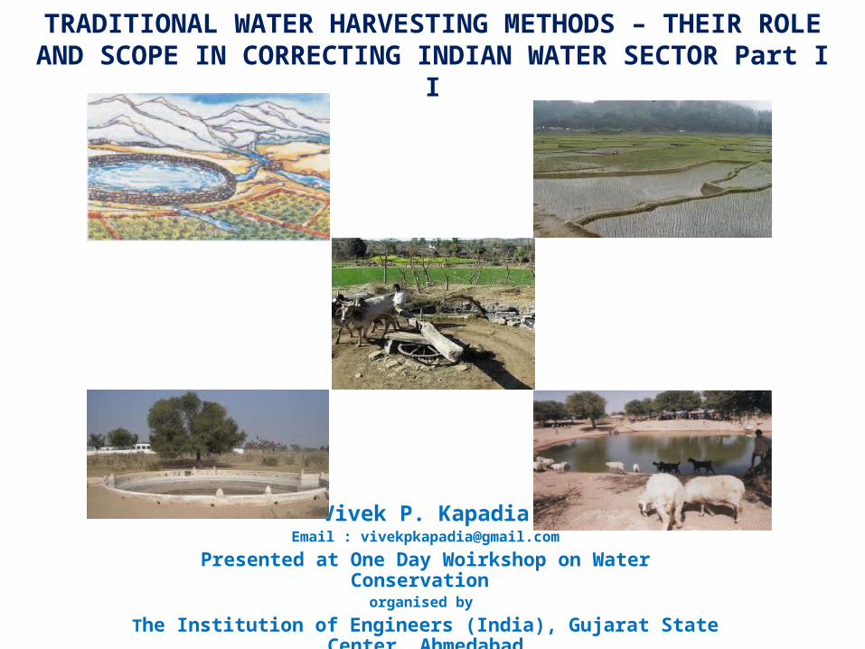
TRADITIONAL WATER HARVESTING METHODS – THEIR ROLE AND SCOPE IN CORRECTING INDIAN WATER SECTOR Part I I Vivek P. Kapadia Email : [email protected] Presented at One Day Woirkshop on Water Conservation organised by The Institution of Engineers (India), Gujarat State Center, Ahmedabad
Transcript of Traditional water harvesting methods – their role and scope in correcting indian water sector part...
TRADITIONAL WATER HARVESTING METHODS – THEIR ROLE AND SCOPE IN CORRECTING INDIAN WATER SECTOR Part I I
Vivek P. KapadiaEmail : [email protected]
Presented at One Day Woirkshop on Water Conservation organised by
The Institution of Engineers (India), Gujarat State Center, Ahmedabad
TRADITIONAL WATER CONSERVATION METHODS
2
3
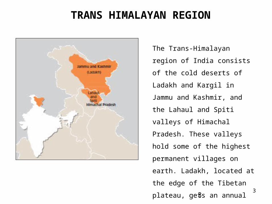
TRANS HIMALAYAN REGION
3
The Trans-Himalayan region of India
consists of the cold deserts of Ladakh
and Kargil in Jammu and Kashmir,
and the Lahaul and Spiti valleys of
Himachal Pradesh. These valleys
hold some of the highest permanent
villages on earth. Ladakh, located at
the edge of the Tibetan plateau, gets
an annual rainfall of only 140 mm.
4
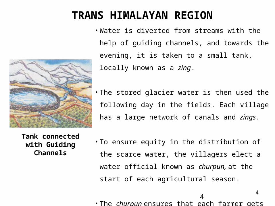
TRANS HIMALAYAN REGION
4
• Water is diverted from streams with the help of guiding
channels, and towards the evening, it is taken to a small tank,
locally known as a zing.
• The stored glacier water is then used the following day in the
fields. Each village has a large network of canals and zings.
• To ensure equity in the distribution of the scarce water, the
villagers elect a water official known as churpun, at the start
of each agricultural season.
• The churpun ensures that each farmer gets adequate water in
proportion to the area of land he owns. Disputes over use of
water are very rare.
Tank connected with Guiding Channels
5
TRANS HIMALAYAN REGION
5
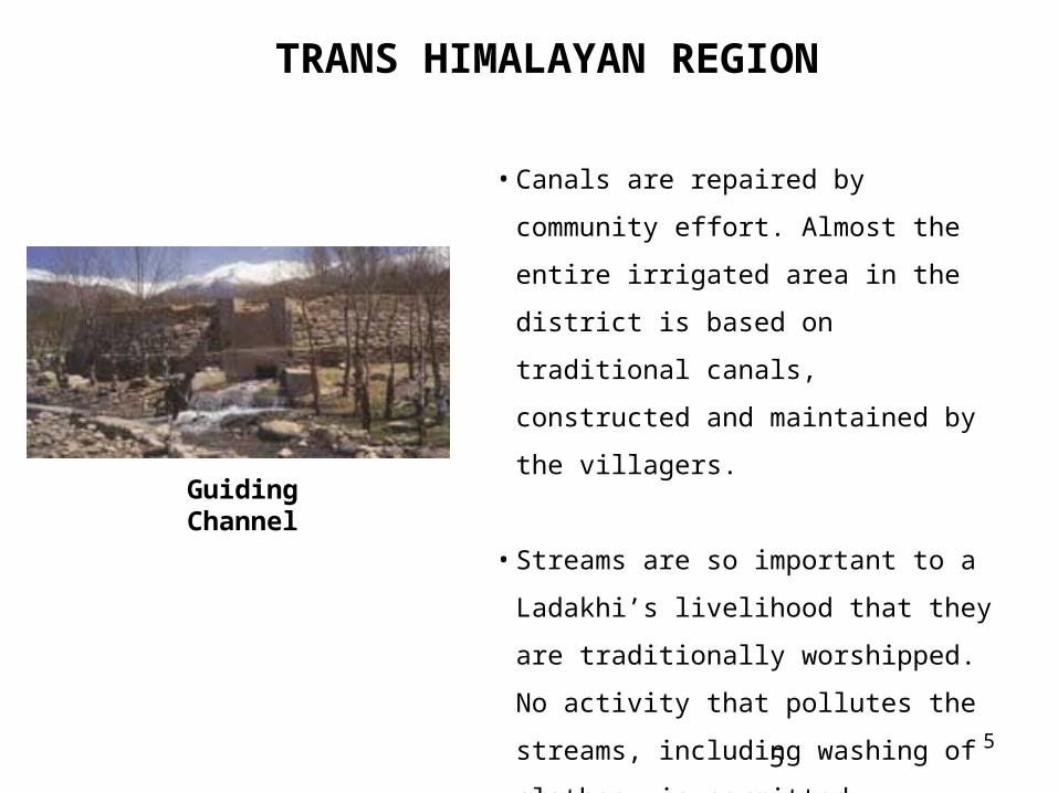
• Canals are repaired by community effort.
Almost the entire irrigated area in the district
is based on traditional canals, constructed and
maintained by the villagers.
• Streams are so important to a Ladakhi’s
livelihood that they are traditionally
worshipped. No activity that pollutes the
streams, including washing of clothes, is
permitted.
Guiding Channel
6
WESTERN HIMALAYAS
6
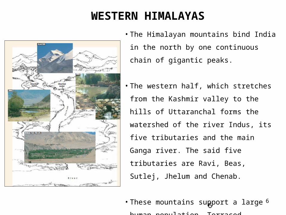
• The Himalayan mountains bind India in the north
by one continuous chain of gigantic peaks.
• The western half, which stretches from the
Kashmir valley to the hills of Uttaranchal forms the
watershed of the river Indus, its five tributaries and
the main Ganga river. The said five tributaries are
Ravi, Beas, Sutlej, Jhelum and Chenab.
• These mountains support a large human
population. Terraced agriculture is commonly
practiced on the slopes, and paddy cultivation in
the valleys and duns - the wide valleys that
separate the sub-Himalayan ranges from the middle
mountains.
7
WESTERN HIMALAYAS
7
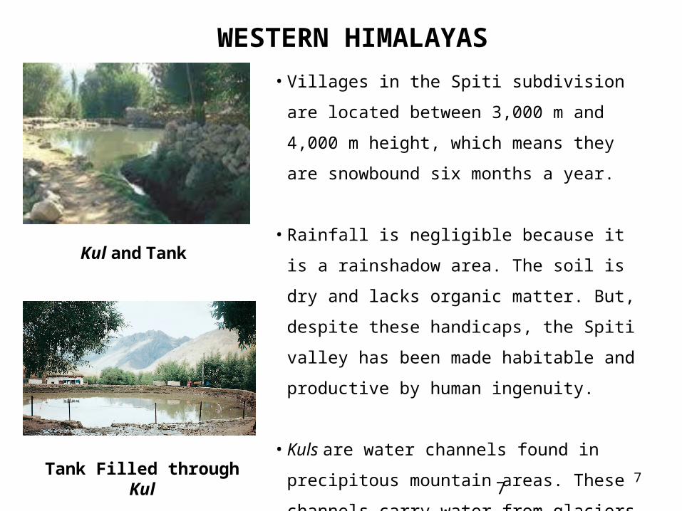
• Villages in the Spiti subdivision are located
between 3,000 m and 4,000 m height, which means
they are snowbound six months a year.
• Rainfall is negligible because it is a rainshadow
area. The soil is dry and lacks organic matter. But,
despite these handicaps, the Spiti valley has been
made habitable and productive by human
ingenuity.
• Kuls are water channels found in precipitous
mountain areas. These channels carry water from
glaciers to villages in the Spiti valley of Himachal
Pradesh. Where the terrain is muddy, the kul is
lined with rocks to keep it from becoming clogged.
Kul and Tank
Tank Filled through Kul
8
WESTERN HIMALAYAS
8
• Between sowing in April and harvesting in September, water availability is for
approximately 70 days. But if a family whose share is 30 days need kul water for only
20 days, it can sell its surplus.
• Water shares are renewed and adjusted every season according to need, but a share
cannot be lent, sold or disposed of in perpetuity.
• Water shares are renewed and adjusted every season according to need, but a share
cannot be lent, sold or disposed of in perpetuity.
9
WESTERN HIMALAYAS
9
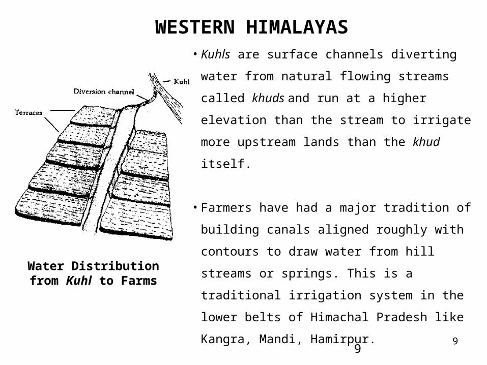
• Kuhls are surface channels diverting water from natural
flowing streams called khuds and run at a higher
elevation than the stream to irrigate more upstream
lands than the khud itself.
• Farmers have had a major tradition of building canals
aligned roughly with contours to draw water from hill
streams or springs. This is a traditional irrigation
system in the lower belts of Himachal Pradesh like
Kangra, Mandi, Hamirpur.
• The system consists of a temporary headwall
(constructed usually with river boulders) across a khud
(ravine) for storage and diversion of the flow through a
canal to the fields.
Water Distribution from Kuhl to Farms
10
WESTERN HIMALAYAS
10
• The kuhls were constructed and maintained by the village community. At the
beginning of the irrigation season, the kohli (the water tender) would organize the
irrigators to construct the headwall, repair the kuhl and make the system operational.
The kohli played the role of a local engineer. Any person refusing to participate in
construction and repair activities without valid reason, would be denied water for
that season.
11
EASTERN HIMALAYAS AND NORTH EAST HILLS
11
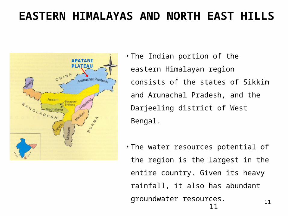
• The Indian portion of the eastern Himalayan
region consists of the states of Sikkim and
Arunachal Pradesh, and the Darjeeling district
of West Bengal.
• The water resources potential of the region is
the largest in the entire country. Given its heavy
rainfall, it also has abundant groundwater
resources.
12
EASTERN HIMALAYAS AND NORTH EAST HILLS
12
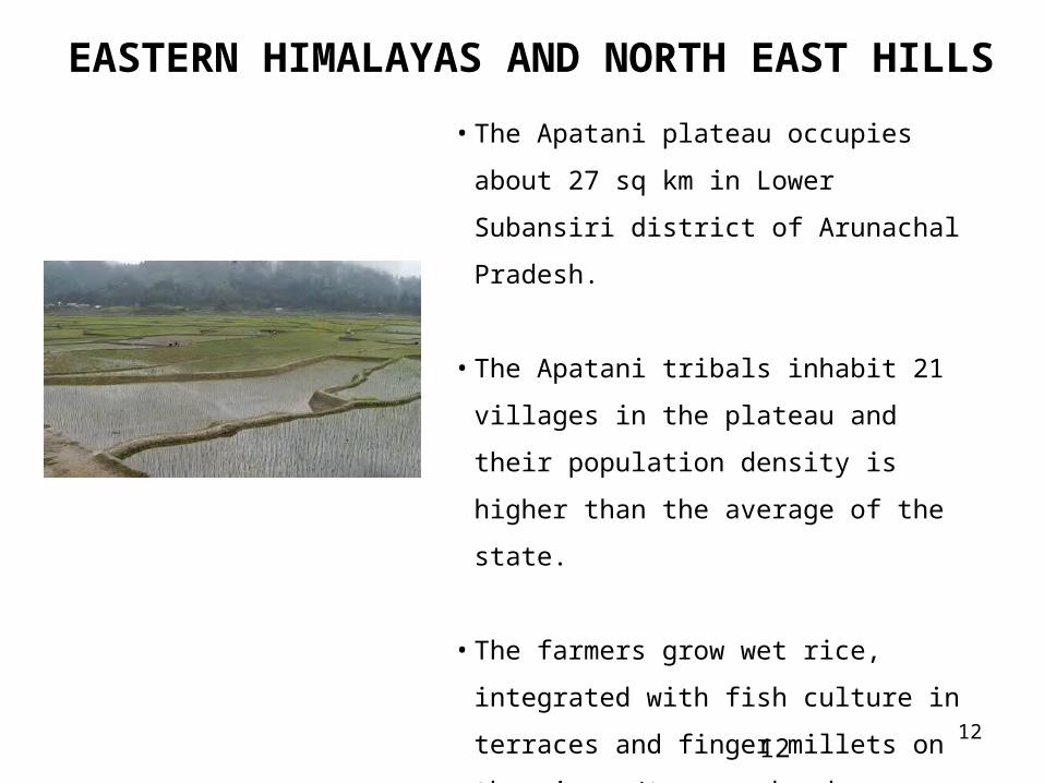
• The Apatani plateau occupies about 27 sq km in
Lower Subansiri district of Arunachal Pradesh.
• The Apatani tribals inhabit 21 villages in the
plateau and their population density is higher
than the average of the state.
• The farmers grow wet rice, integrated with fish
culture in terraces and finger millets on the
risers/terrace bunds.
• Terraces prepared in the main valley are quite
broad, perfectly leveled and provided with
strong bunds.
13
EASTERN HIMALAYAS AND NORTH EAST HILLS
13
• The slope of land in the main valley ranges between 1-8%.
• Puddling and levelling of terraces is done manually with the help of indigenous
wooden tools.
• Fish channels across the terrace are dug with wooden crowbar having flattened tip.
• Every stream arising from the surrounding hills is tapped, channelised at the rim of
the valley and diverted to the terrace fields by a network of primary, secondary and
tertiary channels.
14
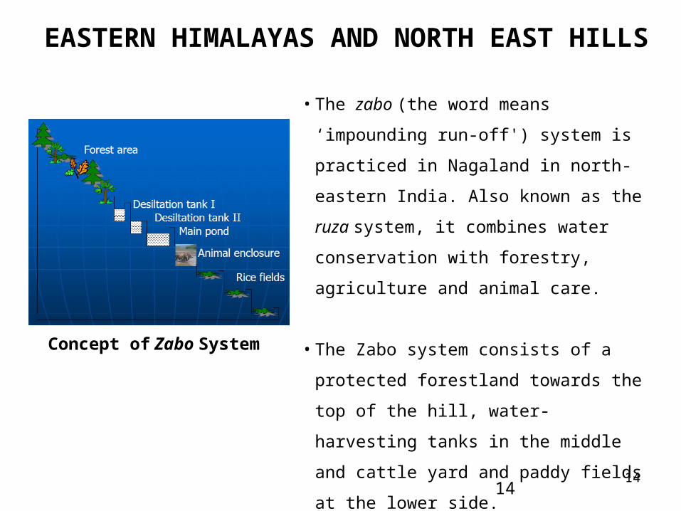
EASTERN HIMALAYAS AND NORTH EAST HILLS
14
• The zabo (the word means ‘impounding run-
off') system is practiced in Nagaland in north-
eastern India. Also known as the ruza system, it
combines water conservation with forestry,
agriculture and animal care.
• The Zabo system consists of a protected
forestland towards the top of the hill, water-
harvesting tanks in the middle and cattle yard
and paddy fields at the lower side.
Concept of Zabo System
15
EASTERN HIMALAYAS AND NORTH EAST HILLS
15
• Near the catchment area (mid-hill), silt
retention tank and water harvesting tank are
dugout with the formation of earthen
embankments. Silt retention tanks are
constructed at two or more points and the
water is kept for 2 or 3 days in these tanks
before being transferred to the main tank. The
silt retention tanks are cleaned annually and
the desilted materials, which have good
amount of organic matter and nutrients, are
transferred in the terrace fields.
Rice Fields
• In constructing the water-harvesting tank, the bottom surface is properly rammed and
sidewalls are plastered with paddy husk to minimise the loss of water through seepage.
16
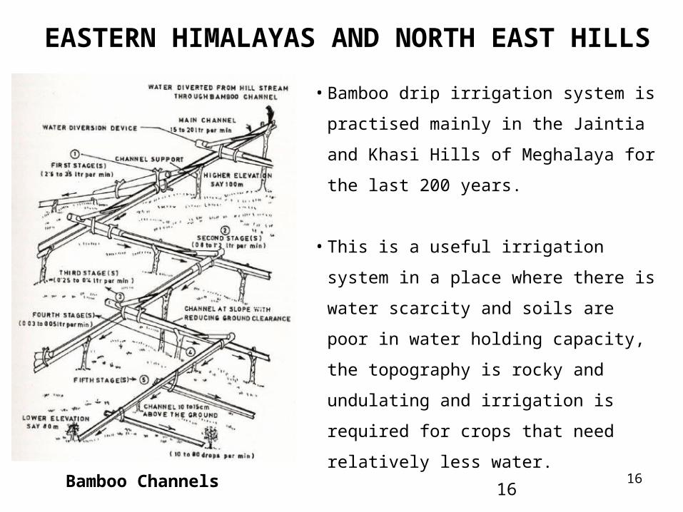
EASTERN HIMALAYAS AND NORTH EAST HILLS
16
• Bamboo drip irrigation system is practised
mainly in the Jaintia and Khasi Hills of
Meghalaya for the last 200 years.
• This is a useful irrigation system in a place
where there is water scarcity and soils are poor
in water holding capacity, the topography is
rocky and undulating and irrigation is required
for crops that need relatively less water.
Bamboo Channels
17
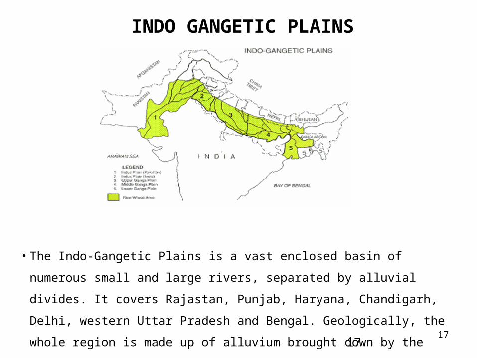
INDO GANGETIC PLAINS
17
• The Indo-Gangetic Plains is a vast enclosed basin of numerous small and large rivers,
separated by alluvial divides. It covers Rajastan, Punjab, Haryana, Chandigarh, Delhi,
western Uttar Pradesh and Bengal. Geologically, the whole region is made up of
alluvium brought down by the Himalayan rivers.
18
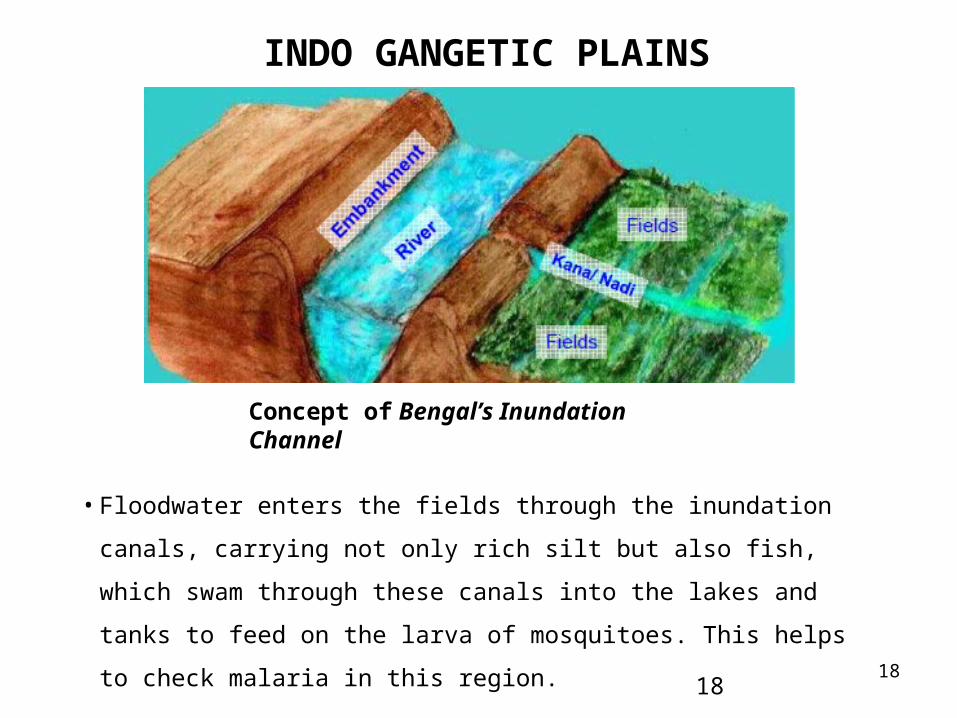
INDO GANGETIC PLAINS
18
• Floodwater enters the fields through the inundation canals, carrying not only rich
silt but also fish, which swam through these canals into the lakes and tanks to
feed on the larva of mosquitoes. This helps to check malaria in this region.
Concept of Bengal’s Inundation Channel
19
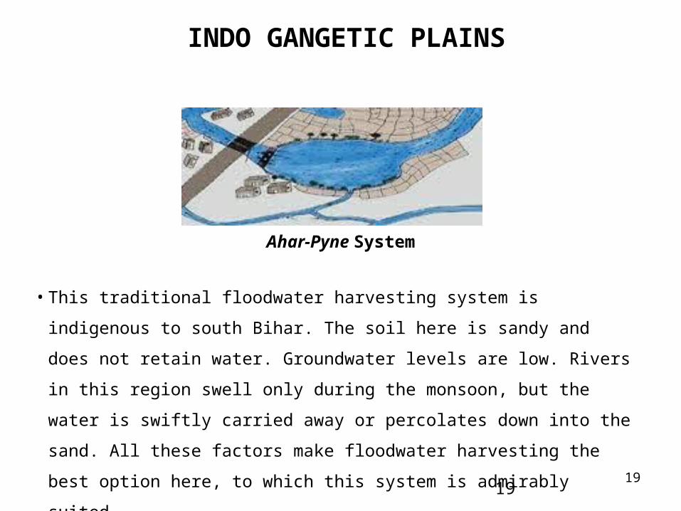
INDO GANGETIC PLAINS
19
• This traditional floodwater harvesting system is indigenous to south Bihar. The soil
here is sandy and does not retain water. Groundwater levels are low. Rivers in this
region swell only during the monsoon, but the water is swiftly carried away or
percolates down into the sand. All these factors make floodwater harvesting the best
option here, to which this system is admirably suited.
Ahar-Pyne System
20
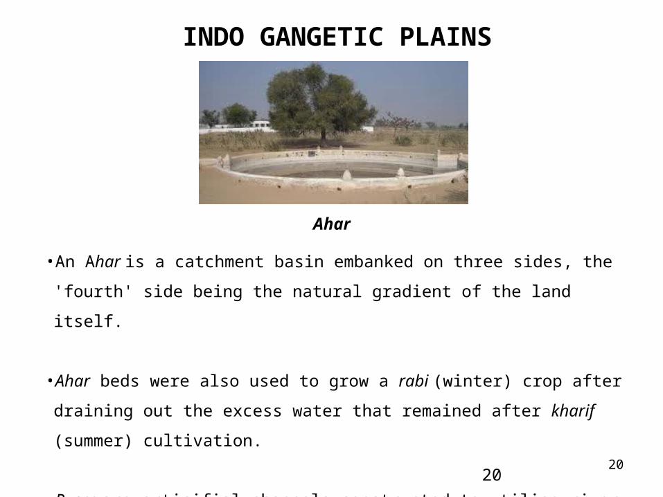
INDO GANGETIC PLAINS
20
•An Ahar is a catchment basin embanked on three sides, the 'fourth' side being the
natural gradient of the land itself.
•Ahar beds were also used to grow a rabi (winter) crop after draining out the excess
water that remained after kharif (summer) cultivation.
•Pynes are articifial channels constructed to utilise river water in agricultural fields.
Starting out from the river, pynes meander through fields to end up in an Ahar.
Ahar
21
EASTERN HIGHLANDS
21
• The Eastern Plateau extends across Jharkhand, West Bengal, Chattisgarh, Madhya
Pradesh and Orissa. The uplands of Jharkhand also known as the Chotanagpur Plateau,
cover the districts of Palamau, Ranchi, Dhanbad, Hazaribagh, Giridih, Santhal
Parganas and Singhbhum, and extend into the Purulia, Bankura, Mednipore, districts of
West Bengal. This region slopes towards the southeast.
22
EASTERN HIGHLANDS
22
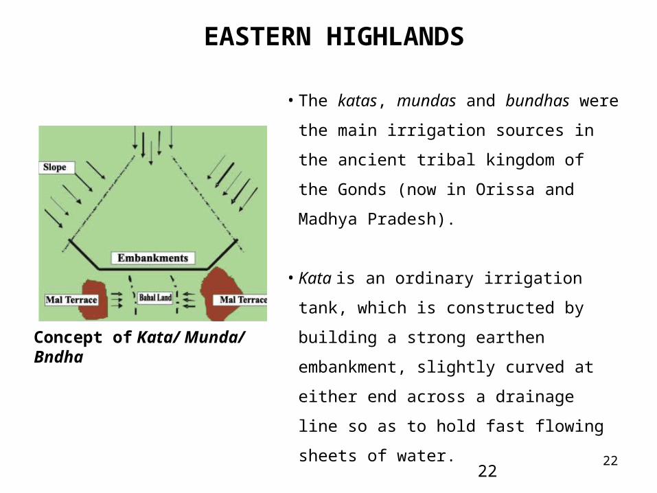
• The katas, mundas and bundhas were the main
irrigation sources in the ancient tribal kingdom
of the Gonds (now in Orissa and Madhya
Pradesh).
• Kata is an ordinary irrigation tank, which is
constructed by building a strong earthen
embankment, slightly curved at either end across
a drainage line so as to hold fast flowing sheets
of water.
Concept of Kata/ Munda/ Bndha
23
EASTERN HIGHLANDS
23
• Munda is an embankment of smaller size across a drainage channel. Embankments of
this sort are very common, as they can easily be constructed by the raiyats (individual
farmers) themselves for the benefit of their own holding.
• Bundh is a four sided tank excavated below the kata from which it derives its water by
percolation. They are almost invariably used for drinking purposes only and are
properly regarded as suitable monuments of piety or charity and are invariably
consecrated or married to a god.
• Water distribution was supervised by the village panch.
24
CENTRAL HIGHLANDS
24
• The Central Highlands comprise the semi-arid uplands of eastern Rajasthan, the
Aravalli range and the uplands of the Banas-Chambal basin in Rajasthan; the Jhansi
and Mirzapur uplands of Uttar Pradesh; the eastern hilly regions of Dangs and
Panchmahal in Gujarat; northern Madhya Pradesh uplands; the Sagar, Bhopal and the
Ratlam plateaus of central Madhya Pradesh; and the Narmada region, including the
flanks of the Vindhya and Satpura ranges of southern Madhya Pradesh.
25
EASTERN HIGHLANDS
25
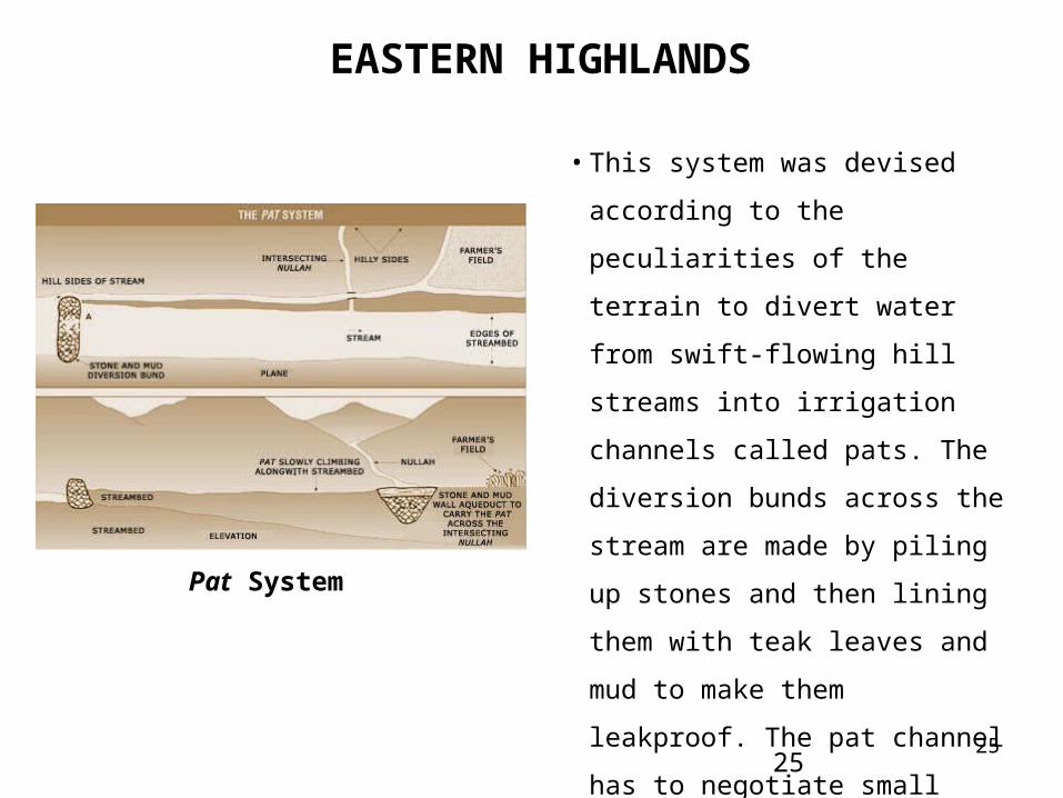
• This system was devised according to
the peculiarities of the terrain to divert
water from swift-flowing hill streams
into irrigation channels called pats.
The diversion bunds across the stream
are made by piling up stones and then
lining them with teak leaves and mud
to make them leakproof. The pat
channel has to negotiate small nullahs
that join the stream off and on, and
also sheer cliffs before reaching the
fields.
Pat System
26
EASTERN HIGHLANDS
26
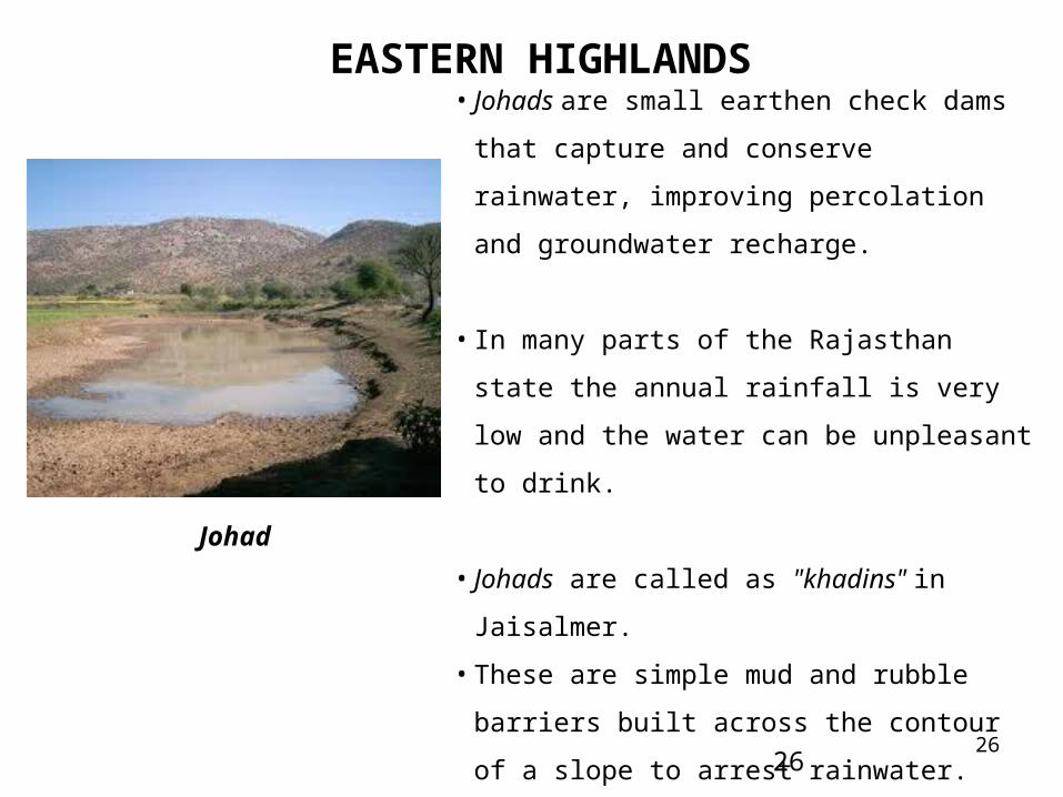
• Johads are small earthen check dams that capture
and conserve rainwater, improving percolation and
groundwater recharge.
• In many parts of the Rajasthan state the annual
rainfall is very low and the water can be unpleasant
to drink.
• Johads are called as "khadins" in Jaisalmer.
• These are simple mud and rubble barriers built
across the contour of a slope to arrest rainwater.
• These earthen check dams are meant to catch and
conserve rainwater, leading to improved percolation
and groundwater recharge.
Johad
27
THAR DESERT REGION
27
•The Thar Desert covers an area of 44.6 million hectare (mha), of which 27.8 mha lie in
India and the rest in Pakistan.
•The desert is bounded by the Aravalli hills in the east, by the fertile Indus and the Nara
valleys of Pakistan and the salt marsh of the Rann of Kutch in the west, and by the
alluvial plains of Haryana and Punjab in the north.
•Area under Thar region: Western Rajasthan, part of Gujarat—whole of Kachchh and
parts of districts like Banaskantha, Patan, Surendranagar, Punjab- whole of Bhatinda
and Ferozepur districts and Haryana-- most of Hissar and parts of Mohindergarh
districts.
28
THAR DESERT REGION
28
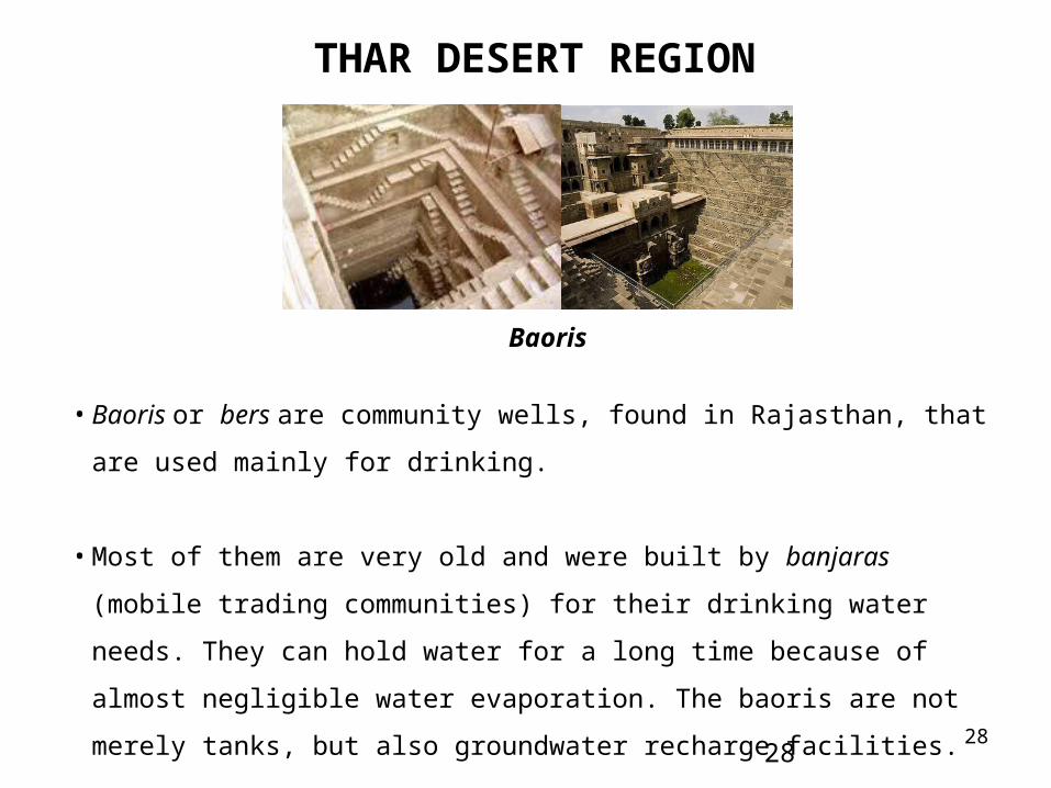
• Baoris or bers are community wells, found in Rajasthan, that are used mainly for
drinking.
• Most of them are very old and were built by banjaras (mobile trading communities)
for their drinking water needs. They can hold water for a long time because of almost
negligible water evaporation. The baoris are not merely tanks, but also groundwater
recharge facilities.
Baoris
29
THAR DESERT REGION
29
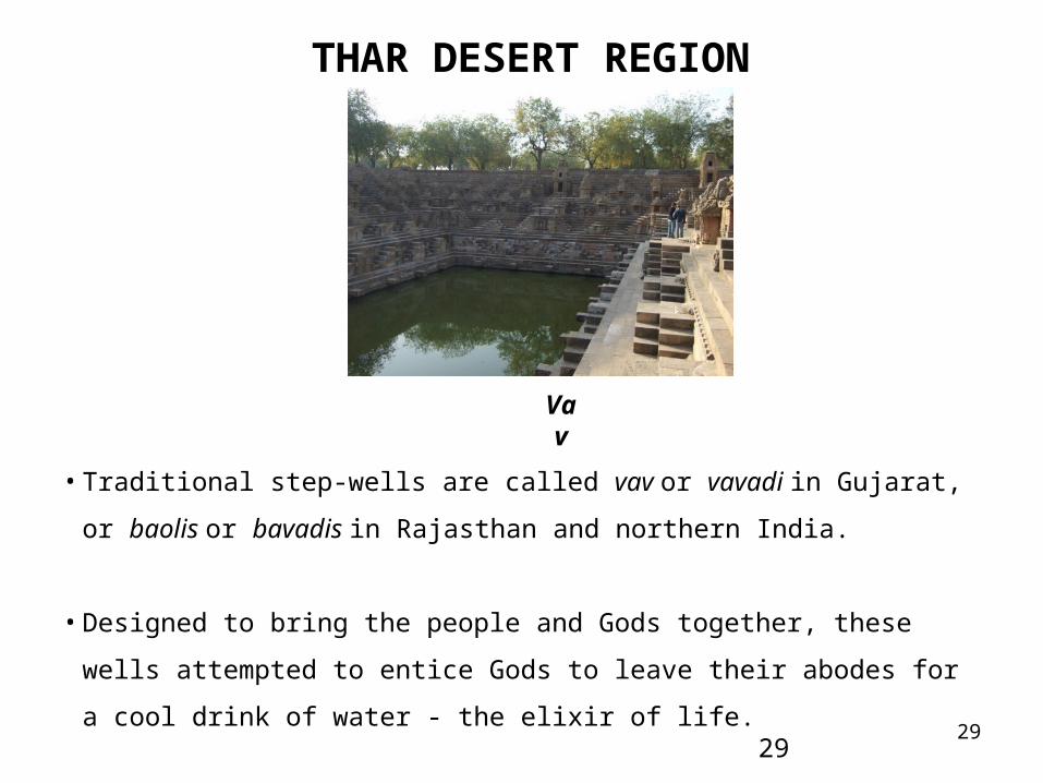
• Traditional step-wells are called vav or vavadi in Gujarat, or baolis or bavadis in
Rajasthan and northern India.
• Designed to bring the people and Gods together, these wells attempted to entice Gods
to leave their abodes for a cool drink of water - the elixir of life.
Vav
30
THAR DESERT REGION
30
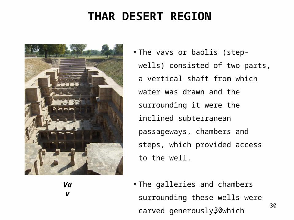
• The vavs or baolis (step-wells) consisted of
two parts, a vertical shaft from which water
was drawn and the surrounding it were the
inclined subterranean passageways,
chambers and steps, which provided access
to the well.
• The galleries and chambers surrounding
these wells were carved generously, which
became cool retreats during summers.
Vav
31
WESTERN COASTAL PLAINS
31
•The Western Coastal Plains stretch southward from the hot and near-arid Kathiawar
peninsula of Gujarat to the humid Malabar coast of Kerala. In the north, these plains are
bounded by the part of the Thar Desert lying in Gujarat. To the northeast, they are
bound by the Aravalli hills, Malwa Plateau, and Vindhya and Satpura ranges, and along
the eastern stretch by the western slopes of the Western Ghats all the way down from
Gujarat through Maharashtra, Goa and Karnataka to Kerala.
32
WESTERN COASTAL PLAINS
32
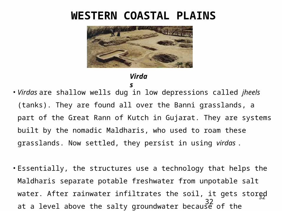
• Virdas are shallow wells dug in low depressions called jheels (tanks). They are found all
over the Banni grasslands, a part of the Great Rann of Kutch in Gujarat. They are systems
built by the nomadic Maldharis, who used to roam these grasslands. Now settled, they
persist in using virdas .
• Essentially, the structures use a technology that helps the Maldharis separate potable
freshwater from unpotable salt water. After rainwater infiltrates the soil, it gets stored at a
level above the salty groundwater because of the difference in their density.
Virdas
33
WESTERN COASTAL PLAINS
33
• A structure is built to reach down (about 1 m) to this upper layer of accumulated
rainwater. Between these two layers of sweet and saline water, there exists a zone of
brackish water. As freshwater is removed, the brackish water moves upwards, and
accumulates towards the bottom of the virda.
34
THE DECCAN PLATAU
34
•The Deccan Plateau constitutes the whole of the south Indian tableland - the elevated
region lying east of the Western Ghats. The plateau occupies large parts of Maharashtra
and Karnataka and a portion of Andhra Pradesh.
35
THE DECCAN PLATAU
35
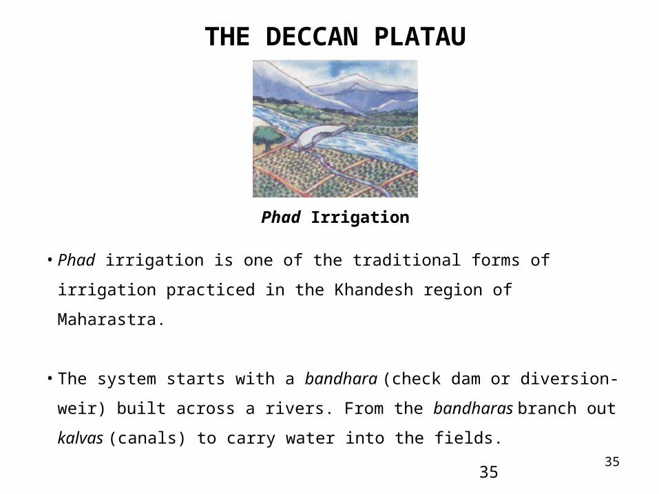
• Phad irrigation is one of the traditional forms of irrigation practiced in the Khandesh
region of Maharastra.
• The system starts with a bandhara (check dam or diversion-weir) built across a rivers.
From the bandharas branch out kalvas (canals) to carry water into the fields.
Phad Irrigation
36
THE DECCAN PLATAU
36
• Charis (distributaries) are built for feeding water from the kalva to different areas of
the phad. Sarangs (field channels) carry water to individual fields. Sandams (escapes),
along with kalvas and charis , drain away excess water.
• In this way water reaches the kayam baghayat (agricultural command area), usually
divided into four phads (blocks). The size of a phad can vary from 10-200 ha, the
average being 100-125 ha.
• Every year, the village decides which phads to use and which to leave fallow. Only
one type of crop is allowed in one phad. Generally, sugarcane is grown in one or two
phads; seasonal crops are grown in the others. This ensures a healthy crop rotation
system that maintains soil fertility, and reduces the danger of waterlogging and
salinity.

37
THE DECCAN PLATAU
37
•These are check dams or diversion weirs built
across rivers.
•A traditional system found in Maharashtra, their
presence raises the water level of the rivers so that it
begins to flow into channels.
•Where a bandhara was built across a small stream,
the water supply would usually last for a few
months after the rains.
•They are built either by villagers or by private
persons who received rent-free land in return for
their public act.
Bandhara
Bandhara Across a Stream
38
THE DECCAN PLATAU
38
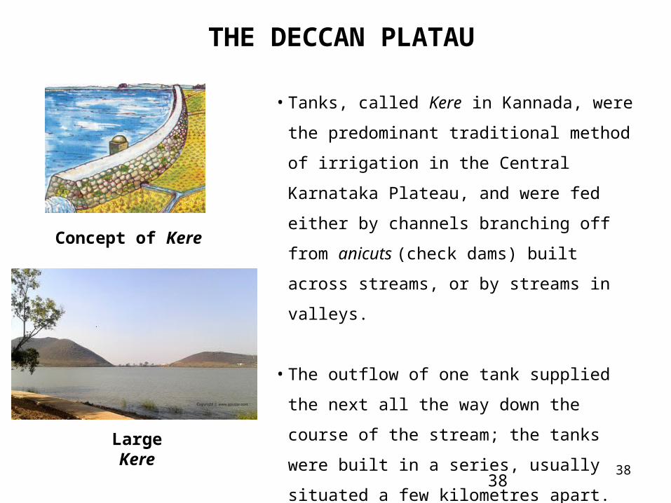
• Tanks, called Kere in Kannada, were the
predominant traditional method of irrigation in the
Central Karnataka Plateau, and were fed either by
channels branching off from anicuts (check dams)
built across streams, or by streams in valleys.
• The outflow of one tank supplied the next all the
way down the course of the stream; the tanks were
built in a series, usually situated a few kilometres
apart. This ensured no wastage through overflow,
and the seepage of a tank higher up in the series
would be collected in the next lower one.
Concept of Kere
Large Kere
39
SOUTH EASTERN COASTAL PLAINS
39
• The South Eastern Coastal Plain is a wide and long stretch of land that lies between
the Eastern Ghats and the Bay of Bengal. The major rivers which pass through this
region have carved out broad valleys and deltas.
40
SOUTH EASTERN COASTAL PLAINS
40
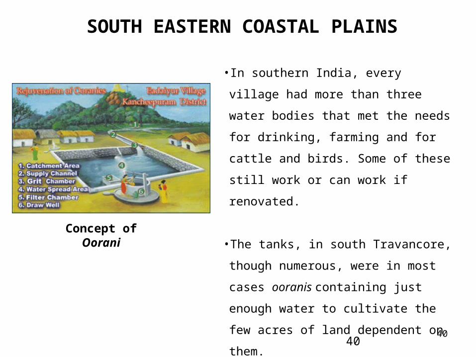
• In southern India, every village had more than
three water bodies that met the needs for
drinking, farming and for cattle and birds.
Some of these still work or can work if
renovated.
•The tanks, in south Travancore, though
numerous, were in most cases ooranis
containing just enough water to cultivate the
few acres of land dependent on them.
Concept of Oorani
41
SOUTH EASTERN COASTAL PLAINS
41
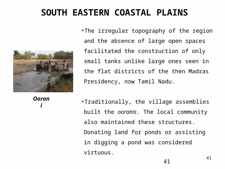
•The irregular topography of the region and the absence
of large open spaces facilitated the construction of only
small tanks unlike large ones seen in the flat districts of
the then Madras Presidency, now Tamil Nadu.
•Traditionally, the village assemblies built the ooranis.
The local community also maintained these structures.
Donating land for ponds or assisting in digging a pond
was considered virtuous.
•The maximum benefit from using oorani water goes to
women who usually fetch water for domestic needs.
Oorani
42
WESTERN GHATS
42
• The Western Ghats constitute a narrow but long range of hills running from north to
south along the western coast of India.
• The Western Ghats extend from Gujarat to Kerala, traversing the states of
Maharashtra, Goa and Karnataka.
• The ghats end as low hills in the Kanyakumari district of Tamil Nadu, situated at the
southern tip of India. The eastern flanks of the Western Ghats extend into Tirunelveli,
Ramanathpuram and Madurai districts of Tamil Nadu.
43
SOUTH EASTERN COASTAL PLAINS
43
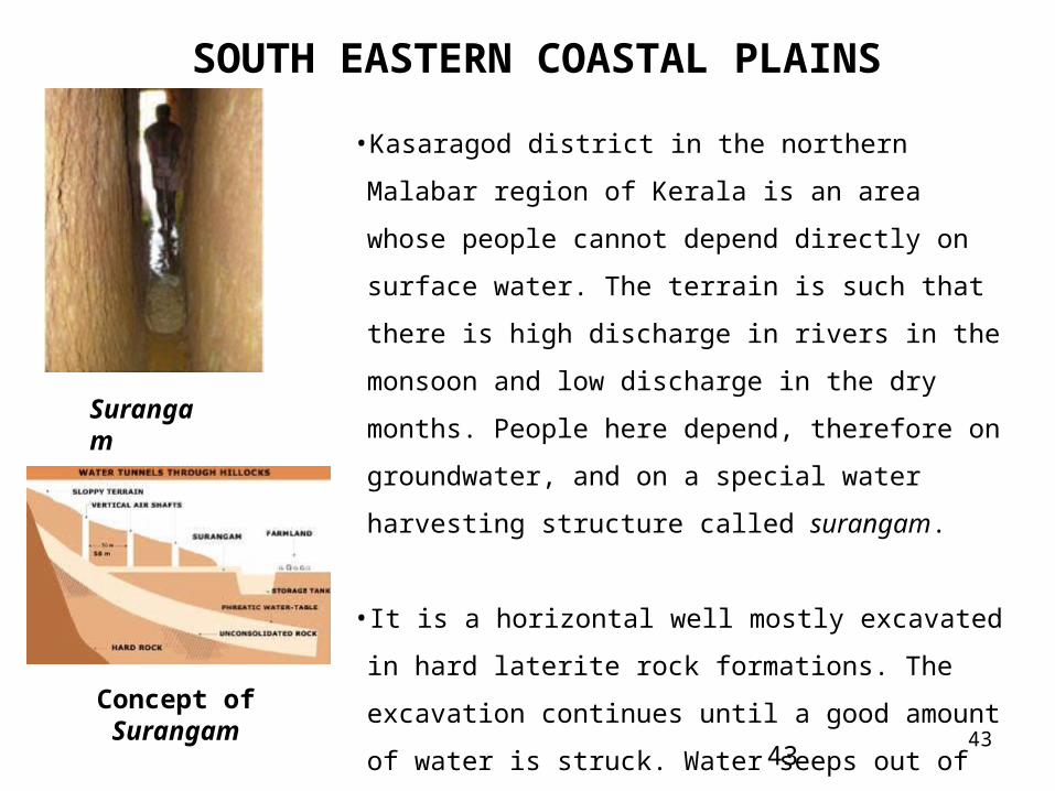
•Kasaragod district in the northern Malabar region of Kerala
is an area whose people cannot depend directly on surface
water. The terrain is such that there is high discharge in
rivers in the monsoon and low discharge in the dry months.
People here depend, therefore on groundwater, and on a
special water harvesting structure called surangam.
• It is a horizontal well mostly excavated in hard laterite rock
formations. The excavation continues until a good amount
of water is struck. Water seeps out of the hard rock and
flows out of the tunnel. This water is usually collected in an
open pit constructed outside the surangam.
Surangam
Concept of Surangam
44
SOUTH EASTERN COASTAL PLAINS
44
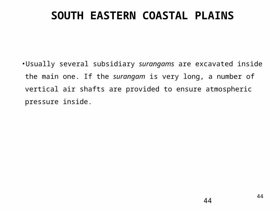
•Usually several subsidiary surangams are excavated inside the main one. If the
surangam is very long, a number of vertical air shafts are provided to ensure
atmospheric pressure inside.
45
CONCLUSIONS
Without addressing the entire agriculturable land, potential of land resources could
not be fully utilized and water sector can not be said to be in order
Placing Water Sector in order is the key to Indian prosperity – all other corrections
would follow
45
Centralized approach to water management has limitations – decentralized
approach may be applied as complementary to it rather than an alternative – Indian
traditional methods of water conservation and utilization are based on
decentralized approach, environmental enrichment, groundwater recharge,
wholistic view towards water, community participation, cost effectiveness, etc. and
hence are much more promising and time-tested and hence can better introduce
corrections to the Indian water sector
CONCLUSIONS
India preaches the values which include veneration of resources rather than
viewing them as a subject to consumption - if education system is made founded
on these values, modern society would become sensitive to environment and hence
would automatically opt for sustainable ways of development – for the world to be
better, the mankind must understand the significance of honoring the nature and its
gift in the form of five basic elements – earth, water, space, light and fire
46
For India to make progress, address the basic issues of ignorant masses who do
not have access to safe drinking water, sanitation, food, education, home, etc. as
by ignoring the so-called ignorant, India has become and remained slave for
centuries and even today is not free in true sense
THANKS TO ALL47