TRACT 42472 - East Carroll Parish, Louisiana 51.67 … · TRACT 42472 - East Carroll Parish,...
17
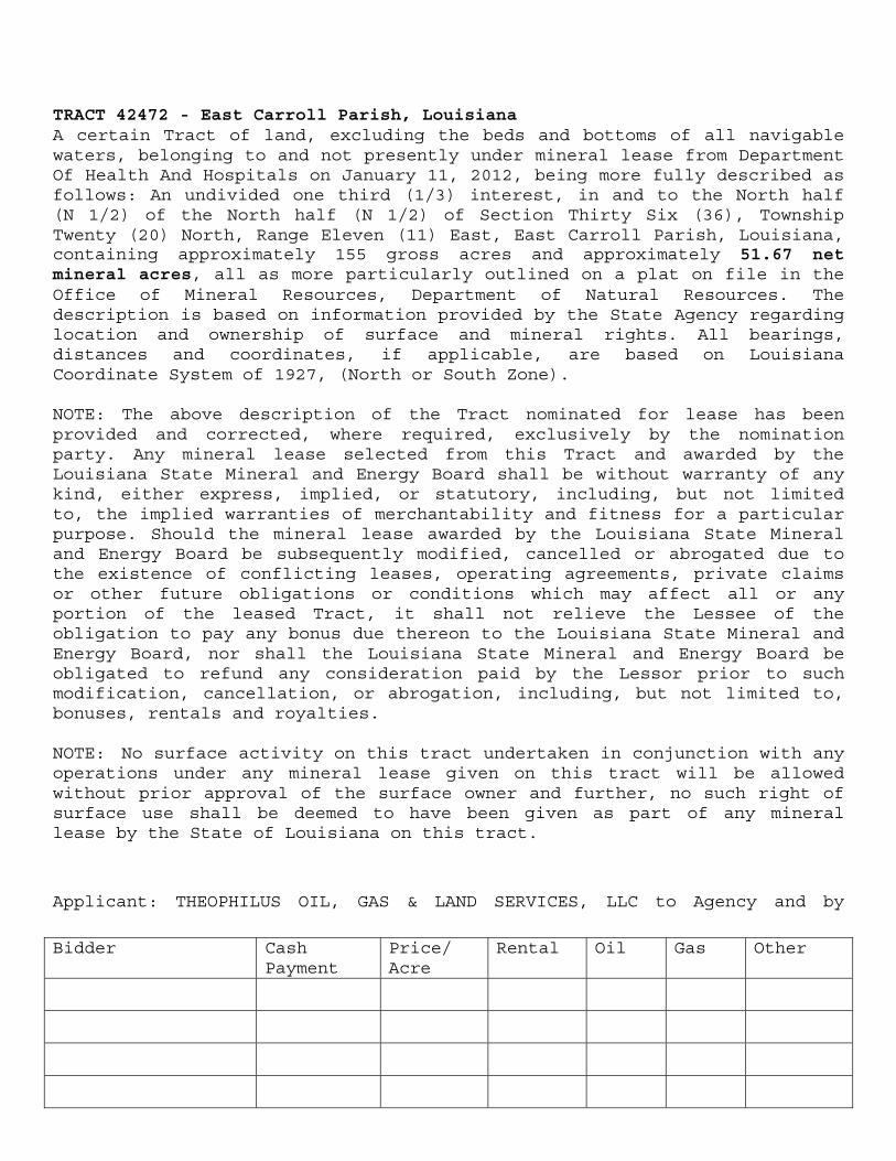
TRACT 42472 - East Carroll Parish, Louisiana A certain Tract of land, excluding the beds and bottoms of all navigable waters, belonging to and not presently under mineral lease from Department Of Health And Hospitals on January 11, 2012, being more fully described as follows: An undivided one third (1/3) interest, in and to the North half (N 1/2) of the North half (N 1/2) of Section Thirty Six (36), Township Twenty (20) North, Range Eleven (11) East, East Carroll Parish, Louisiana, containing approximately 155 gross acres and approximately 51.67 net mineral acres, all as more particularly outlined on a plat on file in the Office of Mineral Resources, Department of Natural Resources. The description is based on information provided by the State Agency regarding location and ownership of surface and mineral rights. All bearings, distances and coordinates, if applicable, are based on Louisiana Coordinate System of 1927, (North or South Zone). NOTE: The above description of the Tract nominated for lease has been provided and corrected, where required, exclusively by the nomination party. Any mineral lease selected from this Tract and awarded by the Louisiana State Mineral and Energy Board shall be without warranty of any kind, either express, implied, or statutory, including, but not limited to, the implied warranties of merchantability and fitness for a particular purpose. Should the mineral lease awarded by the Louisiana State Mineral and Energy Board be subsequently modified, cancelled or abrogated due to the existence of conflicting leases, operating agreements, private claims or other future obligations or conditions which may affect all or any portion of the leased Tract, it shall not relieve the Lessee of the obligation to pay any bonus due thereon to the Louisiana State Mineral and Energy Board, nor shall the Louisiana State Mineral and Energy Board be obligated to refund any consideration paid by the Lessor prior to such modification, cancellation, or abrogation, including, but not limited to, bonuses, rentals and royalties. NOTE: No surface activity on this tract undertaken in conjunction with any operations under any mineral lease given on this tract will be allowed without prior approval of the surface owner and further, no such right of surface use shall be deemed to have been given as part of any mineral lease by the State of Louisiana on this tract. Applicant: THEOPHILUS OIL, GAS & LAND SERVICES, LLC to Agency and by Bidder Cash Payment Price/ Acre Rental Oil Gas Other
Transcript of TRACT 42472 - East Carroll Parish, Louisiana 51.67 … · TRACT 42472 - East Carroll Parish,...
TRACT 42472 - East Carroll Parish, Louisiana A certain Tract of land, excluding the beds and bottoms of all navigable waters, belonging to and not presently under mineral lease from Department Of Health And Hospitals on January 11, 2012, being more fully described as follows: An undivided one third (1/3) interest, in and to the North half (N 1/2) of the North half (N 1/2) of Section Thirty Six (36), Township Twenty (20) North, Range Eleven (11) East, East Carroll Parish, Louisiana, containing approximately 155 gross acres and approximately 51.67 net mineral acres, all as more particularly outlined on a plat on file in the Office of Mineral Resources, Department of Natural Resources. The description is based on information provided by the State Agency regarding location and ownership of surface and mineral rights. All bearings, distances and coordinates, if applicable, are based on Louisiana Coordinate System of 1927, (North or South Zone). NOTE: The above description of the Tract nominated for lease has been provided and corrected, where required, exclusively by the nomination party. Any mineral lease selected from this Tract and awarded by the Louisiana State Mineral and Energy Board shall be without warranty of any kind, either express, implied, or statutory, including, but not limited to, the implied warranties of merchantability and fitness for a particular purpose. Should the mineral lease awarded by the Louisiana State Mineral and Energy Board be subsequently modified, cancelled or abrogated due to the existence of conflicting leases, operating agreements, private claims or other future obligations or conditions which may affect all or any portion of the leased Tract, it shall not relieve the Lessee of the obligation to pay any bonus due thereon to the Louisiana State Mineral and Energy Board, nor shall the Louisiana State Mineral and Energy Board be obligated to refund any consideration paid by the Lessor prior to such modification, cancellation, or abrogation, including, but not limited to, bonuses, rentals and royalties. NOTE: No surface activity on this tract undertaken in conjunction with any operations under any mineral lease given on this tract will be allowed without prior approval of the surface owner and further, no such right of surface use shall be deemed to have been given as part of any mineral lease by the State of Louisiana on this tract.
Applicant: THEOPHILUS OIL, GAS & LAND SERVICES, LLC to Agency and by
Bidder Cash Payment
Price/ Acre
Rental Oil Gas Other

2
Resolution from the Department Of Health And Hospitals authorizing the Mineral Board to act in its behalf
3
Office of Mineral Resources, Acres: 51.67 Tract Number: 42472
4
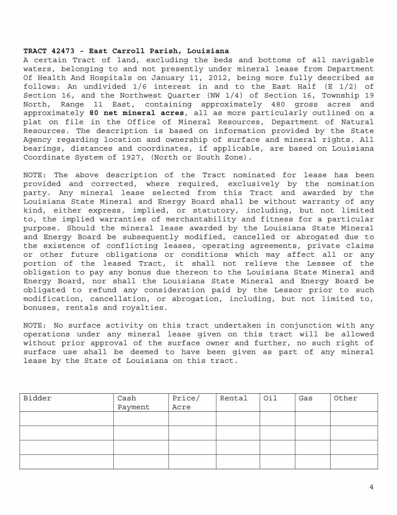
TRACT 42473 - East Carroll Parish, Louisiana A certain Tract of land, excluding the beds and bottoms of all navigable waters, belonging to and not presently under mineral lease from Department Of Health And Hospitals on January 11, 2012, being more fully described as follows: An undivided 1/6 interest in and to the East Half (E 1/2) of Section 16, and the Northwest Quarter (NW 1/4) of Section 16, Township 19 North, Range 11 East, containing approximately 480 gross acres and approximately 80 net mineral acres, all as more particularly outlined on a plat on file in the Office of Mineral Resources, Department of Natural Resources. The description is based on information provided by the State Agency regarding location and ownership of surface and mineral rights. All bearings, distances and coordinates, if applicable, are based on Louisiana Coordinate System of 1927, (North or South Zone). NOTE: The above description of the Tract nominated for lease has been provided and corrected, where required, exclusively by the nomination party. Any mineral lease selected from this Tract and awarded by the Louisiana State Mineral and Energy Board shall be without warranty of any kind, either express, implied, or statutory, including, but not limited to, the implied warranties of merchantability and fitness for a particular purpose. Should the mineral lease awarded by the Louisiana State Mineral and Energy Board be subsequently modified, cancelled or abrogated due to the existence of conflicting leases, operating agreements, private claims or other future obligations or conditions which may affect all or any portion of the leased Tract, it shall not relieve the Lessee of the obligation to pay any bonus due thereon to the Louisiana State Mineral and Energy Board, nor shall the Louisiana State Mineral and Energy Board be obligated to refund any consideration paid by the Lessor prior to such modification, cancellation, or abrogation, including, but not limited to, bonuses, rentals and royalties. NOTE: No surface activity on this tract undertaken in conjunction with any operations under any mineral lease given on this tract will be allowed without prior approval of the surface owner and further, no such right of surface use shall be deemed to have been given as part of any mineral lease by the State of Louisiana on this tract.
Bidder Cash Payment
Price/ Acre
Rental Oil Gas Other

5
Applicant: THEOPHILUS OIL, GAS & LAND SERVICES, LLC to Agency and by Resolution from the Department Of Health And Hospitals authorizing the Mineral Board to act in its behalf
6
Office of Mineral Resources, Acres: 80 Tract Number: 42473
7
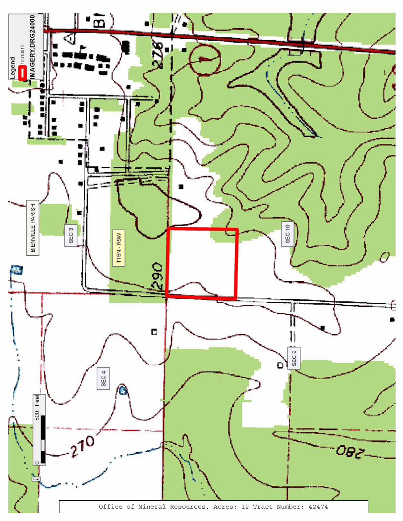
TRACT 42474 - Bienville Parish, Louisiana A certain Tract of land, excluding the beds and bottoms of all navigable waters, belonging to and not presently under mineral lease from Town Of Ringgold on January 11, 2012, being more fully described as follows: A 12.0 acre tract in the West 2/3 of the NW 1/4 of the NW 1/4 of Section 10, Township 15 North, Range 9 West, Ringgold, Bienville Parish, Louisiana, more particularly described as follows; From the iron pipe marking the NW corner of Section 10, Township 15 North, Range 9 West, run South 89 degrees 49 feet East along the North line of said Section 10, 153.00 ft. to an iron rod on the East R/W of a parish blacktop road, and the point of beginning; thence continue South 89 degrees 49 feet East 725.20 ft. to an iron rod at the NE corner of the West 2/3 of NW 1/4 of the NW 1/4; thence run South l degrees 28 feet W, 720.80 ft. to an iron rod; thence run North 89 degrees 49 feet W, 725.20 ft. to an iron rod on the East R/W of the aforementioned parish blacktop road; thence run North l degrees 28 feet East along said R/W, 720.80 ft. to the point of beginning, containing approximately 12 acres, all as more particularly outlined on a plat on file in the Office of Mineral Resources, Department of Natural Resources. The description is based on information provided by the State Agency regarding location and ownership of surface and mineral rights. All bearings, distances and coordinates, if applicable, are based on Louisiana Coordinate System of 1927, (North or South Zone). NOTE: The above description of the Tract nominated for lease has been provided and corrected, where required, exclusively by the nomination party. Any mineral lease selected from this Tract and awarded by the Louisiana State Mineral and Energy Board shall be without warranty of any kind, either express, implied, or statutory, including, but not limited to, the implied warranties of merchantability and fitness for a particular purpose. Should the mineral lease awarded by the Louisiana State Mineral and Energy Board be subsequently modified, cancelled or abrogated due to the existence of conflicting leases, operating agreements, private claims or other future obligations or conditions which may affect all or any portion of the leased Tract, it shall not relieve the Lessee of the obligation to pay any bonus due thereon to the Louisiana State Mineral and Energy Board, nor shall the Louisiana State Mineral and Energy Board be obligated to refund any consideration paid by the Lessor prior to such modification, cancellation, or abrogation, including, but not limited to, bonuses, rentals and royalties. NOTE: The Town of Ringgold will require a minimum bonus of $5000 per acre and a minimum royalty of 25%.
NOTE: The following conditions will apply to any lease granted on this tract:

8
1. If in the event of production, a division order is circulated by Lessee, assigns or the purchaser of production, such division order will be a simple statement of interest containing no warranty or indemnity clauses and containing no clauses modifying in any way the terms of this lease. The insertion of any such clauses will be of no force and effect so far as concerns Lessor or its assigns and heirs. It shall not be a requirements upon Lessor to execute said division Order, however Lessor agrees to provide confirmation of its, name, address, and social security or tax identification number.
2. This lease shall be binding upon and inure to the benefit of the
heirs, assigns, subleases, successors and legal representatives of the parties hereto, whether a party hereto or whether bound by operation of law.
3. It is specifically understood and agreed that this lease covers only
oil, gas, sulphur, associated liquid or liquefiable hydrocarbons. Accordingly, the words “oil, gas” when used herein, shall mean oil, gas, sulphur and associated liquid or liquefiable hydrocarbons, and the words “all other minerals” whenever used herein shall be stricken from this lease so that such “all other minerals,” including but not limited to coal, lignite, sands, graphites, rocks, metals, and/or other natural substances of every nature and kind are reserved to the Lessor.
4. This lease is granted and made without any warranty whatsoever and
without any recourse against Lessor whatsoever, either express or implied, even to the extent of any monies or benefits received under any of the terms hereof.
5. After the expiration of the primary term or any extension thereof,
this lease shall terminate as to all depths Two hundred feet (200’) below the stratigraphic equivalent of the deepest depth drilled by any well drilled in the leased premises or on acreage pooled therewith on the expiration of the primary term or any extension thereof, including any extension per the provisions of Paragraph 6 of the Lease providing for continuous operations. Provided however, that if a productive formation is discovered and the same is producing when the depth limitation takes effect, this lease shall extend to the greater of (1) two hundred feet (200’) below the stratigraphic equivalent of the base of such formation (as defined in the Louisiana Conservation Commission Field Order for such formation) or (2) two hundred feet (200’) below the stratigraphic equivalent of the deepest depth drilled by any wells drilled in the leased premises or on acreage pooled therewith.
6. In the event of default on the part of Lessee in the performance of
any of the covenants or obligations assumed by Lessee herein, and should it become necessary for Lessor to employ an attorney at law to
9
enforce any such provision or covenant of this lease, Lessee agrees to pay Lessor any reasonable cost incurred in such enforcement, including reasonable attorney’s fees and reasonable costs incurred. Also, in the event of default on the part of Lessor in the performance of any of the covenants or obligations assumed by Lessor herein, and should it become necessary for Lessee to employ an attorney at law to enforce any such provision or covenant of this lease, Lessor agrees to pay Lessee any reasonable cost incurred in such enforcement, including attorney’s reasonable fees and reasonable costs incurred.
7. It is expressly provided that no part of this lease shall be
maintained by shut-in royalty payment for more than Twenty four months, and in no event shall shut-in payments be made arbitrarily so as to deprive the Lessor of the production and royalties that said Lessor is entitled to by virtue of their mineral interests, mineral rights and their rights under this lease.
8. (A) Lessor or its assigns shall notify Lessor thirty (30) days prior
to operations being conducted on the Leased premises and make all payment due hereunder for surface damages (10) days prior to entry on the premises. Lessee or its assigns shall pay Lessor for the appraised value of any timber to be removed by Lessee’s operations hereunder.
Lessee or its assigns shall reimburse Lessor for the cost of Lessor’s
forester’s appraisal of said timber. Lessor reserves the right to salvage the appraised timber to be removed. Moreover, Lessee or its assigns shall also reimburse Lessor for the reasonable value of damages to the surface of the leased premises, which damages have been caused by Lessee’s use thereof or negligence thereon.
Lessee or its assigns agree to fill and level all slush pits so as to
return the surface to the original condition as nearly as practical within ninety (90) days after the abandonment of the use of such pit. Lessees or its assigns agree to conduct all operations in compliance with the recommendations of the Louisiana Forestry Association contained in the brochure entitled Recommended Forestry Best Management Practices for Louisiana and dated April, 1988.
(B) No timber, brush debris, stumps or soil, etc. shall be pushed or
piled outside the area cleared or used by Lessee. Cattle guards, drainage culverts and gates installed by Lessee on roads or other areas shall be left in place and intact, and keys provided to Lessor. All road location surfacing material (except wooden boards) shall be left in place and shall revert to the Lessor as landowner, subject to the servitudes and rights of way created by the Lessor by his acts.
10
9. Lessee or its assigns will execute and record a formal act releasing from operation of this lease all acreage and formations not held by operations, shut-in payments, production or any other manner provided for in this lease within ninety (90) days of the expiration of the primary term or any extension thereof. Lessee will furnish Lessor a certified copy of said recorded release and any associated instruments, notices, Orders, rules, rulings, or other documentary materials relative to the leasehold within ten days of written request.
10. Wherever the designation “One-Eighth (1/8th)” appears in the printed
lease form covering and referring to royalty payments, the designation One-Fourth (1/4th or 25%) shall be substituted therefore, so that the royalty due Lessor on all production from the property shall be Twenty-Five percent of that produced from said lands or attributable to the mineral rights of Lessor.
11. Lessee or its assigns shall insure, indemnify and hold Lessor
harmless from any and all responsibility for their operations and those of their subcontractors, and further any liability and responsibility concerning wetlands, environmental laws or regulations, scenic rivers or endangered species statutes as a result of Lessee’s operations and agree to conduct operations in compliance with any and all statutes or regulations concerning the same.
12. No solids, liquids, gases or combinations thereof other than those
necessary to actually drill and complete the wells on the leased premises shall be injected into any lands of Lessor or any subsurface zone, horizon, formation or strata for the purpose of disposal without the express written consent of the Lessor.
13. Lessee shall bury all pipelines in the ground (except those on the
well site) between twenty-four and forty-eight inches below normal ground level where contours of the surface will permit. In the event that Lessor enters into agricultural operations on said lands prior to the beginning of construction operations, then said depth shall be forty-eight inches.
14. In the event of production, Lessee shall erect, install, and maintain
at no cost to Lessor a metal gate at the points of entry and exit to the herein described lands. Said gates shall be constructed of not less than two (2”) diameter iron pipe with appropriate wings on each side of said gates to prevent vehicular traffic around the ends of said gates. Access to the through the gate shall be provided to Lessor or his designated agents at all times.
15. This lease is made expressly subject to all terms, conditions and
provisions as numbered 14 – 19 herein, and all of said provisions shall prevail over the original provisions in this lease form.
11
16. Any equipment including but not limited to, piping, tubing,
compressors, tanks, separators, pumping units, etc., left in the wells or on the property covered by this lease shall revert to the LESSOR, at LESSOR’S option, if not removed within 180 days from the termination of this lease or the cessation of operations, for example, by the plug and abandonment of the well.
17. Lessors mineral rights and royalty shall be calculated free and clear
of costs and expenses for exploration, drilling, development and production including, but not limited to, dehydration, storage, compression, separation by mechanical means and product stabilization, transportation, processing, or treatment, and Lessors royalty shall bear only its proportionate share of ad valorem taxes and production, severance, or other excise taxes attributable to Lessors share of royalty. Further, it is agreed that Lessor royalty shall be calculated at the price of natural gas of the established market facilities used by third parties in arms length transactions, at the sales point of production.
18. It is further agreed that the Bonus royalty herein paid and the
production royalties herein provided are the principal inducement to Lessor to enter into this contract of lease, and same shall be payable by company check or third party certified funds only.
19. Lessor does hereby acknowledge and grant to the Lessee the right to
use the leased premises described on the attached Exhibit “A” for the purpose of drilling (directionally and/or horizontally), testing, completing, producing, operating, re-working, re-drilling, and maintaining a well or wells that has a bottom hole location or locations beneath lands which are included in a unit that does not include any part of the leased premises (individually, a “well”). Lessee shall also have the right to log and test strata and formations penetrated by the borehole of the well or wells.
In addition, Lessor hereby grants, assigns and conveys unto Lessee, its successors and assigns, a subsurface well bore servitude and right of use over Lessor’s lands for the placement of well bores (along routes selected by Lessee) from the well or wells drilled on the leased premises, along with the right to place, repair, abandon and extract such piping, casing, and other equipment or material as may be necessary, useful or convenient in the operations described herein in connection with the well or wells. It is hereby understood that no royalties will be paid to Lessor for any well or wells that is completed in a unit in which the Lessor owns no mineral interest.
12
Applicant: HUNTER ENERGY CORPORATION to Agency and by Resolution from the Town Of Ringgold authorizing the Mineral Board to act in its behalf
Bidder Cash Payment
Price/ Acre
Rental Oil Gas Other
13
Office of Mineral Resources, Acres: 12 Tract Number: 42474
14
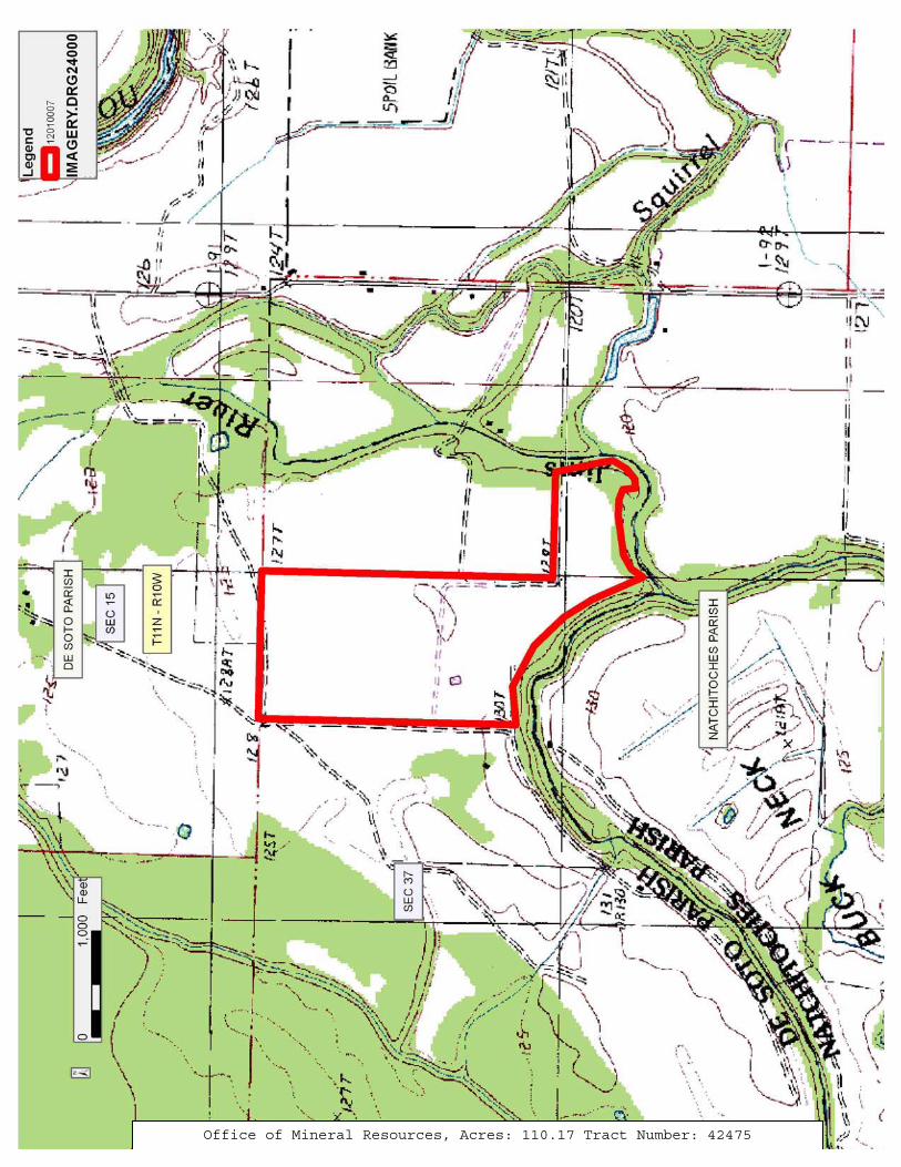
TRACT 42475 - De Soto Parish, Louisiana A certain Tract of land, excluding the beds and bottoms of all navigable waters, belonging to and not presently under mineral lease from Northwestern State University on January 11, 2012, being more fully described as follows: That certain piece, parcel or tract of land situated in Section 22, Township 11 North, Range 10 West, and described as follows: Beginning at the ¼ section corner between Section 15 and Section 22, and thence run South 00 degrees 50 minutes West 41.60 chains, thence run South 89 degrees East 15.15 chains to the Bayou, and thence around the Bayou as follows: South 12 degrees 12 minutes East 6.46 chains, South 10 degrees 44 minutes East 1.88 chains, South 31 degrees 50 minutes West 2.33 chains, South 52 degrees 06 minutes West 1.85 chains, South 84 degrees 38 minutes West 1.25 chains, North 6 degrees 40 minutes West 1.79 chains, North 69 degrees 43 minutes West 1.58 chains, North 87 degrees 30 minutes West 2.27 chains, South 81 degrees 55 minutes West 5.71 chains, South 59 degrees 15 minutes West 2.27 chains, South 34 degrees 47 minutes West 2.0 chains, North 24 degrees 27 minutes West 7.86 chains, North 32 degrees 10 minutes West 4.68 chains, North 44 degrees 05 minutes West 2.50 chains, North 44 degrees 37 minutes West 3.52 chains, North 62 degrees 40 minutes West 6.56 chains, South 84 degrees 14 minutes West 5.50 chains, and thence run North 00 degrees 50 minutes East 36.83 chains, thence run South 89 degrees East 21.74 chains to the ¼ section corner between Section 15 and Section 22, the original point of beginning, and containing 105.40 acres. And that certain piece, parcel or tract of land situated in Section 22, Township 11 North, Range 10 West, and described as follows: Beginning at the Northeast Corner of the Northwest Quarter of Section 22, Township 11 North, Range 10 West and running thence West 8.36 chains, thence South 42 degrees East 4.40 chains, thence South 31 degrees East 9 chains, thence South 16 degrees East 3.16 chains, thence North 14.14 chains to beginning, containing 4.77 acres LESS AND EXCEPT: all waterbottoms that the state may claim or own and to which the mineral rights are vested in them; Containing approximately 110.17 acres, , all as more particularly outlined on a plat on file in the Office of Mineral Resources, Department of Natural Resources. The description is based on information provided by the State Agency regarding location and ownership of surface and mineral rights. All bearings, distances and coordinates, if applicable, are based on Louisiana Coordinate System of 1927, (North or South Zone). NOTE: The above description of the Tract nominated for lease has been provided and corrected, where required, exclusively by the nomination party. Any mineral lease selected from this Tract and awarded by the Louisiana State Mineral and Energy Board shall be without warranty of any kind, either express, implied, or statutory, including, but not limited to, the implied warranties of merchantability and fitness for a particular
15
purpose. Should the mineral lease awarded by the Louisiana State Mineral and Energy Board be subsequently modified, cancelled or abrogated due to the existence of conflicting leases, operating agreements, private claims or other future obligations or conditions which may affect all or any portion of the leased Tract, it shall not relieve the Lessee of the obligation to pay any bonus due thereon to the Louisiana State Mineral and Energy Board, nor shall the Louisiana State Mineral and Energy Board be obligated to refund any consideration paid by the Lessor prior to such modification, cancellation, or abrogation, including, but not limited to, bonuses, rentals and royalties. NOTE: Lessee, its successors and assigns, may produce oil, gas and other minerals from the leased premises by drilling from a surface location on other lands, but notwithstanding any other provision of this lease, Lessee, its successors and assigns, shall not use the surface of the Lessor’s property for drilling or any other operations without prior written permission of Lessor, which permission may be withheld at Lessor’s discretion. NOTE: Notwithstanding anything to the contrary herein contained, at the end of the primary term or any extension thereof by operations, if the Commissioner of Conservation of the State of Louisiana establishes a drilling unit which includes a part of the land herein leased, the production of oil, gas and other minerals from such unit shall maintain this lease in full force and effect only as to such portions of the leased land embraced in said pooled unit; and this lease shall expire as to that part of the land herein leased not included in such unit; and Lessee, its successors and assigns, agrees to relinquish by formal instrument any portion of the leased land not included in a unit created by the Commissioner of Conservation while this lease is in effect. NOTE: Upon the expiration of the primary term hereof or any extension thereof by operations, this lease shall automatically terminate and be of no further force or effect except as to all part of the leased premises then included within the geographical boundaries of a producing unit duly established by governmental agency or authority having jurisdiction, from the surface of the earth to a depth of 100 feet below the deepest depth from which any well commenced during the primary term hereof on the leased premises or on lands pooled therewith is completed and from which there is production in paying quantities, such depth determination to be made on a unit by unit basis. In the absence of units so established, this lease shall terminate except as to 40 acres around each producing oil well and 160 acres around each producing or shut-in gas well located on the leased premises, in as near the form of a square as is practicable, from the surface of the earth down to a depth of 100 feet below the deepest depth from which said well or wells are completed and from which there is production in paying quantities, such depth determination to be made on a well by well basis.
16
NOTE: There shall be a minimum royalty provision of not less than 25%. NOTE: The primary term of lease shall not exceed three (3) years.
Applicant: MUSTANG EXPLORATION, LLC to Agency and by Resolution from the Northwestern State University authorizing the Mineral Board to act in its behalf
Bidder Cash Payment
Price/ Acre
Rental Oil Gas Other
17
Office of Mineral Resources, Acres: 110.17 Tract Number: 42475
![[1998] 3 R.C.S. SUCCESSION ORDON c. GRAIL 437 · Jane Carroll, Marie Suzanne Carroll, Joan Gregory Carroll, Margaret Jane Carroll, Shelagh Carroll and Laing Douglas Marie Suzanne](https://static.fdocuments.net/doc/165x107/5e89eca40a561e2394069fac/1998-3-rcs-succession-ordon-c-grail-437-jane-carroll-marie-suzanne-carroll.jpg)