Tracks & Trails Guide - Thames-Coromandel District the Peninsula/Tracks and... · YOUR COROMANDEL...
29
YOUR COROMANDEL Tracks & Trails Guide
Transcript of Tracks & Trails Guide - Thames-Coromandel District the Peninsula/Tracks and... · YOUR COROMANDEL...

YOUR COROMANDELTracks & Trails Guide

3
YOU
R CO
ROM
AND
EL T
RACK
S &
TRAI
LS
2
WEL
COM
EYO
UR
CORO
MAN
DEL
TRA
CKS
& TR
AILS
KAU
RI D
IEBA
CK
Unlike the back-country tracks in the mountainous terrain managed by the Department of Conservation, the walks outlined in this book are mostly shorter and easier excursions near our town centres, and on a variety of TCDC and public conservation land.
Welcome to Your Coromandel Local Tracks and Trails Guide
@ThamesCoromandelDistrictCouncil
@OurCoromandel
coromandel_tcdc
Follow us on:
There are plenty of treasures to discover among these walks, taking you from harbour and river margins, heritage town centres, playgrounds, busy working wharves and, of course, the sandy beaches the Coromandel is famous for. We’ve got walks for people of all fitness levels, and we’ve included cycle paths and mountain biking trails as well.
Developing walking and biking paths on our Council’s own reserves, and helping community groups and businesspeople develop tracks of their own, is a major strand of our economic development programme. We welcome feedback on the paths included in this book and we’d like to hear from you if you’ve got plans to develop a walking or cycling track in your area of the district.
As with any path that is shared among multiple users, be considerate of others, use a bell or your voice to warn people you’re about to pass on a bike, clean up after yourself, and most of all, get out there and enjoy yourself.FRONT COVER Main photo: location Lonely Bay Inset photos L-R: Rings Loop Walk, Whitianga Bike Park, Lonely Bay, Matarangi Felicity Jean Photography
This page: Rings Loop Walk, p20 Felicity Jean Photography
Email: [email protected]
What is Kauri Dieback? Kauri dieback is a disease caused by the microscopic pathogen Phytophthora agathidicida (PA). There is currently no known cure for PA, which kills most if not all of the kauri it infects. It can be spread by just a pinhead of soil, and is most commonly transferred by people on their footwear and equipment.
But everyone can play their part to stop the disease from spreading by practising good hygiene when entering or leaving kauri forests, and sticking to marked tracks.
Keep Kauri Standing
www.kauridieback.co.nz
What can I do to stop it spreading? When you are around kauri:• Make sure foot wear and equipment are scrubbed clean to remove all visible soil and plant material before AND after visiting a kauri forest.
• Please use cleaning stations where provided, and follow the hygiene steps. This includes first scrubbing off all visible soil and then spraying with disinfectant.
• Stay on the track and off kauri roots.
• Keep your dog on a leash at all times.
By following these steps we can all help protect kauri and ensure they remain standing into the future.
X X
1. SCRUB
2. SPRAY
3. STAY

THE COROMANDEL PENINSULA
ContentsNorthern Coromandel1 Waikawau Bay..................................... 102 Tuateawa Nikau Grove Walk .............. 113 New Chum Beach ............................... 124 Whangapoua Beach to Opera Point .. 135 Long Bay to Tucks Bay ........................ 146 Kauri Block .......................................... 157 Wyuna Bay .......................................... 168 Waiau Falls and Kauri Grove
Lookout Walk ...................................... 17
Eastern Coromandel Walks 9 Rings Loop and Bluff Rd
to Matarangi ........................................ 2010 Opito Bay to Crayfish Bay................... 2111 Whitianga Waterfront
and Town Heritage ............................. 2212 Whitianga Bike Park ........................... 2313 Maramaratotara/Ferry Landing ......... 2414 Shakespeare Cliff to Lonely Bay ........ 2515 Cathedral Cove and Hahei Beach ..... 26
Thames & Thames Coast16 Waiomu Kauri Grove .......................... 3017 Rockys Walk to Tinkers Gully ............ 3118 Moanataiari Mountain Bike Trails ...... 3219 Karaka-Waiotahi Circuit ..................... 33
20 John William Hall Arboretum............. 3421 Miners’ Cottages
and Shortland Cemetery .................... 3522 Thames Coastal Pathway .............. 36-3723 Hauraki Rail Trail ................................ 3824 Kauaeranga Valley .............................. 39
South Eastern Coromandel25 Te Karo Bay to Otara Bay .................... 4226 Pumpkin Hill Summit ......................... 4327 Tairua History Trail ............................. 4428 Paku Hill Summit ................................ 4529 Pepe Loop Track ................................. 4630 Red Bridge Track ................................. 4631 Pauanui-Tairua Trail ........................... 4732 Mt Pauanui Summit ............................ 4833 Broken Hills Recreation Area ............. 4934 Wentworth Valley Falls ....................... 5035 Te Ara O Te Wairoa
(Moana Anu Anu Harbour) ................. 5136 Opoutere Forest to Beach .................. 5237 Peninsula Lookout .............................. 5338 Pokohino Bay ...................................... 5339 Whangamata Ridges
Mountain Bike Park ............................ 54
5
THE
CORO
MAN
DEL
PEN
INSU
LA M
APYO
UR
CORO
MAN
DEL
TRA
CKS
& TR
AILS
4
CON
TEN
TSYO
UR
CORO
MAN
DEL
TRA
CKS
& TR
AILS
25
26
27 2829
3231
30
33
34
35
36
3739
38
1
2
3
4
67
8
5 9
131112
1514
10
16
17
1819
20
21
24
23
22

6
WEL
COM
EYO
UR
CORO
MAN
DEL
TRA
CKS
& TR
AILS
7
YOU
R D
OG
YOU
R CO
ROM
AND
EL T
RACK
S &
TRAI
LS
W H I L E T R AV E L L I N G I N
N E W Z E A L A N D I W I L L
T I A K I P R O M I S E
C A R E F O R L A N D , S E A A N D N AT U R E ,
T R E A D I N G L I G H T LY A N D L E AV I N G N O T R A C E
T R AV E L S A F E LY, S H O W I N G C A R E
A N D C O N S I D E R AT I O N F O R A L L
R E S P E C T C U LT U R E , T R AV E L L I N G
W I T H A N O P E N H E A R T A N D M I N D
Tiaki means to care for people and place. The Tiaki Promise is a commitment to care for New Zealand, for now and for future generations.
New Zealand is precious, and everyone who lives and travels here has a responsibility to look after it.
By following the Tiaki Promise, you are making a commitment to New Zealand. To act as a guardian, protecting and preserving our home.
Nau Mai, Haere Mai Ki Aotearoa, Welcome to New Zealand.
TIAKINEWZEALAND.COM#TIAKIPROMISE
H O W T O C A R E F O R N E W Z E A L A N D
We are lucky to be able to take our best canine buddies almost anywhere, whether it’s down to the beach or for a stroll into town for a bite to eat. However, to make it a place for everyone to enjoy, we have a few simple rules for dogs and handlers when sharing our beaches, reserves and public spaces including tracks and walkways.
Dogs must be on a lead in most areas unless specified. Remember, dogs are not allowed in cemeteries, sports fields and within five metres of playgrounds. Dogs are prohibited from protected bird habitats from Labour Weekend to 1 March, which is dotterel breeding season. And from 20 December to 31 January and on public holiday weekends, most beaches have time restrictions for when dogs are allowed on the beach, if at all.
If you’re in doubt about when and where you can walk your dog, keep an eye out for signs and maps, pop into one of our Council offices or head to our website tcdc.govt.nz/dogrules
What to do if you come across wildlifeIf you come across wildlife on a track or reserve, don’t put yourself in harm’s way. Leave wildlife where you find it. Give it space and don’t touch it.
If wildlife is posing a threat to people, call DOC.
If you witness people harassing wildlife, call Police.
For any matters involving dogs, call TCDC on 07 868 0200.
YOUR DOG
Dogs on DOC landPublic conservation lands managed by DOC are places where our unique plants, animals and heritage are protected. Help look after our native wildlife by taking your dog only to approved dog areas if you’re on public conservation land.
Check the DOC website doc.govt.nz for tracks where you can take your dog or visit DOC’s Kauaeranga Visitor Centre.

8
YOU
R CO
ROM
AND
EL T
RACK
S &
TRAI
LS
Bay
1
2
3
4
67
8
5
SAFE
TY IN
FORM
ATIO
N
Local Knowledge ContactsTCDC Area OfficesThames, Whitianga, Whangamata, Coromandel Town +64 7 868 0200 [email protected] tcdc.govt.nz
Visitor Information CentresSee back cover for our local information centres, or visit thecoromandel.com
SAFETY INFORMATION
Plan your tripSeek local knowledge, plan the route you’ll take and the amount of time you can reasonably expect it to take. Do not follow pink markers that lead to pest bait stations – they do not mark formed tracks.
Tell someoneTell someone your plans and leave a date for when to raise the alarm if you haven’t returned. If someone is missing, dial 111.
Be aware of the weatherThe Coromandel’s weather can be unpredictable and is particularly susceptible to heavy rain and floods. Check the forecast at metservice.com and expect weather changes.
Know your limitsChallenge yourself within your physical limits and experience.
Take sufficient suppliesPack enough food, equipment, appropriate communication and emergency rations for the worst-case scenario. Be aware that some parts of the Coromandel have limited cell phone coverage.
Search & RescueThere are numerous voluntary Search & Rescue groups on the Coromandel that can give advice, including Kuaotunu Search and Rescue.
facebook.com/KuaotunuSAR
landsar.org.nz
Northern Coromandel
1 Waikawau Bay
2 Tuateawa Nikau Grove Walk
3 New Chum Beach Walk
4 Whangapoua Beach Walk to Opera Point
5 Long Bay to Tucks Bay Walk
6 Kauri Block Walk
7 Wyuna Bay Walk
8 Waiau Falls and Kauri Grove Lookout Walk
9
NO
RTH
ERN
CO
ROM
AND
EL M
APYO
UR
CORO
MAN
DEL
TRA
CKS
& TR
AILS

YOU
R CO
ROM
AND
EL T
RACK
S &
TRAI
LS
10
Tuateawa Nikau Grove Walk
2
Waikawau Bay
From opposite the entrance to the DOC camp at Waikawau Bay a short walk of 5-10 min leads uphill to a cluster of kauri that were planted by children who are now adults. The lookout is a good place to catch your breath after the walk up and enjoy the views over the long, sandy strip of Waikawau Bay to the north, and the small community of Little Bay, to the south. For a longer walk, take DOC’s Matamataharakeke Trail from the back of Pump Paddock at the Waikawau campsite. Cross the stile next to Matamataharakeke Stream. The loop track is part of the original Waikawau to Kennedy Bay route used by gold miners and loggers. Follow the track through the bush past a series of lookouts with views over bush-clad hills out to the Pacific Ocean and the offshore islands. Once back at Waikawau, cool off with a swim at the beach. At the north end of the bay you’ll see shorebirds including dotterels and oyster catchers. There is also the “children’s forest” that Moehau Environment Group (MEG) has planted with Colville School students. MEG has undertaken extensive pest management in the wetlands.
Matamataharakeke Trail
Duration: 3hrs return approx
Distance: 6.5km return approx
1
Little Bay.
Between Kennedy Bay and Waikawau Bay is Tuateawa. The walk from Waihirere Dr to the beach offers superbly rugged, unspoilt scenery from pohutukawa and nikau forest to amazing views over the sea. From Kennedy Bay head north on Tuateawa Rd and turn right onto Waihirere Dr and park. The walk starts about 300m past Puriri Pl, on your right.
Duration: 1hr return approx
Distance: 2.2km return approx
11
YOU
R CO
ROM
AND
EL T
RACK
S &
TRAI
LS

12 13
YOU
R CO
ROM
AND
EL T
RACK
S &
TRAI
LS
YOU
R CO
ROM
AND
EL T
RACK
S &
TRAI
LS
New Chum Beach Walk
At the north end of Whangapoua Beach, cross the stream and begin your journey along the shoreline and over the neck of Motuto Point to a beach that is considered one of the best in the world. You will pass spectacular nikau groves and huge pohutukawa. The path is rough in parts and good walking shoes are recommended. Note: There are no toilets at New Chum Beach, so make use of the public toilets in Whangapoua at the north end of Mangakahia Dr (where you can park) and at Meri Te Tai Reserve at the junction of Tangiora Ave, McMahon Ave and Mangakahia Dr (where you can also park).
Duration: 1hr 30mins return approx
Distance: 2.5km return approx
3
From the playground, shop and public toilet at Meri Te Tai Reserve, turn right along the beachfront reserve to South End Reserve and Te Rehutae Point (Opera Point), the site of Ruakawa Pa. From the beach, walk to Tangiora Ave and follow it to the DOC car park and the beginning of the loop track that goes up to the summit of the point and back along its shore. The way up to the pa goes through dense bush, nikau palms and ancient pohutukawa and near the summit there are some traces of the pa. There are excellent views from the top of the point. The track then descends to the Whangapoua Harbour side of Te Rehutae Point along the sandy shoreline back to the beginning of the track.
Duration: 2hrs return approx
Distance: 4km return approx
4
Whangapoua Beach Walk to Opera Point

14 15
YOU
R CO
ROM
AND
EL T
RACK
S &
TRAI
LS
YOU
R CO
ROM
AND
EL T
RACK
S &
TRAI
LS
Long Bay to Tucks Bay Walk
The Long Bay campground has access to a variety of walks. From the car park on the foreshore you can head to the fish cleaning station, where there are two entrances you can take. Both options will lead you to Tucks Bay Beach. The option on the right takes you through kauri trees and display boards where you can read up and learn about different native trees as you climb your way to a tall kauri tree. The track will lead up to the gravel road, then you head down the road on your right leading to Tucks Bay. Follow this path as it returns you to Long Bay.
These tracks have been closed several times recently due to erosion damage from storms and wet weather. Take care when walking these tracks: the damage has been fixed but we advise caution.
Duration: 1hr return approx
Distance: 2.8km return approx
5
Kauri Block Walk
This track is on DOC land but is a short, easy walk that is accessible from Coromandel Town and offers spectacular views over the town, nearby islands and the Coromandel Ranges. Access is from a right of way beside 356 Wharf Rd, opposite the access to Jacks Point Boat Ramp. Follow the path through regenerating bush and many kauri, planted by the Kauri 2000 Trust. Be sure to take the side track to the high point where there is an old pa site with panoramic views. The main track follows the ridge to where it emerges at Harbour View Rd. From here, either go down the road and back to town past the wharf on Long Bay Rd (no footpath) or take the path to the right that leads to Hauraki Rd which takes you back to Wharf Rd.
For a longer walking experience (about 70min one way), take the Harray Track from Harbour View Rd over the hills to the other side of Coromandel Town to Rings Rd.
Duration: 1hr 30mins return approx
Distance: 1.6km return approx
6
Long Bay.

16 17
YOU
R CO
ROM
AND
EL T
RACK
S &
TRAI
LS
YOU
R CO
ROM
AND
EL T
RACK
S &
TRAI
LS
Wyuna Peninsula features stunning views of the Firth of Thames, Hauraki Gulf and McGregor Bay, and it contains a glorious child friendly beach (public toilets are here). Park at the car park at Wyuna Beach and, tide permitting, walk towards the tip of the peninsula to Ruffins Bay beach to the right and return. Explore the rest of the beach towards the base of the peninsula and then once you’re back in the car return along the spine of the peninsula on Wyuna Bay Rd and then turn left at the T-junction with Long Bay Rd then left again after about 120 metres onto Glenfern Dr where there is a walkway on the right which leads to Long Bay Beach. Here you can either walk down the beach or rejoin Long Bay Rd by car to where it ends at the Long Bay holiday park, where there are public toilets and access to the Long Bay to Tucks Bay Walk (see page 14).
Duration: Wyuna Bay to Long Bay 3hrs
Distance: Wyuna Bay to Long Bay Rd 2.6km
7
Waiau Falls can be viewed from the roadside 7km along The 309 Road from the Coromandel Town side. Beautiful native bush surrounds the falls and its popular swimming hole.
Another 1km up The 309 Road a short, easy walking track leads to the most accessible and mature stand of kauri on the Coromandel. The grove contains a ‘siamese’ kauri which forks just above the ground. No dogs are allowed on this track.
To help avoid the spread of kauri dieback disease, stay away from kauri tree roots and clean your footwear and gear before and after visiting any kauri forest. See page 3 for more information on kauri dieback disease.
Duration: 30mins return
Distance: 500metres
8
Wyuna Bay Walk Waiau Falls and Kauri Grove Lookout Walk
Orca at Long Bay.
309 Road Kauri Grove.

Eastern Coromandel
9
1311
12
1514
10
9 Rings Loop Walk and Bluff Rd to Matarangi Track
10 Opito Bay to Crayfish Bay
11 Whitianga Waterfront and Town Heritage walk & bike
12 Whitianga Bike Park tracks and walks
13 Maramaratotara Bay and Ferry Landing Walk
14 Shakespeare Cliff to Lonely Bay Walk
15 Cathedral Cove Walk and Hahei Beach
Lonely Bay. Photo Felicity Jean Photography.
18
YOU
R CO
ROM
AND
EL T
RACK
S &
TRAI
LS
19
EAST
ERN
CO
ROM
AND
EL M
APYO
UR
CORO
MAN
DEL
TRA
CKS
& TR
AILS

20 21
YOU
R CO
ROM
AND
EL T
RACK
S &
TRAI
LS
YOU
R CO
ROM
AND
EL T
RACK
S &
TRAI
LS
9
Rings Beach, nestled between Kuaotunu and Matarangi, hosts a back country trail for walkers, runners and mountain bike users to enjoy. The Rings Loop Track can be accessed at both ends of Rings Beach and sits inside a 267ha conservation estate. There are hill climbs, one of which takes you up to the trig point with a great view overlooking Matarangi Beach. There’s native bush which is regenerating thanks to a tree-planting programme which started in 2010; and there’s birdlife and a wetland. The track was the brainchild of the late Bruce Smith of Kuaotunu, built entirely by volunteer labour and is now managed under the umbrella of the Coromandel Peninsula Coastal Walkways Society. This trail is dog friendly but unfortunately not viable for scooters or wheelchairs. The nearest public toilets are at the Kuaotunu boat ramp or Kuaotunu tennis court reserve. Another shorter route from Rings Beach is heading along the Bluff Rd (pedestrian and bike access only) through to Matarangi return, which takes about 40 minutes.
Duration: 2hrs approx
Distance: 4.7km
Rings Loop Walk and Bluff Rd to Matarangi Track
The only way to get to Opito Bay is via the Kuaotunu Village, following Black Jack Rd, through Otama Beach (which is a stopover all of its own) continuing along the gravel road another 20 minutes to get to Opito Bay.
At the northern end of the beach you can see Skippers Ridge – along with nearby Sarah’s Gully – both sites of archaeological excavations in the late 1950s, which first found evidence of early Polynesian settlement in the North Island. Another significant historical site is the pa at the southern end of the beach. To take in the full experience, park at the northern end of the beach at the Skippers Rd reserve, making your way along the beach to the southern end where there is another public reserve and toilet. Just past the reserve continue along the beach to ascend the 196 steps up to the pa site where you get sensational views across Mercury Bay. You can carry on back down to the beach and around to Crayfish Bay, a small horseshoe-shaped bay.The walk is approximately three hours without stops and features regularly in the ECHO Walking Festival, which is held in April every year.
Duration: 3hrs return approx
Distance: 6km return approx
10
Opito Bay to Crayfish Bay
Opito Bay. Photo: John Riddle.
Phot
o: J
ohn
Ridd
le.
Phot
o Fe
licity
Jea
n Ph
otog
raph
y.

22 23
YOU
R CO
ROM
AND
EL T
RACK
S &
TRAI
LS
YOU
R CO
ROM
AND
EL T
RACK
S &
TRAI
LS
Only minutes north of the Whitianga town centre on Moewai Rd lie 17ha of mountain biking, BMX tracks and bush walking trails that suit all ages and abilities. Since 2004 the Whitianga Bike Club has leased land from our Council and developed this facility with donations and sponsorship thanks to local businesses. The park is free and offers about two to three hours riding for average riders with more than 20 trail options from novice to extreme. The BMX track has two loops with the faster leading into the slower and can be entered independently, with a kiddies track nearby. Alongside the bike trails is a walking track which also sidles around the perimeter of the Whitianga golf course and takes in a grove of up to 50 kauri trees and views through the bush to Mercury Bay and its islands. You could spend the day here with family and friends. There is a BBQ (bring your own gas bottle), badminton nets, rope climbs and frisbee court. Sunshade, drinking dispensers and toilet are also on site. It’s also dog, and in some parts accessibility, friendly. You can download the PDF trail map at whitiangabikeclub.co.nz/trails.html or pick up copies from the Bike Man shop in Whitianga or the Whitianga i-SITE.
11
It’s approximately 3.5km from the Whitianga Wharf to the end of Brophy’s Beach that you can either run, walk, mobility scooter, wheelchair or bike using the beachfront footpath. Features to take in include a fever of stingrays stenciled into a section of the path, thanks to input from of one of our most well-known and iconic artists – Michael Smither, and the historic Buffalo anchor, a memorial to the HMS Buffalo, which was wrecked in a storm on 28 July 1840, killing two crew on board. The footpath also swings past a children’s playground and the Taputapuatea Stream, which is a great spot for kids to swim. Amenities along the way include two BBQ sites, dog litter dispensers, three public toilets and several water stations. Another diversion taking in the town’s heritage signs is across from the Buffalo memorial anchor into Halligan Rd. Take a left into Cook Dr where you’ll pass The Lost Spring, a natural thermal spring that’s been developed into a luxury hot pool and day spa. From here there’s a sign-posted council walkway on Cook Dr to School Rd Reserve. Take School Rd to Eyre St, turn right to Hannan Rd, then left on Kenneth Ave to the end and through another walkway onto Albert St. From here you can view old pioneer buildings on Coghill St before turning left onto Victoria St. Walk towards the harbour to complete a circuit of the main town centre.
Duration: Whitianga waterfront (one way) 1hrDistance: 3.5km
Duration: Town heritage circuit 1hrDistance: 2.5km
Whitianga Waterfront and Town Heritage walk and bike
12
Whitianga Bike Park tracks and walks
Phot
o Fe
licity
Jea
n Ph
otog
raph
y.

24 25
YOU
R CO
ROM
AND
EL T
RACK
S &
TRAI
LS
YOU
R CO
ROM
AND
EL T
RACK
S &
TRAI
LS
13
You’ll require a reasonable level of fitness to do this walk, which takes in Whitianga Rock, where there are the remains of a well-fortified pa built by local iwi Ngati Hei more than 150 years ago. The track starts at the Ferry Landing car park. Head inland for 5-10 minutes ascending to Whitianga Rock, where you get a stunning view over Whitianga. You can return going down to Back Bay, through wetland and native bush where there’s the odd steep section and tree roots for steps. Alternatively you can start at the walkway signpost on Purangi Rd to get to the hilltop and lookout seats before returning back down to the road, along the footpath back to the ferry. There are public toilets at the Ferry Landing car park. No dog, mobility or bike access.
Duration: 1hr approx
Distance: 3km approx
Maramaratotara/ Ferry Landing Walk
In 1769 Captain James Cook was in the Mercury Bay area for 12 days, stocking up on provisions, carrying out maintenance to his ship Endeavour and interacting and trading with the local Maori. Stories say Cook either thought the profile of the cliff at the western end of Cooks Beach resembled the profile of William Shakespeare – or that the landscape looked so poetic – that he named it Shakespeare Cliff. This headland is one of the Coromandel’s most outstanding vistas with the walk down to Lonely Bay a popular spot for wedding photos, thanks to its seclusion and scenery. Shakespeare Cliff is a great spot for picnics, has a public toilet, pohutukawa groves and plaques detailing the history of the area. To get to Shakespeare Cliff you can walk the Lookout Rd from Flaxmill Bay and from the reserve, (which is horseshoe shaped) walk down a steep track to Lonely Bay. You’ll need to follow Lookout Rd back to Purangi Rd and either turn right for Flaxmill Bay or left to a track to Cooks Beach. The reserve at Shakespeare Cliff is mobility friendly, but the track down to Lonely Bay is not and requires a decent level of fitness. Allow at least an hour for the 3km return loop from Flaxmill Bay or 30 minutes return from Shakespeare Cliff to Lonely Bay.
Duration: Flaxmill Bay to Lonely Bay 1hr return approx
Distance: 3km return approx
Shakespeare Cliff to Lonely Bay Walk
14
15
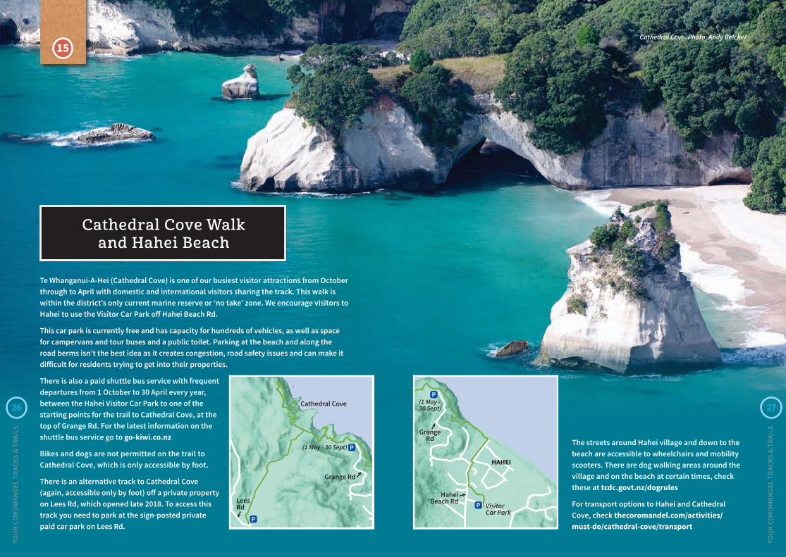
Cathedral Cove Walk and Hahei Beach
Te Whanganui-A-Hei (Cathedral Cove) is one of our busiest visitor attractions from October through to April with domestic and international visitors sharing the track. This walk is within the district’s only current marine reserve or ‘no take’ zone. We encourage visitors to Hahei to use the Visitor Car Park off Hahei Beach Rd.
This car park is currently free and has capacity for hundreds of vehicles, as well as space for campervans and tour buses and a public toilet. Parking at the beach and along the road berms isn’t the best idea as it creates congestion, road safety issues and can make it difficult for residents trying to get into their properties.
There is also a paid shuttle bus service with frequent departures from 1 October to 30 April every year, between the Hahei Visitor Car Park to one of the starting points for the trail to Cathedral Cove, at the top of Grange Rd. For the latest information on the shuttle bus service go to go-kiwi.co.nz
Bikes and dogs are not permitted on the trail to Cathedral Cove, which is only accessible by foot.
There is an alternative track to Cathedral Cove (again, accessible only by foot) off a private property on Lees Rd, which opened late 2018. To access this track you need to park at the sign-posted private paid car park on Lees Rd.
Cathedral Cove. Photo: Andy Belcher
The streets around Hahei village and down to the beach are accessible to wheelchairs and mobility scooters. There are dog walking areas around the village and on the beach at certain times, check these at tcdc.govt.nz/dogrules
For transport options to Hahei and Cathedral Cove, check thecoromandel.com/activities/ must-do/cathedral-cove/transport
26
YOU
R CO
ROM
AND
EL T
RACK
S &
TRAI
LS
27
YOU
R CO
ROM
AND
EL T
RACK
S &
TRAI
LS
HAHEI
GrangeRd
HaheiBeach Rd
Visitor Car Park
(1 May - 30 Sept)

16
17
1819
20
21
24
23
22
Pou on the Kopu Bridge at sunrise.
Thames & Thames Coast
16 Waiomu Kauri Grove
17 Rockys Walk to Tinkers Gully, Tararu
18 Moanataiari Mountain Bike Trails
19 Karaka-Waiotahi Circuit
20 John William Hall Arboretum
21 Miners’ Cottages and Shortland Cemetery
22 Thames Coastal Pathway
23 Hauraki Rail Trail – Thames
24 Kauaeranga Valley tracks and trails
28
YOU
R CO
ROM
AND
EL T
RACK
S &
TRAI
LS
29
THAM
ES &
TH
AMES
CO
AST
MAP
YOU
R CO
ROM
AND
EL T
RACK
S &
TRAI
LS

31
YOU
R CO
ROM
AND
EL T
RACK
S &
TRAI
LS
16
Waiomu Kauri GroveFrom the car park by Dickson Park Motor Camp on Victoria St in Tararu, this walk climbs steeply before flattening out along a ridge. The track is uneven in places but offers good views over Tararu and the Firth of Thames. There is a steep descent into Tinkers Gully and then a short walk back along Victoria St to the car park.
Duration: 3hrs
Distance: 6km return approx
Rockys Walk to Tinkers Gully, Tararu
17
30
YOU
R CO
ROM
AND
EL T
RACK
S &
TRAI
LS
This path is maintained by DOC but it’s well-developed and apart from the final ascent up steps to the stand of mature kauri, the general grade is not too challenging for walkers of moderate fitness. Park at the car park on Waiomu Valley Rd on the left about 200m past Lucy Rd and continue on foot up the road to where the track begins. Clean your footwear on arrival and departure at the cleaning station to help prevent the spread of kauri dieback.
Duration: To the kauri grove 45mins approx
Distance: 2.5km

32 33
YOU
R CO
ROM
AND
EL T
RACK
S &
TRAI
LS
YOU
R CO
ROM
AND
EL T
RACK
S &
TRAI
LS
The Thames Mountain Bike Club has created a network of mountain bike trails of varying lengths for all skill levels in the hills behind Thames. Parking is at the end of Moanataiari Creek Road, which is on the north end of Thames by the St John Ambulance station. At the top of the access road behind the gate there is a flat area that’s perfect for picnics, with great views over the Firth of Thames. Here there is also a pump-track, a jump track, a kids loop (the Hundred-Acre Wood) and the start of the trail network.
The Thames Mountain Bike Club maintains these trails. For more information see the club’s Facebook page facebook.com/Thamesmtbclub
This track can be accessed either from Karaka or Waiotahi roads, and if you’ve got two cars available you can leave one at each end to avoid walking back to your car at the start point.
There is a small car park up Waiotahi Rd where the track begins. An initial steep climb through regenerating bush levels off as you wind through the hills. There is a great view across the Firth of Thames before the track dives back into the hills. After about two hours Waiotahi Track meets the Karaka Track, and you can either carry on for several more hours to Crosbies Hut and other tramping tracks down the main range of the Coromandel, or return to Thames via Karaka Track and the Red Rocks (also called Red Bluff after the colour of the lichen that grows on them). The rocks are about an hour or so after the junction, or if you’re coming from Thames up the Karaka Track, about two hours from the trail head.
At the Red Rocks, the trail crosses a bluff and there are impressive views over the Karaka Valley all the way to Table Mountain. While the Waiotahi Track is generally well developed, the Karaka Track is rougher and has many boggy sections. There are also some tricky stream crossings, two of which have been bridged by the Thames Mountain Bike Club. Along the way you’ll pass many reminders of the gold-mining history of Thames, especially on Karaka Track, which was formerly developed to access the gold mining works. There are many shafts and tunnels dug into the hills to access the seams of gold and these may be hidden by vegetation. Keep to the marked official track and please supervise children.
Duration: 4.5hrs approx
Distance: 11km approx
18
Karaka-Waiotahi Circuit
19
Moanataiari Mountain Bike Trails
34 35
YOU
R CO
ROM
AND
EL T
RACK
S &
TRAI
LS
YOU
R CO
ROM
AND
EL T
RACK
S &
TRAI
LS
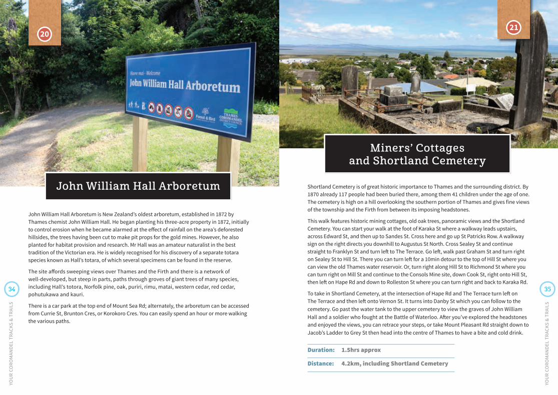
John William Hall Arboretum is New Zealand’s oldest arboretum, established in 1872 by Thames chemist John William Hall. He began planting his three-acre property in 1872, initially to control erosion when he became alarmed at the effect of rainfall on the area’s deforested hillsides, the trees having been cut to make pit props for the gold mines. However, he also planted for habitat provision and research. Mr Hall was an amateur naturalist in the best tradition of the Victorian era. He is widely recognised for his discovery of a separate totara species known as Hall’s totara, of which several specimens can be found in the reserve.
The site affords sweeping views over Thames and the Firth and there is a network of well-developed, but steep in parts, paths through groves of giant trees of many species, including Hall’s totora, Norfolk pine, oak, puriri, rimu, matai, western cedar, red cedar, pohutukawa and kauri.
There is a car park at the top end of Mount Sea Rd; alternately, the arboretum can be accessed from Currie St, Brunton Cres, or Korokoro Cres. You can easily spend an hour or more walking the various paths.
John William Hall Arboretum
20
Shortland Cemetery is of great historic importance to Thames and the surrounding district. By 1870 already 117 people had been buried there, among them 41 children under the age of one. The cemetery is high on a hill overlooking the southern portion of Thames and gives fine views of the township and the Firth from between its imposing headstones.
This walk features historic mining cottages, old oak trees, panoramic views and the Shortland Cemetery. You can start your walk at the foot of Karaka St where a walkway leads upstairs, across Edward St, and then up to Sandes St. Cross here and go up St Patricks Row. A walkway sign on the right directs you downhill to Augustus St North. Cross Sealey St and continue straight to Franklyn St and turn left to The Terrace. Go left, walk past Graham St and turn right on Sealey St to Hill St. There you can turn left for a 10min detour to the top of Hill St where you can view the old Thames water reservoir. Or, turn right along Hill St to Richmond St where you can turn right on Mill St and continue to the Consols Mine site, down Cook St, right onto Hill St, then left on Hape Rd and down to Rolleston St where you can turn right and back to Karaka Rd.
To take in Shortland Cemetery, at the intersection of Hape Rd and The Terrace turn left on The Terrace and then left onto Vernon St. It turns into Danby St which you can follow to the cemetery. Go past the water tank to the upper cemetery to view the graves of John William Hall and a soldier who fought at the Battle of Waterloo. After you’ve explored the headstones and enjoyed the views, you can retrace your steps, or take Mount Pleasant Rd straight down to Jacob’s Ladder to Grey St then head into the centre of Thames to have a bite and cold drink.
Duration: 1.5hrs approx
Distance: 4.2km, including Shortland Cemetery
Miners’ Cottages and Shortland Cemetery
21
36 37
YOU
R CO
ROM
AND
EL T
RACK
S &
TRAI
LS
YOU
R CO
ROM
AND
EL T
RACK
S &
TRAI
LS
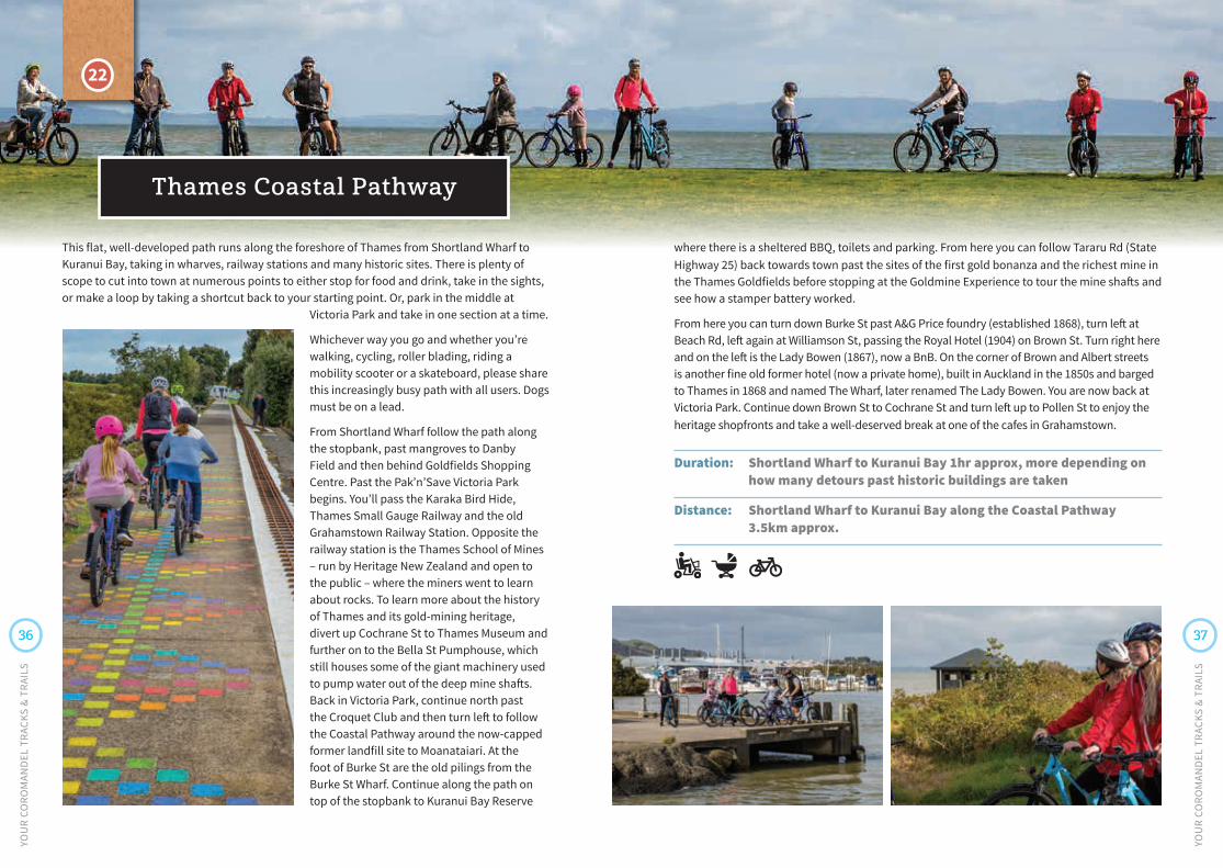
This flat, well-developed path runs along the foreshore of Thames from Shortland Wharf to Kuranui Bay, taking in wharves, railway stations and many historic sites. There is plenty of scope to cut into town at numerous points to either stop for food and drink, take in the sights, or make a loop by taking a shortcut back to your starting point. Or, park in the middle at
Victoria Park and take in one section at a time.
Whichever way you go and whether you’re walking, cycling, roller blading, riding a mobility scooter or a skateboard, please share this increasingly busy path with all users. Dogs must be on a lead.
From Shortland Wharf follow the path along the stopbank, past mangroves to Danby Field and then behind Goldfields Shopping Centre. Past the Pak’n’Save Victoria Park begins. You’ll pass the Karaka Bird Hide, Thames Small Gauge Railway and the old Grahamstown Railway Station. Opposite the railway station is the Thames School of Mines – run by Heritage New Zealand and open to the public – where the miners went to learn about rocks. To learn more about the history of Thames and its gold-mining heritage, divert up Cochrane St to Thames Museum and further on to the Bella St Pumphouse, which still houses some of the giant machinery used to pump water out of the deep mine shafts. Back in Victoria Park, continue north past the Croquet Club and then turn left to follow the Coastal Pathway around the now-capped former landfill site to Moanataiari. At the foot of Burke St are the old pilings from the Burke St Wharf. Continue along the path on top of the stopbank to Kuranui Bay Reserve
Thames Coastal Pathway
where there is a sheltered BBQ, toilets and parking. From here you can follow Tararu Rd (State Highway 25) back towards town past the sites of the first gold bonanza and the richest mine in the Thames Goldfields before stopping at the Goldmine Experience to tour the mine shafts and see how a stamper battery worked.
From here you can turn down Burke St past A&G Price foundry (established 1868), turn left at Beach Rd, left again at Williamson St, passing the Royal Hotel (1904) on Brown St. Turn right here and on the left is the Lady Bowen (1867), now a BnB. On the corner of Brown and Albert streets is another fine old former hotel (now a private home), built in Auckland in the 1850s and barged to Thames in 1868 and named The Wharf, later renamed The Lady Bowen. You are now back at Victoria Park. Continue down Brown St to Cochrane St and turn left up to Pollen St to enjoy the heritage shopfronts and take a well-deserved break at one of the cafes in Grahamstown.
Duration: Shortland Wharf to Kuranui Bay 1hr approx, more depending on how many detours past historic buildings are taken
Distance: Shortland Wharf to Kuranui Bay along the Coastal Pathway 3.5km approx.
22

38 39
YOU
R CO
ROM
AND
EL T
RACK
S &
TRAI
LS
YOU
R CO
ROM
AND
EL T
RACK
S &
TRAI
LS
The Hauraki Rail Trail begins at Shortland Wharf, but can also be accessed across the Kauaeranga River at Rhodes Park, where there is also parking available. On the south side of the Kauaeranga River Bridge have a look at the Sentinel, a statue put in place to mark the 150th anniversary of the opening of the Thames Goldfields in 1867. Just before the entrance to Sir Keith Park Memorial Airfield is the welcome sign to Thames, a re-purposed stamper battery from the town’s gold mining years. Continue down the Rail Trail and you’ll see another sculpture, a large jandal, part of the Thames Public Art Trust’s sculpture trail project along the Kopu-Thames section of the Rail Trail. More sculptures are planned to serve as “visual breadcrumbs” to draw visitors down the Rail Trail and into Thames. After the Totara Palms subdivision, the Rail Trail swings towards the Waihou River and then follows the stopbanks into Kopu, where next to the Kopu Bridge are toilets.
The Rail Trail then divides with one branch crossing the bridge and following the stopbanks along the Firth of Thames to Kaiaua and the other branch following the old railway line past Matatoki, Puriri and Hikutaia (where there are stops for food and drink) to Paeroa, Waihi and Te Aroha. A further extension to Matamata was nearing completion in late 2019.
Please share the Rail Trail with all users, whether on foot, bicycle or mobility scooter.
haurakirailtrail.co.nz
Duration: Thames to Kopu 20mins cycle, 1hr on foot approx
Distance: Thames to Kopu 7km one way
23
Hauraki Rail Trail – Thames
There are numerous walks along easy paths or tougher tramping tracks in the Kauaeranga Valley just outside of Thames. The most popular track is the Pinnacles Walk, which follows an old packhorse route for much of its 7km length to an impressive DOC hut (book ahead) and onwards to the Pinnacles summit (759m) and spectacular views of the bush, mountains and east coast of the peninsula. Allow 7-8hrs return. There are also the Hotoritori mountain bike trails which are suitable for riders of all ages. Check the DOC website and the DOC Kauaeranga Visitor Centre up Kauaeranga Valley Rd for the latest information on all these trails.
DOC website: doc.govt.nz
Visitor Centre: 07 867 9080, [email protected]
Kauaeranga Valley tracks and trails
24The path to the Pinnacles.

South Eastern Coromandel
Opoutere Beach.
25
26
27 2829
3231
30
33
34
35
36
3739
38
25 Whenuakite to Sailors Grave Track
26 Pumpkin Hill Summit, Tairua
27 Tairua History Trail
28 Paku Hill Summit Walk, Tairua
29 Pepe Loop Track
30 Red Bridge Track
31 Pauanui-Tairua Trail, Pauanui
32 Mt Pauanui Summit Walkway
33 Broken Hills Recreation Area
34 Wentworth Valley Falls
35 Te Ara O Te Wairoa (Moana Anu Anu Harbour) Walkway
36 Opoutere Forest to Beach Trail
37 Peninsula Lookout
38 Pokohino Bay
39 Whangamata Ridges Mountain Bike Park
40
YOU
R CO
ROM
AND
EL T
RACK
S &
TRAI
LS
41
SOU
TH E
ASTE
RN C
ORO
MAN
DEL
MAP
YOU
R CO
ROM
AND
EL T
RACK
S &
TRAI
LS

42 43
YOU
R CO
ROM
AND
EL T
RACK
S &
TRAI
LS
YOU
R CO
ROM
AND
EL T
RACK
S &
TRAI
LS
25
From the Te Karo Bay (Sailors Grave) beach car park, cross the estuary and walk north towards the headland. The historic ‘sailors grave’ is signposted and can be found just a few metres into the bush. Alternatively, park at the bottom car park end of the road into Te Karo Bay and follow the track to the beach to avoid crossing the stream. From the beach, you will need to walk another 100m to the start of the Otara Bay track over the headland – a walk of approximately 25 minutes each way with a well-formed track and great views.
There is a basic toilet at the Sailors Grave car park and picnic tables under the shade. Allow 45 minutes for the return walk to Otara Bay.
The track to Sailors Grave from Whenuakite is currently closed due to kauri dieback disease. Check the DOC website for the latest information on this track and others in the Coromandel which may be affected by kauri dieback. doc.govt.nz
Duration: 50mins return
Distance: 700m one way
Te Karo Bay to Otara Bay
This 15-minute walk was recently developed by our Council and affords magnificent views over Tairua and Pauanui from a trig point lookout. Access to the trig is steep, and caution is needed.
From Tairua, drive north on State Highway 25 toward Te Karo Bay/Sailors Grave and turn into Pumpkin Hill Rd immediately to your right at the Sailors Grave Rd turnoff. A small parking area is located approximately 2km down this road. Walk up the wide gravel path to a series of steep wooden steps and a summit with sweeping views of Tairua and Pauanui. The track still requires some work to make the lookout point safe for all visitors and is not recommended for people with small children.
Duration: 15mins
Distance: 250m
26
Pumpkin Hill Summit, Tairua

44 45
YOU
R CO
ROM
AND
EL T
RACK
S &
TRAI
LS
YOU
R CO
ROM
AND
EL T
RACK
S &
TRAI
LS
Take a walk, or a few, through the history of Tairua on the Tairua History Trail, which takes in the social and built history of Tairua via 20 sites of local significance. From the oldest remaining building in Tairua to the site of the oldest human artefact found in New Zealand to date, the trail features fascinating stories from the past. The walk starts at Pepe Reserve, on Main Rd Tairua and takes about 45 minutes return. Grab the Tairua History Trail map from the local information centre to guide you on the walk.
Duration: 45mins return
Distance: 1.5km approx
27
Paku is the twin-peaked mountain at the head of Tairua Harbour where the estuary flows to the sea. The summit walk is relatively short (30-45 minutes return) and the last 15 metres is steep, but the reward is a spectacular 360-degree view of Pauanui, Tairua and the outer islands including Shoe and Slipper Islands. There are also some great views of the coast looking north.
The track is accessed from the car park at the end of Paku Dr, Tairua, where signposts mark the start of the track. Displays are placed at the summit identifying parts of the panorama and rich history of the area.
Directions: From Tairua town centre follow Manaia Rd, turn right into Paku Dr, and then right into Tirinui Cres, where the start of the track is signposted.
There is also car parking halfway up the hill at the Memorial Reserve Car Park on Paku Dr.
Duration: 45mins return approx
Distance: 640m return
28
Paku Hill Summit Walk, Tairua
Tairua History Trail

46 47
YOU
R CO
ROM
AND
EL T
RACK
S &
TRAI
LS
YOU
R CO
ROM
AND
EL T
RACK
S &
TRAI
LS
The track starts by Ian Hoppers Rock at Waterways Parade, within the Pauanui Waterways, and first heads across a boardwalk over Tangitarori Stream towards grassy reserve but soon joins with a gravel trail and then winds its way into the bush and follows alongside the Tairua River. After crossing Duck Creek, the track looks west towards the Pinnacles as it makes its way towards Hikuai. This trail has been built by Pauanui community volunteers, who have a vision for the completed track to link Pauanui to Tairua. Suitable for walkers and cyclists, the trail is well formed and largely flat, with a few small hills. At the time of publication, this track was approximately 8km long. When it reaches Hikuai, the track will be approximately 24km return to Pauanui. pauanuitairuatrail.org.nz
Duration: 2hrs return approx
Distance: 16km return
31
Pauanui-Tairua Trail, Pauanui
This 3km track in the Coromandel Forest Park is a well-guarded gem and a favourite running and riding track for Tairua locals. It’s an approximately 3km bush track along the ridgeline, which is hilly in parts, but for those on bikes, the steep climbs are worth the effort for the fun riding down. The views over farmland and across the estuary to Pauanui provide a surprising sense of escape that belies its short distance from the Tairua main street. Access points are at the Hinemoa Tce cul-de-sac (upper access) and at the road end of Red Bridge Rd (lower access). You can park your vehicle at either point.
Duration: 45min Distance: 3km
Red Bridge Track
For a different view of Tairua, away from the ocean beach side, try this 3km loop around the Pepe Estuary inlet. The loop track was created by the Walk Tairua Society, and takes you around the perimeter of the Tairua Golf Course through council reserves, while taking in the swampland and its wildlife and birds and views back up to the Coromandel Forest Park. The track is flat, with a pedestrian bridge over the Pepe Stream, and is suitable for bikes.
Park your car at the playground by Pepe Estuary and cross the road to start the track on Pepe Rd. While there are safety shields in place, please be aware of the neighbouring golf course and stay on the marked tracks. You can then continue your walk along the Tairua Estuary, towards Paku Mountain. This is a grassed area with no footpath, and there are signs detailing the birdlife found in Paku Bay. Choose to continue up Paku if you’re feeling energetic or visit the Tairua Ocean Beach before returning to town.
Duration: 45min Distance: 3km
29
30
Pepe Loop Track
48 49
YOU
R CO
ROM
AND
EL T
RACK
S &
TRAI
LS
YOU
R CO
ROM
AND
EL T
RACK
S &
TRAI
LS
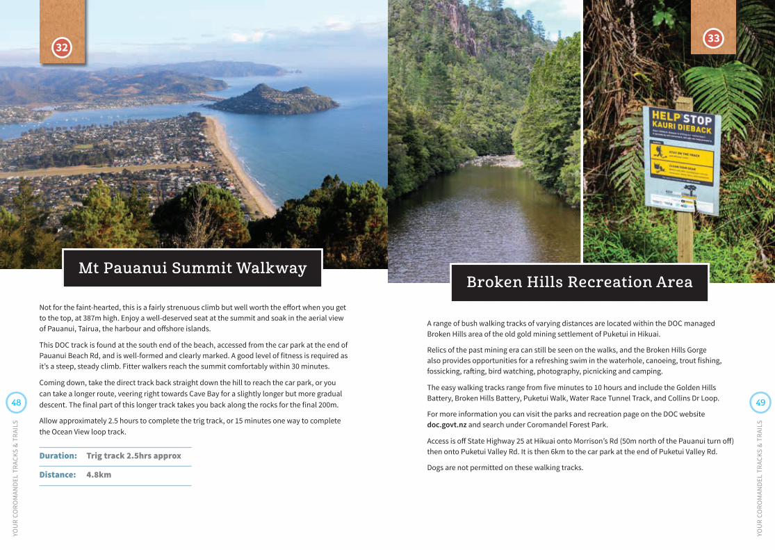
Not for the faint-hearted, this is a fairly strenuous climb but well worth the effort when you get to the top, at 387m high. Enjoy a well-deserved seat at the summit and soak in the aerial view of Pauanui, Tairua, the harbour and offshore islands.
This DOC track is found at the south end of the beach, accessed from the car park at the end of Pauanui Beach Rd, and is well-formed and clearly marked. A good level of fitness is required as it’s a steep, steady climb. Fitter walkers reach the summit comfortably within 30 minutes.
Coming down, take the direct track back straight down the hill to reach the car park, or you can take a longer route, veering right towards Cave Bay for a slightly longer but more gradual descent. The final part of this longer track takes you back along the rocks for the final 200m.
Allow approximately 2.5 hours to complete the trig track, or 15 minutes one way to complete the Ocean View loop track.
Duration: Trig track 2.5hrs approx
Distance: 4.8km
32
A range of bush walking tracks of varying distances are located within the DOC managed Broken Hills area of the old gold mining settlement of Puketui in Hikuai.
Relics of the past mining era can still be seen on the walks, and the Broken Hills Gorge also provides opportunities for a refreshing swim in the waterhole, canoeing, trout fishing, fossicking, rafting, bird watching, photography, picnicking and camping.
The easy walking tracks range from five minutes to 10 hours and include the Golden Hills Battery, Broken Hills Battery, Puketui Walk, Water Race Tunnel Track, and Collins Dr Loop.
For more information you can visit the parks and recreation page on the DOC website doc.govt.nz and search under Coromandel Forest Park.
Access is off State Highway 25 at Hikuai onto Morrison’s Rd (50m north of the Pauanui turn off) then onto Puketui Valley Rd. It is then 6km to the car park at the end of Puketui Valley Rd.
Dogs are not permitted on these walking tracks.
Broken Hills Recreation Area
33
Mt Pauanui Summit Walkway

50 51
YOU
R CO
ROM
AND
EL T
RACK
S &
TRAI
LS
YOU
R CO
ROM
AND
EL T
RACK
S &
TRAI
LS
The DOC managed Wentworth Valley Falls is close to Whangamata and an easy 3km walk that is a great activity for the whole family, including dogs (must be on a lead). It will take you about 1hour and 15minutes to reach the falls strolling through regenerating forest beside the river. Turn off State Highway 25, 7km south of Whangamata township, on to Wentworth Valley Rd (on the right as you’re travelling south) to discover Wentworth River. At the end of the road you’ll find a DOC campsite, picnic areas, and a bush track with historic gold mining features that will lead you to the stunning two-drop waterfall.
From the look-out point of the waterfall you can head down for a swim at the base of the falls; however, this is a difficult climb down and caution is advised.
Experienced trampers can continue on to cross the main range Maratoto-Wentworth Crossing which is an advanced track and takes approximately five hours one-way.
Duration: 2.5hrs return
Distance: 6km return
34
Wentworth Valley Falls
Te Ara O Te Wairoa Walkway takes in the beauty of the Whangamata Estuary and Harbour while providing linkages to our network of reserves. Some of this walkway remains in grass and walkers are directed by signage while other sections include formed paths and boardwalks.
You can easily access the walk from anywhere in Whangamata with the option of walking from town past the supermarket and following the fitness trail through to Hetherington Reserve, also along the estuary edge behind the town’s industrial area. Look for signage through Moana Point Reserve that directs walkers to the grassed trail as you enter Whangamata (before the causeway). At Awarua Point you will find the plaque marking the place where Whangamata’s first-ever shop was located.
There are concepts for proposed future stages that will create a walkway linking all of Whangamata’s reserves and allows walkers and cyclists to enjoy up to 8km of tracks with various surfaces. This concept will be done in stages as and when funding becomes available. tcdc.govt.nz/whangamatawalkway
Te Ara O Te Wairoa (Moana Anu Anu Harbour) Walkway
35

52
YOU
R CO
ROM
AND
EL T
RACK
S &
TRAI
LS
YOU
R CO
ROM
AND
EL T
RACK
S &
TRAI
LS
Peninsula Lookout
From Whangamata drive north on State Highway 25 for 11km until you reach the turn-off to Opoutere, where there are numerous walks and mountain biking options. The car park to access the DOC managed walk is approximately 4kms down Opoutere Rd. The track starts by crossing a wooden footbridge and through well-established pine trees. On reaching the beach follow the track to the right before walking along the shoreline to see for yourself one metre deep layers of shell that make up a fascinating archaeological midden confirming people have lived here from as early as 1350AD. At the southern end of Opoutere Beach lies the winding entrance to the Wharekawa Harbour which is protected by a spectacular sand spit. The spit is a breeding ground for several endangered species of native sea birds including the New Zealand Dotterel and Variable Oystercatcher. A DOC Ranger is on duty at the refuge during breeding season from November through to February.
You can also explore the Ohui rock pools at the northern end of the beach and into the state forest to visit the historic Phoenix goldmine.
Stay at the Opoutere Coastal Campground and easily access the tracks and trails from there: opouterebeach.co.nz
Duration: 40mins return
Distance: 1.5km return approx
36
Opoutere Forest to Beach Trail
There are two recreation areas near Onemana in the Tairua Forest, about a 10-minute drive from Whangamata. Off Tairua Rd (State Highway 25), on Whitipirorua Rd, turn right at the top of the hill on the way to Onemana to access Peninsula Rd or left to discover Pokohino. To access these drive along the gravel roads at 30kmh for 10-15 minutes to access the car parks, please take care and be mindful of cyclists. Always check the signage first that access is possible. The forestry company opens the gates at 7am and locks them at 7pm so you must be out by then.
At the end of Peninsula Rd enjoy a picturesque picnic area and encounter astounding views of Whangamata and its harbour. This track is a lot easier compared to the Pokohino Bay walk and will take 15-25 minutes depending on which track you take around the bush-clad hillside. Peninsula Rd is a popular mountain bike ride. You can also access a short but steep track which leads down to the secluded Te Ananui Beach.
37
If you turn left, instead of right onto Peninsula Rd, you end up at Pokohino Bay, a beautiful, secluded beach and only accessible on foot via a steep forest track. This track is not for the faint-hearted. From the car park the track will take you about 15-20 minutes, winding down to a tiny tidal lagoon. Ascending back to the car park will take longer, depending on your level of fitness, given the steep slope. This walk is unsuitable for anyone with limited mobility and fairly stout shoes are recommended.
Pokohino Bay
38
53

55
YOU
R CO
ROM
AND
EL T
RACK
S &
TRAI
LS
39Onemana Beach.
Photo: Andre Haruk.
The Whangamata Ridges Mountain Bike Park trailhead is located in forest company land, 4km north of Whangamata off Ridge Rd and features some amazing single-track, with purpose-built berms, jumps and rollers. The Grade 1-5 trails provide a huge amount of fun and days of enjoyment for everyone from families right through to advanced riders. There’s something here for all levels. Set in a mixture of native bush, pine forest and some recently cleared forest terrain, riders at Whangamata Ridges Mountain Bike Park will experience fun single-track, exciting downhills and climbs that reward the effort with spectacular views of ocean and forest. In addition to the introduction of eight brand new trails, there is a newly developed family-friendly area complete with industrial size sun-shades, picnic tables and a number of fun kiddie trails. This area can be accessed by vehicle between 7am to 7pm on weekends and public holidays.
Before you go riding it is best to stop into the local cycle shop, Pedal and Paddle at 700 Port Rd Whangamata (07 865 8096), to find out the best way to navigate around the park and see what tracks are open as this changes due to forestry works. Support the local mountain biking
club, enjoy unlimited access to the trails and contribute to future trail construction and maintenance by purchasing an annual membership for just $10, available from Pedal and Paddle. Riders can also purchase a permit from Destination Coromandel, our regional tourism promoter: thecoromandel.com
For more information, visit the Whangamata Ridges Mountain Bike Park Facebook page.
54
YOU
R CO
ROM
AND
EL T
RACK
S &
TRAI
LS
Whangamata Ridges Mountain Bike Park
The Whangamata Ridges Mountain Bike Park picnic area.

Ask a localOUR LOCAL INFORMATION CENTRES
We’ve got two i-SITEs and five Visitor Information Centres on the Coromandel that can point you in the right direction.
Check Destination Coromandel’s website thecoromandel.com for suggestions on where to stay, play,
eat and things to do in the Coromandel.
i-SITE Thames200 Mary St, 07 868 7284, [email protected] thecoromandel.com
i-SITE Whitianga66 Albert St, 07 866 5555, [email protected]
Whangamata Information Centre616 Port Rd, 027 311 4102, [email protected]
Tairua Information Centre2 Manaia Rd, 07 864 7575, [email protected], tairua.co.nz
Pauanui Information Centre23 Centreway, 07 864 7101, [email protected]
Coromandel Information Centre74 Kapanga Rd, 07 866 8598, [email protected], coromandeltown.co.nz
Kauaeranga Visitor Centre (DOC)Kauaeranga Valley Rd, Thames, 07 867 9080, [email protected]
Dece
mbe
r 201
9 ed
ition