
Town of Richmond Hill - trca.ca · Figure 2: Silver Maple Organic Deciduous Swamp (SWD6-2)..... 18...
54
Town of Richmond Hill Terrestrial Biological Inventory and Assessment September, 2015
Transcript of Town of Richmond Hill - trca.ca · Figure 2: Silver Maple Organic Deciduous Swamp (SWD6-2)..... 18...

Town of Richmond Hill
Terrestrial Biological Inventory and Assessment
September, 2015

Report prepared by: Paul Prior, Fauna Biologist
Natasha Gonsalves, Flora Biologist
Patricia Moleirinho, GIS Technologist
Reviewed by: Sue Hayes, Project Manager, Terrestrial Monitoring and
Inventories
Scott Jarvie, Associate Director, Environmental
Monitoring and Data Management Section
This report may be referenced as:
Toronto and Region Conservation Authority (TRCA). 2015. Town of
Richmond Hill: Terrestrial Biological Inventory and Assessment

T o w n o f R i c h m o n d H i l l T e r r e s t r i a l B i o l o g i c a l
I n v e n t o r y
September , 2015
i
Table of Contents
p a g e
1.0 Introduction ......................................................................................... 1
1.1 TRCA’s Terrestrial Natural Heritage Program ............................................................... 1
2.0 Study Area Location and History ........................................................ 3
3.0 Inventory Methodology .......................................................................... 5
3.1 Landscape Analysis ...................................................................................................... 7
3.2 Vegetation Communities, Flora and Fauna Species ..................................................... 8
4.0 Results and Discussion ....................................................................... 11
4.1 Regional Context ........................................................................................................ 11
4.2 Habitat Patch Findings for the Town of Richmond Hill ................................................ 11
4.2.1 Quantity of Natural Cover ............................................................................................... 12
4.2.2. Quality Distribution of Natural Cover.............................................................................. 13
4.3 Vegetation Community Findings for the Town of Richmond Hill ................................. 14
4.3.1 Vegetation Community Representation ......................................................................... 14
4.3.2 Vegetation Communities of Concern ............................................................................. 16
4.4 Flora Findings for the Town of Richmond Hill ............................................................. 18
4.4.1 Flora Species Representation ........................................................................................ 18
4.4.2 Flora Species of Concern .............................................................................................. 19
4.4.3 Historic Flora Findings ................................................................................................... 23
4.4.4 Invasive Species Findings .............................................................................................. 24
4.5 Fauna Species Findings for the Town of Richmond Hill ............................................ 27
4.5.1 Fauna Species of Concern ............................................................................................ 29
5.0 Summary and Recommendations ....................................................... 39
5.1 Site Summary ............................................................................................................. 40
5.2 Site Recommendations .............................................................................................. 41
6.0 References ........................................................................................... 46

T o w n o f R i c h m o n d H i l l T e r r e s t r i a l B i o l o g i c a l
I n v e n t o r y
September , 2015
ii
p a g e
L i s t o f Tab les Table 1: List of designated ANSI, ESA and PSW habitats within Richmond Hill ............................. 4 Table 2a: Local scores and ranks for vegetation communities ......................................................... 6 Table 2b: Local scores and ranks for flora species ............................................................................ 6 Table 2c: Local scores and ranks for fauna species .......................................................................... 7 Table 3: Habitat patch quality, rank and species response ............................................................. 8 Table 4: Schedule of TRCA biological surveys at Richmond Hill Study Area ................................. 9 Table 5: Schedule of TRCA biological surveys at Richmond Hill Study Area in 2014 .................... 9 Table 6: Summary of Vegetation Communities classified in Surveyed Areas ............................... 14 Table 7: Summary of Flora Species found in Surveyed Areas ...................................................... 19 Table 8: Summary of historic flora species found in Surveyed Areas, pre-2000 .......................... 23 Table 9: Fauna species believed to be locally extirpated .............................................................. 28 Table 10: Summary of Fauna Species of Concern, Surveyed Areas .............................................. 31
L i s t o f F igur es Figure 1: Proportion of broadly defined natural cover habitat types ............................................ 12 Figure 2: Silver Maple Organic Deciduous Swamp (SWD6-2) ....................................................... 18 Figure 3: Fringed polygala .............................................................................................................. 20 Figure 4: Woody betony .................................................................................................................. 21 Figure 5: Dame’s rocket .................................................................................................................. 25 Figure 6: European buckthorn invasion.......................................................................................... 26 Figure 7: Example of backyard encroachment into the natural area ............................................. 26 Figure 8: Jefferson complex salamander ....................................................................................... 30 Figure 9: Ground-nesting birds ....................................................................................................... 33 Figure 10: Canopy nesters ................................................................................................................ 35
L i s t o f Maps
Map 1: The Town of Richmond Hill Study Area in the Context of Regional Natural Cover ......... 48
Map 2: Public Land Ownership within the Town of Richmond Hill Study Area ........................... 49
Map 3: Surveyed Areas by TRCA in 2014 by Survey Block within the Study Area ..................... 50
Map 4: Surveyed Areas by TRCA by Year within the Town of Richmond Hill Study Area .......... 51
Map 5: LTMP Sites within the Town of Richmond Hill Study Area............................................... 52
Map 6a: Designated ANSI, ESA and PSW habitats within the Study Area, North ......................... 53
Map 6b: Designated ANSI, ESA and PSW habitats within the Study Area, South ........................ 54
Map 7 : Regional Natural System Habitat Patch Quality ............................................................... 55
Map 8: Distribution of Fauna Regional Species of Concern ........................................................ 56
Map 9a: Habitat Patch Size Scores with Fauna Area Sensitivity Scores, North (2005-2014) ....... 57

T o w n o f R i c h m o n d H i l l T e r r e s t r i a l B i o l o g i c a l
I n v e n t o r y
September , 2015
iii
Map 9b: Habitat Patch Size Scores with Fauna Area Sensitivity Scores, South (2005-2014) ...... 58
Map 10a: Interior Forest at the Town of Richmond Hill, North ......................................................... 59
Map 10b: Interior Forest at the Town of Richmond Hill, South ........................................................ 60
Map 11a: Scores for Matrix Influence and Flora Sensitivity to Development, North ....................... 61
Map 11b: Scores for Matrix Influence and Flora Sensitivity to Development, South....................... 62
Map 12a: Scores for Matrix Influence and Fauna Sensitivity to Development, North ..................... 63
Map 12b: Scores for Matrix Influence and Fauna Sensitivity to Development, South..................... 64
Map 13a: Habitat Patch Quality, North ............................................................................................. 65
Map 13b: Habitat Patch Quality, South ............................................................................................. 66
Map 14a: Vegetation Communities with their Associated Local Ranks, North................................ 67
Map 14b: Vegetation Communities with their Associated Local Ranks, South ............................... 68
Map 15a: Location of Flora Species of Concern, North ................................................................... 69
Map 15b: Location of Flora Species of Concern, South .................................................................. 70
Map 16a: Flora Species Habitat Dependence Scores, North .......................................................... 71
Map 16b: Flora Species Habitat Dependence Scores, South ......................................................... 72
Map 17a: Location of Fauna Species of Concern, North ................................................................. 73
Map 17b: Location of Fauna Species of Concern, South ................................................................ 74
Map 18a: Fauna Species Habitat Dependence Scores, North ........................................................ 75
Map 18b: Fauna Species Habitat Dependence Scores, South ....................................................... 76
List of Appendices Appendix 1: List of Vegetation Communities (1996-2014) ........................................................... 77
Appendix 1a: List of Vegetation Communities (2014) .................................................................... 82
Appendix 2: List of Flora Species (2000 - 2014) ........................................................................... 87
Appendix 2a: List of Flora Species by Survey Block (2014) ......................................................... 112
Appendix 2b: List of Historical Flora Species (pre-2000) ............................................................. 132
Appendix 2c: List of LTMP Flora Species (2008 - 2014) .............................................................. 134
Appendix 3: List of Fauna Species (2005 – 2014) ...................................................................... 140
Appendix 3a: List of Fauna Species by Survey Block (2014) ...................................................... 146
Appendix 3b: List of LTMP Fauna Species (2008 - 2014) ............................................................ 150

T o w n o f R i c h m o n d H i l l T e r r e s t r i a l B i o l o g i c a l
I n v e n t o r y
September , 2015
iv
Executive Summary
The Town of Richmond Hill straddles the Oak Ridges Moraine, a nationally significant natural feature, and extends south towards the City of Toronto, the most densely populated urban centre in Canada. This report presents the results of a terrestrial biological inventory that was conducted by the Toronto and Region Conservation Authority (TRCA) in 2014 on publicly owned lands (Town of Richmond Hill and TRCA) at the request of the Town. Additional data collected over the past two decades by the TRCA have also been compiled to augment the 2014 survey data including records from the long term monitoring project (LTMP) and incidental records from road ecology surveys. This data will be used to prioritize restoration activities and to inform land management decisions.
Richmond Hill covers 10,201 hectares of which 2,408 hectares (~24%) is identified as natural cover. The majority of this natural cover is situated in the northern quarter of the Town where several large forest blocks remain relatively intact; much of the land in the southern section was initially cleared for agriculture and is now largely urbanized, with remaining natural cover represented by narrow riparian corridors and a few small remnant upland forest blocks. Of the 2,408 hectares of natural cover, 1,930 hectares (80%) are designated as Area of Natural or Scientific Interest (ANSI), Environmentally Significant Area (ESA) or Provincially Significant Wetland (PSW).
The TRCA inventories are conducted at three different levels: the landscape level, the vegetation community level, and the species level. The first level references the latest (i.e. 2013) digital imagery and utilizes computer models to identify habitat patches at a broad scale; finer level analysis identifying unique vegetation community types is assessed in-field through the process of Ecological Land Classification; finally, flora and fauna species are assessed through extensive field surveys. The TRCA local ranking process (L-ranks), applied to all three levels of data, enables a consistent and readily comparable assessment of the overall health of the natural system within the study area. Since the ranking system is based on regional data, this provides a convenient way to compare the inventory results from the Study Area to the status of the regional natural heritage.
In total over the past two decades, the TRCA has inventoried 1,990 hectares of natural cover within the Study Area. Combined, the surveyed areas represent 83% of the natural cover in the Town; although 100% would be ideal, this is a large enough proportion to enable a good understanding of the overall status of natural heritage within the Study Area. The surveyed areas maintain 223 different vegetation communities, 918 naturally occurring flora species, and 149 fauna species. From a fauna perspective, the Study Area can be compared to the newly designated Rouge National Urban Park (RNUP). The RNUP, although only just over half the size of the Town, has a similar amount of natural cover (2301 ha), and has amassed a fauna inventory of 155 species over the past decade. Although the Urban Park is embedded in a largely agricultural matrix, with some extensive mature forest patches in the lower central reaches, the anticipated increase in public use over the next few years is going to present very similar issues to the ones expected to impact the more extensive forest features in the northern section of the Town.
T o w n o f R i c h m o n d H i l l T e r r e s t r i a l B i o l o g i c a l
I n v e n t o r y
September , 2015
v
The difference between the northern quarter and the remainder of the Study Area is very striking, and is well-illustrated by the variation in Habitat Patch Score: the northern quarter scores as L3 or “fair” with a couple of the more extensive forest patches scoring as L2 (“good”), while the more urbanized southern section scores as L4, “poor”. This difference is further reflected in the occurrence of flora and fauna species of regional concern. The majority of L1 to L3 fauna species (species of regional concern), for example, are located in the larger, more intact forest and wetland habitat features of the Oak Ridges Moraine Corridor. Similarly, the distribution and richness of L1 to L3 ranked flora species is greatest in the northern sections of the Study Area and are generally associated with high quality habitats particularly the provincially significant wetland and forest complexes. The ability of these areas to support the wide diversity of species that they do (including a number ecologically sensitive species uncommon in other parts of the Greater Toronto Area (GTA)) is owed in large part to their shape, size and low levels of disturbance. Flora species vary in their ability to tolerate disturbance; those most sensitive possess a low threshold to environmental change and will not persist should said conditions change too drastically. It is seen that all flora species of concern found within the Study Area are sensitive to development, being vulnerable to at least one kind of disturbance that is associated with land use changes.
In order to at least maintain the current condition of natural heritage features within the Study Area there are several challenges that must be met in managing the existing patches of natural cover and the surrounding increasingly urban matrix. The prevalence of invasive non-native plants throughout much of the surveyed areas has been identified as a potential major threat to the quality of the Town’s natural system. As urbanization continues to spread across the northern quarter of the Study Area, many of the issues that have already impacted the remnant natural features to the south will need to be mitigated in order to prevent a similar deterioration of the natural features in this northern section. There are also opportunities within these challenges; the inevitable increase in public use of the natural features as the urban landscape continues to expand may be off-set by actively engaging the local community in stewardship of their natural landscape.

T o w n o f R i c h m o n d H i l l T e r r e s t r i a l B i o l o g i c a l
I n v e n t o r y
September , 2015
1
1.0 Introduction
In 2014, the Toronto Region Conservation Authority (TRCA) conducted an extensive biological
inventory of flora, vegetation community, and fauna species within the municipal boundary of the
Town of Richmond Hill (hereafter referred to as “the Town” or “Study Area”)(Map 1). At the
request of the municipality, all properties with natural cover owned and managed by the Town
were the focus of the inventory (hereafter referred to as the “Surveyed Areas”) (Maps 2 and 3).
The biological inventory performed in 2014 provides an update to past biological data across the
Study Area.
Additional field data for sites within the municipal boundaries but not managed by the Town, e.g.
Lake Wilcox, Lake St. George, Oak Ridges Moraine Corridor Park (ORMCP) and Oak Ridges
Corridor Conservation Reserve East (ORCCRE), supplementary data from fixed long-term
monitoring project (LTMP) stations, and additional supplementary records from TRCA staff
biologists conducting road ecology surveys, were also incorporated into the dataset (Maps 4 and
5). This report serves to bring together all of this data from various sources in order to provide a
comprehensive analysis of the current state of the natural conditions in the Town. This compilation
of data will inform the prioritization of areas for restoration and land management activities. As with
other local jurisdictions, Emerald Ash Borer (EAB) along with various other invasive pests and the
recent ice storm has had significant effects on the tree canopy in the Town of Richmond Hill.
Through the development and implementation of a restoration plan that will look to protect,
enhance and increase biodiversity of the natural areas in Richmond Hill, it will become more
resilient against future threats.
At the larger scale, the purpose of the work conducted by the TRCA during the 2014 field season
was to characterize the terrestrial natural heritage features of the Town of Richmond Hill Study
Area. Once characterized, the site features can then be understood within the larger Humber, Don
and Rouge River watersheds and regional contexts of the Terrestrial Natural Heritage Program,
enabling a better understanding of biodiversity across the TRCA’s jurisdiction, thereby helping to
improve the Terrestrial Natural Heritage System Strategy (TNHSS) targets. The question that the
inventory addresses is “How do the areas surveyed in Richmond Hill fit within the regional and watershed natural system, and how should its contribution to this system be protected and maximized?” The important underlying message offered by this question is that the health of the
natural system is measured at the regional scale and specific sites must be considered together
for their benefits at all scales, from the site to the larger system.
1.1 TRCA’s Terrestrial Natural Heritage Program
Rapid urban expansion in the TRCA jurisdiction has led to continuous and incremental loss of
natural cover and species. In a landscape that probably supported 95% forest cover prior to
European settlement, current mapping shows that only 17% forest and wetland cover remains.

T o w n o f R i c h m o n d H i l l T e r r e s t r i a l B i o l o g i c a l
I n v e n t o r y
September , 2015
2
Agricultural and natural lands are increasingly being urbanized while species continue to
disappear from a landscape that is less able to support them. This represents a substantial loss of
ecological integrity and ecosystem function that will be exacerbated in the future according to
current urbanization trends. With the loss of natural cover, diminishing proportions of various
natural vegetation communities and reduced populations of native species remain. Unforeseen
stresses are then exerted on the remaining flora and fauna in the natural heritage system. They
become even rarer and may eventually be lost. This trend lowers the ability of the land to support
biodiversity and to maintain or enhance human society (e.g. through increased pollution and
decreased space for recreation). The important issue is the cumulative loss of natural cover in the
TRCA region that has resulted from innumerable site-specific decisions.
In the late 1990s the TRCA initiated the Terrestrial Natural Heritage Program to address the loss of
terrestrial biodiversity within the jurisdiction’s nine watersheds. This work is based on two
landscape-level indicators: the quality distribution of natural cover and the quantity of natural
cover. The aim of the program is to create a conservation strategy that both protects elements of
the natural system (vegetation communities, flora and fauna species) before they become rare
and promotes greater ecological function of the natural system as a whole. This preventive
approach is needed because by the time a community or species has become rare, irreversible
damage has often already occurred. A healthy natural system capable of supporting regional
biodiversity in the long term is the goal of the Terrestrial Natural Heritage Systems Strategy by
setting targets – both short- and long-term (100 years) – for the two landscape indicators in order
to provide direction in planning at all scales (TRCA 2007a, TRCA 2007b).
A target system that identifies a land base where natural cover should be restored is a key
component of the Strategy. Although the objectives of the Strategy are based on making positive
changes at all scales, the evaluation models were developed at the landscape scale using a
combination of digital land cover mapping and field-collected data. Field-collected data also
provides ground-level information in the application of the landscape models at the site scale. The
two indicators and the targets that have been set for them are explained in Section 3.1. It is
important to understand that habitat quality and distribution are interdependent. For example,
neither well-distributed poor-quality natural cover nor poorly-distributed good-quality natural cover
achieves the desired condition of sustainable biodiversity and social benefits across the
watershed.
The natural habitat within the Town of Richmond Hill covers an extensive area as well as forming
important links along the riparian corridors of the upper reaches of the East Humber, Rouge and
Don Rivers. The natural cover in the northern section constitutes a very important link in the east-
west corridor of the Oak Ridges Moraine corridor. In the southern half of the Study Area the
remnant natural cover patches are extremely important in maintaining effective migration and
dispersal routes across the rapidly expanding urban landscape.

T o w n o f R i c h m o n d H i l l T e r r e s t r i a l B i o l o g i c a l
I n v e n t o r y
September , 2015
3
2.0 Study Area Location and History
Located in York Region, the Town of Richmond Hill covers 10,201 ha and is bound by 4 major
roads: Bloomington Road to the north, Highway 7 to the south, Highway 404 to the east and
Bathurst Street to the west (Maps 1 and 2). The Town is subdivided by 3 watersheds: the upper
reaches of the Humber River watershed, the upper and mid-reaches of the Rouge River watershed
and the northern reaches of the Don River watershed.
The vast majority (approximately three-quarters) of the Town lies within the Great Lakes – St.
Lawrence floristic region, a region which is composed primarily of mixed coniferous-deciduous
forest. Extending into the southwest area of the site is a branch of the Carolinian floristic region, a
region associated with deciduous tree species.
There are three distinct physiographic regions found in the Town: the Peel Plain, the South Slope
and the Oak Ridges Moraine (ORM). A wide swath of the Peel Plain runs to the south and is
defined by till plains and scattered occurrences of drumlins. This lends to a topography that
ranges from predominantly flat to gently undulating. Soils are mainly comprised of clay loams and
clays with lesser occurrences of loam and sandy loams. The high clay content of these soils
functions to impede the flow of water resulting in low to moderate soil permeability. Past land-use
was mainly agriculturally based owing to the fertile nature of the soils.
The South Slope physiographic region is found to the north of the Peel Plain. It runs through the
middle of Richmond Hill and is characterized by druminalized till plains. The soils, found in both
upland and bottomland areas, are loam-based with clay loams, sandy loams and loam covering
the greatest extent of the Town. Soil permeability is moderate in areas with sandy loams and low
in areas with clay loams. The steep topography and low soil permeability means that surface
waters tend to drain quickly into the neighboring watercourses.
The main physiographic region to the north is the ORM. It is marked by kame moraines and till
moraines giving the topography a distinctly hilly appearance. Soil textures are somewhat variable
with a mosaic of sandy loam, clay loam and loam soils constituting the main bulk. This region is
known for its kettle lake formations left by past glacier activity; Lake Wilcox, Bond Lake, Philips
Lake and Lake St. George being amongst the largest of these water bodies. The ORM has a high
concentration of identified Provincially Significant Wetlands (PSW), Areas of Natural and Scientific
Interest (ANSI) and Environmentally Sensitive Areas (ESA) that collectively support a wide
diversity of species. Most notably are the Rouge River Headwater Wetland Complex, Wilcox – St.
George Wetland Complex; the Philips-Bond–Thompson Wetland Complex, Jefferson Forest,
Bloomington Wetlands, and Simeon Lake Forest Complex. The first three are Provincially
Significant Wetland systems that form an extensive network of marsh, swamp and bog
communities throughout the Study Area while the latter are ANSI and/or ESA. South of 19th Line
fewer pockets of significant wetland and forest habitats are seen. However, sections of the
provincially significant Rouge River Headwater Wetland Complex as well as the Richvale Forest
ESA, (located south of Carrville Rd) are present (Table 1 and Maps 6a/b).
T o w n o f R i c h m o n d H i l l T e r r e s t r i a l B i o l o g i c a l
I n v e n t o r y
September , 2015
4
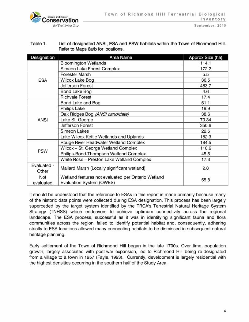
Table 1. List of designated ANSI, ESA and PSW habitats within the Town of Richmond Hill. Refer to Maps 6a/b for locations.
Designation Area Name Approx Size (ha)
ESA
Bloomington Wetlands 114.1
Simeon Lake Forest Complex 172.2
Forester Marsh 5.5
Wilcox Lake Bog 36.5
Jefferson Forest 483.7
Bond Lake Bog 4.6
Richvale Forest 17.4
ANSI
Bond Lake and Bog 51.1
Philips Lake 19.9
Oak Ridges Bog (ANSI candidate) 38.6
Lake St. George 70.34
Jefferson Forest 350.6
Simeon Lakes 22.5
Lake Wilcox Kettle Wetlands and Uplands 182.3
PSW
Rouge River Headwater Wetland Complex 184.5
Wilcox – St. George Wetland Complex 110.6
Philips-Bond-Thompson Wetland Complex 45.5
White Rose – Preston Lake Wetland Complex 17.3
Evaluated -
Other Mallard Marsh (Locally significant wetland) 2.8
Not
evaluated
Wetland features not evaluated per Ontario Wetland Evaluation System (OWES)
55.8
It should be understood that the reference to ESAs in this report is made primarily because many
of the historic data points were collected during ESA designation. This process has been largely
superceded by the target system identified by the TRCA's Terrestrial Natural Heritage System
Strategy (TNHSS) which endeavors to achieve optimum connectivity across the regional
landscape. The ESA process, successful as it was in identifying significant fauna and flora
communities across the region, failed to identify potential habitat and, consequently, adhering
strictly to ESA locations allowed many connecting habitats to be dismissed in subsequent natural
heritage planning.
Early settlement of the Town of Richmond Hill began in the late 1700s. Over time, population
growth, largely associated with post-war expansion, led to Richmond Hill being re-designated
from a village to a town in 1957 (Fayle, 1993). Currently, development is largely residential with
the highest densities occurring in the southern half of the Study Area.

T o w n o f R i c h m o n d H i l l T e r r e s t r i a l B i o l o g i c a l
I n v e n t o r y
September , 2015
5
3.0 Inventory Methodology
A biological inventory was conducted at the levels of habitat patch (landscape analysis),
vegetation community, and species (flora and fauna) according to the TRCA methodologies for
landscape evaluation (TRCA 2007c) and field data collection (TRCA 2007d). Habitat patch
mapping was collected across all TRCA watersheds in 2013 using four broadly-defined patch
categories: forest, wetland, meadow and dynamic (i.e. beach, bluff, dune, prairie or savannah)
communities. The mapping was digitized using ArcView GIS software. This data was then used to
conduct the landscape analysis across the TRCA region and a subset using the Town of
Richmond Hill boundary was created. Contrary to the landscape analysis completed for the entire
Study Area, the vegetation community and species level data were collected through site level
biological inventories in 2014.
A key component of the field data collection is the scoring and ranking of vegetation communities
and flora and fauna species to generate local “L” ranks (L1 to L5); this process was undertaken in
1996-2000 and ranks are reviewed regularly (TRCA 2010a). Vegetation community ranks are
based on scores from two criteria: local occurrence and the number of geophysical requirements
or factors on which they depend (Table 2a). Flora species are ranks are based on the scores for
four criteria: local occurrence, population trend, habitat dependence, and sensitivity to impacts
associated with development (Table 2b). Fauna species are ranked based on the scores of seven
criteria: local occurrence, local population trend, continent-wide population trend, habitat dependence, sensitivity to development, area-sensitivity, and patch isolation sensitivity (Table 2c).
With the use of this ranking system, communities or species of regional concern, ranked L1 to L3,
now replace the idea of rare communities or species. Rarity (local occurrence) is still considered
as one of many criteria that make up the L-ranks, making it possible to recognize communities or
species of regional concern before they have become rare.
In addition to the L1 to L3 ranked species, a large number of currently common or secure species
at the regional level are considered of concern in the urban context. These are the species
identified with an L-rank of L4. Although L4 species are widespread and frequently occur in
relatively intact urban sites, they are vulnerable to long-term declines.

T o w n o f R i c h m o n d H i l l T e r r e s t r i a l B i o l o g i c a l
I n v e n t o r y
September , 2015
6
Table 2a: Local scores and conservation ranks for vegetation communities
Total of Scores Rank Level of Conservation Concern in TRCA Region
1-2 L5 Generally secure; may be a conservation concern in a few specific situations. Contributes to natural cover.
3-4 L4 Generally secure in rural matrix; of conservation concern in the urban matrix.
5-6 L3 Of regional concern; restricted in occurrence and/or requires specific site conditions; generally occurs in natural rather than cultural areas.
7-8 L2 Of regional concern; typically occurs in high-quality natural areas and under highly specific site conditions; probably at risk in the Toronto area.
9-10 L1 Of regional concern in TRCA jurisdiction due to rarity, stringent habitat needs, and/or threat to habitat.
Blank L+ Community defined by alien species (e.g. Scots pine plantation, buckthorn thicket). Contributes to natural cover at least to some extent.
Table 2b: Local scores and conservation ranks for flora species
Total of Scores Rank Level of Conservation Concern in TRCA Region
2-10 L5
Able to withstand high levels of disturbance; generally secure throughout the jurisdiction, including the urban matrix. May be of very localized concern in highly degraded areas.
11-13 L4 Able to withstand some disturbance; generally secure in rural matrix; of concern in urban matrix.
14-16 L3 Able to withstand minor disturbance; generally secure in natural matrix; considered to be of regional concern.
17-18 L2
Unable to withstand disturbance; some criteria are very limiting factors; generally occur in high-quality natural areas, in natural matrix; probably rare in the TRCA jurisdiction; of concern regionally.
19-20 L1
Unable to withstand disturbance; many criteria are limiting factors; generally occur in high-quality natural areas in natural matrix; almost certainly rare in the TRCA jurisdiction; of concern regionally.
Not scored LX Extirpated from our region with remote chance of rediscovery. Presumably highly sensitive.
Not scored LH Hybrid between two native species. Usually not scored unless highly stable and behaves like a species (e.g. Equisetum x nelsonii).
Not scored L+ Exotic. Not native to TRCA jurisdiction. Includes hybrids between a native species and an exotic.
Not scored L+? Origin uncertain or disputed (i.e. may or may not be native).

T o w n o f R i c h m o n d H i l l T e r r e s t r i a l B i o l o g i c a l
I n v e n t o r y
September , 2015
7
Table 2c: Local conservation ranks and scores for fauna species
Total of Scores Rank Level of Conservation Concern in TRCA Region
2 - 9 L5 Generally secure; may be of conservation concern in a few specific situations at upper end of score range.
10 - 14 L4 Generally secure in the rural matrix; of conservation concern in the urban matrix.
15 - 19 L3 Of regional concern; restricted in occurrence and/or requires specific site
conditions; generally occurs in natural rather than cultural areas.
20 - 24 L2 Of regional concern; occurs in high quality natural areas and under highly specific site conditions; probably at risk within the Toronto region.
25 - 40 L1 Of regional concern in the TRCA region due to rarity, stringent habitat needs and/or threat to habitat.
Not scored U Unscored (e.g. as yet unassigned).
Not scored L+ Exotic/non-native species. Usually occurring through intentional introduction.
Not scored LX Extirpated from the region with remote chance of rediscovery. Presumably highly sensitive.
3.1 Landscape Analysis
The quality, distribution and quantity of natural cover in a region are important determinants of the
species distribution, vegetation community health and the provision of ecosystem services (e.g.
air and water quality, recreation, aesthetics) in that region.
Base Mapping
The first step in evaluating a natural system or an individual habitat patch is to interpret and map
land cover using aerial photographs. The basic unit for the evaluation at all scales is the habitat
patch in the region, which are then combined and evaluated as a system at any scale. A habitat patch is a continuous piece of habitat, as determined from aerial photo interpretation. The TRCA
maps habitat according to four broad categories: forest, wetland, meadow, and dynamic (i.e.
beach, dune, bluff, prairie or savannah). At the regional level, the TRCA jurisdiction is made up of
thousands of habitat patches. This mapping of habitat patches in broad categories is conducted
through remote–sensing and is used in the evaluation of quality, distribution and quantity of
natural cover. It should not be confused with the more detailed mapping of vegetation
communities obtained through field surveys and that is used to ground-truth the evaluation (see
Section 3.2).

T o w n o f R i c h m o n d H i l l T e r r e s t r i a l B i o l o g i c a l
I n v e n t o r y
September , 2015
8
Quality Distribution of Natural Cover
The quality of each habitat patch is evaluated according to three criteria: size (the number of
hectares occupied by the patch), shape (edge-to-area ratio), and matrix influence (measure of the
positive and negative impacts from surrounding land-use) (TRCA 2007c). A total score for each
patch is obtained through a weighted average of the scores for the three criteria. This total score is
used as a measure of the ‘quality’ of a habitat patch and is translated into a local rank (L-rank)
ranging from L1 to L5 based on the range of possible total scores from 3 to 15 points. Of these L-
ranks, L1 represents the highest quality habitat and L5 the poorest.
Species presence or absence correlates to habitat patch quality (size, shape and matrix influence)
(Kilgour 2003). The quality target is based on attaining a quality of habitat patch throughout the
natural system that would support in the very long term a broad range of biodiversity, specifically
a quality that would support the region’s fauna Species of Conservation Concern (Table 3).
Table 3: Habitat patch quality, rank and species response
Size, Shape and Matrix Influence Patch Rank Fauna Species of Conservation Concern
Excellent L1 Generally found
Good L2 Generally found
Fair L3 Generally found
Poor L4 Generally not found
Very Poor L5 Generally not found
Quantity
The amount of natural cover needed in the landscape is based on the quantity required to
accommodate and achieve the quality distribution targets described above. The two targets are
therefore linked to each other: it will be impossible to achieve the required distribution of natural
heritage quality without the appropriate quantity of natural cover. The proportion of the region that
needs to be maintained as natural cover in order to achieve the desired quality has been identified
as 30% (TRCA, 2007a).
3.2 Vegetation Communities, Flora and Fauna Species
Vegetation community and flora and fauna species data were collected through field surveys
(Table 4 and 5). These surveys were done during the appropriate times of year to capture
breeding status in the case of amphibians and birds, and during the optimal growing period of the
various plant species and communities. Vegetation communities and flora species were surveyed
concurrently.

T o w n o f R i c h m o n d H i l l T e r r e s t r i a l B i o l o g i c a l
I n v e n t o r y
September , 2015
9
Table 4. Schedule of TRCA biological surveys conducted throughout the Town of Richmond Hill (1996 to 2014). Refer to Maps 3 and 4 for overview.
Survey Item Survey Year(s)
Patch / Landscape (across entire Study Area) 2002, 2007/08; 2013
Vegetation Communities and Flora Species
(Surveyed Areas only) 1996-1998*; 2000; 2001-2009; 2011-2014
Terrestrial long-term forest and wetland
monitoring plots 2008-2014
Frogs and Nocturnal Spring Birds (Surveyed
Areas only) 1996, 1997; 1999-2014
Breeding Songbirds (Surveyed Areas only) 1996, 1997; 2000-2014
*flora species records only
Table 5. Schedule of TRCA biological surveys conducted throughout the Town of Richmond Hill (2014). Refer to Map 3 for overview.
Survey Item Survey Date(s) Survey Effort (Hours)
Patch / Landscape
(across entire Study Area) 2013 ortho-photos 26 hours
Vegetation Communities and Flora
Species (Surveyed Areas only) May 1st – Oct 3rd 784 hours
Terrestrial long-term forest and wetland
monitoring plots
May: 21st ; Jul: 11th ; Aug: 24th ;
Sept: 4th, 9th ~18 hours
Frogs and Nocturnal Spring Birds
(Surveyed Areas only) April: 22nd, 24th; May 12th – 14th 19 hours
Breeding Songbirds
(Surveyed Areas only)
May 30th; June 2nd – 6th, 11th,
18th, 19th, 23rd – 27th, 30th; July
2nd – 4th, 10th.
112.5 hours
Botanical field-work was conducted from spring to late fall in 2014 for natural areas owned by the
Town (Maps 2 and 3). To facilitate the 2014 inventory work, the Study Area was split into survey
blocks. Blocks were delineated according to the major roadways that intersect the Study Area and
given a letter A through Y (Map 3). For each of the survey blocks, a corresponding vegetation,
flora and fauna list documenting all species detected or communities described, was created
(Appendices 1a, 2a and 3a). Vegetation community designations were based on the Ecological
Land Classification (ELC) for Southern Ontario and determined to the level of vegetation type (Lee
et al. 1998). Community boundaries were outlined onto printouts of digital ortho-rectified
photographs (ortho-photos) to a scale of 1:2000 and then digitized in ArcView. Flora species of
regional concern (species ranked L1 to L3) were mapped as point data with approximate number
of individuals seen.

T o w n o f R i c h m o n d H i l l T e r r e s t r i a l B i o l o g i c a l
I n v e n t o r y
September , 2015
10
As natural cover within the surveyed areas extends beyond the areas owned and managed by the
Town, supplementary botanical data from terrestrial inventories conducted over the last 15 years
(which includes all TRCA owned properties) was also included to provide enhanced (but not complete) coverage (Appendices 1 - 3). Map 4 shows all natural areas surveyed by TRCA in the
Town of Richmond Hill between the years 1996 and 2013. (Note: Webster Park was not surveyed in 2014 as ELC and flora data for this area was collected in 2013). Furthermore, applicable data
from TRCA long-term fixed monitoring plots (two forest plots and nine wetland transects)
established between 2008 and 2014 (Map 5) as well as relevant historic data (i.e. pre- 2000) was
compiled and provided in Appendix 2b and 2c.
The TRCA has conducted fauna inventories at various sites within the Town almost annually since
1996. The extent of these inventories has varied from year to year and until 2014 there had been
little duplication and revisiting of sites. In 2014, an effort was made to update the inventories for
allof the Town owned properties and therefore many sites were visited for a second time allowing
for a certain amount of comparison between specific habitat patches in the Study Area. The
protocol for inventories conducted by the TRCA has remained constant since 2000 and can be
considered as two elements: spring fauna surveys search primarily for frog species of regional
conservation concern and record incidentally the presence of any early-spring nocturnal bird
species (owls and American woodcocks); surveys conducted from late-May through to mid-July
are concerned primarily with the mapping of breeding bird species of regional conservation
concern.
The only aspect of the TRCA’s inventories within the Town over the past 14 years that has not
been entirely constant is the list of mappable species. Throughout the TRCA region all L1 to L3
ranked species’ territories are mapped, but in general, L4 ranked species have only been mapped
in areas considered either urban or near-urban. Over the course of the past 14 years, sites that
once were considered entirely rural (and therefore were only mapped for L1 to L3 species) now
fall within the matrix influence of new urban developments, and as such, require the mapping of
L4 species in addition to the L1 to L3 ranked species. This is an important consideration in making
any comparisons between the number of points mapped for each species across the years. In
2014, all L1 to L4 ranked species – species of regional and urban concern were mapped within
the surveyed areas.
As per the TRCA data collection protocol, breeding bird surveys were carried out by visiting all
parts of the site at least twice during the breeding season (last week of May to mid-July) to
determine the breeding status of each mapped point. The methodology for identifying confirmed
and possible breeding birds follows Cadman et al. (2007). All initial visits were completed by the
end of the third week of June. The field-season is organized so that by late June only repeat visits
are being conducted. It is imperative that any visit made in the first half of June is subsequently
validated by a second visit later in the season. Fauna species of regional and urban concern
(species ranked L1 to L4) were mapped as point data with each point representing a possible
breeding territory.

T o w n o f R i c h m o n d H i l l T e r r e s t r i a l B i o l o g i c a l
I n v e n t o r y
September , 2015
11
In addition to the data collected during extensive formal TRCA surveys, this inventory considers
the supplementary fauna observations mapped during the annual LTMP counts. As of 2014, there
are a total of 22 fauna LTMP stations in the Town, all concentrated in the north half of the Study
Area, on the Oak Ridges Moraine (Map 5). The list of fauna LTMP stations (Appendix 3b) consists
of 10 combined wetland frog and bird stations, 4 meadow bird stations, 7 forest bird stations and
one red-backed salamander plot. This current document, an overview of the natural system of the
entire Study Area, also includes incidental fauna observations made by TRCA staff outside of the
formal inventories and monitoring projects, and additional records from various Ministry of Natural
Resources and Forestry (MNRF) surveys, e.g. records from the Ontario Herpetological Atlas
(OHS). Note that the TRCA’s fauna data management protocol imposes a 10 year threshold on
use of historical data, and therefore observations made prior to 2005 are not included in any
calculation of current inventory.
4.0 Results and Discussion
Information pertaining to the Study Area was collected through both remote-sensing and ground-
truthing surveys. This information contains three levels of detail: habitat patch, vegetation
community, and species (flora and fauna). This section provides the information collected and its
analysis in the context of the TNHS Strategy.
4.1 Regional Context
Based on 2013 ortho-photography, approximately 26% of the land area in the TRCA jurisdiction
consists of natural cover. Of the non-natural cover (i.e. the remaining 74% of the land area), 51% is
urban and 23% is rural / agricultural. The regional level analysis of habitat patches shows that the
present average patch quality across the TRCA jurisdiction is “fair” (L3 rank) (Map 7). Although
historically, the region would have consisted of up to 95% forest cover, currently only about 18% is
covered by forest and wetland that is contained largely in the northern half of the TRCA
jurisdiction. In addition, meadow cover stands at 7.7% of the region. Thus the existing natural
system stands below the quantity target that has been set for the region (30%) and also has an
unbalanced distribution. The distribution of fauna species of concern is also largely restricted to
the northern part of the jurisdiction; fauna species of regional concern are generally absent from
the urban matrix (Map 8). The regional picture, being the result of a long history of land use
changes, confirms that all site-based decisions contribute to the condition of a region.
4.2 Habitat Patch Findings for the Town of Richmond Hill
The following details the site according to the two natural system indicators used in designing the
Terrestrial Natural Heritage System Strategy: the quality distribution and quantity of natural cover.
Analysis was based on 2013 ortho-photos.

T o w n o f R i c h m o n d H i l l T e r r e s t r i a l B i o l o g i c a l
I n v e n t o r y
September , 2015
12
4.2.1 Quantity of Natural Cover
The entire Town is 10,201 ha in size and coarse habitat patch analysis shows a total of 2,408 ha of
natural cover (regardless of property boundary) which accounts for ~24% of the Study Area. A
more detailed (fine–level) habitat analysis describing the variability amongst habitat types and
vegetation communities is obtained through in-field vegetation surveys. The following results are
based on available data for surveyed areas only.
When ELC data collected over the last 15 years is compiled, it reveals a total of 1990 ha of
surveyed natural area (covering 83 % of the total natural cover) within the Study Area (Appendix
1). This natural cover is concentrated towards the northern half of the Study Area and is
comprised of 829.9 ha of forest, 205.7 ha of successional, 410.8 ha of meadow, 148.9 ha of
aquatic, 393 ha of wetland and 1.84 ha of dynamic (i.e. beach, bluff, dune, prairie or savannah)
habitat (Figure 1 and Appendix 1).
Figure 1: Proportion of broadly defined natural cover habitat types based on 2000 to 2014
ELC data in the Surveyed Areas.

T o w n o f R i c h m o n d H i l l T e r r e s t r i a l B i o l o g i c a l
I n v e n t o r y
September , 2015
13
4.2.2. Quality Distribution of Natural Cover
The results for quality distribution are reported below under the headings of habitat patch size and
shape, matrix influence and total score.
Habitat Patch Size and Shape
Existing habitat patches throughout much of the Study Area are generally narrow and highly
fragmented, exceptions being those natural areas that occur along the Oak Ridges Moraine (e.g.
ORMCP and ORCCRE) where natural cover remains relatively intact. The presence of interior
forest, up to 400 m from patch edge in two cases, improves overall patch quality. The most
extensive forest patch, that holds the largest area of interior forest, is located on the south side of
Stouffville Road, east of Yonge Street. Such large patches score as “good” for size but due to
irregularities in shape score “fair” to “very poor” for shape. Natural cover patches to the south
score “fair” to “poor” for their size and lack any interior habitat (i.e. no forest beyond 100 m from
any forest edge) but can score as high as “good” for shape if the feature has limited edge (Maps
9a/b and 10a/b).
Habitat Patch Matrix Influence
Analysis based on the 2013 ortho-photos shows that the matrix influence score for habitat in the
less urbanised northern section of the Study Area is generally “fair”, in contrast to the southern
half which scores an average of “very poor”(Maps 11a/b and 12a/b). The TRCA measures matrix
influence at the landscape level by assigning set values; positive, neutral and negative, to the type
of landscape use occurring within 2 km of the subject site. The Town of Richmond Hill is heavily
developed in the southern half with residential housing accounting for the greatest proportion of
landscape use. This urban landscape exerts a negative matrix influence on the remaining natural
cover. In the extreme north-eastern corner, north of Bethesda Road and east of Lake St. George,
where the matrix is either natural or agricultural, the patches of natural cover score as “good” for
matrix influence.
Habitat Patch Total Score
Factoring the combined scores of patch size, shape and matrix influence, the natural cover within
the northern half of the Town of Richmond Hill achieves a “fair” score, with only two large patches
of forest cover achieving a “good” score. Unfortunately, one of these two patches is the
aforementioned un-surveyed tract on the south side of Stouffville Road. The second “good” patch
of forest is the isolated tract on the south side of the railway, east of Leslie Street. There is one
additional area, a wetland (part of the White Rose – Preston Lake Wetland Complex), that scores
as “good” at the very north-eastern corner of the Study Area (Bloomington Road and Highway
404) (Map 13a). A clear divide exists between the northern and southern half of the Study Area;
the southern half of Richmond Hill achieves just a “poor” overall score (Map 13b). Landscape
scores are intended to be applied at the broader landscape level and therefore caution needs to
be exercised when referring to such measures at the more refined site level.

T o w n o f R i c h m o n d H i l l T e r r e s t r i a l B i o l o g i c a l
I n v e n t o r y
September , 2015
14
4.3 Vegetation Community Findings for the Town of Richmond Hill
4.3.1 Vegetation Community Representation
A total of 223 different vegetation communities were documented in the surveyed areas of the
Town. Eighteen of these are found solely as complexes or inclusions within larger vegetation
communities (Table 6).
Table 6. Summary of vegetation communities classified in Surveyed Areas
Class Number of Types Area (hectares)
Forest 95 829.9
Successional 23 205.7
Meadow 3 410.8
Wetland 81 393
Aquatic 14 148.9
Dynamic (e.g. beach, bluff, dune) 7 1.84
Total 223 1990.14
Forest habitat encompassing 95 different forest types (64 forests and 31 plantations) extended
over 830 ha of the surveyed areas and accounted for 42% of its total natural cover. Of those,
deciduous forests were the most diverse (40 types) occupying the largest expanse of area with
390 ha. Upland areas were generally dominated by sugar maple (Acer saccharum), red oak
(Quercus rubra), white birch (Betula paprifera) and trembling aspen (Populus tremuloides) with
lesser occurrences of white ash (Fraxinus americana) and black cherry (Prunus serotina). Communities of Dry-Fresh Sugar Maple Deciduous Forest (FOD5-1), Fresh-Moist Sugar Maple –
Hardwood Deciduous Forest and Dry-Fresh Sugar Maple–Oak Forest (FOD5-3) are most common
along tablelands while Dry-Fresh Hemlock Sugar Maple Forest (FOM3-2) is characteristic of
sloped areas.
Lowland forests and floodplain areas occurring on moister soils were associated with crack willow
(Salix x fragilis), black walnut (Juglans nigra), white elm (Ulmus americana) and Manitoba maple
(Acer negundo). The vegetation assemblages that spanned the largest expanse of area are Fresh-
Moist Willow Lowland Deciduous Forest (FOD7-3), Fresh-Moist Black Walnut Lowland Deciduous
Forest (FOD7-4), Fresh-Moist Manitoba Maple Lowland Deciduous Forest (FOD7-a) and Fresh-
Moist Exotic Lowland Deciduous Forest (FOD7-c). In descending order, they occupied 53.7 ha,
12.1 ha, 6.8 ha and 5.9 ha respectively.
Plantation represents approximately 34% (286 ha) of the surveyed forest cover and slightly less
than a third (14%) of the total cover in the surveyed area. Thirty-one plantation types were
documented with restoration plantations (i.e. mixed, deciduous and coniferous) collectively
covering the most area (187 ha). Most species selected for restoration efforts were native; white
pine (Pinus strobus), white spruce (Picea glauca) and trembling aspen were common and site
appropriate choices. Occasionally exotic species were incorporated into the restoration designs.

T o w n o f R i c h m o n d H i l l T e r r e s t r i a l B i o l o g i c a l
I n v e n t o r y
September , 2015
15
Scotch Pine Coniferous Plantation (CUP3-3), Black Locust Deciduous Plantation (CUP1-c) and
Black Locust - Conifer Mixed Plantation (CUP2-b) covered 9.6 ha, 5.0 ha and 1.0 ha respectively
and illustrate 3 intentional exotic plantings. Thirteen non-native plantations are described in the
surveyed areas. Exotic species such as these can easily become invasive if not managed
properly.
Successional habitats as represented by 23 different types (one found solely as a complex) cover
206 ha and provide 10% of the total natural cover throughout the surveyed area. Over half (52%)
of the successional cover is exotic in character. Exotic Successional Woodland (CUW1-b),
Buckthorn Deciduous Thicket (CUT1-b) and Exotic Successional Savannah (CUS1-b) are the
community types most prevalent and are chiefly dominated by buckthorn (Rhamnus cathartica), crack willow and English hawthorn (Crataegus monogyna). Native successional habitats
occupying the remaining area are largely denoted by Treed Hedgerow (CUH1-A), Hawthorn
Successional Woodland (CUW1-D) and Native Deciduous Successional Woodland (CUW1-A3).
Common associates in these communities are sugar maple, basswood (Tilia americana), dotted
hawthorn (Crataegus punctata) as well as staghorn sumac (Rhus typhina) and wild red raspberry
(Rubus idaeus spp. strigosus).
Meadow communities covering 411 ha are classified into 3 types and provide 21% of the total
natural cover in the surveyed areas. Native forb meadow (CUM1-A) is the most widespread
community type. This vegetation community contributed 180.7 ha of habitat and is generally
characterised by clustered collections of tall goldenrod (Solidago altissima), Canada goldenrod
(Solidago canadensis), New England aster (Symphyotrichum novae-angliae), and heath aster
(Symphyotrichum ericoides var. ericoides). With 179.1 ha, exotic forb meadow (CUM1-c)
dominated by weedy annual and bi-annual exotic herbaceous plants is the second-most
widespread community type. Queen Anne’s lace (Daucus carota), bird’s foot trefoil (Lotus corniculatus), cow vetch (Vicia cracca) and various clover species (Melilotus spp. and Trifolium spp), are amongst the list of exotic species associated with this community.
Wetlands spanning 393 ha represent 20% of the total natural cover surveyed throughout the
Town. A total of 81 different wetland types (37 swamps, 40 marshes, 3 bogs and 1 fen) were
documented. Seven only occur as an inclusion or complex. Collectively, native swamps provide
the most cover with 221 ha, followed by 167 ha of marsh and 5.0 ha of combined bog and fen
habitats. In particular, deciduous swamp communities (16) were the most prevalent and typically
associated with maple, ash and birch species over both mineral and organic substrates. Paper
Birch – Poplar Mineral Deciduous Swamp (SWD4-3), Silver Maple Organic Deciduous Swamp
(SWD6-2) and Willow Mineral Deciduous Swamp provided the most cover in swamps of this kind.
Coniferous and mixed swamp communities were found to a lesser extent; a total of 13 different
types were described. In most instances white cedar (Thuja occidentalis) was the single dominant
species with smaller assemblages of red maple (Acer rubrum) and yellow birch (Betula alleghaniensis). In this category White Cedar – Hardwood Organic Mixed Swamp (SWM4-1),
White Cedar Organic Coniferous Swamp (SWC3-1) and White Cedar Mineral Coniferous Swamp
(SWC1-1) were most prevalent. In addition, small to medium sized pockets of 15 exotic wetland
communities described were described. Reed Canary Grass Mineral Meadow Marsh (MAM2-2)

T o w n o f R i c h m o n d H i l l T e r r e s t r i a l B i o l o g i c a l
I n v e n t o r y
September , 2015
16
cover the largest area (43.4 ha) and are generally found along riparian corridors. This was
followed by 23.4 ha of Narrow-leaved Cattail Mineral Shallow Marsh (MAS2-1b) and 6.9 ha of
Exotic Mineral Thicket Swamp (SWT2-a).
Aquatic habitats total 149 ha (7.5% of natural cover surveyed) and consist of 5 submerged shallow
aquatic, 4 mixed shallow aquatic, 2 floating leaved shallow aquatic and 2 open aquatic community
types. Un-vegetated riverine and deep aquatic systems account for 61% of the surveyed natural
cover in this vegetation type. Water Milfoil Submerged Shallow Aquatic (SAS1-4), Pondweed
Submerged Shallow Aquatic (SAS1-1) and Duckweed Mixed Shallow Aquatic (SAM1-2) are the 3
most frequently encountered vegetated shallow aquatic communities.
Seven dynamic community types totalling 2 ha provide ≤1% of the surveyed areas’ natural cover.
Most were small patches of shrub and tree bluffs running adjacent river and stream corridors. The
most extensive community in this category was Fresh-Moist Tallgrass Prairie Planting (TPO2-A);
which equalled 1.6 ha.
4.3.2 Vegetation Communities of Concern
The vegetation communities that occur in the TRCA jurisdiction are scored and given a local rank
from L1 to L5 based on the two criteria mentioned in Section 3.0. Vegetation communities with a
rank of L1 to L3 are considered of concern across the entire jurisdiction while L4 communities are
considered of concern in the urban portion of the jurisdiction. There are 77 vegetation
communities occurring within the surveyed areas of the Study Area that have a L-rank of L1-L3
and 61 that are ranked L4 (communities are listed with ranks in Appendix 1; location and
boundaries shown on Maps 14a/b). The communities of regional conservation concern (L1 to L3)
occupy 226 ha, 11.4% of the total natural cover surveyed and consist of 17 forests, 49 wetlands, 6
aquatic, and 5 dynamic community types. The communities of urban concern (L4) occupy almost
double the amount of area with 435 ha (21.8% of natural cover surveyed) and consist of 29
forests, 9 successional, 17 wetlands and 6 aquatic community types. However, the L-rank in itself
is not sufficient for determining whether a particular community at the site is of high conservation
concern, other factors such as maturity, health and quality of habitat are also considered.
Forest vegetation communities of regional conservation concern (one L2 and sixteen L3) were
restricted to the upper regions of the Study Area just north of Elgin Mills Rd West. Dry-Fresh White
Pine-Oak Mixed Forest (FOM2-1) was the sole L2 ranked community documented. Two separate
patches of this community type have been described; the largest and most intact (~9.3 ha) was
found in the Jefferson Forest ESA/Lake Wilcox Kettle Wetlands and Uplands ANSI near the
northeast corner of Bayview Avenue and Stouffville Road. This mature forest is characterised by
white pine and red oak (Quercus rubra) in the canopy and a number of high quality shrub and
herbaceous species indicative of dry sandy soils in the understory including beaked hazel
(Corylus cornuta), maple-leaved viburnum (Viburnum acerfolium), witch hazel (Hamamelis virginiana), and rough-leaved dogwood (Cornus rugosa). Fresh-Moist Hemlock-White Pine
Coniferous Forest (FOC3-A), Dry–Fresh Oak- Red Maple Deciduous Forest (FOD2-1) and Dry-
Fresh Hardwood–Hemlock Mixed Forest (FOM3-1) were the next largest in total area covered (9.9

T o w n o f R i c h m o n d H i l l T e r r e s t r i a l B i o l o g i c a l
I n v e n t o r y
September , 2015
17
ha, 7.8 ha and 7.1 ha respectively). Furthermore, one FOD2-1 patch occurs in isolation and marks
the second largest intact forest block of any single vegetation type in the area. This mature forest,
located in the Oak Ridge’s Bog ANSI in the area south of Bloomington Road, purports a sedge
rich ground layer dominated by early-flowering sedge (Carex pedunculata), loose-flowered sedge
(Carex laxiflora) and Peck’s sedge (Carex peckii).
Similarly, the bulk of forest communities of urban concern (ranked L4) are also situated north of
Elgin Mills Road West. These communities are mainly comprised of fast growing early
successional species such trembling aspen and white birch as well later successional species of
sugar maple, black cherry and white ash. Fresh-Moist Ash Deciduous Forest (FOD7-2), Dry-Fresh
White Pine-Hardwood Mixed Forest (FOM2-A), Dry-Fresh Hemlock–Sugar Maple Mixed Forest
(FOM3-2) and Dry-Fresh Sugar Maple – Oak Deciduous Forest (FOD5-3) provide the most
coverage with 32.3 ha, 27.3 ha, 22.6 ha, and 19.2 ha individually.
Some of the larger parklands such as Webster Park, Mill Pond and Pioneer Park in the south west
regions of the Town supported a variety of L4 as well as a few L3 communities. Vegetation
patches in these areas are generally small to mid-sized which is expected given the surrounding
land-use. In Webster Park, mixed communities consisting of either white cedar and or hemlock in
association with common hardwoods (e.g. sugar maple, birch or poplar) are typical. Examples of
L4-ranked vegetation communities include Fresh-Moist Sugar Maple Hemlock Mixed Forest
(FOM6-1), Fresh-Moist White Cedar Sugar Maple Mixed Forest (FOM7-1) and Fresh-Moist White
Cedar Hardwood Mixed Forest (FOM7-2). White Pine dominated communities of FOM2-A were
described in Mill Pond and Pioneer Park as well as one L3-ranked Dry-Fresh White Cedar Paper
Birch Mixed Forest (FOM4-1) in Mill Pond.
Wetland habitats (i.e. swamp, marsh, bog and fen) are concentrated to the north along the Oak
Ridge’s Moraine in Blocks A, B, C, D, and E. and are mostly linked to designated PSW, ANSI or
ESAs such as Wilcox – St-George Wetland Complex and the Philips – Bond –Thompson Wetland
Complex. A total of 49 wetland communities were deemed of regional concern (–five L1s;
eighteen L2s; and twenty-six L3s). Another seventeen L4 ranked communities were documented.
Swamp communities exhibited the most diversity with 36 different native types recorded. White
cedar in association with hardwoods such as silver maple (Acer saccharinum), red maple, yellow
birch and black ash (Fraxinus nigra) dominated the broad spectrum of swamp communities.
Examples of communities found include Silver Maple Organic Deciduous Swamp (SWD6-
2)(Figure 2); Birch-Conifer Organic Mixed Swamp (SWM6-1); Red Maple Organic Deciduous
Swamp (SWD6-1) and Red Maple – Conifer Organic Mixed Swamp (SWM5-1). Productivity was
high in most of the wetland communities with a number of uncommon and rare species being
found. Of particular rarity is Tamarack – Black Spruce Organic Coniferous Swamp (SWC4-1)
found in Bond Lake Bog ANSI and Oak Ridge Bog ANSI (candidate). It is the only L1 ranked
swamp community within the surveyed areas. Four other L1 communities consisting of three bogs
and one fen were found. These are listed as follows: Leatherleaf shrub kettle bog (BOS2-1);
Tamarack- Leatherleaf Treed Kettle Bog (BOT2-1), and White Pine – Red Maple – Birch –
Leatherleaf Treed Kettle Bog (BOT2-1A). The strict geo-physical requirements in conjunction with
limited distribution across the TRCA jurisdiction lead to the high ranking of these communities.

T o w n o f R i c h m o n d H i l l T e r r e s t r i a l B i o l o g i c a l
I n v e n t o r y
September , 2015
18
Twelve of the fourteen aquatic communities are of concern in either a regional or urban wide
context (6–L3s and 6 L4s). The communities of regional concern were predominantly mixed
shallow aquatics such as Water Lily – Bull Lily Mixed Shallow Aquatic (SAM1-A) and Duckweed
Mixed Shallow Aquatic (SAM1-2) while Pondweed Submerged Shallow Aquatic (SAS1-1) and
Water Milfoil Submerged Shallow Aquatic (SAS1-4) are two L4 communities that cover the most
area. Collectively, shallow aquatic communities occupy 58 ha of the surveyed areas.
Figure 2: Silver Maple Organic Deciduous Swamp (SWD6-2), a vegetation community of
regional concern (ranked L2) documented during the 2014 field surveys (TRCA,
2014)
4.4 Flora Findings for the Town of Richmond Hill
4.4.1 Flora Species Representation
Floristic surveys conducted by TRCA between 2000 and 2014 and supplemented by historical
data (pre-2000) and LTMP monitoring plot data (2008-2014; Map 5) identified a total of 1055
species of vascular plants (Table 7; Appendix 2). Excluding flora deemed historic (68), 918
species recorded were naturally occurring and 69 were planted species. Of the non-planted
species recorded, 608 (66%) are native. Species distribution and richness is limited by a

T o w n o f R i c h m o n d H i l l T e r r e s t r i a l B i o l o g i c a l
I n v e n t o r y
September , 2015
19
landscape heavily fragmented from residential and commercial development. Biodiversity in the
surveyed areas of the Study Area is moderate given its size and reflects the range of forest and
wetland communities (each with their own unique suite of species); particularly to the north where
natural cover features remain somewhat intact.
Table 7. Summary of flora species found in Surveyed Areas, 2000-2014
Total # of extant species 987
Naturally-occurring species 918
Planted species 69
Native (naturally-occurring) species 609
Number of L1 - L3 species (non-planted) 252
Number of L1 - L3 species (planted) 19
Number of L4 species (non-planted) 154
Number of L4 species (planted) 2
Exotic species (non-planted) 333
Exotic species (planted) 45
4.4.2 Flora Species of Concern
There are 271 vascular plant species of regional conservation concern (rank L1 to L3) within the
surveyed areas of the Study Area (252 natural and 19 planted). Broken down by rank there are
twelve L1s, sixty L2s and one hundred and seventy-eight L3s species that occur naturally. Another
156 species (154 natural, 2 planted) are considered to be of urban concern and possess a rank of
L4. Appendix 2 lists plant species by ranks and locations are shown on Maps 15a/b. The ranks are
based on sensitivity to human disturbance associated with development; and habitat
dependence, as well as on rarity (TRCA 2010a). Higher-ranked species therefore may not be
currently rare but are at risk of long-term decline due to the other criteria.
Twenty-nine of these L1 to L3 plants are regionally rare (found in six or fewer of the forty-four
10x10 km UTM grid squares that cover the TRCA jurisdiction). Many of them rank as provincially-
uncommon (provincial rank S4). One such example is naked-flowered tick-trefoil (Desmodium nudiflorum), an herbaceous plant. Highly sensitive to surface contamination, trampling and
invasive species, naked-flowered tick-trefoil needs high quality intact forest to survive. Populations
of this plant are scare throughout the GTA with some, as in the case of Rouge Park, having
disappeared (last recorded in 1988-1990). Based on historical records from 1996 or earlier,
Jefferson Forest in the town of Richmond Hill and Happy Valley Forest in King City are the two
sites within the GTA where this species has been known to occur. Its recent rediscovery in 2014
along the southern edge of Jefferson Forest confirms its continued existence and underscores the
value of protecting un-fragmented and natural forest habitats in an effort to maintain species
biodiversity. One flora species at risk was documented; butternut (Juglans cinerea), a deciduous
tree widespread in deciduous forests throughout Central and Eastern North America, is listed as
endangered in Canada (COSEWIC, 2003). Butternut is well distributed in the Town with multiple
records found between 2004 and 2014. Populations are in decline due to the rapid spread of

T o w n o f R i c h m o n d H i l l T e r r e s t r i a l B i o l o g i c a l
I n v e n t o r y
September , 2015
20
butternut canker, a fungal disease. Infestation generally leads to death within a few years with only
a few individuals showing resistance (Nielsen et al., 2003).
Flora species of concern were distributed according to habitat type. Rich deciduous woods such
as those found in Jefferson Forest supported several spring ephemerals species such as narrow
leaved spring beauty (Claytonia virginiana) and sharp-lobed hepatica (Anemone acutiloba) as well
as the less commonly encountered Bicknell’s cranesbill (Geranium bicknellii) and shining club-
moss (Huperzia lucidula). Forest communities where soil conditions were acidic supported
populations of wintergreen (Gaultheria procumbens), pipsissewa (Chimaphila umbellata ssp. umbellata), one-sided pyrola (Orthilia secunda) and fringed polygala (Polygala paucifolia) (Figure
3). Drier woods and semi-open habitats sustained wood betony (Pedicularis canadensis) and
cow-wheat (Melampyrum lineare), both of which are hemi-parasitic flowering herbaceous plants
that are partially dependent on other plants for nutrients (e.g. water) (Figure 4).
Figure 3: Fringed polygala, an L2 ranked wildflower of dry to moist conifer forests (TRCA,
2014)

T o w n o f R i c h m o n d H i l l T e r r e s t r i a l B i o l o g i c a l
I n v e n t o r y
September , 2015
21
Figure 4: Wood betony, a hemi-parasitic flowering herbaceous plant that is partially
dependent on other plants for nutrients (TRCA, 2014)
Species richness and diversity was perhaps highest in the wetland areas, a reflection of the wide
range of wetland habitat types that were found across the surveyed areas. Pitcher plant
(Sarracenia purpurea), creeping snowberry (Gaultheria hispidula) bog rosemary (Andromeda polifolia var. latifolia), round-leaved sundew (Drosera rotundifolia), large cranberry (Vaccinium macrocarpon), small cranberry (Vaccinium oxycoccos) bog buckbean (Menyanthes trifoliata) and
with-rod (Viburnum nudum var. cassinoides) were amongst the list of bog and swamp habitat
specialists recorded in the Bond Lake and Bog ANSI (northeast section of Yonge Street and
Stouffville Road). Other major findings included cuckoo-flower (Cardamine nymanii) in 2001 at
Lake St. George and small pondweed (Potamogeton pusillus ssp. pusillus) in 2014 in Block B.
Twenty-one of the species of conservation concern were introduced to the site through plantings.
Switchgrass (Panicum virgatum), Canada rye-grass (Elymus canadensis) and big bluestem
(Andropogon gerardii) (all ranked L3) are prairie grasses frequently used in restoration plantings.
Occasionally open areas were planted with high ranking species such as pearly everlasting
(Anaphalis margaritacea, Indian grass (Sorghastrum nutans), prairie cordgrass (Spartina pectinata) and thin-leaved sunflower (Helianthus decapetalus).

T o w n o f R i c h m o n d H i l l T e r r e s t r i a l B i o l o g i c a l
I n v e n t o r y
September , 2015
22
All of the flora species of concern are sensitive to development, being vulnerable to at least one
kind of disturbance that is associated with land use changes. A large proportion of the species of
concern (those associated with fens, bogs, seepage swamps or cool mixed to coniferous forests
on north-facing slopes) are vulnerable to hydrological changes. A few examples include tamarack
(Larix laricina), oak fern (Gymnocarpium dryopteris) and mitrewort (Mitella diphylla). Nutrient
inputs from surrounding agriculture, fill dumping or stormwater run-off also can affect the
fens/bogs and marshes.
In 2012, wetlands in the northeast section of Yonge Street and Bloomington Avenue, known as the
Baif wetlands, underwent significant flooding due to overflow from an adjacent storm water pond
into the wetland feature. The prolonged changes in water levels elicited drastic shifts in species
composition that may become permanent. Soil chemistry and nutrient cycling are the main drivers
that dictate wetland productivity. Changes to the water balance and hydro-period from factors
such as prolonged flooding (if outside the wetlands normal threshold) will lead to alterations in its
mechanics and overall functioning (Mitsch and Gosselink, 2007).
Species of successional and barren areas such as foxglove beard-tongue (Penstemon digitalis),
inhabit places that could readily be overtaken by more competitive invasive species, especially if
there are no factors active to maintain an open character to the habitat. Forest ground layer
species could also be vulnerable to invasive species such as dog-strangling vine (Cynanchum rossicum) and garlic mustard (Alliaria petiolata) if these can disperse along disturbance corridors
such as trails.
Increased human traffic into a natural area results in disturbance caused by trampling and the
incursion of invasive species that compete with the existing native flora. The heaviest trampling
(due to pedestrian and bike trails) is along the ORCCRE to the east and ORMCP to the west. The
mature forests in these areas and associated tablelands have sensitive forest floor species such
as narrow-leaved spring beauty and wood anemone (Anemone quinquefolia). Habitat
fragmentation can lead to increased populations of herbivores such as white-tailed deer
(Odocoileus virginianus); deer have had significant impacts in natural areas across the GTA.
Evidence of light to moderate deer browse was observed during field work in the surveyed areas.
In addition to being sensitive to land use impacts, all of the species of concern can be considered
habitat specialists, scoring relatively high in habitat dependence. Habitat dependence scores are
shown on Maps 16a/b. Roughly, they are found in seven or fewer vegetation cohorts (groupings
of vegetation types with similar floristic characteristics) (TRCA 2010). They will not readily recover
when these habitats are lost or altered. The Town has habitat specialists corresponding to all of its
main habitat types. For example, mature swamps support thicket horsetail (Equisetum pratense)
and golden saxifrage (Chrysosplenium americanum) while fen and bog systems support pitcher
plant and sundews. Moist richer forests have ferns such as maidenhair fern (Adiantum pedatum);
as well as sedges such as white bear sedge (Carex albursina) and broad-leaved sedge (Carex platyphylla). Several spring ephemerals occur in parts of mature forested areas, including
Dutchman’s breeches (Dicentra cucullaria) and squirrel-corn (Dicentra canadensis).

T o w n o f R i c h m o n d H i l l T e r r e s t r i a l B i o l o g i c a l
I n v e n t o r y
September , 2015
23
4.4.3 Historic Flora Findings
The Toronto and Region Conservation Authority places a 15 year threshold on flora records within
a site; once surpassed, flora findings (if not rediscovered through subsequent surveys) are
classified as historic. Following this guideline any flora record that precedes 2000 is considered
historic. Flora records gathered from past TRCA botanical inventories coupled with MNRF data
specific to the Study Area show 68 historical species that have not been observed since 1999 or
earlier (Table 8). Appendix 2b details all historical flora records.
Table 8. Summary of historic flora species found in Surveyed Areas, pre-2000
Total # of species 68
Historical native species 58
Extirpated native species (LX) 1
L1 to L3 native species 54
L4 native species 3
Historical exotic species 10
Of the 68 total number of flora species, 58 are native and the remaining 10 are exotic. All native
species are of conservation concern possessing a rank of L4 or higher (L1-L3 – 54; L4 – 3 and LX -
1). The largest bulk (29) is found in the Jefferson Forest ANSI (Map 6a), a tract of land for which
only 1996 MNRF survey records exist. Documented species unique to this forest were five L1s,
sixteen L2s, seven L3s and one L4. Swamp thistle (Cirsium muticum), white adder’s mouth
(Malaxis monophyllos var. brachypoda), spotted coral-root (Corallorhiza maculata), Hickey’s
ground pine (Lycopodium hickeyi), and ground pine (Lycopodium obscurum) encompass the L1
species. SimilarIy, in the absence of recent rediscoveries several other species at Jefferson
Forest, mainly those members of the grass, aster and heath families, are deemed historic and
include: slender wheat-grass (Elymus trachycaulus), yellow panic grass (Dichanthelium xanthophysum), sharp-leaved goldenrod (Solidago arguta var. arguta), hairy goldenrod (Solidago hispida), viscid cudweed (Pseudognaphalium macounii) and one-flowered pyrola (Moneses uniflora). As current data is not available it is not possible to verify if these particular suites of
wetland and upland species still persist. It is speculated that local populations that occurred on
the periphery of now developed lands (e.g. roads or housing developments) have disappeared.
Small populations of stout goldenrod (Solidago squarrosa) for example were recorded in 1996 in
meadow habitat north of Stouffville Road and West of Bayview Avenue. This population is likely
locally extinct due to abutment by a housing development.
Earlier records show that L1 species pinweed (Lechea intermedia), and rose pogonia (Pogonia ophioglossoides) were documented in the ORCCRE/ ORMCP wetland and upland areas as far
back as 1910 and 1911 while early coralroot (Corallorhiza trifida) was last seen between 1901-
1934 in Bond Lake/ Lake Wilcox communities. In addition, 1992 records from Gore and Shorie
show dwarf birch (Betula pumila) in the kettle bogs in the West Gormley Area.

T o w n o f R i c h m o n d H i l l T e r r e s t r i a l B i o l o g i c a l
I n v e n t o r y
September , 2015
24
Amongst the list is one species ranked LX; white fringed orchis (Platanthera blephariglottis var. blephariglottis) is a member of the orchid family that is considered extinct from the area with the
last observation occurring in 1929 in the bogs east of Lake Wilcox. This is a highly conservative
species with strict habitat requirements. It is sensitive to hydrological changes, invasive species
and surface contamination.
4.4.4 Invasive Species Findings
Exotic species are prevalent throughout the Town, from the 2014 dataset alone, 281 exotics were
recorded; this number rises to 378 when it is pooled with the 2000-2013 species lists. Although
widespread, the threat that these exotics pose depends on their degree of invasiveness or rather
their ability of out-compete local native species for resources such as food, light and space. Many
such as dandelion (Taraxacum officinale) and Queen Anne’s lace have naturalised throughout the
area proving their ability to co-exist with native flora. Others are weedy annuals or bi-annuals, such
as corn speedwell (Veronica arvensis) and charlock (Sinapsis arvensis), having scattered
occurrences and therefore pose limited risk to native biodiversity.
The species most problematic are the ones that have aggressive dispersal strategies (i.e. air,
water) that enable them to spread rapidly or inhibit the growth of other plants, resulting in native
biodiversity declines. Control of these species can be difficult making early detection and
management a priority. Their spread is facilitated by disturbance, but some of them are quite
capable of altering and taking over habitats even when there is little disturbance.
Specific to habitat type, several exotic plant species present in the Town warrant further
discussion. In the upland areas: dog-strangling vine, garlic mustard, Dame’s rocket (Hesperis matronalis), goutweed (Aegopodium podagraria), Manitoba maple and European buckthorn are
present. In the wetland areas reed canary grass (Phalaris arundinacea), common reed
(Phragmites australis), purple loosestrife (Lythrum salicaria), and hybrid cattail (Typha x glauca) are present. Singularly and collectively these species threaten the biotic integrity in the Town and
the GTA as a whole.
Dog-strangling vine is vine native to Europe and Russia. In 2014, it was found in 21 of the 25
blocks surveyed. Spread through disturbance pathways such as trails, this exotic vine is
particularly problematic in the TRCA jurisdiction and other parts of the Lower Great Lakes (TRCA
2008b). With a dense root mat and through the production of copious amounts of wind-dispersed
seeds, it invades every kind of upland habitat, especially semi-open successional and young
forest communities. Invasion into old-growth forests and wetland edges has also been observed.
Garlic mustard and Dame’s rocket are two members of the mustard family that have proven to be
highly aggressive (Figure 5). Both have a tendency towards monocultures as they are highly
prolific seed producers that spread easily by animal and human (i.e. footwear) pathways. Garlic
mustard, preferring forest and successional habitats, was found in 23 of the 25 survey blocks in
2014; it is adept at outcompeting native flora including sensitive spring ephemerals.

T o w n o f R i c h m o n d H i l l T e r r e s t r i a l B i o l o g i c a l
I n v e n t o r y
September , 2015
25
Figure 5: Dame’s rocket is an abundant invasive herbaceous plant common to most
floodplain forests (TRCA, 2014)
Manitoba Maple is a particularly virulent tree species that is able to invade all habitat types except
wetland. It has a tendency to dominant the understory and its rapid rate of growth enables it to
quickly alter the canopy structure of the community it invades. This was seen in both upland and
lowland semi-open and closed communities.
European buckthorn is extremely abundant in successional areas and in the understorey of some
plantations. This shrub can reach heights of 10 m or more when it is mature. Its many-branched
form produces a dense canopy and/or sub-canopy that is highly effective at shading out native
species. In addition, it is highly prolific, producing copious numbers of seedlings that often creates
a homogenous ground layer that inhibits the growth and regeneration of other forest species
(Figure 6).
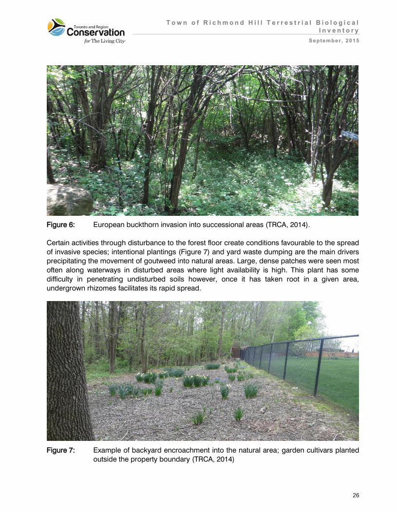
T o w n o f R i c h m o n d H i l l T e r r e s t r i a l B i o l o g i c a l
I n v e n t o r y
September , 2015
26
Figure 6: European buckthorn invasion into successional areas (TRCA, 2014).
Certain activities through disturbance to the forest floor create conditions favourable to the spread
of invasive species; intentional plantings (Figure 7) and yard waste dumping are the main drivers
precipitating the movement of goutweed into natural areas. Large, dense patches were seen most
often along waterways in disturbed areas where light availability is high. This plant has some
difficulty in penetrating undisturbed soils however, once it has taken root in a given area,
undergrown rhizomes facilitates its rapid spread.
Figure 7: Example of backyard encroachment into the natural area; garden cultivars planted
outside the property boundary (TRCA, 2014)

T o w n o f R i c h m o n d H i l l T e r r e s t r i a l B i o l o g i c a l
I n v e n t o r y
September , 2015
27
Additionally, meadow and forest edge habitats were also subject to invasion by numerous other
shrubs and tree species present within the Study Area including: exotic honeysuckles (Lonicera spp.), Russian olive (Elaeangus angustifolia), English hawthorn (Crataegus monogyna), Scot’s
pine (Pinus sylvestris) and multiflora rose (Rosa multiflora). In the wetland habitats hybrid cattail
was seen to dominate the open marshes. Controlling storm water inputs and maintaining
adequate variability in topography and water level will allow for other species to coexist.
Furthermore, the spread of invasive pests is on the rise throughout the forests of Southern
Ontario. In the Town, Emerald Ash Borer (EAB) (Agrilus planipennis) is perhaps the most
immediate threat followed by Asian Long-horn Beetle (ALB) (Anoplophora glabripennis). Toronto
and Region Conservation Authority forestry staff have found EAB infestations across most TRCA
properties throughout York Region and evidence of this pest (e.g. d-shaped exit holes) was found
in various locations throughout the surveyed areas in 2014. All ash dominated communities are
susceptible to EAB; examples of at-risk communities found in the surveyed areas include Dry-
Fresh White Ash Deciduous Forest (FOD4-2) (seen in Mill Pond) and Fresh-Moist Sugar Maple–
Ash Deciduous Forest (FOD6-1) (seen in Pioneer Park). Without inoculation, infected trees usually
die within 5 years of less. Another pest on the horizon is ALB. Thought to have been eradicated,
ALB was relocated near Pearson International Airport in 2013. Although not identified in field
surveys, if present, all broad-leaved treed communities, particularly those dominated by maple
species (preferred host) would be vulnerable to attack (OFAH/OMNR, 2013).
Other pests to be vigilant of is hemlock wooly aldegid (Adelges tsugae) (HWA) and gpysy moth
(Lymantria dispar dispar). Hemlock wooly aldegid is a small sap-sucking insect that has
devastated hemlock forests in the United States. If introduced into the area it has the potential to
kill vast populations of healthy hemlock trees in a period of 3 to 5 years (rate of decline depends
on factors such as environmental stress and tree condition). Fresh-Moist Hemlock Coniferous
Forest (FOC3-1), Fresh-Moist Hemlock – White Pine Coniferous Forest (FOC3-A) and Dry-Fresh
Hemlock – Sugar Maple Mixed Forest (FOM3-2) are amongst the list of hemlock dominated
communities that would be at risk from this pest. Fortunately the incidence of hemlock wooly
aldegid is fairly low in Ontario with only a few isolated reports in 2012 and 2013 (Ryan, 2013).
Gypsy moth is prevalent across the GTA; however most municipalities have rigorous control
efforts in place to mitigate the impacts of infestations. Control can be difficult as it has a wide
range of hosts that include maples, oaks, apples, walnuts and birch. Most deciduous treed
communities are at-risk to infestation. Scattered occurrence of eggs masses and adult caterpillars
both live and dead were observed during field surveys.
4.5 Fauna Species Findings for the Town of Richmond Hill
Over the course of the past decade (2005 to 2014) a total of 149 vertebrate fauna species have
been documented as possible breeding species within the Study Area. An additional 6 species
have been recorded historically, and these apparent extirpations tell an interesting story about the
changes in the status of natural heritage in the Town of Richmond Hill over the past couple of

T o w n o f R i c h m o n d H i l l T e r r e s t r i a l B i o l o g i c a l
I n v e n t o r y
September , 2015
28
decades. Four of the 6 extirpations are of species ranked as L2; 3 of the species are wetland
dependent and the remaining 3 are forest dependent. Table 9 presents more details on these
apparent losses.
Table 9: Fauna species believed to be locally extirpated prior to 2005
Species TRCA
L-rank Last
Recorded Source Location Comments
Barred Owl L2 1997 TRCA NE corner of ORCCRE
most extensive mature forest in the Study Area
Blue-winged Teal
L3 1997 TRCA wetlands north of Bond Lake Bog
as of 1999, this wetland is entirely surrounded by a housing development
Common Gallinule
L2 1997 TRCA wetlands adjacent to Bathurst Glen Golf Course
breeding territories mapped for the wetlands at SW corner and N side
Northern Goshawk
L2 1997 TRCA NE corner of ORRCRE
most extensive mature forest in the Study Area
Western Chorus Frog
L2
1989 OHS west end of Lake Wilcox
chorus of 30+ individuals
1996 MNRF wetland south of Lake Wilcox
from the GTA inventory project
1999 OHS wetland to NE of Bathurst Glen Golf Course
low chorus
2003/04 Ecoplans
Ltd.
4 locations along Bayview Avenue between Stouffville Road and Bloomington Road
work conducted around the Bayview Extension project
White-throated Sparrow
L3 2001 TRCA Lake St. George 2 territories identified in forest north of the lake.
The current list of 149 species is broken down into: 107 bird species, 16 reptiles and amphibians,
and 26 mammal species. This total of 149 breeding vertebrate fauna species ranks among the
longest species lists compiled for any Study Area within the region; the extensive East Duffins
Headwaters Study Area (1301 ha, almost entirely natural cover) amassed a list of 131 documented
species including 106 bird species, 10 reptiles and amphibians, and 15 mammal species. At first
glance it seems remarkable that a largely agricultural and suburban landscape has documented
T o w n o f R i c h m o n d H i l l T e r r e s t r i a l B i o l o g i c a l
I n v e n t o r y
September , 2015
29
more breeding fauna species than the largest expanse of forest habitat in the region. However, it
is important to consider the variety of habitat types that occurs within the respective Study Areas:
Richmond Hill contains several fairly high quality wetlands, 428 ha of meadow habitat, and the
extensive mature forest of ORCCRE. The East Duffins Headwaters Study Area contains only a few
small wetlands and is largely forested. It is more important to consider instead the number of
territories of each sensitive species: ovenbird (Seiurus aurocapillus) for example is represented by
422 unique territories at the East Duffins Headwaters, whereas there have been only 38 unique
territories mapped for the species in the Study Area. More appropriate would be a comparison
with the fauna inventory for the newly designated Rouge National Urban Park, largely agricultural
but with some extensive mature forest patches in the lower central reaches. The area that now
constitutes the Rouge National Urban Park (5810 ha with 2301 ha of natural cover) has amassed a
fauna inventory of 155 species over the past decade (112 breeding bird species, 19 herps and 24
mammals). Refer to Appendix 3 for a list of the fauna species observed in the Study Area and their
corresponding L-ranks.
It is important to understand that the TRCA inventories are based entirely on observations verified
by TRCA field staff. Species that are realistically expected to occur within the Study Area but have
not been verifiably reported in the past 10 years are currently not included in the full fauna list. For
example, it is highly likely that Dekay’s brownsnake (Storeria dekayi) occurs throughout much of
the Study Area, but as yet, there have been no confirmed reports of this species – an L4 species
that is widespread and reasonably common through much of the Toronto region. The same is
likely true for many of the lower ranked small mammals for which the TRCA has surprisingly few
confirmed reports for the region. For this reason, if comparisons are to be made to other sites, it is
suggested that the full inventory be broken down into birds, herpetofauna and mammals.
4.5.1 Fauna Species of Concern
Fauna species, like vegetation communities and flora species are considered of regional
conservation concern if they rank L1 to L3 based on their scores for the seven criteria mentioned
in Section 3.0. Since the Study Area is situated in a landscape that is experiencing considerable
degrees of urbanisation in certain sections, this report also considers those species ranked as L4,
i.e. those species that are of concern in urban landscapes. As with flora, this is a proactive,
preventive approach, identifying where conservation efforts need to be made before a species
becomes rare.
The TRCA fauna surveys within the Study Area over the past decade have reported 45 bird
species of regional concern (L1 to L3), including seven L2 ranked species (e.g. broad-winged
hawk, Buteo platypterus; ruffed grouse, Bonasa umbellus; hooded warbler, Setophaga citrina). In
addition, there were 13 herpetofauna and 7 mammal species of regional concern, including two
L1 species (the 2 “mole” salamanders: Jefferson salamander, Ambystoma jeffersonianum (Figure
8); and spotted salamander, Ambystoma maculatum) and nine L2 species (including common
snapping turtle, Chelydra serpentina; smooth greensnake, Opheodrys vernalis; and northern
flying-squirrel, Glaucomys sabrinus) (Table 10).

T o w n o f R i c h m o n d H i l l T e r r e s t r i a l B i o l o g i c a l
I n v e n t o r y
September , 2015
30
Figure 8: Jefferson complex salamander, an “Endangered” Species at Risk that occurs in
small numbers within the Study Area (Photo: TRCA archive)
Of all of these high ranking species, 7 are classified as Species at Risk at either the Federal or
Provincial levels. Provincially, both bobolink (Dolichonyx oryzivorus) and eastern meadowlark
(Sturnella magma) are listed as Threatened and depend on carefully managed and relatively
undisturbed meadow habitats; Jefferson salamander requires large undisturbed tracts of
deciduous or mixed mature forest with easy access to fish-less breeding ponds; common
snapping turtle (listed as Special Concern) is dependent on wetlands, and, again, on easy access
to nesting sites away from the water; wood thrush (Hylocichla mustelina, listed as Special
Concern) requires deciduous or mixed forests; and bank swallow (Riparia riparia, listed as
Threatened”) has a very specific requirement for banks, cliffs and bluffs. The only species that is
listed at the Federal but not Provincial level is the olive-sided flycatcher, (Contopus cooperi, listed
as Threatened); this is a bird of boreal forests and is represented by a single bird that summered
at Bond Lake Bog in 2008. Finally, 2 more Species at Risk which are locally ranked as L4,
regularly nest within the Study Area: eastern wood-pewee (Contopus virens, listed as Special
Concern) and barn swallow (Hirundo rustica, listed as Threatened). It should also be noted here
T o w n o f R i c h m o n d H i l l T e r r e s t r i a l B i o l o g i c a l
I n v e n t o r y
September , 2015
31
that in 2010 the MNRF received and confirmed a report of a road-killed Blanding’s turtle
(Emydoidea blandingii, (Threatened) from a site at the north end of the Study Area. The origin of
this particular individual is a little suspect given the location; it is possible that the animal was a
transplant from “cottage country” or elsewhere outside of the Toronto region. Locations of
breeding fauna species of concern are depicted on Maps 17a/b.
Table 10. Summary of fauna species of regional and urban conservation concern reported
from the Study Area for the period 2005 to 2014
Fauna Number of Species Number of Species of Regional and Urban Concern
(L1 to L4 rank)
Birds 107 76
Herps 16 16
Mammals 26 19
Totals 149 111
Local occurrence is one of seven scoring criteria for fauna species and is based on TRCA data
and information from the Natural Heritage Information Centre (NHIC) of the MNRF (NHIC 2008).
Using local occurrence as a measure of regional rarity, any species that is reported as a probable
or confirmed breeder in fewer than 10 of the forty-four 10x10 km UTM grid squares in the TRCA
jurisdiction is considered regionally rare (i.e. scores three to five points for this criterion) (TRCA,
2010).
A total of 22 of the fauna species of regional concern documented within the Study Area over the
past decade are considered regionally rare: 12 bird species, 4 herp species and 6 mammals. Of
the 12 bird species, 8 are closely associated with mature forest habitat and more specifically,
largely coniferous forests or plantations. This relatively high number of such forest bird species is
perhaps a reflection of the presence of extensive mature coniferous stands at ORCCRE and the
Jefferson Forest complex. Five of these coniferous forest species have more northern affinities
and it is this distribution factor that dictates both their rare status within the region, and their
presence in the forests in the north end of the Study Area.
Mammals and non-anuran herpetofauna are generally too cryptic to be effectively surveyed within
the rather rapid assessments that are conducted by the TRCA. Through additional more in-depth
studies (road-kill and salamander surveys) Jefferson and spotted salamanders are known to be
breeding in ponds associated with some of the more mature forest patches within the Study Area.
However, these studies suggest that road-kill on some of the area’s increasingly busy roads is
becoming a huge issue for these rare animals. Smooth greensnake was discovered and reported
by a member of the public on private property in the vicinity of Jefferson Sideroad and Yonge
Street (confirmed by TRCA staff and observed at same location by TRCA staff in subsequent
years, 2010 to 2012); this is one of only two known regional locations for this species since 1999.
Sensitivity to development is another criterion used to determine the L-rank of fauna species. A
large number of impacts that result from local land use, both urban and agricultural, can affect the

T o w n o f R i c h m o n d H i l l T e r r e s t r i a l B i o l o g i c a l
I n v e n t o r y
September , 2015
32
local fauna. These impacts – considered separately from the issue of actual habitat loss – can be
divided into two distinct categories. The first category involves changes that arise from local
urbanization that directly affect the breeding habitat of the species in question. These changes
alter the composition and structure of the vegetation communities; for example, the clearing and
manicuring of the habitat (e.g. by removal of dead wood and clearance of shrub understorey). The
second category of impacts involves changes that directly affect individuals of the species in
question. Examples include increased predation from an increase in the local population of
predator species that thrive alongside human developments (e.g. blue jays, Cyanocitta cristata; American crows, Corvus brachyrhynchos; squirrels, Sciuridae; raccoons, Procyon lotor; and
house cats, Felis catus); parasitism (from facilitating the access of brown-headed cowbirds,
Molothrus ater, a species which prefers more open, edge-type habitat); competition (for nest-
cavities with bird species such as house sparrows, Passer domesticus; and European starlings,
Sturnus vulgaris); flushing (causing disturbance and abandonment of nest) and, sensitivity to
pesticides.
Fauna species are considered to have a high sensitivity to development if they score 3 or more
points (out of a possible 5) for this criterion. In the Study Area many of the species that are ranked
L1 to L4 receive this score (87 of the 111 species) and are therefore considered sensitive to one or
more of the impacts associated with development.
Almost half of the forty-three L1 to L3 ranked bird species considered sensitive to development
habitually nest on or near to the ground and as such are highly susceptible to ground-borne
disturbance, e.g. off-leash dog-walking. However, 3 of these species nest in wetlands, a habitat
that is not as much visited by such disturbances; the fact that there were 11 Virginia rail (Rallus limicola) territories throughout the Study Area’s wetlands supports this. Ten of the sensitive
ground-nesters are primarily associated with forested habitat and it seems that it is in this habitat
that ground-nesters have most suffered from the impacts of the matrix influences that proximity to
human activity imposes. Ruffed grouse was reported from 4 different locations (7 records) pre-
2005, but subsequently has been recorded just once at one of those same locations (the relatively
isolated forest block south of the railway, at NW Leslie Street and 19th Avenue, in 2012). There
have been no recent records of this sensitive species from the heavily used forest blocks at
ORCCRE and Lake St. George. Oak Ridges Corridor Conservation Reserve does still hold a
surprisingly high number of ovenbird (Figure 9) territories but this same species was represented
by just one territory at Lake St.George. This latter forest site is also the last site at which another
locally extirpated ground-nester – white-throated sparrow (Zonotrichia albicollis) – was recorded in
2001.
Of the remaining 6 ground-nesting species, 5 are meadow-dependent and given the extensive
agricultural land it might be expected that populations of species such as bobolink and eastern
meadowlark would be well-represented. This is not the case, with only 13 and 5 territories being
recorded respectively. This may in fact be a result of the concentration of inventories around
forested and wetland habitats but, given the Species at Risk status of these 2 species, this is a
knowledge gap that needs to be filled.

T o w n o f R i c h m o n d H i l l T e r r e s t r i a l B i o l o g i c a l
I n v e n t o r y
September , 2015
33
Figure 9: Ground-nesting birds such as ovenbirds are heavily impacted by the negative
matrix influences associated with urban and near-urban development (Photo: Paul
Prior, 2014).
Ground-nesting birds are highly susceptible both to increased predation from ground-foraging
predators that are subsidized by local residences (house cats, raccoons) and to repeated flushing
from the nest (by pedestrians, off-trail bikers and dogs) resulting in abandonment and failed
breeding attempts. One of the more significant forest blocks in the Study Area – ORCCRE - is
criss-crossed by an extensive network of trails and so it is surprising to find that there are
approximately 20 active ovenbird territories in this block. Certainly, this does not approach the
density of ovenbird territories in areas such as East Duffins Headwaters (in the north-east corner
of the region) and Palgrave Conservation Area (in the north-west corner of the region, upper
reaches of the Humber River watershed), but it suggests that this forest block is still seen as highly
desirable habitat by this quintessential forest songbird. As the matrix influence pressures on the
ORCCRE forest continue to increase it will be important to maintain an understanding of the status
of this ovenbird population. It seems unlikely that it can maintain at the current level unless efforts
are made to mitigate the negative matrix influences. Many of the negative influences associated
with urbanization can be transferred deep within an otherwise intact natural matrix by extensive
trail networks used by large numbers of people originating from quite distant urban and suburban
centres. Extensive public use of a natural habitat can have substantial negative impact through the
cumulative effects of hiking, dog-walking and biking on the site. Similarly, clearing of forest

T o w n o f R i c h m o n d H i l l T e r r e s t r i a l B i o l o g i c a l
I n v e n t o r y
September , 2015
34
understory to accommodate trails displaces sensitive low-nesting species. It is possible that the
large size of this forest block does allow some pockets of habitat to remain relatively undisturbed
and unaffected by the traffic on these trails, be it hikers, bikers or dog walkers.
Various studies have shown that many bird species react negatively to human intrusion (i.e. the
mere presence of people) to the extent that nest-abandonment and decreased nest-attentiveness
lead to reduced reproduction and survival. One example of such a study showed that abundance
was 48% lower for hermit thrushes (a ground-nesting/foraging species) in intruded sites than in
the control sites (Gutzwiller and Anderson 1999). Elsewhere, a recent study reported that dog-
walking in natural habitats caused a 35% reduction in bird diversity and a 41% reduction in
abundance, with even higher impacts on ground-nesting species (Banks and Bryant 2007).
In contrast to the generally rather depauperate populations of ground-nesting forest-bird species,
there are several canopy and mid-canopy nesting species that are well-represented in the Study
Area but almost exclusively in the north-eastern quarter. Scarlet tanager (Piranga olivacea), wood
thrush and black-throated green warbler (Setophaga virens) (Figure 10) – all ranked L3 - held 14,
36, and 14 territories respectively. Species ranked L4 of the same forest guild are more evenly
distributed throughout the Study Area with pine warbler (Setophaga pinus) holding 43 territories,
and eastern wood-pewee holding 79 territories. Such upper and middle canopy nesting species
are somewhat less affected by trail use, but are still susceptible to artificially high densities of
predators (domestic cats, raccoons, opossums, Corvids) and brood parasites (i.e. brown-headed
cowbirds) subsidized by backyard feeders and poor garbage management. It should be noted
that the TRCA fauna inventory assesses the presence of species, (i.e. the number of territories of
each species at the site), but does not give any indication of the success of nesting attempts.
As far as the non-avian species are concerned, all of the 16 herpetofauna are considered sensitive
to development. The sensitivity of these species varies considerably but again the majority of them
are impacted by ground-borne disturbances at some stage of their life cycles. The 2 native turtle
species – common snapping turtle and midland painted turtle (Chrysemys picta marginata) – both
nest in terrestrial situations, and in both cases their eggs are very vulnerable to predation by
artificially elevated populations of predators such as racoons and Virginia opossums (Didelphis virginiana). Frogs, toads and salamanders are very sensitive to water quality in their native
wetlands: run-off from roads and trails can carry road-salt and oils into the breeding habitats; and
intrusion into those ponds by dogs can increase turbidity which in turn can severely limit the
success of spawning. Meanwhile, those species which spend a large proportion of their lives
foraging across forest floors – wood frogs (Lithobates sylvatica), grey treefrogs (Hyla versicolor), spring peepers (Pseudacris crucifer), and various snake species – are prone to predation,
disturbance and collection from various human activities.

T o w n o f R i c h m o n d H i l l T e r r e s t r i a l B i o l o g i c a l
I n v e n t o r y
September , 2015
35
Figure 10: Canopy nesters such as black-throated green warblers are still maintaining fairly
good populations at ORCCRE, the largest forest patch in the north-east corner of
the Study Area (Photo: Paul Prior, 2014)
The compaction of soil through excessive trail use by both bicycles and hikers can have
considerable impacts on any species that lead largely fossorial lives, foraging through
underground tunnel systems. This could potentially limit the local success of the two “mole”
(Ambystoma) salamanders - Jefferson and spotted – and also limit the opportunities for sensitive
mammals such as hairy-tailed mole (Parascalops breweri) and the two shrew species recorded in
the Study Area inventory. Free-ranging domestic cats have been shown to have a devastating
effect on bird and small mammal populations (Loss et al. 2013) and any increase in the local
domestic cat population (as will no doubt occur as new housing developments encroach on the
natural cover) will likely further diminish the local populations of the two L2 ranked mammals,
northern flying-squirrel and woodland jumping-mouse (Napaeozapus insignis). Both of these
species have been recorded in the past decade at the ORCCRE forest block, an area that is facing
imminent adjacent housing development. This same impact will definitely affect the five L3 ranked
mammals and to some extent several of the L4 mammal species, but the ranking system indicates
a degree of resilience for the lower ranked species and therefore although several of the L4
mammals are preyed upon by domestic cats, these species’ populations and productivity are
probably high enough to withstand higher rates of predation than, for example, the L3 ranked
meadow-jumping mouse (Zapus hudsonicus).

T o w n o f R i c h m o n d H i l l T e r r e s t r i a l B i o l o g i c a l
I n v e n t o r y
September , 2015
36
Great blue heron (Ardea herodias) scores as sensitive to development and deserves particular
mention. It is one of the few L3 ranked species that is present as a nesting species in the
urbanizing southern half of the Study Area. Currently there is a growing heronry located just to the
west of Highway 404, south of 19th Avenue. From the initial observation of 2 nests in 2002 (MNRF),
then 18 nests in 2005, there are now as many as 62 active nests (this number is pending
confirmation) in what is one of the larger heronries in the region. This growth in the heronry has
occurred despite the proximity of Highway 404, and alongside gradual growth in housing
developments set-back several hundred metres from the woodlot. It appears that as long as the
development maintains a sufficient buffer of several hundred metres, the herons are capable of
maintaining a successful nesting situation. This has been the case for other heronries throughout
the region, and it is important, if the heronry is to persist, that negative matrix influences continue
to be mitigated by an effective buffer, and that public access to the woodlot immediately prior to
and during the nesting season (March through August) is prohibited.
Area sensitivity is a scoring criterion that can be closely related to the issue of a species’ need for
isolation. Fauna species are scored for area sensitivity based on their requirement for a certain
minimum size of preferred habitat. Species that require large tracts of habitat (>100 ha in total)
score the maximum five points, while species that either show no minimum habitat requirement, or
require <1 ha in total, score one point. Species scoring three points or more (require ≥5 ha in
total) are deemed area sensitive species. Researchers have shown that for some species of birds,
area sensitivity is a rather fluid factor, dependent and varying inversely with the overall percentage
forest cover within the landscape surrounding the site where those species are found (Rosenburg
et al. 1999).
Fifty-two of the fauna species of regional and urban concern that were recorded within the Study
Area over the past decade are considered area sensitive; all of these species – including 31 bird
species ranked L1 to L3 - require at least 5 ha of habitat. Ten of the area sensitive bird species
score 4+ points in this criterion and as such require at least 20 ha of continuous habitat; 9 of
these species are forest-dependent and certainly their area requirements are well met by the
extensive forest blocks in the north-east corner of the Study Area. Broad-winged hawk is the only
species recorded over the past decade that scores the maximum 5 points, requiring over 100 ha
of continuous natural habitat. Again the northern forest blocks exceed this requirement and in the
past have accommodated two other top predators that achieve the same area sensitivity score:
barred owl (Strix varia) and northern goshawk (Accipiter gentilis) have not been recorded as
breeding birds in the Study Area since 1997. However, a pair of barred owls were discovered
breeding in a Stouffville woodlot (Bethesda and 9th Line) in 2014 so it appears that the species
may gradually be adapting to the new near-urban landscape; since ORCCRE has not diminished
appreciably in size since the late 1990s there is still a chance (if some of the negative matrix
influences can be mitigated) that this species could return as a breeding species.
Almost none of the highly area sensitive species have been recorded away from the more
extensively forested landscape of the north-east quarter of the Study Area, with just a few pine
warblers and the occasional pileated woodpecker (Dryocopus pileatus) occurring in the larger of
the remnants in the urban north-west. Two pairs of ovenbirds were reported from one 50 ha forest

T o w n o f R i c h m o n d H i l l T e r r e s t r i a l B i o l o g i c a l
I n v e n t o r y
September , 2015
37
remnant embedded in a brand new housing development in the north-west in 2007; the same
forest patch was re-surveyed in 2014 and no ovenbirds recorded. Although the forest patch in this
particular case is still large enough to accommodate this area sensitive species, the matrix
influence from the surrounding housing development is negative enough to have persuaded this
species to abandon the location. A similar situation seems to have arisen with the equally area
sensitive and similarly ground-nesting black-and-white warbler (Mniotilta varia) which was
recorded in the forest at Lake St. George (111 ha) in 2000 and 2001 but not in the extensive
survey conducted in 2014. Meanwhile the species was still present (3 pairs) in the smaller (67 ha)
but more isolated forest patch south of the railway at north-west Leslie Street and 19th Avenue in
2012. Again it appears that despite the large area of some forest patches, only canopy or mid-
level nesters are able to persist in these forests since they are not as impacted by trail use and
other negative matrix influences in the vicinity of their breeding territories as are ground- or low-
nesting species.
The three area sensitive frog species (wood frog, spring peeper, and grey treefrog), two
salamanders and one newt species (eastern newt, Notophthalmus viridescens) which occur in the
Study Area, are area sensitive primarily due to their need for two habitat types in which they
require to complete their life cycle: wetlands for breeding, and upland forests for foraging and
over-wintering. Unlike the various sensitive and extremely mobile bird species, these amphibian
species are somewhat tied to their home range, and thus populations will persist for several
seasons beyond initial disturbances caused by development. For this reason, despite ranking as
L2, the three frog species are still well-distributed through the northern half of the Study Area, i.e.
both in the extensive natural cover of the north-east and the isolated fragments of the recently
urbanized north-west. The forest fragments and wetlands in the more urbanized southern half of
the Study Area support hardly any L1 to L3 species regardless of the number of fragments that
exceed the 5 ha threshold for many of the area sensitive species.
In conclusion, species’ patch-size constraints are due to a variety of factors including foraging
requirements and the need for isolation within a habitat block during nesting. In the latter case,
regardless of the provision of a habitat patch of sufficient size, if that block is seriously and
frequently disturbed by human intrusion, such species will be liable to abandon the site. Such a
variety of habitat needs are more likely satisfied within a larger extent of natural cover. The amount
of forest cover in the north-east quarter of the Study Area accommodates multiple territories of
area-sensitive species.
Patch isolation sensitivity in fauna measures the overall response of fauna species to
fragmentation and isolation of habitat patches. One of the two main aspects of this scoring
criterion is the physical ability or the predisposition of a species to move about within the
landscape and is related to the connectivity of habitat within a landscape. The second main
aspect is the potential impact that roads have on fauna species that are known to be mobile. Thus
most bird species score fairly low for this criterion (although they prefer to forage and move along
connecting corridors) whereas many herpetofauna score very high (since their life cycle requires
them to move between different habitat types which may increase likelihood of road-kill). One
example of how this criterion affects species populations is the need for adult birds to forage for

T o w n o f R i c h m o n d H i l l T e r r e s t r i a l B i o l o g i c a l
I n v e n t o r y
September , 2015
38
food during the nestling and fledgling stage of the breeding season. By maintaining and
improving the connectivity of natural cover within the landscape (e.g. by restoration of intervening
lands) we are able to positively influence the populations of such species, improving their foraging
and dispersal potential.
Thirty-seven fauna species of regional and urban concern reported from the Study Area are
considered sensitive to patch isolation including twenty-five L1 to L3 ranked species of which 13
are herps and 6 are mammals. The majority of these 25 species are restricted to the northern half
of the municipality, and again, more specifically the extensive natural habitat in the north-east
quarter, where the landscape still presents opportunities for non-avian fauna species to move
between their wetland breeding pools and upland summer and winter habitats. Certainly the most
significant of all of the fauna species that score high for patch isolation sensitivity are the two L1
ranked Ambystoma salamanders. Both of these species are restricted to the north-eastern quarter
of the municipality, but it is highly likely that their populations are severely stressed given the
recent increase in road-traffic in the area (expected to increase considerably as more people
move into the new housing being constructed on all sides of the ORCCRE). Road-kill has the
potential to gradually diminish local populations of all sensitive amphibian species – no matter
what the L-rank is - and, if the species are to persist in the Study Area, measures need to be taken
to enable safe passage for these fauna elements throughout the area. In other parts of the Toronto
region it has become clear that road-kill is also an issue that applies to paved and un-paved trails
frequented by bicycles.
The one amphibian species that has failed to persist even in the somewhat more intact north-east
quarter is western chorus frog (Pseudacris triseriata). This species was still present along the
Bayview extension corridor as recently as 2004 but there have been no further records since then.
Historically, it appears that the species occurred primarily in the more open landscape of the
north-west quarter. This is in keeping with chorus frogs’ preference – at least within the Toronto
region - for the small ephemeral wetlands that are associated with the spring thaw on open
farmland. Presumably, the small populations that were still being reported through the 1990s and
early 2000s were persisting in isolated remnants of what was once a loose but connected network
of such ephemeral wetlands, much as what still occurs on the Peel clay plain in the western part of
the Toronto region (the last regional bastion of this gradually disappearing species).
Fauna species that score greater than three points under the habitat dependence criterion are
considered habitat specialists (Maps 18a/b). These species exhibit a combination of very specific
habitat requirements that range from the microhabitat (e.g. decaying logs, aquatic vegetation) and
requirements for particular moisture conditions, vegetation structure or spatial landscape
structures, to preferences for certain community series and macro-habitat types. Thirty-two fauna
species that occur in the Study Area are considered habitat specialists including 28 species of
regional concern. Of the 26 habitat dependent bird species present in the Study Area, 15 are
dependent on various types of forest. This relatively high number suggests that the forest patches
in the Study Area – at least those extensive patches in the northern section – are still functioning at
a fairly high level as far as avifauna is concerned, despite the decline in ground-nesting species.
The presence of good numbers of highly forest-dependent species such as scarlet tanager,

T o w n o f R i c h m o n d H i l l T e r r e s t r i a l B i o l o g i c a l
I n v e n t o r y
September , 2015
39
Blackburnian warbler (Setophaga fusca) and black-throated green warbler in the deciduous and
mixed forest of the northern part of the study area is in contrast to these same species’ absence
from forest fragments further south, within the more urban landscape.
The only mammal species to register as highly habitat dependent is northern flying squirrel. This
species is highly dependent on the availability of tree cavities, usually adopting those excavated in
large dead and dying trees by woodpeckers. In an extensive natural forest a shortage of such nest
opportunities is rarely an issue and so this very specific habitat requirement is easily fulfilled;
however, in a forest that is managed in part for public use, many such trees are removed for safety
reasons, reducing the nesting and foraging opportunities for many fauna species including
northern flying squirrel. Standing dead wood is very much a part of what raises the quality of a
natural and undisturbed forest patch.
A site’s species list presents only the species’ richness, i.e. it indicates only the presence or
absence of species at a site but indicates neither the breeding success nor the population stability
of each species at the site. A healthy functioning system will accommodate a whole suite of
species that are adapted to the habitat types at the site, and will allow those particular species to
thrive and breed successfully. As the quality of the habitat patch improves so will the
representation of flora and fauna species associated with that habitat. In this way, representation
biodiversity is an excellent measure of the health of a natural system. Degraded forest habitats in
urban landscapes often accommodate only generalist species with the more sensitive forest-
dependent species entirely absent. The Study Area presents the whole range of forest habitat
quality with highly stressed and isolated fragments of forest embedded in a dense urban
landscape in the southern reaches, and at the other extreme, in the north-east quarter, extensive
patches of mature deciduous and mixed forest with relatively large areas of forest interior habitat
surrounded by the somewhat neutral matrix influence of an agricultural landscape. Currently there
is good representation of sensitive, habitat dependent forest species in the northern section of the
Study Area suggesting that the forest habitat is still reasonably functional, but future management
of the site will need to address the issue of visitor pressure on these still functioning forest blocks
in order to avoid the decline in sensitive fauna species that has occurred throughout the southern
half of the Study Area, and to some extent is now happening in the north-west quarter.
5.0 Summary and Recommendations
The recommendations for the Town to take into consideration are the regional targets for natural
heritage in the TRCA jurisdiction as described by the TRCA’s Terrestrial Natural Heritage Systems
Strategy. To reach the regional targets for quality distribution and quantity of natural cover, every
site will require its own individualized plan of action. Following is a short summary of the Study
Area within the regional context, followed by specific recommendations.
T o w n o f R i c h m o n d H i l l T e r r e s t r i a l B i o l o g i c a l
I n v e n t o r y
September , 2015
40
5.1 Study Area Summary
1. The Study Area equates to the entire extent of the municipality of the Town of Richmond Hill, sitting on the upper reaches of three watersheds: the East Humber River, the Rouge River and The Don River.
2. The Town is extensively urbanized in the south, and this urbanization is slowly moving first into the north-west section, and is set to extend into the north-east section in the near future.
3. The Study Area incorporates a range of natural cover quality, with highly stressed and
low functioning forest remnants in the urbanised south, and extensive high quality mature forest patches in the still rural north-east.
4. The surveyed areas consists of 1,990 ha of natural cover all of which has been
inventoried at least once over the past 2 decades with several patches being revisited in the 2014 inventory; this presents an opportunity to make some comparisons of natural features over time.
5. There are 223 vegetation types (including 18 found solely as complexes and/or inclusions), ranging from mature forest to shallow marsh and aquatic communities documented in the surveyed areas. This includes 95 forest, 23 successional, 3 meadow, 81 wetland, 14 aquatic, and 7 dynamic vegetation community types. This level of community diversity reflects the size of the site and its diverse topography and history including more recent plantings and natural regeneration, streams and ponds. The vegetation diversity is comparable to other high-quality sites of similar size in the TRCA jurisdiction.
6. Seventy-seven of the vegetation communities identified within the surveyed areas are
of regional conservation concern (ranked L1 to L3). A Tamarack – Black Spruce Organic Coniferous Swamp (SWC4-1) along with all the bog and fen communities, are ranked as L1. These communities are the most sensitive in the TRCA region.
7. Several small wetlands (vernal pools) are located throughout north-east section of the
Study Area providing breeding opportunities for a very high number of amphibian species including two L1 ranked salamanders. Such populations are even more significant given the proximity of the encroaching urbanizing landscape.
8. The wetlands and aquatic habitat within the Study Area provide habitat opportunities
for two Species at Risk, Jefferson salamander and snapping turtle.
9. A total of 918 naturally-occurring flora species were observed between 2000 and 2014. This includes 252 plants ranked L1 to L3 (considered flora species of regional concern) plus an additional 154 species of concern in urban areas (L4). Many of these species are associated with the forest and wetland vegetation communities. Total species

T o w n o f R i c h m o n d H i l l T e r r e s t r i a l B i o l o g i c a l
I n v e n t o r y
September , 2015
41
richness is high especially as it relates to wetland species. Non-planted native species are still predominant, comprising 66% of the total (918).
10. Historic flora points (pre-2000) totalled 68 and included 1 locally extirpated species, 54
species of regional concern and 3 species of urban concern. The vast majority of these species were restricted to sections of the Jefferson Forest ANSI, an area that has not been surveyed since 1996 (completed by MNRF).
11. There is good representation of forest plant species in deciduous, mixed and
coniferous forest types. Spring ephemerals are abundant in much of the deciduous forest. The wetland species persist in spite of being sensitive to urban impacts.
12. The 149 species of vertebrate fauna observed is a total which ranks alongside some of
the highest quality sites across the region. This exceptionally high diversity is due to the presence of wide selection of all three major habitat types (forest, wetland and meadow) throughout the northern half of the municipality.
13. Although forest ground-nesting species (e.g. ovenbird, ruffed grouse) are showing
varying degrees of decline, the forest canopy within the northern half of the Study Area supports good populations of some typical canopy nesting species such as pine warbler (43 territories), black-throated green warbler (14 territories) and scarlet tanager (14 territories).
14. The northern forest tracts also still support two pairs of broad-winged hawk, an avian
predator that is generally associated with relatively high quality forest habitat.
15. Six fauna regional species of concern, present through the 1990s and early 2000s,
appear to have been extirpated from the township over the past decade. This list includes the federally “threatened” western chorus frog, which has shown considerable declines throughout its previous range within the Toronto region.
16. The heronry at Leslie Street and Elgin Mills Road, initiated in 2002, appears to be very
healthy with the latest unconfirmed report of 62 active nests in 2014 placing it as one of the largest heronries in the region.
5.2 Recommendations
The recommendations primarily address objectives of protecting regional biodiversity in the TRCA
jurisdiction. In order to maintain or enhance the current level of biodiversity the overall integrity of
the natural heritage system that includes the Study Area must be protected; for example, much of
the highest quality natural cover within the surveyed Study Area lies on the Oak Ridges Moraine, a
feature that extends east and west well beyond the municipal boundaries. The high public profile
of the Oak Ridges Moraine makes this objective even more critically important, since it provides
an example to the public for how natural heritage is to be protected. Therefore, at the landscape
scale, in keeping with the TNHSS, connections to other natural habitat patches in the landscape

T o w n o f R i c h m o n d H i l l T e r r e s t r i a l B i o l o g i c a l
I n v e n t o r y
September , 2015
42
need to be created and maintained. Furthermore, the recommendations identify the issues that
may occur with any increased public use of the natural features within the Study Area as the urban
landscape continues to expand. Local community stewardship needs to address this potential
increase in negative matrix influence and ensure that effective mitigation is included as part of any
future management.
The following recommendations address the above natural heritage concerns, with an emphasis
upon bolstering the existing natural features. Thus, we recommend overall that 1) existing habitats
and features be protected and enhanced; 2) that public use be managed; 3) that invasive species
be controlled; and 4) that monitoring and inventories be conducted on a regular basis to
understand any changes in the natural system that occur.
1. Protect and Enhance Existing Features
The first priority should be to focus on maintaining conditions that allow existing communities or species of conservation concern to thrive. This is especially true of the
mature forest habitats throughout the northern half of the Study Area.
a. There are still opportunities to increase the size and connectivity of habitat patches
in the currently rural north-eastern quarter. For example, connectivity could be
increased by providing tunnels for wildlife passage under the east-west road
(Stouffville Road) that cuts across Jefferson Forest ANSI, and separates this ANSI
from the Lake Wilcox and Kettle Wetlands and Uplands ANSI (i.e. ORCCRE).
Currently, the only bridges and culverts installed with the intention of providing
some connectivity along the Moraine are along Bayview Avenue, north of Stouffville
Road, but unfortunately the natural cover on either side of Bayview Avenue has
been extensively impacted by adjacent housing developments. It is important,
when installing such eco-passages, to take into account the local landscape and
any changes in land-use that are planned for the future.
b. A wildlife mortality study could be conducted to determine if there are road kill
“hotspots” within the Study Area. By conducting field studies to determine where
wildlife are crossing and the numbers, this information will help inform long-term
local transportation plans. An area that may be of concern is along Bethesda Road
between Lake St. George and ORCCRE.
c. By securing additional land and enlarging the natural system in the north-east
quarter of the Study Area, it would be better able to accommodate and buffer
public use.

T o w n o f R i c h m o n d H i l l T e r r e s t r i a l B i o l o g i c a l
I n v e n t o r y
September , 2015
43
d. Conducting soil and moisture assessments prior to restoration activities will help
determine suitable lists of species for planting. If soil conditions are suitable,
consideration should be given to adding vernal pool features.
e. Since hiking and biking trails also potentially have significant impacts on the
movements (dispersal and foraging) of frogs, snakes and small mammals, effective
and adequate passages (e.g. tunnels and culverts) could be installed along such
trails.
f. Given the management requirement to remove hazard trees in the vicinity of trails,
providing properly protected and fully-monitored nest-boxes would enhance
opportunities for species such as great-crested flycatcher (Myiarchus crinitus), and
increase the likelihood of recruitment of other cavity-nesters such as eastern
screech-owl, and perhaps even the return of barred owl.
2. Manage Public Use
Landscape metrics indicate that the existing matrix influence at this Study Area is largely
negative. The impact of these urban influences is undoubtedly exacerbated by the
disturbance that occurs along the trails. Visitor pressure is likely to increase in the future,
and it is important that this increase in use does not impact sensitive habitat features such
as the wetlands.
a. Decisions about public use and what facilities to install at the various natural
features that are expected to be heavily utilised by the local communities should
take into account what is appropriate in terms of promoting conservation biology
and sustainable land planning (e.g. a focus on “passive” low-impact nature
observation and interpretation).
b. The Town’s trail standards and trail master plan may need to be updated so that
ways to protect sensitive features and species could be considered and
implemented. One method that might prove effective in reducing soil compaction
and incidentally persuading hikers, bikers and dog-walkers to stick to formal trails
would be to install board walks as an alternative to simple trails, even in areas that
are dry throughout the year. Such a design would also diminish the chances of
herpetofauna mortalities caused by cyclists.
c. Use of interpretive signs at many of the natural features can serve to foster greater
community involvement and awareness of the natural heritage of the Town. An
education program could be initiated with the local community in an attempt to
foster respect for this important natural feature and the associated natural system.

T o w n o f R i c h m o n d H i l l T e r r e s t r i a l B i o l o g i c a l
I n v e n t o r y
September , 2015
44
d. It is important that dogs are kept leashed when visiting natural habitats within the
Study Area, particularly in the north-eastern quarter. This will help facilitate the
nesting success of any ground-nesting birds and to protect other terrestrial fauna.
In specific areas of open habitat where the sensitive ground-nesting Species at
Risk, bobolink and eastern meadowlark occur, dog-walking (i.e. both on and off-
leash) could be prohibited throughout the nesting season.
e. Involving the local community in any restoration efforts at many of the natural
features will enhance feelings of good stewardship, which in turn will result in more
ecologically positive behaviour, e.g. responsible gardening practices including
proper disposal of yard waste; diminished use of salt on paved surfaces in close
proximity to natural features; responsible dog-ownership).
3. Control Invasive Species
Several invasive plant species are threats to the native biodiversity in the Study Area. It is essential that well-planned and realistic measures be undertaken to control invasive species. Management for invasive species will need to be tailored to the individual species
in question, depending on how wide-spread and established they are.
a. Since most of the invasive species in the surveyed areas have large and/or diffuse
populations, the best approach is to control disturbance that would aid their further
spread rather than eradication efforts. For example, trail repair, trailside plantings of
competitive native ground covers such as bloodroot (Sanguinaria canadensis) and
discouraging dumping (e.g. yard-waste) would reduce the disturbance that
encourages garlic mustard.
b. Common reed might be a realistic candidate for eradication efforts from the
Richmond Hill Area. This species is currently present in discrete populations but
has a high potential for spread. If resources are available, removal efforts could
concentrate on these localized populations.
c. Targeted invasive species control could be undertaken as a proactive maintenance
measure along the trail corridors as well as to any other areas targeted for
restoration planting provided it will help to minimize spread to more pristine natural
areas. This would include local removal of dog-strangling vine, European
buckthorn, Manitoba maple, and other species that are widespread across the
Study Area as a whole.
d. Emerald ash borer is now established across the TRCA jurisdiction and will kill
many ash trees. At this stage, EAB has become more of a public safety issue and a
source of disturbance to the overall ecosystem, as control is not realistic. Dead

T o w n o f R i c h m o n d H i l l T e r r e s t r i a l B i o l o g i c a l
I n v e n t o r y
September , 2015
45
trees near trails will become hazards and expensive to remove. At the same time,
areas with ash should be targeted for control of other invasive species that are
likely to take advantage of the increased light resulting from loss of ash in the
canopy. Additionally, emerging threats from pests such as ALB and HWA are cause
for concern; the development of an early detection system (i.e. monitoring) would
facilitate control efforts should infestation occur.
4. Continuation of Monitoring and Inventory
The extensive inventory and monitoring work that has been conducted over the past
couple of decades within the Town of Richmond Hill presents an excellent opportunity to
the further understanding of the impacts of different levels of urbanization on a natural
system.
a. A long-term inventory and monitoring program could be set up specifically for the
Study Area in order to detect temporal and spatial trends over time. The data
collected could continue to inform restoration priorities, identify threats to the
natural heritage and provide data to make sound land management decisions.
b. An inventory of the natural cover outside of publicly owned lands would help to
inform and interpret data collected on the publicly owned lands. Look for
opportunities to secure funding and partnerships in order to fill any data gaps in the
inventory of natural cover within these areas. The most obvious gap at the moment
is the lack of any vegetation community, flora and fauna species records for the
large forest tract south of Stouffville Road and east of Yonge Street, owned in part
by the Summit Golf and Country Club. This tract accommodates the largest extent
of interior forest in the Town of Richmond Hill and therefore would provide
additional insight into the functioning of the natural heritage system.
c. Any road widening or upgrading projects could be preceded by the early initiation
of a road ecology program to investigate the potential impacts of such work on the
migration and dispersal behaviours of local herpetofauna and mammal
populations. The imminent work along Bethesda Road between Bayview and Leslie
presents just such an opportunity.
d. The herony at Leslie Street and Elgin Mills Road is going to be monitored by the
TRCA to identify any changes that may occur due to local developments. The
monitoring results will be shared with the Town of Richmond Hill to guide mitigation
of any future developments in the vicinity.

T o w n o f R i c h m o n d H i l l T e r r e s t r i a l B i o l o g i c a l
I n v e n t o r y
September , 2015
46
6.0 References Banks P.B. and Bryant J.V. 2007. Four-legged friend or foe? Dog walking displaces native birds
from natural areas. Biology Letters (2007) 3. 611-613. Available on-line at:
http://rsbl.royalsocietypublishing.org/content/3/6/611.full.pdf [Accessed 8 January 2010].
Cadman M.D., Sutherland D.A., Beck G.G., Lepage D., and Couturier A.R. (eds). 2007. Atlas of the
Breeding Birds of Ontario, 2001 – 2005. Bird Studies Canada, Environment Canada, Ontario Field Ornithologists, Ontario Ministry of Natural Resources, and Ontario Nature, Toronto, xxii + 706pp.
COSEWIC 2003. COSEWIC assessment and status report on the butternut Juglans cinerea in Canada. Committee on the Status of Endangered Wildlife in Canada. Ottawa. vii + 32 pp.
De Fisher LE, Bonter DN (2013) Effects of Invasive European Fire Ants (Myrmic rubra) on Herring Gull (Larus argentatus) Reproduction. PLoS ONE 8 (5): e64185.doi:
10.1371/journal.pone.0064185 Fayle J. 1993. In-depth History of Richmond Hill. Town of Richmond Hill website. Available on-line
at: http://www.richmondhill.ca/subpage.asp?pageid=townhall_history_of_richmond_hill [Accessed 17 February 2015].
Gutzwiller K.J. and Anderson S.H. 1999. Spatial extent of human-intrusion effects on subalpine bird distributions. Condor 101:378-389.
Kilgour B. 2003. Landscape and patch character as a determinant of occurrence of eighty selected bird species in the Toronto area. A report prepared for the TRCA. Jacques-
Whitford Ltd.,2003
Lee H., Bakowsky W.D., Riley J., Bowles J., Puddister M., Uhlig P. and McMurray S. 1998.
Ecological land classification for southern Ontario: first approximation and its application. Peterborough, Ontario: Ontario Ministry of Natural Resources, Southcentral Science
Section, Science Development and Transfer Branch.
Loss, Scott R., Tom Will, Peter P. Marra. The impact of free-ranging domestic cats on wildlife of the United States. Nature Communications 4, Article number 1396. January 2013.
http://www.nature.com/ncomms/journal/v4/n1/abs/ncomms2380.html
Mitsch W.J and Gosselink J.G., 2007. Wetlands. Fourth Editiion. Hoboken, New Jersey, John
Wiley & Sons Inc.
NHIC [Ontario Natural Heritage Information Centre] 2008. Natural Heritage Information website.
Online. [http://nhic.mnr.gov.on.ca/nhic_.cfm] Accessed 14 February 2011.

T o w n o f R i c h m o n d H i l l T e r r e s t r i a l B i o l o g i c a l
I n v e n t o r y
September , 2015
47
Nielsen, C., M. Cherry, B. Boysen, A. Hopkin, J. McLaughlin, T. Beardmore. 2003. COSEWIC status report on the the butternut Juglans cinerea in Canada in COSEWIC assessment and status report on the butternut Juglans cinerea in Canada. Committee on the Status of
Endangered Wildlife in Canada. Ottawa. 1-32 pp.
OFAH/OMNR. 2012. OFAH/OMNR Invading Species Awareness Program. Asian Long-horned Beetle. Online. [http://www.invadingspecies.com] Accessed 30 March 2015.
Rosenburg K.V., Rohrbaugh R.W. Jr., Barker S.E., Hames R.S. and Dhondt A.A. 1999. A land manager’s guide to improving habitat for scarlet tanagers and other forest-interior birds.
Ithaca, NY: The Cornfell Lab of Ornithology.
Ryan, K. 2013. Natural Sciences and Engineering Research Council of Canada Online
[http://www.invasiveinsects.ca/hwa/hwa.html] Accessed March 31 2015.
TRCA 2007a. The Terrestrial Natural Heritage System Strategy. Toronto Region Conservation
Authority.
TRCA 2007b. Setting Terrestrial Natural Heritage System Targets. Toronto Region Conservation
Authority.
TRCA 2007c. Evaluating and Designing Terrestrial Natural Heritage Systems. Toronto Region
Conservation Authority.
TRCA 2007d. Terrestrial Natural Heritage Program Data Collection Methodology. Toronto Region
Conservation Authority.
TRCA 2008b. Dog-strangling vine – Cynanchum rossicum (Kleopow) Borhidi: a review of distribution, ecology and control of this invasive plant. Toronto and Region Conservation
Authority and Rouge Park. Online. [http://www.rougepark.com/unique/reports.php]
Accessed 6 January 2012.
TRCA 2010a. Vegetation Community and Species Ranking and Scoring method. Toronto Region
Conservation Authority.
![SWD6 Redux - Guia de Equipo [Krain]](https://static.fdocuments.net/doc/165x107/55cf9a90550346d033a25eb7/swd6-redux-guia-de-equipo-krain.jpg)