TOWN OF CAMBRIDGE DRAFT BICYCLE PLAN 2018 - 2022 · 2.3.2 Western Australia Planning Commission...
47
TOWN OF CAMBRIDGE DRAFT BICYCLE PLAN 2018 - 2022 9347 6000 | [email protected] | cambridge.wa.gov.au BACKGROUND REPORT
Transcript of TOWN OF CAMBRIDGE DRAFT BICYCLE PLAN 2018 - 2022 · 2.3.2 Western Australia Planning Commission...

TOWN OF CAMBRIDGE DRAFT BICYCLE PLAN
2018 - 2022
9347 6000 | [email protected] | cambridge.wa.gov.au BACKGROUND REPORT

Town of Cambridge Bicycle Plan 2018 Background Study
ii
Contact Information
Cardno (WA) Pty Ltd
Trading as Cardno
ABN 77 009 119 000
11 Harvest Terrace, West Perth WA 6005
Telephone: 08 9273 3888
Facsimile: 08 9486 8664
International: +61 8 9273 3888
www.cardno.com
Document Information
Prepared for Town of Cambridge
Project Name Bicycle Plan 2018
Background Study
Site Name Town of Cambridge LGA
Client Reference CAMB0003
Project No. CW963500
Document Title Town of Cambridge
Discipline Code Traffic & Transport
Document Type Report
Document Sequence 002
Date 6 March 2018
Revision Number C
Author(s): Raymond Rachmat
Transport Engineer
Approved By:
Jacob Martin
Team Leader, Transport Planning
© Cardno. Copyright in the whole and every part of this document belongs to Cardno and may not be used, sold, transferred, copied or reproduced in whole or in part in any manner or form or in or on any media to any person other than by agreement with Cardno.
This document is produced by Cardno solely for the benefit and use by the client in accordance with the terms of the engagement. Cardno does not and shall not assume any responsibility or liability whatsoever to any third party arising out of any use or reliance by any third party on the content of this document.

Town of Cambridge Bicycle Plan 2018 Background Study
iii
Table of Contents
1 Introduction 6
1.1 Background Context 6
1.2 Objectives 6
2 Policy Review 7
2.2 National Policies 7
2.2.1 National Urban Policy: Our Cities, Our Future (2011) 7
2.2.2 Moving Australia 2030 (2013) 7
2.2.3 National Cycling Strategy (2010) 7
2.2.4 Walking, Riding and Access to Public Transport (2013) 8
2.3 State Policies 9
2.3.1 Western Australian Bicycle Network (WABN) Plan 2014-31 9
2.3.2 Western Australia Planning Commission Development Control Policy 1.5 – Bicycle Planning (1998)
9
2.3.3 Liveable Neighbourhoods (2009) 10
2.3.4 Main Roads WA (MRWA) Policy for Cycling Infrastructure (2000) 10
2.3.5 Activity Centres for Perth and Peel 11
2.3.6 Perth and Peel @3.5 Million 11
2.3.7 Our Bike Path 2014-2020 12
2.3.8 Perth Transport Plan for 3.5 Million People and Beyond 13
2.4 Local Policies 14
2.4.1 Town of Cambridge Town Planning Scheme 14
2.4.2 Town of Cambridge Parking Policy (Policy 5.1) 14
2.4.3 Town of Cambridge Strategic Community Plan 2013-2023 14
2.4.4 West Leederville Activity Centre Plan 14
3 Crash Analysis 16
3.1.1 Crash Data 16
3.1.2 Crash Locations 17
4 Consultation 19
4.1 Survey Results 19
4.2 Cycling Routes 22
4.3 Stakeholder Consultation 25
5 Planning for Cyclists 26
5.1 On-Street Facilities 26
5.2 Off-Street Facilities 28
5.3 Bicycle Boulevards (Safe Active Street) 31
5.4 Protected/Separated Cycle Lanes 33
5.5 Cycle Lane / Sealed Shoulder Termination 34
5.5.1 Signalised Intersection 34
5.5.2 Roundabouts 36
6 Wayfinding 37
6.1 Best Practice 37
6.1.2 Implementing a Wayfinding Signage Project 38
6.1.3 Sign Selection and Placement 38
7 End of Trip Facilities (EoT) 39 7.1.1 Background 39

Town of Cambridge Bicycle Plan 2018 Background Study
iv
7.1.2 Locations 40
7.1.3 Development Provisions 40
7.1.4 Bicycle Parking at Schools 41
8 Encouraging Behaviour Change 42
8.1 Method of Travel 42
8.2 Target Audience 42
8.3 Cycling Segmentation 43
8.4 Recommended Behaviour Change Approach and Activities 43
8.5 Raising the Awareness of Cycling 44
8.6 Tools and Resources 44
8.7 To be Able to Ride Appropriately 44
8.8 Infrastructure and Supporting Facilities 45
8.9 Positive Reinforcement 45
8.10 Targeted Driver Education 45
8.11 School Programs 45
8.12 Connecting Facilities 46
8.13 Maintenance 46
9 Conclusion 47
Tables
Table 2-1 Policies Relevant to the Bicycle Plan
7
Table 3-1 Crash Location and Number of Occurrence 17
Table 4-1 Summary of Comments/Issues with Regards to Existing/Proposed Cycling Routes 23
Table 5-1 Design Considerations for On-Street Cycling Facilities 26
Table 5-2 Design Considerations for Off-Street Cycling Facilities 28
Table 6-1 Best Practice Examples 37
Table 6-2 Implementing a Wayfinding Signage Project 38
Table 7-1 End of Trip Facilities Requirements 40
Table 8-1 Cambridge Mode of Travel 42
Table 8-2 Cycling Segmentation – Descriptions 43
Table 8-3 Behaviour Change Approach 44
Figures
Town of Cambridge – Location
6
Severity of Crashes Involving Bicycles 16
Crash Location within the Town of Cambridge 18
Typical Flat Top Road Hump 30
Bicycle Lanterns 30
Shakespeare Street Bicycle Boulevard – City of Vincent, WA 31
Spokane Street Bicycle Boulevard Utilising Contra-Flow Bicycle Lane with Partial Road Closure – Portland, Oregon USA 32
Williams Avenue Bicycle Boulevard Utilising Diagonal Road Closure – Portland, Oregon USA 32

Town of Cambridge Bicycle Plan 2018 Background Study
v
Protected/Separated One-way Cycle Lanes, Between Parked Cars and Road Kerb – Swanston Street, Carlton VIC 33
Protected/Separated One-way Cycle Lanes, Painted Chevron – Victoria Street, North Melbourne VIC 33
Protected/Separated Bidirectional Cycle Lanes, Solid Kerb Separated – Fitzroy Street, St. Kilda VIC 34
Example of Cycle Lane / Sealed Shoulder Termination Treatment Where Road Widens on Approach to a Signalised Intersection 35
Example of Cycle Labe / Sealed Shoulder Termination Treatment at Single-Lane Roundabout 36
End of Trip Facility 40
Cycling Segmentation 43

Town of Cambridge Bicycle Plan 2018 Background Study
6
1 Introduction
1.1 Background Context
Cardno has been commissioned by the Town of Cambridge (the Town) to develop a bicycle plan for the
Cambridge Local Government Area (LGA). The Plan sets the direction for investment in cycling infrastructure
over the next 5 years, informing Council’s forward works and budgeting processes.
The Town of Cambridge LGA is located in the Perth Metropolitan Region in Western Australia, approximately
5km north-west from the central business district (CBD) of Perth. Figure 1-1 shows the Town’s location and
wards. The Town borders City of Stirling to the north, City of Vincent to the east, City of Perth to the
southeast, City of Subiaco and City of Nedlands to the south, and the Indian Ocean to the west.
Town of Cambridge – Location
1.2 Objectives
This report mainly focuses on review of the Town’s cycling network to gain understanding of existing
deficiencies and identify opportunities for network expansion. As part of the study, saddle survey, desktop
analysis, community consultation, and stakeholder engagement was undertaken to inform the planning of the
Town’s cycling network.
This document will serve as the basis for the Bike Plan, where further details regarding the Town’s future
network will be presented.

Town of Cambridge Bicycle Plan 2018 Background Study
7
2 Policy Review
As part of the Bike Plan, existing local, state, and federal policies related to cycling was undertaken in order
to formulate a bike plan that is consistent with initiatives and directions set out by these policies. A list of
relevant policies and planning documents that were reviewed is detailed in Table 2-1 and described further
below.
Table 2-1 Policies Relevant to the Bicycle Plan
Policy Federal State Local
National Urban Policy: Our Cities, Our Future (2011)
Moving Australia 2030 (2013)
National Cycling Strategy (2010)
Walking, Riding and Access to Public Transport (2013
Western Australian Bicycle Network (W ABN) Plan 2014-2031
West Australian Planning Commission Development Control Policy 1.5 – Bicycle Planning (1998)
Liveable Neighbourhoods (2009)
Main Roads WA Policy for Cycling Infrastructure (2000)
Activity Centres for Perth and Peel
Perth and Peel @ 3.5 Million
Our Bike Path 2014-2020
Perth Transport Plan for 3.5 Million People and Beyond
Town Planning Scheme
Town of Cambridge Parking Policy (Policy 5.1)
Town of Cambridge Strategic Community Plan 2013-2023
West Leederville Activity Centre Plan
2.2 National Policies
2.2.1 National Urban Policy: Our Cities, Our Future (2011)
Our Cities, Our Future is the guiding national framework for shaping the future of our cities, focusing on
improving their productivity, sustainability and liveability. The report identifies that although nearly 40% of
Australians commute less than 10km to work or study, less than 1.6% cycle (p. 55). The absence of safe and
convenient cycling routes is a major contributor to this low mode share. The report also notes that the
infrastructure must meet the needs of its target users (p. 63), a key component of the network design
philosophy for this Bike Plan.
2.2.2 Moving Australia 2030 (2013)
Moving Australia 2030 – A Transport Plan for a Productive and Active Australia was produced in 2013 by the
Moving People 2030 Taskforce. The report outlines a whole-of-system approach to how we fund transport
infrastructure, how we move people, how we move goods, and how we better integrate our spatial planning
systems with effective transport networks.
Cycling is addressed within the report mainly in the context of a healthy and active Australia. The key relevant
recommendation for this Bike Plan is to “Provide sustainable infrastructure funding that supports active travel”.
This Bike Plan supports this recommendation by identifying the highest priorities for allocating funding to
cycling and a clear message that funding needs to be provided in all future years.
2.2.3 National Cycling Strategy (2010)
The Australian National Cycling Strategy 2011-2016 (NCS) was prepared by Austroads and the Australian
Bicycle Council in September 2010. The purpose of this strategy is to double the existing rates of cycling in a

Town of Cambridge Bicycle Plan 2018 Background Study
8
holistic manner by supporting its myriad of benefits through promotion, infrastructure provision, integrated
planning and safety improvements.
Benefits identified in the NCS (pp. 8-11) include:
> Societal Benefits - reduced traffic congestion as a result of commuters shifting to cycling modes, as well
as increasing the land area available for urban activity
> Environmental Benefits - reduced carbon footprint as a result of a transition to active, zero-carbon
transport
> Health Benefits - increased fitness has both a social and economic benefit to the community by
encouraging interaction, improving quality of life and reducing health care costs arising from a sedentary
lifestyle
> Equity Benefits - a comprehensive cycling network reduces the proportion of household income necessary
to provide mobility. This is particularly beneficial for low income families and households located near the
urban fringe, where public transport may be lacking
> Convenience - where cycling infrastructure provides a safe, comprehensive network for access to
education, employment and entertainment precincts, cycling presents an efficient travel mode. Short trips
are most affected by good cycling facilities.
A series of actions have been identified (pp. 27-29) to achieve the goal of doubling cycling mode share. This
implementation framework focuses on the following priorities and objectives:
> Cycling Promotion - Promote cycling as both a viable and safe mode of transport and an enjoyable
recreational activity
> Infrastructure and Facilities - Create a comprehensive network of safe and attractive routes to cycle and
end-of-trip facilities
> Integrated Planning - Consider and address cycling needs in all relevant transport and land use planning
activities
> Safety - Enable people to cycle safely
> Monitoring and Evaluation - Improve monitoring and evaluation of cycling programs and develop a
national decision-making process for investment in cycling
> Guidance and Best Practice - Develop nationally consistent technical guidance for stakeholders to use
and share best practice across jurisdictions.
This Bike Plan incorporates all the key actions listed above. In addition, the Bike Plan aligns with the NCS
objective of “creating a comprehensive network of safe and attractive routes to cycle and end of trip facilities”
(p. 22).
2.2.4 Walking, Riding and Access to Public Transport (2013)
This document is a Ministerial Statement from the Australian Government, setting out how the Government
will increase the proportion of people walking and riding for short trips, and accessing public transport, in our
communities. The document provides a summary of the benefits of greater use of active transport and
guidelines for the coordination of land use and transport planning and development to achieve high quality
outcomes.
There are no direct actions involving Local Government, however this Bike Plan is generally consistent with
the aims and objectives of the document.
Town of Cambridge Bicycle Plan 2018 Background Study
9
2.3 State Policies
2.3.1 Western Australian Bicycle Network (WABN) Plan 2014-31
The Western Australian Bicycle Network (WABN) Plan was released by the Department of Transport in 2014.
This plan replaces the Perth Bicycle Network (PBN) and provides a framework for infrastructure improvements
across Western Australia including Metropolitan and Regional areas.
The WABN Plan focuses on network improvements as a way of creating attractive and safe cycling corridors.
The key aspects of this plan are as follows:
> Implementation - Coordination between Government and non-Government Groups to ensure that the
proposed infrastructure is delivered in an effective manner and to identify opportunities to integrate
delivery across jurisdictions
> Principal Shared Path Network Expansion - The Principal Shared Path network forms the backbone of the
cycle network through Perth. The WABN focuses on funding improvements within 15km of the CBD to
create safe and efficient links along major cycling routes to maximise the benefit of infrastructure funding
> Perth and Regional Bicycle Network Grants - Additional funding to LGAs to plan and provide cycling
infrastructure within their jurisdictions. This includes funding of Local Bike Plans, path infrastructure,
signage and line marking
> Connecting Schools Grant Program – Specific funding to LGAs for projects that improve bicycle access
and end of trip facilities for schools, as well as providing behaviour change initiatives to promote cycling.
> Network Focus - Improvements to the network will be prioritised to promote strategic connections to
schools, major rail/bus stations and activity centres. To assist this process, Department of Transport is
undertaking studies in consultation with Local Government to identify gaps and potential route alignments
which would tend to attract funding
> Review of Traffic Management on Local Roads- Local Government has a role in undertaking road works
to reduce vehicle volumes and speeds through built-up areas. Some of the measures implemented
through these programs have resulted in a reduction of on-road cyclist safety and an increase in conflict.
The review will include a mix of what is seen as best practice and situations of reduced cycling safety,
and consider safety aspects for all roads users, in keeping with the state road safety strategy ‘Towards
Zero’.
Significant increases in Local Government Regional Bicycle Network Grants funding for bicycle facilities were
recommended in the WABN and committed to by the State Government. Many of the projects recommended
as part of this Bike Plan will be eligible for grant funding and the City should apply for grants each year.
2.3.2 Western Australia Planning Commission Development Control Policy 1.5 – Bicycle Planning (1998)
This policy describes the planning considerations which should be taken into account in order to improve the
safety and convenience of cycling. Both State and Local Government agencies have been encouraged to
promote cycling as a mode of transport because of:
> recognition of the adverse environmental effects of motor vehicles, particularly the private car
> moves towards the development of low-energy lifestyles, initially as a response to the “energy crisis” of the
mid-1970s
> the need to make more efficient use of transport infrastructure
> increasing awareness that cycling reduces congestion and the need for car parks.
The policy sets out a requirement to ensure cycling is considered in all aspects of land use and transport
planning. In particular, the policy recommends (pp. 5-6) that a cycling network should be developed for urban
areas by:
> improving the existing road network and new subdivisional roads to meet the needs of cyclists more
effectively
> providing off-road facilities of adequate standard where there is a strong demand (such as near schools)
and where the opportunity exists
> providing information to enable cyclists to make the most effective use of the network

Town of Cambridge Bicycle Plan 2018 Background Study
10
> ensuring that the needs of cyclists are adequately catered for in the planning, design and
construction of extensions to the existing road network.
This Bike Plan has been prepared in accordance with these principles. The Bike Plan contains proposals to
improve the existing road network, provide off-road facilities, provide information (by way of pavement
markings and signs) to enable cyclists to use the network and ensure that cyclists are adequately catered for
in future infrastructure projects.
The policy also supports the provision of appropriate end of trip facilities through the imposition of development
conditions dealing with such matters as the type, number and location of bicycle parking facilities, and the
installation of showers and change rooms with an emphasis on locations including:
> shopping centres
> factories
> offices
> educational establishments
> sport, leisure and entertainment centres
> health centres and hospitals
> libraries and other public
> buildings
> rail and bus stations
> major places of employment
> parks
> beaches and recreation venues
> tourist attractions
Recommendations for the location of future end-of-trip facilities have been included in this Bike Plan.
2.3.3 Liveable Neighbourhoods (2009)
Liveable Neighbourhoods was produced to implement the objectives of the previous State Planning Strategy
which guides the sustainable development of Western Australia to 2029. Its primary function is as a guide to
more sustainable structure planning and subdivision, applicable to new urban areas and large urban infill sites.
The key element of Liveable Neighbourhoods relevant to, and consistent with, this Bike Plan is Element 2,
Objective 9:
> To provide a safe, convenient and legible bike movement network to meet the needs of both
experience and less experienced cyclists, including on-street and off-street routes.
2.3.4 Main Roads WA (MRWA) Policy for Cycling Infrastructure (2000)
This document sets out MRWA’s policies for the provision of cycling infrastructure on its network. All new road
works and upgrades involving road widening will meet the requirements of these guidelines. Existing roads
and cycling facilities that do not meet the above requirements will be progressively upgraded. The timing of
retrofit work will be determined by the availability of funds and priorities.
Key elements of this policy relevant to the Town of Cambridge include:
On-Street Facilities
> New urban roads will be constructed with an edge line separated sealed shoulder in accordance with the
desirable standards within Austroads’ Guide to Traffic Engineering Practice “Bicycles” Part 14 (1999).
Where this cannot be achieved, a shared path will be constructed adjacent to the road.
> On existing highways and main roads, the facility described above for new roads, will only be provided in
conjunction with any upgrades involving widening the road where land is available within the existing road
reserve or, if land is being resumed for other purposes, the cost of acquiring the additional land is not
proportionately higher than that for the other purpose.
> Sections of rural main roads that are regularly used by more than 25 cyclists per day will comply with
urban area guidelines indicated above. Roads not used regularly by cyclists will comply with MRWA
Technical Standards for the provision of shoulders.
Town of Cambridge Bicycle Plan 2018 Background Study
11
Off-Street Facilities
> Main Roads will provide shared paths adjacent to highways and main roads which are not considered
appropriate for cyclists or where the lane widths required by these guidelines cannot be achieved.
> Path widths and layouts will generally be in accordance with Austroads Part 14 (1999), with the use of red
oxide coloured asphalt for the path surface.
Note that the previous Austroads Guide to Traffic Engineering Practice Part 14 - Bicycles has now been
integrated throughout the new Austroads series of guides.
2.3.5 Activity Centres for Perth and Peel
The State Planning Policy 4.2- Activity Centres for Perth and Peel made under part 3 of the Planning and
Development Act 2005 describes the Perth and Peel regional planning framework. The policy provides an
overview of the requirements for the planning and development of new activity centres and the redevelopment
and renewal of existing centres in Perth and Peel. It is mainly concerned with the distribution, function, broad
land use and urban design criteria of activity centres, and with coordinating their land use and infrastructure
planning.
Section 5.3.2: Traffic and parking: General requirements (2) states that the planning of activity centres should:
> take account of the need for access and parking priority accorded to different users and modes including
public transport, freight/delivery, people with a disability, bicycles, pedestrians and private cars, and
balance competing user needs such as workers and visitors; and
> identify necessary improvements to public transport, walking and cycling infrastructure and capital and
recurrent service funding needs.
Appendix 2: Model Centre Framework within the policy engenders a framework that incorporates planning
considerations and activity centre structure plan requirements in the development phase of works. Section 3.4
within Appendix 2 covers the cycling guidelines for activity centres and outlines planning considerations. The
planning considerations include:
Network Provision To promote cycling as a viable mode of transport provision should be made for
a comprehensive network that connects the Centre safely and conveniently to
other local destinations. This includes dedicated or shared paths and the
reallocation of road space to provide more space for cyclists, such as cycle lanes
or bus lanes where cyclists are permitted.
End of trip facilities Facilities should be provided to cater for and promote cycling within commercial
and community developments such as showers, change rooms and lockers.
Cycle Parking Standards to ensure the supply of adequate cycle parking for public and private
use should be adopted and mandated as part of the development control
process.
2.3.6 Perth and Peel @3.5 Million
This document provides guidance to government agencies and local governments on land use, land development, environmental protection, infrastructure investment and the delivery of physical and social infrastructure.
This document envisaged Perth and Peel to be a connected city a network of connected activity centres which deliver employment, entertainment and higher-density lifestyle choices. These centres will be designed to be attractive, accessible, compact, vibrant, pedestrian and cycling-friendly environments that have high-quality public transport and road linkages;

Town of Cambridge Bicycle Plan 2018 Background Study
12
2.3.7 Our Bike Path 2014-2020
This document is published by WestCycle and provide a strategic framework to guide the future and growth
of cycling in Western Australia. The document envisaged Western Australia as a state that embraces all
forms of cycling with safe cycling environment and strong cycling culture with targets set out below:
Participation Over 1 million Western Australians regularly riding
by 2020.
Transport 5% transport mode share for cycling.
Female Participation Reduce disparity between men’s and women’s
participation in cycling.
Increasing the percentage of kids riding to school
Children’s Participation closer to 1970 levels (84% of children walked, cycle
or used public transport in 1970).
Safety Reduce the number of serious bicycle injuries every
year.
Image Dramatically improve community perceptions of
cycling as a safe and enjoyable activity.
Sporting Success Increase the number of Western Australian cyclists
winning gold at national championships.
increase the number of cycling infrastructure
Infrastructure facilities in metropolitan and regional WA (includes
cycle paths, mountain bike trails and cycle sport
facilities) every year
To achieve its vision, the document focuses on 5 key actions that are described below:
Grow a cycling culture Creating a place where riding is encouraged,
supported, and celebrated by creating an
environment where cycling is free from negative
association and embraced as a normal activity.
Create a bike friendly communities Transform the streets, roads, and local
communities into a place where cycling is safe for
adult and children
Build the capability of our community Support and build the capacity and capability of
cycling groups and organisations to effectively
deliver cycling initiatives in communities
Strengthen our sporting pathway Develop pathway structure that enables all Western
Australian to achieve their full potential
Develop a cycling economy Maximise the economic benefits of cycling in
Western Australia.
Category Description
Action Description
Town of Cambridge Bicycle Plan 2018 Background Study
13
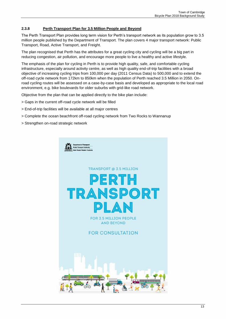
2.3.8 Perth Transport Plan for 3.5 Million People and Beyond
The Perth Transport Plan provides long term vision for Perth’s transport network as its population grow to 3.5
million people published by the Department of Transport. The plan covers 4 major transport network: Public
Transport, Road, Active Transport, and Freight.
The plan recognised that Perth has the attributes for a great cycling city and cycling will be a big part in
reducing congestion, air pollution, and encourage more people to live a healthy and active lifestyle.
The emphasis of the plan for cycling in Perth is to provide high quality, safe, and comfortable cycling
infrastructure, especially around activity centre, as well as high quality end-of-trip facilities with a broad
objective of increasing cycling trips from 100,000 per day (2011 Census Data) to 500,000 and to extend the
off-road cycle network from 172km to 850km when the population of Perth reached 3.5 Million in 2050. On-
road cycling routes will be assessed on a case-by-case basis and developed as appropriate to the local road
environment, e.g. bike boulevards for older suburbs with grid-like road network.
Objective from the plan that can be applied directly to the bike plan include:
> Gaps in the current off-road cycle network will be filled
> End-of-trip facilities will be available at all major centres
> Complete the ocean beachfront off-road cycling network from Two Rocks to Wannanup
> Strengthen on-road strategic network

Town of Cambridge Bicycle Plan 2018 Background Study
14
2.4 Local Policies
2.4.1 Town of Cambridge Town Planning Scheme
The Town Planning Scheme No.1 (TPS No.1) for the Town of Cambridge acts an instrument to control,
regulate and co-ordinate public and private development, the use of land and buildings and other activities to
improve the amenity, convenience, economy and attractiveness of the environment within the municipality.
The document provides direction for the implementation of future infrastructural works, encompassing a
broad scope of development which includes buildings, roads and paths.
2.4.2 Town of Cambridge Parking Policy (Policy 5.1)
Policy 5.1 sets out the access and parking requirements for non-residential developments within the Town. Of relevance to the Bike Plan, one of the aims of the policy is to encourage greater use of and promote other transport modes including cycling to reduce the reliance on the car. Accordingly, the policy presents bicycle parking requirements for short-stay and long-stay for non-residential use. The policy also sets out end-of-trip requirements for land uses which are required to provide long-stay bicycle parking.
2.4.3 Town of Cambridge Strategic Community Plan 2013-2023
The Town of Cambridge Strategic Community Plan 2013-2023 outlines the overriding direction and
framework for the town. The Plan comprises strategic guidance for the Town, in which priority areas of Our
Community Life, Our Natural Environment, Our Planned Neighbourhoods, and Our Council are
highlighted. Key actions within the Strategic Plan and how they relate to the Bike Plan are outlined below:
Our Community Life Goal 3: An active,
safe and inclusive
community
Strategy 3.3: Encourage
activity that meets the
needs of people of all
ages, cultures and
abilities
Provide connected paths and
trails for pedestrians and
cyclists
Our Planned
Neighbourhoods
Goal 6: Efficient
transport networks
Strategy 6.2: Reduce car
dependency
Encourage people to use
alternatives to cars by
providing and improving safe
bicycle and pedestrian links
and facilities.
2.4.4 West Leederville Activity Centre Plan
The Plan focuses on the West Leederville area between the Leederville and West Leederville Strain Station.
The plan lay out a plan to develop West Leederville into a Transit Oriented Development area due to its
excellent access to public transport and proximity to the Perth, Subiaco and Leederville Town Centre. A key
feature of the plan is the proposed bridge over Mitchell Freeway passing the Leederville Station connection
West Leederville and Leederville. The bridge is envisaged to be a ‘transit plaza’ and would accommodate
public transport (bus or light rail), pedestrian, and bicycle.
Key elements that arises out of the plan are:
> Opportunities for increased commercial and residential developments, creating a mixed use area that
takes advantage of its inner-city location and access to public transport.
> Creating comfortable, interesting and safe routes for pedestrians and cyclists.
> Making public transport infrastructure more appealing and a convenient alternative to private motor
vehicles.
> A lively, ‘main street’ character for Cambridge Street, creating a focal point for local retail and services.
Priority Area Goal Strategy Key Actions

Town of Cambridge Bicycle Plan 2018 Background Study
15
> Encouraging a gradual ‘stepping up’ of built form and maintaining a human scale to buildings along street
frontages and around public spaces.
> Enhancing the quality, identity, comfort, accessibility and usability of public areas: street, parks and civic
areas.
> Improving pedestrian and public transit connections between West Leederville, Leederville train station
and the Leederville Town Centre.
Part 3 of the plan provides an overview from access, movement and parking and includes planning principles
with regards to cycling:
> Enhance the ‘fine grained’ street network to provide a multiple choice of routes for pedestrians, cyclists
and vehicles.
> Develop cycle routes to a standard suitable for all classes of cyclists.
As part of the detailed area plan, it also provides recommendation to promote cycling and walking by
providing way-finding facilities at Leederville, West Leederville Station and various strategic street corners,
and end-of-trip facilities installed at various locations in the commercial and retail area.

Town of Cambridge Bicycle Plan 2018 Background Study
16
3 Crash Analysis
3.1.1 Crash Data
Safety is a very important factor in building a successful Bike Plan. The availability and quality of existing
cycle facilities is a good way of determining the level of safety and performance within an area. Main Roads
Western Australia (MRWA) crash data was utilised to identify the level of safety for the existing facilities
within the Town of Cambridge.
Over the past five-year period from 1 January 2011 to 31 December 2015, a total of approximately 3500
crashes have occurred within the Town of Cambridge, with 3.2% (115 crashes) of them involving cyclists.
The number and severity of crashes involving cyclists per year is shown in Figure 3-1.
Out of a total of 115 crashes, 48% of the total number crashes are property damage only and 52% of
crashes required medical attention or hospital treatment. No fatalities were recorded in the five-year period
from 1 January 2011 to 31 December 2015.
Severity of Crashes Involving Bicycles
The number of crashes above represents reported crashes only and it is very likely that crashes that only
involves minor property damage are not reported.
The number of crash over the 5 year period has fluctuated with significant decrease in 2012 and 2013 from
the previous year of 2011 before increasing again in 2014. The overall trend however, shows that there is a
reduction in bicycle crashes.
40
35
30
25
20
15
10
Fatal
Hospital
Medical
PDO-major
PDO-minor
5
0
2011 2012 2013 2014 2015

Town of Cambridge Bicycle Plan 2018 Background Study
17
3.1.2 Crash Locations
Roads where crashes occurred more than once are listed Table 3-1 and shown in Figure 3-2. From the data
presented, it can be seen that The Boulevard and Cambridge Street have the highest number of crashes.
This may only be an indicator that these streets are highly used by cyclists, but further investigation is
required to determine appropriate mitigation options.
Table 3-1 Crash Location and Number of Occurrence
Road Number of Crashes Road Number of Crashes
The Boulevard 10 Gregory Street 3
Cambridge Street 10 Southport Street 3
Jersey Street 6 Selby Street 3
Graham Farmer Fwy (Westbound) off to Loftus St
6 Harborne Street
3
Salvado Road 5 West Coast Highway 3
Underwood Avenue 5 Bold Park Drive 2
Grantham Street 5 Howtree Place 2
Marlow Street 4 Empire Avenue 2
Railway Parade 4 Corboy Street 2
Railway Street 3 Northwood Street 2
Challenger Parade 3 Ruislip Street 2
Birkdale Street 3 Lake Monger Drive 2
Dumfries Road 3
On Cambridge Street, it is notable that 5 out of 10 crashes occurred at driveways. To raise awareness of the
presence of cyclists along the path on Cambridge Street, linemarking or/and signs could be installed alerting
motorists to look for pedestrians and cyclist. Along both sides of Cambridge Street, the path runs
immediately adjacent to the fence line, restricting sightlines for reversing vehicles.
75 crashes or 65% of the total bicycle related crashes occurred at intersections and out of those, 13 crashes
occurred at roundabouts. Intersection crashes hotspots can be seen in Figure 3-2 , including:
> In the vicinity of Grantham Street and Harborne Street
> Cambridge Street and Harborne Street
> Cambridge Street and Loftus Street
The Town should view this crash data as an indicator to identify locations for safety improvements, including
potential for Blackspot funding for vulnerable road users.

Town of Cambridge Bicycle Plan 2018 Background Study
Crash Location within the Town of Cambridge
18

Town of Cambridge Bicycle Plan 2018 Background Study
19
4 Consultation
The stakeholder consultation guided the development of the bicycle plan and provided considerable insight
into the issues throughout the network. For this reason, garnering the local knowledge and opinions of the
community was a key precursor to preparing the Bicycle Network Plan.
The public consultation was held in two stages. In the first stage, a ‘blank-slate’ survey was presented to the
members of the community in order to seek issues, gaps, as well as feedback regarding major routes that
are being investigated. The survey questionnaire was developed in conjunction with the Town and
advertised on the Town’s website, newspapers, and on social media.
To complement the survey, a community workshop was also held during the survey period to provide
opportunity for community members to discuss issues directly with the project team.
4.1 Survey Results
A total of 356 responses were received to the survey, the results of which are summarised below:
Demographics
The survey respondents demographic are summarised in the following series of graphs
GENDER OF RESPONDENTS
LIVE, WORK OR PLAY IN THE TOWN OF CAMBRIDGE?
Male Female Yes No
AGE OF REPONDENTS
140 131
120
100
80
60
40
20
0
0-11 12-19 20-29 30-39 40-49 50-59 60-69 70+
AGE
10%
90%
28%
72%
97
56
43
17
0 2 10
NU
MB
ER
OF
RE
SP
ON
DE
NT
S

Town of Cambridge Bicycle Plan 2018 Background Study
20
17.1%
18.0%
8.1%
1.4%
6.7%
2.5%
160
140
120
100
80
60
40
20
0
NUMBER OF BICYCLES IN HOUSEHOLD
144
0 1 2 3 4 5+
NUMBER OF BICYCLE
It can be seen from the graphs above that the majority of the respondents are male, which consists of 72%
of the total respondents. 40 – 49 years old forms the major part of the age group. 94% of the respondents
(333 out of 356) stated that they have at least two bicycles at home indicating strong demands for cycling
among the residents.
Attitudes, trip purpose, and frequency
The following series of graphs summarises respondents’ trip frequency, purpose and attitude towards
cycling.
FREQUENCY OF CYCLING
Daily
3-6/Week 46.1%
1-2/Week
A few times a month
Less than once a month
Occasionally
Rarely/Never
0% 10% 20% 30% 40% 50%
72 62
55
20
3
NU
MB
ER
OF
RE
SP
ON
DE
NT
S

Town of Cambridge Bicycle Plan 2018 Background Study
21
SHOPPING
SOC IAL
COM PE T I T I ON
COM M UT ING
RECREAT IONAL/ LE ISURE
FO R WH AT PURPOSE DO YOU CYCLE?
18.9% 81.1%
27.6% 72.4%
8.4% 91.6%
62.2% 37.8%
82.8% 17.2%
YES NO
WHICH OF THESE PHRASES BEST DESCRIBES YOU AS A CYCLIST?
A CONFIDENT RIDER WHO IS COMFORTABLE RIDING IN MOST TRAFFIC SITUATIONS (IN MIXED TRAFFIC, ON ROAD)
A RIDER WHO IS SOMEWHAT COMFORTABLE RIDING IN SOME TRAFFIC SITUATIONS (IN MIXED TRAFFIC, ON ROAD)
A RIDER WHO PREFERS DESIGNATED ON ROAD BIKE LANES
A RIDER WHO PREFERS TO STICK TO OFF ROAD DUAL USE FOOTPATH-BIKE PATHS
From the graphs shown above it is noted that there is a high of response rate from the recreational and
commuter cyclists. The high proportion of respondents stating that they are comfortable riding on the road
reflects that the majority of respondents are experienced cyclists.
2.5% of the respondents cited that they rarely or never cycled. These non-cyclist respondents cited that lack
of safe places to ride with children, busy roads, and impractical as the main reason for not riding.
Consequently, these respondents would like to have a safer and better bike paths.
20.1%
43.6%
18.9%
17.4%

Town of Cambridge Bicycle Plan 2018 Background Study
22
8% 2 24% 50% 17%
Route Types
WH AT TYPES OF ROUTES DO YOU CYCLE ON WITHIN THE TOWN OF CAMBR IDGE, AND HOW
FREQUENTLY?
PRINCIPA L
SHARED PAT H
RECREAT IONAL SHARED PAT HS
F O O TP A TH S
SHARED PAT HS %
SIGNED PBN
ROUT ES
LOCAL ROADS
M AJO R ROADS
0% 20% 40% 60% 80% 100%
ALMOST ALWAYS OFTEN SOMETIMES RARELY NEVER
It can be observed that shared paths, signed PBN routes, and local roads are the most popular route types
with combined response for ‘almost always’ and ‘often’ exceeding 60% for each of these routes. This is
consistent with the ‘experienced cyclists’ profile of the survey respondents. Footpath was found to be the
least popular type of cycling route.
4.2 Cycling Routes
The survey also presented a series of existing and proposed major cycling routes that are being investigated
for comment by the public. The respondents are encouraged to highlight issues or present ideas for
improvement to these routes. The summary of comments from the survey is shown in Table 4-1.
While not every comment, issue or recommendation can be addressed in this bike plan, all input from the
community have been taken into account and used to help with prioritising recommended projects presented
in (Section 7).
6% 22% 54% 17%
23% 22% 30% 7%
9% 27% 47% 14%
29% 28% 18% 6%
21% 34% 26% 11%
17% 23% 36% 11%
19%
20%
9%
13%
RO
UT
E T
YP
ES
3%

Town of Cambridge Bicycle Plan 2018 Background Study
23
Table 4-1 Summary of Comments/Issues with Regards to Existing/Proposed Cycling Routes
Jersey Street Parked cars on both sides of the street, which are hazardous due to dooring.
Medium to high traffic volume. Many consider Jersey Street to be too dangerous to cycle on the road.
Traffic calming measures creating squeeze points for cyclists.
Difficult crossing at Grantham and Cambridge Streets.
Demand for dedicated cycling facility either on-road cycle lanes or bike path.
Gregory Street – Barrett Street – Station Street
Difficult to cross at Powis Street, Lake Monger Drive, Cambridge Street, and Salvado Road.
Crossing at Lake Monger Drive was the most common issue mentioned in the survey.
Dodd Street is unsuitable for on-road cycling due to reversing cars and pick-up/drop-off activity at peak times. The pavement condition is also poor at the eastern end.
Strong desire for a connection to Powis Street shared path.
Described by respondents as generally quiet. There is a desire for cycle path south of Lake
Monger Drive.
Selby Street High traffic volume and speed. Road carriageway too narrow for cyclist and cars.
Poor connection into Herdsman Parade.
Difficult crossing at Flynn Road Roundabout.
Many expressed the desire for on-road cycle lanes, however the narrow carriageway and effect on vehicular traffic are noted to be impediments for implementation.
Shared path between Salvado Road and Hay Street is considered to be good to cycle, however it would be beneficial to extend the path north to Herdsman Lake and south to Shenton Park.
No pedestrian and cycling signals at The Boulevard and Cambridge Street intersection.
Brookdale Street / Howtree Place
Section between Underwood Avenue and Oceanic Drive, is hazardous due to cars parked on-street.
Howtree Place is also mentioned as a section of the route that is hazardous due to various factors including, on-street parked cars, heavy vehicle deliveries to Floreat Forum, and cars entering exiting Floreat Forum car park.
Cycle lanes disappear at Oceanic Drive intersection.
A desire to extend the shared path southward of Underwood Avenue to allow for
connectivity with schools along Brockway Road in the City of Nedlands.
The Boulevard Central median causes pinch points for on-road cyclists as cars are unable to overtake.
Shared path quality is below average and in need for maintenance or upgrade.
Many respondents state that conflict with pedestrians, dog walker, other path users, and lack of priority over driveways and intersections deter commuters from using the shared path.
A desire for on-road cycle lanes.
Oceanic Drive Unsmooth shared path surface due to debris cracks and tree roots. Needs maintenance and/or upgrade.
Conflict with other path users on the shared path.
Some considered on-road cycling to be acceptable as dual traffic lane allows cars to overtake, while others feel that it is dangerous due to high traffic speed and glare at sunset.
Notwithstanding, there is a desire for an on-road bike lanes to be provided.
Ruislip Street On-street cycling generally considered safe due to low traffic and low number of parked cars, however the traffic calming measures (blister islands) at West Leederville are hazardous for cyclists.
Riding on the off-road path is very inconvenient due to lack of priority at intersections, which require cyclists to stop - start at every intersection.
While Ruislip Street have priority for the most of the length, many reported that cars at intersecting roads do not stop, causing cyclists to be alert at every intersection.
Difficult crossing at Selby Street and Harborne Street.
Cambridge Street Hazardous to cycle on-road due to parked cars, high traffic volume, and lane narrowing at West Leederville.

Town of Cambridge Bicycle Plan 2018 Background Study
24
Cycling off – road is not viable due to narrow path, pedestrian traffic, and numerous street furniture (bench, bus stop, etc)
A desire for dedicated on-road cycle lanes. Others also suggested to invest on alternative parallel roads such as Ruislip Street and Salvado Road instead.
Grantham Street
Hazardous to cycle on-road road due to parked cars, high traffic volume, and central medians.
There is a desire for on-road cycle lanes, while others expressed that it is better to provide cycling facility on Ruislip Street.
Salvado Road Section west of Selby Street is quiet and is considered to be acceptable to cycle on the road.
East of Selby, on-road cycling is considered to be unsafe due to parked cars, unsafe crossing at Harborne Street signalised intersection, and roundabouts.
A desire for a cycling connection into the Fremantle rail line PSP to the east and Oceanic Drive to the west.
A desire for improved crossing at Selby Street intersection.
Shared path surface west of Jersey Street is unsmooth and damaged by tree roots. Needs
to be maintained.
Lake Monger - Southport Street - Cambridge Street
Demand for the Lake Monger path to be connected to Powis Street shared path and northward.
Conflict with pedestrians and dog walkers at Lake Monger, need for clear separation.
Dangerous crossing at Powis Street off ramp and Southport Street/Lake Monger Drive intersection.
Path condition is poor at some sections caused by tree roots creating bumps.
West Coast Highway and Challenger
Desire to improve connectivity from the Town to the south of the Town into City of Nedlands
and Town of Claremont. Crossing at Rochdale Road was mentioned as particularly dangerous.
Parade Desire for the existing West Coast Highway shared path to be improved/upgraded due to increase pedestrian traffic.
Discontinuous path along the western side of Challenger Parade. Conflict with pedestrians is also an issue.
Cars turning into car parks not paying attention to cyclists on the shared path.
On – road cycling along West Coast Highway is deemed by many to be unsafe due to traffic speed.
On – road cycling on Challenger Parade is considered to be much more conducive for cycling due to lower traffic volume and speed. Many wished for the existing cycle lanes to extend southward.
Discontinuous on-road cycle lane along West Coast Highway
Railway Parade On –road cycling is not considered safe due to on-street parking, roundabouts, and central medians.
A desire to extend the existing shared path between Haydn Bunton Drive and Northwood Street to Loftus Street and link into the newly built shared path on the southern side of Railway Street in the City of Perth.
Railway Parade and Loftus Street signalised intersection needs to be improved for cyclists.
Very few access points to the Fremantle rail line PSP
Hay Street (Underwood Avenue)
A desire to continue existing shared path on the northern side (east of Selby Street) eastward.
On-road cycling is considered to be dangerous due to traffic speed. As such, there is a desire for on-road cycle lanes among many of the respondents
A desire for on-road cycle lane connection into Perry Lakes Drive.

Town of Cambridge Bicycle Plan 2018 Background Study
25
4.3 Stakeholder Consultation
The following stakeholder groups were contacted in the process of formulating this Bike Plan:
> Department of Transport
> Public Transport Authority
> Main Roads WA
> WestCycle
> Bicycle Western Australia
> City of Stirling
> City of Subiaco
> City of Perth
> City of Vincent
> City of Nedlands
> Floreat Forum Centre Management
> Wembley West Leederville Association
> West Leederville Residents Association
> City Beach Residents Association
> UWA Cycling Club
> St. John of God Hospital Subiaco
> Perth Netball Association
> City of Perth Surf Life Saving Club
> Floreat Surf Life Saving Club
> Schools
> Athletics WA
> North Coast Triathlon Club

26
Town of Cambridge Bicycle Plan 2018 Background Study
5 Planning for Cyclists
5.1 On-Street Facilities
Table 5-1 provides a summary of key design considerations when planning typical on-street facilities,
excluding bicycle boulevard facilities. It is recognised that due to the constraints of a built-up environment
some of the objectives may be impossible to achieve in certain locations, and a slightly lower quality facility
may be suitable. The designer will need to consider whether the proposed lower standard facility actually
achieves an improvement in safety or riding conditions for the cyclists, or whether it is safer to omit the
facility altogether if the appropriate standard cannot be reached.
Table 5-1 Design Considerations for On-Street Cycling Facilities
Traffic speed
Continuous median islands
Single-lane roundabouts
Multi-lane roundabouts
Priority-control intersections
Traffic calming devices
Traffic speeds are based on 85th percentile speeds for existing roads, and for the posted speed limit of new roads.
Less than 50km/hr – sealed shoulders or cycle lanes may be desirable, depending on road layout (e.g. if continuous median islands are used) and traffic volumes, however these are generally not required. On-street cyclists can be expected to ride in mixed traffic when prevailing traffic speeds are less than 40km/h.
50km/h – sealed shoulders or cycle lanes may be desirable, depending on the volume of cyclists, volume of vehicles and whether vehicles can overtake easily. On quiet streets with low traffic volumes or undivided carriageways wider than 7m are generally not required.
60km/h-70km/h – sealed shoulders or cycle lanes should be provided with a minimum width of 1.5m.
80km/h+ - sealed shoulders or cycle lanes should be provided with a minimum width of 2.0m. This provides an additional buffer for cyclists alongside fast and heavy traffic.
When considering the traffic speed, it should be noted that the 85th percentile rule applies to nominated traffic speeds. That is, the speed at or below which 85% of all vehicles are observed to travel under free-flowing conditions, therefore accounting for the majority of motorists (AS1742.4).
Wherever continuous median islands are used to separate traffic flows, 1.5m wide sealed shoulders should be provided to ensure that cyclists are not squeezed by vehicles. If barrier kerbs are used for median delineation, an offset of at least 0.3m (0.6m preferable) should be provided. Where these are introduced irregularly along streets the offset from the edge of travelled way should be a consistent minimum of 0.6m. This minimum may be used to match local authority standards on roads with design speed of 70km/h or less.
Austroads recommends an absolute minimum kerb-to-median width of 4.2m, increasing to 4.7m at 80km/hr.
Single lane roundabouts should be designed to reduce, as far as possible, the approach speed of vehicles on all legs. Sealed shoulders or cycle lanes should be ended on approach to the intersection, with clearly defined merge areas, to encourage cyclists to ‘claim the lane’ through the intersection. Cycle lanes should not be painted at the edge of the circulating roadway.
Multi-lane roundabouts should be avoided on on-street cycle routes wherever possible. If a roundabout is required, cyclists should be given the option of ‘claiming the lane’ through the intersection or exiting onto the path network. Cycle lanes should not be painted at the edge of the circulating roadway.
Sealed shoulders or cycle lanes should be provided on the through route. Deceleration lanes should be separate to cycle lanes, as per Main Roads WA standard design. If a slip lane is provided for left turning traffic on the terminating leg, a cycle lane should be provided adjacent to the right turn lane to assist cyclists in turning right.
On cycle routes with sealed shoulders or cycle lanes these should be continued through the traffic calming device, e.g. by providing a bypass around a slow point. The bypass can be either at road level or path level. If the bypass is at path level, care needs to be taken to ensure suitable vertical transitions at either end.
Issue Considerations

27
Town of Cambridge Bicycle Plan 2018 Background Study
Local Area Traffic Management
Sealed shoulders or cycle lanes
Surface treatments for cycle lanes or sealed shoulders
On cycle routes where cyclists are expected to ride with mixed traffic, it is expected that cyclists would ‘claim the lane’ through any traffic calming devices and therefore bypasses are not required. If bypasses are provided, e.g. around a single-lane slow point, the design needs to be aware of potential conflicts where cyclists will merge with vehicles after passing through the device.
Road humps can be uncomfortable for cyclists however when used, the preferred type is a ‘flat top’ road humps as illustrated in Figure 5-1.
Use of cul-de-sacs to prevent ‘rat running’ traffic has the potential to provide low volume, low speed corridors for cycling. However, many of these end-of-street treatments do not appear to appropriately accommodate cyclists. Any future creation of cul-de-sacs or one-way road sections must include provision for cyclists to easily travel both ways, retaining network permeability.
Sealed shoulders are generally adequate in most locations as Western Australian drivers do not tend to park on the carriageway. Formal cycle lanes, signposted with regulatory signage as required under the Road Traffic Code 2000, should be used where it is likely that vehicles will park in the sealed shoulders and create an unsafe conflict between cyclists and vehicles.
For urban streets, it is desirable to use red asphalt as the surface treatment for sealed shoulders and cycle lanes. This treatment provides a high quality surface for cyclists, as well as clearly delineating the presence of the lane and visually narrowing the street which reduces traffic speeds. This should include roads on the rural/urban fringe which are used by high volumes of cyclists (
For rural roads, black asphalt or hot mix is acceptable for sealed shoulders and cycle lanes. As cyclists, particularly road cyclists, are sensitive to rough or uneven road surfaces, the quality of pavement is critical.
‘Green Lane’ treatments should be used on cycle lanes at intersections where there is likely to be a significant conflict between cyclists and motorists – e.g. at the start of a left turn slip lane or at a location where significant volumes of traffic are likely to turn left across a cycle lane. ‘Green Lane’ treatments should, however, be used sparingly across the network to maintain their effectiveness as a warning device.
Parking Where angled parking is located adjacent to on-street facilities there is the potential for conflict between drivers reversing into the traffic lane and cyclists. The risk is significantly reduced when vehicles are parking rear-to-kerb, where oncoming cyclists are more clearly visible.
Therefore, it is good practice to recommend rear-to-kerb parking where high-turnover perpendicular on-street parking is provided. This must be considered in the context of the adjacent roadway, and it is advised that rear-to-kerb parking is not introduced where traffic volumes are high or roadway speeds are >50km/hr.
Rear-to-kerb parking may be mandated through appropriate signage.
1 metre minimum passing distance
A driver of a motor vehicle passing to the right of a bicycle that is travelling on a road in the same direction as the vehicle must pass the bicycle at a safe distance from the bicycle, with safe distance being:
▪ If the speed limit is 60km/h or less: 1m
▪ If the speed limit is more than 60km/h: 1.5m
This new legislation also allows drivers cross center line markings, including single and double continuous white lines and painted islands, only when it is safe to do so.
Designer must consider this rule when considering on-road cycling, such as cycle lanes or mixed traffic cycling to ensure that enough space is available for drivers to pass cyclist at a safe distance of 1m.
Issue Considerations
28
Town of Cambridge Bicycle Plan 2018 Background Study
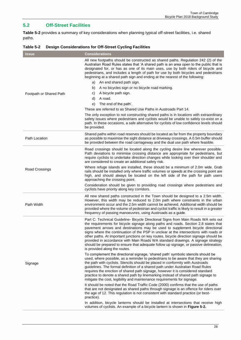
5.2 Off-Street Facilities
Table 5-2 provides a summary of key considerations when planning typical off-street facilities, i.e. shared
paths.
Table 5-2 Design Considerations for Off-Street Cycling Facilities
Footpath or Shared Path
Path Location
Road Crossings
Path Width
Signage
All new footpaths should be constructed as shared paths. Regulation 242 (2) of the Australian Road Rules states that ‘A shared path is an area open to the public that is designated for, or has as one of its main uses, use by both riders of bicycle and pedestrians, and includes a length of path for use by both bicycles and pedestrians beginning at a shared path sign and ending at the nearest of the following:
a) An end shared path sign.
b) A no bicycles sign or no bicycle road marking.
c) A bicycle path sign.
d) A road.
e) The end of the path’.
These are referred to as Shared Use Paths in Austroads Part 14.
The only exception to not constructing shared paths is in locations with extraordinary safety issues where pedestrians and cyclists would be unable to safely co-exist on a path. In these occasions, a safe alternative for cyclists of low confidence levels should be provided.
Shared paths within road reserves should be located as far from the property boundary as possible to maximise the sight distance at driveway crossings. A 0.5m buffer should be provided between the road carriageway and the dual use path where feasible.
Road crossings should be located along the cycling desire line wherever possible. Path deviations to minimise crossing distance are appropriate for pedestrians, but require cyclists to undertake direction changes while looking over their shoulder and are considered to create an additional safety risk.
Where refuge islands are installed, these should be a minimum of 2.0m wide. Grab rails should be installed only where traffic volumes or speeds at the crossing point are high, and should always be located on the left side of the path for path users approaching the crossing point.
Consideration should be given to providing road crossings where pedestrians and cyclists have priority along key corridors.
All new shared paths constructed in the Town should be designed to a 2.5m width. However, this width may be reduced to 2.0m path where constraints in the urban environment occur and the 2.5m width cannot be achieved. Additional width should be provided where the volume of pedestrian and cyclist traffic is likely to result in a greater frequency of passing manoeuvres, using Austroads as a guide.
Part C: Technical Guideline- Bicycle Directional Signs from Main Roads WA sets out the requirements for bicycle signage along paths and roads. Section 2.8 states that pavement arrows and destinations may be used to supplement bicycle directional signs where the continuation of the PSP in unclear at the intersections with roads or other paths. At important junctions on key routes, bicycle direction signage should be provided in accordance with Main Roads WA standard drawings. A signage strategy should be prepared to ensure that adequate follow up signage, or passive delineation, is provided along the routes.
To complement the directional signage, ‘shared path’ symbolic stencils should be used, where possible, as a reminder to pedestrians to be aware that they are sharing the path with cyclists. Stencils should be placed in conformity with Austroads guidelines. The formal definition of a shared path under Australian Road Rules requires the erection of shared path signage, however it is considered standard practice to denote a shared path by linemarking instead of shared path signage to mitigate the cost, legibility and maintenance requirements for signage.
It should be noted that the Road Traffic Code (2000) confirms that the use of paths that are not designated as shared paths through signage is an offence for riders over the age of 12. This regulation is not consistent with standard practice (or best- practice).
In addition, bicycle lanterns should be installed at intersections that receive high volumes of cyclists. An example of a bicycle lantern is shown in Figure 5-2.
Issue Considerations

29
Town of Cambridge Bicycle Plan 2018 Background Study
Centre linemarking should be used on paths wider than 2.5m if the volume of cyclist and pedestrian traffic is significant or if there is a history of conflicts.
These should be avoided as far as possible. If there is a definite need to prevent unauthorised vehicle access to the paths, a single bollard placed in the middle of the path is recommended, with the path widened to 3.0m. Bollard visibility should be enhanced by use of retro-reflective material and supported by a widened centre line on the approaches, to ensure adequate visibility at night.
Speed or access control devices
Grab Rails
Passive Wayfinding
Connectivity
Controlled Access Point (CAP) Roads/Service Roads
Where a definite need exists to reduce cyclist speeds approaching a road crossing, due to poor cyclist behaviour and safety considerations, gates (grab rails) should be used. Gates should be separated by a minimum of 3.0m to allow a cyclist to weave through them at approximately walking pace. In a town centre environment, well- placed street furniture is preferred to achieve the same aims. Bollards should not be used to reduce cyclist speeds.
Grab rails should be placed according to Austroads Guidelines and used sparingly along cycle routes where there are high vehicle crossing volumes or speeds. Grab rails can be used as a passive wayfinding technique to delineate the route of local bicycle routes. Grab rails should always be located on the left side of the path approaching a road crossing and never in the centre of the path.
Passive wayfinding should be incorporated into the design of shared path networks. Strategic placement of grab rails, linemarking and coloured asphalt can illustrate the route of the main shared path without the need for signs.
All new shared paths should be implemented with maximum connectivity, including kerb ramps and crossings to facilitate movement between paths. Ensure that new developments do not introduce missing links in their path networks.
CAP roads/Service roads should not be used as substitute for shared paths.
Issue Considerations
Linemarking

30
Town of Cambridge Bicycle Plan 2018 Background Study
Typical Flat Top Road Hump
Source: Austroads Guide to Traffic Management Part 8
Bicycle Lanterns
31
Town of Cambridge Bicycle Plan 2018 Background Study
5.3 Bicycle Boulevards (Safe Active Street)
A bicycle boulevard is the name given to a range of treatments to quiet suburban streets in order to create a
safe, low speed and low vehicular traffic environment for on-street cycling. In WA, the DoT is funding bike
boulevard projects under the Safe Active Street program. The concept is used extensively in The
Netherlands as well as Portland, USA. As a number of bicycle boulevards are proposed as part of this Local
Bike Plan, the following section is designed to provide an overview of their purpose and key features, in
order to inform detailed design considerations.
The main purpose of a bicycle boulevard is to create a safe, low speed and low vehicular traffic environment
that encourages on-street cycling among cyclists of all confidence levels. With a safer, friendly environment
for cyclists, it is expected that bicycle boulevards will encourage greater take up and utilisation of cycling as
a transport mode for students, commuters and discretionary travel.
The key features of a bicycle boulevard include:
> Road closures and traffic calming devices to reduce traffic volumes and speeds
> High quality shared paths between road sections to create seamless linkages along a route
> Pavement marking, such as bicycle symbols, which guide cyclists on their positioning and remind
motorists of the presence of cyclists
> Reversal of priorities at minor intersection to give the boulevard priority
> Improved crossings at busy roads where the boulevard cannot be given priority
Bicycle boulevards tend to create attractive on-street cycle routes, designed preferentially for cycling
connectivity. Below are some examples of bicycle boulevards.
Shakespeare Street Bicycle Boulevard – City of Vincent, WA
Source: Department of Transport
Source: Nearmap February 2017

32
Town of Cambridge Bicycle Plan 2018 Background Study
Spokane Street Bicycle Boulevard Utilising Contra-Flow Bicycle Lane with Partial Road Closure – Portland, Oregon USA
Source: Oregon Live (photo mirrored to reflect left-hand traffic flow)
Williams Avenue Bicycle Boulevard Utilising Diagonal Road Closure – Portland, Oregon USA
Source: National Association of City Transport Officials, USA (photo mirrored to reflect left-hand traffic flow)

33
Town of Cambridge Bicycle Plan 2018 Background Study
5.4 Protected/Separated Cycle Lanes
Protected or separated cycle lanes are on-road cycling facility where bicycles are physically separated from
main vehicular traffic. Protection or separation from vehicular traffic can be in form of solid kerb barrier, on-
street parked cars, or painted chevrons. If the cycle lane is placed between parked cars and the road
kerbing, a minimum of 1m gap would need to be provided to allow room for opening car doors without
impeding the cycle lane. The cycle lanes can be configured as bidirectional cycle lanes on one side of the
street, or one-way in each direction on both sides of the street.
Refer to Figure 5-6 to Figure 5-8 for examples of protected cycle lanes in different configurations. Further
information regarding protected cycle lanes can be found in Technical Note 128: Selection and Design of
Cycle Tracks by Queensland Department of Transport and Main Roads, which provide comprehensive
design guidance for protected cycle lanes.
Protected/Separated One-way Cycle Lanes, Between Parked Cars and Road Kerb – Swanston Street, Carlton VIC
Source: Bicycle Network Australia
Protected/Separated One-way Cycle Lanes, Painted Chevron – Victoria Street, North Melbourne VIC

34
Town of Cambridge Bicycle Plan 2018 Background Study
Protected/Separated Bidirectional Cycle Lanes, Solid Kerb Separated – Fitzroy Street, St. Kilda VIC
5.5 Cycle Lane / Sealed Shoulder Termination
Intersections are critical points on the bicycle network and, if the level of conflict or perception of danger is
too high, will often become an almost invisible barrier to use of a cycle route.
5.5.1 Signalised Intersection
For signalised intersections where the approach flares into two or more traffic lanes, the treatment is very
simple and examples of appropriate treatments are shown in Figure 5-9. The most important aspect is to,
wherever possible; avoid the situation where a vehicle in a dedicated left turn lane must turn across the cycle
lane at the stop line as this is the most dangerous conflict point.
Where the left lane is a shared through/left lane, the through bicycle lane may be omitted, provided that the
conflict point at the commencement lane is clearly marked.
However, the termination of the cycle lane/sealed shoulder needs to be clearly marked in order to indicate to
both cyclists and motorists that cyclists will be merging at this point. This treatment should also be used on
approach to multi-lane roundabouts.
The most important aspects of this treatment are that:
> The termination of the cycle lane/sealed shoulder occurs well before the give way line at the roundabout
> The merge area is clearly marked with visual cues so that both cyclists and drivers are aware of the
merge
> A kerb ramp leading to a shared path around the outside of the roundabout is provided at a gentle angle,
to allow cyclists who are not confident enough to ride in mixed traffic to use the path network instead

35
Town of Cambridge Bicycle Plan 2018 Background Study
Example of Cycle Lane / Sealed Shoulder Termination Treatment Where Road Widens on Approach to a Signalised Intersection
36
Town of Cambridge Bicycle Plan 2018 Background Study
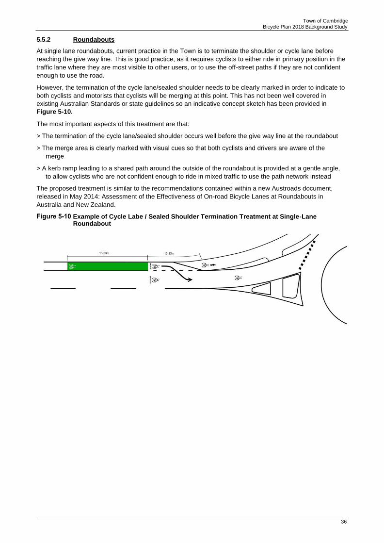
5.5.2 Roundabouts
At single lane roundabouts, current practice in the Town is to terminate the shoulder or cycle lane before
reaching the give way line. This is good practice, as it requires cyclists to either ride in primary position in the
traffic lane where they are most visible to other users, or to use the off-street paths if they are not confident
enough to use the road.
However, the termination of the cycle lane/sealed shoulder needs to be clearly marked in order to indicate to
both cyclists and motorists that cyclists will be merging at this point. This has not been well covered in
existing Australian Standards or state guidelines so an indicative concept sketch has been provided in
Figure 5-10.
The most important aspects of this treatment are that:
> The termination of the cycle lane/sealed shoulder occurs well before the give way line at the roundabout
> The merge area is clearly marked with visual cues so that both cyclists and drivers are aware of the
merge
> A kerb ramp leading to a shared path around the outside of the roundabout is provided at a gentle angle,
to allow cyclists who are not confident enough to ride in mixed traffic to use the path network instead
The proposed treatment is similar to the recommendations contained within a new Austroads document,
released in May 2014: Assessment of the Effectiveness of On-road Bicycle Lanes at Roundabouts in
Australia and New Zealand.
Example of Cycle Labe / Sealed Shoulder Termination Treatment at Single-Lane Roundabout

37
Town of Cambridge Bicycle Plan 2018 Background Study
6 Wayfinding
6.1 Best Practice
Western Australia has a number of wayfinding strategies. The more recent examples include the City of
Cockburn – Your Move and at the City of Joondalup. Refer to Table 6-1.
Table 6-1 Best Practice Examples
City of Cockburn - Your Move
Source: City of Cockburn
In 2013, the Department of Transport and the Department of Sport and Recreation, in collaboration with the City of Cockburn, rolled out the ‘Your Move Cockburn’ pilot project. The project involved engaging more than 10,000 households and empowered them to replace regular car trips with trips on foot, bicycles and public transport. One of the most crucial aspects of the project was the addition of way-finding signs around the City of Cockburn.
These signs were placed on pavements along the City of Cockburn. The aim of these signs was to inform residents and visitors of destinations nearby and the time it took to walk there. From feedback collated, a significant number of residents were unaware of the number of amenities that were within walking distance. The bright and attractive nature of the sign generated interest from the local community to use it as well. As a result the following was achieved:
▪ Over 410,000 car trips avoided.
▪ Over 8 million reduced car minutes travelled.
▪ Increase of 10.5 minutes in physical activity per person per day.
▪ A shift of more than 8% of the population being reclassified from insufficient to sufficient levels of physical activity.
City of Joondalup
Source: City of Joondalup
A wayfinding Signage Strategy was developed for the City of Joondalup with the aim of supporting the City’s overarching “Walkability Plan 2013-2018’. In addition, the strategy also assists the City of Joondalup to create a useful wayfinding system for the benefit of its users. In doing so, the system should be:
▪ Highly visible.
▪ Lead the user to their destination.
▪ Highlight key places within the immediate area.
▪ Integrate with the existing signage.
38
Town of Cambridge Bicycle Plan 2018 Background Study
a) Implementing a Wayfinding Signage Project
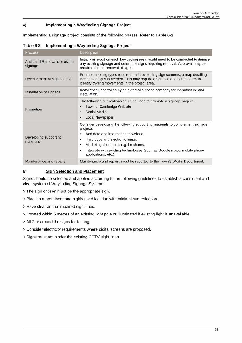
Implementing a signage project consists of the following phases. Refer to Table 6-2.
Table 6-2 Implementing a Wayfinding Signage Project
b) Sign Selection and Placement
Signs should be selected and applied according to the following guidelines to establish a consistent and
clear system of Wayfinding Signage System:
> The sign chosen must be the appropriate sign.
> Place in a prominent and highly used location with minimal sun reflection.
> Have clear and unimpaired sight lines.
> Located within 5 metres of an existing light pole or illuminated if existing light is unavailable.
> All 2m2 around the signs for footing.
> Consider electricity requirements where digital screens are proposed.
> Signs must not hinder the existing CCTV sight lines.
Process Description
Audit and Removal of existing signage
Initially an audit on each key cycling area would need to be conducted to itemise any existing signage and determine signs requiring removal. Approval may be required for the removal of signs.
Development of sign context
Prior to choosing types required and developing sign contents, a map detailing location of signs is needed. This may require an on-site audit of the area to identify cycling movements in the project area.
Installation of signage Installation undertaken by an external signage company for manufacture and installation.
Promotion
The following publications could be used to promote a signage project.
▪ Town of Cambridge Website
▪ Social Media
▪ Local Newspaper
Developing supporting materials
Consider developing the following supporting materials to complement signage projects
▪ Add data and information to website.
▪ Hard copy and electronic maps.
▪ Marketing documents e.g. brochures.
▪ Integrate with existing technologies (such as Google maps, mobile phone applications, etc.)
Maintenance and repairs Maintenance and repairs must be reported to the Town’s Works Department.

39
Town of Cambridge Bicycle Plan 2018 Background Study
7 End of Trip Facilities (EoT)
7.1.1 Background
End of trip facilities are a critical, but often forgotten, component of the cycling network. The presence and/or
quality of end of trip facilities can often make or break the decision to cycle for many trips.
Different trip purposes will have different needs when it comes to end of trip facilities. For example:
> A commuter may want a secure place to park their bicycle inside their workplace, along with showers,
lockers and ironing facilities to enable them to freshen up before commencing work for the day
> A commuter may instead want a secure long term place to park their bicycle at the train station or bus
interchange, allowing them to complete a portion of the trip via bicycle
> A shopper may only want a secure short term place to park their bicycle, conveniently located to their
destination (e.g. close to the entrance of a shopping centre, or on the footpath in a ‘main street’
environment) which is ideally protected from wet weather
> A recreational rider generally has end of trip facilities at their own home but may require a secure place
to park their bicycle at an intermediate destination, such as a cafe or a park
> Long term end of trip facilities for commuters should generally be provided by the employer. Council’s
involvement in the provision of end of trip facilities should be in the form of:
> Requiring, through its Town Planning Scheme, new developments to provide a certain standard of end
of trip facilities for both employees and visitors; and
> Providing suitable end of trip facilities for employees and visitors at its offices, depots, library etc.
Short term end of trip facilities should generally be in the form of simple u-rails or other design which
facilitates the secure parking of a bicycle. In accordance with Austroads guidelines, these should be located
approximately every 30 metres along ‘main street’ type shopping strips and in small clusters at the entrances
to shopping centres and other significant destinations.
There are three train stations either within of near the Town’s boundary (Subiaco, West Leederville, and
Leederville). The purpose of providing EOT facilities at train stations is that it should make it easier for a
person to access the station from a greater distance than by walking. People living within a comfortable
800m of their station (equivalent of a 10 minute walk) are not likely to use a bike to get to the station once
they factor in the extra time taken to prepare for riding (appropriate clothing, securing luggage, helmet, lights
if it is dark, getting the bicycle out of storage/garage) and once they reach the station, locking the bicycle.
The NSW Bicycle Guidelines considers that riding a bicycle over 5 minutes to the station involves less
physical effort than walking. In other words, the decision to ride to the station is only viable if the advantage
of travelling the extra distance for less physical effort outweighs the other factors of using a bicycle. As it is
not possible to control the preparation factors in riding, it is important that the ride or route to the station
coupled with the end of trip facilities is as comfortable and convenient as possible.
At the stations commuters require secure long term place to park their bicycle thus allowing them to
complete a portion of their trip via bicycle.
Specific considerations relating to the provision and location of end of trip facilities at train stations
> Storage areas need to be open and attractive and in easily supervised areas that have good active and
passive public surveillance
> Bicycle parking should be as close as possible to station platform entrances with a maximum walking
distance of 100m
> Bicycle parking u-rails should be located under cover and out of the weather
> Bicycle parking facilities need to be easy to find, well signed and marked
> Bicycle riders need to be able to access the parking facilities easily and quickly from the local routes
Source: Bicycle Guidelines from RTA NSW

40
Town of Cambridge Bicycle Plan 2018 Background Study
End of trip facilities at train stations are the responsibility of the PTA. With future growth in cycling, it is
expected that demand for these facilities will increase. It is recommended that Council monitor the situation
and liaise with the PTA to ensure that supply exceeds demand.
End of Trip Facility
7.1.2 Locations
The Town is responsible for providing bicycle parking on public land such as road reserves, parks,
recreational facilities and Town buildings. U-rails, with capacity for a minimum of 10 bicycles, should be
provided at all major recreational facilities and Town buildings. EoT facilities, such as showers, lockers,
secure parking and washing/drying/ironing facilities should also be provided at workplaces for use by staff.
Public bicycle parking in the form of U-rails should also be progressively installed in front of shops,
businesses, cafes etc. across the urban area.
Bicycle parking adjacent to land uses should consider both the type of destination and the adjacent cycling
infrastructure. Where cyclists are encouraged to ride in mixed traffic or within cycle lanes, on-street bike
parking is particularly important. This can be provided in attractive ‘bike corrals’ which provide a high volume
of bike parking within a small space, often a single car parking bay. This type of bike parking is ideally suited
to main street environments.
7.1.3 Development Provisions
The latest Town Planning Scheme TPS 1 Policy manual does include requirements for long-stay bicycle
parking to provide EoT facilities requirements are shown in Table 7-1.
Table 7-1 End of Trip Facilities Requirements
No. of long-stay bicycle spaces
provided
No. of
Lockers1
No. of Showers 2
1-2 1-2 0
3-5 3-5 1
6-10 6-10 2 (one male, one female)
11-20 11-20 4 (two male, two female)
More than 20 20 or more 4 (two male, two female)
Plus
Additional showers at the rate of 2 showers (one male, one female) for every 10 long-stay parking spaces over 20 provided thereafter
Notes:
1 To be of suitable volume and dimensions to allow storage of clothing, towels, cycling helmets and footwear; well ventilated, secure and
lockable; and located close to shower and change room facilities (where provided). A ratio of one locker to one bicycle space is to be
provided.
2 Change room facilities must also be provided and may either be a combined shower and change cubicle or communal change room
for each gender directly accessible from the showers.

41
Town of Cambridge Bicycle Plan 2018 Background Study
7.1.4 Bicycle Parking at Schools
Bicycle parking at school is important to encourage students to ride to/from school. All schools
within the Town of Cambridge presently have some form of bicycle parking facility, ranging from simple u-
rails to secure cages. The key considerations for bicycle parking at schools include:
> Convenience – the parking should be located close to the classrooms and not at the far end of the
playing fields. Easy access from the approach routes is also important;
> Security – the student, and their parents, need to be confident that their bicycle will not be vandalised or
stolen at school and therefore the parking needs to be secure with passive surveillance. The ultimate
solution to this is a lockable bicycle cage, controlled by staff.
Bicycle security is one of the key factors that discourages cycling to school, as identified through surveys of
school children. Parents note that there are theft concerns where bicycle racks are visible from the road.
With after school activities being variable throughout the week, students may need to leave bicycles parked
at school overnight and this increases the theft risk if the facility is not sufficiently secure.
When planning for end of trip facilities at schools, the different needs of students must be considered,
including:
> Parking is almost always long stay (> 4 hours) and arrival / departure times are very strict. Therefore a
lockable bicycle cage is appropriate, with a responsible person from the school controlling access to the
facility.
> Most bicycle parking guidelines advocate the placement of bicycle parking facilities in areas visible to and
accessible by the public. However, schools are different to other public facilities or workplaces. Placement
of the facility near the school boundary can be a great symbol of the school’s support for sustainable
transport and develop awareness among the school population; however exposure to passing traffic does
bring with it a theft or vandalism risk. If the facility is to be located in view of the public then it needs to be
fully secure to cater for bicycles left overnight or on weekends, and be vandalism proof.
> Weather protection – in the form of a roof to protect from rain and sun – is very desirable to reduce
exposure to the elements. This is particularly desirable on very wet or very hot days where the bicycles
may become unrideable due to wetness or heat exposure.
Whichever location and type of facility is selected, the need for future capacity expansion should be
considered to match the anticipated growth in cycling to schools. Current Austroads guidelines recommend a
provision of 1 bike bay per 5 students over year 4.
It is recommended that schools be encouraged to install secure bicycle cages for their students.
Whilst parking at schools is primarily the responsibility of the school itself, the LGA should encourage
schools to get involved in improving their cycling facilities.
Any proposals by the Town to upgrade bicycle parking at schools should be coordinated with the further
development of the cycle network in the area.

42
Town of Cambridge Bicycle Plan 2018 Background Study
8 Encouraging Behaviour Change
While constructing new infrastructure is crucial to the promotion of cycling in the Town, it is imperative to
engender usage of new infrastructure through encouraging behaviour change. The following sections outline
a variety of factors that influence cycling behaviour. In addition, methods to stimulate cycling change by
encouraging those who do not currently cycle to take up cycling, as well as ensuring that existing cyclists will
continue to ride throughout the Town, will be outlined.
8.1 Method of Travel
The methods of travel for Cambridge residents are displayed in Table 8-1 below. It is interesting to note that
the number of those travelling by car as driver and the number of those travelling via bicycle has grown. The
Town has seen a growth in cycling similar to the Greater Perth area.
Table 8-1 Cambridge Mode of Travel
Main method of travel 2006 2011 Change
Number % Greater Perth Number % Greater Perth 2011-
% of % 2006
Train 212 2% 4.9 321 3% 3.7 109
Bus 559 6% 4.9 752 8% 4.0 193
Ferry 5 0% 0 0 0% 0.0 -5
Tram 5 0% 0.2 3 0% 0.0 -2
Taxi 39 0% 0.2 33 0% 0.2 -6
Car, as driver 6,875 76% 75.8 7,265 73% 78.8 390
Car, as passenger 496 6% 6.9 524 5% 6.4 28
Truck 41 0% 1.2 31 0% 0.7 -10
Motorbike/Scooter 55 1% 0.7 92 1% 0.7 37
Bicycle 264 3% 1.2 402 4% 1.4 138
Other 59 1% 1.3 89 1% 0.7 30
Walked only 390 4% 2.4 477 5% 2.7 87
Total 9,000 100% 100 9,989 100% 100 989
Source: ABS 2011
8.2 Target Audience
To achieve the Town’s strategic target to increase cycling activity within the LGA, segments of the population
should be identified that may be more likely to cycle, cycle more often or to take up cycling for specific trips
(to work, school or for recreation). When reviewing information regarding the Town of Cambridge’s mode
choices by residents and visitors, consideration should be made of those:
> travelling distances or journeys that could be made by bike;
> that own a bicycle (or have access to one); and
> that have a willingness to cycle.
The National Cycling Participation Survey suggests that approximately two thirds of households in Western
Australia have access to a bicycle. In 2011, this equates to approximately 9,000 bicycles within the Town.
Given that a large number of residents have access to a bicycle, it is the provision of high quality cycling
infrastructure that has the potential to encourage those to take up cycling on a more frequent basis.

43
Town of Cambridge Bicycle Plan 2018 Background Study
8.3 Cycling Segmentation
Cycling segmentation (as illustrated in Figure 8-1 below with the segments described in Table 8-2) is a best
practice model for identifying the type and needs of existing and potential cyclists.
Cycling Segmentation
Source: Roger Geller, Portland Bureau of Transportation, https://www.portlandoregon.gov/transportation/article/264746
Table 8-2 Cycling Segmentation – Descriptions
Strong and Fearless 1% Will ride anywhere and in any weather conditions.
Enthused and Confident 6% Relatively comfortable on busy roads with bike lanes
Interested but Concerned 60% Uncomfortable around traffic, feel unsafe.
No way, no how 33% Not interested in cycling for transport
From the ABS 2011 data (shown in Table 8-1) and the community survey results, it is likely that the majority
of those cycling regularly or for transport (such as to work) in the Town of Cambridge at present fall into the
‘Strong and Fearless’ or ‘Enthused and Confident’ categories.
As it is recognised that the ‘Strong and Fearless’ group will likely cycle with or without specific behaviour
change activities or infrastructure, and represent only a small proportion of the population of the Town, an
emphasis for activities has therefore been placed on encouraging the remaining portion of the population
that may cycle occasionally or for recreation. The community survey results also estimate that approximately
83% of the population cycle for recreation. This proportion is likely to make up the ‘Interested but Concerned’
segment and even some of those who would never consider themselves “cyclists”.
This segment will require the implementation of cycling infrastructure to start cycling, but holds the most
potential for increasing cycling mode share. The purpose of behaviour change activities for this group is
therefore to encourage the development of an appreciation of the benefits, provision of the tools and culture
of support for cycling while the network develops.
This research and methodology has informed the proposed approach and activities for Cambridge.
8.4 Recommended Behaviour Change Approach and Activities
There are many models for using promotion to encourage behaviour change. Table 8-3 provides an
overview of the considerations of behavioural change. This model is considered appropriate for the Town,
and provides a clear framework for identifying suitable promotional activities in order to increase the uptake
of cycling for transport purposes. Specifically, for the ‘Enthused and Confident’ and ‘Interested but
Concerned’ segments it provides focus on activities that promote ‘everyday’ cycling in a positive manner and
focuses on tools to overcome identified barriers to cycling.
Type Approximate Proportion Description

44
Town of Cambridge Bicycle Plan 2018 Background Study
Table 8-3 Behaviour Change Approach
Stage of Change Individuals Perception Potential Activities and Interventions
Pre-contemplation Not considering bike riding Raising the awareness of cycling
Introduce messages that portray riding as an activity that individuals associate with in a positive manner.
Contemplation Aware of bike riding, the benefits and interested in finding out more
Ensure that tools and resources are available to support
potential riders seeking information.
Preparing Would like to give riding a go To be able to ride appropriately, have access to a bicycle, to know how to ride it and have the relevant resources and facilities provided.
Action Riding for the first time Ensure infrastructure and supporting facilities are well
maintained, safe, legible and convenient so that the new rider has a positive initial experience.
Maintaining Riding again Positive reinforcement – or the rider may not choose to ride again and relapse into their old behaviour (non-bike riding).
Relapse Stopping riding The rider may re-enter the stages of change at any of the above steps.
Source: Gatersleben and Appleton 2007, Contemplating cycling to work: Attitudes and perceptions in different stages of change, Transportation Research Part A: Policy and Practice, Vol.41, No.4, pp.302-312.
8.5 Raising the Awareness of Cycling
These activities ensure that positive messages regarding cycling are included wherever possible in order to
raise awareness of cycling throughout the community. Particularly for the Town of Cambridge, celebrating
the introduction of new infrastructure should provide an important opportunity to raise awareness of cycling
and encourage the wider public to give the new infrastructure a go.
Examples: Information regarding cycling related activities being included on the Council website,
newsletters and community events. Opportunities to capture and promote feedback from riders regarding
why they enjoy riding in the Town of Cambridge could also be included within this material. Positive imagery
of cycling, and local infrastructure where possible, should be included in Council publications, plans and
reports whenever appropriate.
8.6 Tools and Resources
In order to support those who may be considering cycling, knowledge of the provision of infrastructure
through route maps, visible bicycle parking in convenient locations, guidance on cycling etiquette, road rules
and cycling safely is recommended to help encourage and equip them to take action.
Examples: Relevant information could be supplied electronically in downloadable format from the Council’s
website, made available in printed format from the Library and Community Centre. As the Council will be
looking to introduce new types of cycling and road user infrastructure, it is recommended that additional
education and promotion is associated with these changes to ensure all users are informed and advised of
appropriate use of the new facilities.
8.7 To be Able to Ride Appropriately
In order to ride a bike, you must have access to a bike to ride, and know how to ride it appropriately. Several
councils within Western Australia work to address this barrier through providing cycle training courses, in
order to introduce new riders or increase confidence for the inexperienced rider.
Some councils also provide cycling training specifically for women. These initiatives have been proven
successful in getting the ‘interested and concerned’ group into cycling.
Examples: Cycling education courses and lead rides could be provided.
45
Town of Cambridge Bicycle Plan 2018 Background Study
8.8 Infrastructure and Supporting Facilities
This Bike Plan provides a detailed list of recommendations regarding potential cycling infrastructure
requirements, supporting facilities (such as bike racks) and the importance of maintenance. Cycling and
other community events could be associated with the opening of specific bicycle routes and facilities as
completion of the recommended infrastructure programs occurs, alongside ensuring appropriate promotion
and education regarding the new facilities. Other supporting infrastructure could include signage and
wayfinding tools, bicycle maintenance facilities such as air pumps and so on.
8.9 Positive Reinforcement
To encourage those who start riding, to continue riding, infrastructure must continue to meet users’ needs
and provide for a positive experience. To further reinforce this behaviour, opportunities to recognise and/or
reward bike riders should be considered.
Examples: Cycling surveys and counts to demonstrate and promote improvements to the wider public,
alongside using community events to recognise bike riders. Several authorities also participate in Super
Tuesdays, which is a national annual bike count event. Others use Bike Week to provide an opportunity to
both promote cycling and recognise existing riders, often through cycling breakfasts.
8.10 Targeted Driver Education
Driver education, when targeted properly, can be an effective tool in encouraging better road user behaviour.
Safety focused industries, such as mining, focus significant training resources on driver education in order to
protect the safety of employees, contractors and the community, forming a key component of their
obligations under Occupational Health and Safety legislation. As a major employer, the Town of Cambridge
has a responsibility to ensure that staff who are required to drive or cycle as part of their employment, are
educated in appropriate road user behaviour, including sharing the road with cyclists.
8.11 School Programs
School children are a critically important component of the cycling community; they are the next generation
of cyclists. The early exposure of children to cycling as an enjoyable way to spend their leisure time and to
get to/from school has been proven to contribute significantly to children continuing to cycle into adulthood.
The major opportunities for encouraging school children to ride bicycles include:
> Cycling to/from school – the majority of children live within 5km of their school which is a comfortable
cycling distance
> Cycling lessons at school – teaching children the basics of riding a bicycle and safety on and around
the roads
> Organised cycling sport, either at school or on weekends, ranging from simple leisurely rides, to road
riding and mountain biking
The Town, in conjunction with State Government agencies and community groups, could undertake
programs to encourage school students to take up cycling. These initiatives should be continued at least
once every two years, with different schemes targeting different age groups. A key focus should be children
in the 10-14 age bracket, who are reaching the age where they may consider and are permitted by their
parents to cycle to school.

46
Town of Cambridge Bicycle Plan 2018 Background Study
8.12 Connecting Facilities
Facilities that enable cyclists to continue their journey via public transport are important to promote and
encourage the use of sustainable modes of transport. The main transport nodes in the Town of Cambridge
and the corresponding facilities they provide are as follows:
> West Leederville Station
> Subiaco Station
> Leederville Station
Compared to similar stations across metropolitan Perth, the provision of bicycle lockers and U-Rails at the
stations in the Town of Cambridge is generally satisfactory. Nevertheless, there is an opportunity for many of
these stations to include bicycle shelters on site in conjunction with the pre-existing bicycle lockers.
Other factors that should be considered include:
> Storage areas need to be open and attractive and in easily supervised areas that have good active and
passive public surveillance;
> Bicycle parking should be as close as possible to station platform entrances with a maximum walking
distance of 100m;
> Bicycle parking u-rails should be located under cover and out of the weather;
> Bicycle parking facilities need to be easy to find, well signed and marked; and
> Bicycle riders need to be able to access the parking facilities easily and quickly from the local routes.
Cyclists should also be aware of train etiquette when using public transport and while it is primarily the
responsibility of the PTA, signage should be implemented to inform those using the facilities of the
restrictions. These restrictions include:
> Bikes are not permitted on Transperth train services during peak periods. Between 7.00am and 9.00am,
Monday to Friday, bikes are not permitted on train services travelling to Perth City. Between 4.30pm and
6.30pm, Monday to Friday, bikes are not permitted on train services travelling away from Perth city.
> Bikes cannot depart or pass through Perth, Perth Underground or Esplanade stations in any direction
during the aforementioned peak periods.
> Do not block entrances with your bike or leave it unattended where it can fall over.
> Standard bicycles are not permitted on any Transperth bus service including train replacement buses.
8.13 Maintenance
Regular maintenance is required to keep cycling facilities in a reasonable condition. Cyclists are particularly
vulnerable to punctures and crashes caused by broken glass, loose gravel and vegetation. Regular
maintenance activities should include the following:
> Regular sweeping of paths to remove gravel, sand/earth, broken glass and vegetation;
> Targeted sweeping of known problem areas – e.g. paths through parks after a Saturday night;
> Prompt clean up from storms, fires and other one-off events which cause damage to paths;
> Regular pruning of vegetation to ensure the full path width is available; and
> A regular, documented system of visual path inspections to identify surface or structural defects. An
allocation should be made in each financial year for preventative or remedial maintenance to address this
type of issue.

47
Town of Cambridge Bicycle Plan 2018 Background Study
9 Conclusion
Cardno has been commissioned by the Town of Cambridge (the Town) to develop a bicycle plan for the
Cambridge Local Government Area (LGA). This report focuses on reviewing relevant background information
to inform future cycling network expansion strategy for the Town, which include:
> Review of relevant planning documents
> Community consultation and workshop
> Stakeholder Consultation
In addition, a saddle survey was undertaken at key routes within the Town in order to confirm the findings of
the desktop review and to identify deficiencies in the network that are not documented.
All of the above will inform the planning of the Town’s future network, which will be further discussed in the
Bicycle Plan document along with proposed recommendations to expand the cycling network.


![Metabolis m Photosynthesis [8.2] Cell Respiration [8.3] Fermentation [8.3]](https://static.fdocuments.net/doc/165x107/56649ef95503460f94c0b06c/metabolis-m-photosynthesis-82-cell-respiration-83-fermentation-83.jpg)