Towards a resilient city: Strengthening urban spa#al planning in ...
30
Towards a resilient city: Strengthening urban spa7al planning in Indonesia Hendricus Andy Simarmata Kelompok Studi Kota dalam Perubahan Iklim (KoPI) Program Pascasarjana Kajian Pengembangan Perkotaan Universitas Indonesia Jakarta, 11.09.2012 presented at serial diskusi Forum Kajian Pembangunan (series 2)
Transcript of Towards a resilient city: Strengthening urban spa#al planning in ...

Towards a resilient city: Strengthening urban spa7al planning in Indonesia
Hendricus Andy Simarmata
Kelompok Studi Kota dalam Perubahan Iklim (KoPI) Program Pascasarjana Kajian Pengembangan Perkotaan Universitas Indonesia
Jakarta, 11.09.2012
presented at serial diskusi Forum Kajian Pembangunan (series 2)
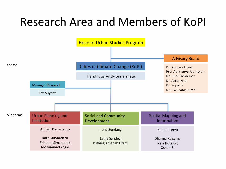
Research Area and Members of KoPI
Urban Planning and InsKtuKon
Social and Community Development
Heri Prasetyo
Dharma Kalsuma Nala Hutasoit Osmar S.
Adriadi Dimastanto
Raka Suryandaru Eriksson Simanjutak Mohammad Yogie
Irene Sondang
LaKfa Saridevi Puthing Amanah Utami
SpaKal Mapping and InformaKon
CiKes in Climate Change (KoPI)
Head of Urban Studies Program
Hendricus Andy Simarmata
Advisory Board
Dr. Komara Djaya Prof Abimanyu Alamsyah Dr. Rudi Tambunan Dr. Azrar Hadi Dr. Yopie S. Dra. WidyawaK MSP
Manager Research
EsK SuyanK
theme
Sub-‐theme
Area of Research
2009 2010 2011 2012 2013 2014…
Macro (Na7onal Level)
Mezzo (Provincial Level)
Micro City and
Community level)
CVI (BRKP)
CVI (BRKP)
CC Impact (DNPI-‐BC)
RPB (BNPB)
Risk Mapping (BNPB)
Village Database (JICA)
CC –flood Impact (JICA)
AdaptaKon Planning* (IAP-‐START)
CC-‐based ZR (IAP-‐START)
SEA-‐North Jakarta (DKI)

Outline
• CiKes and Climate Change • Role of SpaKal Planning • Case study of Jakarta • Lesson learnt

Why ciKes become important? • ConcentraKon of populaKon
à Urban Millennium • Most of the ciKes lie on
coastal area whose have the highest risk
• CiKes are economic engine of countries, globally interconnected
• CiKes have vital infrastructures for people
• CiKes claimed as the highest carbon emi_er
RURAL 40%
URBAN 60%
2030

Why Climate Change Era?
• 1988, IPCC established by WMO and UNEP
• May 1992, UNFCCC, 195 countries, incl. Indonesia
• 1990 à ICLEI, 1200 ciKes in 70 countries, incl. Jakarta
• June 2006, the climate project’s Al-‐Gore, 9 supported countries, incl. Indonesia
• 2008, DNPI via PresidenKal RegulaKon No.46/2008
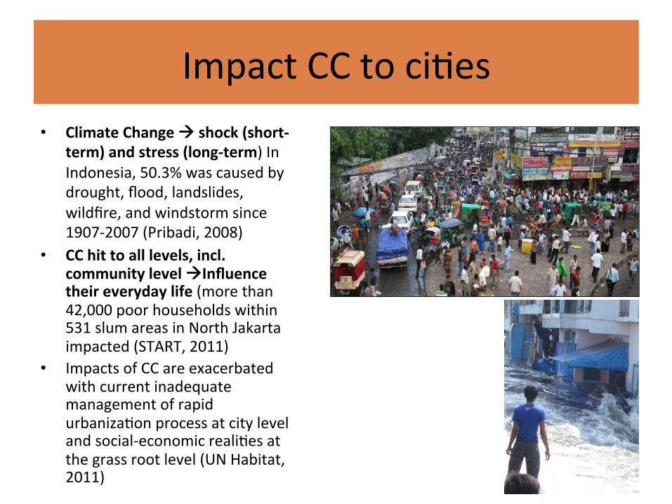
Impact CC to ciKes • Climate Change à shock (short-‐
term) and stress (long-‐term) In Indonesia, 50.3% was caused by drought, flood, landslides, wildfire, and windstorm since 1907-‐2007 (Pribadi, 2008)
• CC hit to all levels, incl. community level àInfluence their everyday life (more than 42,000 poor households within 531 slum areas in North Jakarta impacted (START, 2011)
• Impacts of CC are exacerbated with current inadequate management of rapid urbanizaKon process at city level and social-‐economic realiKes at the grass root level (UN Habitat, 2011)

Lesson from VAA in Indonesia – The Gaps and future research for scaled-‐
down regional and local climate models should be reduced by providing more resources to climate modeling
– A mul7-‐dimensional approach to risk assessment is a prerequisite to effecKve development programs that incorporate climate change responses (adaptaKon).
– The verKcally and horizontally fragmented structure of governance is as much an opportunity as an obstacle to introducing responses to climate change.
– An uncertainty and limited data which have been uKlized for the climate projec7ons are very emergence to be improved Source: DNPI (2010)
Pekalongan case study

Need Resilience perspecKve – AdaptaKon to climate change
requires a broader conceptualiza7on of equitable, legiKmate, and sustainable development in effecKve and resilient response
– Building resilience is parKcularly important in areas such as coastlines, ciKes, agricultural land and industrial zones which are ooen the most impacted by humans, requires an integrated and systems approach.
– Variety of tools and methods being integrated into planning processes, but need new approaches to urban planning and design
Source: ICLEI (2012)

The Need of Mainstreaming AdaptaKon into the SpaKal Planning

The Emergence of AdaptaKon Planning
• AdaptaKon to anthropogenic climate change may represent a new need, not only to choose acKon for responding for responding changes, but also to achieve successful adapta7on in the future (Smithers and Smit, 1997) à the discourse on adaptaKon strategies has been also brought in the context of sustainable development and then involved many development agencies
• can be imposed based on premeditated planning or it can take place without specific policy framework to implement it (Schippers, 2007:4)
• The drivers of adaptaKon planning : – At city level, driven by internal (city) goals and aims (Carmin, 2007) – At community level à some socie7es may strive to adapt (Adger et al. 2009) – At individual level à probably someone who needs to retain vitality and
viability to adapt or to cope à the experiences can be considered as key informaKon sources for planning process. i.e. Mangrove plantaKon in Vietnam (UNDP, 2008), conservaKon of local biodiversity (McLean, 2009), and livelihood strategies (Hornidge & Schotes, 2012)
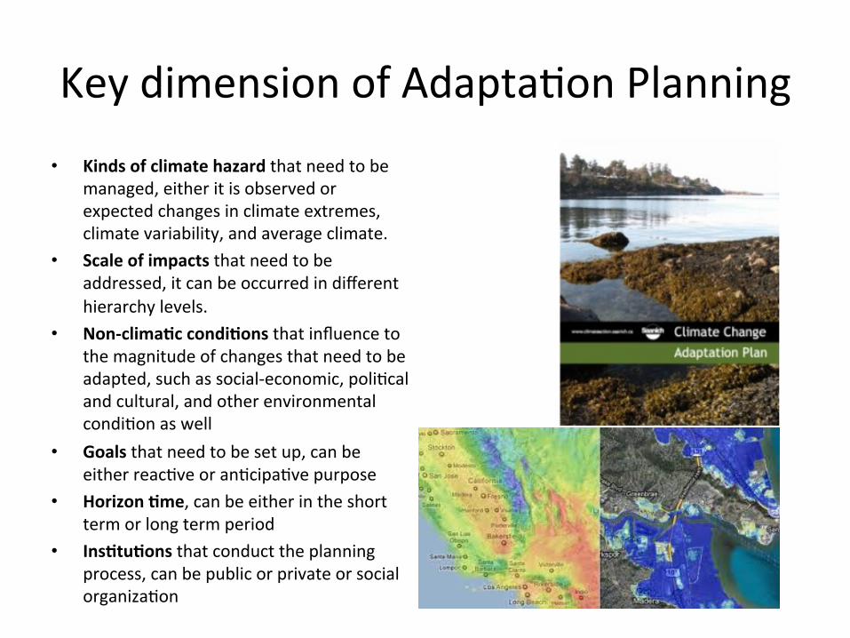
Key dimension of AdaptaKon Planning • Kinds of climate hazard that need to be
managed, either it is observed or expected changes in climate extremes, climate variability, and average climate.
• Scale of impacts that need to be addressed, it can be occurred in different hierarchy levels.
• Non-‐clima7c condi7ons that influence to the magnitude of changes that need to be adapted, such as social-‐economic, poliKcal and cultural, and other environmental condiKon as well
• Goals that need to be set up, can be either reacKve or anKcipaKve purpose
• Horizon 7me, can be either in the short term or long term period
• Ins7tu7ons that conduct the planning process, can be public or private or social organizaKon
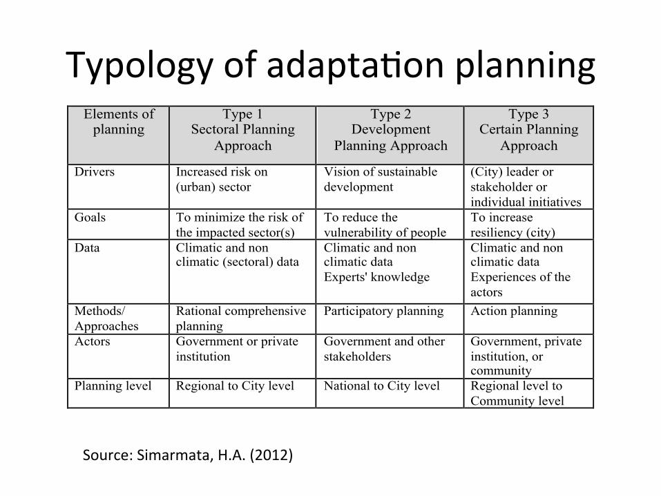
Typology of adaptaKon planning Elements of
planning Type 1
Sectoral Planning Approach
Type 2 Development
Planning Approach
Type 3 Certain Planning
Approach
Drivers Increased risk on (urban) sector
Vision of sustainable development
(City) leader or stakeholder or individual initiatives
Goals To minimize the risk of the impacted sector(s)
To reduce the vulnerability of people
To increase resiliency (city)
Data Climatic and non climatic (sectoral) data
Climatic and non climatic data Experts' knowledge
Climatic and non climatic data Experiences of the actors
Methods/ Approaches
Rational comprehensive planning
Participatory planning Action planning
Actors Government or private institution
Government and other stakeholders
Government, private institution, or community
Planning level Regional to City level National to City level Regional level to Community level
!
Source: Simarmata, H.A. (2012)
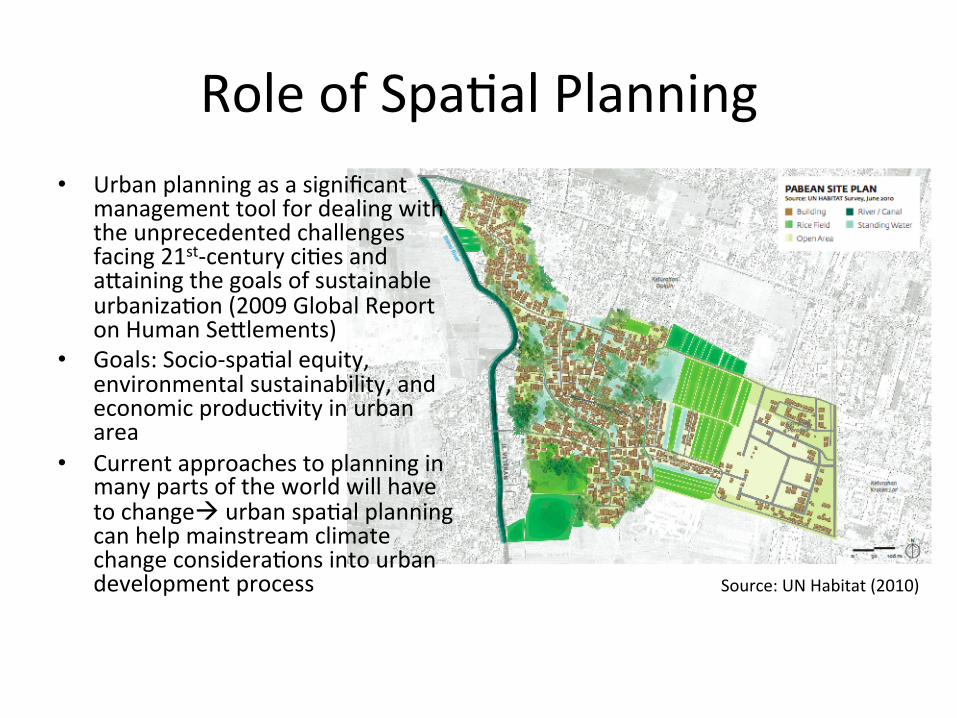
Role of SpaKal Planning • Urban planning as a significant
management tool for dealing with the unprecedented challenges facing 21st-‐century ciKes and a_aining the goals of sustainable urbanizaKon (2009 Global Report on Human Se_lements)
• Goals: Socio-‐spaKal equity, environmental sustainability, and economic producKvity in urban area
• Current approaches to planning in many parts of the world will have to changeà urban spaKal planning can help mainstream climate change consideraKons into urban development process Source: UN Habitat (2010)

SpaKal Planning in Indonesia

SYSTEM
MAIN FUNCTION
ADMINISTRATIVE BOUNDARY
ACTIVITIES
STRATEGIC VALUES
Regional System Intra Urban System
Productive Area Conservation Area
National Provincial Districts/Cities
Rural Area Urban Area
National Strategic Area
Provincial Strategic Area
Districts/Cities Area
Source BHK-DJPR 2010
Type(s) of SpaKal Planning

WIL
AYA
H
PER
KO
TAA
N
General Spatial Plan Detailed Spatial Plan
SP METROPOLITAN AREA
SP MAIN ISLANDS/GROUP ISLANDS
SP STRATEGIC NATIONAL AREA
SP STRATEGIC DISTRICTS AREA
SP URBAN AREA IN DISTRICTS
SP CITIES
SP SUB-DISTRICTS
SP CITIES STRATEGIC AREA
DETAILED SP
SP STRATEGIC PROVINCIAL AREA
DETAILED SP CITIES
RTRW National
RTRW Province
RTRW Districts/Cities
Operational instrument
Basic instrument for zoning regulation
a. General spatial plan can not be used as a base for implementation and controlling; and/or:
b. General spatial plan can not cover huge area which need more detailed plan
if:
SpaKal Planning System

SPATIAL PLANNING
Settlement System Infrastructures Services Plan
Conservation Area Productive Area
Inter-cities System
Intra Urban System
Spatial Use Plan Structure plan
Transportation
Energy
Telecommunication
Sanitary and
Water Resources and Drainage
Ecosystem Services
Social Activities
Culture Activities
Economic Activities
Security
Forest and/or green public space is about 30% of the planning area
Substance of spaKal planning

TINJAUAN PERUNDANGAN
1. UU 32/20092. UU 26/20073. PP 26/20084. PP 15/20105. Permen PU 20/20118. dll
TINJAUAN AWAL WILAYAH
1. Gambaran awal keruangan wilayah regional2. Gambaran awal keruangan lokasi internal
PENGUMPULAN DATA REGIONAL: FUNGSI &
POSISI
1. Fungsi dan peran lokasi dalam konteks regional2. Arahan pengembangan lokasi 3. Interaksi lokasi dengan wilayah regional
PENGUMPULAN DATA INTERNAL LOKASI
Penyusunan kebutuhan data dan desain survey
PENGUMPULAN DATA REGIONAL:
KARAKTERISTIK
1. Data regional fisik2. Data status hutan3. Data regional demografi4. Data ekonomi makro5. Data sarpras wilayah6. Data kerentanan bencana dan iklim
Data Kualitas lingkungan dan fisik dasar: daya dukung lahan, pola tutupan lahan, resiko bencana, kerentanan perubahan iklim
Data pertanahan: status tanah, kepemilikan tanah, harga dan nilai tanah, informasi agraria lainnya
Data demografi: struktur kependudukan, sistem sosial, pasar tenaga kerja, mata penc., tingkat pendapatan penduduk rata-rata
Data ekonomi lokal: interaksi ekonomi masy setempat, interaksi ekonomi dengan negara tetangga, data ekonomi makro, komoditi unggulan setempat, harga-harga
Data sarana dan prasarana dasar: jumlah, jenis dan sebaran sarana umum dan sosial, kualitas pelayanan sarana dan prasarana dasar
PENGOLAHAN DAN ANALISIS DATA REGIONAL
Fungsi, peran, posisi dalam konteks keruangan regional
KONSEPSI PERENCANAAN
Keterkaitan lokasi dengan wilayah sekitarnya
Daya dukung wilayah untuk pengembangan fisik
Status hutan dan kemungkinan pengembangan
Dukungan sumber daya manusia
Sektor basis dan sektor unggulan perekonomian
Sistem interaksi regional
Kualitas pelayanan sarana dan prasarana dasar
PENGOLAHAN DAN ANALISIS DATA INTERNAL
Daya dukung untuk pengembangan fisik
Status kepemilikan lahan dan kemungkinan pengembangan
Dukungan sumber daya manusia
Sektor basis dan sektor unggulan perekonomian
Kualitas pelayanan sarana dan prasarana dasar beserta kebutuhan pengembangannya
Data kebencanaan: kerentanan terhadap bencana dan dampak perubahan iklim (kenaikan permukaan dan pasang)
RENCANA
Tujuan Penataan Ruang
Rencana Struktur Ruang dan Jaringan Prasarana
Rencana Pola Ruang
Penetapan Kawasan Strategis
INDIKASI PROGRAM PEMANFAATAN RUANG
PERANGKAT PENGENDALIAN PEMANFAATAN RUANG
How VA can influence the spa7al planning
Lack of CC tools of analysis
Should be added by CC tools i.e. VAA, RMA
Mainstreamed by adaptaKon planning
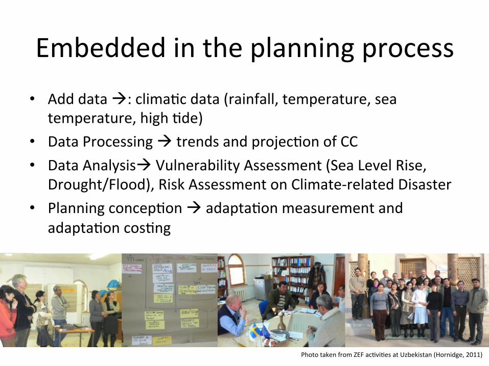
Embedded in the planning process • Add data à: climaKc data (rainfall, temperature, sea
temperature, high Kde) • Data Processing à trends and projecKon of CC • Data Analysisà Vulnerability Assessment (Sea Level Rise,
Drought/Flood), Risk Assessment on Climate-‐related Disaster • Planning concepKon à adaptaKon measurement and
adaptaKon cosKng
Photo taken from ZEF acKviKes at Uzbekistan (Hornidge, 2011)

Synchronize Adapta7on Plan to Spa7al Planning
• Goals of planning à sounds resilient
• Structure plan à add adaptaKon infrastructures
• SpaKal use plan à risk-‐concern
• ImplementaKonà adaptaKon cosKng and governance
• Controlling à special zoning regulaKon

Lesson from Jakarta

Current status and challenges • Jakarta does not have concrete
steps to tackle the problem of climate change
• Government focus on reactive programs rather than prevention to tackle the problem of climate change
• Lack of response maybe due to lack baseline data availability and research, as well as knowledge in climate change
• The spatial plan appears to include hazard analysis of Jakarta, but does not explain climate vulnerability level
Source: Firman et al (2011)

Not only Climate Change impacts: land subsidence • ‘The principal hazard faced by Jakarta
is the increased frequency of flooding due to rising sea levels and rob (Kdal floods), and an increase in the volume of water needing to be managed by the city from increased and erraKc rainfall’ (World Bank, 2011:40)
• ‘Subsidence also increases the city’s vulnerability to the effects of climate change, including increased suscepKbility to Kdal flooding and potenKal damage to infrastructure as the land becomes unstable’ (World Bank, 2011:40)
Impact of SLR and Land Subsidence (Maximum scenario for 2050)
Source: Sofwan Hadi (2010)

2 3
56
13
14
19
26
27
28
29
30 36
38
41
43
51
61
62
65
66
67
68
69
70
71
73
77
26
27
28
29
31
38
69
KECAMATAN CENGKARENG
KECAMATANGROGOL PETAMBURAN
KECAMATAN PALMERAH
KECAMATANTAMAN SARI
KECAMATAN TAMBORA
KECAMATAN KALIDERES
KECAMATAN KEBON JERUK
KECAMATAN KEMBANGAN
KECAMATAN KEMAYORAN
KECAMATAN MENTENG
KECAMATANCEMPAKA PUTIH
KECAMATAN GAMBIR
KECAMATANJOHAR BARU
KECAMATANSAWAH BESAR
KECAMATAN SENEN
KECAMATAN TANAH ABANG
KECAMATAN TEBET
KECAMATAN PASAR MINGGU
KECAMATAN PESANGGRAHAN
KECAMATANSETIABUDI
KECAMATAN MAMPANG PRAPATAN KECAMATANPANCORAN
KECAMATAN KEBAYORAN BARU
KECAMATANKEBAYORAN LAMA
KECAMATAN CILANDAK
KECAMATAN JAGAKARSA
KECAMATAN DUREN SAWIT
KECAMATAN JATINEGARA
KECAMATAN KRAMAT JATI
KECAMATAN PASAR REBO
KECAMATAN PULO GADUNG
KECAMATAN CAKUNG
KECAMATAN CIPAYUNG
KECAMATAN CIRACAS
KECAMATAN MAKASAR
KECAMATANMATRAMAN
KECAMATAN TANJUNG PRIOK
KECAMATAN CILINCING
KECAMATAN KELAPA GADING
KECAMATAN KOJA
KECAMATANPADEMANGAN BARAT
KECAMATAN PENJARINGAN
LEGEND :
PETA LOKASI GENANGAN AIR D I DKI J AKARTA TAHUN 2007
B K
T
B K B
DINAS TATA KOTAPEMERINTAH DAERAH KHUSUS IBUKOTA JAKARTA
NOMOR PEMERIKSAAN
NOMOR LEMBAR NOMOR PETA
SKALA 1 : 40000
PETA IKHTISAR
J AYA RAYA
TANGERANG
DEPOK
BEKASI
KA
LI P
ES
AN
GG
RAH
AN
KA
LI G
RO
GO
L
KRU
KUT
KA
LI B
AR
U B
ARAT
KA
LI C
ILIW
UN
GKA
LI B
ARU
TIM
UR
KALI
CIP
INAN
G
KALI SUNTER
KA
LI B
UAR
AN
KA
LI JATI KR
AMAT
KALI CAKUNG
KALI MOOKERVART
KALI ANGKE
KA
LI
CA
KU
NG
DR
AIN
KA
LI C
AK
UN
G L
AMAC
EN
GK
AR
EN
G D
RAI
N
14
6
9
10
36
11 1213
14 15 16
17
18
20
21
22
23
24
25
26
2728
29
30
31
32
32
33
34
35
37
38
3940
4142
43
44
45
46
47
48 49
5051
52
5354
55
56
58
60
61
62
6364
64
65
6667
68
69
70
71
72
72
72
73
74
74
75
75
98
9979
80
80
81
78
82
83
848484
84
8485
8686
86
86
8788
88
8886
89
89
90
91
91
92
9393
93
94
95
95
96
97
58
59
59
59
77
KALI BEKASI TENGAH
KALI P
ESANG
GRAHAN
KALI
ANG
KE
7
2
8
3
5
19
Also the Poor
Source: Firman et.al (2011) The poor in Jakarta are extremely vulnerable to the hazards described in the previous secKons -‐ in parKcular to flood-‐related disasters -‐ but are also highly resourceful and adapKve in responding to and surviving them
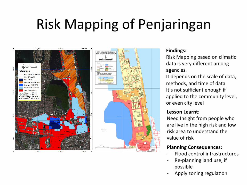
Risk Mapping of Penjaringan Findings: Risk Mapping based on climaKc data is very different among agencies. It depends on the scale of data, methods, and Kme of data It’s not sufficient enough if applied to the community level, or even city level
Lesson Learnt: Need Insight from people who are live in the high risk and low risk area to understand the value of risk
Planning Consequences: -‐ Flood control infrastructures -‐ Re-‐planning land use, if
possible -‐ Apply zoning regulaKon

Zoning Regula7on: Learn From FEMA
Special Flood Hazard area: The land area covered by the floodwaters of the base flood is the Special Flood Hazard Area (SFHA) on NFIP maps. The SFHA is the area where the NaKonal Flood Insurance Program's (NFIP's) floodplain management regulaKons must be enforced and the area where the mandatory purchase of flood insurance applies. The SFHA includes Zones A, AO, AH, A1-‐30, AE, A99, AR, AR/A1-‐30, AR/AE, AR/AO, AR/AH, AR/A, VO, V1-‐30, VE, and V
Na7onal Flood Insurance Program's (NFIP's) Guidance
Lesson Learnt • There is lack of data in terms of types and depth of scale related to climate change data, which
makes it difficult to conduct any meaningful assessment of the climaKc condiKon and the climate modeling is sKll weak in providing the accuracy of future scenario (Firman et al. 2011).
• The limited research available regarding the adaptaKon planning concentrated almost exclusively on integra7ng technical climate indicators/scenarios into planning methods as defined and categorized from natural scienKsts and engineers.
• The adaptaKon planning as indicated only from the technical scienKsts' point of view might not be at all congruent with the vulnerable people's percepKon.
• To study only based on technical science would not get at the essen7al meaning of the adapta7on planning as experienced by the vulnerable people.
• We need to know more about the 'experiences' of individuals on a phenomenon and the meaning they ascribe to their everyday life.
• We needs to harness its long tradi7ons to integrate poverty reducKon with climate change acKons and focus on capacity building of vulnerable groups are the keys (Rabe, 2011)
Source: Simarmata (2012)
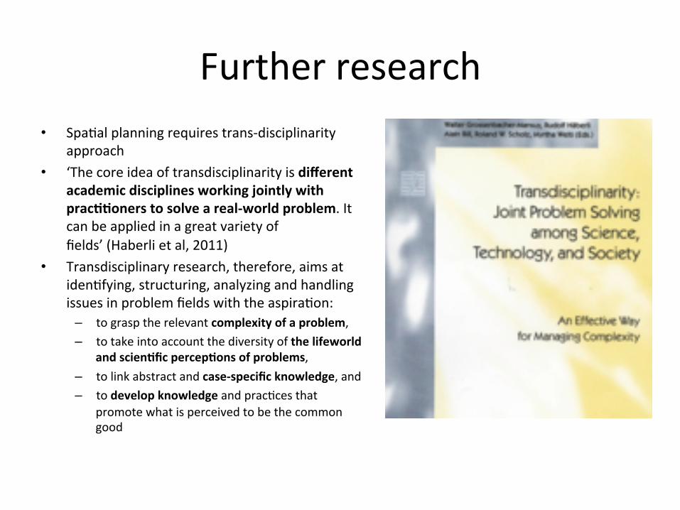
Further research • SpaKal planning requires trans-‐disciplinarity
approach • ‘The core idea of transdisciplinarity is different
academic disciplines working jointly with prac77oners to solve a real-‐world problem. It can be applied in a great variety of fields’ (Haberli et al, 2011)
• Transdisciplinary research, therefore, aims at idenKfying, structuring, analyzing and handling issues in problem fields with the aspiraKon:
– to grasp the relevant complexity of a problem, – to take into account the diversity of the lifeworld
and scien7fic percep7ons of problems, – to link abstract and case-‐specific knowledge, and – to develop knowledge and pracKces that
promote what is perceived to be the common good

Thank you
©h45