tourism intro pp - pdf.usaid.gov
157
Transcript of tourism intro pp - pdf.usaid.gov
SUSTAINABLECOASTAL TOURISMHANDBOOK for the for the for the for the for the
PHILIPPINEs
Carsten M. HüttcheCarsten M. HüttcheCarsten M. HüttcheCarsten M. HüttcheCarsten M. HüttcheAlan T. WhiteAlan T. WhiteAlan T. WhiteAlan T. WhiteAlan T. White
Ma. Monina M. FloresMa. Monina M. FloresMa. Monina M. FloresMa. Monina M. FloresMa. Monina M. Flores
Coastal Resource Management ProjectCoastal Resource Management ProjectCoastal Resource Management ProjectCoastal Resource Management ProjectCoastal Resource Management Projectof the
Department of Environment and Natural ResourcesDepartment of Environment and Natural ResourcesDepartment of Environment and Natural ResourcesDepartment of Environment and Natural ResourcesDepartment of Environment and Natural Resourcessupported by the
United States Agency for International DevelopmentUnited States Agency for International DevelopmentUnited States Agency for International DevelopmentUnited States Agency for International DevelopmentUnited States Agency for International Development
in collaboration with the
Department of TourismDepartment of TourismDepartment of TourismDepartment of TourismDepartment of Tourism
Cebu City, PhilippinesCebu City, PhilippinesCebu City, PhilippinesCebu City, PhilippinesCebu City, Philippines20022002200220022002
SUSTAINABLE COASTAL TOURISM HANDBOOK for the PHILIPPINES
by
Carsten M. HüttcheAlan T. WhiteMa. Monina M. Flores
2002
Printed in Cebu City, Philippines
Citation:Hüttche, C.M., A.T. White and M.M.M. Flores. 2002. Sustainable Coastal Tourism Handbookfor the Philippines. Coastal Resource Management Project of the Department of Environmentand Natural Resources and the Department of Tourism, Cebu City, Philippines, 144 p.
This publication was made possible through support provided by the United States Agency forInternational Development (USAID) under the terms and conditions of Contract No. AID-492-C-00-96-00028-00. The opinions expressed herein are those of the authors and do notnecessarily reflect the views of the USAID. This publication may be reproduced or quoted inother publications as long as proper reference is made to the source.
Photos by Alan T. White unless noted otherwise.
Graphics and layout by Ysolde Collantes; copyediting by Leticia Dizon.
CRMP Document No. 03-CRM/2002
ISBN 971-92290-3-9
Carsten M. Hüttche is Principal/Managing Consultant at Environmental Professionals(ENVIRO PRO/Singapore). He has an MSc in Biology major in Tropical Ecology from FreieUniversität, Berlin, Germany. E-mail: [email protected] [email protected]
Alan T. White is Deputy Chief of Party, Coastal Resource Management Project. He hasa Ph.D. in Geography from the University of Hawaii. He is also President of the CoastalConservation and Education Foundation, Inc. E-mail: [email protected]
Ma. Monina M. Flores developed the Olango Birds and Seascape Tour that won theEnvironmental Experience Award in the 2001 British Airways Tourism for TomorrowAwards and a 2000 Conservation International Excellence in Ecotourism Award. She isfounding chairperson of the Environment and Community Ventures Foundation, Inc.E-mail: [email protected]
iii
CONTENTS
List of TablesList of TablesList of TablesList of TablesList of Tables vvvvv
List of FiguresList of FiguresList of FiguresList of FiguresList of Figures viiviiviiviivii
List of Acronyms and AbbreviationsList of Acronyms and AbbreviationsList of Acronyms and AbbreviationsList of Acronyms and AbbreviationsList of Acronyms and Abbreviations xxxxx
AcknowledgmentsAcknowledgmentsAcknowledgmentsAcknowledgmentsAcknowledgments xiixiixiixiixii
PrefacePrefacePrefacePrefacePreface xiiixiiixiiixiiixiii
CCCCCHAPTERHAPTERHAPTERHAPTERHAPTER 1 1 1 1 1. Introduction—Tourism and Coastal Ecosystems. Introduction—Tourism and Coastal Ecosystems. Introduction—Tourism and Coastal Ecosystems. Introduction—Tourism and Coastal Ecosystems. Introduction—Tourism and Coastal Ecosystems 11111Coastal tourism in the Philippines 1Philippine coasts and resources at stake 5Summary 11
CCCCCHAPTERHAPTERHAPTERHAPTERHAPTER 2 2 2 2 2. Integrated Coastal Management: Context for. Integrated Coastal Management: Context for. Integrated Coastal Management: Context for. Integrated Coastal Management: Context for. Integrated Coastal Management: Context forTourism PlanningTourism PlanningTourism PlanningTourism PlanningTourism Planning 1212121212
Proven approaches and policies for coastal management 13National legal and policy framework for coastal management 14Coastal management as a basic service of local government 15Essential support processes and strategies in coastal management 25Sustaining coastal management through multisectoral and inter-LGU collaboration 27Summary 28
CCCCCHAPTERHAPTERHAPTERHAPTERHAPTER 3. 3. 3. 3. 3. Legal Framework for Managing Coastal Legal Framework for Managing Coastal Legal Framework for Managing Coastal Legal Framework for Managing Coastal Legal Framework for Managing CoastalTourism DevelopmentTourism DevelopmentTourism DevelopmentTourism DevelopmentTourism Development 2 92 92 92 92 9
Summary 32
CCCCCHAPTERHAPTERHAPTERHAPTERHAPTER 4. 4. 4. 4. 4. Planning for Sustainable Tourism Planning for Sustainable Tourism Planning for Sustainable Tourism Planning for Sustainable Tourism Planning for Sustainable Tourism 3333333333What is sustainable tourism 33Planning tool I: Physical carrying capacity 36Planning tool II: Limits of acceptable change 40Planning tool III: Integrated master planning 45Case study: Palawan 47 Case study: Provincial and municipal planning in Palawan 47Summary 48
CCCCCHAPTERHAPTERHAPTERHAPTERHAPTER 5. 5. 5. 5. 5. Developing and Promoting an Ecotourism Developing and Promoting an Ecotourism Developing and Promoting an Ecotourism Developing and Promoting an Ecotourism Developing and Promoting an EcotourismVentureVentureVentureVentureVenture 4 94 94 94 94 9
What is ecotourism? 49Knowing the market 52
iv
Developing an ecotour 53 Case study: The ecotour development process 54Summary 61
CCCCCHAPTERHAPTERHAPTERHAPTERHAPTER 6. 6. 6. 6. 6. Environmental Impact Assessment Environmental Impact Assessment Environmental Impact Assessment Environmental Impact Assessment Environmental Impact Assessment 6262626262Guidelines for the EIS System from the DENR 64Feasibility of EIA process for small-scale resorts 75Case study: Malaysia and Batangas 76 Case study: Pulau Redang, Malaysia and Nasugbu, Batangas 76Minimizing environmental impacts in protected areas 76Summary 77
CCCCCHAPTERHAPTERHAPTERHAPTERHAPTER 7. 7. 7. 7. 7. Site Use and Design Site Use and Design Site Use and Design Site Use and Design Site Use and Design 7878787878Selecting suitable sites with environmental considerations in mind 78Consider local land uses and traditions 87Sustainable building design 88Marinas and shoreline protection structures 92Case study: Mactan Island 94 Case study: The changed rocky and sandy coast of Mactan Island 94Landscaping design 97Summary 100
CCCCCHAPTERHAPTERHAPTERHAPTERHAPTER 8. 8. 8. 8. 8. Construction Activities Construction Activities Construction Activities Construction Activities Construction Activities 101101101101101Building materials and standards for construction 102Summary 108
CCCCCHAPTERHAPTERHAPTERHAPTERHAPTER 9. 9. 9. 9. 9. Sewage, Wastewater and Stormwater Sewage, Wastewater and Stormwater Sewage, Wastewater and Stormwater Sewage, Wastewater and Stormwater Sewage, Wastewater and StormwaterManagementManagementManagementManagementManagement 109109109109109
Philippine standards 110 Case study: Boracay Island and Maribago, Mactan Island 113Southeast Asian standards for wastewater discharge from resorts 113Sustainable solutions for sewage and wastewater disposal 114Stormwater and surface runoff 124Summary 127
CCCCCHAPTERHAPTERHAPTERHAPTERHAPTER 10. 10. 10. 10. 10. Solid Waste Disposal Solid Waste Disposal Solid Waste Disposal Solid Waste Disposal Solid Waste Disposal 128128128128128Summary 129
CCCCCHAPTERHAPTERHAPTERHAPTERHAPTER 11. 11. 11. 11. 11. Environmental Control and Auditing Environmental Control and Auditing Environmental Control and Auditing Environmental Control and Auditing Environmental Control and Auditing 130130130130130Who monitors? 130Environmental audits 133 Case study: Bintan Resorts, Bintan Island, Indonesia 136Summary 136
CCCCCHAPTERHAPTERHAPTERHAPTERHAPTER 12. 12. 12. 12. 12. The Future: Building Capacity for The Future: Building Capacity for The Future: Building Capacity for The Future: Building Capacity for The Future: Building Capacity forSustainable TourismSustainable TourismSustainable TourismSustainable TourismSustainable Tourism 137137137137137
Summary 139
ReferencesReferencesReferencesReferencesReferences 140140140140140
v
LIST OF TABLES
Table 1 Potential environmental impacts from coastal touristdevelopment activities 10
Table 2 New paradigms for coastal management in the Philippines 13
Table 3 Granting of jurisdiction over municipal waters as defined in theFisheries Code 15
Table 4 Coastal management phases and steps as a basic local governmentservice and the roles of various sectors 17
Table 5 Specific roles of government and nongovernment groups incoastal management 22
Table 6 Coastal resource management plan checklist 27
Table 7 Reference guide to coastal tourism development and legislationin the Philippines 30
Table 8 Tourist carrying capacity of a given area 37
Table 9 Selected common planning standards to determine carryingcapacities of coastal areas 40
Table 10 Resident and tourist perceptions of Boracay regarding changes 42in 1997
Table 11 Possible indicators for physical coastal resource and socialconditions for limits of acceptable change process 44
Table 12 Integrated master planning process 45
Table 13 Guidelines for tourism-oriented establishments in Palawanrelevant to coastal areas 48
Table 14 Checklist to differentiate ecotourism from nature-based masstourism 51
Table 15 Visitor expectations in different target markets 52
Table 16 Results of visitor survey in Port Barton, Palawan 53
Table 17 Matching visitor groups and resources or attractions 57
Table 18 Sample itinerary for Olango Birds and Seascape Tour 59
Table 19 Costing and pricing for an ecotour 60
Table 20 ECAs requiring an ECC before development can occur 62
vi
Table 21 Contents of an EIS 66
Table 22 Checklist for good-practice EIS 71
Table 23 An overview of often-cited environmental impacts in the contextof coastal tourism and mitigation measures 72
Table 24 Activities allowed or restricted in the Turtle Island HeritageProtected Area 77
Table 25 Guide for the classification of natural resources in zones of impacts 82
Table 26 Coastal tourism development criteria for Maldives 87
Table 27 Installed renewable energy generating capacity in Southeast Asiain 1998 89
Table 28 Tourism relevant coastal and seawater quality classes 110
Table 29 Water quality criteria for conventional pollutants and toxicsubstances for coastal and marine waters 111
Table 30 Effluent standards for conventional pollutants and toxicsubstances for protected coastal and marine waters 112
Table 31 Regional quality standards for wastewater/sewage dischargeinto coastal waters 114
Table 32 Performance of an engineered wetland (180 m2) at a coastalresort in Indonesia using reed-rock filter system 121
Table 33 Minimum microbiological water quality requirements for theuse of treated wastewater for irrigation 123
Table 34 Objectives for stormwater management 124
Table 35 Proposed environmental monitoring responsibilities for coastaltourism in the Philippines 131
Table 36 Sample environmental monitoring form for weekly monitoring 132
Table 37 Sample self-audit form for hotels and resorts 133
Table 38 Energy and water conservation benchmarks for hotels in tropicalcountries 135
vii
LIST OF FIGURES
Figure 1 Popular and emerging coastal tourism destinations in the Philippines 2
Figure 2 Trends in tourist arrivals from 1995 to 2001 for the Philippinesand Cebu 5
Figure 3 Mutual contributions of tropical coastal habitats 6
Figure 4 Tourist area life cycle with four stages of development 7
Figure 5 Extension of airport runway interferes with sand movement,Dumaguete City 7
Figure 6 Examples of beach erosion caused by the construction of a groinor a boat passage 8
Figure 7 Mangroves and their ecological and economic benefits 9
Figure 8 The hydrologic cycle 10
Figure 9 Cyclical integrated coastal management data collection,planning, implementation and monitoring process 16
Figure 10 The coastal management planning process being adapted forPhilippine local government 16
Figure 11 Illustrative zoning and resource use plan for the coastal area andmunicipal waters 25
Figure 12 Coastal zone and agencies with primary responsibility inmanagement 29
Figure 13 Physical carrying capacity of the coastal zone environment inrelation to tourism 39
Figure 14 The limits of acceptable change planning system 41
Figure 15 The relationship between tourist resident relations and carryingcapacity 43
Figure 16 Planning process for private sector tourism projects 46
Figure 17 Necessary steps and components for the ecotourism productdevelopment process 54
Figure 18 Ecotourism product development steps 55
Figure 19 Frequent environmental impacts of tourism activities on thecoastal zone 64
viii
Figure 20 Types of impacts that should be considered in the EIA 65
Figure 21 Overview of national EIS System 68
Figure 22 Steps and timetable for review of Environmentally Critical Projects 68
Figure 23 Example of how environmental mitigation measures andmanagement plans can be graphically enhanced to assist withimplementation 72
Figure 24 Example of a coastal tourism impact network with direct andindirect impacts 74
Figure 25 Classification of beach resort sites based on coastal features 80
Figure 26 Zoning scheme used for minimizing resort impacts tosensitive areas 81
Figure 27 Effects of locating building too close to the shoreline 83
Figure 28 Coastal shoreline setback required by law in the Philippines andzones 84
Figure 29 Setback along a beach front from edge of vegetation as stipulatedby DOT 84
Figure 30 Placement of septic systems for sewage treatment in relation totopography and soil structure 85
Figure 31 Septic systems must be sited with knowledge of groundwatertables during the monsoon season 86
Figure 32 Staggered building form 86
Figure 33 Building design options for natural ventilation 88
Figure 34 Components for a solar photovoltaic system with possible receivers 89
Figure 35 Typical wind generator system components 90
Figure 36 Example of a mini-hydro plant for electricity generation 91
Figure 37 Undermining of a seawall built on a high energy coastline 92
Figure 38 Effects of placing groins, jetties or breakwaters along a shoreline 93
Figure 39 Beach resort location on the southeastern coast of Mactan Island 95
Figure 40 Modification of the rock coast for resorts along the MactanIsland shore 96
Figure 41 Services provided by trees and vegetation that enhance theenvironmental and aesthetic quality of a coastal tourism facility 97
Figure 42 Mangroves are attractive landscape features due to their diverseadaptation to inundation with a mix of seawater and freshwater 99
ix
Figure 43 Mangroves can be made accessible via elevated boardwalksconnected to other resort facilities 99
Figure 44 Methods of clearing 104
Figure 45 Fencing and vegetative buffers protect streams and seas from theeffects of soil runoff from construction sites 106
Figure 46 Geotextile fencing details 107
Figure 47 Sequence of geotextile silt fences placed in the direction of flowto filter runoff 108
Figure 48 Schematic layout for a wastewater treatment and recycling systemwith engineered wetlands 115
Figure 49 Standard septic system design 116
Figure 50 Placement of septic tank in relation to topography andfreshwater well 117
Figure 51 Side elevation of a typical brick or concrete anaerobic digester 117
Figure 52 Reed root system acts as a biological pump transporting oxygeninto the root zone 119
Figure 53 Cross-section of an engineered wetland cell for sewage andwastewater treatment 119
Figure 54 Tropical engineered wetlands used for the treatment of domesticwastewater from hotels and residences 120
Figure 55 Combination of anaerobic digester and engineered wetland 120
Figure 56 Wastewater and sewage disposal options for small andmedium-scale coastal resorts and hotels 122
Figure 57 Wastewater and sewage disposal options for large-scale coastalresorts and hotels 122
Figure 58 A dry retention basin is one option for collecting stormwater 125
Figure 59 A wet retention pond is another option for stormwater storagein which stormwater is held and discharged at a rate determinedby the size of the outflow pipe 125
Figure 60 Several landscaping techniques that help to minimize stormwaterrunoff damage 126
Figure 61 Possible methods of solid waste disposal in a hotel 128

x
LIST OF ABBREVIATIONSAND ACRONYMS
AO - Administrative OrderBBIR - Bintan Beach International ResortBFAR - Bureau of Fisheries and Aquatic ResourcesBOD - biochemical oxygen demandBRM - Bintan Resort ManagementCBFMA - Community-based Forest Management AgreementCENRO - Community Environment and Natural Resources Office(r)COD - chemical oxygen demandCRM - coastal resource managementDA - Department of AgricultureDAO - Department Administrative OrderDDT - dichloro-diphenyl-trichloroethaneDENR - Department of Environment and Natural ResourcesDILG - Department of the Interior and Local GovernmentDO - dissolved oxygenDOT - Department of TourismECA - Environmentally Critical AreaECAN - Environmentally Critical Areas NetworkECC - Environmental Compliance CertificateECP - Environmentally Critical ProjectEIA - Environmental Impact AssessmentEIARC - Environmental Impact Assessment Review CommitteeEIS - Environmental Impact StatementEMB - Environmental Management BureauEMF - Environmental Monitoring FundEMP - Environmental Management PlanFARMC - Fisheries and Aquatic Resources Management CouncilFLA - Fishpond Lease AgreementICM - integrated coastal managementIEC - information, education and communicationIEE - Initial Environmental ExaminationkW - Kilowatt
xi
kWh - Kilowatt-hoursLAC - limits of acceptable changeLGU - local government unitMARINA - Maritime Industry AuthorityMBAS - methylene blue active substancesMIIMPS - Mactan Island Integrated Master Plan StudyMMT - Multi-Partite Monitoring TeamMPN - most probable numberNEDC - National Ecotourism Development CouncilNGA - national government agencyNGO - nongovernment organizationNIPAS - National Integrated Protected Areas SystemPAMB - Protected Area Management BoardPAWB - Protected Areas and Wildlife BureauPCB - polychlorinated biphenylPCG - Philippine Coast GuardPCSD - Palawan Council for Sustainable DevelopmentPD - Presidential DecreePENRO - Provincial Environment and Natural Resources Office(r)PNP - Philippine National PolicePO - people’s organizationPPA - Philippine Ports AuthorityPTA - Philippine Tourism AuthorityPV - photovoltaicREC - Regional Ecotourism CommitteeRED - Regional Executive DirectorSEP - Strategic Environmental PlanSIA - Social Impact AssessmentSTP - sewage treatment plantTDS - total dissolved solidsTSS - total suspended solids
xii
ACKNOWLEDGMENTS
This book has been endorsed by the Department of Tourism and the Departmentof Environment and Natural Resources. Their cooperation in the development ofthis handbook is much appreciated.
Those persons who have reviewed and assisted with the formulation of contentsor editing include:
Verna Buensuceso, Chief, Product Research Division, Department of TourismPriscilla N. Calimag, Chief, Environmental Management Specialist/Ecotourism
Technical Working Group/Protected Areas and Wildlife Bureau-Department of Environment and Natural Resources and ProjectCoordinator, Department of Tourism
Mary Gleason, Ph.D., Tetra Tech EM Inc.Carlos Libosada, Instructor, Asian Institute of TourismDolores Madrid, Officer-in-charge, Planning and Design Division, Philippine
Tourism AuthorityVictorino Mendoza, Officer-in-charge, Nature Recreation and Extension
Division/Protected Areas and Wildlife Bureau-Department of Environmentand Natural Resources
Marc Miller, Professor, School of Marine Affairs, University of WashingtonNoel Padilla, Policy Studies Division, Department of Environment and Natural
ResourcesAnnabelle Trinidad, Policy Advisor, Coastal Resource Management Project
The authors also acknowledge the staff of Environmental Professionals(ENVIRO PRO/Singapore) for their support; and the Project Team of the OlangoCoral Farm, Cebu, Philippines.
This book depends on many excellent information sources from thePhilippines and elsewhere concerning the development and management oftourism. These references are listed at the end. Much of the material is derived fromthe various publications of the Coastal Resource Management Project of theDepartment of Environment and Natural Resources and supported by the UnitedStates Agency for International Development.
xiii
PREFACE
This handbook provides guidance to the tourism industry through practicaltools and strategies to avoid unnecessary environmental and social problemsassociated with tourism development. Its audience includes tourism developers andoperators of small to large tourism projects, coastal communities, local governmentunits and national government agencies. The book promotes the goals ofgovernment and the private sector to restore a tarnished coastal environment backto clean beaches and crystal-clear waters for long-term business and environmentalviability.
The Philippines is plagued with unplanned coastal development. In the pastwhen coastal areas were sparsely populated and coastal resources plentiful,haphazard development and resource exploitation were not major concerns topeople. Now, the situation is very different and the carrying capacity of manycoastal areas has been surpassed. Population density in the Philippine coastal zone isamong the highest in the world and the obvious lack of development planning andmitigation is taking its toll in degradation of beaches, coral reefs, seagrass beds andwater quality in shoreline and nearshore areas.
The tourism industry depends on a clean and healthy environment. Indeed,travel industry trends are shifting towards more demand for destinations that offerpristine environments, experiences with nature and at least a lack of pollution andcivil society problems. Philippine coastal areas could lose their attraction if issues ofpollution, overcrowding and unplanned development are not addressed. Thetourism industry has an opportunity in improving the situation by identifyingcreative means to assist and guide development with an eye for environmentalpreservation—knowing that well-managed coastal areas will attract more visitors.
Tourism players can look at smart and appropriate solutions for waste treatmentand for shoreline land use. They can become more proactive in guiding tourismdevelopment so that it contributes to coastal management and resourceconservation. Indeed, this handbook points to practical, robust and cost-efficientsystems for environmental protection and management that can be easily operatedand maintained.
This handbook contains a wealth of information to help guide tourismdevelopers, local governments, nongovernment organizations and the many otherstakeholders concerned with tourism in the Philippines. It provides guidance at boththe policy and field levels. It can help with site plans and organizing environmentsensitive recreation uses of coastal areas. It can answer many questions that need tobe asked about how to better maintain our coastal areas for tourism and other uses.Let’s read and make use of its guidance on Philippine coasts!
CHAPTER 1
IntroductionIntroductionIntroductionIntroductionIntroduction—Tourism andTourism andTourism andTourism andTourism andCoastal EcosystemsCoastal EcosystemsCoastal EcosystemsCoastal EcosystemsCoastal Ecosystems
Tourism is now the largest industry in the world.Tourism is now the largest industry in the world.Tourism is now the largest industry in the world.Tourism is now the largest industry in the world.Tourism is now the largest industry in the world.Although it can bring substantial economic benefits,Although it can bring substantial economic benefits,Although it can bring substantial economic benefits,Although it can bring substantial economic benefits,Although it can bring substantial economic benefits,
it has many pitfalls that can easily erode the gains.it has many pitfalls that can easily erode the gains.it has many pitfalls that can easily erode the gains.it has many pitfalls that can easily erode the gains.it has many pitfalls that can easily erode the gains.
COASTAL TOURISM IN THE PHILIPPINES
“Coastal tourism” brings up popular images of resorts at the seaside with whitesandy beaches lined with coconut palms and crystal-clear waters. Advertisements andtravel trade literature have helped to promote this image of the three “S’s” that coastalresorts usually offer—sun, sea and sand.
A fourth “S”, for sex in the form of flourishing prostitution, has created social andcultural problems in many popular coastal tourist playgrounds around the world, especiallyin developing countries. And finally, a fifth “S” has found its way recently into newsheadlines and, more disturbingly, into the coastal waters in front of beach resorts: sewage.
The purpose of this handbook is to provide tourism developers and operators ofsmall to large tourism projects, coastal communities and local government units (LGUs)with practical tools and guidance to avoid unnecessary environmental and social problemsfrom tourism development. The ultimate goal of government and private sector is torestore a tarnished coastal environment back to clean beaches and crystal-clear watersfor long-term business and environmental viability.
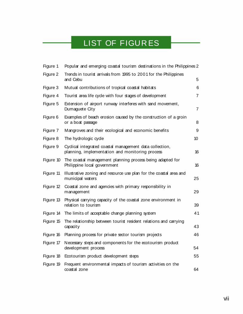
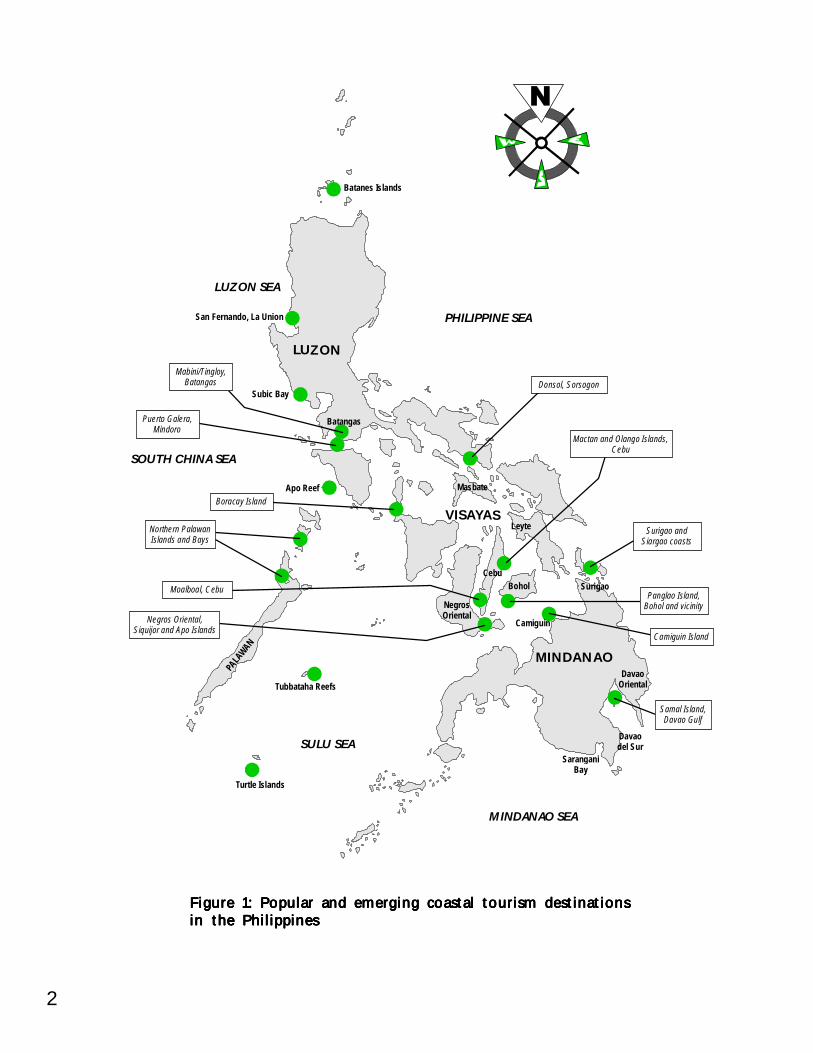
Tropical coastal areas have major advantages compared with the coasts in thetemperate climate zones. They are better suited to offer the combination of sun, sea andsand to tourists year-round. The Philippines’ tropical climate and diverse 18,000-kilometercoastline on more than 7,000 islands have made it an important area for coastal tourismdevelopment. Important coastal tourism destinations in the Philippines are shown inFigure 1.
2
Figure 1: Popular and emerging coastal tourism destinationsFigure 1: Popular and emerging coastal tourism destinationsFigure 1: Popular and emerging coastal tourism destinationsFigure 1: Popular and emerging coastal tourism destinationsFigure 1: Popular and emerging coastal tourism destinationsin the Philippinesin the Philippinesin the Philippinesin the Philippinesin the Philippines
Apo Reef
Leyte
NegrosOriental
DavaoOriental
Davaodel Sur
SaranganiBay
Tubbataha Reefs
Turtle Islands
PHILIPPINE SEA
LUZON SEA
SOUTH CHINA SEA
SULU SEA
MINDANAO SEA
MINDANAO
LUZON
VISAYAS
Masbate
CebuBohol
PALA
WAN
Batangas
Subic Bay
San Fernando, La Union
Batanes Islands
Camiguin
Surigao
Mactan and Olango Islands,Cebu
Donsol, Sorsogon
Panglao Island,Bohol and vicinity
Surigao andSiargao coasts
Boracay Island
Northern PalawanIslands and Bays
Moalboal, Cebu
Negros Oriental,Siquijor and Apo Islands
Mabini/Tingloy,Batangas
Puerto Galera,Mindoro
Camiguin Island
Samal Island,Davao Gulf
3IntroductionIntroductionIntroductionIntroductionIntroduction—Tourism and Coastal EcosystemsTourism and Coastal EcosystemsTourism and Coastal EcosystemsTourism and Coastal EcosystemsTourism and Coastal Ecosystems
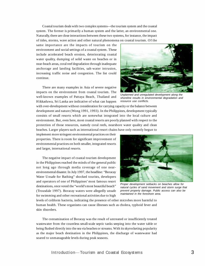
Coastal tourism deals with two complex systems—the tourism system and the coastalsystem. The former is primarily a human system and the latter, an environmental one.Naturally, there are close interactions between these two systems, for instance, the impactof tides, storms, wave action and other natural phenomena on coastal tourism. Of thesame importance are the impacts of tourism on theenvironment and social settings of a coastal system. Theseinclude accelerated beach erosion, deteriorating coastalwater quality, dumping of solid waste on beaches or innear-beach areas, coral reef degradation through inadequateanchorage and landing facilities, salt-water intrusion,increasing traffic noise and congestion. The list couldcontinue.
There are many examples in Asia of severe negativeimpacts on the environment from coastal tourism. Thewell-known examples of Pattaya Beach, Thailand andHikkaduwa, Sri Lanka are indicative of what can happenwith over-development without consideration for carrying capacity or the balance betweendevelopment and nature (Wong 1991, 1993). In the Philippines, development typicallyconsists of small resorts which are somewhat integrated into the local culture andenvironment. But, even here, most coastal resorts are poorly planned with respect to theprotection of those resources, namely coral reefs, nearshore water quality and cleanbeaches. Larger players such as international resort chains have only recently begun toimplement more stringent environmental practices on theirproperties. There is room for significant improvement ofenvironmental practices on both smaller, integrated resortsand larger, international resorts.
The negative impact of coastal tourism developmentin the Philippines reached the minds of the general publicnot long ago through media coverage of one near-environmental disaster. In July 1997, the headline: “BoracayWater Unsafe for Bathing” shocked tourists, developersand operators of one of Philippines’ most famous resortdestinations, once voted the “world’s most beautiful beach”(Trousdale 1997). Boracay waters were allegedly unsafefor swimming and other recreational activities due to highlevels of coliform bacteria, indicating the presence of other microbes more harmful tohuman health. These organisms can cause illnesses such as cholera, typhoid fever andskin disorders.
The contamination of Boracay was the result of untreated or insufficiently treatedwastewater from the countless small-scale septic tanks seeping into the water table orbeing flushed directly into the sea via beaches or streams. With its skyrocketing popularityas the major beach destination in the Philippines, the discharge of wastewater hadsoared to unmanageable levels during peak seasons.
Unplanned and unregulated development along theshoreline results in environmental degradation andresource use conflicts.
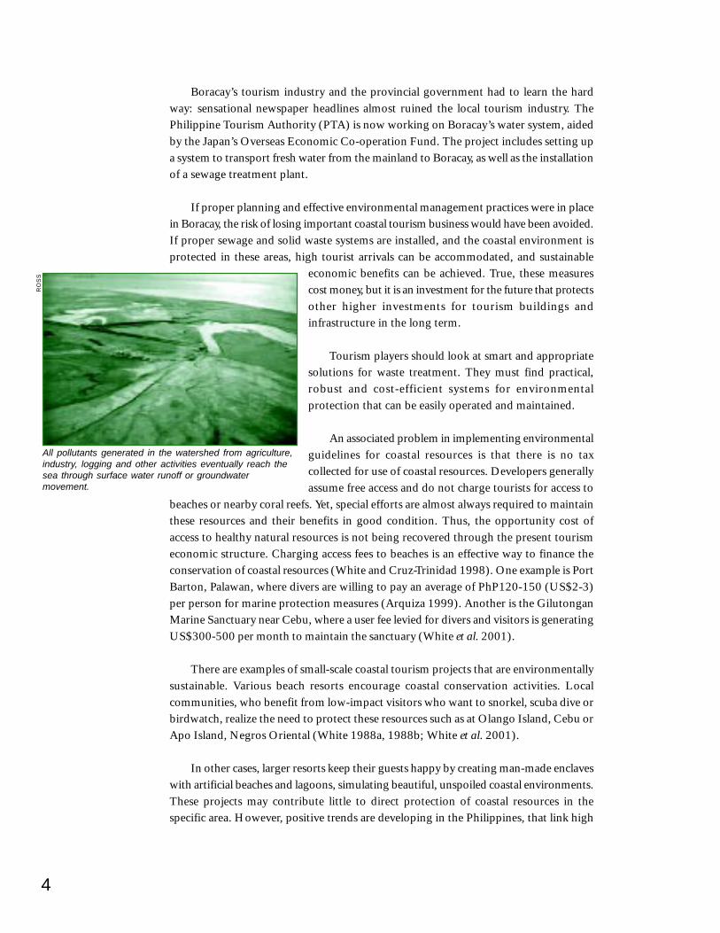
Proper development setbacks on beaches allow fornatural cycles of sand movement and storm surge thatprevent property damage. Public access can also bemaintained in the foreshore area.
4
Boracay’s tourism industry and the provincial government had to learn the hardway: sensational newspaper headlines almost ruined the local tourism industry. ThePhilippine Tourism Authority (PTA) is now working on Boracay’s water system, aidedby the Japan’s Overseas Economic Co-operation Fund. The project includes setting upa system to transport fresh water from the mainland to Boracay, as well as the installationof a sewage treatment plant.
If proper planning and effective environmental management practices were in placein Boracay, the risk of losing important coastal tourism business would have been avoided.If proper sewage and solid waste systems are installed, and the coastal environment isprotected in these areas, high tourist arrivals can be accommodated, and sustainable
economic benefits can be achieved. True, these measurescost money, but it is an investment for the future that protectsother higher investments for tourism buildings andinfrastructure in the long term.
Tourism players should look at smart and appropriatesolutions for waste treatment. They must find practical,robust and cost-efficient systems for environmentalprotection that can be easily operated and maintained.
An associated problem in implementing environmentalguidelines for coastal resources is that there is no taxcollected for use of coastal resources. Developers generallyassume free access and do not charge tourists for access to
beaches or nearby coral reefs. Yet, special efforts are almost always required to maintainthese resources and their benefits in good condition. Thus, the opportunity cost ofaccess to healthy natural resources is not being recovered through the present tourismeconomic structure. Charging access fees to beaches is an effective way to finance theconservation of coastal resources (White and Cruz-Trinidad 1998). One example is PortBarton, Palawan, where divers are willing to pay an average of PhP120-150 (US$2-3)per person for marine protection measures (Arquiza 1999). Another is the GilutonganMarine Sanctuary near Cebu, where a user fee levied for divers and visitors is generatingUS$300-500 per month to maintain the sanctuary (White et al. 2001).
There are examples of small-scale coastal tourism projects that are environmentallysustainable. Various beach resorts encourage coastal conservation activities. Localcommunities, who benefit from low-impact visitors who want to snorkel, scuba dive orbirdwatch, realize the need to protect these resources such as at Olango Island, Cebu orApo Island, Negros Oriental (White 1988a, 1988b; White et al. 2001).
In other cases, larger resorts keep their guests happy by creating man-made enclaveswith artificial beaches and lagoons, simulating beautiful, unspoiled coastal environments.These projects may contribute little to direct protection of coastal resources in thespecific area. However, positive trends are developing in the Philippines, that link high
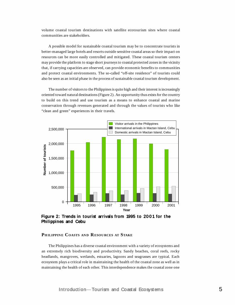
All pollutants generated in the watershed from agriculture,industry, logging and other activities eventually reach thesea through surface water runoff or groundwatermovement.
RO
SS
5IntroductionIntroductionIntroductionIntroductionIntroduction—Tourism and Coastal EcosystemsTourism and Coastal EcosystemsTourism and Coastal EcosystemsTourism and Coastal EcosystemsTourism and Coastal Ecosystems
volume coastal tourism destinations with satellite ecotourism sites where coastalcommunities are stakeholders.
A possible model for sustainable coastal tourism may be to concentrate tourists inbetter-managed large hotels and resorts outside sensitive coastal areas so their impact onresources can be more easily controlled and mitigated. These coastal tourism centersmay provide the platform to stage short journeys to coastal protected zones in the vicinitythat, if carrying capacities are observed, can provide economic benefits to communitiesand protect coastal environments. The so-called “off-site residence” of tourists couldalso be seen as an initial phase in the process of sustainable coastal tourism development.
The number of visitors to the Philippines is quite high and their interest is increasinglyoriented toward natural destinations (Figure 2). An opportunity thus exists for the countryto build on this trend and use tourism as a means to enhance coastal and marineconservation through revenues generated and through the values of tourists who like“clean and green” experiences in their travels.
Figure 2: Trends in tourist arrivals from 1995 to 2001 for theFigure 2: Trends in tourist arrivals from 1995 to 2001 for theFigure 2: Trends in tourist arrivals from 1995 to 2001 for theFigure 2: Trends in tourist arrivals from 1995 to 2001 for theFigure 2: Trends in tourist arrivals from 1995 to 2001 for thePhilippines and CebuPhilippines and CebuPhilippines and CebuPhilippines and CebuPhilippines and Cebu
Year1995
2,500,000
2,000,000
1,500,000
1,000,000
500,000
01996 1997 1998
Num
ber o
f tou
rists
1999 2000 2001
Visitor arrivals in the PhilippinesInternational arrivals in Mactan Island, CebuDomestic arrivals in Mactan Island, Cebu
PHILIPPINE COASTS AND RESOURCES AT STAKE
The Philippines has a diverse coastal environment with a variety of ecosystems andan extremely rich biodiversity and productivity. Sandy beaches, coral reefs, rockyheadlands, mangroves, wetlands, estuaries, lagoons and seagrasses are typical. Eachecosystem plays a critical role in maintaining the health of the coastal zone as well as inmaintaining the health of each other. This interdependence makes the coastal zone one
6
of the most sensitive geographic areas. Damageto a coral reef, for example, will allow greaterwave action on shore, causing beach loss.Alteration of one feature of the coastal zone usuallycauses damage to another feature, either directlyor indirectly (Figure 3). A detailed analysis of thePhilippine coastal ecosystems is presented inPhilippine Coastal Management Guidebook SeriesNo. 5: Managing Coastal Habitats and MarineProtected Areas (DENR et al. 2001) and inPhilippine Coral Reefs: A Natural History Guide(White 2001).
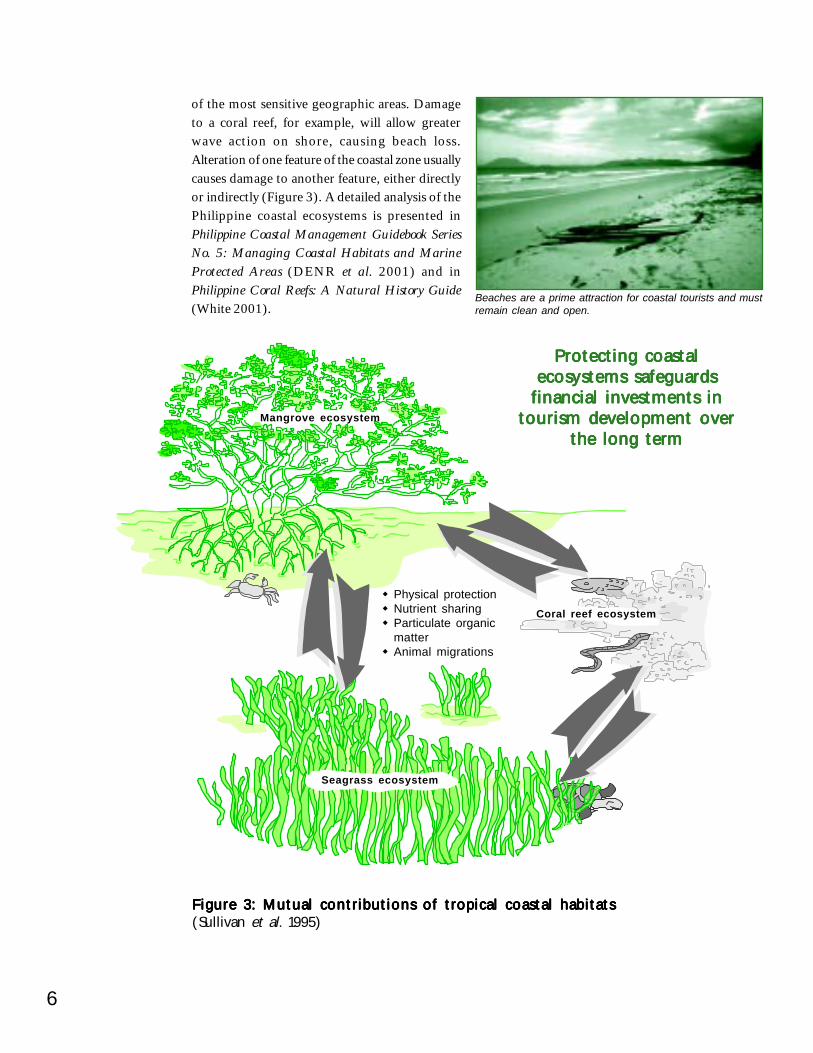
Beaches are a prime attraction for coastal tourists and mustremain clean and open.
Protecting coastalProtecting coastalProtecting coastalProtecting coastalProtecting coastalecosystems safeguardsecosystems safeguardsecosystems safeguardsecosystems safeguardsecosystems safeguards
financial investments infinancial investments infinancial investments infinancial investments infinancial investments intourism development overtourism development overtourism development overtourism development overtourism development over
the long termthe long termthe long termthe long termthe long term
Coral reef ecosystem
Mangrove ecosystem
Physical protectionNutrient sharingParticulate organicmatterAnimal migrations
Seagrass ecosystem
Figure 3: Mutual contributions of tropical coastal habitatsFigure 3: Mutual contributions of tropical coastal habitatsFigure 3: Mutual contributions of tropical coastal habitatsFigure 3: Mutual contributions of tropical coastal habitatsFigure 3: Mutual contributions of tropical coastal habitats(Sullivan et al. 1995)
7IntroductionIntroductionIntroductionIntroductionIntroduction—Tourism and Coastal EcosystemsTourism and Coastal EcosystemsTourism and Coastal EcosystemsTourism and Coastal EcosystemsTourism and Coastal Ecosystems
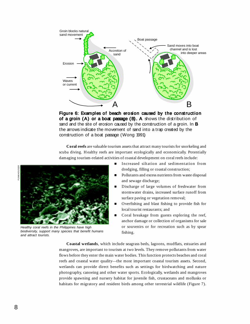
Figure 5: Extension of airport runway interferes with sandFigure 5: Extension of airport runway interferes with sandFigure 5: Extension of airport runway interferes with sandFigure 5: Extension of airport runway interferes with sandFigure 5: Extension of airport runway interferes with sandmovement, Dumaguete City movement, Dumaguete City movement, Dumaguete City movement, Dumaguete City movement, Dumaguete City (DENR et al. 2001)
original runwaybeach
ORIGINAL
coralreef
current
new runway
NEW
accretion current
erodedarea
reef
seawall toprotecthouses
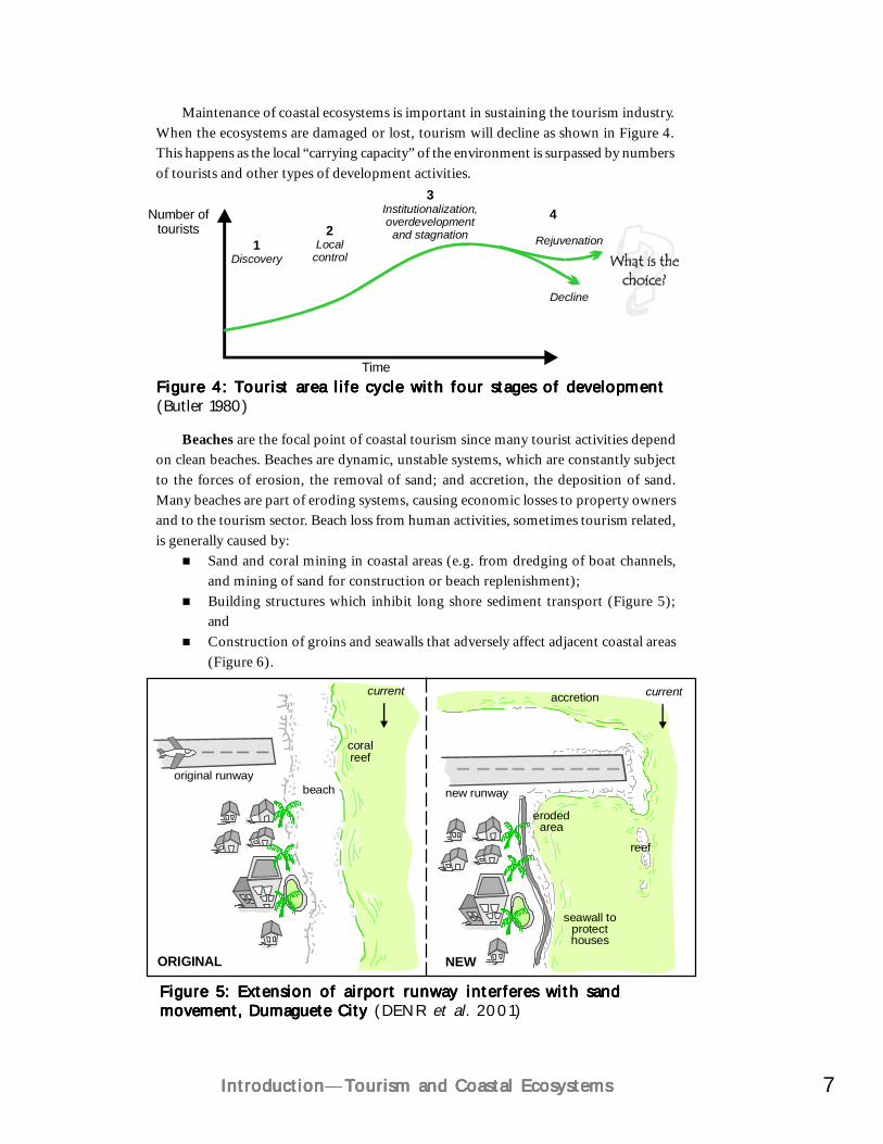
Figure 4: Tourist area life cycle with four stages of developmentFigure 4: Tourist area life cycle with four stages of developmentFigure 4: Tourist area life cycle with four stages of developmentFigure 4: Tourist area life cycle with four stages of developmentFigure 4: Tourist area life cycle with four stages of development(Butler 1980)
Maintenance of coastal ecosystems is important in sustaining the tourism industry.When the ecosystems are damaged or lost, tourism will decline as shown in Figure 4.This happens as the local “carrying capacity” of the environment is surpassed by numbersof tourists and other types of development activities.
Beaches are the focal point of coastal tourism since many tourist activities dependon clean beaches. Beaches are dynamic, unstable systems, which are constantly subjectto the forces of erosion, the removal of sand; and accretion, the deposition of sand.Many beaches are part of eroding systems, causing economic losses to property ownersand to the tourism sector. Beach loss from human activities, sometimes tourism related,is generally caused by:
Sand and coral mining in coastal areas (e.g. from dredging of boat channels,and mining of sand for construction or beach replenishment);Building structures which inhibit long shore sediment transport (Figure 5);andConstruction of groins and seawalls that adversely affect adjacent coastal areas(Figure 6).
Number oftourists
Time
1Discovery
Rejuvenation
Decline
2Local
control
3Institutionalization,overdevelopment
and stagnation
4
8
Coral reefs are valuable tourism assets that attract many tourists for snorkeling andscuba diving. Healthy reefs are important ecologically and economically. Potentiallydamaging tourism-related activities of coastal development on coral reefs include:
Increased siltation and sedimentation fromdredging, filling or coastal construction;Pollutants and excess nutrients from waste disposaland sewage discharge;Discharge of large volumes of freshwater fromstormwater drains, increased surface runoff fromsurface paving or vegetation removal;Overfishing and blast fishing to provide fish forlocal tourist restaurants; andCoral breakage from guests exploring the reef,anchor damage or collection of organisms for saleor souvenirs or for recreation such as by spearfishing.
Coastal wetlands, which include seagrass beds, lagoons, mudflats, estuaries andmangroves, are important to tourism at two levels. They remove pollutants from waterflows before they enter the main water bodies. This function protects beaches and coralreefs and coastal water quality—the most important coastal tourism assets. Second,wetlands can provide direct benefits such as settings for birdwatching and naturephotography, canoeing and other water sports. Ecologically, wetlands and mangrovesprovide spawning and nursery habitat for juvenile fish, crustaceans and mollusks orhabitats for migratory and resident birds among other terrestrial wildlife (Figure 7).
Healthy coral reefs in the Philippines have highbiodiversity, support many species that benefit humansand attract tourists.
FUN
KH
OU
SE
R
Figure 6: Examples of beach erosion caused by the constructionFigure 6: Examples of beach erosion caused by the constructionFigure 6: Examples of beach erosion caused by the constructionFigure 6: Examples of beach erosion caused by the constructionFigure 6: Examples of beach erosion caused by the constructionof a groin (A) or a boat passage (B). A of a groin (A) or a boat passage (B). A of a groin (A) or a boat passage (B). A of a groin (A) or a boat passage (B). A of a groin (A) or a boat passage (B). A shows the distribution ofsand and the site of erosion caused by the construction of a groin. In BBBBBthe arrows indicate the movement of sand into a trap created by theconstruction of a boat passage (Wong 1991)
Erosion
A B
Wavesor current
Accretion of sand
Boat passage
Groin blocks naturalsand movement
Sand moves into boat channel and is lost into deeper areas
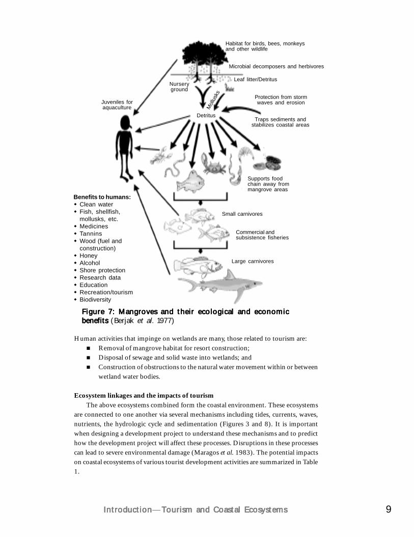
9IntroductionIntroductionIntroductionIntroductionIntroduction—Tourism and Coastal EcosystemsTourism and Coastal EcosystemsTourism and Coastal EcosystemsTourism and Coastal EcosystemsTourism and Coastal Ecosystems
Figure 7: Mangroves and their ecological and economicFigure 7: Mangroves and their ecological and economicFigure 7: Mangroves and their ecological and economicFigure 7: Mangroves and their ecological and economicFigure 7: Mangroves and their ecological and economicbenefits benefits benefits benefits benefits (Berjak et al. 1977)
Habitat for birds, bees, monkeysand other wildlife
Microbial decomposers and herbivores
Leaf litter/Detritus
Detritus
Nurseryground
Protection from stormwaves and erosion
Traps sediments andstabilizes coastal areas
Supports foodchain away frommangrove areas
Small carnivores
Commercial andsubsistence fisheries
Large carnivores
Juveniles foraquaculture M
ollus
ks
Benefits to humans:Clean waterFish, shellfish,mollusks, etc.MedicinesTanninsWood (fuel andconstruction)HoneyAlcoholShore protectionResearch dataEducationRecreation/tourismBiodiversity
Human activities that impinge on wetlands are many, those related to tourism are:Removal of mangrove habitat for resort construction;Disposal of sewage and solid waste into wetlands; andConstruction of obstructions to the natural water movement within or betweenwetland water bodies.
Ecosystem linkages and the impacts of tourismThe above ecosystems combined form the coastal environment. These ecosystems
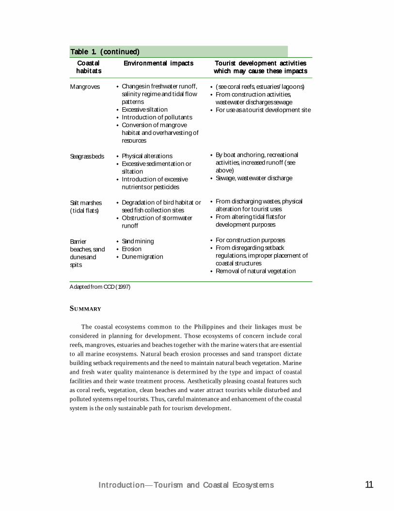
are connected to one another via several mechanisms including tides, currents, waves,nutrients, the hydrologic cycle and sedimentation (Figures 3 and 8). It is importantwhen designing a development project to understand these mechanisms and to predicthow the development project will affect these processes. Disruptions in these processescan lead to severe environmental damage (Maragos et al. 1983). The potential impactson coastal ecosystems of various tourist development activities are summarized in Table1.
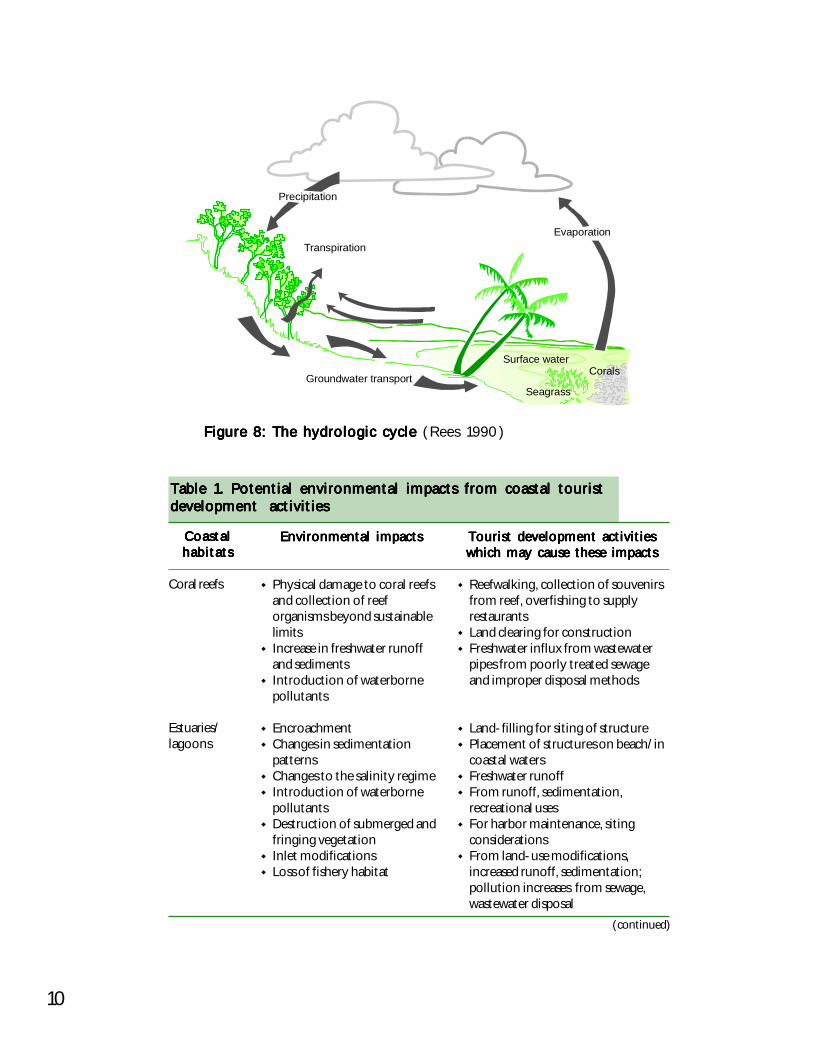
10
Figure 8: The hydrologic cycle Figure 8: The hydrologic cycle Figure 8: The hydrologic cycle Figure 8: The hydrologic cycle Figure 8: The hydrologic cycle (Rees 1990)
Precipitation
Transpiration
Groundwater transport
Evaporation
Surface waterCorals
Seagrass
CoastalCoastalCoastalCoastalCoastalhabitatshabitatshabitatshabitatshabitats
Coral reefs
Estuaries/lagoons
(continued)
Environmental impactsEnvironmental impactsEnvironmental impactsEnvironmental impactsEnvironmental impacts
Physical damage to coral reefsand collection of reeforganisms beyond sustainablelimitsIncrease in freshwater runoffand sedimentsIntroduction of waterbornepollutants
EncroachmentChanges in sedimentationpatternsChanges to the salinity regimeIntroduction of waterbornepollutantsDestruction of submerged andfringing vegetationInlet modificationsLoss of fishery habitat
Tourist development activitiesTourist development activitiesTourist development activitiesTourist development activitiesTourist development activitieswhich may cause these impactswhich may cause these impactswhich may cause these impactswhich may cause these impactswhich may cause these impacts
Reefwalking, collection of souvenirsfrom reef, overfishing to supplyrestaurantsLand clearing for constructionFreshwater influx from wastewaterpipes from poorly treated sewageand improper disposal methods
Land-filling for siting of structurePlacement of structures on beach/incoastal watersFreshwater runoffFrom runoff, sedimentation,recreational usesFor harbor maintenance, sitingconsiderationsFrom land-use modifications,increased runoff, sedimentation;pollution increases from sewage,wastewater disposal
Table 1. Potential environmental impacts from coastal touristTable 1. Potential environmental impacts from coastal touristTable 1. Potential environmental impacts from coastal touristTable 1. Potential environmental impacts from coastal touristTable 1. Potential environmental impacts from coastal touristdevelopment activitiesdevelopment activitiesdevelopment activitiesdevelopment activitiesdevelopment activities
11IntroductionIntroductionIntroductionIntroductionIntroduction—Tourism and Coastal EcosystemsTourism and Coastal EcosystemsTourism and Coastal EcosystemsTourism and Coastal EcosystemsTourism and Coastal Ecosystems
SUMMARY
The coastal ecosystems common to the Philippines and their linkages must beconsidered in planning for development. Those ecosystems of concern include coralreefs, mangroves, estuaries and beaches together with the marine waters that are essentialto all marine ecosystems. Natural beach erosion processes and sand transport dictatebuilding setback requirements and the need to maintain natural beach vegetation. Marineand fresh water quality maintenance is determined by the type and impact of coastalfacilities and their waste treatment process. Aesthetically pleasing coastal features suchas coral reefs, vegetation, clean beaches and water attract tourists while disturbed andpolluted systems repel tourists. Thus, careful maintenance and enhancement of the coastalsystem is the only sustainable path for tourism development.
CoastalCoastalCoastalCoastalCoastalhabitatshabitatshabitatshabitatshabitats
Adapted from CCD (1997)
Environmental impactsEnvironmental impactsEnvironmental impactsEnvironmental impactsEnvironmental impacts Tourist development activitiesTourist development activitiesTourist development activitiesTourist development activitiesTourist development activitieswhich may cause these impactswhich may cause these impactswhich may cause these impactswhich may cause these impactswhich may cause these impacts
Table 1. (continued)Table 1. (continued)Table 1. (continued)Table 1. (continued)Table 1. (continued)
Mangroves
Seagrass beds
Salt marshes(tidal flats)
Barrierbeaches, sanddunes andspits
Changes in freshwater runoff,salinity regime and tidal flowpatternsExcessive siltationIntroduction of pollutantsConversion of mangrovehabitat and overharvesting ofresources
Physical alterationsExcessive sedimentation orsiltationIntroduction of excessivenutrients or pesticides
Degradation of bird habitat orseed fish collection sitesObstruction of stormwaterrunoff
Sand miningErosionDune migration
(see coral reefs, estuaries/lagoons)From construction activities,wastewater discharges sewageFor use as a tourist development site
By boat anchoring, recreationalactivities, increased runoff (seeabove)Sewage, wastewater discharge
From discharging wastes, physicalalteration for tourist usesFrom altering tidal flats fordevelopment purposes
For construction purposesFrom disregarding setbackregulations, improper placement ofcoastal structuresRemoval of natural vegetation
CHAPTER 2
Integrated Coastal Management:Integrated Coastal Management:Integrated Coastal Management:Integrated Coastal Management:Integrated Coastal Management:Context for Tourism PlanningContext for Tourism PlanningContext for Tourism PlanningContext for Tourism PlanningContext for Tourism Planning
The best plans are no guarantee for stoppingThe best plans are no guarantee for stoppingThe best plans are no guarantee for stoppingThe best plans are no guarantee for stoppingThe best plans are no guarantee for stoppingenvironmental degradation, but withoutenvironmental degradation, but withoutenvironmental degradation, but withoutenvironmental degradation, but withoutenvironmental degradation, but without
them there is no hope!them there is no hope!them there is no hope!them there is no hope!them there is no hope!
The development of tourism in coastal areas occurs in the context of the coastalenvironment and its ecosystems described in Chapter 1. The coastal area has manycomplexities that must be considered for any kind of development, whether it istourism related or not. This chapter provides an introduction to integrated coastalmanagement (ICM) as the overall approach to address the issues created bydevelopment in coastal areas. ICM is a means of planning for resource managementand coastal development and implementing these plans. ICM considers the interactionamong and within human development activities and the natural coastal environment.It provides a systematic way to analyze the coastal situation and to plan for itsdevelopment before mitigation and restoration are required. It helps prioritize theoutcomes that people value most through a participatory process whereby all keystakeholders have a role in the decision process in planning the development of theirarea.
The widespread decline of coastal resources in the Philippines is, without a doubt,a fundamental and urgent issue that needs to be addressed through active involvementfrom all sectors of society. The uncontrolled exploitation of natural resources hasserved as the primary starting point for the degraded condition of coastal resourcesexperienced today. Tourism only stands to lose from this deteriorating scenario.
Regular and appropriate investments in coastal management are required to sustainnational and local benefits derived from coastal resources. Furthermore, with therecognition that effective management develops from a participatory process involvingcoastal stakeholders and day-to-day resource users, many countries, including thePhilippines, have devolved the responsibility of managing coastal resources to the
13Integrated Coastal Management: Context for Tourism PlanningIntegrated Coastal Management: Context for Tourism PlanningIntegrated Coastal Management: Context for Tourism PlanningIntegrated Coastal Management: Context for Tourism PlanningIntegrated Coastal Management: Context for Tourism Planning
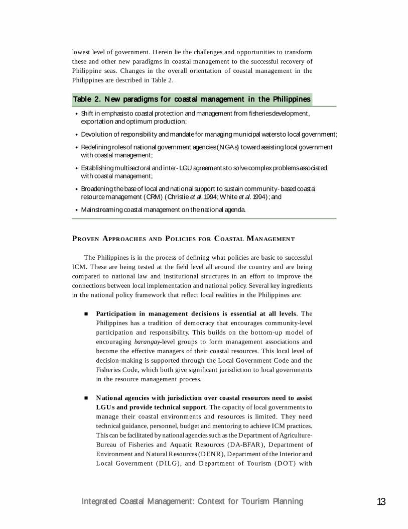
lowest level of government. Herein lie the challenges and opportunities to transformthese and other new paradigms in coastal management to the successful recovery ofPhilippine seas. Changes in the overall orientation of coastal management in thePhilippines are described in Table 2.
Table 2. New paradigms for coastal management in the PhilippinesTable 2. New paradigms for coastal management in the PhilippinesTable 2. New paradigms for coastal management in the PhilippinesTable 2. New paradigms for coastal management in the PhilippinesTable 2. New paradigms for coastal management in the Philippines
Shift in emphasis to coastal protection and management from fisheries development,exportation and optimum production;
Devolution of responsibility and mandate for managing municipal waters to local government;
Redefining roles of national government agencies (NGAs) toward assisting local governmentwith coastal management;
Establishing multisectoral and inter-LGU agreements to solve complex problems associatedwith coastal management;
Broadening the base of local and national support to sustain community-based coastalresource management (CRM) (Christie et al. 1994; White et al. 1994); and
Mainstreaming coastal management on the national agenda.
PROVEN APPROACHES AND POLICIES FOR COASTAL MANAGEMENT
The Philippines is in the process of defining what policies are basic to successfulICM. These are being tested at the field level all around the country and are beingcompared to national law and institutional structures in an effort to improve theconnections between local implementation and national policy. Several key ingredientsin the national policy framework that reflect local realities in the Philippines are:
Participation in management decisions is essential at all levels. ThePhilippines has a tradition of democracy that encourages community-levelparticipation and responsibility. This builds on the bottom-up model ofencouraging barangay-level groups to form management associations andbecome the effective managers of their coastal resources. This local level ofdecision-making is supported through the Local Government Code and theFisheries Code, which both give significant jurisdiction to local governmentsin the resource management process.
National agencies with jurisdiction over coastal resources need to assistLGUs and provide technical support. The capacity of local governments tomanage their coastal environments and resources is limited. They needtechnical guidance, personnel, budget and mentoring to achieve ICM practices.This can be facilitated by national agencies such as the Department of Agriculture-Bureau of Fisheries and Aquatic Resources (DA-BFAR), Department ofEnvironment and Natural Resources (DENR), Department of the Interior andLocal Government (DILG), and Department of Tourism (DOT) with
14
jurisdiction and concern for coastal environments and resources. The differencenow, as compared to the past, is that the direct management responsibility andimplementing authority lies primarily with the local governments.
Collaboration and synergy among agencies is essential. The very term“integrated” strongly suggests that all institutions with a mandate and concernfor management of coastal resources must collaborate. This collaborationwill include government and nongovernment organizations (NGOs) andinternational projects and donors. The planning unit and the boundaries ofcollaboration will most often be determined by ecological criteria and naturaldivisions. Bays with defined ocean parameters, resources and issues do notrespect political boundaries. Rather, they must be planned for and managed asa bay unit. This may include several municipalities and one or more provincesin some cases.
Multiple education and communication strategies are required to build awide base of support for ICM. People must begin to understand the issuesbefore they will take action to solve them. This can be achieved througheducation and media campaigns. ICM can be promoted through networks ofconstituency groups to support initiatives, thus ensuring better sustainabilityof efforts.
Proven technical interventions must be pursued and applied appropriately.Much experience has been gained through a variety of coastal managementprojects that have tested coastal management interventions. The viableinterventions must be pursued, such as integrated planning, habitat protectionand management, improved law enforcement, environmentally sensitivelivelihood options, community organization and education, and others(Christie and White 1997).
Local government plays a pivotal role as the last safety net for the recovery ofcoastal and marine resources in the Philippines. For this reason, the Philippine CoastalManagement Guidebook Series (DENR et al. 2001) highlights coastal managementprocesses and management measures that are collectively viewed as the delivery of basicservices by local governments — municipal, city and provincial. These basic servicescannot be delivered without cooperation between local governments and, at the sametime, without the support of NGAs, NGOs, coastal communities, academe, private andother sectors.
NATIONAL LEGAL AND POLICY FRAMEWORK FOR COASTAL MANAGEMENT
The primary mandate for coastal management has been largely devolved to localgovernment under the Local Government Code of 1991 (Republic Act No. 7160)and more recently defined in the Fisheries Code of 1998 (Republic Act No. 8550).
15Integrated Coastal Management: Context for Tourism PlanningIntegrated Coastal Management: Context for Tourism PlanningIntegrated Coastal Management: Context for Tourism PlanningIntegrated Coastal Management: Context for Tourism PlanningIntegrated Coastal Management: Context for Tourism Planning
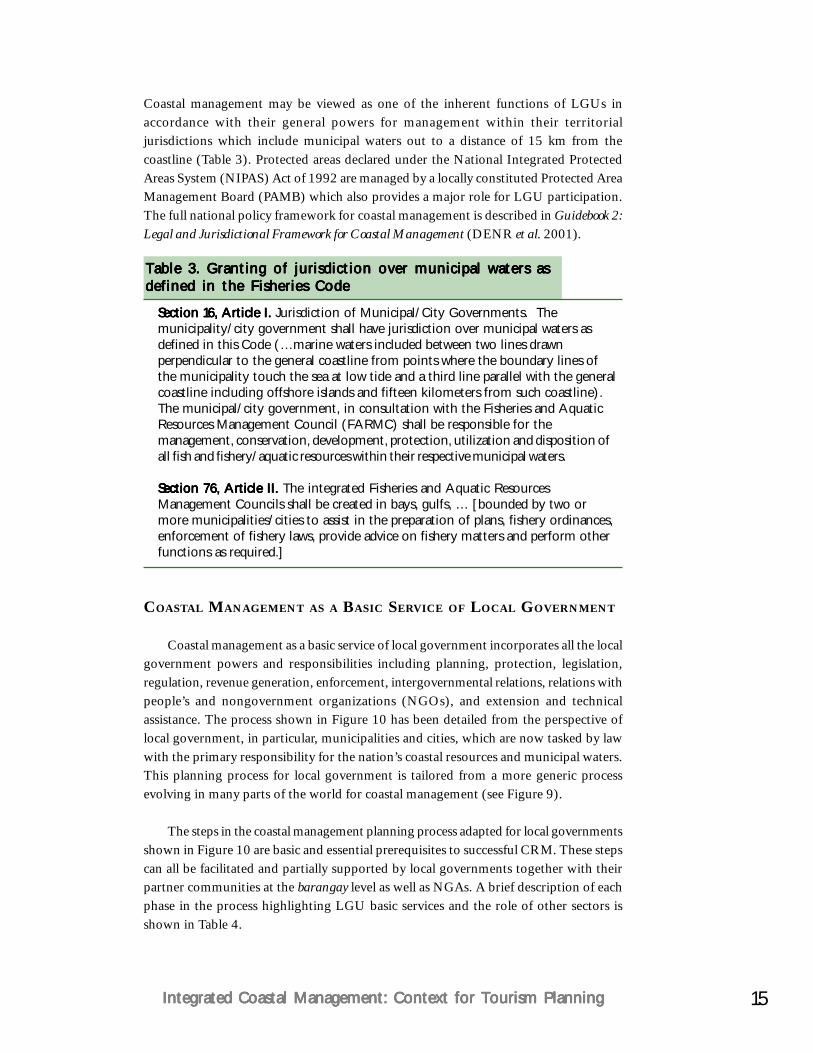
Coastal management may be viewed as one of the inherent functions of LGUs inaccordance with their general powers for management within their territorialjurisdictions which include municipal waters out to a distance of 15 km from thecoastline (Table 3). Protected areas declared under the National Integrated ProtectedAreas System (NIPAS) Act of 1992 are managed by a locally constituted Protected AreaManagement Board (PAMB) which also provides a major role for LGU participation.The full national policy framework for coastal management is described in Guidebook 2:Legal and Jurisdictional Framework for Coastal Management (DENR et al. 2001).
COASTAL MANAGEMENT AS A BASIC SERVICE OF LOCAL GOVERNMENT
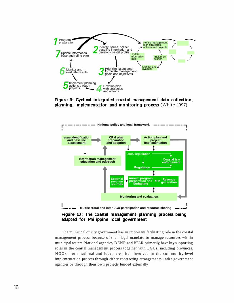
Coastal management as a basic service of local government incorporates all the localgovernment powers and responsibilities including planning, protection, legislation,regulation, revenue generation, enforcement, intergovernmental relations, relations withpeople’s and nongovernment organizations (NGOs), and extension and technicalassistance. The process shown in Figure 10 has been detailed from the perspective oflocal government, in particular, municipalities and cities, which are now tasked by lawwith the primary responsibility for the nation’s coastal resources and municipal waters.This planning process for local government is tailored from a more generic processevolving in many parts of the world for coastal management (see Figure 9).
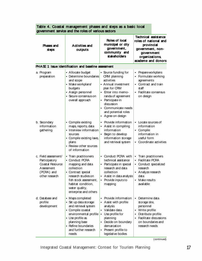
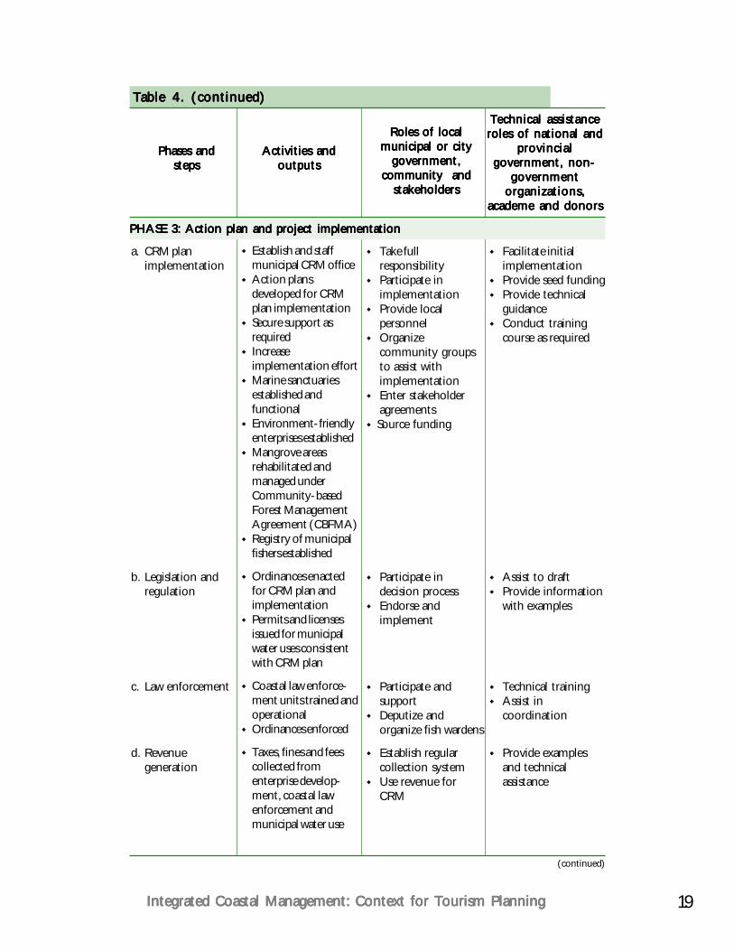
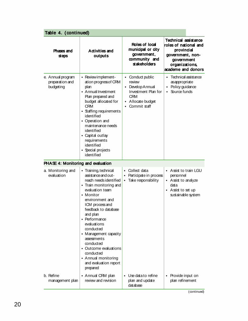
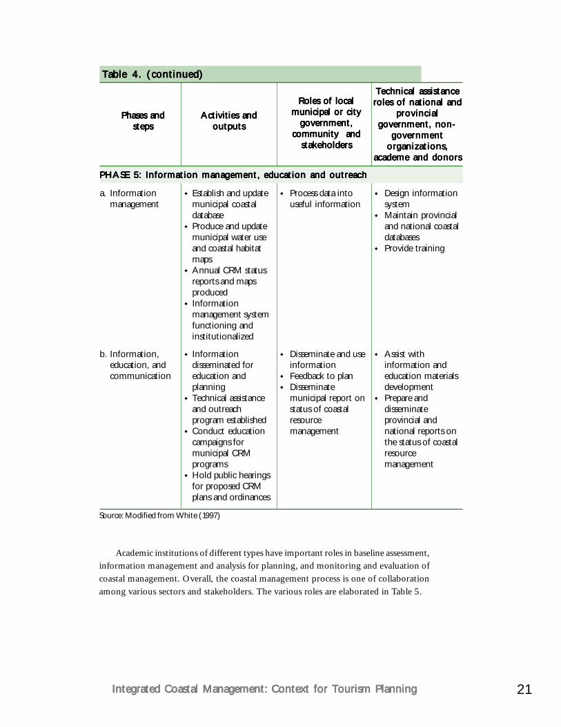
The steps in the coastal management planning process adapted for local governmentsshown in Figure 10 are basic and essential prerequisites to successful CRM. These stepscan all be facilitated and partially supported by local governments together with theirpartner communities at the barangay level as well as NGAs. A brief description of eachphase in the process highlighting LGU basic services and the role of other sectors isshown in Table 4.
Table 3. Granting of jurisdiction over municipal waters asTable 3. Granting of jurisdiction over municipal waters asTable 3. Granting of jurisdiction over municipal waters asTable 3. Granting of jurisdiction over municipal waters asTable 3. Granting of jurisdiction over municipal waters asdefined in the Fisheries Codedefined in the Fisheries Codedefined in the Fisheries Codedefined in the Fisheries Codedefined in the Fisheries Code
Section 16, Article I.Section 16, Article I.Section 16, Article I.Section 16, Article I.Section 16, Article I. Jurisdiction of Municipal/City Governments. Themunicipality/city government shall have jurisdiction over municipal waters asdefined in this Code (…marine waters included between two lines drawnperpendicular to the general coastline from points where the boundary lines ofthe municipality touch the sea at low tide and a third line parallel with the generalcoastline including offshore islands and fifteen kilometers from such coastline).The municipal/city government, in consultation with the Fisheries and AquaticResources Management Council (FARMC) shall be responsible for themanagement, conservation, development, protection, utilization and disposition ofall fish and fishery/aquatic resources within their respective municipal waters.
Section 76, Article II. Section 76, Article II. Section 76, Article II. Section 76, Article II. Section 76, Article II. The integrated Fisheries and Aquatic ResourcesManagement Councils shall be created in bays, gulfs, … [bounded by two ormore municipalities/cities to assist in the preparation of plans, fishery ordinances,enforcement of fishery laws, provide advice on fishery matters and perform otherfunctions as required.]
16
Figure 9: Cyclical integrated coastal management data collection,Figure 9: Cyclical integrated coastal management data collection,Figure 9: Cyclical integrated coastal management data collection,Figure 9: Cyclical integrated coastal management data collection,Figure 9: Cyclical integrated coastal management data collection,planning, implementation and monitoring process planning, implementation and monitoring process planning, implementation and monitoring process planning, implementation and monitoring process planning, implementation and monitoring process (White 1997)
The municipal or city government has an important facilitating role in the coastalmanagement process because of their legal mandate to manage resources withinmunicipal waters. National agencies, DENR and BFAR primarily, have key supportingroles in the coastal management process together with LGUs, including provinces.NGOs, both national and local, are often involved in the community-levelimplementation process through either contracting arrangements under governmentagencies or through their own projects funded externally.
Programpreparation
Identify issues, collectbaseline information anddevelop coastal profile
Prioritize issues andformulate managementgoals and objectives
Refine managementplan strategies,actions and projects
Monitor andevaluate
Updateinformationbase
Implementactions
Develop planwith strategiesand actions
Implement planningactions throughprojects
Monitor andevaluate results
Update informationbase and refine plan
Issue identificationand baselineassessment
Information management,education and outreach
Externalrevenuesources
Local legislation
Regulation
Annual programpreparation and
budgetingRevenue
generation
Coastal lawenforcement
Monitoring and evaluation
CRM planpreparation
and adoption
Action plan andproject
implementation
National policy and legal framework
Multisectoral and inter-LGU participation and resource sharing
Figure 10: The coastal management planning process beingFigure 10: The coastal management planning process beingFigure 10: The coastal management planning process beingFigure 10: The coastal management planning process beingFigure 10: The coastal management planning process beingadapted for Philippine local governmentadapted for Philippine local governmentadapted for Philippine local governmentadapted for Philippine local governmentadapted for Philippine local government
17Integrated Coastal Management: Context for Tourism PlanningIntegrated Coastal Management: Context for Tourism PlanningIntegrated Coastal Management: Context for Tourism PlanningIntegrated Coastal Management: Context for Tourism PlanningIntegrated Coastal Management: Context for Tourism Planning
Table 4. Coastal management phases and steps as a basic localTable 4. Coastal management phases and steps as a basic localTable 4. Coastal management phases and steps as a basic localTable 4. Coastal management phases and steps as a basic localTable 4. Coastal management phases and steps as a basic localgovernment service and the roles of various sectorsgovernment service and the roles of various sectorsgovernment service and the roles of various sectorsgovernment service and the roles of various sectorsgovernment service and the roles of various sectors
Phases andPhases andPhases andPhases andPhases andstepsstepsstepsstepssteps
Activities andActivities andActivities andActivities andActivities andoutputsoutputsoutputsoutputsoutputs
Roles of localRoles of localRoles of localRoles of localRoles of localmunicipal or citymunicipal or citymunicipal or citymunicipal or citymunicipal or city
government,government,government,government,government,community andcommunity andcommunity andcommunity andcommunity and
stakeholdersstakeholdersstakeholdersstakeholdersstakeholders
Technical assistanceTechnical assistanceTechnical assistanceTechnical assistanceTechnical assistanceroles of national androles of national androles of national androles of national androles of national and
provincialprovincialprovincialprovincialprovincialgovernment, non-government, non-government, non-government, non-government, non-
governmentgovernmentgovernmentgovernmentgovernmentorganizations,organizations,organizations,organizations,organizations,
academe and donorsacademe and donorsacademe and donorsacademe and donorsacademe and donors
PHASE 1: Issue identification and baseline assessmentPHASE 1: Issue identification and baseline assessmentPHASE 1: Issue identification and baseline assessmentPHASE 1: Issue identification and baseline assessmentPHASE 1: Issue identification and baseline assessment
a. Programpreparation
b. Secondaryinformationgathering
c. Field assessment/ParticipatoryCoastal ResourceAssessment(PCRA) andother research
d. Database andprofiledevelopment
Allocate budgetDetermine boundariesand scopeMake workplans/budgetsAssign personnelSecure consensus onoverall approach
Compile existingmaps, reports, dataInterview informationsourcesCompile existing laws,plansReview other sourcesof information
Train practitionersConduct PCRAmapping and datacollectionContract specialresearch studies onfish stock assessment,habitat condition,water quality,enterprise and others
Maps completedSet up data storageand retrieval systemCompile coastalenvironmental profileUse profile asplanning baseRefine boundariesand further researchneeds
Source funding forCRM planningactivitiesAnnual investmentplan for CRMEnter into memo-randa of agreementParticipate indiscussionCommunicate needsand potential rolesAgree on design
Provide informationAssist in compilinginformationBegin to developinformation storageand retrieval system
Conduct PCRA withtechnical assistanceParticipate in specialresearch and datacollectionAssist in data analysisProvide inputs tomapping
Provide informationAssist with profileanalysisValidate dataUse profile forplanningDecide on boundarydemarcationPresent profile tolegislative bodies
Prepare workplansFormulate workingagreementsContract and trainstaffFacilitate consensuson design
Locate sources ofinformationCompileinformation inuseful formCoordinate activities
Train practitionersFacilitate PCRAConduct specializedresearchAnalyze researchdataMake resultsavailable
Determine datastorage site,personnelWrite profileDistribute profileFacilitate discussionson boundaries andresearch needs
(continued)
18
Table 4. (continued)Table 4. (continued)Table 4. (continued)Table 4. (continued)Table 4. (continued)
Phases andPhases andPhases andPhases andPhases andstepsstepsstepsstepssteps
Activities andActivities andActivities andActivities andActivities andoutputsoutputsoutputsoutputsoutputs
Roles of localRoles of localRoles of localRoles of localRoles of localmunicipal or citymunicipal or citymunicipal or citymunicipal or citymunicipal or city
government,government,government,government,government,community andcommunity andcommunity andcommunity andcommunity and
stakeholdersstakeholdersstakeholdersstakeholdersstakeholders
Technical assistanceTechnical assistanceTechnical assistanceTechnical assistanceTechnical assistanceroles of national androles of national androles of national androles of national androles of national and
provincialprovincialprovincialprovincialprovincialgovernment, non-government, non-government, non-government, non-government, non-
governmentgovernmentgovernmentgovernmentgovernmentorganizations,organizations,organizations,organizations,organizations,
academe and donorsacademe and donorsacademe and donorsacademe and donorsacademe and donors
e. Prioritize issuesand analyzecauses
Conduct communityand municipal-basedplanning sessionsDevelop issue treePrioritize issues formanagement
Participate inprocess and providemajor inputParticipate inconflict resolutionSet priorities in realterms
Facilitate processInterject outsideperspectives,research findings,policies, etc.Help translate issuesinto causes
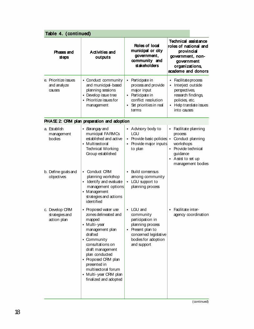
PHASE 2: CRM plan preparation and adoptionPHASE 2: CRM plan preparation and adoptionPHASE 2: CRM plan preparation and adoptionPHASE 2: CRM plan preparation and adoptionPHASE 2: CRM plan preparation and adoption
a. Establishmanagementbodies
b. Define goals andobjectives
c. Develop CRMstrategies andaction plan
Barangay andmunicipal FARMCsestablished and activeMultisectoralTechnical WorkingGroup established
Conduct CRMplanning workshopIdentify and evaluatemanagement optionsManagementstrategies and actionsidentified
Proposed water usezones delineated andmappedMulti-yearmanagement plandraftedCommunityconsultations ondraft managementplan conductedProposed CRM planpresented inmultisectoral forumMulti-year CRM planfinalized and adopted
Advisory body toLGUProvide basic policiesProvide major inputsto plan
Build consensusamong communityLGU support toplanning process
LGU andcommunityparticipation inplanning processPresent plan toconcerned legislativebodies for adoptionand support
Facilitate planningprocessConduct planningworkshopsProvide technicalguidanceAssist to set upmanagement bodies
Facilitate inter-agency coordination
(continued)
19Integrated Coastal Management: Context for Tourism PlanningIntegrated Coastal Management: Context for Tourism PlanningIntegrated Coastal Management: Context for Tourism PlanningIntegrated Coastal Management: Context for Tourism PlanningIntegrated Coastal Management: Context for Tourism Planning
Table 4. (continued)Table 4. (continued)Table 4. (continued)Table 4. (continued)Table 4. (continued)
Phases andPhases andPhases andPhases andPhases andstepsstepsstepsstepssteps
Activities andActivities andActivities andActivities andActivities andoutputsoutputsoutputsoutputsoutputs
Roles of localRoles of localRoles of localRoles of localRoles of localmunicipal or citymunicipal or citymunicipal or citymunicipal or citymunicipal or city
government,government,government,government,government,community andcommunity andcommunity andcommunity andcommunity and
stakeholdersstakeholdersstakeholdersstakeholdersstakeholders
Technical assistanceTechnical assistanceTechnical assistanceTechnical assistanceTechnical assistanceroles of national androles of national androles of national androles of national androles of national and
provincialprovincialprovincialprovincialprovincialgovernment, non-government, non-government, non-government, non-government, non-
governmentgovernmentgovernmentgovernmentgovernmentorganizations,organizations,organizations,organizations,organizations,
academe and donorsacademe and donorsacademe and donorsacademe and donorsacademe and donors
PHASE 3: Action plan and project implementationPHASE 3: Action plan and project implementationPHASE 3: Action plan and project implementationPHASE 3: Action plan and project implementationPHASE 3: Action plan and project implementation
a. CRM planimplementation
b. Legislation andregulation
c. Law enforcement
d. Revenuegeneration
Establish and staffmunicipal CRM officeAction plansdeveloped for CRMplan implementationSecure support asrequiredIncreaseimplementation effortMarine sanctuariesestablished andfunctionalEnvironment-friendlyenterprises establishedMangrove areasrehabilitated andmanaged underCommunity-basedForest ManagementAgreement (CBFMA)Registry of municipalfishers established
Ordinances enactedfor CRM plan andimplementationPermits and licensesissued for municipalwater uses consistentwith CRM plan
Coastal law enforce-ment units trained andoperationalOrdinances enforced
Taxes, fines and feescollected fromenterprise develop-ment, coastal lawenforcement andmunicipal water use
Take fullresponsibilityParticipate inimplementationProvide localpersonnelOrganizecommunity groupsto assist withimplementationEnter stakeholderagreementsSource funding
Participate indecision processEndorse andimplement
Participate andsupportDeputize andorganize fish wardens
Establish regularcollection systemUse revenue forCRM
Facilitate initialimplementationProvide seed fundingProvide technicalguidanceConduct trainingcourse as required
Assist to draftProvide informationwith examples
Technical trainingAssist incoordination
Provide examplesand technicalassistance
(continued)
20
Table 4. (continued)Table 4. (continued)Table 4. (continued)Table 4. (continued)Table 4. (continued)
Phases andPhases andPhases andPhases andPhases andstepsstepsstepsstepssteps
Activities andActivities andActivities andActivities andActivities andoutputsoutputsoutputsoutputsoutputs
Roles of localRoles of localRoles of localRoles of localRoles of localmunicipal or citymunicipal or citymunicipal or citymunicipal or citymunicipal or city
government,government,government,government,government,community andcommunity andcommunity andcommunity andcommunity and
stakeholdersstakeholdersstakeholdersstakeholdersstakeholders
Technical assistanceTechnical assistanceTechnical assistanceTechnical assistanceTechnical assistanceroles of national androles of national androles of national androles of national androles of national and
provincialprovincialprovincialprovincialprovincialgovernment, non-government, non-government, non-government, non-government, non-
governmentgovernmentgovernmentgovernmentgovernmentorganizations,organizations,organizations,organizations,organizations,
academe and donorsacademe and donorsacademe and donorsacademe and donorsacademe and donors
PHASE 4: Monitoring and evaluationPHASE 4: Monitoring and evaluationPHASE 4: Monitoring and evaluationPHASE 4: Monitoring and evaluationPHASE 4: Monitoring and evaluation
e. Annual programpreparation andbudgeting
Review implement-ation progress of CRMplanAnnual InvestmentPlan prepared andbudget allocated forCRMStaffing requirementsidentifiedOperation andmaintenance needsidentifiedCapital outlayrequirementsidentifiedSpecial projectsidentified
Conduct publicreviewDevelop AnnualInvestment Plan forCRMAllocate budgetCommit staff
Technical assistanceas appropriatePolicy guidanceSource funds
a. Monitoring andevaluation
b. Refinemanagement plan
Training, technicalassistance and out-reach needs identifiedTrain monitoring andevaluation teamMonitorenvironment andICM process andfeedback to databaseand planPerformanceevaluationsconductedManagement capacityassessmentsconductedOutcome evaluationsconductedAnnual monitoringand evaluation reportprepared
Annual CRM planreview and revision
Collect dataParticipate in processTake responsibility
Use data to refineplan and updatedatabase
Assist to train LGUpersonnelAssist to analyzedataAssist to set upsustainable system
Provide input onplan refinement
(continued)
21Integrated Coastal Management: Context for Tourism PlanningIntegrated Coastal Management: Context for Tourism PlanningIntegrated Coastal Management: Context for Tourism PlanningIntegrated Coastal Management: Context for Tourism PlanningIntegrated Coastal Management: Context for Tourism Planning
a. Informationmanagement
b. Information,education, andcommunication
Establish and updatemunicipal coastaldatabaseProduce and updatemunicipal water useand coastal habitatmapsAnnual CRM statusreports and mapsproducedInformationmanagement systemfunctioning andinstitutionalized
Informationdisseminated foreducation andplanningTechnical assistanceand outreachprogram establishedConduct educationcampaigns formunicipal CRMprogramsHold public hearingsfor proposed CRMplans and ordinances
Process data intouseful information
Disseminate and useinformationFeedback to planDisseminatemunicipal report onstatus of coastalresourcemanagement
Design informationsystemMaintain provincialand national coastaldatabasesProvide training
Assist withinformation andeducation materialsdevelopmentPrepare anddisseminateprovincial andnational reports onthe status of coastalresourcemanagement
Table 4. (continued)Table 4. (continued)Table 4. (continued)Table 4. (continued)Table 4. (continued)
Phases andPhases andPhases andPhases andPhases andstepsstepsstepsstepssteps
Activities andActivities andActivities andActivities andActivities andoutputsoutputsoutputsoutputsoutputs
Roles of localRoles of localRoles of localRoles of localRoles of localmunicipal or citymunicipal or citymunicipal or citymunicipal or citymunicipal or city
government,government,government,government,government,community andcommunity andcommunity andcommunity andcommunity and
stakeholdersstakeholdersstakeholdersstakeholdersstakeholders
Technical assistanceTechnical assistanceTechnical assistanceTechnical assistanceTechnical assistanceroles of national androles of national androles of national androles of national androles of national and
provincialprovincialprovincialprovincialprovincialgovernment, non-government, non-government, non-government, non-government, non-
governmentgovernmentgovernmentgovernmentgovernmentorganizations,organizations,organizations,organizations,organizations,
academe and donorsacademe and donorsacademe and donorsacademe and donorsacademe and donors
PHASE 5: Information management, education and outreachPHASE 5: Information management, education and outreachPHASE 5: Information management, education and outreachPHASE 5: Information management, education and outreachPHASE 5: Information management, education and outreach
Source: Modified from White (1997)
Academic institutions of different types have important roles in baseline assessment,information management and analysis for planning, and monitoring and evaluation ofcoastal management. Overall, the coastal management process is one of collaborationamong various sectors and stakeholders. The various roles are elaborated in Table 5.
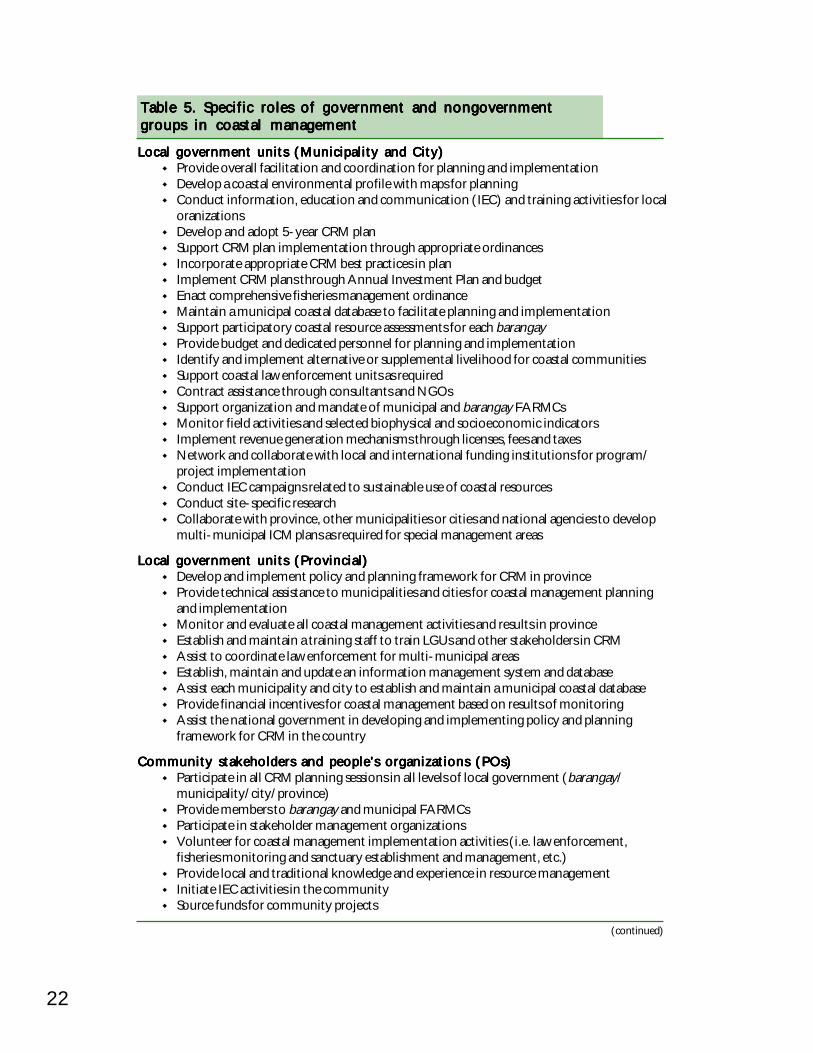
22
Table 5. Specific roles of government and nongovernmentTable 5. Specific roles of government and nongovernmentTable 5. Specific roles of government and nongovernmentTable 5. Specific roles of government and nongovernmentTable 5. Specific roles of government and nongovernmentgroups in coastal managementgroups in coastal managementgroups in coastal managementgroups in coastal managementgroups in coastal management
Local government units (Municipality and City)Local government units (Municipality and City)Local government units (Municipality and City)Local government units (Municipality and City)Local government units (Municipality and City)Provide overall facilitation and coordination for planning and implementationDevelop a coastal environmental profile with maps for planningConduct information, education and communication (IEC) and training activities for localoranizationsDevelop and adopt 5-year CRM planSupport CRM plan implementation through appropriate ordinancesIncorporate appropriate CRM best practices in planImplement CRM plans through Annual Investment Plan and budgetEnact comprehensive fisheries management ordinanceMaintain a municipal coastal database to facilitate planning and implementationSupport participatory coastal resource assessments for each barangayProvide budget and dedicated personnel for planning and implementationIdentify and implement alternative or supplemental livelihood for coastal communitiesSupport coastal law enforcement units as requiredContract assistance through consultants and NGOsSupport organization and mandate of municipal and barangay FARMCsMonitor field activities and selected biophysical and socioeconomic indicatorsImplement revenue generation mechanisms through licenses, fees and taxesNetwork and collaborate with local and international funding institutions for program/project implementationConduct IEC campaigns related to sustainable use of coastal resourcesConduct site-specific researchCollaborate with province, other municipalities or cities and national agencies to developmulti-municipal ICM plans as required for special management areas
Local government units (Provincial)Local government units (Provincial)Local government units (Provincial)Local government units (Provincial)Local government units (Provincial)Develop and implement policy and planning framework for CRM in provinceProvide technical assistance to municipalities and cities for coastal management planningand implementationMonitor and evaluate all coastal management activities and results in provinceEstablish and maintain a training staff to train LGUs and other stakeholders in CRMAssist to coordinate law enforcement for multi-municipal areasEstablish, maintain and update an information management system and databaseAssist each municipality and city to establish and maintain a municipal coastal databaseProvide financial incentives for coastal management based on results of monitoringAssist the national government in developing and implementing policy and planningframework for CRM in the country
Community stakeholders and people’s organizations (POs)Community stakeholders and people’s organizations (POs)Community stakeholders and people’s organizations (POs)Community stakeholders and people’s organizations (POs)Community stakeholders and people’s organizations (POs)Participate in all CRM planning sessions in all levels of local government (barangay/municipality/city/province)Provide members to barangay and municipal FARMCsParticipate in stakeholder management organizationsVolunteer for coastal management implementation activities (i.e. law enforcement,fisheries monitoring and sanctuary establishment and management, etc.)Provide local and traditional knowledge and experience in resource managementInitiate IEC activities in the communitySource funds for community projects
(continued)
23Integrated Coastal Management: Context for Tourism PlanningIntegrated Coastal Management: Context for Tourism PlanningIntegrated Coastal Management: Context for Tourism PlanningIntegrated Coastal Management: Context for Tourism PlanningIntegrated Coastal Management: Context for Tourism Planning
Table 5. (continued)Table 5. (continued)Table 5. (continued)Table 5. (continued)Table 5. (continued)
(continued)
Local government units (Local government units (Local government units (Local government units (Local government units (barangaybarangaybarangaybarangaybarangay)))))Data gathering and profilingCollaborative planning, implementation and gathering of informationParticipation in FARMC, Bantay Dagat and other organizationsFormulation of resolutions on CRM and enterprise for submission to municipality
Department of Environment and Natural Resources (DENR)Department of Environment and Natural Resources (DENR)Department of Environment and Natural Resources (DENR)Department of Environment and Natural Resources (DENR)Department of Environment and Natural Resources (DENR)Formulate in coordination with BFAR, a national strategic framework for CRMAssist with management of resources and areas under the mandate of DENR (e.g.mangroves, water quality, foreshore management, quarrying and protected areas)Provide material input assistance in specific projects under DENR's mandateProvide technical guidance to LGUs in coastal management planning andimplementationAssist in training of LGUs and community stakeholdersIdentify and implement alternative or supplemental livelihood for coastal communitiesCoordinate with BFAR in the sustainable management of coastal and marine resourcesMonitor and evaluate progress in achieving goals and objectives for coastal and marineresources in the Medium Term Program Development Plan
Bureau of Fisheries and Aquatic Resources (BFAR)Bureau of Fisheries and Aquatic Resources (BFAR)Bureau of Fisheries and Aquatic Resources (BFAR)Bureau of Fisheries and Aquatic Resources (BFAR)Bureau of Fisheries and Aquatic Resources (BFAR)Formulate a national fisheries management plan as a component of a national strategicframework for CRMAssist with management of resources and areas under the mandate of BFAR (e.g. fisheriesof all kinds, fishing techniques, stock assessment and aquaculture)Provide material input assistance in specific projects under BFAR's mandateProvide technical guidance in coastal management planning and implementationAssist in training of LGUs and community stakeholdersAssist in fishery enforcementCoordinate with DENR in the sustainable management of coastal and marine resourcesMonitor and evaluate progress in achieving goals and objectives for coastal and marineresources in the Medium Term Program Development Plan
Department of the Interior and Local Government (DILG)Department of the Interior and Local Government (DILG)Department of the Interior and Local Government (DILG)Department of the Interior and Local Government (DILG)Department of the Interior and Local Government (DILG)Provide technical guidance and training to LGUs in enhancing the delivery of CRM as abasic serviceProvide operational coastal law enforcement units under the Philippine National Police(PNP) Maritime GroupProvide financial assistance in specific projects under DILG's mandateMonitor and evaluate progress in achieving the goals and objectives for coastal and marineresources in the Medium Term Program Development Plan
Department of Science and Technology (DOST)Department of Science and Technology (DOST)Department of Science and Technology (DOST)Department of Science and Technology (DOST)Department of Science and Technology (DOST)Monitor aquatic and marine research and development projectsFormulate strategies, policies, plans, programs and projects for aquatic and marine sciencetechnologyGenerate external funds
Department of Tourism (DOT)Department of Tourism (DOT)Department of Tourism (DOT)Department of Tourism (DOT)Department of Tourism (DOT)Undertake tourism planningPromote and assist tourismEstablish policies and guidelines for tourism developmentAssist tourism development to comply with Philippine laws and norms
24
Table 5. (continued)Table 5. (continued)Table 5. (continued)Table 5. (continued)Table 5. (continued)
Department of Transportation and Communication (DOTC)Department of Transportation and Communication (DOTC)Department of Transportation and Communication (DOTC)Department of Transportation and Communication (DOTC)Department of Transportation and Communication (DOTC)Formulate policies, plans and regulations involving maritime transportation through theMaritime Industry Authority (MARINA)Develop ports and harbors through the Philippine Ports Authority (PPA)Assist in the implementation of laws in the high seas and waters of the Philippines;safeguard marine resources and the environment; prevent, mitigate and control marinepollution through the Philippine Coast Guard (PCG)
Philippine Council for Aquatic and Marine Research and Development (PCAMRD)Philippine Council for Aquatic and Marine Research and Development (PCAMRD)Philippine Council for Aquatic and Marine Research and Development (PCAMRD)Philippine Council for Aquatic and Marine Research and Development (PCAMRD)Philippine Council for Aquatic and Marine Research and Development (PCAMRD)Coordinate, plan, monitor and evaluate research development activities dealing with thecountry's aquatic resourcesFacilitate and program the allocation of government funds earmarked for fisheries andaquatic resources research and development, including coastal management initiativesof academic institutionsGenerate resource-based information for the management of the country's marineresourcesAct as the government lead agency in the implementation of the National Course onIntegrated Coastal Management and the training program on ICM for LGUsMaintain the National Aquatic Resources Research and Development System and thePhilReefs, the information network on coral reefs and related ecosystems
Nongovernment organizationsNongovernment organizationsNongovernment organizationsNongovernment organizationsNongovernment organizationsProvide assistance at the community and barangay level to organize FARMCs andother resource management organizationsProvide technical services to LGUs for implementing community level interventionsProvide information and education services at the community and municipal levelProvide legal services for environmental and fisheries law enforcementAssist in monitoring of biophysical and socioeconomic indicatorsProvide a conduit for financial assistance to LGUs for coastal management
Academic institutionsAcademic institutionsAcademic institutionsAcademic institutionsAcademic institutionsAssist in analyzing information for coastal environmental profilesAssist in designing and implementing a monitoring program for biophysical,socioeconomic and legal-institutional indicators in CRM for LGUsAssist in integrating existing data and information into ICM plansAssist in formulating CRM plans and packaging of project proposalsAssist in designing and maintaining a management information system and databasefor coastal managementAssist in designing coastal management projects for multi-municipal managementareasAssist in training LGUs and communitiesAssist in designing IEC and community development programs and strategies for LGUs,NGOs and POs
Donors (national and international)Donors (national and international)Donors (national and international)Donors (national and international)Donors (national and international)Provide financial assistance to national and local governments for CRM projectsProvide financial assistance for building sustainability in CRM through technicalassistance in program design, policy planning and implementation, training, education,monitoring and other aspects of coastal management programsAssist in coordinating multisectoral collaboration and policy support for CRMProvide international experience in coastal management policy and implementation
Source: DENR et al. 2001 (Book No. 1)
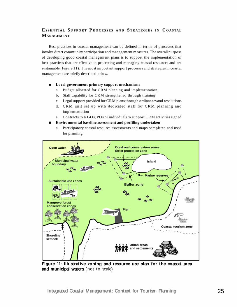
25Integrated Coastal Management: Context for Tourism PlanningIntegrated Coastal Management: Context for Tourism PlanningIntegrated Coastal Management: Context for Tourism PlanningIntegrated Coastal Management: Context for Tourism PlanningIntegrated Coastal Management: Context for Tourism Planning
ESSENTIAL SUPPORT PROCESSES AND STRATEGIES IN COASTAL
MANAGEMENT
Best practices in coastal management can be defined in terms of processes thatinvolve direct community participation and management measures. The overall purposeof developing good coastal management plans is to support the implementation ofbest practices that are effective in protecting and managing coastal resources and aresustainable (Figure 11). The most important support processes and strategies in coastalmanagement are briefly described below.
Local government primary support mechanismsa. Budget allocated for CRM planning and implementationb. Staff capability for CRM strengthened through trainingc. Legal support provided for CRM plans through ordinances and resolutionsd. CRM unit set up with dedicated staff for CRM planning and
implementatione. Contracts to NGOs, POs or individuals to support CRM activities signedEnvironmental baseline assessment and profiling undertakena. Participatory coastal resource assessments and maps completed and used
for planning
Figure 11: Illustrative zoning and resource use plan for the coastal areaFigure 11: Illustrative zoning and resource use plan for the coastal areaFigure 11: Illustrative zoning and resource use plan for the coastal areaFigure 11: Illustrative zoning and resource use plan for the coastal areaFigure 11: Illustrative zoning and resource use plan for the coastal areaand municipal waters and municipal waters and municipal waters and municipal waters and municipal waters (not to scale)
Sustainable use zones
Mangrove forestconservation zones
Municipal waterboundary
Buffer zone
Coral reef conservation zonesStrict protection zone
Urban areasand settlements
Pier
Coastal tourism zone
Island
Shorelinesetback
Open water
Marine reserves
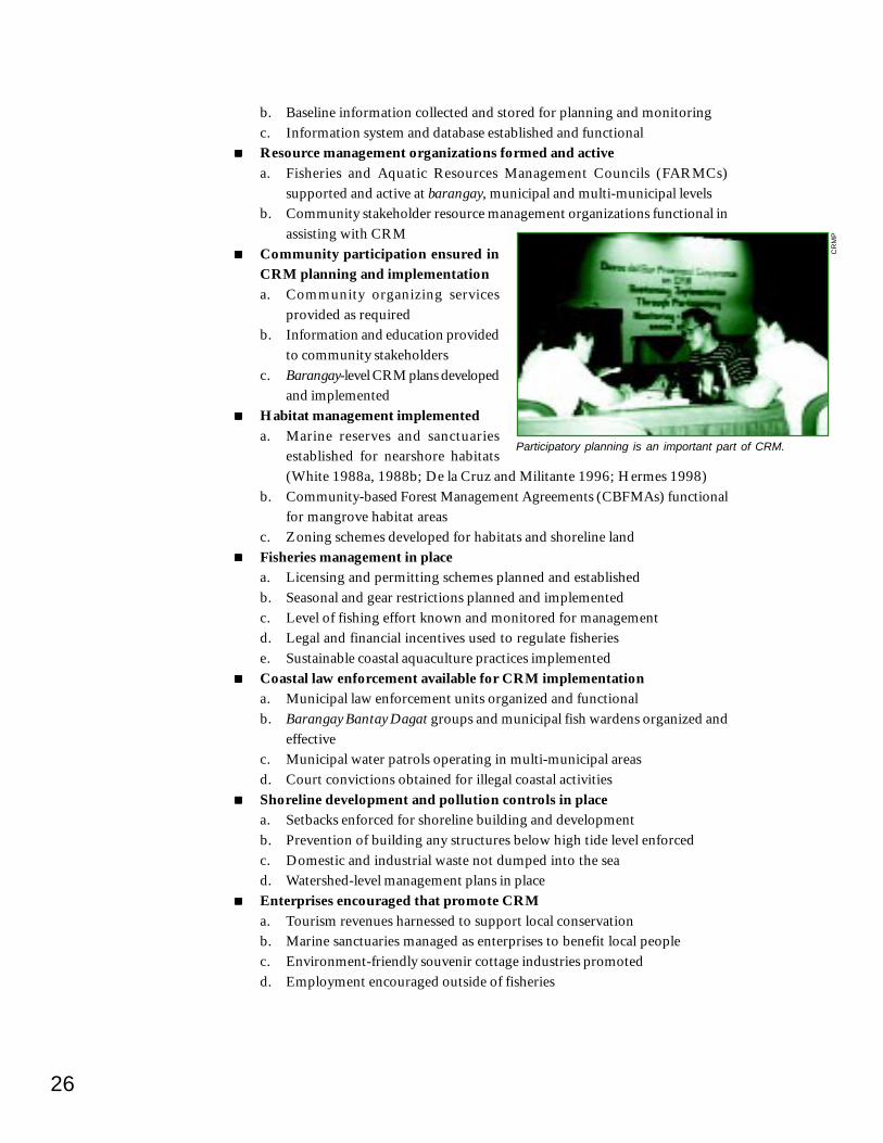
26
b. Baseline information collected and stored for planning and monitoringc. Information system and database established and functionalResource management organizations formed and activea. Fisheries and Aquatic Resources Management Councils (FARMCs)
supported and active at barangay, municipal and multi-municipal levelsb. Community stakeholder resource management organizations functional in
assisting with CRMCommunity participation ensured inCRM planning and implementationa. Community organizing services
provided as requiredb. Information and education provided
to community stakeholdersc. Barangay-level CRM plans developed
and implementedHabitat management implementeda. Marine reserves and sanctuaries
established for nearshore habitats(White 1988a, 1988b; De la Cruz and Militante 1996; Hermes 1998)
b. Community-based Forest Management Agreements (CBFMAs) functionalfor mangrove habitat areas
c. Zoning schemes developed for habitats and shoreline landFisheries management in placea. Licensing and permitting schemes planned and establishedb. Seasonal and gear restrictions planned and implementedc. Level of fishing effort known and monitored for managementd. Legal and financial incentives used to regulate fisheriese. Sustainable coastal aquaculture practices implementedCoastal law enforcement available for CRM implementationa. Municipal law enforcement units organized and functionalb. Barangay Bantay Dagat groups and municipal fish wardens organized and
effectivec. Municipal water patrols operating in multi-municipal areasd. Court convictions obtained for illegal coastal activitiesShoreline development and pollution controls in placea. Setbacks enforced for shoreline building and developmentb. Prevention of building any structures below high tide level enforcedc. Domestic and industrial waste not dumped into the sead. Watershed-level management plans in placeEnterprises encouraged that promote CRMa. Tourism revenues harnessed to support local conservationb. Marine sanctuaries managed as enterprises to benefit local peoplec. Environment-friendly souvenir cottage industries promotedd. Employment encouraged outside of fisheries
Participatory planning is an important part of CRM.
CR
MP
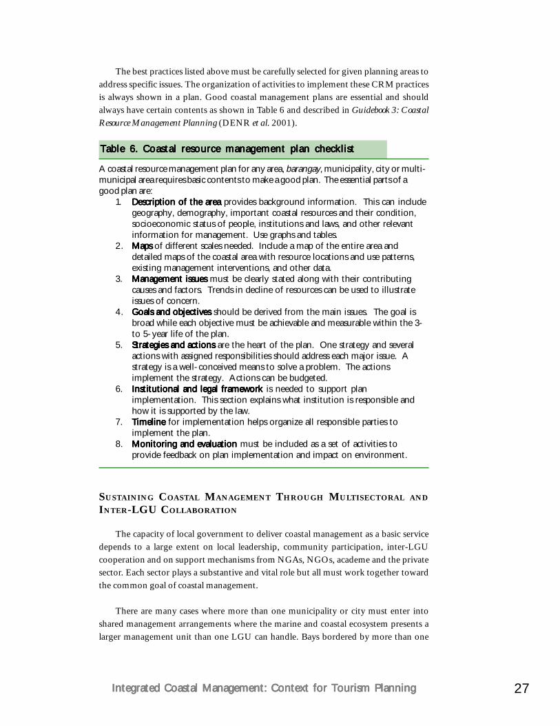
27Integrated Coastal Management: Context for Tourism PlanningIntegrated Coastal Management: Context for Tourism PlanningIntegrated Coastal Management: Context for Tourism PlanningIntegrated Coastal Management: Context for Tourism PlanningIntegrated Coastal Management: Context for Tourism Planning
The best practices listed above must be carefully selected for given planning areas toaddress specific issues. The organization of activities to implement these CRM practicesis always shown in a plan. Good coastal management plans are essential and shouldalways have certain contents as shown in Table 6 and described in Guidebook 3: CoastalResource Management Planning (DENR et al. 2001).
Table 6. Coastal resource management plan checklistTable 6. Coastal resource management plan checklistTable 6. Coastal resource management plan checklistTable 6. Coastal resource management plan checklistTable 6. Coastal resource management plan checklist
A coastal resource management plan for any area, barangay, municipality, city or multi-municipal area requires basic contents to make a good plan. The essential parts of agood plan are:
1. Description of the areaDescription of the areaDescription of the areaDescription of the areaDescription of the area provides background information. This can includegeography, demography, important coastal resources and their condition,socioeconomic status of people, institutions and laws, and other relevantinformation for management. Use graphs and tables.
2. Maps Maps Maps Maps Maps of different scales needed. Include a map of the entire area anddetailed maps of the coastal area with resource locations and use patterns,existing management interventions, and other data.
3. Management issuesManagement issuesManagement issuesManagement issuesManagement issues must be clearly stated along with their contributingcauses and factors. Trends in decline of resources can be used to illustrateissues of concern.
4. Goals and objectivesGoals and objectivesGoals and objectivesGoals and objectivesGoals and objectives should be derived from the main issues. The goal isbroad while each objective must be achievable and measurable within the 3-to 5-year life of the plan.
5. Strategies and actionsStrategies and actionsStrategies and actionsStrategies and actionsStrategies and actions are the heart of the plan. One strategy and severalactions with assigned responsibilities should address each major issue. Astrategy is a well-conceived means to solve a problem. The actionsimplement the strategy. Actions can be budgeted.
6. Institutional and legal frameworkInstitutional and legal frameworkInstitutional and legal frameworkInstitutional and legal frameworkInstitutional and legal framework is needed to support planimplementation. This section explains what institution is responsible andhow it is supported by the law.
7. TimelineTimelineTimelineTimelineTimeline for implementation helps organize all responsible parties toimplement the plan.
8. Monitoring and evaluationMonitoring and evaluationMonitoring and evaluationMonitoring and evaluationMonitoring and evaluation must be included as a set of activities toprovide feedback on plan implementation and impact on environment.
SUSTAINING COASTAL MANAGEMENT THROUGH MULTISECTORAL AND
INTER-LGU COLLABORATION
The capacity of local government to deliver coastal management as a basic servicedepends to a large extent on local leadership, community participation, inter-LGUcooperation and on support mechanisms from NGAs, NGOs, academe and the privatesector. Each sector plays a substantive and vital role but all must work together towardthe common goal of coastal management.
There are many cases where more than one municipality or city must enter intoshared management arrangements where the marine and coastal ecosystem presents alarger management unit than one LGU can handle. Bays bordered by more than one
28
LGU require bay-wide management plans that are common to all concerned LGUs.Fisheries in such instances do not follow jurisdictional boundaries and must be plannedand managed with an ecosystem focus.
Coastal areas with a complex mix of management issues to resolve requiremultisectoral arrangements and plans to address the issues. Areas with industrial ortourism development concerns require plans that are developed with the participationof the appropriate national agencies, private stakeholders and the concerned LGUs.Such plans must also consider economic criteria in decision-making that value naturalcoastal resource benefits and revenues (White and Cruz-Trinidad 1998).
All multisectoral and multi-municipal planning areas require the establishmentand monitoring of baseline information and databases to measure the effectiveness ofmanagement activities. Academic institutions can play an important role in collectingand managing this baseline information. All coastal management implementationactivities can only be measured for success if monitored results are checked againstbaseline information. Because management of information is not always done efficientlyby government institutions, nongovernment institutions can assist with this importantfunction.
SUMMARY
Integrated coastal management offers a framework to plan for tourism developmentwithin a broader context than site-specific projects or resorts. Coastal areas in thePhilippines are beset with many types of development all of which add up to negativeimpacts on the coastal environment. Unless planning is done at a scale that encompassesa stretch of coastline and addresses various types of activities, any tourism site will sufferas seen in most coastal areas. ICM can help municipalities and cities plan for developmentthrough a process that involves all stakeholders, brings technical solutions and looks tothe future.
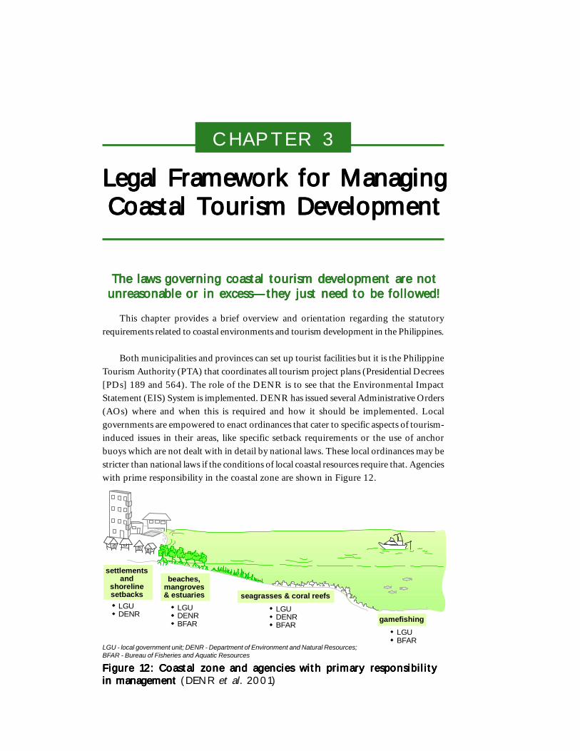
CHAPTER 3
Legal Framework for ManagingLegal Framework for ManagingLegal Framework for ManagingLegal Framework for ManagingLegal Framework for ManagingCoastal Tourism DevelopmentCoastal Tourism DevelopmentCoastal Tourism DevelopmentCoastal Tourism DevelopmentCoastal Tourism Development
The laws governing coastal tourism development are notThe laws governing coastal tourism development are notThe laws governing coastal tourism development are notThe laws governing coastal tourism development are notThe laws governing coastal tourism development are notunreasonable or in excess—they just need to be followed!unreasonable or in excess—they just need to be followed!unreasonable or in excess—they just need to be followed!unreasonable or in excess—they just need to be followed!unreasonable or in excess—they just need to be followed!
This chapter provides a brief overview and orientation regarding the statutoryrequirements related to coastal environments and tourism development in the Philippines.
Both municipalities and provinces can set up tourist facilities but it is the PhilippineTourism Authority (PTA) that coordinates all tourism project plans (Presidential Decrees[PDs] 189 and 564). The role of the DENR is to see that the Environmental ImpactStatement (EIS) System is implemented. DENR has issued several Administrative Orders(AOs) where and when this is required and how it should be implemented. Localgovernments are empowered to enact ordinances that cater to specific aspects of tourism-induced issues in their areas, like specific setback requirements or the use of anchorbuoys which are not dealt with in detail by national laws. These local ordinances may bestricter than national laws if the conditions of local coastal resources require that. Agencieswith prime responsibility in the coastal zone are shown in Figure 12.
Figure 12: Coastal zone and agencies with primary responsibilityFigure 12: Coastal zone and agencies with primary responsibilityFigure 12: Coastal zone and agencies with primary responsibilityFigure 12: Coastal zone and agencies with primary responsibilityFigure 12: Coastal zone and agencies with primary responsibilityin management in management in management in management in management (DENR et al. 2001)
LGU - local government unit; DENR - Department of Environment and Natural Resources;BFAR - Bureau of Fisheries and Aquatic Resources
settlementsand
shorelinesetbacks
beaches,mangroves& estuaries seagrasses & coral reefs
gamefishingLGUDENR
LGUDENRBFAR
LGUDENRBFAR
LGUBFAR
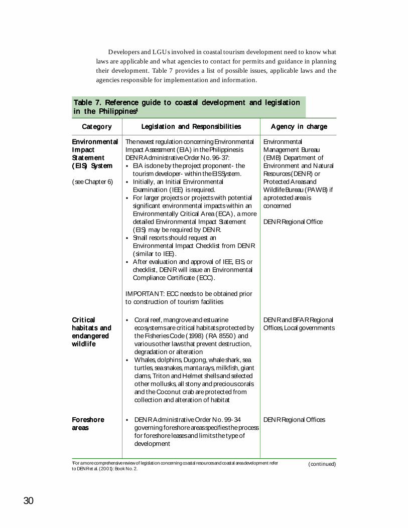
30
Developers and LGUs involved in coastal tourism development need to know whatlaws are applicable and what agencies to contact for permits and guidance in planningtheir development. Table 7 provides a list of possible issues, applicable laws and theagencies responsible for implementation and information.
Table 7. Reference guide to coastal development and legislationTable 7. Reference guide to coastal development and legislationTable 7. Reference guide to coastal development and legislationTable 7. Reference guide to coastal development and legislationTable 7. Reference guide to coastal development and legislationin the Philippinesin the Philippinesin the Philippinesin the Philippinesin the Philippines11111
CategoryCategoryCategoryCategoryCategory Legislation and ResponsibilitiesLegislation and ResponsibilitiesLegislation and ResponsibilitiesLegislation and ResponsibilitiesLegislation and Responsibilities Agency in chargeAgency in chargeAgency in chargeAgency in chargeAgency in charge
EnvironmentalEnvironmentalEnvironmentalEnvironmentalEnvironmentalImpactImpactImpactImpactImpactStatementStatementStatementStatementStatement(EIS) System(EIS) System(EIS) System(EIS) System(EIS) System
(see Chapter 6)
The newest regulation concerning EnvironmentalImpact Assessment (EIA) in the Philippines isDENR Administrative Order No. 96-37:
EIA is done by the project proponent- thetourism developer- within the EIS System.Initially, an Initial EnvironmentalExamination (IEE) is required.For larger projects or projects with potentialsignificant environmental impacts within anEnvironmentally Critical Area (ECA), a moredetailed Environmental Impact Statement(EIS) may be required by DENR.Small resorts should request anEnvironmental Impact Checklist from DENR(similar to IEE).After evaluation and approval of IEE, EIS, orchecklist, DENR will issue an EnvironmentalCompliance Certificate (ECC).
IMPORTANT: ECC needs to be obtained priorto construction of tourism facilities
EnvironmentalManagement Bureau(EMB) Department ofEnvironment and NaturalResources (DENR) orProtected Areas andWildlife Bureau (PAWB) ifa protected area isconcerned
DENR Regional Office
(continued)
CriticalCriticalCriticalCriticalCriticalhabitats andhabitats andhabitats andhabitats andhabitats andendangeredendangeredendangeredendangeredendangeredwildlifewildlifewildlifewildlifewildlife
Coral reef, mangrove and estuarineecosystems are critical habitats protected bythe Fisheries Code (1998) (RA 8550) andvarious other laws that prevent destruction,degradation or alterationWhales, dolphins, Dugong, whale shark, seaturtles, sea snakes, manta rays, milkfish, giantclams, Triton and Helmet shells and selectedother mollusks, all stony and precious coralsand the Coconut crab are protected fromcollection and alteration of habitat
DENR and BFAR RegionalOffices, Local governments
ForeshoreForeshoreForeshoreForeshoreForeshoreareasareasareasareasareas
DENR Administrative Order No. 99-34governing foreshore areas specifies the processfor foreshore leases and limits the type ofdevelopment
DENR Regional Offices
1For a more comprehensive review of legislation concerning coastal resources and coastal area development referto DENR et al. (2001): Book No. 2.
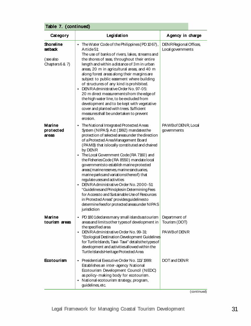
31Legal Framework for Managing Coastal Tourism DevelopmentLegal Framework for Managing Coastal Tourism DevelopmentLegal Framework for Managing Coastal Tourism DevelopmentLegal Framework for Managing Coastal Tourism DevelopmentLegal Framework for Managing Coastal Tourism Development
Table 7. (continued)Table 7. (continued)Table 7. (continued)Table 7. (continued)Table 7. (continued)
CategoryCategoryCategoryCategoryCategory LegislationLegislationLegislationLegislationLegislation Agency in chargeAgency in chargeAgency in chargeAgency in chargeAgency in charge
ShorelineShorelineShorelineShorelineShorelinesetbacksetbacksetbacksetbacksetback
(see alsoChapters 6 & 7)
The Water Code of the Philippines (PD 1067),Article 51:The use of banks of rivers, lakes, streams andthe shores of seas, throughout their entirelength and within a distance of 3 m in urbanareas, 20 m in agricultural areas, and 40 malong forest areas along their margins aresubject to public easement where buildingof structures of any kind is prohibited.DENR Administrative Order No. 97-05:20 m direct measurements from the edge ofthe high water line, to be excluded fromdevelopment and to be kept with vegetativecover and planted with trees. Sufficientmeasures shall be undertaken to preventerosion.
DENR Regional Offices,Local governments
MarineMarineMarineMarineMarineprotectedprotectedprotectedprotectedprotectedareasareasareasareasareas
The National Integrated Protected AreasSystem (NIPAS) Act (1992) mandates theprotection of selected areas under the directionof a Protected Area Management Board(PAMB) that is locally constituted and chairedby DENRThe Local Government Code (RA 7160) andthe Fisheries Code (RA 8550) mandate localgovernments to establish marine protectedareas (marine reserves, marine sanctuaries,marine parks and variations thereof) thatregulate uses and activitiesDENR Administrative Order No. 2000-51:“Guidelines and Principles in Determining Feesfor Access to and Sustainable Use of Resourcesin Protected Areas” provides guidelines todetermine fees for protected areas under NIPASjurisdiction
PAWB of DENR, Localgovernments
EcotourismEcotourismEcotourismEcotourismEcotourism Presidential Executive Order No. 111/1999:Establishes an inter-agency NationalEcotourism Development Council (NEDC)as policy-making body for ecotourism.National ecotourism strategy, program,guidelines, etc.
DOT and DENR
MarineMarineMarineMarineMarinetourism areastourism areastourism areastourism areastourism areas
PD 1801 declares many small islands as tourismareas and limits other types of development inthe specified areaDENR Administrative Order No. 99-31:“Ecological Destination Development Guidelinesfor Turtle Islands, Tawi-Tawi” details the types ofdevelopment and activities allowed within theTurtle Islands Heritage Protected Area
Department ofTourism (DOT)
PAWB of DENR
(continued)
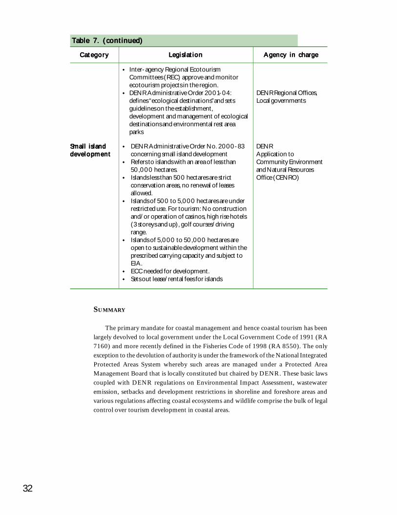
32
SUMMARY
The primary mandate for coastal management and hence coastal tourism has beenlargely devolved to local government under the Local Government Code of 1991 (RA7160) and more recently defined in the Fisheries Code of 1998 (RA 8550). The onlyexception to the devolution of authority is under the framework of the National IntegratedProtected Areas System whereby such areas are managed under a Protected AreaManagement Board that is locally constituted but chaired by DENR. These basic lawscoupled with DENR regulations on Environmental Impact Assessment, wastewateremission, setbacks and development restrictions in shoreline and foreshore areas andvarious regulations affecting coastal ecosystems and wildlife comprise the bulk of legalcontrol over tourism development in coastal areas.
Table 7. (continued)Table 7. (continued)Table 7. (continued)Table 7. (continued)Table 7. (continued)
CategoryCategoryCategoryCategoryCategory LegislationLegislationLegislationLegislationLegislation Agency in chargeAgency in chargeAgency in chargeAgency in chargeAgency in charge
Small islandSmall islandSmall islandSmall islandSmall islanddevelopmentdevelopmentdevelopmentdevelopmentdevelopment
DENR Administrative Order No. 2000-83concerning small island developmentRefers to islands with an area of less than50,000 hectares.Islands less than 500 hectares are strictconservation areas, no renewal of leasesallowed.Islands of 500 to 5,000 hectares are underrestricted use. For tourism: No constructionand/or operation of casinos, high rise hotels(3 storeys and up), golf courses/drivingrange.Islands of 5,000 to 50,000 hectares areopen to sustainable development within theprescribed carrying capacity and subject toEIA.ECC needed for development.Sets out lease/rental fees for islands
DENRApplication toCommunity Environmentand Natural ResourcesOffice (CENRO)
Inter-agency Regional EcotourismCommittees (REC) approve and monitorecotourism projects in the region.DENR Administrative Order 2001-04:defines “ecological destinations”and setsguidelines on the establishment,development and management of ecologicaldestinations and environmental rest areaparks
DENR Regional Offices,Local governments
CHAPTER 4
Planning for SustainablePlanning for SustainablePlanning for SustainablePlanning for SustainablePlanning for SustainableTourismTourismTourismTourismTourism
If we had been paid 50 cents for every wordIf we had been paid 50 cents for every wordIf we had been paid 50 cents for every wordIf we had been paid 50 cents for every wordIf we had been paid 50 cents for every wordthat has been written on sustainablethat has been written on sustainablethat has been written on sustainablethat has been written on sustainablethat has been written on sustainabledevelopment, we would be wealthy.development, we would be wealthy.development, we would be wealthy.development, we would be wealthy.development, we would be wealthy.
If we had been paid 50 cents for every actionIf we had been paid 50 cents for every actionIf we had been paid 50 cents for every actionIf we had been paid 50 cents for every actionIf we had been paid 50 cents for every actiontaken, we would be paupers.taken, we would be paupers.taken, we would be paupers.taken, we would be paupers.taken, we would be paupers.
WHAT IS SUSTAINABLE TOURISM?
International institutions have started to formulate strategies and principles forsustainable tourism development in parallel with the Department of Tourism in thePhilippines. The planning tools of determining “carrying capacity” and the “limits ofacceptable change” are increasingly being used along with “integrated master planning”described in this chapter. Stepping-stones in the growing worldwide awareness forsustainable tourism are the World Conference on Sustainable Tourism, Lanzarote, CanaryIslands, Spain (1995), the International Conference of Environment Ministers onBiodiversity and Tourism, Berlin, Germany (1997) and the Manila Declaration on theSocial Impact of Tourism, Manila, Philippines (1997).
The following points are important principles on the route to sustainable tourism:Tourism should integrate the natural, cultural and human environments. Itmust respect the fragile balances that characterize many tourist destinationsthrough analysis of carrying capacity in particular for small islands andenvironmentally sensitive areas.Tourism must consider its effects on cultural heritage and traditional elements,activities and dynamics of each local community. These elements must at alltimes play a central role in the formulation of tourism strategies, particularlyin developing countries.
34
SUSTAINABLE TOURISM FRAMEWORK
Sustainable development means the solidarity, mutual respect and participationof all players implicated in the process, especially those indigenous to the locality.This must be based on efficient cooperation mechanisms at all levels: local,national, regional and international.Government should promote actions for integrating the planning of tourismwith environmental NGOs and local communities.Measures must be developed to permit a more equitable distribution of thebenefits and burdens of tourism. This implies a change in consumption patternsand the introduction of resource users fees.Environmentally and culturally vulnerable spaces, both now and in the future,shall be given special priority in the matter of technical cooperation andfinancial aid for sustainable tourism development. Similarly, special treatmentshould be given to spaces that have been degraded by obsolete and high-impact tourism models.There is a need to support and promote feasibility studies, vigorous scientificfield-work, tourism demonstration projects within the framework ofsustainable development, the development of programs in the field ofinternational cooperation, and the introduction of environmental managementsystems.Attention should be given to the role and environmental effects oftransportation in tourism, and economic instruments should be developedand implemented to reduce the use of non-renewable energy.
The National Ecotourism Development Council of the Philippines has formulated apolicy statement to guide tourism development in the Philippines. The summary of thispolicy is quoted below.
In the beginning of life and it will be until the end, people are united with nature.This is the beninning triad of TIME, PEOPLE, and NATURE, the integrity of creation.Drawing from the Filipinos’ mythical past of Malakas and Maganda or the biblical storyof Adam and Eve, it is second nature to the Filipino to see the other person as a “fellowhuman being” (kapwa-tao). Hence, the concept of equality and partnership is nothingnew to the Filipino. This is the concept that is at the heart of sustainable tourism in thePhilippines.
Because of this unity with nature and this concept of equality and partnership,every family and community can be one in owning up the accountability to be stewardsof the future:
as a way of giving glory to the Creator,as a way of valuing human life and the legacy of our forefathers, andout of respect for the dignity of the human person.
(continued)
35Planning for Sustainable TourismPlanning for Sustainable TourismPlanning for Sustainable TourismPlanning for Sustainable TourismPlanning for Sustainable Tourism
(Sustainable... continued)
This heart of gold in every Filipino, in every family and community is the soul ofPhilippine tourism. This is the driving force that will give life to and propel tourism.This is the ideal of motivation for sustainable tourism.
In pushing tourism forward, due consideration and diligence is given to the character,way of life, and ecology of every destination in the Philippines and also the needs of theworld in the future. And priority is given to total human development. Character, way oflife, and ecology of the Filipino are the building blocks or the main ingredients indeveloping tourism products appropriate for the destination —
About people, there’s cultural, heritage, pilgrimage, and historical tourism.About ecology, there’s ecotourism, environmental or nature tourism, adventure
tourism and the indigenous peoples’ link to nature or ethnic tourism.About people’s way of life, there’s rural, business & leisure, sports and health tourism.
The aspirations of every person, family and community are the very same goals oftourism in the Philippines: produce better yields, have a better place to live in, and be abetter person and have a better family life.
So the efforts that will be put in by the present generation will be worthwhile andbeneficial and will safeguard the welfare of the future generations, it is right and just tohave a system that will monitor the effects of collective action. And Philippine Agenda21 has identified six barometers: socio-cultural, economic, ecological, technological,institutional, and political viability.
Peace is the foundation and the essential ingredient of attractive tourism. Tourismpromotes international and cross-cultural understanding, that is why it is referred to asthe world’s peace industry.
Building on the Filipino’s value of malasakit or solicitous concern, customer focusshould be the strategy for developing and marketing a tourist destination so that it willnot only be globally competitive but more importantly through niche marketing thePhilippines can find and establish its leading edge. The rich natural and cultural heritageof the Philippines allows for diversity in travel and tourism experiences and the unifyingquality would be the innate good nature of the Filipinos. What every tourismmasterplanner or practitioner should keep topmost in their mind when thinking customerfocus is:
“IF YOU WANT TOURISTS TO FIND YOUR CITY/PROVINCE/MUNICIPALITY/BARANGAY ATTRACTIVE, THE RESIDENTS MUST FIRSTFIND IT ATTRACTIVE.”
Each community improves to reflect what the residents want for themselves and thecommunity welcomes to their “home” whoever conducts himself or herself as a personshould, and in return, the people reciprocate with graciousness and genuine hospitality.
36
(Sustainable... continued)
Every Filipino aspires for a well-ordered balanced and prosperous life — there isphysical equity (good health), intellectual equity (continually expanding learning), spiritualequity (clear sense of life’s purpose and meaningful life), psychological equity (self-esteem and positive self-concept), and financial equity (having enough money to meetthe needs for subsistence). Equity in society is a vital strategy in sustainable development.Equity in society is not just about distribution of wealth. It begins with a keen sense ofself and sustained by finding greater value and meaning in relationships. When theheart is empty, the head cannot think, and a full pocket only amplifies this emptiness.
Tourism is sustainable when it dignifies and makes people proud of it becausepeople treat each other well; it satisfies the customer because there is a lot of caring; andit promotes well-being because it brings out the best in every Filipino.
When tourism is developed, managed and promoted in this manner then it will bealive, progressive, enduring, and continually beneficial because an EMPOWEREDSOCIETY stewards it, TOURISM DEVELOPMENT is COMMUNITY-SUSTAINED,and GOVERNMENT NURTURES the INDUSTRY to make it GLOBAL in state ofmind.
Truly sustainable tourism is the Philippines gift to the world because it lends to theBETTERMENT of the NATION, its people are imbued with a sense of nationhoodbecause of renewed SENSE OF IDENTITY, PRIDE OF PLACE, andCOMMITMENT.
PLANNING TOOL I: PHYSICAL CARRYING CAPACITY
The assessment of the physical carrying capacity in sensitive coastal environmentsis a good planning tool for sustainable tourism development. The carrying capacity isthe level of visitor use an area can accommodate with high levels of satisfaction forvisitors and few impacts on resources. The concept implies that there are limits tovisitor use. In fact, most problems related to coastal development are the result of placingtoo much stress on limited coastal resources, exceeding the carrying capacity.
A formula to estimate the tourist carrying capacity of a given area consists of dividingthe area to be used by tourists by the average individual ‘standard’ (usually in m2/person)required (Boullón 1985). This individual standard, however, is not easily arrived at, andmust be carefully defined for each particular case, since it involves at least three capacityvariables: material, psychological and ecological.
Once this average standard has been specifically determined for each particulararea, then planning can proceed with some degree of confidence knowing that a givendevelopment will not alter the environment of a site more than is acceptable. An exampleshowing how to determine the carrying capacity is given in Table 8.
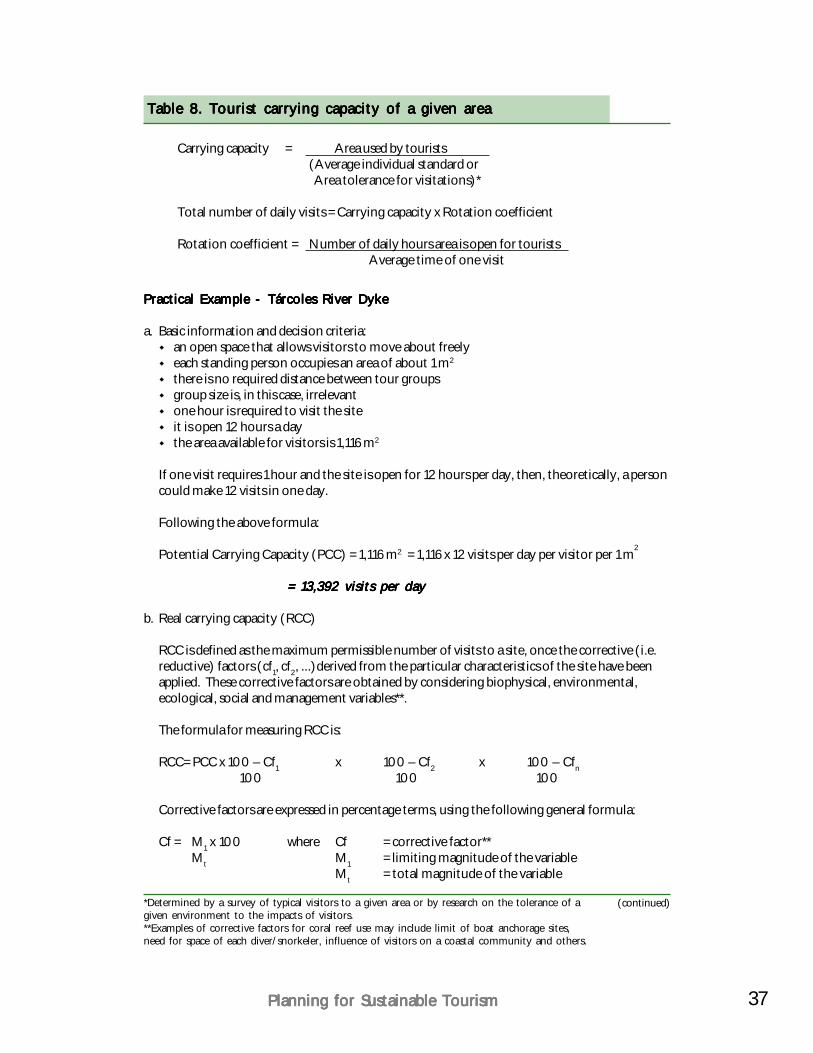
37Planning for Sustainable TourismPlanning for Sustainable TourismPlanning for Sustainable TourismPlanning for Sustainable TourismPlanning for Sustainable Tourism
Table 8. Tourist carrying capacity of a given areaTable 8. Tourist carrying capacity of a given areaTable 8. Tourist carrying capacity of a given areaTable 8. Tourist carrying capacity of a given areaTable 8. Tourist carrying capacity of a given area
(continued)
Carrying capacity = Area used by tourists(Average individual standard or Area tolerance for visitations)*
Total number of daily visits = Carrying capacity x Rotation coefficient
Rotation coefficient = Number of daily hours area is open for touristsAverage time of one visit
Practical Example - Tárcoles River DykePractical Example - Tárcoles River DykePractical Example - Tárcoles River DykePractical Example - Tárcoles River DykePractical Example - Tárcoles River Dyke
a. Basic information and decision criteria:an open space that allows visitors to move about freelyeach standing person occupies an area of about 1 m2
there is no required distance between tour groupsgroup size is, in this case, irrelevantone hour is required to visit the siteit is open 12 hours a daythe area available for visitors is 1,116 m2
If one visit requires 1 hour and the site is open for 12 hours per day, then, theoretically, a personcould make 12 visits in one day.
Following the above formula:
Potential Carrying Capacity (PCC) = 1,116 m2 = 1,116 x 12 visits per day per visitor per 1 m2
= 13,392 visits per day= 13,392 visits per day= 13,392 visits per day= 13,392 visits per day= 13,392 visits per day
b. Real carrying capacity (RCC)
RCC is defined as the maximum permissible number of visits to a site, once the corrective (i.e.reductive) factors (cf1, cf2, ...)derived from the particular characteristics of the site have beenapplied. These corrective factors are obtained by considering biophysical, environmental,ecological, social and management variables**.
The formula for measuring RCC is:
RCC= PCC x 100 – Cf1 x 100 – Cf2 x 100 – Cfn100 100 100
Corrective factors are expressed in percentage terms, using the following general formula:
Cf = M1 x 100 where Cf = corrective factor**Mt M1 = limiting magnitude of the variable
Mt = total magnitude of the variable
*Determined by a survey of typical visitors to a given area or by research on the tolerance of agiven environment to the impacts of visitors.**Examples of corrective factors for coral reef use may include limit of boat anchorage sites,need for space of each diver/snorkeler, influence of visitors on a coastal community and others.

38
Table 8. (continued)Table 8. (continued)Table 8. (continued)Table 8. (continued)Table 8. (continued)
Example: Excessive sunshine at Tárcoles River DykeExample: Excessive sunshine at Tárcoles River DykeExample: Excessive sunshine at Tárcoles River DykeExample: Excessive sunshine at Tárcoles River DykeExample: Excessive sunshine at Tárcoles River Dyke
At this site, which has no roof cover for visitors, there are normally 12 hours of sunshine eachday (06:00- 18:00). Between 10:00 and 15:00 sunshine is intense, making visits to the sitevery uncomfortable. During the rainy season, which lasts three months, rain occurs between12:00 and 18:00. Intense sunshine is accordingly reduced to the hours of 10:00-12:00.Hence, there are:
9 months without rain (dry season) = 270 sunny days per year3 rainy months = 90 rainy days per year
M1a = 270 days per year x 5 excessive sunshine hours per day = 1,350 hours of excessivesunshine per year.
M1b = 90 days per year x 2 excessive sunshine hours per day = 180 hours of excessivesunshine per year.
M1 = 1,530 total hours of excessive sunshine per year.
The total hours of available sunshine (Mt) are:Mta = 270 sunny days per year x 12 sunshine hours per day = 3,240 hours of sunshine per
year.Mtb = 90 sunny days per year x 6 sunshine hours per day = 540 hours of sunshine per year.Mt = 3,780 total hours of sunshine per year.
Cf sunshine= = 1,530 total hours of excessive sunshine per year x 100 3,780 total hours of sunshine per year
Cf sunshine= = excessive sunshine factor = 40% limitation
Example: Rainfall at Tárcoles River DykeExample: Rainfall at Tárcoles River DykeExample: Rainfall at Tárcoles River DykeExample: Rainfall at Tárcoles River DykeExample: Rainfall at Tárcoles River Dyke
We know that there are 90 rainy days per year and that rain falls between 12:00 and 18:00,hindering normal visitation during those hours.
Hence:M1 = 90 rainy days per year x 6 hours limiting rain per day = 540 hours of limiting rain peryear.Mt = total number of visiting hours per year = 360 days x 12 hours per day = 4,320 visitinghours per year.
Cf rainfall = 540 x 100 = rainy weather corrective factor = 12.5%4,320
RCC= PCC x 100 – Cf1 x 100 – Cf2 x 100 – Cfn 100 100 1 00
RCC= 13,392 x 100 – 40 x 100 – 12.5 = 13,392 x (0.59 x 0.875) = 13,392 x 0.516 100 100
The Real Carrying Capacity (RCC) for this site is 6,914 visits per day.The Real Carrying Capacity (RCC) for this site is 6,914 visits per day.The Real Carrying Capacity (RCC) for this site is 6,914 visits per day.The Real Carrying Capacity (RCC) for this site is 6,914 visits per day.The Real Carrying Capacity (RCC) for this site is 6,914 visits per day.
Source: Ceballos-Lascuráin (1991)
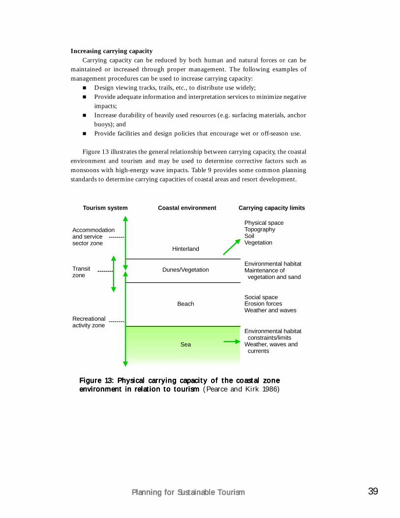
39Planning for Sustainable TourismPlanning for Sustainable TourismPlanning for Sustainable TourismPlanning for Sustainable TourismPlanning for Sustainable Tourism
Increasing carrying capacityCarrying capacity can be reduced by both human and natural forces or can be
maintained or increased through proper management. The following examples ofmanagement procedures can be used to increase carrying capacity:
Design viewing tracks, trails, etc., to distribute use widely;Provide adequate information and interpretation services to minimize negativeimpacts;Increase durability of heavily used resources (e.g. surfacing materials, anchorbuoys); andProvide facilities and design policies that encourage wet or off-season use.
Figure 13 illustrates the general relationship between carrying capacity, the coastalenvironment and tourism and may be used to determine corrective factors such asmonsoons with high-energy wave impacts. Table 9 provides some common planningstandards to determine carrying capacities of coastal areas and resort development.
Tourism system
Accommodationand servicesector zone
Physical spaceTopographySoilVegetation
Environmental habitatMaintenance of vegetation and sand
Social spaceErosion forcesWeather and waves
Environmental habitat constraints/limitsWeather, waves and currents
Transitzone
Dunes/Vegetation
Beach
Sea
Hinterland
Recreationalactivity zone
Coastal environment Carrying capacity limits
Figure 13: Physical carrying capacity of the coastal zoneFigure 13: Physical carrying capacity of the coastal zoneFigure 13: Physical carrying capacity of the coastal zoneFigure 13: Physical carrying capacity of the coastal zoneFigure 13: Physical carrying capacity of the coastal zoneenvironment in relation to tourism environment in relation to tourism environment in relation to tourism environment in relation to tourism environment in relation to tourism (Pearce and Kirk 1986)
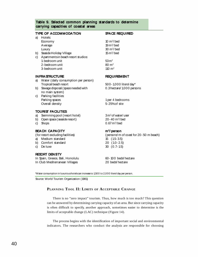
40
Source: World Tourism Organization (1981)
TYPE OF ACCOMMODATIONTYPE OF ACCOMMODATIONTYPE OF ACCOMMODATIONTYPE OF ACCOMMODATIONTYPE OF ACCOMMODATION SPACE REQUIREDSPACE REQUIREDSPACE REQUIREDSPACE REQUIREDSPACE REQUIREDa) Hotels:
Economy 10 m2/bedAverage 19 m2/bedLuxury 30 m2/bed
b) Seaside Holiday Village 15 m2/bedc) Apartments in beach resort studios:
1-bedroom unit 53 m2
2-bedroom unit 80 m2
3-bedroom unit 110 m2
INFRASTRUCTUREINFRASTRUCTUREINFRASTRUCTUREINFRASTRUCTUREINFRASTRUCTURE REQUIREMENTREQUIREMENTREQUIREMENTREQUIREMENTREQUIREMENTa) Water (daily consumption per person)
Tropical beach resort 500-1,000 liters/day*b) Sewage disposal (space needed with 0.3 hectare/1,000 persons
no main system)c) Parking facilities:
Parking spaces 1 per 4 bedroomsOverall density 5-25% of site
TOURIST FACILITIESTOURIST FACILITIESTOURIST FACILITIESTOURIST FACILITIESTOURIST FACILITIESa) Swimming pool (resort hotel) 3 m2 of water/userb) Open space (seaside resort) 20-40 m2/bedc) Shops 0.67 m2/bed
BEACH CAPACITYBEACH CAPACITYBEACH CAPACITYBEACH CAPACITYBEACH CAPACITY mmmmm22222/person/person/person/person/person(for resort excluding facilities) (persons/m of coast for 20-50 m beach)a) Medium standard 15 (1.5-3.5)b) Comfort standard 20 (1.0-2.5)c) De luxe 30 (0.7-1.5)
RESORT DENSITYRESORT DENSITYRESORT DENSITYRESORT DENSITYRESORT DENSITYIn Spain, Greece, Bali, Honolulu 60-100 beds/hectareIn Club Mediterranean Villages 20 beds/hectare
*Water consumption in luxurious hotels can increase to 1,500 to 2,000 liters/day per person.
PLANNING TOOL II: LIMITS OF ACCEPTABLE CHANGE
There is no “zero impact” tourism. Thus, how much is too much? This questioncan be answered by determining carrying capacity of an area. But since carrying capacityis often difficult to specify, another approach, sometimes easier to determine is thelimits of acceptable change (LAC) technique (Figure 14).
The process begins with the identification of important social and environmentalindicators. The researchers who conduct the analysis are responsible for choosing
Table 9. Selected common planning standards to determineTable 9. Selected common planning standards to determineTable 9. Selected common planning standards to determineTable 9. Selected common planning standards to determineTable 9. Selected common planning standards to determinecarrying capacities of coastal areascarrying capacities of coastal areascarrying capacities of coastal areascarrying capacities of coastal areascarrying capacities of coastal areas
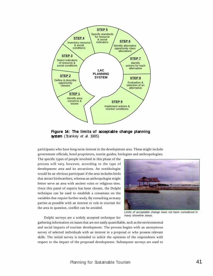
41Planning for Sustainable TourismPlanning for Sustainable TourismPlanning for Sustainable TourismPlanning for Sustainable TourismPlanning for Sustainable Tourism
participants who have long-term interest in the development area. These might includegovernment officials, hotel proprietors, tourist guides, biologists and anthropologists.The specific types of people involved in this phase of theprocess will vary, however, according to the type ofdevelopment area and its attractions. An ornithologistwould be an obvious participant if the area includes birdsthat attract birdwatchers, whereas an anthropologist mightbetter serve an area with ancient ruins or religious sites.Once this panel of experts has been chosen, the Delphitechnique can be used to establish a consensus on thevariables that require further study. By consulting as manyparties as possible with an interest or role in tourism forthe area in question, conflict can be avoided.
Delphi surveys are a widely accepted technique forgathering information on issues that are not easily quantifiable, such as the environmentaland social impacts of tourism development. The process begins with an anonymoussurvey of selected individuals with an interest in a proposal or who possess relevantskills. The initial survey is intended to solicit the opinions of the respondents withrespect to the impact of the proposed development. Subsequent surveys are used to
Figure 14: The limits of acceptable change planningFigure 14: The limits of acceptable change planningFigure 14: The limits of acceptable change planningFigure 14: The limits of acceptable change planningFigure 14: The limits of acceptable change planningsystem system system system system (Stankey et al. 1985)
LACPLANNING
SYSTEM
STEP 5
STEP 4STEP 6
STEP 7
STEP 8
STEP 9
STEP 3
STEP 2
STEP 1
Specify standardsfor resource
& socialindicatorsInventory resource
& socialconditions
Identify alternativeopportunity class
allocations
Identifyactions for each
alternative
Evaluation &selection of an
alternative
Implement actions &monitor conditions
Select indicatorsof resource &
social conditions
Define & describeopportunity
classes
Identify areaconcerns &
issues
Limits of acceptable change have not been considered inmany shoreline areas.
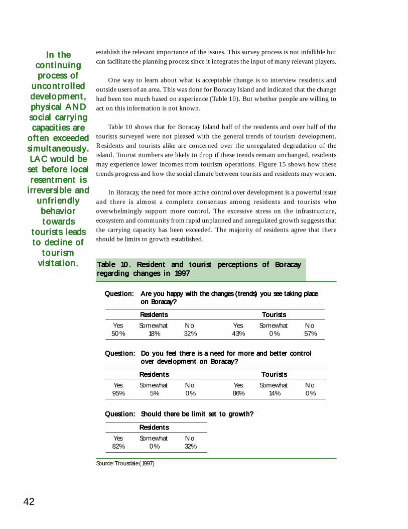
42
Table 10. Resident and tourist perceptions of BoracayTable 10. Resident and tourist perceptions of BoracayTable 10. Resident and tourist perceptions of BoracayTable 10. Resident and tourist perceptions of BoracayTable 10. Resident and tourist perceptions of Boracayregarding changes in 1997regarding changes in 1997regarding changes in 1997regarding changes in 1997regarding changes in 1997
ResidentsResidentsResidentsResidentsResidents TouristsTouristsTouristsTouristsTourists
Yes Somewhat No Yes Somewhat No50% 18% 32% 43% 0% 57%
Source: Trousdale (1997)
Question:Question:Question:Question:Question: Are you happy with the changes (trends) you see taking placeAre you happy with the changes (trends) you see taking placeAre you happy with the changes (trends) you see taking placeAre you happy with the changes (trends) you see taking placeAre you happy with the changes (trends) you see taking placeon Boracay?on Boracay?on Boracay?on Boracay?on Boracay?
ResidentsResidentsResidentsResidentsResidents TouristsTouristsTouristsTouristsTourists
Yes Somewhat No Yes Somewhat No95% 5% 0% 86% 14% 0%
Question:Question:Question:Question:Question: Do you feel there is a need for more and better controlDo you feel there is a need for more and better controlDo you feel there is a need for more and better controlDo you feel there is a need for more and better controlDo you feel there is a need for more and better controlover development on Boracay?over development on Boracay?over development on Boracay?over development on Boracay?over development on Boracay?
ResidentsResidentsResidentsResidentsResidents
Yes Somewhat No82% 0% 32%
Question:Question:Question:Question:Question: Should there be limit set to growth?Should there be limit set to growth?Should there be limit set to growth?Should there be limit set to growth?Should there be limit set to growth?
establish the relevant importance of the issues. This survey process is not infallible butcan facilitate the planning process since it integrates the input of many relevant players.
One way to learn about what is acceptable change is to interview residents andoutside users of an area. This was done for Boracay Island and indicated that the changehad been too much based on experience (Table 10). But whether people are willing toact on this information is not known.
Table 10 shows that for Boracay Island half of the residents and over half of thetourists surveyed were not pleased with the general trends of tourism development.Residents and tourists alike are concerned over the unregulated degradation of theisland. Tourist numbers are likely to drop if these trends remain unchanged, residentsmay experience lower incomes from tourism operations. Figure 15 shows how thesetrends progress and how the social climate between tourists and residents may worsen.
In Boracay, the need for more active control over development is a powerful issueand there is almost a complete consensus among residents and tourists whooverwhelmingly support more control. The excessive stress on the infrastructure,ecosystem and community from rapid unplanned and unregulated growth suggests thatthe carrying capacity has been exceeded. The majority of residents agree that thereshould be limits to growth established.
In theIn theIn theIn theIn thecontinuingcontinuingcontinuingcontinuingcontinuingprocess ofprocess ofprocess ofprocess ofprocess of
uncontrolleduncontrolleduncontrolleduncontrolleduncontrolleddevelopment,development,development,development,development,physical ANDphysical ANDphysical ANDphysical ANDphysical ANDsocial carryingsocial carryingsocial carryingsocial carryingsocial carryingcapacities arecapacities arecapacities arecapacities arecapacities are
often exceededoften exceededoften exceededoften exceededoften exceededsimultaneously.simultaneously.simultaneously.simultaneously.simultaneously.LAC would beLAC would beLAC would beLAC would beLAC would be
set before localset before localset before localset before localset before localresentment isresentment isresentment isresentment isresentment is
irreversible andirreversible andirreversible andirreversible andirreversible andunfriendlyunfriendlyunfriendlyunfriendlyunfriendlybehaviorbehaviorbehaviorbehaviorbehaviortowardstowardstowardstowardstowards
tourists leadstourists leadstourists leadstourists leadstourists leadsto decline ofto decline ofto decline ofto decline ofto decline of
tourismtourismtourismtourismtourismvisitation.visitation.visitation.visitation.visitation.
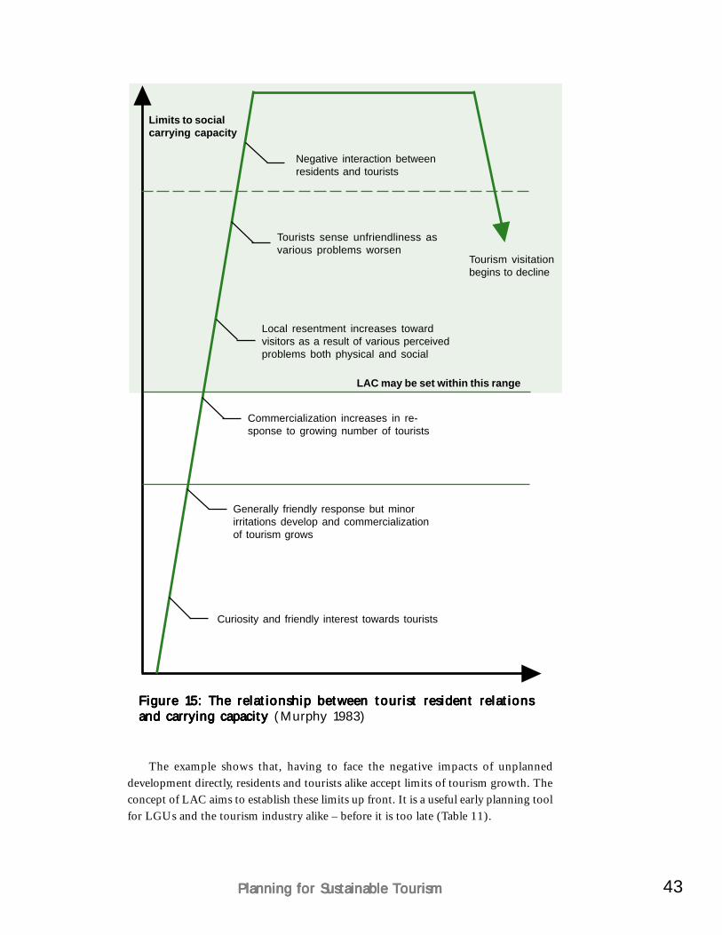
43Planning for Sustainable TourismPlanning for Sustainable TourismPlanning for Sustainable TourismPlanning for Sustainable TourismPlanning for Sustainable Tourism
The example shows that, having to face the negative impacts of unplanneddevelopment directly, residents and tourists alike accept limits of tourism growth. Theconcept of LAC aims to establish these limits up front. It is a useful early planning toolfor LGUs and the tourism industry alike – before it is too late (Table 11).
Figure 15: The relationship between tourist resident relationsFigure 15: The relationship between tourist resident relationsFigure 15: The relationship between tourist resident relationsFigure 15: The relationship between tourist resident relationsFigure 15: The relationship between tourist resident relationsand carrying capacity and carrying capacity and carrying capacity and carrying capacity and carrying capacity (Murphy 1983)
Limits to socialcarrying capacity
Negative interaction betweenresidents and tourists
Tourists sense unfriendliness asvarious problems worsen
Local resentment increases towardvisitors as a result of various perceivedproblems both physical and social
Commercialization increases in re-sponse to growing number of tourists
Generally friendly response but minorirritations develop and commercializationof tourism grows
Curiosity and friendly interest towards tourists
Tourism visitationbegins to decline
LAC may be set within this range
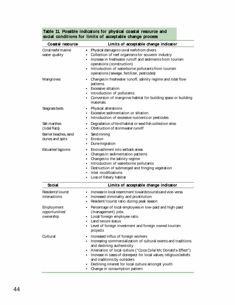
44
Table 11. Possible indicators for physical coastal resource andTable 11. Possible indicators for physical coastal resource andTable 11. Possible indicators for physical coastal resource andTable 11. Possible indicators for physical coastal resource andTable 11. Possible indicators for physical coastal resource andsocial conditions for limits of acceptable change processsocial conditions for limits of acceptable change processsocial conditions for limits of acceptable change processsocial conditions for limits of acceptable change processsocial conditions for limits of acceptable change process
Coastal resourceCoastal resourceCoastal resourceCoastal resourceCoastal resource Limits of acceptable change indicatorLimits of acceptable change indicatorLimits of acceptable change indicatorLimits of acceptable change indicatorLimits of acceptable change indicatorCoral reefs/marine Physical damage to coral reefs from diverswater quality Collection of reef organisms for souvenir industry
Increase in freshwater runoff and sediments from tourismoperations (construction)Introduction of waterborne pollutants from tourismoperations (sewage, fertilizer, pesticides)
Mangroves Changes in freshwater runoff, salinity regime and tidal flowpatternsExcessive siltationIntroduction of pollutantsConversion of mangrove habitat for building space or buildingmaterials
Seagrass beds Physical alterationsExcessive sedimentation or siltationIntroduction of excessive nutrients or pesticides
Salt marshes Degradation of bird habitat or seed fish collection sites(tidal flats) Obstruction of stormwater runoffBarrier beaches, sand Sand miningdunes and spits Erosion
Dune migrationEstuaries/lagoons Encroachment into setback areas
Changes in sedimentation patternsChanges to the salinity regimeIntroduction of waterborne pollutantsDestruction of submerged and fringing vegetationInlet modificationsLoss of fishery habitat
SocialSocialSocialSocialSocial Limits of acceptable change indicatorLimits of acceptable change indicatorLimits of acceptable change indicatorLimits of acceptable change indicatorLimits of acceptable change indicator
Residents/tourist Increase in local resentment towards tourists and vice-versainteractions Increased criminality and prostitution
Resident/tourist ratio during peak seasonEmployment Percentage of local employees in low-paid and high-paidopportunities/ (management) jobsownership Local/foreign employee ratio
Land tenure statusLevel of foreign investment and foreign owned tourismprojects
Cultural Increased influx of foreign workersIncreasing commercialization of cultural events and traditionsand declining authenticityAlienation of local culture (“Coca Cola/Mc Donald’s-Effect”)Increase in cases of disrespect for local values, religious beliefsand traditions by outsidersDeclining interest for local culture amongst youthChange in consumption pattern
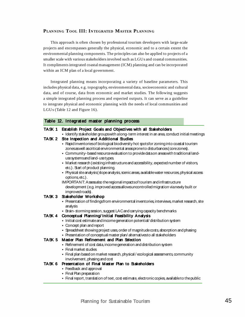
45Planning for Sustainable TourismPlanning for Sustainable TourismPlanning for Sustainable TourismPlanning for Sustainable TourismPlanning for Sustainable Tourism
PLANNING TOOL III: INTEGRATED MASTER PLANNING
This approach is often chosen by professional tourism developers with large-scaleprojects and encompasses generally the physical, economic and to a certain extent theenvironmental planning components. The principles can also be applied to projects of asmaller scale with various stakeholders involved such as LGUs and coastal communities.It compliments integrated coastal management (ICM) planning and can be incorporatedwithin an ICM plan of a local government.
Integrated planning means incorporating a variety of baseline parameters. Thisincludes physical data, e.g. topography, environmental data, socioeconomic and culturaldata, and of course, data from economic and market studies. The following suggestsa simple integrated planning process and expected outputs. It can serve as a guidelineto integrate physical and economic planning with the needs of local communities andLGUs (Table 12 and Figure 16).
Table 12. Integrated master planning processTable 12. Integrated master planning processTable 12. Integrated master planning processTable 12. Integrated master planning processTable 12. Integrated master planning process
TASK 1TASK 1TASK 1TASK 1TASK 1 Establish Project Goals and Objectives with all StakeholdersEstablish Project Goals and Objectives with all StakeholdersEstablish Project Goals and Objectives with all StakeholdersEstablish Project Goals and Objectives with all StakeholdersEstablish Project Goals and Objectives with all StakeholdersIdentify stakeholder groups with a long-term interest in an area, conduct initial meetings
TASK 2TASK 2TASK 2TASK 2TASK 2 Site Inspection and Additional StudiesSite Inspection and Additional StudiesSite Inspection and Additional StudiesSite Inspection and Additional StudiesSite Inspection and Additional StudiesRapid inventories of biological biodiversity hot spots for zoning into coastal tourismzones as well as critical environmental areas prone to disturbances (core zones).Community-based resource evaluation to provide data on areas with traditional land-use systems and land-use types.Market research (existing infrastructure and accessibility, expected number of visitors,etc.). Start of product planning.Physical site analysis (slope analysis, scenic areas, available water resources, physical accessoptions, etc.).
IMPORTANT: Assess also the regional impacts of tourism and infrastructuredevelopment (e.g. improved access allows uncontrolled migration via newly built orimproved roads).
TASK 3TASK 3TASK 3TASK 3TASK 3 Stakeholder WorkshopStakeholder WorkshopStakeholder WorkshopStakeholder WorkshopStakeholder WorkshopPresentation of findings from environmental inventories, interviews, market research, siteanalysisBrain-storming session, suggest LAC and carrying capacity benchmarks
TASK 4TASK 4TASK 4TASK 4TASK 4 Conceptual Planning/Initial Feasibility AnalysisConceptual Planning/Initial Feasibility AnalysisConceptual Planning/Initial Feasibility AnalysisConceptual Planning/Initial Feasibility AnalysisConceptual Planning/Initial Feasibility AnalysisInitial cost estimate and income generation potential/distribution systemConcept plan and reportSpreadsheet showing project uses, order of magnitude costs, absorption and phasingPresentation of conceptual master plan/alternatives to all stakeholders
TASK 5TASK 5TASK 5TASK 5TASK 5 Master Plan Refinement and Plan SelectionMaster Plan Refinement and Plan SelectionMaster Plan Refinement and Plan SelectionMaster Plan Refinement and Plan SelectionMaster Plan Refinement and Plan SelectionRefinement of cost data, income generation and distribution systemFinal market studiesFinal plan based on market research, physical /ecological assessments, communityinvolvement, phasing and cost
TASK 6TASK 6TASK 6TASK 6TASK 6 Presentation of Final Master Plan to StakeholdersPresentation of Final Master Plan to StakeholdersPresentation of Final Master Plan to StakeholdersPresentation of Final Master Plan to StakeholdersPresentation of Final Master Plan to StakeholdersFeedback and approvalFinal Plan preparationFinal report, translation of text, cost estimate, electronic copies, available to the public
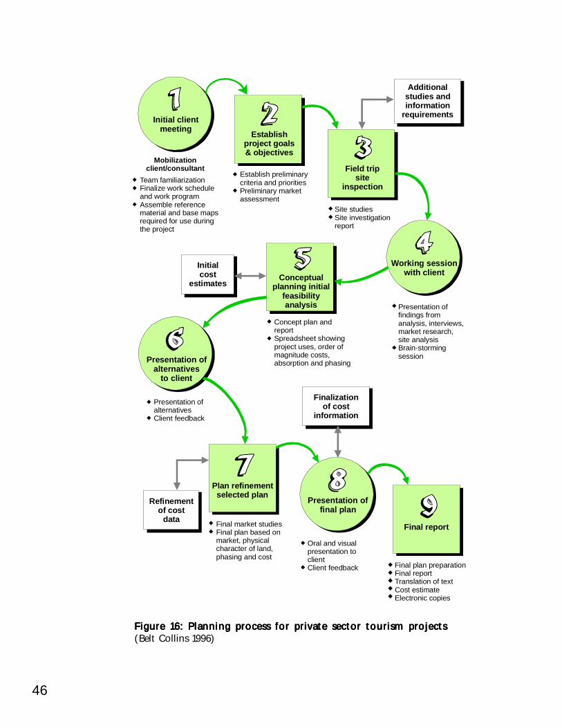
46
Figure 16: Planning process for private sector tourism projectsFigure 16: Planning process for private sector tourism projectsFigure 16: Planning process for private sector tourism projectsFigure 16: Planning process for private sector tourism projectsFigure 16: Planning process for private sector tourism projects(Belt Collins 1996)
Initial clientmeeting
Working sessionwith client
Presentation ofalternatives
to client
Presentation offinal plan
Mobilizationclient/consultant
Establishproject goals& objectives
Field tripsite
inspection
Additionalstudies andinformation
requirements
Initialcost
estimates
Finalizationof cost
information
Refinementof cost
data
Conceptualplanning initial
feasibilityanalysis
Plan refinementselected plan
Final report
Establish preliminarycriteria and prioritiesPreliminary marketassessment
Site studiesSite investigationreport
Concept plan andreportSpreadsheet showingproject uses, order ofmagnitude costs,absorption and phasing
Presentation ofalternativesClient feedback
Final market studiesFinal plan based onmarket, physicalcharacter of land,phasing and cost
Oral and visualpresentation toclientClient feedback Final plan preparation
Final reportTranslation of textCost estimateElectronic copies
Presentation offindings fromanalysis, interviews,market research,site analysisBrain-stormingsession
Team familiarizationFinalize work scheduleand work programAssemble referencematerial and base mapsrequired for use duringthe project
47Planning for Sustainable TourismPlanning for Sustainable TourismPlanning for Sustainable TourismPlanning for Sustainable TourismPlanning for Sustainable Tourism
CASE STUDY:PROVINCIAL AND MUNICIPAL PLANNING IN PALAWAN
CASE STUDY: PALAWAN
Palawan Province is proactive in trying to present unsustainable coastal development.The case study that follows exhibits some of planning processes with development principleshighlighted in this chapter.
Among all Philippine provinces, Palawan stands out environmentally because of itsstatus as a major repository of biological diversity as well as an ecologically sensitivearea. This reputation has given rise to a unique law called the Strategic EnvironmentalPlan (SEP) for Palawan. The centerpiece of the SEP law is the creation of anEnvironmentally Critical Areas Network (ECAN), basically a zoning system that divideseach of the province’s 23 towns and the capital city into core zones, buffer zones, andmultiple-use zones (with a tourism development component). Core zones are restrictedareas, such as national parks, marine reserves and higher elevations that require maximumprotection and minimal human intrusion. These core zones are surrounded by bufferzones, which are meant to shield the inner areas from economic activities. The lowerelevations and generally more developed areas are designated as multiple-use zones,where most town sites and settlements are found.
Under the SEP law, equitable access to resources is emphasized and local communitymanagement is encouraged. Ecological viability and social acceptability of developmentprojects are given importance. The Palawan Council for Sustainable Development (PCSD)was created to implement the law. To decentralize decision-making, ECAN boards aresupposed to be organized in each municipality with members from LGUs, tribal groupsand NGOs.
The underlying philosophy is to provide equitable access to the resources and toassign responsibility for their management to the LGU and the community. Palawan’sECAN Coastal Zone shall adopt the concept of marine parks and reserves, which usuallyrequires limited entry and encourages various uses with emphasis on education, recreationand preservation.
It is the policy of PCSD to support and promote the sustainable development ofPalawan through proper conservation, utilization and development of its natural resourcesto provide optimum yields on a continuing basis. It shall also promote and encouragethe involvement of all sectors of society and maximize people participation in naturalresource management, conservation and protection. PCSD also recognizes the significanceof preserving and declaring certain areas free from human intervention to maintainecological balance.
The PCSD has established a set of easy-to-implement guidelines for tourismdevelopment in coastal areas. These guidelines concerning planning and managementof tourism establishments are not too technical and can be enforced and managed byLGUs to control tourism development (Table 13).
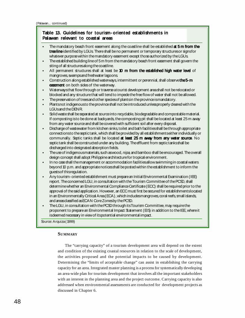
48
(Palawan... continued)
Table 13. Guidelines for tourism-oriented establishments inTable 13. Guidelines for tourism-oriented establishments inTable 13. Guidelines for tourism-oriented establishments inTable 13. Guidelines for tourism-oriented establishments inTable 13. Guidelines for tourism-oriented establishments inPalawan relevant to coastal areasPalawan relevant to coastal areasPalawan relevant to coastal areasPalawan relevant to coastal areasPalawan relevant to coastal areas
The mandatory beach front easement along the coastline shall be established at 5 m from theat 5 m from theat 5 m from theat 5 m from theat 5 m from thetree linetree linetree linetree linetree line identified by LGUs. There shall be no permanent or temporary structures or signs forwhatever purpose within the mandatory easement except those authorized by the LGUs.The established building line of 5 m from the mandatory beach front easement shall govern thesiting of all structures along the coastline.All permanent structures shall at least be 10 m from the established high water level10 m from the established high water level10 m from the established high water level10 m from the established high water level10 m from the established high water level ofmangroves, swamps and freshwater lagoons.Construction along established waterways, intermittent or perennial, shall observe the 5-mthe 5-mthe 5-mthe 5-mthe 5-measementeasementeasementeasementeasement on both sides of the waterway.Waterways that flow through or traverse a tourist development area shall not be relocated orblocked and any structure that will tend to impede the free flow of water shall not be allowed.The preservation of trees and other species of plants in the province is mandatory.Plants not indigenous to the province shall not be introduced unless properly cleared with theLGUs and the DENR.Solid waste shall be separated at source into recyclable, biodegradable and compostable material.If composting is to be done at backyards, the composting pit shall be located at least 25 m awayfrom any water source and shall be covered with sufficient soil after every disposal.Discharge of wastewater from kitchen sinks, toilet and bath facilities shall be through appropriateconnections to the septic tank, which shall be provided by all establishments either individually orcommunally. Septic tanks shall be located at least 25 m away from any water sourceat least 25 m away from any water sourceat least 25 m away from any water sourceat least 25 m away from any water sourceat least 25 m away from any water source. Noseptic tank shall be constructed under any building. The effluent from septic tanks shall bedischarged into designated absorption fields.The use of indigenous materials, such as wood, nipa, and bamboo shall be encouraged. The overalldesign concept shall adopt Philippine architecture for tropical environment.In no case shall the management or accommodation facilities allow swimming in coastal watersbeyond 10 p.m. and appropriate notices shall be posted within the establishment to inform theguests of this regulation.Any tourism-oriented establishment must prepare an Initial Environmental Examination (IEE)report. The concerned LGU, in consultation with the Tourism Committee of the PCSD, shalldetermine whether an Environmental Compliance Certificate (ECC) shall be required prior to theapproval of the said application. However, an ECC must first be secured for establishments locatedin an Environmentally Critical Area (ECA), which includes mangroves, coral reefs, small islands,and areas classified as ECAN Core Zones by the PCSD.The LGU, in consultation with the PCSD through its Tourism Committee, may require theproponent to prepare an Environmental Impact Statement (EIS) in addition to the IEE, where itis deemed necessary in view of its potential environmental impact.
Source: Arquiza (1999)
SUMMARY
The “carrying capacity” of a tourism development area will depend on the extentand condition of the existing coastal resources in relation to the scale of development,the activities proposed and the potential impacts to be caused by development.Determining the “limits of acceptable change” can assist in establishing the carryingcapacity for an area. Integrated master planning is a process for systematically developingan area-wide plan for tourism development that involves all the important stakeholderswith an interest in the planning area and the project outcome. Carrying capacity is alsoaddressed when environmental assessments are conducted for development projects asdiscussed in Chapter 6.
CHAPTER 5
Developing and Promoting anDeveloping and Promoting anDeveloping and Promoting anDeveloping and Promoting anDeveloping and Promoting anEcotourism VentureEcotourism VentureEcotourism VentureEcotourism VentureEcotourism Venture
Ecotourism as a term is overused but realEcotourism as a term is overused but realEcotourism as a term is overused but realEcotourism as a term is overused but realEcotourism as a term is overused but realecotourism can enhance environmentalecotourism can enhance environmentalecotourism can enhance environmentalecotourism can enhance environmentalecotourism can enhance environmental
conservation and provide tangible benefitsconservation and provide tangible benefitsconservation and provide tangible benefitsconservation and provide tangible benefitsconservation and provide tangible benefitsto local communities.to local communities.to local communities.to local communities.to local communities.
Product development is an essential part of any form of tourism development. Youhave to know your market to be able to offer the right tourism product. For conventionalcoastal tourism projects the developer will conduct a market analysis and feasibilitystudy prior and as part of the early planning process. Medium and small-scale coastaltourism projects should consider a similar approach to set up a successful and professionalbusiness.
Product standards and requirements for small and medium-scale projects areconsiderably different from large-scale coastal tourism developments. Small and medium-scale developers are more likely to venture into niche markets. That is why we arepresenting the product development process for a coastal ecotourism product.
The focus of this chapter is the “software” of ecotourism. This consists of the“ecotour” and other attractions visitors will experience during their stay. The “hardware”of ecotourism, e.g. boats for transportation, accommodations and restaurants is addressedin later chapters.
WHAT IS ECOTOURISM?
There is no widely agreed definition of ecotourism and much of the travel industryliterature fails to differentiate between nature-based mass tourism (such as scuba divingin general or destinations like the Galapagos Islands) and ecotourism. The InternationalEcotourism Society defines ecotourism as: “responsible travel to natural areas, which conserves
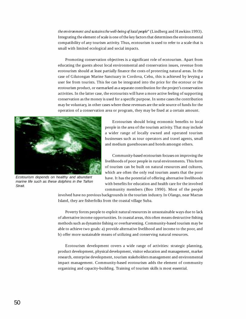
50
the environment and sustains the well-being of local people” (Lindberg and Hawkins 1993).Integrating the element of scale is one of the key factors that determines the environmentalcompatibility of any tourism activity. Thus, ecotourism is used to refer to a scale that issmall with limited ecological and social impacts.
Promoting conservation objectives is a significant role of ecotourism. Apart fromeducating the guests about local environmental and conservation issues, revenue fromecotourism should at least partially finance the costs of protecting natural areas. In thecase of Gilutongan Marine Sanctuary in Cordova, Cebu, this is achieved by levying auser fee from tourists. This fee can be integrated into the price for the ecotour or theecotourism product, or earmarked as a separate contribution for the project’s conservationactivities. In the latter case, the ecotourists will have a more active feeling of supportingconservation as the money is used for a specific purpose. In some cases the contributionmay be voluntary, in other cases where these revenues are the sole source of funds for theoperation of a conservation area or program, they may be fixed at a certain amount.
Ecotourism should bring economic benefits to localpeople in the area of the tourism activity. That may includea wider range of locally owned and operated tourismbusinesses such as tour operators and travel agents, smalland medium guesthouses and hotels amongst others.
Community-based ecotourism focuses on improving thelivelihoods of poor people in rural environments. This formof tourism can be built on natural resources and cultures,which are often the only real tourism assets that the poorhave. It has the potential of offering alternative livelihoodswith benefits for education and health care for the involvedcommunity members (Boo 1990). Most of the people
involved have no previous backgrounds in the tourism industry. In Olango, near MactanIsland, they are fisherfolks from the coastal village Suba.
Poverty forces people to exploit natural resources in unsustainable ways due to lackof alternative income opportunities. In coastal areas, this often means destructive fishingmethods such as dynamite fishing or overharvesting. Community-based tourism may beable to achieve two goals: a) provide alternative livelihood and income to the poor, andb) offer more sustainable means of utilizing and conserving natural resources.
Ecotourism development covers a wide range of activities: strategic planning,product development, physical development, visitor education and management, marketresearch, enterprise development, tourism stakeholders management and environmentalimpact management. Community-based ecotourism adds the element of communityorganizing and capacity-building. Training of tourism skills is most essential.
Ecotourism depends on healthy and abundantmarine life such as these dolphins in the TañonStrait.
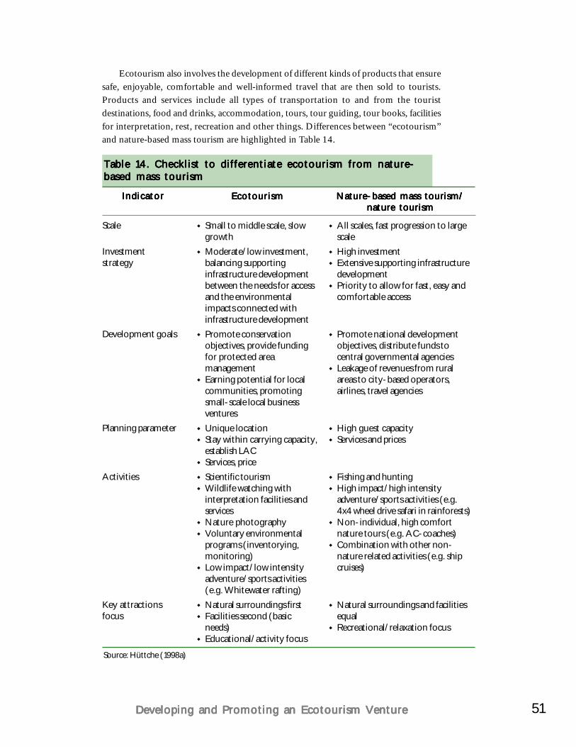
51Developing and Promoting an Ecotourism VentureDeveloping and Promoting an Ecotourism VentureDeveloping and Promoting an Ecotourism VentureDeveloping and Promoting an Ecotourism VentureDeveloping and Promoting an Ecotourism Venture
Ecotourism also involves the development of different kinds of products that ensuresafe, enjoyable, comfortable and well-informed travel that are then sold to tourists.Products and services include all types of transportation to and from the touristdestinations, food and drinks, accommodation, tours, tour guiding, tour books, facilitiesfor interpretation, rest, recreation and other things. Differences between “ecotourism”and nature-based mass tourism are highlighted in Table 14.
Table 14. Checklist to differentiate ecotourism from nature-Table 14. Checklist to differentiate ecotourism from nature-Table 14. Checklist to differentiate ecotourism from nature-Table 14. Checklist to differentiate ecotourism from nature-Table 14. Checklist to differentiate ecotourism from nature-based mass tourismbased mass tourismbased mass tourismbased mass tourismbased mass tourism
IndicatorIndicatorIndicatorIndicatorIndicator
Scale
Investmentstrategy
Development goals
Planning parameter
Activities
Key attractionsfocus
EcotourismEcotourismEcotourismEcotourismEcotourism
Small to middle scale, slowgrowthModerate/low investment,balancing supportinginfrastructure developmentbetween the needs for accessand the environmentalimpacts connected withinfrastructure developmentPromote conservationobjectives, provide fundingfor protected areamanagementEarning potential for localcommunities, promotingsmall-scale local businessventuresUnique locationStay within carrying capacity,establish LACServices, priceScientific tourismWildlife watching withinterpretation facilities andservicesNature photographyVoluntary environmentalprograms (inventorying,monitoring)Low impact/low intensityadventure/sports activities(e.g. Whitewater rafting)Natural surroundings firstFacilities second (basicneeds)Educational/activity focus
Nature-based mass tourism/Nature-based mass tourism/Nature-based mass tourism/Nature-based mass tourism/Nature-based mass tourism/nature tourismnature tourismnature tourismnature tourismnature tourism
All scales, fast progression to largescaleHigh investmentExtensive supporting infrastructuredevelopmentPriority to allow for fast, easy andcomfortable access
Promote national developmentobjectives, distribute funds tocentral governmental agenciesLeakage of revenues from ruralareas to city-based operators,airlines, travel agencies
High guest capacityServices and prices
Fishing and huntingHigh impact/high intensityadventure/sports activities (e.g.4x4 wheel drive safari in rainforests)Non-individual, high comfortnature tours (e.g. AC-coaches)Combination with other non-nature related activities (e.g. shipcruises)
Natural surroundings and facilitiesequalRecreational/relaxation focus
Source: Hüttche (1998a)
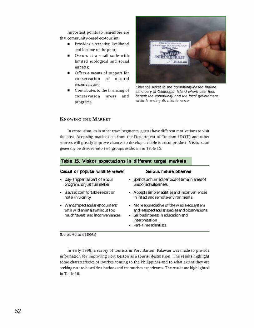
52
Important points to remember arethat community-based ecotourism:
Provides alternative livelihoodand income to the poor;Occurs at a small scale withlimited ecological and socialimpacts;Offers a means of support forconservation of naturalresources; andContributes to the financing ofconservation areas andprograms.
KNOWING THE MARKET
In ecotourism, as in other travel segments, guests have different motivations to visitthe area. Accessing market data from the Department of Tourism (DOT) and othersources will greatly improve chances to develop a viable tourism product. Visitors cangenerally be divided into two groups as shown in Table 15.
Entrance ticket to the community-based marinesanctuary at Gilutongan Island where user feesbenefit the community and the local government,while financing its maintenance.
Casual or popular wildlife viewerCasual or popular wildlife viewerCasual or popular wildlife viewerCasual or popular wildlife viewerCasual or popular wildlife viewer
Day-tripper, as part of a tourprogram, or just fun seeker
Stays at comfortable resort orhotel in vicinity
Wants “spectacular encounters”with wild animals without toomuch ‘sweat’ and inconveniences
Serious nature observerSerious nature observerSerious nature observerSerious nature observerSerious nature observer
Spends unhurried periods of time in areas ofunspoiled wilderness
Accepts simple facilities and inconveniencesin intact and remote environments
More appreciative of the whole ecosystemand less spectacular species and observationsSerious interest in education andinterpretationPart-time scientists
Source: Hüttche (1998a)
Table 15. Visitor expectations in different target marketsTable 15. Visitor expectations in different target marketsTable 15. Visitor expectations in different target marketsTable 15. Visitor expectations in different target marketsTable 15. Visitor expectations in different target markets
In early 1998, a survey of tourists in Port Barton, Palawan was made to provideinformation for improving Port Barton as a tourist destination. The results highlightsome characteristics of tourists coming to the Philippines and to what extent they areseeking nature-based destinations and ecotourism experiences. The results are highlightedin Table 16.
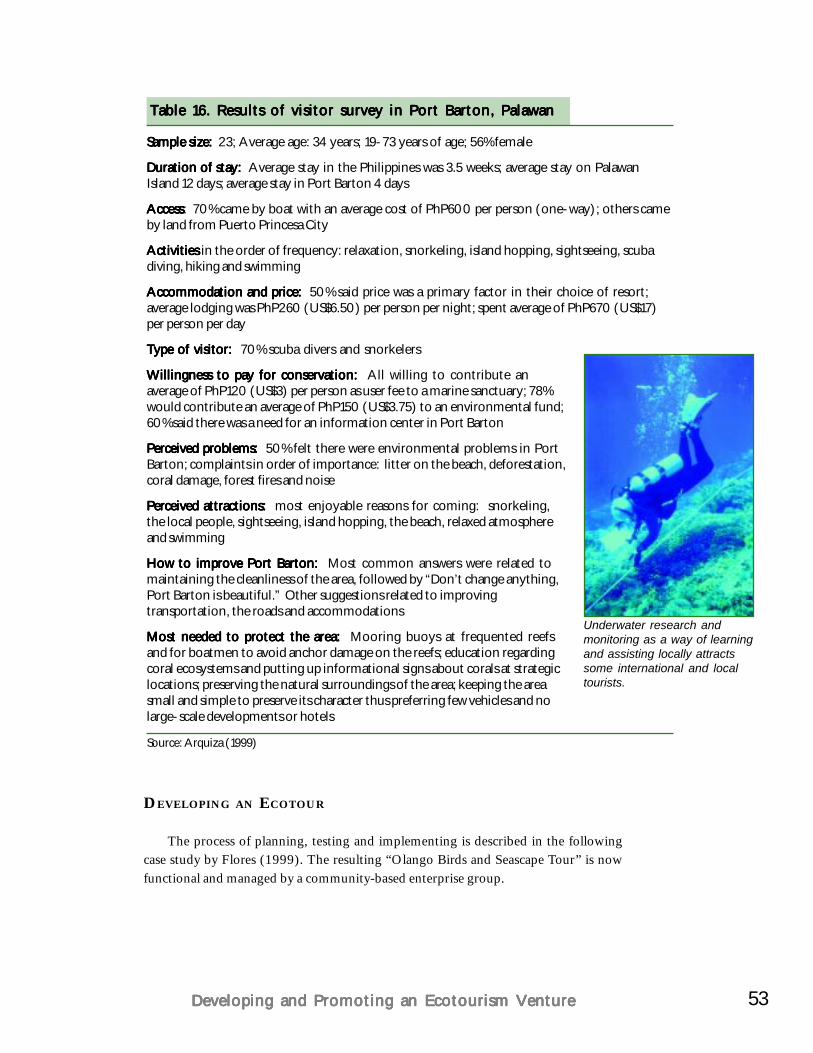
53Developing and Promoting an Ecotourism VentureDeveloping and Promoting an Ecotourism VentureDeveloping and Promoting an Ecotourism VentureDeveloping and Promoting an Ecotourism VentureDeveloping and Promoting an Ecotourism Venture
Sample size:Sample size:Sample size:Sample size:Sample size: 23; Average age: 34 years; 19-73 years of age; 56% female
Duration of stay: Duration of stay: Duration of stay: Duration of stay: Duration of stay: Average stay in the Philippines was 3.5 weeks; average stay on PalawanIsland 12 days; average stay in Port Barton 4 days
AccessAccessAccessAccessAccess: 70% came by boat with an average cost of PhP600 per person (one-way); others cameby land from Puerto Princesa City
Activities Activities Activities Activities Activities in the order of frequency: relaxation, snorkeling, island hopping, sightseeing, scubadiving, hiking and swimming
Accommodation and price: Accommodation and price: Accommodation and price: Accommodation and price: Accommodation and price: 50% said price was a primary factor in their choice of resort;average lodging was PhP260 (US$6.50) per person per night; spent average of PhP670 (US$17)per person per day
Type of visitor: Type of visitor: Type of visitor: Type of visitor: Type of visitor: 70% scuba divers and snorkelers
Willingness to pay for conservation:Willingness to pay for conservation:Willingness to pay for conservation:Willingness to pay for conservation:Willingness to pay for conservation: All willing to contribute anaverage of PhP120 (US$3) per person as user fee to a marine sanctuary; 78%would contribute an average of PhP150 (US$3.75) to an environmental fund;60% said there was a need for an information center in Port Barton
Perceived problems: Perceived problems: Perceived problems: Perceived problems: Perceived problems: 50% felt there were environmental problems in PortBarton; complaints in order of importance: litter on the beach, deforestation,coral damage, forest fires and noise
Perceived attractions: Perceived attractions: Perceived attractions: Perceived attractions: Perceived attractions: most enjoyable reasons for coming: snorkeling,the local people, sightseeing, island hopping, the beach, relaxed atmosphereand swimming
How to improve Port Barton: How to improve Port Barton: How to improve Port Barton: How to improve Port Barton: How to improve Port Barton: Most common answers were related tomaintaining the cleanliness of the area, followed by “Don’t change anything,Port Barton is beautiful.” Other suggestions related to improvingtransportation, the roads and accommodations
Most needed to protect the area: Most needed to protect the area: Most needed to protect the area: Most needed to protect the area: Most needed to protect the area: Mooring buoys at frequented reefsand for boatmen to avoid anchor damage on the reefs; education regardingcoral ecosystems and putting up informational signs about corals at strategiclocations; preserving the natural surroundings of the area; keeping the areasmall and simple to preserve its character thus preferring few vehicles and nolarge-scale developments or hotels
Source: Arquiza (1999)
Table 16. Results of visitor survey in Port Barton, PalawanTable 16. Results of visitor survey in Port Barton, PalawanTable 16. Results of visitor survey in Port Barton, PalawanTable 16. Results of visitor survey in Port Barton, PalawanTable 16. Results of visitor survey in Port Barton, Palawan
Underwater research andmonitoring as a way of learningand assisting locally attractssome international and localtourists.
DEVELOPING AN ECOTOUR
The process of planning, testing and implementing is described in the followingcase study by Flores (1999). The resulting “Olango Birds and Seascape Tour” is nowfunctional and managed by a community-based enterprise group.
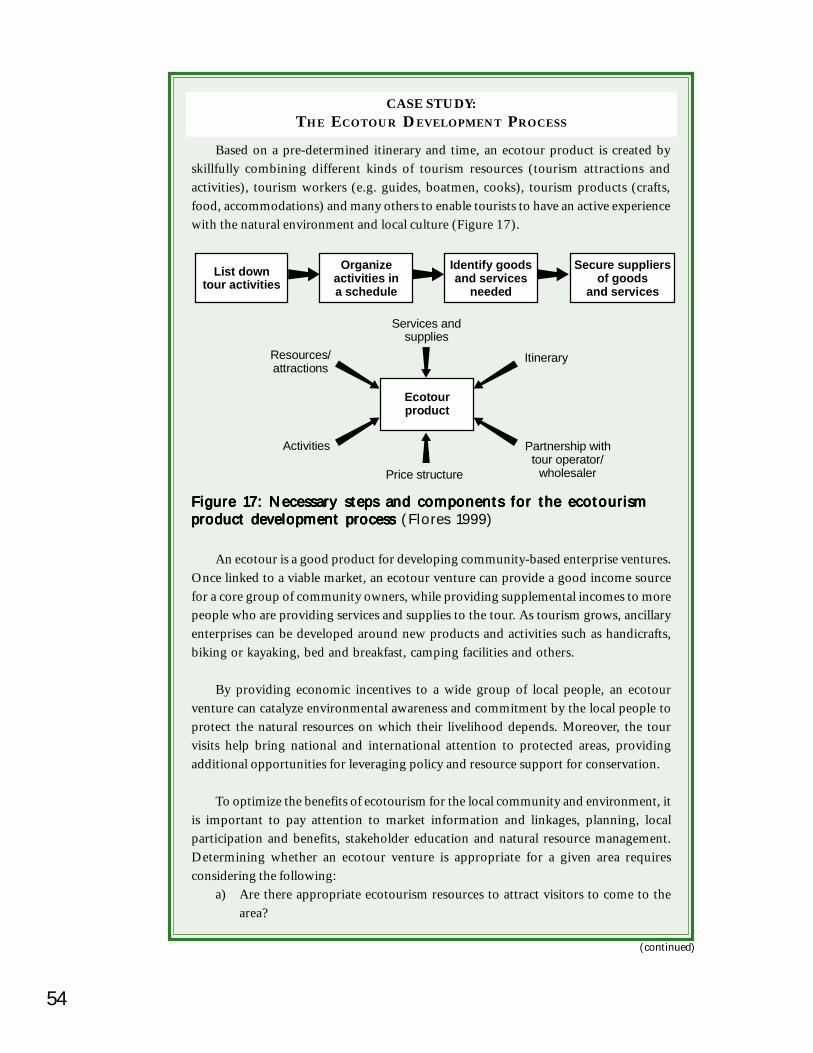
54
Figure 17: Necessary steps and components for the ecotourismFigure 17: Necessary steps and components for the ecotourismFigure 17: Necessary steps and components for the ecotourismFigure 17: Necessary steps and components for the ecotourismFigure 17: Necessary steps and components for the ecotourismproduct development process product development process product development process product development process product development process (Flores 1999)
Based on a pre-determined itinerary and time, an ecotour product is created byskillfully combining different kinds of tourism resources (tourism attractions andactivities), tourism workers (e.g. guides, boatmen, cooks), tourism products (crafts,food, accommodations) and many others to enable tourists to have an active experiencewith the natural environment and local culture (Figure 17).
An ecotour is a good product for developing community-based enterprise ventures.Once linked to a viable market, an ecotour venture can provide a good income sourcefor a core group of community owners, while providing supplemental incomes to morepeople who are providing services and supplies to the tour. As tourism grows, ancillaryenterprises can be developed around new products and activities such as handicrafts,biking or kayaking, bed and breakfast, camping facilities and others.
By providing economic incentives to a wide group of local people, an ecotourventure can catalyze environmental awareness and commitment by the local people toprotect the natural resources on which their livelihood depends. Moreover, the tourvisits help bring national and international attention to protected areas, providingadditional opportunities for leveraging policy and resource support for conservation.
To optimize the benefits of ecotourism for the local community and environment, itis important to pay attention to market information and linkages, planning, localparticipation and benefits, stakeholder education and natural resource management.Determining whether an ecotour venture is appropriate for a given area requiresconsidering the following:
a) Are there appropriate ecotourism resources to attract visitors to come to thearea?
(continued)
List downtour activities
Organizeactivities ina schedule
Identify goodsand services
needed
Ecotourproduct
Resources/attractions
Activities
Itinerary
Partnership withtour operator/
wholesalerPrice structure
Services andsupplies
Secure suppliersof goods
and services
CASE STUDY:THE ECOTOUR DEVELOPMENT PROCESS

55Developing and Promoting an Ecotourism VentureDeveloping and Promoting an Ecotourism VentureDeveloping and Promoting an Ecotourism VentureDeveloping and Promoting an Ecotourism VentureDeveloping and Promoting an Ecotourism Venture
Figure 18: Ecotourism product development steps Figure 18: Ecotourism product development steps Figure 18: Ecotourism product development steps Figure 18: Ecotourism product development steps Figure 18: Ecotourism product development steps (Flores 1999)
b) Is there something unique (attraction, experience, knowledge, package, price)that is competitive in relation to other local tour products or those being visitedby target tourists?
c) Is the area accessible to tourists safely, reliably and regularly?d) Are there tour operators and brokers who could sell the product directly to
tourists and who could be responsible in bringing the tourists to the area?e) Are there dedicated tourism workers (people who will work in the venture)
who enjoy relating with people and working hard and are willing to commit towork even in difficult times?
f) Are the people in the community organized for and involved in decision-makingon ecotourism development in their area?
g) Will the community share in the economic benefits of the ecotour venture?h) Are government bodies on local development, resource and tourism management
in the area supportive of the planned venture?i) Do the community, concerned public agencies or private groups integrate the
ecotour venture in a larger environmental conservation effort?j) Will there be a professional business management system to run the venture in
the locality?k) Is there access to financing for starting the venture?
Ecotourism Product Development – Step by StepThe steps to develop an ecotourism product are outlined in Figure 18 and explained
in more detail below. This process will vary from one project to another depending onthe local context, needs and potential (Lindberg and Hawkins 1993).
1. Identify and assess existing and potential ecotour resources in the target areaEcotour resources are natural, cultural or historical attractions in a given locality.These are the core resources for ecotour product development. Attractions canbe places, objects, events and people’s unique way of life. Natural attractionsinclude surf and beaches, coral reefs, mangroves, rivers and waterfalls, caves,mountains and cliffs, forests and lakes. Cultural and historical attractions include
(continued)
Identify andassess ecotour
resources
Launch thecommercial
run of the tour
Identifymarket
segments
Test run andfine-tune
the product
Establishpartnerships
with touroperators
Match resourceand marketsegments
Secure suppliersof goods and
services
Develop a tourtheme fromthe match
Pull togethera tour
package
(The Ecotour... continued)
56
churches, artifacts, festivals, rites and rituals, traditional production (such asfishing, loom weaving, woodcarving and brass making) as well as annual localcompetitions like banca (boat) and carabao (water-buffalo) races.
Other important resources that need to be identified and assessed are: food andaccommodation services, stores (for souvenirs, film, rentals or sale of outdoorgear), transportation, information services, access to infrastructure (ports,communications, roads and trails), public services (police, rescue, health andmedical) and local skills (cooks, guides, boatmen, entertainers, natural andcultural interpreters, etc.). If any of these resources are not available locally,identify the nearest place where they are available or what training is required.
Knowledge of available financial services and organizations assisting inecotourism development is useful.
To start the identification process, make a list of attractions with a briefdescription of what is unique or special about them. Begin with attractions thatare already popular with locals and visitors. Proceed to list other less popularbut potential ecotour attractions.
Score the resources identified for: attractiveness, ability to draw visitors,accessibility, integrity and contribution to environmental conservation and culturalpromotion. A higher score indicates a greater resource potential for ecotourproduct development.
2. Identify market segmentsIdentify and analyze existing local tour destinations and products. Destinationsare places and events that attract visitors. Products are tour packages that areput together by tour operators. In places where there are no tourists yet, getinformation about destinations and products near the locality. What kind ofvisitor goes there (include both local and foreign)? Where do they come from?How many and from what month to what month do they visit (seasonality)?Who brings them (tour operator)? What activities do they engage in? Howlong do they stay? How much do they spend? Be specific with the data gathering.List down names and places. Primary and secondary data can be gathered fromthe nearest Department of Tourism (DOT) office, local tour operators, guidesand local residents around the destination. Interviews with the visitors themselvesare very useful.
Group the visitors according to activities that they engage in. List the visitorgroups under one column and the activities under another column. This exerciseshould give a good picture of the nature of the existing accessible visitor markets.Remember that schools and companies are also potential markets.
(continued)
(The Ecotour... continued)
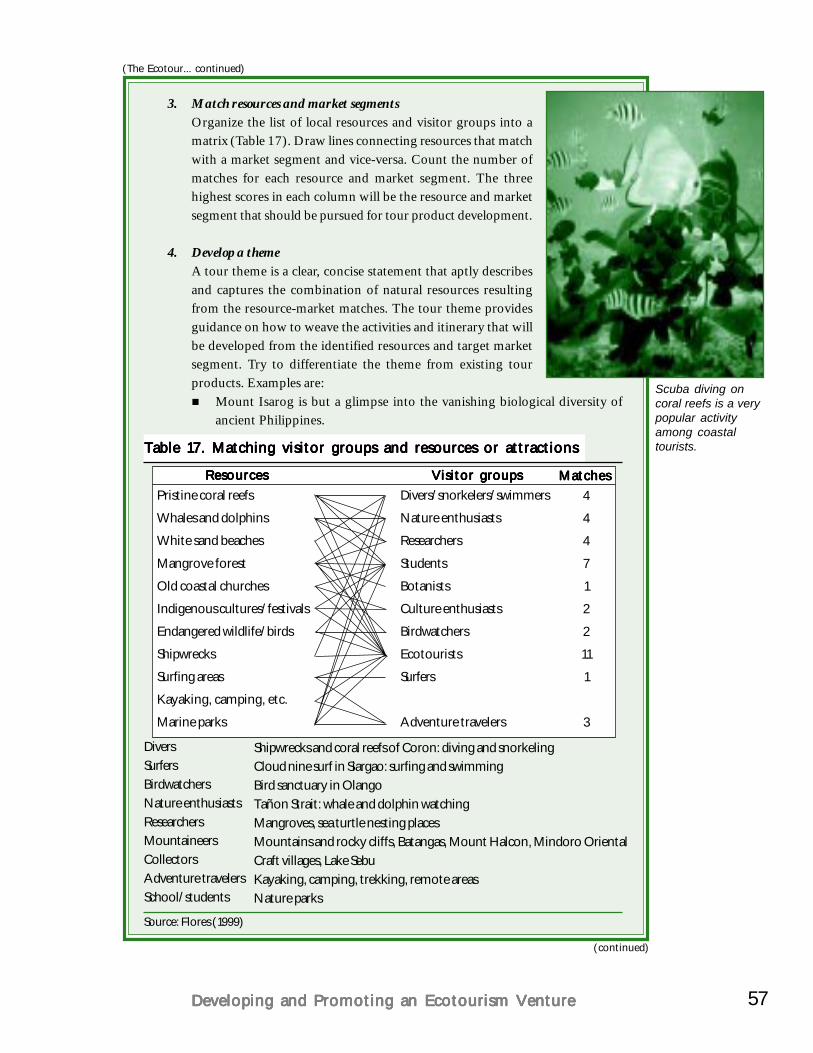
57Developing and Promoting an Ecotourism VentureDeveloping and Promoting an Ecotourism VentureDeveloping and Promoting an Ecotourism VentureDeveloping and Promoting an Ecotourism VentureDeveloping and Promoting an Ecotourism Venture
Table 17. Matching visitor groups and resources or attractionsTable 17. Matching visitor groups and resources or attractionsTable 17. Matching visitor groups and resources or attractionsTable 17. Matching visitor groups and resources or attractionsTable 17. Matching visitor groups and resources or attractions
Shipwrecks and coral reefs of Coron: diving and snorkelingCloud nine surf in Siargao: surfing and swimmingBird sanctuary in OlangoTañon Strait: whale and dolphin watchingMangroves, sea turtle nesting placesMountains and rocky cliffs, Batangas, Mount Halcon, Mindoro OrientalCraft villages, Lake SebuKayaking, camping, trekking, remote areasNature parks
DiversSurfersBirdwatchersNature enthusiastsResearchersMountaineersCollectorsAdventure travelersSchool/students
Source: Flores (1999)
3. Match resources and market segmentsOrganize the list of local resources and visitor groups into amatrix (Table 17). Draw lines connecting resources that matchwith a market segment and vice-versa. Count the number ofmatches for each resource and market segment. The threehighest scores in each column will be the resource and marketsegment that should be pursued for tour product development.
4. Develop a themeA tour theme is a clear, concise statement that aptly describesand captures the combination of natural resources resultingfrom the resource-market matches. The tour theme providesguidance on how to weave the activities and itinerary that willbe developed from the identified resources and target marketsegment. Try to differentiate the theme from existing tourproducts. Examples are:
Mount Isarog is but a glimpse into the vanishing biological diversity ofancient Philippines.
Scuba diving oncoral reefs is a verypopular activityamong coastaltourists.
ResourcesResourcesResourcesResourcesResources Visitor groupsVisitor groupsVisitor groupsVisitor groupsVisitor groupsPristine coral reefs
Whales and dolphins
White sand beaches
Mangrove forest
Old coastal churches
Indigenous cultures/festivals
Endangered wildlife/birds
Shipwrecks
Surfing areas
Kayaking, camping, etc.
Marine parks
Divers/snorkelers/swimmers
Nature enthusiasts
Researchers
Students
Botanists
Culture enthusiasts
Birdwatchers
Ecotourists
Surfers
Adventure travelers
MatchesMatchesMatchesMatchesMatches4
4
4
7
1
2
2
11
1
3
(continued)
(The Ecotour... continued)
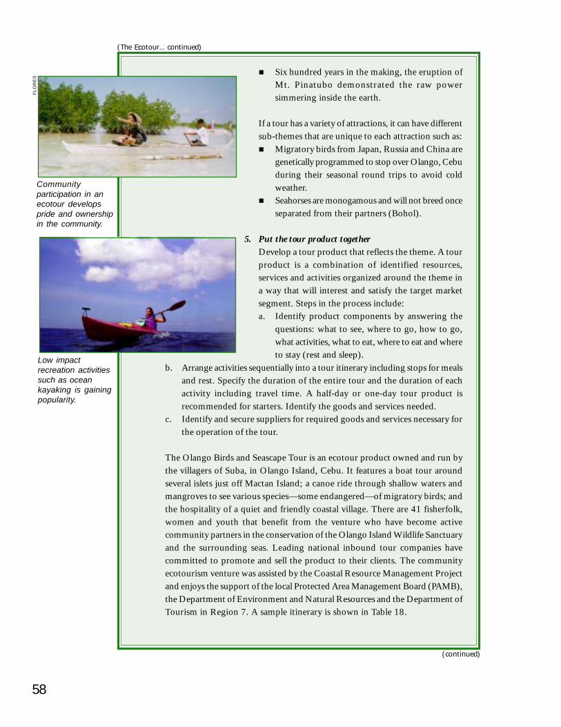
58
Six hundred years in the making, the eruption ofMt. Pinatubo demonstrated the raw powersimmering inside the earth.
If a tour has a variety of attractions, it can have differentsub-themes that are unique to each attraction such as:
Migratory birds from Japan, Russia and China aregenetically programmed to stop over Olango, Cebuduring their seasonal round trips to avoid coldweather.Seahorses are monogamous and will not breed onceseparated from their partners (Bohol).
5. Put the tour product togetherDevelop a tour product that reflects the theme. A tourproduct is a combination of identified resources,services and activities organized around the theme ina way that will interest and satisfy the target marketsegment. Steps in the process include:a. Identify product components by answering the
questions: what to see, where to go, how to go,what activities, what to eat, where to eat and whereto stay (rest and sleep).
Communityparticipation in anecotour developspride and ownershipin the community.
Low impactrecreation activitiessuch as oceankayaking is gainingpopularity.
(continued)
(The Ecotour... continued)
b. Arrange activities sequentially into a tour itinerary including stops for mealsand rest. Specify the duration of the entire tour and the duration of eachactivity including travel time. A half-day or one-day tour product isrecommended for starters. Identify the goods and services needed.
c. Identify and secure suppliers for required goods and services necessary forthe operation of the tour.
The Olango Birds and Seascape Tour is an ecotour product owned and run bythe villagers of Suba, in Olango Island, Cebu. It features a boat tour aroundseveral islets just off Mactan Island; a canoe ride through shallow waters andmangroves to see various species—some endangered—of migratory birds; andthe hospitality of a quiet and friendly coastal village. There are 41 fisherfolk,women and youth that benefit from the venture who have become activecommunity partners in the conservation of the Olango Island Wildlife Sanctuaryand the surrounding seas. Leading national inbound tour companies havecommitted to promote and sell the product to their clients. The communityecotourism venture was assisted by the Coastal Resource Management Projectand enjoys the support of the local Protected Area Management Board (PAMB),the Department of Environment and Natural Resources and the Department ofTourism in Region 7. A sample itinerary is shown in Table 18.
FLO
RE
S
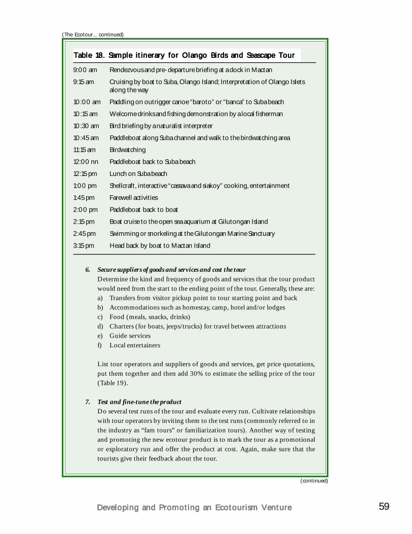
59Developing and Promoting an Ecotourism VentureDeveloping and Promoting an Ecotourism VentureDeveloping and Promoting an Ecotourism VentureDeveloping and Promoting an Ecotourism VentureDeveloping and Promoting an Ecotourism Venture
9:00 am Rendezvous and pre-departure briefing at a dock in Mactan
9:15 am Cruising by boat to Suba, Olango Island; Interpretation of Olango Isletsalong the way
10:00 am Paddling on outrigger canoe “baroto” or “banca” to Suba beach
10:15 am Welcome drinks and fishing demonstration by a local fisherman
10:30 am Bird briefing by a naturalist interpreter
10:45 am Paddleboat along Suba channel and walk to the birdwatching area
11:15 am Birdwatching
12:00 nn Paddleboat back to Suba beach
12:15 pm Lunch on Suba beach
1:00 pm Shellcraft, interactive “cassava and siakoy” cooking, entertainment
1:45 pm Farewell activities
2:00 pm Paddleboat back to boat
2:15 pm Boat cruise to the open sea aquarium at Gilutongan Island
2:45 pm Swimming or snorkeling at the Gilutongan Marine Sanctuary
3:15 pm Head back by boat to Mactan Island
Table 18. Sample itinerary for Olango Birds and Seascape TourTable 18. Sample itinerary for Olango Birds and Seascape TourTable 18. Sample itinerary for Olango Birds and Seascape TourTable 18. Sample itinerary for Olango Birds and Seascape TourTable 18. Sample itinerary for Olango Birds and Seascape Tour
6. Secure suppliers of goods and services and cost the tourDetermine the kind and frequency of goods and services that the tour productwould need from the start to the ending point of the tour. Generally, these are:a) Transfers from visitor pickup point to tour starting point and backb) Accommodations such as homestay, camp, hotel and/or lodgesc) Food (meals, snacks, drinks)d) Charters (for boats, jeeps/trucks) for travel between attractionse) Guide servicesf) Local entertainers
List tour operators and suppliers of goods and services, get price quotations,put them together and then add 30% to estimate the selling price of the tour(Table 19).
7. Test and fine-tune the productDo several test runs of the tour and evaluate every run. Cultivate relationshipswith tour operators by inviting them to the test runs (commonly referred to inthe industry as “fam tours” or familiarization tours). Another way of testingand promoting the new ecotour product is to mark the tour as a promotionalor exploratory run and offer the product at cost. Again, make sure that thetourists give their feedback about the tour.
(continued)
(The Ecotour... continued)
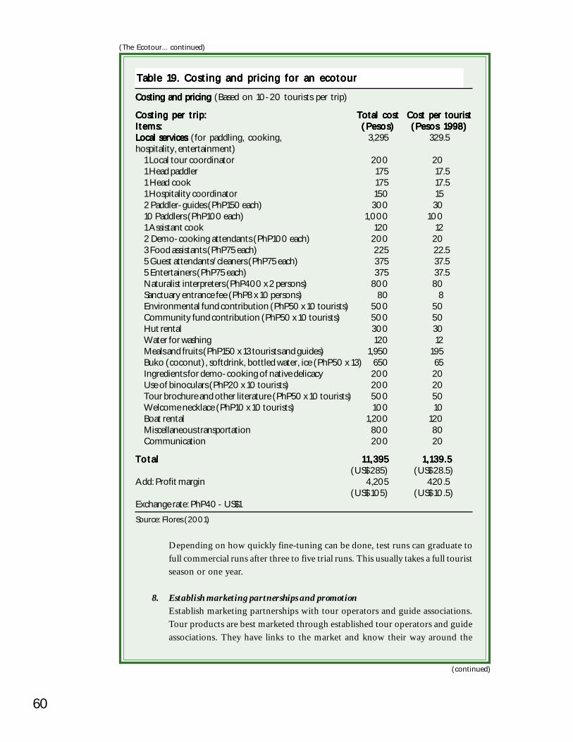
60
Costing and pricing Costing and pricing Costing and pricing Costing and pricing Costing and pricing (Based on 10-20 tourists per trip)
Costing per trip:Costing per trip:Costing per trip:Costing per trip:Costing per trip: Total costTotal costTotal costTotal costTotal cost Cost per touristCost per touristCost per touristCost per touristCost per touristItems:Items:Items:Items:Items: (Pesos)(Pesos)(Pesos)(Pesos)(Pesos) (Pesos 1998)(Pesos 1998)(Pesos 1998)(Pesos 1998)(Pesos 1998)Local servicesLocal servicesLocal servicesLocal servicesLocal services (for paddling, cooking, 3,295 329.5hospitality, entertainment)
1 Local tour coordinator 200 201 Head paddler 175 17.51 Head cook 175 17.51 Hospitality coordinator 150 152 Paddler-guides (PhP150 each) 300 3010 Paddlers (PhP100 each) 1,000 1001 Assistant cook 120 122 Demo-cooking attendants (PhP100 each) 200 203 Food assistants (PhP75 each) 225 22.55 Guest attendants/cleaners (PhP75 each) 375 37.55 Entertainers (PhP75 each) 375 37.5Naturalist interpreters (PhP400 x 2 persons) 800 80Sanctuary entrance fee (PhP8 x 10 persons) 80 8Environmental fund contribution (PhP50 x 10 tourists) 500 50Community fund contribution (PhP50 x 10 tourists) 500 50Hut rental 300 30Water for washing 120 12Meals and fruits (PhP150 x 13 tourists and guides) 1,950 195Buko (coconut), softdrink, bottled water, ice (PhP50 x 13) 650 65Ingredients for demo-cooking of native delicacy 200 20Use of binoculars (PhP20 x 10 tourists) 200 20Tour brochure and other literature (PhP50 x 10 tourists) 500 50Welcome necklace (PhP10 x 10 tourists) 100 10Boat rental 1,200 120Miscellaneous transportation 800 80Communication 200 20
TotalTotalTotalTotalTotal 11,39511,39511,39511,39511,395 1,139.51,139.51,139.51,139.51,139.5(US$ 285) (US$ 28.5)
Add: Profit margin 4,205 420.5(US$ 105) (US$ 10.5)
Exchange rate: PhP40 - US$1Source: Flores (2001)
Table 19. Costing and pricing for an ecotourTable 19. Costing and pricing for an ecotourTable 19. Costing and pricing for an ecotourTable 19. Costing and pricing for an ecotourTable 19. Costing and pricing for an ecotour
Depending on how quickly fine-tuning can be done, test runs can graduate tofull commercial runs after three to five trial runs. This usually takes a full touristseason or one year.
8. Establish marketing partnerships and promotionEstablish marketing partnerships with tour operators and guide associations.Tour products are best marketed through established tour operators and guideassociations. They have links to the market and know their way around the
(continued)
(The Ecotour... continued)
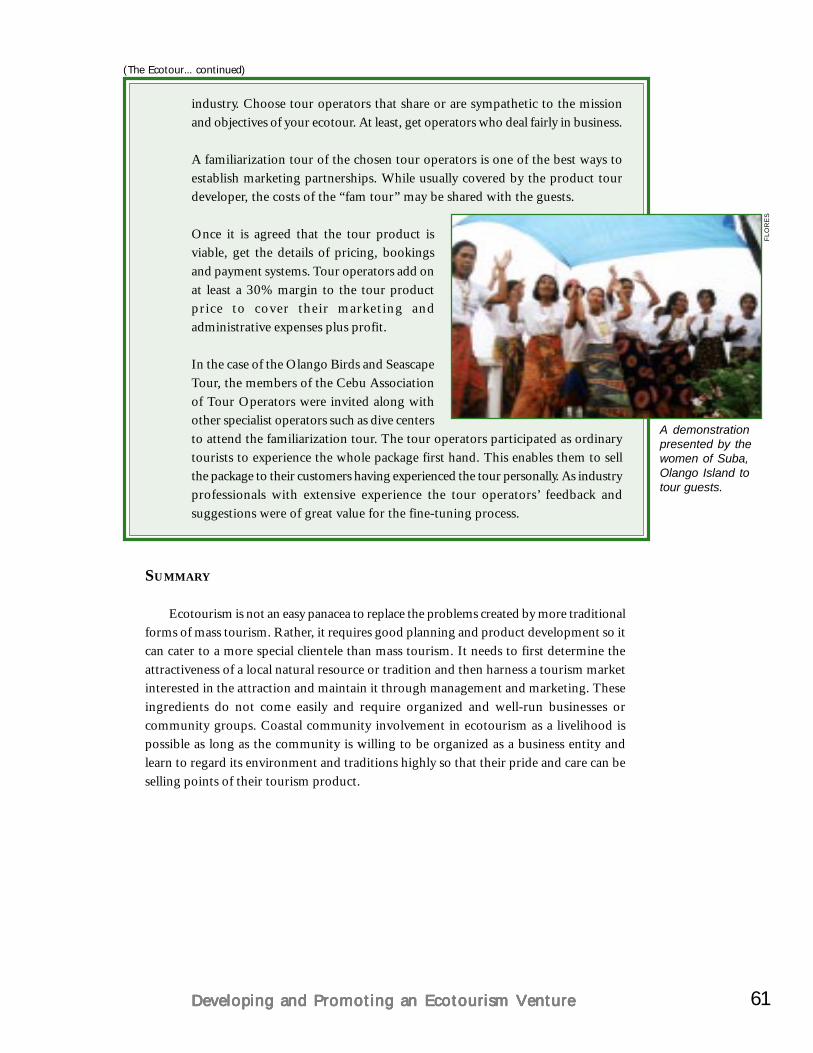
61Developing and Promoting an Ecotourism VentureDeveloping and Promoting an Ecotourism VentureDeveloping and Promoting an Ecotourism VentureDeveloping and Promoting an Ecotourism VentureDeveloping and Promoting an Ecotourism Venture
industry. Choose tour operators that share or are sympathetic to the missionand objectives of your ecotour. At least, get operators who deal fairly in business.
A familiarization tour of the chosen tour operators is one of the best ways toestablish marketing partnerships. While usually covered by the product tourdeveloper, the costs of the “fam tour” may be shared with the guests.
Once it is agreed that the tour product isviable, get the details of pricing, bookingsand payment systems. Tour operators add onat least a 30% margin to the tour productprice to cover their marketing andadministrative expenses plus profit.
In the case of the Olango Birds and SeascapeTour, the members of the Cebu Associationof Tour Operators were invited along withother specialist operators such as dive centersto attend the familiarization tour. The tour operators participated as ordinarytourists to experience the whole package first hand. This enables them to sellthe package to their customers having experienced the tour personally. As industryprofessionals with extensive experience the tour operators’ feedback andsuggestions were of great value for the fine-tuning process.
A demonstrationpresented by thewomen of Suba,Olango Island totour guests.
SUMMARY
Ecotourism is not an easy panacea to replace the problems created by more traditionalforms of mass tourism. Rather, it requires good planning and product development so itcan cater to a more special clientele than mass tourism. It needs to first determine theattractiveness of a local natural resource or tradition and then harness a tourism marketinterested in the attraction and maintain it through management and marketing. Theseingredients do not come easily and require organized and well-run businesses orcommunity groups. Coastal community involvement in ecotourism as a livelihood ispossible as long as the community is willing to be organized as a business entity andlearn to regard its environment and traditions highly so that their pride and care can beselling points of their tourism product.
(The Ecotour... continued)
FLO
RE
S
CHAPTER 6
Environmental ImpactEnvironmental ImpactEnvironmental ImpactEnvironmental ImpactEnvironmental ImpactAssessmentAssessmentAssessmentAssessmentAssessment
Environmental Impact Assessment (EIA) is theEnvironmental Impact Assessment (EIA) is theEnvironmental Impact Assessment (EIA) is theEnvironmental Impact Assessment (EIA) is theEnvironmental Impact Assessment (EIA) is theprocess of assessing potential impacts of a plannedprocess of assessing potential impacts of a plannedprocess of assessing potential impacts of a plannedprocess of assessing potential impacts of a plannedprocess of assessing potential impacts of a planned
project and designing appropriate preventive,project and designing appropriate preventive,project and designing appropriate preventive,project and designing appropriate preventive,project and designing appropriate preventive,mitigating and enhancement measures. EIA should bemitigating and enhancement measures. EIA should bemitigating and enhancement measures. EIA should bemitigating and enhancement measures. EIA should bemitigating and enhancement measures. EIA should bedone early when plans can still accommodate requireddone early when plans can still accommodate requireddone early when plans can still accommodate requireddone early when plans can still accommodate requireddone early when plans can still accommodate requiredchanges. Otherwise, EIA becomes a pointless exercise.changes. Otherwise, EIA becomes a pointless exercise.changes. Otherwise, EIA becomes a pointless exercise.changes. Otherwise, EIA becomes a pointless exercise.changes. Otherwise, EIA becomes a pointless exercise.
All development projects that occur in Environmentally Critical Areas (ECAs) orthose that are considered Environmentally Critical Projects (ECPs) as defined underPresidential Proclamation No. 2146, Series of 1981 and presented in Table 20 arecovered by the Environmental Impact Statement (EIS) System. As such, they are requiredto obtain an Environmental Clearance Certificate (ECC) after undertaking anEnvironmental Impact Assessment (EIA).
Protected areas such as national parks, watershed reserves, wildlife preserves andsanctuaries declared by law; seascapesAreas set aside as potential tourist spots;Habitats of endangered or threatened species indigenous to the Philippines;Areas of unique historic, archaeological or scientific interest;Areas traditionally occupied by indigenous people and cultural communities;Areas frequently hit by natural calamities (geologic hazards, floods, typhoons,volcanic activity, etc.);Areas with critical (steep) slopes;Areas classified as prime agricultural lands;Aquifer recharge areas;Water bodies used for domestic supply or support of fish and wildlife;Mangrove areas supporting critical ecological functions or on which people dependfor livelihood;Coral reefs which have critical ecological functions; andAreas which are ecologically, socially or geologically sensitive.
Table 20. ECAs requiring an ECC before development can occurTable 20. ECAs requiring an ECC before development can occurTable 20. ECAs requiring an ECC before development can occurTable 20. ECAs requiring an ECC before development can occurTable 20. ECAs requiring an ECC before development can occur
63Environmental Impact AssessmentEnvironmental Impact AssessmentEnvironmental Impact AssessmentEnvironmental Impact AssessmentEnvironmental Impact Assessment
EIA is a planning and management tool that will help government decision-makers,the project proponent and affected communities or groups decide whether the positiveconsequences or benefits of the project will outweigh the negative consequences orrisks. These consequences can be classified as biophysical and ecological, geophysical,socioeconomic, cultural and human health impacts.
EIA will aslo identify alternatives and measures which can prevent, minimize oralleviate the adverse consequences of the project in all its stages from construction,operation, closing to rehabilitation after the project has ended. It will also providesufficient options for the project to be continued with assurance that the quality of theenvironment and well-being of the people will be safeguarded.
In brief, EIA has the following objectives:To identify adverse environmental problems that may be expected to occur;To identify environmental benefits and constraints of the project as well as itseconomic and environmental acceptability to the community;To identify critical environmental problems, which require further studies and/or monitoring;To examine and select the optimal alternative from the various relevant optionsavailable;To incorporate appropriate mitigation measures into the development process;andTo involve the public in the decision-making process related to the environmentand social settings.
The initial letters E, I and A also describe three important attributes of the EIAprocess:
EARLY: EIA begins at the interception of development planning to identifyopportunities and constraints in natural systems and thus guide the designof projects.
INTEGRATED: EIA is linked directly to engineering and economic studies, notperformed separately or at a later time.
ALWAYS: The EIA process continues to accumulate data throughout the projectcycle, monitoring the implementation of environmental protectionmeasures and suggesting mid-course corrections to management.
Typical reasons why EIAs are required for tourism development are depicted inFigures 19 and 20. Because coastal shoreline areas are sensitive environmental features,it is easy to disrupt nature and cause permanent damage and change without properplanning, analysis and monitoring.
EIA is done by the project proponent — the agency, business firm or organizationthat wants to pursue a project that falls within the EIS System.
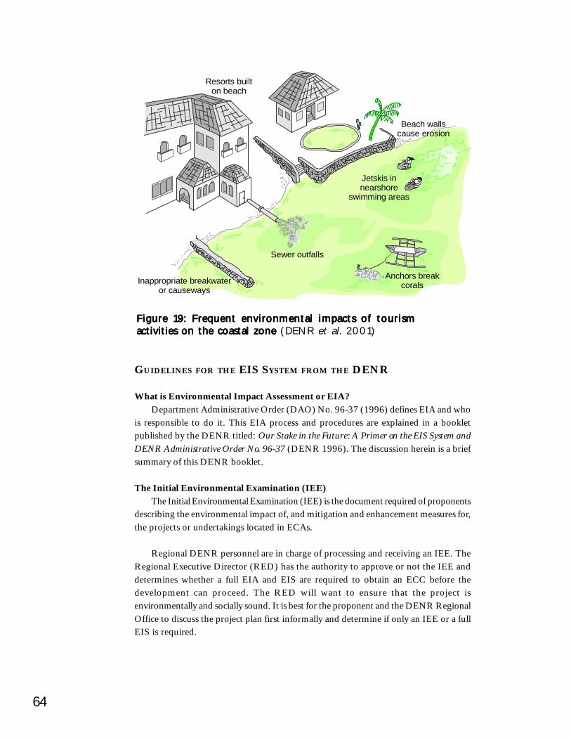
64
Resorts builton beach
Beach wallscause erosion
Sewer outfalls
Jetskis innearshore
swimming areas
Inappropriate breakwateror causeways
Anchors breakcorals
Figure 19: Frequent environmental impacts of tourismFigure 19: Frequent environmental impacts of tourismFigure 19: Frequent environmental impacts of tourismFigure 19: Frequent environmental impacts of tourismFigure 19: Frequent environmental impacts of tourismactivities on the coastal zone activities on the coastal zone activities on the coastal zone activities on the coastal zone activities on the coastal zone (DENR et al. 2001)
GUIDELINES FOR THE EIS SYSTEM FROM THE DENR
What is Environmental Impact Assessment or EIA?Department Administrative Order (DAO) No. 96-37 (1996) defines EIA and who
is responsible to do it. This EIA process and procedures are explained in a bookletpublished by the DENR titled: Our Stake in the Future: A Primer on the EIS System andDENR Administrative Order No. 96-37 (DENR 1996). The discussion herein is a briefsummary of this DENR booklet.
The Initial Environmental Examination (IEE)The Initial Environmental Examination (IEE) is the document required of proponents
describing the environmental impact of, and mitigation and enhancement measures for,the projects or undertakings located in ECAs.
Regional DENR personnel are in charge of processing and receiving an IEE. TheRegional Executive Director (RED) has the authority to approve or not the IEE anddetermines whether a full EIA and EIS are required to obtain an ECC before thedevelopment can proceed. The RED will want to ensure that the project isenvironmentally and socially sound. It is best for the proponent and the DENR RegionalOffice to discuss the project plan first informally and determine if only an IEE or a fullEIS is required.
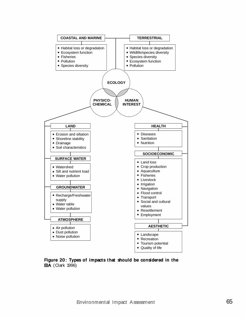
65Environmental Impact AssessmentEnvironmental Impact AssessmentEnvironmental Impact AssessmentEnvironmental Impact AssessmentEnvironmental Impact Assessment
Figure 20: Types of impacts that should be considered in theFigure 20: Types of impacts that should be considered in theFigure 20: Types of impacts that should be considered in theFigure 20: Types of impacts that should be considered in theFigure 20: Types of impacts that should be considered in theEIA EIA EIA EIA EIA (Clark 1996)
COASTAL AND MARINE
LAND
SURFACE WATER
GROUNDWATER
ATMOSPHERE
Habitat loss or degradationEcosystem functionFisheriesPollutionSpecies diversity
Erosion and siltationShoreline stabilityDrainageSoil characteristics
WatershedSilt and nutrient loadWater pollution
Recharge/FreshwatersupplyWater tableWater pollution
Air pollutionDust pollutionNoise pollution
TERRESTRIAL
HEALTH
AESTHETIC
SOCIOECONOMIC
Habitat loss or degradationWildlife/species diversitySpecies diversityEcosystem functionPollution
DiseasesSanitationNutrition
LandscapeRecreationTourism potentialQuality of life
Land lossCrop productionAquacultureFisheriesLivestockIrrigationNavigationFlood controlTransportSocial and culturalvaluesResettlementEmployment
ECOLOGY
PHYSICO-CHEMICAL
HUMANINTEREST
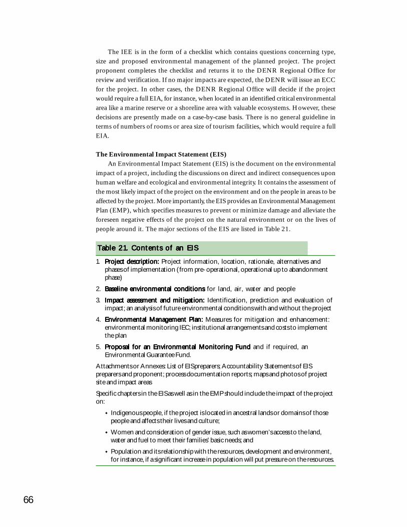
66
The IEE is in the form of a checklist which contains questions concerning type,size and proposed environmental management of the planned project. The projectproponent completes the checklist and returns it to the DENR Regional Office forreview and verification. If no major impacts are expected, the DENR will issue an ECCfor the project. In other cases, the DENR Regional Office will decide if the projectwould require a full EIA, for instance, when located in an identified critical environmentalarea like a marine reserve or a shoreline area with valuable ecosystems. However, thesedecisions are presently made on a case-by-case basis. There is no general guideline interms of numbers of rooms or area size of tourism facilities, which would require a fullEIA.
The Environmental Impact Statement (EIS)An Environmental Impact Statement (EIS) is the document on the environmental
impact of a project, including the discussions on direct and indirect consequences uponhuman welfare and ecological and environmental integrity. It contains the assessment ofthe most likely impact of the project on the environment and on the people in areas to beaffected by the project. More importantly, the EIS provides an Environmental ManagementPlan (EMP), which specifies measures to prevent or minimize damage and alleviate theforeseen negative effects of the project on the natural environment or on the lives ofpeople around it. The major sections of the EIS are listed in Table 21.
Table 21. Contents of an EISTable 21. Contents of an EISTable 21. Contents of an EISTable 21. Contents of an EISTable 21. Contents of an EIS
1. Project description:Project description:Project description:Project description:Project description: Project information, location, rationale, alternatives andphases of implementation (from pre-operational, operational up to abandonmentphase)
2. Baseline environmental conditionsBaseline environmental conditionsBaseline environmental conditionsBaseline environmental conditionsBaseline environmental conditions for land, air, water and people
3. Impact assessment and mitigation:Impact assessment and mitigation:Impact assessment and mitigation:Impact assessment and mitigation:Impact assessment and mitigation: Identification, prediction and evaluation ofimpact; an analysis of future environmental conditions with and without the project
4. Environmental Management Plan:Environmental Management Plan:Environmental Management Plan:Environmental Management Plan:Environmental Management Plan: Measures for mitigation and enhancement:environmental monitoring IEC; institutional arrangements and costs to implementthe plan
5. Proposal for an Environmental Monitoring FundProposal for an Environmental Monitoring FundProposal for an Environmental Monitoring FundProposal for an Environmental Monitoring FundProposal for an Environmental Monitoring Fund and if required, anEnvironmental Guarantee Fund.
Attachments or Annexes: List of EIS preparers; Accountability Statements of EISpreparers and proponent; process documentation reports; maps and photos of projectsite and impact areas
Specific chapters in the EIS as well as in the EMP should include the impact of the projecton:
Indigenous people, if the project is located in ancestral lands or domains of thosepeople and affects their lives and culture;
Women and consideration of gender issue, such as women’s access to the land,water and fuel to meet their families’ basic needs; and
Population and its relationship with the resources, development and environment,for instance, if a significant increase in population will put pressure on the resources.
67Environmental Impact AssessmentEnvironmental Impact AssessmentEnvironmental Impact AssessmentEnvironmental Impact AssessmentEnvironmental Impact Assessment
The review process for an IEE, EIA and EIA is outlined in the booklet published byDENR (1996) and outlined in Figures 21 and 22. A key factor in the process is thetimely communication between the project proponent and the DENR Regional Officeand personnel. The project proponent should at all times try to meet the requirements ofa good EIS in a sincere effort to minimize impact on the environment and social conditionsof the area of concern. The project proponent or any of the stakeholders may appeal thedecision of the DENR Regional Executive Director, in granting or denying an ECC fora project. The person or group filing the appeal should make the appeal to the DENRSecretary within 15 days from the receipt of the decision. The DENR Secretary’s decisionon the appeal is final and can be immediately enforced.
Monitoring of compliance with ECC and of environmental impactsWhen a project begins implementation or construction, the Environmental
Management Plan approved as part of the ECC is monitored for compliance. For aproject granted an ECC based on an EIS, a Multi-Partite Monitoring Team (MMT)should be formed soon after the project’s ECC is issued, in time for the project startup.The functions of the MMT are generally to:
Monitor project compliance with the EMP and conditions in the ECC;Gather information if damage occurs or public complaints are raised about theproject;Prepare and disseminate monitoring reports and submit recommendations tothe DENR; andConduct relevant community information and education campaigns regardingthe project and its impact on the environment.
The core members of the MMT are: the project proponent; affected communitiesand women, through their designated representatives; the relevant LGUs (barangay,municipal, or provincial); the DENR Provincial and/or Community Environment andNatural Resources Officers (PENROs/CENROs) in the project areas. Other membersmay be identified during MMT formation. The DENR Regional Office and theEnvironmental Management Bureau (EMB) will provide support to the MMT in technicalaspects of evaluation and policy monitoring.
Participation of stakeholders within the EIA SystemThe primary means of public and stakeholder participation in the EIA System are:
Public consultations are held to allow free and open exchange of informationand discussion by the proponent and stakeholders. This is important duringscoping and during the EIA study and planning stages.Public hearings are required if the project affects a great number of people, ifthere is mounting concern or opposition to the project, or if there is a requestfrom any stakeholder. This is facilitated by a hearing officer designated byDENR.Alternative dispute or conflict resolution processes are used if there are complexissues between the proponent and other stakeholders that remain unresolvedand stall the completion of the EIS, or hinder the determination of social
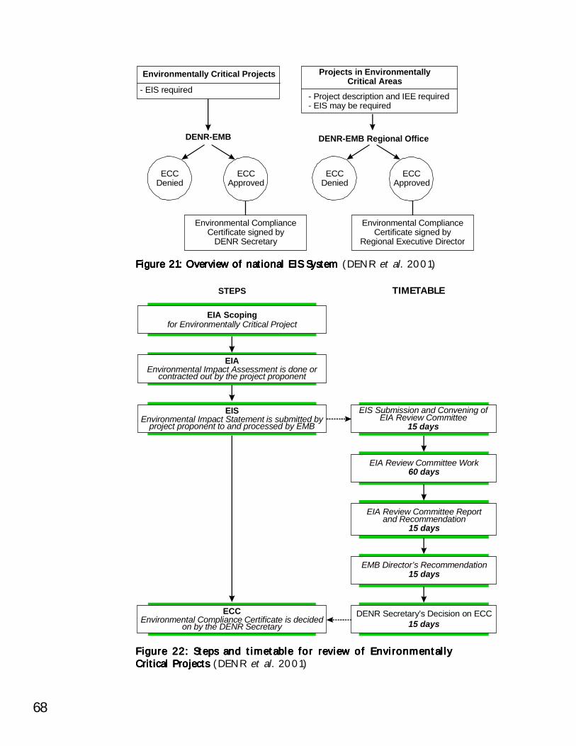
68
Figure 21: Overview of national EIS System Figure 21: Overview of national EIS System Figure 21: Overview of national EIS System Figure 21: Overview of national EIS System Figure 21: Overview of national EIS System (DENR et al. 2001)
Environmentally Critical Projects
Environmental ComplianceCertificate signed by
DENR Secretary
Environmental ComplianceCertificate signed by
Regional Executive Director
DENR-EMB
ECCDenied
ECCDenied
ECCApproved
ECCApproved
DENR-EMB Regional Office
Projects in EnvironmentallyCritical Areas
- EIS required- Project description and IEE required- EIS may be required
Figure 22: Steps and timetable for review of EnvironmentallyFigure 22: Steps and timetable for review of EnvironmentallyFigure 22: Steps and timetable for review of EnvironmentallyFigure 22: Steps and timetable for review of EnvironmentallyFigure 22: Steps and timetable for review of EnvironmentallyCritical Projects Critical Projects Critical Projects Critical Projects Critical Projects (DENR et al. 2001)
EIA Scopingfor Environmentally Critical Project
STEPS TIMETABLE
EIAEnvironmental Impact Assessment is done or
contracted out by the project proponent
EISEnvironmental Impact Statement is submitted by
project proponent to and processed by EMB
ECCEnvironmental Compliance Certificate is decided
on by the DENR Secretary
EIS Submission and Convening ofEIA Review Committee
15 days
EIA Review Committee Work60 days
EIA Review Committee Reportand Recommendation
15 days
EMB Director’s Recommendation15 days
DENR Secretary’s Decision on ECC15 days
69Environmental Impact AssessmentEnvironmental Impact AssessmentEnvironmental Impact AssessmentEnvironmental Impact AssessmentEnvironmental Impact Assessment
acceptability. Mediation, negotiation or similar methods may be used to cometo a consensus on key issues.Public information is essential for public participation. A public notice ofsubmission of the EIS or IEE should be posted by the proponent in a conspicuousplace in the barangay and municipal halls of affected communities. Thestakeholders and public are also notified of any consultations or other meetingsregarding the project. Information about the project should be presented tocommunities in local language. The proponents must cover costs.
The stakeholders are comprised of people and communities living or working inareas affected by a project. Those most likely to be affected are the first ones to beconsulted about the project’s impact on their lives. Appropriate attention should begiven to the concerns of indigenous people and women. Through their designatedrepresentatives, they should be able to take part in the decision-making process of theproject. Stakeholders of a project also include: LGUs where the project is located up tothe barangay level; social institutions, like churches and schools; other governmentagencies and business entities operating there; NGOs and POs working in the area; andother groups that evidently will be affected by the project.
LGUs aim to protect their constituents and the natural resources of their geographicaljurisdiction. They can, therefore, fulfill key roles by:
Helping DENR to disseminate information and implement the EIS Systemand to encourage compliance in minimizing impacts from development projects;Helping to bring together the stakeholders among their constituents toparticipate in the EIS scoping, consultations or other processes in ensuring theproject’s environmental and social acceptability; andParticipating as a member of the MMT for specific projects.
Social Impact AssessmentIn addition to environmental factors, impact assessment should also include an
analysis of the potential social impacts and mitigation options, either as part of the EIA,or in a separate Social Impact Assessment (SIA), conducted simultaneously with theEIA. Anticipating and addressing the potential social impacts in surrounding communitiesis equally important to the success of a resort development as mitigating environmentalthreats. Key points in SIA are:
Discuss with local stakeholders and experts to ensure that they get an opportunityto review the development program and the expected results and benefits;Collect demographic data of the surrounding communities together with theearning structures before tourism development;Evaluate impacts on existing land-uses and cultural traditions; andDetermine potential secondary and tertiary environmental and social impactsand their significance. Often secondary impacts like intense migration to newlyaccessible areas can cause more severe environmental and social problems andconflicts than the direct impacts from resort development.
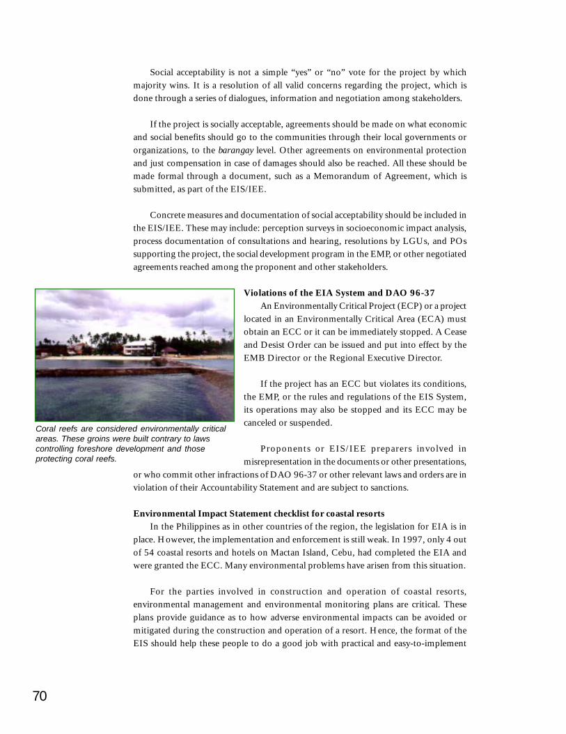
70
Social acceptability is not a simple “yes” or “no” vote for the project by whichmajority wins. It is a resolution of all valid concerns regarding the project, which isdone through a series of dialogues, information and negotiation among stakeholders.
If the project is socially acceptable, agreements should be made on what economicand social benefits should go to the communities through their local governments ororganizations, to the barangay level. Other agreements on environmental protectionand just compensation in case of damages should also be reached. All these should bemade formal through a document, such as a Memorandum of Agreement, which issubmitted, as part of the EIS/IEE.
Concrete measures and documentation of social acceptability should be included inthe EIS/IEE. These may include: perception surveys in socioeconomic impact analysis,process documentation of consultations and hearing, resolutions by LGUs, and POssupporting the project, the social development program in the EMP, or other negotiatedagreements reached among the proponent and other stakeholders.
Violations of the EIA System and DAO 96-37An Environmentally Critical Project (ECP) or a project
located in an Environmentally Critical Area (ECA) mustobtain an ECC or it can be immediately stopped. A Ceaseand Desist Order can be issued and put into effect by theEMB Director or the Regional Executive Director.
If the project has an ECC but violates its conditions,the EMP, or the rules and regulations of the EIS System,its operations may also be stopped and its ECC may becanceled or suspended.
Proponents or EIS/IEE preparers involved inmisrepresentation in the documents or other presentations,
or who commit other infractions of DAO 96-37 or other relevant laws and orders are inviolation of their Accountability Statement and are subject to sanctions.
Environmental Impact Statement checklist for coastal resortsIn the Philippines as in other countries of the region, the legislation for EIA is in
place. However, the implementation and enforcement is still weak. In 1997, only 4 outof 54 coastal resorts and hotels on Mactan Island, Cebu, had completed the EIA andwere granted the ECC. Many environmental problems have arisen from this situation.
For the parties involved in construction and operation of coastal resorts,environmental management and environmental monitoring plans are critical. Theseplans provide guidance as to how adverse environmental impacts can be avoided ormitigated during the construction and operation of a resort. Hence, the format of theEIS should help these people to do a good job with practical and easy-to-implement
Coral reefs are considered environmentally criticalareas. These groins were built contrary to lawscontrolling foreshore development and thoseprotecting coral reefs.
71Environmental Impact AssessmentEnvironmental Impact AssessmentEnvironmental Impact AssessmentEnvironmental Impact AssessmentEnvironmental Impact Assessment
recommendations. Although professionals are normally approved by DENR to preparean EIS, in many cases the quality of the EIS may vary and be too wordy, non-specific oroverly academic.
Local and regional DENR officials, as well as the project proponents, can use theuser-friendly guidelines for drafting an EIS shown in Table 22. These are particularlyhelpful for the environmental management and monitoring measures. It is importantthat mitigating measures are described in detail so they can easily be implemented bythe construction personnel (Figure 23 and Table 23). A coastal tourism impact networkis shown in Figure 24 that highlights the interconnections among tourism impacts,quality of environment and the ultimate tourism demand for an area.
Most crucial and practical environmental management and monitoring measuresare tailor-made to suit site-specific conditions.
Avoid general statements on management measures like “Runoff should beprevented”. Describe how this should be done.
Structure EIS documents, especially EMPs, following the sequence of developmentactivities (e.g. land-use planning, land clearing, grading, drainage works, buildingconstruction, landscaping, operations). In this way, it becomes more relevant tothe practitioners as they can easily refer to the work phase they are dealing with atany time of the development process.
Present information on environmental management practices in a visuallyaccessible manner wherever possible with sketches, typical cross sections,dimensions and design details (see example in Figure 23).
Use simple language for easy understanding by implementing agencies such asconstruction contractors.
Identify clearly the implementing agencies and responsibilities.
Quantify environmental management measures for costing purposes. If no budgetsare allocated for mitigation measures (e.g. silt traps and fences, etc.), thecontractors may not be able to implement them. Include environmental budgetsin all awarded works contracts.
Provide exact location details of areas allocated for measures. Simple maps make iteasy to find the locations for management measures.
Table 22. Checklist for good-practice EISTable 22. Checklist for good-practice EISTable 22. Checklist for good-practice EISTable 22. Checklist for good-practice EISTable 22. Checklist for good-practice EIS
Source: Hüttche (1999a)
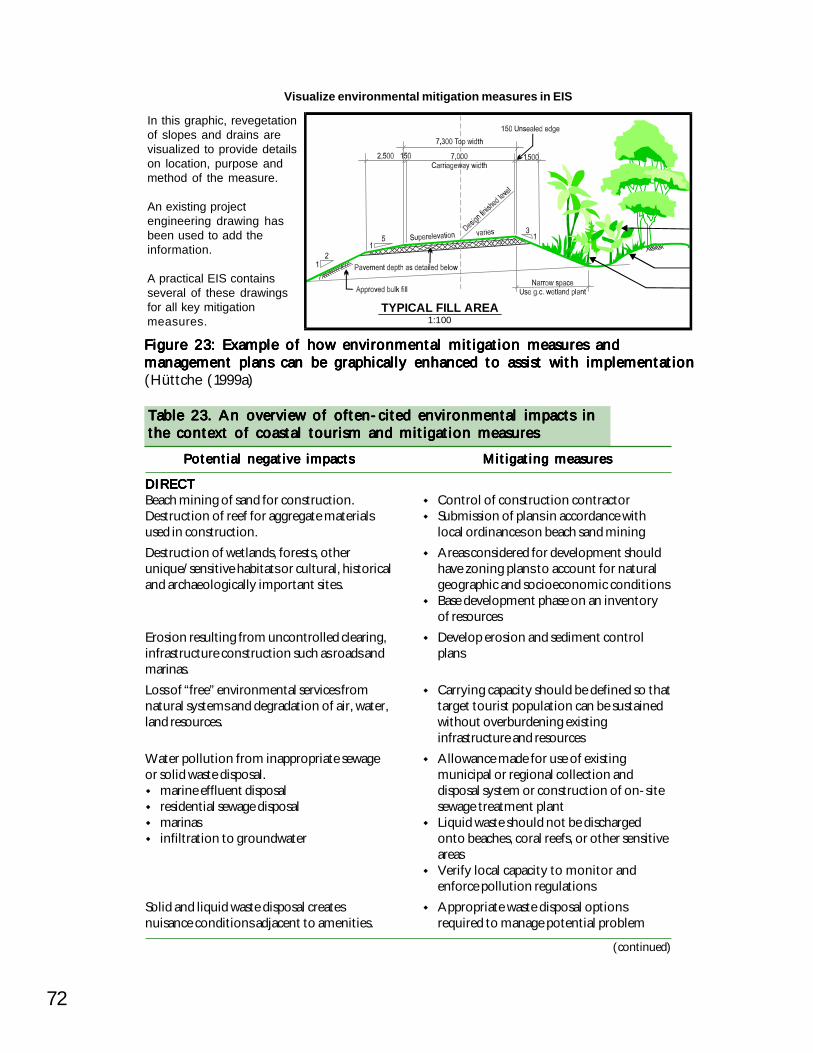
72
DIRECTDIRECTDIRECTDIRECTDIRECTBeach mining of sand for construction.Destruction of reef for aggregate materialsused in construction.Destruction of wetlands, forests, otherunique/sensitive habitats or cultural, historicaland archaeologically important sites.
Erosion resulting from uncontrolled clearing,infrastructure construction such as roads andmarinas.Loss of “free” environmental services fromnatural systems and degradation of air, water,land resources.
Water pollution from inappropriate sewageor solid waste disposal.
marine effluent disposalresidential sewage disposalmarinasinfiltration to groundwater
Solid and liquid waste disposal createsnuisance conditions adjacent to amenities.
Table 23. An overview of often-cited environmental impacts inTable 23. An overview of often-cited environmental impacts inTable 23. An overview of often-cited environmental impacts inTable 23. An overview of often-cited environmental impacts inTable 23. An overview of often-cited environmental impacts inthe context of coastal tourism and mitigation measuresthe context of coastal tourism and mitigation measuresthe context of coastal tourism and mitigation measuresthe context of coastal tourism and mitigation measuresthe context of coastal tourism and mitigation measures
Control of construction contractorSubmission of plans in accordance withlocal ordinances on beach sand miningAreas considered for development shouldhave zoning plans to account for naturalgeographic and socioeconomic conditionsBase development phase on an inventoryof resourcesDevelop erosion and sediment controlplans
Carrying capacity should be defined so thattarget tourist population can be sustainedwithout overburdening existinginfrastructure and resourcesAllowance made for use of existingmunicipal or regional collection anddisposal system or construction of on-sitesewage treatment plantLiquid waste should not be dischargedonto beaches, coral reefs, or other sensitiveareasVerify local capacity to monitor andenforce pollution regulationsAppropriate waste disposal optionsrequired to manage potential problem
Potential negative impactsPotential negative impactsPotential negative impactsPotential negative impactsPotential negative impacts Mitigating measuresMitigating measuresMitigating measuresMitigating measuresMitigating measures
(continued)
Figure 23: Example of how environmental mitigation measures andFigure 23: Example of how environmental mitigation measures andFigure 23: Example of how environmental mitigation measures andFigure 23: Example of how environmental mitigation measures andFigure 23: Example of how environmental mitigation measures andmanagement plans can be graphically enhanced to assist with implementationmanagement plans can be graphically enhanced to assist with implementationmanagement plans can be graphically enhanced to assist with implementationmanagement plans can be graphically enhanced to assist with implementationmanagement plans can be graphically enhanced to assist with implementation(Hüttche (1999a)
In this graphic, revegetationof slopes and drains arevisualized to provide detailson location, purpose andmethod of the measure.
An existing projectengineering drawing hasbeen used to add theinformation.
A practical EIS containsseveral of these drawingsfor all key mitigationmeasures.
Visualize environmental mitigation measures in EIS
TYPICAL FILL AREA1:100
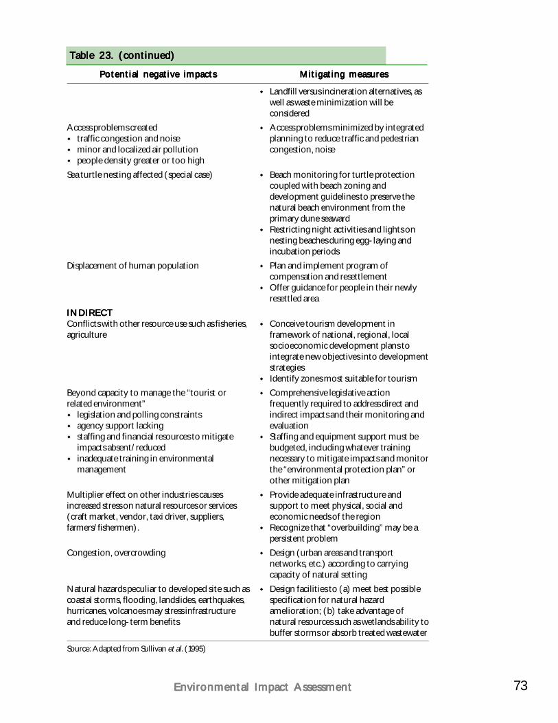
73Environmental Impact AssessmentEnvironmental Impact AssessmentEnvironmental Impact AssessmentEnvironmental Impact AssessmentEnvironmental Impact Assessment
Table 23. (continued)Table 23. (continued)Table 23. (continued)Table 23. (continued)Table 23. (continued)
Landfill versus incineration alternatives, aswell as waste minimization will beconsideredAccess problems minimized by integratedplanning to reduce traffic and pedestriancongestion, noise
Beach monitoring for turtle protectioncoupled with beach zoning anddevelopment guidelines to preserve thenatural beach environment from theprimary dune seawardRestricting night activities and lights onnesting beaches during egg-laying andincubation periodsPlan and implement program ofcompensation and resettlementOffer guidance for people in their newlyresettled area
Conceive tourism development inframework of national, regional, localsocioeconomic development plans tointegrate new objectives into developmentstrategiesIdentify zones most suitable for tourismComprehensive legislative actionfrequently required to address direct andindirect impacts and their monitoring andevaluationStaffing and equipment support must bebudgeted, including whatever trainingnecessary to mitigate impacts and monitorthe “environmental protection plan” orother mitigation planProvide adequate infrastructure andsupport to meet physical, social andeconomic needs of the regionRecognize that “overbuilding” may be apersistent problemDesign (urban areas and transportnetworks, etc.) according to carryingcapacity of natural settingDesign facilities to (a) meet best possiblespecification for natural hazardamelioration; (b) take advantage ofnatural resources such as wetlands ability tobuffer storms or absorb treated wastewater
Access problems createdtraffic congestion and noiseminor and localized air pollutionpeople density greater or too high
Sea turtle nesting affected (special case)
Displacement of human population
INDIRECTINDIRECTINDIRECTINDIRECTINDIRECTConflicts with other resource use such as fisheries,agriculture
Beyond capacity to manage the “tourist orrelated environment”
legislation and polling constraintsagency support lackingstaffing and financial resources to mitigateimpacts absent/reducedinadequate training in environmentalmanagement
Multiplier effect on other industries causesincreased stress on natural resources or services(craft market, vendor, taxi driver, suppliers,farmers/fishermen).
Congestion, overcrowding
Natural hazards peculiar to developed site such ascoastal storms, flooding, landslides, earthquakes,hurricanes, volcanoes may stress infrastructureand reduce long-term benefits
Potential negative impactsPotential negative impactsPotential negative impactsPotential negative impactsPotential negative impacts Mitigating measuresMitigating measuresMitigating measuresMitigating measuresMitigating measures
Source: Adapted from Sullivan et al. (1995)
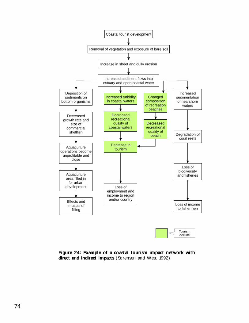
74
Figure 24: Example of a coastal tourism impact network withFigure 24: Example of a coastal tourism impact network withFigure 24: Example of a coastal tourism impact network withFigure 24: Example of a coastal tourism impact network withFigure 24: Example of a coastal tourism impact network withdirect and indirect impacts direct and indirect impacts direct and indirect impacts direct and indirect impacts direct and indirect impacts (Sorensen and West 1992)
Coastal tourist development
Removal of vegetation and exposure of bare soil
Increase in sheet and gully erosion
Increased sediment flows intoestuary and open coastal water
Increased turbidityin coastal waters
Changedcompositionof recreation
beaches
Decreasedrecreational
quality ofbeach
Deposition ofsediments on
bottom organisms
Increasedsedimentationof nearshore
waters
Degradation ofcoral reefs
Loss ofbiodiversity
and fisheries
Loss of incometo fishermen
Decrease intourismAquaculture
operations becomeunprofitable and
close
Aquaculturearea filled in
for urbandevelopment
Effects andimpacts of
filling
Loss ofemployment andincome to regionand/or country
Decreasedrecreational
quality ofcoastal waters
Decreasedgrowth rate and
size ofcommercial
shellfish
Tourismdecline
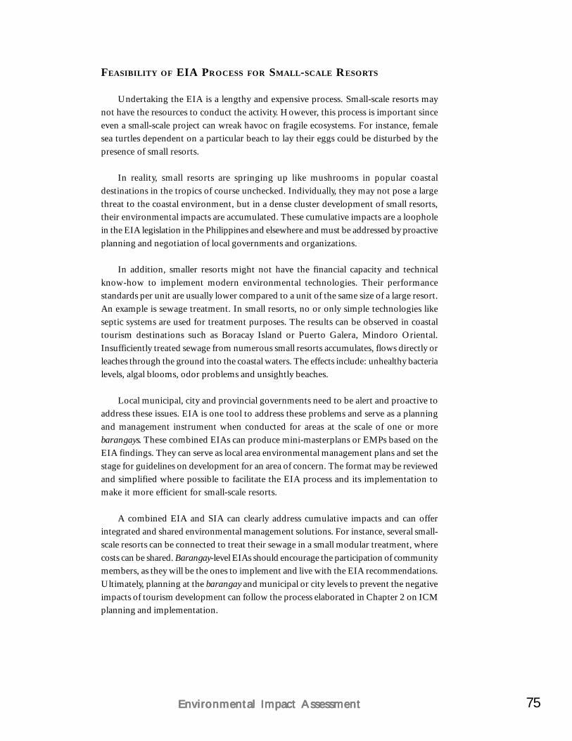
75Environmental Impact AssessmentEnvironmental Impact AssessmentEnvironmental Impact AssessmentEnvironmental Impact AssessmentEnvironmental Impact Assessment
FEASIBILITY OF EIA PROCESS FOR SMALL-SCALE RESORTS
Undertaking the EIA is a lengthy and expensive process. Small-scale resorts maynot have the resources to conduct the activity. However, this process is important sinceeven a small-scale project can wreak havoc on fragile ecosystems. For instance, femalesea turtles dependent on a particular beach to lay their eggs could be disturbed by thepresence of small resorts.
In reality, small resorts are springing up like mushrooms in popular coastaldestinations in the tropics of course unchecked. Individually, they may not pose a largethreat to the coastal environment, but in a dense cluster development of small resorts,their environmental impacts are accumulated. These cumulative impacts are a loopholein the EIA legislation in the Philippines and elsewhere and must be addressed by proactiveplanning and negotiation of local governments and organizations.
In addition, smaller resorts might not have the financial capacity and technicalknow-how to implement modern environmental technologies. Their performancestandards per unit are usually lower compared to a unit of the same size of a large resort.An example is sewage treatment. In small resorts, no or only simple technologies likeseptic systems are used for treatment purposes. The results can be observed in coastaltourism destinations such as Boracay Island or Puerto Galera, Mindoro Oriental.Insufficiently treated sewage from numerous small resorts accumulates, flows directly orleaches through the ground into the coastal waters. The effects include: unhealthy bacterialevels, algal blooms, odor problems and unsightly beaches.
Local municipal, city and provincial governments need to be alert and proactive toaddress these issues. EIA is one tool to address these problems and serve as a planningand management instrument when conducted for areas at the scale of one or morebarangays. These combined EIAs can produce mini-masterplans or EMPs based on theEIA findings. They can serve as local area environmental management plans and set thestage for guidelines on development for an area of concern. The format may be reviewedand simplified where possible to facilitate the EIA process and its implementation tomake it more efficient for small-scale resorts.
A combined EIA and SIA can clearly address cumulative impacts and can offerintegrated and shared environmental management solutions. For instance, several small-scale resorts can be connected to treat their sewage in a small modular treatment, wherecosts can be shared. Barangay-level EIAs should encourage the participation of communitymembers, as they will be the ones to implement and live with the EIA recommendations.Ultimately, planning at the barangay and municipal or city levels to prevent the negativeimpacts of tourism development can follow the process elaborated in Chapter 2 on ICMplanning and implementation.
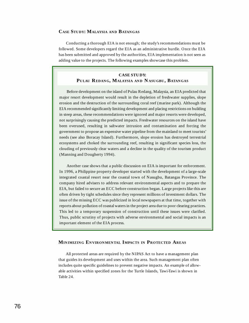
76
CASE STUDY: MALAYSIA AND BATANGAS
Conducting a thorough EIA is not enough; the study’s recommendations must befollowed. Some developers regard the EIA as an administrative hurdle. Once the EIAhas been submitted and approved by the authorities, EIA implementation is not seen asadding value to the projects. The following examples showcase this problem.
Before development on the island of Pulau Redang, Malaysia, an EIA predicted thatmajor resort development would result in the depletion of freshwater supplies, slopeerosion and the destruction of the surrounding coral reef (marine park). Although theEIA recommended significantly limiting development and placing restrictions on buildingin steep areas, these recommendations were ignored and major resorts were developed,not surprisingly causing the predicted impacts. Freshwater resources on the island havebeen overused, resulting in saltwater intrusion and contamination and forcing thegovernment to propose an expensive water pipeline from the mainland to meet tourists’needs (see also Boracay Island). Furthermore, slope erosion has destroyed terrestrialecosystems and choked the surrounding reef, resulting in significant species loss, theclouding of previously clear waters and a decline in the quality of the tourism product(Manning and Dougherty 1994).
Another case shows that a public discussion on EIA is important for enforcement.In 1996, a Philippine property developer started with the development of a large-scaleintegrated coastal resort near the coastal town of Nasugbu, Batangas Province. Thecompany hired advisers to address relevant environmental aspects and to prepare theEIA, but failed to secure an ECC before construction began. Large projects like this areoften driven by tight schedules since they represent millions of investment dollars. Theissue of the missing ECC was publicized in local newspapers at that time, together withreports about pollution of coastal waters in the project area due to poor clearing practices.This led to a temporary suspension of construction until these issues were clarified.Thus, public scrutiny of projects with adverse environmental and social impacts is animportant element of the EIA process.
CASE STUDY:PULAU REDANG, MALAYSIA AND NASUGBU, BATANGAS
MINIMIZING ENVIRONMENTAL IMPACTS IN PROTECTED AREAS
All protected areas are required by the NIPAS Act to have a management planthat guides its development and uses within the area. Such management plan oftenincludes quite specific guidelines to prevent negative impacts. An example of allow-able activities within specified zones for the Turtle Islands, Tawi-Tawi is shown inTable 24.
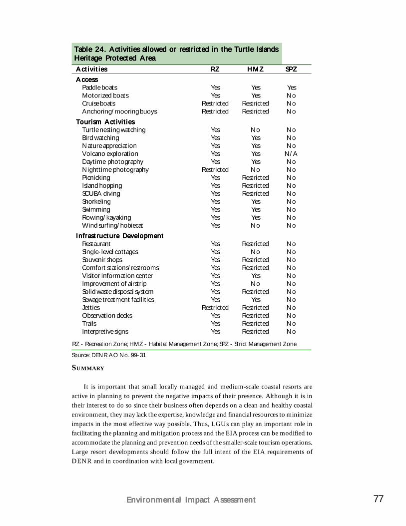
77Environmental Impact AssessmentEnvironmental Impact AssessmentEnvironmental Impact AssessmentEnvironmental Impact AssessmentEnvironmental Impact Assessment
Table 24. Table 24. Table 24. Table 24. Table 24. Activities allowed or restricted in the Turtle IslandsActivities allowed or restricted in the Turtle IslandsActivities allowed or restricted in the Turtle IslandsActivities allowed or restricted in the Turtle IslandsActivities allowed or restricted in the Turtle IslandsHeritage Protected AreaHeritage Protected AreaHeritage Protected AreaHeritage Protected AreaHeritage Protected AreaActivitiesActivitiesActivitiesActivitiesActivities RZRZRZRZRZ HMZHMZHMZHMZHMZ SPZSPZSPZSPZSPZAccessAccessAccessAccessAccess
Paddle boats Yes Yes YesMotorized boats Yes Yes NoCruise boats Restricted Restricted NoAnchoring/mooring buoys Restricted Restricted No
Tourism ActivitiesTourism ActivitiesTourism ActivitiesTourism ActivitiesTourism ActivitiesTurtle nesting watching Yes No NoBird watching Yes Yes NoNature appreciation Yes Yes NoVolcano exploration Yes Yes N/ADaytime photography Yes Yes NoNighttime photography Restricted No NoPicnicking Yes Restricted NoIsland hopping Yes Restricted NoSCUBA diving Yes Restricted NoSnorkeling Yes Yes NoSwimming Yes Yes NoRowing/kayaking Yes Yes NoWind surfing/hobiecat Yes No No
Infrastructure DevelopmentInfrastructure DevelopmentInfrastructure DevelopmentInfrastructure DevelopmentInfrastructure DevelopmentRestaurant Yes Restricted NoSingle-level cottages Yes No NoSouvenir shops Yes Restricted NoComfort stations/restrooms Yes Restricted NoVisitor information center Yes Yes NoImprovement of airstrip Yes No NoSolid waste disposal system Yes Restricted NoSewage treatment facilities Yes Yes NoJetties Restricted Restricted NoObservation decks Yes Restricted NoTrails Yes Restricted NoInterpretive signs Yes Restricted No
RZ - Recreation Zone; HMZ - Habitat Management Zone; SPZ - Strict Management Zone
Source: DENR AO No. 99-31
SUMMARY
It is important that small locally managed and medium-scale coastal resorts areactive in planning to prevent the negative impacts of their presence. Although it is intheir interest to do so since their business often depends on a clean and healthy coastalenvironment, they may lack the expertise, knowledge and financial resources to minimizeimpacts in the most effective way possible. Thus, LGUs can play an important role infacilitating the planning and mitigation process and the EIA process can be modified toaccommodate the planning and prevention needs of the smaller-scale tourism operations.Large resort developments should follow the full intent of the EIA requirements ofDENR and in coordination with local government.
CHAPTER 7
Site Use and DesignSite Use and DesignSite Use and DesignSite Use and DesignSite Use and Design
Sustainable design is not a reworking ofSustainable design is not a reworking ofSustainable design is not a reworking ofSustainable design is not a reworking ofSustainable design is not a reworking ofconventional approaches and technologies,conventional approaches and technologies,conventional approaches and technologies,conventional approaches and technologies,conventional approaches and technologies,
but a fundamental change in thinking and inbut a fundamental change in thinking and inbut a fundamental change in thinking and inbut a fundamental change in thinking and inbut a fundamental change in thinking and inways of operatingways of operatingways of operatingways of operatingways of operating—you can’t put spots onyou can’t put spots onyou can’t put spots onyou can’t put spots onyou can’t put spots on
an elephant and call it a cheetah.an elephant and call it a cheetah.an elephant and call it a cheetah.an elephant and call it a cheetah.an elephant and call it a cheetah.-C. Franklin (1993)-C. Franklin (1993)-C. Franklin (1993)-C. Franklin (1993)-C. Franklin (1993)
Planning and development in coastal areas is often not sufficiently systematic, thusleading to environmental decline. Voluntary measures by private developers and individualsare necessary to change this pattern. This will result in the preservation of the scenic andnatural attractions of the coastal zone. This chapter outlines the considerations thattourist developers should make when planning to use a site within the coastal zone andis consistent with guidelines endorsed by the Department of Tourism (UNDP/WTO/DOT 1991).
With better planning and integration with the community, overall socioeconomicbenefits from natural resources will increase and last much longer.
SELECTING SUITABLE SITES WITH ENVIRONMENTAL CONSIDERATIONS IN
MIND
Physical location and design of coastal tourism projects go hand in hand with theEIA process, described in Chapter 6. EIA delivers the necessary data on natural resourcesand the site’s potentials and constraints to facilitate the location and design of buildingsand facilities. In general, a site should be maintained in its original state as much aspossible by locating all buildings with the least environmental impacts possible. Extensivere-shaping of land and alienated designs should be avoided. The benefits of this approachare both aesthetic and economic. Costs can be reduced dramatically by consideringphysical and geographic features when planning developments.
79Site Use and DesignSite Use and DesignSite Use and DesignSite Use and DesignSite Use and Design
Utilizing existing natural coastal systems and conditions can, for example, reducereliance on electric cooling systems and water pumps. Less investment and groundmaintenance will be necessary if existing vegetation is kept intact.
Existing coastal geomorphology and the physical attributes and features of the coastalzone are of great importance for the selection of a suitable resort site. Knowing andrecognizing some coastal geomorphological features and trends is important for boththe short-term and the long-term development of the resort. For example, if the potentialcoastal erosion is known, a setback or buffer zone can be incorporated in the placementof the resort.
Research on Malaysia’s east coast has produced a classification guide of beachresort sites as a reference for the identification of potential resort sites (Figure 25).
Recommendation for resort sites for the classification shown in Figure 25Picture A Zetaform bay, where a resort is best located in the protected northern
curve and away from the river mouth. Other possible locations includingthe exposed southern sector are along the length of the bay but allshould be away from river mouths.
Picture B Non-zetaform bay, where the best location is usually in the center ofthe bay as both ends of the bay are subject to marked seasonal beachchanges.
Picture C Coastal barrier, where the beach resort is best located landward of thelagoon (seasonal channel) separating the barrier from the mainland.
Picture D Low linear coast, where the preferred location is away from any coastalerosion and river mouth.
Picture E Estuary, where the preferred location is above the flood level and awayfrom the changes attendant with spit formation.
Besides beaches, there are many other types of coasts and elements to be consideredfor an environmentally sensitive resort site location. Seasonal monsoons and storm wavesare important factors (see Shoreline setbacks), and the effects of the resort on thesurrounding environment have to be anticipated (Bird 1969; Bascom 1980).
In the resort design practice, environmental zoning provides clear guidance for theselection of building sites. A simple system is illustrated in Figure 26 and operates asfollows:
All identified coastal resources are classified in zones of impacts with zone 1being the most sensitive to disturbances and zone 3 the least sensitive. Thisserves to identify and demarcate environmentally sensitive areas as context forthe proposed development.Environmentally sensitive areas are designated as coastal buffer zones or“greenbelts”. A classification guide used for the zoning is presented in Table25.
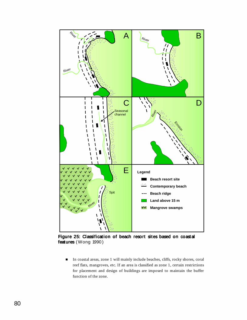
80
Figure 25: Classification of beach resort sites based on coastalFigure 25: Classification of beach resort sites based on coastalFigure 25: Classification of beach resort sites based on coastalFigure 25: Classification of beach resort sites based on coastalFigure 25: Classification of beach resort sites based on coastalfeatures features features features features (Wong 1990)
In coastal areas, zone 1 will mainly include beaches, cliffs, rocky shores, coralreef flats, mangroves, etc. If an area is classified as zone 1, certain restrictionsfor placement and design of buildings are imposed to maintain the bufferfunction of the zone.
River
River
River
Spit
Rive
r
Erosion
Seasonalchannel
River
Legend
Beach resort site
Contemporary beach
Beach ridge
Land above 15 m
Mangrove swamps
A
C
E
D
B
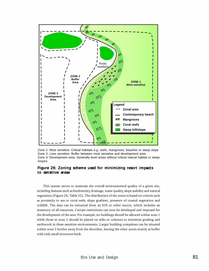
81Site Use and DesignSite Use and DesignSite Use and DesignSite Use and DesignSite Use and Design
ZONE 3Development
Area
ZONE 2BufferArea ZONE 1
Most sensitive
Rockyheadland
This system serves to maintain the overall environmental quality of a given site,including features such as biodiversity, drainage, water quality, slope stability and naturalvegetation (Figure 26; Table 25). The distribution of the zones is based on criteria suchas proximity to sea or coral reefs, slope gradient, presence of coastal vegetation andwildlife. The data can be extracted from an EIS or other source, which includes aninventory of all resources. Certain restrictions can now be developed and imposed forthe development of the area. For example, no buildings should be allowed within zone 1while those in zone 2 should be placed on stilts or columns to minimize grading andearthwork in these sensitive environments. Larger building complexes can be situatedwithin zone 3 further away from the shoreline, leaving the other zones mainly as bufferwith only small structures built.
Figure 26: Zoning scheme used for minimizing resort impactsFigure 26: Zoning scheme used for minimizing resort impactsFigure 26: Zoning scheme used for minimizing resort impactsFigure 26: Zoning scheme used for minimizing resort impactsFigure 26: Zoning scheme used for minimizing resort impactsto sensitive areasto sensitive areasto sensitive areasto sensitive areasto sensitive areas
Zone 1: Most sensitive: Critical habitats e.g. reefs, mangroves, beaches or steep slopeZone 2: Less sensitive: Buffer between most sensitive and development areaZone 3: Development area: Generally level areas without critical natural habitat or steepslopes
Zonal areaContemporary beachMangrovesCoral reefsSteep hill/slope
Legend
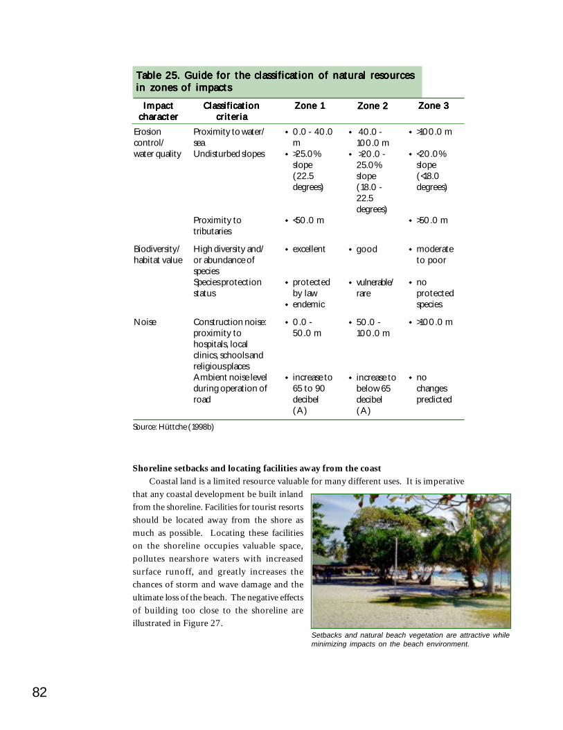
82
Shoreline setbacks and locating facilities away from the coastCoastal land is a limited resource valuable for many different uses. It is imperative
that any coastal development be built inlandfrom the shoreline. Facilities for tourist resortsshould be located away from the shore asmuch as possible. Locating these facilitieson the shoreline occupies valuable space,pollutes nearshore waters with increasedsurface runoff, and greatly increases thechances of storm and wave damage and theultimate loss of the beach. The negative effectsof building too close to the shoreline areillustrated in Figure 27.
Table 25. Guide for the classification of natural resourcesTable 25. Guide for the classification of natural resourcesTable 25. Guide for the classification of natural resourcesTable 25. Guide for the classification of natural resourcesTable 25. Guide for the classification of natural resourcesin zones of impactsin zones of impactsin zones of impactsin zones of impactsin zones of impacts
ImpactImpactImpactImpactImpactcharactercharactercharactercharactercharacter
ClassificationClassificationClassificationClassificationClassificationcriteriacriteriacriteriacriteriacriteria
Zone 1Zone 1Zone 1Zone 1Zone 1 Zone 2Zone 2Zone 2Zone 2Zone 2 Zone 3Zone 3Zone 3Zone 3Zone 3
Erosioncontrol/water quality
Biodiversity/habitat value
Noise
Proximity to water/seaUndisturbed slopes
Proximity totributaries
High diversity and/or abundance ofspeciesSpecies protectionstatus
Construction noise:proximity tohospitals, localclinics, schools andreligious placesAmbient noise levelduring operation ofroad
0.0 - 40.0m>25.0%slope(22.5degrees)
<50.0 m
excellent
protectedby lawendemic
0.0 -50.0 m
increase to65 to 90decibel(A)
40.0 -100.0 m>20.0 -25.0%slope(18.0 -22.5degrees)
good
vulnerable/rare
50.0 -100.0 m
increase tobelow 65decibel(A)
>100.0 m
<20.0%slope(<18.0degrees)
>50.0 m
moderateto poor
noprotectedspecies
>100.0 m
nochangespredicted
Source: Hüttche (1998b)
Setbacks and natural beach vegetation are attractive whileminimizing impacts on the beach environment.
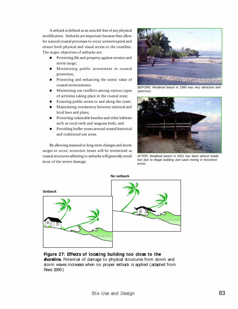
83Site Use and DesignSite Use and DesignSite Use and DesignSite Use and DesignSite Use and Design
Figure 27: Effects of locating building too close to theFigure 27: Effects of locating building too close to theFigure 27: Effects of locating building too close to theFigure 27: Effects of locating building too close to theFigure 27: Effects of locating building too close to theshoreline. shoreline. shoreline. shoreline. shoreline. Potential of damage to physical structures from storm andstorm waves increases when no proper setback is applied (adapted fromRees 1990)
A setback is defined as an area left free of any physicalmodification. Setbacks are important because they allowfor natural coastal processes to occur uninterrupted andensure both physical and visual access to the coastline.The major objectives of setbacks are:
Protecting life and property against erosion andstorm surge;Minimizing public investment in coastalprotection;Protecting and enhancing the scenic value ofcoastal environments;Minimizing use conflicts among various typesof activities taking place in the coastal zone;Ensuring public access to and along the coast;Maintaining consistency between national andlocal laws and plans;Protecting vulnerable beaches and other habitatssuch as coral reefs and seagrass beds; andProviding buffer zones around coastal historicaland traditional use areas.
By allowing seasonal or long-term changes and stormsurges to occur, economic losses will be minimized ascoastal structures adhering to setbacks will generally avoidmost of the severe damage.
No setback
Setback
AFTER: Moalboal beach in 2001 has been almost totallylost due to illegal building and sand mining in foreshoreareas.
BEFORE: Moalboal beach in 1980 was very attractive andspacious.

84
The setback regulations for coastal areas vary from country to country. Indonesiarequires a 100-m shoreline setback for all buildings from the mean high water line.Some countries like Sri Lanka allow for variable setbacks that depend on the section ofcoast and the rates of erosion, the type of structures to be constructed and an overallappraisal of the site and its limitations (CCD 1997).
The required easement or setback distances under Philippine law and the terminologyused to describe shoreline areas are shown in Figure 28. A provision of the Water Codeor PD 1067 states that “the banks of rivers and streams and the shores of the seas andlakes throughout their entire length and within a zone of 3 m in urban areas, 20 m inagricultural areas, and 40 m in forest areas, along their margins, are subject to theeasement of public use in the interest of recreation, navigation, floatage, fishing, andsalvage. No person shall be allowed to stay in this zone…or to build structures of anykind.” Furthermore, PD 1198 requires the rehabilitation of damaged foreshore areasto their original condition. The DOT has established a minimum setback or “easementzone” for beach resorts of 30 m from the seaward edge of natural vegetation as shownin Figure 29 (UNDP/WTO/DOT 1991).
Figure 28: Coastal shoreline setback required by law in theFigure 28: Coastal shoreline setback required by law in theFigure 28: Coastal shoreline setback required by law in theFigure 28: Coastal shoreline setback required by law in theFigure 28: Coastal shoreline setback required by law in thePhilippines and zones Philippines and zones Philippines and zones Philippines and zones Philippines and zones (DENR et al. 2001)
Figure 29: Setback along a beach front from edge of vegetationFigure 29: Setback along a beach front from edge of vegetationFigure 29: Setback along a beach front from edge of vegetationFigure 29: Setback along a beach front from edge of vegetationFigure 29: Setback along a beach front from edge of vegetationas stipulated by DOT as stipulated by DOT as stipulated by DOT as stipulated by DOT as stipulated by DOT (UNDP/WTO/DOT 1991)
Edge of vegetation
Vegetation30 m wide easement zone
Development zoneBeachEnergy-dissipation
zone
Sea
High tideline
Low tideline
Alienable &disposable
"Salvage oreasement zone"
No building"setback" areaabove high tide
line and foreshorearea
Mean high tide
Foreshore
Low tide
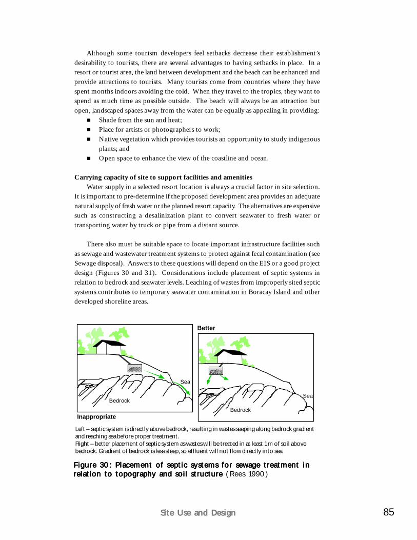
85Site Use and DesignSite Use and DesignSite Use and DesignSite Use and DesignSite Use and Design
Although some tourism developers feel setbacks decrease their establishment’sdesirability to tourists, there are several advantages to having setbacks in place. In aresort or tourist area, the land between development and the beach can be enhanced andprovide attractions to tourists. Many tourists come from countries where they havespent months indoors avoiding the cold. When they travel to the tropics, they want tospend as much time as possible outside. The beach will always be an attraction butopen, landscaped spaces away from the water can be equally as appealing in providing:
Shade from the sun and heat;Place for artists or photographers to work;Native vegetation which provides tourists an opportunity to study indigenousplants; andOpen space to enhance the view of the coastline and ocean.
Carrying capacity of site to support facilities and amenitiesWater supply in a selected resort location is always a crucial factor in site selection.
It is important to pre-determine if the proposed development area provides an adequatenatural supply of fresh water or the planned resort capacity. The alternatives are expensivesuch as constructing a desalinization plant to convert seawater to fresh water ortransporting water by truck or pipe from a distant source.
There also must be suitable space to locate important infrastructure facilities suchas sewage and wastewater treatment systems to protect against fecal contamination (seeSewage disposal). Answers to these questions will depend on the EIS or a good projectdesign (Figures 30 and 31). Considerations include placement of septic systems inrelation to bedrock and seawater levels. Leaching of wastes from improperly sited septicsystems contributes to temporary seawater contamination in Boracay Island and otherdeveloped shoreline areas.
Figure 30: Placement of septic systems for sewage treatment inFigure 30: Placement of septic systems for sewage treatment inFigure 30: Placement of septic systems for sewage treatment inFigure 30: Placement of septic systems for sewage treatment inFigure 30: Placement of septic systems for sewage treatment inrelation to topography and soil structure relation to topography and soil structure relation to topography and soil structure relation to topography and soil structure relation to topography and soil structure (Rees 1990)
Left – septic system is directly above bedrock, resulting in wastes seeping along bedrock gradientand reaching sea before proper treatment.Right – better placement of septic system as wastes will be treated in at least 1 m of soil abovebedrock. Gradient of bedrock is less steep, so effluent will not flow directly into sea.
Bedrock
Sea
Bedrock
Sea
Inappropriate
Better
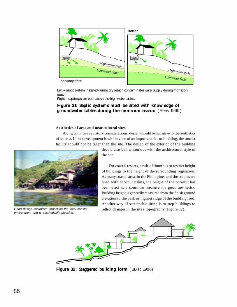
86
Figure 32: Staggered building form Figure 32: Staggered building form Figure 32: Staggered building form Figure 32: Staggered building form Figure 32: Staggered building form (BBIR 1996)
Aesthetics of area and near cultural sitesAlong with the regulatory considerations, design should be sensitive to the aesthetics
of an area. If the development is within view of an important site or building, the touristfacility should not be taller than the site. The design of the exterior of the building
should also be harmonious with the architectural style ofthe site.
For coastal resorts, a rule of thumb is to restrict heightof buildings to the height of the surrounding vegetation.As many coastal areas in the Philippines and the tropics arelined with coconut palms, the height of the coconut hasbeen used as a common measure for good aesthetics.Building height is generally measured from the finish groundelevation to the peak or highest ridge of the building roof.Another way of sustainable siting is to step buildings toreflect changes in the site’s topography (Figure 32).Good design minimizes impact on the local coastal
environment and is aesthetically pleasing.
Figure 31: Septic systems must be sited with knowledge ofFigure 31: Septic systems must be sited with knowledge ofFigure 31: Septic systems must be sited with knowledge ofFigure 31: Septic systems must be sited with knowledge ofFigure 31: Septic systems must be sited with knowledge ofgroundwater tables during the monsoon season groundwater tables during the monsoon season groundwater tables during the monsoon season groundwater tables during the monsoon season groundwater tables during the monsoon season (Rees 1990)
Left – septic system installed during dry season contaminates water supply during monsoonseason.Right – septic system built above the high water tables.
High water tableLow water table
High water tableLow water table
Better
Inappropriate
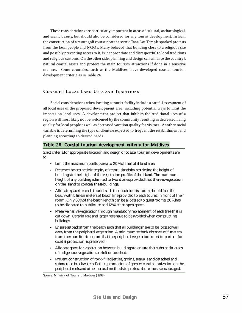
87Site Use and DesignSite Use and DesignSite Use and DesignSite Use and DesignSite Use and Design
Strict criteria for appropriate location and design of coastal tourism developments areto:
Limit the maximum builtup area to 20% of the total land area.
Preserve the aesthetic integrity of resort islands by restricting the height ofbuildings to the height of the vegetation profile of the island. The maximumheight of any building is limited to two stories provided that there is vegetationon the island to conceal these buildings.
Allocate space for each tourist such that each tourist room should face thebeach with 5 linear meters of beach line provided to each tourist in front of theirroom. Only 68% of the beach length can be allocated to guestrooms, 20% hasto be allocated to public use and 12% left as open space.
Preserve native vegetation through mandatory replacement of each tree that iscut down. Certain rare and large trees have to be avoided when constructingbuildings.Ensure setbacks from the beach such that all buildings have to be located wellaway from the peripheral vegetation. A minimum setback distance of 5 metersfrom the shoreline to ensure that the peripheral vegetation, most important forcoastal protection, is preserved.
Allocate space for vegetation between buildings to ensure that substantial areasof indigenous vegetation are left untouched.
Prevent construction of rock-filled jetties, groins, seawalls and detached andsubmerged breakwaters. Rather, promotion of greater coral colonization on theperipheral reefs and other natural methods to protect shorelines is encouraged.
These considerations are particularly important in areas of cultural, archaeological,and scenic beauty, but should also be considered for any tourist development. In Bali,the construction of a resort golf course near the scenic Tana Lot Temple sparked protestsfrom the local people and NGOs. Many believed that building close to a religious siteand possibly preventing access to it, is inappropriate and disrespectful to local traditionsand religious customs. On the other side, planning and design can enhance the country’snatural coastal assets and protect the main tourism attractions if done in a sensitivemanner. Some countries, such as the Maldives, have developed coastal tourismdevelopment criteria as in Table 26.
CONSIDER LOCAL LAND USES AND TRADITIONS
Social considerations when locating a tourist facility include a careful assessment ofall local uses of the proposed development area, including potential ways to limit theimpacts on local uses. A development project that inhibits the traditional uses of aregion will most likely not be welcomed by the community, resulting in decreased livingquality for local people as well as decreased vacation quality for visitors. Another socialvariable is determining the type of clientele expected to frequent the establishment andplanning according to desired needs.
Table 26. Coastal tourism development criteria for MaldivesTable 26. Coastal tourism development criteria for MaldivesTable 26. Coastal tourism development criteria for MaldivesTable 26. Coastal tourism development criteria for MaldivesTable 26. Coastal tourism development criteria for Maldives
Source: Ministry of Tourism, Maldives (1998)
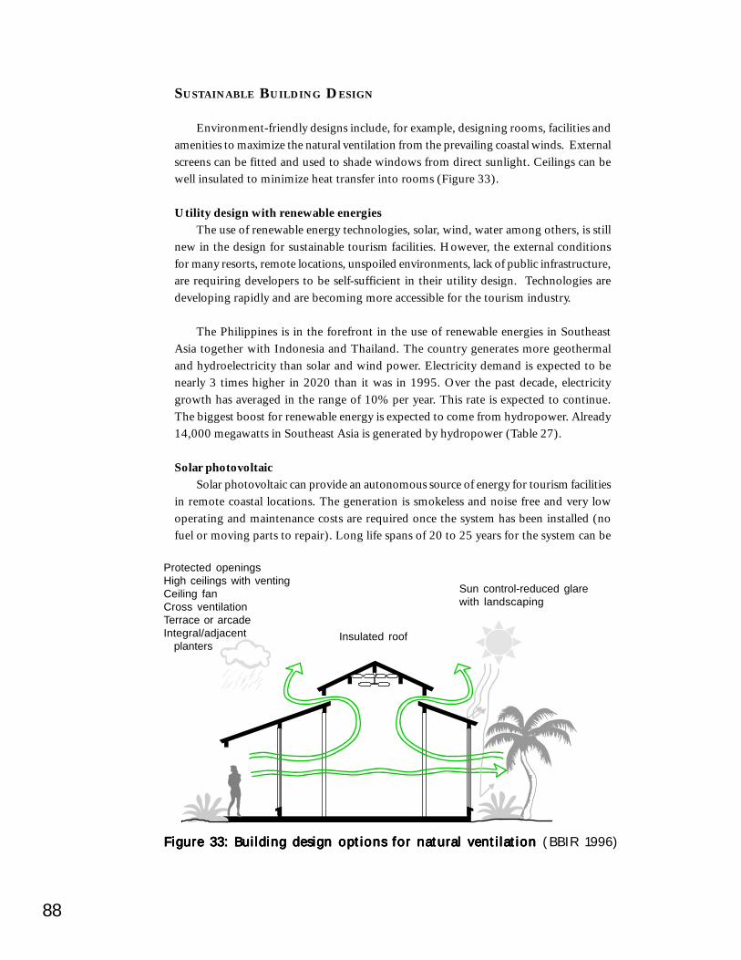
88
SUSTAINABLE BUILDING DESIGN
Environment-friendly designs include, for example, designing rooms, facilities andamenities to maximize the natural ventilation from the prevailing coastal winds. Externalscreens can be fitted and used to shade windows from direct sunlight. Ceilings can bewell insulated to minimize heat transfer into rooms (Figure 33).
Utility design with renewable energiesThe use of renewable energy technologies, solar, wind, water among others, is still
new in the design for sustainable tourism facilities. However, the external conditionsfor many resorts, remote locations, unspoiled environments, lack of public infrastructure,are requiring developers to be self-sufficient in their utility design. Technologies aredeveloping rapidly and are becoming more accessible for the tourism industry.
The Philippines is in the forefront in the use of renewable energies in SoutheastAsia together with Indonesia and Thailand. The country generates more geothermaland hydroelectricity than solar and wind power. Electricity demand is expected to benearly 3 times higher in 2020 than it was in 1995. Over the past decade, electricitygrowth has averaged in the range of 10% per year. This rate is expected to continue.The biggest boost for renewable energy is expected to come from hydropower. Already14,000 megawatts in Southeast Asia is generated by hydropower (Table 27).
Solar photovoltaicSolar photovoltaic can provide an autonomous source of energy for tourism facilities
in remote coastal locations. The generation is smokeless and noise free and very lowoperating and maintenance costs are required once the system has been installed (nofuel or moving parts to repair). Long life spans of 20 to 25 years for the system can be
Figure 33: Building design options for natural ventilation Figure 33: Building design options for natural ventilation Figure 33: Building design options for natural ventilation Figure 33: Building design options for natural ventilation Figure 33: Building design options for natural ventilation (BBIR 1996)
Insulated roof
Protected openingsHigh ceilings with ventingCeiling fanCross ventilationTerrace or arcadeIntegral/adjacent planters
Sun control-reduced glarewith landscaping
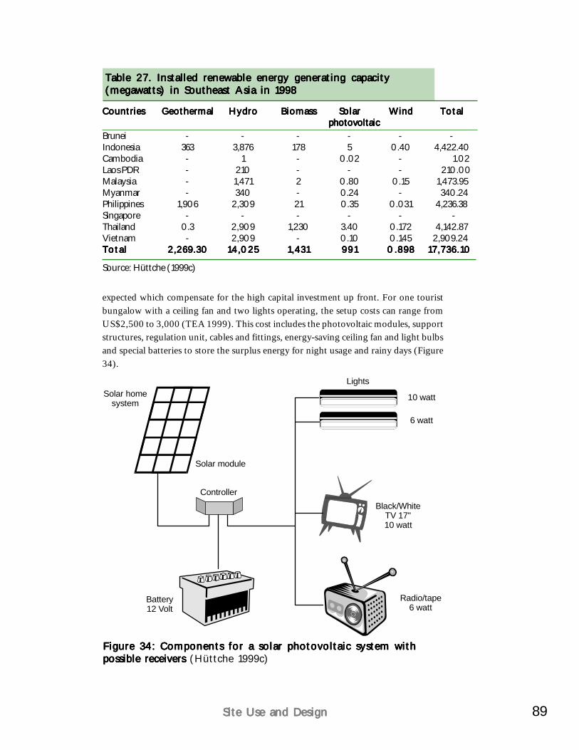
89Site Use and DesignSite Use and DesignSite Use and DesignSite Use and DesignSite Use and Design
expected which compensate for the high capital investment up front. For one touristbungalow with a ceiling fan and two lights operating, the setup costs can range fromUS$2,500 to 3,000 (TEA 1999). This cost includes the photovoltaic modules, supportstructures, regulation unit, cables and fittings, energy-saving ceiling fan and light bulbsand special batteries to store the surplus energy for night usage and rainy days (Figure34).
Figure 34: Components for a solar photovoltaic system withFigure 34: Components for a solar photovoltaic system withFigure 34: Components for a solar photovoltaic system withFigure 34: Components for a solar photovoltaic system withFigure 34: Components for a solar photovoltaic system withpossible receivers possible receivers possible receivers possible receivers possible receivers (Hüttche 1999c)
Solar module
Controller
Battery12 Volt
Solar homesystem
Black/WhiteTV 17"10 watt
Radio/tape6 watt
10 watt
Lights
6 watt
Table 27. Installed renewable energy generating capacityTable 27. Installed renewable energy generating capacityTable 27. Installed renewable energy generating capacityTable 27. Installed renewable energy generating capacityTable 27. Installed renewable energy generating capacity(megawatts) in Southeast Asia in 1998(megawatts) in Southeast Asia in 1998(megawatts) in Southeast Asia in 1998(megawatts) in Southeast Asia in 1998(megawatts) in Southeast Asia in 1998
CountriesCountriesCountriesCountriesCountries GeothermalGeothermalGeothermalGeothermalGeothermal HydroHydroHydroHydroHydro BiomassBiomassBiomassBiomassBiomass SolarSolarSolarSolarSolar WindWindWindWindWind TotalTotalTotalTotalTotal photovoltaicphotovoltaicphotovoltaicphotovoltaicphotovoltaic
Brunei - - - - - -Indonesia 363 3,876 178 5 0.40 4,422.40Cambodia - 1 - 0.02 - 1.02Laos PDR - 210 - - - 210.00Malaysia - 1,471 2 0.80 0.15 1,473.95Myanmar - 340 - 0.24 - 340.24Philippines 1,906 2,309 21 0.35 0.031 4,236.38Singapore - - - - - -Thailand 0.3 2,909 1,230 3.40 0.172 4,142.87Vietnam - 2,909 - 0.10 0.145 2,909.24TotalTotalTotalTotalTotal 2,269.302,269.302,269.302,269.302,269.30 14,02514,02514,02514,02514,025 1,4311,4311,4311,4311,431 991991991991991 0.8980.8980.8980.8980.898 17,736.1017,736.1017,736.1017,736.1017,736.10
Source: Hüttche (1999c)
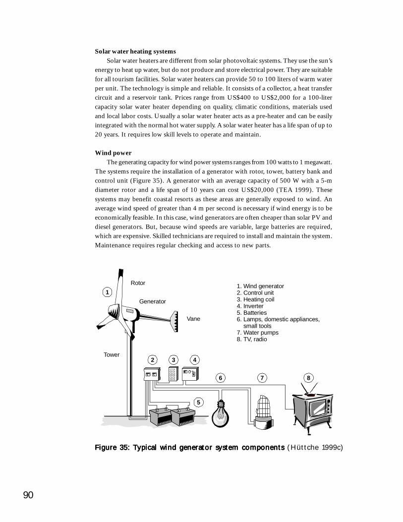
90
Solar water heating systemsSolar water heaters are different from solar photovoltaic systems. They use the sun’s
energy to heat up water, but do not produce and store electrical power. They are suitablefor all tourism facilities. Solar water heaters can provide 50 to 100 liters of warm waterper unit. The technology is simple and reliable. It consists of a collector, a heat transfercircuit and a reservoir tank. Prices range from US$400 to US$2,000 for a 100-litercapacity solar water heater depending on quality, climatic conditions, materials usedand local labor costs. Usually a solar water heater acts as a pre-heater and can be easilyintegrated with the normal hot water supply. A solar water heater has a life span of up to20 years. It requires low skill levels to operate and maintain.
Wind powerThe generating capacity for wind power systems ranges from 100 watts to 1 megawatt.
The systems require the installation of a generator with rotor, tower, battery bank andcontrol unit (Figure 35). A generator with an average capacity of 500 W with a 5-mdiameter rotor and a life span of 10 years can cost US$20,000 (TEA 1999). Thesesystems may benefit coastal resorts as these areas are generally exposed to wind. Anaverage wind speed of greater than 4 m per second is necessary if wind energy is to beeconomically feasible. In this case, wind generators are often cheaper than solar PV anddiesel generators. But, because wind speeds are variable, large batteries are required,which are expensive. Skilled technicians are required to install and maintain the system.Maintenance requires regular checking and access to new parts.
Figure 35: Typical wind generator system components Figure 35: Typical wind generator system components Figure 35: Typical wind generator system components Figure 35: Typical wind generator system components Figure 35: Typical wind generator system components (Hüttche 1999c)
1. Wind generator2. Control unit3. Heating coil4. Inverter5. Batteries6. Lamps, domestic appliances, small tools7. Water pumps8. TV, radio
Rotor
Generator
Vane
2 3 4
5
6 7 8
1
Tower

91Site Use and DesignSite Use and DesignSite Use and DesignSite Use and DesignSite Use and Design
Hydro powerElectricity can be generated on a small scale using the water flow in rivers and
streams (Figure 36). Hydro plants are classified as: micro (less than 100 kW), mini(100-500 kW), small (500-1,000 kW) or large (above 1,000 kW). The first two systemsare more relevant to tourism projects. These systems consist of a weir (small dam),settling tank, turbine and generator and control mechanism. Micro and mini hydro aremost suitable where there is no grid extension. Investment costs for micro and minihydro plants are very site-specific. They depend on the distance between the plant andthe tourism facility and on what the electricity will be used for. To avoid large distributioncosts, the hydro plant should be 5 km or less from the resort. A well-maintained systemcan last about 20 years without any major new investments.
Figure 36: Example of a mini-hydro plant for electricity generationFigure 36: Example of a mini-hydro plant for electricity generationFigure 36: Example of a mini-hydro plant for electricity generationFigure 36: Example of a mini-hydro plant for electricity generationFigure 36: Example of a mini-hydro plant for electricity generation(Hüttche 1999c)
Settling tankCanal
Headrace
Sluice gate
Spillway
Forebay tankPenstock
Transmission
Generator
Turbine
Trailrace
Control panel
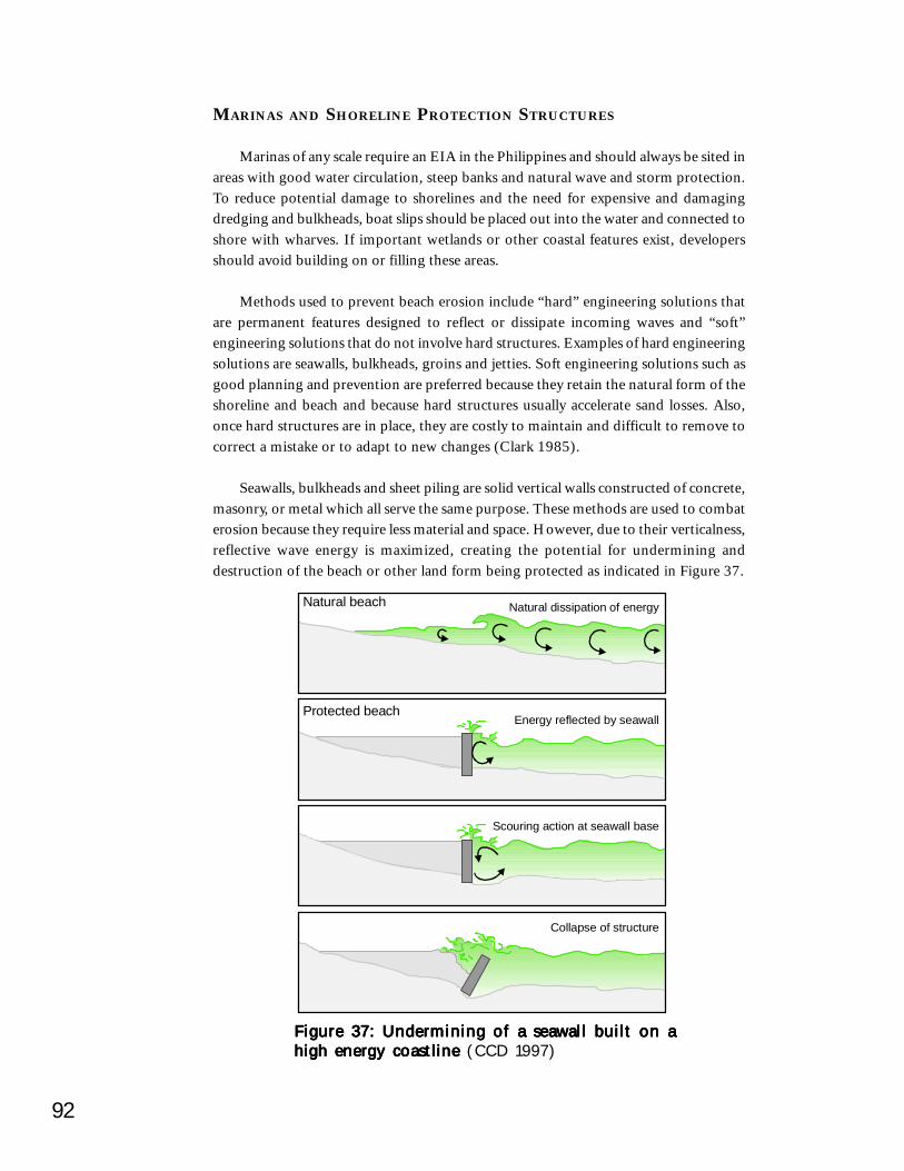
92
MARINAS AND SHORELINE PROTECTION STRUCTURES
Marinas of any scale require an EIA in the Philippines and should always be sited inareas with good water circulation, steep banks and natural wave and storm protection.To reduce potential damage to shorelines and the need for expensive and damagingdredging and bulkheads, boat slips should be placed out into the water and connected toshore with wharves. If important wetlands or other coastal features exist, developersshould avoid building on or filling these areas.
Methods used to prevent beach erosion include “hard” engineering solutions thatare permanent features designed to reflect or dissipate incoming waves and “soft”engineering solutions that do not involve hard structures. Examples of hard engineeringsolutions are seawalls, bulkheads, groins and jetties. Soft engineering solutions such asgood planning and prevention are preferred because they retain the natural form of theshoreline and beach and because hard structures usually accelerate sand losses. Also,once hard structures are in place, they are costly to maintain and difficult to remove tocorrect a mistake or to adapt to new changes (Clark 1985).
Seawalls, bulkheads and sheet piling are solid vertical walls constructed of concrete,masonry, or metal which all serve the same purpose. These methods are used to combaterosion because they require less material and space. However, due to their verticalness,reflective wave energy is maximized, creating the potential for undermining anddestruction of the beach or other land form being protected as indicated in Figure 37.
Figure 37: Undermining of a seawall built on aFigure 37: Undermining of a seawall built on aFigure 37: Undermining of a seawall built on aFigure 37: Undermining of a seawall built on aFigure 37: Undermining of a seawall built on ahigh energy coastline high energy coastline high energy coastline high energy coastline high energy coastline (CCD 1997)
Scouring action at seawall base
Natural beach Natural dissipation of energy
Collapse of structure
Protected beachEnergy reflected by seawall
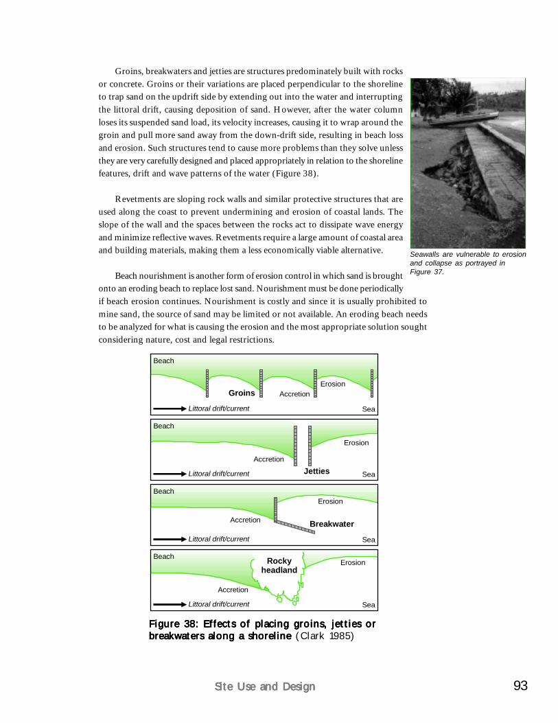
93Site Use and DesignSite Use and DesignSite Use and DesignSite Use and DesignSite Use and Design
Groins, breakwaters and jetties are structures predominately built with rocksor concrete. Groins or their variations are placed perpendicular to the shorelineto trap sand on the updrift side by extending out into the water and interruptingthe littoral drift, causing deposition of sand. However, after the water columnloses its suspended sand load, its velocity increases, causing it to wrap around thegroin and pull more sand away from the down-drift side, resulting in beach lossand erosion. Such structures tend to cause more problems than they solve unlessthey are very carefully designed and placed appropriately in relation to the shorelinefeatures, drift and wave patterns of the water (Figure 38).
Revetments are sloping rock walls and similar protective structures that areused along the coast to prevent undermining and erosion of coastal lands. Theslope of the wall and the spaces between the rocks act to dissipate wave energyand minimize reflective waves. Revetments require a large amount of coastal areaand building materials, making them a less economically viable alternative.
Beach nourishment is another form of erosion control in which sand is broughtonto an eroding beach to replace lost sand. Nourishment must be done periodicallyif beach erosion continues. Nourishment is costly and since it is usually prohibited tomine sand, the source of sand may be limited or not available. An eroding beach needsto be analyzed for what is causing the erosion and the most appropriate solution soughtconsidering nature, cost and legal restrictions.
Figure 38: Effects of placing groins, jetties orFigure 38: Effects of placing groins, jetties orFigure 38: Effects of placing groins, jetties orFigure 38: Effects of placing groins, jetties orFigure 38: Effects of placing groins, jetties orbreakwaters along a shoreline breakwaters along a shoreline breakwaters along a shoreline breakwaters along a shoreline breakwaters along a shoreline (Clark 1985)
Beach
Littoral drift/current
Littoral drift/current
Accretion
Accretion
Groins
Jetties
Erosion
Erosion
Sea
Sea
Beach
Beach
Littoral drift/current
Accretion Breakwater
Erosion
Sea
Beach
Littoral drift/current
Accretion
Erosion
Sea
Rockyheadland
Seawalls are vulnerable to erosionand collapse as portrayed inFigure 37.
94
In all options of protecting coastal areas from erosion, the science is highly impreciseand costly. Engineering studies to determine placement of the structure, obtaining permits,building materials and construction are some of the initial costs. Long-term maintenancecan be very costly depending on the structure used or the erosion forces of the area. Theonly method of avoiding these costs is to not develop along eroding beaches. If developmentis to occur on these beaches, setbacks must be followed to prevent property damage andlarge costs.
In planning a coastal tourist establishment, the hazards of beach erosion may beavoided by following several “golden rules” for combating beach erosion:
Understand the natural beach system before it is altered. Site-specific studiesmay be required at many locations to insure wise planning decisions;Develop a setback line before construction begins;Never mine the sand from the dune, beach or nearshore sandbars;Where a major obstruction to longshore water transport is built, such as aharbor, use soft solutions, such as sand nourishment or diversion of channels,rather than hard solutions, such as revetments or seawalls, to solve beach erosionproblems; andDo not panic after a storm has drastically altered the beach. Wherever possible,let the normal beach cycle return the sand.
CASE STUDY: MACTAN ISLAND
The southeast coast of Mactan Island is an example of uncontrolled developmentstarting in the 1970s that has culminated in a highly modified shoreline. Although inhindsight it cannot be changed, there are lessons to be learned for Philippine shorelinedevelopment as noted in the following case study.
CASE STUDY:THE CHANGED ROCKY AND SANDY COAST OF MACTAN ISLAND
As a coastal resort destination, Mactan Island stands in sharp contrast to the coastdestinations in other Southeast Asian countries. Mactan’s coastal tourism has essentiallydeveloped on a low rock coast with two lagoons facing a deep sea fringed by viable coralreefs. The Mactan shoreline is characterized by short sandy beaches between pronouncedcoral rock outcrops serving as “headlands” along the southeast coast facing OlangoIsland (Figure 39). Since the 1970s, this coast has experienced significant change due topoorly planned resort development.
Three types of modification to Mactan’s southeast coast can be identified. The earlystage involved the least amount of change to the rock coast. The existing limited sandybeaches were used and sea walls were built where necessary. The middle stage ofmodification witnessed a variety of coastal structures built to retain the beaches, together
(continued)
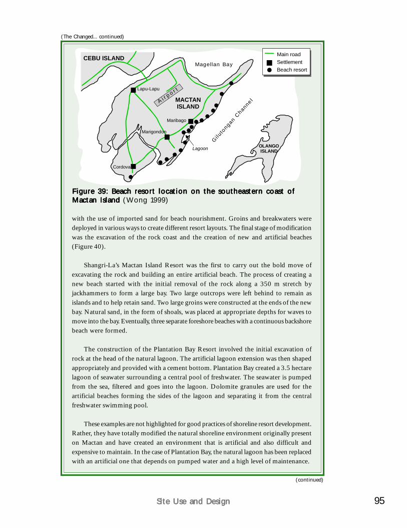
95Site Use and DesignSite Use and DesignSite Use and DesignSite Use and DesignSite Use and Design
Figure 39: Beach resort location on the southeastern coast ofFigure 39: Beach resort location on the southeastern coast ofFigure 39: Beach resort location on the southeastern coast ofFigure 39: Beach resort location on the southeastern coast ofFigure 39: Beach resort location on the southeastern coast ofMactan Island Mactan Island Mactan Island Mactan Island Mactan Island (Wong 1999)
(The Changed... continued)
A i r p o r tLapu-Lapu
MACTANISLAND
CEBU ISLAND
OLANGOISLAND
Marigondon
Maribago
Lagoon
Cordova
Giluto
ngan Channe l
Magellan Bay
Main roadSettlementBeach resort
(continued)
with the use of imported sand for beach nourishment. Groins and breakwaters weredeployed in various ways to create different resort layouts. The final stage of modificationwas the excavation of the rock coast and the creation of new and artificial beaches(Figure 40).
Shangri-La’s Mactan Island Resort was the first to carry out the bold move ofexcavating the rock and building an entire artificial beach. The process of creating anew beach started with the initial removal of the rock along a 350 m stretch byjackhammers to form a large bay. Two large outcrops were left behind to remain asislands and to help retain sand. Two large groins were constructed at the ends of the newbay. Natural sand, in the form of shoals, was placed at appropriate depths for waves tomove into the bay. Eventually, three separate foreshore beaches with a continuous backshorebeach were formed.
The construction of the Plantation Bay Resort involved the initial excavation ofrock at the head of the natural lagoon. The artificial lagoon extension was then shapedappropriately and provided with a cement bottom. Plantation Bay created a 3.5 hectarelagoon of seawater surrounding a central pool of freshwater. The seawater is pumpedfrom the sea, filtered and goes into the lagoon. Dolomite granules are used for theartificial beaches forming the sides of the lagoon and separating it from the centralfreshwater swimming pool.
These examples are not highlighted for good practices of shoreline resort development.Rather, they have totally modified the natural shoreline environment originally presenton Mactan and have created an environment that is artificial and also difficult andexpensive to maintain. In the case of Plantation Bay, the natural lagoon has been replacedwith an artificial one that depends on pumped water and a high level of maintenance.
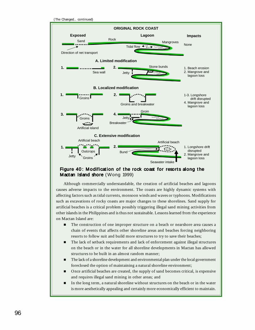
96
Although commercially understandable, the creation of artificial beaches and lagoonscauses adverse impacts to the environment. The coasts are highly dynamic systems withaffecting factors such as tidal currents, monsoon winds and waves or typhoons. Modificationssuch as excavations of rocky coasts are major changes to these shorelines. Sand supply forartificial beaches is a critical problem possibly triggering illegal sand mining activities fromother islands in the Philippines and is thus not sustainable. Lessons learned from the experienceon Mactan Island are:
The construction of one improper structure on a beach or nearshore area causes achain of events that affects other shoreline areas and beaches forcing neighboringresorts to follow suit and build more structures to try to save their beaches;The lack of setback requirements and lack of enforcement against illegal structureson the beach or in the water for all shoreline developments in Mactan has allowedstructures to be built in an almost random manner;The lack of a shoreline development and environmental plan under the local governmentforeclosed the option of maintaining a natural shoreline environment;Once artificial beaches are created, the supply of sand becomes critical, is expensiveand requires illegal sand mining in other areas; andIn the long term, a natural shoreline without structures on the beach or in the wateris more aesthetically appealing and certainly more economically efficient to maintain.
(The Changed... continued)
Figure 40: Modification of the rock coast for resorts along theFigure 40: Modification of the rock coast for resorts along theFigure 40: Modification of the rock coast for resorts along theFigure 40: Modification of the rock coast for resorts along theFigure 40: Modification of the rock coast for resorts along theMactan Island shore Mactan Island shore Mactan Island shore Mactan Island shore Mactan Island shore (Wong 1999)
ORIGINAL ROCK COAST
SandExposed Lagoon Impacts
RockMangroves
NoneTidal flow
Direction of net transport
1. Beach erosion2. Mangrove and lagoon loss
A. Limited modification1.
Sea wall2. Stone bunds
Jetty
1-3. Longshore drift disrupted4. Mangrove and lagoon loss
B. Localized modification
1.Groins
2.
Groins and breakwater
3.
Artificial island
Groins4.
Groin
JettyBreakwater
1. Longshore drift disrupted2. Mangrove and lagoon loss
C. Extensive modification
1.
Artificial beach
Outcrops
GroinsJetty
2.Artificial beach
Seawater intake
Bund
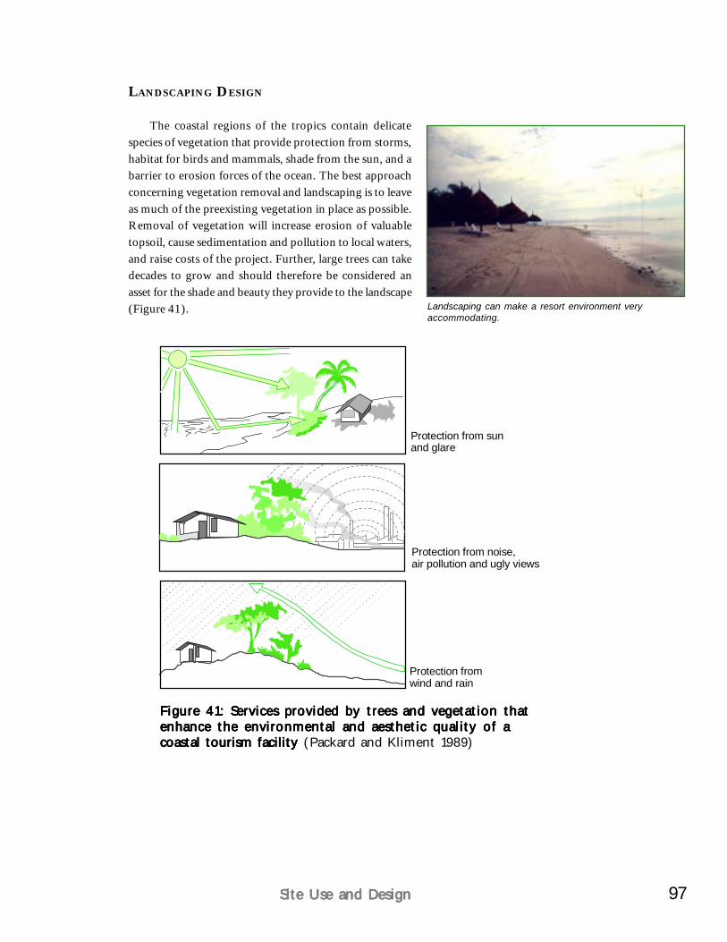
97Site Use and DesignSite Use and DesignSite Use and DesignSite Use and DesignSite Use and Design
LANDSCAPING DESIGN
The coastal regions of the tropics contain delicatespecies of vegetation that provide protection from storms,habitat for birds and mammals, shade from the sun, and abarrier to erosion forces of the ocean. The best approachconcerning vegetation removal and landscaping is to leaveas much of the preexisting vegetation in place as possible.Removal of vegetation will increase erosion of valuabletopsoil, cause sedimentation and pollution to local waters,and raise costs of the project. Further, large trees can takedecades to grow and should therefore be considered anasset for the shade and beauty they provide to the landscape(Figure 41).
Protection from sunand glare
Protection from noise,air pollution and ugly views
Protection fromwind and rain
Figure 41: Services provided by trees and vegetation thatFigure 41: Services provided by trees and vegetation thatFigure 41: Services provided by trees and vegetation thatFigure 41: Services provided by trees and vegetation thatFigure 41: Services provided by trees and vegetation thatenhance the environmental and aesthetic quality of aenhance the environmental and aesthetic quality of aenhance the environmental and aesthetic quality of aenhance the environmental and aesthetic quality of aenhance the environmental and aesthetic quality of acoastal tourism facility coastal tourism facility coastal tourism facility coastal tourism facility coastal tourism facility (Packard and Kliment 1989)
Landscaping can make a resort environment veryaccommodating.
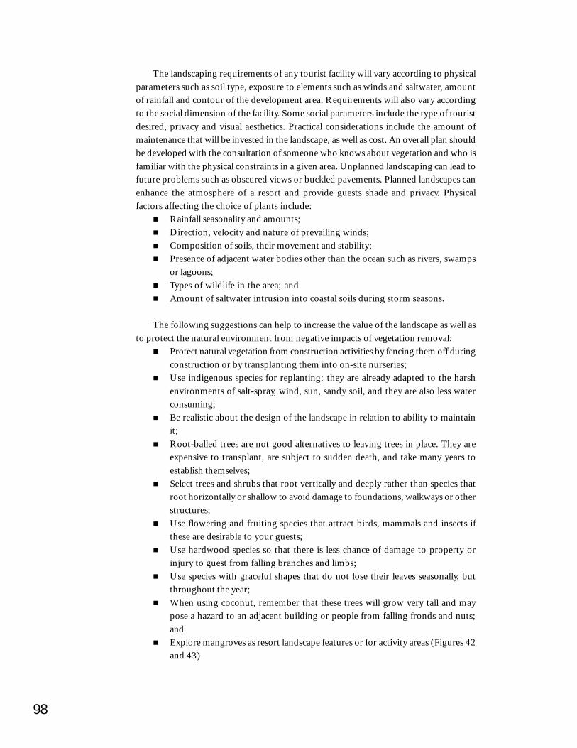
98
The landscaping requirements of any tourist facility will vary according to physicalparameters such as soil type, exposure to elements such as winds and saltwater, amountof rainfall and contour of the development area. Requirements will also vary accordingto the social dimension of the facility. Some social parameters include the type of touristdesired, privacy and visual aesthetics. Practical considerations include the amount ofmaintenance that will be invested in the landscape, as well as cost. An overall plan shouldbe developed with the consultation of someone who knows about vegetation and who isfamiliar with the physical constraints in a given area. Unplanned landscaping can lead tofuture problems such as obscured views or buckled pavements. Planned landscapes canenhance the atmosphere of a resort and provide guests shade and privacy. Physicalfactors affecting the choice of plants include:
Rainfall seasonality and amounts;Direction, velocity and nature of prevailing winds;Composition of soils, their movement and stability;Presence of adjacent water bodies other than the ocean such as rivers, swampsor lagoons;Types of wildlife in the area; andAmount of saltwater intrusion into coastal soils during storm seasons.
The following suggestions can help to increase the value of the landscape as well asto protect the natural environment from negative impacts of vegetation removal:
Protect natural vegetation from construction activities by fencing them off duringconstruction or by transplanting them into on-site nurseries;Use indigenous species for replanting: they are already adapted to the harshenvironments of salt-spray, wind, sun, sandy soil, and they are also less waterconsuming;Be realistic about the design of the landscape in relation to ability to maintainit;Root-balled trees are not good alternatives to leaving trees in place. They areexpensive to transplant, are subject to sudden death, and take many years toestablish themselves;Select trees and shrubs that root vertically and deeply rather than species thatroot horizontally or shallow to avoid damage to foundations, walkways or otherstructures;Use flowering and fruiting species that attract birds, mammals and insects ifthese are desirable to your guests;Use hardwood species so that there is less chance of damage to property orinjury to guest from falling branches and limbs;Use species with graceful shapes that do not lose their leaves seasonally, butthroughout the year;When using coconut, remember that these trees will grow very tall and maypose a hazard to an adjacent building or people from falling fronds and nuts;andExplore mangroves as resort landscape features or for activity areas (Figures 42and 43).
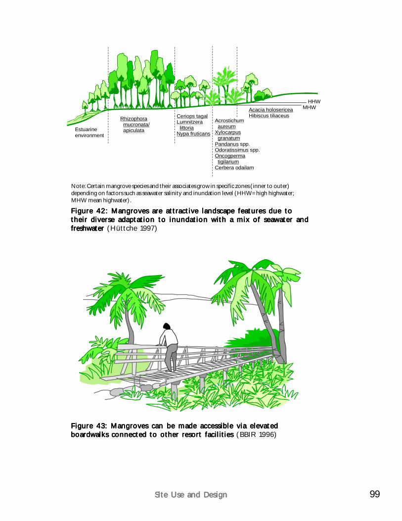
99Site Use and DesignSite Use and DesignSite Use and DesignSite Use and DesignSite Use and Design
HHWMHW
Estuarineenvironment
Rhizophoramucronata/apiculata
Ceriops tagalLumnitzera
littoriaNypa fruticans
Acrostichumaureum
Xylocarpusgranatum
PandanusOdoratissimusOncogpermatigilarium
Cerbera odailam
spp.
spp.
Acacia holosericeaHibiscus tiliaceus
Note: Certain mangrove species and their associates grow in specific zones (inner to outer)depending on factors such as seawater salinity and inundation level (HHW= high highwater;MHW mean highwater).
Figure 43: Mangroves can be made accessible via elevatedFigure 43: Mangroves can be made accessible via elevatedFigure 43: Mangroves can be made accessible via elevatedFigure 43: Mangroves can be made accessible via elevatedFigure 43: Mangroves can be made accessible via elevatedboardwalks connected to other resort facilities boardwalks connected to other resort facilities boardwalks connected to other resort facilities boardwalks connected to other resort facilities boardwalks connected to other resort facilities (BBIR 1996)
Figure 42: Mangroves are attractive landscape features due toFigure 42: Mangroves are attractive landscape features due toFigure 42: Mangroves are attractive landscape features due toFigure 42: Mangroves are attractive landscape features due toFigure 42: Mangroves are attractive landscape features due totheir diverse adaptation to inundation with a mix of seawater andtheir diverse adaptation to inundation with a mix of seawater andtheir diverse adaptation to inundation with a mix of seawater andtheir diverse adaptation to inundation with a mix of seawater andtheir diverse adaptation to inundation with a mix of seawater andfreshwater freshwater freshwater freshwater freshwater (Hüttche 1997)
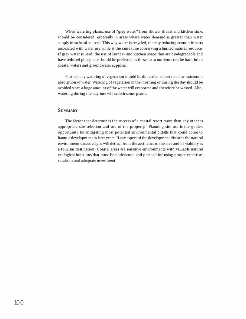
100
When watering plants, use of “grey water” from shower drains and kitchen sinksshould be considered, especially in areas where water demand is greater than watersupply from local sources. This way, water is recycled, thereby reducing economic costsassociated with water use while at the same time conserving a limited natural resource.If grey water is used, the use of laundry and kitchen soaps that are biodegradable andhave reduced phosphate should be preferred as these extra nutrients can be harmful tocoastal waters and groundwater supplies.
Further, any watering of vegetation should be done after sunset to allow maximumabsorption of water. Watering of vegetation in the morning or during the day should beavoided since a large amount of the water will evaporate and therefore be wasted. Also,watering during the daytime will scorch some plants.
SUMMARY
The factor that determines the success of a coastal resort more than any other isappropriate site selection and use of the property. Planning site use is the goldenopportunity for mitigating most potential environmental pitfalls that could come tohaunt a development in later years. If any aspect of the development disturbs the naturalenvironment excessively, it will detract from the aesthetics of the area and its viability asa tourism destination. Coastal areas are sensitive environments with valuable naturalecological functions that must be understood and planned for using proper expertise,solutions and adequate investment.

CHAPTER 8
Construction ActivitiesConstruction ActivitiesConstruction ActivitiesConstruction ActivitiesConstruction Activities
Construction is when humans take over.Construction is when humans take over.Construction is when humans take over.Construction is when humans take over.Construction is when humans take over.This is always dangerous and requires carefulThis is always dangerous and requires carefulThis is always dangerous and requires carefulThis is always dangerous and requires carefulThis is always dangerous and requires careful
planning and management to preventplanning and management to preventplanning and management to preventplanning and management to preventplanning and management to preventunwanted results.unwanted results.unwanted results.unwanted results.unwanted results.
During construction of coastal tourism facilities, various direct and indirectenvironmental impacts occur. Therein lies the nature of construction, an activity causingalterations in the physical, biological and social environment.
Some impacts are temporary and cease when construction is complete, others alterthe coastal landscape irreversibly. Secondary impacts from construction such as soilerosion, increased surface runoff and siltation of coastalwaters can be more serious as they can affect larger areasthan the original construction site. By means of surfacerunoff into coastal areas, various ecosystem types can beimpacted, for instance, coastal streams, wetlands or coralreefs.
Environmental Impact Assessments (EIAs) in any formhelp guide construction activities to minimize negativeimpacts. Environmental Clearance Certificate (ECC)requirements should also be followed.
Careful management of construction activities in coastalenvironments benefits the environment and protects theinvestment into existing coastal assets such as clean beaches and seas. In many cases,where no proper environmental controls were exercised during construction, repairsand cleanup measures of scenic beaches or lagoons become expensive.
Construction activities, if not planned and controlled, cancause irreplaceable environmental damage to adevelopment site.
102
BUILDING MATERIALS AND STANDARDS FOR CONSTRUCTION
In most cases, developers use local materials for the construction of facilities. Incoastal areas, the use of sand to make concrete for permanent structures can have seriousimpacts. Beaches are lost as a result of sand removal. Sand mining can cause sedimentationin nearshore waters. Using coral as a construction material causes direct loss of largeareas of reef. Historically, coral rocks were used in the construction of some houses,tourist facilities and shoreline protection measures. This coral mining led to significantloss of reefs and extensive coastal erosion and loss of valuable beaches. Coral is nowstrictly protected and not used.
Besides conventional materials, such as sand, gravel and wood, resorts can usematerials recycled from other sources. Many new recycled materials are attractive,durable and relatively inexpensive. These materials include sawdust and plastic.Materials from resorts’ operations like bottles can be recycled into products such asglasses and tiles. Certain native materials can also be used creatively in resort designand construction such as coconut and its derived fiber products, nipa palm and otherlocal materials.
The following set of standards can be copied and amended by LGUs and developersto suit their individual needs. They should be made known to all involved constructioncontractors by making them part of contractual agreements. If contractors fail tocomply with these standards, they have to cover mitigation or repair expenses and canbe punished with contractual fines.
Pre-construction preparationsPreserve a sufficient area around remaining trees with smaller trees andundergrowth to protect trees from sun and heat stress as well as immediatedamage through construction.Prior to, and during construction, all trees/habitats should be clearly defined,so that inadvertent entry does not occur. Areas may be delineated either by:
Placement of temporary construction fencing to restrict access intosensitive areasPosting of signs on durable posts, or on construction fence, to indicatethat these areas should be avoided.
In addition, orientation training should be conducted for all constructionworkers to advise them of the restrictions on entering environmentally sensitiveareas.Protect ‘stepping stone’ habitats from damage during construction. ‘Steppingstones’ are habitat pockets to which wildlife can retreat during constructionor which are used by wildlife to migrate temporarily to undisturbed areas.Avoid disturbances from construction during breeding seasons of sensitivebird species, sea turtles or other wildlife. Seal off effective nest and roostsites.
103Construction ActivitiesConstruction ActivitiesConstruction ActivitiesConstruction ActivitiesConstruction Activities
During construction: Clearing and removal practicesPractice the proposed standards for clearing, grading excavation and earthwork,
temporary drainage and construction as outlined below. The practice of clearing orremoving vegetation from the project site should be based on the following principles:
To allow for construction of specific structures and facilities;To ensure public health, safety and welfare;To enhance the aesthetic impact of proposed developments within the contextof the development;To minimize the degree and extent of clearing as much as possible;To reduce costs of clearing and re-landscaping;To reduce the potential for soil erosion; andTo limit impacts on the coastal and stream waters and on the local ecology.
Any clearing and removal activity can be described as belonging to one of the fourfollowing categories in order of preference in maintaining the environment (Figure 44):
No clearing: No removal of plant understory or tree felling; an area of retainedforest with no access provided.Aesthetic clearing: Removal of understory vegetation for visual access andaesthetic enhancement, to the extent indicated on the landscape design drawings.
To minimize disturbance to existing soils, aesthetic clearing work shouldbe carried out manually, and no heavy equipment should be used.Aesthetic clearing is distinct from selective clearing and should be carriedout separately.
Selective clearing: Removal of dangerous trees and potentially dangerous treesto ensure public health, safety and welfare.
To minimize disturbance to the existing soil and other plants, selectiveclearing should be carried out manually, no heavy machinery should beused.Selective clearing is distinct from total clearing and should be carried outseparately.Cut dangerous and potentially dangerous trees, which have been identifiedand marked (based on such factors as size, species, condition, proximity todevelopment). Tree felling should not be carried out by heavy equipment.Trees should be felled towards the total clearance area. Trees should be cutas near to the existing ground level as possible. Stump and roots should notbe removed or disturbed.Rough grading should use native topsoil to fill local depressions to preventpockets of standing water and provide overall positive drainage.
Total clearing: Removal of all vegetation in the area required for construction.Only where completely necessary for building construction or safety reasons.Tree felling should begin at the center of the clearance area and movetowards the limit of work to prevent damage outside the limit of clearingwork.Tree stumps should only be removed where buildings or underground servicesare to be located but left in other areas and cut as close to grade as possible.
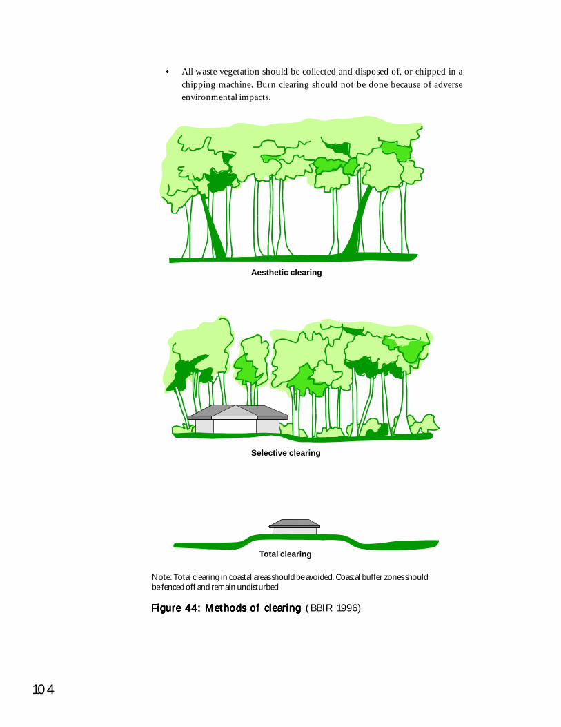
104
All waste vegetation should be collected and disposed of, or chipped in achipping machine. Burn clearing should not be done because of adverseenvironmental impacts.
Figure 44: Methods of clearing Figure 44: Methods of clearing Figure 44: Methods of clearing Figure 44: Methods of clearing Figure 44: Methods of clearing (BBIR 1996)
Note: Total clearing in coastal areas should be avoided. Coastal buffer zones shouldbe fenced off and remain undisturbed
Total clearing
Selective clearing
Aesthetic clearing

105Construction ActivitiesConstruction ActivitiesConstruction ActivitiesConstruction ActivitiesConstruction Activities
Specific guidelines for clearing and removalKey points to consider are:
Contractors should have and follow approved clearing plans;Clearing plans should indicate which trees are to be cleared, which are to berelocated, and which are to be preserved in place;To reduce the potential for soil erosion and sedimentation of waterways, clearingand grading activities should be phased to limit the area of land left unvegetatedat one time;No clearing should be done within the established setbacks from streams orcoastal waters;A vegetated buffer strip of approximately 30 m should be maintained betweencleared areas and coastal or stream waters to help filter runoff water and preventsedimentation;Clearing should not alter existing stream flows or natural drainage;No clearing of mangrove areas should take place;No mature trees should be cleared for the purposes of locating temporarystructures; andRevegetation of cleared areas should be conducted as soon as practical to preventsoil erosion. Areas that must remain cleared for more than 30 days beforeconstruction or landscaping should be temporarily vegetated with an appropriategrass or groundcover.
During construction: Grading, excavation and earthworkGrading, excavation and earthwork should be minimized as much as possible and
limited to only those areas absolutely needed for one or more of the following structures:Roadways;Drainage and sewerage works;Electrical and communication lines;Topsoil stripping or leveling to insure thatminimum depths of fill are maintained; andBuilding foundations.
To preserve topsoil, and limit off-site disposal,amounts of cut and fill should be balanced as much aspossible. Also, the use of heavy machinery for gradingand earthwork should be limited as much as practical toprevent impacts to the existing soil profile and vegetation.
A vegetated buffer strip of approximately 30 m shouldbe maintained between areas of earthwork and coastal or stream waters to help filterrunoff water and prevent sedimentation of waterways. Excavation or earthwork shouldnot alter existing stream flows or drainageways. All grading and earthwork activities
Extent of clearing was not considered in this constructionsite since no vegetation remains!
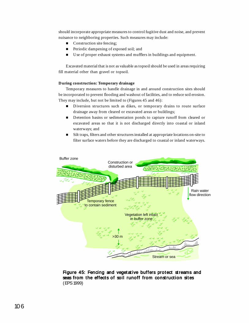
106
should incorporate appropriate measures to control fugitive dust and noise, and preventnuisance to neighboring properties. Such measures may include:
Construction site fencing;Periodic dampening of exposed soil; andUse of proper exhaust systems and mufflers in buildings and equipment.
Excavated material that is not as valuable as topsoil should be used in areas requiringfill material other than gravel or topsoil.
During construction: Temporary drainageTemporary measures to handle drainage in and around construction sites should
be incorporated to prevent flooding and washout of facilities, and to reduce soil erosion.They may include, but not be limited to (Figures 45 and 46):
Diversion structures such as dikes, or temporary drains to route surfacedrainage away from cleared or excavated areas or buildings;Detention basins or sedimentation ponds to capture runoff from cleared orexcavated areas so that it is not discharged directly into coastal or inlandwaterways; andSilt traps, filters and other structures installed at appropriate locations on-site tofilter surface waters before they are discharged to coastal or inland waterways.
Figure 45: Fencing and vegetative buffers protect streams andFigure 45: Fencing and vegetative buffers protect streams andFigure 45: Fencing and vegetative buffers protect streams andFigure 45: Fencing and vegetative buffers protect streams andFigure 45: Fencing and vegetative buffers protect streams andseas from the effects of soil runoff from construction sitesseas from the effects of soil runoff from construction sitesseas from the effects of soil runoff from construction sitesseas from the effects of soil runoff from construction sitesseas from the effects of soil runoff from construction sites(EPS 1999)
Temporary fenceto contain sediment
Vegetation left intactin buffer zone
Rain waterflow direction
>30 m
Stream or sea
Construction ordisturbed area
Buffer zone
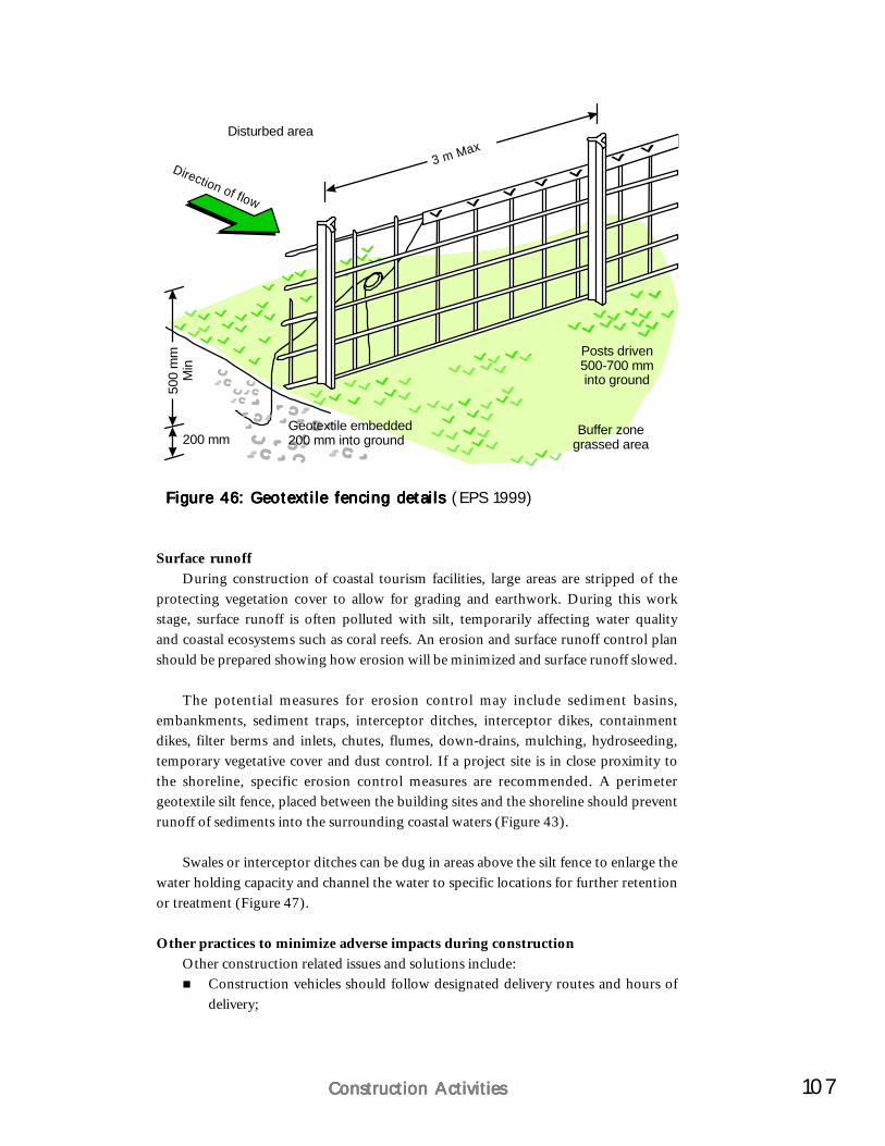
107Construction ActivitiesConstruction ActivitiesConstruction ActivitiesConstruction ActivitiesConstruction Activities
Surface runoffDuring construction of coastal tourism facilities, large areas are stripped of the
protecting vegetation cover to allow for grading and earthwork. During this workstage, surface runoff is often polluted with silt, temporarily affecting water qualityand coastal ecosystems such as coral reefs. An erosion and surface runoff control planshould be prepared showing how erosion will be minimized and surface runoff slowed.
The potential measures for erosion control may include sediment basins,embankments, sediment traps, interceptor ditches, interceptor dikes, containmentdikes, filter berms and inlets, chutes, flumes, down-drains, mulching, hydroseeding,temporary vegetative cover and dust control. If a project site is in close proximity tothe shoreline, specific erosion control measures are recommended. A perimetergeotextile silt fence, placed between the building sites and the shoreline should preventrunoff of sediments into the surrounding coastal waters (Figure 43).
Swales or interceptor ditches can be dug in areas above the silt fence to enlarge thewater holding capacity and channel the water to specific locations for further retentionor treatment (Figure 47).
Other practices to minimize adverse impacts during constructionOther construction related issues and solutions include:
Construction vehicles should follow designated delivery routes and hours ofdelivery;
Figure 46: Geotextile fencing detailsFigure 46: Geotextile fencing detailsFigure 46: Geotextile fencing detailsFigure 46: Geotextile fencing detailsFigure 46: Geotextile fencing details (EPS 1999)
Disturbed area
Direction of flow
Posts driven500-700 mminto ground
Buffer zonegrassed area
3 m Max
200 mm
500
mm
Min
Geotextile embedded200 mm into ground
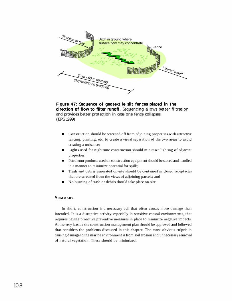
108
Figure 47: Sequence of geotextile silt fences placed in theFigure 47: Sequence of geotextile silt fences placed in theFigure 47: Sequence of geotextile silt fences placed in theFigure 47: Sequence of geotextile silt fences placed in theFigure 47: Sequence of geotextile silt fences placed in thedirection of flow to filter runoff. direction of flow to filter runoff. direction of flow to filter runoff. direction of flow to filter runoff. direction of flow to filter runoff. Sequencing allows better filtrationand provides better protection in case one fence collapses(EPS 1999)
Construction should be screened off from adjoining properties with attractivefencing, planting, etc, to create a visual separation of the two areas to avoidcreating a nuisance;Lights used for nighttime construction should minimize lighting of adjacentproperties;Petroleum products used on construction equipment should be stored and handledin a manner to minimize potential for spills;Trash and debris generated on-site should be contained in closed receptaclesthat are screened from the views of adjoining parcels; andNo burning of trash or debris should take place on-site.
SUMMARY
In short, construction is a necessary evil that often causes more damage thanintended. It is a disruptive activity, especially in sensitive coastal environments, thatrequires having proactive preventive measures in place to minimize negative impacts.At the very least, a site construction management plan should be approved and followedthat considers the problems discussed in this chapter. The most obvious culprit incausing damage to the marine environment is from soil erosion and unnecessary removalof natural vegetation. These should be minimized.
Ditch in ground wheresurface flow may concentrate
Fence
30 m - 60 m spacing(depending on gradient)
Direction of flow
Filtered runoff
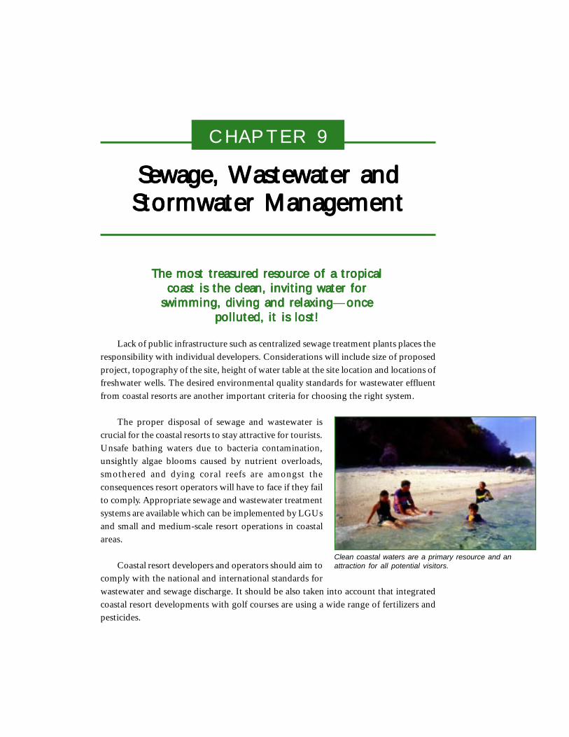
CHAPTER 9
Sewage, Wastewater andSewage, Wastewater andSewage, Wastewater andSewage, Wastewater andSewage, Wastewater andStormwater ManagementStormwater ManagementStormwater ManagementStormwater ManagementStormwater Management
The most treasured resource of a tropicalThe most treasured resource of a tropicalThe most treasured resource of a tropicalThe most treasured resource of a tropicalThe most treasured resource of a tropicalcoast is the clean, inviting water forcoast is the clean, inviting water forcoast is the clean, inviting water forcoast is the clean, inviting water forcoast is the clean, inviting water for
swimming, diving and relaxingswimming, diving and relaxingswimming, diving and relaxingswimming, diving and relaxingswimming, diving and relaxing—onceonceonceonceoncepolluted, it is lost!polluted, it is lost!polluted, it is lost!polluted, it is lost!polluted, it is lost!
Lack of public infrastructure such as centralized sewage treatment plants places theresponsibility with individual developers. Considerations will include size of proposedproject, topography of the site, height of water table at the site location and locations offreshwater wells. The desired environmental quality standards for wastewater effluentfrom coastal resorts are another important criteria for choosing the right system.
The proper disposal of sewage and wastewater iscrucial for the coastal resorts to stay attractive for tourists.Unsafe bathing waters due to bacteria contamination,unsightly algae blooms caused by nutrient overloads,smothered and dying coral reefs are amongst theconsequences resort operators will have to face if they failto comply. Appropriate sewage and wastewater treatmentsystems are available which can be implemented by LGUsand small and medium-scale resort operations in coastalareas.
Coastal resort developers and operators should aim tocomply with the national and international standards forwastewater and sewage discharge. It should be also taken into account that integratedcoastal resort developments with golf courses are using a wide range of fertilizers andpesticides.
Clean coastal waters are a primary resource and anattraction for all potential visitors.
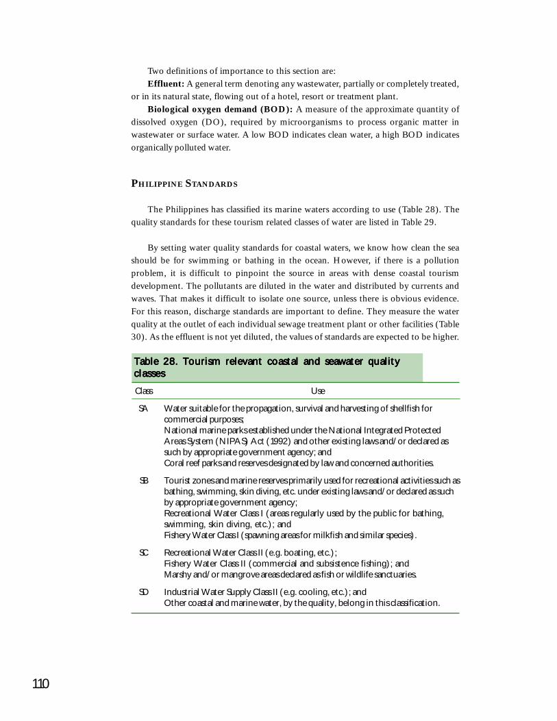
110
Two definitions of importance to this section are:Effluent: A general term denoting any wastewater, partially or completely treated,
or in its natural state, flowing out of a hotel, resort or treatment plant.Biological oxygen demand (BOD): A measure of the approximate quantity of
dissolved oxygen (DO), required by microorganisms to process organic matter inwastewater or surface water. A low BOD indicates clean water, a high BOD indicatesorganically polluted water.
PHILIPPINE STANDARDS
The Philippines has classified its marine waters according to use (Table 28). Thequality standards for these tourism related classes of water are listed in Table 29.
By setting water quality standards for coastal waters, we know how clean the seashould be for swimming or bathing in the ocean. However, if there is a pollutionproblem, it is difficult to pinpoint the source in areas with dense coastal tourismdevelopment. The pollutants are diluted in the water and distributed by currents andwaves. That makes it difficult to isolate one source, unless there is obvious evidence.For this reason, discharge standards are important to define. They measure the waterquality at the outlet of each individual sewage treatment plant or other facilities (Table30). As the effluent is not yet diluted, the values of standards are expected to be higher.
Class Use
SA Water suitable for the propagation, survival and harvesting of shellfish forcommercial purposes;National marine parks established under the National Integrated ProtectedAreas System (NIPAS) Act (1992) and other existing laws and/or declared assuch by appropriate government agency; andCoral reef parks and reserves designated by law and concerned authorities.
SB Tourist zones and marine reserves primarily used for recreational activities such asbathing, swimming, skin diving, etc. under existing laws and/or declared as suchby appropriate government agency;Recreational Water Class I (areas regularly used by the public for bathing,swimming, skin diving, etc.); andFishery Water Class I (spawning areas for milkfish and similar species).
SC Recreational Water Class II (e.g. boating, etc.);Fishery Water Class II (commercial and subsistence fishing); andMarshy and/or mangrove areas declared as fish or wildlife sanctuaries.
SD Industrial Water Supply Class II (e.g. cooling, etc.); andOther coastal and marine water, by the quality, belong in this classification.
Table 28. Tourism relevant coastal and seawater qualityTable 28. Tourism relevant coastal and seawater qualityTable 28. Tourism relevant coastal and seawater qualityTable 28. Tourism relevant coastal and seawater qualityTable 28. Tourism relevant coastal and seawater qualityclassesclassesclassesclassesclasses
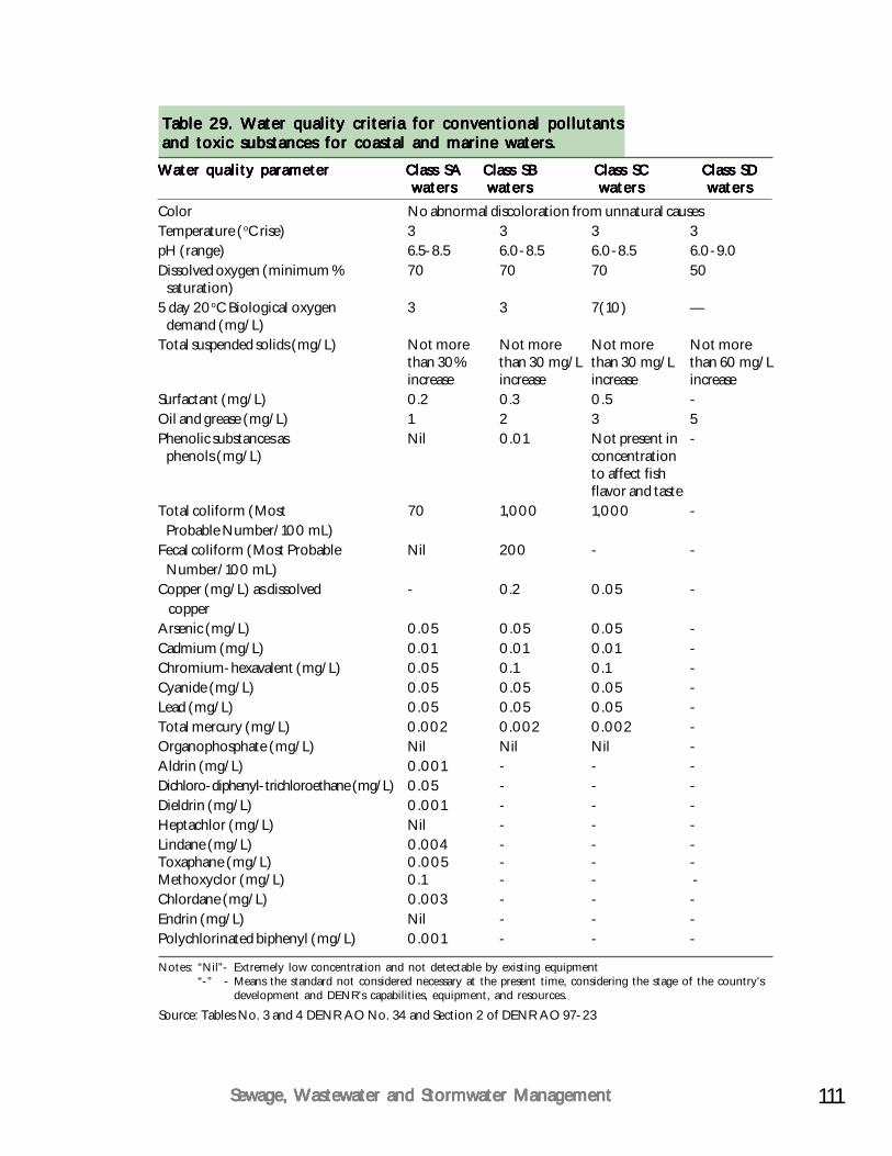
111Sewage, Wastewater and Stormwater ManagementSewage, Wastewater and Stormwater ManagementSewage, Wastewater and Stormwater ManagementSewage, Wastewater and Stormwater ManagementSewage, Wastewater and Stormwater Management
Water quality parameterWater quality parameterWater quality parameterWater quality parameterWater quality parameter Class SAClass SAClass SAClass SAClass SA Class SBClass SBClass SBClass SBClass SB Class SCClass SCClass SCClass SCClass SC Class SDClass SDClass SDClass SDClass SDwaterswaterswaterswaterswaters waterswaterswaterswaterswaters waterswaterswaterswaterswaters waterswaterswaterswaterswaters
Color No abnormal discoloration from unnatural causesTemperature (oC rise) 3 3 3 3pH (range) 6.5-8.5 6.0-8.5 6.0-8.5 6.0-9.0Dissolved oxygen (minimum % 70 70 70 50 saturation)5 day 20oC Biological oxygen 3 3 7(10) — demand (mg/L)Total suspended solids (mg/L) Not more Not more Not more Not more
than 30% than 30 mg/L than 30 mg/L than 60 mg/Lincrease increase increase increase
Surfactant (mg/L) 0.2 0.3 0.5 -Oil and grease (mg/L) 1 2 3 5Phenolic substances as Nil 0.01 Not present in - phenols (mg/L) concentration
to affect fishflavor and taste
Total coliform (Most 70 1,000 1,000 - Probable Number/100 mL)Fecal coliform (Most Probable Nil 200 - - Number/100 mL)Copper (mg/L) as dissolved - 0.2 0.05 - copperArsenic (mg/L) 0.05 0.05 0.05 -Cadmium (mg/L) 0.01 0.01 0.01 -Chromium-hexavalent (mg/L) 0.05 0.1 0.1 -Cyanide (mg/L) 0.05 0.05 0.05 -Lead (mg/L) 0.05 0.05 0.05 -Total mercury (mg/L) 0.002 0.002 0.002 -Organophosphate (mg/L) Nil Nil Nil -Aldrin (mg/L) 0.001 - - -Dichloro-diphenyl-trichloroethane (mg/L) 0.05 - - -Dieldrin (mg/L) 0.001 - - -Heptachlor (mg/L) Nil - - -Lindane (mg/L) 0.004 - - -Toxaphane (mg/L) 0.005 - - -Methoxyclor (mg/L) 0.1 - - -Chlordane (mg/L) 0.003 - - -Endrin (mg/L) Nil - - -Polychlorinated biphenyl (mg/L) 0.001 - - -
Table 29. Water quality criteria for conventional pollutantsTable 29. Water quality criteria for conventional pollutantsTable 29. Water quality criteria for conventional pollutantsTable 29. Water quality criteria for conventional pollutantsTable 29. Water quality criteria for conventional pollutantsand toxic substances for coastal and marine waters.and toxic substances for coastal and marine waters.and toxic substances for coastal and marine waters.and toxic substances for coastal and marine waters.and toxic substances for coastal and marine waters.
Notes: “Nil”- Extremely low concentration and not detectable by existing equipment“-” - Means the standard not considered necessary at the present time, considering the stage of the country’s
development and DENR’s capabilities, equipment, and resources.
Source: Tables No. 3 and 4 DENR AO No. 34 and Section 2 of DENR AO 97-23
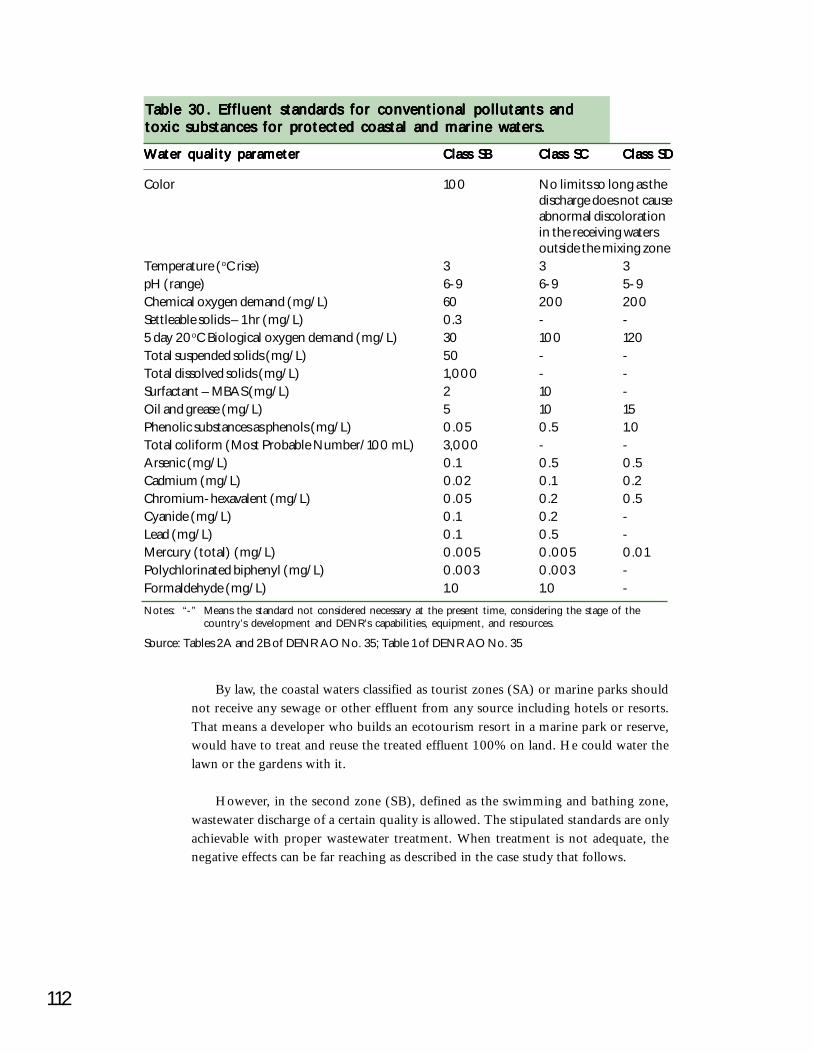
112
Water quality parameterWater quality parameterWater quality parameterWater quality parameterWater quality parameter Class SBClass SBClass SBClass SBClass SB Class SCClass SCClass SCClass SCClass SC Class SDClass SDClass SDClass SDClass SD
Color 100 No limits so long as thedischarge does not causeabnormal discolorationin the receiving watersoutside the mixing zone
Temperature (oC rise) 3 3 3pH (range) 6-9 6-9 5-9Chemical oxygen demand (mg/L) 60 200 200Settleable solids – 1 hr (mg/L) 0.3 - -5 day 20oC Biological oxygen demand (mg/L) 30 100 120Total suspended solids (mg/L) 50 - -Total dissolved solids (mg/L) 1,000 - -Surfactant – MBAS (mg/L) 2 10 -Oil and grease (mg/L) 5 10 15Phenolic substances as phenols (mg/L) 0.05 0.5 1.0Total coliform (Most Probable Number/100 mL) 3,000 - -Arsenic (mg/L) 0.1 0.5 0.5Cadmium (mg/L) 0.02 0.1 0.2Chromium-hexavalent (mg/L) 0.05 0.2 0.5Cyanide (mg/L) 0.1 0.2 -Lead (mg/L) 0.1 0.5 -Mercury (total) (mg/L) 0.005 0.005 0.01Polychlorinated biphenyl (mg/L) 0.003 0.003 -Formaldehyde (mg/L) 1.0 1.0 -
Table 30. Effluent standards for conventional pollutants andTable 30. Effluent standards for conventional pollutants andTable 30. Effluent standards for conventional pollutants andTable 30. Effluent standards for conventional pollutants andTable 30. Effluent standards for conventional pollutants andtoxic substances for protected coastal and marine waters.toxic substances for protected coastal and marine waters.toxic substances for protected coastal and marine waters.toxic substances for protected coastal and marine waters.toxic substances for protected coastal and marine waters.
Notes: “-” Means the standard not considered necessary at the present time, considering the stage of thecountry’s development and DENR’s capabilities, equipment, and resources.
Source: Tables 2A and 2B of DENR AO No. 35; Table 1 of DENR AO No. 35
By law, the coastal waters classified as tourist zones (SA) or marine parks shouldnot receive any sewage or other effluent from any source including hotels or resorts.That means a developer who builds an ecotourism resort in a marine park or reserve,would have to treat and reuse the treated effluent 100% on land. He could water thelawn or the gardens with it.
However, in the second zone (SB), defined as the swimming and bathing zone,wastewater discharge of a certain quality is allowed. The stipulated standards are onlyachievable with proper wastewater treatment. When treatment is not adequate, thenegative effects can be far reaching as described in the case study that follows.
113Sewage, Wastewater and Stormwater ManagementSewage, Wastewater and Stormwater ManagementSewage, Wastewater and Stormwater ManagementSewage, Wastewater and Stormwater ManagementSewage, Wastewater and Stormwater Management
SOUTHEAST ASIAN STANDARDS FOR WASTEWATER DISCHARGE FROM
RESORTS
Water quality standards for wastewater discharge developed and adopted by somemajor regional coastal resorts can be used as benchmarks. These are noted in Table 31with notes on handling and recycling of treated wastewater for irrigation or dischargeinto the sea. It is desirable to reuse treated wastewater to save on precious potable waterresources.
CASE STUDY:BORACAY ISLAND AND MARIBAGO, MACTAN ISLAND
In 1997, DENR tested the quality of marine waters off Boracay Island to find thatthe Philippine water quality standards for tourism areas were not being met. This led tothe widely publicized reports of Boracay’s waters being unsafe for swimming and otherrecreational activities due to high levels of coliform bacteria (total coliforms > 1,000MPN/100 ml, fecal coliforms > 200 MPN/100 ml). There was a resultant drop intourist arrivals to Boracay.
Also, in 1997, the impacts of coastal tourism in Maribago, Mactan Island, wereassessed as part of a master’s thesis by Martinez (1997). Marine water quality wasselected to determine environmental impacts from coastal tourism. Maribago’s coastalwaters were classified as Class SB, the classification adopted in making the MactanIsland Integrated Master Plan Study (Schema Konsult 1996). Water quality analysis wasconducted for several test stations before and after the peak tourist seasons. The resultsshowed that even after the tourist peak season DO and BOD level were within theallowable levels, indicating good conditions for marine life. The average bacteria levelmeasured in total coliform, however, were above the allowable 1,000 MPN/100 ml.This means that the waters were generally clean except that the sewage treatment systemswere not functioning to full satisfaction during the peak tourist season, when approximately800 visitors visited Maribago’s 10 coastal resorts.
Lessons from these cases regarding prevention of pollution in tourism developmentareas include:
Hotel operators and LGUs need to be proactive and use the quality standardsto monitor and control the performance of their treatment systems;Regular water testing at the outlet of the system should be recorded and keptfor reference or corrective actions;LGUs or NGOs with access to laboratory facilities or water testing kits canconduct independent control of water quality along beaches to detect potentialsources of environmental pollution in the interest of the general public;DENR or the LGU should do more regular monitoring of water parameters,especially during seasons of high tourist visitation in prime tourism areas; andHotel operators should seek cooperation with experts and the LGU to improvetreatment capacities and qualities for wastewater and sewage.

114
SUSTAINABLE SOLUTIONS FOR SEWAGE AND WASTEWATER DISPOSAL
Wastewater or “grey water” is the water stream resulting from water wastes fromrestaurants and hotels excluding sewage. This includes shower water from bathroomsand effluent from hotel laundries. Wastewater can be separated from stormwater andsewage for both treatment and disposal. During pipe laying, grey water should be led toa separate storage tank. This will help in reducing overall water volume to the septicsystem, preventing overload.
If the development is in an area of water shortage or if the developer wishes toconserve water, treated wastewater can be reused to water lawns, shrubs and golf coursesor can be diverted for agricultural use. Reuse of wastewater is inexpensive and savessupply costs for potable water.
Table 31. Regional quality standards for wastewater/sewageTable 31. Regional quality standards for wastewater/sewageTable 31. Regional quality standards for wastewater/sewageTable 31. Regional quality standards for wastewater/sewageTable 31. Regional quality standards for wastewater/sewagedischarge into coastal waters discharge into coastal waters discharge into coastal waters discharge into coastal waters discharge into coastal waters (measured at the treatment plant outlet)
Water quality visibility clear Odorless and not toxic upon ingestionpH 6.5 to 8.5 Lime or acid may be added to correct
pHTemperature 0C 40 350C detrimental to coralsBiological oxygen demand mg/L 15Chemical oxygen demand mg/L 50Total suspended solids mg/L 20 Solids not in excess to inhibit rate of
absorption into soilTotal dissolved solids mg/L 2,000Chloride mg/L 400Sulfate mg/L 200Sulfide mg/L 0.1Detergents mg/L 1 No visual pollution, bubbles, foam, etc.Grease and oil mg/L ND Should not be detectableChlorine mg/L 1 Toxic to plants and aquatic lifePhosphate mg/L 4 Phosphate adversely affects plants and
coral reefs, use phosphate-freedetergents
Calcium mg/L 200Magnesium mg/L 200Nitrate mg/L 13 - 26 90% removed through uptake by turfFecal coliform MPN/100 ml <300 Can disinfect with UV light or
chlorination
Water qualityWater qualityWater qualityWater qualityWater quality UnitUnitUnitUnitUnit StandardStandardStandardStandardStandard NotesNotesNotesNotesNotesparameterparameterparameterparameterparameter
Source: BBIR 1996
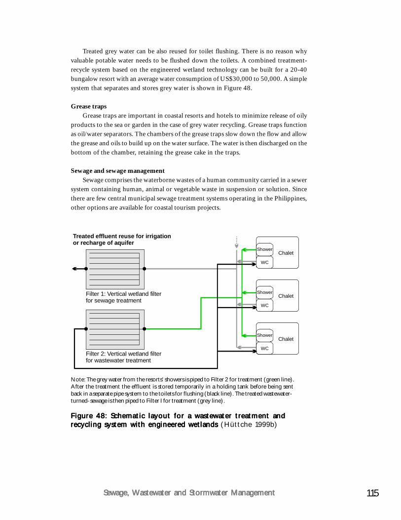
115Sewage, Wastewater and Stormwater ManagementSewage, Wastewater and Stormwater ManagementSewage, Wastewater and Stormwater ManagementSewage, Wastewater and Stormwater ManagementSewage, Wastewater and Stormwater Management
Figure 48: Schematic layout for a wastewater treatment andFigure 48: Schematic layout for a wastewater treatment andFigure 48: Schematic layout for a wastewater treatment andFigure 48: Schematic layout for a wastewater treatment andFigure 48: Schematic layout for a wastewater treatment andrecycling system with engineered wetlands recycling system with engineered wetlands recycling system with engineered wetlands recycling system with engineered wetlands recycling system with engineered wetlands (Hüttche 1999b)
Treated grey water can be also reused for toilet flushing. There is no reason whyvaluable potable water needs to be flushed down the toilets. A combined treatment-recycle system based on the engineered wetland technology can be built for a 20-40bungalow resort with an average water consumption of US$30,000 to 50,000. A simplesystem that separates and stores grey water is shown in Figure 48.
Grease trapsGrease traps are important in coastal resorts and hotels to minimize release of oily
products to the sea or garden in the case of grey water recycling. Grease traps functionas oil/water separators. The chambers of the grease traps slow down the flow and allowthe grease and oils to build up on the water surface. The water is then discharged on thebottom of the chamber, retaining the grease cake in the traps.
Sewage and sewage managementSewage comprises the waterborne wastes of a human community carried in a sewer
system containing human, animal or vegetable waste in suspension or solution. Sincethere are few central municipal sewage treatment systems operating in the Philippines,other options are available for coastal tourism projects.
Note: The grey water from the resorts’ showers is piped to Filter 2 for treatment (green line).After the treatment the effluent is stored temporarily in a holding tank before being sentback in a separate pipe system to the toilets for flushing (black line). The treated wastewater-turned-sewage is then piped to Filter I for treatment (grey line).
Shower
Shower
Shower
Chalet
Filter 1: Vertical wetland filterfor sewage treatment
Treated effluent reuse for irrigationor recharge of aquifer
Filter 2: Vertical wetland filterfor wastewater treatment
Chalet
Chalet
WC
WC
WC
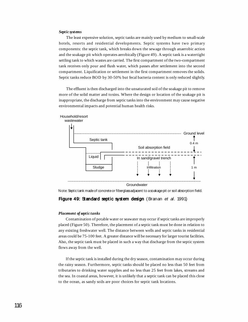
116
Figure 49: Standard septic system design Figure 49: Standard septic system design Figure 49: Standard septic system design Figure 49: Standard septic system design Figure 49: Standard septic system design (Branan et al. 1991)
Note: Septic tank made of concrete or fiberglass adjacent to a soakage pit or soil absorption field.
Septic systemsThe least expensive solution, septic tanks are mainly used by medium to small-scale
hotels, resorts and residential developments. Septic systems have two primarycomponents: the septic tank, which breaks down the sewage through anaerobic actionand the soakage pit which operates aerobically (Figure 49). A septic tank is a watertightsettling tank to which wastes are carried. The first compartment of the two-compartmenttank receives only pour and flush water, which passes after settlement into the secondcompartment. Liquification or settlement in the first compartment removes the solids.Septic tanks reduce BOD by 30-50% but fecal bacteria content is only reduced slightly.
The effluent is then discharged into the unsaturated soil of the soakage pit to removemore of the solid matter and toxins. Where the design or location of the soakage pit isinappropriate, the discharge from septic tanks into the environment may cause negativeenvironmental impacts and potential human health risks.
Placement of septic tanksContamination of potable water or seawater may occur if septic tanks are improperly
placed (Figure 50). Therefore, the placement of a septic tank must be done in relation toany existing freshwater well. The distance between wells and septic tanks in residentialareas could be 75-100 feet. A greater distance will be necessary for larger tourist facilities.Also, the septic tank must be placed in such a way that discharge from the septic systemflows away from the well.
If the septic tank is installed during the dry season, contamination may occur duringthe rainy season. Furthermore, septic tanks should be placed no less than 50 feet fromtributaries to drinking water supplies and no less than 25 feet from lakes, streams andthe sea. In coastal areas, however, it is unlikely that a septic tank can be placed this closeto the ocean, as sandy soils are poor choices for septic tank locations.
1 m
0.4 m
Ground level
Groundwater
Soil absorption field
In sand/gravel trench
Septic tank
Household/resortwastewater
Sludge
Liquid
Infiltration
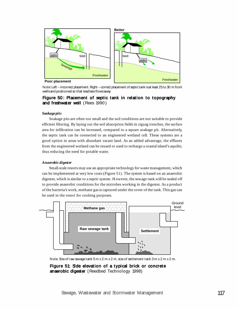
117Sewage, Wastewater and Stormwater ManagementSewage, Wastewater and Stormwater ManagementSewage, Wastewater and Stormwater ManagementSewage, Wastewater and Stormwater ManagementSewage, Wastewater and Stormwater Management
Soakage pitsSoakage pits are often too small and the soil conditions are not suitable to provide
efficient filtering. By laying out the soil absorption fields in zigzag trenches, the surfacearea for infiltration can be increased, compared to a square soakage pit. Alternatively,the septic tank can be connected to an engineered wetland cell. These systems are agood option in areas with abundant vacant land. As an added advantage, the effluentfrom the engineered wetland can be reused or used to recharge a coastal island’s aquifer,thus reducing the need for potable water.
Anaerobic digesterSmall-scale resorts may use an appropriate technology for waste management, which
can be implemented at very low costs (Figure 51). The system is based on an anaerobicdigester, which is similar to a septic system. However, the sewage tank will be sealed offto provide anaerobic conditions for the microbes working in the digester. As a productof the bacteria’s work, methane gas is captured under the cover of the tank. This gas canbe used in the resort for cooking purposes.
Figure 51: Side elevation of a typical brick or concreteFigure 51: Side elevation of a typical brick or concreteFigure 51: Side elevation of a typical brick or concreteFigure 51: Side elevation of a typical brick or concreteFigure 51: Side elevation of a typical brick or concreteanaerobic digester anaerobic digester anaerobic digester anaerobic digester anaerobic digester (Reedbed Technology 1998)
Note: Size of raw sewage tank 5 m x 2 m x 2 m, size of settlement tank 3 m x 2 m x 2 m.
GroundlevelMethane gas
Raw sewage tank Settlement
Figure 50: Placement of septic tank in relation to topographyFigure 50: Placement of septic tank in relation to topographyFigure 50: Placement of septic tank in relation to topographyFigure 50: Placement of septic tank in relation to topographyFigure 50: Placement of septic tank in relation to topographyand freshwater well and freshwater well and freshwater well and freshwater well and freshwater well (Rees 1990)
Note: Left – incorrect placement. Right – correct placement of septic tank is at least 25 to 30 m fromwells and positioned so that leachate flows away
Well Well
FreshwaterFreshwater
Seepage
Better
Poor placement
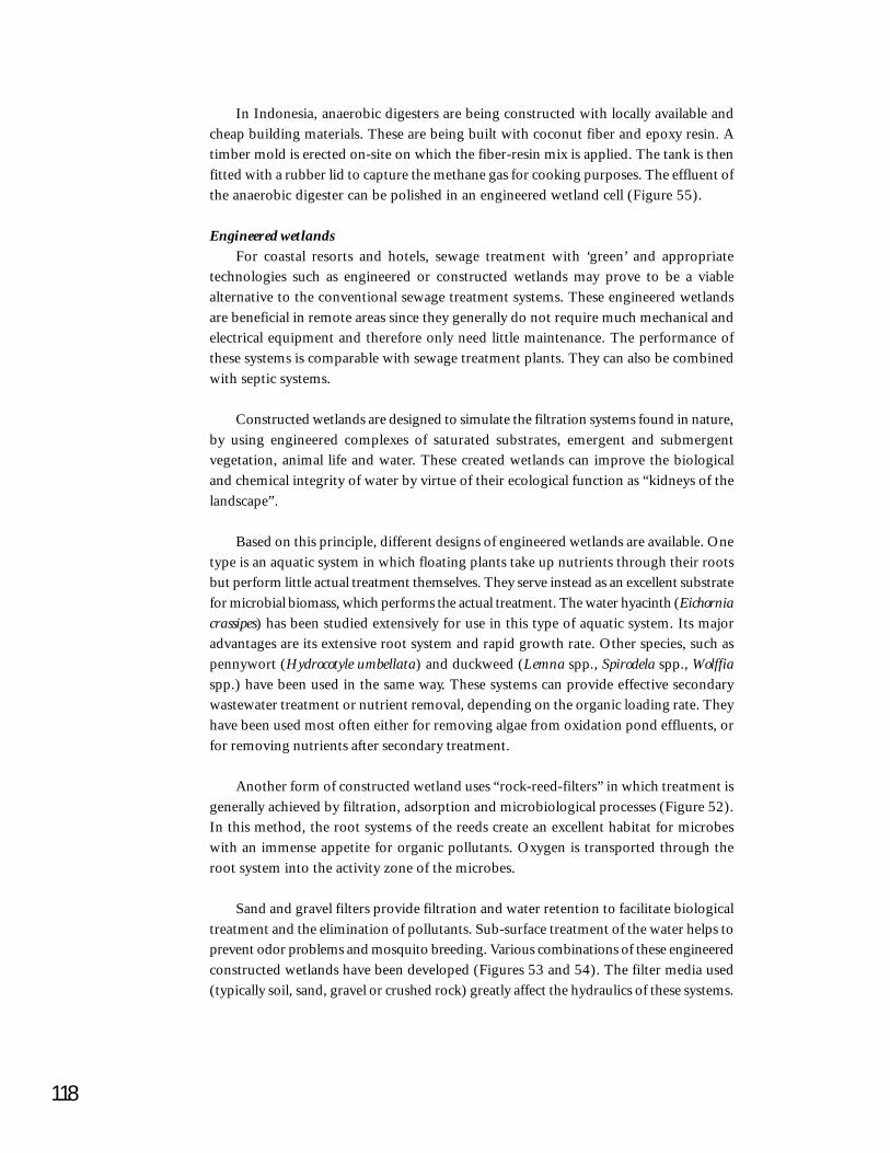
118
In Indonesia, anaerobic digesters are being constructed with locally available andcheap building materials. These are being built with coconut fiber and epoxy resin. Atimber mold is erected on-site on which the fiber-resin mix is applied. The tank is thenfitted with a rubber lid to capture the methane gas for cooking purposes. The effluent ofthe anaerobic digester can be polished in an engineered wetland cell (Figure 55).
Engineered wetlandsFor coastal resorts and hotels, sewage treatment with ‘green’ and appropriate
technologies such as engineered or constructed wetlands may prove to be a viablealternative to the conventional sewage treatment systems. These engineered wetlandsare beneficial in remote areas since they generally do not require much mechanical andelectrical equipment and therefore only need little maintenance. The performance ofthese systems is comparable with sewage treatment plants. They can also be combinedwith septic systems.
Constructed wetlands are designed to simulate the filtration systems found in nature,by using engineered complexes of saturated substrates, emergent and submergentvegetation, animal life and water. These created wetlands can improve the biologicaland chemical integrity of water by virtue of their ecological function as “kidneys of thelandscape”.
Based on this principle, different designs of engineered wetlands are available. Onetype is an aquatic system in which floating plants take up nutrients through their rootsbut perform little actual treatment themselves. They serve instead as an excellent substratefor microbial biomass, which performs the actual treatment. The water hyacinth (Eichorniacrassipes) has been studied extensively for use in this type of aquatic system. Its majoradvantages are its extensive root system and rapid growth rate. Other species, such aspennywort (Hydrocotyle umbellata) and duckweed (Lemna spp., Spirodela spp., Wolffiaspp.) have been used in the same way. These systems can provide effective secondarywastewater treatment or nutrient removal, depending on the organic loading rate. Theyhave been used most often either for removing algae from oxidation pond effluents, orfor removing nutrients after secondary treatment.
Another form of constructed wetland uses “rock-reed-filters” in which treatment isgenerally achieved by filtration, adsorption and microbiological processes (Figure 52).In this method, the root systems of the reeds create an excellent habitat for microbeswith an immense appetite for organic pollutants. Oxygen is transported through theroot system into the activity zone of the microbes.
Sand and gravel filters provide filtration and water retention to facilitate biologicaltreatment and the elimination of pollutants. Sub-surface treatment of the water helps toprevent odor problems and mosquito breeding. Various combinations of these engineeredconstructed wetlands have been developed (Figures 53 and 54). The filter media used(typically soil, sand, gravel or crushed rock) greatly affect the hydraulics of these systems.
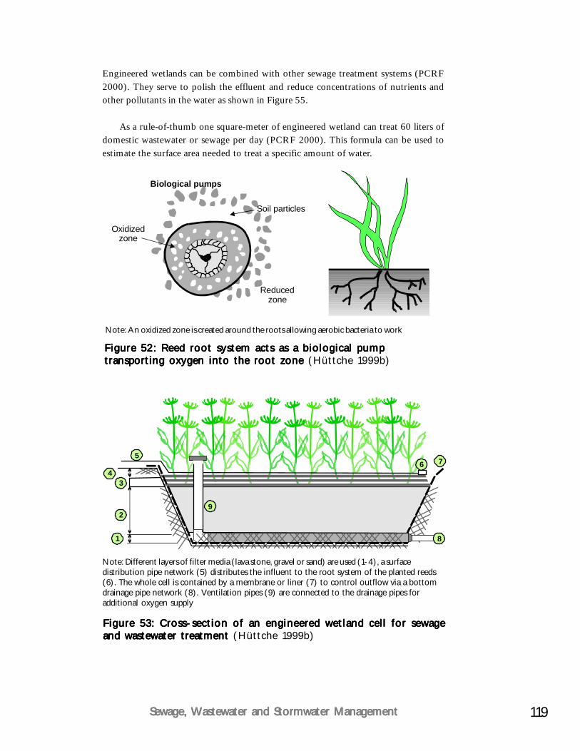
119Sewage, Wastewater and Stormwater ManagementSewage, Wastewater and Stormwater ManagementSewage, Wastewater and Stormwater ManagementSewage, Wastewater and Stormwater ManagementSewage, Wastewater and Stormwater Management
Soil particles
Biological pumps
Oxidizedzone
Reducedzone
Note: An oxidized zone is created around the roots allowing aerobic bacteria to work
Figure 52: Reed root system acts as a biological pumpFigure 52: Reed root system acts as a biological pumpFigure 52: Reed root system acts as a biological pumpFigure 52: Reed root system acts as a biological pumpFigure 52: Reed root system acts as a biological pumptransporting oxygen into the root zone transporting oxygen into the root zone transporting oxygen into the root zone transporting oxygen into the root zone transporting oxygen into the root zone (Hüttche 1999b)
Figure 53: Cross-section of an engineered wetland cell for sewageFigure 53: Cross-section of an engineered wetland cell for sewageFigure 53: Cross-section of an engineered wetland cell for sewageFigure 53: Cross-section of an engineered wetland cell for sewageFigure 53: Cross-section of an engineered wetland cell for sewageand wastewater treatment and wastewater treatment and wastewater treatment and wastewater treatment and wastewater treatment (Hüttche 1999b)
Note: Different layers of filter media (lava stone, gravel or sand) are used (1-4), a surfacedistribution pipe network (5) distributes the influent to the root system of the planted reeds(6). The whole cell is contained by a membrane or liner (7) to control outflow via a bottomdrainage pipe network (8). Ventilation pipes (9) are connected to the drainage pipes foradditional oxygen supply
Engineered wetlands can be combined with other sewage treatment systems (PCRF2000). They serve to polish the effluent and reduce concentrations of nutrients andother pollutants in the water as shown in Figure 55.
As a rule-of-thumb one square-meter of engineered wetland can treat 60 liters ofdomestic wastewater or sewage per day (PCRF 2000). This formula can be used toestimate the surface area needed to treat a specific amount of water.
9
76
81
2
34
5
120
Figure 55: Combination of anaerobic digester and engineeredFigure 55: Combination of anaerobic digester and engineeredFigure 55: Combination of anaerobic digester and engineeredFigure 55: Combination of anaerobic digester and engineeredFigure 55: Combination of anaerobic digester and engineeredwet landwet landwet landwet landwet land
Figure 54: Tropical engineered wetlands used for the treatmentFigure 54: Tropical engineered wetlands used for the treatmentFigure 54: Tropical engineered wetlands used for the treatmentFigure 54: Tropical engineered wetlands used for the treatmentFigure 54: Tropical engineered wetlands used for the treatmentof domestic wastewater from hotels and residences can haveof domestic wastewater from hotels and residences can haveof domestic wastewater from hotels and residences can haveof domestic wastewater from hotels and residences can haveof domestic wastewater from hotels and residences can havedifferent designs. One is shown in the photo above; a verticaldifferent designs. One is shown in the photo above; a verticaldifferent designs. One is shown in the photo above; a verticaldifferent designs. One is shown in the photo above; a verticaldifferent designs. One is shown in the photo above; a verticalflow rock-reed engineered wetland cell has dense growth of reedsflow rock-reed engineered wetland cell has dense growth of reedsflow rock-reed engineered wetland cell has dense growth of reedsflow rock-reed engineered wetland cell has dense growth of reedsflow rock-reed engineered wetland cell has dense growth of reeds(((((Phragmites communisPhragmites communisPhragmites communisPhragmites communisPhragmites communis). The microbiological treatment takes). The microbiological treatment takes). The microbiological treatment takes). The microbiological treatment takes). The microbiological treatment takesplace in the root zone. Another design, “Wastewater Gardens”place in the root zone. Another design, “Wastewater Gardens”place in the root zone. Another design, “Wastewater Gardens”place in the root zone. Another design, “Wastewater Gardens”place in the root zone. Another design, “Wastewater Gardens”concept uses a diverse mix of plants and gravel beds combinedconcept uses a diverse mix of plants and gravel beds combinedconcept uses a diverse mix of plants and gravel beds combinedconcept uses a diverse mix of plants and gravel beds combinedconcept uses a diverse mix of plants and gravel beds combinedwith floating hyacinths in small ponds. Both systems can bewith floating hyacinths in small ponds. Both systems can bewith floating hyacinths in small ponds. Both systems can bewith floating hyacinths in small ponds. Both systems can bewith floating hyacinths in small ponds. Both systems can beintegrated into a resort’s landscape as features integrated into a resort’s landscape as features integrated into a resort’s landscape as features integrated into a resort’s landscape as features integrated into a resort’s landscape as features (PCRF 2000)
Methane gas
Sewage tankSettlement
Engineered wetland
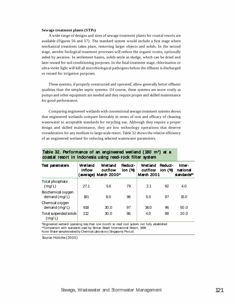
121Sewage, Wastewater and Stormwater ManagementSewage, Wastewater and Stormwater ManagementSewage, Wastewater and Stormwater ManagementSewage, Wastewater and Stormwater ManagementSewage, Wastewater and Stormwater Management
Sewage treatment plants (STPs)A wide range of designs and sizes of sewage treatment plants for coastal resorts are
available (Figures 56 and 57). The standard system would include a first stage wheremechanical treatment takes place, removing larger objects and solids. In the secondstage, aerobic biological treatment processes will reduce the organic toxins, optionallyaided by aeration. In settlement basins, solids settle as sludge, which can be dried andlater reused for soil conditioning purposes. In the final treatment stage, chlorination orultra-violet light will kill all microbiological pathogens before the effluent is dischargedor reused for irrigation purposes.
These systems, if properly constructed and operated, allow generally better effluentqualities than the simpler septic systems. Of course, these systems are more costly aspumps and other equipment are needed and they require proper and skilled maintenancefor good performance.
Comparing engineered wetlands with conventional sewage treatment systems showsthat engineered wetlands compare favorably in terms of cost and efficacy of cleaningwastewater to acceptable standards for recycling use. Although they require a properdesign and skilled maintenance, they are low technology operations that deserveconsideration for any medium to large-scale resort. Table 32 shows the relative efficiencyof an engineered wetland for reducing selected wastewater parameters.
Source: Hüttche (2000)
*Engineered wetland operating less than one month so reed root system not fully established**Comparison with standards used by Bintan Beach International Resort, 1996Note: Water samples tested by Chemical Laboratory (Singapore) Pte Ltd.
Table 32. Performance of an engineered wetland (180 mTable 32. Performance of an engineered wetland (180 mTable 32. Performance of an engineered wetland (180 mTable 32. Performance of an engineered wetland (180 mTable 32. Performance of an engineered wetland (180 m22222) at a) at a) at a) at a) at acoastal resort in Indonesia using reed-rock filter systemcoastal resort in Indonesia using reed-rock filter systemcoastal resort in Indonesia using reed-rock filter systemcoastal resort in Indonesia using reed-rock filter systemcoastal resort in Indonesia using reed-rock filter system
Test parametersTest parametersTest parametersTest parametersTest parameters WetlandWetlandWetlandWetlandWetland WetlandWetlandWetlandWetlandWetland Reduct-Reduct-Reduct-Reduct-Reduct- WetlandWetlandWetlandWetlandWetland Reduct-Reduct-Reduct-Reduct-Reduct- Inter-Inter-Inter-Inter-Inter-inflowinflowinflowinflowinflow outflowoutflowoutflowoutflowoutflow ion (%)ion (%)ion (%)ion (%)ion (%) outflowoutflowoutflowoutflowoutflow ion (%)ion (%)ion (%)ion (%)ion (%) nationalnationalnationalnationalnational
(average)(average)(average)(average)(average) March 2000*March 2000*March 2000*March 2000*March 2000* March 2001March 2001March 2001March 2001March 2001 standards**standards**standards**standards**standards**
Total phosphate (mg/L) 27.1 5.6 79 2.1 92 4.0Biochemical oxygen demand (mg/L) 181 8.0 96 5.0 97 15.0Chemical oxygen demand (mg/L) 918 30.0 97 36.0 96 50.0Total suspended solids 212 30.0 86 4.0 98 20.0 (mg/L)
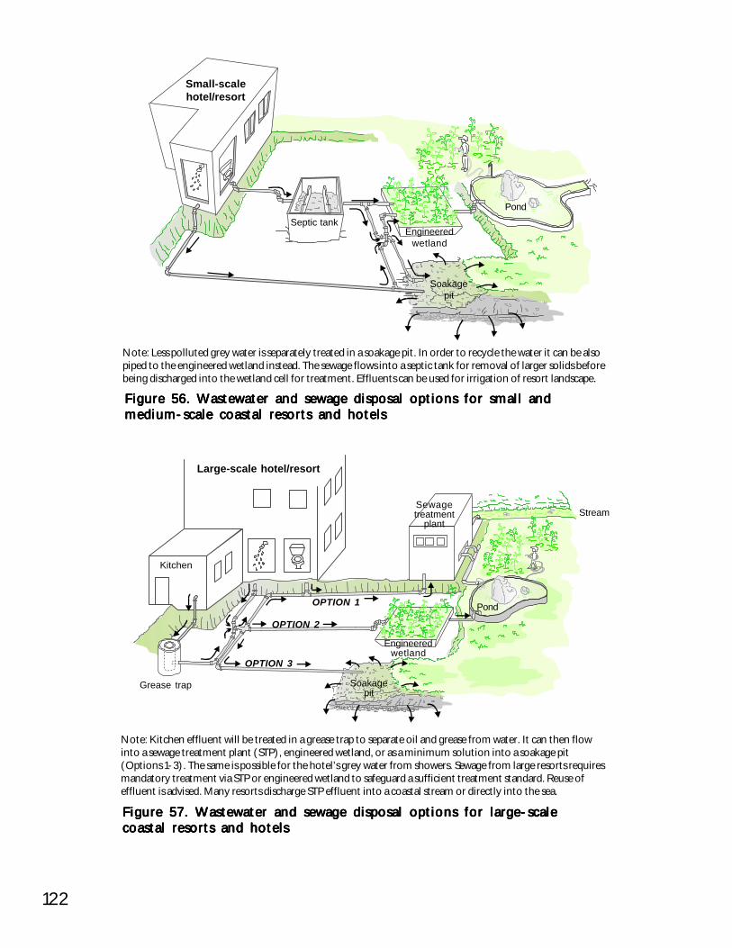
122
Figure 57. Wastewater and sewage disposal options for large-scaleFigure 57. Wastewater and sewage disposal options for large-scaleFigure 57. Wastewater and sewage disposal options for large-scaleFigure 57. Wastewater and sewage disposal options for large-scaleFigure 57. Wastewater and sewage disposal options for large-scalecoastal resorts and hotelscoastal resorts and hotelscoastal resorts and hotelscoastal resorts and hotelscoastal resorts and hotels
Note: Kitchen effluent will be treated in a grease trap to separate oil and grease from water. It can then flowinto a sewage treatment plant (STP), engineered wetland, or as a minimum solution into a soakage pit(Options 1-3). The same is possible for the hotel’s grey water from showers. Sewage from large resorts requiresmandatory treatment via STP or engineered wetland to safeguard a sufficient treatment standard. Reuse ofeffluent is advised. Many resorts discharge STP effluent into a coastal stream or directly into the sea.
Grease trap
Large-scale hotel/resort
Kitchen
Sewagetreatment
plantStream
Pond
Soakagepit
Engineeredwetland
OPTION 2
OPTION 1
OPTION 3
Figure 56. Wastewater and sewage disposal options for small andFigure 56. Wastewater and sewage disposal options for small andFigure 56. Wastewater and sewage disposal options for small andFigure 56. Wastewater and sewage disposal options for small andFigure 56. Wastewater and sewage disposal options for small andmedium-scale coastal resorts and hotelsmedium-scale coastal resorts and hotelsmedium-scale coastal resorts and hotelsmedium-scale coastal resorts and hotelsmedium-scale coastal resorts and hotels
Note: Less polluted grey water is separately treated in a soakage pit. In order to recycle the water it can be alsopiped to the engineered wetland instead. The sewage flows into a septic tank for removal of larger solids beforebeing discharged into the wetland cell for treatment. Effluents can be used for irrigation of resort landscape.
Small-scalehotel/resort
Septic tankPond
Soakagepit
Engineeredwetland
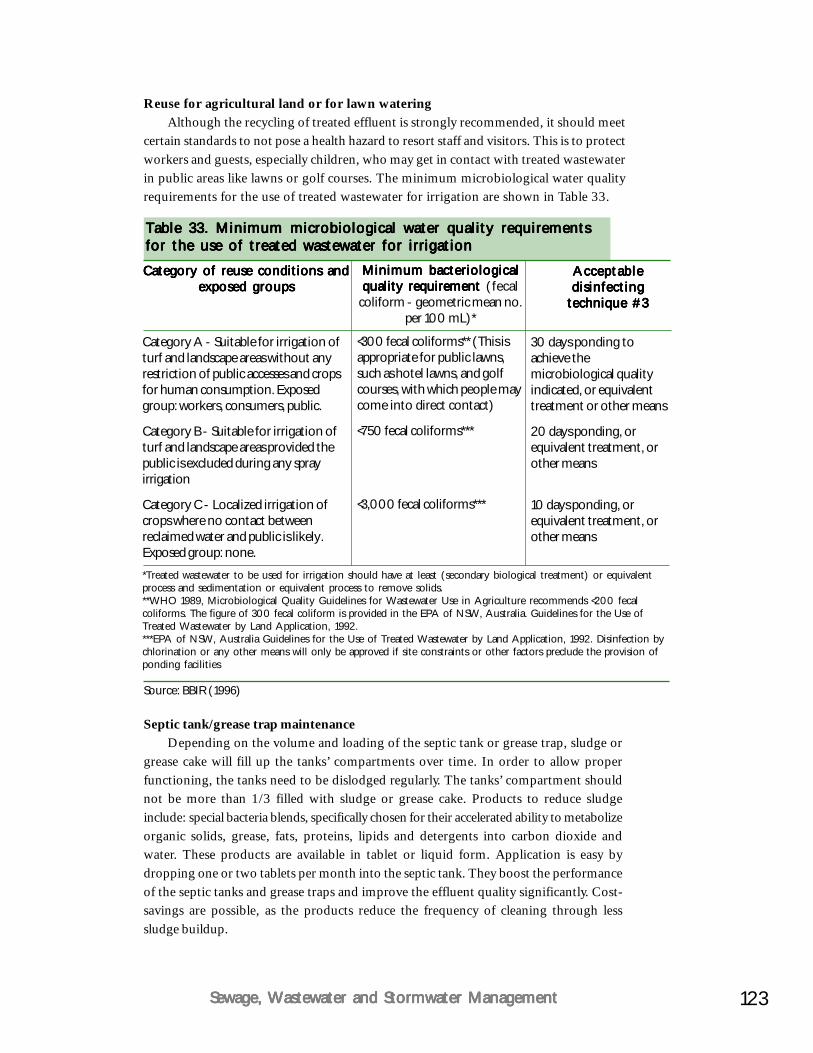
123Sewage, Wastewater and Stormwater ManagementSewage, Wastewater and Stormwater ManagementSewage, Wastewater and Stormwater ManagementSewage, Wastewater and Stormwater ManagementSewage, Wastewater and Stormwater Management
Septic tank/grease trap maintenanceDepending on the volume and loading of the septic tank or grease trap, sludge or
grease cake will fill up the tanks’ compartments over time. In order to allow properfunctioning, the tanks need to be dislodged regularly. The tanks’ compartment shouldnot be more than 1/3 filled with sludge or grease cake. Products to reduce sludgeinclude: special bacteria blends, specifically chosen for their accelerated ability to metabolizeorganic solids, grease, fats, proteins, lipids and detergents into carbon dioxide andwater. These products are available in tablet or liquid form. Application is easy bydropping one or two tablets per month into the septic tank. They boost the performanceof the septic tanks and grease traps and improve the effluent quality significantly. Cost-savings are possible, as the products reduce the frequency of cleaning through lesssludge buildup.
Reuse for agricultural land or for lawn wateringAlthough the recycling of treated effluent is strongly recommended, it should meet
certain standards to not pose a health hazard to resort staff and visitors. This is to protectworkers and guests, especially children, who may get in contact with treated wastewaterin public areas like lawns or golf courses. The minimum microbiological water qualityrequirements for the use of treated wastewater for irrigation are shown in Table 33.
Table 33. Minimum microbiological water quality requirementsTable 33. Minimum microbiological water quality requirementsTable 33. Minimum microbiological water quality requirementsTable 33. Minimum microbiological water quality requirementsTable 33. Minimum microbiological water quality requirementsfor the use of treated wastewater for irrigationfor the use of treated wastewater for irrigationfor the use of treated wastewater for irrigationfor the use of treated wastewater for irrigationfor the use of treated wastewater for irrigation
Category of reuse conditions andCategory of reuse conditions andCategory of reuse conditions andCategory of reuse conditions andCategory of reuse conditions andexposed groupsexposed groupsexposed groupsexposed groupsexposed groups
*Treated wastewater to be used for irrigation should have at least (secondary biological treatment) or equivalentprocess and sedimentation or equivalent process to remove solids.**WHO 1989, Microbiological Quality Guidelines for Wastewater Use in Agriculture recommends <200 fecalcoliforms. The figure of 300 fecal coliform is provided in the EPA of NSW, Australia. Guidelines for the Use ofTreated Wastewater by Land Application, 1992.***EPA of NSW, Australia Guidelines for the Use of Treated Wastewater by Land Application, 1992. Disinfection bychlorination or any other means will only be approved if site constraints or other factors preclude the provision ofponding facilities
Source: BBIR (1996)
Category A - Suitable for irrigation ofturf and landscape areas without anyrestriction of public accesses and cropsfor human consumption. Exposedgroup: workers, consumers, public.
Category B - Suitable for irrigation ofturf and landscape areas provided thepublic is excluded during any sprayirrigation
Category C - Localized irrigation ofcrops where no contact betweenreclaimed water and public is likely.Exposed group: none.
Minimum bacteriologicalMinimum bacteriologicalMinimum bacteriologicalMinimum bacteriologicalMinimum bacteriologicalquality requirement quality requirement quality requirement quality requirement quality requirement (fecal
coliform - geometric mean no.per 100 mL)*
AcceptableAcceptableAcceptableAcceptableAcceptabledisinfectingdisinfectingdisinfectingdisinfectingdisinfecting
technique #3technique #3technique #3technique #3technique #3
<300 fecal coliforms** (This isappropriate for public lawns,such as hotel lawns, and golfcourses, with which people maycome into direct contact)
<750 fecal coliforms***
<3,000 fecal coliforms***
30 days ponding toachieve themicrobiological qualityindicated, or equivalenttreatment or other means
20 days ponding, orequivalent treatment, orother means
10 days ponding, orequivalent treatment, orother means
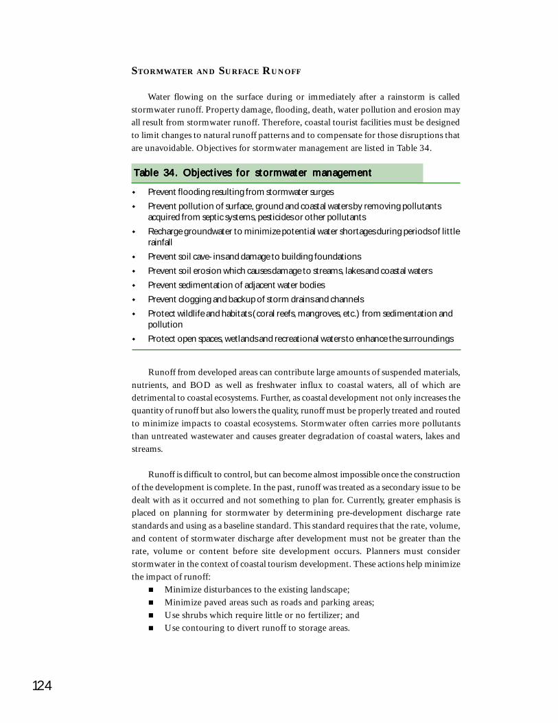
124
STORMWATER AND SURFACE RUNOFF
Water flowing on the surface during or immediately after a rainstorm is calledstormwater runoff. Property damage, flooding, death, water pollution and erosion mayall result from stormwater runoff. Therefore, coastal tourist facilities must be designedto limit changes to natural runoff patterns and to compensate for those disruptions thatare unavoidable. Objectives for stormwater management are listed in Table 34.
Prevent flooding resulting from stormwater surgesPrevent pollution of surface, ground and coastal waters by removing pollutantsacquired from septic systems, pesticides or other pollutantsRecharge groundwater to minimize potential water shortages during periods of littlerainfallPrevent soil cave-ins and damage to building foundationsPrevent soil erosion which causes damage to streams, lakes and coastal watersPrevent sedimentation of adjacent water bodiesPrevent clogging and backup of storm drains and channelsProtect wildlife and habitats (coral reefs, mangroves, etc.) from sedimentation andpollutionProtect open spaces, wetlands and recreational waters to enhance the surroundings
Table 34. Objectives for stormwater managementTable 34. Objectives for stormwater managementTable 34. Objectives for stormwater managementTable 34. Objectives for stormwater managementTable 34. Objectives for stormwater management
Runoff from developed areas can contribute large amounts of suspended materials,nutrients, and BOD as well as freshwater influx to coastal waters, all of which aredetrimental to coastal ecosystems. Further, as coastal development not only increases thequantity of runoff but also lowers the quality, runoff must be properly treated and routedto minimize impacts to coastal ecosystems. Stormwater often carries more pollutantsthan untreated wastewater and causes greater degradation of coastal waters, lakes andstreams.
Runoff is difficult to control, but can become almost impossible once the constructionof the development is complete. In the past, runoff was treated as a secondary issue to bedealt with as it occurred and not something to plan for. Currently, greater emphasis isplaced on planning for stormwater by determining pre-development discharge ratestandards and using as a baseline standard. This standard requires that the rate, volume,and content of stormwater discharge after development must not be greater than therate, volume or content before site development occurs. Planners must considerstormwater in the context of coastal tourism development. These actions help minimizethe impact of runoff:
Minimize disturbances to the existing landscape;Minimize paved areas such as roads and parking areas;Use shrubs which require little or no fertilizer; andUse contouring to divert runoff to storage areas.
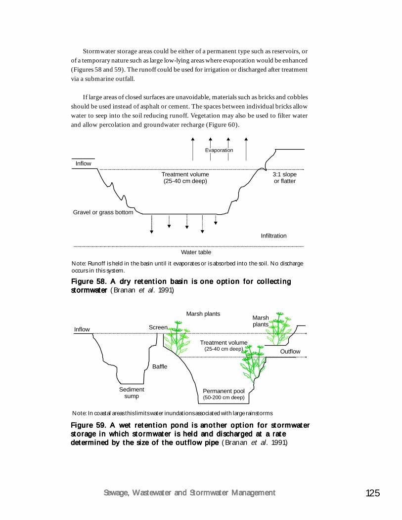
125Sewage, Wastewater and Stormwater ManagementSewage, Wastewater and Stormwater ManagementSewage, Wastewater and Stormwater ManagementSewage, Wastewater and Stormwater ManagementSewage, Wastewater and Stormwater Management
Figure 58. A dry retention basin is one option for collectingFigure 58. A dry retention basin is one option for collectingFigure 58. A dry retention basin is one option for collectingFigure 58. A dry retention basin is one option for collectingFigure 58. A dry retention basin is one option for collectingstormwater stormwater stormwater stormwater stormwater (Branan et al. 1991)
Note: Runoff is held in the basin until it evaporates or is absorbed into the soil. No dischargeoccurs in this system.
3:1 slopeor flatter
Water table
Treatment volume(25-40 cm deep)
Gravel or grass bottom
Inflow
Evaporation
Infiltration
Stormwater storage areas could be either of a permanent type such as reservoirs, orof a temporary nature such as large low-lying areas where evaporation would be enhanced(Figures 58 and 59). The runoff could be used for irrigation or discharged after treatmentvia a submarine outfall.
If large areas of closed surfaces are unavoidable, materials such as bricks and cobblesshould be used instead of asphalt or cement. The spaces between individual bricks allowwater to seep into the soil reducing runoff. Vegetation may also be used to filter waterand allow percolation and groundwater recharge (Figure 60).
Figure 59. A wet retention pond is another option for stormwaterFigure 59. A wet retention pond is another option for stormwaterFigure 59. A wet retention pond is another option for stormwaterFigure 59. A wet retention pond is another option for stormwaterFigure 59. A wet retention pond is another option for stormwaterstorage in which stormwater is held and discharged at a ratestorage in which stormwater is held and discharged at a ratestorage in which stormwater is held and discharged at a ratestorage in which stormwater is held and discharged at a ratestorage in which stormwater is held and discharged at a ratedetermined by the size of the outflow pipe determined by the size of the outflow pipe determined by the size of the outflow pipe determined by the size of the outflow pipe determined by the size of the outflow pipe (Branan et al. 1991)
Note: In coastal areas this limits water inundations associated with large rainstorms
Sedimentsump
Permanent pool(50-200 cm deep)
Treatment volume(25-40 cm deep)
Inflow
Outflow
Screen
Marsh plants Marshplants
Baffle

126
Figure 60. Several landscaping techniques that help to minimizeFigure 60. Several landscaping techniques that help to minimizeFigure 60. Several landscaping techniques that help to minimizeFigure 60. Several landscaping techniques that help to minimizeFigure 60. Several landscaping techniques that help to minimizestormwater runoff damage stormwater runoff damage stormwater runoff damage stormwater runoff damage stormwater runoff damage (Branan et al. 1991)
Notes: A .A .A .A .A . Provides a ground cover that permits rain to percolate into the ground, preventingrunoff flooding while recharging groundwater
B .B .B .B .B . Grass-lined troughs that collect runoff and allow time for water to percolate intothe ground. Swales must be moved to keep the vegetation healthy and to preventoutlet plugging from leaves, garbage or litter.
C .C .C .C .C . Gravel, brick or other pervious surfaces. Separations or pore spaces must besufficient to allow rapid percolation of rainwater.
Transpiration
Percolation
Open brickLattice
Percolation
A. Vegetation
C. Pervious pavements
B. Swales
Parameters to consider in the design of a stormwater disposal system are eithersystem specific or event specific. In system specific parameters, the most importantconsideration is the coefficient of runoff of the catchment area in relation to the actualcatchment area. The coefficient of runoff is dependent on the following factors:
Form, location and size of the catchment area;Type of land-use;Infiltration rate and groundwater table;Slope of ground within the catchment area;Existence, location, length, size, gradient and condition of the drainage systemor canals; andSize, location and capacity of the retention areas.
Event specific parameters are governed by the intensity of rainfall. For example, anintensity of rainfall of 110 mm/hour based on a storm duration of 15 minutes with areturn period of 1 year for open drains requires a certain size drain to channel the water.
127Sewage, Wastewater and Stormwater ManagementSewage, Wastewater and Stormwater ManagementSewage, Wastewater and Stormwater ManagementSewage, Wastewater and Stormwater ManagementSewage, Wastewater and Stormwater Management
This intensity of rainfall would require large culvert and drain sizes. If the system beingdesigned for becomes too expensive, then a slightly less intensity rainfall could be usedfor the average storm event such as: rainfall of 90 mm/hour based on a storm durationof 15 minutes with a return period of three months. For culverts and other structures, anintensity of rainfall for 125 mm/hour based on a storm duration of 15 minutes with areturn period of two years could be used. These figures will depend on rainfall data fromthe area of the development and overall design criteria.
Stormwater collection systemsStormwater collection systems should be designed according to the desired velocity
of the flow and for ease of maintenance. Closed drains should be provided only if:Road width is limited;Where drains are deeper than 0.75 m; andWhere open drains are not aesthetically appropriate.
Stormwater from the collection system should be discharged through outfalls tonatural watercourses, to larger drains or canals, to retention ponds or marshes, or to asoakage system or engineered wetland cell. The discharge through the outfall should bevia a silt trap and a screen to prevent debris collected in the open drains from beingdischarged through the outfall. The placement of the outfall pipes into natural waterwaysshould be in areas with large amounts of flushing and away from coral reefs and othercoastal habitats, which may be damaged by the outfall.
It is important to avoid discharge of stormwater into resort beach areas, eitherthrough artificial or natural drains. This can lead to pollution of beaches with debris andsilt. During heavy rains the high velocity of the stormwater can lead to beach erosion.This can seriously affect the attractiveness of the beach areas for tourists and requiresintensive mitigation. Discharge of stormwater should be channeled towards stable rockyheadlands or outcrops, provided no other coastal ecosystems such as coral reefs areimpacted.
SUMMARY
Along with any water supply scheme, there must be an appropriate plan for disposalof wastewater, stormwater and sewage. Untreated sewage is one of the major sources ofenvironmental pollution in the coastal areas once resorts are operational. Planning forwastewater treatment and recycling should be done in the design phase and be adequateto accommodate expansion of the resort. The technology and designs are available forvery cost-effective and water saving systems for dealing with wastewater. Very little ifany wastewater needs to enter the ocean since all grey water can be used for gardeningand toilet flushing. Stormwater runoff needs to be planned for and channeled away fromthe sea as much as possible. The solutions are as broad as the imagination while anappropriate mix for any given facility must be selected and can produce a truly cleanoperation.
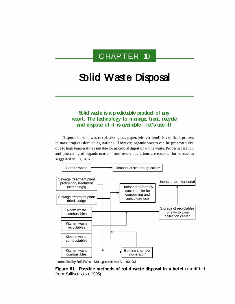
CHAPTER 10
Solid Waste DisposalSolid Waste DisposalSolid Waste DisposalSolid Waste DisposalSolid Waste Disposal
Solid waste is a predictable product of anySolid waste is a predictable product of anySolid waste is a predictable product of anySolid waste is a predictable product of anySolid waste is a predictable product of anyresort. The technology to manage, treat, recycleresort. The technology to manage, treat, recycleresort. The technology to manage, treat, recycleresort. The technology to manage, treat, recycleresort. The technology to manage, treat, recycle
and dispose of it is availableand dispose of it is availableand dispose of it is availableand dispose of it is availableand dispose of it is available—let’s use it!let’s use it!let’s use it!let’s use it!let’s use it!
Disposal of solid wastes (plastics, glass, paper, leftover food) is a difficult processin most tropical developing nations. However, organic wastes can be processed fastdue to high temperatures suitable for microbial digestion of the waste. Proper separationand processing of organic matters from resort operations are essential for success assuggested in Figure 61.
Figure 61. Possible methods of solid waste disposal in a hotelFigure 61. Possible methods of solid waste disposal in a hotelFigure 61. Possible methods of solid waste disposal in a hotelFigure 61. Possible methods of solid waste disposal in a hotelFigure 61. Possible methods of solid waste disposal in a hotel (modifiedfrom Sullivan et al. 1995)
Garden waste
Sewage treatment plantpreliminary treatment
(screenings)
Sewage treatment plantdried sludge
Room wastecombustibles
Kitchen wasterecyclables
Kitchen wastecompostables
Kitchen wastecombustibles
Burning chamberincinerator*
Compost at site for agriculture
Transport to farm bytractor, trailer forcomposting andagriculture use
Inerts to farm for burial
Storage of recyclablesfor sale to towncollection center
*controlled by Solid Waste Management Act No. 90-03
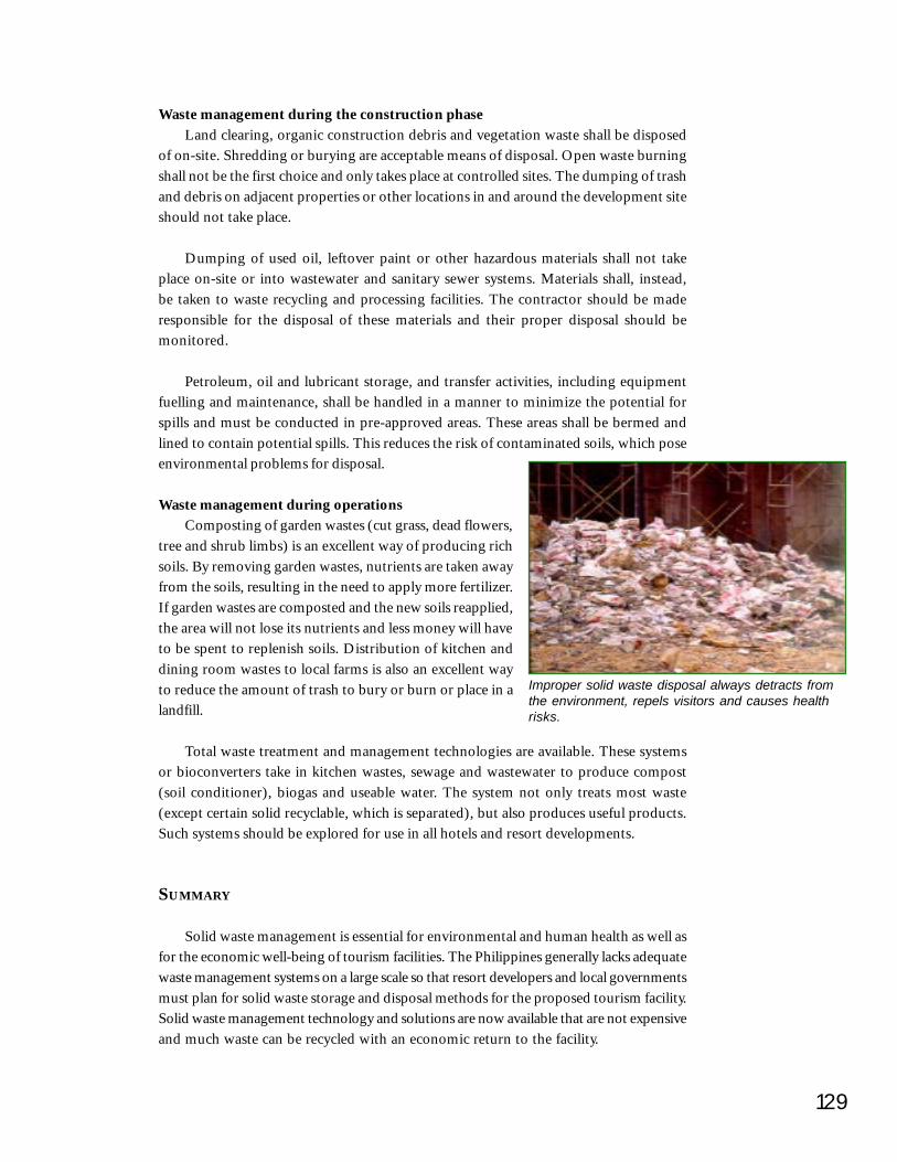
129
Waste management during the construction phaseLand clearing, organic construction debris and vegetation waste shall be disposed
of on-site. Shredding or burying are acceptable means of disposal. Open waste burningshall not be the first choice and only takes place at controlled sites. The dumping of trashand debris on adjacent properties or other locations in and around the development siteshould not take place.
Dumping of used oil, leftover paint or other hazardous materials shall not takeplace on-site or into wastewater and sanitary sewer systems. Materials shall, instead,be taken to waste recycling and processing facilities. The contractor should be maderesponsible for the disposal of these materials and their proper disposal should bemonitored.
Petroleum, oil and lubricant storage, and transfer activities, including equipmentfuelling and maintenance, shall be handled in a manner to minimize the potential forspills and must be conducted in pre-approved areas. These areas shall be bermed andlined to contain potential spills. This reduces the risk of contaminated soils, which poseenvironmental problems for disposal.
Waste management during operationsComposting of garden wastes (cut grass, dead flowers,
tree and shrub limbs) is an excellent way of producing richsoils. By removing garden wastes, nutrients are taken awayfrom the soils, resulting in the need to apply more fertilizer.If garden wastes are composted and the new soils reapplied,the area will not lose its nutrients and less money will haveto be spent to replenish soils. Distribution of kitchen anddining room wastes to local farms is also an excellent wayto reduce the amount of trash to bury or burn or place in alandfill.
Total waste treatment and management technologies are available. These systemsor bioconverters take in kitchen wastes, sewage and wastewater to produce compost(soil conditioner), biogas and useable water. The system not only treats most waste(except certain solid recyclable, which is separated), but also produces useful products.Such systems should be explored for use in all hotels and resort developments.
SUMMARY
Solid waste management is essential for environmental and human health as well asfor the economic well-being of tourism facilities. The Philippines generally lacks adequatewaste management systems on a large scale so that resort developers and local governmentsmust plan for solid waste storage and disposal methods for the proposed tourism facility.Solid waste management technology and solutions are now available that are not expensiveand much waste can be recycled with an economic return to the facility.
Improper solid waste disposal always detracts fromthe environment, repels visitors and causes healthrisks.

CHAPTER 11
Environmental Control andEnvironmental Control andEnvironmental Control andEnvironmental Control andEnvironmental Control andAuditingAuditingAuditingAuditingAuditing
Environmental management and monitoring isEnvironmental management and monitoring isEnvironmental management and monitoring isEnvironmental management and monitoring isEnvironmental management and monitoring isrequired throughout the entire life of a project andrequired throughout the entire life of a project andrequired throughout the entire life of a project andrequired throughout the entire life of a project andrequired throughout the entire life of a project andis the responsibility of the developer and operator.is the responsibility of the developer and operator.is the responsibility of the developer and operator.is the responsibility of the developer and operator.is the responsibility of the developer and operator.
The EIA process does not stop with the completion of the EIS and the granting ofan ECC. Environmental control is a powerful tool for the coastal tourism operator tostreamline operations, minimize major environmental repair measures through earlydetection and improve the quality of housekeeping.
Efficient control is achieved by implementing an environmental monitoringprogram. Environmental monitoring is a planned and systematic data collection activity,carried out repeatedly. Environmental monitoring should ensure that the project doesnot cause any significant long-term environmental impacts, in particular cumulativeimpacts (e.g. sewage), and that the existing environmental conditions are maintainedto ensure the long-term feasibility and quality of the project.
WHO MONITORS?
In the Philippines, the EIA legislation requires the setup of a Multi-Partite MonitoringTeam (MMT) and an Environmental Monitoring Fund (EMF) for projects requiring anEIS. The MMT should conduct an independent review of the project’s compliance withthe EIS, starting from construction throughout the operations stage. The MMT will setan operating plan and schedule.
The core members of the MMT are: the project proponent, affected communitiesand women through their designated representatives, the relevant LGUs, the DENRProvincial and/or Community Environment and Natural Resources Officers (PENROs/CENROs) in the project areas. Other members may be identified. DENR will provide
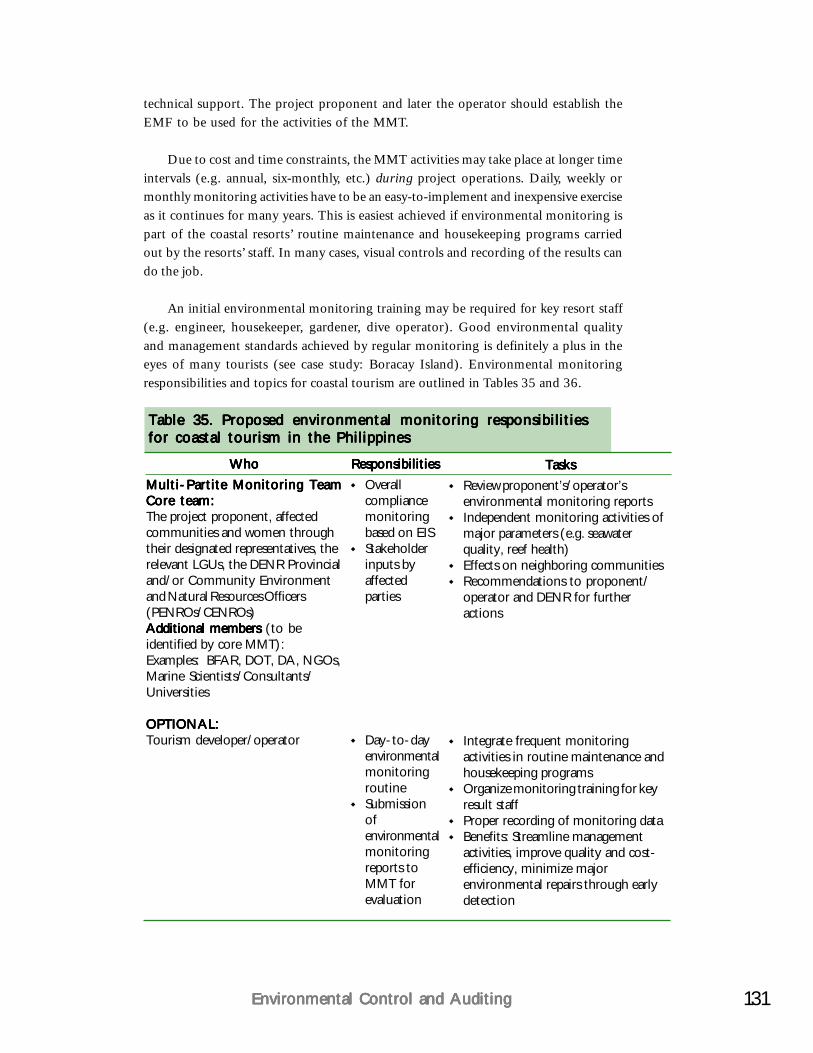
131Environmental Control and AuditingEnvironmental Control and AuditingEnvironmental Control and AuditingEnvironmental Control and AuditingEnvironmental Control and Auditing
technical support. The project proponent and later the operator should establish theEMF to be used for the activities of the MMT.
Due to cost and time constraints, the MMT activities may take place at longer timeintervals (e.g. annual, six-monthly, etc.) during project operations. Daily, weekly ormonthly monitoring activities have to be an easy-to-implement and inexpensive exerciseas it continues for many years. This is easiest achieved if environmental monitoring ispart of the coastal resorts’ routine maintenance and housekeeping programs carriedout by the resorts’ staff. In many cases, visual controls and recording of the results cando the job.
An initial environmental monitoring training may be required for key resort staff(e.g. engineer, housekeeper, gardener, dive operator). Good environmental qualityand management standards achieved by regular monitoring is definitely a plus in theeyes of many tourists (see case study: Boracay Island). Environmental monitoringresponsibilities and topics for coastal tourism are outlined in Tables 35 and 36.
WhoWhoWhoWhoWhoMulti-Partite Monitoring TeamMulti-Partite Monitoring TeamMulti-Partite Monitoring TeamMulti-Partite Monitoring TeamMulti-Partite Monitoring TeamCore team:Core team:Core team:Core team:Core team:The project proponent, affectedcommunities and women throughtheir designated representatives, therelevant LGUs, the DENR Provincialand/or Community Environmentand Natural Resources Officers(PENROs/CENROs)Additional members Additional members Additional members Additional members Additional members (to beidentified by core MMT):Examples: BFAR, DOT, DA, NGOs,Marine Scientists/Consultants/Universities
OPTIONAL:OPTIONAL:OPTIONAL:OPTIONAL:OPTIONAL:Tourism developer/operator
ResponsibilitiesResponsibilitiesResponsibilitiesResponsibilitiesResponsibilitiesOverallcompliancemonitoringbased on EISStakeholderinputs byaffectedparties
Day-to-dayenvironmentalmonitoringroutineSubmissionofenvironmentalmonitoringreports toMMT forevaluation
TasksTasksTasksTasksTasksReview proponent’s/operator’senvironmental monitoring reportsIndependent monitoring activities ofmajor parameters (e.g. seawaterquality, reef health)Effects on neighboring communitiesRecommendations to proponent/operator and DENR for furtheractions
Integrate frequent monitoringactivities in routine maintenance andhousekeeping programsOrganize monitoring training for keyresult staffProper recording of monitoring dataBenefits: Streamline managementactivities, improve quality and cost-efficiency, minimize majorenvironmental repairs through earlydetection
Table 35. Proposed environmental monitoring responsibilitiesTable 35. Proposed environmental monitoring responsibilitiesTable 35. Proposed environmental monitoring responsibilitiesTable 35. Proposed environmental monitoring responsibilitiesTable 35. Proposed environmental monitoring responsibilitiesfor coastal tourism in the Philippinesfor coastal tourism in the Philippinesfor coastal tourism in the Philippinesfor coastal tourism in the Philippinesfor coastal tourism in the Philippines
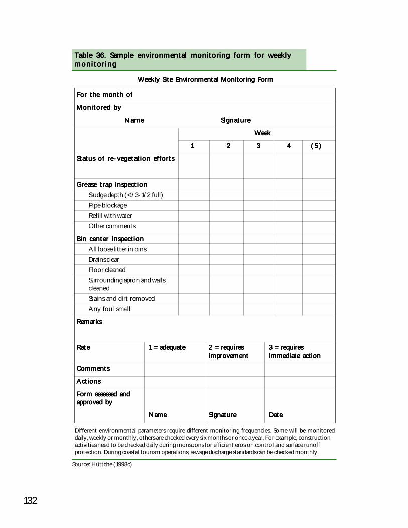
132
Table 36. Sample environmental monitoring form for weeklyTable 36. Sample environmental monitoring form for weeklyTable 36. Sample environmental monitoring form for weeklyTable 36. Sample environmental monitoring form for weeklyTable 36. Sample environmental monitoring form for weeklymonitoringmonitoringmonitoringmonitoringmonitoring
Weekly Site Environmental Monitoring FormWeekly Site Environmental Monitoring FormWeekly Site Environmental Monitoring FormWeekly Site Environmental Monitoring FormWeekly Site Environmental Monitoring Form
For the month ofFor the month ofFor the month ofFor the month ofFor the month of
Monitored byMonitored byMonitored byMonitored byMonitored by
NameNameNameNameName SignatureSignatureSignatureSignatureSignature
Week Week Week Week Week
11111 22222 33333 44444 ( 5 )( 5 )( 5 )( 5 )( 5 )
Status of re-vegetation effortsStatus of re-vegetation effortsStatus of re-vegetation effortsStatus of re-vegetation effortsStatus of re-vegetation efforts
Grease trap inspectionGrease trap inspectionGrease trap inspectionGrease trap inspectionGrease trap inspectionSludge depth (<1/3-1/2 full)Pipe blockageRefill with waterOther comments
Bin center inspectionBin center inspectionBin center inspectionBin center inspectionBin center inspectionAll loose litter in binsDrains clearFloor cleanedSurrounding apron and wallscleanedStains and dirt removedAny foul smell
RemarksRemarksRemarksRemarksRemarks
RateRateRateRateRate 1 = adequate1 = adequate1 = adequate1 = adequate1 = adequate 2 = requires2 = requires2 = requires2 = requires2 = requires 3 = requires3 = requires3 = requires3 = requires3 = requiresimprovementimprovementimprovementimprovementimprovement immediate actionimmediate actionimmediate actionimmediate actionimmediate action
CommentsCommentsCommentsCommentsComments
ActionsActionsActionsActionsActions
Form assessed andForm assessed andForm assessed andForm assessed andForm assessed andapproved byapproved byapproved byapproved byapproved by
NameNameNameNameName SignatureSignatureSignatureSignatureSignature DateDateDateDateDate
Different environmental parameters require different monitoring frequencies. Some will be monitoreddaily, weekly or monthly, others are checked every six months or once a year. For example, constructionactivities need to be checked daily during monsoons for efficient erosion control and surface runoffprotection. During coastal tourism operations, sewage discharge standards can be checked monthly.
Source: Hüttche (1998c)
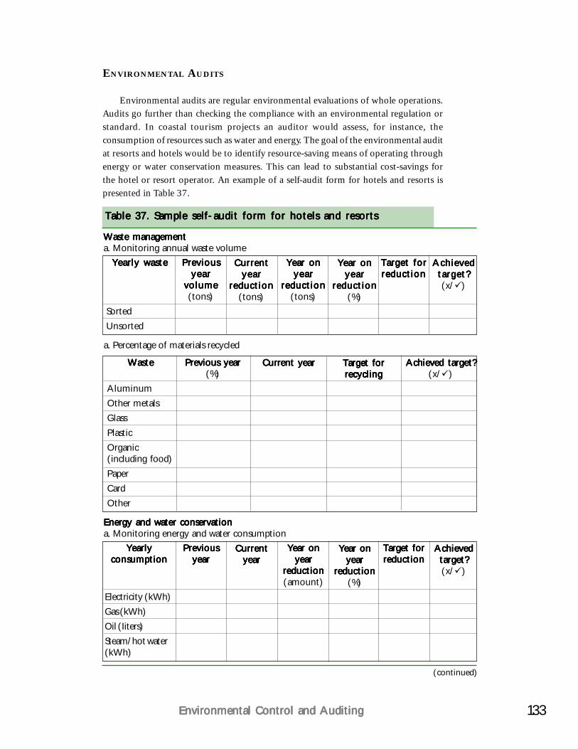
133Environmental Control and AuditingEnvironmental Control and AuditingEnvironmental Control and AuditingEnvironmental Control and AuditingEnvironmental Control and Auditing
ENVIRONMENTAL AUDITS
Environmental audits are regular environmental evaluations of whole operations.Audits go further than checking the compliance with an environmental regulation orstandard. In coastal tourism projects an auditor would assess, for instance, theconsumption of resources such as water and energy. The goal of the environmental auditat resorts and hotels would be to identify resource-saving means of operating throughenergy or water conservation measures. This can lead to substantial cost-savings forthe hotel or resort operator. An example of a self-audit form for hotels and resorts ispresented in Table 37.
Table 37. Sample self-audit form for hotels and resortsTable 37. Sample self-audit form for hotels and resortsTable 37. Sample self-audit form for hotels and resortsTable 37. Sample self-audit form for hotels and resortsTable 37. Sample self-audit form for hotels and resorts
Waste managementWaste managementWaste managementWaste managementWaste managementa. Monitoring annual waste volume
Yearly wasteYearly wasteYearly wasteYearly wasteYearly waste
SortedUnsorted
PreviousPreviousPreviousPreviousPreviousyearyearyearyearyear
volumevolumevolumevolumevolume(tons)
CurrentCurrentCurrentCurrentCurrentyearyearyearyearyear
reductionreductionreductionreductionreduction(tons)
Year onYear onYear onYear onYear onyearyearyearyearyear
reductionreductionreductionreductionreduction(tons)
Year onYear onYear onYear onYear onyearyearyearyearyear
reductionreductionreductionreductionreduction(%)
Target forTarget forTarget forTarget forTarget forreductionreductionreductionreductionreduction
AchievedAchievedAchievedAchievedAchievedtarget?target?target?target?target?(x/ )
a. Percentage of materials recycled
WasteWasteWasteWasteWaste
AluminumOther metalsGlassPlasticOrganic(including food)PaperCardOther
Previous yearPrevious yearPrevious yearPrevious yearPrevious year(%)
Current yearCurrent yearCurrent yearCurrent yearCurrent year Target forTarget forTarget forTarget forTarget forrecyclingrecyclingrecyclingrecyclingrecycling
Achieved target?Achieved target?Achieved target?Achieved target?Achieved target?(x/ )
Energy and water conservationEnergy and water conservationEnergy and water conservationEnergy and water conservationEnergy and water conservationa. Monitoring energy and water consumption
YearlyYearlyYearlyYearlyYearlyconsumptionconsumptionconsumptionconsumptionconsumption
Electricity (kWh)Gas (kWh)Oil (Iiters)Steam/hot water(kWh)
PreviousPreviousPreviousPreviousPreviousyearyearyearyearyear
CurrentCurrentCurrentCurrentCurrentyearyearyearyearyear
Year onYear onYear onYear onYear onyearyearyearyearyear
reductionreductionreductionreductionreduction(amount)
Year onYear onYear onYear onYear onyearyearyearyearyear
reductionreductionreductionreductionreduction(%)
Target forTarget forTarget forTarget forTarget forreductionreductionreductionreductionreduction
AchievedAchievedAchievedAchievedAchievedtarget?target?target?target?target?(x/ )
(continued)
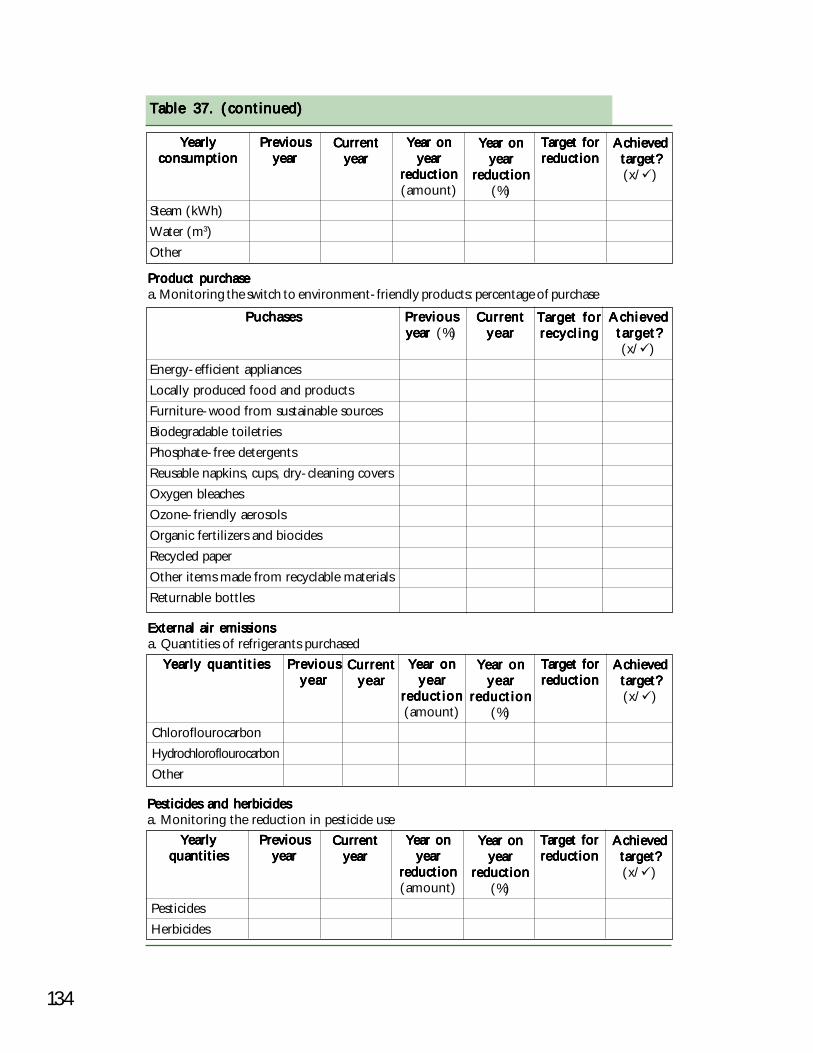
134
Table 37. (continued)Table 37. (continued)Table 37. (continued)Table 37. (continued)Table 37. (continued)
YearlyYearlyYearlyYearlyYearlyconsumptionconsumptionconsumptionconsumptionconsumption
Steam (kWh)Water (m3)Other
PreviousPreviousPreviousPreviousPreviousyearyearyearyearyear
CurrentCurrentCurrentCurrentCurrentyearyearyearyearyear
Year onYear onYear onYear onYear onyearyearyearyearyear
reductionreductionreductionreductionreduction(amount)
Year onYear onYear onYear onYear onyearyearyearyearyear
reductionreductionreductionreductionreduction(%)
AchievedAchievedAchievedAchievedAchievedtarget?target?target?target?target?(x/ )
Target forTarget forTarget forTarget forTarget forreductionreductionreductionreductionreduction
Product purchaseProduct purchaseProduct purchaseProduct purchaseProduct purchasea. Monitoring the switch to environment-friendly products: percentage of purchase
PuchasesPuchasesPuchasesPuchasesPuchases
Energy-efficient appliancesLocally produced food and productsFurniture-wood from sustainable sourcesBiodegradable toiletriesPhosphate-free detergentsReusable napkins, cups, dry-cleaning coversOxygen bleachesOzone-friendly aerosolsOrganic fertilizers and biocidesRecycled paperOther items made from recyclable materialsReturnable bottles
PreviousPreviousPreviousPreviousPreviousyear year year year year (%)
CurrentCurrentCurrentCurrentCurrentyearyearyearyearyear
Target forTarget forTarget forTarget forTarget forrecyclingrecyclingrecyclingrecyclingrecycling
AchievedAchievedAchievedAchievedAchievedtarget?target?target?target?target?(x/ )
External air emissionsExternal air emissionsExternal air emissionsExternal air emissionsExternal air emissionsa. Quantities of refrigerants purchased
Yearly quantitiesYearly quantitiesYearly quantitiesYearly quantitiesYearly quantities
ChloroflourocarbonHydrochloroflourocarbonOther
PreviousPreviousPreviousPreviousPreviousyearyearyearyearyear
CurrentCurrentCurrentCurrentCurrentyearyearyearyearyear
Year onYear onYear onYear onYear onyearyearyearyearyear
reductionreductionreductionreductionreduction(amount)
Year onYear onYear onYear onYear onyearyearyearyearyear
reductionreductionreductionreductionreduction(%)
Target forTarget forTarget forTarget forTarget forreductionreductionreductionreductionreduction
AchievedAchievedAchievedAchievedAchievedtarget?target?target?target?target?(x/ )
Pesticides and herbicidesPesticides and herbicidesPesticides and herbicidesPesticides and herbicidesPesticides and herbicidesa. Monitoring the reduction in pesticide use
YearlyYearlyYearlyYearlyYearlyquantitiesquantitiesquantitiesquantitiesquantities
PesticidesHerbicides
PreviousPreviousPreviousPreviousPreviousyearyearyearyearyear
CurrentCurrentCurrentCurrentCurrentyearyearyearyearyear
Year onYear onYear onYear onYear onyearyearyearyearyear
reductionreductionreductionreductionreduction(amount)
Year onYear onYear onYear onYear onyearyearyearyearyear
reductionreductionreductionreductionreduction(%)
Target forTarget forTarget forTarget forTarget forreductionreductionreductionreductionreduction
AchievedAchievedAchievedAchievedAchievedtarget?target?target?target?target?(x/ )

135Environmental Control and AuditingEnvironmental Control and AuditingEnvironmental Control and AuditingEnvironmental Control and AuditingEnvironmental Control and Auditing
With the results of regular monitoring and audit schemes, coastal resort and hoteloperators can identify areas of good performance and areas for improvements. Itmight help to compare the environmental performance with internationally acceptedbenchmarks. Table 38 shows the performance benchmark for tropical hotels for energyconsumption, efficiency and water consumption. The following case study also highlightshow environmental monitoring can be institutionalized.
Source: Balifokus (2000)1Energy derived directly from petroleum products (gasoline, diesel or natural gas)2Water consumption includes drinking, shower, toilet, cooking and irrigation water for gardens per guest.Tropical resorts with extensive gardens that use potable water for irrigation have a high water consumption perguest and thus a poor performance. The solution is to use treated effluent and not potable water for landscapeirrigation.
Table 38. Energy and water conservation benchmarks for hotelsTable 38. Energy and water conservation benchmarks for hotelsTable 38. Energy and water conservation benchmarks for hotelsTable 38. Energy and water conservation benchmarks for hotelsTable 38. Energy and water conservation benchmarks for hotelsin tropical countriesin tropical countriesin tropical countriesin tropical countriesin tropical countries
Correction Good Fair Poor Very poorfactor
Large hotel (>150 rooms)Large hotel (>150 rooms)Large hotel (>150 rooms)Large hotel (>150 rooms)Large hotel (>150 rooms)Electricity (kWh/mElectricity (kWh/mElectricity (kWh/mElectricity (kWh/mElectricity (kWh/m22222/year)/year)/year)/year)/year) 165165165165165 200200200200200 250250250250250 >250>250>250>250>250
1.3 214.5 260 325 3251.6 264 320 400 400
EnergyEnergyEnergyEnergyEnergy11111 (kWh/m (kWh/m (kWh/m (kWh/m (kWh/m22222/year)/year)/year)/year)/year) 200200200200200 240240240240240 300300300300300 >300>300>300>300>3000.4 80 96 120 1200.7 140 168 210 210
WaterWaterWaterWaterWater22222 (liter/guest/day) (liter/guest/day) (liter/guest/day) (liter/guest/day) (liter/guest/day) 600600600600600 7 7 07 7 07 7 07 7 07 7 0 880880880880880 >880>880>880>880>8801.3 780 1,001 1,144 1,1441.6 960 1,232 1,408 1,408
Medium hotel (50-150 rooms)Medium hotel (50-150 rooms)Medium hotel (50-150 rooms)Medium hotel (50-150 rooms)Medium hotel (50-150 rooms)Electricity (kWh/mElectricity (kWh/mElectricity (kWh/mElectricity (kWh/mElectricity (kWh/m22222/year)/year)/year)/year)/year) 7 07 07 07 07 0 9 09 09 09 09 0 120120120120120 >120>120>120>120>120
1.3 91 117 156 1561.6 112 144 192 192
EnergyEnergyEnergyEnergyEnergy11111 (kWh/m (kWh/m (kWh/m (kWh/m (kWh/m22222/year)/year)/year)/year)/year) 190190190190190 230230230230230 260260260260260 >260>260>260>260>2600.4 76 92 104 1040.7 133 161 182 182
WaterWaterWaterWaterWater22222 (liter/guest/day) (liter/guest/day) (liter/guest/day) (liter/guest/day) (liter/guest/day) 440440440440440 5 0 05 0 05 0 05 0 05 0 0 600600600600600 >600>600>600>600>6001.3 572 650 780 7801.6 704 800 960 960
Small hotel (4-50 rooms)Small hotel (4-50 rooms)Small hotel (4-50 rooms)Small hotel (4-50 rooms)Small hotel (4-50 rooms)Electricity (kWh/mElectricity (kWh/mElectricity (kWh/mElectricity (kWh/mElectricity (kWh/m22222/year)/year)/year)/year)/year) 6060606060 8 08 08 08 08 0 100100100100100 >100>100>100>100>100
1.3 78 104 130 1301.6 96 128 160 160
EnergyEnergyEnergyEnergyEnergy11111 (kWh/m (kWh/m (kWh/m (kWh/m (kWh/m22222/year)/year)/year)/year)/year) 180180180180180 210210210210210 240240240240240 >240>240>240>240>2400.4 72 84 96 960.7 96 147 168 168
WaterWaterWaterWaterWater22222 (liter/guest/day) (liter/guest/day) (liter/guest/day) (liter/guest/day) (liter/guest/day) 330330330330330 380380380380380 440440440440440 >440>440>440>440>4401.3 429 494 572 5721.6 528 608 915.2 915.2
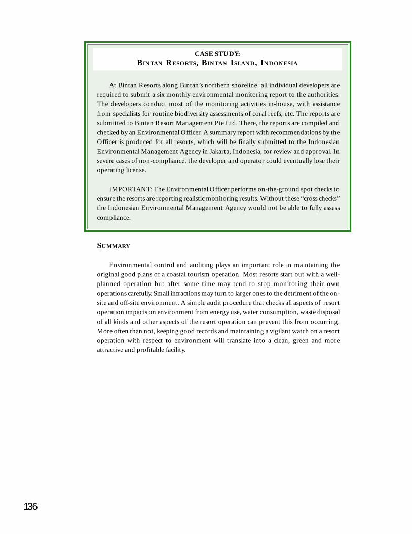
136
CASE STUDY:BINTAN RESORTS, BINTAN ISLAND, INDONESIA
SUMMARY
Environmental control and auditing plays an important role in maintaining theoriginal good plans of a coastal tourism operation. Most resorts start out with a well-planned operation but after some time may tend to stop monitoring their ownoperations carefully. Small infractions may turn to larger ones to the detriment of the on-site and off-site environment. A simple audit procedure that checks all aspects of resortoperation impacts on environment from energy use, water consumption, waste disposalof all kinds and other aspects of the resort operation can prevent this from occurring.More often than not, keeping good records and maintaining a vigilant watch on a resortoperation with respect to environment will translate into a clean, green and moreattractive and profitable facility.
At Bintan Resorts along Bintan’s northern shoreline, all individual developers arerequired to submit a six monthly environmental monitoring report to the authorities.The developers conduct most of the monitoring activities in-house, with assistancefrom specialists for routine biodiversity assessments of coral reefs, etc. The reports aresubmitted to Bintan Resort Management Pte Ltd. There, the reports are compiled andchecked by an Environmental Officer. A summary report with recommendations by theOfficer is produced for all resorts, which will be finally submitted to the IndonesianEnvironmental Management Agency in Jakarta, Indonesia, for review and approval. Insevere cases of non-compliance, the developer and operator could eventually lose theiroperating license.
IMPORTANT: The Environmental Officer performs on-the-ground spot checks toensure the resorts are reporting realistic monitoring results. Without these “cross checks”the Indonesian Environmental Management Agency would not be able to fully assesscompliance.
CHAPTER 12
The Future: Building CapacityThe Future: Building CapacityThe Future: Building CapacityThe Future: Building CapacityThe Future: Building Capacityfor Sustainable Coastalfor Sustainable Coastalfor Sustainable Coastalfor Sustainable Coastalfor Sustainable Coastal
TourismTourismTourismTourismTourismSustainable solutions and ‘green’ technologies areSustainable solutions and ‘green’ technologies areSustainable solutions and ‘green’ technologies areSustainable solutions and ‘green’ technologies areSustainable solutions and ‘green’ technologies areonly as good as the people who implement themonly as good as the people who implement themonly as good as the people who implement themonly as good as the people who implement themonly as good as the people who implement themdaily. That’s why stakeholder and staff awarenessdaily. That’s why stakeholder and staff awarenessdaily. That’s why stakeholder and staff awarenessdaily. That’s why stakeholder and staff awarenessdaily. That’s why stakeholder and staff awareness
and training are of great importance to makeand training are of great importance to makeand training are of great importance to makeand training are of great importance to makeand training are of great importance to makecoastal tourism sustainable.coastal tourism sustainable.coastal tourism sustainable.coastal tourism sustainable.coastal tourism sustainable.
This handbook, augmented by the Philippine Coastal Management Guidebook Series(DENR et al. 2001), provide technical materials for various stakeholder groups. Forintensive training workshops (3-5 days), it is advised to structure the training componentsinto sessions.
The training sessions on sustainable coastal tourism can be linked to the integratedcoastal management (ICM) approach, as tourism is an integral component of coastalzone utilization. Coastal tourism shares its resources with other users (e.g. fishing).Environmental and social impacts from coastal tourism may affect these other resourceusage and vice versa.
In general, ICM training aims to enhance the participants’ awareness of coastalenvironmental issues and appreciation of the ICM approach to address these challenges.
A training workshop on sustainable coastal tourism in the framework of ICM isoutlined here with proposed individual sessions in a logical order. However, each ofthe sessions can be delivered individually or combined as the target audience requires.The materials for the sessions can be extracted from this handbook.
139The Future: Building Capacity for Sustainable Coastal TourismThe Future: Building Capacity for Sustainable Coastal TourismThe Future: Building Capacity for Sustainable Coastal TourismThe Future: Building Capacity for Sustainable Coastal TourismThe Future: Building Capacity for Sustainable Coastal Tourism
Session 5: Strategies and actionsObjectivesAt the end of the session, participants will be able to:
Understand the meaning of strategies and action plans;Formulate strategies and action plans for sustainable coastal tourism; andDevelop a regional ecotour product plan as a key strategy.
Session 6: Ecotour product developmentObjectivesAt the end of the session, participants will be able to:
Conduct a simple tourism market analysis for small and medium-size business;Determine the financial pre-feasibility of the business;Understand the process to set up a professional tourism business; andExplore available niche markets for community-based ecotourism.
Session 7: Environmental management and auditingObjectivesAt the end of the session, participants will be able to:
Describe ‘green practices’ for coastal tourism management;Understand the marketability of ‘green practices’ to ecotourists;Outline ‘green conciousness’ and training for staff and management;Describe the process of evaluation using indicators; andExplain the importance of a reporting system in monitoring and evaluation.
SUMMARY
Building capacity for managing coastal tourism is a multifaceted undertaking.The variety of institutions and persons involved in assisting the design andimplementation of coastal tourism is indeed very large. It is not possible to buildcapacity uniformly among this wide range of stakeholders and institutions.Nevertheless, ongoing training and education is essential to improve the awareness ofpeople in the tourism industry about the need to look for and implement sustainablesolutions. And, the solutions are not only on-site but more often than not the context ofany one tourism establishment is equally or more important than the actual operation ofthe facility. This is why a wider appreciation of ICM planning is essential. If touristscome to a nice beach with all the services and then swim or scuba dive on a dead coralreef resulting either from pollution or destructive fishing, the tourist will probably notreturn. Building this broad awareness among resort planners and operators must be thetheme of training for the future.
140
REFERENCES
Arquiza, Y.D. 1999. Rhythm of the Sea: Coastal Environmental Profile of San Vincente, Palawan.Coastal Resource Management Project, Cebu City, Philippines. 131 p.
Balifokus. 2000. Study on the Tourism Industry of Bali, Indonesia (not published).
Bascom, W. 1980. Waves and Beaches, The Dynamics of the Ocean Surface. Anchor Books,Garden City, New York. 366 p.
Bird, E.C.F. 1969. Coasts. The Massachusetts Institute of Technology Press, Cambridge,Massachusetts. 246 p.
Boo, E. 1990. Ecotourism: Potential and Pitfalls. World Wildlife Fund, Washington, D.C.
Butler, R.W. 1980. The Concept of a Tourist Area Cycle of Evolution: Implications for Managementof Resources. Canadian Geographer 24: 5-12.
Belt Collins Hawaii. 1996. Planning for Tourism Projects. Hawaii.
Belt Collins International Pte Ltd. 1997. Environmental Impact Assessment Report: “HealthSpa” at Nirwana Garden Resort, Pulau Bintan, Indonesia. Singapore.
Berjak, P., G.K. Campbell, B.I. Huckett and N.W. Pammenter. 1977. In The Mangroves ofSouthern Africa. Natal Branch of Wildlife Society of Southern Africa, Duban.
Bintan Beach International Resort (BBIR). 1996. Design and Development Guidelines for BintanBeach International Resort, Pulau Bintan, Indonesia. Singapore.
Boullón, R.C. 1985. Planificación del Espacio Tourístico. Ed. Trillas, México. DF.
Branan, W.V., A.J. Gold and W.R. Wright. 1991. Guidelines for Coastal Water QualityManagement: To Sustain a Healthy Environment and Robust Tourist Industry. ThailandCoastal Resources Management Project, Thailand. 62 p.
Ceballos-Lascuráin, H. 1991. Tourism, Ecotourism and Protected Areas. Parks 2(3): 31-35.
Christie, P. and A.T. White. 1997. Trends in Development of Coastal Area Management inTropical Countries: From Central to Community Orientation. Coastal Management 25:155-181.
Christie P., A.T. White and D. Buhat. 1994. Issues and Applications: Community-based CoralReef Management on San Salvador Island, the Philippines. Society and Natural Resources7: 103-117.
Clark, J.R. (ed.) 1985. Coastal Resources Management: Development Case Studies. ResearchPlanning Institute, Inc. Columbia, South Carolina.
142
Hüttche, C. 1998c. Technical Justification Report/RKL/RPL for Banyan Tree Bintan ResortPhase II/III, Pulau Bintan, Indonesia. Topical Bintan Pte Ltd., Singapore.
Hüttche, C. 1999a. Making AMDAL a Tool for Road Planning in Forests in Indonesia. DiscussionPaper for Policy Makers in Indonesia. NRM (Natural Resource Management Program)/USAID, Indonesia.
Hüttche, C. 1999b. Constructed Wetlands: Engineered “Kidneys of the Landscape”, p. 8-9. InAsia Eco Best Magazine, Nov. 99. RIET (Regional Institute for EnvironmentalTechnology), Singapore.
Hüttche, C. 2000. Setting Up Ecotourism Ventures: The Olango Coral Farm Ecotour. In T.Heeger and F. Sotto (eds.) Coral Farming: A Tool for Reef Rehabilitation and CommunityEcotourism. Philippines.
Lindberg, K. and D.E. Hawkins (eds.) 1993. Ecotourism, A Guide for Planners and Managers.The Ecotourism Society, North Bennington, Vermont. 175 p.
Manning and Dougherty. 1994. Carrying Capacity for Tourism in Sensitive Ecosystems. Presentedat the Building a Sustainable World through Tourism Conference, Montreal, Canada.
Maragos, J.E., A. Soegiarto, E.D. Gomez and M.A. Dow. 1983. Development Planning forTropical Coastal Ecosystems, p. 229-298. In R.A. Carpenter (ed.) Natural Systems forDevelopment: What Planners Need to Know. East-West Center and MacMillan PublishingCo., New York.
Martinez, O.Y. 1997. The Impacts of Coastal Tourism in Maribago, Lapu-Lapu City. Master’sThesis in Environmental Studies, University of the Philippines, Los Baños. 249 p.
Murphy, P. (ed.) 1983. Tourism in Canada: Selected Issues and Options. Western GeographicalSeries 21: 3-23.
Packard, R.T. and S.A. Kliment (eds.) 1989. Ramsey/Sleeper Architectural Standards. StudentEdition, abridged from Seventh Edition. American Institute of Architects. John Wileyand Sons, New York.
Pearce, D.G. and R.M. Kirk. 1986. Carrying Capacities for Coastal Tourism. Ind. Environ.9(1): 3-7.
Planetary Coral Reef Foundation (PCRF) – Indonesia. 2000. Wastewater Gardens™. Sustainable,Biodiverse Wetland Ecosystems for Wastewater Treatment, Residential, Agriculturaland Industrial Wet Cells Design and Construction. Indonesia.
Reedbed Technology Ltd. 1998. Published Report on Bunaken Island Indonesia. Regional Institutefor Environmental Technology, Singapore.
Rees, C. 1990. A Guide to Development in Urban and Coastal Areas. Asian Wetland Bureau,Malaysia. 78 p.
Schema Konsult Inc. 1996. Mactan Island Integrated Master Plan Study. Volume 1, Draft FinalReport. 235 p.

144
Wong, P.P. (ed.) 1993. Tourism vs. Environment: The Case for Coastal Areas. Kluwer AcademicPublishers, London. 225 p.
Wong, P.P. 1999. Adaptive Use of a Rock Coast for Tourism – Mactan Island, Philippines.Tourism Geographies 1(2): 226-243.
World Tourism Organization (WTO). 1981. Proceedings of the Workshop on Resort Planningand Development, Baguio City, Philippines. WRP/Info Note 4. WTO Commission forEast Asia and the Pacific.