Tourism and Biodiversity Corridor · The Tourism and Biodiversity Corridor planning area is ......
121
Tourism and Biodiversity Corridor Final Report A Preliminary Tourism Development Strategy for the Tourism and Biodiversity Corridor June 2002 Prepared by: DB Consulting PO Box 70705 Bryanston 2021
Transcript of Tourism and Biodiversity Corridor · The Tourism and Biodiversity Corridor planning area is ......

Tourism and Biodiversity Corridor
Final Report
A Preliminary Tourism Development
Strategy for the Tourism and Biodiversity Corridor
June 2002 Prepared by: DB Consulting
PO Box 70705 Bryanston
2021

A Preliminary Tourism Development Strategy for the Tourism and Biodiversity Corridor
TABLE OF CONTENTS
1. Introduction ……… 1 2. Methodology ……… 3 3. Key findings from the socio-economic analysis, and related implications for Trans-border collaboration ……… 4 4. Tourism development issues and trends ……… 7 5. Biodiversity and conservation issues and trends ……… 20 6. Regional tourism development context ……… 23 7. Development framework and principles
for the TBC ……… 28 7.1 Strategic objectives ……… 28 7.2 Preliminary design principles ……… 29
8. Conceptual tourism development strategy ……… 31 8.1 The vision ……… 32 8.2 Demonstration projects ……… 33 8.3 Tourism management strategies ……… 40 8.4 Tourism marketing strategies ……… 41 8.5 Tourism development strategies ……… 42 8.6 Spatial development strategies ……… 44 8.7 Investor mobilisation strategies ……… 45 9. Demonstration project ……… 46 10 Follow-up actions ……… 46 Annex 1: Msauli Village Rehabilitation ……… 51 Annex 2: Barberton to Bulembu Road ……… 61 Annex 3 Songimvelo Game Reserve:
Commercialisation of tourism facilities ……… 64

Annex 4: Mountainlands Game Reserve ……… 70 Annex 5: Ebutsini Tourism Project ……… 76 Annex 6: Badplaas Tourism Information Centre ……… 80 Annex 7: Upgrading of the TBC route signage ……… 82 Annex 8: Songimvelo/Malolotja Transfrontier Park and Conservation Areas ……… 84 Annex 9: Lubombo Transfrontier Conservation Area ……… 93 Annex 10: Maguga Dam tourism facilities ……… 97 Annex 11: Bulembu Village Rehabilitation ……… 98 Annex 12: Northern Swaziland and South Eastern
Mpumalanga Development Perspective ………106

List of abbreviations GEF Global Environmental facility IDP Integrated Development Plan KOBWA Komati Basin Water Authority KRBDP Komati River Basin Development Programme LDO Land Development Objectives MPB Mpumalanga Parks Board MYDP Multi-Year Development Programme SADC Southern African Development Community SDI Spatial Development Initiatives SEAHTR South East African heritage Tourism Route TBC Tourism and Biodiversity Corridor TFCA Trans Frontier Conservation Area TFP Trans Frontier Park SME Small and Medium Scale Enterprise

Tourism and Biodiversity Corridor
A Preliminary Tourism Development Strategy.
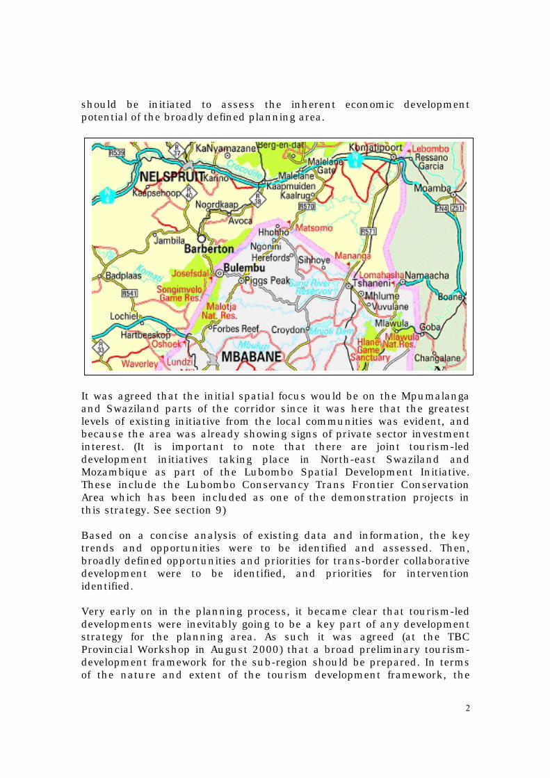
1. Introduction Since 1997, there was increasing consensus between role players in Northern Swaziland, South-eastern Mpumalanga and Southern Mozambique that whilst these predominantly rural areas of the three countries had tremendous inherent development potential for tourism-led growth, that this inherent development potential was tending to be under-emphasised and under-utilised. As a result the decision was taken by the three countries to initiate a number of studies to identify and assess related development opportunities in the Northern Swaziland, South-eastern Mpumalanga and Southern Mozambique sub-region. One of the many concepts that emerged from this process was that of utilising the unique biodiversity, heritage, cultural, geological and archaeological resource base that is shared by the countries as a basis for the development of an economic development corridor where tourism-led developments were the primary activities. The concept has been called different names, and the geographical focus has also differed marginally. There was talk of the ‘Royal Route to the Sea’, the ‘Songimvelo Circle’, the Swaziland Biodiversity and Tourism Corridor to mention a few. By and large, all initiatives have focused on a parts/components of the spatial area running from South Eastern Mpumalanga, through northern Swaziland and into southern Mozambique. The Tourism and Biodiversity Corridor planning area is larger than the above-mentioned initiatives, and includes significant portions of South Eastern Mpumalanga, northern Swaziland and southern Mozambique. The planning area is characterised by very high levels of biodiversity, which combined with the very high diversity of cultural, heritage, geological and archaeological resources renders the area potentially well suited to tourism-led developments. Whilst the concept had been discussed for a number of years, and even though Swaziland had secured significant funding for the biodiversity component from the Global Environment Facility, progress with the tourism development process was limited between 1997 and 1999. In early 2000, Swaziland Ministry of Economic Planning and Development and the Maputo Corridor Company agreed that in order to build on the considerable local interest in boosting local economic development in the sub-region, and in order to generate development momentum, a process
2
should be initiated to assess the inherent economic development potential of the broadly defined planning area. It was agreed that the initial spatial focus would be on the Mpumalanga and Swaziland parts of the corridor since it was here that the greatest levels of existing initiative from the local communities was evident, and because the area was already showing signs of private sector investment interest. (It is important to note that there are joint tourism-led development initiatives taking place in North-east Swaziland and Mozambique as part of the Lubombo Spatial Development Initiative. These include the Lubombo Conservancy Trans Frontier Conservation Area which has been included as one of the demonstration projects in this strategy. See section 9) Based on a concise analysis of existing data and information, the key trends and opportunities were to be identified and assessed. Then, broadly defined opportunities and priorities for trans-border collaborative development were to be identified, and priorities for intervention identified. Very early on in the planning process, it became clear that tourism-led developments were inevitably going to be a key part of any development strategy for the planning area. As such it was agreed (at the TBC Provincial Workshop in August 2000) that a broad preliminary tourism-development framework for the sub-region should be prepared. In terms of the nature and extent of the tourism development framework, the

3
consultants’ brief was specific that the emphasis was on a framework that provided broad direction and not a comprehensive planning framework. The framework was to provide a sound and sustainable strategic context within which the initial tourism anchor projects would be identified and conceptualised. In the latter regard, it was agreed that there should be a specific focus on identifying practically implementable projects that would demonstrate the inherent potential of the area to investors and for investment, as well as impact directly in terms of employment creation, economic growth, local economic development and community empowerment. This report is structured as follows: Section two describes the methodology used. Section three provides an assessment of the existing socio-economic trends in the study area as defined, and highlights the issues, implications, opportunities and priorities for transborder collaborative development initiatives. The Study Area includes the Eerstehoek, Nkomazi and Barberton districts in the Mpumalanga province of South Africa and the Hhohho district in Swaziland. Section four summarises the key tourism development trends in the planning area. Section five provides the broader regional tourism development context. Section six provides a concise overview of the biodiversity and conservation issues and priorities in the planning area. Section seven provides the proposed preliminary tourism development framework and strategies for the planning area. Section eight provides an overview of the key anchor projects as proposed for each country. Section nine provides an overview of each of the initial anchor projects. Section ten provides a list of required follow-up actions.
2. Methodology The Study Area includes the Eerstehoek, Nkomazi and Barberton districts in the Mpumalanga province of South Africa and the Hhohho district in Swaziland. The socio-economic analysis that under-pins the proposals included a review of the prevailing local socio-economic trends and priorities, and an analysis of the likely ability of other economic sectors to provide sustainable employment and economic growth for the sub-region in the next five years. Implications derived from the analysis focus on impacts in terms of employment, economic growth and investment. In addition to the broader socio-economic analysis a more focused analysis was made of the tourism sector. An assessment was made of trends in occupancy for existing tourism operations in the planning area. The key tourism products and experiences in the study area were also assessed, and these trends assessed against national, regional (southern
4
Africa) and international tourism demand trends, thus providing some indication of the ‘match’ with the identified potential product/experiences. In addition to the data derived from secondary analyses, further insight was derived via site visits to the existing and/or proposed reserves/conservancies within the planning area. This enabled a reasonably accurate understanding of the current conservation status (both good and bad) of the above-mentioned areas, which in turn highlighted certain strategic choices required for the further development of these conservation areas.
3. Key findings in terms of the socio-economic analysis, and related implications for trans-border collaboration
The full findings of the “Northern Swaziland and South Eastern Mpumalanga Development Initiative – Socio-economic Perspective” are contained in a separate document. The sections immediately below summarise the main findings and their implications for trans-border collaboration. Annex 12 attached provides further summarised information in terms of the key trends in the human and natural resources, as well as in terms of the sub-regional economy. It is clear from the analysis that the study area is in need of accelerated development. In particular, there is an urgent need for the development of strategies that would create sustainable employment and economic growth. The inadequate performance of the economy of the Study Area is evident in its low labour absorption capacity. The current economic growth rate and the rate at which new entrants to the labour force grows, suggest that the formal economy will not be able to accommodate the entire labour force. This is evident from high unemployment levels in the Study Area. Expansion of existing economic activities and exploitation of new ventures are essential to improve the absorption capacity of the economy. The Study Area’s predominantly young population will put additional pressure on education facilities that are already over-utilised and this will inevitably impact negatively on the employability of those entering the labour market. The continued high rate of people entering the human reproduction phase associated with younger populations put additional pressure on this employability through shear numbers. The predominance of women in the potential economically active population

5
is indicative of limited job opportunities where usually the men work outside the area. The unique geology and associated soil types, as well as the range of altitudes have resulted in the area having a tremendously rich diversity of biota. The natural resource base and climate make the study very well suited to agricultural-led and tourism-led economic development. Underpinning both of these activities is the natural resource base, and as such its long-term management on a sustainable basis will determine the long-term sustainability of the sorts of economic development strategies. Presently, the economy of the Study Area is driven by the agriculture sector and the importance of the agriculture sector as an employment creator stands out. The Komati River Basin Development Programme (KRBDP) is a major attempt to exploit the development potential of the Study Area in addressing the increasing poverty in the area. Although ‘big dam and resettlement’ projects are negatively perceived by many, they can have a positive socio-economic development impact, especially under the circumstances prevailing in the Study Area. The past and anticipated declines of the mining sector in the study area will also create additional unemployment and socio-economic hardships. There is no real prospect at present that these job losses can be made-up elsewhere in the mining sector within the study area. As such alternative sources of employment in economic activities that do not specifically require highly skilled personnel should be vigorously pursued. The under-utilised but potentially ‘world-class’ tourism natural resources seem to offer a clear opportunity for tourism-led development. Tourism-led development also offers important potential for SME development since opportunities are relatively plentiful, and access is that much easier within the tourism industry (particularly resource and culturally based). What is also significant, is that much of this under-utilised tourism development potential is located in or adjacent to rural areas that house many of the poorer communities. Such tourism-led development strategies and initiatives will need to be designed and implemented in a coordinated and integrated manner with the agricultural led developments that form part of the KRBDP. In terms of transborder collaboration issues, a number of observations can be made: Firstly, Swaziland and South Africa share extremely valuable water resources and catchments. These need to be properly managed for the
6
long-term sustainability of the study area, as well as for the further development of Mozambique, which is a downstream user. Secondly, both countries can and are benefiting from the collaborative development of the water resources in support of extensive irrigated agricultural development. Thirdly, if the underlying resource base is to be sustainably utilised and/or conserved, an integrated and coordinated approach to the conservation and management of the resources is essential. Inevitably, this will require considerable related capacity building, and this too can, and should, be approached on a collaborative and co-operative basis. Fourthly, tourism-led development strategies within the study area could have major positive impacts for economic growth and investment within the study area (due to inter alia the potentially employment intensive and SMME friendly nature of the tourism industry, as well as the fact that this sector poses less barriers to entry for less skilled and experienced employment seekers). It is essential for such tourism-led developments that a coordinated and integrated approach is adopted. It is only on this basis that a corridor encompassing a variety of different environments, archaeological experiences, cultures, biological diversity, adventure tourism experiences etc. can be developed. Fifthly, in support of both the agricultural-led and tourism-led development efforts, it is vital that an integrated network of infrastructure and services are developed. If access through the region is perceived to be difficult, excessively slow, dangerous, excessively expensive, etc., both forms of development will be negatively affected. Sixthly, related to the issue of the transborder movement of freight and travelers, in both cases every effort needs to be made to ensure the smooth flow of people/freight across the international borders. In the case of tourists, the seamless transfer of tourists is all the more important since tourists who experience tedious and excessively bureaucratic immigration procedures feel threatened and unwelcome. Finally, with both countries (within the study area) adopting very similar economic development strategies, it would be very useful to consider the establishment of transborder institutional structures. These structures could facilitate the joint design and implementation of policy and strategy, the sharing of lessons of experience, and the sharing of scarce resources such as human expertise and specialised research capacities etc.

7
In terms of relative priorities for intervention, the following conclusions can be drawn: Considerable attention has already been given to the issues of river basin management and development. Related institutional structures have been established. These include the Komati Basin Water Authority (KOBWA) that was established between South Africa and Swaziland by Treaty (describing the nature and functions of KOBWA), and oversees the construction of Lake Motsamo and Maguga Dam. There is also a Tripartite Permanent Technical Committee (South Africa Swaziland and Mozambique), which looks at the whole Nkomati River Basin. In terms of the conservation and management of the underlying resource base, only limited progress has been made to-date. However, Swaziland has secured Global Environmental Facility (GEF) funding for a fairly comprehensive review of the current situation, for future planning and for capacity building. (Swaziland Biodiversity Conservation and Participatory Development Project.) Swaziland has already appointed a full time project manager, and commenced implementation of their work programme. The agricultural-led development process has also received considerable focus and attention over many years, and no particular new intervention is required at this stage. The main area requiring urgent intervention is in terms of trans-border tourism-led development as a basis for socio-economic development. As part of such initiatives one would also need to consider the development of related transborder infrastructure, the redesign of transborder border crossing arrangements, transborder conservation initiatives, and strategies for mobilising much needed private sector investment and expertise, etc. Similarly, the need for and opportunities to establish a transborder institutional structure focused on supporting the implementation of sustainable tourism-led socio-economic development projects is important.
4. Tourism development issues and trends • The planning area contains a significant number of publicly,
communally and privately owned nature reserves. These protected areas provide a range of different natural habitats and

8
related opportunities for nature based adventure and photographic tourism. The major existing reserves include the following:
South African game and nature reserves Songimvelo Established in 1987, this reserve measures 49 000 hectares in extent. It lies in rugged mountain terrain, the highest point being Mlembe peak at 1851m. The reserve offers luxury accommodation. The reserve consists predominantly of grassland and savannah woodland and shrub forest. The reserve also contains elements of the Cape Floral Kingdom in higher areas, as well as three cycad species that are found there. There are 20 species of ungulates in the reserve including hippo, giraffe and rhino. Predators include leopard and caracal, but could accommodate lion too. Some 309 species of birds have also been recorded in the reserve. Barberton Game Reserve The newest of a suite of publicly owned game reserves to be established in the Barberton Valley, the Barberton Game Reserve measures 2500 hectares in size. It is situated 20kilometers south of Nelspruit to the west of the R40 linking Nelspruit and Barberton. The reserve is easily accessible for day trip visitors from Nelspruit and Barberton. The reserve ranges in elevation from 1150m to 680m above sea level, and the predominant vegetation is Sour Lowveld Bushveld of the savanna biome. The Noordkaap River flows through the length of the reserve, which is presently home to a thriving population of kudu, zebra, blue wildebeest, impala and bushbuck. The rare red duiker and klipspringers also occur with one of the highest populations per unit area of mountain reedbuck. Predators include serval, jackal and leopard. Some of the oldest exposed rock formations (greenstones) are found in the reserve. Processes are presently underway to include an additional 1000 hectares of private land through a joint management agreement. Piranie Nature Reserve The Peranie Nature Reserve falls within the limits south of the N4 Maputo Development Corridor and north of the R38 between Barberton and Kaapmuiden. Through a cooperation agreement between the private sector landowners and the State, this newly formed area comprises approximately 10 000 hectares dedicated to conservation and ecotourism, and a further 10 000 hectares set aside for a conservancy with associated agricultural activities. The veld type

9
is Sour Lowveld Bushveld comprising Broken Marula Veld. A variety of game already occurs in the area with plans to introduce the Big 5. The area also boasts 444 recorded bird species. Within the reserve are remnants of African Rock art and an authentic iron smelter. The original Zeederberg old coach/wagon road originating from the time of the transport riders also runs through the reserve. A fully functional lodge is already operational in the reserve and in addition to providing accommodation for ecotourists, also provides conference and wedding reception facilities. Mountainlands Game Reserve Consisting of portions of State, communal and private land, this reserve measures some 18 000 hectares in extent. Elevations range from 600m to 1300 meters above sea level with a number of perennial streams flowing through the area. The vegetation is mostly Sour Lowveld Bushveld of the Savanna Biome merging into the North Eastern Mountain Grassland of the Grassland biome at higher elevations. The range in elevation, and the broken mountain topography result in a variety of habitats supporting a very rich biodiversity. More than 1500 plant species have been identified in the area, a number of which are endemic and endangered. Various game species including kudu, mountain reedbuck, common reedbuck, bushbuck, bushpig, klipspringer, grey duiker, and the rare red duiker already occur. Carnivores such as leopard, caracal, civet, genet and jackal are also already present on the reserve. The reserve has the potential to accommodate the Big Five, and the re-introduction of larger game commenced in April 2002. this reserve also contains examples of archaen geology and Early and Middle Stone Age settlements. Swaziland game and nature reserves Malolotja Nature Reserve The 18 000 hectare reserve is the last true wilderness area in Swaziland. Altitudes range from 650-1900meters above sea level. It is a paradise for hikers. The area is dominated by rugged mountains and includes two of Swaziland’s highest mountains, Ngwenya (1837m) and Silotwane (1680m), as well as its highest waterfall Malolotja Falls (95 meters). In addition to the mountain valleys there are beautiful valleys, deep river gorges, and grass covered plains. It boasts some of the world’s oldest and best-preserved sedimentary rocks, in the world. The Lion Cavern which, is dated at 41 000 BC is the oldest known site of mining activity in the World. The great variety of habitats and

10
vegetation types, ranging from open grassland to forest makes this one of the most interesting botanical areas of Swaziland. The reserve contains tremendous varieties of plants including rare cycads and elements of the Cape Floral Kingdom. The superb variety of wild flowers is second only to South Africa’s Namaqualand. The reserve contains a wide range of smaller mammals (reedbuck, grey rhebuck, oribi, klipspringer, common and red duiker, zebra, warthog, blue and black wildebeest, red hartebeest, blesbok and common reedbuck). In addition 280 bird species occur including specialities such as the blue swallow, blue crane, bald ibis, flufftails, Gurneys sugarbird, Chorister robin, crowned eagle and narina trogon. There are 18 species of amphibians and 54 species of reptiles. Phophonyane Lodge and Nature Reserve This is a small private game reserve famed for its abundant birdlife that thrives in the indigenous forests. Lubombo Conservancy This is a local initiative aimed at ensuring the cooperative and collaborative management of a number of contiguous but separately owned nature reserves. These include Hlane Game Reserve, Mlawula Nature Reserve, Shewula Game Reserve and the Mbuluzi Game Reserve. Hlane Game Reserve: Situated in the Swaziland Lowveld, this 30 000 hectare reserve includes the geographically separate Simunye Nature Reserve. The reserve provides important habitat and food for scavenger species such as vultures and jackals. Hlane is home to Swaziland’s ‘big cats’ – lion leopard and cheetah. The reserve is one of the few conserved areas of potentially productive Lowveld (the rest having been converted to agriculture) and consequently it has unusually high numbers of game including Burchell’s zebra, white rhino, elephant, warthog, kudu, impala, waterbuck, bushbuck, nyala, common duiker, steenbok and giraffe. An interesting ritual performed on Hlane is the ‘Butimba’ , which is an annual royal hunt led by the Swazi King. Mlawula Nature Reserve: The Mlawula Nature Reserve comprises two conservation areas (Mlawula and Ndindza), that are managed as a unit and together cover an area of 16 400 hectares. The reserve offers rugged scenery and has a rich archaeological history with some spectacular caves dating back to 110 000 years as well as many Early and Middle stone Age remains. The reserve ranges in altitude from a

11
high point in the Lubombo mountains of 573 meters to a low of 57 meters in the Lowveld and incorporates a variety of vegetation types including dry thorn savannah, open grassland, and moist woodland. The reserve protects a wide range of endemic plant species including very rare cycads, a variety of antelope, more than 350 species of birds which is the highest bird count in Swaziland. Shewula Game Reserve: Developed on Shewula community land and managed by the Shewula community. A community owned and operated camp has been developed, providing four self-catering rondavels perched on the very edge of the Lubombo escarpment with a view that includes most of the Lowveld. Mbuluzi Game Reserve: This is a privately owned and managed 2500 hectare reserve. It offers attractive riverside scenery with good game viewing, fly fishing and bird watching opportunities.
• There are also considerable portions of communal land that could be well suited to tourism based developments. Some of these areas have already been set aside as community based conservation areas, whilst others are operated on a joint agriculture/conservation/tourism basis. They are briefly discussed below.
Mahushe Shongwe Game Reserve
This Game Reserve (established 1987) is located in the Nkomazi district next to Mzinti village, which is inhabited by members of the Matsamo community, and is very well located relative to an existing tarred road. The reserve measures some 1100 hectares in extent. The landscape is characterised by gently undulating granitic hills covered by Lowveld veld type. The vegetation is broad-leaved woodland providing medium quality grazing and sandy soils. The reserve is fully game fenced; there are two earth dams; a satisfactory internal road network; a small field office, workshop, store and slaughtering facilities; staff housing for a reserve manager and one field ranger picket; small education hall and ablution block; tented camp (4 units of 2 beds with en-suite bathroom); common kitchen and swimming pool. Importantly, the reserve is very well maintained and operated. At least 10 species of game are found on the reserve including giraffe, zebra, kudu, impala, nyala. With proper marketing and limited reorganisation of facilities this could be significantly improved.

12
There is regular utilisation of the facility by local, regional and international tourists. The tourism product is nature based photographic and limited consumptive (hunting) tourism. Not withstanding the virtually non-existent marketing, this reserve continues to enjoy reasonably good (in the context) occupancies. The reserve currently has an occupancy level of around 30% (2001). With proper marketing this could be expected to grow. This type of tourism product is experiencing strong growth in the regional and international context, and the long-term prospects are very good providing a stable macro-economic and political situation is provided. The introduction of a private sector operator should enhance the marketing of the reserve, which should further boost occupancies within the existing 8-bed camp. Mawewe cattle/game ranching project area The Mawewe cattle/game ranching project (started in 1992) is located on the Mpumalanga/Swaziland border between Jeppes Reef and Border Gate in the Nkomazi district. The project area is about 9200 hectares in extent with an undulating granitic landscape covered by Lowveld veld type. Vegetation consists of open to closed woodland with grazing of medium quality. The project area is dissected by numerous seasonal streams. Key existing infrastructure includes the 50km perimeter game-proof fence, boreholes, and drinking troughs. Game species include impala, kudu and giraffe. A small Swazi style tourist camp has been developed. The project is run by an elected committee with the assistance of the MPB. At present the tourism component/potential is very significantly under-utilised. The area could be redeveloped (part game and part cattle) in partnership with a private sector developer/operator in a manner that would make it very suitable for consumptive tourism uses, which are likely to be provide much needed socio-economic benefits for the local community. This project would focus primarily on the local and regional hunting market. The consumptive tourism market is a growing one, and the long term demands for this type of tourism are good, particularly since the availability of affordable hunting opportunities for local and regional ‘biltong’ market are increasingly limited.

13
Masibekela/Mananga Resource Area and the Matsamo cattle/game project area The Masibekela/Mananga Resource Area is located in the extreme south-eastern corner of Mpumalanga on the Swaziland-Mozambique border. This resource area measures is about 6000 hectares in extent, and consists of three main types of vegetation. These include a central perennial wetland system surrounded by thorny savanna in flat areas and open woodland on steep Mananga mountain. Veld type is Zululand Thornveld which only occurs in this particular part of Mpumalanga. Mananga mountain harbours an extensive colony of cycads, several rare species of conservation importance have been found in the wetland area, and this is also an important bird habitat. The Matsamo cattle/game project area is located south of Mzinti village in the Nkomazi District. The local community approached the Mpumalanga Parks Board to assist in developing the area as a cattle/game project (along similar lines to Mawewe in 1995. This project area measures is about 6000 hectares in extent, and consists of undulating granitic landscape with Lowveld veldtype. The area is presently used for communal livestock grazing and for the harvesting of fuelwood for domestic purposes. Both areas lend themselves to the development of infrastructure and facilities focused primarily on the local and regional hunting market. The consumptive tourism market is a growing one, and the long term demands for this type of tourism are good, particularly since the availability of affordable hunting opportunities for local and regional ‘biltong’ market are increasingly limited. In view of the scenic value of this location, the camps could be marketed for ‘affordable’ non-consumptive adventure tourism (mainly hiking related) out of the hunting season. Ebutsini Community tourism area The Ebutsini community is located within an area of about 10 000 hectares. Situated within South Africa, this area of land is ‘strategically’ wedged between Songimvelo and Malolotja Game Reserves. As such it is well located relative to the existing and proposed tourism and conservation facilities/activities that form part of the Tourism and Biodiversity Corridor. The land is of high biodiversity value, and remains in reasonably good condition despite the fact that it has no formal conservation status. Its scenic value is also very high making it potentially conducive to tourism related activities. The local community has already established a reasonably

14
successful 4X4 route through the area, and have secured additional grant funding to expand their infrastructure and facilities. Sand River cattle and game ranch Located in Swaziland, this 21000 hectare ranch is owned jointly by the Swaziland parastatal Tibiyo and the Commonwealth Development Corporation. The Sand River dam is located on the farm, and has a surface area of 700 hectares. The vegetation on the ranch is in good condition, and besides supporting cattle also supports about 3000 head of game. Whilst the ranch presently operates as a cattle ranch, it used to also allow ‘biltong’ hunting opportunities.
• The planning area has unique geology and archaeology. The Barberton Mountainlands has worldwide recognition as a remarkable locality for understanding the history and evolution of the Earth. The Barberton Greenstone Belt rocks evolved between 3.5 and 3.2 billion years ago, making them amongst the oldest and best exposed rocks in the world. In addition there are few places in the world where the rocks of this great age are as well preserved. Research is constantly yielding new scientific discoveries, and microfossils dated at 3.3 billion years old (on par with the Warrawoona Group in Australia) have been found in the area.

15
• Wide range of cultural and heritage opportunities including both
traditional indigenous cultures as well as colonial influences and Dravidian and Arabic influences from 1000 to 3000 years ago. These include Middle Stone Age sites (22 000-100 000 years old) in Barberton, 16th and 17th century bushman rock paintings in Piggs Peak (amongst 20 other sites in Swaziland), various ancient dwellings and setllemnets around 500 years old (one complete village on Wonderscheur in Mountainlands), Lions Cavern, which at between 41 000 and 36 000 BC is the oldest known mine in the world, Labambo Royal Kraal (Swaziland – current), Eureka City (1800s mining settlement), Sheba Gold mine which is the oldest working mine in the world, De Kaap Valley (Valley of Death), Dravidian temple sites (in Mountainlands Game Reserve, Nkomazi Wilderness Nature Reserve and Songimvelo Game Reserve) etc.
• Arts and crafts: A wide range of quality handcrafts is available to
visitors and represent a blend of the best of traditional designs and modern techniques. Some are sold in specialist stores, whilst others are available from the markets and even on the side of the road. The truly traditional Swazi craft is grass weaving, and mats and baskets in all sizes are available. Local materials are used in the production of carved wooden bowls and figures, beadwork, calabashes, spears, battle-axes, shields, drums, leatherwork and soapstone carvings.
Within the STBC there are many locations where tourist will be able
to view and purchase Swazi crafts from roadside entrepreneurs. The larger and more formal stores are located in close proximity to the major road networks where tourist traffic numbers are largest. Some of the better-known stores include Coral Stephans Ltd. weaving studios (at Piggs Peak). The crafts made here are based on fine mohair that is carded, spun, dyed and hand woven into the most spectacular fabrics. More recently, the craftspeople are working with Mopane silks, Raffia and cotton yarn. Also at Piggs Peak is Tintsaba Crafts where some 500 women make sisal baskets, beadwork, grass baskets, sleeping mats, mountain grass basket ware, wooden baskets, wood and soapstone carvings, clay pots and calabashes. A little further south at Ngwenya craftspeople specialise in glassware, silk screened batiks and Swazi candles.
• There is a good potential match between tourism development
potential in the TBC, and tourism demand trends in South Africa: In terms of inherent potential it is a well-accepted fact that South Africa has particularly good inherent potential for nature based tourism – particularly related to the varied scenery and
16
wildlife. Surveys (Grant Thornton Kessel Feinstein discussions 2002) indicate that scenic beauty and wildlife remain the main draw cards for foreign air arrivals to SA (30 per cent and 28 per cent respectively). Also very interesting is that on departure 44 per cent of foreign air arrivals felt that the countries scenic beauty is the most appealing characteristic whilst 27 per cent felt that it was the countries wildlife.
In terms of the SA domestic tourism industry, it is estimated that a
total of 33.5 million trips are undertaken annually1. Of some concern to a province like Mpumalanga, which has such a rich and varied potential for tourism development, is that at present it is second lowest destination for domestic tourists at 6 per cent. This is just less than Free State (7 per cent), and North West (8 per cent) and substantially less than the Limpopo, Eastern Cape and Western Cape Provinces at 13 percent. KwaZulu Natal (18 per cent) and Gauteng (19 per cent) are the most popular domestic destinations.
• Not withstanding the obvious tourism development potential as
described above, this inherent tourism development potential is hardly utilised at all. Clearly the area is not a well-known tourism destination, and one result is that there is a very limited amount of development, as well as poor levels of utilisation. The fact that tourism-led development in the Wild Frontier area is very new is also reflected in the paucity of statistics that are available for the area. Using the latest available information from the Mpumalanga Tourism Authority, together with information gleaned (via interviews) with the Wild Frontier Regional Tourism Organisation, the following picture emerges. Of the estimated 1 million travelers who visit Mpumalanga every year, about half (500 000) are traveling for leisure, business or religious reasons. Of the 500 000 it is further estimated that 50 per cent (250 000) travel for leisure purposes. Of this 250 000 it is estimated that 12 per cent (30 000) people visit the Wild Frontier annually. The Wild Frontier area houses about 8 per cent of Mpumalanga’s tourism facilities/product (measured in terms of numbers of B&Bs, lodges, guesthouses, hotels, self catering accommodation and guest farms). In terms of the composition of the local economy, the wholesale, retail trade and tourism sector is the third largest component of the local economy, but has been growing at a relatively slow rate of about 1.2 per cent between 1996-2000, which is only the fifth fastest rate between the 7 Mpumalanga Tourism
1 About 21 per cent (just over 7 million) are holiday trips, 60 per cent are ‘visiting friends and relatives’, and the balance are for religious, business and health reasons.

17
regions2. Whilst this rate of growth is not especially encouraging, it is the view of the Wild Frontier RTO that growth in the period since 2000 has been very encouraging with a number of new investments made. In this regard it is estimated that there has been a doubling of tourism beds since 2000 (N Oosthuizen, Barberton Tourism Organisation. Pers. Comm). There are also a number of investments in process (such as Msauli Village Rehabilitation, the development of the Nkomazi Wilderness project etc.). In general it appears that most of the existing new developments have been in terms of the development of B&Bs and guesthouses, although there are larger projects that are in advanced stages of negotiation, or in implementation, such as Msauli, Nkomazi Wilderness, Impala hotel, Mountainlands game Reserve, Montagomanie lodge and others. In general these projects are all based on the utilisation of the areas natural and to a lesser extent cultural heritage.
TOURISM DEVELOPMENT ISSUES If one considers the tourism development situation in each country the following trends emerge. On the South African side of the border are two main districts - Barberton and Nkomazi. In the Barberton district the major existing tourism attractions include the Piranie, Songimvelo, Mountainlands, Barberton, Nkomazi Wilderness and Ligwalagwala reserves/conservancies, as well as a range of archeological, geological and culture and heritage attractions (as described above). At this stage, this potential remains largely under-utilised, and the area is not a well-known destination at all3. The area has a number of key advantages that bode well for its future development. They include the following:
2 At the national level the following trends are evident. Whilst South Africa experienced very good growth in foreign tourist arrivals from 1994-1998, this growth has stagnated since 1998. Between 1998 and 1999 foreign tourist arrivals increased marginally (5,3 million to 5,89 million), since 1999 numbers have declined in absolute terms, and in 2001 arrivals (5.72 million) were lower that 1998. Part of this decline can be ascribed to the worldwide decline in foreign travel over this period. South Africa does have the inherent potential to grow its tourism industry, and the expectation (Grant Thornton Kessel Feinstein discussions 2002) is that this should happen with the huge emphasis currently being placed by SA Tourism on marketing SA as a tourism destination. 3 One of the much better known attractions that is located on the edge of the TBC is the Badplaas resort. This relatively thriving resort provides tourists with access to natural hot springs/baths. The ability to attract some of these tourists further into the TBC is an important challenge.

18
• The area has tremendous inherent development potential in terms of nature based photographic and consumptive tourism, in adventure tourism, and in terms of culture and heritage tourism. All of these sectors of the tourism market are key growth sectors in the global tourism economy.
• All the major reserves have reasonably good access by road. Piranie
and Mountainlands via tarred roads, and Songimvelo (the last portion) via gravel road. All reserves are accessible by 2X4 wheel drive vehicles.
• This district is well located in terms of proximity to Swaziland and it’s
related attractions, particularly so once the upgrade of roads linking Barberton to Bulembu to Piggs Peak and Tshaneni are implemented.
• Tourism-led development is receiving a very high priority by the
various levels of local, sub-regional government, as well as the various private sector organisations within this district.
In the Nkomazi district the performance of the tourism sector has been fairly limited to-date, and could be significantly improved. Key strategic issues that bode well for future development potential include the following. • Firstly, the Nkomazi district is located immediately south of the
Kruger National Park – a prime, well-known, existing tourism destination.
• Secondly, this district is well located in terms of proximity to
Mozambique and Swaziland both of which countries have tremendous inherent but under-utilised tourism development potential.
• Thirdly, this district enjoys very good bulk road access, again
strengthening its location as an area through which tourists move between the Kruger National Park, destinations elsewhere in Mpumalanga, Swaziland, and Mozambique, as well as the key source market of Gauteng.
• Fourthly, this district has inherent and under-utilised development
potential for the development of nature based, adventure and cultural tourism products. These types of product are all important growth sectors in the global tourism market. In this regard, there are a number of provincial/community nature reserves/conservancies in the Nkomazi district that are at present very significantly under-

19
utilised. They include Mahushe Shongwe, Masibekela/Mananga, and Matsamo.
However, it is unlikely that the reserves/conservancies within Nkomazi could compete with the Kruger National Park, or the nature reserves that have already been established in Northern Swaziland in terms of their scenic value and spectrum of existing wildlife, and their related potential to provide opportunities for photographic tourism. As such they are likely to battle to attract tourists, and as a result they are also unlikely to attract private sector investment for such activities. A potentially more attractive option that requires further investigation, would be to use these reserves for other types of tourism experience such as destinations for consumptive tourism (which is not for instance available within the Kruger National Park) with a component of cultural tourism. According to the Mpumalanga Parks Board. The Legwalagwala Conservancy is already operating on similar lines to this, with positive results. Opportunities for the development of budget tourism facilities at Lake Matsamo have already been identified, although it is not clear as to whether or not any interest from investors has been expressed in these opportunities thus far. Swaziland has benefited relatively little from southern Africa’s recent tourism growth even though its has a diverse tourism development potential (nature based, archeological, adventure, geological, cultural etc.). Since 1998, arrivals have been decreasing. Swaziland has the locational and natural and cultural tourism potential to ‘exploit’ a portion of transit tourist traffic passing between KwaZulu Natal, Mozambique and Mpumalanga, especially once the planned road upgrade projects are implemented. However, being a relatively small country that can be traversed by car within a few hours, transit tourists tend – in the absence of easy access and knowledge of tourism attractions, products and facilities - to pass through the country without staying overnight. This of course has negative impacts. The situation where limited transit traffic stays overnight in Swaziland could be aggravated by the development of the Maputo Development Corridor and the Lubombo SDI both of which inter alia will facilitate quicker and easier traffic flows along their axes. The challenge for Swaziland is to strengthen themselves as a tourism destination, and to ensure that their tourism products/destinations are marketed and developed as an integral part of the wider tourism initiatives such as the Trans Africa Coast2Coast Tourism Highway

20
Initiative. The incorporation of Northern Swaziland into the Wild frontier RTO and the related development of the Tourism Route Roads and Information Office projects should benefit Swaziland. On the positive side it should be noted that: • Road access to Malolotja, Piggs Peak, Maguga dam, Poponyane is
currently good, and if the proposed upgrading of the road between Bulembu and Piggs Peak is implemented, this will further enhance the level of access.
• The Maguga Dam site is very picturesque, has low human settlement
densities around the dam, has a very scenic undulating topography which could, if packaged in an innovative way provide a very attractive international destination for the Gauteng and Mpumalanga boating fraternity. This site also offers a big range of opportunities for hiking, horse riding, mountain biking, quad biking, 4X4 trails, canoeing, water skiing, angling and fly fishing.
• The rehabilitation of Bulembu (refer to section 9.2 for detail) and
Msauli (refer to section 9.1 for detail) villages into tourism-based residential areas, as well as the expansion of facilities at Malolotja would provide a significant boost for tourism development in the sub-region.
• The proposed upgrading of the Barberton to Bulembu to Piggs Peak
to Tshaneni road will greatly enhance the level of usage of this route for tourist traffic. This in turn will boost tourism demand along the route.
5. Biodiversity and conservation issues and trends The area incorporates a continuum of habitats from the Drakensburg representing the Afromontane Archipelago (1050-1400m) to the Middleveld (400-1000m), to the Lowveld (150-400m), to the Lubombo Mountains (high point of 770m), to the Maputaland/Tongaland coastal plain. Whilst these types of habitat are found elsewhere in Swaziland and South Africa, it is only in the northern parts of Swaziland that this continuum is compressed into a maximum east-west distance of 200km. This renders the area uniquely valuable from a scientific point of view compressing high levels of biodiversity into a relatively small area.

21
The Drakensberg ecoregion of Afromontane grasslands and woodlands forms a high plateau extending from the Eastern Cape through Lesotho and western Swaziland into Mpumalanga. It displays several sub-levels of local endemism – one of which is the Barberton Centre that extends from South Africa into Swaziland. The area is very rich in biota, plants, mammals, snakes, birds, etc. The grassland biome is foremost among the biomes in southern Africa that are poorly represented within existing protected areas. Malolotja Nature Reserve and Songimvelo are two of the
SPECIES DIVERSITY – South Africa
Bulembu
Barberton
Highest species diversity

22
few protected areas where a substantial area of the grassland biome and rare and endemic species are conserved4. The Middleveld and Lowveld encompass a range of productive habitats. These areas contain very fertile soils and can (and historically did) support a large and varied range of larger mammal species. Whilst vast areas of the Middleveld have been settled by pastoralists and sugarcane monoculture, biologically valuable but increasingly discontinuous areas do survive either in inaccessible country, on private or state ranches, or in proclaimed protected areas. The northern Lowveld in Swaziland is notable in supporting rare relict tropical species such as rare snakes, and the overall amphibian and avifaunal diversity is probably the richest in the country. Key protected areas include Mlilwane Wildlife Sanctuary (Middleveld), Mkhaya Game Reserve (western Lowveld), Hlane Game reserve (Lowveld), Mlawula Nature Reserve (Lowveld and Lubombos). About 10 000 hectares of the northern Swaziland Lubombo Mountains is protected within the parastatal reserves of Mlawula and Ndzindza, and 800 hectares of the higher Lubombo to the immediate south of Siteki falls within the Muti Muti private nature reserve. Endemics include plants, lizards, and snakes. The Swaziland Lubombos are also noteworthy in supporting the range’s only population of Oribi, the southernmost populations of Sharpe’s Grysbuck, and in Mozambique the small area of Lubombos adjacent to Swaziland supports the country’s only population of Mountain Reedbuck. The Maputaland/Tongaland coastal plain lies between the Indian Ocean and the eastern foothills of the Lubombo Mountains. Much of the plain consists of recent marine sediments and ancient dune lines, and falls within the Maputaland-Pondoland Regional Mosaic that is a recognised global centre of floral and faunistic diversity, which incorporates the Lubombo Mountains. The vegetation is exceptionally diverse, incorporating forest, woodland, grassland and swamps with at least 15 major vegetation types described.
4 By way of example, the globally threatened bird species that are protected within Malolotja include the Blue Swallow, Blue Crane, Ground Woodpecker, Buffstreaked Chat, Southern Bald Ibis. Species that are regarded as threatened within southern Africa include Stanley’s Bustard, Striped Flufftail, Broadtailed Warbler (all restricted to the grassland biome); the Brown Robin, Forest Canary, and Chorister Robin (indigenous forests of the highlands). Two globally threatened species found in the bushveld in the lowlands include Rudd’s Apalis and the Pinkthroated Twinspot. The globally threatened Cape Griffon Gyps breeds on cliffs across the border in Mozambique. Lowland species regarded asthreatened include the Bateleur, Lappet faced Vulture, Whiteheaded Vulture and the Finfoot.

23
CONSERVATION ISSUES ARISING • Small as the planning area may be, there is no other region in
southern Africa of comparable size that has the same richness of plant and animal species.
• As a consequence of its exceptionally varied topography and habitat
types, Swaziland contains a greater diversity of bird species in a smaller area that the Kruger National Park which is a world-renowned birding locality. The potential for attracting visitors and thereby generating incomes for the continued conservation of the area’s biodiversity exists, if the appropriate infrastructure were to be developed.
• 121 species of mammals have been identified in Swaziland. The
richness of mammals is highest in the northeast and northwest. A similar pattern is shown for the artiodactyls, rodents, insectivores and all mammals except herbivores. Bats and carnivores show highest species richness in the northeast.
• Swaziland has a tremendous diversity – 156 forms - of amphibians
and reptiles. Nine reptiles and one amphibian that occur in Swaziland are listed in the South African Red Data Book
• Swaziland straddles the catchments of four of southeastern Africa’s
most important river systems including the Nkomati, Mbuluzi, Usutu, and Pongola. Surveys indicate at least 51 different species and sub-species of fish. Again a number of these species are listed in the Southern Africa Red Data Book. Furthermore, it is important to note that 80% of Swaziland’s fish fauna are located within the SBTC area.
6. Regional tourism development context There are a variety of tourism development initiatives underway within the south-eastern portion of Africa. Collectively they offer a very diverse range of tourism products, experiences and environments that are potentially complementary in nature. There are within the region, a number of strategic development planning initiatives that are focused at a sub-regional level. These include the Tourism and Biodiversity Corridor, the Swaziland Biodiversity and Tourism Corridor, the Songimvelo/Malolotja TFCA, the Greater Limpopo Transfrontier Park, the Lubombo Spatial Development Initiative (SDI),

24
the Maputo Development Corridor SDI, the Limpopo SDI, the proposed Mountainlands World Heritage Site5 as well as a variety of tourism planning initiatives along the coastline between Beira and the Greater St Lucia Wetland Park. Collectively these areas protect a great diversity of species, many of them endemic species; a large variety of ecosystems; include amongst oldest reserves and the largest transfrontier conservation areas in the World (Greater Limpopo). Whilst the development planning interventions that have underpinned these nature and cultural based tourism-led development initiatives have tended to be somewhat local or at best sub-regional (albeit international) in nature, little practical effort has been placed on integrating these various initiatives at a strategic level into an overall regional tourism context. This is unfortunate in that the individual initiatives are geographically all located very close together, and are potentially well linked by existing bulk infrastructure (albeit that at present some infrastructure is in urgent need of upgrading and/or maintenance). Furthermore by combining their individual products and experiences they collectively offer a vast array of diverse yet complementary tourism products and experiences. These potential advantages are further reinforced by opportunities for participating countries/authorities to benefit from economies of scale associated with a regional approach to tourism marketing, management and development6. More recent discussions held under the auspices of the South East African Tourism Committee have considered the possibility of defining a South East African Heritage Tourism Route (SEATR). Whilst it appears that nothing firm has been put on paper, it is the purpose of this section to describe the emerging concept of the South East African Heritage Tourism Route7.
What is the SEAHTR?
• The SEAHTR is a regional tourism route running through
Mozambique, South Africa, Swaziland and Zimbabwe.
5 This is a recent initiative being proposed by private sector land-owners in the Mountainlands area. 6 These include: Economies of scale associated with the joint development of infrastructure, facilities and services thereby avoiding duplication, as well as sharing of human and final resources; Greater coordination of tourism development policy and strategy; Sharing of lessons of experience; Creating a critical mass to be internationally significant and attractive; etc. 7 This route name is not formally accepted. It was derived for the purposes of this report by the consultant to reflect the geographical context ‘South East Africa’ and the proposed product ‘Heritage Tourism’
25
• The route is comprised of an integrated set of tourism circuits that can be travelled individually or jointly.
• Individually and collectively the circuits provide the traveller with
and extremely diverse tourism experience. This diversity includes price, product, and level of service.
• The SEAHTR also provides the traveller with access to very diverse
natural environments including marine, coastal, bushveld, mountain and forest environments each with their unique fauna and flora. The SEAHTR is relatively unspoiled, with a significant part of the journey in wilderness areas.
• Tourism products are extremely varied within SEAHTR and include
a variety of nature based experiential/adventure tourism opportunities, heritage/cultural tourism opportunities and ecotourism opportunities.
• Along the route is a wide range of traditional cultures as well as
evidence of strong historical colonial influences. From and archaeological perspective the areas covered by the route are extremely rich.
• The various circuits within the SEAHTR provide the traveller a wide
variety of opportunities for self-drive tourism (including 2X4 and 4X4 vehicles).
• Along the route are various forms of accommodation ranging from
camping to luxury accommodation. Similarly in terms of catering, the tourist can choose a range between fully catered (luxury) and self-catering accommodation.
• Since the diversity of price, product and level of service is so wide,
the SEAHTR offers tourism opportunities for the local, regional and international tourist.
• From a transportation perspective, the SEAHTR is well located
relative to the broader regional road and air infrastructure. Furthermore, whilst bearing in mind the large nature based and wilderness component of the route, the SEAHTR is never-the-less also reasonably well provided for in terms of access to supply, service and emergency amenities.

26

27
Some of the key attractions Some of the major game/nature reserves include Cimanimani, Zinave, Banhine, Coutada 16, Maputo Elephant Reserve (all located in Mozambique); Gonarezhou, Malilangwe and various other private and community reserves in South-eastern Zimbabwe; the Kruger National Park, Mountainlands Game Reserve, Songimvelo Game Reserve, Mahusha Shongwe, Mawewe, Masibekela/Mananga, Ndumo, Tembe Elephant Reserve, Hluhuwe/Umfolozi Complex, Mkuzi and the Greater St. Lucia Wetland Park (all of which are located in South Africa), not to mention dozens of private South African game reserves many of which are world renowned. Finally in the Swaziland portion of the SEAHTR the traveler can visit the Malolotja, Hlane, Mlawula Reserves as well as a variety of private game and nature reserves. From a cultural heritage perspective the SEAHTR provides the opportunity for tourists to interact with, observe and/or learn about a wide variety of existing, past and even ancient cultures. These include the traditions of the Zulu, Venda and Shangaan people (in South Africa), and the Tsonga and Swahili cultures in south and northern Mozambique, the Swazi culture and the Matebele and Shona cultures in Zimbabwe. The strong British (South African, Zimbabwe, Swaziland) and Portuguese (Mozambique) colonial influences are also very much in evidence. In various localities within SEATR there are opportunities for tourists to view the remnants of ancient civilisations including various middle Stone Age and Bushman sites. Finally along the route the tourist can purchase diverse hand crafts and art works including beads, baskets, weaving, carving (wood and stone), pottery, glassware, candles, textiles to mention a few. In terms of experiential/adventure tourism opportunities include walking/hiking (in various environments); cycling and mountain biking; horseback riding; paragliding; ballooning; flying (micro-lights, gliders); snorkelling and scuba diving; fishing (fly fishing, deep-sea, coarse fishing, spear fishing); sailing; surfing; rubber rafting, canoeing, kayaking and tubing; Water skiing and parasailing; off-road driving (4X4) amongst others.
The vision for the SEAHTR
To establish the SEAHTR as a world-class natural and cultural heritage tourism route with its own branding identity. The SEAHTR route, and its component parts such as the TBC, would be well, and consistently

28
signposted (including the individual circuits and across international borders). The route, and component parts, would also be subject to a level of collaborative marketing and product development, and accredited establishments along the route would be regulated in terms of a common set of standards/grading. (The route would be based on a good infrastructure network and enhanced levels of visitor security.)
7. Development framework and principles for the Tourism and Biodiversity Corridor
7.1 Strategic objectives The overall strategic objective of this initiative is the promotion and support of sustainable and collaborative socio-economic development between South Africa (South Eastern Mpumalanga), Swaziland (Hhohho District) and Mozambique (Southern Mozambique).8 More specifically there are a number of socio-economic objectives and biodiversity conservation objectives for the sub-region and/or planning area. They are as follows: • To utilise the inherent tourism and conservation potential as a basis
for the development of a world-class nature based tourism destination.
• To increase the rate of economic growth within and adjacent to the
planning area. • To generate new/additional tourism and conservation-led employment
opportunities. • To create a more diversified and robust economy within and adjacent
to the planning area. • To mobilise private sector investment and expertise for tourism and
conservation development within the planning area. • To increase the benefits flowing to the rural communities in order to
launch a process of sustainable development over the long-term.
8 Whilst there appears to be increasing consensus that Mozambique needs to be an integral part of the TBC, and whilst it is also reported that Mozambique wishes to be part of the initiative (Pers. Comment – N Oosthuizen, Wild Frontier Regional Tourism Organisation), to-date the practical focus of planning and investor mobilisation efforts has been in Swaziland and South Africa where the TBC initiative originated.

29
There are also a number of more specific biodiversity conservation objectives for the sub-region and/or planning area. They are as follows: • To demonstrate the strong positive relationship between the
conservation of biodiversity and tourism development. • To develop a sustainable management and biodiversity conservation
system. • To conserve and/or rehabilitate areas with a high existing or potential
biodiversity value 7.2 Preliminary design principles • Any proposed developments must be designed and implemented in a
manner that is sustainable. In terms of this project, sustainable is seen to constitute a balance between the social, economic and environmental considerations. In this regard it is noted in particular that the planning area is characterised by a very high incidence of poverty, as well as high biodiversity and tourism development potential. These three characteristics have the potential to conflict, and it is as such imperative that in the development of certain initiatives that a balance between the issues is attained.
• Any proposed tourism development framework must ensure that
the natural resource base in the planning area is properly conserved. A number of the reserves/conservancies (including Malolotja, Songimvelo, Mountainlands, Nkomazi Wilderness, Pirane game/nature reserves) are strategically important assets since they protect strategically vital water catchments, and also have very high bio-diversity value. As such it is proposed that all proposed developments within the planning area should be designed to comply with standards that would provide for environmental auditing against ISO 14000 standards at some stage.
• The existing and proposed game/nature reserves/conservancies
offer potentially very attractive tourism investment opportunities that need to be better utilised. There are numerous areas/localities within and adjacent to these nature reserves that could sustain tourism developments. In some instances facilities already exist but are severely under-utilised (such as Komati River Lodge and Kromdraai in Songimvelo). In other cases such as in the

30
Songimvelo Panhandle and around Maguga Dam), the potential exists, but has never been utilised.
• The revenue generating ability of these various nature reserves
need to be enhanced in order to provide additional resources for much needed conservation and development initiatives within the other existing and/or potential reserves in the broader planning area. This should have the impact of reducing their impact on the State/Provincial budgets, although it should be noted that in many instances the additional tourism developments will not cover all costs associated with land management, and as such Government will still be required to provide the balance of funding.
• Revenue generated from the nature reserves/conservancies in
the sub-region, should be re-invested locally. There is a need to ensure an institutional structure and legal framework that allows/ensures that locally generated revenues are reinvested into the planning area’s nature reserves and adjacent communities.
• Far greater levels of private sector investment and expertise
needs to be mobilised in support of tourism marketing, management and development. The primary role of the private sector would be to invest resources and expertise into the planning area, and to promote it as an important tourism destination through their development and marketing of individual facilities and attractions. The primary role of the state would be to provide regional planning support and generic marketing in partnership with the private sector. This in turn would promote economic growth and employment creation.
• The tourism development framework must wherever possible
and practical endeavor to build linkages between the proposed tourism developments within the nature reserves and existing and/or proposed community based tourism development initiatives adjacent to the Reserves. In particular it is noted that the Ebutsini, Sheba, Lomshiyo communities have embarked on their own tourism initiatives. Any proposed tourism development initiatives within the State (wholly or partly) should seek to support rather than compete with these. Similarly, specific efforts will be made to ascertain where tourism and/or conservation related activities could be ‘outsourced’ to local communities, and for the use of indigenous building technologies. Wherever possible private sector expertise should be brought in to support these development efforts especially in terms of aspects such as sustainability (economic, financial, environmental and social) as well as marketing.

31
• The design principles formulated for the planning area need to
be integrated into and consistent with the development objectives and priorities of the relevant District, Sub-regional, Local and Tribal authorities’ areas. As such the objectives and priorities for the Tourism and Biodiversity Corridor and it’s component parts in South Africa would need to be fully integrated into the relevant Local and District Authority Land Development Objectives (LDOs) and Integrated Development Plans (IDPs). The principles for development as included in the South African Development Facilitation Act (1995) and the National Environmental Management Act (1998) will also need to be applied. In the same vein, and to avoid ad hoc decision making that results in conflicting land use developments in close proximity to one another, it is important that an integrated development strategy and land use plan for the whole Planning Area is prepared. Similarly, as the Swaziland Biodiversity and Tourism Corridor initiative progresses it would be important that their related design principles, strategies and projects are integrated into the relevant public sector planning and development processes and programmes.
• Areas with land claims: It is essential that in those instances where
there are land claims on any areas of land targeted for tourism developments within the planning area, that the principles and procedures, and rights and obligations of the applicants and the Government are clearly stated in the bidding documents (Requests for Proposals) that are to be presented to prospective investors. As far as possible these claims should be resolved as soon as possible since the uncertainty around land tenure acts as a strong disincentive to further private sector investment and development.
8. Conceptual tourism development strategy The strategies provided are not intended to provide a comprehensive package, and more detailed and site-specific strategies will need to be developed on a site-by-site basis. When and where additional strategies are formulated for specific project sites and/or specific nature reserves, such strategies should not be in conflict with the basic design principles spelled out in section 6, or in conflict with the strategies described in this section. The strategies described below have been developed over the period of the past two years. More recently elements of the strategy have been developed in more detail via such initiatives such as the “Study on

32
Tourism Promotion and Development in the Republic of South Africa”. This initiative (that looked at a number of locations in South Africa) was commissioned by the Department of Environment Affairs and Tourism, and was in the process of finalization at the time of completing this report (The study is also referred to as the JICA Study – JICA being the Japanese development funding agency). The JICA study provides more detail about certain of the strategies and how they could be implemented within the South African component of the TBC. A second related document that should be read in conjunction with this TBC Preliminary Tourism Development Strategy is the TBC Multi year Development Programme (MYDP) that was completed in the latter part of 2001. The MYDP (which built on the preliminary tourism development strategy in so far as they were defined in late 2001) takes a more business planning type focus on the TBC, and highlights the following: • The key activities that need to be undertaken as part of the TBC
initiative. • The related institutional responsibilities for executing such
activities. • The current status in terms of each activity. • The likely time framework within which such activities are intended
to be implemented. 8.1 The vision The vision is to: • Establish the sub-region as a world-class tourism destination • To restructure the economy from one that is stagnant and based
primarily on mining and agricultural led development, to one that is growing, and underpinned by tourism, conservation and agricultural-led development.
• The tourism product to be developed is based on a blend of nature
based (photographic and consumptive), adventure, and cultural (including arts and crafts) tourism activities.
• The existing ownership and ‘control’ structures of the land is such
that the key stakeholders are a blend of people from the public, private and community sectors.
• To market, manage and develop the conservation and tourism
assets on the basis of a regional and collaborative approach with Swaziland and Mozambique.
33
8.2 Demonstration projects and related scheduling Whilst the planning area has undoubted tourism development potential, this potential has remained largely under-utilised to-date. The reasons for this lack of utilisation are varied, but would certainly include the fact that the private sector has in many instances been ‘crowded out’ by the public sector in terms of investment. Secondly, that the area is not at all well known as a tourism destination. Thirdly, that the private sector is probably concerned about the sustainability/security of investing substantial amounts of money in infrastructure and facilities on land which is generally not owned on a freehold basis. Fourthly, the State has also had concerns about the potential impacts of allowing private sector investment into areas that were essentially set aside for conservation uses. Fifthly, there are also certain strategic elements of tourism related infrastructure that need to be developed and/or upgraded. In recent years there has been a far greater acceptance of the need to form partnerships between the State, the private sector and communities for the development of conservation based tourism ventures. However, these concepts of private sector investment, tourism-led development, and of partnerships still need active support and encouragement until the approach, related procedures, principles and so on are well accepted and understood. For this reason it is proposed that an important strategy in promoting the development of the planning area as a priority for sustainable tourism-led investment and economic growth, is to identify a range of demonstration projects that will demonstrate how tourism related investments and partnerships can be structured in a viable and sustainable manner. As part of the initial demonstration process 14 initial demonstration projects have been selected. They are all described very briefly below. In those instances where these anchor projects have been conceptualized in some detail, are described in Annexures 1-11. Whilst no hard and fast scheduling has been described, it is clear that certain of the investment opportunities are more likely to be able to be implemented in the short run (with implementation in the first half of 2002) than others. It is proposed that those projects that are potentially implementable in the short run should be pursued first, and that the publicity achieved can be harnessed for the marketing of the other investment opportunities.


35
Similarly, it is hoped that once investors have invested in the planning area and tourists are present (such as the new owners of the houses at Msauli), these tourists constitute a semi-captive market for other particular tourism ventures (such as game drives and 4X4 drives in Songimvelo, Mountainlands, Ebutsini etc.) thus one creates a ‘snowball effect’ with each development boosting the marketing of the destination, whilst at the same time increasing the demand for a variety of tourism products, as well as support services. There are already a number of investment initiatives underway including the following: Investment and development process at Piranie is already underway and has been driven largely as a private sector initiative. Its impact on the broader planning area is likely to be limited to one of marketing. Similarly the development of the Nkomazi Wilderness Nature Reserve is also well underway as a private sector driven tourism and conservation initiative. The successful development of this project will contribute much investor confidence and to the development momentum in the area. Recently initiative was launched to prepare a nomination for the entire Barberton Mountainlands as a World Heritage Site possibly under the banner of the “Cradle of Life”. If this initiative is successful, and the prospects would appear to be very good in context of the areas unique ancient geology and earliest known life forms on earth, then this status would provide very valuable marketing for the sub-region’s (and the country’s) tourism industry, and also ensures that the sites is properly managed and conserved. It is proposed that The Rehabilitation of Msauli Village be pursued as the first new initiative. The successful rehabilitation of Msauli village, and the subsequent sale of individual properties with rehabilitated houses is a development opportunity that can be implemented immediately. The major spin-off effects of this are expected to include the initial local employment creation and SME development during the course of the rehabilitation of the village. The proposed traversing rights (not exclusive) to the Songimvelo Game Reserve would also secure a revenue stream for the Mpumalanga Parks Board (MPB) that would not only enhance the MPB’s budgetary situation, but also act as a focused marketing campaign (‘word of mouth’) for Songimvelo, and secure additional funds for limited capital expenditure projects and programmes. The successful sale of the residential stock in Msauli will also have the spin off effect of boosting investor confidence in the destination. Once the new owners are using their properties, they provide something of a captive market for a number of the tourism-related facilities/products in the area. These include escorted and self-drive vehicular travelers through Songimvelo, Malolotja, Mountainlands Game Reserve, Barberton Town, Ebutsini 4X4 trail etc. Finally, having a semi-

36
permanent population will also increase the demand for related commercial and social services. This in turn contributes the diversification of the local economy, and create a new economic life-line for the people living in this somewhat isolated valley. The second demonstration project is the upgrading of the Barberton to Bulembu Road, which is a strategic access route into the TBC. This upgrading is to be undertaken using concrete block paving. This method of construction has been selected specifically because it not only provides a very sound technical/engineering solution, but because it is also a method of construction that can be very labour and SME intensive. The funding for this section of road was secured from national and provincial government in January 2002 and planning construction of the road is underway. The third demonstration project to be pursued, and it could well be in parallel with the rehabilitation of Msauli is The Commercialisation of Komati River Lodge, Kromdraai which are both existing facilities in Songimvelo Game Reserve and the development of tourism facilities in the Songimvelo Panhandle section of Songimvelo. The priority for these two projects is related to the fact that they are both significant existing assets that are extremely poorly utilised. The major spin off effects of this development is likely to include employment creation; further diversification of the local economy; marketing of the destination; increased demand for additional tourism activities for tourists resident at Komati River Lodge and Kromdraai; and increased opportunity for SME development. The fourth initiative builds on the current processes of establishing the basic infrastructure and facilities at Mountainlands Game Reserve a step further by initiating the process of tourism investor mobilisation for the development of the tourism facilities in Mountainlands. This process in intended to result in the development of new game lodges, and possibly a hotel, conference facilities, education and training centre, sporting and recreational facilities and walking and 4X4 trails with their related camps. Once again, one could anticipate spin off opportunities related to employment creation, diversification of the local economy, marketing of the destination, increased demand for additional tourism activities for tourists resident at the various Mountainlands Game Reserve lodges and camps, and increased opportunity for SME development. This initiative is particularly important in that it is also based on a partnership between the three main categories of land owners who represent the local community (Lomshiyo Trust), the Private sector (Dycedale and Wonderscheur) and the public sector (Mpumalanga Parks Board). As such it presents an important community public private partnership (CPPP) opportunity.

37
The fifth demonstration project, which will derive considerable demand from the developments at Msauli, Songimvelo and Mountainlands, is the Ebutsini Community tourism project. This is a community-based initiative based in the very picturesque area of communal land that is located between Malolotja and Songimvelo. The initiative is largely geared to the adventure tourism market and included the development of a tourism office and provides tourist accommodation as well as the opportunity to drive along a demarcated route that is suited to the use of 4X4 vehicles. In the latter regard this project is intended to capitalize on the tremendous growth in sales of 4X4 vehicles in general, but in particular to mobilise clients from among the likely tourist who will be using the first three demonstration projects (referred to above) as well as the tourist demand that should result from the demonstration projects that are described below that will take place in Swaziland. This project also includes the expansion of the existing medicinal plant seedling nursery, and the propagation of rare and endangered plant species. The produce of the nursery is intended for the local, regional and international markets. The sixth demonstration project is the development of a tourism information centre in Badplaas. The Badplaas tourism information centre is strategically located relative to the flow of tourists moving from Gauteng Province to Barberton and from the Highlands meander (Dullstroom, Machadadorp etc) through Badplaas (and from resorts such as Badplaas) into the project area. Presently Badplaas does not have a suitable tourism information centre and this has a negative impact on marketing and information dissemination to self-drive tourists. The Information Office franchising concept of the Mpumalanga tourism Authority is ideally suited to this end. The seventh demonstration project, which is closely aligned to the sixth, is concerned with the upgrading of the road signage throughout the TBC (including Mpumalanga and Swaziland) with a consistent set of internationally approved (SADC approved) road route signs. The design of these signs has already been completed and approved as part of the Tourism Route Signage project initiated by the Wild Frontier RTO, as well as the preparation of a related map book. Roads and facility audits for the entire Wild Frontier area have already been completed, and planning for the erection of the signs is already underway. The eighth demonstration project is directly concerned with transboundary collaboration in terms of economic development and conservation management, as well as enhancing the diversity of tourism product and experience available to the tourist. The establishment of the Malolotja/Songimvelo Trans Frontier Park (TFP) and the

38
broader Songimvelo/Malolotja Transfrontier Conservation area (TFCA) is intended to provide the tourist with very easy access to a wide range and diversity of tourism products across an international border. This will provide those hiking, horse riding or self driving tourists with a unique opportunity to experience such activities in a transboundary context, unfettered by the normally associated hindrances of international border control, as well as in very diverse environments. This process is already in its early stages of conceptualization/implementation through the drawing-up of the relevant international protocols. The ninth demonstration project is also concerned with transboundary collaboration in terms of economic development and conservation management and is focused on the establishment of the Lubombo Conservancy TFCA between Swaziland and Mozambique. This process is also already in its early stages of conceptualization/implementation. The tenth demonstration project is concerned with the Expansion of Tourism Facilities in Malolotja. As was mentioned earlier in this report, occupancy levels in Malolotja have traditionally been higher than those of Songimvelo, and with the improved marketing of the planning area as a destination, and with the successful development of the previous demonstration projects described above, one can anticipate an increased demand for facilities related to the photographic and adventure tourism activities that are on offer in Malolotja. The expansion of accommodation facilities in the form of wood-faced cabins is nearing completion and the development of an interpretation center at the Ngwenya mine with rest room and restaurant facilities is also nearing completion. The eleventh demonstration project is concerned with the Development of Tourism Facilities at the Maguga Dam. This dam is situated in a very picturesque setting, and has superb access by road. This access will be even further enhanced if the proposed upgrade of the Barberton to Bulembu to Piggs Peak road is implemented. Market realities suggest that much of the dam resort tourist market is likely to be drawn from places such as Gauteng and Nelspruit. These tourists do at present have quite a significant number of similar opportunities closer to home. However, once the above mentioned demonstration projects come on stream, the marketing of the Maguga projects can be set within the context of a very diverse range of tourism products and experiences. Furthermore, with the successful development of Bulembu, Msauli, Songimvelo, and Mountainlands, one could expect that there will be additional tourism demand for the particular types of tourism products on offer at Maguga (such as house boats, canoeing, fresh water game fishing, water skiing etc.).
39
The twelfth demonstration project, is concerned with the upgrading of the internal road network at Mlawula Nature Reserve to a level suited to 2X4 vehicles, and the development of a new entrance gate on the recently upgraded road between Siteki and the Mhlumeni/Goba border. Funding has already been secured for this project and work is already underway. The thirteenth demonstration project is located in Swaziland, and is concerned with the Rehabilitation of Bulembu Village. This project is expected to have very similar types of impacts as were described in the case of the first demonstration project – the Rehabilitation of Msauli Village. The key difference here is that the development project at Bulembu is almost three times larger that that at Msauli, and would be expected to have commensurately larger socio-economic spin-offs. The successful rehabilitation and sale of this village is likely to provide a very significant boost to the subsequent demonstration projects as described below, as well as for the South African projects mentioned above. The later scheduling is directly related to the fact that Msauli is smaller and more appropriate to ‘test the market with’ as well as the fact that the timing in relation to mining activities is far more appropriate. It is possible that the scheduling of this project may move forward as a result of the recent (April 2002) decision to liquidate the Havelock mine. The fourteenth demonstration project, which could depending on the demand analysis and assessment be shifted forward in the scheduling, is the development of a Consumptive Tourism Zone in the Nkomazi of Mpumalanga and far north-eastern section of the Hhohho district of Swaziland. Within this area there are a number of existing reserves/conservancies that are unlikely to be able to compete with the Kruger National Park, or the nature reserves that have already been established in Northern Swaziland in terms of their scenic value and spectrum of existing wildlife, and their related potential to provide opportunities for photographic tourism. As such they are likely to battle to attract tourists, and as a result they are also unlikely to attract private sector investment for such activities. A potentially more attractive option that requires further investigation would be to use these reserves as destinations for consumptive tourism (which is not for instance available within the Kruger National Park) with a component of cultural tourism. This type of tourism use is potentially very important since it would offer attractive returns to the local communities, a variety of entrepreneurial opportunities, and it is also a market where there is very significant demand from local ‘biltong hunters’ who do not demand very high standards of physical infrastructure and services. (Note: This project has yet to be initiated)

40
8.3 Tourism management strategies • The maintenance and in certain respects the enhancement of
the conservation function. To a very significant degree, the underlying tourism product being offered is the natural environment. From a long-term economic sustainability perspective, it is therefore essential that the natural environment is properly conserved.
• The Swaziland and Mpumalanga Governments will be
responsible for putting in place the environmental regulatory framework for the planning area within which the tourism developments will be implemented, and for monitoring compliance by developments in terms of this framework. The Governments could where practical also devolve - on a management contract basis - the environmental management function to the private sector. In such instances the State will always maintain the environmental regulatory function.
• The development of a set of development and operating
standards that will guide the development process for the Planning Area. Due to the very real environmental sensitivities associated with the development of tourism facilities and infrastructure within the planning area, it is essential that the Mpumalanga and Swaziland Governments put in place a set of sustainable environmental standards. All developments will need to be designed and operated to conform to these standards. It is proposed that the ISO 14000 standards would provide such a set of internationally accepted standards.
• The development of a legal and institutional framework for the
processing of ‘unsolicited bids’ from interested private sector parties for tourism and/or conservation related activities needs to be developed. Whilst an initial set of tourism anchor (or demonstration) projects (refer to section 9) has been selected for immediate development, there are many other viable and sustainable development opportunities that exist within and adjacent to the existing and/or proposed reserves/conservancies. Initiatives from enterprising members of the community which are not in conflict with the conservation and/or tourism development framework/objectives, and which will also ensure the better utilisation and maintenance of these state assets need to be encouraged and supported. This framework would also need to provide guidance in respect of the criteria and procedures for the evaluation and adjudication of bids. At present it appears that the necessary legal and institutional policy framework to facilitate such an approach does not exist within

41
Swaziland or the Mpumalanga Province. This framework will also need to provide for greater efficiency in the evaluation of bids. The current timeframes involved in government processes tend to be so tedious that they discourage private investment.
• The development of a legal and institutional framework that
would facilitate the local re-investment of revenues generated within the planning area nature reserves/conservancies. Such funds would/could only be utilized for legitimate Provincial government related responsibilities. These include: Firstly, conservation activities within and adjacent to the Reserves. Secondly, the maintenance of physical assets within and adjacent to the Reserves which are on state and/or communal land. Thirdly, socio-economic development (Local Economic Development) initiatives with adjacent communities. So as to ensure that the re-investment principle is effectively applied, very specific conservation and land management objectives and strategies for each nature reserve will need to be defined in a goal oriented management plan.
8.4 Tourism marketing and product development strategies • The private sector developers/operators will assume the primary
responsibility for the marketing of the individual project investment areas. In view of the very real financial and technical capacity constraints faced by the Provincial and Local levels of Government, and the local communities, this strategy would also be applied in those instances where partnerships between the private sector and the State and/or communities are being utilized.
• The public sector in collaboration with the various parastatal
and community tourism associations will be responsible for promoting the planning area as a destination.
• Tourism product development strategy should focus on
supporting the public and private sectors in further defining and developing the tourism products. Main products would be related to the development of game reserves/wildlife lodges and resorts; adventure tourism pursuits (including hiking, mountain biking, quad biking, 4X4, rock climbing, abseiling, paragliding); scenic drives focused on natural and cultural heritage; and specific interest tourism products (that are based on the mining history, geology and archeology). As part of this strategy it would also be important to improve on existing products (by improved marketing, interpretation, and building product linkages); expanding certain products (such as

42
the under-utilised potential related to the game reserves and wildlife); and the development of new products (especially in terms of the adventure tourism activities in the reserves and in the mountains).
8.5 Tourism development strategies • The State, private sector and community land owners are to
identify a range of tourism investment opportunities in and adjacent to the nature reserves, and then to package them for investor mobilization.
• The development of tourism related facilities and infrastructure
in the provincially controlled nature reserves as a means of generating socio-economic development and growth. Over and above the contribution that tourism development can make to economic growth and employment creation, tourism developments within the Provincially controlled nature reserves will generate very important sources of extra income for the nature reserves. This income can be utilized to fund the various conservation and socio-economic activities. Such incomes would supplement the funding that is currently being derived from the Provincial budget, and will partly alleviate the shortfall in funding experienced on these nature reserves. It is possible that in certain reserves the additional funding derived from the tourism activities could result in reduced fiscal impact to the Provincial Government.
• Tourism development initiatives need to focus on the
development of smaller tourism facilities providing more affordable (not exclusively high-income) tourism facilities geared to the adventure tourism, wildlife viewing and scenery. The analysis of existing market trends indicates that these types of facilities/accommodation are the best utilized at present.
• The mobilization of private sector investment and expertise for
the development of tourism on both communally controlled and State land. The key role and function of the private sector partners would be to provide the necessary human and financial resources to facilitate the development, marketing and operation of the tourism facilities. The prevailing socio-economic circumstances of the local communities are such that they cannot develop the necessary infrastructure and facilities. Furthermore, since these communities also lack the required skills and experience, they are very unlikely to be able to operate such tourism facilities without outside support. Similarly, the Swaziland and Mpumalanga Province Governments are

43
very hard pressed within the context of other more pressing socio-economic priorities, to provide the necessary human and financial resources to facilitate the tourism development process.
• The development of tourism infrastructure and facilities based
on the use of partnerships between the State and/or the local communities with the private sector.
• The upgrading of key elements in the access road network. Since
Gauteng and Mpumalanga are likely to be the biggest source markets for the Tourism and Biodiversity Corridor, and as most of these Gauteng and Mpumalanga based tourists are likely to be self-drive tourists, it is important that the main access road network is reasonably well developed. By and large the main access road network is adequate, but there are a few important exceptions. These include the surfacing of the Barberton to Bulembu Road (see too section 9.2); secondly, the rehabilitation and upgrading of the Wonderfontein to Carolina to Badplaas to Msauli to Bulembu road; and thirdly the upgrading (realignment and widening) of the Nelspruit to Barberton Road.
• Focus the development of tourism accommodation and
infrastructure on communally controlled land wherever possible as a priority. There are significant areas of communally controlled land that have significant inherent and under-utilized tourism development potential (such as the Lomshiyo Trust land in the Mountainlands game reserve). This is significant bearing in mind the extremely poor socio-economic circumstances currently prevailing in these areas, and the fact that the opportunities for further employment creation in the other economic sectors is very limited. Within this context it is proposed that wherever possible, the development of new accommodation facilities should take place on communally controlled land in order to facilitate greater empowerment benefit flows (including the development of SMEs) to local communities.
• The maintenance of the existing gravel road network providing
access to the nature reserves needs to be improved. The priority focus areas would need to be on those nature reserves selected as part on the initial set of demonstration/anchor projects. These are Songimvelo, Mountainlands Game Reserve, Songimvelo Panhandle, and Mawewe/Masibekela/Mohushe Shongwe complex in Mpumalanga. At present the gravel road network providing access to these nature reserves is often not properly maintained (due to resource constraints) with the result that one could not guarantee

44
the 2X4 tourists access to these nature reserves. This in turn significantly reduces the attractiveness of these locations to tourism investors, and as a spin-off reduces the revenue and employment generating capacity of these under-utilized assets. The maintenance function could also be used as a means of generating further sustainable opportunities for small entrepreneurs who could become responsible for the road maintenance function. The necessary funding would need to be sourced from the Swaziland and/or Mpumalanga Provincial and/or specific local authority budgets. In certain instances such as in the case of the Barberton to Bulembu Road, it is possible that national and provincial funding can be obtained.
In Swaziland’s case the access to Malolotja and to Maguga Dam is significantly better than is the case for the South African Reserves/conservancies. The one weak link is the road between Bulembu and Piggs Peak, as well as between Piggs Peak and Tshaneni. Both of these roads have been identified by the Swaziland Government as priorities for upgrading and have already been subject to preliminary and now detailed planning..
8.6 Spatial development strategies • The Swaziland and Mpumalanga Governments are responsible
for identifying those locations within and adjacent to the Provincially/Nationally controlled protected areas that are immediately available for the development of tourism facilities and infrastructure. The basis for this basic zoning will be the sustainability of likely environmental impacts. The Governments should also define (again on the basis of environmental impacts) those areas within each of the nature reserves that are not available for the development of tourism infrastructure and/or facilities. Where the potential environmental impacts of tourism development are not clear, tourism developments should not be allowed to proceed prior to the necessary environmental analyses and assessments being undertaken. Government should however avoid unnecessary delay with these assessments as this too will act as a disincentive to private sector investment. In those instances where investors wish to urgently invest in such areas (where government has not yet done the necessary environmental assessments), the costs associated with the execution of the necessary environmental impact assessments will have to be carried by the prospective investors.
• The Swaziland and Mpumalanga Province Governments will be
responsible for putting in place an Environmental Management

45
Framework that will guide further tourism developments in the long run.
8.7 Investor mobilisation strategies • The development by the public sector of specific elements of
strategic infrastructure. Whilst the sub-region has reasonably good road infrastructure, a critical weakness that has been identified is the very poor state of the Barberton – Bulembu- Piggs Peak – Tshaneni road. This road is the ‘spine’ of the Tourism and Biodiversity Corridor In view of the market failure, and the roads strategic function, the road’s upgrading will need to be developed via public and/or donor finance9.
• The identification and mobilization of specifically targeted
investors to ‘kick-start’ the tourism investment process. The sub-region is not well known as a tourism destination, very little marketing of the region has taken place, and resources and expertise for marketing the region are very limited. Within this context priority will initially be given to identifying certain investors with a proven track record in terms of the development, operation and marketing of nature based, adventure and cultural tourism facilities. The mobilizing of these established and credible investors/developers/operators into the sub-region will help establish the sub-region as a destination as quickly as possible.
• Collaboration between the public, private and community
institutional structures in the sub-region. The planning and development process thus far, as well as the future mobilization and facilitation of investment into the region is supported by a strong collaborative effort by a range of public, private and community organizations. Key stakeholders that have, and will continue to play an active and direct role include the national ministries of tourism and environmental affairs in both Swaziland and South Africa. At a provincial level, the Mpumalanga Tourism Authority and the Department of Finance and Economic Affairs are supporting the initiative. At a local authority level the Umjindi Municipality has played a leading role with the Barberton Chamber of Business and the Wild Frontier Regional Tourism Association. The longer-term sustainability of the initiative is also significantly dependent on the active support, and more particularly participation of the local private
9 At the time of writing the Barberton to Bulembu section, and the Piggs Peak to Tshaneni section of road have secured funding. Funding for the Piggs Peak to Bulembu section is still outstanding.

46
sector and communities. In the latter regard the Lomshiyo Trust and community, the Sheba community, and the Ebutsini community are critical.
• A sustainable and growing tourism development industry will
require an appropriately trained work force. This issue will require a collaborative effort between the public, private and community sectors especially since the area has a low tourism base, and related skill levels are limited.
9. Demonstration projects Below are listed those proposed anchor projects where some degree of planning and conceptualization has taken place. As can be seen from the discussion in the annexes, in certain instances projects are well advanced, whilst in other, considerable further work is required before the projects could be marketed to prospective investors.. 9.1 Msauli Village Rehabilitation (See Annex 1) 9.2 Barberton to Bulembu Road upgrading (See Annex 2) 9.3 Commercialisation of existing facilities at Komati River Lodge and
Kromdraai in Songimvelo, and the development of new facilities in the Songimvelo Panhandle. (See Annex 3)
9.4 Mountainland Game Reserve – development of tourism facilities and investor mobilisation. (See Annex 4)
9.5 Ebutsini Community Tourism project. (See Annex 5) 9.6 Badplaas Tourism Information Centre (See Annex 6) 9.7 Upgrading of the TBC Route Road signage (See Annex 7) 9.8 Establishment of the Songimvelo/Malolotja Trans Frontier Park
(TFP) and Trans frontier Conservation Area (TFCA). (See Annex 8) 9.9 Establishment of the Lubombo Conservancy TFCA between
Swaziland and Mozambique (See Annex 9) 9.10 Development of tourism facilities at Maguga Dam (See Annex 10) 9.11 Rehabilitation of Bulembu Village (See Annex 11)
10. Follow-up actions This report is largely conceptual in terms of the vision, objectives, principles and strategies it describes. The report is also preliminary in that it provides details about only a few selected anchor investment projects which, at the time of writing were either already in implementation, or appeared to be the most likely to be implemented within the nest 6-12 months. The report is very much a working

47
document that assists those driving the TBC process on a day-to-day basis. However, this preliminary and conceptual approach does have limitations, and now that the point has been reached where there is very considerable interest and support for the initiative from communities, the public sector, donor agencies and the private sector, it is important that the planning framework is developed more comprehensively, and more inclusively. These aspects are discussed further below. The report requires very specific follow-up actions in order to facilitate the inclusion/adoption of the objectives, principles, and strategies into the development priorities and strategies of the various levels of government in Mpumalanga. Whilst the existing efforts to identify and implement some of the initial anchor projects has done much to increase the level of political support for development in parts of the Wild Frontier area of Mpumalanga, and to boost the development momentum in the project area the longer term success of the Tourism and Biodiversity Corridor is inevitably going to be very strongly impacted on by the extent to which the public sector actively supports and promotes the initiative. These public sector initiatives are vitally important in terms of creating the favorable investment environment within which the private sector can operate. In this regard the TBC needs to be included into the plans – Land Development Objectives and Integrated Development Plans – of all (it is already included in some) those local and provincial authorities that are potentially impacted on by this initiative. To initiate such a process will require a process of dialogue and debate between those currently driving the initiative and the various authorities in order to explain exactly why such a process is necessary. It is also important that specific actions are taken in respect of the many rural communities. These communities have a history of marginalisation, and have also suffered the effects of sharp declines in employment from the mining sector. The agricultural sector in the Barberton district has also been growing very slowly. Whilst the greater emphasis being placed on tourism-led development in the Wild Frontier area is easy to motivate from an economic perspective, special care will need to be taken to ensure that the rural communities are fully involved and included in the planning and development process than has taken place thus far. These communities have a very strategic role to play in any tourism-led development initiative in that firstly, they live adjacent to many of the prime tourism assets. If communities experience little or no benefits from the development process, there is every chance that they will become embittered with the process and may well disrupt it with very bad consequences from tourism. Secondly, these communities also live on, or control areas of communal land that could offer additional opportunities for the development of complementary tourism development products and experiences. If these areas of land are to be included into the

48
broader tourism product and facilities, the communities will need to more fully understand the broader tourism development strategy for the TBC. Thirdly, the developments in the region offer a good opportunity for economic growth, wealth creation, and empowerment of local rural communities, and these opportunities should not be missed. One of the main reasons for the increased level of interest and commitment from government for the TBC is that there is an increasing perception (as well as some tangible results) that the TBC initiative will lead to substantial new socio-economic development and growth. In order to ensure that this positive momentum and sentiment is maintained, and that public, private and donor support does not wane, it is imperative that the actual progress made with the initiative is properly monitored, recorded and publicised. In this regard, it is important that proper ‘tracking systems’ are designed and implemented whereby the level of success and/or failure of the initiative can be monitored on a reasonably scientific basis over a period of time. Such a system will not only provide important intelligence for public sector decision-making processes in terms of public funds, but this information is also potentially very useful to prospective donor and/or private sector investors in terms of providing them with accurate intelligence as to investor trends. It is a surprising feature of the TBC initiative that it has, notwithstanding its success thus far, never secured a permanent project manager (with resources) to ‘drive’ the process. Tremendous reliance has been placed on the goodwill of individuals in the private sector, and small amounts of grant funding to support the technical work programme. It is critical that as part of the implementation of the TBC initiative in the future, that a properly funded and credible programme manager and technical team (that could be made up of selected technical consultants rather than permanent staff) be put in place to manage the TBC implementation process. This programme manager and team would take the lead in terms of the following key activities: • To facilitate the implementation of the TBC Multi-year Development
Programme. Related to this is the regular updating of the MYDP in terms of progress made with existing projects, as well as to include into the MYDP new additional project initiatives where applicable.
• To facilitate the identification and conceptualisation of additional
anchor investment projects as part of the TBC. In this regard the programme manager will need to ensure that new projects identified are consistent with the objectives, principles and strategies as defined in the TBC Preliminary Tourism development strategy.

49
• To facilitate the periodic updating of the TBC Preliminary Tourism
Development Strategy. As and when necessary the TBC Tourism Development Strategy will need to be updated to reflect changes in priority, to include additional elements of strategy, and to include new anchor projects that may have been identified.
• To identify and facilitate the removal (where possible) of particular
bottlenecks (on an ongoing basis) that hinders the identification, conceptualisation and implementation of investment projects. These include political, institutional, technical and financial constraints.
• To identify and facilitate the mobilisation of sources of technical and
financial assistance to support the implementation of the TBC Tourism Development Strategy and the Multi-Year Development Programme. In this regard it will be important to consider sources within the public sector (national, provincial and local authority), the private sector and the donor community.
• The design and financing of relevant technical studies that will
facilitate the implementation of the MYDP. In this regard it must be noted that funding will not be used for capital expenditures, or for studies that should typically be the responsibility of investors. This technical component is specifically aimed at supporting the creation of an investor friendly enabling environment and on getting projects prepared/packaged to a level where they can be offered to prospective investors.
• Interaction and coordination with the relevant public, private and
community stakeholders in context of facilitating the implementation of particular investment projects and the TBC programme. Such activities will be focused on those projects within the South African component of the TBC.
• Strategic level interaction and coordination with the relevant South
African government departments (national, provincial and in particular local authorities) to ensure integration of the TBC Tourism Development Strategy and the related Multi-Year Development Programme into the relevant public sector policy and strategy frameworks (i.e. national tourism development priorities [including marketing, investor mobilisation, public works and poverty relief programmes etc.], provincial tourism development strategies [including infrastructure programmes, marketing initiatives, capacity building initiatives, youth development initiatives etc.], and local authority Integrated Development Plans.)

50
• Transboundary collaboration and coordination in order to ensure
coherency and consistency between policy and strategy between the three countries that make up the TBC. In this regard it needs to be noted that the responsibility is confined to the technical aspects of the programme, and in no way interferes with aspects that are typically the responsibility of the relevant countries Foreign Affairs ministries. Particular emphasis should be placed on collaboration and coordination with the Swaziland Biodiversity and Tourism programme, which is already funded and operational.
• Investor mobilisation in support of the various anchor investment
projects. • Marketing of the TBC and its opportunities nationally and
internationally. This function would be executed in very close collaboration with existing initiatives by the Barberton Tourism Local Organisation, Wild Frontier Regional Tourism Organisation, the Mpumalanga Tourism Authority and SA Tourism, as well as the Swaziland and Mozambique marketing initiatives and would focus on supporting, expanding and developing already established initiatives in this field.
In so far as the anchor projects are concerned, a number of the projects listed are in their conceptualisation stages. Since it is very likely that concepts may change somewhat, and that new exciting projects may be identified in the implementation process, it is also strongly recommended that the anchor projects be periodically updated so that the document reflects their current status reasonably accurately. It needs to be remembered that one of the key reasons for pursuing selected anchor projects was their demonstration effect to other would-be investors that the destination is one that is already popular with a range of investors. There can be little doubt that one of the best ways to convince would-be investors is to inform them about all the other existing investment success stories taking place in an area.

51
Annex 1 Msauli Village Rehabilitation INTRODUCTION Msauli Village was developed as a mining town in the early 1940s. Msauli is situated in a picturesque valley at the foot of the Ngwenya Mountains in the eastern Lowveld of Mpumalanga. Msauli is also located within the boundaries of the Songimvelo Game Reserve. Road access to the area is via a secondary road running from Badplaas to Barberton over the Saddleback pass. The distance by road to Barberton is 55km, to Badplaas 60 km and to the Bulembu Border Post 15km. Mining operations at Msauli have ceased and the mine is in the process of decommissioning. As part of this decommissioning process, the current owners of the mine – African Chrysotile Asbestos Limited – are obliged to remove all structures and to rehabilitate the land. ACA has found an investor/developer who wishes to purchase Msauli village including certain of the physical infrastructure/buildings for tourism/residential uses, and as a result related elements of infrastructure and certain facilities are to be retained. Once a closure certificate has been obtained, any structures remaining at the option of the new owner no longer carries the obligation to be removed and rehabilitated, as it no longer constitutes a mine. The Mpumalanga Parks Board are responsible for the management of the Songimvelo Game Reserve. At 48 000 hectares Songimvelo is the largest of Mpumalanga’s game reserves. It forms a contiguous conservation area with the 18 000 hectare Malolotja Nature Reserve in Swaziland. Both of these protected areas have tremendously high bio-diversity, and protect a range of rare and/or endangered plants/birds/animals. Songimvelo is an important water catchment for the Komati, Lomati and the Msoli rivers. This south-eastern part of Mpumalanga and western Swaziland is recognised world-wide as a remarkable locality for understanding the history and evolution/formation of the earth. The Barberton Greenstone belt rocks were formed between 3.5 and 3.2 billion years ago, making them the second oldest in the world. The area is also rich in archaeological and cultural history. Plans are already underway to make available considerable new portions of land in both countries as part of a Transfrontier Conservation Area of around 200 000 hectares (at least).

52
The Mpumalanga Parks Board has for a period of time been interacting with the mine owners (ACA) so as to ensure that any future change of ownership and land use at Msauli is one that will complement and supplement the future development of Songimvelo. STRATEGIC ISSUES • The quality of the natural environment within Songimvelo is very
good. The inherent tourism development potential of this nature reserve is significantly under-utilised, and the ability of this reserve to generate much needed revenues for the Mpumalanga Parks Board and it’s conservation activities, has been under-utilised.
• Whilst a limited amount of accommodation has been developed for
tourist use within Songimvelo (Komati River Lodge and chalets at Kromdraai), such facilities have in practice been extremely poorly utilised to-date. In this regard, a key strategic issue has been that this area is not a well-known tourism destination, which situation has been exacerbated by the very limited marketing of the area. The limited marketing of the area also needs to be understood within the context of the Mpumalanga Parks Board’s, and indeed the Mpumalanga Province’s, very severe human and financial resource constraints.
• The Mpumalanga Parks Board is the adjacent landowner on all
sides of Msauli village (which is essentially an island within Songimvelo Game Reserve). So as to support their tourism and conservation efforts within Songimvelo, the MPB has encouraged and supported a change of the current land use and its ownership to ones that are tourism based, and conservation friendly.
• The MPB is of the opinion that a change of land use to
tourism/recreation and related residential uses, under the management and development of a sustainable and reputable developer would be strategically beneficial (economically, financially, and in terms of conservation) to the current operations and future development of Songimvelo.
• A critical issue in this regard is to encourage/ensure that the
selected new investor has a proven track record in terms of the development, marketing and ongoing operation of such nature/adventure tourism based facilities10.
10 Should the ownership of Msauli be transferred to a developer/operator that cannot rehabilitate and operate the village on a long term sustainable basis, this would

53
• The existing owners can legally sell the village to a new owner on
the basis of a private/private sector deal. There is no need for an open tendering process.
• The value of the village (and the ability to market and sell the
existing housing stock) to a new investor will be significantly enhanced if supported by a mutually beneficial arrangement with the Mpumalanga Parks Board in terms of access to MPB land and facilities. The terms and conditions, and the nature and extent of such access would need to be formally agreed to as a ‘side/parallel’ agreement to the private/private sector deal between the current mine owners and a new investor.
• From a broader socio-economic development perspective, the
development of tourism in this locality is the logical choice now that the mining operations are ceasing, and because of the inherent development potential of the area for nature based, adventure and cultural tourism. Tourism development is potentially well placed to absorb some of those retrenched from mining activities, as well as to generate a range of new local economic development opportunities for adjacent communities.
• There are certain land claims within the broader Songimvelo Game
Reserve. These need to be resolved (one way or another) so as to provide a degree of certainty for the ongoing operation of tourism ventures in the area.
• There are a limited number of rural households located within
and/or immediately adjacent to the Songimvelo Game Reserve. There are no fundamental reasons to suggest that these families cannot be included as active or passive partners in the long term tourism development processes within the area.
• The development of this tourism node is strategically vital to the
longer-term development of the TBC. OBJECTIVES The overall objective of this initiative is to promote sustainable socio-economic development within the context of this strategically important nature conservation and tourism development area. This area has been identified as a priority area for tourism-led development at a national constitute the loss of an important opportunity to boost tourism development in the area, it could also pose a major risk to the MPB and the future development of Songimvelo.

54
level (KPMG report on infrastructure in support of international and domestic tourism development), at a Provincial level (Mpumalanga Tourism Growth Plan), via the Spatial Development Initiatives, by Swaziland (Biodiversity and Tourism Corridor) as well as in terms of the development of a Transfrontier Conservation Area (with Songimvelo and Malolotja as the core) Specific objectives include: • ACA Limited would like to dispose of the village in a manner that
realises a reasonable financial return for their shareholders. • The MPB would like to see the change of land use from mining to
one more commensurate with the MPB managed conservation and tourism activities within Songimvelo. As such MPB would encourage and support a conversion of this mining village to tourism/conservation and related residential uses.
• There are a number of priority socio-economic objectives:
Firstly, to identify a suitable tourism/residential investor to purchase the village before the existing infrastructure falls into disrepair. The private sector investor/operator would be responsible for the rehabilitation, operation and maintenance of the tourism infrastructure and facilities within the village.
Secondly, to use the development momentum gained via the private sector driven marketing and investment process in Msauli to boost the use of tourism infrastructure and facilities at Komati River Lodge and Kromdraai in Songimvelo. Similarly, to use this development momentum to boost the demand for further tourism-led developments in the Songimvelo Panhandle (essentially undeveloped at this stage), as well as Diepgezet and Josefsdal, both of which areas are also significantly under utilised. Thirdly, to use the tourism development process as a basis for employment creation within the area. Fourthly, the generation of new revenue streams (via the tourism development process) which could be used to support the long-term conservation and socio-economic development activities within and adjacent to the reserve.

55
PROPOSALS Description of existing assets Infrastructure • The residential area of Msauli village is served with a reasonably well
constructed road network. The portion of the road running through the village is tarred to control dust. Minor roads give access to many of the natural attractions in the area. The road network in Songimvelo varies. Certain sections such as ‘The Plains” have a well-developed network that was developed for guided game drives, whilst ‘Dunbar Valley’ and the ‘Panhandle’ are only suited to heavy-duty 4X4 vehicles.
• The village is provided with power from ESKOM through a dedicated
overhead power line running from Barberton to a main sub-station. All accommodation units are provided with power at a nominal 220V. The installed capacity of the power supply is 12.5MW, which is more than adequate for the proposed tourism/recreational and residential uses. Additional power is generated in the rainy season by a hydroelectric installation (1.25MW) in the Komati River.
• All the rivers in the area are perennial and provide the village with
an abundant water supply. Water for human consumption is pumped from two pumping stations in the Mtsoli River, which is renowned for its clear and uncontaminated water quality. Potable water is processed at a water treatment plant11 with a capacity of 2 000 000 litres per 24 hours. Potable water is collected in several strategically situated reservoirs from where it is distributed to consumers.
Accommodation facilities • Approximately 100 houses that were used for senior personnel
constitute the most valuable part of the accommodation facilities. Houses are either three or four bed roomed units, some 25% with en-suite or double ablution facilities. Thirty-nine of the houses are brick and mortar construction with the remainder being prefabricated. Eight of the houses are provided with swimming pools.
11 Comprises a chemical assisted settling pond, sand filters and automatic chlorination.

56
Recreational facilities • There is a recreation club with mens and ladies bar as well as
function halls, a small shop, snooker and dart facilities and a well laid out barbecue area.
• A nine hole golf course situated next to the Mtsoli River and
Songimvelo Game Reserve. • Soccer field with pavilion and commentators box. • Swimming pool, squash court, floodlit Bowling Green and three
paved tennis courts, one of which is floodlit. Other facilities/infrastructure • A well equipped guesthouse near the main office complex. • A television transposer station comprising two satellite dishes with
authorised broadcast rights for the immediate area is operated by the company.
Mine buildings and infrastructure • The main office complex that consists of eight large office areas, two
smaller offices, toilet facilities and a large conference room, all housed in a double storey plastered brick building. Substantial storage facilities are also provided.
Key principles • Rather than removing all existing infrastructure in Msauli village,
the preferred option from a socio-economic development perspective is for the bulk of the housing, recreational and office infrastructure to be retained by ACA and then sold to a new tourism investor. The new investor will rehabilitate and maintain such infrastructure/facilities.
• Those buildings and infrastructure not suited to rehabilitation and
re-use by the new investor/developer will need to be removed by ACA.
• The rehabilitation work required to restore the land (including dump
rehabilitation) will need to be executed by ACA according to the

57
rehabilitation plan as approved by the Ministry of Mineral and Energy Affairs.
• When the village is sold the MPB will enter into negotiations with the
new investor/developer so as to provide long-term access to Songimvelo according to specific conditions as agreed between these parties. Such negotiations can also if required by the prospective investor(s) also take place in parallel to the negotiations between the new investor/developer and ACA.
Project parameters • Access granted by the MPB to traverse sections of Songimvelo will be
based on a non-exclusive use lease/concession agreement. The land allocated for such traversing will not be sold to the developers/operators. Similarly, with the exception of the approximately 2000 hectares of land within which the village is located, those traversing rights to Songimvelo will not be exclusive rights.
• The introduction of any non-indigenous fauna and/or flora into the
village and/or Songimvelo is prohibited, and the further control and management of alien infestations within the present ‘surface rights’ area will be the responsibility of the investor.
• The MPB retains the responsibility for all conservation management
functions within Songimvelo and including the village. It is specifically noted that the introduction and/or reintroduction and/or removal of any animal species, including indigenous species, is the sole responsibility of the MPB. (See too element/contract two below)
Project elements Element/contract one: Msauli Village • The rehabilitation of (and possibly extension), the development site
(Msauli mining village) for tourist, recreational, accommodation and related facilities.
• The rehabilitation and operation of all related infrastructure and facilities by the selected investor/operator. The marketing and disposal of existing and/or new houses and/or facilities.
• The restocking of indigenous wildlife into the project area (Songimvelo Game Reserve).
58
• Security, fencing and access control for the village. Element/contract two: Access to Songimvelo Game Reserve • Zone A (Including Msauli village and the golf course):
Approximately 200 hectares that is owned and operated by the private sector and is reserves for the exclusive use of the village residents. This zone will be fenced and will have limited plains game within it. MPB will be responsible for all conservation functions, and for this service they will recover costs from the investor/developer/operator.
• Zone B (Including Diepgezet, Nooitgezien and Josefsdal):
Approximately 5000 hectares. Residents of Msauli will have access to this zone for hiking, cycling, climbing, self drive etc. Part of this area (estimated at 2000 hectares) will be restocked with plains game. Msauli resident’s access to Zone B is not exclusive. Msauli resident’s will be required to pay a yearly levy for unlimited (but controlled) access. Members of the general public are also able to access this area in terms of certain conditions, fees and controls. The development of additional lodges within this area by private sector and/or community-based developers at a later date is not precluded.
• Zone C (Including Songimvelo Plains and Dunbar Valley etc.):
This zone of some 30 000 hectares is characterised by Big Four game (no Lions), and as such access is more tightly controlled. Msauli residents will not have exclusive rights to this area. In view of the dangers associated with the wildlife within the area, (and bearing in mind the opportunity to introduce Cheetah and Spotted Hyena into this zone) walking/hiking would need to be on an ‘accompanied’ basis with an accredited guide. The terrain within this part of Songimvelo is particularly scenic and spectacular, but will only be suited to heavy 4X4 vehicles. To avoid over congestion within this zone strict controls will need to be developed to limit and control access. Is most likely that the bulk of vehicular access will need to be on the basis of guided game vehicles with professional operators/guides. It is proposed that tariffs for access to this area, be it for hiking or vehicular game viewing, will be on the basis of ‘pay as you go’.
• Zone D (The Panhandle): The Panhandle has an area of about 14
000 hectares. The area is particularly well suited to hiking, but could be developed to provide limited access for self-drive 4X4 vehicles. There are existing structures on this part of the reserve

59
that could with very limited expenditure be redeveloped/rehabilitated for overnight accommodation. (See too section 8.3)
Role of the partners – Public sector; Private sector; Communities
The State
• The MPB will be responsible for the conservation management
function within Songimvelo including Zones A, B, C, and D. • The Department of Minerals and Energy Affairs will be responsible
for overseeing and approving the Msauli mine rehabilitation plan. Ongoing monitoring of the rehabilitation
ACA Limited (Current owners/operators of the mine)
• Rehabilitation as per approved decommissioning programme of the
mine, excluding any residential/recreational structures and supporting infrastructure indicated by the new investor/developer.
• Operation/maintenance of the bulk infrastructure and services
(including security) on a basis as agreed to with the new investor/developer.
The new investor/developer • Rehabilitation, redevelopment, operation and maintenance of
accommodation facilities. • Rehabilitation of the bulk infrastructure. • Operation and maintenance of the bulk infrastructure on a phasing
in basis as agreed to with ACA Limited. • Marketing of all houses and facilities. • Rehabilitation and maintenance of the golf course. • Rehabilitation, operation and maintenance of all sporting and
recreational facilities. • Fire risk management

60
• Alien plant control as per agreed upon programme.
Benefit flows – Public sector; Private sector; Communities • Public sector benefits via increased revenue from gate fees and
lease/concession fees. These revenues can be reinvested directly back into the conservation and socio-economic development functions.
• The community benefits via direct employment, on the job training,
and via related entrepreneurship opportunities (wood, refuse removal, road maintenance, tourist guiding, rehabilitation and maintenance, retail etc.).
• The private sector benefits by way of access to prime investment
opportunities resulting from the decommissioning of a mine, as well as a package of rights to access Songimvelo Game Reserve which should enhance the potential to market this new tourism destination and its related facilities.
STATUS AND FOLLOW-UP ACTIONS REQUIRED This project is an advanced stage of negotiation. The only key issues that deal finalisation is awaiting is final agreement on the traversing arrangements, and the final land disposal by the Minister.

61
Annex 2 Barberton to Bulembu Road INTRODUCTION At a macro level the single most important new infrastructural element in the Tourism and Biodiversity Corridor is the development of an all weather road running from Barberton in South Africa, through and over the mountains into Swaziland (via the Josefsdal/Bulembu border post) to Piggs Peak, then through northern Swaziland to Tshaneni (in the east) where it will link into the existing tarred road network that continues east into Mozambique via Namaacha border post and onto Maputo and/or Ponta Do Ouro. STRATEGIC ISSUES • The Barberton to Bulembu project entails the development of a
strategic international tourism link road between South Africa (Barberton) and Swaziland (Bulembu). This road link will provide vastly improved access for tourists and travelers into the Tourism and Biodiversity Corridor, thereby boosting demand for the existing and proposed tourism products and facilities.
• Part of the road has already been upgraded to a black-top standard,
but a distance of about 33km remains gravel. During rainy weather and/or at night this road is generally considered to be too dangerous for 2X4 vehicles, and certainly tourist ‘unfriendly’.
• Within the context of the South African Governments Priority Areas
for Tourism Infrastructure Investment programme, a decision was taken in early 2001 to upgrade the remaining section of the road by block paving the road. A key rationale for using this type of approach was the ability to upgrade the road using labour intensive methods combined with the block paved roads durability and flexibility. The road is due to be completed by March 2002.
• The second section of road to be developed as part of the Tourism
and Biodiversity Corridor is within Swaziland, and is an extension of the Barberton to Josefsdal road. This component of the road (MR20) runs from the Swaziland side of the border – a village called Bulembu – through to Piggs Peak some 20km in distance. A detailed engineering design for this part of the road has been completed, as has the economic feasibility study. At this stage, the Swaziland Government has not secured funding for this 20km section of road. Present average daily traffic on this section of road is fairly low at

62
between 55 at the border post to 280 (at Piggs Peak) vehicles. However, it should be noted that the low levels of usage of this section of road can almost certainly be attributed to the very poor condition of the road (to-date) on the South African side of the border, compounded by the fact that the border post operates for very few hours per day. With the decision by South Africa to proceed with the upgrading of their section of the road, and a commitment by the border authorities to reconsider the operating hours at the border post should usage/demand increase, these two existing obstacles will be lessened. A second related issue is the decision by both countries to pursue the development of the Tourism and Biodiversity Corridor, which should have a direct impact in terms of increased traffic flows. (It should be noted that the Josefsdal border post is not open to commercial traffic at all. This status will remain unchanged for the future.)
• The third section of road provides the linkage between Piggs Peak
and Bulandzeni (Tshaneni) some 37km to the east. The existing average daily traffic on this road varies from around 590 on the western side to 170 in the east. The Swaziland Government has secured the funding for this section of the road upgrading which is due to commence implementation.
OBJECTIVES The primary objective of this project is to complete to an all weather standard the provincial road linking Barberton to the Josefsdal Border gate with Swaziland. Secondary objectives include: • To utilise labour intensive construction techniques for the
construction and upgrade of the 33 kilometer stretch thereby creating much needed employment.
• To construct the road in a manner that will provide maximum
opportunity for the use of small contractors thereby providing a boost to SMME development in the project region.
• To create skills training opportunities in the road construction
process.

63
PROPOSAL Key principles • The use of concrete blocks to upgrade the road is intended to
provide a highly durable all weather road for 2X4 vehicles. • Road design, construction and maintenance will comply with
accepted quality and safety standards that apply in South Africa. • Use is to be made wherever possible and feasible of labour intensive
construction techniques. • Local labour is to be utilised wherever possible and feasible in the
construction of the road. • In constructing the road, use should be made wherever possible and
feasible of local small and medium scale enterprises. This includes those activities associated with the making of the concrete blocks.
• Wherever possible and practical the road construction process
should be used for the development of local skills that can be re-used in the region.
• One constructed the responsibility for long-term maintenance will
be that of the Mpumalanga Department of Public Works, Roads and Transport.
STATUS AND FOLLOW-UP ACTIONS REQUIRED This project is already in implementation (as of February 2002). It is anticipated that the road upgrading should be complete towards the latter part of 2003 (about 20 months). The project is being managed by a Joint Steering Committee between the Barberton Chamber of Business and the Umjindi Municipality. Detailed activities and responsibilities are defined in the Tourism and Biodiversity Corridor Multi-Year Development Programme.
64
Annex 3 Songimvelo Game Reserve - Commercialisation of Tourism Facilities INTRODUCTION The Mpumalanga Parks Board are responsible for the management of the Songimvelo Game Reserve. At 48 000 hectares Songimvelo is the largest of Mpumalanga’s game reserves. It forms a contiguous conservation area with the 18 000 hectare Malolotja Nature Reserve in Swaziland. Both of these protected areas have tremendously high bio-diversity, and protect a range of rare and/or endangered plants/birds/animals. Songimvelo is an important water catchment for the Komati, Lomati and the Msoli rivers. Tourism developments have to-date been limited. The bulk of the existing developments have taken place within the “pan” or plains section of the reserve that is located south of the Barberton to Bulembu Road. The most significant tourism development is the Komati River Lodge development. it consists of a tented camp capable of accommodating 20 persons in ten en-suite tents. Although the facilities have been very poorly marketed and equally poorly utilised, they remain in good condition. Furthermore their location in a location that is very well populated with a diversity of plains and Big Game (Elephant, Rhinoceros, Buffalo, and Leopard) make these an important tourism investment opportunity. The area is very well suited to photographic (wildlife and scenery), adventure (mainly hiking), and limited consumptive tourism. The Songimvelo Panhandle (part of the 48 000 hectare reserve) has an area of about 14 000 hectares. It is located north of the Barberton to Bulembu road and immediately adjacent to the Swaziland border. The natural environment is in a near pristine condition, and to date the area has been maintained as a wilderness area. The area is particularly well suited to hiking, but could be developed to provide limited access for self-drive 4X4 vehicles. There are existing structures on this part of the reserve that could with very limited expenditure be redeveloped/rehabilitated for overnight accommodation. Prior to any 4X4 vehicular access being allowed, certain specifically designed road improvements (to the MPB’s environmental requirements) will need to be made to the route. In this regard, the use of a rehabilitate/operate/transfer principle will apply. The length of the concession to a private sector investor/developer will be proportional to the likely cost of improving this road. The existing Kromdraai budget camp is located on the banks of the Komati River, and provides fairly basic accommodation in wooden chalets for up to 300 people. From a tourism perspective the lodge is not

65
very well located for tourists wishing to access the Songimvelo plains section of the Game Reserve (for photographic tourism) since there is no road infrastructure linking it to the ‘Songimvelo plains’ road network As a result, it has been operating at extremely low levels of occupancy. This facility which has an inherent value of at least R5 million could be converted to provide accommodation for self-catering tourists who wish to access the adventure tourism opportunities including hiking, mountain biking, 4X4 trails, river rafting that are available in sections of the greater Songimvelo Game Reserve. STRATEGIC ISSUES • The quality of the natural environment within Songimvelo is very
good. The inherent tourism development potential of this nature reserve is significantly under-utilised, and the ability of this reserve to generate much needed revenues for the Mpumalanga Parks Board and it’s conservation activities, has been under-utilised.
• Whilst a limited amount of accommodation has been developed for
tourist use within Songimvelo (Komati River Lodge and chalets at Kromdraai), such facilities have in practice been extremely poorly utilised to-date. In this regard, a key strategic issue has been that this area is not a well-known tourism destination, which situation has been exacerbated by the very limited marketing of the area. The limited marketing of the area also needs to be understood within the context of the Mpumalanga Parks Board’s, and indeed the Mpumalanga Province’s, very severe human and financial resource constraints.
• From a tourism development perspective, the area and the existing
facilities are tremendously under-utilised. The Komati River Lodge is currently operating at a level of 3% occupancy which is completely unacceptable in context of the inherent development potential and the existing natural resource base and existing facilities. Similarly the significant investments undertaken at Kromdraai are largely wasted.
• From a broader socio-economic development perspective, the
development of tourism in this locality is the logical choice now that the mining operations are ceasing, and because of the inherent development potential of the area for nature based, adventure and cultural tourism. Tourism development is potentially well placed to absorb some of those retrenched from

66
mining activities, as well as to generate a range of new local economic development opportunities for adjacent communities.
OBJECTIVES The overall objective of this initiative is to promote sustainable socio-economic development within the context of this strategically important nature conservation and tourism development area. This area has been identified as a priority area for tourism-led development at a national level (KPMG report on infrastructure in support of international and domestic tourism development), at a Provincial level (Mpumalanga Tourism Growth Plan), via the Spatial Development Initiatives, by Swaziland (Biodiversity and Tourism Corridor) as well as in terms of the development of a Transfrontier Conservation Area (with Songimvelo and Malolotja as the core) Specific objectives include: • The concessioning to the private sector of the operation and
maintenance of the Komati River Lodge tented camp, the Kromdraai chalets, and the development of tourism operations in the Songimvelo Panhandle. This should ensure the more efficient and effective utilisation of the existing facilities.
• From a tourism development perspective the development and
operation of quality tourism facilities that are located in a very scenic and well stocked nature reserve, will provide a significant boost to tourism-led socio-economic development efforts in South Eastern Mpumalanga and Northern Swaziland.
PROPOSALS Description of existing assets • An existing 20 bed (Ten en suite tents) tented camp with all related
facilities (dining, kitchen, office, storage, swimming pool, etc.) at Komati River Lodge.
• An existing 300 bed (50 chalets) camp located on the banks of the
Komati River. These chalets are all geared to self-catering tourists, and centralised swimming pool facilities are also provided.
• Bulk road access to both facilities is reasonable.

67
• All facilities have good access to water, sanitation and energy supplies.
Key principles • Songimvelo Game Reserve is of strategic significance in terms of the
role it plays as a water catchment, as well as a conservation area for a tremendous diversity of biota. Any developments must not occur at the expense of this primary function.
• The responsibility for the management of Songimvelo is the
responsibility of the Mpumalanga Parks Board. In order to enhance the levels of utilisation of the assets and the inherent tourism development potential, private sector investment and expertise will be mobilised to develop, operate and maintain tourism related infrastructure and facilities.
• Linkages between the developments in Songimvelo and other public,
private and community based initiatives in areas adjacent to Songimvelo (including Swaziland) will wherever possible be promoted. In this regard specific emphasis is to be placed on identifying opportunities, and designing specific development support programmes for involving those communities living adjacent to Songimvelo in related upstream and downstream SME activities.
Parameters • The land allocated for new developments (such as in the Panhandle)
and or the operation of existing facilities will not be sold to developers/operators. A lease/concession agreement of up to 20 years (renewable) will be utilised for the proposed developments. It should be noted that the length of lease/concessions will be in direct proportion to the level of investment and scale of benefits to the State and/or local communities.
• It is proposed that Komati River Lodge could if required be extended
at the developer/operators costs up to 40 beds. Similarly up to four lodges sharing 40 beds could be developed and operated by the private sector in the ‘panhandle’.
• Building plan and EIA procedures will be specified by the
Mpumalanga Government.
68
Project elements Element one: The commercialisation of Komati River Lodge with the option to extend the facilities to 40 beds subject to the satisfactory compliance with EIA procedures. Element two: The commercialisation of Kromdraai Chalets Element three: The development of up to 40 beds of accommodation in the ‘Panhandle’ as well as the development of the 4X4 route (to MPB environmental requirements). Investors/developers will be responsible for all the maintenance of all facilities and related infrastructure (i.e. site specific infrastructure) that they use for their tourism operations. Investors/operators are also encouraged to include proposals in their submissions as to how the maintenance of infrastructure and facilities could be used to generate SME opportunities.
Role of the partners – Public sector; Private sector; Communities The State • Initial site selection for accommodation • DFA procedures • Environmental feasibility studies for the lodges • Environmental regulation • Environmental management Private sector • Development, operation and maintenance of accommodation facilities • Marketing and booking arrangements • Development, operation and maintenance of on-site infrastructure
(energy, water, sewage). • Mobilization of funds and expertise
69
• On the job training for tourism related staff (guiding, vehicle recovery, basic first aid, lodge management and maintenance).
• Detailed EIAs for lodges Benefit flows - Public sector; Private sector; Communities Public sector benefits via increased revenue from gate fees and lease/concession fees. These revenues should be invested directly back into the conservation, maintenance of infrastructure and facilities, and socio-economic development functions. The State will also benefit via the maintenance of specific assets by the private sector. The Community benefits via capacity building via on-the-job training, related entrepreneurship opportunities (wood, refuse removal, road maintenance etc.) and direct employment (related to tourism itself and the assumed environmental management responsibilities on communal and/or State land). The Private sector benefits by way of access to prime investment opportunities that were previously unavailable on state land, and the resultant opportunity to achieve acceptable financial returns. STATUS AND FOLLOW-UP ACTIONS REQUIRED Whilst the MPB appears to have accepted the above-mentioned conceptual proposals, there has been very limited actual practical progress with implementing these proposals to-date. A description of detailed follow-up actions required and related responsibilities is provided in the TBC Multi-year Development Programme document

70
Annex 4 Mountainlands Game Reserve INTRODUCTION The Barberton Mountainlands Nature Reserve measures approximately 18 000 Hectares, and is situated to the east of Barberton town. The reserve is situated in an area of great beauty with high plant species diversity. The natural resource base is characterised by a variety of habitats set in a undulation and at times mountainous setting. The area has a very rich biodiversity and great scenic beauty. Several Red Data plants and bird species are found in the area. There are various antelope as well as carnivore species existing at present. Historically the Big Five also occurred in the area. The Mpumalanga Parks Board has been appointed as custodian of approximately 10 000 hectares of State land within the nature reserve. Through cooperative management agreements with surrounding private and communal landowners whose land makes up the remaining portion of the reserve, these portions of land have been consolidated into a single ecologically and economically viable entity, capable of accommodating the Big Five (lion, leopard, elephant, rhino and buffalo). This reserve is strategically very well located in a tourism development context both within Mpumalanga Province and in terms of the development of the Songimvelo/Malolotja Transfrontier Conservation Area between South Africa and Swaziland respectively. It is likely that the Mountainlands Reserve will in due course become part of the Songimvelo/Malolotja TFCA. STRATEGIC ISSUES • The quality of the natural environment within Mountainlands is
good. This reserve has only recently been established, and as such the inherent tourism development potential of this nature reserve has not been utilised.
• The nature reserve comprises 3 types of landowners – private,
community Trust and State land. The latter’s land was proclaimed as a conservation area in 1996 (proclamation No. 2 of 1996). The remaining portions is unproclaimed at present but will be proclaimed as a nature reserve in the near future.

71
• The reserve has been fenced with a game fence suited to ‘plains game’. Initiatives are underway to secure funding for an upgrade of the fence to Big Five standards (via electrification).
• The reserve has reasonably good access in terms of existing
provincial and national tarred roads. The condition of the roads within the reserve is generally poor.
• Numerous perennial stream originate on and flow through MGR. • From a broader socio-economic development perspective, the
development of tourism in this locality is the logical choice now that the mining operations are ceasing, and because of the inherent development potential of the area for nature based, adventure and cultural tourism. Tourism development is potentially well placed to generate a range of new local economic development opportunities for adjacent communities.
• The development of this tourism node is strategically vital to the
longer-term development of the TBC. OBJECTIVES The overall objective of this initiative is to promote sustainable socio-economic development within the context of this strategically important nature conservation and tourism development area. This area has been identified as a priority area for tourism-led development at a national level (KPMG report on infrastructure in support of international and domestic tourism development), at a Provincial level (Mpumalanga Tourism Growth Plan), via the Spatial Development Initiatives, by Swaziland (Biodiversity and Tourism Corridor) as well as in terms of the development of a Transfrontier Conservation Area (with Songimvelo and Malolotja as the core). Specific objectives include: • The mobilisation of private sector investments and lending • The development of the MGR on the basis of a community/private
public partnership • The generation of a more diversified local economy • The empowerment of the Lomshiyo and Sheba communities
72
PROPOSALS Description of existing assets Infrastructure • The nature reserve is reasonably well located relative to existing
provincial and national tarred roads including the N4 (major link between Gauteng and Maputo) and the R40 and R38.
• The road network within the reserve is suited to 4X4 vehicles at
present. Prior to the mobilisation of tourism investors, some upgrading of this internal network may be required. Planning in this regard is currently underway.
• MGR is fully game fenced. The current fence is suited to Big Five
save for the addition of the electrified fencing to be installed on the existing fence.
• There are numerous buildings within the nature reserve. Their
current use and state of repair varies. Some are still used as residences by private/communal landowners. Future uses will be resolved in the later stages of the tourism development process.
• The reserve has easy access to ESKOM power. ESKOM currently
provides power to three active mines within/adjacent to the reserve, and there is also one power line for residential purposes.
• There are 7 perennial stream in the nature reserve, as well as
numerous non-perennial streams. They provide the nature reserve with an abundant water supply for both human and wildlife uses.
Key principles The following general principles apply: • The members of the partnership commit themselves to the broader
objective of developing the Mountainlands Nature Reserve for tourism and related uses on a sustainable basis. The development of related infrastructure and facilities, as well as the restocking of the Mountainlands Nature Reserve are all actions intended to support

73
the broader socio-economic objectives. The development of the tourism-related activities will be the responsibility of the partnership, and will be done in such a manner that they do not undermine the long-term conservation of the underlying resource base.
• The partnership will undertake to manage the reserve (certain
responsibilities in this regard are delegated to the MPB). This includes the fencing of the reserve; game management; security and anti-poaching activities; veld management etc. The details of the management plan will also be made available to private tourism lodge developers, operators and investors.
• The reserve will be developed with a combination of common and
private road networks. • The reserve will be zoned in a manner that provides a spectrum of
high intensity through to low impact wilderness zones. • Development sites have been located in a manner that ensures that
access is available to 2X4 vehicles, and in a manner that avoids unnecessary traversing within the MGR.
• If consumptive tourism is to be pursued, there will be a clear
separation of photographic and consumptive tourism uses. • The MGR will be managed as a secure area with access and egress
tightly controlled. • Tourism investment opportunities within MGR include
leases/concessions, joint ventures, and freehold sale in certain sections.
In so far as the stocking of game is concerned, the following should also be noted: • The Mpumalanga Parks Board (MPB) has committed to the
restocking of the reserve through locating and relocating game to Mountainlands Nature Reserve from excesses in other reserves as well as from their breeding programmes. (Commenced in April 2002)
• The partnership will be responsible for ensuring that the necessary
basic infrastructure exists to facilitate the management of these game populations (basic roads etc.) while the MPB takes

74
responsibility for the environmental and biological management of the reserve.
Project parameters • Consumptive and non-consumptive use of the surplus game is ‘in
principle’ allowed. Such actions need to be guided by the nature reserves management plan, and related decisions need to be taken in consultation with the partnership, and in particular those within the partnership responsible for the day-to-day management of the game species, as well as those responsible for photographic and non-consumptive tourism uses.
Project elements
Detailed planning for the tourism facilities within MGR has yet to be completed. At the time of writing it has been agreed that the major tourism products are likely to include at least the following: • Ecotourism activities including game viewing, bird watching,
photography. • Adventure tourism including hiking, mountain biking, paragliding,
hang gliding, abseiling, kloofing and limited 4X4 routes. • Heritage tourism persuits focused on the various historical and
cultural sites within MGR • Environmental education • Controlled hunting in specifically demarcated areas Within the context of these proposed products, the proposed investments projects are likely to include the following: • Game lodges • Hotel and conference facilities • Environmental education centre and camps • Adventure and sporting facilities • Hiking and 4X4 trails and camps

75
Role of each stakeholder
The partnership (State, community trust, private land owners)
• The MPB as partner will be responsible for the conservation
management function within the nature reserve • Development of a tourism development plan, and the mobilisation of
investors. • Securing of necessary bulk infrastructure as agreed in terms of the
tourism development plan • The MPB is responsible for sourcing and management of the game
populations.
Private investors
• Development and marketing of tourism related facilities • Destination promotion and advertising • Development, operation and maintenance of facilities and private
lodge/activity specific infrastructure
STATUS AND FOLLOW-UP ACTIONS REQUIRED The partners are expending considerable effort on getting the necessary regulatory frameworks in place (legal and institutional aspects) as well as creating an attractive investment environment (including aspects such as strategic infrastructure and facilities, game stocking, basic staffing, resolution of outstanding land settlement issues. In addition, a number of specific interventions are planned (refer to the TBC Multi-year Development Programme) in order to support the Lomshiyo Trust and the Mpumalanga Parks Board in terms of investor mobilisation.

76
Annex 5 Ebutsini Tourism Project
INTRODUCTION
• This community based initiative includes the further development of the existing 4X4 route, expansion of the medicinal nursery (both size and markets), upgrading of the Ekulindeni Tourism Office, and the development of a variety of tourist accommodation facilities.
• Project is located on communally owned land. The area of land is
some 10 000 hectares. The land is very sparsely inhabited at present, and has a high biodiversity and scenic value.
STRATEGIC ISSUES
• The area is geographically very well located relative to existing portions of high value conservation land including the Songimvelo, Malolotja State game reserves, as well as a number of private reserves including the Nkomazi Wilderness Nature Reserve, and the somewhat more distant Barberton Mountainlands Game Reserve and the Pirane Nature Reserve.
• The area is also very well located relative to existing and proposed
tourism products that can complement and be complemented by the Ebutsini tourism facilities and products. In particular the following are important: The Songimvelo Game Reserve including the existing tourism facilities at Komati River Lodge and Kromdraai; the Msauli Village that is currently in the process of rehabilitation and conversion from mining related uses to photographic and adventure tourism uses.
• This tourism development initiative is also strategically located
from a socio-economic perspective in that whilst the area has undoubtedly high potential for tourism-led development, at present this potential is largely under-utilised. The impacts of the under-performance of the tourism sector to-date is exacerbated by the very limited potential for other economic development and the sharp drop in employment opportunities from the mining sector. As a result the area experiences high levels of poverty.
77
OBJECTIVES The primary objective of this project is to generate sustainable long-term socio-economic development and growth for the Ebutsini Community. Further related objectives include:
• Diversification of the local economy • Diversification of the sub-regional tourism product and
experiences in terms of adventure and cultural tourism • Local economic empowerment
PROPOSALS Description of existing assets The only existing assets are the tourism office complex buildings (7 offices totalling 200 square meters), the 30 kilometer long Adventure Tourism Route (4X4), and the medicinal nursery. The office complex is about 5 years old. The Adventure Tourism Route has been operational for five years, and the medicinal nursery for 3 years. Key principles
• The Adventure Tourism Route is to conform to basic environmental standards. Whilst no formal standard has been selected, the Research and Development division of the Mpumalanga Parks Board has been consulted on the existing alignment of the route and basic maintenance requirements so as to ensure that it is environmentally sustainable.
• The whole cluster of tourism infrastructure and facilities is to be
owned, managed and operated by the local community.
• The tourism products should be marketed as an integral part of the broader Tourism and Biodiversity Corridor in order to support the community in their efforts to boost usage of the facilities, as well as to diversify the tourism product range within the TBC.
• Opportunities for greater use of the facilities by private sector
adventure tourism operators need to be pursued in order to increase the utilisation of the route and its related facilities and in turn to boost revenues and socio-economic benefit flows to the Ebutsini community.

78
Project elements The key elements of the project include:
• The development of a tourism office where tourist information will be readily available, and where reservations for various types of locally available accommodation can be made, and where bookings for the Ebutsini Adventure Tourism Route as well as other day trips in the TBC can be made. In addition the intention is that these buildings will also house the management staff component for the medicinal nursery and other tourism accommodation facilities and infrastructure.
• The development and operation of a Cultural Village. This will
entail the development of about 12 beds of tourist accommodation in traditional structures. The objective with these developments is to ensure that the Ebutsini community are able to maximise the upstream and downstream business opportunities that are associated with tourists using the Adventure Tourism route, for tourists visiting the Ebutsini project area and for tourists visiting other tourism sites in the TBC who would like to overnight in a more traditional living environment. The intention is that this accommodation will be made available on a dinner, bed and breakfast basis.
• The expansion of the existing medicinal nursery. This includes the
expansion of propagation activities, particularly of two very rare endemic species of plant. Once sufficient stocks have been propagated, the intention is to market these products locally, nationally and internationally. Initial demand studies have already shown that these species should fetch very good prices on the international markets. In addition to the propagation activities, this nursery also produces plants with medicinal value. These plants are sold to local traditional healers, and once production levels are sufficiently high, these sales could be expanded provincially and nationally.
• The upgrading and expansion of the existing 4X4 route. This will
include basic maintenance and upgrading of the route, as well as erosion control (much of which is associated with the hauling of wood by locals using sledges), the construction of small bridges and crossings, and the upgrading/development of a picnic site.
• The development of a 32 bed camping/caravanning
accommodation facility owned by the local community.

79
• Related environmental regulation and management
responsibilities.
• Related capacity building for lodge operators, community conservators, and tourism information centre operators.
Project parameters
• No deviations will be allowed from the prescribed Adventure Tourism Route unless in the company of, and on the instruction of, an appointed and/or approved official.
• No use of 2X4 vehicles on the route by tourists.
• The lodge and camping/caravanning facilities will have permanent
staff members to assist, guard and supervise tourist groups.
• The lodge and/or camping/caravanning facilities will provide the necessary facilities and supplies for self-catering tourists – wood, fire places, refuse bins, etc.
• Building plan approval will be the responsibility of the Local
municipality and the Mpumalanga Province Government STATUS AND FOLLOW-UP ACTIONS REQUIRED This project has been in implementation for a number of years. The proposed expansion and upgrading processes, as well as the closer integration of the Ebutsini community’s tourism products and facilities into the TBC is being funded to a large extent by way of funding already secured from the DEAT poverty Relief Funds.

80
Annex 6 Badplaas Tourism Information Centre INTRODUCTION The Badplaas tourism information centre is strategically located relative to the flow of tourists moving from Gauteng Province to Barberton and from the Highlands meander (Dullstroom, Machadadorp etc) through Badplaas (and from resorts such as Badplaas) into the project area. STRATEGIC CONTEXT • Presently Badplaas does not have a suitable tourism information
center and this has a negative impact on marketing and information dissemination to self-drive tourists.
• One of the primary functions of the MTA, RTOs and LTOs and
information offices are to provide up-to-date and accurate information about tourism products, experiences, destinations, infrastructure, services as part of the process of ‘selling’ the various regions, towns etc. as tourism destinations. Within this context initiatives that ensure greater exposure through information office and various information distribution networks are to be pursued in order to help boost the ‘sales of Mpumalanga products.’ (Mynhardt, 2001, 29)
• Mpumalanga has designed a marketing information and
management system that creates and facilitates a regular flow of information for the use and analysis of product owners, interested stakeholders and tourists.
THE PROPOSAL • It is envisaged that an owner-operated concept will be developed for
the information office network in Mpumalanga. This approach is intended to stimulate private sector entrepreneurship and the establishment of sustainable and profitable information offices.
• As part of the owner operated licensing a complete service package
will be provided to the licensee. This includes access to the MTA database, Website, research information, training, and branding. It will also facilitate inclusion in all MTA promotional material, IT infrastructure, information office marketing activities, a reservation system, and advice on financial matters

81
• At the time of writing this project is still in the process of conceptualization. Discussions with the prospective private sector developer/operator indicate that this particular tourism information center would be developed as an integrated tourism service center. It would include a petrol filling station (suitable for cars and busses), the ‘Cradle of Life Museum’, high standard food and ablution facilities, and recreational facilities (including a few species of wild game) catering for children.
STATUS AND FOLLOW-UP ACTIONS REQUIRED The Mpumalanga tourism association has identified a prospective private sector investor who would develop and operate this Tourism Information as a private sector business at, or near, Badplaas. Negotiations are currently underway in to determine the implementation programme.

82
Annex 7 Upgrading of TBC road signage INTRODUCTION The Wild Frontier Tourism Region of Mpumalanga has been identified as a priority region within which the Mpumalanga Tourism Route Road and Signing Framework should be implemented. This framework was initiated in 1998 in response to discussion between the MTA, tourism business operators and roads authorities (including SA National Roads Agency and Mpumalanga Provincial Roads) in response to concerns regarding the poor level of tourism signage along the road infrastructure in Mpumalanga. STRATEGIC ISSUES • The Tourism Route Road Signage Framework is intended to support
the establishment of effective tourism related information infrastructure. It is one key part of Mpumalanga’s integrated tourism information system.12
• Mpumalanga has now developed a sophisticated route road
development system. The route road development concept assumes that tourists traveling by road to a particular destination do not necessarily take the shortest and quickest route. Rather tourists tend to balance ‘effort of getting there’ with the traveling experience along the route (Mynhardt, 2001, 28)
• For a tourist to plan such a trip requires promotional and
information material including road signs as well as maps, brochures and an information office network (see too annex 6).
OBJECTIVES To establish an effective tourism related information infrastructure, specifically route road signage in the Wild Frontier tourism region of Mpumalanga. (It should be noted that as and where necessary this tourist signage would be supplemented by the provision of strategically located and easily accessible tourist information centers and information bureaus.) 12 Other key elements including the information office system and network, and the MTA electronically supported marketing, data base and customer profiling system.

83
PROPOSDALS The key project elements The key activities required in order to implement such a system in the Wild Frontier tourism region include the following: • An audit of existing tourism plant. • The development of a new tourism map for the Wild Frontier
tourism region. • The development of a new brochure of the Wild Frontier tourism
region. • The design and erection of route road signs and tourism facility
signs. STATUS AND FOLLOW-UP ACTIONS REQUIRED This project is already in implementation in the Wild Frontier (and has been completed in the Highlands Meander). The road signage for the Wild Frontier has been designed and approved by the Southern African Development Community (SADC). The road signage will extend throughout the TBC – South Africa, Swaziland and Mozambique. (Partial funding already secured from the Premier’s Fund for all ‘generic level’ Tourist Route Road signs.) In terms of the Wild frontier map book Wild Frontier has forged a strategic alliance with the Lowveld Legogote RTO in order to produce a joint map book more cost effectively. This process is now also in implementation. There is very close and active collaboration between the MTA, the Wild Frontier Regional Tourism Organization and the Tourism and Biodiversity Corridor Initiative in terms of this project.

84
Annex 8 Songimvelo/Malolotja Transfrontier Park and Conservation Areas INTRODUCTION The Songimvelo-Malolotja TFCA is located on the South Africa-Swaziland border between Barberton (SA) and Pigg’s Peak (Swaziland) and covers an area of approximately 700km², with potential extensions of another 500km². The core of the TFCA is formed by the 49 000 ha Songimvelo Game Reserve (SA) and 18 000 ha Malolotja Nature Reserve (Swaziland) which share a common border. The other identified core areas on the Swaziland side are three protection-worthy areas13, namely the Bulembu, Makhonjwa, and Sondeza National Landscapes. The area is characterised by a long and diverse history of land use. Middle-stone-age artifacts dating back 30 000 to 50 000 years were found on Ida Dover (SA). Stone walled sites of the Later Iron Age (the last 1000 years) are common. They range from complex ‘village-type’ sites in the lowly-lying southern area to single stone rings on the exposed uplands. Historian Hromnik14 convincingly argues that many of these sites can actually be linked to Dravidian (Indian) gold miners and traders, which were active in this region many centuries ago. The eNcakeni area (mostly the area known today as Songimvelo) was settled by the bakaNgwane (people of Swaziland) under the eMjindini authority during the reign of King Mswati II (1840-1868). Ngwenya Mountain in Swaziland is the site of the world’s oldest mine, the Lion Cavern, where around 4100 BC, haematite and specularite were mined for cosmetic and ritual uses. This ancient mine is located next to the more modern iron ore mine, which ceased production in 1978. The old Forbes Reef Gold Mine is located in the Forbes Reef forest. A hundred years ago all workable gold was extracted over a twenty years period and Forbes Reef settlement became a ghost town. Stibnite and Stibiconite (antimony) were mined from 1906 to 1917 in the Mali mine on the farm Soodorst (SA). Gold was mined at the Onvewacht and Komati Lily mines (SA). Asbestos is still being actively mined at the Msauli (SA) and Havelock Mine (Swaziland) on the serpentines along the south-eastern Swaziland border. 13 ANON. 1979. Survey of Nationally Protection worthy Areas of Swaziland. Unpublished Report. Swaziland National Trust Commission. 14 Hromnik C.A. 1991. Dravidian gold mining and trade in ancient Komatiland. J.A.A.S. 26(3&4): 283-290
85
STRATEGIC ISSUES • The name for this TFCA has provisionally been taken from the
Songimvelo Game Reserve on the South African side and Malolotja Nature Reserve on the Swaziland side. The name Songimvelo is already well established in the South African provincial tourism-planning sector while Malolotja Nature Reserve is internationally known as a backpacking destination. However, more appropriate names for the TFCA could be the ‘Barberton Mountainland TFCA’ (which reflect the Worldwide recognition of the area as being of great geological interest) or Makhonjwa Hills TFCA (a name encountered on both sides of the border).
• The TFCA is situated in the Barberton Mountainland, which forms
part of the African erosion surface. Elevation ranges from 600 to 1900m above sea level. The TFCA contains catchments of national hydrological importance for both Swaziland and South Africa and is drained by numerous perennial rivers and streams of which the Nkomati and Mlumati are the most significant. The topography is very rugged, with only the Nkomati valley in Songimvelo representing gently rolling terrain. Generally, the broken unspoilt natural landscape of supreme visual impact makes the TFCA aesthetically the most attractive portion of the Swaziland-South African border. Of particular interest are the spectacular, deeply incised gorges of the Mntsoli, Malolotja and Mlumati rivers, as well as several waterfalls (including the Malolotja Falls-Swaziland’s highest waterfall).
• The Barberton Mountainland represents an early Precambrian
greenstone belt. The entire succession of supracrustal rocks constituting the greenstone belt is known as the Swaziland Sequence. The undeformed nature and state of preservation of the geological phenomena account for the international acclaim, which the area enjoys amongst earth scientists. Its rock exposures yield key information on the origin and evolution of the Earth crust, the nature of early life, and the character and development of the ancient ocean and atmosphere. The feature, together with the completeness of the stratigraphic column it presents, attracts worldwide attention to the Barberton Mountainland.
• The Barberton Mountainland is considered to be one of five centres
of endemism along the Transvaal escarpment (Fourie et al. 1988)15. 15 Fourie S.P., Jacobsen N.H.G., Kleynhans C.J. & Tarboton W. 1988 Biogeographical importance and species/areas warranting particular conservation attention. In Ferrar

86
The area is characterised by high species diversity. In Somgimvelo for example more than 1440 species have so far been identified, and in Malolotja more than 1000 species, including many endemics have also been identified. Since 1991 at least four species new to science have been collected from the reserve. This high species number reflects Songimvelo’s location in the quarter-degree grid with the highest recorded plant diversity in Mpumalanga.
• Veld type 8 (north-eastern Mountain Sourveld), which covers most of
the TFCA, is rapidly being lost to afforestation and the spread of alien plant and fish species. This extensive grassland area is therefore of critical importance to conservation. Furthermore, the granite derived soils along the eastern border of Malolotja and the serpentine soils in both reserves are unique features that support important plant communities. The upland bog system in Malolotja reputedly supports the most diverse vlei communities in Swaziland16 and probably in the region.
• Numerous rare and endangered plant species have been found in
the TFCA area. Of these, the occurrence of the only remaining wild population of the Woolly Cycad, Encephalartos heenanii ranks as the most important. Some 400 of these plants occur on Songimvelo with a very few plants growing just across the Swaziland border similar habitat. A significant number of restricted cycads, namely Encepharlatos paucidentantus also occur in both Songimvelo and Malolotja. Important populations of Encephalartos laevifolius are found in Malolotja. Several species of Protea occur in the region and entire Swaziland population of Protea comptonii occurs in Malolotja and Bulembu Mountain.
• Since the proclamation of the reserves a number of large herbivores
have been introduced. The white rhino population on Songimvelo is one of the largest in the Mpumalanga Province. Disease-free buffalo are also present on Songimvelo. Elephant occur on both Malolotja and Songimvelo. Seventy-three mammals have been recorded from Songimvelo and sixty-four from Malolotja. Twenty-seven small mammals occur in Malolotja including three species of grass climbing mouse (Dendromus spp). The TFCA has important populations of regionally threatened species.17
A.A., Isaacs G. & Stacey J.R. (Ed.). Environmental conservation features of the Transvaal Escarpment. Occasional Report 31.CSIR, Pretoria. 16 Compton, R.H. 1966. An Annotated checklist of the Flora of Swaziland. Journal of South African Botany. Supplementary Volume No. VI. 17 Thick-tailed bushbaby (Otolemur crassicaudatus); Samango monkey (Cercpithecus mitis); Honey badger (Mellivora capensis); African civet (Civettictus civetta); White-tailed

87
• More than three hundred and thirty bird species have been recorded
from Songimvelo and more than two hundred and seventy in Malolotja. Important species recorded from the area include White stork (Ciconia ciconia), Yellow-billed Stork (Mycteria ibis), Bald ibis (Geronticus calvus), Bat hawk (Macheiramphus alcinus), Martial Eagle (Polemaetus bellicosus), African finfoot (Podica senegalensis), Stanley’s bustard (Neotis denhami) and Blue swallow (Hirundo atrocaerulea). Of the approximately 92 endemic southern African bird species, 33 have been recorded from Malolotja. The two reserves provide important breeding habitat for African finfoot, Martial eagle, Bald ibis (Geronticus calvus), Stanley’s bustard and Blue crane. At least eight breeding pairs of the critically endangered Blue swallow are present at Malolotja.
• More than twenty species of freshwater fishes have been recorded
from each protected area, including threatened and rare species such as the Incomati rock catlet (Chiloglanis bifurcus), Phongolo rock catlet (Chiloglanis emarginatus), and southern mouthbrooder (Pseudocrenilabrus philander). All six southern African endemic species of rock catlet (Chiloglanis spp.) have been recorded from Malolotja and Songimvelo. Both reserves provide important protected habitat for eels.
• More than fifty species of reptiles and amphibians have been
recorded from Songimvelo and from Malolotja eighty-nine species, comprising 65 reptiles and 24 amphibians. Several regionally important species are found in the area including the Swaziland endemic Thick-tailed rock gecko (Afroedura major), the near-endemic Barberton girdled lizard (Cordylus warreni babertornensis), and the near-endemic Swazi rock snake (Lamprophis swazicus). All three species of southern African grass lizard (Chamaesaura spp.) occur in Malolotja. Regionally important frogs include the Natal ghost frog (Heleophryne natalensis), Plaintive rain frog (Breviceps verucosus), Long-toed running frog (Semnodactylus wealii), Striped grass frog (Ptychadena porosissima) and Yellow striped reed frog (Hyperolium semidiscus).
mongoose (Ichneumia albicauda); Aardwolf (Proteles cristatus,); Leopard (Panthera pardus); Serval (Laptailurus serval); African wild cat (Felis lybica); Antbear (Orycterophus afer); White rhinoceros (Ceratotherium simum); Cape buffalo (Syncerus caffer); Red duiker (Cephalophus natalensis); Tsessebe (Damaliscus lunatus); Oribi (ourebia ourebi), and Grey rhebok (Pelea capreolus).

88
• In terms of land uses, the Malolotja Nature reserve was proclaimed during 1977 whereas Songimvelo was established in 1987. A number of tourist facilities have been established in both reserves and are functional at this stage. On the South African side a number of private conservation initiatives have sprung up in the Barberton Mountainlands. These could, together with community land and other state land, be linked with Songimvelo-Malolotja into a single entity of 1 200 km2. The surrounding land use outside the core TFCA area is mostly plantation forestry and grazing. Apart from a number of formal settlement along the borders of the TFCA, a number of households are scattered across the landscape within the TFCA practicing subsistence agriculture (maize farming and livestock grazing). Income levels are low and future prospects seem slim.
• A comparative study on the value of the respective forms of land use
(namely forestry, maize farming, livestock grazing and ecotourism) on Songimvelo revealed that only forestry could generate financial returns on a par with the full tourism development potential. However, its environmental impact is much higher in terms of the loss of original vegetation and its associated fauna as well as the resulting stream flow reduction. This would have major repercussions for the users downstream, particularly the emergent sugar cane farmers in the Nkomazi district, who depend directly on irrigation water from the Nkomati and Mlumati rivers. Based on the present catchment value of the Songimvelo area and the extent of plantations already present in the Barberton/ Pigg’s Peak area, it is unlikely that new large-scale planting permits would be allocated by the Department of Water Affairs and Forestry.
• Landscape beauty, game viewing, cultural and (soft) adventure
products, within the context of the BTC/TBC, strengthen the areas profile and future potential. The potential growth assumes a ‘without frontiers’ vision based on a partnership between Mpumalanga and Swaziland. If this partnership is not forthcoming then the Songimvelo Circle will not exist and the tourism product offered by both Mpumalanga and Swaziland is that much weaker. The further expansion of the ecotourism facilities in this area and the integration of the tourism experiences across the area have thus been identified as the main opportunity for income generation and job creation in the TCA area. The different types of land-ownership hold the potential to realise true public-community-private partnerships.

89
• Major constraints that have been identified include the following:
o The border which is largely impermeable and which divides the TFCA without allowing the natural synergy to operate.
o Restricted opening times of the Bulembu border post. o The poor condition of the 32 km dirt road linking Barberton and
Havelock across the Bulembu border post. o Subsistence farming in this mountainous area with little
benefits to the individual but with great constraints to a broader ecotourism and development perspective.
o Presence of old abandoned mines and still operating mines such as Msauli and Havelock.
o Spread of alien invasive plants from the forestry areas, resulting in stream flow reduction.
o Still not a well recognised destination in terms of marketing (although this could change in the light of current initiatives).
OBJECTIVES The Songimvelo-Malolotja TFCA Objectives of the Parties are as follows: (1)(a) To promote sustainable economic development and the sustainable
utilisation of natural resources in the Area for the benefit of present and future generations by identifying and establishing appropriate and viable economic activities and initiatives in the Area in accordance with the Objectives and the TFCA Objectives and to develop, market and promote the TFCA to this end;
(b) To address the needs and aspirations of local communities by ensuring their direct participation in and/or ownership of and/or derivation of benefit from any programmes or initiatives that are undertaken in the Area and encouraging or empowering them to do so in whatever way is possible and appropriate.
(2)(a) To protect depleted, threatened, rare or endangered species and
populations in the Area and, in particular, to preserve habitats in the Area considered critical for the survival of such species;
(b) To maintain those ecological processes which characterise the Area and to protect the integrity of ecosystem structure and function in the Area;
(c) To prevent outside and inside activities from detrimentally affecting the Area by identifying such threats and undertaking appropriate action to remove or mitigate such threats.
(3)(a) To preserve, protect and manage any historical and cultural sites

90
and natural aesthetic values of terrestrial and aquatic areas in the Area, for present and future generations;
(b) To facilitate the interpretation of natural and cultural heritage in the Area for the purposes of conservation, education and tourism;
(c) To provide for research and training, and for monitoring the environmental effects of human activities in and near the Area, including the direct and indirect effects of development and adjacent land-use practices.
(4)(a) To make full use of the opportunities and advantages offered by the trans-national nature of the Area and to use this to maximum effect in meeting these objectives;
(b) To promote cross border co-operation and interaction between the Parties at all levels including that of local communities, private sector, non-governmental organisations and government agencies;
(c) To attempt to resolve any specific problems in the Area but without impinging on the sovereignty of either party;
(d) To investigate options for the facilitation of cross-border movement, the positioning of fences, and the possible creation of visa-free areas or reserves;
(e) To create an enabling framework to facilitate the achievement of these objectives; and
(f) To perform strategic studies in order to formulate an agreed programme to implement these objectives.
PROPOSAL Design Principles • Under the TFCA initiative, management of ecosystems encompasses
conservation, utilisation and control activities. The aim of conservation is: o to maintain the potential of the wildlife resources, o that of utilisation so as to derive sustainable economic benefits’; o while that of control so as to reduce any detrimental effects of
wildlife. • Conservation of wildlife shall be achieved by ensuring the survival of
optimum numbers of species managed for sustainable utilisation, and by promoting sustainable land use practices, which includes the existing protected areas, which form part of the TFCA’s.

91
• Sustainable use of wildlife resources under the TFCA initiative is
considered as a desirable and feasible form of land use. However as the ethical perceptions of uses and type of uses may vary between countries and cultures, in certain cases ecologically sustainable consumptive uses, especially in some protected areas, may be precluded on ethical grounds. In situations where consumptive use of natural resources is a complementary land use, use of wild species will have to be conducted within an ethical context that:
o Includes respect for the viability of wild species and integrity of
natural ecosystems. o Recognises the individual and collective responsibility for
maintaining the sustainability of the shared natural resources, and;
o Reflects the need to seek equity of benefits among the present generation and between the present and future generations.
• The TFCA needs to be formalised within the context that each
country recognises and respects the sovereignty of its partners. However, legislation, policies and practices that would promote natural resource integrity and optimum socio-economic benefits should be harmonised. Furthermore, as the Parties to the TFCA initiative are also members of various Regional and International Treaties, Protocols and Conventions that promote biodiversity conservation, they shall endeavour to manage the shared ecosystems and their attendant biodiversity in accordance with the principles stipulated in such Treaties, Protocols and Conventions.
• As ecotourism development and marketing is likely to be the banner
for the proposed TFCA’s, mechanisms for the equitable sharing of revenues, particularly from entry fees to the TFCAs will need to be worked out at the outset to avoid unnecessary conflicts.
• Local community participation, under the TFCA initiative, will be
through the promotion of Community Based Natural Resource Management (CBNRM) in the interstitial areas. The guiding principle under CBNRM is one of sustainable rural development that enables rural communities to manage and directly benefit from natural resources. This is achieved through dual objectives. By making wildlife profitable, through active participation of the private sector, it attempts to stimulate rural development. It also simultaneously provides local communities with incentives to conserve wildlife and to manage inter-related natural resources such as soil, water, woodlands, arable land and grazing land.

92
• The success of the TFCA initiative will depend on long –term political
support and sustained commitment by all the partner nations to contribute financial, intellectual and other resources to the process of establishment, development and sustainable management of the proposed TFCAs.
Proposed work programme PHASE 1. Establishment of the Songimvelo-Malolotja Transfrontier Park • Establish a collaborative managing/coordinating structure for TFP
development. • Formalisation of Inter-State Agreement to establish TFCA. • Integration of Malolotja and Songimvelo conservation management
plans to form a TFP management plan
PHASE 2. Establishment of the Songimvelo-Malolotja Transfrontier Conservation Area • Define stakeholder participation strategy. • Expand the TFP collaborative managing/coordinating structure to
form a collaborative managing/coordinating TFCA structure. • Integration of suitable surrounding areas into a joint TFCA
conservation management plan. • Collaborative development of 1 year and 3 year development plan for
TFCA. STATUS AND FOLLOW-UP ACTIONS REQUIRED This initiative is currently in the process of implementation via a task group from Swaziland and South Africa (in the latter case represented by the Mpumalanga Parks Board.

93
Annex 9 Lubombo Transfrontier Conservation Area INTRODUCTION This proposed TFCA straddles the border between South Africa, Mozambique and Swaziland. It encompasses an area between the Lubombo Hills in the west, and the Indian Ocean in the east, and offers a unique combination of big game, extensive wetlands and coastal areas. The TFCA is 4,195 km2 in extent, of which 317 km2 (8%) is in Swaziland, 2783 km2 (66%) in Mozambique and 1095 km2 (26%) in South Africa (see map at Annexure 1). In Swaziland, the Lubombo Conservancy forms a key component of the land to be included. In Mozambique the key portions of land include the Maputo Elephant Reserve as well as portions of state owned communal land, with a relatively low population density. In South Africa, the key portions of land include the Ndumo Game Reserve, the Tembe Elephant Reserve, the Pongola Game Reserve, Mkuze Game Reserve, the Hluhluwe-Umfolozi Game Reserve, and the Greater St. Lucia Wetland Park. STRATEGIC ISSUES • The 103 species of mammals in the proposed TFCA include both
black and white rhino. Other Red Data Book mammals include samango monkey, suni and red duiker. Unfortunately severe poaching has reduced or even eliminated several species of large animals from the Mozambique side, presenting an important opportunity for mammal restocking programmes, particularly of buffalo, hippo, tsessebe, Burchells zebra, blue wildebeest, roan, sable, oribi, waterbuck, eland, kudu, impala, bushbuck, steenbok, suni and nyala. When ungulates are established, cheetah and wild dog can follow.
• Of the more than 427 bird species found in the area, four species
and 43 subspecies are endemic to Maputaland, which is internationally recognized as a Centre of Endemism. In the Ndumo Game Reserve alone, 416 bird species have been recorded. The 112 species of reptiles include the loggerhead and leather backed turtles, which nest along the extensive beaches.
• The vegetation of Maputaland falls within the savannah biome, and
consists primarily of Subhumid Lowveld Bushveld and Natal Lowveld Bushveld, with limited Coastal Bushveld-Grassland, a complex mosaic of savannah, sand forest, grassland, dune forest,

94
floodplain, pan systems and swamp communities. The conservation of these sand forests and their associated fauna in particular is important, as this habitat type is very limited in extent. The world’s largest remaining area of sand forest (5km wide and 20 km long) lies to the north of Ndumo Game Reserve in Mozambique. This area has tremendous potential for tourism because of its rich bird life.
• The TFCA also has a strong Zulu and Swazi cultural history. From
an archaeological perspective archeologists have made several interesting discoveries, including a very rare record of modern man dating back 110,000 years, as well as many Early and Middle Stone Age remains with the TFCA.
• The extraordinary biodiversity of this TFCA, coupled with its
magnificent scenery, makes this a potentially significant new Southern African tourist destination. Existing tourist facilities are concentrated on the South African side of the border. Ndumo Game Reserve and Tembe Elephant Reserve have a good network of roads, and well established but limited accommodation facilities. Hlane, Mlawula and Mbuluzi Reserves in Swaziland have limited accommodation, ranging from camping to several self-catering 4 bedroom lodges. In the Maputo Elephant Reserve only camping is available, and access is restricted to 4X4 vehicles.
• There are many opportunities throughout the TFCA for private
sector investment in tourism. • In terms of the Lubombo Conservancy, this area is comprised of 60
000 hectares of statutory proclaimed protected areas, private property and Swazi nation land. This area is unique in its scenic beauty, rich diversity of habitat and endemic species, strategic position for access by tourists and traditional Swazi linkages - the Royal hunting ground in Hlane and the Shewula community involvement. Founder members included: Hlane Royal Game Reserve (managed by Big Game Parks a private sector business operating in the Conservation and Tourism field in Swaziland); Mlawula Nature Reserve (managed by Swaziland National Trust Commission, the parastatal responsible to the Ministry of Tourism, Environment & Communications for the management of all national parks and antiquities; Shewula Community Nature Reserve, managed by the Shewula Trust, a committee elected from community members; Mbuluzi Game Reserve (established and managed by Tambankulu Estates); and Siza Ranch (part of a state cattle ranch, and managed by the Ministry of Agriculture.

95
OBJECTIVES The key objectives of the Lubombo TFCA are described in the protocol between Swaziland and Mozambique. They include: • The promotion of sustainable economic development and the
sustainable utilisation of natural resources in the area for the benefit of present and future generations. In support of this, to identify and establish appropriate and viable economic activities and initiatives in the area and to develop, market and promote the TFCA to this end;
• Addressing the needs and aspirations of local communities by
ensuring their direct participation in and/or ownership of and/or derivation of benefit from any programmes or initiatives that are undertaken in the Area and encouraging or empowering them to do so in whatever way is possible and appropriate;
• Protecting depleted, threatened, rare or endangered species and
populations in the area and, in particular, preserving habitats in the area that are considered critical for the survival of such species;
• Maintaining those ecological processes which characterise the Area
and to protect the integrity of ecosystem structure and function in the Area;
• Preventing outside activities from detrimentally affecting the area by
identifying such threats and undertaking appropriate action to remove or mitigate such threats;
• Preserving, protect and manage any historical and cultural sites and
natural aesthetic values of terrestrial and aquatic areas in the area, for present and future generations;
• Facilitating the interpretation of terrestrial and aquatic ecosystems
in the area for the purposes of conservation, education and tourism; • Providing for research and training, and for monitoring the
environmental effects of human activities in and near the area, including the direct and indirect effects of development and adjacent land-use practices;
• Making full use of the opportunities and advantages offered by the
transnational nature of the Area and to use this to maximum effect in meeting the objectives. Related to this to firstly, promote cross

96
border co-operation and interaction between the Parties at all levels including that of local communities, private sector, non-governmental organisations and government agencies. Secondly, to investigate options for the facilitation of cross-border movement, the positioning of fences, and the possible creation of visa-free areas or reserves and to create an enabling framework to facilitate the achievement of these objectives;
• Performing strategic studies in order to formulate an agreed
programme to implement the above-mentioned objectives. STATUS AND FOLLOW UP ACTIONS REQUIRED This initiative is already in implementation under the leadership of a joint Swaziland and Mozambique Task Group that reports to the Swaziland/Mozambique TFCA Commission
97
Annex 10 Maguga Dam Tourism Facilities INTRODUCTION Maguga dam is situated in a relatively under-developed area. It is located about 12 kilometers southeast of Piggs Peak. Due to its remote nature, and the fact that Maguga dam has only recently been completed, the tourism development potential of the area has not as yet been utilised. The very scenic location of this very substantial body of water does present good opportunities for the development of water related tourism and recreation facilities. Furthermore the potential of the broader basin area for adventure based recreational tourism activities is also considered to be very good. OBJECTIVES The primary objective is the promotion of sustainable tourism-led development adjacent to the Maguga dam. PROPOSAL Whilst no finality has been reached on the future tourism developments at Maguga Dam, studies undertaken as part of the development of the dam considered the following: A market survey was undertaken to indicate the size and viability of a tourism based anchor development. The research was more qualitative than quantitative in order to understand the market segments that would possibly frequent a water-based resort type development at Maguga Dam. A financial analysis was also completed as was a technical and institutional assessment In terms of the above the development proposals advocated the development of a floating marina concept, consisting of 40 self-catering floating chalets and 30 hotel-type catered accommodation units, a restaurant and shopping facility, a caravan park with 40 sites and land based recreation facilities. The planning framework also incorporated a conceptual framework for community-based developments. STATUS AND FOLLOW-UP ACTIONS REQUIRED The official status of these proposals is unclear at the time of writing. The proposals still need to be formally adopted by the Swaziland Government.

98
Annex 11 Bulembu Village Rehabilitation (Details about this project need to be confirmed with Swaziland Government and the Biodiversity and Tourism Corridor Initiative.) INTRODUCTION Situated in North Western Swaziland, right on the border with Mpumalanga. Developed as a mining village in the 1930s Located on the northern Boundary of Malolotja. The road linking Barberton over the Saddleback pass to Piggs Peak runs through the town of Bulembu. The distance by road to Barberton is about 60km, and to Piggs Peak about 30km. Underground mining operations have ceased, and the focus of existing activities is on the reprocessing of the existing asbestos dumps in order to reclaim the remaining fibres for which there is a good market. This process only requires a staff component of 300 (management and labourers) as opposed to the staffing component of 2500 when the mine was at full operation. The estimated time framework within which the mining operations would be completed is not clear, but seems to be in the order of 10-12 years. STRATEGIC ISSUES • Bulembu is a very picturesque town with considerable existing
residential, office, entertainment and sporting facilities. In particular, Bulembu has about 280 previously ‘management’ quality houses that are in a reasonable condition. These houses and the related support infrastructure and facilities could be redeveloped/utilised as a major new tourism development node within northwestern Swaziland.
• There are however a number of serious threats which undermine
this development potential. Firstly, if mining operations are to proceed for the next ten years, it is very unlikely that any significant tourism developments could be implemented. Secondly, if the mining does continue for the next ten years, it seems likely

99
that a significant portion of the existing infrastructure will in fact be allowed to deteriorate to an extent that it will loose its tourism development potential and investment value.
• Swaziland Government needs to consider (based on a related
analysis) whether from a legal as well as socio-economic perspective the continuation of mining activities, and the likely loss of all or part of these vital infrastructure and facilities is in fact justified. In particular the potential loss of employment, investment, entrepreneurial opportunities needs to be clarified.
• Havelock mine was liquidated about ten years ago, and then
repurchased by the current owners. It is not clear as to whether or not funds have been set aside for the rehabilitation of work that took place prior to and leading up to the liquidation. If funds have not been kept in trust, this will pose a serious problem since the current owners may only be responsible to rehabilitate those developments that they executed since they purchased the mine.
• Bulembu is located immediately adjacent to two important game
reserves - Malolotja and Songimvelo. The Mpumalanga Parks Board is responsible for Songimvelo on the South African side of the border, whist the Swaziland National Trust Commission is responsible for Malolotja. Both the MPB and the SNTC are promoting increased tourism activities in their respective reserves, and would as such support a change of the current land use at Bulembu and its ownership (and at Msauli) to ones that are tourism based, and conservation friendly.
• The SNTC and the MPB are of the opinion that a change of land
use to tourism/recreation and related residential uses, under the management and development of a sustainable and reputable developer would be strategically beneficial (economically, financially, and in terms of conservation) to the current operations and future development of Malolotja and Songimvelo.
• A critical issue in this regard is to encourage/ensure that the
selected new investors have a proven track record in terms of the development, marketing and ongoing operation of such nature/adventure tourism based facilities. Should the ownership of Bulembu be transferred to a developer/operator that cannot rehabilitate and operate the village on a long term sustainable basis, this would constitute the loss of an important opportunity to boost tourism development in the area, it could also pose a major risk to the SNTC and MPB for the future development of Malolotja,

100
Songimvelo, and the broader Swaziland/South Africa Tourism and Biodiversity Corridor.
• Bulembu is owned by the Swaziland Government, but leased back
to the mining company for the next 10-12 years. (This needs to be verified)
• The value of the village (and the ability to market and sell the
existing housing stock) to a new investor will be significantly enhanced if supported by a mutually beneficial arrangement with the SNTC and the Mpumalanga Parks Board in terms of access to Malolotja and Songimvelo. The terms and conditions, and the nature and extent of such access would need to be formally agreed to as a ‘side/parallel’ agreement to the private/private sector deal between the current mine owners and a new investor.
• From a broader socio-economic development perspective, the
development of tourism in this locality is the logical choice now that the mining operations are ceasing, and because of the inherent development potential of the area for nature based, adventure and cultural tourism. Tourism development is potentially well placed to absorb some of those retrenched from mining activities, as well as to generate a range of new local economic development opportunities for adjacent communities.
• The development of this tourism node is strategically vital to the
longer-term development of the proposed tourism and biodiversity corridor linking Nelspruit to Barberton to Piggs Peak and through northern Swaziland to southern Mozambique.
OBJECTIVES The overall objective of this initiative is to promote sustainable socio-economic development within the context of this strategically located village on the border of South Africa and Swaziland, and in the midst of the Songimvelo, Barberton Mountainlands, and Malolotja nature conservation and tourism development area. This area has been identified as a priority area for tourism-led development by both countries18.
18 In SA, at a national level (KPMG report on infrastructure in support of international and domestic tourism development), at a Provincial level (Mpumalanga Tourism Growth Plan), via the Spatial Development Initiatives, by Swaziland (Biodiversity and Tourism Corridor) as well as in terms of the development of a Transfrontier Conservation Area (with Songimvelo and Malolotja as the core)

101
Specific objectives include: • The SNTC and MPB would support a change of land use from
mining to one more commensurate with the conservation and tourism activities within Malolotja and Songimvelo. As such SNTC and MPB would encourage and support a conversion of this mining village to tourism/conservation and related residential uses.
• There are a number of priority socio-economic objectives: Firstly, to
identify a suitable tourism/residential investor to purchase Bulembu before the existing infrastructure falls into disrepair. The private sector investor/operator would be responsible for the rehabilitation, operation and maintenance of the tourism infrastructure and facilities within the village. Secondly, to use the development momentum gained via the private sector driven marketing and investment process into Bulembu (and Msauli) to boost the use of tourism infrastructure and facilities within Malotja, the proposed Barberton Mountainlands Game Reserve, adjacent to Maguga dam, and in Songimvelo. Thirdly, to use the tourism development process as a basis for employment creation within the area. Fourthly, the generation of new revenue streams (via the tourism development process) which could be used to support the long-term conservation and socio-economic development activities within and adjacent to the reserve.
PROPOSALS Description of existing assets Infrastructure • The residential area of Bulembu is served with a well-constructed
road network. • The village is provided with power • All the rivers in the area are perennial and provide the village with
an abundant water supply. (This needs to be verified) Accommodation facilities • Approximately 280 houses that were used for senior personnel
constitute the most valuable part of the accommodation facilities.

102
• Labourers housing quarters for about 2000 persons in varying
states of repair. Recreational facilities • There is a recreation club with bars, cinemas (350 seat) as well as
function halls, various shops, and a post office. • A nine hole golf course situated which has been allowed to fall into a
poor state of repair. • Soccer/cricket field with pavilion and commentators box. • Swimming pool, squash court, bowling Green and paved tennis
courts Other facilities/infrastructure • A hospital (details of facilities and size to be verified at a later date
as and when necessary) • Extensive office and workshop facilities. KEY PRINCIPLES In the event that agreement is reached that the mining operations are to be ceased, and that a rehabilitation programme is to be implemented as part of the ‘closure’ process, the following principles are proposed. • Rather than removing all existing infrastructure in Bulembu, the
preferred option from a socio-economic development perspective is for the bulk of the management housing, recreational and office infrastructure to be sold to a new tourism investor. The new investor will rehabilitate and maintain such infrastructure/facilities.
• Those buildings and infrastructure not suited to rehabilitation and
re-use by the new investor/developer will need to be removed by the owners.
• The rehabilitation work required to restore the land will need to be
executed according to the rehabilitation plan as approved by the relevant Swaziland Ministry.

103
• When and if the village is sold to a reputable and sustainable tourism/recreation and related residential developer, the SNTC will enter into negotiations with the new investor/developer so as to provide long term access to Malolotja according to specific conditions as agreed between these parties. In the event that Malolotja and Songimvelo (and potentially as well the Barberton Mountainlands game Reserve) are combined into a Trans Frontier Conservation Area (TFCA), then these traversing agreements could be renegotiated to extend access for residents of both Bulembu and Msauli into both sides of the TFCA.
PROJECT PARAMETERS • Access granted by the SNTC (and MPB in the case of a TFCA) to
traverse sections of Malolotja will be based on a lease/concession agreement. The land allocated for such traversing will not be sold to the developers/operators. Similarly the traversing rights to Malolotja will not be exclusive rights.
PROJECT ELEMENTS Element/contract one: Bulembu Village
• The rehabilitation of (and possibly extension), the development site (Bulembu mining village) for tourist, recreational, accommodation and related facilities.
• The rehabilitation and operation of all related infrastructure and facilities by the selected investor/operator. The marketing and disposal of existing and/or new houses and/or facilities.
• Security, fencing and access control for the village.
Element/contract two: Access to Malolotja Game Reserve • Access to Malolotja Game Reserve will be tightly controlled.
Bulembu residents will not have exclusive rights to this area. In view of the limited dangers associated with the wildlife within the area, walking/hiking would not necessarily need to be on an ‘accompanied’ basis with an accredited guide. The terrain within Malolotja is particularly scenic and spectacular, but to avoid over congestion strict controls will need to be developed to limit and control access. Is most likely that the bulk of vehicular access will need to be on the basis of guided game vehicles with professional

104
operators/guides. It is proposed that tariffs for access to this area, be it for hiking or vehicular game viewing, will be on the basis of ‘pay as you go’.
Role of the partners – Public sector; Private sector; Communities
The State
• The SNTC will be responsible for the conservation management
function within Malolotja. • The relevant Swaziland Department will be responsible for
overseeing and approving the Bulembu mine rehabilitation plan, as well as the ongoing monitoring of the rehabilitation
Current owners/operators of the mine
• Rehabilitation as per approved decommissioning programme of the
mine, excluding any residential/recreational structures and supporting infrastructure as indicated by the new investor/developer.
• Operation/maintenance of the bulk infrastructure and services
(including security) one a phasing out basis as agreed to with the new investor/developer.
The new investor/developer • Rehabilitation, redevelopment, operation and maintenance of
accommodation facilities. • Rehabilitation of the bulk infrastructure. • Operation and maintenance of the bulk infrastructure on a phasing
in basis as agreed to with the mine owners/operators and the Swaziland Government.
• Marketing of all houses and facilities. • Rehabilitation and maintenance of the golf course. If desired and
based on an EIA (done at the developers cost), the golf course could be expanded to 18 holes.

105
• Rehabilitation, operation and maintenance of all sporting/recreational facilities.
• Fire risk management • Alien plant control as per agreed upon programme.
Benefit flows – Public sector; Private sector; Communities • Public sector benefits via increased revenue from gate fees and
lease/concession fees. These revenues can be reinvested directly back into the conservation and socio-economic development functions.
• The community benefits via direct employment, on the job training,
and via related entrepreneurship opportunities (wood, refuse removal, road maintenance).
• The private sector benefits by way of access to prime investment
opportunities resulting from the decommissioning of a mine, as well as a package of rights to access Malolotja Game Reserve which should enhance the potential to market this new tourism destination and its related facilities. This in turn should result in the opportunity for the new investor/developer to achieve acceptable financial returns
STATUS AND FOLLOW-UP ACTIONS REQUIRED This project proposal has no official status as yet. In order to take the project further than this conceptual stage it is important that the Swaziland Government indicate whether or not they would like to pursue it, and within what time framework. Some key related issues include getting clarity on the time framework within which the mining operations will or could cease. Secondly, getting clarity as to whether or not funds have been set aside for the rehabilitation of all mining works.

106
Annex 12
Northern Swaziland and South Eastern Mpumalanga development perspective19
1. ORIENTATION The Study Area includes the Eerstehoek, Nkomazi and Barberton districts in the Mpumalanga province of South Africa and the Hhohho district in Swaziland. The following districts surround the area: • Nelspruit, Nzikazi and White River (South Africa) to the north; • Carolina and Ermelo (SA) to the west; • Lubombo (Swaziland) to the east; and • Manzini (Swaziland) to the south.
South-eastern Mpumalanga/Hhohho covers an area of some 12 945 square km, registering an estimated population density of 62 people per square km in 2000 compared to corresponding densities of 58 in Swaziland and 49 in Mpumalanga. The study area locates the national capital of Swaziland, Mbabane (population 60 000), to the south-west of the Hhohho district while the district capital is Piggs Peak in the north-west. Barberton is the largest town in the South African portion of the Study Area.
2. RESOURCES 2.1 Human Resources: The current population of the Study Area is estimated at approximately 800 000, increasing at a rate of around 3% p.a. As in neighbouring areas and countries, however, the spread of HIV and AIDS has substantially reduced average life expectancy and, together with malaria, while putting pressure on the health services, might curb the continued high population growth. As can be observed from the Tables below, the Study Area has a relatively young population structure. Even without empirical evidence, this is bound to put pressure on education facilities that will impact 19 From “SOUTH-EASTERN MPUMALANGA (SOUTH AFRICA)/HHOHHO DISTRICT (SWAZILAND): BRIEF SOCIO-ECONOMIC PERSPECTIVE”. September 2000. Prepared by DB Consulting for the Maputo Corridor Company

107
negatively on the employability of those entering the labour market. The continued high rate of people entering the human reproduction phase associated with younger populations put additional pressure on employability through shear numbers. Table 1: Percentage distribution of the population by age group, gender, urban and rural; Study Area; 1997 Rural Urban Age group Male Female Total Male Female Total Grand Total 0-14 49.8 50.2 100 49.0 51.0 100 47.0 15-64 45.2 54.8 100 48.7 51.3 100 48.6 65+ 43.0 57.0 100 46.5 53.5 100 4.4 Source: Derived from data obtained from the Ministry of Economic Planning and Development, Mbabane, Swaziland and Mpumalanga Development Profile, DBSA, 1998. Another interesting observation from the Tables is the predominance of women in the potential economically active population (15- 64 years age group) as well as in the 65+ years age group. This is indicative of limited job opportunities where usually the men work outside the area. This is even evident in the urban areas of the Study Area, where job opportunities are more available than in the rural areas. The larger number of females in the 65+ years age group stem mainly from the higher life expectancy of women in the area. Table 2: Percentage distribution of the population by age group and gender; Study Area; 1997 Age group 0-14 15-64 65+ Total Male 49.7 46.1 43.4 47.7 (381 600) Female 50.3 53.9 56.6 52.3 (418 400) Total 100 100 100 100 (800 000) Source: Derived from data obtained from the Ministry of Economic Planning and Development, Mbabane, Swaziland and Mpumalanga Development Profile, DBSA, 1998. 2.2 Natural Resources: The Study Area has a unique geology and archaeology and spans a gradient of habitat including high altitude Drakensburg (1050-1400m), Middleveld (1400-1000m), Lowveld (1000-400m), through to the Lebombo Mountains in the east. These altitude gradients coincide with a range of geologies and associated soils, providing for a very rich diversity of biota. Within the Swaziland portion of the Study Area this continuum is compressed into an east-

108
west distance of only 200km. This renders the area uniquely valuable from an ecological and scientific point of view. There is no other region in southern Africa of comparable size that has the same richness of plant and animal species. The Study Area is already home to a number of publicly, communally and privately owned nature reserves including the Songimvelo, Barberton, Pirane, Mountainlands reserves in Mpumalanga, and the Malolotja, Poponyane, Mlawula, Ndindza, Tshaneni, Mbuluzi and Shewula reserves/conservancies in Swaziland. These areas provide a range of differing opportunities for nature-based adventure and photographic tourism. Most of the Study Area has a subtropical climate. The area is well watered, but drought is a recurring problem, and the storage of water is thus critical. Three of the five major rivers in Swaziland rise in South Africa, and all five flow into either South Africa or Mozambique. The exploitation of water resources is therefore governed by bilateral or trilateral agreements. The Komati River System in the Study Area is one of the last river systems that has been undeveloped (up to the 1990’s at least) from a water storage viewpoint. Large areas of medium to very high potential soils in the South African portion, estimated at about 35 000 ha within 2 km of the Komati and Lomati rivers, makes it a high potential irrigation development area. In the Swaziland portion of the Study Area, some 24 000 ha of soil in similar conditions is available. Talks about the development of the Komati River Basin started between Swaziland and South Africa towards the end of the 1970’s and Mozambique joined in by the early eighties. This developed into the identification, investigation, and eventual implementation of the Komati River Basin Development Programme (KRBDP). Phase 1 includes the construction of two dams, the Driekoppies Dam (also called Lake Motsamo) in South Africa, and the Maguga Dam in Swaziland of which both are located in the Study Area. The Driekoppies dam has already been built while construction of the Maguga Dam has commenced. The Study Area also has worldwide recognition as a remarkable locality for understanding the history and evolution of the earth. The Barberton Greenstone Belt rocks evolved between 3.5 and 3.2 billion years ago, making them the second oldest in the world. The mining potential of the area is also considerable including gold, asbestos, nickel, copper and magnesite. Within the Study Area there are

109
a number of operating mines of significance (Sheba gold mine is the oldest working mine in the world, and was at a stage the richest producer of gold per unit of ore mined). There are also a number of mines, which are no longer operational, that are of tourism/heritage interest including various historic buildings in Barberton, Eureka City (1800’s) and Lions Cavern (at between 41 000 and 36 000BC the oldest known mine in the world). There are also very important ancient dwelling sites including Wonderscheur (500 years old), Middle Stone Age sites (22 000-100 000 years old), and about 20 sites where bushman paintings can be viewed.
3. ECONOMY Swaziland's economy20 is based on agriculture and agro-industry (mainly sugar, citrus and woodpulp). Growth sectors include soft drink concentrates, other food products, refrigerators, textiles and paper products. Asbestos and coal are the major minerals. The two largest towns, Mbabane in the Hhohho district and Manzini, are 40 km apart. This area is the country's commercial, financial, tourism and manufacturing hub. Political change in South Africa has impacted adversely to Swaziland's advantages in attracting foreign investment, at least in the short to medium term, since more investments were directed to Swaziland to avoid international sanctions against South Africa.
20 Data restrictions impact adversely on a proper economic analysis of Swaziland on a district level. Nevertheless, assuming a fixed ratio between the number of formally employed and production figures a reasonable indication of the size of the economy on a district level can be obtained if formal employment figures were available. Reasonably meaningful figures regarding employment were obtained from the Ministry of Economic Planning and Development in Mbabane on a district level. A distinction was made between formal and informal employment and unemployment (using the structure of the national data) in order to allow comparison with available labour force statistics for the South African districts. Since no formal employment figures exist per kind of economic activity on a district level, the structure of the district economies could not be determined. Hence, the total Swazi economy was analysed. Employment and GGP data, although somewhat outdated, are reasonably available regarding the South African districts. The relatively small number of economic actors in these district economies impact adversely on the stability of trends and data series fluctuate notably from census to census. However, in the tables, the three South African districts’ data were aggregated and compared to those of Swaziland and Mpumalanga province.

110
The economy of the South African portion of the Study Area is driven by the agriculture sector. Its economy is, however, slightly more diverse than that of Swaziland with manufacturing (including energy), mining and community and social services21 the other major sectors. Table 3 presents an overview of the Gross Geographic Product (GGP) generated in the Study Area for 1997. Table 3 also provide information on the performance of the total Swazi economy, and that of the Mpumalanga province of South Africa, in order to put the performance of the Study Area into perspective. The Study Area’s economy is currently driven by agriculture as indicated by this sector’s share in the GGP of the area. The other large sector, community and social services, is not a directly productive sector. The Swazi economy, on the other hand is dominated by the manufacturing sector, although many of its activities are also agriculture related. The Mpumalanga economy is also driven by the manufacturing sector of which the energy sector constitutes a large part. Table 3: Gross Geographic Product at constant prices by kind of economic activity, Rm, 1997. Area Agr. Min. Man. Cons Trade Trans Fin Serv. Total Study area NA NA NA NA NA NA NA NA
1123.3 100%
Swazi-land
144.9 (10.8%)
17.9 (1.3%)
491.5 (36.8%)
64 (4.8%)
133.7 (10.0%)
80.6 (6.0%)
134 (10.0%)
270.2 (20.2%)
1336.9 100%
Mpuma-langa
1713.2 (7.9%)
4578.1 (21.1%)
10123.5 (46.7%)
392.9 (1.8%)
1361.7 (6.3%)
787.3 (3.6%)
875.8 (4.0%)
1832.4 (8.5%)
21664.9 100%
Source: Derived from data obtained from the Ministry of Economic Planning and Development, Mbabane, Swaziland and Mpumalanga Development Profile, DBSA, 1998. The size of the GGP generated in the Study area is equal to about 84% of the GGP generated in Swaziland while it is equal to about 5% of the Mpumalanga economy. This would change if past growth trends were indicative of future growth, since the Study Area’s economy grew at a slower rate than those of the reference economies did. 21 The contribution of the services sector might give a skewed picture of the real situation. This stems from the fact that government services are over accentuated as a result of the former homeland governmental functions hosted in two of the three districts which represent the South African portion of the Study Area, namely Eerstehoek and Nkomazi. Although the data still reflects this, a scaling down of this sector’s contribution to the GGP will become evident over time as rationalisation progresses.

111
Table 4: Average annual growth rate in Gross Geographic Product by kind of economic activity, percentages, 1993-1997. Area Agr. Min. Man. Const Trade Trans Fin Serv. Total Swazi-land
4.3 -2.6 4.1 14.2 7.6 1.2 4.8 -0.3 3.5
Mpuma-langa
1.5 2.9 4.5 0.0 2.4 2.4 3.1 4.6 3.4
Source: Derived from data obtained from the Economist Intelligence Unit, Country Profiles, Swaziland 1999-2000, August 1999 and Mpumalanga Development Profile, DBSA, 1998. The inadequate performance of the economy of the Study Area is evident in its low labour absorption capacity. From Table 5 below the observation can be made that some 54% of all people that are able and willing to work in the Study Area are not employed in the formal sector of the economy. More than 40% of the labour force is unemployed, while the informal sector currently accommodates only about 11% of the labour force. The current economic growth rate and the rate at which new entrants to the labour force grows, suggest that the formal economy will not be able to accommodate the entire labour force. Expansion of existing economic activities and exploitation of new ventures are essential to improve the absorption capacity of the economy. The position regarding employment in the Study Area is in concert with that prevailing in the rest of Swaziland and Mpumalanga although the employment situation in Swaziland appears to be better22. Table 6: Study Area: Composition of the Labour Force, 1997. Total labour
force (A+B+C) Formally employed (A)
Unemployed (B)
Active in informal sector(C)
Study area 165880 76292 (46.0%) 70620 (42.6%) 18969 (11.4%) Swaziland 176897 95681 (54.1%) 64153 (36.3%) 17063 (9.6%) Mpumalanga 1002691 481927 (48.1%) 394768 (39.4%) 125996 (12.6%)
Source: Derived from data obtained from the Ministry of Economic Planning and Development, Mbabane and Mpumalanga Development Profile, DBSA, 1998. In terms of the structure of the economy (refer table 7) in the study area the following major trends emerge:
22 This could be ascribed to inaccurate data manipulations in order to make the Swazi data compatible to that of the South African districts.

112
3.1 Agriculture: The importance of the agriculture sector as an employment creator stands out. Agriculture renders employment to about 25% of the formally employed in the South African portion of the Study Area. The corresponding figures for Swaziland and Mpumalanga are 24% and 18%, respectively. The additional employment creation through informal and subsistence agriculture activities and of which the latter are not reflected in the data at all, further accentuates the importance of the agriculture sector in the economy of the Study Area. Table 7: Distribution of formal employment by kind of economic activity, 1997. Area Agr. Min. Man. Const Trade Trans Fin Serv. Total Study area
76292 100%
Swazi-land 23130 24.2%
1322 1.4%
17182 18.0%
3965 4.1%
10574 11.1%
1983 3.3%
3965 4.1%
33561 35.1%
95681 100%
Mpuma-langa
85254 17.7%
94110 19.5%
89680 18.6%
25388 5.3%
45613 9.5%
15881 3.3%
15776 3.3%
110225 22.9%
481927 100%
Source: Derived from data obtained from the Ministry of Economic Planning and Development, Mbabane and Mpumalanga Development Profile, DBSA, 1998. Two-thirds of all agricultural land in Swaziland is used for livestock, with the balance devoted to arable agriculture and forestry with the latter especially evident in the Study Area. There are two forms of land tenure and production in both Swaziland and South Africa. These include Swazi Nation Land (SNL) and Title Deed Land (TDL) in Swaziland, and privately owned and traditional tribal land in South Africa. Because it is dependent on rainfed cultivation, SNL, which accounts for approximately 60% of the total land area in Swaziland, and tribal land are highly vulnerable to drought. SNL is held in trust by the king, and controlled and allocated by chiefs according to traditional arrangements. It is operated on the basis of communal tenure, and mainly used for subsistence agriculture (mainly maize and cattle) with little production for markets23. TDL accounts for around 40% of the total land area in Swaziland. The land is used for commercial production, with company estates and plantations (forestry, sugarcane, citrus and pineapples) and cattle farming. There is some cultivation of sugarcane by Swazi smallholders
23 Subsistence agriculture is not as widespread in the Hhohho district than in the rest of Swaziland.

113
and this area is actively addressed by the current KRBDP24. Large areas of TDL are under irrigation, and further growth on TDL will remain limited unless there is an increase in water supplies and land for irrigated agriculture also addressed by the Komati River Basin project. The KRBDP is regarded as one of the major development opportunities in Swaziland. The construction of the Maguga Dam will result in Swaziland obtaining an additional 83 million cubic meters of water for irrigation development. About 7 400 ha is suitable for irrigated agriculture in the lower Komati and the available water will be enough to irrigate the entire area. Almost 75% of this area is planned to be sugar cane development with the rest mainly citrus. The Komati River downstream development is expected to increase agriculture production in the Study Area considerably while ago-industries are also expected to expand. The agriculture sector is responsible for about 26% of the total GGP generated in the Study Area (South African portion). Potential for further growth is related to the successful implementation of the KRBDP. This programme has already increased existing (i.e. before the construction of the Driekoppies Dam) sugar cane production, other agricultural and agro-industrial production, as well as developed new irrigation for sugar, citrus, cotton and beans on the South African side of the Study Area. Importantly, the development process in South Africa was linked to the establishment of small growers/farmers, initially on 2 ha per farmer and later on about 12 ha, as a means of ensuring local economic development and empowerment, as well as providing such farmers with a ‘quota’ thereby guaranteeing them a market for their crop. Further expansions are expected to materialise. All this are not reflected in the data yet, but is bound to increase the GGP contribution of both the agriculture and manufacturing sectors markedly. 3.2 Mining development: Mineral earnings in Swaziland are supported by asbestos production, coal mining and quarried stone for use in domestic construction. In the South African portion of the Study Area, it is mainly mining production in the Barberton district that accounts for the relatively large contribution of more than 13% by this sector.
24 The development objective of the Komati River Basin Development Programme (KRBDP) is to generate economic growth and ensure that the benefits thereof are optimally distributed to also reach the poor communities. The KRBDP focuses on agricultural production, agro industrial development support, and stimulation of market related industrial and commercial activities.

114
On the South African side of the study area, Mining contributes about 22% to the formal employment opportunities created in the South African portion of the Study Area. This points to a rather labour intensive mining sector, since this sector has a share of some 13% only in the aggregate GGP generated in the area. However, as stated up above, prospects for accelerated employment creation in the mining sector are bleak and, in fact, further reductions are more likely. Gold is the main economic mineral (gold production from the area amounts to around 250kg per month – 1995 figure). The Sheba gold mine is the oldest working mine in the world, and was at a stage the richest producer of gold per unit of ore mined. Apart from gold, the Barberton Greenstone Belt also contains concentrations of asbestos (Msauli and Havelock Mines), nickel, copper and magnetite. Whereas asbestos mining in the area has historically provided an important source of employment and economic growth, the longer-term prospects in the Study Area are poor. On the Swaziland side, the Havelock mine at Bulembu has already ceased underground operations and is operating on a very small staff. Current activities are only geared to the reprocessing of the existing asbestos dump. Similarly, at the Msauli mine in Songimvelo Game Reserve, the mine is in the process of closure. Employment is at 15% of full production, underground mining will cease in about a year to 18 months, and full closure will be in about three years. As a result of these developments, significant additional unemployment will result. There are no plans to develop new asbestos mines in the study area. Overall, further exploitation of the mining sector in the study area is limited. 3.3 Manufacturing: Until the mid-1980s commercial agro-processing (sugar, woodpulp, citrus, pineapples, cotton and meat) accounted for about 80% of manufacturing production in Swaziland. The manufacturing sector has since diversified, particularly in the late 1980s. The Coca-Cola concentrate plant relocated to Swaziland from South Africa in 1986 during the sanctions and disinvestment period, while a number of other companies located in Swaziland to take advantage of cheap refined sugar, which is processed into confectionery, syrups and mixes for export to South Africa. The textile industry has expanded significantly, but is now facing competition as a result of trade liberalisation. The most recent manufacturing success, towards the middle of the nineties, has been Masterfridge, which produces refrigerators for the South African and international markets. The manufacturing sector with a share of almost 40%, is the largest contributor to the GGP generated in Swaziland. This sector’s share in formal employment opportunities is about 18%. The discrepancy in production and employment shares in

115
favour of production, points to a manufacturing sector that is considerably less labour intensive than the rest of the economy. In the South African portion of the Study Area, the manufacturing sector contributes about 15% to the total GGP generated25. This is mainly attributed to the agro-industries in the area as well as the relatively strong energy sector. The KRBDP is expected to expand, and already has, the activities of the manufacturing sector in the Study Area. In addition, there is some scope for informal manufacturing activities to be exploited with the end goal of entering the formal sector. This will create opportunities for employment creation in the manufacturing sector, currently contributing more than 12%. 3.4 Construction: The construction sector in Swaziland performed strongly in the nineties and has a share of about 5% in the economy. Since 1996/97 construction activity has been stimulated by major capital expenditure on road projects and the KRBDP. This, and the chronic shortage of adequate urban housing will ensure continued growth in this sector. The construction sector is relatively less pronounced in the South African portion of the Study Area with a contribution of about 3% to the GGP. This sector is expected to grow gradually in concert with expected moderate growth in the overall economy of the area. The construction sector provides employment to about 5% of the formally employed in the South African portion of the Study Area, while the corresponding figure for Swaziland is 4%. This points to a more labour intensive construction industry in the South Africa portion than in Swaziland. Accelerated growth in this sector due to developments associated with the KRBDP and specifically the progress with the building of the Maguga Dam will boost growth in this sector, specifically in Swaziland. 3.5 Trade: The commercial sector’s contribution to the GGP generated in the South African portion of the Study Area amounts to about 8%. Potential for further growth in this sector, linked to the tourism potential of the region, is substantial. Accelerated access to the formal trade sector via the informal sector is essential to exploit this sector to its full potential. The trade sector also accounts for an 8% share in formal employment creation in the Study Area (South African portion). Potential for further
25 The dominance of this sector at the provincial level is largely due to the fact that energy the energy sector in the Highveld district is included in this sector.

116
growth is even more pronounced in terms of employment than production if tourism and its linkages with the informal sector were further exploited. Swaziland has a well-developed retail and wholesale sector, which is dominated by branches of South African chain stores. Its share in the economy is 10% if GGP is taken as yardstick, compared to a share of 11% in formal employment. Sugar and woodpulp have been the leading exports since the 1960s, with sugar dominating until it was overtaken by soft-drink concentrate in 1993. In recent years the export base has been diversified through non-traditional products such as soft-drink concentrate, sugar-based products, paper products, textiles and refrigerators. However, the export base has stagnated in the last three years because of a decline in foreign direct investment. South Africa is the leading trading partner and Swaziland's main source of imports and its main export market. Mozambique is Swaziland's second most important regional trading partner.
Tourism was an important revenue earner for Swaziland when gambling was illegal in South Africa. With the legalisation of casinos in South Africa, and increased competition for South African tourists from the growing Mozambican tourism industry, the sector's growth rate has declined in recent years. Swaziland's main attraction now lies in marketing itself as part of a regional trip. The country's participation in trilateral development initiatives with South Africa and Mozambique could promote it as a destination for European and North American tourists who, together with the conference business, are considered the main potential market. The Study Area has a rich cultural heritage including both traditional African cultures and the remnants of past colonial times. These natural, archeological, cultural, historical assets should collectively provide a very rich resource base from which to drive a tourism-led development process. At present however, this tourism development potential is significantly under-utilised. 3.6 Transport: The transport sector contributes about 2% to the economy of the South African portion of the Study Area, compared to a 3% share in formal employment. Further growth is related to growth in the rest of the economy. There is a good road and rail network in the Study Area. Swaziland Railway is one of the few profitable railways in Africa. It depends largely on through-traffic from the north to the ports of Richards Bay and Durban, although it has diversified by expanding services to the Mozambican port of Maputo. Swaziland is served by a joint-venture airline between the government and a South African carrier, which flies

117
to regional destinations. Key road links, which are in vital need of upgrading in support of tourism-led development within the study area, include the Bulembu to Piggs Peak linkage, the Piggs Peak to Tshaneni linkage, and the Nelspruit to Barberton (which has recently been approved by the SA Government, and the Barberton to Bulembu linkage. 3.7 Finance: The financial sector is relatively well developed and makes a 5% contribution to the economy of the Study Area (South African portion). This sector is considerably less labour intensive if its share in GGP and formal employment is taken as measure. The financial sector’s share is about 1% in formal employment opportunities in the area. Swaziland also has a well-developed commercial banking system, which is served by South Africa's Nedbank, Standard Bank, First National Bank and the parastatal, Swaziland Development and Savings Bank.
3.8 Community and social services: In terms of its contribution to the total GGP generated in the South African portion of the Study Area, the community and social services sector is the largest sector. To promote accelerated economic growth, the relative importance of this sector compared to the more productive sectors, should be scaled down. However, care should be taken not to erode the already limited base of employment opportunities any further. The community and social services sector contributes some 23% to formal employment opportunities. The creation of alternative employment opportunities in the more productive sectors is of utmost importance. Development of the tourism potential of the Study Area could become a major employment creator, in concert with further exploitation of the agriculture and manufacturing potential.