TOPOGRAPHY AND LANDFORMS OF SUBANTARCTIC …
3
TOPOGRAPHY AND LANDFORMS OF SUBANTARCTIC MACQUARIE ISLAND, AUSTRALIA, AS REVEALED BY AIRSAR IMAGERY Ian J. Tapley 1 and Henk Brolsma 2 1 Cooperative Research Center for Landscape Environments and Mineral Exploration, CSIRO Exploration and Mining, Perth, Western Australia. Email: [email protected] 2 Australian Antarctic Division, Kingston, Tasmania 7050. Email: [email protected] Macquarie Island is a World Heritage listed sub-antarctic island located in the Southern Ocean at latitude of 54° 30' south, longitude 158° 57' east. Part of the state of Tasmania, it is 1500 km southeast of the island of Tasmania and 1300 km north of the Antarctic continent. Macquarie Island, or "Macca" as it is generally referred to, is 34 km long and 5.5 km wide at its widest point. It has a total surface area of 128 sq. km, much of which is a central rolling plateau 250-400 m above sea level, bounded on all sides by steep cliffs, from the foot of which extends a coastal platform up to 800m wide. Figure 1: Steep coastal slopes masked by low tussock grasses and occasional sandy beaches where king penguins colonize. In 1998 Macquarie Island was inscribed on the World Heritage List, mainly for its unique geological features. The island is the exposed crest of the undersea Macquarie Ridge, raised to its present position where the Indo- Australian tectonic plate meets the Pacific plate. It is seismically active and the only place on earth where rocks from the earth's mantle (6km below the ocean floor) are being actively exposed above sea level. These unique exposures include excellent examples of pillow basalts and other extrusive volcanic rocks. Macquarie Island is home to a large variety of wildlife including Elephant and Fur seals, Royal, King, Gentoo and Rockhopper penguins. There are no trees on the island although tussock grass and other plants cover the island. For over 50 years Australia has operated a research station at the northern end of the island. A wide variety of research by international groups is carried out on the island including biology, botany, auroral physics, plate tectonics and continental drift, meteorology and medical research. Up until the acquisition of TOPSAR elevation data in 2000 little or no topographic information of Macquarie Island existed for management or scientific purposes. A 1972 map is inaccurate in many places as it was based on oblique aerial photography and little ground control. Due to the almost constant cloud cover on the island and the short windows of opportunity during resupply, aerial photography of the island has been largely unsuccessful. Available imagery from satellites such as SPOT have poor base:height ratio for the creation of an
Transcript of TOPOGRAPHY AND LANDFORMS OF SUBANTARCTIC …

TOPOGRAPHY AND LANDFORMS OF SUBANTARCTIC MACQUARIEISLAND, AUSTRALIA, AS REVEALED BY AIRSAR IMAGERY
Ian J. Tapley1 and Henk Brolsma2
1 Cooperative Research Center for Landscape Environments and Mineral Exploration, CSIRO Exploration andMining, Perth, Western Australia. Email: [email protected]
2 Australian Antarctic Division, Kingston, Tasmania 7050. Email: [email protected]
Macquarie Island is a World Heritage listed sub-antarctic island located in the Southern Ocean at latitude of 54°30' south, longitude 158° 57' east. Part of the state of Tasmania, it is 1500 km southeast of the island ofTasmania and 1300 km north of the Antarctic continent. Macquarie Island, or "Macca" as it is generally referredto, is 34 km long and 5.5 km wide at its widest point. It has a total surface area of 128 sq. km, much of which isa central rolling plateau 250-400 m above sea level, bounded on all sides by steep cliffs, from the foot of whichextends a coastal platform up to 800m wide.
Figure 1: Steep coastal slopes masked by low tussock grasses and occasional sandy beaches where king penguins colonize.
In 1998 Macquarie Island was inscribed on the World Heritage List, mainly for its unique geological features.The island is the exposed crest of the undersea Macquarie Ridge, raised to its present position where the Indo-Australian tectonic plate meets the Pacific plate. It is seismically active and the only place on earth where rocksfrom the earth's mantle (6km below the ocean floor) are being actively exposed above sea level. These uniqueexposures include excellent examples of pillow basalts and other extrusive volcanic rocks.
Macquarie Island is home to a large variety of wildlife including Elephant and Fur seals, Royal, King, Gentooand Rockhopper penguins. There are no trees on the island although tussock grass and other plants cover theisland. For over 50 years Australia has operated a research station at the northern end of the island. A widevariety of research by international groups is carried out on the island including biology, botany, auroral physics,plate tectonics and continental drift, meteorology and medical research.
Up until the acquisition of TOPSAR elevation data in 2000 little or no topographic information of MacquarieIsland existed for management or scientific purposes. A 1972 map is inaccurate in many places as it was basedon oblique aerial photography and little ground control. Due to the almost constant cloud cover on the islandand the short windows of opportunity during resupply, aerial photography of the island has been largelyunsuccessful. Available imagery from satellites such as SPOT have poor base:height ratio for the creation of an
accurate DEM. In fact only one relatively cloud-free scene of SPOT data has been acquired of the island duringthe entire SPOT campaign.
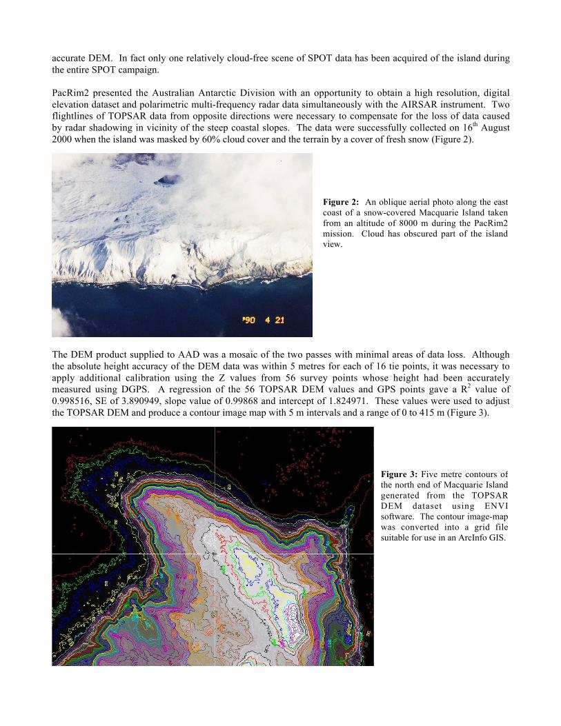
PacRim2 presented the Australian Antarctic Division with an opportunity to obtain a high resolution, digitalelevation dataset and polarimetric multi-frequency radar data simultaneously with the AIRSAR instrument. Twoflightlines of TOPSAR data from opposite directions were necessary to compensate for the loss of data causedby radar shadowing in vicinity of the steep coastal slopes. The data were successfully collected on 16th August2000 when the island was masked by 60% cloud cover and the terrain by a cover of fresh snow (Figure 2).
The DEM product supplied to AAD was a mosaic of the two passes with minimal areas of data loss. Althoughthe absolute height accuracy of the DEM data was within 5 metres for each of 16 tie points, it was necessary toapply additional calibration using the Z values from 56 survey points whose height had been accuratelymeasured using DGPS. A regression of the 56 TOPSAR DEM values and GPS points gave a R2 value of0.998516, SE of 3.890949, slope value of 0.99868 and intercept of 1.824971. These values were used to adjustthe TOPSAR DEM and produce a contour image map with 5 m intervals and a range of 0 to 415 m (Figure 3).
Figure 2: An oblique aerial photo along the eastcoast of a snow-covered Macquarie Island takenfrom an altitude of 8000 m during the PacRim2mission. Cloud has obscured part of the islandview.
Figure 3: Five metre contours ofthe north end of Macquarie Islandgenerated from the TOPSARDEM dataset using ENVIsoftware. The contour image-mapwas converted into a grid filesuitable for use in an ArcInfo GIS.

The TOPSAR DEM will in the first instance be used to locate accurately within a GIS of the island, all scientificdata collected to date. This includes the location of penguin colonies, restricted areas for management ofendangered species, archaeological sites, vegetation distribution map and an accurate topographic base for theexisting geological map and future geological expeditions. Management purposes include the location ofwalking tracks, hazardous areas to avoid, feasibility studies for alternative energy sources such as wind farmsand an accurate location of Judge and Clerk and Bishop and Clerk Islands for navigational purposes
A further accuracy assessment of the TOPSAR data is to be conducted in March 2002 by comparison withDGPS measurements of height taken along two transects extending from the west to east coasts. If as expectedthe data are of suitable accuracy then there is a prospect of future coverage using radar interferometry to examinethe impact of major earthquakes (6.2 or greater on the Richter scale) and their aftershocks that occurapproximately once per year. Quantitative assessment of landslides along the steep coastal slopes and structuraldeformation of the island bedrock should be possible using a combination of differential interferometry,topographic modeling and analyses of the polarimetric data, an example image of which is shown in Figure 4.
Enhancements of POLSAR data are revealing an extraordinary amount of land-surface and geologicalinformation relevant to shaping of the island surface by extensive faulting, wave action and active processestoday including freeze/thawing, wind and rain. Overlaying these enhancements on the TOPSAR DEM enablesthis active landscape to be analyzed in three dimensions. The level of detail indicates that the L- and P-bandsignals, and most likely those of C band, are penetrating the snow cover and being backscattered by theunderlying surface of rock, lag gravels and vegetation. Drainage patterns, dammed lakes, levels of incision, faultstructures, raised beach deposits and terraces can all be recognized in the AIRSAR data.
Figure 4: A 3D perspective model ofMacquarie Island showing acomposite image of AIRSAR dataoverlaid on the TOPSAR DEM andviewed from a NNW direction.Assigned to the RGB colour displayare a pedestal height enhancement of Pand L bands in the red and green guns,respectively, and Cvv in the blue gun.Persistent shadowing along the steep,western coastal slopes indicates thatthe dataset was collected from aposition east of the island