Topo Maps is a viewer for topographical maps … · Topo Maps is a viewer for topographical maps...
65
Topo Maps - User Guide Welcome to Topo Maps This PDF version of the user guide has been automatically generated from the online version. It is intended to be printable on letter or A4 paper; please let us know if you have any problems with that, or anything else. Main Features Topo Maps is a viewer for topographical maps published by the US Geological Survey and Natural Resources Canada. These maps cover the entire of the United States and Canada, including Alaska, Hawaii, Puerto Rico and the U.S. Virgin Islands. Their main use is for hiking and other outdoor activities. In total, more than 70,000 individual maps are available. You can download as many of these as you like, limited only by the storage capacity of your device. Downloads are free of charge. Once downloaded, the maps are stored until you remove them. So unlike the iPhone's built-in Maps app, you can use Topo Maps when you have no network connection. Just download the maps that you need while you have WiFi or cellular coverage and you're all set. As well as the maps themselves, Topo Maps also downloads terrain data. This is used to apply a 3D shading effect over the map to make the shape of the land clearer. You can even adjust the direction of the simulated sunlight that this effect uses. The terrain data is also put to other purposes, including a visibility mode which calculates what should be visible from any viewpoint. The app contains a database of more than a million placenames, which you can search to find the map that you need and to find individual features on those maps. You can add your own waypoints to the maps, and download waypoint files from the internet. You can use the iPhone's GPS to show your current position, and keep the map centered on your position as you move, and you can use its compass to orient the displayed map with the ground. Button Overview There are three groups of buttons; two groups at the bottom of the screen are controlled by slider buttons at the bottom left, and one group at the top of the screen is accessible when the co-ordinate display and crosshairs are shown. GPS: shows your current position on the map. Search: search for landmarks and waypoints. Compass: rotate map to align with the ground. 1 http://topomapsapp.com/
Transcript of Topo Maps is a viewer for topographical maps … · Topo Maps is a viewer for topographical maps...

Topo Maps - User Guide
Welcome to Topo Maps
This PDF version of the user guide has been automatically generated from the online version.It is intended to be printable on letter or A4 paper; please let us know if you have any problemswith that, or anything else.
Main Features
Topo Maps is a viewer for topographical maps published by the US Geological Survey andNatural Resources Canada. These maps cover the entire of the United States and Canada,including Alaska, Hawaii, Puerto Rico and the U.S. Virgin Islands. Their main use is for hikingand other outdoor activities.
In total, more than 70,000 individual maps are available. You can download as many of theseas you like, limited only by the storage capacity of your device. Downloads are free of charge.
Once downloaded, the maps are stored until you remove them. So unlike the iPhone's built-inMaps app, you can use Topo Maps when you have no network connection. Just download themaps that you need while you have WiFi or cellular coverage and you're all set.
As well as the maps themselves, Topo Maps also downloads terrain data. This is used toapply a 3D shading effect over the map to make the shape of the land clearer. You can evenadjust the direction of the simulated sunlight that this effect uses. The terrain data is also putto other purposes, including a visibility mode which calculates what should be visible from anyviewpoint.
The app contains a database of more than a million placenames, which you can search to findthe map that you need and to find individual features on those maps.
You can add your own waypoints to the maps, and download waypoint files from the internet.
You can use the iPhone's GPS to show your current position, and keep the map centered onyour position as you move, and you can use its compass to orient the displayed map with theground.
Button Overview
There are three groups of buttons; two groups at the bottom of the screen are controlled byslider buttons at the bottom left, and one group at the top of the screen is accessible when theco-ordinate display and crosshairs are shown.
GPS: shows your current position on the map.
Search: search for landmarks and waypoints.
Compass: rotate map to align with the ground.
1http://topomapsapp.com/

Topo Maps - User Guide
Help: shows a brief help page.
Go to Apps: show the current area in another maps app or website.
Waypoints: manage manually-entered waypoints.
Waypoint files: download and access waypoint files.
Map Settings: adjust map appearance, erase, and change resolution.
Distance and Bearing: Show distance rings.
Add Waypoint: place a waypoint at the crosshairs.
Visibility mode: compute what's visible.
(The screenshots in this guide were created on iOS 6, and the appearance has changed slightlysince iOS 7. The functionality is unchanged.)
2http://topomapsapp.com/

Topo Maps - User Guide
Installing Maps
The Index Maps
There are four index maps covering the contiguous U.S., Canada and Alaska, Hawaii, andPuerto Rico and the U.S. Virgin Islands:
3http://topomapsapp.com/
Topo Maps - User Guide
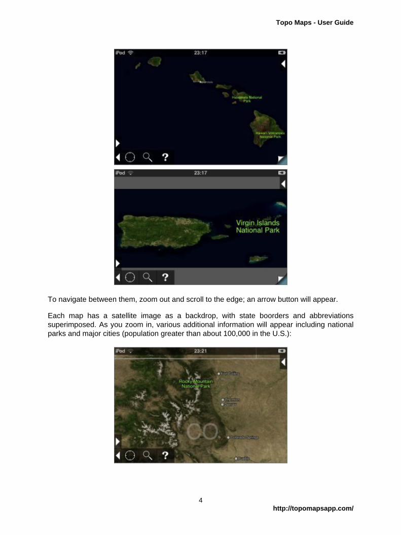
To navigate between them, zoom out and scroll to the edge; an arrow button will appear.
Each map has a satellite image as a backdrop, with state boorders and abbreviationssuperimposed. As you zoom in, various additional information will appear including nationalparks and major cities (population greater than about 100,000 in the U.S.):
4http://topomapsapp.com/

Topo Maps - User Guide
Zooming in further, additional features including state parks, national wildlife refuges, significantpeaks, lakes and rivers, and smaller towns and cities are shown. Also, the yellow grid of mapsis shown:
Selecting Maps
To select a single map to be installed, simply touch it for about half a second without movingyour finger. The map will be shown in blue:
To select a block of maps to install:
1. Arrange the screen so that all the maps you want to install are visible.
2. Touch one of the corner maps until it is selected but do not lift your finger.
3. Slide your finger towards the opposite corner of the block of maps. A blue rectangle willbe shown as you do so:
5http://topomapsapp.com/

Topo Maps - User Guide
4. Lift you finger, and all of those maps (fully or partially covered) will be selected.
In a few areas, maps overlap. This happens mostly in Alaska, where 1:24,000 maps oftenoverlap with 1:63,360 maps, and on the Canada-Alaska border. In these areas, to select themap that you want, zoom in and carefully touch at the center of the correct map's yellow box.
High and Low Resolution Maps
Once you've selected a map or group of maps, you'll be asked whether you want a "QuickInstall" or a "Full Install":
"Quick Install" downloads a lower-resolution version of the map, and is typically about ten timesfaster than "Full Install". It also takes much less space on your device. Generally, the low-resolution maps are good for trip planning, or to check that you have the right map, but the high-resolution versions are needed for navigation: each pixel in the low-resolution maps covers 16pixels on the high-resolution map. The actual resolution in pixels per mile varies from placeto place.
6http://topomapsapp.com/
Topo Maps - User Guide
If you chose to install a low-resolution map, you can later upgrade it to high-resolution. Thisupgrade process only needs to download the difference between the two versions, so you don'twaste any download time by downloading a low-resolution version and then upgrading.
The app limits the number of maps that can be downloaded at once to 20 high-resolution mapsor 100 low-resolution maps. There is no limit to the total number of maps that you can install(except the amount of storage available on your device); these limits are purely on the numberthat can be downloaded in one operation.
Installation
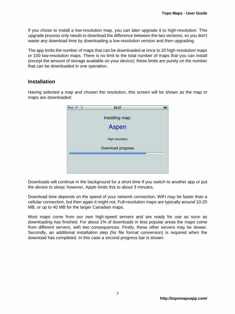
Having selected a map and chosen the resolution, this screen will be shown as the map ormaps are downloaded:
Downloads will continue in the background for a short time if you switch to another app or putthe device to sleep; however, Apple limits this to about 3 minutes.
Download time depends on the speed of your network connection. WiFi may be faster than acellular connection, but then again it might not. Full-resolution maps are typically around 10-20MB, or up to 40 MB for the larger Canadian maps.
Most maps come from our own high-speed servers and are ready for use as soon asdownloading has finished. For about 1% of downloads in less popular areas the maps comefrom different servers, with two consequences. Firstly, these other servers may be slower.Secondly, an additional installation step (for file format conversion) is required when thedownload has completed. In this case a second progress bar is shown:
7http://topomapsapp.com/

Topo Maps - User Guide
Done
Back on the index map, sheets that have been installed are shown in green. Low-resolution"Quick Install" maps are shown in a darker shade than high-resolution "Full Install" maps:
8http://topomapsapp.com/

Topo Maps - User Guide
Viewing Maps
Selecting a map to view
To view a map, touch its green square on the index map for about half a second. The app will"flip over" to show the topo, initially scaled so that the whole map fits on the screen:
Flipping
At the bottom right corner of the screen, a "page curl" button lets you flip back and forth betweenthe currently-selected topo and the index map. The two "sides" operate largely independentlyof each other, so you can move to a different area on the index map and flip back to the sameview of your current topo.
Moving around the map
You can move around the maps with the same gestures as many other iPhone apps:
• To pan, slide with one finger. If you "flick", the map will keep moving under its ownmomentum for a while.
• To zoom in, put two fingers on the screen and slide them apart. Alternatively, double-tapsomewhere to zoom in 2x on that spot.
• To zoom out, put two fingers on the screen and slide them together.
When panning or zooming, take care to start with your fingers away from the buttons or distancescale, if shown.
9http://topomapsapp.com/

Topo Maps - User Guide
Low-res maps
If you zoom in on a low-res map, you'll eventually reach the limit of the map's resolution and itwill appear pixelated. See Map Settings for how to upgrade the map to high resolution.
Mosaicing adjacent maps
If you're interested in an area near the border between two or more maps, you can mosaicthem together. Mosaicing is also useful to get a broad overview of a large area; this imageincludes six maps:
Having installed all of the necessary maps, scroll to the edge of one of them and an arrowbutton will appear:
Touch the button and the adjacent map will be added:
10http://topomapsapp.com/

Topo Maps - User Guide
The app does not impose a limit on the number of maps that can be mosaiced, but you mayfind that it becomes sluggish if you add very many.
Note that some of the maps' border material will show through where they overlap.
Limitations of Mosaicing
Most previous limitations on mosaicing no longer apply, as maps are stretched as necessary ifthey do not precisely match at their joins. However there are still some issues that you shouldbe aware of:
• Mosaicing will go wrong at map projection zone boundaries; these typically occur each 6degrees of longitude. You'll see a warning when this happens.
• GPS, co-ordinate display and waypoint positioning accuracy will fall slightly as the size ofthe mosaic increases. For maximum accuracy, use single maps.
Viewing Maps in Other Apps
You can view the currently-shown area in another app or on the web by touching the "GoTo App" button:
11http://topomapsapp.com/

Topo Maps - User Guide
The first three buttons launch Google Maps or Apple Maps in one of the three different modes- maps, satellite and hybrid. You can select whether Google Maps or Apple Maps are usedusing a switch in the main Settings app - scroll down to find Topo Maps.
The OpenStreetMap button goes to the www.openstreetmap.org website. The Panoramascopeand Offmaps buttons are shown only if those apps are installed. Offmaps is an off-lineOpenStreetMap viewer. Panoramascope is an app by the same author as Topo Maps thatcomputes the view from the current location:
12http://topomapsapp.com/

Topo Maps - User Guide
GPS and Compass
GPS
To activate the GPS, touch the button with the target symbol.
Once a location has been received by the hardware, a blue spot will be shown and the mapwill be locked on your location. If this is on a currently-installed topo map, it will be shown;otherwise the position will be shown on the index map.
The accuracy of the fix is shown by a blue circle around the location spot, and in figures withinthe GPS button itself.
As new location fixes are received the position of the spot and the accuracy information will beupdated. While the map is locked to your location you can zoom in and out as normal; draggingthe map is possible but it will spring back to your current position when you release it.
Touching the GPS button again will stop updating the position and unlock the map, but the spotwill remain visible. Touching a third time will remove the spot.
GPS and other sources of location
Different devices have various different sources of location information:
• On the iPhone and iPads with cellular data there's a real GPS that gets accurate locationfixes from satellites; it needs a fairly clear view of the sky and takes a few second or evena few minutes to get a fix.
• On the iPhone and iPads with cellular data, if you're in range of a cellular base station theID of the base station can be used to give a very rough idea of your position.
13http://topomapsapp.com/

Topo Maps - User Guide
• On the iPod touch and WiFi-only iPad, your position can be estimated based on nearbyWiFi base stations. This is surprisingly accurate in urban areas, but totally ineffective in wildareas.
Typically, on an iPhone when you press the GPS button it will first show a position based oncellular base station information. This will be accurate enough to select the right map, but couldeasily be many hundreds of meters out. Then after a few seconds a GPS fix will be receivedand the display will be updated with its much more accurate position. If you're outside of cellularcoverage, the app can take much longer to get a GPS fix because it doesn't have the initialclue from the cell tower; you may need to wait for several minutes, but you will eventually geta fix if you have a clear view of the sky.
Airplane Mode
All devices have a mode that switches off all radios for aircraft regulation compliance. Note thatthis turns off the GPS receiver as well as the cellular and WiFi radios. So don't be tempted toenable airplane mode when you know you have no cellular reception in the hope of improvingbattery life. If you want to save power, you can turn off the 3G radio in Settings - General -Network; this should not affect the GPS. You might also consider removing the SIM card.
Compass
A compass is present in the iPhone 3GS and newer, and iPad. On other devices the compassbutton is not shown.
To enable the compass, touch the compass button. The map is rotated to align with theground.
14http://topomapsapp.com/

Topo Maps - User Guide
Searching
The Search Screen
The search screen is accessible from both the topo map screen and the index map screenby touching the magnifier icon.
As you type the list of matching place names is continuously updated. If there are thousandsof matching names it may take a few seconds for the list to appear. The app doesn't show alisting if more than 50,000 places match.
Three buttons allow you to change how the results are ordered. They can be either alphabetical,grouped according to feature type, or by distance from the center of the current screen.
The Search Results
Each search result row shows the name of the feature, the state or province, a symbol indicatingthe feature type, and location information.
15http://topomapsapp.com/
Topo Maps - User Guide
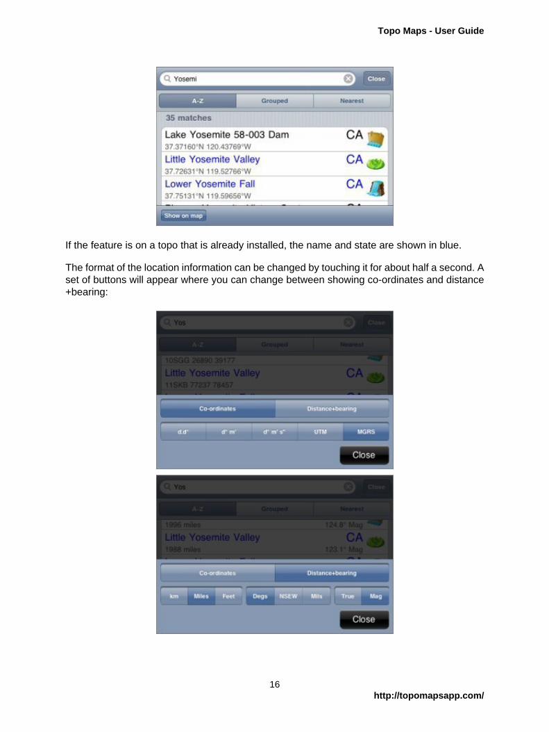
If the feature is on a topo that is already installed, the name and state are shown in blue.
The format of the location information can be changed by touching it for about half a second. Aset of buttons will appear where you can change between showing co-ordinates and distance+bearing:
16http://topomapsapp.com/

Topo Maps - User Guide
The available formats are the same as for the main co-ordinate and distance+bearing displays.Distance and bearing are relative to the current center of the screen.
Touching a search result will take you to that feature on the map. If the appropriate topo isalready installed it will be shown, otherwise the index map will be shown.
Waypoints
Waypoints are included in the search results. Normal waypoints are shown with a yellow/goldbackground, and file waypoints are shown with a Gray/silver background.
Search Results on Maps
You can show the current search results on the map, if there are no more than 10,000 of them.Touch the "Show on map" button at the bottom left of the search screen and the positions ofthe search results will be shown on both the index and the topo maps with small purple spots:
To clear these spots, return to the search screen and clear the search box.
Rivers and related features
For rivers, the app always shows the downstream end of the feature. For example, searchingfor a small creek will show the point where it joins a larger river and changes its name.
The same applies to other features that have upstream and downstream ends, including valleysand lakes.
17http://topomapsapp.com/

Topo Maps - User Guide
What's Included
The app contains a database of about 1.5 million feature names. These come from the USGSand Canadian government sources and have been filtered to remove some of the less usefulcategories. Also included are the names of the maps themselves.
Feedback about missing features or groups of features that could be removed to save spacewould be appreciated.
18http://topomapsapp.com/

Topo Maps - User Guide
Waypoints
Keep Backups!
If you store important waypoints in the app, you should be sure to make regular backupcopies of this data. How to do this is described on the Waypoint Export page.
Adding Waypoints to the map
Firstly, make sure that the crosshairs and co-ordinate display are shown. If not, touch the arrowbutton at the top right of the screen.
Position the crosshairs at the point where you want to place the waypoint, and touch theAdd Waypoint button. The Add Waypoint screen will be shown:
Choose a symbol to use for the waypoint's pin. (Note that the grid of available symbols canbe scrolled left and right.)
19http://topomapsapp.com/

Topo Maps - User Guide
Various suggestions are given for the waypoint's name. Most of these are based on nearbyfeature names and waypoints that you have entered in the vicinity. If nearby names end innumbers, e.g. "Camp 1", it will offer the next number in the sequence i.e. "Camp 2". To useone of the suggested names simply touch it and it will be copied into the name box.
You can also type in a name or edit a suggestion by touching the name box:
Finally touch the Save button at the top right of the screen, and the new waypoint will be shownon the map:
20http://topomapsapp.com/

Topo Maps - User Guide
Other ways to add waypoints
To add a waypoint at your current location, touch the GPS button and wait for it to get anaccurate fix, then touch the add waypoint button as above.
To add a waypoint at a feature from the search results, touch the search result so that the mapis centered on it and then touch the add waypoint button as above.
To add a waypoint at particular co-ordinates, touch the add waypoint button and enter the co-ordinates in the co-ordinates box at the top of the screen:
You can copy-and-paste co-ordinates into this box, e.g. from a web page or email.
Viewing Waypoint Names
Normally, waypoints show only their pin. If you tap the pin, the name is shown in a bubble:
21http://topomapsapp.com/
Topo Maps - User Guide
Editing Waypoints
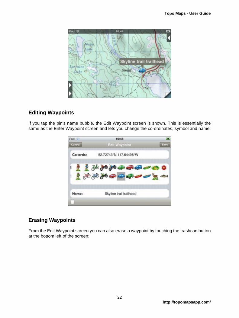
If you tap the pin's name bubble, the Edit Waypoint screen is shown. This is essentially thesame as the Enter Waypoint screen and lets you change the co-ordinates, symbol and name:
Erasing Waypoints
From the Edit Waypoint screen you can also erase a waypoint by touching the trashcan buttonat the bottom left of the screen:
22http://topomapsapp.com/

Topo Maps - User Guide
Moving Waypoints
To move a waypoint, simply erase it from its old location as above, place the crosshairs atthe new location, and touch the add waypoint button. The Add Waypoint screen will appearand will be configured with the symbol and name of the just-erased waypoint, so you can justtouch Save.
The Waypoints Screen
The waypoint listing screen is shown by touching the button that shows a group of pins. Thewaypoints are ordered alphabetically:
At the bottom right of the screen, a switch allows you to turn the display of waypoints on themap on and off.
23http://topomapsapp.com/

Topo Maps - User Guide
Each row shows the name of the waypoint, its symbol, and either its co-ordinates or the distanceand bearing from the center of the current map screen. You can change between co-ordinatesand distance and bearing by touching this row for about half a second; these buttons will appear:
Note that the distance and bearing are from the center of the current map screen, which mayor may not be your current location.
Touching a waypoint's name or symbol will go to its position on the map. Touching the bluearrow shows the Edit Waypoint screen, where you can change the name, symbol or co-ordinates.
At the top right of the screen, an Edit button allows you to more quickly erase waypoints:
24http://topomapsapp.com/

Topo Maps - User Guide
Co-ordinate display
The co-ordinate display is shown by touching the arrow button at the top right of the screen.As well as the co-ordinate display at the top of the screen, fine crosshairs are shown:
The co-ordinates shown in the display correspond to the point under the crosshairs at thecenter of the screen. Note that this is not necessarily your current position. Only if the GPS isactive and the map is locked to your current position, then the co-ordinate display will showyour current co-ordinates.
Co-ordinate Formats
If you touch the co-ordinate display for about half a second without moving your finger, a setof buttons will appear that allow you to set the format:
The supported formats are:
• Decimal degrees.
25http://topomapsapp.com/

Topo Maps - User Guide
• Degrees and decimal minutes.
• Degrees, minutes and seconds.
• UTM
• MGRS
UTM and MGRS are related grid reference formats. The USNG format is essentially the sameas MGRS. For more information, see their Wikipedia pages: UTM, MGRS and USNG.
Map Datum
The current map datum is shown to the left of the co-ordinates. Two are available, NAD27 andWGS84. NAD83 is essentially the same as WGS84. To change datum, touch this display forabout half a second without moving your finger:
Entering Co-Ordinates
After touching the co-ordinate display, a box is displayed below the format buttons into whichyou can type co-ordinates to go to:
26http://topomapsapp.com/

Topo Maps - User Guide
The format that you enter need not be the same as the currently-displayed format; the app willtry to understand what you type and show that location.
It's also possible to copy from and paste to this box, to share co-ordinates with other apps,emails, web pages etc.
Co-Ordinates on the Topo Screen
On the topo screen, additional features are shown when you enable the co-ordinate display:
Distance Scale
At the left hand side of the screen, a distance scale is shown:
(This isn't shown on the index map because its scale is not uniform.) You can change its unitsto either miles, feet or meters by touching it (at its left side) for about half a second; it will cyclethrough the different formats.
27http://topomapsapp.com/

Topo Maps - User Guide
Estimated Altitude Display
To the right of the co-ordinates display, an estimate of the altitude at the crosshairs is shown.This estimate is based on the data that is used to compute the hill shading effect and itsresolution is limited. It will generally give reasonable values in flatter terrain but could besubstantially wrong in more vertical terrain.
The units can be changed between feet and meters by touching the display for about half asecond:
Checking Co-Ordinates
If you need accurate co-ordinates, checking the accuracy at the corners of the map isrecommended:
Most maps show NAD27 co-ordinates (you can check this in the text that's normally at thebottom-left of the map). If you want to use WGS84 co-ordinates, there is normally a cross ashort distance from the corner; check there instead:
28http://topomapsapp.com/

Topo Maps - User Guide
Please report any maps you find that don't align properly.
When you mosaic maps together the accuracy of the co-ordinate display may decrease. In thiscase it's particularly important to check the corners of the maps.
29http://topomapsapp.com/

Topo Maps - User Guide
Distance and Bearing
Distance and bearing mode is available when the co-ordinate display is shown. Place thecrosshairs over a point of interest and touch the button with the concentric circles icon:
Concentric distance rings are shown, and as you move around the map the distance andbearing from the selected point to the crosshairs is updated:
To turn off the feature, touch the button again.
Available Units
The units for the distance and bearing can be changed by touching the appropriate display forabout half a second. For the distance display the available units are km, miles and feet:
30http://topomapsapp.com/

Topo Maps - User Guide
Bearings can be shown in degrees, as compass points (i.e. N, S, E, W) and mils. (There are6400 mils in 360 degrees.) The bearing can be shown either relative to true North or relative tomagnetic North. The magnetic deviation is predicted using the World Magnetic Model; it shouldbe accurate to better than half a degree.
31http://topomapsapp.com/

Topo Maps - User Guide
Map Settings
To display the map settings screen, touch the "map and gear" button. The top part of thescreen is used to change the appearance of the topo map display.
Slope Shading
Slope shading is the 3D effect that is applied on top of the map to emphasize relief. The appcomputes this using terrain data that it downloads when the maps are installed. Using controlson the map settings screen you can change its appearance:
• You can rotate the sun and shade around the hill to set the direction of the simulatedsunlight. Apparently most people see the 3D effect most effectively if the light comes fromthe top left (NW), even though this is not a direction from which sunlight ever comes in theNorthern hemisphere. If you move the sun to the South you'll see more realistic shading,which could be useful to determine which routes will be most sunny.
• The slider allows you to adjust the strength of the shading. If you slide it to the left it isdisabled. Positions in the middle are appropriate for mountainous terrain. In flatter areasyou can move the slider to the right to exaggerate the shading.
This map uses the default shading settings:
32http://topomapsapp.com/

Topo Maps - User Guide
Here the strength has been increased:
Here the sunlight direction has been moved to the South:
For comparison, here's the same map with slope shading disabled:
33http://topomapsapp.com/

Topo Maps - User Guide
The slope shading is updated after you close the map settings window; this may take a moment.
The height data used to compute the slope shading has a horizontal resolution of only about300 feet, so the results are not very precise. Slope shading is most useful when you're viewinga map zoomed out so that the contour lines are not easily visible. The alignment of the shadingdata with the base map also seems to be poor in some areas, and there are occasional artifactssuch as false grooves and ridges.
Height Shading
Height shading is controlled by a switch on the map settings screen. When it's enabled, thebase map is converted to monochrome and a color tint based on height is applied:
This is useful primarily when viewing a zoomed-out map, to get an overview of an area. It'salso useful for those maps in Northern Canada that are published in monochrome:
34http://topomapsapp.com/

Topo Maps - User Guide
As with the slope shading, the resolution of the data is limited and it may take a moment forthe effect to appear after you close the map settings screen. The spectrum used is adjusteddepending on local minima and maxima, but in flat terrain it will still appear, well, flat.
The map settings screen also provides some buttons for managing the installed maps.
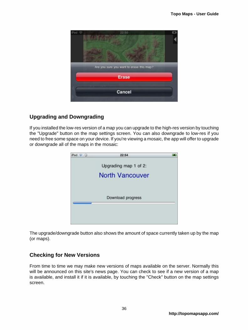
Erasing Maps
To erase a map, touch the red "Erase" button. You'll be prompted for confirmation. If you'reviewing a mosaic, it will offer to erase all of the maps in the mosaic.
35http://topomapsapp.com/
Topo Maps - User Guide
Upgrading and Downgrading
If you installed the low-res version of a map you can upgrade to the high-res version by touchingthe "Upgrade" button on the map settings screen. You can also downgrade to low-res if youneed to free some space on your device. If you're viewing a mosaic, the app will offer to upgradeor downgrade all of the maps in the mosaic:
The upgrade/downgrade button also shows the amount of space currently taken up by the map(or maps).
Checking for New Versions
From time to time we may make new versions of maps available on the server. Normally thiswill be announced on this site's news page. You can check to see if a new version of a mapis available, and install it if it is available, by touching the "Check" button on the map settingsscreen.
36http://topomapsapp.com/

Topo Maps - User Guide
Beware, however, that this function will sometimes be subject to false positives: it may reportthat a new version is available and spend time downloading it when it is not in fact newerthan what you currently have. This is most likely to occur if your initial download required theadditional installation step. In this case, the replacement version is likely to look identical toyour previous version but will consume less storage space.
37http://topomapsapp.com/

Topo Maps - User Guide
Visibility Mode
Visibility mode uses the app's terrain data to compute what should be visible from aparticular viewpoint. Simply place the crosshairs over the viewpoint and touch the Visibilitybutton; the app will paint over the map with the hidden areas in red:
This is of course limited by the resolution of the data. In particular, note that to avoid errors inthe data near the viewpoint (which would have a more substantial impact on the results thanerrors further away), the app computes the view from 30m about ground level and ignores allobstacles within about 400m of the viewpoint.
38http://topomapsapp.com/

Topo Maps - User Guide
Waypoint Files
Topo Maps is able to show waypoints from files that you have created with other programsor downloaded from web sites. This is managed from the Waypoint Files screen, which isaccessed by touching the button showing a group of pins in a box:
The first step is to get the files into the app, and there are several ways of doing this.
Importing files from Safari, Email attachments, and other apps
Since version 1.12 of the app, it is possible to open files directly from Safari and other apps.Topo Maps will offer to open GPX, KML and ZIP files:
When you choose "Open in Topo Maps", Topo Maps will open and display a message like this:
39http://topomapsapp.com/

Topo Maps - User Guide
If you now visit the Waypoint Files screen, the new file will be shown:
Note that in many cases web servers are not configured correctly and GPX and KML files willdisplay as garbage within Safari, rather than offering the "Open In" screen. It is possible to workaround this by using a different web browser that has additional features for downloading files,such as "MyMedia - Download Manager". Or you can use Topo Map's built-in web browser,as described below.
You can use a similar process to import files from email attachments and from other apps suchas DropBox.
40http://topomapsapp.com/

Topo Maps - User Guide
Downloading using the built-in web browser
Note that this process is now somewhat redundant as you can open files directly from Safari,as described above.
It is possible to download waypoint files from web sites directly into the app by touching theDownload button at the bottom of the Waypoint Files screen. When this button is touched aweb browser screen is displayed; you can enter the address of a web site or an expressionto search for:
You can also enter just "g" to go directly to Google.
When you touch a link that Topo Maps recognizes as a waypoint file, it will be downloaded andshown on the Waypoint Files page:
ZIP files
You can also download ZIP files, such as these from www.pctmap.net:
41http://topomapsapp.com/

Topo Maps - User Guide
You can unzip a ZIP file after downloading by touching its entry on the Waypoint Files screen:
Viewing Waypoint File Contents
To view the contents of a waypoint file, simply touch its name in the Waypoint Files screen.Large files make take a few seconds to open. You'll see a section containing information aboutthe file:
42http://topomapsapp.com/

Topo Maps - User Guide
Below that, the waypoints are listed:
Below the waypoints, any tracks that the file contains are shown:
43http://topomapsapp.com/

Topo Maps - User Guide
Each row shows the waypoint's name and either its co-ordinates or distance and bearing fromthe center of the current map screen (which may or may not be your current location). Aswith the search and waypoints screens, if you touch the display you can change between co-ordinates and distance and bearing, and change the units used in the display:
Touching a waypoint name will take you to that location on the map.
If you have trouble opening a waypoint file, e.g. if the app crashes or does not show theexpected content, please get in touch. We have tried this functionality with files from a numberof sources, but bugs could still remain.
File Waypoints on Maps
At the bottom right of each waypoint file's screen, a switch enables you to to turn on display ofthe file's waypoints on the map. To the right of the switch, the symbol that will be used for thefile's waypoints is shown. When the switch is on you can touch this symbol to change it:
The waypoints are then shown on the map:
44http://topomapsapp.com/

Topo Maps - User Guide
Note that to distinguish file waypoints from normal waypoints entered on the device, filewaypoints have a pin that is gray/silver rather than yellow/gold. The bubble color is alsodifferent. Touching the bubble of a file waypoint will display the waypoint file's screen.
When a waypoint file has been turned on for display on the map, the icon that you choose isalso shown on the Waypoint Files screen:
Searching
File waypoints are included in the search results, but only when they are switched on for mapdisplay.
Support for Waypoints vs. Tracks
Most conventional GPS devices are capable of recording both waypoints and tracks. Waypointsare distinct points that the user stores explicitly, e.g. by pressing a button, normally with names.Tracks are a whole series of points, normally stored automatically without individual names.
45http://topomapsapp.com/

Topo Maps - User Guide
The current version of Topo Maps has proper support only for waypoints. If a file containstracks these will be shown in its Waypoint Files screen and you can go to a point on the trackby touching that point in the listing; however, this is the limit of the support for tracks. Morecomplete support for tracks, i.e. displaying and recording them, is planned for a future versionof the app.
Transferring files from your computer
It's also possible to transfer waypoint files from your computer using a web browser. Again, thisprocess is now somewhat redundant as you can open files directly from email attachments,dropbox and so on, as described above.
For this to work, your iPhone or iPad must be connected to the same local network as yourcomputer and that network must not be set up to block this sort of communication betweendevices. Many public or semi-public local networks (e.g. internet cafe and workplace networks)are configured to block communication between local devices for security reasons. Regularhome WiFi networks are the most likely to work. If you have been unable to use computer-to-device communication in other apps (e.g. the many "File transfer" or "WiFi Disk" apps) then itis not likely to work in Topo Maps either.
To start, in Topo Maps go to the Waypoint Files screen and touch the "Server" button at thebottom of the screen:
The app is now running a web server from inside the device. On your computer, enter one ofthe addresses shown into your web browser's address bar:
46http://topomapsapp.com/

Topo Maps - User Guide
From this page, navigate to the Waypoints folder. The contents listed will match those shownon the app's Waypoint Files screen:
47http://topomapsapp.com/

Topo Maps - User Guide
To transfer a file from your computer, use the "Upload File" box; the exact appearance willdepend on which web browser you use. After sending the file it will be shown in the file listing.
Having transferred the file, close your web browser window and touch the "Done" button onthe app. You will now see your file included on the waypoint files screen.
Note that this web server does not run in the background if you quit the app - the app mustremain running in the foreground while you use this feature.
Supported File Formats
Topo Maps understands the following file formats:
• GPX format. This is the recommended format for most applications.
48http://topomapsapp.com/

Topo Maps - User Guide
• KML format. Support for this format is not quite as complete as for GPX format.
• CSV format. This is intended for users who wish to transfer waypoints to and from theirown spreadsheets and databases, as described here.
KMZ format is not directly supported, but it can be used as follows:
1. Transfer the KMZ file into the app using the web server.
2. Rename it to end ".zip" rather than ".kml".
3. Unzip it.
4. You should find a KML file among the unzipped files. Open this.
Managing Files
To erase files, first touch the Edit button at the top right of the screen and then touch the redbutton to the left of the file to be erased:
To rename files, touch the Edit button and then touch the file's name:
49http://topomapsapp.com/

Topo Maps - User Guide
To create folders, touch the "New Folder" button at the bottom of the screen. To give the foldera name, rename it as above:
You can move files between folders. Note that this feature should be considered experimental.After touching Edit, drag files or folders by the re-order symbol at the right of the row to belowthe folder to which you wish to move them:
50http://topomapsapp.com/

Topo Maps - User Guide
To move files or folders up to parent folders, drag them to the top of the screen (except in thetop-most folder):
(As shown above, you may sometimes need to create dummy folders so that these moveoperations work without ambiguity - this is why the feature is experimental.)
You can also view some files that are not waypoint files. For example, the ZIP file downloadedabove contained a PDF file as well as a GPX file, and this can be viewed by touching it:
51http://topomapsapp.com/

Topo Maps - User Guide
Sharing Files
You can share waypoint files by email or open them in other apps by touching the share buttonat the bottom left of the file's screen:
"Open in ..." will show a list of any other apps that you have installed that may be able to viewthe file.
52http://topomapsapp.com/

Topo Maps - User Guide
If you choose "Mail", a regular email composition window will be shown with the file attached:
Merging waypoints into the app
The waypoint file screen also has a button to merge the contents of the file into the app'slocally-added waypoints screen. You normally don't want to do this. Waypoints from filescan be viewed without merging them. It is used primarily when restoring a backup of locally-added waypoints that you had exported. Merging cannot be undone. If you are unsure donot use this feature!
53http://topomapsapp.com/

Topo Maps - User Guide
Waypoint Export
There are a couple of reasons why you might want to export waypoints from the app. Firstly youmay wish to transfer waypoints to another app or program, or to a website, for display. Secondlyyou may want to save a backup copy of your waypoints for safe keeping (and doing so is highlyrecommended). In either case, the process is the same: you first export the waypoints into afile within the app, and then transfer that file out of the app.
Note that the waypoints that are exported are the manually-entered waypoints. Waypoints fromwaypoint files are not exported by this feature.
Exporting
From the Waypoint Files screen, touch the Export button at the bottom of the screen. TheWaypoint Export screen is then shown:
You can export either:
• All waypoints everywhere.
• The waypoints visible on the map before you came to this screen.
• Waypoints in a rectangle that you describe by giving latitude and longitude for the edges:
54http://topomapsapp.com/
Topo Maps - User Guide
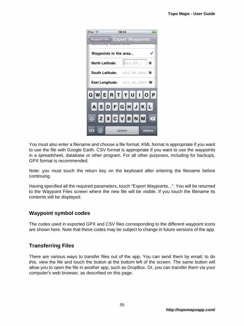
You must also enter a filename and choose a file format. KML format is appropriate if you wantto use the file with Google Earth. CSV format is appropriate if you want to use the waypointsin a spreadsheet, database or other program. For all other purposes, including for backups,GPX format is recommended.
Note: you must touch the return key on the keyboard after entering the filename beforecontinuing.
Having specified all the required parameters, touch "Export Waypoints...". You will be returnedto the Waypoint Files screen where the new file will be visible. If you touch the filename itscontents will be displayed.
Waypoint symbol codes
The codes used in exported GPX and CSV files corresponding to the different waypoint iconsare shown here. Note that these codes may be subject to change in future versions of the app.
Transferring Files
There are various ways to transfer files out of the app. You can send them by email; to dothis, view the file and touch the button at the bottom left of the screen. The same button willallow you to open the file in another app, such as DropBox. Or, you can transfer them via yourcomputer's web browser, as described on this page.
55http://topomapsapp.com/

Topo Maps - User Guide
Restoring Backups
If you need to restore from a waypoint backup:
1. Transfer the file into the app, as with any other waypoint file.
2. View the file.
3. Touch the "Merge" button at the bottom left of the screen.
Important: do not use the "Merge waypoints into app" feature except for restoring waypointbackups. It is not necessary to "merge" waypoint files that you simply wish to view; just turn ondisplay using the switch at the bottom right of the screen. It is not possible to undo a mergeoperation.
56http://topomapsapp.com/

Topo Maps - User Guide
Using CSV Files
CSV format is intended for users who wish to transfer waypoints between Topo Maps andtheir own spreadsheets, databases and other programs. For example, here is a spreadsheetcontaining some of the highest peaks in Alaska:
All spreadsheet programs should be able to save in CSV format; the resulting file will look likethis if viewed using a text editor:
RANK,NAME,HEIGHT,LATITUDE,LONGITUDE1,"Mount McKinley (Denali)",20320,63.069,-151.00632,"Mount Saint Elias",18008,60.2927,-140.93073,"Mount Foraker",17400,62.9605,-151.39924,"Mount Bona",16550,61.3845,-141.75295,"Mount Blackburn",16390,61.7305,-143.4031
Format Details
Topo Maps expects the first row of the file to contain column names. It will ignore any columnswhose names it does not recognize. The recognized names are:
NAME
The name of the waypoint. This column must be present.
LAT or LATITUDE
Latitude, which can be either in decimal degrees, degrees and decimal minutes, or degreesminutes and seconds.
LNG or LONGITUDE
Longitude; same formats as latitude. Note that western-hemisphere longitudes must benegative. You can also put a compass-point letter after the value.
57http://topomapsapp.com/
Topo Maps - User Guide
UTM
UTM co-ordinates may be given instead of latitude and longitude. You should not specifyboth.
MGRS
MGRS co-ordinates, as another alternative way of specifying the location.
DATUM
The map datum, either WGS84, NAD83 (which is the same as WGS84) or NAD27. If notspecified, WGS84 is assumed.
SYM or SYMBOL
The code for symbol to use for the waypoint, if it is merged into the app's built-in waypoints.
Transferring files
These file can be transferred into Topo Maps using any of the normal methods for waypointfiles, i.e. by downloading from a web site or by sending it from your computer's web browser.(If Topo Maps is not offered as an "Open In" option for a .csv file, try zipping it.)
It is also possible to export CSV files out of the app.
Viewing files
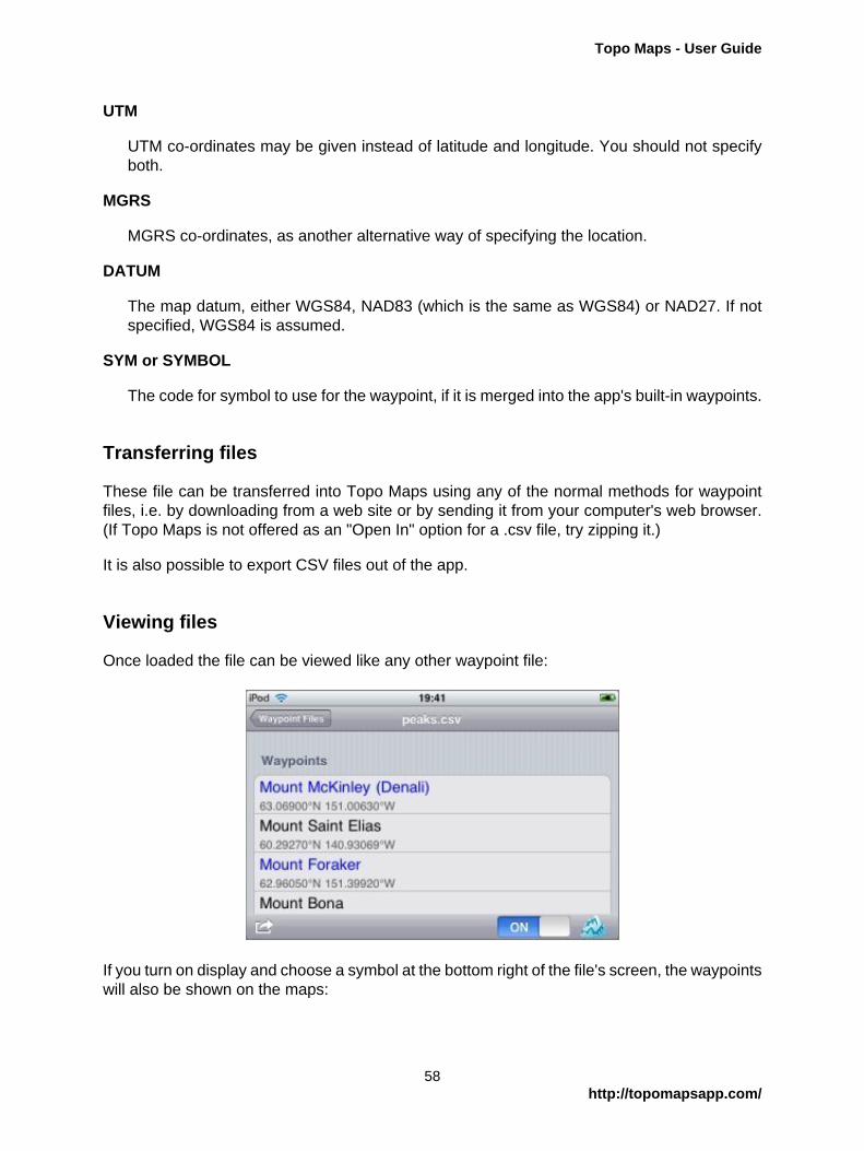
Once loaded the file can be viewed like any other waypoint file:
If you turn on display and choose a symbol at the bottom right of the file's screen, the waypointswill also be shown on the maps:
58http://topomapsapp.com/

Topo Maps - User Guide
They will also appear in the search results.
Do please let us know if you have difficulty importing CSV files.
59http://topomapsapp.com/

Topo Maps - User Guide
Map Import/Export
What this feature Isn't
This feature is not a method for you to load your own map data into Topo Maps, nor to extractfiles from the app to use in other programs. The files that Topo Maps uses are in a format that'snot useful to other applications.
So....
The purpose of map import/export is to make it possible to transfer maps between multipledevices in situations where installing the maps from the internet is impractical for some reason,for example if no fast internet connection is available. It also makes it possible to remove mapsfrom the device to free space for other purposes and to re-load them later.
For most users, it will normally be easier to install maps in the conventional way.
This feature is not often used and should be considered somewhat experimental.
Exporting Maps
To export maps, run the app's built-in web server and navigate to the Maps folder from yourcomputer's web browser. There are sub-folders for U.S. and Canadian maps:
60http://topomapsapp.com/

Topo Maps - User Guide
For U.S. maps, the filename starts with the state abbreviation which is followed by the latitudeand longitude of the degree square, and finally a letter-number indicating the quad within thesquare. This is a standard USGS numbering scheme; you can normally find the codes in theborders of the maps:
61http://topomapsapp.com/

Topo Maps - User Guide
For Canadian maps, the filename is a number-letter-number pattern which is a NaturalResources Canada standard, and is normally shown on the cover of the map, perhaps withmore punctuation:
To copy a file to your computer, click on the map name. If appropriate you can then erase itfrom the app by clicking on the Delete button.
Importing Maps
To import maps, run the web server and navigate to the appropriate maps folder. Use theUpload File box to copy the map file from your computer to the app.
It is important that you do not change the name of the map file on your computer betweenexporting and importing.
62http://topomapsapp.com/

Topo Maps - User Guide
After Transferring
After transferring, close your web browser window and touch the Done button on the app.
If you made any changes to the maps in the app, i.e. erasing or importing, the app will askyou to restart it:
Simply press the home button and restart the app. It may take a few seconds longer to startup than normal as it processes the changes.
63http://topomapsapp.com/
Topo Maps - User Guide
Settings Switches
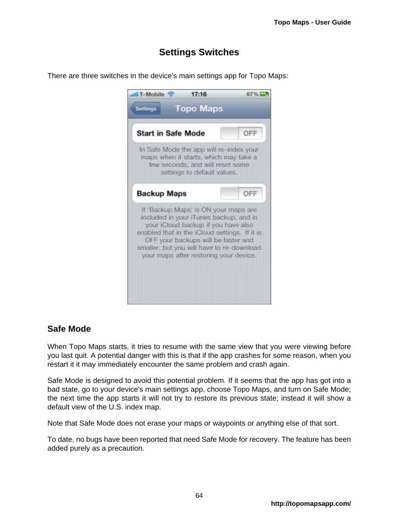
There are three switches in the device's main settings app for Topo Maps:
Safe Mode
When Topo Maps starts, it tries to resume with the same view that you were viewing beforeyou last quit. A potential danger with this is that if the app crashes for some reason, when yourestart it it may immediately encounter the same problem and crash again.
Safe Mode is designed to avoid this potential problem. If it seems that the app has got into abad state, go to your device's main settings app, choose Topo Maps, and turn on Safe Mode;the next time the app starts it will not try to restore its previous state; instead it will show adefault view of the U.S. index map.
Note that Safe Mode does not erase your maps or waypoints or anything else of that sort.
To date, no bugs have been reported that need Safe Mode for recovery. The feature has beenadded purely as a precaution.
64http://topomapsapp.com/

Topo Maps - User Guide
Backup Maps
The "Backup Maps" switch determines what happens when you backup your device. If it is ON,your maps are included in backups; if it is OFF, maps are not included. Your waypoints andwaypoint files are always backed up.
Note that you must run the app at least once after changing the state of the switch for thechange to become effecive.
If you use only iTunes to backup to your computer you may prefer to turn the switch ON, sincethese backups are relatively fast. If you use iCloud backup, however, you will probably preferto turn it OFF, since backing up maps over the internet is likely to be slow and to use muchof your iCloud storage allowance.
Note that if you use iCloud backup, you must also turn it on individually for this app in theiCloud settings.
If your maps are not included in your backups and you need to restore your device, you willneed to re-download all of your maps.
Use Google Maps
This switch determines whether Apple Maps or Google Maps are used for the Go To Appsbutton.
65http://topomapsapp.com/