Tooleybuc bridge replacement socio-economic … Roads and Maritime Services Parsons Brinckerhoff |...
80
NSW Roads and Maritime Services Tooleybuc bridge replacement socio-economic assessment 10 October 2014
Transcript of Tooleybuc bridge replacement socio-economic … Roads and Maritime Services Parsons Brinckerhoff |...

NSW Roads and Maritime Services
Tooleybuc bridge replacement socio-economic assessment 10 October 2014

Document information
Client: NSW Roads and Maritime Services Title: Tooleybuc bridge replacement socio-economic assessment Document No: 2207517A-STE-REP-001 RevB Date: 13 October 2014 Rev Date Details
A 10/06/2014 Draft
B 13/10/2014 Final
Author, Reviewer and Approver details
Prepared by: Kelly Waltisbuhl Date: 13/10/2014 Signature:
Reviewed by: Stephanie Luyks Date: 13/10/2014 Signature:
Approved by: Tim Holmes Date: 13/10/2014 Signature:
Distribution
NSW Roads and Maritime Services, Parsons Brinckerhoff file, Parsons Brinckerhoff Library
©Parsons Brinckerhoff Australia Pty Limited 2014
Copyright in the drawings, information and data recorded in this document (the information) is the property of Parsons Brinckerhoff. This document and the information are solely for the use of the authorised recipient and this document may not be used, copied or reproduced in whole or part for any purpose other than that for which it was supplied by Parsons Brinckerhoff. Parsons Brinckerhoff makes no representation, undertakes no duty and accepts no responsibility to any third party who may use or rely upon this document or the information.
Document owner
Parsons Brinckerhoff Australia Pty Limited ABN 80 078 004 798 Level 15 28 Freshwater Place Southbank VIC 3006 Tel: +61 3 9861 1111 Fax: +61 3 9861 1144 www.pbworld.com Certified to ISO 9001, ISO 14001, OHSAS 18001

Parsons Brinckerhoff | 2207517A-STE-REP-001 RevB i
NSW Roads and Maritime Services Tooleybuc bridge replacement socio-economic assessment
Contents Page number
Abbreviations iv
Executive summary v
1. Introduction 1
1.1 Tooleybuc bridge replacement proposal background 1
1.2 Methodology 3
2. Social policy framework 12
2.1 State-wide level 12
2.2 Regional planning framework 12
2.3 Community planning 13
3. Socio-economic profile 15
3.1 Local and regional context 15
3.2 Social characteristics 17
3.3 Economic characteristics 28
3.4 Social infrastructure 35
3.5 Transport and access 37
4. Impact assessment 38
4.4 Social infrastructure 48
4.5 Community values 50
4.7 Access and connectivity 58
5. Conclusion 63
6. References 65

Parsons Brinckerhoff | 2207517A-STE-REP-001 RevB ii
NSW Roads and Maritime Services Tooleybuc bridge replacement socio-economic assessment
List of tables Page number
Table 1.1 Consultation activities 6 Table 1.2 Socio-economic characteristics and indicators considered in this socio-economic
assessment 7 Table 1.3 Likelihood categories 9 Table 1.4 Levels and types of consequence categories 9 Table 1.5 Overall impact significance 10 Table 3.1 Total population of Study Area and Region, based on 2006 and 2011 Census data 17 Table 3.2 Cultural diversity indicators of the Study Area and Region populations, at 2011
Census 19 Table 3.3 People needing assistance in the Study Area and Region, at 2011 Census 19 Table 3.4 Family and household characteristics within the Study Area and Region, at 2011
Census 20 Table 3.5 Dwelling characteristics within the Study Area and Region, at 2011 Census 21 Table 3.6 Tenure characteristics within the Study Area and Region, at 2011 Census 21 Table 3.7 Median mortgage and rental costs in the Study Area and Region, at 2011 Census 22 Table 3.8 Index of Relative Socio-economic Disadvantage for the Region, at 2011 Census 22 Table 3.9 Vehicle ownership within the Study Area and Region, at 2011 Census 23 Table 3.10 Travel to work patterns of employed persons aged 15 years and over within the
Study Area and Region, at 2011 Census 24 Table 3.11 Items of Aboriginal and non-Aboriginal heritage potential affected by the Proposal 27 Table 3.12 Income and employment within the Study Area and Region, at 2011 Census 28 Table 3.13 Top five industries of employment of employed persons aged over 15 years within
the Study Area and Region, at 2011 Census 30 Table 3.14 Value of agricultural industry in the Region for the 2010/11 financial year (1) 31 Table 3.15 Regional tourist visitation and expenditure for 2012-2013 (1) 33 Table 3.16 Counts of businesses for LGAs within the Region at 30 June each year 34 Table 3.17 Student enrolment of education facilities within the Study Area 35 Table 4.1 Potential property acquisition impacts 38 Table 4.2 Property and land use risk/benefit 39 Table 4.3 Population and demography impact risk/benefit 42 Table 4.4 Economic impacts risk/benefit 44 Table 4.5 Social infrastructure impacts risk/benefit 48 Table 4.6 Community value impacts risk/benefit 51 Table 4.7 Local amenity and character impacts risk/benefit 55 Table 4.8 Access and connectivity impacts risk/benefit 59

Parsons Brinckerhoff | 2207517A-STE-REP-001 RevB iii
NSW Roads and Maritime Services Tooleybuc bridge replacement socio-economic assessment
List of figures Page number
Figure 1.1 Tooleybuc bridge replacement proposal alignment options 2 Figure 1.2 Study area and region based on 2011 Census areas 5 Figure 3.1 Socio-economic land uses 16 Figure 3.2 Population predictions of LGAs within the Region, based on 2014 predictions 17 Figure 3.3 Age and gender distribution of Study Area population, at 2011 Census 18 Figure 3.4 Community facilities in Tooleybuc, NSW 26 Figure 3.5 Rates of unemployment from December 2012 to December 2013 29 Figure 3.6 Contributing value add industries present to the Wakool and Swan Hill LGA
economies 31
List of appendices Appendix A Community values survey

Parsons Brinckerhoff | 2207517A-STE-REP-001 RevB iv
NSW Roads and Maritime Services Tooleybuc bridge replacement socio-economic assessment
Abbreviations ABS Australian Bureau of Statistics
GRP Gross Regional Product
LGA Local Government Area
NSW New South Wales
RDA Regional Development Australia
Roads and Maritime Roads and Maritime Services
SES State Emergency Service
VIC Victoria

Parsons Brinckerhoff | 2207517A-STE-REP-001 RevB v
NSW Roads and Maritime Services Tooleybuc bridge replacement socio-economic assessment
Executive summary Tooleybuc bridge was the last Allan timber truss and lift span bridge built in NSW in 1925. It is recognised as a significant asset to the local and regional communities in south-western New South Wales (NSW) and north-western Victoria (VIC). The bridge is part of Mallee Highway and is a pivotal cross border connection which crosses the Murray River at Tooleybuc in NSW, located around 919km south-west of Sydney, 476km east of Adelaide, 381km north-west of Melbourne and 46km north west of Swan Hill.
The Timber Truss Bridge Strategy, endorsed by the Heritage Council of NSW in 2012, identified the need for Tooleybuc bridge to be replaced. The Mallee Highway is a known strategic freight route between Sydney and Adelaide and the bridge is a pivotal link in the network. As a key road freight corridor, the bridge was included in the NSW Government’s ‘Bridges for the Bush’ funding program, which has provided NSW Roads and Maritime Services (Roads and Maritime) and Victoria’s VicRoads with the opportunity to build a replacement bridge (the Proposal).
Three strategic route options for the replacement Tooleybuc bridge have been developed by Roads and Maritime, including:
Yellow option: a high level bridge downstream of the existing bridge Blue option: a low level bridge with lift span immediately next to and upstream of the existing bridge Purple option: a low level bridge with lift span upstream of existing bridge.
Roads and Maritime engaged Parsons Brinckerhoff to complete a high level socio-economic assessment as part of detailed investigations to help identify a preferred bridge replacement option, with a decision expected in mid-2015. The socio-economic impacts and benefits associated with the proposed options were identified and informed by:
Current preliminary design information about each option Information of other large developments in the Region The existing socio-economic profile of the communities’ unique characteristics in the Study Area and the
Region Outcomes of previous consultation completed by Roads and Maritime Outcomes of the consultation carried out specifically for the assessment to understand community
values, concerns and opportunities perceived for each bridge replacement option.
Impacts associated with the Proposal may be direct or indirect, actual or perceived and will vary between construction and operational phases. This report considers impacts and benefits in the Study Area and Region associated with the following aspects:
Property and land use Changes to population and demography Economic, including business and industry Social infrastructure Community values Local amenity and character Access and connectivity.
Key findings
Each bridge replacement option, although different in location and route, is likely to have similar impacts during the construction phase of the Proposal. The anticipated operational impacts for each bridge replacement option are more varied, however there are similarities in the impacts identified for the Blue and

Parsons Brinckerhoff | 2207517A-STE-REP-001 RevB vi
NSW Roads and Maritime Services Tooleybuc bridge replacement socio-economic assessment
the Purple options. That is, the Blue and Purple options include a lift span and have similar routes that both cross the Murray River upstream of the existing bridge. Alternatively, the Yellow option proposes a new alignment, downstream of the existing bridge and an elevated design with no lift span.
The stakeholder and community consultation identified potential access and amenity concerns for each of the options. The Blue and Purple options would maintain access to Murray Street, noted as an important contributor to the local economy by attracting highway passing trade. However, with the anticipated future increase in road users, these options would see a greater number of heavy vehicles passing through the centre of Tooleybuc. This could possibly increase some retail trade but at a cost to the local amenity, which was highlighted as a valued characteristic by community members, residents and visitors alike. This in turn could affect the lifestyle and tourism in the town. There are limited mitigation strategies for the Blue and Purple options that would minimise the amenity impact caused by an increase in heavy vehicle traffic through Tooleybuc.
The Yellow option would potentially improve the long-term amenity in Murray Street by removing existing heavy vehicle traffic through the Tooleybuc Township, resulting in improved safety and amenity. The key stakeholder and community concern regarding the Yellow option was the potential access changes or restrictions that could result in less opportunity for highway passing trade for local businesses, particularly the Murray Street retail shops and to the Tooleybuc Sporting Club. However, evaluation studies conducted on highway bypass projects in regional NSW provide evidence of long-term positive economic impacts and increased amenity outcomes for the communities when highway traffic bypasses townships (Parolin, 2012). Mitigation measures could be implemented for the Yellow option including potential design options to allow visibility of the town centre and the facilities in the park area; and implementation of signage measures to indicate the service and facilities available in Tooleybuc. It is also recommended that adequate turning lanes are considered in the design to allow for easy and safe access to the town, Tooleybuc Sporting Club and the Tooleybuc Central School.
From a socio-economic assessment perspective, the Yellow option is preferred as it would, on balance, be the option with the least impact on and greatest benefit to the Study Area in the long-term. This is based on key conditions such as sufficient mitigation of potential impacts.

Parsons Brinckerhoff | 2207517A-STE-REP-001 RevB 1
NSW Roads and Maritime Services Tooleybuc bridge replacement socio-economic assessment
1. Introduction 1.1 Tooleybuc bridge replacement proposal background The Tooleybuc bridge is recognised as a significant asset to the local and regional communities in south-western New South Wales (NSW) and north-western Victoria (VIC). The bridge forms an important gateway in the Mallee Highway as it crosses the Murray River, which separates NSW and VIC. The Mallee Highway itself has been identified as a strategic freight route between Sydney and Adelaide, as well as Southern NSW and the Murray Valley in VIC. At the local level, Tooleybuc bridge provides a direct avenue between Tooleybuc in NSW, and Piangil in VIC.
Tooleybuc bridge was built in 1925. As the last Allan timber truss and lift span bridge built in NSW, the bridge is listed on the State Heritage Register and Victorian Heritage Register. The bridge has a single traffic lane and vehicles give way to oncoming traffic.
The bridge was identified for replacement under the Timber Truss Bridge Strategy, which was endorsed by the Heritage Council of NSW in August 2012. Given the bridge is located on an important road freight corridor, the NSW Government’s ‘Bridges for the Bush’ program has provided NSW Roads and Maritime Services (Roads and Maritime) and Victoria’s VicRoads with the opportunity to build a replacement bridge (the Proposal). Consistent with the objectives of this program, the replacement bridge will cater for current and future traffic and freight demands in the regional area. In addition this Proposal will provide additional benefits to the local communities and the broader region through improved safety, traffic flow and reduced travel times.
Based on initial investigations and feedback received from the community in 2013 during a number of previously conducted consultation activities, Roads and Maritime developed three strategic route options for the replacement Tooleybuc bridge. These are:
Yellow option: a high level bridge downstream of the existing bridge Blue option: a low level bridge with lift span immediately next to and upstream of the existing bridge Purple option: a low level bridge with lift span upstream of existing bridge.
All three options have a connection to Murray Street, the main shopping district of Tooleybuc, and are shown in Figure 1.1.

Balranald
(Mallee Highway)
(Mallee Highway)
Tooleybuc
Piangil
SWANHILL LGA[VIC]
WAKOOLLGA[NSW]
Tooleybuc Road
MURRAY RIVER
Yanga Way
Grant Street
Lockha
rt Stree
t
Murray
Street
Scott Street
Lea StreetLea Street
Wakoo
l Stree
t
Cadell
Street
Wood
Street
Sharrock Lane
\\Apmel
fil01\pro
j\R\Roa
ds_Ma
ritime_S
ervices
\22075
17A_TO
OLEYBU
C_BRID
GE_SOC
IOECON
OMI\10
_GIS\P
rojects\
Maps\2
207517
A_GIS_
001_B2
.mxd //
kumar
g // 8/1
0/2014
TOOLEYBUC BRIDGE REPLACEMENTROADS AND MARITIME SERVICES
[ Figure 1.1 Tooleybuc Bridge replacement proposal alignment optionsAlignment Options
Blue optionPurple optionYellow option
State boundary
0 100 200 300 400 500 60050Metres
Image source : Google Earth 2014 CNES / Astrium
!.!.
!.!.

Parsons Brinckerhoff | 2207517A-STE-REP-001 RevB 3
NSW Roads and Maritime Services Tooleybuc bridge replacement socio-economic assessment
Purpose
As part of the next planning phase of the Proposal, Roads and Maritime is carrying out further detailed specialist studies into these three bridge replacement options, including road safety, flood modelling, noise and vibration, landscape and visual, flora and fauna, and Aboriginal heritage investigations. Parsons Brinckerhoff was contracted to carry out a socio-economic assessment as part of these investigations. This socio-economic assessment in conjunction with other specialist studies being completed will help inform the selection of a preferred Tooleybuc bridge replacement option, expected by mid-2015.
The approach to this socio-economic assessment and the contents of this report includes:
Outlining the methodology used to carry out the assessment and defining the Study Area involved Placing the Proposal within its social and economic policy framework Describing the Study Area’s existing socio-economic profile Identifying and discussing potential social and economic impacts that could occur for each replacement
option Assessing the likelihood and consequence of potential social and economic impacts that could occur for
each replacement option Suggesting strategies for optimising benefits and mitigating risks that may arise from the Proposal Recommending a preferred option in a socio-economic context.
1.2 Methodology Socio-economic assessments are used to identify and highlight potential beneficial or negative socio-economic impacts to the local and regional communities that may occur throughout the life of a project. This assessment will inform future planning and design phases for the Proposal, including contributing to the determination of a preferred replacement option. The methodology used to carry out the Proposal’s socio-economic assessment is outlined in the following subsections.
1.2.1 Designated Study Areas
Based on the Proposal location, key geographical areas were selected to be included in the assessment. These were:
Study Area
For the purposes of the socio-economic assessment, the “Study Area” was designated as both Tooleybuc in NSW and Piangil in VIC. The respective “State Suburb Areas”, as defined by the Australian Bureau of Statistics (ABS), were used for the Study Area’s geographic boundary (see Figure 1.2). As the Study Area covers both NSW and VIC, information integral to developing the socio-economic profile was not always available in the same format. Therefore, several key terms have been used to present data and information through this report:
“NSW Study Area portion”: information and data concerning only Tooleybuc, the section of the Study Area within NSW
“VIC Study Area portion”: information and data concerning only Piangil, the section of the Study Area within NSW
“Study Area”: combined NSW and VIC Study Area portions, as presented in Figure 1.2.
Region
The “Region” was designated as incorporating the Local Government Areas (LGAs) of Wakool Shire Council in NSW, and Swan Hill Rural City Council in VIC. Where data and information for the LGAs could not be

Parsons Brinckerhoff | 2207517A-STE-REP-001 RevB 4
NSW Roads and Maritime Services Tooleybuc bridge replacement socio-economic assessment
combined (due to incompatible formats of data issued by different state governments) but was pertinent to the socio-economic assessment, the information is presented as “NSW portion of Region” and “VIC portion of Region”.
Balranald Shire Council in NSW has also been considered in establishing the regional policy framework given this Council is in relatively close proximity to the Proposal and is integral in the regional context, particularly given the expected future freight movements originating and terminating in Balranald Shire. This third LGA, however, has not been included in the statistical presentation of the Region since the Study Area does not fall within this municipality.
The defined Study Area and Region are presented below in Figure 1.2.
As the Tooleybuc bridge traverses the NSW-VIC border, both of these states and their relevant policies were considered throughout the socio-economic assessment.
Data sources
A moderate level of assessment is required for the Proposal according to Roads and Maritime’s Environmental Impact Assessment Practice Note: Socio-economic assessment. Therefore, quantitative and qualitative information was gathered from a range of primary and secondary data sources to develop the socio-economic assessment including:
Statistical information from a range of sources including Australian Bureau of Statistics (ABS) 2006 and 2011 Census data
Social service provider information from provider websites, including local councils and relevant government websites pertaining to education, health, employment and emergency services
Local and regional planning instruments including community and social plans from local and state government levels
Consultation outcomes from previous planning activities at the local and state government levels Completed investigations and assessments from earlier Proposal stages Outcomes from stakeholder consultation conducted during earlier Proposal stages Outcomes from stakeholder consultation conducted as part of this socio-economic assessment process Site visit and observations of the local area (including observations of types of local businesses, local
services, community centres and public open spaces).
Targeted consultation with key community and government stakeholders was carried out to inform the development of the socio-economic assessment. The outcomes of consultation served to verify data collected during desktop investigations. Additional data not available from other sources was also collected during consultation, such as insights offered about community outlook, values, attitudes, and local knowledge.

NSW
NSW
VIC
VIC
SWANHILL LGA[VIC]
WAKOOL LGA[NSW]
BALRANALD[NSW]
\\Apmel
fil01\pro
j\R\Roa
ds_Ma
ritime_S
ervices
\22075
17A_TO
OLEYBU
C_BRID
GE_SOC
IOECON
OMI\10
_GIS\P
rojects\
Maps\2
207517
A_GIS_
002_B1
.mxd //
kumar
g // 27/
08/201
4
TOOLEYBUC BRIDGE REPLACEMENTROADS AND MARITIME SERVICES
SITE LOCATIONHAY
OUYEN
KERANG
MILDURA
HOPETOUN
BALRANALDROBINVALE
SWAN HILL
WYCHEPROOFSHEPPARTON-MOOROOPNA
VIC
NSW
SA
[Figure 1.2 Study Area and Region based on 2011 Census areas
Study AreaRegionLocal government areaState boundary 0 5025
Kilometers
STUDY AREATOOLEYBUC
PIANGIL
NSWVIC
STATE OVERVIEW
LOCAL OVERVIEW

Parsons Brinckerhoff | 2207517A-STE-REP-001 RevB 6
NSW Roads and Maritime Services Tooleybuc bridge replacement socio-economic assessment
A number of consultation activities were used to gauge community members’ and stakeholders’ attitudes and perceptions of the current socio-economic environment and the proposed bridge replacement options. Participants were selected based on a range of criteria including geographic location, relevance to socio-economic factors and interest in local or regional outcomes of the Proposal. A selection of stakeholders including businesses, community organisations and private landowners who had previously registered interest in the Proposal were also chosen using a random selection process. Once selected, participants were contacted using information provided by Roads and Maritime. Table 1.1 outlines the consultation activities to engage stakeholders and community members.
Table 1.1 Consultation activities
Consultation method Number
Telephone interviews 10
Face-to-face meetings 9
Group discussion 1
Consultation was conducted with a range of stakeholders including representatives from:
Swan Hill Rural City Council Wakool Shire Council Balranald Shire Council Tooleybuc Sporting Club Tooleybuc Central School Piangil General Store Piangil Post Office Tooleybuc Post Office Andrew Peace Wines Tooleybuc Motel Tooleybuc Caravan Park Lucky Phil’s (local Tooleybuc store) Tooleybuc Club Motor Inn Tooleybuc Community Health NSW Rural Fire Services Local private land owners and residents.
A list of questions aimed at gathering insights into community values and attitudes was developed and used as a framework to guide all consultation events and promote consistency of response types. The framework questions used are provided in Appendix A.
1.2.2 Socio-economic characteristics and indicators
To understand the existing social and economic environment of the area surrounding the Proposal, a socio-economic profile including existing community attitudes and perceptions was developed for the defined Study Area and, where relevant, the Region. This profile offered a ‘baseline’ from which potential social and economic impacts from the Proposal were identified and possible significance levels were assessed.
Key socio-economic characteristics have been used to structure the socio-economic profile, impact assessment, and management and mitigation strategies sections presented in this report. Socio-economic indicators considered within each of these characteristics are summarised in Table 1.2.

Parsons Brinckerhoff | 2207517A-STE-REP-001 RevB 7
NSW Roads and Maritime Services Tooleybuc bridge replacement socio-economic assessment
Table 1.2 Socio-economic characteristics and indicators considered in this socio-economic assessment
Socio-economic characteristics Socio-economic indicators
Social characteristics
Population and demography Total population
Population predictions
Age distribution of population
Median age
Aboriginal and Torres Strait Islander population
Place of birth
Languages other than English spoken at home
People with need for assistance
Families and housing Average household size Family composition
Total dwellings
Dwelling types
Housing tenure
Total households
Median mortgage repayments and rent paid
Property values
Socio-economic indicators for areas (SEIRA)
Advantage and disadvantage index by decile
Travel behaviours Number of motor vehicles by household
Method of travel to work
Key pedestrian, cycle, public transport and local road networks, maritime transport and facilities, scenic drives and tourist routes
Key activity centres such as commercial areas, schools, employment and user catchments
Community values Areas, buildings, places, open spaces, landscapes and views of importance to the community
Places of Aboriginal or non-Aboriginal heritage and significance
Community health, wellbeing and safety
Community cohesion
Sense of place
Local amenity
Access and connectivity
Economic characteristics
Labour force, income and employment
Median household income
Unemployment rate
Industry of employment

Parsons Brinckerhoff | 2207517A-STE-REP-001 RevB 8
NSW Roads and Maritime Services Tooleybuc bridge replacement socio-economic assessment
Socio-economic characteristics Socio-economic indicators
Business and industry Productivity of agricultural land
Visitor statistics by tourism region Types, value and trends of key local and regional industries
Type, nature and number of local businesses
Current access and parking facilities available to businesses
Social infrastructure
Social infrastructure Types and accessibility of services such as education, health and emergency services
Types and accessibility of community facilities such as sporting facilities, open spaces, churches, community halls, etc.
Shopping, including the provision and location of shopping centres, markets, etc.
Transport and access, including transport facilities, pedestrian and cycle networks, school bus routes, tourist routes, etc.
1.2.3 Impact assessment
The impact assessment process included identifying and analysing likely changes to the existing socio-economic baseline of the Study Area and Region resulting from the Proposal. Impacts (both beneficial and negative) were identified based on:
Proposal information and anticipated construction methodology The established socio-economic baseline Feedback from targeted consultation with key community and government stakeholders completed
during early Proposal stages and as part of this socio-economic assessment process.
Similar identified impacts and opportunities were grouped into the following categories:
Property and land use Changes to population and demography Economic, including business and industry Social infrastructure Community values Local amenity and character Access and connectivity.
Evaluating the significance of impacts once identified was an important factor in the assessment process. Once the significance of an impact was determined, key issues requiring greater attention were distinguished and appropriate mitigation and/or enhancement strategies were developed. To evaluate the significance of each identified potential impact, the likelihood of occurrence and anticipated consequence of the impact were determined using the process outlined in the following subsections.
1.2.3.1 Likelihood
Likelihood is defined as the chance of an impact or benefit occurring. The likelihood of each identified potential socio-economic impact associated with the Proposal was determined using the categories in Table 1.3.

Parsons Brinckerhoff | 2207517A-STE-REP-001 RevB 9
NSW Roads and Maritime Services Tooleybuc bridge replacement socio-economic assessment
Table 1.3 Likelihood categories
Likelihood categories
Rating Guidance
Almost Certain A Is expected to occur in most circumstances
Likely B Could occur in most circumstances
Possible C Has occurred here or elsewhere
Unlikely D Has not occurred yet but could
Remote E Very unlikely, may occur in exceptional circumstances
1.2.3.2 Consequence
Consequence is defined as the anticipated or plausible level of magnitude of an impact. It is noted that the consequence of an impact as perceived by the community or other stakeholders may differ from the actual consequence of the impact. Perceived impacts and consequences have been considered in this socio-economic assessment as these impacts can pose risks to the Proposal that require appropriate mitigation and management.
The consequence of each identified potential socio-economic impact associated with the Proposal was determined based on the categories presented in Table 1.4.
Table 1.4 Levels and types of consequence categories
Consequence categories
Rating Social and/or economic consequence
Critical V Effect that either affects the well-being of a group of many people within a widespread area or continues beyond the Proposal life and is effectively permanent requiring considerable intervention to return to the socio-economic baseline. Serious or sustained public/local interest or concern. Reputation and/or relationships impacted with majority of key stakeholders. or Huge financial or social opportunities for communities or a group of many people throughout a widespread area or continuing beyond the Proposal life. Significantly enhanced reputation for proponent.
Major IV Effect that will affect the well-being of a group of people beyond the site boundary into the regional area, or continues beyond the life of the Proposal so that that the socio-economic baseline is re-established with considerable intervention. Major public/local interest or concern. Reputation and/or relationships impacted with a significant number of stakeholders. or Major financial or social gains for communities or a group of people throughout a widespread area or continuing beyond the Proposal life. Enhanced reputation for proponent.
Moderate III Effect that will affect the well-being of a group of people beyond the site boundary into the Study Area, or continues beyond the life of the Proposal so that that the socioeconomic baseline is re-established with some intervention. Medium public/local interest or concern. Reputation and/or relationships impacted with some stakeholders. or High financial or social gains for communities or a group of people within the Study Area or Region. Some enhancement to proponent reputation.

Parsons Brinckerhoff | 2207517A-STE-REP-001 RevB 10
NSW Roads and Maritime Services Tooleybuc bridge replacement socio-economic assessment
Consequence categories
Rating Social and/or economic consequence
Minor II Effect that will affect the well-being of a small number people or which occurs exceptionally, mostly within the site boundary and does not extend beyond the life of the Proposal, so that the socio-economic baseline returns naturally or with limited intervention within a few months. Minor public/local interest or concern. Reputation and/or relationships impacted with a small number of stakeholders. or Minor financial or social gains for communities or a group of people within the Study Area or Region. Minor improvement to proponent reputation.
Negligible I Effect that will affect the well-being of a very small number people or which occurs very exceptionally, mostly within the site boundary and does not extend beyond the life of the Proposal, so that the socio-economic baseline returns naturally or with limited intervention in the short-term. Little or no public interest. or Low or no discernible financial or social gains for communities of a group of people within the Study Area or Region. Small or no discernible benefit to proponent reputation.
Source: Adapted from the Procedure Risk Management Framework and Guidelines (Central Queensland University, 2012), UK Department of Energy and Climate Change (DECC) Severn Tidal Power SEA - Communities Topic Paper April 2010 (prepared by Parsons Brinckerhoff), and Risk Management Guidelines Companion to AS/NZS 4360:2004 2005.
1.2.3.3 Risk/benefit assessment matrix
Once the likelihood and consequence of each potential social impact and opportunity were determined, the level of overall significance was evaluated using the matrix outlined in Table 1.5.
Table 1.5 Overall impact significance
Consequence
Negligible Minor Moderate Major Critical
I II III IV V
Like
lihoo
d
Almost Certain A Low Moderate High Major Major
Likely B Negligible Moderate Moderate High Major
Possible C Negligible Low Moderate Moderate High
Unlikely D Negligible Negligible Low Low Moderate
Remote E Negligible Negligible Negligible Negligible Low
The assessed likelihood, consequence and overall significance of each socio-economic impact, are presented in Section 4. ‘Negative’ or ‘positive’ classifications are also included for impacts assessed as higher than ‘Negligible’.
1.2.4 Cumulative impacts
The social environment is typically subject to cumulative impacts from different aspects of the Proposal interacting, as well as from Proposal impacts combining with impacts from other developments in the area.

Parsons Brinckerhoff | 2207517A-STE-REP-001 RevB 11
NSW Roads and Maritime Services Tooleybuc bridge replacement socio-economic assessment
At the time of this study, no specific developments were identified within the Study Area itself that might reasonably be considered to contribute to cumulative socio-economic impacts.
It should be noted, however, that the bridge replacement options are being considered in the context of expected future freight demands passing along the Mallee Highway, and that freight movements through the Study Area might reasonably be expected to increase given improvements to the bridge’s capacity. For example, it was observed during the community consultation process that the proposed Balranald Mineral Sands project would lead to an increase in heavy freight vehicle traffic through the Study Area for the next 10 years. An increase in the number of truck movements through Tooleybuc and Piangil would undoubtedly have a cumulative impact on socio-economic aspects of the Study Area, even though this development is not taking place within the Study Area itself. Impacts will be influenced to a greater or lesser degree depending on the bridge replacement option that is ultimately selected.
1.2.5 Limitations
While all due care was taken during the socio-economic assessment, several unavoidable data-related limitations presented while carrying out this assessment. The “State Suburb Areas” defined by the ABS changed from the 2006 Census to the 2011 Census. That is, the Piangil State Suburb Area was reduced from 1717.1km2 to 628.5km2, and the Tooleybuc State Suburb Area was reduced from 1.1km2 to 1km2. These boundary changes present a limitation to the comparability of 2006 and 2011 Census data for the Study Area. Census data for the LGA of Wakool and Swan City, alternatively, is comparable as the boundaries for these areas have not altered. Time series data for these areas has been used for the statistical presentation of the Region.
The ABS uses introduced random error to ensure that individuals cannot be identified from its released data. Evidence of introduced random error in this report may be observed in data presented as the Study Area, as the population for this designated assessment area is small. The ABS introduces random error to ensure that individuals are not able to be identified in their release of statistics. This means that all cells are slightly adjusted when the introduced random error technique is applied. Although such adjustments result in small introduced random errors, the overall information value of the table is not weakened. Totals and subtotals in ABS summary tables are also subject to small adjustments, which include modifications to preserve the ability to total figures within tables. Although each modified table is internally consistent, some minor discrepancies may arise when comparing tables that contain similar data.
Most stakeholders contacted to request participation in the phone surveys were aware of the Proposal and the options currently being investigated by Roads and Maritime. However there were several participants that could not distinguish the differences between the Blue and the Purple options in particular. In this instance comments made about benefits or impacts were more general, requiring interpretation so that comments could be applied to the most relevant option/s.
During the consultation period, Roads and Maritime announced maintenance work to be completed on the existing Tooleybuc bridge. Although the work is not directly related to the Proposal there is the potential for it to influence stakeholders’ and community members’ perceptions. That is, several participants noted a preference for the Yellow option based on the current impacts associated with the existing bridge maintenance closures and the perception that the Blue and Purple options, both being lift span designs like the existing bridge, would also require closures for maintenance work.

Parsons Brinckerhoff | 2207517A-STE-REP-001 RevB 12
NSW Roads and Maritime Services Tooleybuc bridge replacement socio-economic assessment
2. Social policy framework This section outlines the socio-economic policies relevant to the Study Area and Region. Consideration of these polices, visions, plans, and objectives is important for understanding the social and economic context in which the Proposal is situated. Appreciating this context assists in identifying potential benefits and negative impacts from the Proposal, and establishing suitable management and mitigation strategies that are consistent with the Study Area’s existing socio-economic framework and character.
2.1 State-wide level The NSW Government released its NSW 2021: A Plan to Make NSW Number One in 2011, which outlines the Government’s 10-year plan to guide its decision making, resource allocation and policy development. Goals and targets within five major priorities are outlined in this whole-of-government plan. These five priorities that will drive the NSW State Government’s agenda over the next 10 years are (NSW Government 2011):
Rebuild the economy Return quality services Renovate infrastructure Strengthen local environment and communities Restore accountability to government.
A State Planning Policy Framework currently provides key policy direction for state planning issues in VIC. Notably, Clause 18 of this Framework stipulates that “planning should ensure an integrated and sustainable transport system that provides access to social and economic opportunities [and] facilitates economic prosperity”. With VIC the ‘nation’s premier logistics centre’, one key objective of Clause 18 is to ensure that key transport gateways and freight links, such as that offered by the Tooleybuc bridge, are further developed. Clause 17 of the State Planning Policy Framework is also of some relevance to the Proposal as it confirms the need for planning to provide a strong and innovative economy (Department of Transport, Planning and Local Infrastructure 2014b).
The Victorian Government has also developed Victoria – The Freight State, a long-term strategy to improve freight and logistics efficiency, productivity, and connectivity within the state. This freight Plan largely focuses on the movement of freight within the state, but also considers the relevance for interstate freight gateways (Victorian Government 2013). This Plan is relevant to the Proposal in that Tooleybuc bridge is situated along the Adelaide to Sydney freight route, and provides an important link for freight movements from the north-west of Victoria.
Since the Proposal crosses the Murray River, it is located within the Australian Government’s Murray Darling Basin Plan area. This Plan is concerned with sustainable management of surface water and groundwater resources of Murray-Darling Basin (Murray-Darling Basin Authority 2014), and therefore, has no direct impact on this Proposal.
2.2 Regional planning framework At a regional planning level, the NSW Study Area portion and Region is located within the NSW Government’s Murray-Lower Darling Region. In December 2012, the NSW Government released its Murray-Lower Darling Regional Action Plan, outlining key actions for the region that align with the state-wide priorities stipulated in the NSW 2021 plan (see above) and informed by community feedback. The four key priorities for the region identified in this Action Plan are (Department of Premier and Cabinet 2012):

Parsons Brinckerhoff | 2207517A-STE-REP-001 RevB 13
NSW Roads and Maritime Services Tooleybuc bridge replacement socio-economic assessment
To be prosperous and economically diverse To have quality education and training opportunities To be recognised for its strong and resilient communities To be well-connected though increased access to transport services and infrastructure improvements.
The NSW Government’s Murray-Murrumbidgee Regional Transport Plan outlines how transport challenges unique to the area will be addressed over the coming 20 years. Improving cross-border connectivity is identified as a key action within this Regional Transport Plan due to the importance of travel between NSW and VIC for economic growth and prosperity at a regional level. The Proposal is listed as an action for improving travel within the Murray-Murrumbidgee region within the Regional Transport Plan due to its funding from the NSW Government’s Bridges for the Bush Program (Transport for NSW 2013).
The VIC Study Area portion and Region is captured within the Northern Loddon Mallee region. The Northern Loddon Mallee Regional Strategic Plan, issued by Regional Development Australia (RDA) and the Victorian Government in 2010, provides broad direction for maximising opportunities and managing future growth and change for the region, and was developed with extensive community and stakeholder input. Key aspirations for the next 10-20 years for the region have been identified in this Strategic Plan, including having sustainable, water efficient farming, resilient and connected communities, a diverse and robust economy, and enhanced natural and cultural heritage. Seven strategic directions, identified priority actions, and key initiatives are included in this plan which together, will help to achieve these regional aspirations (RDA 2010). Based on the strategic directions outlined in this Strategic Plan, the Loddon Mallee North Regional Growth Plan was released in May 2014. This recently released Plan provides broad direction for land use and development throughout the region, and aims to better facilitate the achievement of the Northern Loddon Mallee region’s aspirations (Victorian Government 2014).
From an economic perspective, the RDA Murray Region’s Regional Plan 2013-2016 guides the pursuit of development objectives within the Murray region, which covers 13 LGAs in NSW including Wakool. This Plan has set a vision for “Murray regional communities that feel empowered, informed and encouraged to be prosperous, vibrant, excited by their potential and optimistic about their future”. Regional Development Australia Murray Region has identified seven regional priorities in this Regional Plan, with one notably focusing on cross-border cooperation and solutions inclusive of economic, environmental and social investment opportunities. One outcome from such cross-border cooperation has been the development of “Murray Now Ltd”, a not for profit regional cross-border entity (RDA Murray 2013).
2.3 Community planning The Proposal is situated within Wakool LGA in NSW and Swan Hill LGA in VIC. Balranald LGA is also located near the Proposal, to the north-west of Wakool LGA. Swan Hill LGA and Wakool LGA constitute the defined Region for the socio-economic assessment.
Wakool LGA, governed by Wakool Shire Council, covers 7,549km2, and had an estimated population of 3,979 as of 30 June 2013 (ABS 2014a). Wakool Shire Council’s vision, as outlined in the Council’s Vision 2023 Community Strategic Plan, is to have healthy, culturally rich and inclusive communities, resilient local economies, sustainable built and natural environments, and democratic and engaged communities (Wakool Shire Council 2013). Wakool Shire Council has decided to renew its focus on economic development, and as such, is in the process of developing a renewed Economic Development strategy, due for release in 2014 (Wakool Shire Council n.d.-b).
Swan Hill LGA, governed by Swan Hill Rural City Council, covers 6,116km2 and is home to an estimated 20,867 people as of 30 June 2014 (ABS 2014a). As outlined in the Municipal Community Plan 2011-2016, the vision for Swan Hill Rural City Council is to be “a vibrant community that displays growth and sustainability with a strong identity and confidence in a prosperous future by working together” (Swan Hill Rural City Council 2011b). In line with this vision, a Piangil Community Plan 2013-2030 has been established that promotes locally identified objectives, proposals and initiatives for the Piangil area (Swan Hill Rural City

Parsons Brinckerhoff | 2207517A-STE-REP-001 RevB 14
NSW Roads and Maritime Services Tooleybuc bridge replacement socio-economic assessment
Council 2013). Of particular relevance to the Proposal is the Piangil community’s desire to beautify and upgrade the Mallee Highway, which the Tooleybuc bridge currently forms part of.
Recognising the importance of economic development to its communities, Swan Hill Rural City Council has developed and implemented an Economic Development Strategy 2011-2016. This Strategy identifies economic opportunities and challenges for the Council area, and appropriate strategies for their management. While ageing infrastructure has been identified as a challenge for the Council in this strategy, improved transport infrastructure is identified to be a key opportunity that will address this challenge and facilitate the economic growth of the area (Swan Hill Rural City Council 2011a).
Balranald LGA, governed by Balranald Shire Council, covers an area of 21,699km2 and has an estimated population of 2,371 people as of 30 June 2013 (ABS 2014a). While Balranald LGA was not included within the defined Region for this assessment, the Mallee Highway provides a crucial point of access to and from the area. Transport along this route is particularly important for the area’s economy with agriculture being the main industry (Balranald Shire Council 2012). As previously noted in Section 1.3.5, the proposed Balranald Mineral Sands development is anticipated to be a significant future economic contributor to the Balranald LGA. Therefore, works associated with the Proposal may present both beneficial and negative impacts to economic development in Balranald Shire Council.

Parsons Brinckerhoff | 2207517A-STE-REP-001 RevB 15
NSW Roads and Maritime Services Tooleybuc bridge replacement socio-economic assessment
3. Socio-economic profile This section describes the social and economic characteristics of the Study Area and Region, as defined in Section 1.3.1. Establishing this baseline context is necessary for identifying and assessing impacts and benefits that may result from the bridge replacement options. Desktop research as well as feedback collected during consultation activities has informed the development of the following socio-economic profile.
3.1 Local and regional context As presented in the Introduction, the Proposal is situated between Tooleybuc in NSW and Piangil in VIC. The distance between Tooleybuc and Piangil is around 3.5km and cross border access requires using Tooleybuc bridge. The bridge is also used for local and regional freight and logistics to transport goods both within the Study Area, the Region and forms part of the main transport route between Adelaide and Sydney.
Tooleybuc, Piangil and the surrounding rural areas are characterised by agricultural land uses hence the main economic contributor to the Study Area and Region is agriculture, forestry and fishing (see Section 3.3). Another key industry that supports the local economy is tourism, more so in the NSW Study Area portion where a variety of tourism accommodation businesses are located.
A number of community facilities and business that help sustain the community by providing goods and services as well as employment opportunities are located within the Study Area. Figure 3.1 illustrates the socio-economic makeup of the Study Area, specifically the NSW Study Area portion which is in closest proximity to the Proposal. Key socio-economic land uses in relation to the three bridge replacement options are also highlighted in Figure 3.1.

!Toilet blocks
!Old bridgekeeper's cottage
!
Shared use path
!
Boat ramp
!Picnic/Recreation area
Tooleybuc
SWANHILL LGA[VIC]
WAKOOL LGA[NSW]
Tooleybuc Road
TooleybucCentralSchool
TooleybucMotel
TooleybucCaravanPark
TooleybucHotel
Post office &General store
Tooleybuccommunity health
TooleybucPreschool
NSW RuralFire ServiceTooleybuc
Lockha
rt Road
River S
treet
Murray
Street
Scott Street
Lea Street
Lea Street
Wakoo
l Stree
t
Cadell
Street
MURRAY RIVER
\\Apmel
fil01\pro
j\R\Roa
ds_Ma
ritime_S
ervices
\22075
17A_TO
OLEYBU
C_BRID
GE_SOC
IOECON
OMI\10
_GIS\P
rojects\
Maps\2
207517
A_GIS_
004_A1
.mxd //
kumar
g // 11/
09/201
4
TOOLEYBUC BRIDGE REPLACEMENTROADS AND MARITIME SERVICES
[ Figure 3.1 Socio-economic land uses
Alignment OptionsBlue optionPurple optionYellow option
State boundaryProperty boundary
LanduseAccomodationAgricultural land
BusinessesIndustryPublic Conservation and ResourceRecreation/community areasSocial infrastructure 0 100 20050
MetresImage source : Google Earth 2014 CNES / Astrium

Parsons Brinckerhoff | 2207517A-STE-REP-001 RevB 17
NSW Roads and Maritime Services Tooleybuc bridge replacement socio-economic assessment
3.2 Social characteristics
3.2.1 Population and demography
3.2.1.1 Population and age distribution
At the time of the 2011 Census, the Study Area had a total population of 510 people and the Region had a population of 24,503. As Table 3.1 indicates, there was a decrease in the Study Area population from the 2006 to 2011 Census. The change in ABS ‘State Suburb Area’ boundaries from the 2006 to 2011 Census may account for some of this apparent decrease in population. The ABS boundaries used for the Region did not change, however, but a decrease in the population (of 0.5% per year) was recorded for this area (see Section 1.2.5 for further details regarding ABS areas).
Table 3.1 Total population of Study Area and Region, based on 2006 and 2011 Census data
Study Area Region
Total area NSW portion VIC portion
2006 (total number) 833 179 654 24,996
2011 (total number) 509 176 333 24,411
% change (per year) -7.8% -0.3% -9.8% -0.5%
Source: Australian Bureau of Statistics 2008a,b,c,d; 2013b,c,e,f
Recent population predictions for Wakool LGA and Swan Hill LGA, which together comprise the Region, indicate mixed growth trends over the next 20 years. Figure 3.2 illustrates that the population of Wakool is expected to decrease at a rate of 1.0% loss per year from 2011 to 2031. In contrast, the population of Swan Hill LGA is anticipated to grow at a rate of 0.5% per year from 2011 to 2031.
Source: Department of Planning and Environment 2014, Department of Transport, Planning and Local Infrastructure 2014a
Figure 3.2 Population predictions of LGAs within the Region, based on 2014 predictions

Parsons Brinckerhoff | 2207517A-STE-REP-001 RevB 18
NSW Roads and Maritime Services Tooleybuc bridge replacement socio-economic assessment
At the time of the 2011 Census, the median ages for the NSW and VIC Study Area portions were 49 and 44, respectively. For comparison, the median ages for the NSW portion of Region and VIC portion of Region were 48 and 38 respectively, and for the states of NSW and VIC, 38 and 37 years of age. Therefore, the Study Area population has a greater than average ageing population compared to both the Region and States. Figure 3.3 highlights the age and gender distribution within the Study Area at 2011 Census.
Source: Australian Bureau of Statistics 2013b,d
Figure 3.3 Age and gender distribution of Study Area population, at 2011 Census
3.2.1.2 Cultural diversity
At the 2011 Census, 2.9% of the Study Area population identified as Aboriginal and/or Torres Strait Islander. Most of this identifying population live in the NSW Study Area portion, as indicated in Table 3.2.
The majority of the Study Area population were born in Australia, with 11.4% of the population born outside of Australia. The top four countries of birth outside Australia for the Study Area population at the 2011 Census were the United Kingdom (2.2%), New Zealand (1.6%), Italy (1.2%) and South Africa (1.2%). Similarly for the Region, the majority of the population was born in Australia with 10.9% born elsewhere. The top four countries of birth outside Australia for the Region were the United Kingdom (1.3%), Italy (1.3%), India (1.2%) and New Zealand (0.8%). Therefore, the birth countries recorded by the 2011 Census were similar across the Study Area and Region populations.
As displayed in Table 3.2, 9.4% of the Study Area population and 10.3% of the Region population indicated they spoke a language other than English at home in the 2011 Census. Italian (2.4%), Indo-Aryan languages (1.0%), Indonesian languages (1.0%) and Chinese languages (0.8%) were the top four languages other than English spoken at home in the Study Area at this time. Similarly in the Region, Italian (2.3%), Indo-Aryan languages (1.2%), Chinese languages (1.0%), and Vietnamese (0.7%) were the top four languages spoken at home. These statistics indicate that the rate of English and other languages spoken at home by the Study Area population was similar to that of the Region population at the 2011 Census.

Parsons Brinckerhoff | 2207517A-STE-REP-001 RevB 19
NSW Roads and Maritime Services Tooleybuc bridge replacement socio-economic assessment
In total, 85.5% of the Study Area population and 88.0% of the Region population were recorded as Australian citizens in the 2011 Census. The proportion of Australian Citizens within the VIC Study Area portion (90.1%) was notably greater than the proportion of Australian Citizens within the NSW Study Area portion (76.7%).
Table 3.2 Cultural diversity indicators of the Study Area and Region populations, at 2011 Census
Characteristic Study Area Region
Total area NSW portion VIC portion
Count % of total Count % of
total Count % of total Count % of
total
Total population 509 n/a 176 n/a 333 n/a 24,411 n/a
Aboriginal and/or Torres Strait Islander
15 2.9% 12 6.8% 3 0.9% 978 4.0%
Born outside of Australia 58 11.4% 31 17.6% 27 8.1% 2,653 10.9%
Speak language other than English at home
48 9.4% 18 10.2% 30 9.0% 2,524 10.3%
Australian citizens 435 85.5% 135 76.7% 300 90.1% 21,481 88.0%
Source: Australian Bureau of Statistics 2013b,c,e,f
3.2.1.3 People needing assistance
People needing assistance refers to people requiring support with core activities such as self-care, mobility, and communication because of a profound or severe disability, long term health condition (last six months or more) or old age. As demonstrated in Table 3.3, the proportion of people needing assistance within the Study Area (2.0%) is lower than for the Region (5.3%) according to data collected during the 2011 Census.
Table 3.3 People needing assistance in the Study Area and Region, at 2011 Census
Characteristic Study Area Region
Total area NSW portion VIC portion
Count % of total Count % of
total Count % of total Count % of
total
Persons that have need tor assistance
10 2.0% 3 1.7% 7 2.1% 1,287 5.3%
Source: Australian Bureau of Statistics 2013b,c,e,f
3.2.2 Families and housing
3.2.2.1 Families
In the 2011 Census, there were 131 families in the Study Area and 2,221 families recorded in the Region. In the Study Area, couples with no children were the most common family type constituting 48.9% of all families. This proportion was greater within the NSW Study Area portion at 68.9% of all families. Families

Parsons Brinckerhoff | 2207517A-STE-REP-001 RevB 20
NSW Roads and Maritime Services Tooleybuc bridge replacement socio-economic assessment
with children under 15 years of age constituted 32.1% of families in the Study Area. A similar trend was observed for the Region with couples with no children constituting 44.0% of all families and families with children less than 15 years of age constituting 38.2%, a slightly greater proportion than at the Study Area level. Table 3.4 displays additional information regarding family characteristics for the Study Area and Region.
The average household size for the NSW Study Area portion was 1.8 people, while the average size for the VIC Study Area portion was 2.8 people. This notable difference reflects the greater proportion of couple families with no children compared to the proportion of families with children less than 15 years of age in the NSW Study Area portion, as presented in Table 3.4.
Table 3.4 Family and household characteristics within the Study Area and Region, at 2011 Census
Characteristic Study Area Region
Total area NSW portion VIC portion
Total families 131 45 86 6,369
Couple family with no children (% of total families) 48.9% 68.9% 38.4% 44.0%
Couple family with children under 15 (% of total families) 27.5% 20.0% 31.4% 29.3%
One parent family with children under 15 (% of total households)
4.6% 0.0% 7.0% 8.9%
Average household size (persons) n/a 1.8 2.8 n/a
Source: Australian Bureau of Statistics 2013b,c,e,f
3.2.2.2 Housing
Of the 238 total available private dwellings in the Study Area, 79.0% or 188 were occupied at the time of the 2011 Census. The rate of occupation specifically within the NSW Study Area portion was slightly lower at 72.8% of total private dwellings, and slightly greater at 83.7% in the VIC Study Area portion. Additionally for the Region, 85.0% of private dwellings were occupied at the 2011 Census.
As demonstrated in Table 3.5, the majority of occupied dwellings in the Study Area were separate houses (93.6%), followed by other dwellings (all caravans, cabins or houseboats) (2.7%), and flats, units or apartments (2.1%). There were no semi-detached or townhouse dwellings identified as occupied within the Study Area at this time. Separate houses notably constituted 97.3% of all occupied private dwellings within the VIC Study Area portion. Across the Region, separate houses again constituted the majority of occupied dwellings (87.7%), followed by flats, units or apartments (7.2%), semi-detached or townhouses (2.5%), and other dwellings (2.4%).

Parsons Brinckerhoff | 2207517A-STE-REP-001 RevB 21
NSW Roads and Maritime Services Tooleybuc bridge replacement socio-economic assessment
Table 3.5 Dwelling characteristics within the Study Area and Region, at 2011 Census
Characteristic Study Area Region
Total area NSW portion VIC portion
Total private dwellings (count) 238 103 135 10,682
Total occupied private dwellings (count)1 188 75 113 9,078
Total occupied private dwellings (% of total private dwellings)
79.0% 72.8% 83.7% 85.0%
Separate house (% of total occupied private dwellings) 93.6% 88.0% 97.3% 87.7%
Semi-detached or townhouse (% of total occupied private dwellings)
0.0% 0.0% 0.0% 2.5%
Flat, unit or apartment (% of total occupied private dwellings)
2.1% 5.3% 0.0% 7.2%
Other dwelling (% of total occupied private dwellings) 2.7% 6.7% 0.0% 2.4%
Source: Australian Bureau of Statistics 2013b,c,e,f
Within the Study Area, over half of the total occupied private dwellings were owned outright (55.6%) at the 2011 Census. By comparison, only 38.1% of private dwellings were owned outright within the Region. Additional statistics regarding tenure of occupied dwellings for the Study Area and Region collected during the 2011 Census are presented in Table 3.6.
Table 3.6 Tenure characteristics within the Study Area and Region, at 2011 Census
Characteristic Study Area Region
Total area NSW portion VIC portion
Total occupied private dwellings1 187 75 112 9,074
Owned outright (% of total occupied private dwellings) 55.6% 53.3% 57.1% 38.1%
Owned with a mortgage (% of total occupied private dwellings)
18.7% 13.3% 22.3% 28.4%
Rented (% of total occupied private dwellings) 19.3% 29.3% 12.5% 28.8%
Other tenure type (% of total occupied private dwellings) 1.6% 0.0% 2.7% 0.8%
Tenure type not stated (% of total occupied dwellings) 4.8% 4.0% 5.4% 4.0%
Source: Australian Bureau of Statistics 2013b,c,e,f
1 Refer to Section 1.3.6 Limitations to explain the discrepancy in the ABS data in Table 3.5 and 3.6 regarding total number of
occupied private dwellings.

Parsons Brinckerhoff | 2207517A-STE-REP-001 RevB 22
NSW Roads and Maritime Services Tooleybuc bridge replacement socio-economic assessment
Median monthly mortgage repayments and weekly rental prices for the NSW and VIC Study Area portions and Regional portions at the time of the 2011 Census are presented in Table 3.7. The median costs of housing in the Study Area and Region were less than the median costs in NSW and VIC. As the Study Area and Region are located in rural areas, lower than state median mortgage and rental prices are to be expected.
Table 3.7 Median mortgage and rental costs in the Study Area and Region, at 2011 Census
Characteristic Study Area Region State (for comparison)
NSW portion VIC portion
Wakool LGA (NSW
portion)
Swan Hill LGA (VIC portion)
NSW VIC
Median mortgage repayment ($/month)
$910 $819 $960 $1,192 $1,993 $1,700
Median rent ($/week) $110 Data shown
as $0 $120 $157 $300 $277
Source: Australian Bureau of Statistics 2013a,b,c,d,e,f
3.2.3 Socio-economic indicators for areas (SEIFA)
The ABS has developed the Index of Relative Socio-economic Disadvantage, an index that summarises key economic and social information about people and households within the relevant area. The SEIFA index does not represent individual households, but rather the entire area and the availability of material and social resources to which people in that area have access. The SEIFA index helps identify areas that require funding and services, new business opportunities and contributes to other research (ABS 2011). Information considered in this index includes income, qualifications, low skilled jobs, and unemployment, among other factors. A low rank indicates relatively greater level of disadvantage.
Table 3.8 demonstrates Wakool LGA is relatively less disadvantaged than other NSW LGAs, while Swan Hill LGA is more disadvantaged than other VIC LGAs. The SEIFA ranking within Australia suggests that Swan Hill LGA is relatively more disadvantaged than Wakool LGA. Both LGAs are, however, relatively more disadvantage than other LGAs at a national level.
Table 3.8 Index of Relative Socio-economic Disadvantage for the Region, at 2011 Census
Characteristic Wakool LGA (NSW portion of Region) Swan Hill LGA (VIC portion of Region)
Rank within
Australia (out of 564)
Decile
Rank within NSW
(out of 153)
Decile
Rank within
Australia (out of 564)
Decile Rank within
VIC (out of 80)
Decile
Disadvantage 262 5 82 6 181 4 12 2
Source: Australian Bureau of Statistics 2013g

Parsons Brinckerhoff | 2207517A-STE-REP-001 RevB 23
NSW Roads and Maritime Services Tooleybuc bridge replacement socio-economic assessment
3.2.4 Travel behaviour
3.2.4.1 Vehicle ownership
Vehicle ownership statistics are influenced by factors including age structure, household types, household income, access to public transport, proximity to shops, services, and places of education and employment. Depending on these measures, vehicle ownership can be a neutral measure or indicate advantage or disadvantage (.id 2014).
Vehicle ownership in the Study Area is higher than the Region, as indicated in Table 3.9. Of particular note, the VIC Study Area portion has a significantly greater proportion of occupied private dwellings with two or more vehicles (74.3%) compared to the Study Area overall (61.4%) and the Region (56.2%).
Table 3.9 Vehicle ownership within the Study Area and Region, at 2011 Census
Characteristic Study Area Region
Total area NSW portion VIC portion
Count % of total Count % of
total Count % of total Count % of
total
Occupied private dwellings with no motor vehicles
7 3.7% 4 5.3% 3 2.7% 687 7.6%
Occupied private dwellings with one motor vehicle
58 30.7% 35 46.1% 23 20.4% 2860 31.5%
Occupied private dwellings with two or more motor vehicles
116 61.4% 32 42.1% 84 74.3% 5099 56.2%
Source: Australian Bureau of Statistics 2013b,c,e,f
3.2.4.2 Travel to work patterns
The most common travel to work method in the Study Area and Region was via car as the driver, as indicated in Table 3.10. Notably, a higher proportion of the working population in the Study Area (13.9%) worked from home according to the 2011 Census compared with the Region (8.5%). This may be attributed partly to the number of general owner operator businesses and agricultural producers located in regional towns that would not need to drive to work. Similarly managers or owners of the accommodation available in the NSW Study Area portion may live onsite and would not need to commute.

Parsons Brinckerhoff | 2207517A-STE-REP-001 RevB 24
NSW Roads and Maritime Services Tooleybuc bridge replacement socio-economic assessment
Table 3.10 Travel to work patterns of employed persons aged 15 years and over within the Study Area and Region, at 2011 Census
Characteristic Study Area Region
Total area NSW portion VIC portion
Count % of total Count % of
total Count % of total Count % of
total
One method (total) 162 77.9% 53 84.1% 109 75.2% 8470 79.1%
One method (car, as driver) 113 54.3% 38 60.3% 75 51.7% 6646 62.0%
One method (car, as passenger) 17 8.2% 9 14.3% 8 5.5% 702 6.6%
Walked only 19 9.1% 6 9.5% 13 9.0% 737 6.9%
Two methods (total) 3 1.4% 0 0.0% 3 2.1% 69 0.6%
Three methods (total) 0 0.0% 0 0.0% 0 0.0% 6 0.1%
Worked from home 29 13.9% 7 11.1% 22 15.2% 912 8.5%
Source: Australian Bureau of Statistics 2013b,c,e,f
The consultation process revealed that it is not uncommon for residents in the Study Area to travel to Swan Hill for work. This journey would typically be carried out in private motor vehicles, although it was noted that the bus connection between Tooleybuc and Swan Hill is well patronised, particularly by workers in the agricultural industry.
3.2.4.3 Key transport networks
The Mallee Highway is a known key transport network between Adelaide and Sydney at a national level and interconnection at the Region level providing cross-border access. This network is used for both local and regional transport and freight requirements in addition to tourism visitors either passing through to get to their destination or following the Murray River self-drive tour, or something similar.
In terms of transport networks within the Study Area the key road used is the Mallee Highway which traverses along Murray Street, Lea Street and Yanga Way in the NSW Study Area portion. Other notable streets that are well used due to the location of businesses or community services and facilities include Cadell Street and Lockhart Road. Lockhart Road and Cadell Street also connect the NSW Study Area portion to the community of Goodnight in the north and Nyah in the south.
Both the NSW Study Area portion and the VIC Study Area portion are fairly self-sufficient in terms of goods, services and facilities in each location. Consultation informed that there is some travel between the two communities such as Piangil residents travelling to Tooleybuc for some health services provided by Tooleybuc Community Health Clinic and Tooleybuc residents travelling to Piangil for fuel since the Tooleybuc petrol station closed down. Participants also noted they travelled to Swan Hill for more specialist requirements or to do a ‘big grocery shop’ on a weekly or monthly basis or travel to Melbourne for specialist medical treatment.
Consistent with most regional communities there is limited provision for public transport and residents in the community are dependent on their car for travel. Some participants in the consultation process noted that when they do have to travel to Melbourne for health care they drive most of the way but park at a train or bus

Parsons Brinckerhoff | 2207517A-STE-REP-001 RevB 25
NSW Roads and Maritime Services Tooleybuc bridge replacement socio-economic assessment
station before commuting via public transport to their final destination. Although some community members stated that the bus service to Swan Hill is well used, other participants made comments about the fact they do not have the ‘luxury’ of public transport - however they also indicated as long-term residents in the area they had accepted the fact that to get around they needed to drive.
Consultation highlighted a cycling link from the school across the highway to Murray Street along the eastern side of the road and further community members informed many school children cycle to and from school. There is a pedestrian path that connects the facilities park with the Sporting Club, which follows the Murray River. It was noted by several participants that this path is highly regarded and used frequently by the community and tourist visitors alike.
Another key transport network is the Murray River itself, which is used by scenic boat tours and local residents for recreational activities such as fishing. Tooleybuc provides a boat ramp which is used by residents in both the Study Area and Region.
3.2.4.4 Activity centres
In the region surrounding the Proposal there are several activity centres. The more major centres include Swan Hill toward the south, Manangatang to the west, Balranald to the north-east and Moulamein to the east. Consultation informed that many residents travel to Swan Hill and Balranald on a fairly regular basis for services such as car mechanics, specialised health or for a ‘big shop’.
Tooleybuc, located in the NSW Study Area, is the closest activity centre to the Proposal. Murray Street is where the majority of businesses and services (presented in Section 3.3.2.2) are located, with some also in the street parallel, Cadell Street. Tooleybuc in itself is a key activity centre within the Region with residents from surrounding areas traveling to visit the Sporting Club or its golf or sports facilities, the Community Health Clinic and the Tooleybuc Central School.
There are several small communities in the surrounding Region. Piangil, to the west, is the second closest activity centre to the Proposal which is located in VIC. Wood Wood and Miralie are also located in the VIC portion of the Region to the south of Piangil; further south is Nyah which is close to an alternative Murray River crossing and cross border access into NSW. In the NSW portion of Region there is Goodnight to the north, Kyalite to the east and Koraleigh in the south.
3.2.5 Community values
3.2.5.1 Cultural landscape
According the UN World Heritage Convention, cultural landscapes represent the “combined works of nature and man” (UNESCO 1992). Cultural landscapes provide a sense of place and identity, mapping human relationships with the land over time and existing as legacies of an area’s history and development (The Cultural Landscape Foundation 2014).
In the NSW Study Area portion, there are several facilities and features of importance to the community that together constitute the cultural landscape. These features include the existing Tooleybuc bridge, beautifully maintained parks along the Murray River and an operational community boat ramp, as well as the Old Bridge Keepers Cottage. Figure 3.4 demonstrates the locations of these waterfront facilities.
There are three parks within the NSW portion of the Study Area. For clarity, these will be referred to as the ‘boat ramp park’ (located opposite the Mallee Highway / Murray Street intersection), the ‘facilities park’ (located along Murray Street) and the ‘local park’ (located to the south of the existing Tooleybuc bridge).

!Toilet blocks
!Old bridgekeeper's cottage
!
Shared use path
!
Boat ramp
!Picnic/Recreation area
Tooleybuc
SWANHILL LGA[VIC]
WAKOOL LGA[NSW]
Tooleybuc Road
TooleybucCentralSchool
TooleybucMotel
TooleybucCaravanPark
TooleybucHotel
Post office &General store
Tooleybuccommunity health
TooleybucPreschool
NSW RuralFire ServiceTooleybuc
Lockha
rt Road
River S
treet
Murray
Street
Scott Street
Lea Street
Lea Street
Wakoo
l Stree
t
Cadell
Street
MURRAY RIVER
\\Apmel
fil01\pro
j\R\Roa
ds_Ma
ritime_S
ervices
\22075
17A_TO
OLEYBU
C_BRID
GE_SOC
IOECON
OMI\10
_GIS\P
rojects\
Maps\2
207517
A_GIS_
004_A1
.mxd //
kumar
g // 11/
09/201
4
TOOLEYBUC BRIDGE REPLACEMENTROADS AND MARITIME SERVICES
[
Alignment OptionsBlue optionPurple optionYellow option
State boundaryProperty boundary
LanduseAccomodationAgricultural land
BusinessesIndustryPublic Conservation and ResourceRecreation/community areasSocial infrastructure 0 100 20050
MetresImage source : Google Earth 2014 CNES / Astrium
Figure 3.4 Community facilities in Tooleybuc

Parsons Brinckerhoff | 2207517A-STE-REP-001 RevB 27
NSW Roads and Maritime Services Tooleybuc bridge replacement socio-economic assessment
The Tooleybuc Sporting Club also contributes to the cultural landscape of Tooleybuc, described as having “a tremendous amount of community spirit” (Wakool Shire Council n.d.-a), offering an array of hospitality, social and recreational facilities. Participants in the community consultation process for this study consistently reinforced the importance of the Tooleybuc Sporting Club to the whole Study Area, in terms of a hub for sporting and social activities, as a tourist destination and as an economic contributor to the Study Area through its employment of around 50 staff per annum.
In the VIC Study Area portion, places of importance to the community include Piangil Memorial Park, the Memorial Hall which recognises soldiers from World War I, and the new Piangil Community Centre which is currently under construction (and so will likely be a place of importance once completed). The Piangil Community Group is championing all aspects of this development (Swan Hill Rural City Council 2013), likely enhancing community ownership of the centre.
Several items of Aboriginal and non-Aboriginal heritage were identified as occurring or potentially occurring within the three proposed replacement options as part of the environmental constraints analysis completed by AECOM Australia. Table 3.11 lists these items of significance, as identified through desktop review and site inspections.
Table 3.11 Items of Aboriginal and non-Aboriginal heritage potential affected by the Proposal
Items of Aboriginal heritage Items of non-Aboriginal heritage One scarred tree Midden site AHIMS352-2-0012 may extend into the
proposal corridors in subsurface deposits One potential mound site Areas of potential archaeological sensitivity: Banks of Lake Coomaroop, NSW Area surrounding and including the lunette landform
system in NSW Both banks of the Murray River.
The existing Tooleybuc bridge Tooleybuc Cemetery Bridge Keepers Cottage and Punt Gate Mooring cross historical site Steam engine display.
Source: AECOM Australia Pty Ltd 2014
3.2.5.2 Community identity and liveability
The declining population in the NSW Study Area portion was raised as a concern for Tooleybuc residents during a community place-making workshop in 2009. In particular, young people relocating away for education and employment were of concern (Wakool Shire Council 2009).
The qualitative information collected during the community consultation process reinforced the significance of this topic as a concern for locals. Other key aspects around community identity and liveability, which were raised during the consultation process, can be summarised as follows:
The words most frequently used to describe the Study Area by interviewees were ‘quiet’ and ‘friendly’
In general, participants in the community consultation process noted that cultural links between the townships of Tooleybuc and Piangil were typically not as strong as with other similar-sized cross-border communities, with the exception of residents close to the river in the VIC portion of the Study Area who associate with Tooleybuc rather than Piangil. It was observed that in some aspects the townships function as separate communities with distinct identities, although a high importance was consistently placed upon the Tooleybuc Sporting Club as a social, cultural and economic link that brought the communities together
This lack of a central community identity was reinforced by the observation that there was a general inconsistency in what was accepted to be understood by the term ‘town’. For residents in the NSW Study Area portion, this term was variously used to describe the main row of businesses on Murray Street in Tooleybuc; the section of Lockhart Road including Tooleybuc Sporting Club; and Swan Hill,

Parsons Brinckerhoff | 2207517A-STE-REP-001 RevB 28
NSW Roads and Maritime Services Tooleybuc bridge replacement socio-economic assessment
some 45 km distant. For residents in the VIC Study Area section, this term might also refer to the main street in Piangil
The survival of Tooleybuc Sporting Club was the concern raised most consistently in relation to the long-term sustainability and viability of the Study Area community. If the Sporting Club were to close, it was suggested that this would also have a significant impact on other cultural and social activities in the area; this would include sporting activities such as football, tennis, golf and bowls and also the social aspects provided by the Club as a meeting place and entertainment venue
A concern that was raised on several occasions was the lack of appropriate and quality housing in the Study Area, particularly for young families or first-time home buyers. This was seen as a contributing factor to the tendency for young people to move away, in turn contributing to the ageing population in the Study Area
Although the social cohesion of the Study Area was generally described as being ‘stable’, it was observed that several businesses in the NSW Study Area portion in particular had closed down in recent times. These included a butcher’s shop and a local mechanic, which were viewed as important components for the town’s social fabric
It was observed that a number of itinerant workers are accommodated in the NSW Study Area portion during fruit picking seasons, which may create a sense of transience within the community at certain times.
3.3 Economic characteristics 3.3.1 Labour force, income and employment
The median total personal income in the NSW and VIC Study Area portions only differed by $1/week at the time of the 2011 Census (see Table 3.12). Median total household income differed significantly between these two areas, however, with the median total household income within the NSW Study Area portion being $681/week, and $1027/week for the VIC Study Area portion. This significant difference between median household incomes despite essentially equal median personal incomes across the two areas is explained by the larger median household size for the VIC Study Area portion at 2.8 people compared to 1.8 in the NSW Study Area portion, as presented previously in Section 3.2.2.1. Median personal and household incomes are slightly lower in the NSW portion of Region compared to the VIC portion of Region.
According to the 2011 Census, the rate of unemployment in the Study Area was greater than in the Region. Notably, unemployment in the NSW Study Area portion was more than 10% higher than unemployment in the VIC Study Area portion at this time, as presented in Table 3.12.
Table 3.12 Income and employment within the Study Area and Region, at 2011 Census
Characteristic Study Area Region
Total area NSW portion
VIC portion Total area NSW
portion VIC
portion
Median total personal income ($/week) n/a $393 $392 n/a $414 $481
Median total household income ($/week) n/a $681 $1027 n/a $810 $886
Unemployment rate (of persons aged 15 years and over seeking employment)
7.4% 14.5% 4.1% 4.7% 3.7% 4.9%
Source: Australian Bureau of Statistics 2013b,c,e,f
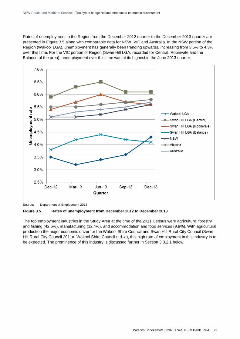
Parsons Brinckerhoff | 2207517A-STE-REP-001 RevB 29
NSW Roads and Maritime Services Tooleybuc bridge replacement socio-economic assessment
Rates of unemployment in the Region from the December 2012 quarter to the December 2013 quarter are presented in Figure 3.5 along with comparable data for NSW, VIC and Australia. In the NSW portion of the Region (Wakool LGA), unemployment has generally been trending upwards, increasing from 3.5% to 4.3% over this time. For the VIC portion of Region (Swan Hill LGA, recorded for Central, Robinvale and the Balance of the area), unemployment over this time was at its highest in the June 2013 quarter.
Source: Department of Employment 2013
Figure 3.5 Rates of unemployment from December 2012 to December 2013
The top employment industries in the Study Area at the time of the 2011 Census were agriculture, forestry and fishing (42.6%), manufacturing (12.4%), and accommodation and food services (9.9%). With agricultural production the major economic driver for the Wakool Shire Council and Swan Hill Rural City Council (Swan Hill Rural City Council 2011a, Wakool Shire Council n.d.-a), this high rate of employment in this industry is to be expected. The prominence of this industry is discussed further in Section 3.3.2.1 below.

Parsons Brinckerhoff | 2207517A-STE-REP-001 RevB 30
NSW Roads and Maritime Services Tooleybuc bridge replacement socio-economic assessment
Table 3.13 Top five industries of employment of employed persons aged over 15 years within the Study Area and Region, at 2011 Census
Characteristic Study Area Region
Total area NSW portion VIC portion
Count % of total Count % of
total Count % of total Count % of
total
Agriculture, forestry and fishing
86 42.6% 18 30.5% 68 47.6% 2,215 20.7%
Manufacturing 25 12.4% 10 16.9% 15 10.5% 915 8.5%
Accommodation and food services 20 9.9% 12 20.3% 8 5.6% 685 6.4%
Retail trade 15 7.4% 12 20.3% 3 2.1% 1,117 10.4%
Transport, postal and warehousing 12 5.9% 4 6.8% 8 5.6% 473 4.4%
Source: Australian Bureau of Statistics 2013b,c,e,f
3.3.2 Business and industry
3.3.2.1 Local and regional industry
The gross regional product (GRP) for Wakool LGA for 2011/12 was $271.8million (Regional Development Australia Murray 2013). For the same period, the GRP in Swan Hill LGA was $1,028million (REMPLAN 2013).
Value add can be used to indicate the value and contribution of different industries to a region’s economy. The agriculture, forestry and fishing industry group contributes the greatest value add to both the Wakool and Swan Hill LGA economies, and therefore is the dominant contributor to the Region’s economy. For Wakool LGA’s economy specifically, agriculture, forestry and fishing contributed over 40% of the value add, with all other industries not contributing more than 10% in 2011/12. The Swan Hill LGA economy in 2012/13 appeared to be more diverse, with agriculture, forestry and fishing contributing 17.2% of the value add, followed closely by rental, hiring and real estate services (12.6%), manufacturing (11.3%), and health care and social assistance (8.5%) industries. Figure 3.6 indicates the contribution of industries to both LGA economies. Data from the same financial year is not available for both LGAs so this representation is indicative only.

Parsons Brinckerhoff | 2207517A-STE-REP-001 RevB 31
NSW Roads and Maritime Services Tooleybuc bridge replacement socio-economic assessment
Source: Adapted from Regional Development Australia Murray 2013, REMPLAN 2013 Note: Wakool LGA data for 2011/12. Swan Hill LGA data for 2012/13.
Figure 3.6 Contributing value add industries present to the Wakool and Swan Hill LGA economies
Agriculture
The total agricultural value for the Region was $767.5million for the 2010/11 financial year. The breakdown of commodities and contributing values to the overall agricultural value in the Region is presented in Table 3.14. Evidently, the greatest contributing commodity in the NSW portion of Region was cereal crops (50.2%) and fruit (including grapes and nuts) in the VIC portion of Region (56.1%).
Table 3.14 Value of agricultural industry in the Region for the 2010/11 financial year (1)
Commodity Wakool LGA (NSW portion of Region) Swan Hill LGA (VIC portion of Region)
Total value ($m) % of total Total value ($m) % of total
Total agriculture 165.6 n/a 601.9 n/a
Crops total value 117.9 71.2% 579.7 96.3%
Broadacre crops
Hay 7.0 4.2% 3.2 0.5%
Cereal crops 83.2 50.2% 164.4 27.3%
Legumes for grain 1.1 0.7% 8.4 1.4%
Oil seeds 2.4 1.4% 7.8 1.3%
Other crops 0.1 0.1% 0.9 0.1%

Parsons Brinckerhoff | 2207517A-STE-REP-001 RevB 32
NSW Roads and Maritime Services Tooleybuc bridge replacement socio-economic assessment
Commodity Wakool LGA (NSW portion of Region) Swan Hill LGA (VIC portion of Region)
Total value ($m) % of total Total value ($m) % of total
Horticulture
Nurseries, cut flowers and cultivated turf
2.9 1.8% 16.2 2.7%
Vegetables for seed 0.2 0.1% 0.4 0.1%
Vegetables for human consumption
3.3 2.0% 40.6 6.7%
Fruit (including. grapes and nuts) 17.7 10.7% 337.9 56.1%
Livestock
Slaughtered and meats 25.9 15.6% 10 1.7%
Livestock products (eggs, milk, wool, etc.)
21.8 13.2% 12.3 2.0%
Source: Australian Bureau of Statistics 2012
(1) All values presented are gross values
Tourism and visitation
The value of tourism and hospitality sales in Swan Hill LGA for 2012/13 was $26.1m (Economic profile id). Additionally during this time, Swan Hill was the second most visited region in the Mallee region during this time period (Tourism Research Australia 2013).
Tooleybuc has been noted to have the potential to become a significant stop-over point due to its strategic position along the Mallee Highway, and the requirement for travellers to slow down approaching the Tooleybuc bridge. People driving through the town contribute significantly to the existing tourism market, with many travelling between Adelaide and Sydney (Wakool Shire Council 2011).
During the community consultation process carried out for this study, interviewees consistently referenced the significance of tourist trade to the economy in the NSW Study Area portion. While specific data on the tourism industry’s value in the Study Area is not available, the presence of three motels, a caravan park and self-catering accommodation in the NSW Study Area portion support the view that the township receives a significant economic contribution from tourist trade. During consultation, the main tourist attractions were highlighted to be the Murray River, the facilities park and the tranquillity of the surrounding natural environment. Additionally the existing Tooleybuc bridge and Bridge Keepers Cottage were also noted as key tourism attractions.
Accommodation providers in the NSW Study Area portion provided a subjective estimate of around a 50/50 spilt between guests staying in the NSW Study Area portion as a stopover en route to another destination, and those guests staying in the NSW Study Area portion as a destination in itself. Attractions for guests specifically staying in the NSW Study Area portion included leisure activities such as fishing and golf, as well as a number of festivals in the region taking place throughout the year that bring people to the town such as Jazz Festivals and a Country Music Festival. Short-term workers and infrastructure maintenance crews also regularly used the NSW Study Area portion as an accommodation centre.

Parsons Brinckerhoff | 2207517A-STE-REP-001 RevB 33
NSW Roads and Maritime Services Tooleybuc bridge replacement socio-economic assessment
Participants in the community consultation process generally commented that the majority of overnight stops in the NSW Study Area portion were planned in advance, and that bookings were often made via the internet by travellers who were intending to stop at that location. It was anecdotally observed that repeat trade (e.g. previous guests returning for a subsequent visit) made up a substantial portion of accommodation trade in the town.
The facilities park located west of Murray Street in Tooleybuc was identified as being of particular significance to the tourism industry, providing a rest point and toilet facilities for short-term stopover breaks. Interviewees from businesses located along Murray Street also stressed the importance of the facilities park in attracting customers passing through the town.
In contrast, the VIC Study Area portion does not have any overnight accommodation available and is not perceived as a tourist destination in itself; nevertheless, the service station and Piangil General Store were recognised as depending substantially on passing traffic, including freight traffic.
Both Wakool and Swan Hill LGAs have developed tourism websites to inform and guide their growing tourism markets.
Visitation and expenditure for the Tourism Research Australia defined Murray and Mallee regions that include the Study Area and Region for the 2012/2013 period are presented in Table 3.15. For this data, it appears that visitation is greater in the Murray region in NSW compared to the Mallee region in VIC.
Table 3.15 Regional tourist visitation and expenditure for 2012-2013 (1)
Characteristic Visitors Expenditure Nights Average stay Average trip expenditure
'000 $ million '000 Nights $
Visitors to the Murray (NSW)
Domestic day 1,265 209 - - 165
Domestic overnight 964 412 2,606 3 427
International 19 np 372 19 Np
Visitors to Mallee (VIC)
Domestic day 661 84 - - 127
Domestic overnight 682 339 2,286 3 497
International 23 np 620 27 Np
Source: Tourism Research Australia 2013
(1) All visitors ages 15 and over (2) np: not published due to reliability concerns
3.3.2.2 Local businesses
An array of local businesses service the Study Area, including:
Plumber Electrician Carpet Cleaning service Shed constructors

Parsons Brinckerhoff | 2207517A-STE-REP-001 RevB 34
NSW Roads and Maritime Services Tooleybuc bridge replacement socio-economic assessment
Take-away food shops “Old Tooleybuc Doll Cottage” General stores Post office facilities Tourism accommodation, including caravan park Transport services TAB service “Chetwynd Park”, a citrus business that exports to the USA and Asia.
Murray Street is the main shopping district of the NSW Study Area portion, and the current Tooleybuc bridge provides direct access and subsequent drive-by exposure to businesses on this street. Businesses here include a local store, take-away food shops, the Tooleybuc Hotel and the Post Office. On-street parking is available for these businesses. Previous consultation has indicated the importance of continuing current main street exposure with the replacement option.
Over the last five years, the total number of businesses across the Region has remained just above 3,000. In 2008, there were 3,063 businesses but most recently in 2012, 3011 businesses were recorded as indicated in Table 3.16. Notably, businesses from the Agriculture, Forestry and Fishing industry constituted the largest proportion of businesses in both the NSW portion of Region (297 business and 59.5%) and VIC portion of Region (1000 and 39.5%) in 2012 (ABS 2014b, 2014c).
Table 3.16 Counts of businesses for LGAs within the Region at 30 June each year
Business type 2008 2009 2010 2011 2012
Wakool LGA (NSW portion of Region)
Non-employing businesses
318 316 330 317 309
Employing businesses with 1-4 employees
113 108 111 113 115
Employing businesses with 5 or more employees
74 70 61 65 73
Total businesses 505 494 502 495 497
Swan Hill LGA (VIC portion of Region)
Non-employing businesses
1,394 1,370 1,416 1,441 1,432
Employing businesses with 1-4 employees
587 575 607 631 618
Employing businesses with 5 or more employees
577 563 503 486 464

Parsons Brinckerhoff | 2207517A-STE-REP-001 RevB 35
NSW Roads and Maritime Services Tooleybuc bridge replacement socio-economic assessment
Business type 2008 2009 2010 2011 2012
Total businesses 2,558 2,508 2,526 2,558 2,514
Total for Region
Total businesses 3,063 3,002 3,028 3,053 3,011
Source: Australian Bureau of Statistics 2014b,c
3.4 Social infrastructure
3.4.1 Services
3.4.1.1 Education
Education facilities in the Study Area include Tooleybuc Central School in NSW, and Piangil Primary School in VIC. Tooleybuc Central School caters for students from Kindergarten to Year 12 (including a preschool), while Piangil Primary School only provides for primary years. As indicated by Table 3.17, enrolments have been fairly consistent at Tooleybuc Central School over the past six years, but have dropped significantly for Piangil Primary School.
Community consultation revealed a general perception that the Tooleybuc Central School is well attended and has benefited from recent funding and investment. The school’s catchment area covers a radius of approximately 40km, with many students travelling by bus. Community perception is that the school’s enrolment numbers have remained stable over the past 5-6 years, which is supported by the data in Table 3.16. In contrast, Piangil Primary School’s declining enrolment numbers were viewed as a cause for some concern by community members in the VIC Study Area portion.
Table 3.17 Student enrolment of education facilities within the Study Area
Education facility 2008 2009 2010 2011 2012 2013
Tooleybuc Central School
132 127 122 121 125 126
Piangil Primary School
18 19 16 13 12 6
Source: ACARA 2013
During a place making workshop with the community in the NSW Study Area portion in 2009, it was noted that pathways and footpaths to the Tooleybuc Pre-School and Central School are uneven and present trip hazards (Wakool Shire Council 2009).
3.4.1.2 Health services
Health facilities available in the Study Area include:
Home and Community Care, Tooleybuc: Offers respite care, home assistance and maintenance, community transport services, social support services and additional community services

Parsons Brinckerhoff | 2207517A-STE-REP-001 RevB 36
NSW Roads and Maritime Services Tooleybuc bridge replacement socio-economic assessment
Tooleybuc Community Health Centre: Provides a range of health services on a rotating basis including women’s health, mental health, dietician, podiatry, speech pathology, immunisations and early childhood clinic (Tooleybuc Central School 2014).
During a community place making workshop in the NSW Study Area portion in 2009, a comment was made that a doctor is only available in the township one day per week (Wakool Shire Council 2009).
3.4.1.3 Police
The NSW Study Area portion is included within the NSW Police Force’s Deniliquin Local Area Command in the Southern Region. The VIC Study Area portion is included within the Victoria Police’s Western Region. The closest police services that provide for the Study Area include:
Balranald Police Station Deniliquin Police Station (Command Centre) Swan Hill Police Station.
Poor police presence was raised as an issue by the community in the NSW Study Area portion during a place making workshop in late 2009, with a police officer only available in town half a day per week (Wakool Shire Council 2009). There is a police station at Piangil, located 5km from Tooleybuc; however it has been closed since 2010.
3.4.1.4 Other emergency services
Emergency services such as fire services, ambulance services and the state emergency service (SES) that provide for the Study Area include:
Fire services:
Balranald Fire Brigade (NSW) NSW Rural Fire Service - Mid Murray Zone Office (NSW) Swan Hill Regional Fire HQ (VIC) Piangil Fire Brigade (VIC)
Ambulance:
NSW Ambulance – Albury Vic Ambulance – Bendigo
SES:
SES Balranald (NSW) SES Swan Hill (VIC).
3.4.2 Community facilities
A number of community facilities exist in the study area, including:
Tooleybuc Sporting Club including associated clubs and facilities such as:
Tooleybuc Gold Club Inc. Tooleybuc Bowling Club Tooleybuc Tennis Club Tooleybuc Cricket Club Tooleybuc-Manangatang Football/Netball Club 9-hole golf course and 18-hole mini golf course Tennis court

Parsons Brinckerhoff | 2207517A-STE-REP-001 RevB 37
NSW Roads and Maritime Services Tooleybuc bridge replacement socio-economic assessment
Netball courts Football and cricket oval Half sized basketball court
Tooleybuc and Piangil District Fishing Club Inc.
Tooleybuc Recreation Reserve and Hall
Our Lady Help of Christians Catholic Church
Piangil RSL
Piangil Hall (under construction)
Piangil Memorial Park and Recreation Reserve
BMX track in Piangil
Tooleybuc Mobile Library, at Tooleybuc School and on-street on alternative Fridays.
Whilst the community consultation revealed that most participants felt the level of community facilities in the Study Area was adequate given the size of the townships, it was frequently noted that many residents travel regularly to Swan Hill for larger shopping excursions or for facilities such as banking and health services.
3.5 Transport and access Every Friday, the “Goodnight Express” operates to provide community members transportation to service Swan Hill. This service stops in Tooleybuc Post Office at 9.45am, and arrives at Swan Hill at 10.50am. The service departs Swan Hill at 1.30pm. A return ticket on this service costs $8 per adult and $5 for a child up to 16 years of age. The Goodnight Express service is an initiative established by Wakool Shire’s Home and Community Car (HACC) service, and funded by the NSW Ministry for Transport (Tooleybuc Central School 2014).
Further discussion of key transport networks is presented in Section 3.2.4.3.

Parsons Brinckerhoff | 2207517A-STE-REP-001 RevB 38
NSW Roads and Maritime Services Tooleybuc bridge replacement socio-economic assessment
4. Impact assessment The replacement of Tooleybuc bridge, both during construction of a new bridge over the Murray River and once it is operational, can have both positive and negative effects on individuals, the communities at a local and regional level, business and economics. The Proposal may affect current and future road users including freight and tourism trips, businesses, individuals living in the community and people working in the community or the broader region.
The impacts associated with the Proposal may be direct or indirect, actual or perceived and will vary between the construction phase and the operational phase. Several impacts and benefits associated with the socio-economic profile of the Study Area and the Region have been identified.
Sections 4.1 to 4.7 provide more detail on the anticipated Proposal impacts and benefits and the associated issues during both the construction and operation phase.
This assessment provides discussion about the range of potential social and/or economic impacts and benefits associated with each bridge replacement option. Further detail on other impacts anticipated and their severity is available in separate specialist studies being carried out on behalf of Roads and Maritime, including assessment of noise and vibration, visual impact, air quality, Flora and Fauna, Aboriginal cultural heritage, and hydrology (flood modelling). This report will be considered together with these other studies when assessing the most effective solution for the Proposal.
4.1 Property and land use Property and land use impacts relating to how the Proposal may affect public and/or private property and the current land uses. The three options would have varying degrees of property and land use impacts due to their differing alignments.
The Purple and Blue options would have fewer property and land use impacts than the Yellow option. Roads and Maritime has identified that these two options would require partial property acquisitions in the VIC Study Area portion, reducing the land holding size for individual owners. There is the potential, however, that the proposed Purple and Blue alignments will predominantly use existing road corridors and therefore minimise any impact to land use. Table 4.8 outlines the potential property acquisition of each option.
Table 4.1 Potential property acquisition impacts
Option Full property acquisition Partial property acquisition
Purple 0 1
Blue 0 1
Yellow 3 1
The most notable property impacts would be associated with the Yellow option. Roads and Maritime has indicated that this option would require full acquisition of three properties in the NSW Study Area portion and a partial acquisition in the VIC Study Area portion. These acquisitions in the NSW Study Area portion would result in displacement of one resident, a business and the rural fire station and also curtail any planned property improvements on the individual properties.
A key outcome from the consultation process was that the owners of the residential property potentially acquired in the NSW Study Area portion under the Yellow option indicated that the acquisition would not be considered by them as a significant obstacle to the Yellow option proceeding – and, in fact, that the Yellow

Parsons Brinckerhoff | 2207517A-STE-REP-001 RevB 39
NSW Roads and Maritime Services Tooleybuc bridge replacement socio-economic assessment
option was their preferred option given the benefits of separating freight traffic from Murray Street. Under these circumstances, the impact of land acquisition from the Yellow option could be significantly reduced.
The residential property owners to be impacted under the Yellow option in the VIC Study Area portion are unlikely to have their dwelling acquired; rather, a partial acquisition of land not including the dwelling would be required, therefore reducing the impact. The landowners indicated a preference for the Blue or Purple option; however, they acknowledged that the Yellow option presented the greatest benefits from an overall traffic and transport perspective.
These outcomes from the consultation process have been incorporated into the determination of the ‘Consequence’ component of the impact assessment below, and they have been considered as a factor when determining overall impacts of each option.
It was highlighted during consultation that there is a lack of appropriate and/or quality housing or property availability particularly in the NSW Study Area portion, and concerns were raised by the residents who would be subject to full acquisition about the ability to relocate within the Study Area to a property with similar characteristics. Additionally, it was noted that advance notice is important to allow adequate time to identify potential options and relocate. Similarly, relocation of the fire station would require consideration, since a key factor in identifying a site is having suitable access that is not impeded by traffic or busy roads.
Consultation with the local community identified that the Yellow option may also impact the current land use of the boat ramp park and boat ramp in the NSW Study Area portion. Community members noted this area is well used for local social gatherings and by tourists passing through. The use of this land would be affected as part of it would need to be resumed, reducing the land holding and impeding access to river frontage and to the boat ramp.
Table 4.2 outlines potential impacts and the associated consequence for each option; this is a high level assessment and considers the likelihood and consequence of both benefits and risks. Further discussion is provided in the Sections 4.1.1 and 4.1.2 and suggested strategies to optimise benefits or mitigate impacts are noted in Section 4.1.3.
Table 4.2 Property and land use risk/benefit
Impact Details Option Likelihood Consequence(1) Potential risk/benefit(2)
Construction
Property acquisitions
Property acquisition due to the Proposal – loss of land
Blue C I Negligible
Purple C I Negligible
Yellow A II Moderate (negative)
Displacement of residents, business, social infrastructure
Loss of property and resident, business or service has to move
Blue E I Negligible
Purple E I Negligible
Yellow B II Moderate (negative)
Reduce land holding size
Loss of land use
Blue D I Negligible
Purple C II Low (negative)
Yellow B II Moderate (negative)
Acquisition or reduce land holding size
Impact on property improvements
Blue C I Negligible
Purple C I Negligible
Yellow C III Moderate (negative)

Parsons Brinckerhoff | 2207517A-STE-REP-001 RevB 40
NSW Roads and Maritime Services Tooleybuc bridge replacement socio-economic assessment
Impact Details Option Likelihood Consequence(1) Potential risk/benefit(2)
Acquisition or reduce land holding size
Loss of access to public space
Blue B II Moderate (negative)
Purple C I Negligible
Yellow A III High (negative)
Operation
Property acquisitions
Resumed property as a result of the Proposal – loss of land
Blue D I Negligible
Purple D I Negligible
Yellow D I Negligible
Displacement of residents, business, social infrastructure
loss of property and resident, business or service has to move
Blue E II Negligible
Purple E II Negligible
Yellow B II Moderate (negative)
Reduce land holding size
Loss of land use
Blue D II Negligible
Purple D II Negligible
Yellow B II Moderate (negative)
Acquisition or reduce land holding size
Impact on property improvements
Blue D II Negligible
Purple D II Negligible
Yellow D III Low (negative)
Acquisition or reduce land holding size
Loss of access to public space
Blue D I Negligible
Purple C II Low (negative)
Yellow C II Low (negative)
(1) Outcomes from the consultation process have been considered and incorporated into the determination of the ‘Consequence’ component of the impact assessment.
(2) The potential risk/benefit has been identified using the risk/benefit assessment matrix (Section 1.3.4.3) to help understand the impact. Negative or positive risk/benefits indicate the nature of the impact to develop strategies to mitigate the impact or optimise the benefit, dependant on the level of likelihood and consequence.
4.1.1 Construction phase
Each of the options would result in impacts to property and land use during the construction phase as a result of site establishment works and road and bridge construction activities. Depending on the detailed design and development of a construction plan there could be additional impacts to land use during construction once an appropriate construction site is identified. There is an existing maintenance compound located in the VIC Study Area portion that would be suitable for use for construction purposes, although would likely not be sufficient to meet all storage and site requirements for a new bridge construction.
As the Yellow option is in close proximity to the boat ramp park in the NSW Study Area portion, some of this park land could be considered an appropriate construction site; however further investigation may identify alternative options that could be used. If the boat ramp park area is identified as the most appropriate construction site it could impact the land use of the park further. This should only be temporary and established immediately prior to construction commencing and rehabilitated once construction is completed. In the VIC Study Area portion there would be similar requirements for site access, however as there is no community or recreational land the land use impacts associated with the Yellow option would not be as significant.

Parsons Brinckerhoff | 2207517A-STE-REP-001 RevB 41
NSW Roads and Maritime Services Tooleybuc bridge replacement socio-economic assessment
For the Blue and the Purple options, there are limited locations for a construction site in the NSW Study Area portion in close proximity to where the bridge placements are proposed, and use of the facilities park and car park close to those locations might be considered appropriate. Hence there could be similar land use impacts associated with construction for either of these two options. Similar to the Yellow option, this would be less of an issue in the VIC Study Area for the Blue and Purple options.
4.1.2 Operational phase
Once the new bridge is operational, the main impact for the Blue, Purple and Yellow option will be adapting to the change in land use. Land use changes will only become fully evident once the preferred option is identified, the detailed design is completed and construction commences. Once the bridge is complete and the community in the Study Area can grasp what the final replacement bridge encompasses, the reality of the specific changes to individual land uses will be better understood.
4.1.3 Suggested mitigation strategies
Once the preferred option is determined the detailed design should consider potential mitigation strategies for reducing impacts to specific property(s) and property owners, such as using road reserves where possible
Liaise with Council and the Rural Fire Service, where required, so the detailed design for the preferred option allows adequate road access for fire trucks exiting the fire station; at the existing fire station site for the Blue and Purple options and a new site for the Yellow option (a suitable site to be determined)
Where impact to community or recreational land is unavoidable, such as the boat ramp park in the Yellow option and the facilities park in the Blue option, liaise with Council and community members to gain feedback about rehabilitating the area post construction. This information should be considered when developing the detailed design for the preferred option
Ongoing consultation with potentially affected property owners regarding the Proposal and informing when the preferred option has been determined
Acquisition of property in accordance with the Land Acquisition and Compensation Act 1986 (V) and The Land Acquisition (Just Terms Compensation) Act 1991 (NSW)
Once the preferred option is determined and the detailed design is developed, consult with the community to inform and set expectations of any negotiables and non-negotiables.
4.2 Changes to population and demography The construction of the Proposal, regardless of the option selected, is likely to see an increase in the population and demographic changes due to the influx of work crews to the area. These population changes would be temporary and it is unlikely that any ongoing effects would continue once the Proposal is operational.
Table 4.3 outlines potential impacts and the associated consequence for each option; this is a high level assessment and considers the likelihood and consequence of both benefits and risks. Further discussion is provided in the Sections 4.2.1 and 4.2.2 and suggested strategies to optimise benefits or mitigate impacts are noted in Section 4.2.3.

Parsons Brinckerhoff | 2207517A-STE-REP-001 RevB 42
NSW Roads and Maritime Services Tooleybuc bridge replacement socio-economic assessment
Table 4.3 Population and demography impact risk/benefit
Impact Details Option Likelihood Consequence(1) Potential risk/benefit(2)
Construction
Population and demography
Increased population and changed demography
Blue A III High (positive)
Purple A III High (positive)
Yellow A III High (positive)
Decreased population and changed demography
Blue D II Negligible
Purple D II Negligible
Yellow D II Negligible
Operation
Population and demography
Increased population and changed demography
Blue D II Negligible
Purple D II Negligible
Yellow C II Low (positive)
Decreased population and changed demography
Blue C II Low (negative)
Purple C II Low (negative)
Yellow C II Low (negative)
(1) Outcomes from the consultation process have been considered and incorporated into the determination of the ‘Consequence’ component of the impact assessment.
(2) The potential risk/benefit has been identified using the risk/benefit assessment matrix (Section 1.3.4.3) to help understand the impact. Negative or positive risk/benefits indicate the nature of the impact to develop strategies to mitigate the impact or optimise the benefit, dependant on the level of likelihood and consequence.
4.2.1 Construction phase
All three options, Yellow, Blue and Purple, would have a high impact to the Study Area during the construction phase. It is anticipated that a large number of construction personnel, relative to the size of the town, would be required during construction. As the population in the Study Area and the Region has a higher than average elderly population the workforce is anticipated to come from other locations in NSW or VIC. However this impact would only be short term, during construction, and once construction is completed it is expected the population and demography would return to current levels.
Other specialist studies will provide more detail regarding the construction required for each option. With this additional detail, anticipated workforce requirements and construction scheduling will be determined, which in turn will provide a better understanding of the potential effects on population and demography in the Study Area.
4.2.2 Operational phase
Once operational, no substantial changes to the population or demography are expected for the Blue, Purple or Yellow options. The Blue or Purple options are very unlikely to have any change however the Yellow option has the potential to have some minor effects in the NSW Study Area portion.
The possible change in population and demography in the Study Area is associated with the residential property acquisition in the Yellow option. This is dependent on land availability and for the affected property owner to relocate within the Study Area versus moving elsewhere. Concerns for suitable property availability were highlighted during consultation.

Parsons Brinckerhoff | 2207517A-STE-REP-001 RevB 43
NSW Roads and Maritime Services Tooleybuc bridge replacement socio-economic assessment
Consultation also revealed some perceived implications and benefits to the population and demography of the Study Area for each option. It was noted that the Blue option could increase the population as a result of additional traffic entering Murray Street and create more awareness of the NSW Study Area portion. Opposing this, there were concerns for safety and reduced amenity, dust and noise associated with the additional traffic resulting in residents moving away from the NSW Study Area portion.
The Purple option, which also would direct traffic through Murray Street was perceived to have a similar effect to the Blue option, with opposing views on the potential impacts to the population and demography.
There is a perceived potential benefit to population and demography associated with the Yellow option. There is the perception that by diverting traffic away from Murray Street in the NSW Study Area portion the lifestyle would improve, making the location more attractive to families and retirees, which could potentially encourage residential growth, increasing the population and diversifying the demography.
4.2.3 Suggested mitigation strategies
Where impact to property is unavoidable, liaise with Council and the affected property owners to identify suitable alternative property in the Study Area if relocation is required
Develop and include behavioural requirements for workforce personnel as part of their induction to reduce any adverse effect of a younger demography present in the local community
Provide residents with a contact phone number during construction to report any concerns, this will help monitor issues and manage any adverse impacts.
4.3 Economic Economic impacts include direct and/or indirect effects the Proposal may have in the Study Area and Region. These impacts can include changes to employment, specifically in the Study Area, and changes to business and industry in the Study Area and Region. The main aim of the Proposal is to simultaneously improve road network performance, cross border access, and the freight route between Sydney and Adelaide. Consideration of potential economic impacts indicates the Proposal would have an overall economic benefit in the Study Area and Region.
As indicated in the existing socio-economic profile, the rate of unemployment in the Study Area is slightly higher than in the Region. This may be reflective of number of job opportunities available in the Study Area. There is also a greater than average ageing population identified in the 2011 Census data and also through consultation where several participants informed they were retired and referred to the NSW Study Area portion as a ‘retirement village’ community.
Of the working population in the Study Area, the most predominant industry of employment is agriculture, forestry and fishing, followed by manufacturing. This is reflective of the prominent agricultural landscape and reference to the rich agricultural country and local produce during consultation.
Table 4.4 outlines potential impacts and the associated consequence for each option; this is a high level assessment and considers the likelihood and consequence of both benefits and risks. Further discussion is provided in the Sections 4.3.1 and 4.3.2 and suggested strategies to optimise benefits or mitigate impacts are noted in Section 4.3.3.

Parsons Brinckerhoff | 2207517A-STE-REP-001 RevB 44
NSW Roads and Maritime Services Tooleybuc bridge replacement socio-economic assessment
Table 4.4 Economic impacts risk/benefit
Impact Details Option Likelihood Consequence(1) Potential risk/benefit(2)
Construction
Employment Employment opportunities
Blue C II Low (positive)
Purple C II Low (positive)
Yellow C II Low (positive)
Economic impact on Local business
Effects on patronage and sales
Blue B II Moderate (positive)
Purple B II Moderate (positive)
Yellow B II Moderate (positive)
Economic impact on Regional Industry
Travel time impact
Traffic flow
Blue C II Low (negative)
Purple C II Low (negative)
Yellow C II Low (negative)
Economic impact on Agriculture
Travel time impact
Traffic flow
Blue C II Low (negative)
Purple C II Low (negative)
Yellow C II Low (negative)
Economic impact on Tourism
Amenity Availability Repeat stays Reputation
impact
Blue C III Moderate (positive)
Purple C III Moderate (positive)
Yellow C III Moderate (positive)
Operation
Employment Employment opportunities
Blue C I Negligible
Purple C I Negligible
Yellow C I Negligible
Economic impact on Local business
Effects on patronage and sales
Blue B II Moderate (positive)
Purple B II Moderate (positive)
Yellow B II Moderate (positive)
Economic impact on Regional Industry
Travel time impact
Traffic flow
Blue B III Moderate (positive)
Purple B III Moderate (positive)
Yellow B V Major (positive)
Economic impact on Agriculture
Travel time impact
Traffic flow
Blue B III Moderate (positive)
Purple B III Moderate (positive)
Yellow A III High (positive)
Economic impact on Tourism
Amenity Availability Repeat stays Reputation
impact
Blue B III Moderate (positive)
Purple B III Moderate (positive)
Yellow B III Moderate (positive)
(1) Outcomes from the consultation process have been considered and incorporated into the determination of the ‘Consequence’ component of the impact assessment.
(2) The potential risk/benefit has been identified using the risk/benefit assessment matrix (Section 1.3.4.3) to help understand the impact. Negative or positive risk/benefits indicate the nature of the impact to develop strategies to mitigate the impact or optimise the benefit, dependant on the level of likelihood and consequence.

Parsons Brinckerhoff | 2207517A-STE-REP-001 RevB 45
NSW Roads and Maritime Services Tooleybuc bridge replacement socio-economic assessment
4.3.1 Construction phase
4.3.1.1 Employment
Construction of the Proposal may present employment opportunities in both the Study Area and the Region, particularly if local trades and civil construction firms are provided with opportunities to tender for construction activities. All three options would present similar employment opportunities in the Study Area since each option would require a similar number of construction workers, with the Yellow option potentially requiring more workers or a longer works schedule. There may however be greater benefit to various disciplines within the construction industry such as earth moving companies, steel fixers or others – this would be determined by the detailed design development of the preferred option. Workers would influx to the Study Area during construction and although some workers may commute, many would require the use of local accommodation and goods and services. This would be an economic benefit to local businesses in the Study Area and could result in a potential need for short-term staff to be employed.
4.3.1.2 Business and industry
Local and regional
During construction some local and regional business and industry would experience economic impacts while others could have economic benefits. The Proposal is anticipated to have a substantial impact during construction however would be beneficial to the Study Area and the Region in the long run. Participants mostly agreed that a replacement bridge is needed and some commented that the construction works would potentially not cause as much economic impact as is currently experienced when the existing bridge is undergoing maintenance.
All three options may cause some indirect effects on businesses in the Study Area and the Region as a result of construction works in the area. Generally these impacts will be due to an increase in traffic, construction machinery and road works associated with building the replacement bridge. This could have a negative economic impact as a result of increased travel times for local and regional logistic movements and transportation of agricultural produce. However this would only be for the duration of construction and once the new bridge is completed travel times would be improved.
Local goods and service providers may experience some economic benefit from the Proposal during construction. All three options would see an influx of construction workers to the Study Area, increasing patronage to local business such as accommodation providers in the NSW Study Area portion, social facilities such as the Sporting Club, and the Tooleybuc Hotel and TAB. Additionally, the general stores and Post Offices in Tooleybuc and Piangil and the petrol station would likely benefit from increased trade.
Agriculture
Construction of either the Blue, Purple or Yellow options is unlikely to have any direct economic impact to the Agricultural industry in the Study Area or in the Region. Some indirect economic impact could be experienced as a result of travel time delays while transporting produce caused by traffic management or if alternative routes are to be used. These indirect impacts would only occur, however, during the construction phase.
Agricultural producers in the Study Area and the Region may have some indirect economic impact; for example, if construction coincides with the harvest season there is also a possibility that local accommodation providers will take advantage of the demand and increase their rates. If pickers stay at accommodation in Tooleybuc and perceive this expense as too great they may decide to go elsewhere to help harvest. Agricultural producers would either have to pay pickers more or face the possibility of losing some of their harvest.

Parsons Brinckerhoff | 2207517A-STE-REP-001 RevB 46
NSW Roads and Maritime Services Tooleybuc bridge replacement socio-economic assessment
Tourism
Each bridge replacement option could cause possible economic impacts to tourism and visitation. These impacts are indirect and unavoidable and have the potential to have long term effects on the tourism industry in the Study Area.
Dependent on Proposal timing, there is the potential for construction to conflict with key tourism events or harvest periods, resulting in a potential accommodation shortage in the Study Area. Turning guests away could potentially negatively impact on repeat tourism stays.
During construction it is anticipated that there will be noise, vibration, visual amenity, and air quality impacts. Although management strategies would be implemented to minimise impacts, visitors expecting to visit a quiet riverside town may perceive these impacts particularly negatively. Such visitor dissatisfaction could result in loss of patronage or damage Tooleybuc’s reputation as a tourism destination.
Alternatively, the influx of construction workforce would bring people to the Study Area that may not have considered visiting before. This could have a positive impact on tourism both in the short-term (particularly if their families visit) and in the long-term as they may return for a holiday or promote the area through word-of-mouth to family and friends.
4.3.2 Operational phase
The Proposal will improve the road network performance through travel time savings and for current road users and would provide a more direct route for interconnections in the Region and the journey between Sydney and Adelaide. Therefore the Proposal would have an overall positive economic impact to local business and the local and regional economies. However there may be some impacts associated with the different options.
4.3.2.1 Employment
Once the new river crossing is operational, there is no foreseeable directly associated employment effect on the Study Area, either positive or negative, regardless of the selected bridge option. The overall benefit of opening up the transport route may, however, see subsequent employment opportunities arise.
4.3.2.2 Business and industry
Local businesses located in the Study Area are likely to have some economic benefit from the improved access between the two localities and to the broader Region. Further, the higher Mass Limits associated with all three bridge replacement options will allow freight and logistics companies to use this road connection that were inhibited by the weight restrictions of the existing Tooleybuc bridge. This would see an economic benefit to business and industry through a more direct route between Sydney and Adelaide.
Consultation highlighted a clear preference for the Yellow option overall. Concern was raised during consultation, however, that economic impacts associated with the loss of passing trade and exposure would arise with this option as it alters access to Tooleybuc’s Murray Street. This concern was largely generated from participants in the NSW Study Area portion such as Murray Street businesses, accommodation providers and Tooleybuc Sporting Club. Similarities can be drawn from studies undertaken on town bypass upgrades in NSW. The Roads and Maritime report ‘Evaluation of Town Bypasses 2012’ undertook a sixteen year review of the NSW bypass towns for Yass, Gunning and Goulburn. The study revealed that the longer term economic impacts of town bypasses are positive with evidence showing all of the towns experiencing higher levels of highway passing trade. The study also concluded that longer term highway bypasses have in most cases have resulted in overall economic development benefits (Parolin, B 2012). A number of interviewees also raised the possibility of enhanced economic benefits to Murray Street businesses from the removal of heavy traffic through the town, thus improving local amenity.

Parsons Brinckerhoff | 2207517A-STE-REP-001 RevB 47
NSW Roads and Maritime Services Tooleybuc bridge replacement socio-economic assessment
The Blue and Purple options were perceived to potentially increase exposure to Murray Street businesses with the additional traffic flow anticipated to use the replacement bridge which could benefit local businesses. It was also noted, however, that the increase in heavy vehicle movements would potentially have an adverse impact on amenity which could decrease visitation at tourism accommodation (discussed in the Tourism sub section below).
On the other hand, businesses in the VIC Study Area portion are likely to have an economic benefit from the increase in passing trade with all bridge replacement options. However, there are no known conflicting businesses such as tourism providers and retail outlets located in Piangil.
Agriculture
Once the replacement bridge is operational an improved road network performance is expected. This would have a positive impact on the local and regional agricultural industry through likely efficiencies for produce transportation.
The Yellow option would provide the most economic benefit to the Agricultural industry. This is because the proposed design would provide the most reliable and timely route, with no unexpected delays associated with the lift span design and river users passing below or interfaces with traffic in Tooleybuc town centre along Murray Street.
The Blue and the Purple option would provide marginally improved travel times as a result of the dual lanes compared to the existing single lane Tooleybuc bridge. However any marginal improvement would probably be lost as these two options would direct traffic along Murray Street through Tooleybuc town centre. In addition, both these options are lift span bridge designs, making them susceptible to unexpected delays from both road and river traffic which would impact travel times and reduce efficiency.
Tourism
All three options are likely to have a minor negative impact on tourism if visitors are specifically traveling to see the current Tooleybuc bridge as it will no longer operate and is intended to be removed once the new river crossing is constructed.
The Yellow option is most likely to have an effect on tourism as it will impact the several key locations noted to be enjoyed by visitors including the boat ramp park, the boat ramp and the path along the river within the NSW Study Area portion. Visitors could perceive these impacts as a reduction in amenity and potentially having repercussions on the tourism industry. Conversely, it was suggested during the consultation process that this option might improve overall amenity by enhancing the attractiveness of the town centre through the reduction in heavy vehicle traffic.
The Blue and Purple options are not likely to directly impact the key attractions in the NSW Study Area portion. However these two options would provide continued traffic access through the Tooleybuc town centre. Given the replacement bridge is anticipated to be used by more logistics and freight vehicles, noise and traffic associated with the increase of heavy vehicle movements would cause likely negative economic impacts to the tourism industry due to reduced amenity.
4.3.3 Suggested mitigation strategies
Identify key agricultural and tourism dates so they can be accommodated for in the construction plan, as best as possible
Develop management plans for traffic, visual and noise to minimise any potential economic impacts to business and industry during construction

Parsons Brinckerhoff | 2207517A-STE-REP-001 RevB 48
NSW Roads and Maritime Services Tooleybuc bridge replacement socio-economic assessment
In order to monitor direct impact on accommodation providers, baseline statistics on the number of ‘spontaneous stays’ as opposed to ‘pre-booked stays’ should be recorded – accommodation providers could capture this data over several months
Develop a consultation plan so key business and industry stakeholders are known and kept informed about the progress of the Proposal and are notified of construction works in a timely manner so information can be passed on to patrons
If the Yellow option is decided to be the preferred option, the detailed design should include a signage strategy to indicate the services and facilities in NSW Study Area portion, specifically business and accommodation facilitates in Murray Street and the Sporting Club on Lockhart Road
If the Yellow option is decided the preferred option, the design might allow Tooleybuc town centre to be seen from the bridge, where feasible, to encourage drivers to stop. Locations for signage that directs drivers to the town centre should also be included in design
Investigate opportunities for a local buy strategy where businesses within the Study Area and Region are able to tender for goods and/or service delivery during construction
Where impact to community or recreational land is unavoidable, such as the boat ramp park in the Yellow option and the local park in the Blue option, liaise with Council and the community members to gain feedback about how they would like to see the area rehabilitated post construction. This could then be considered when developing the detailed design for the preferred option.
4.4 Social infrastructure Social infrastructure includes community services or facilities such as healthcare or hospitals, educational and recreation. It is anticipated that there could be a temporary demand increase associated with any proposed option during construction, given the rise of population, however this is not anticipated to have a negative impact given the unlikely permanent settlement of the workforce. Furthermore, the Study Area is conditioned to a high level of passing trade and visitors and therefore, it is unlikely that the increase in population would have adverse impacts.
The assessment is therefore focused on potential impacts on local community access to social infrastructure as a result of the operation of the bridge options.
Table 4.5 outlines potential impacts and the associated consequence for each option; this is a high level assessment and considers the likelihood and consequence of both benefits and risks. Further discussion is provided in the Sections 4.4.1 and 4.4.2 and suggested strategies to optimise benefits or mitigate impacts are noted in Section 4.4.3.
Table 4.5 Social infrastructure impacts risk/benefit
Impact Details Option Likelihood Consequence(1) Potential risk/benefit(2)
Construction
Impact to educational facilities
Service availability
Demand
Blue C I Negligible
Purple C I Negligible
Yellow C II Low
Impact to health care
Service availability
Demand
Blue C I Negligible
Purple C I Negligible
Yellow C I Negligible

Parsons Brinckerhoff | 2207517A-STE-REP-001 RevB 49
NSW Roads and Maritime Services Tooleybuc bridge replacement socio-economic assessment
Impact Details Option Likelihood Consequence(1) Potential risk/benefit(2)
Impact to recreational facilities
Access
Demand
Blue C I Negligible
Purple C I Negligible
Yellow C II Low (negative)
Operation
Impact to educational facilities
Access Blue C III Moderate (negative)
Purple C III Moderate (negative)
Yellow B III Moderate (negative)
Impact to health care
Access Blue D I Negligible
Purple D I Negligible
Yellow D I Negligible
Impact to recreational facilities
Access Blue D I Negligible
Purple D I Negligible
Yellow B II Moderate
(1) Outcomes from the consultation process have been considered and incorporated into the determination of the ‘Consequence’ component of the impact assessment.
(2) The potential risk/benefit has been identified using the risk/benefit assessment matrix (Section 1.3.4.3) to help understand the impact. Negative or positive risk/benefits indicate the nature of the impact to develop strategies to mitigate the impact or optimise the benefit, dependant on the level of likelihood and consequence.
4.4.1 Construction phase
The temporary increase in population during the construction period could result in a greater demand for social infrastructure during construction, however overall the consequences will be minimal. The key impact to social infrastructure may be an increase in demand for health facilities and emergency services given these resources are currently limited within the Study Area. It is anticipated that the construction contractor will provide onsite first aid facilities and have emergency plan in place; therefore it is unlikely that there would be a negative impact on the existing health facilities.
During construction there would need to be consideration of minimising the impacts to any recreational areas such as the boat ramp park or boat ramp once a preferred option is selected.
Due its proximity, the Yellow option will likely present some impact to accessing Tooleybuc Central School during construction. This impact would be of low significance with changes to access only temporary.
Consultation also highlighted the need to maintain access to the Community Health Clinic located on Cadell Street as this service is visited by community members in both the NSW and VIC Study Area portions. Although Cadell Street would not be affected during construction there could be restricted access associated with each the options. The Blue and Purple option would likely limit access to Cadell Street from Murray Street whereas the Yellow option would be likely to limit access to Cadell Street from the Mallee Highway. These potential access restrictions to Cadell Street would only be temporary and alternative routes would be identified to maintain access to the Clinic.
4.4.2 Operational phase
It is anticipated that there will no significant long term changes to social infrastructure or services as a direct result of the bridge upgrade.

Parsons Brinckerhoff | 2207517A-STE-REP-001 RevB 50
NSW Roads and Maritime Services Tooleybuc bridge replacement socio-economic assessment
If the Yellow option is determined the preferred option, there is the potential for access to Tooleybuc Central School and Tooleybuc Sporting Club to be altered for operation of the new bridge. Although exact impacts cannot be fully understood until the detailed design is completed, it is foreseeable that if this option is chosen the intersection of Murray Street and the Mallee Highway would require changes. It is anticipated that impacts would be minimal.
For all options, pedestrian access to social infrastructure (namely Tooleybuc Central School but also the Tooleybuc Sports Club) would potentially be altered during operation due to the anticipated increase in heavy vehicle traffic facilitated by the new river crossing. As the Blue and Purple options require vehicles to turn between Murray Street and Lea Street, safety issues regarding pedestrian access to Tooleybuc Central School associated with these options are expected to have a lower likelihood than the Yellow option. That is, the Yellow option will provide vehicles with more direct access between the new river crossing and Lea Street and potentially less need to slow down to turn onto Murray Street (depending on the traffic configurations developed for that intersection during detailed design).
The Tooleybuc Community Health Centre is located on Cadell Street, perpendicular to Lea Street. Access during operation will not be affected.
4.4.3 Suggested mitigation strategies
Provide first aid facilities and trained staff at the construction site
Develop a traffic management plan to minimise any potential conflicts between access requirements and construction activities
Ensure safe pedestrian crossing options are provided for in design, particularly around Tooleybuc Central School
During construction maintain access to social infrastructure and if restricted access in unavoidable work with the affected stakeholders to minimise the inconvenience as much as possible
Ensure appropriate vehicle crossing that facilitates safe turning is included at Murray Street/Lea Street intersection
Ensure social infrastructure management are aware of any access changes during construction so they are able to inform community members about the changes
Communicate changes to the Study Area and the Region to ensure alternative access option are known
Consider implementing a safety awareness and education program at Tooleybuc Central School prior to and during construction
Once the Proposal is operational, advertise any changed access e.g. traffic signals or turns, use street signage to direct traffic and promote new access location(s) to social infrastructure.
4.5 Community values Community values relate to how an individual perceives the affect the Proposal would have on the cultural landscape and the community identity and liveability in the Study Area. Impacts to community values could have the potential to cause wellbeing implications, both actual and perceived. Key issues relating to community values include community cohesion and connectivity, places of significance and places including Aboriginal and Cultural significance, lifestyle, and liveability.
There is a strong connection to the area with participants informing they have lived in the area for many years and enjoy the lifestyle. This is also supported by the ageing population and that a number of participants noted the NSW Study Area portion has a retirement village feel.

Parsons Brinckerhoff | 2207517A-STE-REP-001 RevB 51
NSW Roads and Maritime Services Tooleybuc bridge replacement socio-economic assessment
Locations that are valued by the community include the Sporting Club, the boat ramp and path along the Murray River and the facilities park area and its facilities. These areas were reported to be well used by both the residents in Study Area and the Region, and were highly valued for the peaceful scenery and natural environment. Interestingly, consultation did not identify any major concerns with removing the existing Tooleybuc bridge, however some community members expressed mild interest in retaining some sort of commemoration, e.g. through a picture, a plaque or a retention of part of the bridge structure.
The Bridge Keepers Cottage is unlikely to be impacted by any of the proposed options. There are possible impacts to Aboriginal heritage associated with each of options. A separate Aboriginal Cultural Heritage Study is being completed to better understand these potential impacts.
A key influencer of community value is community cohesion, which includes the connectedness or isolation individuals feel to others in the community. It is made apparent by the social networks, dependence on others or the general community spirit. Consultation highlighted the interconnectedness of community members, specifically in the NSW Study Area portion, noting it is a close-knit town similar to any other rural community in Australia. Contrary to this, one participant noted that Tooleybuc is not a good place to live if you are dependent on others.
The Sporting Club was identified as a key location facilitating social activities and cohesiveness between community members in the NSW and VIC Study Area portions, however consultation highlighted the two localities have limited interaction other than through Sporting Club activities.
Table 4.6 outlines potential impacts and the associated consequence for each option; this is a high level assessment and considers the likelihood and consequence of both benefits and risks. Further discussion is provided in the Sections 4.5.1 and 4.5.2 and suggested strategies to optimise benefits or mitigate impacts are noted in Section 4.5.
Table 4.6 Community value impacts risk/benefit
Impact Details Option Likelihood Consequence(1) Potential risk/benefit(2)
Construction
Impact to Community cohesion and connectivity
Access Traffic flow
Blue B II Moderate (negative)
Purple B II Moderate (negative)
Yellow B II Moderate (negative)
Places of Significance(3)
Access Blue C II Low (negative)
Purple C II Low (negative)
Yellow B II Moderate (negative)
Lifestyle and liveability
Safety
Amenity including noise, air quality and visual impacts
Access
Blue B II Moderate (negative)
Purple B II Moderate (negative)
Yellow B II Moderate (negative)

Parsons Brinckerhoff | 2207517A-STE-REP-001 RevB 52
NSW Roads and Maritime Services Tooleybuc bridge replacement socio-economic assessment
Impact Details Option Likelihood Consequence(1) Potential risk/benefit(2)
Construction
Cultural landscape
Items of cultural significance to the community
Amenity including noise, air quality and visual impacts
Environment impact
Blue C II Low (negative)
Purple C II Low (negative)
Yellow B II Moderate (negative)
Operation
Impact to Community cohesion and connectivity
Access Traffic flow
Blue B II Moderate (negative)
Purple B II Moderate (negative)
Yellow B III Moderate (negative)
Places of Significance(3)
Access Blue B I Negligible
Purple B I Negligible
Yellow B I Negligible
Lifestyle and liveability
Safety
Amenity including noise, air quality and visual impacts
Access
Blue B III Moderate (negative)
Purple B III Moderate (negative)
Yellow C II Low (negative)
Cultural landscape
Items of cultural significance to the community
Amenity including noise, air quality and visual impacts
Blue B II Moderate (negative)
Purple B II Moderate (negative)
Yellow B II Moderate (negative)
(1) Outcomes from the consultation process have been considered and incorporated into the determination of the ‘Consequence’ component of the impact assessment.
(2) The potential risk/benefit has been identified using the risk/benefit assessment matrix (Section 1.3.4.3) to help understand the impact. Negative or positive risk/benefits indicate the nature of the impact to develop strategies to mitigate the impact or optimise the benefit, dependant on the level of likelihood and consequence.
(3) Includes non-Aboriginal cultural heritage, a separate Aboriginal Cultural Heritage Report is being prepared to assess these impacts.
4.5.1 Construction phase
Constructing the replacement bridge has the ability to marginally impact community values. Impacts to community values during construction will be more localised to the individual locations that would be affected by the different options however these impacts would be similar for each area. The main community value concerns during the construction phase would be safety, severance and noise.

Parsons Brinckerhoff | 2207517A-STE-REP-001 RevB 53
NSW Roads and Maritime Services Tooleybuc bridge replacement socio-economic assessment
All three options would cause perceived safety concerns as a result of increased traffic and heavy vehicles and machinery in the Study Area. These impacts would be perceived to possibly impact pedestrians, cyclist and other road users. The Blue and Purple options would have an impact to businesses and their patrons and residents located in Murray Street and road users passing through the town centre. The Yellow option would potentially cause perceived safety impacts in the NSW Study Area portion to pedestrians, cyclists and motorists heading to the Tooleybuc Central School or visiting the Sporting Club. These safety impacts would be indirect and temporary, and further traffic management and mitigation strategies would be required to be put in place to minimise any potential hazards.
The community may perceive some localised severance impacts during construction works due to altered access requiring a change in travel patterns associated with all three options. All three options may produce perceived impacts on community values as construction will potentially affect access to and use of the boat ramp park, boat ramp, and path along the river, which together contribute to the cultural landscape of Tooleybuc. The Yellow option may also present delays or changes to accessing Tooleybuc Sporting Club and associated recreational facilities, both also part of the cultural landscape. These impacts, however, will only be temporary and of low significance as the cultural landscape overall will be preserved during construction.
Consultation made it evident that the community highly regard the quiet peaceful lifestyle Tooleybuc has to offer. Therefore noise associated with construction activities has the potential to impact this core community value in the NSW Study Area portion. All three options would have similar noise impacts, with slightly higher construction noise impacts associated with the Yellow option. Although these impacts would be mitigated there is a high possibility noise impacts will be perceived as being greater than they actually are due to the emphasis placed on the tranquillity of the existing environment in the Study Area. A separate technical study for noise is being prepared to assess these impacts.
4.5.2 Operational phase
The Proposal will result in improved local and regional connectivity within the Study Area, between the NSW and VIC Study Area portions, and within the Region through better travel times and road network performance which will have a positive impact on community cohesion. There are, however, some potential impacts on community values associated with each option. These impacts vary due to the route and location each option proposes.
There are community concerns that the Yellow option could sever the town of Tooleybuc as it may cut the existing connection between the town centre and the recreational and community services to the north of the Mallee Highway turn-off to Balranald, specifically the Sporting Club and the School. Additionally, it is perceived that once the bridge is operational there could be issues with the ability to safely cross the highway or for through traffic to safely access the businesses on Murray Street. However, when assessed, the actual severance would be minimal as the route proposed for the Yellow option would be built in the existing road alignment at the intersection and therefore safe access for pedestrians and north-south traffic would be maintained. The Yellow option would also potentially improve the residential amenity and the quiet lifestyle as a result of the reduction of traffic particularly freight vehicles passing through the township.
The Blue and Purple options have a lower perceived and actual severance change to the Study Area. However, as these two routes direct traffic through Murray Street there are likely to be actual impacts to community values in relation to residential amenity, lifestyle and cultural landscape. The new bridge is anticipated to facilitate an additional traffic increase, particular with freight users. The community highly concerned about potential impact to the town’s safety, the quiet amenity and riverside lifestyle in Tooleybuc.
A key concern highlighted during consultation was in relation to the potential impact to the boat ramp, the path along the river and the boat ramp park area. These were identified as highly valued components of the cultural landscape. The Yellow option is likely to have a moderate impact through a slight reduction in the land holding; however detailed design would need to confirm the exact level of impact. The Blue and Purple

Parsons Brinckerhoff | 2207517A-STE-REP-001 RevB 54
NSW Roads and Maritime Services Tooleybuc bridge replacement socio-economic assessment
options may have an indirect impact through increased traffic volumes, which may promote increased visitation and appreciation of the cultural landscape. These options could also potentially impact on the river park space. The overall significance of this impact will be determined in detailed design, however, given the community hold the boat ramp, pathway and park as a highly valued area, the impact risk during operations for the Yellow option is moderately negative. The Blue and Purple options do not propose any negative changes to the boat ramp in terms of cultural landscape however, overall may have an overall moderate impact to the cultural landscape through impacts to the residential amenity and character of the township.
4.5.3 Suggested mitigation strategies
During construction maintain access to properties, Tooleybuc town centre and community recreational facilities and if restrictions to access are unavoidable work with the affected stakeholders to minimise the inconvenience as much as possible
Ensure cultural landscape components (such as boat ramp, path along the river and park area) are preserved as much as possible during detailed design, construction and if necessary, restored for operation
If the Yellow option is determined the preferred option, and the impact to the boat ramp and park area are unavoidable, work with Council to provide an alternative boat ramp location
Where impact to community or recreational land is unavoidable, such as the boat ramp park in the Yellow option and the local park in the Blue option, liaise with Council and the community members to gain feedback about how they would like to see the area rehabilitated post construction. This could then be considered when developing the detailed design for the preferred option
Keep the community informed of the Proposal progress and once the preferred option is determined and detailed design developed, consult with the community to gain buy-in of the Proposal and outline negotiables and non-negotiables such as traffic treatments and landscaping reinstatement
Develop traffic and noise management plans for the selected option to minimise potential impacts.
4.6 Local amenity and character Local amenity and character refer to the pleasantness or attractiveness of the Study Area or the ways in which a person feels comfort from their surrounding environment. Amenity influences individual properties, open spaces within the Study Area and the Region as a whole. As noted in consultation, the NSW Study Area portion is regarded as a quiet, sleepy town with a beautiful natural environment located on the Murray River. Many residents have lived in the area for a long time and many participants involved in consultation recalled the history and character of the town.
Local amenity and character will potentially be affected by the Proposal due to noise and vibration impacts compromising landscape, air quality, amenity and other environmental aspects throughout both the construction and operation phases. The significance of these impacts associated with the Proposal are considered further in relevant technical studies being completed for Roads and Maritime concurrent with this socioeconomic study.
Table 4.7 outlines potential impacts and the associated consequence for each option; this is a high level assessment and considers the likelihood and consequence of both benefits and risks. Further discussion is provided in the Sections 4.6.1 and 4.6.2 and suggested strategies to optimise benefits or mitigate impacts are noted in Section 4.6.3.

Parsons Brinckerhoff | 2207517A-STE-REP-001 RevB 55
NSW Roads and Maritime Services Tooleybuc bridge replacement socio-economic assessment
Table 4.7 Local amenity and character impacts risk/benefit
Impact Details Option Likelihood Consequence(1) Potential risk/benefit (2)
Construction
Noise and vibration(3)
Traffic noise
Machinery
Blue B III Moderate (negative)
Purple B III Moderate (negative)
Yellow B III Moderate (negative)
Visual impacts(3) Heavy vehicles
Change in landscape
Lights
Blue B II Moderate (negative)
Purple B II Moderate (negative)
Yellow B III Moderate (negative)
Air quality impacts
Emissions Dust
Blue C II Low (negative)
Purple C II Low (negative)
Yellow C II Low (negative)
Operation
Noise and vibration(3)
Traffic noise
Machinery
Blue B II Moderate (negative)
Purple B II Moderate (negative)
Yellow C II Low (negative)
Visual impacts(3) Heavy vehicles
Change in landscape
Lights
Blue B II Moderate (negative)
Purple B II Moderate (negative)
Yellow C II Low (negative)
Air quality impacts
Emissions
Dust
Blue C II Low (negative)
Purple C II Low (negative)
Yellow C I Negligible
(1) Outcomes from the consultation process have been considered and incorporated into the determination of the ‘Consequence’ component of the impact assessment.
(2) The potential risk/benefit has been identified using the risk/benefit assessment matrix (Section 1.3.4.3) to help understand the impact. Negative or positive risk/benefits indicate the nature of the impact to develop strategies to mitigate the impact or optimise the benefit, dependant on the level of likelihood and consequence.
(3) These impacts are assumed, a separate technical study for both noise and vibration and visual impacts are being prepared to assess these impacts.
4.6.1 Construction phase
Construction works for the new bridge will likely affect both sides of the river bank where the river crossing lands. Different residents or business would be affected by each river crossing option and there is the possibility for additional impacts to other adjacent property owners depending on where the construction site is located. For the Blue and Purple options the construction impacts will be fairly similar however the nature of the Yellow option means it will have markedly different construction impacts.
The Purple option would likely result in noise and vibration issues, air quality and visual impacts resulting in a loss of amenity for the Tooleybuc Hotel and its patrons, the Tooleybuc Motel and its guests and residents along Murray Street, south of Grant Street. These issues may also cause reduced amenity to the residential property north of Mallee Highway in the VIC Study Area.

Parsons Brinckerhoff | 2207517A-STE-REP-001 RevB 56
NSW Roads and Maritime Services Tooleybuc bridge replacement socio-economic assessment
Similarly, the Blue option would also have noise and vibration issues, air quality and visual impacts resulting in a loss of amenity for the Tooleybuc Hotel and its patrons, the Tooleybuc Motel and its guests and other businesses along the Murray Street such as the Newsagency and the Caravan Park. The Blue option also impacts on the local park which is anecdotally well-used by the community in the NSW portion of the Study Area. Moreover the residential property in the VIC Study Area would also be affected by these issues and a loss of amenity from the Blue option.
The Yellow option would have increased noise issues as a result of additional heavy vehicle movements associated with constructing the elevated portion of the bridge. However, the anticipated property acquisitions required for this option mean that the potential loss of amenity due to noise and vibration issues, air quality and visual impacts would no longer be relevant for the properties in the immediate vicinity. Nonetheless, the residents located on Murray Street (towards the Balranald turn off), the teachers and students at Tooleybuc Central School, and businesses such as the post office located on the Mallee Highway heading toward Balranald would all experience impacts from construction.
As noted in consultation the facilities park area is well used by residents in the Study Area and the Region and travellers passing through. All three options have the potential to cause decreased amenity to park and river users due to noise, vibration, and air quality impacts associated with bridge construction.
4.6.1.1 Noise and vibration impacts
Construction of the replacement bridge will require site establishment, earthworks and activities to construct the road and the bridge. The impacts highlighted in this section are assumed and a separate technical study for both noise and vibration is being prepared to assess these impacts.
For each option, it is highly likely noise and vibration impacts would have an effect on the local amenity and character of the Study Area. Key noise issues that would cause amenity impact would include noise caused by increased traffic and heavy vehicle movements, excavation, construction and the use of machinery.
As identified in consultation, the NSW Study Area is known and loved for its quiet and peaceful lifestyle. During construction this highly regarded character of the town would be impacted during construction of any of the three options that are proposed. All of the options propose to intersect Murray Street in the NSW Study Area, hence businesses and residents located along Murray Street, between Grant Street and the Mallee Highway toward Balranald would have decreased amenity as a result of noise during construction.
4.6.1.2 Visual impacts
The impacts highlighted in this section are assumed and a separate technical study for visual impacts is being prepared to assess these impacts. Visual impacts that are likely to cause reduced amenity during construction would include road closures or partial road closures, machinery, work crews and traffic management signage. These impacts would only be short-term, for the duration of the construction phase. The most noticeable change would be caused by the establishment of a construction site and the presence of construction machinery along Murray Street which would be very different from the current landscape and natural environment along the Murray River in the NSW Study Area portion.
Many participants noted fondness for the natural environment and scenery along the Murray River, particularly in the NSW Study Area portion. Hence there is potential for a high visual impact to be perceived for any of the options during construction of the Proposal.
4.6.1.3 Air quality impacts
Air quality impacts are likely to occur as a result of constructing the Blue, Purple or Yellow option. Air quality impacts would include dust and emissions from construction vehicles and machinery. While these air quality

Parsons Brinckerhoff | 2207517A-STE-REP-001 RevB 57
NSW Roads and Maritime Services Tooleybuc bridge replacement socio-economic assessment
impacts would only be temporary during construction works, mitigation measures would be implemented to minimise dust associated with the work to reduce amenity impacts on residents and businesses.
The Yellow option is likely to have increased levels of air quality impacts compared to the Blue and Purple options since the proposed elevated bridge design would probably require more earthworks and importing large quantities of fill material to the site.
Participants highlighted key characteristics of the local rural environment as having high quality natural scenery and a good lifestyle. As a result there is the potential for air quality impacts during construction to be perceived as having a greater impact on the local amenity than the actual impact.
4.6.2 Operational phase
Varying levels of amenity impacts would be associated with each of the proposed options when they are operational. The outcomes of technical studies for noise and vibration, visual impacts and air quality will help to better understand the level of the amenity impact anticipated to the Study Area for each option.
All of the options would involve some changed amenity to residents and businesses in the Study Area, particularly in the NSW Study Area portion. The Yellow option would have a high level of visual impact as the elevated bridge design would be a distinctive addition to the current landscape whereas the Blue and Purple options would be more similar to the existing Tooleybuc bridge and be a lesser a change to the local environment.
Conversely, with the anticipated increase in traffic once the new connection is operation, the Blue and Purple options would have a higher level of noise and air quality impacts which would reduce amenity to businesses and resident located along Murray Street. While the Yellow option, which diverts traffic, could improve amenity by reducing the noise and air quality impacts along Murray Street.
Consultation highlighted a clear preference for the Yellow option to help improve amenity of Tooleybuc as less traffic would pass along Murray Street. Noting, visual, noise and air quality impacts associated with the additional traffic expected to use the new bridge, specifically freight movements, would be too great an impact on Murray Street.
A few localities, namely the Tooleybuc Central School and residents and business located on the Mallee Highway heading toward Balranald may be affected by increased traffic noise and air quality impacts, reducing amenity however all three options would cause similar effects.
Consultation revealed that there are perceptions that amenity will change following the completion of the Proposal. The Yellow option provides the opportunity to improve main street amenity with reduced traffic through town and therefore having positive impact to the current situation.
4.6.2.1 Noise and vibration impacts
A key aim of the Proposal is to provide better access between NSW and VIC in the Study Area and the Region and improve the connection between Sydney and Adelaide. Therefore it is expected, once the preferred option is decided and is operational, the connection would be used by more travellers including local and national freight. This additional traffic on the road would cause marginally higher noise levels in the Study Area however noise modelling will determine whether they are within or exceed the acceptable levels. It is not anticipated that there would be any vibration impacts associated with the operation of the bridge.
It is not anticipated for any of the options that, once the bridge is operational, noise and or vibration impacts would cause any significant reduction of amenity to the Study Area.

Parsons Brinckerhoff | 2207517A-STE-REP-001 RevB 58
NSW Roads and Maritime Services Tooleybuc bridge replacement socio-economic assessment
4.6.2.2 Visual impacts
All three options are likely to have visual impacts resulting in changed amenity to the rural environment. The Yellow option is likely to have the most impact on the current landscape detracting from the visual amenity as the elevated bridge will potentially stand out amongst the surrounding character of the Study Area. Contrastingly, the Blue and Purple design would be more similar to the existing Tooleybuc bridge resulting in minimal changes to the local visual amenity.
Moreover the anticipated increase in traffic, particularly freight movements, once the replacement bridge is completed has the potential to decrease visual amenity. If the Blue or the Purple option is proceeded with then this concern would affect more business and residents than the Yellow option.
4.6.2.3 Air quality impacts
On completion of the new bridge, whether it is the Yellow, Blue or Purple option, there would be minimal air impacts during the operational phase as the road surface would be sealed.
With the anticipation of additional traffic using the new connection there could be a marginal increase in emissions from road users. The Blue and Purple options, which would still see traffic pass through Murray Street, could have increased levels of emissions resulting in decreased amenity in the NSW Study Area portion. The Yellow option could potentially improve amenity as traffic would be directed straight through to the Mallee Highway.
4.6.3 Suggested mitigation strategies
Once the preferred option is determined and a detailed design developed, management plans for noise, visual and air quality will be developed to outline management practices and minimise potential impacts
Adhere to restricted working hours so residents and business are aware of when construction work is occurring and can plan activities accordingly (e.g. use of the boat park for Yellow option or local park for Blue option)
Where working hours are required to change (such as night works), provide adequate notification to relevant stakeholders and public
Provide ongoing regular progress updates and communication about the type of work involved and the impacts anticipated
Provide residents with a contact phone number during construction to report any concerns, this will help monitor issues and manage any adverse impacts
Allow for community buy-in to the Proposal by seeking input on negotiable items, such as landscaping to reduce uncertainty of what the final Proposal will look like
Where impact to community or recreational land is unavoidable, such as the boat ramp park in the Yellow option and the local park in the Blue option, liaise with Council and the community members to gain feedback about how they would like to see the area rehabilitated post construction. This could then be considered when developing the detailed design for the preferred option.
4.7 Access and connectivity Access and connectivity encompasses both the ability to easily and safely travel within the Study Area and connections between the Study Area and other locations in the Region. This includes actual and perceived safety effects of the changes associated with regularly used travel routes and can result in social impacts particularly for the community in the NSW Study Area through changes to their movement patterns whether they are travelling by vehicle, walking or cycling.

Parsons Brinckerhoff | 2207517A-STE-REP-001 RevB 59
NSW Roads and Maritime Services Tooleybuc bridge replacement socio-economic assessment
Table 4.8 outlines potential impacts and the associated consequence for each option; this is a high level assessment and considers the likelihood and consequence of both benefits and risks. Further discussion is provided in the Sections 4.7.1 and 4.7.2 and suggested strategies to optimise benefits or mitigate impacts are noted in Section 4.7.3.
Table 4.8 Access and connectivity impacts risk/benefit
Impact Details Option Likelihood Consequence(1) Potential risk/benefit(2)
Construction
Impact on road users
Travel patterns
Blue B II Moderate (negative)
Purple B II Moderate (negative)
Yellow B II Moderate (negative)
Impact on pedestrian/ cyclist
Access Safety
Blue C II Low (negative)
Purple C II Low (negative)
Yellow B III Moderate (negative)
Impact on commercial, recreational and community services
Access Blue B II Moderate (Negative)
Purple B II Moderate (negative)
Yellow B II Moderate (negative)
Impact on road users and local residents
Property access
Blue B II Moderate (negative)
Purple B II Moderate (negative)
Yellow B II Moderate (negative)
Impact on cross border and regional connections
Access Blue C II Low (negative)
Purple C II Low (negative)
Yellow C II Low (negative)
Impact on road users
Traffic flow Travel times
Blue B II Moderate (negative)
Purple B II Moderate (negative)
Yellow B II Moderate (negative)
Operation
Impact on road users
Travel patterns
Blue B II Moderate (negative)
Purple B II Moderate (negative)
Yellow B II Moderate (negative)
Impact Details Option Likelihood Consequence(1) Potential risk/benefit(2)
Construction
Impact on pedestrian/ cyclist
Access Safety
Blue C II Low (negative)
Purple C II Low (negative)
Yellow C III Moderate (negative)

Parsons Brinckerhoff | 2207517A-STE-REP-001 RevB 60
NSW Roads and Maritime Services Tooleybuc bridge replacement socio-economic assessment
Impact Details Option Likelihood Consequence(1) Potential risk/benefit(2)
Impact on commercial, recreational and community services
Access Blue C II Low (negative)
Purple C II Low (negative)
Yellow C II Low (negative)
Impact on road users and local residents
Property access
Blue D II Negligible
Purple D II Negligible
Yellow D II Negligible
Impact on cross border and regional connections
Access Blue B III Moderate (positive)
Purple B III Moderate (positive)
Yellow B IV High (positive)
Impact on road users
Traffic flow
Travel times
Blue B IV High (negative)
Purple B IV High (negative)
Yellow D II Negligible
(1) Outcomes from the consultation process have been considered and incorporated into the determination of the ‘Consequence’ component of the impact assessment.
(2) The potential risk/benefit has been identified using the risk/benefit assessment matrix (Section 1.3.4.3) to help understand the impact. Negative or positive risk/benefits indicate the nature of the impact to develop strategies to mitigate the impact or optimise the benefit, dependant on the level of likelihood and consequence.
4.7.1 Construction phase
During construction, there is likely to be some disruption to travel patterns through changes to road conditions and traffic management associated with construction activities and changes to access.
All three options are likely to have general traffic impacts in the Study Area during construction. It is anticipated that the number of vehicles on local roads for the duration of the construction period would increase substantially including heavy vehicles required for construction as well as construction personnel commuting to site. Such increased traffic volumes would potentially slow traffic flow through the Study Area and cause congestion. Further, with the increased presence of heavy vehicles there is the added issue for pedestrian and cyclist safety, particularly school children.
Both the Blue and the Purple options have the possibility of restricting access on Murray Street, particularly to the Tooleybuc Hotel and other businesses south. However this would only be a temporary impact and traffic could potentially be diverted via Grant Street. The Yellow option would impact the intersection of Murray Street and the Mallee Highway towards Balranald during construction, which may also require access changes to Tooleybuc Central School.
Due to the close proximity of the Blue option to the existing bridge some minor changes or restrictions to cross the bridge may be necessary during construction for safety precautions in both the NSW Study Area and the VIC Study Area. This would also affect other road users such as interstate and local freight movements and travellers passing through the Region.
There would be minimal changes to pedestrian and cycling access for the Blue and Purple options during construction however more substantial impacts would be likely for the Yellow option. If the Yellow option is identified as the preferred option, access to the river-side walkway between the club and the boat ramp park would be restricted during construction.
The Yellow option is likely to require large amounts of fill material to be transported to the Study Area for construction of the elevated portions of the bridge. The increase in trucks delivering the material would cause

Parsons Brinckerhoff | 2207517A-STE-REP-001 RevB 61
NSW Roads and Maritime Services Tooleybuc bridge replacement socio-economic assessment
localised traffic and congestion. This would affect the NSW Study Area more than the VIC Study Area as more activities and traffic are located in NSW. The Purple option would require some fill material however not to the same extent hence the impacts would not be as great as those associated with the Yellow option.
All three replacement options could temporarily restrict travel on the Murray River during construction. The Yellow option would also restrict the ability to access the boat ramp in the NSW Study Area portion.
Feedback from consultation revealed limited impacts or benefits associated with the construction of the preferred option once it is determined. The main concern raised was regarding safety however it was also noted they would expect Roads and Maritime to appoint a specialist to ensure safety of local residents and road users during construction.
4.7.2 Operational phase
The Proposal aims to improve access between NSW and VIC for the local community in addition to improving the regional connections between Sydney and Adelaide. Therefore the Proposal will have a positive impact on freight movements, regional road users and improved cross river access for local motorists and cyclist.
All three options would result in changes to travel patterns, such as the possible introduction of turning restrictions, traffic signs, closure of the existing bridge and opening of new connections. These changes are expected to be minor but will require both local and regional road users to adapt to the change.
The Yellow option would provide the most benefit with the elevated design as it would allow traffic to freely cross the Murray River at any time; similarly river traffic could pass underneath without any delays. The Blue and Purple options are designed to include a lifting span bridge which would still have some issues with time delays for both road and river users.
The Yellow option was supported from an emergency services perspective as an elevated design would be the most suitable to allow unrestricted access when responding to an emergency in the Region. The lifting span design proposed with the Blue and Purple options was regarded as having limitations and potentially increasing emergency response times.
The Proposal is a key link in the freight route connecting Sydney and Adelaide hence increased vehicle movements are anticipated. All options will provide benefits to thorough traffic; however the Blue and Purple options may have a detrimental effect on traffic and congestion on Murray Street in the NSW Study Area. Alternatively, the Yellow option would divert through traffic away from Murray Street which would minimise the impact.
Consultation with stakeholders and residents in the NSW Study Area highlighted some concern with the Yellow option regarding access changes to Tooleybuc Central School and to the Community Health Clinic located in Cadell Street. There were also safety concerns raised relating to the increase of heavy vehicles and the perception that the Yellow option would encourage motorists to travel at higher speeds. Specifically, vehicles travelling along the Mallee Highway toward Balranald would approach the Murray Street intersection at higher speeds, as they would gain speed from the decline of the elevated bridge this was perceived as a major safety concern for pedestrians and cyclists crossing Mallee Highway.
A perceived impact was highlighted through consultation in that the Yellow option could potentially cut the connection between the town of Tooleybuc and the services and facilities north of the Mallee Highway, such as the Tooleybuc Central School and the Sporting Club. This is a perceived impact and concerns should be considered in the detailed design if the Yellow option is determined to be the preferred option.

Parsons Brinckerhoff | 2207517A-STE-REP-001 RevB 62
NSW Roads and Maritime Services Tooleybuc bridge replacement socio-economic assessment
4.7.3 Suggested mitigation strategies
During construction maintain access to properties, Tooleybuc town centre and community recreational facilities and, if restricted access is unavoidable, work with the affected stakeholders to minimise the inconvenience as much as possible.
Once the preferred option is determined the detailed design should consider potential impacts to property and, where possible, reduce any impact to property owners.
Develop a traffic management plan to minimise any potential conflicts between access requirements and construction activities.
Provide residents with a contact phone number during construction to report any concerns, this will help monitor issues and manage any adverse impacts.
Once the preferred option is determined, a traffic management plan is to be developed to minimise potential hazards during construction. This would also identify suitable transport routes and vehicle movements and highlight appropriate parking to reduce impacts on local streets.
Ongoing communication to stakeholders, including road and river users, regarding construction works and any access changes or restrictions should occur to ensure those accessing or travelling through the Study Area are kept informed.
Tooleybuc Central School students should be educated about safety around construction and heavy vehicles.
If the Yellow option is determined to be the preferred option, consideration might be given to a replacement pathway or bridge underpass in the detailed design to facilitate a safe alternative to cross the Mallee Highway and maintain access from the boat ramp park to the Sporting Club.
Where impact to community or recreational land is unavoidable, such as the boat ramp park in the Yellow option and the facilities park in the Blue option, liaise with Council and the community members to gain feedback about how they would like to see the area rehabilitated post construction. This could then be considered when developing the detailed design for the preferred option.

Parsons Brinckerhoff | 2207517A-STE-REP-001 RevB 63
NSW Roads and Maritime Services Tooleybuc bridge replacement socio-economic assessment
5. Conclusion The existing Tooleybuc bridge plays a significant role in most aspects of the community’s socio-economic profile, particularly with regards to tourism and the freight movements associated with agriculture, which are so vital to the economy of the Study Area.
From this socio-economic assessment of each Tooleybuc bridge alternative, the Yellow option presents the most significant level of impact in relation to land acquisition and the potential for passing trade to bypass the businesses located along Murray Street in Tooleybuc, which has implications for the tourism trade in the NSW Study Area portion. However, evaluation studies conducted on highway bypass projects in regional NSW provide evidence of long-term positive economic impacts and increased amenity outcomes for the communities when highway traffic bypasses townships (Parolin, 2012). In contrast, the Blue and Purple options have relatively minor land-associated impacts and will maintain a through traffic route into Murray Street, thus minimising potential impacts on tourism. Consequently, the desktop analysis presents the Yellow option relatively unfavourably in these terms.
The Blue and Purple options compare poorly to the Yellow option in relation to overall travel times and traffic flows, due predominantly to the disruptions to road traffic associated with a lift span bridge and the relatively higher levels of traffic interface caused by through traffic mingling with local traffic along Murray Street.
The desktop analysis revealed that the VIC Study Area portion remains relatively unaffected by the various socio-economic impacts of each option, with the notable exception of the residential property which would require some partial land acquisition associated with the Yellow option.
The community consultation process provided critical insights into community attitudes and values associated with the relative merits of each option, as well as providing a broader picture into some of the underlying aspects of the socio-economic profile of the Study Area. Through the consultation process, it was revealed that the majority of participants favoured the Yellow option, with the most significant reason for this being the separation of heavy truck movements from Murray Street.
It was widely considered that the benefits of removing trucks from this part of Tooleybuc would outweigh the potential impacts on tourism and passing trade, particularly if appropriate mitigation measures were put in place to direct passing traffic into the key activity centres such as Murray Street and the Sporting Club. Maintaining visibility to the township itself and in particular to the facilities park and toilet facilities was considered particularly important. There was a wide consensus among the majority of the community that these mitigation measures would largely negate any potential negative impacts caused by the loss of traffic that might otherwise pass directly by the Murray Street businesses. Furthermore, it was suggested that should the Blue or Purple options be selected, the expected future increase in truck movements may generate comparable impacts on passing trade through the significant reduction in amenity along Murray Street caused by heavy vehicle movements.
Accommodation providers also supported the view that the Yellow option would not significantly impact on their trade, citing the preponderance of pre-planned visits to the NSW Study Area portion when compared to spontaneous stopovers.
The land use impacts of the Yellow option should also be considered in the context of the views expressed by the owners of the residential property in the NSW Study Area portion, who advised that they viewed the Yellow option as the most desirable option, despite the consequent loss of their home. This may be considered as a substantial mitigating factor when assessing the overall land-associated impacts of the Yellow option.

Parsons Brinckerhoff | 2207517A-STE-REP-001 RevB 64
NSW Roads and Maritime Services Tooleybuc bridge replacement socio-economic assessment
This study therefore presents the following conclusions:
The Yellow option should be considered as the preferred option from a socio-economic view, but with a number of recommendations to ensure that impacts are minimised and benefits are maximised. These conditions include:
Adequate signage to direct tourist and passing traffic into Murray Street and to the Sporting Club in Tooleybuc
A bridge design that allows, where possible, visibility into the Tooleybuc township for drivers on the bridge structure
A design that minimises impacts on the facilities park along Murray Street and that maintains visual amenity and connection to the park and toilet facilities
Appropriate road design and advisory signage to limit the speed of vehicles travelling along the Mallee Highway and crossing the Murray Street/Lockhart Road intersection
Specific community engagement and consultation strategies should be adopted for the land owners most significantly impacted by the Yellow option, in particular the residents in VIC Study Area portion who will be subject to partial land acquisition. Suggested measures are noted in Section 4.1.3 of this report
Roads and Maritime should continue its community engagement program to ensure the community is informed of the decision-making process in a timely manner. The consultation process indicated that the existing communications methods of public meetings, emails and newsletters are considered effective in keeping the community informed.

Parsons Brinckerhoff | 2207517A-STE-REP-001 RevB 65
NSW Roads and Maritime Services Tooleybuc bridge replacement socio-economic assessment
6. References .id 2014, Community profile Australia: Number of cars per household, viewed 3 September 2014, <http://profile.id.com.au/australia/car-ownership>
AECOM Australia Pty Ltd 2014, Tooleybuc bridge replacement: Environmental constraints analysis, Roads and Maritime Services, Sydney.
Australian Bureau of Statistics 2008a, Piangil (SSC26435): 2006 Census Community Profile Series: Basic Community Profile, viewed 3 July 2014, <http://www.censusdata.abs.gov.au/census_services/getproduct/census/2006/communityprofile/SSC26435?opendocument&navpos=230>
Australian Bureau of Statistics 2008b, Swan Hill (RC) (LGA26610): 2006 Census Community Profile Series: Basic Community Profile, viewed 3 July 2014, <http://www.censusdata.abs.gov.au/census_services/getproduct/census/2006/communityprofile/LGA26610?opendocument&navpos=230>
Australian Bureau of Statistics 2008c, Tooleybuc (SSC19087): 2006 Census Community Profile Series: Basic Community Profile, viewed 3 July 2014, <http://www.censusdata.abs.gov.au/census_services/getproduct/census/2006/communityprofile/SSC19087?opendocument&navpos=220>
Australian Bureau of Statistics 2008d, Wakool (A) (LGA17800): 2006 Census Community Profile Series: Basic Community Profile, viewed 3 July 2014, <http://www.censusdata.abs.gov.au/census_services/getproduct/census/2006/communityprofile/LGA17800?opendocument&navpos=230>
Australian Bureau of Statistics 2011, Technical Paper: Socio-Economic Indexes for Areas (SEIFA) (2033.0.55.001), viewed 28 July 2014, http://www.ausstats.abs.gov.au/ausstats/subscriber.nsf/0/22CEDA8038AF7A0DCA257B3B00116E34/$File/2033.0.55.001%20seifa%202011%20technical%20paper.pdf
Australian Bureau of Statistics 2012, 7503.0 – Value of Agricultural Commodities Produced, Australia, 2010-11, “ASGC NSW – VACP” and “ASGC VIC – VACP” downloads, viewed 29 July 2014, <http://www.abs.gov.au/AUSSTATS/[email protected]/DetailsPage/7503.02010-11?OpenDocument>
Australian Bureau of Statistics 2013a, New South Wales (1): 2011 Census of Population and Housing, Basic Community Profile, viewed 3 July 2014, <http://www.censusdata.abs.gov.au/census_services/getproduct/census/2011/communityprofile/1?opendocument&navpos=230>
Australian Bureau of Statistics 2013b, Piangil (SSC21084): 2011 Census of Population and Housing, Basic Community Profile, viewed 3 July 2014, http://www.censusdata.abs.gov.au/census_services/getproduct/census/2011/communityprofile/SSC21084?opendocument&navpos=230
Australian Bureau of Statistics 2013c, Swan Hill (RC) (LGA26610): 2011 Census of Population and Housing, Basic Community Profile, viewed 3 July 2014, <http://www.censusdata.abs.gov.au/census_services/getproduct/census/2011/communityprofile/LGA26610?opendocument&navpos=230>

Parsons Brinckerhoff | 2207517A-STE-REP-001 RevB 66
NSW Roads and Maritime Services Tooleybuc bridge replacement socio-economic assessment
Australian Bureau of Statistics 2013d, Tooleybuc (SSC12291): 2011 Census of Population and Housing, Basic Community Profile, viewed 3 July 2014, <http://www.censusdata.abs.gov.au/census_services/getproduct/census/2011/communityprofile/SSC12291?opendocument&navpos=220>
Australian Bureau of Statistics 2013e, Victoria (2): 2011 Census of Population and Housing, Basic Community Profile, viewed 3 July 2014, <http://www.censusdata.abs.gov.au/census_services/getproduct/census/2011/communityprofile/2?opendocument&navpos=230>
Australian Bureau of Statistics 2013f, Wakool (A) (LGA17800): 2011 Census of Population and Housing, Basic Community Profile, viewed 3 July 2014, <http://www.censusdata.abs.gov.au/census_services/getproduct/census/2011/communityprofile/LGA17800?opendocument&navpos=230>
Australian Bureau of Statistics 2013g, 2033.0.55.001 – Census of Population and Housing: Socio-Economic Indexes for Areas (SEIFA), Australia, 2011, “Local Government Areas, Indexes, SEIFA 2011” download, viewed 29 July 2014, <http://www.abs.gov.au/AUSSTATS/[email protected]/DetailsPage/2033.0.55.0012011?OpenDocument >
Australian Bureau of Statistics 2014a, 3218.0 – Regional Population Growth, Australia, 2012-2013: Population estimates by Local Government Area (ASGS 2013), 2003 to 2013, viewed 3 July 2014, <http://www.abs.gov.au/AUSSTATS/[email protected]/DetailsPage/3218.02012-13?OpenDocument>
Australian Bureau of Statistics 2014b, Swan Hill RC 26610: National Regional Profile 2008-2012, viewed 29 July 2014, <http://stat.abs.gov.au/itt/r.jsp?RegionSummary®ion=26610&dataset=ABS_NRP9_LGA&geoconcept=REGION&maplayerid=LGA2012&measure=MEASURE&datasetASGS=ABS_NRP9_ASGS&datasetLGA=ABS_NRP9_LGA®ionLGA=REGION®ionASGS=REGION>
Australian Bureau of Statistics 2014c, Wakool A 17800: National Regional Profile 2008-2012, viewed 29 July 2014, <http://stat.abs.gov.au/itt/r.jsp?RegionSummary®ion=17800&dataset=ABS_NRP9_LGA&geoconcept=REGION&maplayerid=LGA2012&measure=MEASURE&datasetASGS=ABS_NRP9_ASGS&datasetLGA=ABS_NRP9_LGA®ionLGA=REGION®ionASGS=REGION>
Australian Curriculum, Assessment and Reporting Authority (ACARA) 2013, My School, viewed 3 July 2014, <http://www.myschool.edu.au/ >
Balranald Shire Council 2012, Community Strategic Plan Balranald Shire 2022, viewed 3 July 2014, <http://www.balranald.nsw.gov.au/wp-content/uploads/2014/03/V2-Balranald-Shire-Community-Strategic-Plan-Adpoted-.pdf>
Central Queensland University 2012, Procedure Risk Management Framework and Guidelines, viewed 1 July 2014, <http://policy.cqu.edu.au/Policy/policy_file.do?policyid=1422>
The Cultural Landscape Foundation 2014, What are Cultural Landscapes?, viewed 11 September 2014, <http://tclf.org/landscapes/what-are-cultural-landscapes>
Department of Employment 2013, Small area labour markets Australia: December quarter 2013, viewed 3 July 2014, <http://docs.employment.gov.au/system/files/doc/other/salm_-_december_2013.pdf>
Department of Planning & Environment 2014, Local Government Areas: 2014 NSW Projections – Regional NSW LGA data, viewed 30 June 2014, <http://www.planning.nsw.gov.au/en-au/deliveringhomes/populationandhouseholdprojections/data.aspx>

Parsons Brinckerhoff | 2207517A-STE-REP-001 RevB 67
NSW Roads and Maritime Services Tooleybuc bridge replacement socio-economic assessment
Department of Premier and Cabinet 2012, Murray-Lower Darling: Regional Action Plan, viewed 1 July 2014, <http://www.2021.nsw.gov.au/sites/default/files/pdf/DPC13917-NSW-RAP-Murray-LD-2012_FA-web.pdf>
Department of Transport, Planning and Local Infrastructure 2014a, Victoria in Future 2014 – Data tables: Every fifth year from 2011 to 2031, Total population, households and dwellings, viewed 30 June 2014, <http://www.dpcd.vic.gov.au/home/publications-and-research/urban-and-regional-research/census-2011/victoria-in-future-2014/vif-2014-data-tables>
Department of Transport, Planning and Local Infrastructure 2014b, Victoria Planning Provisions, viewed 1 July 2014, <http://planningschemes.dpcd.vic.gov.au/schemes/vpps>
Murray-Darling Basin Authority 2014, Basin Plan, viewed 3 July 2014, <http://www.mdba.gov.au/what-we-do/basin-plan>
New South Wales Government 2011, NSW 2021: A Plan to make NSW Number One, viewed 1 July 2014, <http://www.2021.nsw.gov.au/sites/default/files/NSW2021_WEB%20VERSION.pdf>
Parolin, B 2012, Economic Evaluation of Town Bypasses: Final Report, Faculty of Built Environment, University of New South Wales.
Parsons Brinckerhoff Ltd, Black and Veatch Limited and Berkeley Hanover Consulting 2010, Severn Tidal Power SEA - Communities Topic Paper April 2010, Department of Energy and Climate Change (DECC), United Kingdom, viewed 1 July 2014, <https://www.gov.uk/government/uploads/system/uploads/attachment_data/file/69907/43._Communities_-_NTS.pdf>
Regional Development Australia 2010, London Mallee Regional Strategic Plan: Northern Region, viewed 1 July 2014, <http://www.rdv.vic.gov.au/__data/assets/pdf_file/0005/188150/1762-SM-Loddon-Mallee-Regional-Strategy-Plan-44pp-NORTHERN-FINAL-PROOF11.pdf>
Regional Development Australia Murray 2013, Regional Development Australia Murray Regional Plan 2013-2016, viewed 1 July 2014, <http://www.rdamurray.org.au/images/pdfs/RDA%20Murray%20Regional%20Plan%202013_2016.pdf>
REMPLAN 2013, Swan Hill Rural City Council Economic Profile: Value-Added by Industry, viewed 29 July 2014, <http://www.economicprofile.com.au/swanhill/economy/value-added#bar-chart>
Swan Hill Rural City Council 2011a, Economic Development Strategy 2011-2016, viewed 3 July 2014, <http://www.swanhill.vic.gov.au/wp-content/uploads/2013/09/Economic-Development-Strategy-2011-2016.pdf>
Swan Hill Rural City Council 2011b, Municipal Community Plan 2011-2016, viewed 3 July 2014, <http://www.swanhill.vic.gov.au/wp-content/uploads/2013/08/Draft_copy_of_the_Municipal_Community_Plan_20101.pdf>
Swan Hill Rural City Council 2013, Piangil Community Plan 2013-2020, viewed 3 July 2014, <http://www.swanhill.vic.gov.au/wp-content/uploads/2013/09/Piangil_Community_Plan_2013-2020_1.pdf>
Tooleybuc Central School 2013, The Bridge: Term 2 Week 2, viewed 30 June 2014, <http://www.tooleybuc-c.schools.nsw.edu.au/cmsresources/tooleybuc-central-school/misc/2013/5/bridge_2013_t2_wk_2.pdf>
Tooleybuc Central School 2014, The Bridge: Term 2 Week 6, viewed 30 June 2014, <http://www.tooleybuc-c.schools.nsw.edu.au/cmsresources/tooleybuc-central-school/misc/2014/6/bridge_2014_t2_wk_6_1402374616512.pdf>

Parsons Brinckerhoff | 2207517A-STE-REP-001 RevB 68
NSW Roads and Maritime Services Tooleybuc bridge replacement socio-economic assessment
Tourism Research Australia 2013, Regional tourism profiles 2012-2013, viewed 3 July 2014, <http://www.tra.gov.au/statistics/Regional-overview.html>
Transport for NSW 2013, Murray-Murrumbidgee Regional Transport Plan, viewed 3 July 2014, <http://www.transport.nsw.gov.au/sites/default/files/b2b/publications/TfNSW-MurrayMurrumbidgee-regional-plan.pdf>
United Nations Educational, Scientific and Cultural Organization (UNESCO) 1992, Cultural Landscape: History and Terminology, viewed 11 September 2014, <http://whc.unesco.org/en/culturallandscape/#1>
Victorian Government 2013, Victoria – The Freight State: The Victorian Freight and Logistics Plan, viewed 29 July 2014, <http://www.transport.vic.gov.au/__data/assets/pdf_file/0005/99203/VFLP-Victorian-Freight-and-Logistics-Plan.pdf>
Victorian Government 2014, Loddon Mallee North Regional Growth Plan, viewed 1 July 2014, <http://www.dpcd.vic.gov.au/__data/assets/pdf_file/0004/229774/Loddon-Mallee-North-Regional-Growth-Plan-May-2014.pdf>
Wakool Shire Council n.d.-a, Economic Profile, viewed 3 July 2014, <http://www.wakool.nsw.gov.au/images/documents/wakool/news/WSC%20Economic%20Profile.pdf>
Wakool Shire Council n.d.-b, Economy: Economic information, viewed 3 July 2014, <http://www.wakool.nsw.gov.au/index.php?option=com_content&view=category&id=3448&Itemid=3588>
Wakool Shire Council 2009, Outputs from Place Making Priorities Workshops: summary of outputs and priority projects, viewed 3 July 2014, <http://www.wakool.nsw.gov.au/images/documents/wakool/mig/908927-Outputsplacemakingprioritiesworkshops.pdf>
Wakool Shire Council 2011, Wakool Shire Tourism Strategy 2011, viewed 3 July 2014, <http://wakool.nsw.gov.au/images/documents/wakool/Council/documents/wsc%20tourism%20strategy%20final.pdf>
Wakool Shire Council 2013, Vision 2023 Community Strategic Plan, viewed 3 July 2014, <http://www.wakool.nsw.gov.au/images/documents/wakool/Council%20Meeting/Community%20Strategic%20Plan.pdf>

Appendix A
Community values survey

NSW Roads and Maritime Services Tooleybuc bridge replacement socio-economic assessment
Parsons Brinckerhoff | 2207517A-STE-REP-001 RevB A-1

NSW Roads and Maritime Services Tooleybuc bridge replacement socio-economic assessment
Parsons Brinckerhoff | 2207517A-STE-REP-001 RevB A-2

NSW Roads and Maritime Services Tooleybuc bridge replacement socio-economic assessment
Parsons Brinckerhoff | 2207517A-STE-REP-001 RevB A-3