Tookany Creek Watershed Trash Pollution Update ... · Tookany Creek Watershed Trash Pollution...
7
Tookany Creek Watershed Trash Pollution Update Photographic Trash Surveys Jan- May, 2013* 1. Cedarbrook Plaza and Upper Rock Creek 2. Cheltenham Mall and Upper Rock Creek 3. Cedarbrook Plaza 4. Mill Run Creek 5. Tookany Creek – High School Park Area 6. Burholme Park and Burholme Creek 7. Lower Tookany Creek 8. Outfall (Lower Took Creek Prkwy) 9. Outfall T-080-03 10. Outfall T-080-02 11. Rock Creek Tookany Creek Surveys Findings to Date 1 2 9 5 3 10 4 7 6 8 • Litter is Watershed wide problem • Commercial area litter significant • Creek trash throughout Watershed • Outfalls are a significant source of Creek trash • 2004 Outfall survey needs updating • Traces of sewage observed below several stormwater outfalls • Plastic bags major creek trash problem • Plastic bags could be passing inlet traps – this needs further investigation • Illegal dumping at Burholme Park • Photo Surveys important 1 st step • ArcGIS and GPS important tools in Trash Surveys 11 5/16/13 1 * Original trash surveys focused on Tacony Creek Park area: Aug – Nov, 2012
Transcript of Tookany Creek Watershed Trash Pollution Update ... · Tookany Creek Watershed Trash Pollution...

Tookany Creek Watershed Trash Pollution Update Photographic Trash Surveys Jan- May, 2013*
1. Cedarbrook Plaza and Upper Rock Creek
2. Cheltenham Mall and Upper Rock Creek
3. Cedarbrook Plaza 4. Mill Run Creek 5. Tookany Creek – High School Park Area 6. Burholme Park and Burholme Creek 7. Lower Tookany Creek 8. Outfall (Lower Took Creek Prkwy) 9. Outfall T-080-03 10. Outfall T-080-02 11. Rock Creek
Tookany Creek Surveys
Findings to Date 1
2
9
5
3
10
4
7
6
8
• Litter is Watershed wide problem • Commercial area litter significant • Creek trash throughout Watershed • Outfalls are a significant source of
Creek trash • 2004 Outfall survey needs updating • Traces of sewage observed below
several stormwater outfalls • Plastic bags major creek trash problem • Plastic bags could be passing inlet
traps – this needs further investigation • Illegal dumping at Burholme Park • Photo Surveys important 1st step • ArcGIS and GPS important tools in
Trash Surveys
11
5/16/13 1 * Original trash surveys focused on Tacony Creek Park area: Aug – Nov, 2012
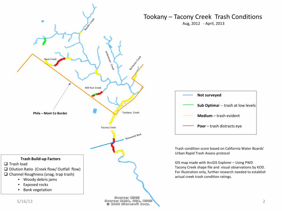
Tookany – Tacony Creek Trash Conditions Aug, 2012 - April, 2013
Not surveyed Sub Optimal -- trash at low levels Medium – trash evident Poor – trash distracts eye
Trash condition score based on California Water Boards’ Urban Rapid Trash Assess protocol GIS map made with ArcGIS Explorer – Using PWD Tacony Creek shape file and visual observations by KOD. For illustration only, further research needed to establish actual creek trash condition ratings.
Phila – Mont Co Border
Rock Creek
Mill Run Creek
Tookany Creek
Tacony Creek
5/16/13 2
Trash Build-up Factors Trash load Dilution Ratio (Creek flow/ Outfall flow) Channel Roughness (snag, trap trash)
• Woody debris jams • Exposed rocks • Bank vegetation

5/16/13 3
PWD MS4 Outfall T-080-02 Trash Just Downstream
Below PWD MS4 Outfall: T-088-01
PWD MS4 Outfall T-097-01 Rock Channel below outfall
PWD CSO Outfall T-05
Preliminary indication that neutral buoyancy materials (plastic bags) may be bypassing PWD inlet traps

Frankford Creek
Rock Creek
T-097-01: PWD MS4 Outfall Location & ID
T-01: PWD CSO Outfall Location & ID
T-01
T-05
T-03
T-09
T-08 T-10
T-080-02
T-080-03
T-097-01
T-088-01
T-079-01
10 PWD Outfalls That Discharge Trash to Tookany – Tacony Creek*
Kelly O’Day ( 5/6/13)
Type PWD Outfall Receiving Creek
Location Level of Evidence
T-079-02 Tacony Creek Adams Ave Trash in outfall channelT-080-02 Tookany Creek Cheltenham Ave Trash in outfall channelT-080-03 Tookany Creek Cheltenham Ave Trash in outfall channelT-088-01 Mill Run Creek Cheltenham Ave Trash in outfall channelT-097-01 Rock Creek Cheltenham Ave Trash in outfall channel
T-01 Rock Creek Below Ogontz Ave LocationT-03 Tacony Creek Below Adams Ave Trash in outfall channelT-05 Tacony Creek Below Rising Sun Ave Trash in outfall channelT-08 Tacony Creek Upstream Roosevelt Bvd LocationT-09 & T-10 Tacony Creek Roosevelt Blvd Location
CSO
MS4
PWD Outfalls with Evidence of Trash Discharge
5/16/13 4
* PWD currently assessing these 10 outfalls.
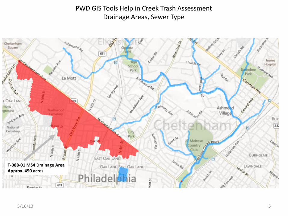
T-088-01 MS4 Drainage Area Approx. 450 acres
PWD GIS Tools Help in Creek Trash Assessment Drainage Areas, Sewer Type
5/16/13 5

Mall
PWD CSO T-01
PWD MS4 T-097-01
PWD MS4 T-097-02
PWD MS4 T-096-01
PWD CSO Area: T-01 261 acres
PWD MS4 Area: T-097 62 acres
PWD MS4 Area: T-096 26 acres
Cedarbrook Plaza
Cheltenham Mall
Cheltenham Plaza
PWD GIS Tools Help in Creek Trash Assessment Outfalls, Drainage Areas, Sewer Type
5/16/13 6
5/16/13 7
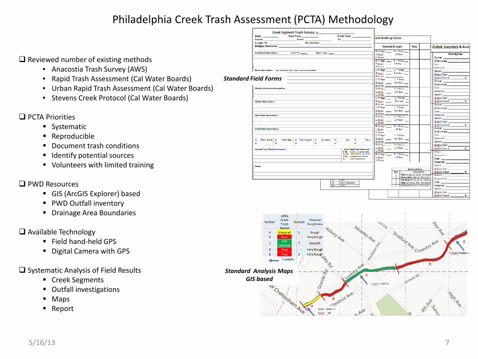
Philadelphia Creek Trash Assessment (PCTA) Methodology
Reviewed number of existing methods • Anacostia Trash Survey (AWS) • Rapid Trash Assessment (Cal Water Boards) • Urban Rapid Trash Assessment (Cal Water Boards) • Stevens Creek Protocol (Cal Water Boards)
PCTA Priorities
Systematic Reproducible Document trash conditions Identify potential sources Volunteers with limited training
PWD Resources
GIS (ArcGIS Explorer) based PWD Outfall inventory Drainage Area Boundaries
Available Technology
Field hand-held GPS Digital Camera with GPS
Systematic Analysis of Field Results
Creek Segments Outfall investigations Maps Report
Standard Field Forms
Standard Analysis Maps GIS based