Tokai Earthquake Preparedness in Shizuoka Prefecture, Japan · PDF fileTokai Earthquake...
32
Tokai Earthquake Preparedness in Shizuoka Prefecture, Japan April 2010 Shizuoka Prefecture This document was originally created and published by Shizuoka Prefecture in Japan. English translation was provided by Yohko Igarashi, Visiting Scientist, ITIC, with the kind acceptance of Shizuoka Prefecture. For Educational and Non-Profit Use Only !
Transcript of Tokai Earthquake Preparedness in Shizuoka Prefecture, Japan · PDF fileTokai Earthquake...

Tokai Earthquake Preparedness in Shizuoka Prefecture, Japan
April 2010
Shizuoka Prefecture This document was originally created and published by Shizuoka Prefecture in Japan. English translation was provided by Yohko Igarashi, Visiting Scientist, ITIC, with the kind acceptance of Shizuoka Prefecture.
For Educational and Non-Profit Use Only !

1. Tokai Earthquake ���������������������������������������� 1 (1) Tokai Earthquake �������������������������������������������������������������������� 1 (2) Basis of the Occurrence of Tokai Earthquake ������������������������������������������ 2
Fujikawa-kako Fault Zone�Tonankai�Nankai Earthquake ������������������������������� 3
2. Estimated Damage���������������������������������������� 4
3. Operation of Earthquake Preparedness ����������������������������� 7
4. Monitoring System for Tokai Earthquake ��������������������������� 10 (1) Governmental System of Earthquake Research ���������������������������������������� 10 (2) Observation Network for Earthquake Prediction in Shizuoka Prefecture ����������������� 11
5. Responses to the Issuance of “Information about Tokai Earthquake” ������������� 12
6. Working on Effective Disaster Management�������������������������� 14 (1) Disaster Management System in Shizuoka Prefecture ���������������������������������� 14 (2) Community Support Staffs in Local Disaster Prevention Bureau ������������������������ 14 (3) Establishing Permanent Disaster Management Headquarters Facilities������������������� 15 (4) Advanced Information Network System ����������������������������������������������� 16 (5) Advanced Disaster Information Support System (ASSIST-II) ��������������������������� 18 (6) Plan to Obtain Support for Wide-Area in Shizuoka Prefecture based on the Guidelines for Tokai Earthquake Emergency Response Activities ������������ 19 (7) National On-Site Disaster Management Headquarters ���������������������������������� 19 (8) Firefighter Aviation Corps ������������������������������������������������������������ 20 Disaster Prevention Function of Mt. Fuji Shizuoka Airport ��������������������������������� 20 (9) Management in Isolated Areas �������������������������������������������������������� 22 (10) Agreement for Use of Tomei Expressway ��������������������������������������������� 22
Analysis of the Residents’ Concerns about Tokai Earthquake ������������������������������ 22 (11) Regulation for Promotion of Earthquake Countermeasures ����������������������������� 23 (12) Agreement on Wide-Area Support by Nationwide Prefectures during Disaster ����������� 23 (13) Acceptance and Support of Disaster Volunteers ���������������������������������������� 23
7. Promotion of Earthquake Countermeasures Action Program 2006 �������������� 24 (1) National Strategy for Earthquake Disaster Management �������������������������������� 24 (2) Earthquake Countermeasure Action Program 2006 ������������������������������������� 24 (3) Project "TOUKAI-0" (Project "no collapse" in Japanese) ������������������������������� 25 (4) Display Earthquake Resistance of Prefectural Buildings �������������������������������� 26 Simplified Version “Wooden Collapse Bu-Ru-Ru” ���������������������������������������� 26 (5) Encourage Local Voluntary Disaster Management Organizations through Collaboration �� 27
Act Concerning Support for Reconstructing Livelihoods of Disaster Victims ����������������� 27
8. Disaster Management Drills ���������������������������������� 28 Establishment of “Tax System for Promotion of the Earthquake Resistant Retrofit of Buildings”��28 Shizuoka Prefectural Earthquake Preparedness Education Center ��������������������������� 29
� Cover ��
��������
Action against the Earthquake with its Epicenter in Suruga Bay on August 11 2009
The Shizuoka Prefecture Disaster Management Headquarter was set up immediately after the earthquake. The emergency action was taken in cooperation with the municipalities in Shizuoka and the relevant disaster prevention organizations.

(1) Tokai Earthquake Mechanism of Plate-Boundary Earthquakes Occurrence An expected Tokai Earthquake is a plate-boundary earthquake (another name is ocean-trench earthquake). The deepest area in Suruga Bay (the area called Suruga Trough) is the boundary of the Philippine Sea plate and Eurasian plate.
���� ������1 In August 1976, Mr. Katsuhiko Ishibashi, an assistant at the Faculty of Science, University of Tokyo, theorized: “It would not be surprising if a large-scale earthquake occurred in the Tokai area centering around Shizuoka Prefecture tomorrow.” The publication of this earthquake theory brought about a serious social problem and it has become the most urgent task for the prefecture, cities and families to prepare for a Tokai Earthquake. Over thirty years have passed without a majorearthquake in this area since this theory was published, but seismologists are in agreement with each other that “The occurrence of a Tokai Earthquake is more likelyday by day.”
Plates around Japan �
Source: Dr. Tetsuzo Seno
Assumed Focal Region of Tokai Earthquake
Source: Japan Meteorological Agency
The Philippine Sea plate, which forms the seabed, moves to the Eurasian plate at the rate of several cm per year and slides below it.
The edge of the Eurasian plate isdragged downward and strain is accumulated.
When the strain comes to the limit, the Eurasian plate springs upward and an earthquake occurs. At that time, tsunami is also generated.
1

(2) Basis of the Occurrence of Tokai Earthquake Large earthquakes occur periodically
Past Large Earthquakes and the Assumed Focal Region along the Pacific Coast
Earthquakes caused by the subduction of oceanic plates occur repeatedly along the Pacific Coast of Japan. From the Tokai region to off Shikoku, where the Philippine Sea plate is subducting, earthquakes of nearly the same magnitude have occurred repeatedly in almost the same place over a 100 to 150 year period. West of the Tokai region, the Tonankai Earthquake and the Nankai Earthquake occurred in 1944 and 1946 respectively after the Ansei-Tokai Earthquake in 1854, and it is thought that the energy of earthquake was once released.
However, from Suruga Bay to the Sea of Enshu, no large earthquake has occurred since the Ansei-Tokai Earthquake in 1854 and this area is called a Blank Area of seismic activity. Earthquake energy is accumulated in this area and a large earthquake is expected to occur in the near future. Also in the western area of Kanagawa Prefecture,
earthquakes measuring near magnitude 7 occurred five times in almost the same interval since the Kanei Earthquake in 1633, and a large earthquake is expected to occur there in the near future.
2

Strain is accumulated underground � Recent Crustal Movements in and around Tokai Region
According to the crustal movement observation in theTokai Region by the Geophysical Survey Institute, the horizontal movement shows contraction in Suruga Bay at a speed of about 1cm/yr along east-west direction and the vertical movement shows subsidence in the western part of Suruga Bay. According to the surveys which are held four times a year, the benchmark in Omaezaki City is subsiding with seasonal variation as shown in the following graph relative to the benchmark in Kakegawa City. It is thought that the earthquake will occur when the subsidence stops and begins to rise.
According to the recent observed data, in a deeper area from the assumed focal region of a Tokai Earthquake, the slow slip (aseismic low speed slip) continued from 2001 until 2005, and it has almost stopped. On the other hand, the seismic activity has been lower than usual (seismic quiescence) from the east of Lake Hamanako to central Shizuoka Prefecture. The energy to generate a Tokai Earthquake has been continuously accumulating and a Tokai Earthquake can occur at any moment as about 150 years have passedsince the previous Ansei-Tokai Earthquake.
�
Fujikawa-kako Fault Zone
Fujikawa-kako fault zone extends in the north-south direction about 20km, from the mouth of Fuji River in the east of Shizuoka Prefecture to the southwestern foot of Mt. Fuji, and is thought to connect to the plate boundary fault in Suruga Bay (the focal region of a Tokai Earthquake). The governmental Earthquake Research Committee published the evaluation results in October 1998, based on the survey until then. The activity of this fault zone ranks one of the highest among the active faults in Japan. The average interval of the past seismic activities (average interval of earthquake occurrences) is about a thousand and several hundred years, and it is highly possible that the latest was more than 1000 years ago. The next seismic activity in this fault zone is expected to bring displacement of 7m or more, magnitude about 8, and the source region will reach Suruga Bay. The active period could be in relatively near future -- in several hundred years -- and according to the long span estimation (January 2006), the probability of the earthquake occurrence in the next 30 years is estimated from 0.2% to 11%.
Tonankai�Nankai Earthquakes
Also in the region along the Nankai trough from the west of the Sea of Enshu to off Shikoku, large subduction-zone earthquakes historically occur at about 100~150 year period. Among the earthquakes, those which occur from the Sea of Enshu to the Sea of Kumano are referred to as a “Tonankai Earthquake”, and those which occur off Shikoku arereferred to as a “Nankai Earthquake”. It is feared that a large earthquake may occur in the first half of this century. “Areas Designated for Promoting Measures against Tonankai�Nankai Earthquakes Disaster” were designated in December 2003, as the areas where there is possibility of extreme disaster by Tonankai�Nankai Earthquakes and 18 cities and towns in Shizuoka Prefecture are designated. According to “General Principles of Countermeasures for Tonankai�Nankai Earthquakes” published by the Central Disaster Management Council in 2003, if a Tokai Earthquake doesn’t occur after considerable time, the possibility of a Tokai Earthquake occurrence related to Tonankai�Nankai Earthquakes will rise. If a Tokai Earthquake does not occur in about another 10 years, this general principle should be re-examined with Countermeasures for a Tokai Earthquake. Even if a Tokai Earthquake and a Tonankai Earthquake occur at the same time, the effect of earthquake movement caused by the fault of a Tokai Earthquake, which is directly below the cities, will be the largest, so the Countermeasures for a Tokai Earthquake should be sufficient.
Location Map of Fujikawa-kako Fault Zone
���������������������������������������������������������������������������������������������
3
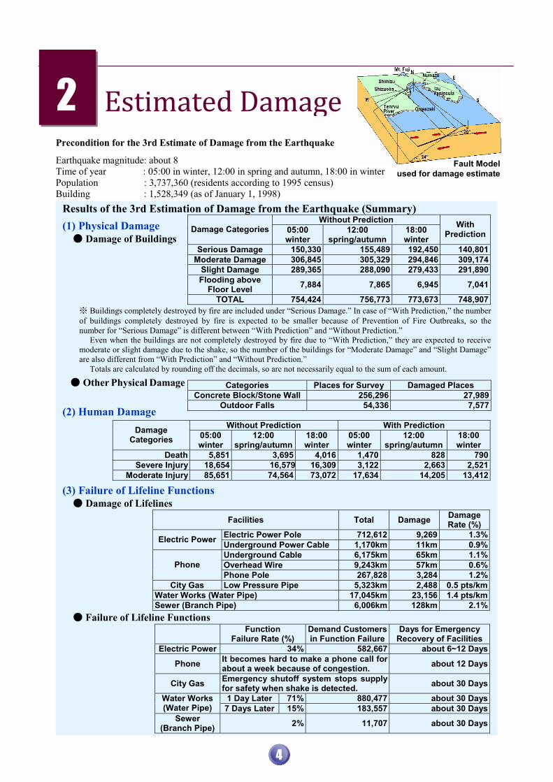
Precondition for the 3rd Estimate of Damage from the Earthquake
Earthquake magnitude: about 8 Time of year : 05:00 in winter, 12:00 in spring and autumn, 18:00 in winter Population : 3,737,360 (residents according to 1995 census) Building : 1,528,349 (as of January 1, 1998)
������������2 Fault Model
used for damage estimate
Results of the 3rd Estimation of Damage from the Earthquake (Summary)
(1) Physical Damage � Damage of Buildings Buildings completely destroyed by fire are included under “Serious Damage.” In case of “With Prediction,” the number
of buildings completely destroyed by fire is expected to be smaller because of Prevention of Fire Outbreaks, so the number for “Serious Damage” is different between “With Prediction” and “Without Prediction.”
Even when the buildings are not completely destroyed by fire due to “With Prediction,” they are expected to receive moderate or slight damage due to the shake, so the number of the buildings for “Moderate Damage” and “Slight Damage” are also different from “With Prediction” and “Without Prediction.”
Totals are calculated by rounding off the decimals, so are not necessarily equal to the sum of each amount.
� Other Physical Damage
(2) Human Damage
Without Prediction With Prediction Damage Categories 05:00
winter 12:00
spring/autumn18:00 winter
05:00 winter
12:00 spring/autumn
18:00 winter
Death 5,851 3,695 4,016 1,470 828 790Severe Injury 18,654 16,579 16,309 3,122 2,663 2,521
Moderate Injury 85,651 74,564 73,072 17,634 14,205 13,412
(3) Failure of Lifeline Functions � Damage of Lifelines
Facilities Total Damage Damage Rate (%)
Electric Power Pole 712,612 9,269 1.3%Electric Power Underground Power Cable 1,170km 11km 0.9%Underground Cable 6,175km 65km 1.1%Overhead Wire 9,243km 57km 0.6%Phone Phone Pole 267,828 3,284 1.2%
City Gas Low Pressure Pipe 5,323km 2,488 0.5 pts/kmWater Works (Water Pipe) 17,045km 23,156 1.4 pts/kmSewer (Branch Pipe) 6,006km 128km 2.1%
� Failure of Lifeline Functions Function
Failure Rate (%) Demand Customers in Function Failure
Days for Emergency Recovery of Facilities
Electric Power 34% 582,667 about 6~12 Days
Phone It becomes hard to make a phone call for about a week because of congestion. about 12 Days
City Gas Emergency shutoff system stops supply for safety when shake is detected. about 30 Days
1 Day Later 71% 880,477 about 30 DaysWater Works (Water Pipe) 7 Days Later 15% 183,557 about 30 Days
Sewer (Branch Pipe) 2% 11,707 about 30 Days
Without Prediction Damage Categories 05:00
winter 12:00
spring/autumn18:00 winter
With Prediction
Serious Damage 150,330 155,489 192,450 140,801Moderate Damage 306,845 305,329 294,846 309,174
Slight Damage 289,365 288,090 279,433 291,890Flooding above
Floor Level 7,884 7,865 6,945 7,041
TOTAL 754,424 756,773 773,673 748,907
Categories Places for Survey Damaged Places Concrete Block/Stone Wall 256,296 27,989
Outdoor Falls 54,336 7,577
4

5

6

Achievements of Earthquake Preparedness Projects Operated by Shizuoka Prefecture (unit: 100 million yen) ���������������������������������������
�
�
�
�
�
�
�
�
�
�
�#
� Achievements of Earthquake Preparedness Projects (unit: 100 million yen)
Category Projects Planned Amount Achieved Amount
as of March 2009 1. Urgent Improvement Project for Earthquake Countermeasures 8,884 8,172 (92%)
1st plan (1996.4~2001.3) 1,758 1,518 (86%)
(as of March 2001) 2nd plan
(1997.4~2006.3) 1,132 632 (56%) (as of March 2006)
2. Earthquake Disaster Prevention Urgent Project 3rd plan
(2006.4~2011.3) 979 410 (42%) (as of March 2009)
3. Earthquake Preparedness Projects operated individually by prefecture, etc.
8,352
Total 19,084 ( ) means progress rate
Achievement of Extra Corporation Enterprise Tax (unit: 1 million yen)
Period Achieved Amount April 1979 ~ March 1984 39,369 April 1984 ~ March 1989 60,147 April 1989 ~ March 1994 56,654
Total 156,170
3 ����������� �������
“Large-Scale Earthquake Countermeasures Special Act” enumerates the shelters, evacuation routes, firefighting facilities, emergency transportation routes and related facilities, communication facilities, etc. as examples of infrastructures that have to be constructed immediately, in order to protect lives and properties from the disaster by a Tokai Earthquake. Shizuoka Prefecture has been constructing various facilities since April 1980 following the Urgent Improvement Project for Earthquake Countermeasures based on “Special Fiscal Measures Act for Urgent Improvement Project for Earthquake Countermeasures in Areas under Intensified Measures against Earthquake Disaster.” The 30-year project will be completed in March 2010.
As for the Five-Year Plan for Earthquake Disaster Prevention Urgent Project based on “Earthquake Disaster Management Special Measures Act,” ShizuokaPrefecture also continues to construct the shelters, emergency transportation routes, etc. from April 2006 to March 2011 following the third Five-Year Plan.Additionally, Shizuoka Prefecture has some other earthquake preparedness projects operated individually by prefecture. Shizuoka Prefecture operated the earthquake preparedness projects by imposing extra corporation enterprise tax over 15 years from April 1979 to March 1994 with understanding and cooperation of enterprises and by using it as a financial resource.
Total and Details of the Cost from April 1979 to March 2009
Total 19,084
Other grant-in-aid to cities and towns etc. 6,232
Construction of emergency transportation routes 3,324
Reconstruction ofearthquake-resistant hospitals, schools andsocial welfare facilities 3,543
Construction of communication facilities 475 Construction of facilities to avoid tsunami hazards 798 Construction of firefighting facilities 787 Construction of shelters and
evacuation routes 1,452
Landslide countermeasures 2,474
7

Earthquake Preparedness Projects so far and the Effects in Reducing Damage
Note1: Cost of projects are the details of the total amount of 1,908 billions yen from April 1979 to March 2009. Main projects are shown above as examples. Note2: Effects in reducing damage is calculated with the projects operated by March 2000.
Construction of shelters and evacuation routes 145.2 billion yen
shelters 81.5ha, evacuation routes 33.3km
Construction of firefighting facilities 78.7 billion yen
earthquake-resistant water tank etc. 8,716 facilities
Reconstruction of earthquake-resistant hospitals, schools and social welfare facilities 354.3 billion yen
primary/junior high school 1,456 schools social welfare facilities 189 facilities
Construction of facilities for avoiding tsunami hazards 79.8 billion yen
river management/coastal conservation facilities 48 facilities
Landslide countermeasures 247.4 billion yen
steep-slope-failure prevention facilities, landslide prevention facilities, etc. 2,526 facilities in total
Speeds up evacuation Secures shelters
Reduces Fire Damage (18:00 in winter)
buildings completely destroyed by fire: 79,000 � 58,000 (26% reduced)human damage: 800 � 590 (27% reduced)
Reduces tsunami inundation area (05:00 in winter)
inundation area: 59km2 � 38 km2 (36% reduced) human damage: deaths 810 � 230 (72% reduced) physical damage: completely destroyed buildings 6,700 � 2,200 (66% reduced)
Secures safety of inpatients, pupils, students and nursing home residents after a sudden earthquake
Secures medical aid centers and evacuation bases after the earthquake
Reduces impacts of landslides (05:00 in winter)
human damage: deaths 660 � 560 (16% reduced)physical damage: completely destroyed buildings 4,200 � 3,500 (15% reduced)
Construction of emergency transportation routes 332.4 billion yen
emergency transportation routes 17.0km
Construction of communication facilities 47.5 billion yen
multipoint wireless 10,680 stations
Other grant-in-aid to cities and towns 623.2 billion yen
construction of disaster management bases, improvement of densely inhabited areas with old buildings, promoting local voluntary disaster management organizations, increasingdisaster management consciousness, etc.
Speeds up emergency transportation of foods, living materials, materials and machinery for recovery, etc.
Improves dissemination of accurate information to the citizens
Expedites appropriate Disaster Management Headquarters Activities
Speeds up disaster emergency response Promotes individual and community disaster mitigation activities
Reduction of Human and Physical Damage
Faster Disaster Emergency Response
8

Johoku Park (Shizuoka City)
Shelter
Large Water Gate with Observatory in Numazu Port “View-O” (Numazu City)
Facilities to Avoid Tsunami Hazards
Community Center in the Third Section (Yaizu City)
Disaster Management Base
Iwachi Nishinota (Matsuzaki Town)
Facilities for Steep-Slope-Failure Prevention
Arai Route12/Arai Overpass (Arai town)
JR Overpass
Fujiminami Junior High School Building (Fuji City)
Reconstruction of Earthquake-Resistant Public Primary and Junior High School
Fire Truck Long Ladder Type (30m) (Shizuoka City)
Firefighting Facilities and Equipment
National Route 478 (Kikugawa City)
Emergency Transportation Route
ImaizumiKaguraishi Route1, Kandagasawa Overpass(Fuji City)
Tomei Overpass
9

(1) Governmental System of Earthquake Research
Earthquake Research Promotion
Based on the Earthquake Disaster Management Special Measures Act, which was enacted in July 1995, the Headquarters of Earthquake Research Promotion was established to advance earthquake research. A Policy Committee was created to examine planning, coordination, formulation and public relations for the policies. An Earthquake Research Committee was created to assess research results for earthquakes. Earthquake Assessment Committee for � Coordinating Committee for Earthquake the Areas Under Intensified Measures Prediction against Earthquake Disaster
4 ������������������������� ������
This committee was established at the time of the designation of the Areas under Intensified Measures against Earthquake Disaster (August 7, 1979) based on the Large-Scale Earthquake Countermeasures Special Act. It is comprised of six university professors in Tokyo who will assess if the anomaly leads to a Tokai Earthquake when strainmeter data show irregular over reference values, etc. When the assessment indicates it is connected with the earthquake occurrence, it is reported to the Prime Minister. The Prime Minister will issue the warning declaration for the areas under intensified measures after the Cabinet meeting decision, and inform the residences in the areas about Tokai Earthquake Warning.
This committee was established in 1969. Members are specialists from government offices (Japan Meteorological Agency, Geophysical Survey Institute, etc.) and universities, involved in the project of earthquake prediction, and examine the latest observed data. The secretariat is in the Geophysical Survey Institute. In addition to the regular meetings every three months, the central, east and west Japan sectional meetings and special plenary meetings are convenedwhen anomalous phenomenon is observed.
Chairman Katsuyuki ABE (Professor Emeritus at University of Tokyo)Members Kunihiko SHIMAZAKI (Professor Emeritus at University of Tokyo) Toshikatsu YOSHII (Professor at College of Humanities and Sciences, Nihon University) Teruyuki KATO (Professor at ERI, University of Tokyo) Naoshi HIRATA (Professor at ERI, University of Tokyo) Akio YOSHIDA (Visiting Professor at Shizuoka University) (as of June 15, 2009)
Chairman Kunihiko SHIMAZAKI (Professor Emeritus at University of Tokyo) Vice Chair East�Central Japan Branch Chair Kunihiko MATSUZAWA (Professor at Graduate School of Science,
Tohoku University) Vice Chair West Japan Branch Chair Kazuo HIRAHARA (Professor at Graduate School of Science, Kyoto University) Members 27 members (as of June 16, 2009)
10
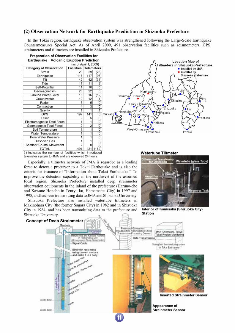
(2) Observation Network for Earthquake Prediction in Shizuoka Prefecture In the Tokai region, earthquake observation system was strengthened following the Large-Scale Earthquake Countermeasures Special Act. As of April 2009, 491 observation facilities such as seismometers, GPS, strainmeters and tiltmeters are installed in Shizuoka Prefecture.
Preparation of Observation Facilities for Earthquake�Volcanic Eruption Prediction (as of April 1, 2009)
Category of Observation Facilities TelemetersStrain 29 29 (23)
Earthquake 117 117 (95)Tilt 42 42 (33)
Tide 11 11 (9)Self-Potential 11 10 (0)
Geomagnetism 28 22 (0)Ground Water-Level 16 16 (12)
Groundwater 12 12 (4)Radon 5 5 (0)
Contraction 4 3 (0)Gravity 1 1 (1)GPS 197 141 (5)Laser 9 5 (0)
Electromagnetic Total Force 1 1 (0)Geomagnetic Total Force 2 2 (0)
Soil Temperature 1 1 (0)Water Temperature 1 1 (0)
Pore Water Pressure 1 1 (0)Dissolved Gas 1 1 (0)
Seafloor Crustal Movement 2 0 (0)TOTAL 491 421 (182)
( ) indicates the number of facilities which introduced telemeter system to JMA and are observed 24 hours.
Especially, a tiltmeter network of JMA is regarded as a leading force to detect a precursor to a Tokai Earthquake and is also the criteria for issuance of “Information about Tokai Earthquake.” To improve the detection capability in the northwest of the assumed focal region, Shizuoka Prefecture installed deep strainmeterobservation equipments in the inland of the prefecture (Haruno-cho and Kawane-Honcho in Tenryu-ku, Hamamatsu City) in 1997 and 1998, and has been transmitting data to JMA and Shizuoka University. Shizuoka Prefecture also installed watertube tiltmeters in Makinohara City (the former Sagara City) in 1982 and in Shizuoka City in 1984, and has been transmitting data to the prefecture and Shizuoka University.
Watertube Tiltmeter
Interior of Kamisaka (Shizuoka City) Station
� Inserted Strainmeter Sensor
Appearance of Strainmeter Sensor
Concept of Deep Strainmeter
11

5 Responses to the Issuance of “Information about Tokai Earthquake”
JMA continually monitors the crustal condition 24 hours a day using observation instruments such as seismometers, strainmeters, etc., installed in the Tokai region centering around Shizuoka Prefecture. When observed data show anomalous changes, JMA issues information about Tokai Earthquake in the following three categories, depending on the danger.
� Tokai Earthquake Report Information when the observed phenomenon cannot be
initially evaluated if it is a precursor of a Tokai Earthquake, or when it turns out to be irrelevant to a precursor.
� Tokai Earthquake Advisory Information when the possibility increases that the
observed phenomenon is a precursor of a Tokai Earthquake.
� Tokai Earthquake Warning Information when the occurrence of a Tokai Earthquakeis expected. This information is reported to the Prime
Minister. The Prime Minister will issue the “Warning Declaration” for the Areas under Intensified Measures against Earthquake Disaster including the whole Shizuoka Prefecture (all the cities and towns) after the Cabinet meeting decision. After Tokai Earthquake Advisory or Tokai
Earthquake Warning is issued, each announcement will be cancelled when it is interpreted that the occurrence of a Tokai Earthquake is no longer expected. The issuances of Tokai Earthquake Report, Tokai Earthquake Advisory, Tokai Earthquake Warning and Warning Declaration are announced to the prefectural residences through TV and radio. When the Warning Declaration is issued, it is also announced through the public-address systems (wireless systems to transmit one message throughout a municipality), sirens, and vehicles with public address system.
Information when the observed phenomenon cannot be initially evaluated if it is a precursor of a Tokai Earthquake, or when it turns out to be irrelevant to a precursor.
Information when the possibility increases that the observed phenomenon is a precursor of a Tokai Earthquake.
Information when the occurrence of a Tokai Earthquake is expected.
(Possibility of the Sudden Occurrence of Tokai Earthquake) Though the observation system and analysis technique for the Tokai Earthquake prediction have improved and advanced every year, it is not 100% reliable. There is always the possibility that a Tokai Earthquake may occur without being predicted. Therefore, it is important to be prepared at all time by securing earthquake resistance of buildings, fixing furniture, storing food and water, etc., so as to respond appropriately whenever an earthquake occurs, without relying on the possibility of earthquake prediction.
12
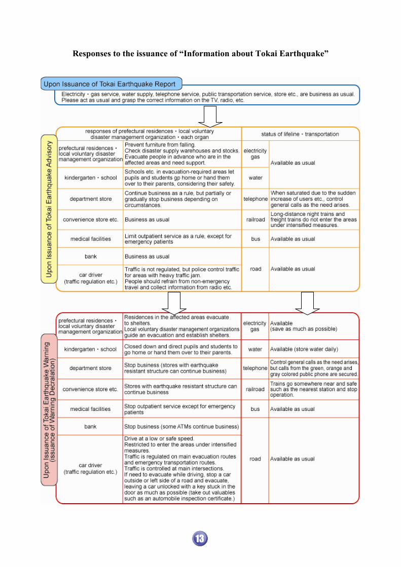
Responses to the issuance of “Information about Tokai Earthquake”
13

(1) Disaster Management System in Shizuoka Prefecture
� Disaster Management District Map � Disaster Management System (2) Community Support Staffs in Local Disaster Prevention Bureau
� � � �
6 ���������� �������������������������
In order to improve and strengthen the disaster emergency response in the local areas in the prefecture, such as information collection, support of municipalities, etc., Shizuoka Prefecture established four local disaster prevention bureaus. These four
bureaus are to play the central role as the local headquarters during a disaster. The prefectural headquarter will work in wide and close cooperation with national government offices and coordinate activities throughout the prefecture.
In Shizuoka Prefecture, support team (team is a title during a disaster, support staffs is the name in usual time, it belongs to local headquarters and commonly called SPECT) was established in April 2005, in order to support largely damaged municipalities to operate disaster emergency response during a disaster by large-scale earthquakes, etc. SPECT is dispatched to the municipalities, which are in need of support after the disaster occurs. SPECT collects damage information, operates emergency responses, coordinates support by prefecture, coordinates the activities of related disaster prevention organizations and coordinates the acceptance of wide-area support by national governments, etc.
SHIZUOKA PREFECTURAL EMERGENCY COORDINATION TEAM [SPECT]is reorganized from the original SPECT established in April 1996.
In normal time, SPECT carries out the training and drills to understand the local geographical and topographical condition and to obtain the knowledge and skill for disaster emergency responses so that municipalities can quickly implement the appropriate measures first when disaster occurs. SPECT also supports municipalities to strengthen their disaster management system, revises the local disaster management plans, works on the subsidies for comprehensive support of large-scale earthquake countermeasure, etc. Additionally, SPECT strengthens the relationship
with lifeline organizations and is promoting disaster management.
14

(3) Establishing Permanent Disaster Management Headquarters Facilities
Shizuoka Pref. Crisis Management Center (EAST) Shizuoka Pref. Crisis Management Center (EAST) Area to make decision Area to plan measures and support
Shizuoka Pref. Crisis Management Center (West) Shizuoka Pref. Crisis Management Center (East) Area to collect and analyze information AV operation desk
��� �Communication Control Room Helicopter TV Transmission System established by prefectural government control bureau (communication control room)
Shizuoka Prefecture has established a permanent
crisis management center at the disaster management headquarters in the prefectural government annex building to handle disasters such as large-scale earthquakes. Shizuoka Prefecture Crisis Management Center was re-equipped from December 2007 to July 2008, to enable the head (prefectural governor) and members to expedite decision making and operation, and to accept support teams smoothly that correspond to the Guidelines for Emergency Activities for the Prevention of Tokai Earthquake, in case of large-scale disasters.
Shizuoka Prefecture Crisis Management Center has arranged monitors to each location to understanddamage throughout the prefecture immediately after a disaster occurs. The center shares information with staffs that are dispatched from related disaster prevention organizations such as Self-Defense Force when a disaster occurs so that they can coordinate quickly. The local disaster prevention bureaus also have the
permanent facilities for the local headquarters. Hotlines to the headquarters, municipal headquarters and other necessary functions are in place.
15

(4) Advanced Information Network System �
�
�
�
�
�
�
� Location of Facilities (as of January 1, 2010)
Detail Name of Facilities Number of Facilities(deployed number) Ground Wireless Station Satellite Earth Station
Prefectural Government (headquarters)
1 1 1
Relay Station
10 10 -
Relay Station for Heli-TV*
1 1 -
Reflection Plate
2 2 -
Comprehensive Office
9 9 9Independent Civil Engineering Office 2 2 2Other Prefectural Branch Office 17 17 17Enterprise Bureau Branch Office 5 - 5Municipality (include branches) 65 61 65Fire Disaster Management organization 26 26 26Related Disaster Management Organization 11 10 10Hospital at Disaster Management Office 9 - 9Reley Mobile for Satellite Transmission 1 - 1Portable Satellite Earth Station 18 - 18Portable Heli-TV* Receiving Device 1 1 -
Total 178 140 163 * Heli-TV: Helicopter TV Transmission System �
�
In May 1996, Shizuoka Prefecture constructed the efficient “comprehensive information network system” by establishing two routes of satellite communication and ground wireless, as a part of information infrastructure to meet the advanced information system. This system unified the ground wireless and satellite communication synthetically and organically, and is highly reliable. The system is constructed as a
communication channel connecting the prefectural office, municipalities and related disaster prevention organizations, and is used practically for various purposes such as data transmission, general administration phone and monitoring as well as disaster prevention communication. From now on, Shizuoka Prefecture will respond tothe advanced network system including digitalization.
16
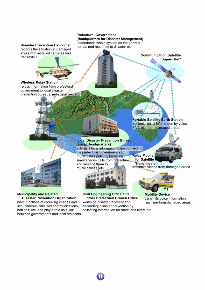
Communication Satellite “Super-Bird”
Disaster Prevention Helicopter records the situation at damaged areas with installed cameras and transmits it.
Prefectural Government(Headquarters for Disaster Management)understands whole system as the general bureau and responds to disaster etc.
Municipality and Related Disaster Prevention Organization have functions of receiving images and simultaneous calls, fax communications, hotlines, etc. and play a role as a link between governments and local residents.
Civil Engineering Office and other Prefectural Branch Office works on disaster recovery and secondary disaster prevention by collecting information on roads and rivers etc.
Mobility Devicetransmits voice information in real time from damaged areas.
Wireless Relay Station relays information from prefectural government to local disaster prevention bureaus, municipalities, etc.
Portable Satellite Earth Stationtransmits initial information by voice, FAX, etc. from damaged areas.
Relay Mobile for Satellite Transmission transmits videos from damaged areas.
Local Disaster Prevention Bureau(Local Headquarters) acts as a local information base connecting the prefectural government and municipalities etc. by receiving simultaneous calls from prefecture and sending them to municipalities, etc.
17

(5) Advanced Disaster Information Support System (ASSIST-II)
“Advanced Disaster Information Support System” (ASSIST-II) can collect information about weather, damage, etc. from national or prefectural government branch offices, municipalities and related disaster prevention organizations quickly and accurately by using computer system. This system supports DisasterEmergency Response. The special feature of this system is that it can provide more accurate information about the situation by visualizing it. “ASSIST-II” ties up with other systems, displays onto the large screens, and integrates various independent disaster prevention systems. “ASSIST-II” supports activities from the stage of establishing national/local headquarters to that of planning measures.
1. System to Collect Damage Information
connects the four local headquarters and branch offices with prefectural headquarters by comprehensive information network, disaster prevention LAN and prefectural government LAN. The system collects damage information quickly and shares disaster information by using computers.
2. Management System for Information of Requests can manage requests information from municipalities to the prefecture and responses for those requests. Also, can grasp the status for responses by the prefecture in real time as “uncertified”, “suspended”, “confirmation required”, “on going” or “done”.
3. System to Collect Map Information ties up with the system for damage information collection and displays damaged areas on a map. Also, utilizes the images from the helicopter TV transmission system and grasps the summary of damage quickly.
4. System for Disaster Prevention Database
constructs database for various basic disaster prevention information such as the locations of shelters, evacuation areas and heliports in the prefecture which are designated in the “Disaster Management Local Plan” in advance. It also supports damage estimation right after a disaster occurs, using the estimated data of seismic intensity, building and human damage ratio and so on in the prefecture, simulated for a hypothetical Tokai Earthquake.
5. Display System for Seismic Intensity ties up with the seismic intensity information network system of Shizuoka Prefecture and JMA Network System for Emergency Disaster Prevention Information, and displays seismic intensity information, weather warnings/advisories and so on. in the prefecture.
6. System to Distribute Information Simultaneously distributes emergency information at the same time to municipalities and related disaster prevention organizations by utilizing Internet and LGWAN.
18

(6) Plan to Obtain Support for Wide-Area in Shizuoka Prefecture based on the Guidelines for Tokai Earthquake Emergency Response Activities
Main Base Locations of Support Teams Base of Support Team at Ashigara Service Area (7) National On-Site Disaster Management Headquarters
National On-Site Disaster Management Headquarters Joint On-Site Management Headquarters Meeting (Drill on January 18, 2007) (Drill on January 18, 2007)
When a large-scale disaster such as a Tokai Earthquake occurs or Tokai Earthquake Warning is declared, “On-Site Headquarters for Urgent Disaster Management” (“On-Site Headquarters for Earthquake Disaster Alert” under declaration of Tokai Earthquake Warning) is established in the Shizuoka Prefectural Government Annex as the on-site headquarters of the national “Headquarters for Urgent Disaster Management” (“Headquarters for Earthquake Disaster Alert” under declaration of Tokai Earthquake Warning) .
This on-site headquarters is headed by the Senior Vice Minister or the Parliamentary Secretary for the Cabinet Office and consists of the staffs of related government offices such as the Cabinet Office, Fire and Disaster Management Agency, and Ministry ofHealth, Labour and Welfare. This on-site headquarterscoordinates the activities with prefecture, collects damage information and requests for support, provides information on the measures of the national government and supports prefecture.
In April 2005, Shizuoka Prefecture formulated thewide-area support acceptance plan to accept nationalwide-area support smoothly when a Tokai Earthquakeetc. occurs. Also, Shizuoka Prefecture amended theplans for medical activities in October 2006. As for the four activity fields of relief andfirefighting, medical treatment, providing relief goods,and transportation, this plan points out the number ofsupport teams and patients in need of aid or wide-area medical transfer, amount of expected relief goods, and scale and area to transport clearly as the main activities. To carry out activities steadily based on the plans, Shizuoka Prefecture checks each role assignment,understands the stock status of personnel and equipment,and examines the plans for activity bases and heliportsin cooperation mostly with local disaster preventionbureaus, and with municipalities and Self-Defense Force.
Scale of Support Team Dispatch (max.)
19

(8) Firefighter Aviation Corps � Summary of Firefighter Aviation Corps
Disaster Prevention Function of Mt. Fuji Shizuoka Airport
Shizuoka Prefecture uses Mt. Fuji Shizuoka Airport as a disaster management base in case of disasters, and aims to improve and strengthen disaster management, using the cases of the Great Hanshin-Awaji Earthquake, the 2004 Mid Niigata Prefecture Earthquake, and the storms and floods in the whole country as lessons. (1) Assembly base for aviation corps and refueling/night-time stationing base for helicopters �use as an assembly base for police or firefighter aviation corps and as a refueling/night-time stationing base for helicopters operating in the prefecture. (2) Support team acceptance base �when the roads are cut-off, use as an acceptance base for aviation support teams, support staffs from lifeline organizations, and materials and emergency relief goods. (3) Wide-area transportation base for serious cases �make a practical use as a wide-area transportation base for the serious illnesses and artificial dialysis patients who need to be transported to non-damaged prefectures by plane. (4) Base to dispatch support staffs to other prefectures �make a practical use as a base to dispatch support staffs from Shizuoka Prefecture when large-scale disasters occur in other prefectures.
In order to prepare the quick and wide-area aviation fire and disaster management system, Shizuoka Prefecture established the firefighter aviation corps with disaster prevention helicopters and highly trained members in 1997. When a large-scale disaster such as a Tokai Earthquake occurs, the disaster prevention helicopter #2 (nickname: Orange Arrow) carries out the disaster emergency response, forest fire fighting, etc. and
Organization / - 8 firefighters dispatched to the prefecture- belong to disaster prevention bureau - members have an additional post as prefecture officers
Establishment / April 1, 1997 Flight time / - 365 days a year
- sunrise to sunset in emergency (except the maintenance season)
Air base / in “Shizuoka Heliport” / emergency dispatch and drill to prepare
the disaster quick response systems for medical transport, rescue, firefighting, etc.
Duties
- medical transport - rescue - fire fighting - disaster emergency response
- normal time investigation of disaster hazardous areas- ensuring the places for taking-off and landing out of the heliport - support of wide-area aviation firefighting activities - support activities under the emergency fire department support corps
protects Shizuoka Prefecture from the air. Shizuoka Prefecture will improve the aviation fire
and disaster management system by constructing the mutual assistance system between Shizuoka City and Hamamatsu City. The former has introduced the firefighter aviation corps since October 1, 2008, and the latter is planning to introduce one by the end of March 2011.
Rendering of Shizuoka Airport
20

� Disaster Prevention Helicopter #2 (Orange Arrow)
Stretcher Device
Hoist Device Tank for Firefighting
Search Light
Camera for Heli-TV
Introduction Date Type Registry Number
February 20, 1997 Kawasaki BK117C-1 JA119R
Overall Length (include main rotor)Overall Width (include main rotor)Overall Height
13.00m 11.00m 3.85m
Number of Sheets 10 sheets (max. 11) Maximum Take-off Weight Zero Fuel Weight Load Weight
3,350 kg 2,175 kg 1,175 kg
Maximum Speed Maximum Cruising Speed Maximum Range Maximum Endurance
278 km/h 248 km/h 555 km 3 hours
Standard Tank 710 � (568kg)
Main Performance/Specification
Hoist Device device to lift up people lift-up ability: 272 kg cable length: 90 m
Repelling Device device for 4 members to repel at the same time
Tank for Firefighting 670 � (self-supply) Packet for Firefighting
600~800 � (self-supply) adjustable for 600, 700, 800 �
Cargo Sling Device device to transport heavy loads under helicopter
ability:1,300kg (with load meter)Stretcher Device device to install 2 stretchers Loudspeaker Device out of the Helicopter
public information:1,000 w ground communication: 250w
Search Light luminous intensity: 30 million cd
Heli-TV transmission device
device with GPS to transmit videos and voice to the ground, recorded by a camera in the helicopter
Main Equipment
Shizuoka City Firefighter Aviation Corps (Shizuoka City Firefighting Helicopter “Kawasemi”)
Shizuoka City introduced the Shizuoka City Firefighter Aviation Corps with the firefighting helicopter “Kawasemi” on October 1, 2008, to understand the damage situation, to rescue and to operate emergent medical service and firefighting quickly and accurately under any disasters as well as a Tokai Earthquake. Shizuoka Prefecture and City concluded “The Mutual Assistance Agreement for the Aviation Fire Management in Shizuoka Prefecture” on March 26, 2008 to strengthen the aviation fire management system in the prefecture.
Profile of “Kawasemi”
- Canadian Bell 412EP - Maximum Personnel Capacity 15 - Maximum Cruising Speed 226km/h - Main Devices Resource Hoist Tank for Firefighting Emergency Stretcher Heli-TV Transmission Device
21
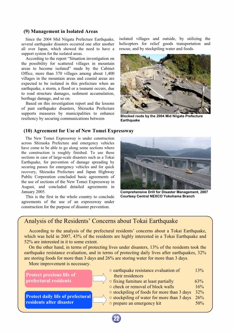
(9) Management in Isolated Areas (10) Agreement for Use of New Tomei Expressway
Blocked route by the 2004 Mid Niigata Prefecture Earthquake
Since the 2004 Mid Niigata Prefecture Earthquake,several earthquake disasters occurred one after another all over Japan, which showed the need to have a support system for the isolated areas. According to the report “Situation investigation on the possibility for scattered villages in mountain areas to become isolated” made by the Cabinet Office, more than 370 villages among about 1,400 villages in the mountain areas and coastal areas are expected to be isolated in this prefecture when an earthquake, a storm, a flood or a tsunami occurs, due to road structure damages, sediment accumulation, berthage damage, and so on. Based on this investigation report and the lessons of past earthquake disasters, Shizuoka Prefecture supports measures by municipalities to enhance resiliency by securing communications between
isolated villages and outside, by utilizing the helicopters for relief goods transportation and rescue, and by stockpiling water and foods.
The New Tomei Expressway is under construction across Shizuoka Prefecture and emergency vehicles have come to be able to go along some sections where the construction is roughly finished. To use thesesections in case of large-scale disasters such as a Tokai Earthquake, for prevention of damage spreading by securing passes for emergency vehicles and for quick recovery, Shizuoka Prefecture and Japan Highway Public Corporation concluded basic agreements of the use of sections of the New Tomei Expressway in August, and concluded detailed agreements in January 2005. This is the first in the whole country to conclude agreements of the use of an expressway under construction for the purpose of disaster prevention.
Comprehensive Drill for Disaster Management, 2007Courtesy Central NEXCO Yokohama Branch
Analysis of the Residents’ Concerns about Tokai Earthquake According to the analysis of the prefectural residents’ concerns about a Tokai Earthquake, which was held in 2007, 43% of the residents are highly interested in a Tokai Earthquake and 52% are interested in it to some extent. On the other hand, in terms of protecting lives under disasters, 13% of the residents took the earthquake resistance evaluation, and in terms of protecting daily lives after earthquakes, 32% are storing foods for more than 3 days and 26% are storing water for more than 3 days. More improvement is necessary.
� earthquake resistance evaluation of 13% their residences � fixing furniture at least partially 63% � check or removal of block walls 16% � stockpiling of foods for more than 3 days 32% � stockpiling of water for more than 3 days 26% � prepare an emergency kit 50%
Protect precious life of prefectural residents
Protect daily life of prefectural residents after disaster
22

(11) Regulation for Promotion of Earthquake Countermeasures
(12) Agreement on Wide-Area Support by Nationwide Prefectures during Disaster
(13) Acceptance and Support of Disaster Volunteers
To protect residents’ life, health and property from large-scale disasters such as the expected Tokai Earthquake or earthquakes in the western area of Kanagawa Prefecture by making use of the lessons from the Great Hanshin-Awaji Earthquake, Shizuoka Prefecture clarifies the responsibility of prefecture, municipalities and residents. Also, Shizuoka Prefecture promotes the accurate earthquake managements by determining measures for disaster
preparedness such as the prevention of buildings collapse due to earthquakes, measures for securing the emergency traffic after earthquakes occur and for others which are particularly significant for earthquake management. Then, in order to improve resiliencyagainst the earthquake disasters where residents can live safely, Shizuoka Prefecture enacted “earthquakecounter-measure promotion regulation” on March 22, 1996 and executed it on April 1, 1996.
In July 1996, the National Governors’ Association and each prefecture concluded the “Agreement on the Wide-Area Support by Nationwide Prefectures under Disaster” for each prefecture to support wide area according to the request from damaged prefectures under the coordination by the National Governors’ Association, in case that a large scale disaster occurs and damaged prefectures or each regional governors’ association cannot operate enough emergency response. Based on this agreement, 15 prefectures including Shizuoka Prefecture dispatched 200 prefectural officers to Nagaoka and Ojiya City to manage shelter operations
for the 2004 Mid Niigata Prefecture Earthquake, and 3 prefectures dispatched 12 prefectural officers to Kashiwazaki City to assess residential property damage for the 2007 Off Mid Niigata Prefecture Earthquake. Additionally, Shizuoka Prefecture coordinated the wide-area support with nation government offices and each prefecture and also dispatched 368 doctors, nurses, architects and civil engineers according to the request from the nation etc. for the 2004 Mid Niigata Prefecture Earthquake. Shizuoka Prefecture dispatched 42 nurses and architects for the 2007 Off Mid Niigata Earthquake.
When the disaster management headquarters and local headquarters are established, Shizuoka Prefecture will coordinate the arrangements over the municipality boundaries, by establishing the prefectural disaster volunteer headquarters and information center, and prefectural disaster volunteer support center, in cooperation with Shizuoka Council of Social Welfare, Shizuoka Volunteer Association and volunteer groups. In order to make this system work smoothly, Shizuoka Prefecture carries out the drills of setup and operation of volunteer headquarters in cooperation with Shizuoka Volunteer Association. Also, disaster volunteer coordinators are trained as human resources to manage these headquarters operations. Additionally, Shizuoka Prefecture established a “Fund for Shizuoka Prefecture Disaster Volunteer Activities” for the first time in this country as the fund
for operation cost when the headquarters are established (the balance of the fund at the end of March 2007 was about 50 million yen).
Medical Examinations for the Residents by Medical Relief Staffs
Transportation of Foods to the Sheltersby the Dispatched Officers, etc.
Support Activities by Disaster Volunteer Groups
23

(1) National Strategy for Earthquake Disaster Management (2) Earthquake Countermeasures Action Program 2006
7 Promotion of Earthquake Counter- measures Action Program 2006
Japan established the “Earthquake Disaster Management Strategy” for a Tokai Earthquake. The goal is to reduce the number of deaths and the amount of economic damage by half in the next 10 years (by the end of March 2015), at the Central Disaster Management Council in March 2005. To achieve this target, it is necessary for local government to participate. Therefore, Japan amended the Basic Disaster Management Plan and decided that prefectures also should identify a “local target” based on the Strategy for Earthquake Disaster Management.
� Central Disaster Management Council � �
� “Central Disaster Management Council” is a council consists of the Prime Minister, who takes the chair, all Cabinet Ministers, chiefs of designated public corporations and people of experience or academic standing, and offers opinions regarding important matters pertinent to disaster management to the Prime Minister and Minister of State for Disaster Management.
In order to reduce the damage due to a Tokai Earthquake efficiently, it is necessary to set a definite amount of damage reduction as a target value, select effective countermeasures and promote in a focused manner. Therefore, based on the national Earthquake Disaster Management Strategy, Shizuoka Prefecture updated the “Earthquake Countermeasures Action Program 2001,” which Shizuoka Prefecture had been working on since 2001, and established the “Earthquake Countermeasures Action Program 2006” as the “local target”. From now on, Shizuoka Prefecture will operate the countermeasures incorporated in the “Earthquake Countermeasures Action Program 2006” steadily and will make an effort to achieve the target, through collaboration with the prefectural residents.
24
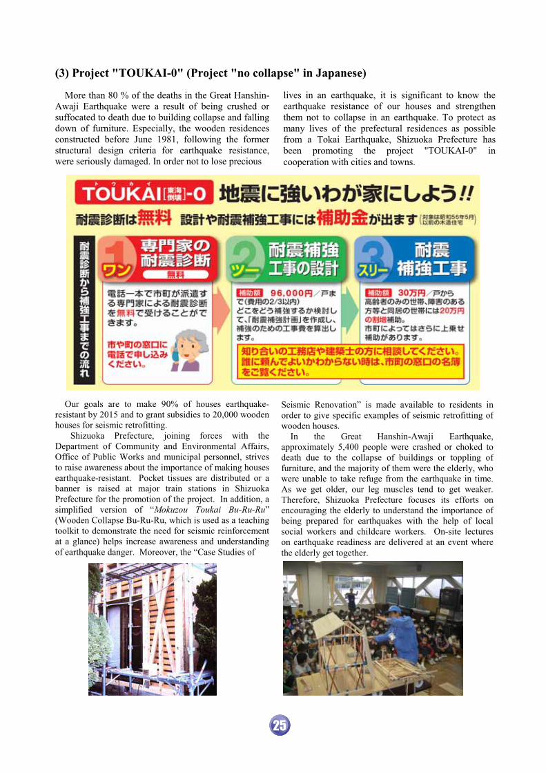
(3) Project "TOUKAI-0" (Project "no collapse" in Japanese)
� � � � � � � � �
lives in an earthquake, it is significant to know the earthquake resistance of our houses and strengthen them not to collapse in an earthquake. To protect as many lives of the prefectural residences as possible from a Tokai Earthquake, Shizuoka Prefecture has been promoting the project "TOUKAI-0" in cooperation with cities and towns.
More than 80 % of the deaths in the Great Hanshin-Awaji Earthquake were a result of being crushed or suffocated to death due to building collapse and falling down of furniture. Especially, the wooden residences constructed before June 1981, following the former structural design criteria for earthquake resistance, were seriously damaged. In order not to lose precious
25
Our goals are to make 90% of houses earthquake-resistant by 2015 and to grant subsidies to 20,000 wooden houses for seismic retrofitting. � Shizuoka Prefecture, joining forces with the Department of Community and Environmental Affairs, Office of Public Works and municipal personnel, strives to raise awareness about the importance of making houses earthquake-resistant. Pocket tissues are distributed or a banner is raised at major train stations in Shizuoka Prefecture for the promotion of the project. In addition, a simplified version of “Mokuzou Toukai Bu-Ru-Ru” (Wooden Collapse Bu-Ru-Ru, which is used as a teaching toolkit to demonstrate the need for seismic reinforcement at a glance) helps increase awareness and understanding of earthquake danger. Moreover, the “Case Studies of
Seismic Renovation” is made available to residents in order to give specific examples of seismic retrofitting of wooden houses.
In the Great Hanshin-Awaji Earthquake, approximately 5,400 people were crashed or choked to death due to the collapse of buildings or toppling of furniture, and the majority of them were the elderly, who were unable to take refuge from the earthquake in time. As we get older, our leg muscles tend to get weaker. Therefore, Shizuoka Prefecture focuses its efforts on encouraging the elderly to understand the importance of being prepared for earthquakes with the help of local social workers and childcare workers. On-site lectures on earthquake readiness are delivered at an event where the elderly get together.

(4) Display Earthquake Resistance of Prefectural Buildings
� � � � � � � � � � � � � � � � � � � � � �
� � � � � � � � � � � � � � � � � � � � � �
The General Principles of Countermeasures for Tokai Earthquake was decided at the Central Disaster Management Council, and the Emergency Action Plan for Tokai Earthquake was decided at the Cabinet meeting in 2003. In this Plan, it was indicated to compile a list of the status of earthquake resistance in public buildings and inform the public, so that the residences can react appropriately in case of disasters. Following this decision, in April 2004, Shizuoka Prefecture published an official list of earthquake resistance of prefectural buildings. In 2006, Shizuoka Prefecture started displaying earthquake resistance information for each building to inform the citizens and visitors of that information and how to react in case of disasters. Among the prefectural buildings whose earthquake resistance information is published in the list (3,056 buildings as of April 1, 2008), the information is posted for the 2,318 buildings, which will serve as centers during disasters or many people use. The sign is about B5 size and is placed on where it is highly visible like an entrance. Based on the criteria for earthquake resistance created by Shizuoka Prefecture, the sign is colored green for the buildings in the category of Ia and Ib, which have enough earthquake resistance against a Tokai Earthquake, and is colored yellow for the buildings in the category of II and III, which lack earthquake resistance. Shizuoka Prefecture’s criteria Ia is evaluated to be about 1.8 times stronger, and Ib to be about 1.5 times stronger, as compared with the criteria in the Japanese Building Standard Law. All the cities and towns in Shizuoka Prefecture have a list for earthquake resistance of public buildings and proceed to label the buildings the same way the prefecture does.
�� translation…
“Building designated as a Center during
Disasters Entry to this building may be restricted by the issuance of Warning Declaration or after a Tokai Earthquake.”
�� translation…
- Do not enter this building at the issuance of Warning Declaration.
- Contact the building manager if you enter this building after a Tokai Earthquake.�
Label Indications
Simplified Version “Wooden Collapse Bu-Ru-Ru”
To motivate people effectively to make their homes earthquake resistant, Shizuoka Prefecture developed the Simplified Version of “Wooden House Collapse Bu-Ru-Ru” as a wooden collapse experimentalteaching material, and established a system to produce and sell through collaboration with Professor Fukuwa at the Graduate School of Nagoya University and Shizuoka Prefecture Workshop Federation “WA,” a Nonprofit Corporation.
Experiment on the Simplified Version “Wooden House Collapse Bu-Ru-Ru”
The Simplified Version of “Wooden Collapse Bu-Ru-Ru” models a two-story house with a frontage of roughly 3.6m and depth of about 5.5m, on a scale of one to ten. Two houses with different construction; with or without braces and shear walls, or with heavy or light roof, etc., are placed next to each other on a table with pulleys (shaking table). We can learn the difference in the way of shaking and the necessity of earthquake resistant structural reinforcement visually by shaking the table. The Simplified Version of “Wooden Collapse Bu-Ru-Ru” is found in local disaster prevention bureaus, civil engineering offices and so on, and will be used as a teaching material foreducation in seismic retrofitting in cities and towns, schools, and local communities.
26

(5) Encourage Local Voluntary Disaster Management Organizations through Collaboration
To protect ourselves and our family from a large-scale earthquake such as a Tokai Earthquake, we have to undertake enough preparedness measures for the occurrence of various disasters. However, once a large-scale earthquake occurs, what an individual or a family can do to prevent disaster expansion is limited, and sometimes it is accompanied with danger and difficulty. In such cases, it is necessary for neighbors, who meet in daily life, to gather, cooperate with each other and work on disaster prevention systematically. “Local voluntary disaster management organization” is an organization for local people to work on disaster preparedness together, not only during disasters but on a daily basis. Those organizations are formed almost 100%,
about 5,000 organizations, throughout the prefecture. In order for the residents to act adequately and minimize damage when a large-scale disaster occurs, local voluntary disaster management organizations are preparing for the damage due to earthquakes such as safety check in local areas, dissemination and education of knowledge on disaster management to the residents,
operation of disaster management drills, and more. Also, when an earthquake actually occurs, local voluntary disaster management organizations play very important roles such as initial firefighting, rescuing victims, collecting information, administration of shelters, among other things. Shizuoka Prefecture is also working on professional
trainings for local disaster management instructors, who lead local voluntary disaster management organizations, Shizuoka Prefecture disaster management specialists, who work on disaster management in administration or enterprise offices using their professional knowledge on disaster management, etc., to promote enrichment and build-up of local disaster management ability throughcollaboration with local voluntary disaster management organizations, related disaster management organizations, firefighting corps, disaster management specialists, disaster volunteers, schools, business establishments, welfare commissioners and children’s commissioners, welfare groups, and so on.
Damage Degree of Residence Reconstruction Method Basic Support Fund
Additional Support Fund TOTAL
Construct/Purchase 100 200 300 Repair 100 100 200 Completely Destroyed Rent 100 50 150
Construct/Purchase 50 200 250 Repair 50 100 150 Half Destroyed, Large-Scale
Repair is Required Rent 50 50 100
Act Concerning Support for Reconstructing Livelihoods of Disaster Victims “Act Concerning Support for Reconstructing Livelihoods of Disaster Victims” supports families, whose houses were severely damaged due to natural disasters such as earthquake or typhoon, to reconstruct their livelihoods by providing support funds. This Act is aiming to encourage and assist efforts to reconstruct by themselves. This Act applies to prefectures or cities, towns and villages which are damaged over a certain amount, and supports households where residences are completely or half destroyed (no limit by age or annual income). Support funds are categorized into “Basic Support Fund” and “Additional Support Fund”. The former is provided depending on the extent of damage to residences such as “completely destroyed,” and the latter is provided depending on the way of reconstruction such as “construct newly,” or “repair.” Support funds are provided in flat-rate payment without limiting the use, and the amount is 3 million yen at maximum. (unit: 10,000 yen)
For Households who live alone, the amount of the funds become 3/4 of above.
�
Safety Check in Local Areas
Dissemination and Education of Knowledge on Disaster Management Disaster Management Drills
Initial Firefighting
Rescue
Collection and Transmission of Information Evacuation Guidance
Administration of Shelters
Normal Condition
Act
iviti
es o
f loc
al v
olun
tary
dis
aste
r m
anag
emen
t org
aniz
atio
ns
Activities to prepare for large-scale disasters through safety check in local areas or residences and disaster management drills
Activities to protect people and prevent disasters from expanding when large-scale disasters occur
DuringDisaster
Safety Check in Local Areas
Dissemination and Education of Knowledge on Disaster Management Disaster Management Drills
Initial Firefighting
Rescue
Collection and Transmission of Information Evacuation Guidance
Administration of Shelters
Normal ConditionNormal
Condition
Act
iviti
es o
f loc
al v
olun
tary
dis
aste
r m
anag
emen
t org
aniz
atio
ns
Activities to prepare for large-scale disasters through safety check in local areas or residences and disaster management drills
Activities to protect people and prevent disasters from expanding when large-scale disasters occur
DuringDisasterDuring
Disaster
27

�
�
�
� �
�
�
�
�
�
�
�
�
�
�
�
�
�
�
�
�
�
�
�
�
�
�
�
�
�
�
�
�
�
�
�
�
��
�
�
�
�
�
�
�
�
�
to do by practicing drills repeatedly for all possible scenarios in normal times. Therefore, the following drills are mainly operated in Shizuoka Prefecture.
Scenario: Earthquake as large as Tokai Earthquake occurred suddenly When a Tokai Earthquake occurs, tsunami will hit the coastal areas in theprefecture and severe damage is expected. In order to prepare for this case, formerTachibana town and the prefecture operated Tsunami Evacuation Drill in 1989 for the first time. These days, the prefecture, municipalities along the coasts, relateddisaster prevention organizations and autonomous disaster preventionorganizations operate Tsunami Evacuation Drill on one day during the Tsunami Preparedness Promotion Period (July 1 ~ 10). This drill aims to operate drills of information communication to residents,evacuation indication for visitors in the beach such as tourists, rescuing victimsand closing floodgates, and to learn how to mitigate disasters.
Tsunami Evacuation Drill (Tsunami Preparedness Promotion Period: July 1~10)
Scenario: Tokai Earthquake occurred suddenly This mobilization drill is annually held in middle or late April for all the staffs without notice in advance, under estimation of a Tokai Earthquake’s sudden occurrence. This drill aims to maintain initial responses in the disaster management headquarters after the personnel change in April.
Personnel Mobilization Drill in the Prefecture
Scenario: Tokai Earthquake is predicted
“Tokai Earthquake Theory” was presented in 1976 and “Large-Scale EarthquakeCountermeasures Special Act” was enacted in 1978. Shizuoka Prefecture has been participating in the Comprehensive Drill for Disaster Management since 1979, which estimates the occurrence of a Tokai Earthquake, in order to deal with thelarge-scale earthquake disasters. The nation, prefecture, municipalities, related disaster prevention organizations and autonomous disaster prevention organizations cooperate to operate the drill, aiming to execute measures planned by each family and autonomous disaster prevention organization and to learn how to act for disaster prevention, when Tokai Earthquake Advisory or Warning is issued.
Comprehensive Drill for Disaster Management
(September 1)
Scenario: Earthquake as large as Tokai Earthquake occurred suddenly “Regional Disaster Prevention Day” was established for the Tonankai Earthquake which occurred on December 7, 1944. Regional Disaster Prevention Drill has been operated on the 1st Sunday in December, which is called “Regional Disaster Prevention Day,” since 1983 every year. In the drill, each municipality individually operates a series of management drills, such as evacuation, firefighting and rescue after the earthquake occurrence, mainly under the autonomous disaster prevention organization’s lead. This drill aims to make use of each local characteristic and learn how to mitigate disasters.
Regional Disaster Prevention Drill
(1st Sunday in December: Regional Disaster Prevention Day)
Since earthquake disasters cause wide and various damageand confusion, quick and accurate responses are expected. To keep calm in an emergency, it is necessary to learn what
�������������������� ��8
Establishment of “Tax System for Promotion of the Earthquake Resistant Retrofit of Building” “Earthquake Disaster Management Strategy,” which aims to reduce the number of deaths and amount of economic damage by half in another 10 years, was decided at the Central Disaster Management Council in March 2005. To achieve this objective, a specific objective was incorporated to raise the rate of earthquake resistant residences from 75% (as of 2003) to 90% by March 2015. To support this objective, “Tax System for Promotion of the Earthquake Resistant Retrofit of Buildings” was established at the tax reform in 2006.
Object Object Residence Deduction Income
Tax
People who seismically retrofit their houses from Apr.1 2006 to Dec.31 2008
Construction started before May 31, 1981 for one’s own residence, not conforming to the current standard of earthquake resistance
Deduct 10% of the cost for the retrofit from income tax (maximum limit: 200,000 yen)
Fixed Assets Tax
People who complete seismic retrofitting of their residences from Jan.1 2006 to Dec.31 2015 (include rental-house business)
Exists since Jan.1, 1982 or before
Deduct the fixed assets tax a half during the following periods � 2006~2009 complete retrofit: 3 years� 2010~2012 complete retrofit: 2 years� 2013~2015 complete retrofit: 1year
28
�
�
�
�
�
�
�
�
� � �
�
�
�
�
�
�
�� ��� ��
�
�
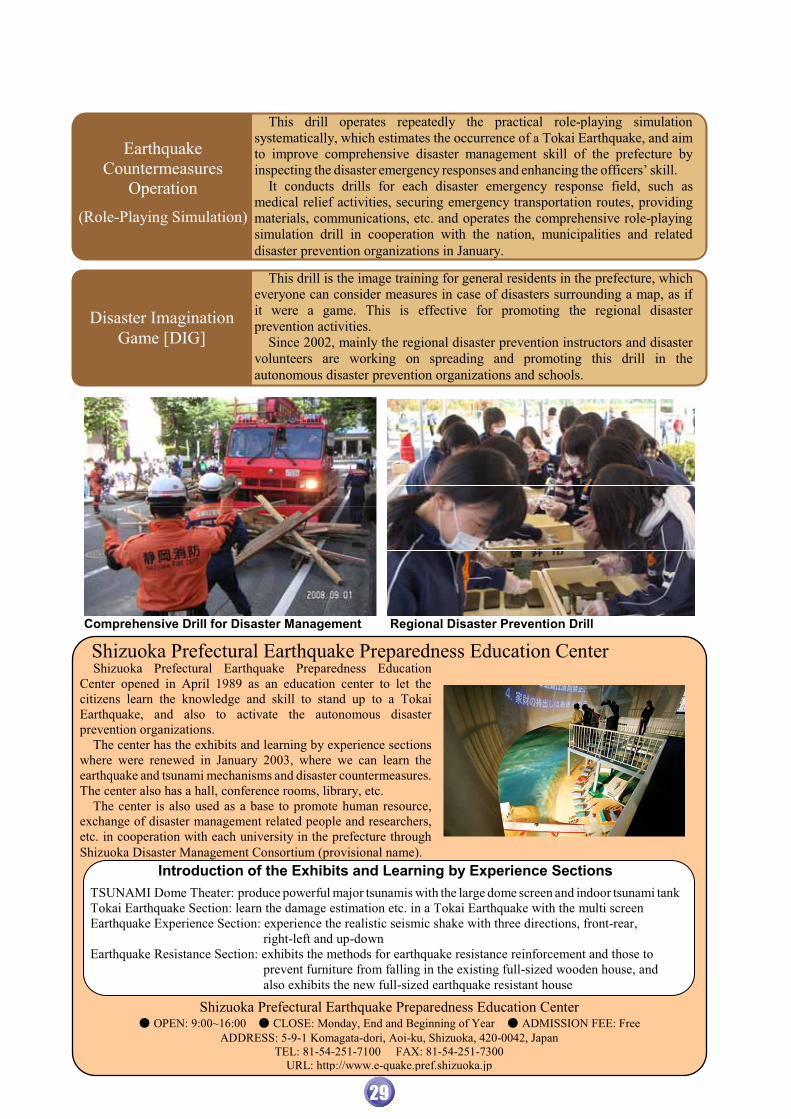
This drill operates repeatedly the practical role-playing simulation systematically, which estimates the occurrence of a Tokai Earthquake, and aimto improve comprehensive disaster management skill of the prefecture by inspecting the disaster emergency responses and enhancing the officers’ skill. It conducts drills for each disaster emergency response field, such as medical relief activities, securing emergency transportation routes, providing materials, communications, etc. and operates the comprehensive role-playing simulation drill in cooperation with the nation, municipalities and related disaster prevention organizations in January.
Earthquake Countermeasures
Operation
(Role-Playing Simulation)
This drill is the image training for general residents in the prefecture, which everyone can consider measures in case of disasters surrounding a map, as if it were a game. This is effective for promoting the regional disaster prevention activities. Since 2002, mainly the regional disaster prevention instructors and disaster volunteers are working on spreading and promoting this drill in the autonomous disaster prevention organizations and schools.
Disaster Imagination Game [DIG]
Comprehensive Drill for Disaster Management Regional Disaster Prevention Drill
Shizuoka Prefectural Earthquake Preparedness Education Center Shizuoka Prefectural Earthquake Preparedness Education Center opened in April 1989 as an education center to let the citizens learn the knowledge and skill to stand up to a Tokai Earthquake, and also to activate the autonomous disaster prevention organizations. The center has the exhibits and learning by experience sectionswhere were renewed in January 2003, where we can learn the earthquake and tsunami mechanisms and disaster countermeasures. The center also has a hall, conference rooms, library, etc. The center is also used as a base to promote human resource, exchange of disaster management related people and researchers, etc. in cooperation with each university in the prefecture through Shizuoka Disaster Management Consortium (provisional name).
Introduction of the Exhibits and Learning by Experience Sections
TSUNAMI Dome Theater: produce powerful major tsunamis with the large dome screen and indoor tsunami tankTokai Earthquake Section: learn the damage estimation etc. in a Tokai Earthquake with the multi screen Earthquake Experience Section: experience the realistic seismic shake with three directions, front-rear, right-left and up-down Earthquake Resistance Section: exhibits the methods for earthquake resistance reinforcement and those to prevent furniture from falling in the existing full-sized wooden house, and also exhibits the new full-sized earthquake resistant house
Shizuoka Prefectural Earthquake Preparedness Education Center � OPEN: 9:00~16:00 � CLOSE: Monday, End and Beginning of Year � ADMISSION FEE: Free
ADDRESS: 5-9-1 Komagata-dori, Aoi-ku, Shizuoka, 420-0042, Japan TEL: 81-54-251-7100 FAX: 81-54-251-7300
URL: http://www.e-quake.pref.shizuoka.jp
29

�
Disaster Prevention Information via Internet is available on the web site of Shizuoka Prefecture Department of Emergency Management Shizuoka Prefecture Department of Emergency Management http://www.pref.shizuoka.jp/bousai/
Protecting you and your family from Earthquakes “Life Passport” http://www.pref.shizuoka.jp/m/lifepass/j_index.html (Japanese) This site is created for mobile phone access.
Edited and Published by
Shizuoka Prefecture Department of Emergency Management
9-6 Ote-machi Aoiku Shizuoka City 420-8061, Japan
TEL: 81-54-221-3596 FAX: 81-54-221-3252


![Proposals to Extend Healthy Life Expectancy in Shizuoka ...€¦ · [Gap between life expectancy and healthy life expectancy in Shizuoka Prefecture] Healthy life expectancy *Source:](https://static.fdocuments.net/doc/165x107/5f427921a09c2479a15262fb/proposals-to-extend-healthy-life-expectancy-in-shizuoka-gap-between-life-expectancy.jpg)