To what extent is integration pursued in compulsory ...
43
This is the accepted version of the following article: Lai S., Leone F. (2020) To what extent is integration pursued in compulsory planning tools concerning coastal and marine areas? Evidences from two Mediterranean protected areas. Land Use Policy, 99 104859 (16 pp.), ISSN: 0264-8377. https://doi.org/10.1016/j.landusepol.2020.104859 To what extent is integration pursued in compulsory planning tools concerning coastal and marine areas? Evidences from two Mediterranean protected areas. Abstract: Coastal areas are worldwide characterized by multiple pressures generated by high levels of urbanization and by conflictual and inappropriate uses. The establishment of protected areas represents a tool to contrast such pressures. The integration between planning tools represents a key issue, in particular in the Mediterranean area; hence, it has been addressed by both legally binding acts and voluntary agreements and charters concerning coastal zone management as well as marine spatial planning. By looking at two Italian case studies and analyzing their planning documents currently in force, our study aims at assessing the level of integration in relation to planning and management of areas characterized by the coexistence of various nature protection regimes. Our analysis shows that, although integration seems to be a key point in the planning agenda and in spite of some improvements, an integrated management approach in Mediterranean coastal and marine areas is still in its infancy. The results of the analysis show that, rather than contributing to building an integrated approach to marine and coastal zone management, each planning tool focuses on complying with its sectoral, normative framework. This situation can partly be attributed to the multilayered, and complex, Italian framework, characterized by several categories of protected areas with their own legal act and objectives. Keywords: Environmental planning; Natural protected areas; Marine protected areas; Natura 2000 sites; Integrated coastal area management; Coastal zone management.
Transcript of To what extent is integration pursued in compulsory ...

This is the accepted version of the following article:
Lai S., Leone F. (2020) To what extent is integration pursued in compulsory planning tools
concerning coastal and marine areas? Evidences from two Mediterranean protected areas.
Land Use Policy, 99 104859 (16 pp.), ISSN: 0264-8377.
https://doi.org/10.1016/j.landusepol.2020.104859
To what extent is integration pursued in compulsory planning tools
concerning coastal and marine areas? Evidences from two Mediterranean
protected areas.
Abstract: Coastal areas are worldwide characterized by multiple pressures generated by
high levels of urbanization and by conflictual and inappropriate uses. The establishment of
protected areas represents a tool to contrast such pressures. The integration between planning
tools represents a key issue, in particular in the Mediterranean area; hence, it has been
addressed by both legally binding acts and voluntary agreements and charters concerning
coastal zone management as well as marine spatial planning. By looking at two Italian case
studies and analyzing their planning documents currently in force, our study aims at
assessing the level of integration in relation to planning and management of areas
characterized by the coexistence of various nature protection regimes. Our analysis shows
that, although integration seems to be a key point in the planning agenda and in spite of some
improvements, an integrated management approach in Mediterranean coastal and marine
areas is still in its infancy. The results of the analysis show that, rather than contributing to
building an integrated approach to marine and coastal zone management, each planning tool
focuses on complying with its sectoral, normative framework. This situation can partly be
attributed to the multilayered, and complex, Italian framework, characterized by several
categories of protected areas with their own legal act and objectives.
Keywords: Environmental planning; Natural protected areas; Marine protected areas; Natura 2000
sites; Integrated coastal area management; Coastal zone management.
1. Introduction
Coastal areas, increasingly referred to as land-sea interfaces, are characterized by complex
natural processes; at the same time, they are affected by environmental degradation due to
both the intrinsic fragility of transition areas and conflicting and inadequate uses. According
to data provided by Eurostat (Engelbert and Collet, 2013), in the Mediterranean Basin, the
high level of urbanization of coastal zones has further exacerbated the situation. Data from
the European Environmental Agency (2013) show that around 40 percent of the European
population lives within a 50-km buffer zone from the coastline. Moreover, new
developments in coastal areas have entailed several impacts on coastal and marine
ecosystems in terms of population pressure and in terms of risks deriving from climate
change. Therefore, coastal areas are not merely a boundary; rather, they, represent a
transitional space where the effects of the land on the sea and vice versa are not fully
understood yet (Van Assche et al., in press).
At the international level, various typologies of protected areas (the most popular of which
are Marine Protected Areas (MPAs)) have been established in order to deal with pressures
that threaten coastal areas. In the Mediterranean Basin, MPAs cover 4 percent of the total
marine surface (Gabrié et al., 2012), that is, around 100,000 square kilometers. Moreover,
Directive 92/43/EEC “on the conservation of natural habitats and of wild fauna and flora”,
henceforth the Habitats Directive, established the Natura 2000 Network, an ecological
network of protected areas. In particular, the Network includes three typologies of sites: Sites
of Community Importance (SCIs) and Special Areas of Conservation (SACs), established
under the Habitats Directive, and Special Protection Areas (SPAs), designed in compliance
with the Directive 2009/147/EC “on the conservation of wild birds”, hereinafter the Birds
Directive. At the end of 2018, marine Natura 2000 sites covered 9.5 percent of EU seas,
approximately 551,900 square kilometers (European Commission, 2019). MPAs and Other
Effective area-based Conservation Measures (OECMs)1
cover 7.14 percent of the
Mediterranean Sea (MedPAN, UNEP/MAP-RAC/SPA, 2016).
On the other hand, the existing governance framework and the several instruments defined at
the national level to manage and planning costal zones have proven to be insufficient to
promote sustainable use of coastal and marine resources and to protect coastal and marine
ecosystems (Van Assche et al., in press). In fact, governance of coastal and marine systems,
conceived as socio-ecological zones where anthropogenic activities interact with natural
ecosystems (Papatheochari and Coccossis, 2019), is a newly debated issue (Pittman and
Armitage, 2016). Moreover, scholars and policy makers do not agree on what are the most
effective policies and instruments to promote a multi-scalar and cross-sectoral governance of
coastal and marine areas (Álvarez-Romero et al., 2011; Arkema et al., 2015). For example,
Ommer et al. (2012, p. 319) call for interdisciplinary science to achieve effective governance,
while, according to Clarke et al. (2013), conventional systems of government fail to integrate
and coordinate different knowledge, values and interests that characterize coastal and marine
zones.
Various studies (among many: Shipman and Stojanovic, 2007; Portman et al., 2012;
Rochette and Billé, 2012; Ioppolo et al., 2013) have highlighted the key role of coordination
and integration in planning and management of coastal areas. The first concept accounts for
the coordination among different authorities in charge of the management and planning of
coastal and marine protected areas. These authorities, sometimes corresponding to different
tiers of government, characterized by a fragmentation of sectoral skills and competences,
must cooperate in order to perform their functions. The second concept concerns the
integration among normative, management and planning tools. In fact, coastal areas are often
characterized by activities and problems that transcend national borders and competences
1 The meaning of OECM was provided during the 14th UN Biodiversity Conference, at which all Parties agreed
on defining it as “A geographically defined area other than a Protected Area, which is governed and managed in
ways that achieve positive and sustained long-term outcomes for the in situ conservation of biodiversity, with
associated ecosystem functions and services and where applicable, cultural, spiritual, socio-economic, and
other locally relevant values.”

(Ernoul and Wardelle-Johnson, 2015) and by potential conflictual uses (Ramsey et al., 2015).
Therefore, integrated management-based approaches represent a prerequisite to promote an
effective use of coastal resources, to mitigate conflicts and to protect ecosystems (Ehler,
2003). For example, Giakoumi et al. (2018) identify stakeholder engagement, leadership and
political will as factors that may determine the success or the failure of MPA strategies. On
the other hand, although a shift in the paradigm of coastal zone governance towards a more
collaborative and integrative approach is a consolidated issue in literature, its implementation
in practice is problematic (Walsh, 2019).
According to Portman (2016), integration in marine and coastal planning represents both a
fundamental principle and a challenge. In fact, “integration connotes the crossing of
boundaries”, be they physical (i.e., ecosystems’ or landscape units’ boundaries) or
non-material (e.g., between scientific disciplines, professional fields, administrative, or
jurisdictional) (Portman, 2016, p. 63). However, the practical implementation of the
integration concept (when and how) and its implications in terms of efficiency and validity of
the planning and management process remain an under-researched topic (Piwowarczyka et
al., 2019).
For example, according to Gee et al. (2019), the implementation of the integration concept
within coastal zone management deals with four typologies of challenges: i. multi-scale and
transboundary integration; ii. policy and sector integration; iii. stakeholders’ integration; and,
iv. knowledge integration.
Multi-scale and transboundary integration concern a two-dimensional form of coordination
and collaboration horizontal, conceived as governmental integration between different
national norms and regulations, and vertical, defined as integration between different norms
and regulation within national borders (Gee et al., 2019; Piwowarczyka et al., 2019). Several
authors (for instance: Kidd, 2013; Janßen et al., 2018a, 2018b) suggest that problems
concerning planning and management of marine coastal areas require a supranational
approach. Building a sound knowledge and understanding of different roles and functions
across supranational and national multi-level governance and effective forms of multi-scale
communication is still a major challenge (Janßen et al., 2018b). Policy and sector integration

concerns sharing common objectives and concerns (Gee et al., 2019). According to Saunders
et al. (2019), this is not a final goal but a means to tackle disagreements and incompatibilities
of interests, focus and objectives between policy fields and sectors.
Stakeholders integration concerns the involvement and inclusion of interested significant
groups and individuals (Gee et al., 2019). The main challenges concern three questions: i.
who should be involved? ii. how should stakeholders be involved? (Saunders et al., 2019),
and, iii. how can stakeholders be effective in contributing to issues concerning marine and
coastal zone management? (Morf et al., 2017).
Knowledge integration concerns what types of information and data should be included (Gee
et al., 2019). The main challenges concern differences in terms of local knowledge and
expertise (Van Assche et al., 2017) and, therefore, how to contextualize and generalize the
acquired knowledge (Saunders et al., 2019).
Not surprisingly, other interpretations on how to categorize integration types have been put
forward (Portman, 2011; Kidd, 2013; Olsen et al., 2014; Jones et al., 2016; Saunders et al.,
2019; Smythe and McCann, 2019), and a number of frameworks aiming at assessing how
integration is being interpreted in coastal areas planning and management, as well as
integration levels and extent, have been proposed.
Portman (2011) proposes an analytical framework whereby integration in marine spatial
planning is assessed through a two-dimensional graph whose axes are scale (understood as
the physical extent) and scope (referring to “uses or elements of environmental subsystems”)
and applies it to three integrated initiatives in Portugal, UK and US. Jones et al. (2016) and
Olsen et al. (2014) both use a two-dimensional lens to evaluate integration as well, but the
two dimensions are here horizontal (across sectors) and vertical (across tiers of government).
Kidd’s (2013) framework, applied to the Irish Sea case, is similar to the previous two (i.e.,
Jones et al., 2016; Olsen et al., 2014) in that both integration across sectors and integration
across/within governments are considered in evaluating coastal and ocean management; in
addition, two more dimensions are here introduced: spatial integration (i.e. across the
land-sea interface) and science management integration (regarding decision making
informed by science, both natural and social). Smythe and McCann (2019) analyze

integration by focusing on governance aspects only and by using a three-dimensional
framework (applied to three US case studies, two on the Pacific Ocean and one on the
Atlantic Ocean) comprising interagency and intergovernmental integration, stakeholder
integration, and knowledge integration, hence their framework is similar to Kidd’s one but it
leaves the physical (spatial) aspect aside. A five-dimension analytical framework to examine
integration is put forward by Saunders et al. (2019), and it includes cross-border,
policy/sector, knowledge, stakeholder and temporal integration: therefore, it shares some
common features with the previous frameworks, to which it adds the temporal dimension,
understood as the forward-looking, future-oriented character of marine spatial planning, in
that future needs must be taken into account when defining present policies, leaving room for
adaption and flexibility.
Moreover, other studies focus on the so-called ecosystem-based framework, whereby human
beings and societies are regarded as parts of ecosystems (Douvere, 2008; Ehler and Douvere,
2009; Foley et al., 2010; Katsanevakis, 2011; Domínguez-Tejo et al., 2016), rather than
something external that merely gains benefits from, and produces pressures on, natural
ecosystems. Based upon the precautionary principle and the adaptive management principle
(Katsanevakis, 2011), the ecosystem-based approach to management is advocated as the only
that can deliver sustainable development, with its multiple objectives, and at the same time
reduce or prevent conflicts (Douvere, 2008), hence as an optimal approach to marine spatial
planning, which has gained strength in the last twenty years (Maestro et al., 2019).
From these perspectives, the conflict between uses in the Mediterranean coastal and marine
areas and the consequent necessity of an integrated planning approach have been analyzed
and addressed by several official documents. Some of the them are legally binding, such as
the Directive 2008/56/EC “Marine Strategy Framework Directive” and Directive
2014/89/EU “establishing a framework for maritime spatial planning” and others are not
mandatory, such as the Protocol on integrated coastal zone management in the Mediterranean
(ICZM), ratified by the European Council in 2010, and the Bologna Charter.
From the reviewed literature, it emerges that previous studies concerning integration in
planning and management of coastal areas have developed various frameworks that have
been applied either to assess integrated initiatives (as in Portman, 2011) or to analyze the
degree of integration by looking at a large marine portion as a whole (as in Kidd, 2013), or at
statewide marine areas (as in Smythe and McCann, 2019). Such studies do not explicitly
address the issue of how to assess integration across a number of compulsory planning tools
stemming from the different laws and regulations in force that need to coexist in the same
coastal area, in the absence (at least for the time being) of a comprehensive and integrated
planning tool that fulfils the various obligations. Hence, in this study we aim to address this
research gap by analyzing the level of integration achieved in areas characterized by the
coexistence of various nature protection regimes, and, as a consequence, of various planning
and regulatory tools; by doing so, this study takes into account the legal constraints on marine
spatial planning in MPAs and Natura 2000 sites, which can only be done by preliminarily
looking at the understanding of the integration concept underpinning such legal constraints.
To this end, in a first phase, legally binding and voluntary tools are analyzed in order to
define a conceptual framework to explore and break up the underpinning integration concept.
In a second phase, the conceptual framework is applied to two Italian case studies in order to
assess the degree of integration among different tools in force in coastal and marine areas.
Moreover, this study does not represent an experimental case but presents the results of a
case study interpretation.
The study is composed of five sections. The second section describes the methodological
approach, the selected case studies, and the materials used for the analysis. The results are
presented in the third section and discussed in the fourth, while concluding remarks and
future directions of the research are provided in the fifth section.
2. Materials and Methods
2.1. Methodology
In the first phase we conceptualize recommendations and directions concerning integrated
management of marine and coastal areas so as to assess (in the second phase) whether, and in
what way(s), such integration is implemented at the local level. Our framework is grounded
on the analysis and interpretation of the following documents:
- Directive 2008/56/EC of the European Parliament and of the Council of 17 June 2008
establishing a framework for community action in the field of marine environmental
policy (Marine Strategy Framework Directive);
- Directive 2014/89/EU of the European Parliament and of the Council of 23 July 2014
establishing a framework for maritime spatial planning;
- Protocol on Integrated Coastal Zone Management in the Mediterranean;
- European Regions’ charter for coastal protection and for the promotion of a network
of a European Interregional Observatory for the defence of Mediterranean coasts
(“Bologna Charter”);
- Convention for the Protection of the Marine Environment and the Coastal Region of
the Mediterranean (“Barcelona Convention”);
- Marine Strategy and Blue Growth (“Livorno Charter”).
While the first and second are legally binding directives for all of the Countries in the
European Union, the third, fourth, fifth, and sixth are voluntary agreements between the
contracting parties.
All of the above documents concern marine and coastal areas and provide either compulsory
measures or indicative directions for their management. A preliminary reading of the
documents was carried out, which led to a list of fragments relating to integration, or
combination, or simultaneous consideration of different aspects. Next, the fragments were
grouped according to common issues, which enabled the identification of six underlying
themes as follows: i. space; ii. institutional and administrative aspects; iii, planning tools; iv.
functions and their impacts on the environment; v. environmental resources; vi. social and
economic issues. The six themes were subsequently narrowed down to four (by merging the
second and third theme, as well as the fourth and fifth), hence four types of integration were
elicited, and a conceptual framework was defined, comprising common features, partially
overlapping recommendations, and conflicting directions. Therefore, the framework
develops on four types of integration, defined as follows.
Spatial integration is here understood as an approach that considers both marine and
terrestrial areas and regards them as a single, unified system. This is of particular significance
in coastal areas, at the land-sea interface, and requires an ecosystem approach to resource
management (Forst, 2009).
Institutional, administrative and planning integration focuses on the definition and
implementation of policies and strategies, also including planning tools. Therefore, this type
of integration, concerns coordination and cooperation between different tiers of government
(local, regional, national), which entails, among others, communication on, and consensus
about, roles and responsibilities of officers and managers from the various administrations
involved. According to Álvarez-Romero et al. (2011), this is a “fundamental barrier to
integrated land-sea planning”. Consequently, since institutional visions and rules concerning
a territory are laid out in planning documents, this typology of integration also looks at
interactions and interdependencies between the various (usually sectoral, according to Smith
et al., 2011) planning tools and policies in force in the coastal zone. Such integration,
currently mostly lacking, is achieved when mechanisms whereby implications of the
development of marine spaces on land (and vice versa) (Turner and Essex, 2016) are
accounted for and implemented.
Functional and environmental integration take into account the various functions performed
on (or by) the land-sea interface (such as biotic and non-biotic resource exploitation,
transports, recreation, conservation: Smith et al., 2011; Kerr et al., 2014; Turner and Essex,
2016), their mutual relationships, and their environmental effects and impacts on coastal and
marine natural resources, which was a highly debated issue in the Oceans section of Agenda
21 of the 1992 UNCED Conference (Barcena, 1992).
Socio-economic integration relates to coexistence of different economic activities and social
interests, hence it also regards inclusion of local communities and the wider civil society, as
well as private sector, NGOs and other stakeholders (Roberts and Jones, 2013). Such
inclusion is advocated as necessary to successfully tackle the challenges posed by coastal
area management by Davos (1998), who argues that effective management of coastal areas
depends on stakeholders’ voluntary cooperation and on the ability to incorporate “the public
will in a proactive, participatory and conflict minimizing manner”.
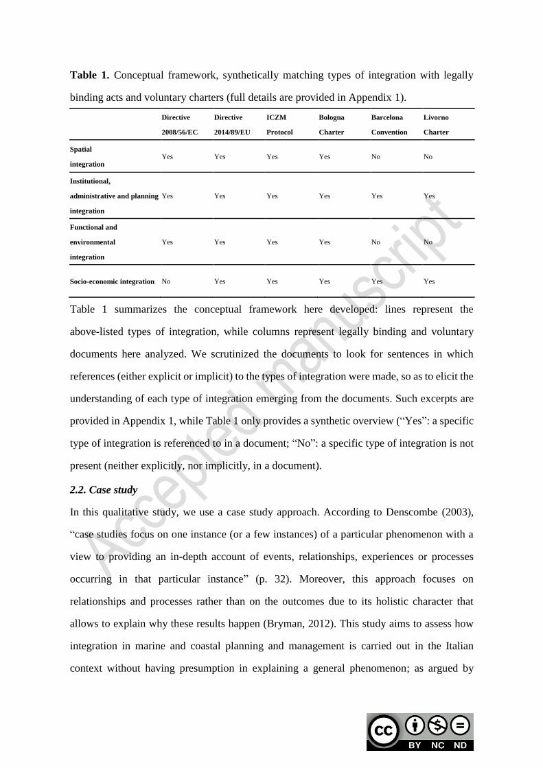
Table 1. Conceptual framework, synthetically matching types of integration with legally
binding acts and voluntary charters (full details are provided in Appendix 1).
Directive
2008/56/EC
Directive
2014/89/EU
ICZM
Protocol
Bologna
Charter
Barcelona
Convention
Livorno
Charter
Spatial
integration Yes Yes Yes Yes No No
Institutional,
administrative and planning
integration
Yes Yes Yes Yes Yes Yes
Functional and
environmental
integration
Yes Yes Yes Yes No No
Socio-economic integration No Yes Yes Yes Yes Yes
Table 1 summarizes the conceptual framework here developed: lines represent the
above-listed types of integration, while columns represent legally binding and voluntary
documents here analyzed. We scrutinized the documents to look for sentences in which
references (either explicit or implicit) to the types of integration were made, so as to elicit the
understanding of each type of integration emerging from the documents. Such excerpts are
provided in Appendix 1, while Table 1 only provides a synthetic overview (“Yes”: a specific
type of integration is referenced to in a document; “No”: a specific type of integration is not
present (neither explicitly, nor implicitly, in a document).
2.2. Case study
In this qualitative study, we use a case study approach. According to Denscombe (2003),
“case studies focus on one instance (or a few instances) of a particular phenomenon with a
view to providing an in-depth account of events, relationships, experiences or processes
occurring in that particular instance” (p. 32). Moreover, this approach focuses on
relationships and processes rather than on the outcomes due to its holistic character that
allows to explain why these results happen (Bryman, 2012). This study aims to assess how
integration in marine and coastal planning and management is carried out in the Italian
context without having presumption in explaining a general phenomenon; as argued by
Bryman (2012), “it is not the purpose of this research design to generalize to other cases” (p.
71).
Moreover, the study is implemented within the project “GIREPAM–Integrated Management
of Ecological Networks through Parks and Marine Areas”, funded by the Interreg Maritime
Italy France 2014-2020 program, whose partners are from two countries, Italy and France
(the eligibility of the areas being restricted to five regions, Sardinia, Liguria, Tuscany,
Corsica, and French Region Sud, formerly Provence-Alpes-Côte d’Azur). In particular, this
study analyzes (against the framework summarized in Table 1 and fully presented in
Appendix 1) two Italian case studies, selected on the basis of three criteria: first, they are
characterized by regulatory and planning tools that that are compulsory and play a key role
with regard to integration of voluntary and legally binding tools analyzed in the conceptual
framework (see Table 1); second, a number of binding tools (Plan of the Natural Park;
Regulation of the MPA; Conservation measures and Management Plan for the Natura 2000
sites) are in force, which results in a high level of complexity of their respective governance
frameworks; third, they are located within the Italian regions that are part of the GIREPAM
project. In Italy, the three typologies of protected areas (Natural Park, MPA and Natura 2000
site) overlap in five cases only. Beside the two the case studies here selected and analyzed
(one in Sardinia and one in Liguria, see Figure 1), a third one is located in Liguria, and the
fourth and the fifth in Campania. One of the Ligurian case studies, concerning the Cinque
Terre National Park, was not selected because its Plan was revoked by the regional
administration in 2010, while Campania is out of the scope of the project as it is not included
in the Interreg Maritime Italy France 2014-2020 program cooperation area. Therefore, to put
it with Bryman (2012), the two selected case studies represent a critical case, because they
represent the most complex Italian examples in terms of overlapping between protected
areas.
For the above reasons, the two selected case studies are appropriate to attempt answering the
research question that underpins this study, i.e. to investigate the extent to which integration
is pursued in areas characterized by the coexistence of various nature protection regimes.
While, as already stated previously, and following Bryman (2012) there is no presumption
that the findings from the two cases studies can be generalized, at least three characteristics
link the two selected case studies to current research debates, as follows.
First, integrative approaches on coastal and marine resources require spatial protection
measures which should be grounded on the ecosystem approach, while at the same time also
considering social and economic impacts; hence, according to Braun (2017), MPAs
designations and Natura 2000 provisions, although necessary, are not sufficient per se.
Second, a general issue underlined in the literature is the lack of a “coherent governance
system” (Ehler, 2003) in the management of coastal and marine areas, leading to fragmented
competencies and powers shared across a number of governmental agencies, even in the case
of MPAs, where an ad-hoc managing body is set up. As highlighted by Zoppi (2018), this
calls for virtuous multilevel governance processes and integrated “strategic environmental
stepwise assessment approaches”. Third, both scientific advice and stakeholder inputs should
be integrated “in a formal and structured way” into MPA planning processes (Muntoni at al.,
2019). With reference to the three items above, the two selected case studies could, in
principle, show ambivalent features. On the one hand, their being simultaneously MPAs and
Natura 2000 sites is expected to lead to implementing an ecosystem approach which however
might be unbalanced towards environmental issue; moreover, their being managed by a
single organization (one in the Asinara case and one in the Portofino one) is also expected to
facilitate integrative processes which should be reflected in their planning and regulatory
documents. On the other hand, the managing bodies in charge of the two selected areas share
competences with other organizations, hence no prior expectation concerns the governance
processes, as well as the incorporation of stakeholder needs and scientific knowledge.
Both the selected case studies are located in the Mediterranean Sea (see Figure 1). In both
cases, various natural protected areas, established under different legal frameworks, coexist.
As a consequence, such areas are characterized by overlapping (but not identical) objectives.
The Sardinian case study comprises Asinara National Park, the Asinara Island MPA, as well
as three Natura 2000 sites (two SPAs, ITB010001 “Isola Asinara”, and ITB013011 “Isola
Piana di Porto Torres”, and one SAC, ITB010082 “Isola dell’Asinara”). The Ligurian case
study comprises the Portofino Natural Regional Park, the Portofino MPA, as well as four
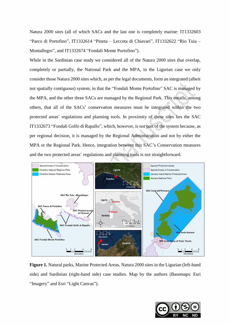
Natura 2000 sites (all of which SACs and the last one is completely marine: IT1332603
“Parco di Portofino”, IT1332614 “Pineta – Lecceta di Chiavari”, IT1332622 “Rio Tuia –
Montallegro”, and IT1332674 “Fondali Monte Portofino”).
While in the Sardinian case study we considered all of the Natura 2000 sites that overlap,
completely or partially, the National Park and the MPA, in the Ligurian case we only
consider those Natura 2000 sites which, as per the legal documents, form an integrated (albeit
not spatially contiguous) system, in that the “Fondali Monte Portofino” SAC is managed by
the MPA, and the other three SACs are managed by the Regional Park. This entails, among
others, that all of the SACs’ conservation measures must be integrated within the two
protected areas’ regulations and planning tools. In proximity of these sites lies the SAC
IT1332673 “Fondali Golfo di Rapallo”, which, however, is not part of the system because, as
per regional decision, it is managed by the Regional Administration and not by either the
MPA or the Regional Park. Hence, integration between this SAC’s Conservation measures
and the two protected areas’ regulations and planning tools is not straightforward.
Figure 1. Natural parks, Marine Protected Areas, Natura 2000 sites in the Ligurian (left-hand
side) and Sardinian (right-hand side) case studies. Map by the authors (Basemaps: Esri
“Imagery” and Esri “Light Canvas”).

2.3. Materials
The conceptual framework in Appendix 1 was next used to analyze planning and
management tools in force in the two selected case studies, for which we examined the
following documents:
- the Plans of the natural Parks and their Implementation Codes, drafted and approved
in compliance with the national law on protected areas (no. 1991/394, article 12 for
the Asinara National Park and article 25 for the Portofino Regional Park), aiming at
preserving natural and environmental values (and, to a lesser extent, historical,
cultural, anthropological, and traditional values) of the natural protected area by
controlling land uses. They are legally binding and prevail over any other land use
plan or sectoral plan, with two notable exceptions: first, the regional river basin
management plan and the flood risk management plan, compliant with the European
Water Framework Directive (Directive 2000/60/EC “establishing a framework for
community action in the field of water policy”) and Floods Directive (Directive
2007/60/EC “on the assessment and management of flood risks”) respectively,
together with their implementing plans (prominently the plan for the natural hazard
management, i.e. flooding and erosion), because they ultimately aim at safeguarding
human lives; and, second, the regional landscape plan, compliant with the National
Code of Cultural Heritage and Landscape (national law no. 2004/42) and the
European Landscape Convention, because it aims at preserving communities’
identities and senses of places by ensuring that their distinctive features are protected
and managed so as to ensure that heritage values and characteristic features of a
landscape are maintained for future generations;
- the national Decrees (1999/04/26 for the Portofino MPA and 2002/08/13 for the
Asinara Island MPA) that establish the two MPAs, together with the two regulatory
tools (in Italian: “Regolamenti di Esecuzione e Organizzazione”, which roughly
translates as “Executive and Organizational Regulations”); the latter are compliant
with the national law on protected areas (no. 1991/394, articles 18 and 19), and with
the national law for the protection of the sea (no. 979/1982, articles 25-27), and
regulate human activities through a zoning scheme ranging from no-take, no-entry
areas to areas in which tourism, fishing, and recreational activities are allowed, and
subject to the limitations and restrictions provided by the regulatory tools;
- the SAC and the SPA management plans (in the Sardinian case study) together with
the general and site-specific conservation measures2 (in the Ligurian case study);
both management plans and conservation measures are identified, approved, and
established under the Habitats Directive and ultimately aimed at ensuring that natural
and semi-natural habitats and species of Community interest are restored or
maintained at a favorable conservation status.
Each of the above listed documents was analyzed to find out evidences of the integration
elements reported synthetically in Table 1 and in detail in Appendix 1.
It has to be pointed out that other studies that propose frameworks to assess integration in
marine and coastal planning (e.g. Portman, 2011; Jones et al., 2016; Smythe and McCann,
2019), or identify principles for integrated marine planning (e.g. Dickinson et al., 2010), or
assess the integration levels in marine initiatives (e.g. Gee et al., 2019), also rely on
documental analysis and/or case study assessment.
3. Results
The full results of the analysis of the planning and regulation documents listed in Section 2.3
concerning the selected case studies against the framework presented in Section 2 is provided
in Table 2 (Sardinia, Asinara island) and Table 3 (Liguria, Portofino area).
2 The Habitats Directive states that “…Member States shall establish the necessary conservation measures
involving, if need be, appropriate management plans specifically designed for the sites or integrated into other
development plans…” (article 6). Therefore, the European Commission did not provide strict guidelines on the
structure and contents of management plans of Natura 2000 sites. Moreover, the Decree of the President of the
Italian Republic no. 357/1997, which implements the Habitats Directive into the national legislative framework,
establishes that regional administrations are in charge of defining and implementing conservation measures, but
without providing common rules and procedures. Therefore, Italian regional administrations have adopted
different approaches. While the Sardinian regional administration established that a management plan must be
elaborated for each Natura 2000 site, the Ligurian regional administration defined general conservation
measures for all Natura 2000 sites, site-specific conservation measures for each Natura 2000 site in relation to
the site peculiarities and established the elaboration of the management plan for some Natura 2000 sites.
In relation to the Sardinian case study, an idea of spatial integration between marine and
terrestrial zones is defined only within the Plan of the Natural Park, which recognizes an
integrated systemic unit composed by terrestrial and marine areas identified in relation to
structural, functional, social and economic peculiarities (article 3 of the Implementation
Code). In other words, the Plan of the Natural Park conceives the terrestrial and marine
components as a single, unitary ecosystem (article 10). The integration between spatial
conservation tools is more common, although not reciprocal. For example, the Plan of the
Natural Park refers to Regulation of the MPA, while the SAC and SPA Management Plans
refer both to the Plan of the Natural Park, in terms of zoning and conservation measures, and
to the regulatory tool of the MPA in relation to the management of specific threats to
biodiversity.
As regards institutional, administrative and planning integration, a reference to coordination
and/or cooperation between Member States is totally absent, except for the fact that the
Pelagos Sanctuary3, an international marine protected area, established for protecting marine
mammals, is mentioned in the Management Plans of Natura 2000 sites. On the other hand,
references to coordination between different authorities with competences on coastal areas at
the national, regional and local levels are more common. For instance, the Plan of the Natural
Park provides for agreements between the authority in charge of the management of the
Asinara Natural Park, the Sardinian regional administration and the municipality of Porto
Torres in order to approve the implementation plans of hamlets (termed “urban units” within
the plan) located within the island, and agreements between different institutions in relation
to the provisions concerning areas that are not included within the territory of the Natural
Park, but are contiguous to it. In relation to the planning implementation tool, article 1 refers
to the national Decree that establish the MPA and its Regulation in relation to provisions
concerning the marine areas surrounding the National Park, where the Plan takes a
purposeful role, rather than a prescriptive one. The relations between the Plan of the Natural
3 The Pelagos Sanctuary for Mediterranean Marine Mammals was established in 1999 through the Pelagos
Agreement, an official document signed by France, Italy and the Principality of Monaco in order to coordinate
actions and initiatives to safeguard cetaceans and their habitats. The agreement came into effect on 2002.
Park and the other planning tools are addressed by different articles of the Implementation
Code, as well. The Plan of the Natural Park is conceived as an overarching, and higher-level
in the Italian hierarchical planning system, tool that replaces the other urban, landscape and
sectoral planning tools within the park’s borders, whereas it represents a tool to address
planning decisions in the areas contiguous to the Park. The Management Plans of Natura
2000 sites do not take into account the relations between different protection tools;
nonetheless, they make provision for several actions whose implementation entails a close
cooperation among different authorities, which, if put into effect, may strengthen the
conservation strategies envisioned in these tools. The theme of collaboration between
different authorities or institutions in order to guarantee the surveillance and control is
present in the Regulation of the MPA and in the Management Plans. Data sharing, scientific
research and monitoring represent three key issues. The Plan of the Natural Park provides for
the implementation and management of an information system whereby the analyses carried
out in the plan-making process should be continuously updated and the effects resulting from
actions implemented by other authorities and institutions that have a competence within the
Natural Park boundaries should be monitored. Moreover, according to the Management
Plans of Natura 2000 sites, the above-mentioned information system must contain an atlas of
biodiversity to be integrated within the regional information system. According to the
Regulation of the MPA, the monitoring of marine and coastal environment should use
datasets and protocols defined by the Ministry of the environment and protection of the
territory and the sea, whereas the Management Plans of the Natura 2000 sites promote a
broader collaboration with universities in order to define monitoring actions concerning
species’ and habitats’ conservation status. On the other hand, the Regulation of the MPA
does not consider the integration among different planning tools.
In relation to functional and environmental integration, maintenance or achievement of a
good ecological status of ecosystems through the elimination of factors that may impact
negatively on them is made explicit in two objectives of the SAC and the SPA Management
Plans. These objectives are purely oriented towards conservation issues, in which “healthy”
ecosystems have an intrinsic value, regardless of the services that these ecosystems may
provide to humans. Only the Plan of the Natural Park refers to the ecosystem approach when
it introduces the concept of “landscape-environmental units”, which are taken as the spatial
reference for the plan’s regulations and are defined as areas characterized by specific natural,
ecological, environmental and functional peculiarities and strongly connected through
ecological, structural and functional relations. Hence, both the Plan of the Natural Park and
the Regulation of the MPA make provisions for a vision that integrates conservation and use
of biodiversity, for instance in relation to nature tourism in the first tool and to fish resources
in the second. However, in both tools the focus on protection of biological diversity prevails
over their potential uses, whereas the theme of the plurality of pressures on coastal areas due
to the increasing demand for different, competing uses is not tackled.Table 2. Implementing
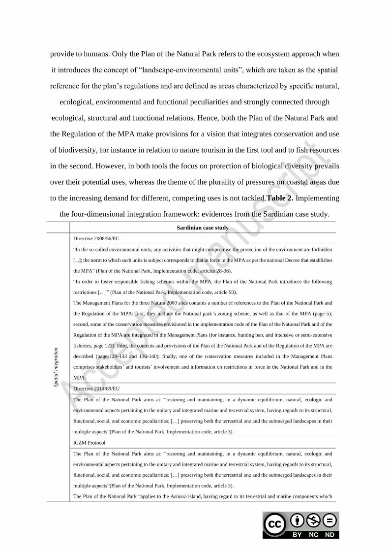
the four-dimensional integration framework: evidences from the Sardinian case study.
Sardinian case study
Spa
tia
l in
teg
rati
on
Directive 2008/56/EC
“In the so-called environmental units, any activities that might compromise the protection of the environment are forbidden
[...]; the norm to which such units is subject corresponds to that in force in the MPA as per the national Decree that establishes
the MPA” (Plan of the National Park, Implementation code, articles 28-36).
“In order to foster responsible fishing schemes within the MPA, the Plan of the National Park introduces the following
restrictions […]” (Plan of the National Park, Implementation code, article 50).
The Management Plans for the three Natura 2000 sites contains a number of references to the Plan of the National Park and
the Regulation of the MPA: first, they include the National park’s zoning scheme, as well as that of the MPA (page 5);
second, some of the conservation measures envisioned in the implementation code of the Plan of the National Park and of the
Regulation of the MPA are integrated in the Management Plans (for instance, hunting ban, and intensive or semi-extensive
fisheries, page 123); third, the contents and provisions of the Plan of the National Park and of the Regulation of the MPA are
described (pages129-133 and 136-140); finally, one of the conservation measures included in the Management Plans
comprises stakeholders’ and tourists’ involvement and information on restrictions in force in the National Park and in the
MPA.
Directive 2014/89/EU
The Plan of the National Park aims at: “restoring and maintaining, in a dynamic equilibrium, natural, ecologic and
environmental aspects pertaining to the unitary and integrated marine and terrestrial system, having regards to its structural,
functional, social, and economic peculiarities; […] preserving both the terrestrial one and the submerged landscapes in their
multiple aspects”(Plan of the National Park, Implementation code, article 3).
ICZM Protocol
The Plan of the National Park aims at: “restoring and maintaining, in a dynamic equilibrium, natural, ecologic and
environmental aspects pertaining to the unitary and integrated marine and terrestrial system, having regards to its structural,
functional, social, and economic peculiarities; […] preserving both the terrestrial one and the submerged landscapes in their
multiple aspects”(Plan of the National Park, Implementation code, article 3).
The Plan of the National Park “applies to the Asinara island, having regard to its terrestrial and marine components which
constitute a unitary ecosystem, and to the surrounding area (north-western Sardinia sub-region), which has significant
relationships with the Asinara island (Plan of the National Park, Implementation code, article 10).
The Management Plans for Natura 2000 sites look comprehensively at the three sites, which comprise both marine and
terrestrial habitats, hence they necessarily integrate the terrestrial and marine dimensions.
Bologna Charter
The Plan of the National Park aims at: “restoring and maintaining, in a dynamic equilibrium, natural, ecologic and
environmental aspects pertaining to the unitary and integrated marine and terrestrial system, having regards to its structural,
functional, social, and economic peculiarities; […] preserving both the terrestrial one and the submerged landscapes in their
multiple aspects”(Plan of the National Park, Implementation code, article 3).
Since the ITB010001 “Isola Asinara” SAC stretches over land and over the sea, conservation objectives identified in the
Management Plansfor Natura 2000 sites refer to both the terrestrial and the marine area.
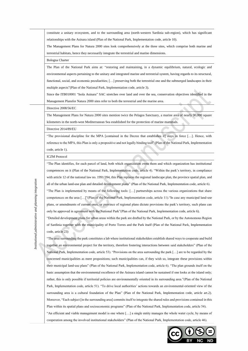
Inst
itu
tiona
l,ad
min
istr
ati
ve a
nd
pla
nnin
g i
nte
gra
tion
Directive 2008/56/EC
The Management Plans for Natura 2000 sites mention twice the Pelagos Sanctuary, a marine area of nearly 90,000 square
kilometers in the north-west Mediterranean Sea established for the protection of marine mammals.
Directive 2014/89/EU
“The provisional discipline for the MPA [contained in the Decree that establishes it] stays in force […]. Hence, with
reference to the MPA, this Plan is only a propositive and not legally binding tool” (Plan of the National Park, Implementation
code, article 1).
ICZM Protocol
“The Plan identifies, for each parcel of land, both which organization owns them and which organization has institutional
competences on it (Plan of the National Park, Implementation code, article 4). “Within the park’s territory, in compliance
with article 12 of the national law no. 1991/394, this Plan replaces the regional landscape plan, the province spatial plan, and
all of the urban land-use plan and detailed development plans” (Plan of the National Park, Implementation code, article 6).
“The Plan is implemented by means of the following tools: […] partnerships across the various organizations that share
competences on the area […]”(Plan of the National Park, Implementation code, article 11).“In case any municipal land-use
plans, or amendments of current ones, or province of regional plans dictate provisions the park’s territory, such plans can
only be approved in agreement with the National Park”(Plan of the National Park, Implementation code, article 6).
“Detailed development plans for urban areas within the park are drafted by the National Park, or by the Autonomous Region
of Sardinia together with the municipality of Porto Torres and the Park itself (Plan of the National Park, Implementation
code, article 23)
“The area surrounding the park constitutes a lab where institutional stakeholders establish shared ways to cooperate and build
together an environmental project for the territory, therefore fostering interactions between said stakeholders” (Plan of the
National Park, Implementation code, article 53). “Provisions on the area surrounding the park […] are to be regarded by the
concerned municipalities as mere propositions; such municipalities can, if they wish so, integrate these provisions within
their municipal land-use plans” (Plan of the National Park, Implementation code, article 6). “The plan grounds itself on the
basic assumption that the environmental excellence of the Asinara island cannot be sustained if one looks at the island only;
rather, this is only possible if territorial policies are environmentally oriented in its surrounding area.”(Plan of the National
Park, Implementation code, article 51). “To drive local authorities’ actions towards an environmental-oriented view of the
surrounding area is a cultural foundation of the Plan” (Plan of the National Park, Implementation code, article art.2).
Moreover, “Each subject [in the surrounding area] commits itself to integrate the shared rules and provisions contained in this
Plan within its spatial plans and socioeconomic programs” (Plan of the National Park, Implementation code, article 54).
“An efficient and viable management model is one where […] a single entity manages the whole water cycle, by means of
cooperation among the involved institutional stakeholders” (Plan of the National Park, Implementation code, article 46).
“The Manager of the MPA can be the same person as the Director of the National Park” (MPA Regulation, article 5).
“Surveillance in the MPA is carried out by the coast guard, as well as by local police. The management body of the MPA can
also involve the regional Forestry Corps” (Decree that establishes the MPA, article 7; MPA Regulation, article 28).
The Management Plans for Natura 2000 sites contain a conservation measure aiming at strengthening the surveillance
capacity of the National Park’s organization, of the coast guard, and of the regional Forestry Corps.
The Management Plans for Natura 2000 sites contain a conservation measure fostering cooperation among institutional
authorities to implement a number of conservation objectives (preservation of vegetal species, monitoring of marine
mammals, monitoring of amphibians and reptiles, surveillance, restoration of buildings).
Barcelona Convention
“The Geographic Information System of the National Park is an essential tool to manage environmental resources and
processes within the park’s territory, as well as to foster information sharing and cooperation required for social and
institutional participation in the park’s management” (Plan of the National Park, Implementation code).
The National Park […] implements and manages The Geographic Information System so as to complete and update spatial
analyses and environmental assessments carried out in the preparation of the plan; moreover, it monitors the environmental
effects of projects and actions implemented by the National Park by the municipalities, by the province, and by whomever is
entitled to act within the park’s boundaries (Plan of the National Park, Implementation code, article 7).
“Research programs within the MPA aiming at controlling the quality of marine waters must be carried out in accordance of
the Environmental Ministry’s protocols established in the framework of the National program for the monitoring of coastal
and marine environment”. “The MPA management body can make use of the Environmental Ministry’s datasets” (MPA
Regulation, article 27).
The Management Plans for Natura 2000 sites contain a conservation measure titled “Implementation of the Biodiversity
Atlas within the park’s Geographic Information System, integrated within the Environmental Regional Information System
of the Autonomous Region of Sardinia”.
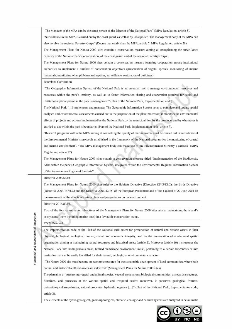
Fun
ctio
na
l and
envi
ron
men
tal
inte
gra
tio
n
Directive 2008/56/EC
The Management Plans for Natura 2000 sites refer to the Habitats Directive (Directive 92/43/EEC), the Birds Directive
(Directive 2009/147/EC) and the Directive 2001/42/EC of the European Parliament and of the Council of 27 June 2001 on
the assessment of the effects of certain plans and programmes on the environment.
Directive 2014/89/EU
Two of the four conservation objectives of the Management Plans for Natura 2000 sites aim at maintaining the island’s
ecosystems (there including marine ones) in a favorable conservation status.
ICZM Protocol
The Implementation code of the Plan of the National Park caters for preservation of natural and historic assets in their
physical, biological, ecological, human, social, and economic integrity, and for the preservation of a relational spatial
organization aiming at maintaining natural resources and historical assets (article 2). Moreover (article 10) it structures the
National Park into homogeneous areas, termed “landscape-environment units”, pertaining to a certain biocenosis or into
territories that can be easily identified for their natural, ecologic, or environmental character.
“The Natura 2000 site must become an economic resource for the sustainable development of local communities, where both
natural and historical-cultural assets are valorized” (Management Plans for Natura 2000 sites).
The plan aims at “preserving vegetal and animal species, vegetal associations, biological communities, as regards structures,
functions, and processes at the various spatial and temporal scales; moreover, it preserves geological features,
paleontological singularities, natural processes, hydraulic regimes […]” (Plan of the National Park, Implementation code,
article 3).
The elements of the hydro-geological, geomorphological, climatic, ecologic and cultural systems are analyzed in detail in the
Management Plan for Natura 2000 sites.
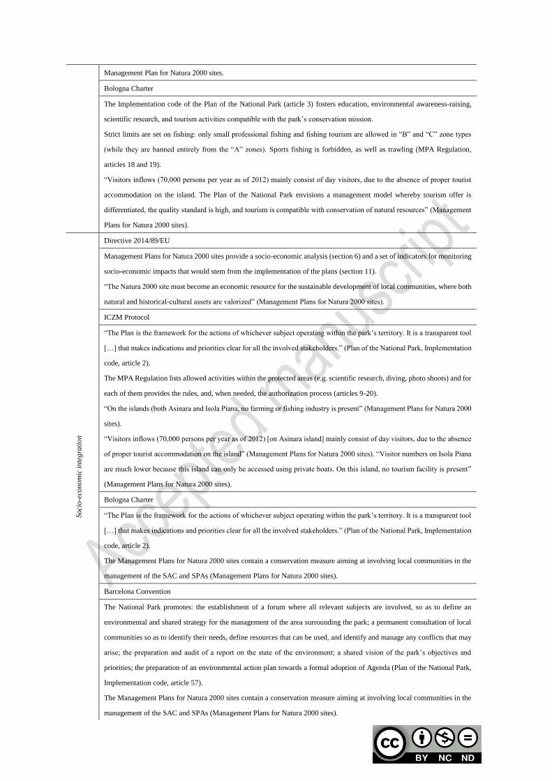
Bologna Charter
The Implementation code of the Plan of the National Park (article 3) fosters education, environmental awareness-raising,
scientific research, and tourism activities compatible with the park’s conservation mission.
Strict limits are set on fishing: only small professional fishing and fishing tourism are allowed in “B” and “C” zone types
(while they are banned entirely from the “A” zones). Sports fishing is forbidden, as well as trawling (MPA Regulation,
articles 18 and 19).
“Visitors inflows (70,000 persons per year as of 2012) mainly consist of day visitors, due to the absence of proper tourist
accommodation on the island. The Plan of the National Park envisions a management model whereby tourism offer is
differentiated, the quality standard is high, and tourism is compatible with conservation of natural resources” (Management
Plans for Natura 2000 sites).
Soci
o-e
con
om
ic i
nte
gra
tio
n
Directive 2014/89/EU
Management Plans for Natura 2000 sites provide a socio-economic analysis (section 6) and a set of indicators for monitoring
socio-economic impacts that would stem from the implementation of the plans (section 11).
“The Natura 2000 site must become an economic resource for the sustainable development of local communities, where both
natural and historical-cultural assets are valorized” (Management Plans for Natura 2000 sites).
ICZM Protocol
“The Plan is the framework for the actions of whichever subject operating within the park’s territory. It is a transparent tool
[…] that makes indications and priorities clear for all the involved stakeholders.” (Plan of the National Park, Implementation
code, article 2).
The MPA Regulation lists allowed activities within the protected areas (e.g. scientific research, diving, photo shoots) and for
each of them provides the rules, and, when needed, the authorization process (articles 9-20).
“On the islands (both Asinara and Isola Piana, no farming or fishing industry is present” (Management Plans for Natura 2000
sites).
“Visitors inflows (70,000 persons per year as of 2012) [on Asinara island] mainly consist of day visitors, due to the absence
of proper tourist accommodation on the island” (Management Plans for Natura 2000 sites). “Visitor numbers on Isola Piana
are much lower because this island can only be accessed using private boats. On this island, no tourism facility is present”
(Management Plans for Natura 2000 sites).
Bologna Charter
“The Plan is the framework for the actions of whichever subject operating within the park’s territory. It is a transparent tool
[…] that makes indications and priorities clear for all the involved stakeholders.” (Plan of the National Park, Implementation
code, article 2).
The Management Plans for Natura 2000 sites contain a conservation measure aiming at involving local communities in the
management of the SAC and SPAs (Management Plans for Natura 2000 sites).
Barcelona Convention
The National Park promotes: the establishment of a forum where all relevant subjects are involved, so as to define an
environmental and shared strategy for the management of the area surrounding the park; a permanent consultation of local
communities so as to identify their needs, define resources that can be used, and identify and manage any conflicts that may
arise; the preparation and audit of a report on the state of the environment; a shared vision of the park’s objectives and
priorities; the preparation of an environmental action plan towards a formal adoption of Agenda (Plan of the National Park,
Implementation code, article 57).
The Management Plans for Natura 2000 sites contain a conservation measure aiming at involving local communities in the
management of the SAC and SPAs (Management Plans for Natura 2000 sites).

As for socio-economic integration, only the Management Plans of Natura 2000 sites consider
social and economic aspects oriented to sustainable growth of the territory and to sustainable
use of its resources. The multiple uses of coastal areas and their integration are considered
both in the Plan of the Natural Park, where they represent a reference framework to orient,
plan and implement actions to be carried out by authorities and institutions that have
competences within Park’s borders (article 2 of the Implementation Code), and in the
Management Plans of Natura 2000 sites, where, however, they are analyzed only in
descriptive terms. Although the participation of local communities and stakeholders is
foreseen in both the Plan of the Natural Park and in the Management Plans of Natura 2000
sites, their involvement takes the form of a consultation in the first tool and of mere
information in the second, rather than that of a real participation.
In relation to the Ligurian case study and with reference to spatial integration, the
management tools of the MPA (i.e., the national Decree that establishes the MPA and its
Regulation) do not take into account any consideration defined within the conceptual
framework. However, the Plan of the Natural Park and the SACs Conservation measures (be
it general or site-specific) consider the integration between conservation goals and
management measures. In particular, both tools promote an integrated management of SACs
and the Regional Park. The Plan of the Natural Park focuses only on a functionally integrated
management, whereas the site-specific Conservation measures promote the elaboration of an
integrated management plan with the Plan of the Natural Park.
As regards institutional, administrative and planning integration, nearly all of the tools define
relations and mechanisms for cooperation between the authority in charge of the
Livorno Charter
The National Park promotes: the establishment of a forum where all relevant subjects are involved, so as to define an
environmental and shared strategy for the management of the area surrounding the park; a permanent consultation of local
communities so as to identify their needs, define resources that can be used, and identify and manage any conflicts that may
arise; the preparation and audit of a report on the state of the environment; a shared vision of the park’s objectives and
priorities; the preparation of an environmental action plan towards a formal adoption of Agenda (Plan of the National Park,
Implementation code, article 57).
The Management Plans for Natura 2000 sites contain a conservation measure aiming at involving local communities in the
management of the SAC and SPAs (Management Plans for Natura 2000 sites).

management of the site and the other authorities and institutions that have competences
within the site borders. In particular, the Regulation of the MPA establishes and regulates
roles and responsibilities of its management bodies. In relation to the effectiveness of control
activities over the sea and coasts, although most tools make provisions for surveillance and
monitoring activities, only the site-specific Conservation measures concerning the marine
SAC explicitly promote coordination between port authorities and regional administration in
order to prevent unauthorized trawling. Moreover, the Plan of the Natural Park is conceived
as a tool that integrates measures and rules established by regional, provincial and local
planning, whereas the site-specific Conservation measures promote the integration between
provisions of Management Plans and the Plan of the Natural Park.
In relation to functional and environmental integration, all tools refer to the integration of
objectives and strategies deriving from higher-level laws and directives that regulate specific
environmental aspects within the protected areas borders. For example, the Regulation of the
MPA defines the characteristics of boat engines by making explicit reference to the criteria
established by the Directive 2003/44/EC concerning noise and gas emissions. The general
Conservation measures of terrestrial SACs are more forward-looking and establish
characteristics that future Management Plans and site-specific Conservation measures must
have in terms of normative consistency. For example, they establish that Management Plans
must integrate measures concerning the reduction of the risk caused by the use of plant
protection products (Italian Decree 22 January 2014 concerning the adoption of the National
Action Plan for the sustainable use of plant protection products). All of the tools make
reference to the ecosystem approach, ecosystem services and to the effects of climate change.
Although the management tools of the MPA and the Plan of the Natural Park do not
explicitly refer to an integrated approach to plan and manage these areas by governing its
multiple functions, they do regulate activities and their interactions within their reference
sites and therefore they integrate different uses to balance human activities in coastal areas
with protection and conservation of biodiversity objectives. Only site-specific Conservation
measures explicitly promote an integrated approach.

Table 2. Implementing the four-dimensional integration framework: evidences from the
Ligurian case study.
Ligurian case study
Spa
tia
l in
teg
rati
on
Directive 2008/56/EC
The Plan regulates the areas included within the park’s borders and the three terrestrial Natura 2000 sites (Plan of the
Regional Park).
The Plan aims at managing Natura 2000 sites and the regional park according to a functional integration (Plan of the Regional
Park).
MP and Plan of the natural park should be integrated (Site-specific conservation measures related to each Natura 2000 site
analyzed).
Directive 2014/89/EU
The Plan aims at promoting an integrated image of the regional park with Natura 2000 sites in order to enhance the whole
territorial system (Plan of the Regional Park).
Bologna Charter
The Plan aims at managing Natura 2000 sites and the regional park according to a functional integration (Plan of the Regional
Park).
Inst
itu
tiona
l-ad
min
istr
ati
ve i
nte
gra
tion
ICZM Protocol
Article no. 7 establishes roles and relationships between the authority in charge for the management of MPA and the Ministry
of the environment, land and sea in relation to the elaboration and approval of the regulatory tool (national Decree that
establish the MPA).
Articles nos. 4, 5, 6 and 7 establish roles and responsibilities of management bodies and define relations and mechanisms for
cooperation between the authority in charge of the management of the site and the other authorities and institutions that have
competences within the site borders (Regulatory tool of the MPA).
Article no. 4 defines relations and mechanisms for cooperation between the authority in charge of the management of the site
and the other authorities and institutions that have competences within the site borders (Plan of the Regional Park;
site-specific conservation measures concerning the three terrestrial Natura 2000 sites).
The Plan is conceived as a tool that integrates measures and rules established by regional, provincial and local planning (Plan
of the Regional Park).
Provisions of MPs and the Plan of the natural Park should be integrated (site-specific conservation measures related to each
Natura 2000 site analyzed).
Livorno Charter
Surveillance and monitoring activities are defined (Regulatory tool of the MPA; general conservation measures concerning
terrestrial SACs; site-specific conservation measures concerning Natura 2000 sites).
Coordination between port authorities and regional administration in order to prevent unauthorized trawling is promoted
(site-specific conservation measures concerning the marine Natura 2000 sites).
Fun
ctio
na
l and
envi
ron
men
tal
inte
gra
tion
Directive 2008/56/EC
Objectives and strategies deriving from higher-level laws and directives that regulate specific aspects within the protected
areas borders should be integrated (national Decree that establish the MPA; Regulatory tool of the MPA; Plan of the Regional
Park; general conservation measures concerning terrestrial SACs; site-specific conservation measures related to each Natura
2000 site analyzed).
Characteristics of boat engines concerning noise and gas emissions must be compatible with those established by the

Directive 2003/44/EC (Regulatory tool of the MPA).
MPs must integrate measures concerning the reduction of the risk caused by the use of plant protection products (Italian
Decree 22 January 2014 concerning the adoption of the National Action Plan for the sustainable use of plant protection
products) (General conservation measures concerning terrestrial SACs).
General conservation measures must be integrated with site-specific conservation measures and MPs, if planned (General
conservation measures concerning terrestrial SACs).
Directive 2014/89/EU
Activities, uses, and their interactions are regulated in order to balance human activities in coastal areas with protection and
conservation of biodiversity objectives (national Decree that establish the MPA; Regulatory tool of the MPA; Plan of the
Regional Park; general conservation measures concerning terrestrial SACs).
MP and Plan of the natural park should be integrated (Site-specific conservation measures related to each Natura 2000 site
analyzed).
ICZM Protocol
Protected areas should be managed so as to take into account significant issues such as climate change (national Decree that
establish the MPA; Regulatory tool of the MPA; Plan of the Regional Park; general conservation measures concerning
terrestrial SACs; site-specific conservation measures related to each Natura 2000 site analyzed).
Activities uses and their interactions are regulated in order to balance human activities in coastal areas with protection and
conservation of biodiversity objectives (national Decree that establish the MPA; Regulatory tool of the MPA; Plan of the
Regional Park; general conservation measures concerning terrestrial SACs; site-specific conservation measures related to
each Natura 2000 site analyzed).
Bologna Charter
Activities, uses, and their interactions are regulated in order to balance human activities in coastal areas with protection and
conservation of biodiversity objectives (national Decree that establish the MPA; Regulatory tool of the MPA; Plan of the
Regional Park; general conservation measures concerning terrestrial SACs).
Soci
o-e
con
om
ic i
nte
gra
tio
n
Directive 2014/89/EU
The manager of the protected area should promote a socio-economic development of the territory in line with the natural and
landscape value of the protected area (national Decree that establish the MPA; Regulatory tool of the MPA; Plan of the
Regional Park; general conservation measures concerning terrestrial SACs).
The Plan defines nine regulatory annexes that regulate environmental, economic and social components. Each of them
tackles a specific management issue and in particular: i. Regulation on regeneration of the building heritage; ii. Regulation on
vegetation intervention; iii. Regulation on waters and springs; iv. Regulation on accessibility; v. Regulation on agricultural
activities; vi. Regulation on fauna; vii. Regulation of fruition of the area; viii. Regulation on environmental protection; and,
ix. Regulation on coastal areas and beach operators (Plan of the Regional Park).
ICZM Protocol
Activities, uses, and their interactions are regulated in order to balance human activities in coastal areas with protection and
conservation of biodiversity objectives (national Decree that establish the MPA; Regulatory tool of the MPA; Plan of the
Regional Park; general conservation measures concerning terrestrial SACs; site-specific conservation measures related to
each Natura 2000 site analyzed).
Bologna Charter
The director of the MPA should develop socio-economic projects through the use of private and public funds (national and
EU) (Regulatory tool of the MPA),
Livorno Charter
Information and education campaigns are defined and promoted in order to spread ecological knowledge among local
communities and potential users of the territory (national Decree that establish the MPA; Regulatory tool of the MPA; Plan of
the Regional Park; general conservation measures concerning terrestrial SACs; site-specific conservation measures related to
each Natura 2000 site analyzed),
ICZM Protocol
Protected areas should be managed in order to taking into account significant issues such as climate change (national Decree
that establish the MPA; Regulatory tool of the MPA; Plan of the Regional Park; general conservation measures concerning
terrestrial SACs; site-specific conservation measures related to each Natura 2000 site analyzed).
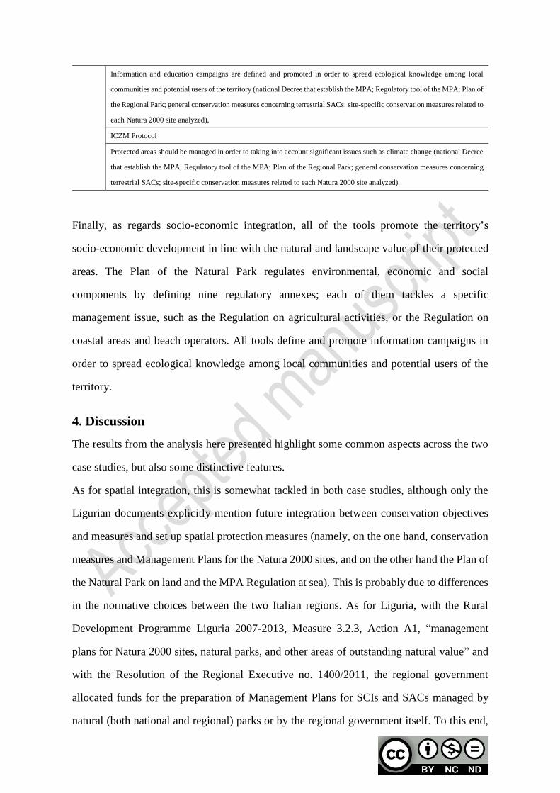
Finally, as regards socio-economic integration, all of the tools promote the territory’s
socio-economic development in line with the natural and landscape value of their protected
areas. The Plan of the Natural Park regulates environmental, economic and social
components by defining nine regulatory annexes; each of them tackles a specific
management issue, such as the Regulation on agricultural activities, or the Regulation on
coastal areas and beach operators. All tools define and promote information campaigns in
order to spread ecological knowledge among local communities and potential users of the
territory.
4. Discussion
The results from the analysis here presented highlight some common aspects across the two
case studies, but also some distinctive features.
As for spatial integration, this is somewhat tackled in both case studies, although only the
Ligurian documents explicitly mention future integration between conservation objectives
and measures and set up spatial protection measures (namely, on the one hand, conservation
measures and Management Plans for the Natura 2000 sites, and on the other hand the Plan of
the Natural Park on land and the MPA Regulation at sea). This is probably due to differences
in the normative choices between the two Italian regions. As for Liguria, with the Rural
Development Programme Liguria 2007-2013, Measure 3.2.3, Action A1, “management
plans for Natura 2000 sites, natural parks, and other areas of outstanding natural value” and
with the Resolution of the Regional Executive no. 1400/2011, the regional government
allocated funds for the preparation of Management Plans for SCIs and SACs managed by
natural (both national and regional) parks or by the regional government itself. To this end,
public bodies in charge of natural parks with old planning tools that needed updating and that
overlapped Natura 2000 sites, used such funds to prepare integrated planning tools, among
which the Plans of the natural parks “Alpi Liguri”, “Antola”, “Aveto”, and “Beigua”. On the
other hand, in Sardinia only Management Plans for SCIs, SPAs, and SACs were funded,
none of which integrated into Plans for the Natural Parks or Regulation for MPAs. Moreover,
in both the case studies a spatially integrated marine-terrestrial system is almost never
mentioned, the only exception being the Plan of Asinara National Park; this signals the lack
of a unitary vision, widely acknowledged in the literature (Tsilimigkas and Rempis, 2017),
and most likely originates from sectoral characteristics of the analyzed planning and
regulatory tools, prominently MPA Regulations, which exclusively focus on marine areas.
With reference to institutional, administrative and planning integration, the teme of
coordination and/or cooperation is highly relevant in both cases, as detailed provisions can be
found concerning coordination between national, regional, and local institutions sharing
competences on coastal areas. Such diversity in governance systems is deemed, in the
literature, as key to resilience in marine protected areas (Jones et al., 2013) rather than a
problem to tackle by concentrating competences in one institution and some successful
examples are reported (Day and Dobbs, 2013). Among matters on which coordination is
deemed necessary, and problematic, the construction of shared data bases to address the
so-called “knowledge deficit” (Gazzola et al., 2015), prerequisite to develop sound
environmental policies, which is only present in the Asinara case study and not made clear in
the Portofino one. For what concerns the implementation of policies and strategies through
planning tools, shared features emerge from the two case studies: most of the planning and
regulatory documents here analyzed do mention the other documents in force in the same
area; however, full integration is not made clear (let alone implemented), but for the
site-specific Conservation measures in the Portofino case, which call for integration between,
on the one hand, the management plans (to be prepared yet) for Natura 2000 sites and, on the
other hand, either the plan of the natural park or the MPA regulation. According to Soriani et
al. (2015) coastal areas are characterized by uncoordinated legislation due to a fragmentation
of roles and responsibilities at the national, regional and local level. Therefore, a change in
governance models is necessary in order to go beyond short-term perspectives that address
socio-economic interests.
Concerning functional and environmental integration, an integrated vision of the several
overlapping systems and functions is almost never made explicit, the only exception being
site-specific Conservation measures in the Ligurian case study, which provide directions for
a desired, integrated approach to planning and management of the sites. Since they establish
clear regulations concerning activities, uses, and their interactions, all of the documents
provide an analysis of human activities so as to balance uses on land and at sea that can, in
principle, be harmful to the environment with biodiversity conservation and protection. In
this respect, Portofino site-specific Conservation measures are the only documents, among
those analyzed in this study, that explicitly promote an integrated approach. The issue of
functional integration may represent a key problem to address integration. In fact, it reflects
the theoretical discussion on soft versus hard sustainability. Soft sustainability focuses on
economic development of coastal and marine areas, where conservation has not a privileged
role. To the contrary, the hard sustainability conceives conservation as a pillar of coastal and
marine planning and therefore planning actions should be oriented to achieve a good
environmental quality (Piwowarczyka et al., 2019). Such low consideration for the multiple
functions performed by the two areas reflects in a general neglect of the ecosystem approach,
explicitly declared and taken as a reference point only within the Plan of the Asinara National
Park, but never acknowledged in any of the Portofino documents. According to Kirkfeldt
(2019) concepts such as the ecosystem-based approach, the ecosystem-based management
and the ecosystem approach intend to implement an ecosystem viewpoint within coastal and
marine planning. However, these commonly used concepts are rarely effectively
implemented within planning processes (Sardà et al., 2015) due to a lack of clear definition
and strategies on how to operationalize such concepts in real cases (Jay et al., 2016).
As regards socio-economic integration, all of the documents concerning the Sardinian case
study tackle the multiple economic uses and activities in coastal areas. In the Portofino case,
the Plan for the Natural Park, with its nine regulatory annexes, provides a more detailed
discipline than the other tools. Such difference can be explained by looking at dissimilarities
between the two case studies: while a management plan is in place for all of the Sardinian
Natura 2000 sites here considered, such management plans, albeit contemplated, are not in
place yet in the Ligurian Natura 2000 sites, where only general and site-specific conservation
measures have been approved so far. Moreover, although in both cases participation of local
communities and stakeholders is foreseen in all of the documents we examined, as a matter of
facts in none of them participation translates as a process in which local communities can
effectively play an active role and rise to positions of responsibility. This holds true for most
part of planning processes, as participation is often regarded as a formal, statutory
accomplishment rather than as something that can create an added value in terms of
knowledge, shared goals and plan actions (Cooke and Kothari, 2001; Innes and Booher,
2004).
5. Conclusions
In this study, we have attempted to assess the level of integration emerging from planning
documents in coastal and marine areas characterized by the coexistence of overlapping
nature protection regimes, where a number of compulsory planning tools need to coexist,
hence taking into account the legal constraints on marine spatial planning in MPAs and
Natura 2000 sites. For this reason, after reviewing relevant literature that explores the
integration concept and assesses it through multi-dimensional frameworks and other
approaches (such as the ecosystem-based framework), a four-dimensional framework
(comprising spatial integration, institutional, administrative and planning integration,
functional and environmental integration, socio-economic integration) was here developed
based upon legally-binding acts and voluntary agreements in force in the Mediterranean area.
The framework was next applied to two case studies, showing that the various planning and
regulatory tools here analyzed are more concerned with complying each with its own
normative framework rather than with contributing towards building an integrated approach
to coastal and marine area management. This can partly be attributed to the multilayered, and
complex, Italian framework, where several categories of protected areas (natural parks,

having either national or regional significance, marine protected areas, Natura 2000 sites,
natural reserves, Ramsar sites, to name the most important ones) coexist, each stemming
from its own legal act (e.g., a national law, a regional law, or a European directive), and each
pursuing its own mission and objectives. Lack of a unitary legal framework has led to
overlapping planning and regulatory tools in force in areas that are subject to a number of
protection regimes, as the two case studies have shown.
Apart from such common aspects, some differences between the two case studies have been
highlighted and can be traced back to regional disparities in the way Italian regions, to which
the national state devolved competences on the management of Natura 2000 sites, interpret
their roles and the duties and tasks stemming from the Habitats Directive (Lai, 2020).
The framework here proposed makes it possible to compare, under a multidimensional lens,
how various planning and regulatory tools in force in the same area pursue integration.
Precisely because it is designed to assess “ex post” such tools, the method allows protected
area managers, planners, and decision makers to critically examine the very provisions on
which activities are framed and regulated in their protected areas, hence stimulating
reflections on weak areas that could possibly be strengthened when revising their regulations
and plans. In this respect, the work by Zoppi (2018), which puts forward a method to
integrate Natura 2000 conservation measures into MPAs regulations, could be taken as a
starting point to address the issue of scarce institutional, administrative, and planning
integration. Moreover, some scholars have proposed models, experiences, and approaches
that promise to deliver a high level of integration in decision-making processes, for instance
by making use of new tools envisioned by the European Union, such as the Integrated
Territorial Investment (Garcia-Ayllon, 2018), though participatory mechanisms. Similar
collaborative approaches are advocated, among others, by Gillgren et al. (2019), and on such
basis a revised Systems Approach Framework has been implemented, to develop scenarios
that are meant to help decision makers translate into practice the concepts of integrated
coastal zone management (Inácio and Umgiesser, 2019; Støttrup et al., 2019). Such
approaches are faced with what Billè (2008) has termed “the four entrenched illusions”
concerning integrated coastal zone management, most prominently the belief that
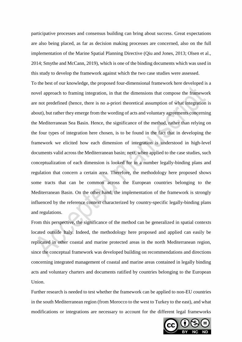
participative processes and consensus building can bring about success. Great expectations
are also being placed, as far as decision making processes are concerned, also on the full
implementation of the Marine Spatial Planning Directive (Qiu and Jones, 2013; Olsen et al.,
2014; Smythe and McCann, 2019), which is one of the binding documents which was used in
this study to develop the framework against which the two case studies were assessed.
To the best of our knowledge, the proposed four-dimensional framework here developed is a
novel approach to framing integration, in that the dimensions that compose the framework
are not predefined (hence, there is no a-priori theoretical assumption of what integration is
about), but rather they emerge from the wording of acts and voluntary agreements concerning
the Mediterranean Sea Basin. Hence, the significance of the method, rather than relying on
the four types of integration here chosen, is to be found in the fact that in developing the
framework we elicited how each dimension of integration is understood in high-level
documents valid across the Mediterranean basin; next, when applied to the case studies, such
conceptualization of each dimension is looked for in a number legally-binding plans and
regulation that concern a certain area. Therefore, the methodology here proposed shows
some tracts that can be common across the European countries belonging to the
Mediterranean Basin. On the other hand, the implementation of the framework is strongly
influenced by the reference context characterized by country-specific legally-binding plans
and regulations.
From this perspective, the significance of the method can be generalized in spatial contexts
located outside Italy. Indeed, the methodology here proposed and applied can easily be
replicated in other coastal and marine protected areas in the north Mediterranean region,
since the conceptual framework was developed building on recommendations and directions
concerning integrated management of coastal and marine areas contained in legally binding
acts and voluntary charters and documents ratified by countries belonging to the European
Union.
Further research is needed to test whether the framework can be applied to non-EU countries
in the south Mediterranean region (from Morocco to the west to Turkey to the east), and what
modifications or integrations are necessary to account for the different legal frameworks
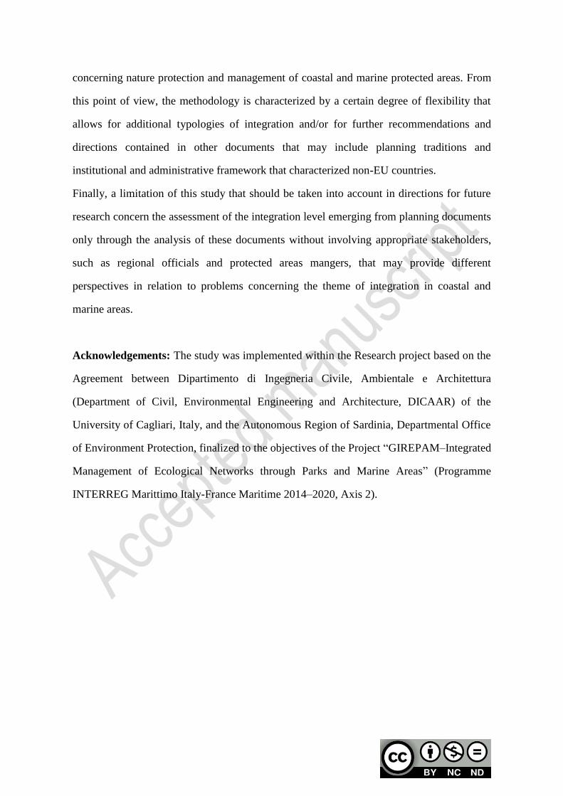
concerning nature protection and management of coastal and marine protected areas. From
this point of view, the methodology is characterized by a certain degree of flexibility that
allows for additional typologies of integration and/or for further recommendations and
directions contained in other documents that may include planning traditions and
institutional and administrative framework that characterized non-EU countries.
Finally, a limitation of this study that should be taken into account in directions for future
research concern the assessment of the integration level emerging from planning documents
only through the analysis of these documents without involving appropriate stakeholders,
such as regional officials and protected areas mangers, that may provide different
perspectives in relation to problems concerning the theme of integration in coastal and
marine areas.
Acknowledgements: The study was implemented within the Research project based on the
Agreement between Dipartimento di Ingegneria Civile, Ambientale e Architettura
(Department of Civil, Environmental Engineering and Architecture, DICAAR) of the
University of Cagliari, Italy, and the Autonomous Region of Sardinia, Departmental Office
of Environment Protection, finalized to the objectives of the Project “GIREPAM–Integrated
Management of Ecological Networks through Parks and Marine Areas” (Programme
INTERREG Marittimo Italy-France Maritime 2014–2020, Axis 2).

Appendix 1
This appendix presents in full the conceptual framework developed to analyze how
integration is understood in planning and management tools in force in overlapping protected
areas.
While a synthesis is provided in the main body of the article (Table 1), here full excerpts from
the six legally binding acts and voluntary charters examined are reported, split into two tables
for the sake of legibility.
Abbreviations used are as follows:
SI: Spatial integration
IAPI: Institutional, administrative and planning integration
FEI: Functional and environmental integration
SEI: Socio-economic integration
Conceptual framework, part 1: legally binding acts
Directive 2008/56/EC Directive 2014/89/EU ICZM Protocol
SI
Integration of conservation objectives,
management measures and monitoring
and assessment activities set up for
spatial protection measures (such as
SPAs, SACs and MPAs).
Consideration of land-sea interactions. Integration between the marine and
terrestrial areas forming a single entity.
IAPI
Coordination between Member States
[…] as regards to measures or even a
common plan of action
Coordination between Member States
and third countries having sovereignty or
jurisdiction over waters in the same
marine region or subregion.
Trans-boundary cooperation between
Member States bordering marine waters
to ensure coherence between their
maritime spatial plans
Cooperation with third countries.
Promoting maritime spatial planning as a
cross-cutting policy tool enabling public
authorities and stakeholders to apply a
coordinated, integrated and
trans-boundary approach.
Maritime spatial planning can help
determining orientations related to
sustainable and integrated management
of human activities at sea, preservation of
the living environment, the fragility of
coastal ecosystems, erosion and social
and economic factors.
Maritime spatial planning should aim to
integrate the maritime dimension of some
coastal uses or activities and their impacts
and ultimately allow an integrated and
strategic vision.
Member states shall promote coherence
between maritime spatial planning and
the resulting plan or plans and other
processes, such as integrated coastal
management or equivalent formal or
informal practices and other relevant
processes.
Coordination between all decisions by the
public authorities, at the national,
regional and local levels, which affect the
use of the coastal zones.
Institutional coordination […] in order to
avoid sectoral approaches and facilitate
comprehensive approaches.
Cooperation between competent […]
authorities to strengthen the coherence
and effectiveness of the coastal strategies,
plans and programmes established.
Cross-sectorally institutional
coordination of the various administrative
services at regional and local levels.
Coordination between the various
authorities competent for both the marine
and the land parts of coastal zones.
Coordination between national
authorities and regional and local bodies
in the field of coastal strategies, plans and
programmes.

Directive 2008/56/EC Directive 2014/89/EU ICZM Protocol
FEI
Integration of environmental
considerations into relevant policy areas.
Promoting integration of environmental
consideration into other policies.
Coherence between, and integration of
environmental concerns into, the
different policies, agreements and
legislative measures which impact on the
marine environment.
Integrated planning and management
approach to deal with the multiple
pressures on coastal resources and the
high and rapidly increasing demand for
maritime space for different purposes,
such as installations for the production of
energy from renewable sources, oil and
gas exploration and exploitation,
maritime shipping and fishing activities,
ecosystem and biodiversity conservation,
the extraction of raw materials, tourism,
aquaculture installations and underwater
cultural heritage.
Integration of healthy marine ecosystems
and their multiple services that can
deliver substantial benefits in terms of
food production, recreation and tourism,
climate change mitigation and adaptation,
shoreline dynamics control and disaster
prevention within planning decisions
Taking into account of all elements
relating to hydrological,
geomorphological, climatic, ecological,
socioeconomic and cultural systems in an
integrated manner.
Balanced allocation of uses throughout
the entire coastal zone.
Implementation of the ecosystems
approach to coastal planning and
management in order to ensure the
sustainable development of coastal zones.
Integration between the environment and
landscapes on the one hand and
economic, social and cultural
development on the other hand.
SEI ---
Taking into account of environmental,
economic and social aspects, as well as
safety aspects.
Implementation of an ecosystem
approach in order to promote a
sustainable development of coastal and
maritime economies and a sustainable use
of coastal and marine resources.
Taking into account of the multiplicity
and diversity of activities in coastal
zones.
Taking into account of the relevant
interactions of activities and uses.
Conceptual framework, part 2: voluntary charters
Bologna Charter Barcellona Convention Livorno Charter
SI
Integration between the objectives of
management of land, water and
living resources.
--- ---
IAPI
Integrated modelling tools,
monitoring systems, data
management and decision support
systems.
Cooperation between the contracting
parties in relation to:
complementary or joint programmes
for pollution monitoring in the
Mediterranean Sea Area;
aspects in the fields of science and
technology and to exchange data as
well as other scientific information
for the purpose of this Convention;
[…] the formulation and adoption of
appropriate rules and procedures for
the determination of liability and
compensation for damage resulting
from pollution of the marine
environment.
High level of institutional
coordination and synergies in
relation to sea issues also in Italy in
order to make national strategies on
sustainability more effective.
Coordination and effectiveness of
surveillance activities in the sea and
along the coast in order to obtain
unitary standards and adequate levels
of scientific and functional
monitoring activities.
FEI
Appropriate balance between, and
integration of, conservation and use
of biological diversity.
--- ---
SEI
Coordination between public and
private initiatives which affect the
use of the coastal zone.
Taking into account of all forms of
relevant information, including
scientific indigenous and local
knowledge.
Appropriate governance allowing
adequate and timely participation in
a transparent decision-making
process by local populations and
stakeholders.
Promoting the empowerment of
responsibilities and the participation
of coastal communities.
Implementation of interventions for
participation and communication of
all involved actors in relation to the
marine environment strategy.

References
Álvarez-Romero, J.G.; Pressey, R.L.; Ban, N.C.; Vance-Borland, K.; Willer, C.; Klein, C.J.; Gaines, S.D.;
Integrated land-sea conservation planning: the missing links. Annu. Rev. Ecol. Evol. Syst. 2011, 42 (1),
381–409. https://doi.org/10.1146/annurev-ecolsys-102209-144702.
Arkema, K.K.; Verutes, G.M.; Wood, S.A.; Clarke-Samuels, C.; Rosado, S.; Canto, M.; Rosenthal, A.;
Ruckelshaus, M.; Guannel, G.; Toft, J.; Faries, J.; Silver, J.M.; Griffin, R.; Guerry, A.D. Embedding
ecosystem services in coastal planning leads to better outcomes for people and nature, PNAS 2015, 112
(24), 7390–7395. https://doi.org/10.1073/pnas.1406483112.
Barcena, A. An overview of the Oceans in Agenda 21 of the 1992 United Nations Conference on environment
and development. Marine Pollution Bulletin 1992, 25, 107–111.
https://doi.org/10.1016/0025-326X(92)90197-E.
Braun, D. Marine Protected Areas as spatial protection measures under the Marine Strategy Framework
Directive. In Goriup, P.D. (Ed.) Management of Marine Protected Areas: A Network Perspective 2017,
Chichester, UK: Wiley & Sons Print. ISBN:9781119075776, Online ISBN:9781119075806.
https://doi.org/10.1002/9781119075806. Pages 89–101.
Bryman, A. Social Research Methods, 4th ed.; Oxford University Press: New York, USA, 2012.
Clarke, B.; Stocker, L.; Coffey, B.; Leith, P.; Harvey, N.; Baldwin, C.; Baxter, T.; Bruekers, G.; Danese Galano,
C.; Good, M.; Haward, M.; Hofmeester, C.; Martins De Freitas, D.; Mumford, T.; Nursey-Bray, M.;
Kriwoken, L.; Shaw, J.; Shaw, J.; Smith, T.; Thomsen, D.; Wood, D.; Cannard, T. Enhancing the
knowledge governance interface: coasts, climate and collaboration. Ocean Coast Manag. 2013, 86, 88–99.
https://doi.org/10.1016/j.ocecoaman.2013.02.009.
Cooke, B.; Kothari, U. Participation: the New Tyranny?; Zed Books: London, UK, 2001.
Davos, C.A. Sustaining co-operation for coastal sustainability. J Environ Manage 1998, 52, 379–387.
https://doi.org/10.1006/jema.1998.0186.
Day, J.C.; Dobbs, K. Effective governance of a large and complex cross-jurisdictional marine protected area:
Australia’s Great Barrier Reef. Mar Policy 2013, 41, 14–24.
https://doi.org/10.1016/j.marpol.2012.12.020.
Denscombe, M. The Good Research Guide for Small-scale Social Research Projects, 2nd ed.; Open University
Press: Maidenhead, Philadelphia USA, 2003.
Dickinson, M.; Rutherford,, M.; Gunton, T. Principles for integrated marine planning: A review of international
experience. Environments 2010, 37, 21-46
Domínguez-Tejo, E.; Metternicht, G.; Johnston, E.; Hedge, L. Marine Spatial Planning advancing the
Ecosystem-Based Approach to coastal zone management: A review. Mar. Policy 2016, 72, 115–130.
https://doi.org/10.1016/j.marpol.2016.06.023.
Douvere, F. The importance of marine spatial planning in advancing ecosystem-based sea use management.
Mar. Policy 2008, 32, 762–771. https://doi.org/10.1016/j.marpol.2008.03.021.
Ehler, C.; Douvere, F. Marine Spatial Planning: a Step-by-step Approach toward Ecosystem-based
Management. Intergovernmental Oceanographic Commission and Man and the Biosphere Programme.
IOC Manual and Guides No. 53, ICAM Dossier No. 6. UNESCO, Paris, France, 2009.

Ehler, C.N. Indicators to measure governance performance in integrated coastal management. Ocean Coast.
Manage. 2003, 46, 335–345. https://doi.org/10.1016/S0964-5691(03)00020-6.
Engelbert, A.; Collet, I. Coastal regions: People Living Along the Coastline and Integration of NUTS 2010 and
Latest Population Grid, 2013. Available online:
https://webgate.ec.europa.eu/maritimeforum/system/files/Sif_coastal%20regions_07Nov2013.pdf
(accessed on 20 November 2019).
Ernoul, L.; Wardelle-Johnson, A. Environmental discourses: Understanding the implications on ICZM protocol
implementation in two Mediterranean deltas. Ocean Coast. Manage. 2015, 103, 97–108.
https://doi.org/10.1016/j.ocecoaman.2014.11.014.
European Commission. Natura 2000. Key drivers of success for Natura 2000. Nature and Biodiversity
Newsletter 2019, n. 45, February.
http://ec.europa.eu/environment/nature/info/pubs/docs/nat2000newsl/nat45_en.pdf (accessed on 20
November 2019).
European Environmental Agency. Balancing the Future of Europe’s Coasts. Knowledge Base for Integrated
Management. Report no. 12/2013, Publications Office of the European Union: Luxembourg, 2013.
Available online: https://www.eea.europa.eu/publications/balancing-the-future-of-europes (accessed on
20 November 2019).
Foley, M.M; Halpern, B.S.; Micheli, F.; Armsby, M.H..; Caldwell, M.R.; Crain, C.M.; Prahler, E.; Rohr, N.;
Sivas, D.; Beck, M.W.; Carr, M.H.; Crowder, L.B.; Duffy, J.E.; Hacker, S.D.; McLeod, K.L.; Palumbi,
S.R.; Peterson, C.H.; Regan, H.M.; Ruckelshaus, M.H.; Sandifer, P.A.; Steneck, R.S. Guiding ecological
principles for marine spatial planning. Mar. Policy 2010, 34, 955–966.
https://doi.org/10.1016/j.marpol.2010.02.001.
Forst, M.F. The convergence of Integrated Coastal Zone Management and the ecosystems approach. Ocean
Cost Manage 2009, 52, 294–306. https://doi.org/10.1016/j.ocecoaman.2009.03.007.
Gabrié, C.; Lagabrielle, E.; Bissery, C.; Crochelet, E.; Meola, B.; Webster, C.; Claudet, J.; Chassanite, A.;
Marinesque, S.; Robert, P.; Goutx, M.; Quod, C. The Status of Marine Protected Areas in the
Mediterranean Sea, MedPAN and RAC/SPA, 2012. Available online:
http://www.rac-spa.org/sites/default/files/doc_medmpanet/final_docs_regional/5_status_of_marine_prot
ected_areas_in_the_mediterranean_2012.pdf (accessed on 20 November 2019).
Garcia-Ayllon, S. The Integrated Territorial Investment (ITI) of the Mar Menor as a model for the future in the
comprehensive management of enclosed coastal seas Ocean Cost Manage 2018, 166, 82–97.
https://doi.org/10.1016/j.ocecoaman.2018.05.004.
Gazzola, P.; Roe, M.H.; Cowie, P.J. Marine spatial planning and terrestrial spatial planning: reflecting on new
agendas. Environ Plann C 2015, 33, 1156–1172. https://doi.org/10.1177/0263774X15612317.
Gee, K.; Blazauskas, N.; Dahl, K.; Göke, C.; Hassler, B.; Kannen, A.; Leposa, N.; Morf, A.; Strand, H.; Weig,
B.; Zaucha, J. Can tools contribute to integration in MSP? A comparative review of selected tools and
approaches Ocean Coast. Manage. 2019, 179, 104834.
https://doi.org/10.1016/j.ocecoaman.2019.104834.
Giakoumi, S.; McGowan, J.; Mills, M.; Beger, M.; Bustamante R.H., Charles, A.; Christie, P.; Fox, M.;
Garcia-Borboroglu, P.; Gelcich, S.; Guidetti, P.; Mackelworth, P.; Maina, J.M.; McCook, L.; Micheli, F.;
Morgan, L.E.; Mumby, P.J.; Reyes, L.M.; White, A.; Grorud-Colvert, K.; Possingham, H.P. Revisiting
“success” and “failure” of marine protected areas: A conservation scientist perspective. Front. Mar. Sci.
2018, 5, 223. https://doi.org/10.3389/fmars.2018.00223.
Gillgren, C.; Støttrup, G.G.; Schumacher, J.; Dinesen, G.E. Working together: collaborative decision making
for sustainable Integrated Coastal Management (ICM). J. Coast. Conserv. 2019, 23, 959–968.
https://doi.org/10.1007/s11852-018-0631-z.
Innes, J.E.; Booher, D.E. Reframing public participation: Strategies for the 21st century. Planning Theory &
Practice 2004, 5 (4), 419–436.
Ioppolo, G.; Saija, G.; Salomone, R. From coastal management to environmental management: The sustainable
eco-tourism program for the mid-western coast of Sardinia (Italy). Land Use Policy 2013, 31, 460–471.
https://doi.org/10.1016/j.landusepol.2012.08.010.
Janßen, H.; Bastardie, F.; Eero, M.; Hamon, K.G.; Hinrichsen, H.; Marchal, P.; Nielsen, J.R.; Le Pape, O.;
Schulze, T.; Simons, S.; Teal, L.R.; Tidd, A. Integration of fisheries into marine spatial planning: Quo
vadis? Estuar. Coast. Shelf S. 2018a, 201, 105–113. https://doi.org/10.1016/j.ecss.2017.01.003.
Janßen, H.; Varjopuro, R.; Luttmann, A.; Morf, A.; Nieminen, H. Imbalances in interaction for transboundary
marine spatial planning: Insights from the Baltic Sea Region. Ocean Coast. Manage. 2018b, 161,
201–210. https://doi.org/10.1016/j.ocecoaman.2018.05.008.
Jay, S.; Klenke, T.; Janßen, H. Consensus and variance in the ecosystem approach to marine spatial planning:
German perspectives and multi-actor implications. Land Use Policy 2016, 54, 129–138.
https://doi.org/10.1016/j.landusepol.2016.02.015.
Jones, P.J.S.; Lieberknecht, L.M.; Qiu, W. Marine spatial planning in reality: Introduction to case studies and
discussion of findings. Mar Policy 2016, 71, 256–264. https://doi.org/10.1016/j.marpol.2016.04.026.
Jones, P.J.S.; Qiu, W.; De Santo, E.M. Governing marine protected areas: Social–ecological resilience through
institutional diversity. Mar Policy 2013, 41, 5–13. https://doi.org/10.1016/j.marpol.2012.12.026.
Katsanevakis, S.; Stelzenmüller, V.; South, A.; Sørensen, T.K.; Jones, P.J.S..; Kerr, S.; Badalamenti, F.;
Anagnostou, C.; Breen, P.; Chust, G.; D’Anna, G.; Duijn, M.; Filatova, T.; Fiorentino, F.; Hulsman, H.;
Johnson, K.; Karageorgis, A.P.; Kröncke, I.; Mirto, S.; Pipitone, C.; Portelli, S.; Qiu, W.; Reiss, H.;
Sakellariou, D.; Salomidi, M.; van Hoof, L.; Vassilopoulou, V.; Vega Fernández, T.; Vöge, S.; Weber, A.;
Zenetos, A.; ter Hofstede, R. Ecosystem-based marine spatial management: Review of concepts, policies,
tools, and critical issues. Ocean Coast. Manage. 2011, 54, 807–820.
https://doi.org/10.1016/j.ocecoaman.2011.09.002.
Kerr, S.; Johnson, K.; Side, J.C. Planning at the edge: Integrating across the land sea divide. Mar Policy 2014,
47, 118–125. https://doi.org/10.1016/j.marpol.2014.01.023.
Kidd, S. Rising to the integration ambitions of Marine Spatial Planning: Reflections from the Irish Sea. Mar.
Policy 2013, 39, 273–282. https://doi.org/10.1016/j.marpol.2012.11.004.
Kirkfeldt, T.S. An ocean of concepts: Why choosing between ecosystem-based management, ecosystem-based
approach and ecosystem approach makes a difference. Mar. Policy 2019, 106, 103541.
https://doi.org/10.1016/j.marpol.2019.103541.
Inácio M.; Umgiesser, G. A systems approach framework for coastal management and its application in practice
J. Coast. Conserv. 2019, 23, 877–879. https://doi.org/10.1007/s11852-019-00709-8

Lai, S. Hindrances to effective implementation of the Habitats Directive in Italy: Regional differences in
designating Special Areas of Conservation. Sustainability 2020, 12(6), 2335 (18 pp.)
https://doi.org/10.3390/su12062335.
Maestro, M.; Pérez-Cayeiro, M.L.; Chica-Ruiz, J.A.; Reyes, H. Marine protected areas in the 21st century:
Current situation and trends. Ocean Coast. Manage. 2019, 171, 28–36.
https://doi.org/10.1016/j.ocecoaman.2019.01.008.
MedPAN; UNEP/MAP-RAC/SPA. The 2016 Status of Marine Protected Areas in the Mediterranean. Main
Findings, 2016.
http://d2ouvy59p0dg6k.cloudfront.net/downloads/medpan_forum_mpa_2016___brochure_a4_en_web_
1_.pdf (accessed on 20 November 2019).
Morf, A.; Sandström, A.; Jagers, S.C. Balancing sustainability in two pioneering marine national parks in
Scandinavia. Ocean Coast. Manage. 2017, 139, 51–63. https://doi.org/0.1016/j.ocecoaman.2017.01.002.
Muntoni, M.; Devillers, R.; Koen-Alonso, M. Science should not be left behind during the design of a Marine
Protected Area: Meeting conservation priorities while integrating stakeholder interests. Facets 2019, 4,
472–492. https://doi.org/10.1139/facets-2018-0033
Olsen, E.; Fluharty, D.; Hoel, A.H.; Hostens, K.; Maes, F.; Pecceu, E. Integration at the Round Table: Marine
Spatial Planning in Multi-Stakeholder Settings. PLOS ONE 2014, 9, e109964.
https://doi.org/10.1093/icesjms/fsr157.
Ommer, R.E.; Perry, R.I.; Murray, G.; Neis, B. Social-ecological dynamism, knowledge, and sustainable
coastal marine fisheries. Curr. Opin. Env. Sust. 2012, 4, 316–322.
https://doi.org/10.1016/j.cosust.2012.05.010.
Papatheochari, T.; Coccossis, H. Development of a waterfront regeneration tool to support local
decisionmaking in the context of integrated coastal zone management. Ocean. Coast. Manage. 2019, 169,
284–295. https://doi.org/10.1016/j.ocecoaman.2018.12.013.
Pittman, J.; Armitage, D. Governance across the land-sea interface: A systematic review. Environ. Sci. Policy
2016, 64, 9–17. https://doi.org/10.1016/j.envsci.2016.05.022.
Piwowarczyka, J.; Gee, K.; Gilek, M.; Hassler, B.; Luttmann, A.; Maack, L.; Matczak, M.; Morf, A.; Saunders,
F.; Stalmokaitė, I.; Zaucha, J. Insights into integration challenges in the Baltic Sea Region marine spatial
planning: Implications for the HELCOM-VASAB principles. Ocean Coast. Manage. 2019, 175, 98–109.
https://doi.org/10.1016/j.ocecoaman.2019.03.023.
Portman, M.E. Environmental Planning for Oceans and Coasts: Methods, Tools and Technologies; Springer
International Publishing, Switzerland, 2016; ISBN 978-3-319-26971-9.
Portman, M.E. Marine spatial planning: achieving and evaluating integration. ICES Journal of Marine Science.
2011, 68, 2191–2200. https://doi.org/10.1093/icesjms/fsr157.
Portman, M.E.; Esteves, L.S.; Le, X.Q.; Khan, A.Z. Improving integration for integrated coastal zone
management: An eight-country study. Sci. Total Environ. 2012, 439, 194–201.
https://doi.org/10.1016/j.scitotenv.2012.09.016.
Qiu, W.; Jones, P.J.S. The emerging policy landscape for marine spatial planning in Europe. Mar. Pol. 2013, 39,
182-190. https://doi.org/10.1016/j.marpol.2012.10.010
Ramsey, V.; Cooper, J.A.G.; Yates, K.L. Integrated coastal zone management and its potential application to
Antigua and Barbuda. Ocean Coast. Manage. 2015, 118, 259–274.
https://doi.org/10.1016/j.ocecoaman.2015.04.017.
Roberts, T.; Jones, P.J.S. North East Kent European marine site: Overcoming barriers to conservation through
community engagement. Mar Policy 2013, 41, 33–40. https://doi.org/10.1016/j.marpol.2012.12.016.
Rochette, J.; Billé, R. ICZM Protocols to regional seas conventions: What? Why? How? Mar. Policy 2012, 36,
977–984. https://doi.org/10.1016/j.marpol.2012.02.014.
Sardá, R.; Valls, J.F.; Pintó, J.; Ariza, E.; Lozoya, J.P.; Fraguell, R.M.; Martí, C.; Rucabado, J.; Ramis, J.;
Jimenez, J.A. Towards a new integrated beach management system: The ecosystem-based management
system for beaches. Ocean Coast. Manag. 2015, 118, 167–177.
https://doi.org/10.1016/j.ocecoaman.2015.07.020.
Saunders, F.; Gilek, M.; Day, J.; Hassler, B.; McCann, J.; Smythe, T. Examining the role of integration in
marine spatial planning: Towards an analytical framework to understand challenges in diverse settings.
Ocean Coast. Manage. 2019, 169, 1–9. https://doi.org/10.1016/j.ocecoaman.2018.11.011.
Shipman, B.; Stojanovic, T. Facts, Fictions, and failures of integrated coastal zone management in Europe.
Coast. Manage. 2007, 35, 375–398. https://doi.org/10.1080/08920750601169659.
Smith, H.D., Maes, F., Stojanovic, T.A., Ballinger, R.C. The integration of land and marine spatial planning. J
Coast Conserv 2011, 15, 291–303. https://doi.org/10.1007/s11852-010-0098-z.
Smythe, T.C.; McCann, J. Achieving integration in marine governance through marine spatial planning:
Findings from practice in the United States. Ocean Coast. Manage. 2019, 167, 197–207.
https://doi.org/10.1016/j.ocecoaman.2018.10.006.
Soriani, S.; Buono, F.; Camuffo, M. Problems and pitfalls in ICZM implementation: Lessons from some
selected Mediterranean and Black Sea cases. Journal of Integrated Coastal Zone Management 2015,
18(S1), 7 pp. https://doi.org/10.4172/2473-3350.1000S1-002.
Støttrup, J.G.; Dinesen, G.E.; Schumacher, J.; Gillgren, C; Inácio M.; Schernewski, G. The systems approach
framework for collaborative, science-based management of complex systems. J. Coast. Conserv. 2019,
23, 881–898. https://doi.org/10.1007/s11852-018-00677-5
Tsilimigkas, G.; Rempis, N. Maritime spatial planning and spatial planning: Synergy issues and
incompatibilities. Evidence from Crete island, Greece. Ocean Cost Manage 2017, 139, 33–41.
https://doi.org/10.1016/j.ocecoaman.2017.02.001.
Turner, J.; Essex, S. Integrated terrestrial and marine planning in England’s coastal inter-tidal zone: Assessing
the operational effectiveness of the Coastal Concordat. Mar Policy 2016, 72, 166–175.
https://doi.org/10.1016/j.marpol.2016.07.014.
Van Assche, K.; Beunen, R.; Duineveld, M. The will to knowledge: natural resource management and
power/knowledge dynamics. J. Environ. Pol. Plan. 2017, 19, 245–250.
https://doi.org/10.1080/1523908X.2017.1336927.
Van Assche, K.; Hornidge, A.K.; Schlüter, A.; Vaidianu, N. Governance and the coastal condition: Towards
new modes of observation, adaptation and integration. Mar. Policy 2020, 112, 103413.
https://doi.org/10.1016/j.marpol.2019.01.002
Walsh, C. Integration of expertise or collaborative practice? Coastal management and climate adaptation at the
Wadden Sea. Ocean Coast. Manage. 2019, 167, 78–86. https://doi.org/10.1016/j.ocecoaman.2018.10.004.
Zoppi, C. Integration of conservation measures concerning Natura 2000 sites into Marine Protected Areas
Regulations: A study related to Sardinia. Sustainability 2018, 10, 3460 (18 pp.);
https://doi.org/10.3390/su10103460.
Web references
Directive 92/43/EEC of the European Council of 21 May 1992 on the conservation of natural habitats and of
wild fauna and flora. https://eur-lex.europa.eu/legal-content/EN/TXT/?uri=CELEX:31992L0043
(accessed on 20 November 2019).
Convention for the Protection of the Marine Environment and the Coastal Region of the Mediterranean (1995).
https://wedocs.unep.org/rest/bitstreams/2467/retrieve (accessed on on 20 November 2019).
European Landscape Convention (2000).
https://www.coe.int/en/web/conventions/full-list/-/conventions/rms/0900001680080621 (accessed on 20
November 2019).
Directive 2000/60/EC of the European Parliament and of the Council of 23 October 2000 Establishing a
Framework for Community Action in the Field of Water Policy.
https://eur-lex.europa.eu/legal-content/en/TXT/HTML/?uri=CELEX:32000L0060 (accessed on 20
November 2019).
Directive 2003/44/EC of the European Parliament and of the Council of 16 June 2003 amending Directive
94/25/EC on the approximation of the laws, regulations and administrative provisions of the Member
States relating to recreational craft.
https://eur-lex.europa.eu/legal-content/EN/ALL/?uri=CELEX%3A32003L0044 (accessed on 20
November 2019).
Directive 2007/60/EC of the European Parliament and of the Council of 23 October 2007 on the Assessment
and Management of Flood Risks.
https://eur-lex.europa.eu/legal-content/EN/TXT/?uri=celex:32007L0060 (accessed on 20 November
2019).
Directive 2008/56/EC of the European Parliament and of the Council of 17 June 2008 Establishing a
Framework for Community Action in the Field of Marine Environmental Policy.
https://eur-lex.europa.eu/legal-content/EN/TXT/?uri=CELEX%3A32008L0056 (accessed on 20
November 2019).
Directive 2009/147/EC of the European Parliament and of the Council of 30 November 2009 on the
conservation of wild birds. https://eur-lex.europa.eu/legal-content/EN/TXT/?uri=CELEX:32009L0147
(accessed on 20 November 2019).
Protocol on Integrated Coastal Zone Management in the Mediterranean (2009).
https://eur-lex.europa.eu/legal-content/EN/TXT/?uri=CELEX:22009A0204%2801%29 (accessed on 20
November 2019).
European Regions’ Charter for Coastal Protection and for the Promotion of a Network of a European
Interregional Observatory for the Defence of Mediterranean Coasts (2013).
http://www.bolognacharter.eu/the-charter/#tab-1 (accessed on 20 November 2019).

Directive 2014/89/EU of the European Parliament and of the Council of 23 July 2014 Establishing a Framework
for Maritime Spatial Planning. https://eur-lex.europa.eu/legal-content/EN/
TXT/?uri=celex%3A32014L0089 (accessed on 20 November 2019).
Carta di Livorno: Marine Strategy e Blue Growth [Livorno Charter: Marine Strategy and Blue Growth] (2014).
http://www.strategiamarina.isprambiente.it/carta-di-livorno-marine-strategy-e-blue-growth (accessed on
20 November 2019).