TNMCorps News - The National Map · buoy is a tourist attraction and on ... According to Wikipedia,...
10
This summer, a few members of The National Map Corps had the opportunity to visit some interesting places! We thought it would be fun to share our travels with you: ERIN As a geographer, a trip to the southernmost point in the continental United States was a required stop when visiting Key West, FL. The anchored concrete buoy is a tourist attraction and on the day I visited there was a long line of people waiting to take their picture with it. I snapped a picture of the buoy and the beautiful setting, but skipped the long line. According to Wikipedia, it is one of the most visited and photographed attractions in Key West, and it graces many of the souvenirs available in the countless tourist shops. From this point, you are closer to Cuba than to Miami, FL. Wikipedia also says that the actual southernmost point in the continental US is 10 miles away at Ballast Key. However, that is a privately owned island and visitors are not allowed. Surprisingly, many geographic point of interest tourist spots are not in the exact location of the actual point of interest. Years ago while studying abroad in Ecuador (Equator in Spanish) we visited the equator monument(s). Yes, that is right, there are two and both claim to be on the actual equator. There are many interesting examples of this. It just goes to show that mapping can be tricky, it isn’t always completely black and white, and accuracy and precision are always improving. VOLUME 3, ISSUE 4 THE NATIONAL MAP CORPS JULY 2017 TNMCorps News I NSIDE T HIS I SSUE 1 Summer Vacation! 3 Volunteer Spotlight: meyerkv 3 Tips and Tricks for Editing in Puerto Rico 5 Tips and Tricks for Editing in Alaska 9 TNMCorps Cryptogram 9 Past Puzzle Keys 10 Recognition Summer Vacation! Two equator lines, about 240 meters apart
Transcript of TNMCorps News - The National Map · buoy is a tourist attraction and on ... According to Wikipedia,...

This summer, a few members of The National Map Corps had the opportunity to visit some interesting places! We thought it would be fun to share our travels with you:
ERIN As a geographer, a trip
to the southernmost
point in the continental
United States was a
required stop when
visiting Key West, FL.
The anchored concrete
buoy is a tourist
attraction and on the
day I visited there was a
long line of people
waiting to take their
picture with it. I
snapped a picture of the buoy and the beautiful setting, but skipped the long line.
According to Wikipedia, it is one of the most visited and photographed attractions in
Key West, and it graces many of the souvenirs available in the countless tourist
shops. From this point, you are closer to Cuba than to Miami, FL. Wikipedia also says
that the actual southernmost point in the continental
US is 10 miles away at Ballast Key. However, that is a
privately owned island and visitors are not allowed.
Surprisingly, many geographic point of interest tourist
spots are not in the exact location of the actual point
of interest.
Years ago while studying abroad in Ecuador (Equator in
Spanish) we visited the equator monument(s). Yes,
that is right, there are two and both claim to be on the
actual equator. There are many interesting examples
of this. It just goes to show that mapping can be
tricky, it isn’t always completely black and white, and
accuracy and precision are always improving.
V O L U M E 3 , I S S U E 4 T H E N A T I O N A L M A P C O R P S J U L Y 2 0 1 7
TNMCorps News
I N S I D E T H I S I S S U E
1 Summer Vacation!
3 Volunteer Spotlight: meyerkv
3 Tips and Tricks for Editing in
Puerto Rico
5 Tips and Tricks for Editing in
Alaska
9 TNMCorps Cryptogram
9 Past Puzzle Keys
10 Recognition
Summer Vacation!
Two equator lines, about 240 meters apart

Page 2 TNMCorps News
EMILY Port Angeles, Washington - Although many
people probably don’t have the small town
of Port Angeles on their vacation destination
radar, it’s a pretty interesting place! Not
only is it the birthplace of NFL legend John
Elway, but it is home to the main Olympic
National Park visitor’s center! Emily spent a
couple of days there in early June to see her
husband off on a sea kayaking expedition
down the Washington coast.
SAM
The Great Sand Dunes National Park - A Mountaineer’s Beach! Over spring break, everyone dreams of vacationing at a
sandy beach, right?? Instead of a sandy beach, this spring Sam explored a sandy mountain, otherwise known as the Great
Sand Dunes National Park - the perfect beach for mountaineers!!
The Great Sand Dunes are the tallest sand dunes in North America. The sands that form the dunes are remnants of a sand
sheet that was left behind when Lake Alamosa fell subject to natural climate change. The predominant southwest winds
through the San Luis valley now pick up remnants of the sand sheet and deposits sand at the base of the Sangre de Cristo
Mountains as the winds are lifted over the mountain range.
TNMCorps News Page 3
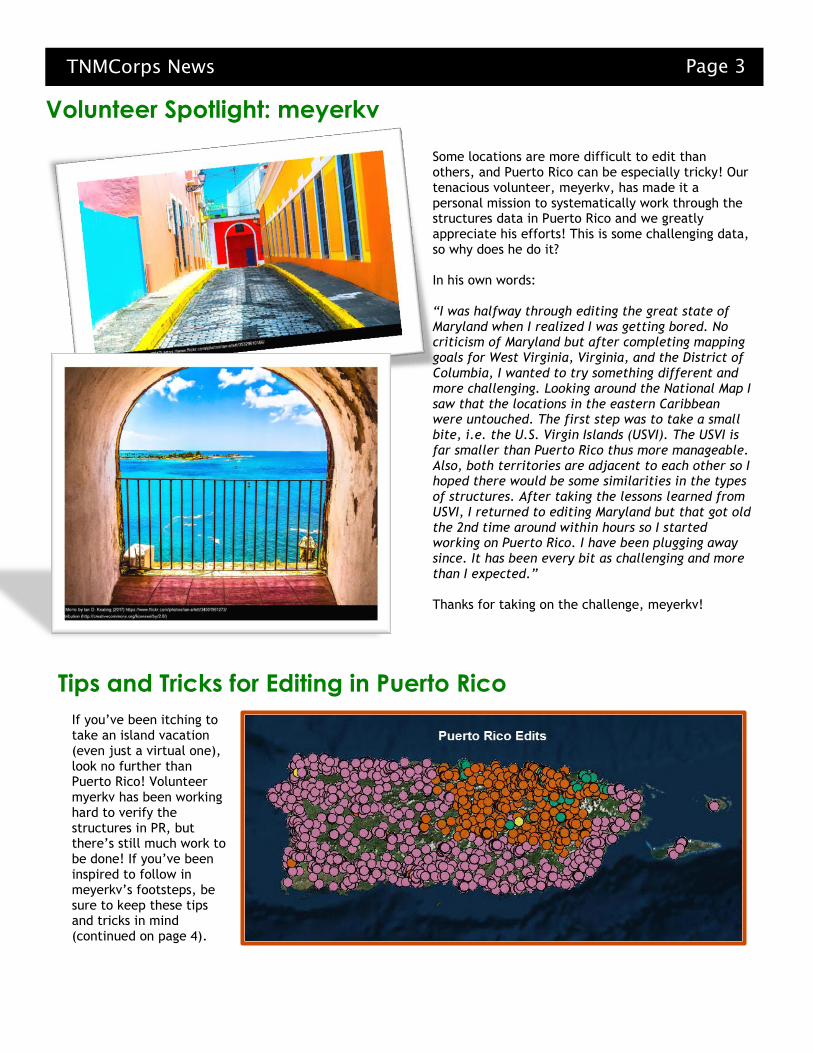
If you’ve been itching to take an island vacation (even just a virtual one), look no further than Puerto Rico! Volunteer myerkv has been working hard to verify the structures in PR, but there’s still much work to be done! If you’ve been inspired to follow in meyerkv’s footsteps, be sure to keep these tips and tricks in mind (continued on page 4).
Tips and Tricks for Editing in Puerto Rico
Volunteer Spotlight: meyerkv
Some locations are more difficult to edit than others, and Puerto Rico can be especially tricky! Our tenacious volunteer, meyerkv, has made it a personal mission to systematically work through the structures data in Puerto Rico and we greatly appreciate his efforts! This is some challenging data, so why does he do it? In his own words: “I was halfway through editing the great state of Maryland when I realized I was getting bored. No criticism of Maryland but after completing mapping goals for West Virginia, Virginia, and the District of Columbia, I wanted to try something different and more challenging. Looking around the National Map I saw that the locations in the eastern Caribbean were untouched. The first step was to take a small bite, i.e. the U.S. Virgin Islands (USVI). The USVI is far smaller than Puerto Rico thus more manageable. Also, both territories are adjacent to each other so I hoped there would be some similarities in the types of structures. After taking the lessons learned from USVI, I returned to editing Maryland but that got old the 2nd time around within hours so I started working on Puerto Rico. I have been plugging away since. It has been every bit as challenging and more than I expected.” Thanks for taking on the challenge, meyerkv!
Page 4 TNMCorps News
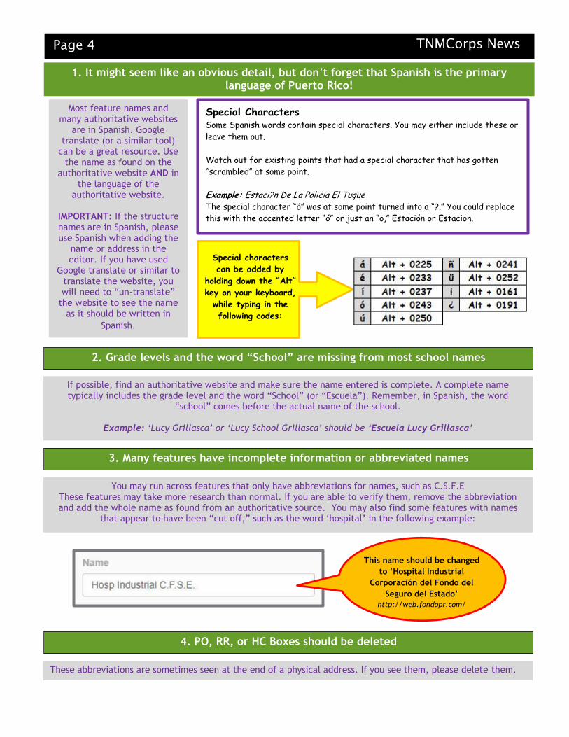
1. It might seem like an obvious detail, but don’t forget that Spanish is the primary language of Puerto Rico!
Special Characters Some Spanish words contain special characters. You may either include these or
leave them out.
Watch out for existing points that had a special character that has gotten
“scrambled” at some point.
Example: Estaci?n De La Policia El Tuque The special character “ó” was at some point turned into a “?.” You could replace
this with the accented letter “ó” or just an “o,” Estación or Estacion.
2. Grade levels and the word “School” are missing from most school names
3. Many features have incomplete information or abbreviated names
4. PO, RR, or HC Boxes should be deleted
Most feature names and many authoritative websites
are in Spanish. Google translate (or a similar tool)
can be a great resource. Use the name as found on the
authoritative website AND in the language of the
authoritative website.
IMPORTANT: If the structure names are in Spanish, please use Spanish when adding the
name or address in the editor. If you have used
Google translate or similar to translate the website, you will need to “un-translate”
the website to see the name as it should be written in
Spanish.
Special characters
can be added by
holding down the “Alt”
key on your keyboard,
while typing in the
following codes:
If possible, find an authoritative website and make sure the name entered is complete. A complete name typically includes the grade level and the word “School” (or “Escuela”). Remember, in Spanish, the word
“school” comes before the actual name of the school.
Example: ‘Lucy Grillasca’ or ‘Lucy School Grillasca’ should be ‘Escuela Lucy Grillasca’
You may run across features that only have abbreviations for names, such as C.S.F.E These features may take more research than normal. If you are able to verify them, remove the abbreviation and add the whole name as found from an authoritative source. You may also find some features with names
that appear to have been “cut off,” such as the word ‘hospital’ in the following example:
This name should be changed
to ‘Hospital Industrial
Corporación del Fondo del
Seguro del Estado’
http://web.fondopr.com/
These abbreviations are sometimes seen at the end of a physical address. If you see them, please delete them.
TNMCorps News Page 5
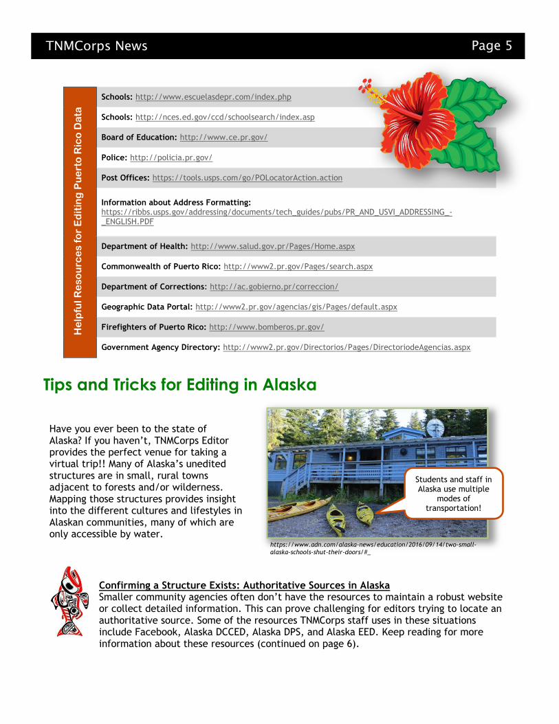
Schools: http://www.escuelasdepr.com/index.php
Schools: http://nces.ed.gov/ccd/schoolsearch/index.asp
Board of Education: http://www.ce.pr.gov/
Police: http://policia.pr.gov/
Post Offices: https://tools.usps.com/go/POLocatorAction.action
Information about Address Formatting: https://ribbs.usps.gov/addressing/documents/tech_guides/pubs/PR_AND_USVI_ADDRESSING_-_ENGLISH.PDF
Department of Health: http://www.salud.gov.pr/Pages/Home.aspx
Commonwealth of Puerto Rico: http://www2.pr.gov/Pages/search.aspx
Department of Corrections: http://ac.gobierno.pr/correccion/
Geographic Data Portal: http://www2.pr.gov/agencias/gis/Pages/default.aspx
Firefighters of Puerto Rico: http://www.bomberos.pr.gov/
Government Agency Directory: http://www2.pr.gov/Directorios/Pages/DirectoriodeAgencias.aspx
Have you ever been to the state of Alaska? If you haven’t, TNMCorps Editor provides the perfect venue for taking a virtual trip!! Many of Alaska’s unedited structures are in small, rural towns adjacent to forests and/or wilderness. Mapping those structures provides insight into the different cultures and lifestyles in Alaskan communities, many of which are only accessible by water.
Confirming a Structure Exists: Authoritative Sources in Alaska Smaller community agencies often don’t have the resources to maintain a robust website or collect detailed information. This can prove challenging for editors trying to locate an authoritative source. Some of the resources TNMCorps staff uses in these situations include Facebook, Alaska DCCED, Alaska DPS, and Alaska EED. Keep reading for more information about these resources (continued on page 6).
Tips and Tricks for Editing in Alaska
He
lpfu
l R
es
ou
rce
s f
or
Ed
itin
g P
ue
rto
Ric
o D
ata
Students and staff in Alaska use multiple
modes of transportation!
https://www.adn.com/alaska-news/education/2016/09/14/two-small-alaska-schools-shut-their-doors/#_

Page 6 TNMCorps News
FACEBOOK - Small organizations sometimes create Facebook pages for their virtual presence while others have no virtual presence at all. If search results produce a Facebook page, make sure the page is “official” before using its information to update a point.

TNMCorps News Page 7
ALASKA DCCED - Alaska’s Department of Commerce, Community and Economic Development (DCCED) often lists public service entities in a community. This can be helpful for confirming whether a structure exists. ALASKA DPS - Alaska’s Department of Public Safety (DPS) has a directory of fire departments that helps confirm whether a fire department exists. Most addresses in the directory are PO boxes, so it’s not very useful for confirming exact locations. Alas, it helps to confirm the official title of a fire department and whether users should keep or remove a point. ALASKA EED - Alaska’s Education & Early Development (EED) website has a directory of public schools in the state. The directory also provides physical addresses, which makes it quite useful for confirming both a structure’s official name and exact location.
Confirming a Structure’s Location: Aerial Imagery in Alaska Confirming the correct location of a structure can be very challenging in Alaska’s small rural towns. This is to be expected but rest assured, we have some tips and tricks to help!

Page 8 TNMCorps News
Alaska Community Profile Maps
Alaska DCCED provides an interactive set of aerials for smaller communities. While they don’t necessarily provide street views, Alaska Community Profile Maps do allow you to zoom in far enough to distinguish buildings.

TNMCorps News Page 9
TNMCorps Cryptogram!
Past Puzzle Keys
See bottom of page for solution
http://www.discoveryeducation.com/free-puzzlemaker/
ADVANCED EDITOR AUTHORITATIVE WEBSITE CARTOGRASAURUS CEMETERY COORDINATES DELETE HIGH SCHOOL HOSPITAL MIDDLE SCHOOL POST OFFICE PRISON RECOGNITION SAVE STANDARD EDITOR STRUCTURES DATA THE NATIONAL MAP CORPS TOPO MAPS
US GEOLOGICAL SURVEY
Across 7. A nearly extinct sub-species of cartographer Cartograsaurus 9. 32.9929,-81.3243 feature Swallow Savanna Cemetery 10. Recognition category given to volunteers who have edited 1000 to 1999 points Alidade Alliance Down 1. Home of the Tebbetts Post Office Missouri 2. 33.0344,-108.7052 feature Buckhorn Post Office 3. Greenmount Cemetery city Durango 4. 35.9399,-80.1055 feature **This is still a mystery since there does not appear to be a feature at this location! Please accept our apologies for this mistake! 5. Maringouin Post Office state Louisiana 6. The month TNMCorps launched the new map editor August 8. Data represented by an icon with a red border unedited
May 2017 Newsletter
March 2017 Newsletter
Cryptogram Solution: New to The National Map Corps? Head to the southeast to map points!

Page 10 TNMCorps News
CONTACT US AT: [email protected] for suggestions,
questions, additions to the next newsletter, or if you would like to
be removed from the email list.
Have a story or
photo you’d like
to share? We want them! This could be
anything from a photo of you
verifying a structure or an
interesting story that you
discovered while editing. Photos,
graphics, and stories may be used
in future news releases and social
media posts. All materials
submitted become part of the
“public domain,” and can be
used by USGS in the future unless
otherwise specified.
Please email them to
Name that App! We’ve been calling the new editor, “new editor” or “TNMCorps Map Editor”. But we could really use some help in coming up with a creative name! If you have any suggestions for a name for our online editor, please email your suggestions to [email protected].
New Recognition Category Members
Squadron of Biplane Spectators
(6000-6999)
Ring of Reconnaissance Rocketeers
(5000-5999)
Flock of Winged Witnesses
(4000-4999)
Cassie Tammy Wang
geo163
Family of Floating Photogrammetrists
(3000-3999)
Mr Ballwin
Theodolite Assemblage (2000-2999)
Alidade Alliance (1000-1999)
SD Michael
Stadia Board Society (500-999)
Mmmbekka
USGSTaylor
TSDNAV
Circle of the Surveyor’s Compass (200-499)
jgaddis
mmmbekka
Peregrine
TSDNAV
Pedometer Posse (100-199) LouisianaGirl
gmbule
Rui L
TSDNAV
mmmbekka
nina.frohling
jordanskordahl
rea1961
Society of the Steel Tape (50-99)
LouisianaGirl gmbule
LTPZ
TSDNAV
jordanskordahl
nina.frohling
rea1961
DeniBoy
Acidion
ChrisColeman
awatters
derrickdgregory
CourtneyvS
jafishe1
GlennieCastle
Acidion
CRSGamer
ChrisColeman
TUFFYJCW
derrickdgregory
AllisonMakosky
AspenShadow
Order of the Surveyor’s Chain (25-49)
gmbule
CourtneyvS
TSDNAV
awatters
nina.frohling
rea1961
DeniBoy
Karst1
ChrisColeman
jordanskordahl
lrhayden
xfxie
MMcGuill17
TehSmithster
ChrisColeman
SandiD
Awatters
jafishe1
rzolla