TKPK – BASSETERRE/Robert L. Bradshaw ST · PDF filetkpk – basseterre/robert l....
21
AIP EASTERN CARIBBEAN AD 2.7-1-1 13 MAR 08 AD 2. AERODROMES TKPK AD 2.1 AERODROME LOCATION INDICATOR AND NAME TKPK – BASSETERRE/Robert L. Bradshaw ST CHRISTOPHER(ST. KITTS) TKPK AD 2.2 AERODROME GEOGRAPHICAL AND ADMINISTRATIVE DATA 1 ARP coordinates and site at AD Lat : 17 18 41N Long : 062 43 07W Site : Mid-point of RWY on Centreline 2 Direction and distance from (city) 2.8 km (1.5 nm) NE of BASSETERRE Elevation/Reference temperature 51.8 m (170 feet) 30.2 0 C (JUN) 3 4 MAG/VAR/Annual change 14 0 W (2000) 5 AD Administration, address, telephone, telefax, telex, AFS TRINIDAD AND TOBAGO CIVIL AVIATION AUTHORITY AMD 16 St. Christopher Air & Sea Ports Authority P.O. Box 963 Basseterre St. Kitts, W.I. Tel : (869) 465-8121-3/AIRPORT DIV (869)465-8472 Telexfax: (869) 465 8124/AIRPORT DIV : (869)465-6722 AFS : TKPKYAYX 6 Types of traffic permitted (IFR/VFR) IFR/VFR 7 Remarks NIL TKPK AD 2.3 OPERATIONAL HOURS 1 AD Administration Mon – Fri. – 1200 – 2100 Except Public Holidays 2 Customs and Immigration 1000 - 0100 3 Health and Sanitation 1000 - 0100 4 AIS Briefing Office 1000 - 0100 5 ATS Reporting Office (ARO) 1000 - 0100 6 MET Briefing Office H24 7 ATS 1000 - 0100 8 Fuelling 1000 - 0100 9 Handling By arrangement with operating agencies 10 Security H24 11 De-icing NIL 12 Remarks Other times on Req 24hrs notice
Transcript of TKPK – BASSETERRE/Robert L. Bradshaw ST · PDF filetkpk – basseterre/robert l....

AIP
EASTERN CARIBBEAN AD 2.7-1-1
13 MAR 08AD 2. AERODROMES
TKPK AD 2.1 AERODROME LOCATION INDICATOR AND NAME
TKPK – BASSETERRE/Robert L. Bradshaw ST CHRISTOPHER(ST. KITTS)
TKPK AD 2.2 AERODROME GEOGRAPHICAL AND ADMINISTRATIVE DATA
1 ARP coordinates and site at AD Lat : 17 18 41N Long : 062 43 07W Site : Mid-point of RWY on Centreline
2 Direction and distance from (city) 2.8 km (1.5 nm) NE of BASSETERRE
Elevation/Reference temperature 51.8 m (170 feet) 30.20 C (JUN) 3
4 MAG/VAR/Annual change 140 W (2000) 5 AD Administration, address, telephone,
telefax, telex, AFS
TRINIDAD AND TOBAGO CIVIL AVIATION AUTHORITY AMD 16
St. Christopher Air & Sea Ports Authority P.O. Box 963 Basseterre St. Kitts, W.I. Tel : (869) 465-8121-3/AIRPORT DIV (869)465-8472 Telexfax: (869) 465 8124/AIRPORT DIV : (869)465-6722 AFS : TKPKYAYX
6 Types of traffic permitted (IFR/VFR) IFR/VFR
7 Remarks NIL
TKPK AD 2.3 OPERATIONAL HOURS
1 AD Administration Mon – Fri. – 1200 – 2100 Except Public Holidays
2 Customs and Immigration 1000 - 0100
3 Health and Sanitation 1000 - 0100
4 AIS Briefing Office 1000 - 0100
5 ATS Reporting Office (ARO) 1000 - 0100
6 MET Briefing Office H24
7 ATS 1000 - 0100
8 Fuelling 1000 - 0100
9 Handling By arrangement with operating agencies
10 Security H24
11 De-icing NIL
12 Remarks Other times on Req 24hrs notice
AD 2.7-1-2 17 MAY 01
AIP EASTERN CARIBBEAN
01/01 TRINIDAD AND TOBAGO CIVIL AVIATION AUTHORITY
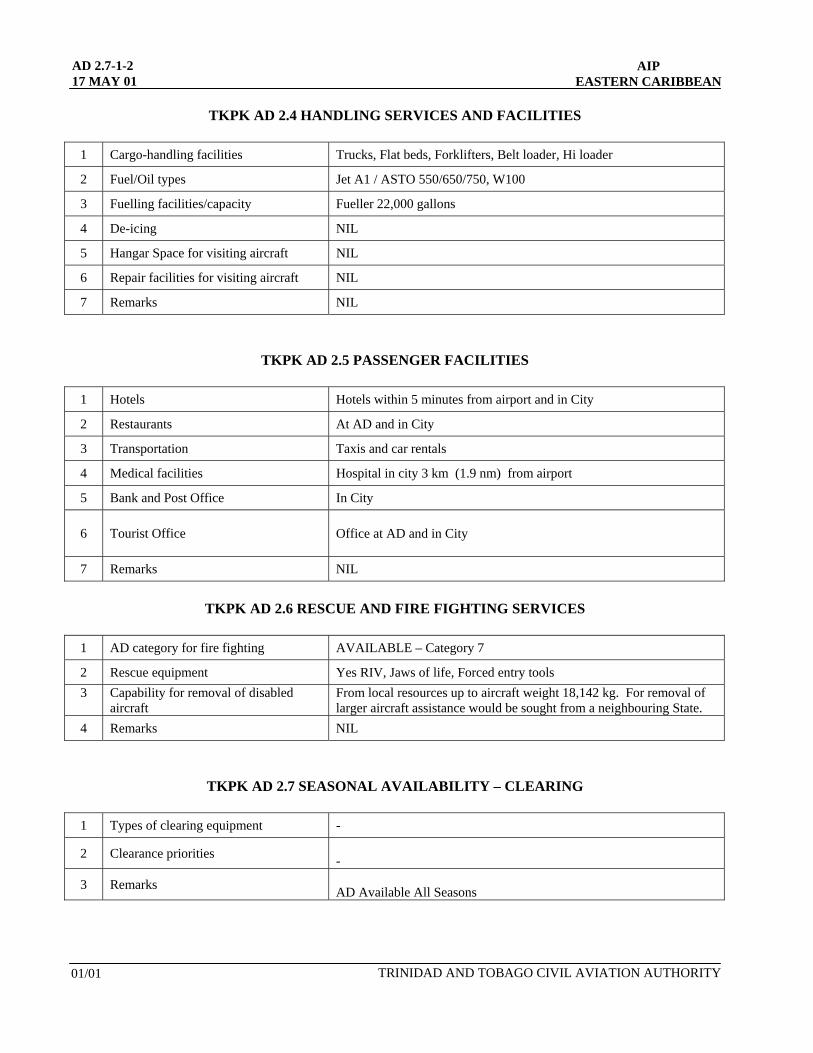
TKPK AD 2.4 HANDLING SERVICES AND FACILITIES
1 Cargo-handling facilities Trucks, Flat beds, Forklifters, Belt loader, Hi loader
2 Fuel/Oil types Jet A1 / ASTO 550/650/750, W100
3 Fuelling facilities/capacity Fueller 22,000 gallons
4 De-icing NIL
5 Hangar Space for visiting aircraft NIL
6 Repair facilities for visiting aircraft NIL
7 Remarks NIL
TKPK AD 2.5 PASSENGER FACILITIES
1 Hotels Hotels within 5 minutes from airport and in City
2 Restaurants At AD and in City
3 Transportation Taxis and car rentals
4 Medical facilities Hospital in city 3 km (1.9 nm) from airport
5 Bank and Post Office In City
6 Tourist Office Office at AD and in City
7 Remarks NIL
TKPK AD 2.6 RESCUE AND FIRE FIGHTING SERVICES
1 AD category for fire fighting AVAILABLE – Category 7
2 Rescue equipment Yes RIV, Jaws of life, Forced entry tools 3 Capability for removal of disabled
aircraft From local resources up to aircraft weight 18,142 kg. For removal of larger aircraft assistance would be sought from a neighbouring State.
4 Remarks NIL
TKPK AD 2.7 SEASONAL AVAILABILITY – CLEARING
1 Types of clearing equipment -
2 Clearance priorities -
3 Remarks AD Available All Seasons

AIP EASTERN CARIBBEAN
AD 2.7-1-3 05 JUL 07
TRINIDAD AND TOBAGO CIVIL AVIATION AUTHORITY AMD 14
TKPK AD 2.8 APRONS, TAXIWAYS AND CHECK LOCATION DATA
1 Apron surface and strength
OLD NEW Surface : Asphalt Concrete Strength : LCN 70 + 110/F/A/W/T - (can accommodate six (6)
wide-bodied aircraft)
2 Taxiway width, surface and strength
TWY A TWY B TWY C Width : 22 m 22 m 24 M Surface : Asphalt Asphalt Asphalt Strength : LCN 70 + LCN 70+ 95/F/A/W/T
3 ACL location and elevation
Location : Terminal Apron Elevation : 47.8 m (157 ft) AMSL
4 VOR/INS checkpoints
VOR : NIL INS : 171842N0624254W
5 Remarks NIL
TKPK AD 2.9 SURFACE MOVEMENT GUIDANCE AND CONTROL SYSTEM AND MARKINGS
1
Use of aircraft stand ID signs, TWY guide lines and visual docking/parking guidance system of aircraft stands
Guide lines at apron.
2
Markings: Lights (LGT)
RWY: Designation, THR, Centreline, Edge TWY: Centreline, All Holding position at all TWY/RWY Intersections RWY: THR, Edge, End TWY: Edge, Apron
3 Stop bars NIL
4 Remarks NIL

AD 2.7-1-4 17 MAY 01
AIP EASTERN CARIBBEAN
AMD 01 TRINIDAD AND TOBAGO CIVIL AVIATION AUTHORITY
TKPK AD 2.10 AERODROME OBSTACLES
In approach/TKOF areas In circling area and at AD Remarks
1 2 3
RWY/Area affected
Obstacle type Elevation Marking/LGT Coordinates
Obstacle type Elevation Marking/LGT coordinates
a b c a b
- -
NIL
NIL
Hills North of RWY 07/25 649m AMSL
and South of RWY 540m AMSL
Circling not authorized
TKPK AD 2.11 METEOROLOGICAL INFORMATION PROVIDED
1 Associated MET Office Robert L. Bradshaw, V.C. Bird, National Weather Service San Juan
2 Hours of service Met Office outside hours
0600 –0100 (or to last scheduled flight) NIL
3 Office responsible for TAF preparation Periods of validity San Juan weather service, P.R. 12 hrs with updates
4 Type of landing forecast Interval of issuance Trend
5 Briefing/consultation provided Personal consultation
6 Flight documentation Language(s) used NIL
7 Charts and other information available for briefing or consultation Available on request
8 Supplementary equipment available for providing information NIL
9 ATS units provided with information Robert L. Bradshaw TWR
10 Additional information (limitation of service, etc.) 24 hrs prior request outside hours of service
AIP
EASTERN CARIBBEAN AD 2.7-1-5
13 MAR 08
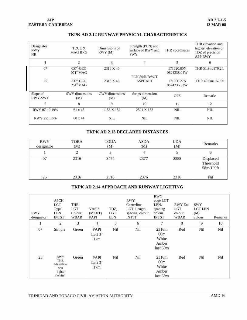
TKPK AD 2.12 RUNWAY PHYSICAL CHARACTERISTICS
Designator RWY
THR elevation and highest elevation of TDZ of precision APP RWY
TRUE & MAG BRG
Dimensions of RWY (M)
Strength (PCN) and surface of RWY and SWY
THR coordinates NR
1 2 3 4 5 6 07
25
0570 GEO 0710 MAG
2370 GEO 2510 MAG
2316 X 45
2316 X 45
TRINIDAD AND TOBAGO CIVIL AVIATION AUTHORITY AMD 16
PCN 80/R/B/W/T ASPHALT
171820.80N 0624338.04W
171900.27N
0624235.63W
THR 51.9m/170.2ft
THR 49.5m/162.5ft
Slope of RWY-SWY
SWY dimensions (M)
CWY dimensions (M)
Strips dimension (M) OFZ Remarks
7 8 9 10 11 12 RWY 07 : 0.19%
RWY 25: 1.6%
61 x 45
60 x 44
1158 X 152
NIL
2501 X 152
NIL
NIL
NIL
NIL
NIL
TKPK AD 2.13 DECLARED DISTANCES
RWY
designator TORA
(M) TODA
(M) ASDA
(M) LDA (M) Remarks
1 2 3 4 5 6 07
25
2316
2316
3474
2316
2377
2376
2258
2316
Displaced Threshold 58m/190ft
Nil
TKPK AD 2.14 APPROACH AND RUNWAY LIGHTING
RWY designator
APCH LGT Type LEN INTST
THR LGT Colour WBAR
VASIS (MEHT) PAPI
TDZ, LGT LEN
RWY Centreline LGT, Length, spacing, colour, INTST
RWY edge LGT LEN, spacing colour INTST
RWY End LGT colour WBAR
SWY LGT LEN (M) colour Remarks
1 2 3 4 5 6 7 8 9 10 07
25
Simple
RWY THR
Identification
lights (White)
Green
Green
PAPI Left 3°
17m
PAPI Left 3°
17m
Nil
Nil
Nil
Nil
2316m 60m
White Amber
last 60m
2316m 60m
White Amber
last 60m
Red
Red
Nil
Nil
Nil
Nil
AD 2.7-1-6 05 JUL 07
AIP EASTERN CARIBBEAN
AMD 14 TRINIDAD AND TOBAGO CIVIL AVIATION AUTHORITY
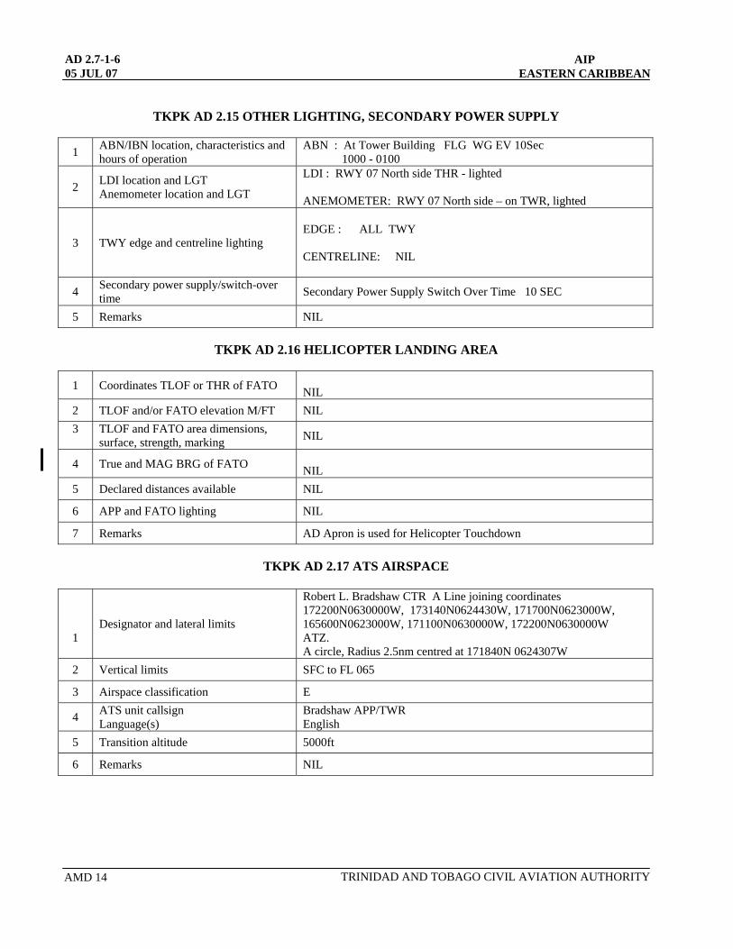
TKPK AD 2.15 OTHER LIGHTING, SECONDARY POWER SUPPLY
1 ABN/IBN location, characteristics and hours of operation
ABN : At Tower Building FLG WG EV 10Sec 1000 - 0100
LDI location and LGT 2 Anemometer location and LGT
LDI : RWY 07 North side THR - lighted ANEMOMETER: RWY 07 North side – on TWR, lighted
3 TWY edge and centreline lighting
EDGE : ALL TWY CENTRELINE: NIL
4 Secondary power supply/switch-over time Secondary Power Supply Switch Over Time 10 SEC
5 Remarks NIL
TKPK AD 2.16 HELICOPTER LANDING AREA
1 NIL Coordinates TLOF or THR of FATO
2 TLOF and/or FATO elevation M/FT NIL 3 TLOF and FATO area dimensions,
surface, strength, marking NIL
4 True and MAG BRG of FATO NIL
5 Declared distances available NIL
6 APP and FATO lighting NIL
7 Remarks AD Apron is used for Helicopter Touchdown
TKPK AD 2.17 ATS AIRSPACE
1 Designator and lateral limits
Robert L. Bradshaw CTR A Line joining coordinates 172200N0630000W, 173140N0624430W, 171700N0623000W, 165600N0623000W, 171100N0630000W, 172200N0630000W ATZ. A circle, Radius 2.5nm centred at 171840N 0624307W
2 Vertical limits SFC to FL 065
3 Airspace classification E
4 ATS unit callsign Language(s)
Bradshaw APP/TWR English
5 Transition altitude 5000ft
6 Remarks NIL

AIP
EASTERN CARIBBEAN AD 2.7-1-717 MAY 01
TKPK AD 2.18 ATS COMMUNICATION FACILITIES
Service
designation Call sign Frequency Hours of Operation Remarks
1 2 3 4 5 APP
TWR
GND
Bradshaw Approach
Bradshaw Tower
Bradshaw Ground
119.6 MHz
118.3MHz
121.9MHz
1000 – 0100
1000 - 0100
1000 - 0100
- - -
TKPK AD 2.19 RADIO NAVIGATION AND LANDING AIDS
Type of aid, CAT of
ILS/MLS ID Frequency Hours of operation
Site of transmitting antenna coordinates
Elevation of DME transmitting antenna Remarks
1 2 3 4 5 6 7
NDB DME
SKB SKB
325 KHz
112.0MHz
CH 57X
H24
H24
171742.66N 0624438.42W
171823.27N 0624340.24W
- -
TRINIDAD AND TOBAGO CIVIL AVIATION AUTHORITY 01/01

AD 2.7-1-8 AIP 15 MAR 07 EASTERN CARIBBEAN
TKPK AD 2.20 LOCAL TRAFFIC REGULATIONS
1. Airport Regulations 1.1 At Eastern Caribbean Airports, a number of local regulations apply. The regulations are available from Air Traffic
Services. These Regulations include, among other subjects, the following:
a) the meaning of markings and signs;
b) information about aircraft stands including visual docking guidance systems;
c) information about taxiing from aircraft stands including taxi clearance;
d) information about taxiing on runways
e) limitations on the operation of large aircraft including limitations on the use of the aircraft’s own power for taxiing;
f) helicopter operations;
g) marshaller assistance and towing assistance;
h) use of engine power exceeding idle power;
i) engine start-up and use of APU;
j) fuel spillage; and
k) local flying restrictions applicable to the respective aerodromes.
When a local regulation is of importance for the safe operation of aircraft on the apron, the information will be given to each aircraft by the TWR or GND. 1.2 Airport Regulations/Restrictions
1. Aircraft to make initial contact on Tower Frequency 118.3MHz 2. Services outside normal hours of operation require 24 hours prior notification 3. Minimum flight altitude over town and built up area 1500ft
4. Visual manoeuvring North of extended RWY centreline.
5. For arriving aircraft : All engines must be shut down prior to the deplaning of any passenger.
6. For departing aircraft : No engine shall be started until all passengers have boarded the aircraft.
1.3 Regulations requests
“Local Regulations” may be requested, in writing, from the AD Authority contained in AIP Section Aerodrome AD2.2 item 5.
2. Taxiing
2.1 Taxiing to and from stands
Arriving aircraft will be allocated a Gate Number by the TWR or GND.
TRINIDAD AND TOBAGO CIVIL AVIATION AUTHORITYAMD 13
AIP
EASTERN CARIBBEAN AD 2.7-1-8.113 MAR 08
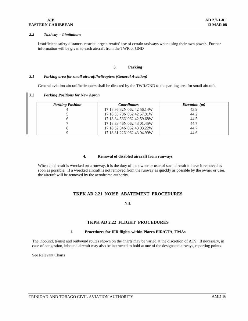
2.2 Taxiway – Limitations
Insufficient safety distances restrict large aircrafts’ use of certain taxiways when using their own power. Further information will be given to each aircraft from the TWR or GND
3. Parking 3.1 Parking area for small aircraft/helicopters (General Aviation)
General aviation aircraft/helicopters shall be directed by the TWR/GND to the parking area for small aircraft. 3.2 Parking Positions for New Apron
Parking Position Coordinates Elevation (m) 4 17 18 36.82N 062 42 56.14W
17 18 35.70N 062 42 57.91W 17 18 34.58N 062 42 59.68W 17 18 33.46N 062 43 01.45W 17 18 32.34N 062 43 03.22W
43.9 44.2 44.5 44.7 44.7
5 6 7 8 9 17 18 31.22N 062 43 04.99W 44.6
4. Removal of disabled aircraft from runways
When an aircraft is wrecked on a runway, it is the duty of the owner or user of such aircraft to have it removed as soon as possible. If a wrecked aircraft is not removed from the runway as quickly as possible by the owner or user, the aircraft will be removed by the aerodrome authority.
TKPK AD 2.21 NOISE ABATEMENT PROCEDURES
NIL
TKPK AD 2.22 FLIGHT PROCEDURES
1. Procedures for IFR flights within Piarco FIR/CTA, TMAs
The inbound, transit and outbound routes shown on the charts may be varied at the discretion of ATS. If necessary, in case of congestion, inbound aircraft may also be instructed to hold at one of the designated airways, reporting points.
See Relevant Charts
TRINIDAD AND TOBAGO CIVIL AVIATION AUTHORITY AMD 16

AD 2.7-1-8.2 13 MAR 08
AIP EASTERN CARIBBEAN
AMD 16 TRINIDAD AND TOBAGO CIVIL AVIATION AUTHORITY
TKPK AD 2.23 ADDITIONAL INFORMATION
1. Bird concentrations in the vicinity of the airport During grass cutting activities on the airfield, egrets are normally in the vicinity of the grass cutter. As far as practicable, Aerodrome/Approach Control will inform pilots of this bird activity and estimated heights. During the above periods pilots of aircraft are advised, where the design limitations of aircraft installations permit, to operate landing lights in flight, within the Control Zone and during take-off, approach-to-land and climb and descent procedures.
2. Other Information
High terrain North West through East of aerodrome.
AIP EASTERN CARIBBEAN
AD 2.7-1-9 25 OCT 07
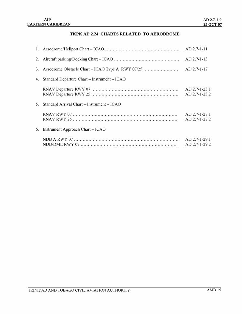
TKPK AD 2.24 CHARTS RELATED TO AERODROME
1. Aerodrome/Heliport Chart – ICAO……………………………………………. AD 2.7-1-11
2. Aircraft parking/Docking Chart – ICAO ……………………………………… AD 2.7-1-13
3. Aerodrome Obstacle Chart – ICAO Type A RWY 07/25 …………………… AD 2.7-1-17
4. Standard Departure Chart – Instrument – ICAO
RNAV Departure RWY 07 …………………………………………………… AD 2.7-1-23.1 RNAV Departure RWY 25 …………………………………………………… AD 2.7-1-23.2
5. Standard Arrival Chart – Instrument – ICAO
RNAV RWY 07 ………………………………………………………………. AD 2.7-1-27.1 RNAV RWY 25 ………………………………………………………………. AD 2.7-1-27.2
6. Instrument Approach Chart – ICAO
NDB A RWY 07 ………………………………………………………………. AD 2.7-1-29.1 NDB/DME RWY 07 ………………………………………………………….. AD 2.7-1-29.2
TRINIDAD AND TOBAGO CIVIL AVIATION AUTHORITY AMD 15
Moses
Underline
Moses
Underline
Moses
Underline
Moses
Underline
Moses
Underline
Moses
Underline
Moses
Underline
Moses
Underline
Moses
Underline
Moses
Underline

INTENTIONALLY LEFT BLANK


DIMENSIONS IN FEET /METERS ELEVA-I-IOIVS IIV FEET
AERODROME OBSTACLE CHART - ICAO TYPE A - OPERATING LIMITATIONS
BRADSHAW INTL CTKPK) BASSETERRE, ST. K l n S
RWY 07 /25
DECLARED DISTANCES
RWY 07 RWY 25
1 7599 2316 TAKE- OFF RUN AVAILABLE (TORA) 7599 23/61
1 1 3 9 8 3474 TAKE- OFF DISTANCE AVAILABLE (TODA) 7599 2316 1 1 7801 2378 ACCELEWTE STOP DISTANCE AVAILABLE (ASDA) 7796 2376 1 1 7408 2258 LANDING DISTANCE AVAILABLE (LDA) 7599 23/61
8000 9000 10000 11000 12000 VERTICAL
-0 SCALE
APPROX. 1 :I300
TRINIDAD AND TOBAGO CIVIL AVIATION AUTHORITY
HORIZONTAL SCALE APPROXIMATLY 1:13000 I FEET 0 1000 2000 3000 4000 5000
I I I I I I I I I I I I I I I I I I I I I I I I I I I I I
METERS 0 500 1000 1500

AIP
EASTERN CARIBBEAN AD 2.7-1-23.1
17 MAY 01
TKPK STANDARD DEPARTURE CHART – INSTRUMENT – ICAO RNAV DEPARTURE RWY 07
TO BE DEVELOPED
TRINIDAD AND TOBAGO CIVIL AVIATION AUTHORITY 01/01

AD 2.7-1-23.2 17 MAY 01
AIP EASTERN CARIBBEAN
TKPK STANDARD DEPARTURE CHART – INSTRUMENT – ICAO
RNAV DEPARTURE RWY 25
TO BE DEVELOPED
01/01 TRINIDAD AND TOBAGO CIVIL AVIATION AUTHORITY

AIP AD 2.7-1-27.1
EASTERN CARIBBEAN 17 MAY 01
TKPK STANDARD ARRIVAL CHART – INSTRUMENT – ICAO RNAV RWY 07
TO BE DEVELOPED
TRINIDAD AND TOBAGO CIVIL AVIATION AUTHORITY 01/01

AD 2.7-1-27.2 17 MAY 01
AIP EASTERN CARIBBEAN
TKPK STANDARD ARRIVAL CHART – INSTRUMENT – ICAO
RNAV RWY 25
TO BE DEVELOPED
01/01 TRINIDAD AND TOBAGO CIVIL AVIATION AUTHORITY
AIP EASTERN CARIBBEAN
AIP EASTERN CARIBBEAN
AD 2.7-1-29.117 MAY 01
AD 2.7-1-29.117 MAY 01
INSTRUMENT APPROACH CHART
AERODROME ELEVATION 22 FT
APP 119.8 TWR 118.0 GND 121.9
CASTRIES / GEORGE F. CHARLES
SAINT LUCIA TLPC NDB CLOUDBREAK RWY 09
BEARINGS ARE MAGNETIC ALTITUDE ELEVATIONS AND HEIGHT IN FEET
TRANSITION LEVEL: BY ATC TRANSITION ALTITUDE: 9000 FT
NOT TO SCALE
MISSED APPROACH: CLIMB ON 083º FROM SLU NDB TO 4200´, TURN RIGHT AND RETURN TO SLU NDB AND HOLD
OCA/H A B C D
STRAIGHT IN APPROACH
CIRCLING 1350' (1332')
6 KM
REMARKS: CIRCLING NOT AUTHORISED SOUTH OF RWY 09/27
MSA 4200 FT 25NM
NDB SLU
01/0101/01 TRINIDAD AND TOBAGO CIVIL AVIATION AUTHORITY TRINIDAD AND TOBAGO CIVIL AVIATION AUTHORITY
INSTRUMENT APPROACH CHART
AERODROME ELEVATION 168 FT
APP 119.6
TWR 118.3
GND 121.9
BASSETERRE/ROBERT L. BRADSHAW
ST. KITTS TKPK
NDB A RWY 07
BEARINGS ARE MAGNETICALTITUDE ELEVATIONS AND HEIGHT IN FEET
TRANSITION LEVEL: BY A.T.C.
TRANSITION ALTITUDE: 5000 FT NOT TO SCALE
MISSED APPROACH:
CLIMBING RIGHT TURN TO 3500
243 THEN CLIMBING RIGHT TURN TO 5000RETURN TO ‘SKB’ NDB AND HOLD.
´ ON° HEADING,
´.
PROCEDURE NOT AUTHORISEDWHEN TWR INOP
CIRCLING NOT AUTHORISED NORTH OF RWY 07/25
REMARKSMDA/H
STRAIGHT IN APPROACH
CIRCLING
A B C D
KNOTS
MIN:SEC
RATE OF DESC
70 90 100 120 140
1580´ (1412´)1760m
14°W (2000)
5000´
060°
240°
4300´
MSA 25 NMNDB SKB
3792´
243°
063°
018°
198°
243° hdg
ROBERT L. BRADSHAW325 SKB
• • • — • — — • • •
MNM
ALT
5000´
1 MIN
VAR
063°
243°
1580´ (1412´)2080m
1580´ (1412´)4160m
IAF/NDB SKB
M
243°
1047´
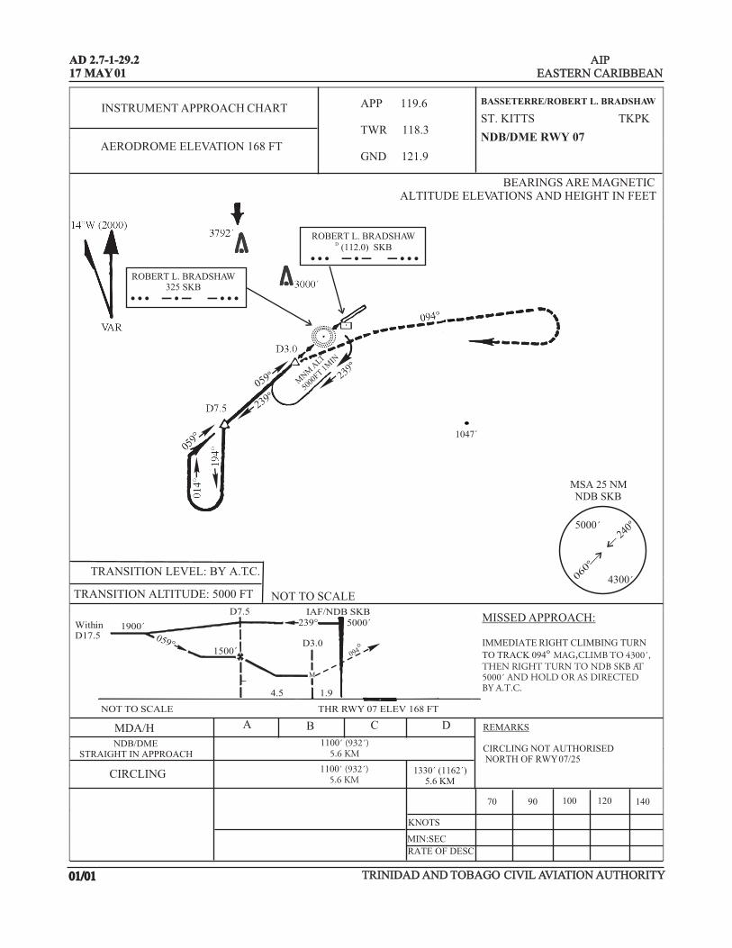
AIP EASTERN CARIBBEAN
AIP EASTERN CARIBBEAN
AD 2.7-1-29.217 MAY 01AD 2.7-1-29.217 MAY 01
INSTRUMENT APPROACH CHART
AERODROME ELEVATION 22 FT
APP 119.8 TWR 118.0 GND 121.9
CASTRIES / GEORGE F. CHARLES
SAINT LUCIA TLPC NDB CLOUDBREAK RWY 09
BEARINGS ARE MAGNETIC ALTITUDE ELEVATIONS AND HEIGHT IN FEET
TRANSITION LEVEL: BY ATC TRANSITION ALTITUDE: 9000 FT
NOT TO SCALE
MISSED APPROACH: CLIMB ON 083º FROM SLU NDB TO 4200´, TURN RIGHT AND RETURN TO SLU NDB AND HOLD
OCA/H A B C D
STRAIGHT IN APPROACH
CIRCLING 1350' (1332')
6 KM
REMARKS: CIRCLING NOT AUTHORISED SOUTH OF RWY 09/27
MSA 4200 FT 25NM
NDB SLU
01/0101/01 TRINIDAD AND TOBAGO CIVIL AVIATION AUTHORITY TRINIDAD AND TOBAGO CIVIL AVIATION AUTHORITY
INSTRUMENT APPROACH CHART
AERODROME ELEVATION 168 FT
APP 119.6
TWR 118.3
GND 121.9
BASSETERRE/ROBERT L. BRADSHAW
ST. KITTS TKPK
NDB/DME RWY 07
BEARINGS ARE MAGNETICALTITUDE ELEVATIONS AND HEIGHT IN FEET
TRANSITION LEVEL: BY A.T.C.
TRANSITION ALTITUDE: 5000 FT NOT TO SCALE
MISSED APPROACH:
IMMEDIATE RIGHT CLIMBING TURN
TO TRACK 094THEN RIGHT TURN TO NDB SKB AT5000 AND HOLD OR AS DIRECTEDBY A.T.C.
° MAG,CLIMB TO 4300´,
´
CIRCLING NOT AUTHORISED NORTH OF RWY 07/25
REMARKSMDA/HNDB/DME
STRAIGHT IN APPROACH
CIRCLING
A B C D
KNOTS
MIN:SEC
RATE OF DESC
70 90 100 120 140
1100´ (932´)5.6 KM
WithinD17.5
1900´059°
D7.5239°
IAF/NDB SKB5000´
D3.01500´
NOT TO SCALE THR RWY 07 ELEV 168 FT
4.5 1.9
ROBERT L. BRADSHAW325 SKB
• • • — • — — • • •
ROBERT L. BRADSHAWD (112.0) SKB
• • • — • — — • • •
MNM
ALT
5000
FT 1M
IN
239°
5000´
239°059°
060°
240°
4300´
M
094°
1100´ (932´)5.6 KM
MSA 25 NMNDB SKB
1330´ (1162´)5.6 KM
1047´