T.K. Bundtzen Alaska Division of Geological and...
28
Public-data File 86-27 PLACER GEOLOGY OF THE PORCUPINE MINING DISTRICT, SKAGWAY B-4 QUADRANGLE, ALASKA T.K. Bundtzen Alaska Division of Geological and Geophysical Surveys THIS REPORT HAS NOT BEEN REVIEWm FOR TECHNICAL CONTENT (EXCEPT AS NOTED I N TEXT) OR FOR CONFORHITY TO THE EDITORIAL STANDARDS OF DGGS. 794 University Avenue, Basement Fairbanks, Alaska 99709
Transcript of T.K. Bundtzen Alaska Division of Geological and...
Public-data File 86-27
PLACER GEOLOGY OF THE PORCUPINE MINING DISTRICT, SKAGWAY B-4 QUADRANGLE, ALASKA
T.K. Bundtzen
Alaska Division of Geological and Geophysical Surveys
THIS REPORT HAS NOT BEEN REVIEWm FOR TECHNICAL CONTENT (EXCEPT AS NOTED IN
TEXT) OR FOR CONFORHITY TO THE EDITORIAL STANDARDS OF DGGS.
794 University Avenue, Basement Fairbanks, Alaska 99709
CONTENTS
Page
I n t r o d u c t i o n ........................................................... Geography .............................................................. Bedrock g e o l o g i c s k e t c h ................................................ G l a c i a l geology ........................................................ .Mining h i s t o r y ................... ! ..................................... P l a c e r geology ......................................................... Economic p o t e n t i a l ..................................................... ...................................... Porcupine Creek bench l e v e l s ................................. Modern channel of Porcupine Creek
Bench and modern f l u v i a l c h a n n e l s of Cahoon Creek ................. McKinley Creek .................................................... Summit. Cottonwood. and Nugget Creek a l l u v i a l f a n s ................ G l a c i e r and Porcupine Creek a l l u v i a l f a n s .........................
References c i t e d .......................................................
F i g u r e 1 . FIGURES
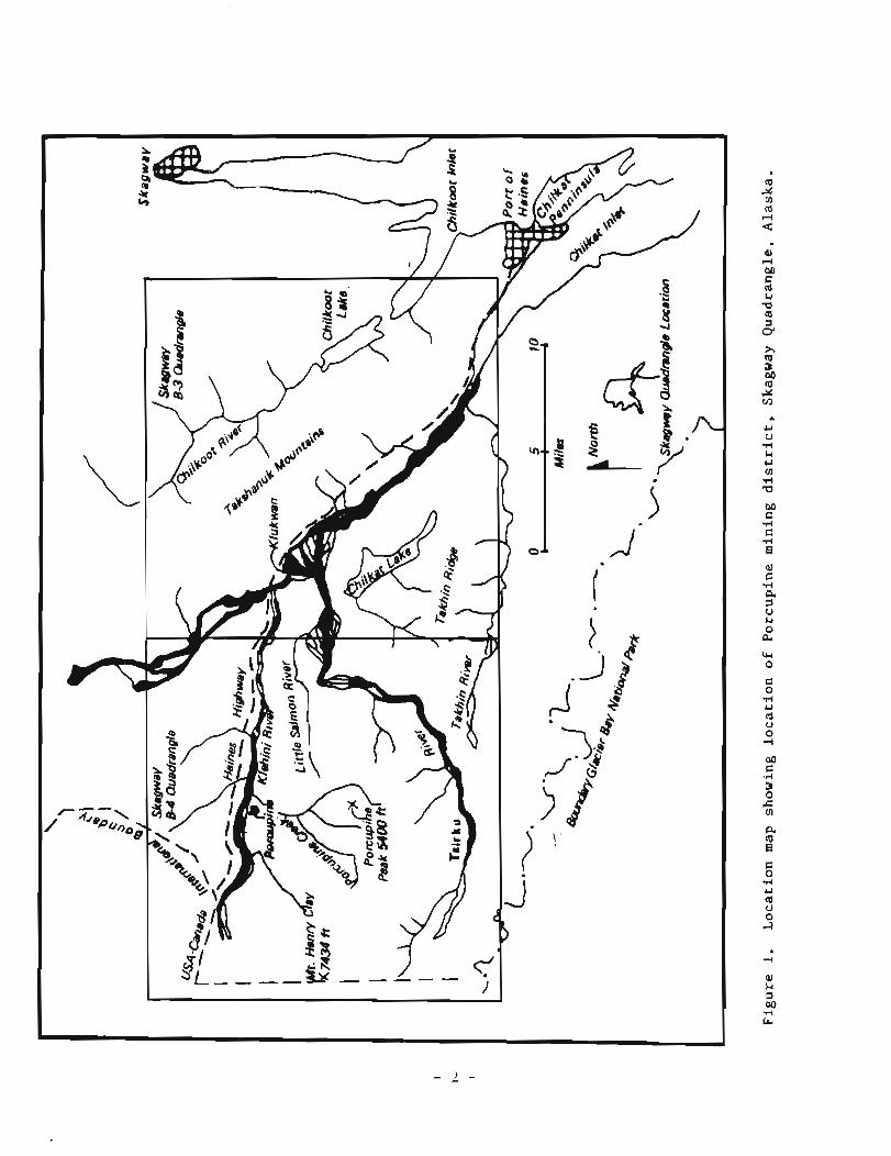
Loca t ion map showing Porcup ine mining d i s t r i c t . Skagway ...................................... Quadrangle. Alaska
Probable e x t e n t of L a t e Wisconsin g l a c i a t i o n . Porcup ine ................................. mining d i s t r i c t . Alaska
............. Deep s t ream i n c i s i o n i n Cottonwood Creek v a l l e y Canyon breakout a r e a of G l a c i e r Creek a l l u v i a l f a n ,
looking southwest ....................................... Washing p l a n t a t canyon breakout of Porcupine Creek i n 1984 . .......... Stream g r a d i e n t s i n t h e Porcupine d i s t r i c t . Alaska Locat ion of paleo-bedrock f l u v i a l channe l s t h a t a r e i n c i s e d
i n t o bedrock from t h e mouth of McKinley Creek t o t h e Porcupine Creek a l l u v i a l f a n . Porcupine d i s t r i c t .
..................................... s o u t h e a s t e r n Alaska Exposed ' a ' channe l on t h e w e s t e r n l i m i t of Porcup ine
Creek a f t e r mining a c t i v i t i e s ........................... Gossanous c a v i t y on bedrock s u r f a c e a t s i t e shown i n
f i g u r e 8 ................................................ 10 . Upper o r ' second ' w a t e r f a l l s McKinley Creek. l o o k i n g n o r t h .. 11 . Cross s e c t i o n of Porcupine and G l a c i e r Creeks a t
conf luence of K l e h i n i R iver . adapted from B e a t t y (1937) .
T a b l e 1 . Summary of r a d i o c a r b o n a n a l y s e s o f channel g r a v e l s . .............................. Porcupine d i s t r i c t . Alaska 2 . Trace element and g o l d f i n e n e s s a n a l y s e s from p l a c e r g o l d .................... i n Porcupine mining d i s t r i c t . Alaska 3 . Minera log ica l i d e n t i f i c a t i o n s of s e l e c t e d pan c o n c e n t r a t e s .
....................... Porcupine mining d i s t r i c t . Alaska 4 . Est imated bedrock f o o t a g e from paleochannels and unmined
s t ream s e c t i o n s . Porcupine Creek d ra inage . Porcup ine ................................. mining d i s t r i c t . Alaska

Page PLATE
P l a t e 1. Q u a t e r n a r y l p l a c e r geology of P o r c u p i n e mining d i s t r i c t , Alaska ................................................ I n pocke t
iii
PLACER GEOLOGY OF THE PORCUPINE M I N I N G DISTRICT SKAGWAY B-4 QUADRANGLE, ALASKA
BY T.K. Bundtzen
INTRODUCTION
During September 5-9, 1984, 'and June 15-26, 1985, t h e a u t h o r i n v e s t i - ga ted t h e Qua te rnary geology and heavy m i n e r a l p l a c e r d e p o s i t s o f t h e Porcu- p ine mining d i s t r i c t i n t h e Skagway B-3 and B-4 Quadrangles about 30 m i nor thwest of Haines i n s o u t h e a s t e r n Alaska ( f i g . 1 ) . These i n v e s t i g a t i o n s were conducted a s p a r t of a coopera t ive s t u d y of t h e Haines s u b d i s t r i c t o f the Juneau mining d i s t r i c t by t h e U.S. Bureau of Mines (USBM) and Alaska D i v i s i o n of G e o l o g i c a l and Geophysical Surveys (ADGGS). A Quaternary geo log ic map t h a t i n c l u d e s sample l o c a t i o n s , g o l d f i n e n e s s r e s u l t s , heavy m i n e r a l c o n c e n t r a t e a n a l y s e s , and i n t e r p r e t i v e t e x t a r e h e r e i n p r e s e n t e d . I thank Mark Lockwood and Karen C l a u t i c e f o r a s s i s t a n c e d u r i n g t h e 1984 and 1985 seasons r e s p e c t i v e l y . I a l s o thank Rober t Hoekzema (USBM) f o r p r o v i d i n g p l a c e r go ld samples t h a t were analyzed f o r t r a c e e lements ; i n f o r m a t i v e d i s - c u s s i o n s w i t h him and h i s c o l l e a g u e s S teve Fechner , Mark Meyer, and Nathan Rathburn a l s o a i d e d t h i s s t u d y . J a n S t i l l (USBM), provided l o g i s t i c a l sup- p o r t , and Wyatt G i l b e r t (DGGS) f r e e l y gave g e o l o g i c e x p e r t i s e dur ing t h e course of t h e i n v e s t i g a t i o n . Mine owners J o s e p h i n e J u r g e l e i t and James McLaughlin p rov ided much h i s t o r i c a l background on p a s t mining a c t i v i t i e s .
GEOGRAPHY
The Porcupine mining d i s t r i c t encompasses a 225 m i 2 r e g i o n i n south- e a s t e r n Alaska t h a t i n c l u d e s t h e g r e a t e r p o r t i o n of t h e Lower K l e h i n i R iver d r a i n a g e , a n eas tward f lowing t r i b u t a r y of t h e C h i l k a t R iver ( f i g . 1 ) . The o l d mining camp of Porcupine i s 26 m i nor thwes t of Ha ines , t h e n e a r e s t com- m e r c i a l c e n t e r l o c a t e d n e a r t h e head of Lynn Canal. A c i r c u l a r m a s s i f - l i k e upland t h a t makes up most of t h e d i s t r i c t i s bounded on t h e n o r t h by t h e K l e h i n i R i v e r , on t h e e a s t and s o u t h by t h e T s i r k u R i v e r , and on t h e west by rugged g l a c i a t e d mountains a long t h e United Sta tes-Canada b o r d e r .
R e l i e f r a n g e s from 450 i t on t h e f l o o d p l a i n s o f t h e K l e h i n i and T s i r k u Rivers t o 7 ,464-f t -high M t . Henry Clay. Porcup ine Peak, about 5,400 f e e t above s e a l e v e l , i s t h e geograph ic c e n t e r of t h e mining d i s t r i c t . The a r e a is c h a r a c t e r i z e d by s t e e p , g l a c i a l l y carved mountains and U-shaped v a l l e y s ; much of t h e s o u t h w e s t e r n p o r t i o n of t h e s t u d y a r e a i s covered by g l a c i e r s and i c e f i e l d s . Modern g l a c i e r s extend t o t h e f l o o d p l a i n s of t h e Ts i rku River a s low as 700 f t above s e a l e v e l .
Rapid p o s t - g l a c i a l downcutt ing has i n c i s e d s t e e p , bedrock-walled canyons i n t h e v a l l e y s of Porcup ine , McKinley, Cahoon, Cottonwood, Nugget, and Summit Creeks and a number of w a t e r f a l l s a r e p r e s e n t on most s t ream d r a i n a g e s . Travers ing i n v e g e t a t e d canyon a r e a s d u r i n g t h i s i n v e s t i g a t i o n was sometimes hazardous .
(I] r( a
C (I]
A dense f o r e s t of w e s t e r n hemlock, S i t k a sp ruce , and a s s o c i a t e d under- b r u s h benea th t h e f o r e s t canopy c o v e r s much of t h e h i l l s l o p e s and t e r r a c e d , g l a c i a t e d a r e a s t o approximately 3,000 f t e l e v a t i o n . Black cottonwood, a l d e r , b i r c h , and willow grow on modern f l o o d p l a i n s of t h e major s t r e a m s and on c e r t a i n h i l l s l o p e s a s h i g h a s 3 ,800 f t . The dense v e g e t a t i o n , which c o v e r s approximately 30 p e r c e n t of t h e s t u d y a r e a , i n c l u d i n g most of t h e p l a c e r mining a r e a s , o b s c u r e s bedrock and Qua te rnary g e o l o g i c r e l a t i o n s h i p s .
Access t o t h e r e g i o n i s provfded by a bumpy 9-mi-long l o g g i n g and mining road from Mile 3 2 of t h e Haines Highway t o t h e o l d mining community of Porcu- p i n e n e a r t h e mouth of Porcupine Creek. From h e r e , logg ing and mining r o a d s , and f o o t t r a i l s provide a d d i t i o n a l l i m i t e d a c c e s s t o t h e mining camps.
BEDROCK GEOLOGIC SKETCH
Bedrock geology was examined o n l y i n mined a r e a s d u r i n g t h e i n v e s t i g a - t i o n . The v a r i o u s sed imenta ry , metamorphic, and g r a n i t i c r o c k s were o r i g i n a l l y d e s c r i b e d by Eakin (1919) , l a t e r by MacKevett and Winkler (1974) , and most r e c e n t l y by Redman and o t h e r s (1985) .
P o s s i b l y t h e o l d e s t rock u n i t i n t h e a r e a is t h e Middle t o L a t e P a l e o z o i c Porcupine Limestone o r Marble, which forms prominent o u t c r o p s of c a r b o n a t e a long t h e a c c e s s road on t h e s o u t h s i d e of t h e K l e h i n i R i v e r and a l o n g canyon w a l l s of Porcupine Creek. Amphipora-bearing zones on Porcupine Creek s u g g e s t Devonian o r M i s s i s s i p p i a n ages . Over lying t h e Porcup ine Limestone is t h e Porcupine S l a t e , which may range i n age from M i s s i s s i p p i a n t o Pennsylvanian (Redman and o t h e r s , 1985) . The s l a t e , s a n d s t o n e , and s i l t s t o n e of t h e Porcupine S l a t e forms a complex a n t i f o r m th roughout t h e c e n t r a l p o r t i o n of t h e s t u d y a r e a . A u r i f e r o u s l o d e s c u t t i n g t h i s ' s l a t e b e l t ' a r e b e l i e v e d by many p r e v i o u s workers t o be t h e s o u r c e o f most p l a c e r g o l d i n t h e d i s t r i c t . The w e s t e r n and n o r t h e a s t e r n r e g i o n s a r e u n d e r l a i n by p i l l o w b a s a l t , ca rbona te , and v o l c a n i c l a s t i c sediments t h a t may be T r i a s s i c i n a g e , based on f o s s i l s c o l l e c t e d i n 1985 (Ken Dawson, o r a l . c o m u n . , 1985). Many of t h e c o n t a c t r e l a t i o n s h i p s between major l ayered u n i t s a r e thought t o be f a u l t s based on t h e most r e c e n t mapping (Redman and o t h e r s , 1985) . The h i g h e s t p o r t i o n of t h e m a s s i f - l i k e up land i s cored by a 15 m i 2 g r a n o d i o r i t e p l u t o n .
GLACIAL GEOLOGY
The s tudy a r e a b e a r s i m p r e s s i v e ev idence of e x t e n s i v e g l a c i a t i o n b u t s p e c i f i c l i m i t s of t h e v a r i o u s P l e i s t o c e n e and Holocene g l a c i a l advances a r e n o t w e l l unders tood. The r e c e n t n a t u r e o f g l a c i a t i o n th roughout s o u t h e a s t e r n Alaska h a s masked a l l ev idence of i c e a c t i v i t y p r i o r t o a b o u t 70,000 y r B.P. (Molnia, 1986; Mann, 1986; Pdwh, 1975) , and v i r t u a l l y a l l g l a c i a l d e p o s i t s and landforms observed today i n t h e Porcupine a r e a a r e p robab ly L a t e Wisconsin (30,000 t o 10,000 y r B.P.) and younger. G l a c i e r s th roughout t h e Alexander Archipelago, i n c l u d i n g t h e s t u d y a r e a , had a complex h i s t o r y d u r i n g L a t e Wisconsin t ime. I c e expanded r a d i a l l y from i s l a n d s o r mountain m a s s i f s a t t h e same time major i c e s t r e a m s were invading t h e c o a s t l i n e from t h e i n t e r i o r and t h e Coast Range mountains . Hence dur ing L a t e Wisconsin and p o s s i b l y Ear ly Holocene, l a r g e g l a c i a l t r o u g h s of t h e K l e h i n i , C h i l k a t , and
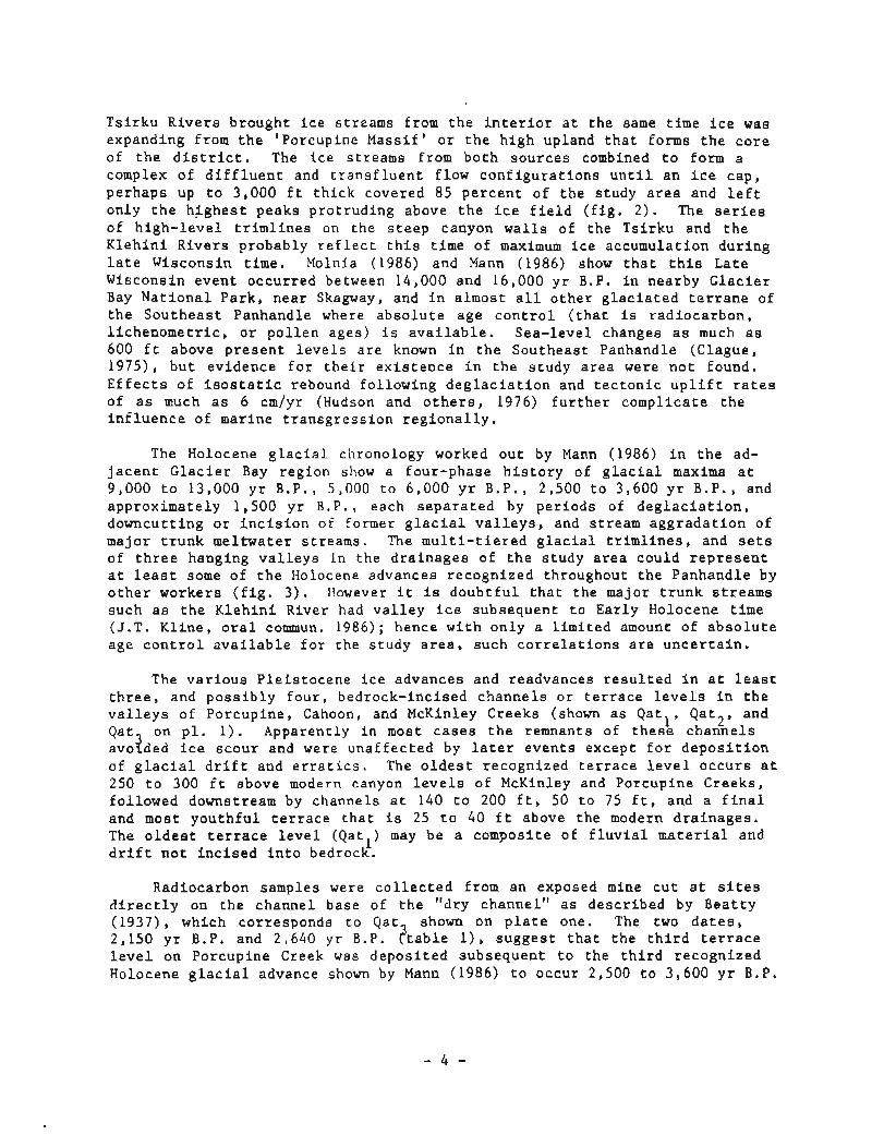
T s i r k u R i v e r s b rought i c e s t reams from t h e i n t e r i o r a t t h e same t ime i c e was expanding from t h e 'Porcupine Mass i f ' o r t h e h i g h upland t h a t forms t h e c o r e of t h e d i s t r i c t . The i c e s t reams from b o t h s o u r c e s combined t o form a complex of d i f f l u e n t and t r a n s f l u e n t f low con£ i g u r a t i o n s u n t i l a n i c e cap , pe rhaps up t o 3,000 f t t h i c k covered 85 p e r c e n t of t h e s tudy a r e a and l e f t on ly t h e h i g h e s t peaks p r o t r u d i n g above t h e i c e f i e l d ( f i g . 2 ) . The s e r i e s of h i g h - l e v e l t r i m l i n e s on t h e s t e e p canyon w a l l s of t h e T s i r k u and t h e K l e h i n i R i v e r s probably r e f l e c t t h i s t ime of maximum i c e accumulat ion d u r i n g l a t e Wisconsin t ime. Molnia (1986) and Mann (1986) show t h a t t h i s L a t e Wisconsin e v e n t occur red between 14,000 and 16,000 y r B.P. i n nearby G l a c i e r Bay N a t i o n a l P a r k , n e a r Skagway, and i n a lmos t a l l o t h e r g l a c i a t e d t e r r a n e of t h e S o u t h e a s t Panhandle where a b s o l u t e age c o n t r o l ( t h a t i s r a d i o c a r b o n , l i c h e n o m e t r i c , o r p o l l e n ages ) i s a v a i l a b l e . Sea- level changes a s much a s 600 f t above p r e s e n t l e v e l s a r e known i n t h e Sou theas t Panhandle (Clague, 1975) , b u t ev idence f o r t h e i r e x i s t e n c e i n t h e s t u d y a r e a were n o t found. E f f e c t s of i s o s t a t i c rebound fo l lowing d e g l a c i a t i o n and t e c t o n i c u p l i f t r a t e s of a s much a s 6 cm/yr (Hudson and o t h e r s , 1976) f u r t h e r compl ica te t h e i n f l u e n c e of marine t r a n s g r e s s i o n r e g i o n a l l y .
The Holocene g l a c i a l chronology worked o u t by Mann (1986) i n t h e ad- j a c e n t G l a c i e r Bay r e g i o n show a four-phase h i s t o r y of g l a c i a l maxima a t 9 ,000 t o 13,000 y r B.P., 5,000 t o 6,000 y r B.P., 2,500 t o 3,600 y r B.P., and approx imate ly 1,500 y r B.P., each s e p a r a t e d by p e r i o d s of d e g l a c i a t i o n , downcut t ing o r i n c i s i o n of former g l a c i a l v a l l e y s , and s t ream a g g r a d a t i o n of major t r u n k mel twa te r s t reams . The m u l t i - t i e r e d g l a c i a l t r i m l i n e s , and s e t s of t h r e e hanging v a l l e y s i n t h e d r a i n a g e s of t h e s t u d y a r e a cou ld r e p r e s e n t a t l e a s t some of t h e Holocene advances recognized throughout t h e Panhandle by o t h e r workers ( f i g . 3 ) . However i t is d o u b t f u l t h a t t h e major t r u n k s t r e a m s such a s t h e K l e h i n i River had v a l l e y i c e subsequent t o E a r l y Holocene t ime ( J . T . K l i n e , o r a l commun. 1986) ; hence w i t h o n l y a l i m i t e d amount of a b s o l u t e age c o n t r o l a v a i l a b l e f o r t h e s t u d y a r e a , such c o r r e l a t i o n s a r e u n c e r t a i n .
The v a r i o u s P l e i s t o c e n e i c e advances and readvances r e s u l t e d i n a t l e a s t t h r e e , and p o s s i b l y f o u r , bedrock- incised c h a n n e l s o r t e r r a c e l e v e l s i n t h e v a l l e y s of Porcup ine , Cahoon, and McKinley Creeks (shown a s Q a t l , Qa t2 , and Qat on p l . 1 ) . Apparent ly i n most c a s e s t h e remnants of t h e s e c h a n n e l s avo?ded i c e s c o u r and were u n a f f e c t e d by l a t e r e v e n t s excep t f o r d e p o s i t i o n of g l a c i a l d r i f t and e r r a t i c s . The o l d e s t r ecognized t e r r a c e l e v e l o c c u r s a t 250 t o 300 f t above modern canyon l e v e l s of McKinley and Porcupine Creeks , fo l lowed downstream by channels a t 140 t o 200 f t , 50 t o 75 f t , and a f i n a l and most y o u t h f u l t e r r a c e t h a t i s 25 t o 40 f t above t h e modern d r a i n a g e s . The o l d e s t t e r r a c e l e v e l (Qat l ) may be a composi te of f l u v i a l m a t e r i a l and d r i f t n o t i n c i s e d i n t o bedrock.
Radiocarbon samples were c o l l e c t e d from an exposed mine c u t a t s i t e s d i r e c t l y on t h e channe l base of t h e "dry channel ' ' a s d e s c r i b e d by B e a t t y (1937) , which cor responds t o Qat shown on p l a t e one. The two d a t e s , 2,150 y r B.P. and 2,640 y r B.P. ? t a b l e I ) , s u g g e s t t h a t t h e t h i r d t e r r a c e l e v e l on Porcup ine Creek was d e p o s i t e d subsequen t t o t h e t h i r d recognized Holocene g l a c i a l advance shown by Mann (1986) t o occur 2,500 t o 3 ,600 y r B.P.
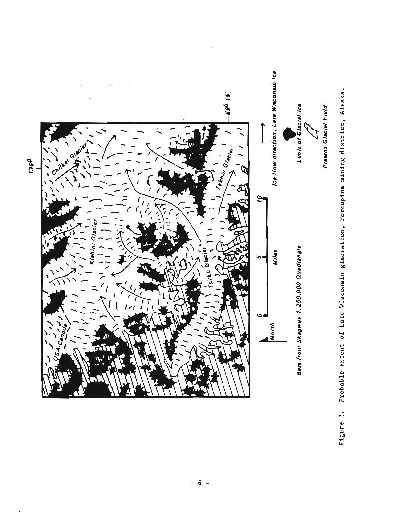
F i g u r e 3 . Deep s t r e a m i n c i s i o n i n Cottonwood Creek v a l l e y . (Note former perched hanging v a l l e y a t 3,150 f t e l e v a t i o n ) .
- 7 -

Table 1. Summary of radiocarbon analyses of channel g r a v e l s , Porcupine d i s t r i c t , Alaska.
C-14 age Lab number F ie ld number (y r B.P. 2 lx ) Remarks
Beta 11090 8BTC2
Beta 11091 8BTC3
2,190 2 90 B.P . Woody m a t e r i a l i n dry channel near w a t e r f a l l .
i
2,640 2 100 B.P. Wood from base of dry channel , western s i d e of Porcupine Creek.
The l a s t Holocene advance [ B e a t t y ' s (1937) second and f i n a l r e t r e a t ] occupied 1- t o 2 -mi s t r e t c h e s of Porcupine, McKinley, and G l a c i e r Creek v a l l e y s below present g l a c i a l t e rmin i a s c l e a r l y i nd ica t ed by r ecen t morainal l i m i t s on a i r photos. I t could c o r r e l a t e with the 1,000 t o 1,500 y r B.P. La te Holocene advance descr ibed by Mann (1986). Beatty (1937) r e p o r t s t h a t t h e a c t i v e g l a c i e r on Cahoon Creek r e t r e a t e d near ly a mi le dur ing t h e years 1898 t o 1937, i nd ica t ing t h a t t he reg ion i s s t i l l undergoing d e g l a c i a t i o n fo l lowing the l a t e s t Holocene advance(s) .
Besides leaving behind mul t ip l e d r i f t l i m i t s , bedrock-incised bench channels , t r i m l i n e s , and hanging v a l l e y s , mul t ip le g l a c i a l ep isodes a l s o produced perched a l l u v i a l and c o l l u v i a l fans and ice-marginal meltwater channels ( p l . 1 ) . The a l l u v i a l f a n complex of Porcupine and Glac i e r Creeks (Qaf u n i t on p l . 1) has obviously had more than one per iod of agg rada t iona l development and the former f an apex was probably a t l e a s t 1 m i south of i t s p re sen t p o s i t i o n a t the breakout of Porcupine Canyon ( f i g . 4 ) . A d i s t r i b u t - a r y channel of t h i s fan probably s p i l l e d over i n t o the dra inage now occupied by Walker Lake. A s Porcupine and o t h e r a l l u v i a l fans b u i l t up, t h e s t reams developed mul t ip le d i s t r i b u t a r y channels across t h e i r s u r f a c e s . The barbed t r i b u t a r y e f f e c t of the Glac i e r and Porcupine fans f o r t h e l a s t 1.5 m i of t h e i r courses t o the Klehin i River r e f l e c t s these changes dur ing f a n evolu- t ion .
Development of a l l u v i a l f ans on Cottonwood and Nugget Creeks have been s i g n i f i c a n t l y inf luenced by e a r l i e r e a s t t o west g lac ia l -mel twater f e a t u r e s t h a t dra ined Late Wisconsin o r Holocene v a l l e y i c e i n t h e Ts i rku River . Former i c e marginal meltwater channels have l e f t prominently notched, be- headed drainages i n the Herman Creek and Walker Lake a r e a , a long t h e Klehin i River near t he United States-Canada border , and i n i s o l a t e d s e c t i o n s of t he Ts i rku River (p l . 1 ) . The meltwater channels a r e i nc i sed i n g l a c i a l d r i f t i n c o n t r a s t t o t he bedrock i n c i s i o n of f l u v i a l channels p rev ious ly descr ibed.
Elevated, modern t e r r a c e al luvium and a l l u v i a l f a n s of L a t e s t Holocene age p a r a l l e l the modern f loodp la ins of the Tsirku and Kleh in i Rivers and a r e a r e s u l t of recent per iods of s t ream aggradat ion during d i s t r i b u t a r y channel development.
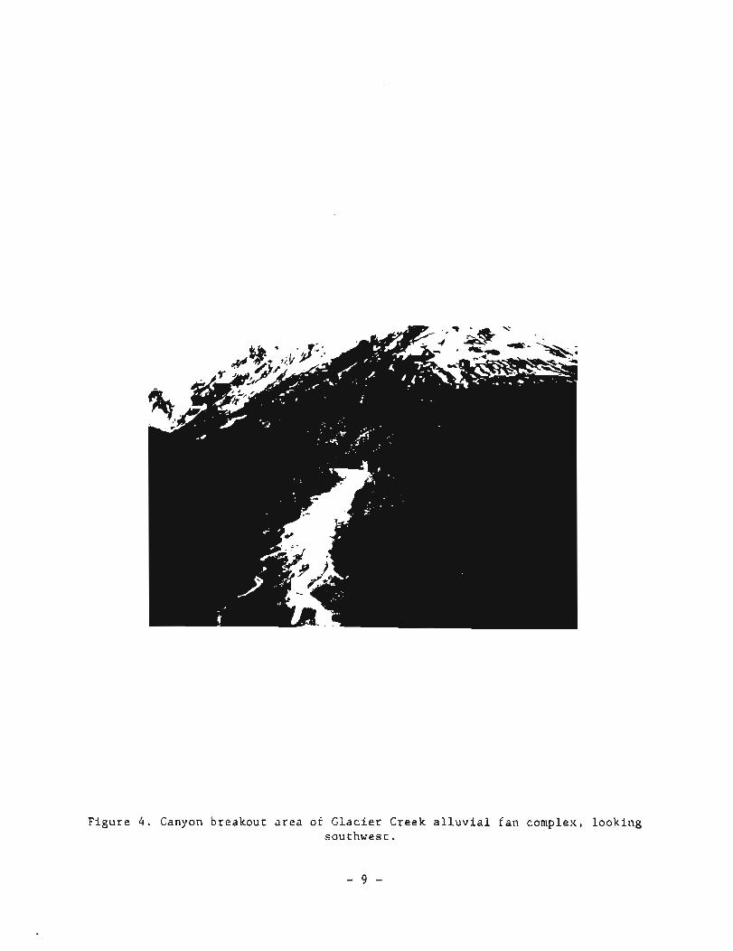
F i g u r e 4 . Canyon b reakou t a r e a of G l a c i e r Creek a l l u v i a l f a n complex, l o o k i n g sou thwes t .
M I N I N G HISTORY
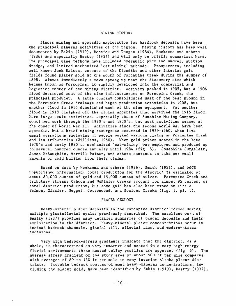
P l a c e r mining and s p o r a d i c e x p l o r a t i o n f o r h a r d r o c k d e p o s i t s have been t h e p r i n c i p a l m i n e r a l a c t i v i t i e s of t h e r e g i o n . Mining h i s t o r y has been w e l l documented by Eakin (1919) , Rennick and Doogan (1984) , Hoekzema and o t h e r s (1986) and e s p e c i a l l y B e a t t y (1937) and w i l l o n l y be b r i e f l y summarized h e r e . The p r i n c i p a l mine methods have included h y d r a u l i c p i c k and shove l , s u c t i o n dredge, and l i m i t e d mechanized 'cat-mining' methods. P r o s p e c t o r s , i n c l u d i n g w e l l known J a c k D a l t o n , e n r o u t e t o ' t h e Klondike and o t h e r i n t e r i o r go ld f i e l d s found p l a c e r g o l d a t t h e mouth of Porcup ine Creek d u r i n g t h e summer of 1898. Almost immediate ly a town sprang up n e a r t h e d i s c o v e r y s i t e which became known a s Porcup ine ; i t r a p i d l y developed i n t o t h e commercial and l o g i s t i c s c e n t e r of t h e mining d i s t r i c t . A c t i v i t y peaked i n 1905, b u t a 1906 f lood d e s t r o y e d most of t h e mine i n f r a s t r u c t u r e on Porcupine Creek, t h e p r i n c i p a l p roducer . A l a r g e company c o n s o l i d a t e d most of t h e b e s t ground i n t h e Porcupine Creek d r a i n a g e and began p r o d u c t i o n a c t i v i t i e s i n 1908, b u t a n o t h e r f l o o d i n 1915 demolished much of t h e mine equipment. Yet a n o t h e r f lood i n 1918 f i n i s h e d o f f t h e mining a p p a r a t u s t h a t s u r v i v e d t h e 1915 f l o o d . More l a r g e - s c a l e a c t i v i t i e s , e s p e c i a l l y t h o s e of Sunshine Mining Company, cont inued work th rough t h e 1920 's and 19301s, b u t most a c t i v i t i e s ceased a t t h e o n s e t of World War 11. A c t i v i t i e s s i n c e t h e second World War have been s p o r a d i c , b u t a b r i e f mining resurgence o c c u r r e d i n 1959-1960, when f i v e small o p e r a t i o n s employing 15 people worked v a r i o u s c l a i m s on Porcupine Creek and i t s t r i b u t a r i e s (Wil l iams, 1960). When g o l d p r i c e s s o a r e d i n t h e l a t e 1970 's and e a r l y 19801s , mechanized 'ca t -mining ' was employed and produced up t o s e v e r a l hundred ounces annua l ly u n t i l 1984 ( f i g . 5 ) . Joseph ine J u r g e l e i t , James McLaughlin, M e r r i l l Palmer, and o t h e r s c o n t i n u e t o t a k e o u t s m a l l amounts of g o l d b u l l i o n from t h e i r c la ims.
Based on d a t a by Hoekzema and o t h e r s (1986) , Smith (1933) , and DGGS unpubl ished i n f o r m a t i o n , t o t a l p roduc t ion f o r t h e d i s t r i c t i s e s t i m a t e d a t about 80,000 ounces of g o l d and 15,000 ounces o f s i l v e r . Porcupine Creek and t r i b u t a r y s t r e a m s Cahoon and McKinley Creeks account f o r a lmost 95 p e r c e n t of t o t a l d i s t r i c t p r o d u c t i o n , bu t some go ld h a s a l s o been mined on L i t t l e Salmon, G l a c i e r , Nugget, Cottonwood, and Boulder Creeks ( f i g . 1 , p l . 1 ) .
PLACER GEOLOGY
Heavy-mineral p l a c e r d e p o s i t s i n t h e Porcup ine d i s t r i c t formed d u r i n g m u l t i p l e g l a c i o f l u v i a l c y c l e s p r e v i o u s l y d e s c r i b e d . The e x c e l l e n t work of Bea t ty (1937) p r o v i d e s many d e t a i l e d summaries of p l a c e r d e p o s i t s and t h e i r e x p l o i t a t i o n i n t h e d i s t r i c t . Heavy-mineral p l a c e r c o n c e n t r a t i o n s occur i n i n c i s e d bedrock c h a n n e l s , g l a c i a l till, a l l u v i a l f a n s , and modern-stream i n c i s i o n s .
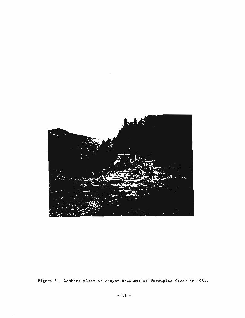
Very h i g h bedrock-s t ream g r a d i e n t s i n d i c a t e t h a t t h e d i s t r i c t , a s a whole, is c h a r a c t e r i z e d a s v e r y immature and n e s t e d i n a v e r y h igh energy f l u v i a l environment; t h r e e n e s t e d v a l l e y p r o f i l e s a r e a p p a r e n t ( f i g . 6 ) . The average s t r e a m g r a d i e n t of t h e s tudy a r e a of abou t 500 f t p e r m i l e compares w i t h averages of 80 t o 150 f t per mi le i n many i n t e r i o r Alaska p l a c e r d i s - t r i c t s . P robab le bedrock s o u r c e s of most heavy-mineral c o n c e n t r a t i o n s , i n - c l u d i n g t h e p l a c e r g o l d , have been i d e n t i f i e d by Eakin (1919) , Bea t ty (1937) ,
F i g u r e 5. Washing p l a n t a t canyon b r e a k o u t o f P o r c u p i n e Creek i n 1984.
- 11 -
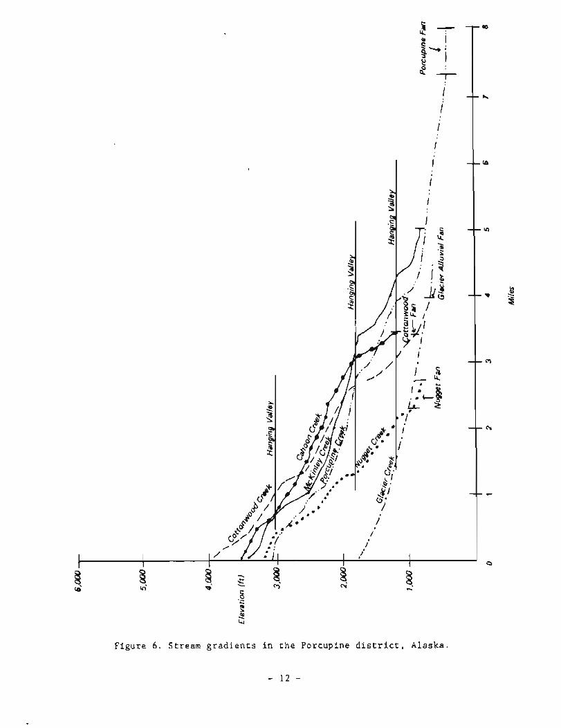
F i g u r e 6 . S t r e a m g r a d i e n t s i n t h e P o r c u p i n e d i s t r i c t , A l a s k a .
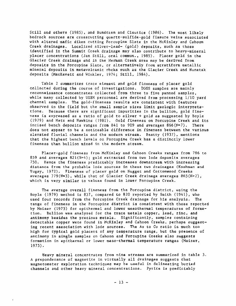
Still and others (1985), and Bundtzen and Clautice (1986). The most likely bedrock sources are crosscutting quartz-sulfide-gold fissure veins associated with altered mafic dikes cutting Porcupine Slate in the McKinley and Cahoon Creek drainages. Localized silver-lead- (gold) deposits, such as those identified in the Summit Creek drainage may also contribute to heavy-mineral placer concentrations (Jan Still, oral commun., 1985). Placer gold in the Glacier Creek drainage and in the Herman Creek area may be derived from deposits in the Porcupine Slate, or alternatively from stratiform metallic mineral deposits in metavolcanic rbcks such as the Glacier Creek and Nunatak deposits (MacKevett and Winkler, 1974; Still, 1984).
Table 2 summarizes trace element and gold fineness of placer gold collected during the course of investigations. DGGS samples are mainly reconnaissance concentrates collected from three to five panned samples, while many collected by USBM personnel are derived from processing 1/10 yard channel samples. The gold-fineness results are consistent with features observed in the field but the small sample sizes limit geologic interpreta- tions. Because there are significant impurities in the bullion, gold fine- ness is expressed as a ratio of gold to silver + gold as suggested by Boyle (1979) and Metz and Hawkins (1981). Gold fineness on Porcupine Creek and its incised bench deposits ranges from 841 to 909 and averages 866(N=7). There does not appear to be a noticeable difference in fineness between the various elevated fluvial channels and the modern stream. Beatty (1937), mentions that the highest bench levels on Porcupine Creek has a distinctly lower fineness than bullion mined in the modern stream.
Placer-gold fineness from McKinley and Cahoon Creeks ranges from 786 to 859 and averages 821(N=4); gold extracted from two lode deposits averages 750. Hence the fineness predictably increases downstream with increasing distance from the probable lode sources in these two drainages (Koshman and Yugay, 1972). Fineness of placer gold on Kugget and Cottonwood Creeks averages 779(N=3), while that of Glacier Creek drainage averages 865(N=2), which is very similar to values found in lower Porcupine Creek.
The average overall fineness from the Porcupine district, using the Boyle (1979) method is 837, compared to 820 reported by Smith (1941), who used four records from the Porcupine Creek drainage for his analysis. The range of fineness in the Porcupine district is consistent with those reported by Moiser (1975) for epithermal and lower mesothermal temperatures of forma- tion. Bullion was analyzed for the trace metals copper, lead, zinc, and antimony besides the precious metals. Significantly, samples containing detectable copper were found in McKinley and Cahoon Creeks, perhaps suggest- ing recent association with lode sources. The Au to Cu ratio is much too high for typical gold placers of any temperature range, but the presence of antimony in single samples on Cahoon and Porcupine Creeks also suggests formation in epithermal or lower meso-thermal temperature ranges (Moiser, 1975).
Heavy mineral concentrates from nine streams are summarized in table 3. A preponderance of magnetite in virtually all drainages suggests that magnetometer exploration techniques may be useful in delineating buried channels and other heavy mineral concentrations. Pyrite is predictably

Table 2. Trace element and gold f i n e n e s s a n a l y s e s from p l a c e r go ld i n t h e Porcupine mining d i s t r i c t , Alaska. 1
F i e l d no.
9047
Drainage bas i n l o c a l i t y (c reek)
Porcupine
Porcupine
Porcupine
Porcupine
Porcupine
Porcupine Porcupine
McKinley
McKinley
McKinley McKinley
McKinley Cahoon
G l a c i e r
Chris tmas
Nugget
Nugget
Cottonwood
Sample weight (mg)
21.64
64.01
35.36
34.75
64.94
67.18 50.70
65.82
4.97
33.74 16.15
8.15 70.10
36.60
9.01
60.09
28.40
18.30
Gold ( p p t )
7 94
90 2
817
81.2
822
838 838
8 1 1
779
669 855
780 7 38
855
835
722
756
769
S i l v e r ( p p t )
140
90
145
144
155
107 115
18 7
170
259 136
219 201
136
129
236
207
19 3
Other ( p p t )
1
8
38
44
2 9
5 5 47
2
5 1
50 0
1 1 3
9
36
42
37
38
True f i n e n e s s
850
90 9
849
849
84 1
886 879
813
820
721 859
780 786
863
866
754
78 5
799
Channel sample, 1 / 1 0 y a r d , Por- cup i n e Creek. Channel sample 1 / 1 0 y a r d , ou t be- low plunge pool . Channel sample 1 / 1 0 y a r d , modern Porcupine channe l . Channel sample 1 /10 y a r d , bench upstream from cab in . 3 pans on bedrock n e a r l a n d s l i d e on ' a ' bench west s i d e o f creek. Channel sample, 1 / 1 0 yard . 112 pan, MacElvery channe l , e a s t - s i d e Porcupine Creek. Channel sample, 1 / 1 0 y a r d , on bedrock. Channel sample, 1 / 1 0 y a r d , boulder l a y e r under col luvium. From s u l f i d e vug, ' l a d d e r v e i n ' . 3 pans, modern f l o o d p l a i n , boulder - r ich . From-Golden Eagle vug v e i n . Channel sample, 1 / 1 0 y a r d , on and i n bedrock c racks . Channel sample, 1 / 1 0 y a r d , 6 i n . g r a v e l on bedrock. 3 pans, from a u r i f e r o u s t i l l on bedrock. Channel sample, 1 / 1 0 yard , f l u v i a l g r a v e l and t i l l . 3 pans, modern f l o o d p l a i n , no t on bedrock. 3 pans, modern f l o o d p l a i n , no t on bedrock.
%old b u l l i o n d e r i v e d from channel and g r a b samples c o l l e c t e d by Robert Hoekzema, S teve Fechner, Mark Meyer, and Nathan Rathburn (USBM) and Tom Bundtzen and Karen C l a u t i c e (DGGS). A l l e lements p resen ted i n p a r t s p e r thousand; gold and s i l v e r de te rmina t ions by P e t e r Lee, Chemex Labs, I n c . , Vancouver, B.C. V7J2C1, by Bondar Clegg Company, Ltd. , Lakewood, Colorado, 80228 and by N.C. Veach, DGGS Mineral Laboratory, Fa i rbanks , Alaska 99709.
2Zinc and l e a d were looked f o r b u t n o t d e t e c t e d . 'True F ineness ' a s d e f i n e d by Boyle (1979, p. 197) i s t h e r a t i o o f gold t o go ld p l u s s i l v e r t imes 1000 o r Au 1000. Au + Ag
3 ~ o l d panned from 'hardrock ' q u a r t z - s u l f i d e v e i n near Golden Eagle p rospec t (Bundtzen and C l a u t i c e , 1986).
- - = n o t d e t e c t e d .
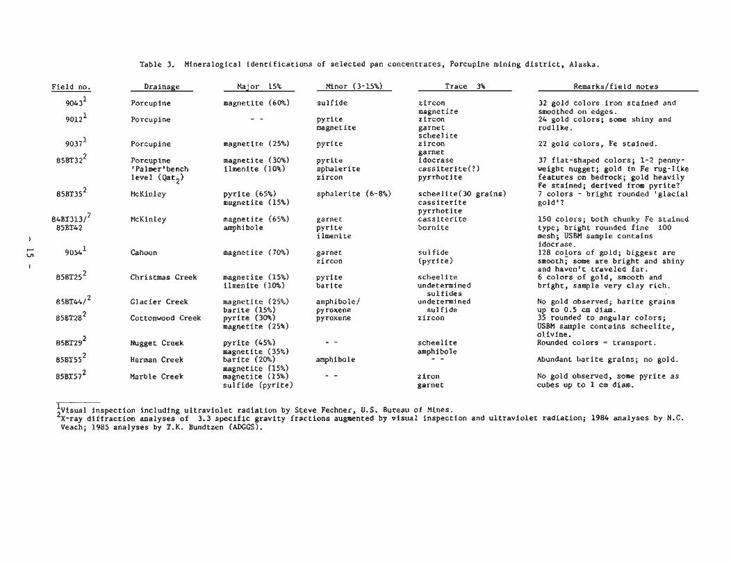
Table 3. Mineralogical identifications of selected pan concentrates, Porcupine mining district, Alaska.
Field no. Drainage
Porcupine
Porcupine
Major 15%
magnetite (60%)
Minor ( 3-15%)
sulfide
Trace 3% Remarks/field notes
zircon magnetite zircon garnet scheel ite zircon garnet idocrase cassiterite(?) pyrrhotite
32 gold colors iron stained and smoothed on edges. 24 gold colors; some shiny and rodlike.
pyrite magnetite
magnetite (25%) Porcupine pyrite 22 gold colors, Fe stained.
Porcupine 'Palmer' bench level (Qat2)
magnetite (30%) ilmenite (10%)
pyrite sphalerite zircon
37 flat-shaped colors; 1-2 penny- weight nugget; gold in Fe rug-like features on bedrock; gold heavily Fe stained; derived from pyrite? 7 colors - bright rounded 'glacial gold ' ?
McKinley pyrite (65%) magnetite (15%)
sphalerite (6-8%) scheelite(30 grains) cassiterite pyrrhotite cassiterite bornite
magnetite (65%) amphibole
150 colors; both chunky Fe stained type; bright rounded fine 100 mesh; USBM sample contains idocrase . 128 colors of gold; biggest are smooth; some are bright and shiny and haven't traveled far. 6 colors of gold, smooth and bright, sample very clay rich.
McKinley garnet pyrite ilmenite
Cahoon magnetite (70%) sulfide (pyrite)
garnet zircon
Christmas Creek magnetite (15%) ilmenite (10%)
scheelite undetermined sulfides
undetermined sul f ide
zircon
pyrite barite
Glacier Creek
Cottonwood Creek
magnetite (25%) barite (15%) pyrite (30%) magnetite (25%)
amphibole/ pyroxene pyroxene
No gold observed; barite grains up to 0.5 cm diam. 35 rounded to angular colors; USBM sample contains scheelite, olivine. Rounded colors = transport. Nugget Creek
Herman Creek
pyrite (45%) magnetite (35%) barite (20%)
scheelite amphibole - - Abundant barite grains; no gold. amphibole
magnetite (15%) 8 5 ~ ~ 5 7 ~ Marble Creek magnetite (15%) - -
sulfide (pyrite) ziron garnet
No gold observed, some pyrite as cubes up to 1 cm diam.
:visual inspection including ultraviolet radiation by Steve Fechner, U.S. Bureau of Mines. X-ray diffraction analyses of 3.3 specific gravity fractions augmented by visual inspection and ultraviolet radiation; 1984 analyses by N.C. Veach; 1985 analyses by T.K. Bundtzen (ADGGS).
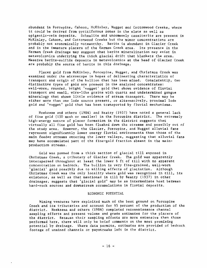
abundant in Porcupine, Cahoon, McKinley, Nugget and Cottonwood Creeks, where it could be derived from pyritiferous zones in the slate as well as epigentic-vein deposits. Scheelite and uncommonly cassiterite are present in McKinley, Cahoon, and Cottonwood Creeks but the minor concentrations are probably not economically noteworthy. Barite is abundant in Glacier Creek and in the immature placers of the Herman Creek area. Its presence in the Herman Creek drainage may suggest that barite mineralization may exist in metavolcanics underlying the thick glacial drift that blankets the area. Massive barite-sulfide deposits in metavolcanics at the head of Glacier Creek are probably the source of barite in this drainage.
Placer gold from McKinley, Porcupine, Nugget, and Christmas Creek was examined under the microscope in hopes of delineating characteristics of transport and origin of the bullion that has been mined. Consistently, two distinctive types of gold are present in the analyzed concentrates: well-worn, rounded, bright 'nugget' gold that shows evidence of fluvial transport and small, wire-like grains with quartz and undetermined gangue mineralogy that shows little evidence of stream transport. There may be either more than one lode source present, or alternatively, proximal lode gold and 'nugget' gold that has been transported by fluvial mechanisms.
Hoekzema and others (1986) and Beatty (1937) have noted a general lack of fine gold (150 mesh or smaller) in the Porcupine district. The extremely high-energy nature of placer formation in the district suggests that virtually all fine gold has been flushed down the streams and possibly out of the study area. However, the Glacier, Porcupine, and Nugget alluvial fans represent significantly lower energy fluvial environments than those of the main feeder streams entering the lower valleys, suggesting that alluvial fans may have accumulated part of the fine-gold fraction absent in the main- production streams.
Gold was panned from a thick section of glacial till exposed in Christmas Creek, a tributary of Glacier Creek. The gold was apparently interspersed throughout at least the lower 6 ft of till with no apparent concentration on bedrock. The bullion is very fine-grained, well-worn 'glacial' gold possibly due to milling effects of glaciation. Although Christmas Creek was the only locality where gold was recognized in till, its existence, as well as that mentioned in till by Beatty (1937) in other drainages, suggests that 'glacial gold' may be an intermediate host between hard-rock sources and downstream accumulations in fluvial deposits.
ECONOMIC POTENTIAL
Mining ventures have exploited much of the best ground on Porcupine Creek and its tributaries and account for 95 percent of the production of the district. Hoekzema and others (1986) completed reconnaissance channel sampling efforts and present volume and grade estimates for the placers of the district. Because their sampling efforts are more extensive then those performed here, there will only be brief comments on the most promising potential by drainage. Where data permits, estimates are provided of bedrock footage of unmined channels or paystreaks left in the district.
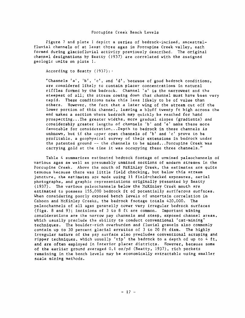
Porcupine Creek Bench Leve l s
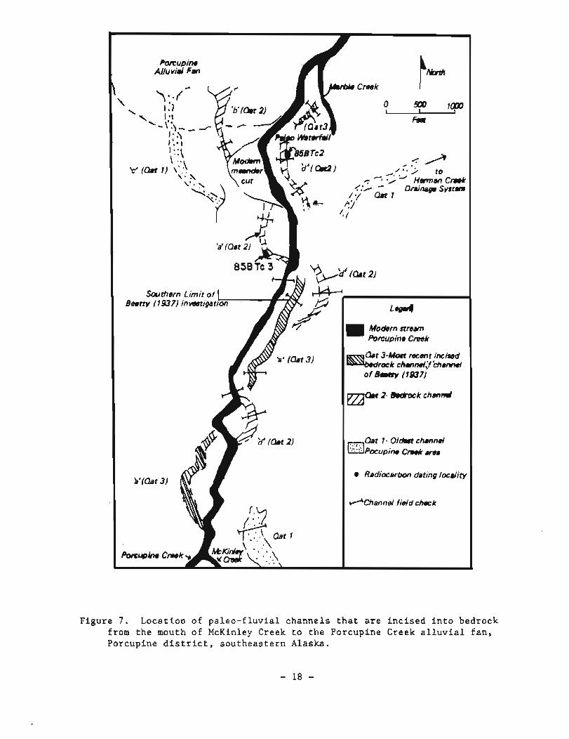
F i g u r e 7 and p l a t e 1 d e p i c t a s e r i e s of bedrock- inc i sed , a n c e s t r a l - f l u v i a l channe l s of a t l e a s t t h r e e a g e s i n Porcupine Creek v a l l e y , each formed d u r i n g g l a c i o f l u v i a l a c t i v i t y p r e v i o u s l y desc r ibed . The o r i g i n a l channe l d e s i g n a t i o n s by Beat ty (1937) a r e c o r r e l a t e d w i t h t h e a s s i g n e d g e o l o g i c u n i t s on p l a t e 1.
According t o Beat ty (1937) : 1
"Channels ' a ' , ' b ' , ' c ' , and ' d l , because of good bedrock c o n d i t i o n s , a r e cons idered l i k e l y t o c o n t a i n p l a c e r c o n c e n t r a t i o n s i n n a t u r a l r i f f l e s formed by t h e bedrock. Channel ' a ' i s t h e na r rowes t and t h e s t e e p e s t of a l l ; t h e s t ream coming down t h a t channel must have been v e r y r a p i d . These c o n d i t i o n s make t h i s l e s s l i k e l y t o be of v a l u e t h a n o t h e r s . However, t h e f a c t t h a t a l a t e r wing of t h e s t ream c u t o f f t h e lower p o r t i o n of t h i s channe l , l e a v i n g a b l u f f twenty f t h i g h a c r o s s t h e end makes a s e c t i o n where bedrock may q u i c k l y be reached f o r hand p r o s p e c t i n g ... The g r e a t e r w i d t h s , more g r a d u a l s l o p e s ( g r a d i e n t s ) and c o n s i d e r a b l y g r e a t e r l e n g t h s o f c h a n n e l s ' b ' and ' e ' make t h e s e more f a v o r a b l e f o r c o n s i d e r a t i o n ... Depth t o bedrock i n t h e s e c h a n n e l s i s unknown, b u t i f t h e upper open c h a n n e l s of ' b ' and ' c ' prove t o be p r o f i t a b l e , a geophys ica l su rvey of t h e i r e x t e n s i o n s i n bedrock under t h e p a t e n t e d ground -- t h e c h a n n e l s t o be mined ... Porcupine Creek was c a r r y i n g g o l d a t t h e time i t was occupying t h e s e t h r e e channe l s . "
Tab le 4 summarizes e s t i m a t e d bedrock f o o t a g e of unmined p a l e o c h a n n e l s of v a r i o u s a g e s a s w e l l a s presumably unmined s e c t i o n s of modern s t r e a m s i n t h e Porcup ine Creek. Above t h e mouth of McKinley Creek, t h e e s t i m a t e s a r e q u i t e t enuous because t h e r e was l i t t l e f i e l d check ing , b u t below t h i s s t r e a m j u n c t u r e , t h e e s t i m a t e s a r e made u s i n g 11 f i e ld -checked exposures , a e r i a l pho tographs , and g r a p h i c r e p r e s e n t a t i o n s o r i g i n a l l y p r e s e n t e d by Bea t ty (1937) . The v a r i o u s pa leochanne l s below t h e EcKinley Creek mouth a r e e s t i m a t e d t o p o s s e s s 155,000 bedrock f t of p o t e n t i a l l y a u r i f e r o u s s u r f a c e s . When c o n s i d e r i n g poor ly exposed bench l e v e l s of u n c e r t a i n c o r r e l a t i o n i n Cahoon and McKinley Creeks , t h e bedrock f o o t a g e t o t a l s 420,000. The p a l e o c h a n n e l s of a l l ages g e n e r a l l y cover v e r y i r r e g u l a r bedrock s u r f a c e s ( f i g s . 8 and 9 ) ; i n c i s i o n s of 3 t o 8 f t a r e common. Important mining c o n s i d e r a t i o n s a r e t h e narrow pay c h a n n e l s and s t e e p , exposed c h a n n e l a r e a s , which u s u a l l y p rec lude t h e a b i l i t y t o conduct conven t iona l ' ca t -mining ' t e c h n i q u e s . The bou lder - r i ch overburden and f l u v i a l g r a v e l s a l s o commonly c o n t a i n up t o 30 p e r c e n t g l a c i a l e r r a t i c s of 3 t o 20 f t diam. The h i g h l y i r r e g u l a r n a t u r e of t h e pay s u r f a c e a l s o p r e c l u d e s c o n v e n t i o n a l s c r a p i n g and r i p p e r t e c h n i q u e s , which u s u a l l y ' r i p ' t h e bedrock t o a dep th o f up t o 4 f t , and a r e o f t e n employed i n I n t e r i o r p l a c e r d i s t r i c t s . However, because some of t h e e a r l i e r ground averaged 0 . 1 oz /yd ( B e a t t y , 1937) , r i c h p o c k e t s remaining i n t h e bench l e v e l s may be economical ly e x t r a c t a b l e u s i n g s m a l l e r s c a l e mining methods.
Sauthern Limit of Beuttv / 19371 inmtigat
Potcupins Creek
of B ~ c r y (lS37)
Radiocarbon dating locality
+Channel fidd c k k
Figure 7 . L o c a t i o n of p a l e o - f l u v i a l channe l s t h a t a r e i n c i s e d i n t o bedrock from t h e mouth of McKinley Creek t o t h e Porcup ine Creek a l l u v i a l f a n , Porcupine d i s t r i c t , s o u t h e a s t e r n Alaska.
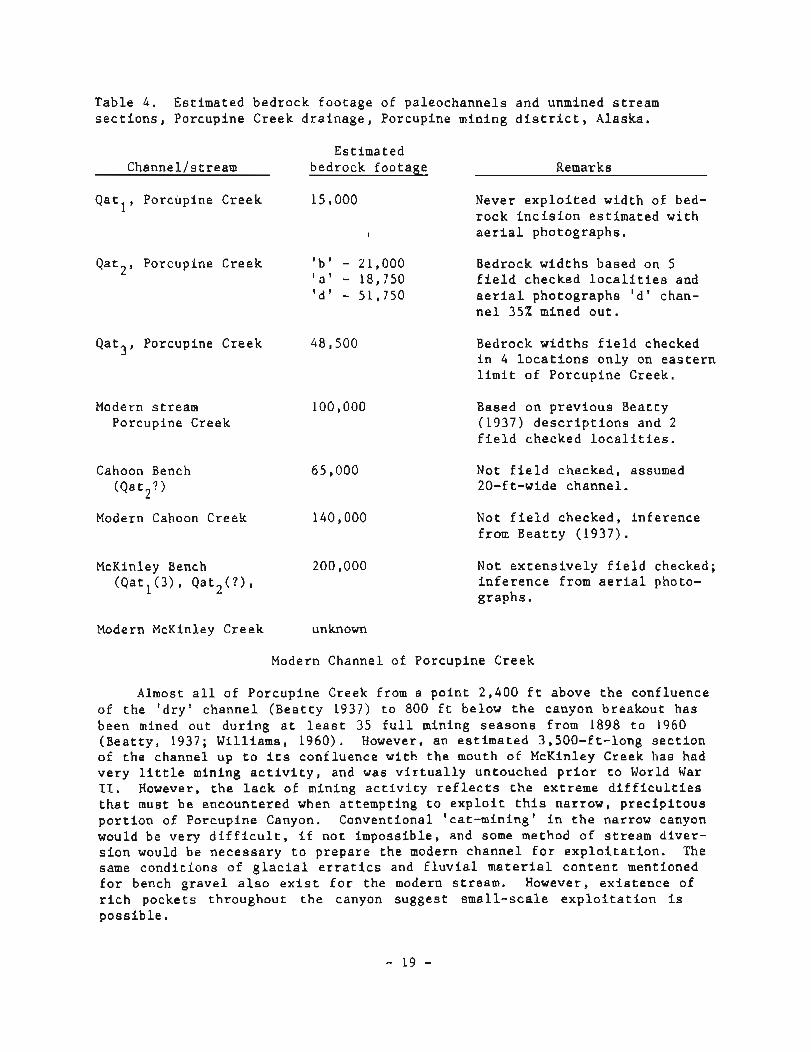
Table 4 . Est imated bedrock f o o t a g e of pa leochanne l s and unmined s t ream s e c t i o n s , Porcupine Creek d r a i n a g e , Porcupine mining d i s t r i c t , Alaska.
Est imated Channel /s t ream bedrock foo tage Remarks
Q a t l , Porcupine Creek 15,000
I
Never e x p l o i t e d width of bed- r o c k i n c i s i o n e s t i m a t e d w i t h a e r i a l photographs .
Q a t 2 , Porcupine Creek ' b ' - 21,000 Bedrock w i d t h s based on 5 ' a ' - 18,750 f i e l d checked l o c a l i t i e s and Id ' - 51,750 a e r i a l photographs ' d l chan-
n e l 35% mined o u t .
Q a t 3 , Porcupine Creek 48,500
Modern s t ream 100,000 Porcupine Creek
Cahoon Bench ( Q a t 2 ?
Modern Cahoon Creek 140,000
McKinley Bench 200,000 ( Q a t l ( 3 ) , Q a t 2 ( ? ) ,
Bedrock w i d t h s f i e l d checked i n 4 l o c a t i o n s on ly on e a s t e r n l i m i t of Porcup ine Creek.
Based on p r e v i o u s Beat ty (1937) d e s c r i p t i o n s and 2 f i e l d checked l o c a l i t i e s .
Not f i e l d checked, assumed 20-ft-wide channe l .
Not f i e l d checked, i n f e r e n c e from B e a t t y (1937) .
Not e x t e n s i v e l y f i e l d checked; i n f e r e n c e from a e r i a l photo- g raphs .
Modern McKinley Creek unknown
Modern Channel of Porcupine Creek
Almost a l l of Porcup ine Creek from a p o i n t 2,400 f t above t h e conf luence of t h e ' d r y ' channe l ( B e a t t y 1937) t o 800 f t below t h e canyon breakout has been mined ou t d u r i n g a t l e a s t 35 f u l l mining s e a s o n s from 1898 t o 1960 ( B e a t t y , 1937; Wi l l i ams , 1960). However, an e s t i m a t e d 3,500-ft- long s e c t i o n of t h e channel up t o i t s conf luence w i t h t h e mouth of McKinley Creek has had v e r y l i t t l e mining a c t i v i t y , and was v i r t u a l l y untouched p r i o r t o World War 11. However, t h e l a c k of mining a c t i v i t y r e f l e c t s t h e extreme d i f f i c u l t i e s t h a t must be encounte red when a t t e m p t i n g t o e x p l o i t t h i s narrow, p r e c i p i t o u s p o r t i o n of Porcupine Canyon. Conventional ' ca t -mining ' i n t h e narrow canyon would be ve ry d i f f i c u l t , i f n o t imposs ib le , and some method of s t r e a m d i v e r - s i o n would be n e c e s s a r y t o p r e p a r e t h e modern c h a n n e l f o r e x p l o i t a t i o n . The same c o n d i t i o n s of g l a c i a l e r r a t i c s and f l u v i a l m a t e r i a l c o n t e n t mentioned f o r bench g r a v e l a l s o e x i s t f o r t h e modern s t ream. However, e x i s t e n c e of r i c h pockets throughout t h e canyon suggest s m a l l - s c a l e e x p l o i t a t i o n i s p o s s i b l e .

Figure 8. Exposed ' a ' channe l ( Q a t Z , f i g . 7 ) on t h e w e s t e r n l i m i t of Porcupine Creek a f t e r mining a c t i v i t i e s . Note h i g h l y i r r e g u l a r bedrock s u r f ace .

F i g u r e 9 . Gossanous c a v i t y on bedrock s u r f a c e a t s i t e shown i n f i g u r e 8. Rich pay was panned h e r e .
- 2 1 -

Bench and Modern F l u v i a l Channels of Cahoon Creek
Grave l s were n o t examined i n t h e Cahoon Creek d r a i n a g e . Based on work by Bea t ty (1937) , unworked p l a c e r s may ex tend a l o n g t h e e n t i r e s t r e a m d r a i n a g e w i t h t h e e x c e p t i o n of t h e l a s t h a l f m i l e n e a r t h e mouth and t h e s e c t i o n a t t h e head of t h e c r e e k , immediately p rox imal t o t h e modern g l a c i e r . Cahoon Creek y i e l d e d t h e c o a r s e s t go ld i n t h e d i s t r i c t and 30 pennyweight nuggets were n o t uncommon.
i
McKinley Creek
Much of lower McKinley Creek h a s been thoroughly worked, sometimes a s many a s f o u r t i m e s (J. J u r g e l e i t , o r a l commun., 1985). However, much of t h e upper p o r t i o n of t h e c r e e k , e s p e c i a l l y t h o s e s e c t i o n s above t h e j u n c t i o n of Cahoon Creek, h a s n o t been explored because " t h e e a r l y p r o s p e c t o r s c la imed t h e r e was no pay on McKinley Creek above Cahoon Creek'' ( B e a t t y , 1937, p. 5 3 ) . P r o s p e c t i n g and development work by James McLaughlin d u r i n g t h e l a s t few y e a r s shows pay i n t h e 0 .01 t o 0.03 oz/yd range a t t h e 1,750 t o 1,820 f t e l e v a t i o n of t h e modern s t ream. A t h r e e - t i e r bench l e v e l on t h e r i g h t l i m i t below t h e ' second w a t e r f a l l ' a l s o c o n t a i n s s i g n i f i c a n t gold v a l u e s and d e s e r v e s t o be p r o s p e c t e d ( f i g . 10) .
Gold h a s been s u c c e s s f u l l y e x p l o i t e d a t t h e b a s e of w a t e r f a l l s on McKinley Creek and c leanups of up t o s e v e r a l thousand ounces were s a i d t o have been r e c o v e r e d i n p a s t y e a r s ( f i g . 1 0 ) .
Summit, Cottonwood and Nugget Creek A l l u v i a l Fans
The headward p o r t i o n s of bo th Cottonwood and Nugget Creeks a r e v e r y high-energy s t r e a m s o r i g i n a t i n g i n a m u l t i - t i e r e d hanging v a l l e y on t h e s o u t h s i d e of t h e s t u d y a r e a . These s t reams c u t th rough s l a t e - p h y l l i t e bedrock, and excep t f o r small, i s o l a t e d p o c k e t s , do n o t c o n t a i n a p p r e c i a b l e heavy- m i n e r a l c o n c e n t r a t i o n s o r even f l u v i a l sed iments because most of t h e m a t e r i a l h a s been f l u s h e d downstream i n t o t h e lower v a l l e y s of t h e T s i r k u River d r a i n a g e . The c r e e k s a r e f i l l e d w i t h g r a n i t i c e r r a t i c s ( 3 t o 9 f t d iam), which account f o r up t o 70 percen t of t h e f l o a t by volume.
A l l t h r e e s t r e a m s form smal l a l l u v i a l f a n s a t t h e h y d r a u l i c f l e x u r e p o i n t of t h e lower v a l l e y and canyon b r e a k o u t , and t h e s e f a n s a r e t h e p r i n c i p a l a u r i f e r o u s p r o s p e c t s . Nugget Creek produced s e v e r a l hundred ounces of b u l l i o n i n e a r l y y e a r s and probably is t h e b e s t p r o s p e c t of t h e t h r e e . Gold was panned from a t l e a s t two ' f a l s e bedrock ' s i l t s u r f a c e s above bedrock, a s w e l l as i n exposed-bedrock c u t s . I roughly e s t i m a t e t h a t 250,000 and 175,000 bedrock f t e x i s t i n m u l t i p l e - d i s t r i b u t a r y channe l s of t h e Cottonwood and Nugget Creek a l l u v i a l f a n s r e s p e c t i v e l y . These two s t r e a m s r e p o r t e d l y d i d n o t c o n t a i n t h e r i c h g r a d e s of pay t h a t were encountered i n t h e Porcupine Creek d r a i n a g e , a f a c t t h a t p robab ly e x p l a i n s t h e modest g o l d p roduc t ion (300 o z ) t o d a t e . However i t i s s i g n i f i c a n t t h a t c o a r s e d e t r i t u s i n c l u d i n g g r a n i t i c e r r a t i c s a r e l a r g e l y a b s e n t e s p e c i a l l y i n t h e Nugget Creek a l l u v i a l f an . Of a l l t h e a u r i f e r o u s g r a v e l s known i n t h e Porcupine d i s t r i c t , those of Cottonwood and Nugget Creeks a r e among t h e most amendable t o c o n v e n t i o n a l mechanized 'ca t -mining, ' t h e dominant mining method i n Alaska today.
F i g u r e LO. Upper or 'second' waterfalls, McKinley Creek, looking north.
- 23 -
Very l i t t l e i s known about a u r i f e r o u s pay on Summit Creek; t h e mouth i s c logged w i t h g r a n i t i c e r r a t i c s and c o a r s e d e t r i t u s i n c o n t r a s t t o m a t e r i a l a t t h e mouths of Cottonwood and Nugget Creeks.
G l a c i e r and Porcupine Creek A l l u v i a l Fans
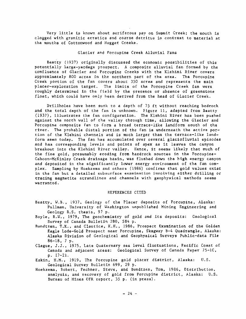
~ e a t t ~ (1937) o r i g i n a l l y d i s c u s s e d t h e economic p o s s i b i l i t i e s of t h i s p o t e n t i a l l y large-yardage p r o s p e c t . A composite a l l u v i a l f a n formed by t h e conf luence of G l a c i e r and Porcupine Creeks w i t h t h e K l e h i n i R iver covers approx imate ly 800 a c r e s i n t h e n o r t h e r n p a r t of t h e a r e a . The Porcupine Creek p o r t i o n of t h e f a n c o v e r s about 350 a c r e s and r e p r e s e n t s t h e main p l a c e r - e x p l o r a t i o n t a r g e t . The l i m i t s of t h e Porcupine Creek f a n were roughly determined i n t h e f i e l d by t h e presence o r absence of g r e e n s t o n e f l o a t , which could have on ly been d e r i v e d from t h e head of G l a c i e r Creek.
D r i l l h o l e s have been sunk t o a dep th of 75 f t w i t h o u t r e a c h i n g bedrock and t h e t o t a l dep th of t h e f a n i s unknown. F igure 11, a d a p t e d from Bea t ty (1937) , i l l u s t r a t e s t h e f a n c o n f i g u r a t i o n . The K l e h i n i R i v e r h a s been pushed a g a i n s t t h e n o r t h w a l l of t h e v a l l e y through t ime, a l l o w i n g t h e G l a c i e r and Porcup ine composite f a n t o form a broad t e r r a c e - l i k e l andform s o u t h of t h e r i v e r . The probable d i s t a l p o r t i o n of t h e f a n i s u n d e r n e a t h t h e a c t i v e por- t i o n of t h e K l e h i n i c h a n n e l s and i s much l a r g e r t h a n t h e t e r r a c e - l i k e land- form s e e n today. The f a n h a s accumulated over s e v e r a l g l a c i o f l u v i a l e p i s o d e s and h a s corresponding l e v e l s and p o i n t s of apex a s i t l e a v e s t h e canyon b r e a k o u t i n t o t h e K l e h i n i R iver v a l l e y . Hence, i t seems l i k e l y t h a t much of t h e f i n e g o l d , presumably e r o d i n g from hardrock s o u r c e s i n t h e Porcupine- Cahoon-McKinley Creek d r a i n a g e b a s i n , was f lushed down t h e h i g h energy canyon and d e p o s i t e d i n t h e s i g n i f i c a n t l y lower energy environment o f t h e f a n com- p l e x . Sampling by Hoekzema and o t h e r s (1986) conf i rms t h a t g o l d v a l u e s e x i s t i n t h e f a n bu t a d e t a i l e d s u b s u r f a c e examination i n v o l v i n g e i t h e r d r i l l i n g o r t r a c i n g magne t i t e s t r a n d l i n e s and channe l s w i t h g e o p h y s i c a l methods seems war ran ted .
REFERENCES CITED
B e a t t y , W . B . , 1937, Geology of t h e P l a c e r d e p o s i t s o f Porcup ine , Alaska: Pullman, U n i v e r s i t y of Washington unpubl ished Mining Engineer ing and Geology B.S. t h e s i s , 97 p.
Boyle , R.W., 1979, The geochemist ry of gold and i t s d e p o s i t s : Geo log ica l Survey of Canada B u l l e t i n 280, 584 p.
Bundtzen, T.K., and C l a u t i c e , K . H . , 1986, Prospect Examinat ion o f t h e Golden Eagle Lode-Gold P r o s p e c t n e a r Porcupine, Skagway B-4 Quadrang le , Alaska: Alaska D i v i s i o n of G e o l o g i c a l and Geophysical Surveys P u b l i c - d a t a F i l e 86-18, 7 p.
Clague, J .J . , 1975, L a t e Qua te rnary s e a l e v e l f l u c t u a t i o n s , P a c i f i c Coast of Canada and a d j a c e n t a r e a s : Geolog ica l Survey of Canada Paper 75-lC, p. 17-21.
Eakin , H.M. , 1919, The Porcupine gold p l a c e r d i s t r i c t , Alaska: U.S. Geolog ica l Survey B u l l e t i n 699, 29 p.
Hoekzema, Rober t , Fechner , S t e v e , and Bundtzen, Tom, 1986, D i s t r i b u t i o n , a n a l y s i s , and recovery of g o l d from Porcupine d i s t r i c t , Alaska: U.S. Bureau of Mines OFR r e p o r t , 35 p . ( i n p r e s s ) .
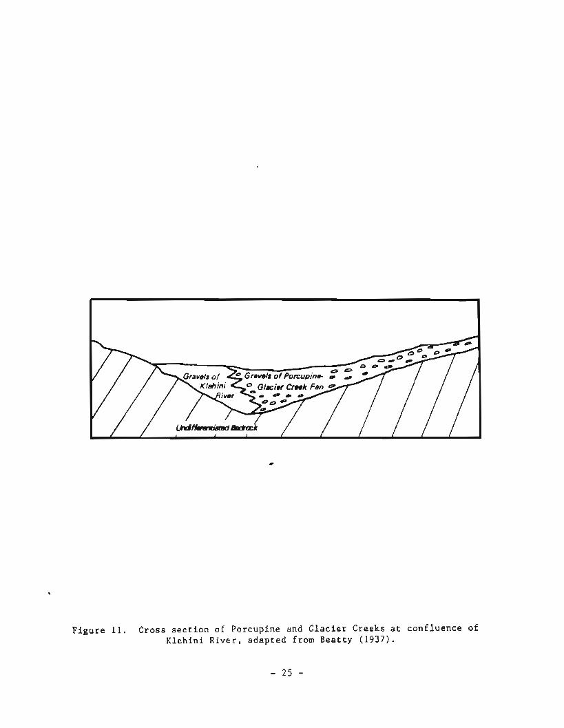
F i g u r e 11. Cross s e c t i o n of Porcup ine and G l a c i e r Creeks a t c o n f l u e n c e of K l e h i n i R i v e r , a d a p t e d from B e a t t y (1937) .
- 2 5 -
Hudson, Travis, Plafker, George, and Rubin, Meyer, 1976, Uplift rates of marine terrace sequences in the Gulf of Alaska, in Cobb, E.H., ed., The United States Geological Survey in ~laska---~ccom~lishments during 1975: U.S. Geological Survey Circular 733, p. 11-13.
Koshman, P.N., and Yugay, T.A., 1972, The causes of variation in fineness levels of gold placers: Geochemistry International, 1972, p. 481-484 (Translated in english from Geokhimixa 6, p. 750-753).
MacKevett, F.M., Jr., and Winkler, R., 1974, Geology of the Skagway B-3 and B-4 Quadrangles, ~outheastekn Alaska: U. S. Geological Survey Pro- fessional Paper 832, 33 p.
Mann, D.H., 1986, Wisconsin and Holocene Glaciation in southeast Alaska, - in Hamilton, T.D., Reed, K.M., and Thorson, R.M., ed., Glaciation in Alaska, the Geologic Record: Alaska Geological Society, p. 237-261.
Metz, P.A., and Hawkins, D.B., 1981, A summary of gold fineness values from Alaska placer deposits: University of Alaska Mineral Industry Research Laboratory Report No. 45, 63 p.
Moiser, E.L., 1975, Use of emission spectroscopy for semiquantitative analysis of trace elements and silver in native gold, in Ward, F.N., ed., New and refined methods of trace element analysis useful in - exploration: U.S. Geological Survey Bulletin 1408, p. 97-105.
Molnia, B.F., 1986, Glacial history of the northeastern Gulf of Alaska---A synthesis, &I Hamilton, T.D., Reed, K.M., and Thorson, R.M., ed., Glaciation in Alaska the Geologic Record: Alaska Geological soXety, Anchorage, Alaska, p. 219-236.
Pdwd, T.L., 1975, Quaternary Geology of Alaska: U.S. Geological Survey Professional Paper 835, 145 p.
Redman, E.R., Gilbert, W.G., Jones, B.K., Rosenkrans, D., and Hickok, B.D., 1985, Preliminary bedrock geologic map of the Skagway B-4 Quadrangle, Alaska: Alaska Division of Geological and Geophysical Surveys Report of Investigation 85-6, scale 1:63,360.
Rennick, Penny, and Doogan, Kathy, editors, 1984, The Chilkat River Valley: Alaska Geographic, v. 11, n. 3, 111 p.
Robinson, M.S., and Bundtzen, T.K., 1979, Historic gold production in Alaska ---a minisummary: Alaska Division of Geological and Geophysical Surveys Mines and Geology Bulletin, v. 28, n. 3, p 1-4.
Smith, P.S., 1933, Past placer gold production from Alaska: U.S. Geological Survey Bulletin 857, 19 p.
Smith, P.S., 1941, Fineness of gold from Alaska Placers: U.S. Geological Survey Bulletin 910C, p. 147-269.
Still, J.C., 1984, Stratiform massive sulfide deposits of the Mt. Henry Clay area, southeast Alaska: U.S. Bureau of Mines Open-file Report 118-84, 65 p.
Still, J.C., Weir, K.R., Gilbert, W.G., and Redman, E.R., 1985, Stream sediment, float, and bedrock sampling in the Porcupine mining area, southeast Alaska: U.S. Bureau of Mines Open-file Report 173-84, 9 p.
Williams, J.A., 1960, Report for the Year 1960: Division of Mines and Geology Annual Minerals Report, 67 p.