Timor L'este | X-Ray Magazine | Issue 47 - March 2012 · 69 X-RAY MAG : 47 : 2012 EDITORIAL...
11
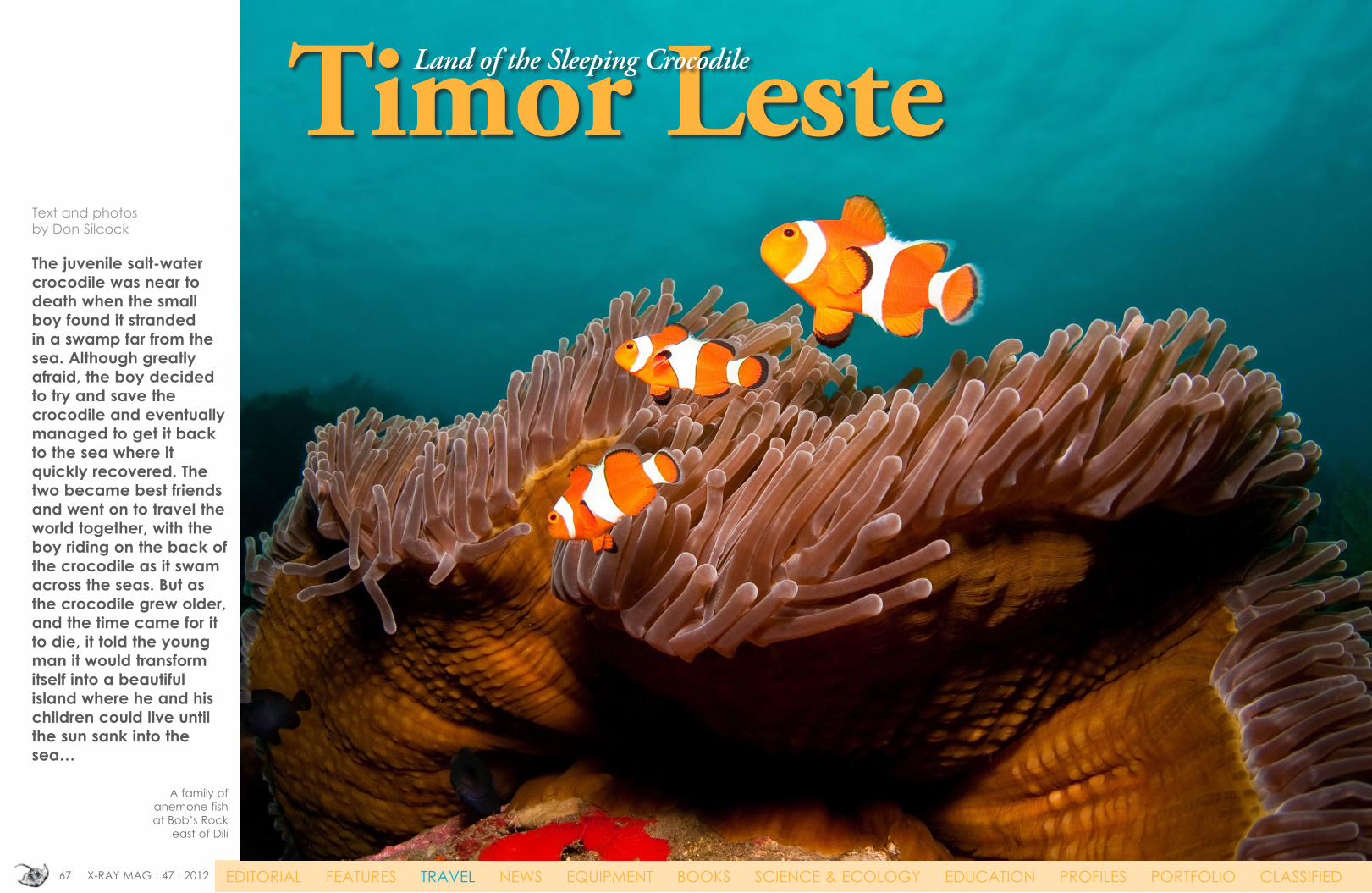
67 X-RAY MAG : 47 : 2012 EDITORIAL FEATURES TRAVEL NEWS EQUIPMENT BOOKS SCIENCE & ECOLOGY EDUCATION PROFILES PORTFOLIO CLASSIFIED Timor Leste Land of the Sleeping Crocodile Text and photos by Don Silcock The juvenile salt-water crocodile was near to death when the small boy found it stranded in a swamp far from the sea. Although greatly afraid, the boy decided to try and save the crocodile and eventually managed to get it back to the sea where it quickly recovered. The two became best friends and went on to travel the world together, with the boy riding on the back of the crocodile as it swam across the seas. But as the crocodile grew older, and the time came for it to die, it told the young man it would transform itself into a beautiful island where he and his children could live until the sun sank into the sea… A family of anemone fish at Bob’s Rock east of Dili
Transcript of Timor L'este | X-Ray Magazine | Issue 47 - March 2012 · 69 X-RAY MAG : 47 : 2012 EDITORIAL...
67 X-RAY MAG : 47 : 2012 EDITORIAL FEATURES TRAVEL NEWS EQUIPMENT BOOKS SCIENCE & ECOLOGY EDUCATION PROFILES PORTFOLIO CLASSIFIED
Timor LesteLand of the Sleeping Crocodile
Text and photos by Don Silcock The juvenile salt-water crocodile was near to death when the small boy found it stranded in a swamp far from the sea. Although greatly afraid, the boy decided to try and save the crocodile and eventually managed to get it back to the sea where it quickly recovered. The two became best friends and went on to travel the world together, with the boy riding on the back of the crocodile as it swam across the seas. But as the crocodile grew older, and the time came for it to die, it told the young man it would transform itself into a beautiful island where he and his children could live until the sun sank into the sea…
A family of anemone fish at Bob’s Rock
east of Dili

68 X-RAY MAG : 47 : 2012 EDITORIAL FEATURES TRAVEL NEWS EQUIPMENT BOOKS SCIENCE & ECOLOGY EDUCATION PROFILES PORTFOLIO CLASSIFIED
The tale of the boy and his cold-blooded friend is told often in Timor to explain the island’s crocodile-like shape and why the Timorese have a special affinity with the large reptile that is said to inhabit the creeks and pools along much of the south coast of the country.
A new country—twice The island of Timor has a long history of colonial rule dating back to the early 16th century when the Portuguese and Dutch sailing ships first arrived in search of the source of the incredibly lucrative Spice Trade. Divided into eastern and western halves by the Europeans, Dutch West Timor eventually became part of the new Republic of
Indonesia in 1949 when the Dutch formerly withdrew from their East Indies colonies. However, East Timor remained under Portuguese rule until 1975 when political turmoil and a military mounted coup d’état in Lisbon resulted in the Portuguese abruptly leaving and effectively abandoning the territory after 455 years of colonial rule.
travel Timor Leste
Declaring itself independent on the 28 November 1975 as the Democratic Republic of East Timor, the country was invaded and annexed just nine days later by its large western neighbor
Indonesia, and another 24 years of often brutal colonial rule was to follow. The end of the Suharto era in Indonesia ultimately lead to self-determination and the newly independent Republic of Timor Leste finally joined the global community on the 20 May 2002. Lead by the charismatic former guerilla leader Xanana Gusmao, and the urbane and articulate Nobel Peace Prize winner, Dr Ramos Horta, the country more commonly known by its anglicised
name of East Timor remains one of the world’s poorest nations, but its large
reserves of natural gas and oil promise a much brighter future.
Cape Fatucama
Food vendors at Avenue de Portugal prepare for the evening
CLOCKWISE FROM FAR LEFT: The view from the top of Cape Fatucama towards Dili; Arte Moris art commune in Dili; Painted crocodile model at Arte Moris

69 X-RAY MAG : 47 : 2012 EDITORIAL FEATURES TRAVEL NEWS EQUIPMENT BOOKS SCIENCE & ECOLOGY EDUCATION PROFILES PORTFOLIO CLASSIFIED
Diving Timor Leste A quick look at the map and a basic understanding of the Indonesian Throughflow is enough to tell you that just as North Sulawesi, Raja Ampat and
the north-east coast of Bali flourish from their exposure to those nutrient rich waters, so does the north coast of Timor hold considerable promise. To the north of Timor Leste are the remote islands of Alor and Wetar—the most easterly of the chain of islands called the
Lesser Sundas, which form the southern boundary of the huge Indonesian archipelago. Further north above Alor and Wetar are the deep basins of the Banda Sea,
and as the rich waters of the Throughflow surge their way south and approach the Lesser Sunda shelf, upwellings are created that suck up the phosphorus and nitrogen-laden detritus of the sea so rich in nutrients. The Ombai Strait between Alor, Wetar and Timor Leste is one of the three main passages for the Indonesian Throughflow through the Lesser Sunda islands, which means two things: big currents and the chance of some great diving! Add to this mix the fact that recreational scuba diving simply did not exist in Timor Leste ten years ago, and the known dives sites are simply a fraction of what are still to be discovered.
Main diving locations Currently the main diving locations in Timor Leste can be broken down into four areas: those in and around the capital of Dili; the coastal locations up to two hours’ drive to the east and west of Dili; the large island of Atauro to the north of Dili; and
Timor Lestetravel
TOP LEFT TO RIGHT: Scorpionfish, hawkfish and mantis shrimp at the Pertamina Jetty and anemone shrimp at Dili Rock; Commensal Shrimp at the Pertamina Jetty (above); Hairy Crab at Dili Rock (left)

70 X-RAY MAG : 47 : 2012 EDITORIAL FEATURES TRAVEL NEWS EQUIPMENT BOOKS SCIENCE & ECOLOGY EDUCATION PROFILES PORTFOLIO CLASSIFIED
the smaller uninhabited island of Jaco at the far eastern tip of the country.
Dili There are three main sites that are dived regu-larly in Dili—the Pertamina Jetty near the center of the city, Tasi Tolu on the west-ern outskirts and nearby Dili Rock. All are shore dives. Pertamina Jetty and Tasi Tolu are muck diving and crit-ter sites, while Dili Rock is a mixture of critters and coral gardens. Tasi Tolu enjoys
a somewhat legendary status both as Timor Leste’s version of the Lembeh Strait, which is rather overstating the situation
as it is just one site—albeit a very good one—compared to the multiple sites in Lembeh. It owes its actual existence as a dive site to the direct intervention of the country’s president. Tasi Tolu takes its name from the three fresh water lakes just below the nearby foothills, which fill to capacity during the rainy season and then overflow, flood-ing the roads and villages in the general area. To prevent this, the government commissioned a project to install a drain-age channel so that the overflow could run off into the sea—the subsequent design for which took the most logical path and would have dumped the out-flow right on to the Tasi Tolu site. The local diving community waged a campaign to get the drainage channel relocated and ultimately got the issue on the radar screen of Dr Ramos Horta, the President of Timor Leste. Horta sees tour-ism as part of the potential solution to one of Timor Leste’s most pressing problems—
Timor Lestetravel
CLOCKWISE FROM TOP LEFT: Paddleflap rhinopias, thorny seahorse, tozeuma shrimp, tiger shrimp and porcelain crab at Tasi Tolu

71 X-RAY MAG : 47 : 2012 EDITORIAL FEATURES TRAVEL NEWS EQUIPMENT BOOKS SCIENCE & ECOLOGY EDUCATION PROFILES PORTFOLIO CLASSIFIED
lack of employment opportuni-ties—and accepted that destroy-ing one of the best critter dive sites in Dili was not a great idea and was eventually able to stop the project. I did several dives at Tasi Tol and eventually got to know it like the back of my hand, but I have to say that I would have missed the site completely if I had not been shown it by the dive guides from Dive Timor Lorosae, the dive center with which I dived in Timor Leste. Not that the site is particularly hard to find. Rather, it looks noth-ing like a photogenic one, as it’s just a flat patch of marine growth. But in amongst it, you will find a
wide variety of photogenic critters.
East of Dili There are numerous dives sites heading east from Dili, all of which are shore dives reached by short paths from the main road and involve getting kitted up under whatever shade is available and walking down the beach. All the sites have sheltered entries, so actually getting in to the water is easy and exposure to the strong currents of the Ombai Strait is gradual and manageable. My personal favorites to the east of Dili were Secret Garden, Marble Rock and One Tree—with Secret Garden standing out because its
small, but superb, sponge garden filled with resident colonies of pho-togenic purple anthias and silvery glass fish.
West of Dili There are two main dive site areas to the west of Dili—Bubble Beach and the picturesque town of Maubara. Bubble Beach is reputed to be one of the best dives in Timor Leste. Unfortunately, access from the shore is not possible anymore, as the area had been fenced off as the “bubbles” are believed to be natural gas leaking up from the deep water gas reserves that hold the key to Timor Leste’s future
Timor LestetravelLEFT TO RIGHT: Beautiful bommie at Marble Rock east of Dili; Stunning soft cor-als and sponges at Mau-bara west of Dili; Yet another beautiful Bommie, this time at One Tree east of Dili

72 X-RAY MAG : 47 : 2012 EDITORIAL FEATURES TRAVEL NEWS EQUIPMENT BOOKS SCIENCE & ECOLOGY EDUCATION PROFILES PORTFOLIO CLASSIFIED
prosperity. A fenced-off area is the site of a proposed gas processing facility. There are two sites at Maubara—the Church and the Fort, with the former offering some superb diving around the numerous bommies on the sloping coral slope. First impressions should be ignored, because the shallower parts of the slope are not particularly appeal-
ing, but as you go deeper at around 15m, they come to life and positively abound with marine life that is nourished by the strong cur-rents that sweep the site. My favorite bommie was about 200m to the north-west of the main entry point straight down from the car parking area near the church. It is at around 19m in depth and was simply teeming with life.
Ata’uro The large and visibly stunning island of Ata’uro is located 30km due north of Dili. For me, it was a case of, “so near, but oh so far”. The island is right in the path of the Indonesian Throughflow, as it rushes south into the Ombai Strait. Tales of schools of pelagics and pods of whales and dolphins abound. Alas, not for me, as that basic logistic detail—a boat—required for such diving was not available. So, all I could do was note the many stories from people I met who have dived there and resolve to get back in the future. Ata’uro suffers from a lack of rainfall, which
means that life is hard for the permanent residents of the island, and development is significantly slower than on the mainland. But the lack of run-off from the island means that the visibility around At’auro is exceptional. Jaco Island At the very eastern tip of Timor is the area of Los Palo and the National Park of Jaco Island. Boasting brilliant white sand beaches, turquoise seas and apparently pristine reefs, the diving around the island is reputed to be exceptional, as the area is effectively completely unspoiled because the island is uninhabited and rarely visited by commercial fishing boats. But the only real option to dive Jaco Island is from a liveaboard, which simply was not available when I was there. But all that will change in 2012 when the highly regarded Worldwide Dive and Sail will conduct several back-to-back trips in Timor Leste with its liveaboard the SY Oriental Siren.
Timor Lestetravel
CLOCKWISE FROM TOP LEFT: Stunning bommie at Dirt Track east of Dili; Is this the best bommie in Timor Leste? Maubara west of Dili; Another incredible bommie at Maubara; Shy Goby on a sea whip at Bob’s Rock east of Dili

73 X-RAY MAG : 47 : 2012 EDITORIAL FEATURES TRAVEL NEWS EQUIPMENT BOOKS SCIENCE & ECOLOGY EDUCATION PROFILES PORTFOLIO CLASSIFIED
The Indonesian Throughflow A basic understanding of the Indonesian Throughflow (ITF) and sverdrups is essential if you want to know why the scuba diving can be so be good in certain parts of the vast Indonesian Archipelago and less-so in other areas. The Readers Digest explanation of what causes the ITF is a disparity in sea levels. The Pacific Ocean to the northwest of the Indonesian archipelago has a sea level of 150mm (6 inches) above average, whilst the Indian Ocean to the south has a sea level 150mm below average. This disparity is caused by the trade winds and associated oceanic currents that act in opposite directions in the northern and southern hemispheres. The overall consequence of this disparity is the largest movement of water on the planet, which flows through the Indonesian archipelago from the Pacific Ocean to the northeast to the Indian Ocean in the southwest. So huge is the volume of water associated with the ITF that traditional measurements such as cubic meters and gallons are inadequate to describe it in an easily understandable way. So, the Norwegian scientist, Harald Sverdrup, invented the sverdrup—one million cubic meters of water per
second. The best way to visualize a sverdrup is to think of a river 100m wide, 10m deep and flowing at four knots. Then imagine 500 of those rivers all combined together, and that is one sverdrup.
It is estimated that the total amount of seawater that passes through the ITF is 20-22 sverdrups, or 10,000 of those rivers. The people Timor Leste’s people are fiercely independent. They have paid a very heavy price to achieve independence,
with an estimated 200,000 losing their lives during the 24 years the country was the 27th province of Indonesia.Comprised of 16 ethnic groups, each with its own language, but dominated by the Tetuns from the western part of the country, Timor Leste is one of only two staunchly Roman Catholic countries in Asia—the Philippines being the other. While the country’s oil and gas reserves holds the promise of a brighter future, Timor Leste remains amongst the poorest countries in Asia. After ten years of independence, the grinding poverty is clearly making patience wear rather thin. A very interesting facet of Timor Leste culture is tara bandu, a form of adat, or traditional customary practice, found among specific ethnic groups in Malaysia, Indonesia and the southern Philippines. In the absence of a formal law and order system, adats are used by these ethnic groups to regulate and control overall village life and its social order. During the occupation,
Timor Lestetravel Commensal Shrimp at the Pertamina Jetty
Schooling Anthias at Dirt Track east of Dili Sea Star at Dirt Track east of Dili

74 X-RAY MAG : 47 : 2012 EDITORIAL FEATURES TRAVEL NEWS EQUIPMENT BOOKS SCIENCE & ECOLOGY EDUCATION PROFILES PORTFOLIO CLASSIFIED
the Indonesian legal system was applied and all Adat customs were prohibited. However, since the new country emerged in 2002, tara bandu has enjoyed a revival under the sponsorship of several non-governmental organizations (NGO’s) active in Timor Leste. Tara bandu means “hanging
prohibition”. Contrary to the literal interpretation a westerner might take, the hanging part refers to the fact that whatever is prohibited is hung (displayed) in a prominent position as a warning to potential thieves and poachers. A fairly elaborate ceremony is conducted to initiate the specific
prohibition, which can cover anything from protecting an area of the local environment—such as cutting trees or fouling a water source— to stealing vegetables from other people’s gardens. Valuable animals are sacrificed during the ceremony. People
caught breaking the prohibitions are required to provide the same number of animals to restore the balance of the tara bandu. But perhaps the most effective, and certainly the most controversial, element of the prohibition are the magic spells
that are cast that call upon the souls of the village ancestors to assist with the protection. NGO’s saw the tara bandu as an excellent way to help restore some of the environmental damage caused by excessive deforestation during the occupation and a way to introduce localized law and order, given the scant availability of police and legal resources in the new country.
Fast food There are two really nice side
benefits to diving the coastal sites to the east and west of Dili. The first is the drive itself, which is quite spectacular and vaguely reminiscent of the Big Sur area in California, as the coast road hugs the shoreline and winds around the many bays and headlands along the way. The mountainous hinterland of Timor Leste starts at the coast and rise dramatically,
creating a beautiful backdrop to the crystal waters of the Ombai Strait. The other side benefit is the Timor Leste version of fast food, which is readily available at the side of the road. Villagers of Timor Leste supplement their income by selling freshly caught grilled fish and packages
of very tasty yellow rice wrapped in leaves.
Dive operators There are currently three options available if you are looking to sample what Timor Leste has to offer—two land-based and one liveaboard. The two land-based opera-tors are Dive Timor Lorosae and
Timor Lestetravel LEFT TO RIGHT: Statue of Christ at Cape Fatucama; Catholic monument in Dili; Fast food shop, Timor Leste style
Local kids watch the divers gear up at Bob’s Rock east of Dili

75 X-RAY MAG : 47 : 2012 EDITORIAL FEATURES TRAVEL NEWS EQUIPMENT BOOKS SCIENCE & ECOLOGY EDUCATION PROFILES PORTFOLIO CLASSIFIED
Free Flow Diving, both of which are located right across from the beach on Avenida de Portugal, the main street of Dili. My trip was organized with Dive Timor Lorosae, or DTL as it is usually referred to, which is started back in 2002 by Darwin based Australian Mark Mialszygrosz, who first went to Timor Leste in 2000 to assist with the rebuilding of the country’s infrastructure after the bloody transition to independence. Mark is an interesting guy to talk to and is very passionate about Timor Leste and its people, plus he has some great tales about the exploratory dives in the early days after independence diving places that simply had never been seen before. When I dived Timor Leste DTL were in between boats and
their new one had not arrived from Australia, so all my dives were all shore dives either in the Dili area or to the east and west, and I was unable to dive
Atauro. But all that has changed now that the boat has arrived and DTL dives Atauro regularly, so I am planning my next trip as I write this article. The third option is Worldwide Dive and Sail liveaboard the SY Oriental Siren, which will conduct several back-to-back trips in Timor Leste from August 2012 and will dive the best of the Dili and coastal sites (including Bubble Beach) and both Ata’uro and Jaco Islands.
Excursions I used to do it on every trip—dive up to the very last possible minute and then spend the remaining time packing my gear and
reviewing my underwater images, completely ignoring the above water scenery. Writing for X-RAY MAG has changed all that, and now I dare not return from an assignment without spending at least one full day exploring as much of the locale as possible. Dili and the immediate countryside have much to offer, and you can either be adventurous
by hiring a motorbike and drive yourself or mitigate the traffic accident risks by going for a car and a driver. I went for the low-cost adventurous option and really enjoyed the freedom of finding my own way around. Here is my list of must-see places in the order that I did them in.
Avenue de Portugal. An early morning walk down the main thoroughfare of Dili is a pleasant way to start the day and you will
see the local fishermen bringing in their catch on the beach and laying it out for sale on the roadside wall. The avenue follows the coast most of the way through Dili, and you will find much to see, ranging from the new high-tech and closely guarded Chinese Embassy to hotels and cafés serving breakfast.
Cape Fatucama. Mid-morning is a good time to check out the huge statue of Christ on the headland at the eastern end of Dili and the fantastic view its location offers. Reminiscent of the one in Rio de Janeiro, the statue was built by the Indonesians during their occupation of the country in an attempt to get the strongly Roman Catholic Timorese on side. It’s quite a hike up the hill to the base of the statue, but the view once there is well worth it, and there are a couple of cafés near the beach on the way back into Dili where you can get a local coffee and restore your metabolism.
The mountains. If you’ve dived the coastal sites, you’ve driven the coast road. So, why not
Timor Lestetravel
CLOCKWISE FROM TOP LEFT: Dive Timor Lorosae; Ata’uro Island; Mountains south of Dili; Dili sunrise; Secret Garden dive site; Coral Grouper

76 X-RAY MAG : 47 : 2012 EDITORIAL FEATURES TRAVEL NEWS EQUIPMENT BOOKS SCIENCE & ECOLOGY EDUCATION PROFILES PORTFOLIO CLASSIFIED
head inland and check out the mountainous interior? Eat before you do, as facilities are few and far between. Midday is the best time to do this trip, as it is much cooler as you climb out of Dili towards the old hill towns of Aileu and
Maubisse, which are the centre of the main coffee growing area of Timor Leste. If you make it all the way to Maubisse, you will find that the former government rest house has been converted into a hotel called the Pousada and boasts 360 degree views of the
spectacular mountain scenery.
Santa Cruz Cemetery. Not what you would normally consider to be top of one’s list of tourist attractions, but 30 minutes wandering around the site of the 1991 massacre of more than
100 people by the Indonesian Army will endear you to the sheer determination of the Timorese people. Caught on film by two western journalists and smuggled into Australia at great personal risk, the film alerted the world to the suffering and injustice that the Timorese were experiencing.
Xanana Reading Room. Dedicated to Xanana Gusmao—the former guerrilla leader and now prime minister of Timor Leste—this part library, part museum and part cultural centre is an essential stop for visitors to Dili in search of information and advice about Timor Leste.
Arte Moris. In many ways, this kind of artistic commune set in the remains of an Indonesian
era museum personifies all that is weird and wonderful about Dili. Art students live here while they are trained in a variety of mediums, and their works are on display throughout the buildings and grounds.
Avenue de Portugal. As the sun starts to set, it’s time to go back to where you started the day and join the many locals who dine and drink at the beachside stalls, which spring up late in the afternoon. Freshly grilled fish and ice cold beer rarely tasted so good. Afterthoughts As divers, we are constantly looking for new and exciting places to try. Timor Leste offers an interesting mix of things
to see above and below the water. Very much in the mode of a developing country, Timor Leste’s rough edges add to its charm. The sheer determination of its people to overcome the country’s colonial past and the brutal years of the Indonesian occupation is simply admirable. The known diving locations justify a trip in themselves, but the thought of what waits to be discovered is tantalizing. If you do decide to go, do yourself a favour and allow some extra time to do some land-based exploring and enjoy the country as it is now because it won’t stay this way forever. ■
For more information please visit Don Silcock’s website at: Indopacificimages.com
Timor Lestetravel
CLOCKWISE FROM FAR LEFT: Schooling anthias at Secret Garden, east of Dili; Duban hinge-beak shrimp at Pertamina Jetty; Superb shallow water bommie at Secret Garden, east of Dili; Goby at Dili Rock; Moray eel at Pertamina Jetty

77 X-RAY MAG : 47 : 2012 EDITORIAL FEATURES TRAVEL NEWS EQUIPMENT BOOKS SCIENCE & ECOLOGY EDUCATION PROFILES PORTFOLIO CLASSIFIED
Economy About 70 percent of the economic infrastruc-
ture of the country was devastated by Indone-
sian troops and anti-independence militias by late 1999. Refugees numbering 300,000 fled westward. A mas-sive international pro-gram of 5,000 peace-keepers (up to 8,000) and 1,300 police offic-
ers helped to stabilize the country over the
next three years. This led to significant reconstruc-
tion in both rural and urban areas. Challenges the country
continues to face includes gen-erating jobs for young people entering the work force, rebuilding its infrastructure and strengthen-ing the civil administration. Oil and gas resource development in offshore waters has helped to increase government revenues, but not jobs, since there are no production facilities in the coun-try. The economy continues to improve despite the outbreak of violence and civil unrest in 2006. By 2009, most of an estimated 100,000 internally displaced per-sons came back home. Govern-ment increased spending signifi-
cantly in 2009-2010, for the most part on basic infrastructure, roads and electricity leading to first time national debt in late 2011.
Population 1,177,834Ethnic groups: Austronesian (Malayo-Polynesian), Papuan, small Chinese minority. Religions: Roman Catholic 98%, Muslim 1%, Protestant 1% (2005). Internet us-ers: 2,100 (2009)
Currency U.S. Dollar
Language The official lan-guages are Tetum and Portu-guese. Indonesian, English and about 16 indigenous languages are spoken. Tetum, Galole, Mam-bae and Kemak are spoken by a large part of the population.
Health There is a very high de-gree of risk for food or waterborne diseases such as bacterial and protozoal diarrhea, hepatitis A, and typhoid fever as well as vec-torborne diseases such as chikun-gunya, dengue fever and malaria (2009)
Decompression ChambersBALI: Sanglah General Hospital Hyperbaric Medical Department. Tel: 62-361-227911
MAKASSAR (SULAWESI): Rumah Sakit Umum Wahidin Sudirohusodo. Tel: 62 - 0411 (584677) or 584675
Web sitesDiscover Diliwww.discover-dili.com ■
History In the early 16th cen-tury, the Portuguese began to trade with the island of Timor and colonized it by the mid-century. After clashes with the Dutch in the area, Portugal ceded the west-ern portion of the island to them in a treaty in 1859. From 1942 to 1945, imperial Japan occupied Portuguese Timor, but after the Japanese defeat in World War II, Portugal resumed colonial author-ity. On 28 November 1975, East Timor declared itself independent from Portugal. Nine days later, it was invaded and occupied by Indonesian forces. In July 1976, Indonesia incorporated it and designated the region a province of Timor Timur (East Timor). Over the next 20 years, an unsuccessful campaign of pacification fol-lowed. An estimated 100,000 to 250,000 individuals lost their lives during this period. On 30 August 1999, an overwhelming majority of the people of Timor Leste voted for independence from Indonesia in a popular referendum super-vised by the United Nations. In retribution, Indonesian militias sup-ported by the country’s military began a large-scale scorched earth campaign as the Timorese awaited the arrival of a multina-tional peacekeeping force in late September 1999. Around 1,400 Timorese were killed by the militias and 300,000 people were forci-bly pushed into western Timor as
refugees. De-struction was rampant and affected most of the coun-try’s infrastruc-ture, including nearly all of the country’s electrical grid as well as homes, irriga-tion systems, water supply systems, and schools. The violence was brought to an end on 20 September 1999, when an Australian-led force of peacekeeping troops—called the International Force for East Timor (INTERFET)—were deployed to the country. Timor Leste was internationally recog-nized as an independent state on 20 May 2002. However, inter-nal tensions threatened the new nation’s security again in 2006, when a military strike sparked violence leading to a breakdown of law and order. Once again an Australian-led peace-keeping force—this time called the Inter-national Stabilization Force (ISF)—was deployed to Timor Leste at the request of Dili. In addition, an authorized police presence of
over 1,600 personnel was organ-ized and deployed in Timor Leste by the U.N. Security Council in what was called the U.N. Integrat-ed Mission in Timor-Leste (UNMIT). Stability was restored in the region by the ISF and UNMIT, thereby al-lowing peaceful presidential and parliamentary elections to be held in 2007. Since then, the country has experienced stability except for one incidence in 2008 when a rebel group tried and failed to stage a coup. Government: re-public. Capital: Dili
Geography Timor Leste is lo-cated in Southeastern Asia, north-
west of Australia. It lies at the east-ern end of the Indonesian archipelago in the Lesser Sunda Islands. The country includes the eastern half of the island of Timor, the Oecussi (Ambeno) region on the northwest portion of the island of Timor, as well as the islands of Pulau Jaco and Pulau Atauro. Terrain: moun-tainous. Lowest point: Timor Sea, Savu Sea, and Banda Sea 0m. Highest point: Foho Tatamailau 2,963m. Coast-
line: 706km
Climate Timor Leste’s climate is tropical, humid and hot, with dry and rainy seasons. Natural haz-ards include earthquakes, tsuna-mis and tropical cyclones; floods and landslides are common.
Environment Deforestation and soil erosion have developed as a result of widespread use of slash and burn agriculture. Timor Leste is party to the following international agreements: Biodi-versity, Climate Change, Climate Change-Kyoto Protocol, Desertifi-cation
I N D O N E S I A
INDONESIA
Banda Sea
Timor Sea
Savu Sea Pulau Jaco
Pulau Atauro
Pante Makasar
Suai
Liquica
ViquequeErmera
Manatuto
BaucauDILI
Timor Lestefact file
RIGHT: Global map with location of Timor Leste BELOW: Detail map of
Timor LesteSOURCES: US CIA WORLD FACT BOOK, STARFISH.CH
NASA
Anemone shrimp at Dili Rock