TIKAMGARH DISTRICT - Central Ground Water Board
17
TIKAMGARH DISTRICT MADHYA PRADESH Ministry of Water Resources Central Ground Water Board North Central Region Government of India 2013
Transcript of TIKAMGARH DISTRICT - Central Ground Water Board

TIKAMGARH DISTRICT MADHYA PRADESH
Ministry of Water Resources Central Ground Water Board
North Central Region Government of India
2013

TIKAMGARH DISTRICT AT A GLANCE
S. N. ITEMS STATISTICS
1 General Information
1) Geographical area
2) Administrative Divisions (As on 2012)
Number of Thesil/Blocks
Number of Panchayats/Villages
3) Population (Census 2011)
4) Normal Annual Rainfall (mm)
5,04800 hactare
6/6
459/976
1,444,920
1064.1 mm
2 Geomorphology
Major Physiographic Units
Major Drainage
1. The hill ranges.
2. The intermountain fertile valleys.
1. Betwa River.
2. Dhasan River.
3 Land Use (‘000Ha)
1) Forest area
2) Net area sown
3)Gross Cropped area
68.6
208.8
301.0
4 Major Soil Types
Black Humus Granitic & yellowish grey
colour with Kankar soils.
5 Principal Crops
a) Soyabean
b) Gram
c) Rice
d)Wheat
e) Jawar
f) Urad
Total
6 Irrigation by Different Sources
Dug wells
Tube wells/ Bore wells
Tank/Ponds
Canals
Other sources
Net Irrigated area
Gross Irrigated area
No. Area(‘000ha)
76296 114.4
2129 9.6
1148 6.2
175 6.7
8 8.3
--- 110.3
--- 145.2
7 Number Of Ground Water Monitoring Wells of CGWB (As on 31.03.2013)
No of Dug Wells : 14
No of Piezometers : 07
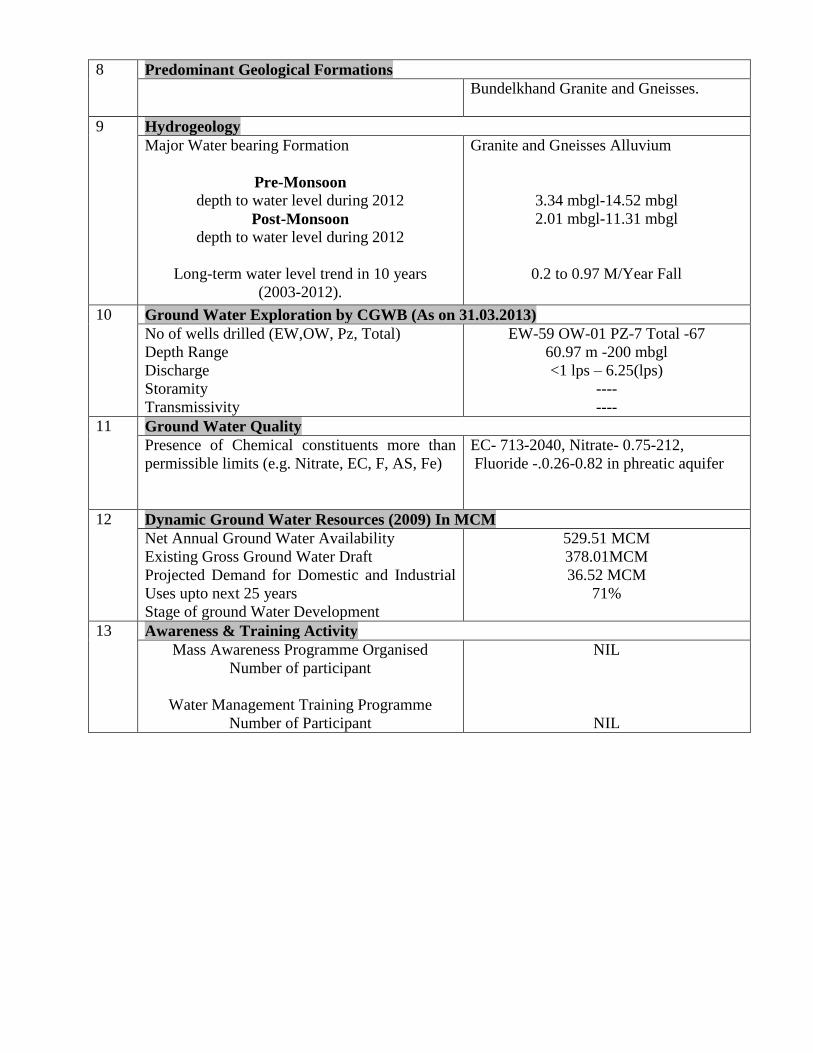
8 Predominant Geological Formations
Bundelkhand Granite and Gneisses.
9 Hydrogeology
Major Water bearing Formation
Pre-Monsoon
depth to water level during 2012
Post-Monsoon
depth to water level during 2012
Long-term water level trend in 10 years
(2003-2012).
Granite and Gneisses Alluvium
3.34 mbgl-14.52 mbgl
2.01 mbgl-11.31 mbgl
0.2 to 0.97 M/Year Fall
10 Ground Water Exploration by CGWB (As on 31.03.2013)
No of wells drilled (EW,OW, Pz, Total)
Depth Range
Discharge
Storamity
Transmissivity
EW-59 OW-01 PZ-7 Total -67
60.97 m -200 mbgl
<1 lps – 6.25(lps)
----
----
11 Ground Water Quality
Presence of Chemical constituents more than
permissible limits (e.g. Nitrate, EC, F, AS, Fe)
EC- 713-2040, Nitrate- 0.75-212,
Fluoride -.0.26-0.82 in phreatic aquifer
12 Dynamic Ground Water Resources (2009) In MCM
Net Annual Ground Water Availability
Existing Gross Ground Water Draft
Projected Demand for Domestic and Industrial
Uses upto next 25 years
Stage of ground Water Development
529.51 MCM
378.01MCM
36.52 MCM
71%
13 Awareness & Training Activity
Mass Awareness Programme Organised
Number of participant
Water Management Training Programme
Number of Participant
NIL
NIL

1.0 INTRODUCTION
The Tikamgarh
District encompassing an
area of 5048 Km Co-
ordinates of 2426 ;
2540 North Latitudes
and 7826 to 7926; East
longitudes falling in
toposheets No. 54 K, 54 P,
54 O and 54 L. Tikamgarh
district is situated in the
northern part of Madhya
Pradesh. It is bounded in
the north and west by the
Jhansi and Lalitpur of
Uttar Pradesh, in east by
the Chhatarpur district and
separated by River
Dhasan.The District has
been divided into six
Thesils and Blocks (Fig-
1). There are 865 Villages
and 13 Towns in the
District. Details of
administrative divisions of
the district are given in
Table-1.

Table – 1: Administrative Divisions, District TIKAMGARH, (M.P).
S.No Block Area Sq.Km No. of Villages No. of Towns
1. TIKAMGARH 867.00 155 3
2. BALDEVGARH 858.96 151 2
3. JATARA 1008.60 171 2
4. PALERA 748.22 135 1
5. NIWARI 606.00 123 2
6. PRITHIPUR 958.62 130 3
TOTAL 5048 865 13
Drainage
The entire district comes under Betwa sub-basin of Ganga basin. Dadhni, Janmi, bargi,
Ur and Dhasan are the major rivers draining in the district area and ultimately join in the north
with Betwa river. Dhasan, Jamni and Sadhni are Perrenial Rivers whereas Ur, Bargi, Gorar and
Supihar are ephemeral rivers. The overall drainage pattern in the district is dendritic.
Irrigation
Irrigation facilities in Tikamgarh are under developing stage. 67.63% of net sown area is
irrigated and rest of the area is rain-fed. Surface water irrigation in the district is constituted to
14.73%. Ground water is main source of irrigation and constitutes to 81.27% of the total
Agricultural land in the district. Total area irrigated by surface water and Ground water is 240.11
Sq.km & 1324.47 Sq.km respectively. There are 1925 tube wells and 76215 dug wells in the
district for Irrigation.
CGWB Activities
1) Systematic Hydrogeological Survey in Tikamgarh district was carried out by Sh.
P.N. Singh and Sh. V.S. Verma during 1990-91
2) Report on “Groundwater resources and development potential of Tikamgarh
district” was prepared by Sh. R.N. Sharma in 1994.
3) Exploratory Drilling by Contractual drilling under accelerated exploratory drilling
in the years 201-02 and 2003-04.
4) District Ground water management and development studies in Niwari, Tatava and
Prithipur block of Tikamgarh district by Sh. D.K. Rai, Sc ‘B’ in the Year 2005-06.
5) District Ground Water Management and Development studies in Tikamgarh,
Palara and Baldeogarh block of Tikamgarh district by Sh. A.K. Jain, Sc ‘B’ in the
year 2005-2006.

2.0 CLIMATE AND RAINFALL
The Climate of Tikamgarh district, M.P. characterized by a hot summer and general
dryness except during the southwest monsoon season. The year may divided into four seasons.
The cold season, December to February is followed by the hot season from March to about the
middle of June. The period from the middle of June to September is the southwest monsoon.
October and November form the post monsoon or transition period.
The normal annual rainfall of Tikamgarh district is 1057.1 mm. Tikamgarh District
received maximum rainfall received during southwest monsoon period i.e. June to September.
About 90.3% of the annual rainfall received during monsoon season. Only 9.7% of the annual
rainfall takes place between October to May period. Thus, surplus water for ground water
recharge is available only during the southwest monsoon period.
The normal maximum temperature received during the month of May is 41.8 C and
minimum during the month of January is 7.0C. The normal annual means maximum and
minimum temperatures of Tikamgarh district are 32.4C & 17.5C respectively.
During the southwest monsoon season the relative humidity generally exceeds 87%
(August month). In the rest of the year it is drier. The driest part of the year is the summer
season, when relative humidity is less 35%. May is the driest month of the year.
The wind velocity is higher during the pre monsoon period as compared to post monsoon
period. The maximum wind velocity 9.3 km/hr observed during the month of June and minimum
3.0 km/hr during the month of December. The average normal annual wind velocity of
Tikamgarh district is 5.6 km/hr. Normal climatologically parameter of Tikamgarh district is
given in Table - 2.

Table-2 Normal Climatological Parameters For Tikamgarh District
S.No. Parameter Jan Feb Mar April May June July Aug Sept Oct Nov Dec Annua
l
1 Maximum
Temp (C)
24.3 26.8 33.2 39.1 41.8 38.9 32.5 30.9 32.3 33.2 29.8 25.5 32.4
2 Minimum
Temp (C)
7.0 9.1 13.8 20.0 25.1 26.9 24.5 23.8 22.7 22.7 11.7 7.4 17.5
3 Relative
Humidity
(%)
74 69 55 36 35 58 83 87 82 82 64 4 65
4 Wind
Velocity
(Km/hr)
3.3 3.9 4.7 54 6.8 9.3 8.9 7.2 5.5 5.5 3.0 5.3 5.6
5 Rainfall
(m.m.)
21.5 20.8 6.6 3.0 4.8 115.4 321.0 387.3 131.4 131.4 22.0 6.6 1057.1

3.0 GEOMORPHOLOGY AND SOIL TYPES
3.1 Geomorphology
Geomorphological features are directly controlled by the geological formations and their
structures. They are can be classified into two broad regions.
1. The hill ranges.
2. The intermountain fertile valleys.
The hill ranges are made up of hard compact and resistant granite masses intruded by
quartz reef. The heights of hills range from 200 m to 400 m amsl.
The intermountain valley is fertile and covered by colluvial and detrital of parent rock
along with organic material. The thickness of alluvial fill varies from 10-16 meters. Thus, the
important valleys in the district are;
1. Jooramora – Madia valley sloping N-W
2. Majrakachhar to Dighuar Khurd village sloping north –west.
3. Mudeni to Dhoura valley trending northwards.
4. Bachchoda to Khistone valley trending northwards.
3.2 Soils
Soils derived from parent rocks are of three types i.e. black humus granitic and yellowish
grey colour with kankar soils are derived due to disintegration and decomposition of parent
rocks.
4.0 GROUND WATER SCENARIO
4.1 Hydrogeology
Entire district of Tikamgarh falls in Bundelkhand granite and gneisses, which are
profusely intruded by quartz reefs and pegmatite’s. Granite is generally flesh-red colour and
coarse grained showing porphyritic texture. However, grey-coloured granite which appears to be
metamorphosed into gneissic variety are also discernible in some blocks like Jatara, Baldeogarh,
Palera etc. Both the pink and grey Coloured granite have undergone intensive weathering. The
long narrow ridges formed by quartz-reef are intrusive into the granite. The joints and fractures
developed in the host granitic body are due to such intrusions. These quartz reefs act as water
divides as well as cut off walls across the ground water flows.

Thus the main factors which define the
groundwater environs are: -
1. The nature and structure of granitic
rock.
2. Depth and nature of weathered mantle
(overburden) overlying hard compact
basement.
3. Size intensity and inter connections of
joints and fractures developed in the
granitic country rock.
4. Arial extent and configuration of
valleys between the quartz reefs.
5. Water holding and yielding capacity
of the aquifers developed both in the
overburden and fractured granite.
Thus, thicker the overburden and
intense is the weathering along with
closer joint planes in granitic terrain.
The more will be the ground water
storage and yield.
From the Hydrogeological studies two distinct groundwater environs are found to exist in
this district.
a). Upland and Hilly tract of granite. This tract is formed by highly weathered product
of granite amendable for faster percolation of rainwater and favours groundwater
occurrences within 5 to 8 m bgl. The average yield of groundwater structured
ranges from 0.16 m3 to 0.1 m
3/day. The annual fluctuation of water table ranges
from 2 m to 2.5 m.
b). Granitic tract between too intrusive bodies: This tract is influenced by the
occurrence of quartz reefs. The granites have developed fractured and joints, which
favours and act as good conduct for groundwater circulation and occurrence within
the boundaries defined by quartz reef.
Depth To Water Level
Central Ground Water Board has been carrying out water level monitoring of Ground
Water monitoring wells (GW MW), since more than last two decades. Water levels of these
monitoring wells are being monitored four times in a year during the months of January, May,
August and November. A hydrogeological map (fig-2) of Tikamgarh district has been prepared
on the basis of available data. To study ground water regime of the area, pre-monsoon and post-
monsoon depth to water level maps of the district has been prepared.

Pre-monsoon (May2012) The pre-monsoon depth to water
level in the district ranges between 4.13 m
bgl and 18.50m bgl. Major part of the
district have water level in the range of 4-
12m bgl during the pre monsoon.
Post-monsoon (November 2012) During post-monsoon period, water level
varies from 2.94m bgl to 15.17m bgl. In
major part of the district, water level is less
than 10 m bgl.

Groundwater level trend (May 2003 to May 2012) Analyses of Groundwater level data of pre-monsoon period indicate that there is
declining trend in the range of 0.0018 - 0.27 m/yr.
Aquifer Parameters
Central Ground Water Board has drilled 53 exploratory wells in the district.
Hydrogeological data of exploratory wells in the district is given in Table-4.
Perusal of Table-4 reveals that, the depth of these bore wells varies from 60.97 mbgl to
200 mbgl and Discharge of the bore well varies from less than 1 lps to 6.25 lps. Aquifer in these
bore wells is generally jointed, fractured and weathered Granite.


DETAILS OF EXPLORATORY WELLS CONSTRUCTED BY CONTRACTUAL DRILLING UNDER DROUGHT
ASSISTANCE IN TIKAMGARH DISTRICT (2001-2002).
S
No.
Location Month of
Construction
Depth
Drilled (m)
Zones Tapped Geology Static Water
Level (mbgl)
Tested
Discharge (lps)
Draw
Down (m)
1 Orchha 200 16.59-32.59, 117.13-126.77 Granite 7.95 1.0 33.0
2 Tarichar Kalan January, 2002 200 Granite - Dry -
3 Murara January, 2002 182.92 16.59-21.16, 66.86-71.43 Granite 6.63 1.0 1.17
4 Pohakhas January, 2002 60.97 9.74-14.31, 28.02-32.59 Granite - 2.0 -
5 Prithvipur January, 2002 152.43 30.30-34.87, 73.72-78.29 Granite 0.85 1.0 33.0
6 Nivari January, 2002 83.84 28.00-32.59, 66.86-83.84 Granite 7.14 1.0 2.22
7 Achhrumata January, 2002 200 14.31-16.59, 155.98-165.12 Granite 4.91 1.0 19.73
8 Mudrani January, 2002 110.71 7.5-11.5(0.8)
16.21 (1.5) 34.0-38.0 (3.2)
Granite 7.41 1.0 0.47
9 Birora Khet January, 2002 200 5.0-7.50(0.5), 12-14 (2.0) Granite 4.17 1.0 0.6
10 Churara January, 2002 187.97 Granite - Dry -
11 Joramora January, 2002 187.97 9.50-16.00 (2.0)
21-25.50 (0.5)
Granite 7.68 1.0 9.97
12 Manakpura January, 2002 200 Granite - Dry -
13 Nandanwara January, 2002 200 28.00-32.00, 73.00-82.00 Granite 3.04 1.0 17.0
14 Bamori January, 2002 200 21.00-28.00, 41.00-50.00 Granite 8.55 1.6 0.55
15 Samara January, 2002 200 9.00-16.00, 28.00-34.00
80.00-92.00
Granite 7.51 1.0 8.86
16 Mogna January, 2002 187.97 Granite - Meager -
17 Digora January, 2002 187.97 Granite - Dry -
18 Lar January, 2002 200 Granite - Dry -
19 Birou January, 2002 200 3.5-5.0, 16.00-21.00 Granite 8.33 1.0 23.0
20 Buhdhera January, 2002 162.12 12.00-16.00(1.2lps) Granite 11.0 1.0 6.0
21 Malgawan January, 2002 151.41 Granite >60 1.0 -
22 Hatta January, 2002 200 41.00-53.00, 76.00-82.00 Granite 13.49 1.0 32.0
23 Radhepur January, 2002 114.85 Granite - Dry -

Table-4: Well wise Details of Exploratory By Contractual drilling of CGWB in Tikamgarh District (M.P).
Sr
No
Location Depth
Drilled
(mbgl)
Zones tapped
(mbgl)
Static
water
level
(mbgl)
Discharge
(m3/hr)
Draw down
(m)/
Discharge
(Lpm)
Aquifer material
1 Tikamgarh
Town
178.73 9.5-16.0, 98-105 5.5 7.2 2.4/68 Weathered & Fractured Granite
2 Dunga 125.59 9.5-14, 100-105 4.70 37.8 0.5/375 Sand Boulder Cobble & Fractured
Granite
3 Khargapur 174.16 24-32 6.80 5.4 - Fractured Granite
4 Dhonga 183.030 6-7.5, 18-30, 64-74 5.58 7.2 2.50/42 Weathered & Fractured Granite
5 Manikpura 200 170-184 132.0 4.32 - Fractured Granite
6 Larkhas 200 9.5-12.0 116.0 2.16 - Fractured Granite
7 Amarpur 151.31 24-32, 51-60 9.12 19.44 5.5/250 Negligible
8 Badagaon 178.73 5-10, 24-28 5.60 9.36 - Weathered & Fractured Granite
9 Doda 114.75 24-30 7.5 32.4 0.5/250 Weathered & Fractured Granite
10 Hyderpur 192.00 23-28 15.00 1.44 - Weathered & Fractured Granite
11 Ganeshpura 192.44 17-28 5.70 7.92 - Weathered & Fractured Granite
12 Baldeogarh 32.49 17-30 4.73 64.8 2.28/240 Sand Boulder Cobble & Fractured
Granite
13 Palera 183.30 16-25 3.04 17.28 4.30/214 Weathered & Fractured Granite
14 Jatara 200 10-12 5.93 5.4 - Fractured Granite
15 Chandora 200 11.50-18.0 8.5 12.6 - Weathered & Fractured Granite
16 Bherua Tal 137.60 9.5-18.50 4.03 21.6 3.0/350 Sand
17 Kari 200 9-15 8.5 7.2 - Weathered & Fractured Granite
18 Mohangarh 200 18-23, 75-80 2.05 17.28 3.00/288 Weathered & Fractured Granite
19 Hateri 200 7.5-8.5 9.00 4.32 - Fractured Granite
20 Bandha 200 19-22 8.50 3.6 - Fractured Granite
21 Kargawan 192.44 14-19, 53-62 5.08 12.6 1.5/88 Weathered & Fractured Granite
22 Bhopalpura 200 Dry - - - -
23 Ziron 200 8.5-15.0 3.5 12.6 3.5/250 Weathered & Fractured Granite

24 Sakera
Bhadram
200 15-18 14.60 5.4 - Weathered & Fractured Granite
25 Garar 200 16-18 5.06 5.4 - Weathered & Fractured Granite
26 Harshmau 200 18-25 8.50 4.68 - Weathered & Fractured Granite
27 Mohanpura 200 Dry - - - Weathered & Fractured Granite
28 Panhari 200 10-12 20.0 0.72 - Weathered & Fractured Granite
29 Parkheda 200 16-18,23-28,173-
178
3.85 21.6 8.5/214 Weathered & Fractured Granite
30 Asati 200 20-26 12.60 5.4 - Weathered & Fractured Granite

4.2 Ground Water Resource
Tikamgarh district is occupied by Bundelkhand granite with a thin soil cover. Dynamic
ground water resources of the district have been estimated for base year -2008/09 on block-wise
basis. Out of 5,04,800 ha of geographical area, 4,88,100 ha ( 97%) is ground water recharge
worthy area and 16,700 ha (3%) is hilly area. There are six number of assessment units (block)
in the district which fall under non -command (88%) and command (12 %) sub units. All blocks
of the district in command area are categorized as safe. Non command area of Baldeogarh,
Jatarah, Niwari, Palera and Tikamgarh are caategrised as semi critical (safe in 2003/04).Highest
stage of ground water development is computed as 82 % for Baldeogarh Block. The net ground
water availability in the district 52,951ham and ground water draft for all uses is 37,801 ham,
making stage of ground water water development 71 % (51 % in 2003/04) as a whole for
district. After making allocation for future domestic and industrial supply for next 25 years,
balance available ground water for future irrigation would be 13,742 ham.
Table-5: GROUND WATER RESOURCES AND STAGE OF DEVELOPMENT, (2009)
S. No. Assessment
Unit
Sub-unit
Command/
Non-
Command/
Net Annual
Ground
water
Availability
(ham)
Existing
Gross
Ground
water
Draft for
Irrigation
(ham)
Existing
Gross
Ground
water Draft
for Domestic
& Industrial
water Supply
(ham)
Existing
Gross
Ground
water
Draft
for All
uses
(ham)
Provision for
domestic,
and
industrial
requirement
supply to
next 25 year
(2033) (ham)
Net Ground
water
Availability
for future
irrigation d
development
(ham)
Stage of
Ground
water
Development
(%)
Category
Baldeogarh
Command 1111 338 40 379 74 699 34
Safe
Non-Command 7489 6233 395 6628 609 647 89 Semi
Critical
Block Total 8600 6571 435 7006 683 1346 81
Jatara Command 3483 932 50 982 93 2458 28 Safe
Non-Command 8451 6205 480 6686 761 1485 79 Semi
Critical
Block Total 11934 7137 530 7668 854 3943 64
Niwari Command 1430 594 56 651 85 751 45 Safe
Non-Command 5095 4029 281 4310 379 687 85 Semi
Critical
Block Total 6525 4623 337 4960 464 1438 76
Palera Command
Non-Command 6973 5227 395 5622 624 1121 81 Semi
Critical
Block Total 6973 5227 395 5622 624 1121 81 Semi
Critical
Prathivipur Command 1191 473 38 510 65 653 43 Safe
Non-Command 7949 4625 271 4896 407 2917 62 Safe
Block Total 9140 5098 309 5406 473 3569 59
Tikamgarh Command 2249 867 29 896 61 1321 40 Safe
Non-Command 7529 6033 209 6242 493 1003 83 Semi
Critical
Block Total 9779 6900 238 7138 555 2324 73
District Total 52951 35557 2244 37801 3652 13742 71

4.3 Ground Water Quality
Groundwater quality in Tikamgarh district is accessed annually by CGWB on the basis of
samples collected from 14 numbers of hydrograph stations in the district. On the basis of
examination of data for the year 2011, the water quality is described as follows. The Electrical
Conductivity ranges from 713 to 2040 micromhos per cm at 25°C. The fluoride ranges from 0.26
mg/l to 0.82 mg/l. The nitrate ranges from 0.75 mg/l to 212 mg/l.


![District Disaster Management Plan [DDMP] …...District Disaster Management Plan [DDMP] Tikamgarh (Madhya Pradesh) M.P. Government 2 Certificate To whomsoever it may concern This is](https://static.fdocuments.net/doc/165x107/5e83e2555393814f214f4516/district-disaster-management-plan-ddmp-district-disaster-management-plan-ddmp.jpg)