Thurston County Voluntary Stewardship...
32
Thurston County Voluntary Stewardship Program VSP Regional Informational Meeting January 27, 2017
Transcript of Thurston County Voluntary Stewardship...

Thurston County Voluntary Stewardship ProgramVSP Regional Informational Meeting January 27, 2017

OverviewThe Voluntary Stewardship Program in Thurston CountyProcess Overview Status of VSP in Thurston CountyProgress of the Work PlanNext Steps

Process Overview

VSP Requirements and Steps
Nominate Watersheds
Form Watershed Workgroup
Develop Work Plan• Goals &
Benchmarks• Stewardship
Plan Checklist
Submit Work Plan for approval
Implement• Work with
Volunteer Producers to develop Stewardship Plans
Monitor (2 & 5 years) adapt if needed

VSP Roles
Thurston County
• Opt-in to VSP• Designate Watersheds• Designate VSP
Workgroup• Administrative Entity
VSP Workgroup
• Develop Work Plan• Designate Technical
Assistance Providers• Set goals and
benchmarks• Establish monitoring and
adaptive management• Submit work plan to SCC
Conservation Commission and Technical Panel
• Technical Panel (WSDA, WDFW, Ecology, SCC) reviews and recommends action on work plan
• Director of SCC decides to approve or deny

What’s the status of VSP in Thurston county?

StatusNominated in 2012 • Nominate Watersheds
Formed in 2014 • Form Watershed Workgroup
Drafts 2015-16 and Tech Panel 1/17
• Develop Work Plan• Goals and Benchmarks• Stewardship plan Checklist• Lead Technical Provider Identified
Required to submit March 2017 • Submit Work Plan to SCC and Technical Panel

Nominated WatershedsNisqually (WRIA 11)
Deschutes (WRIA 13)
Chehalis (WRIAs 22/23)
Kennedy-Goldsborough (WRIA 14)

Formed Workgroup
Agricultural producers and citizens
WA State Farm Bureau
Thurston County Farm Bureau
Olympia Beekeepers Association
Taylor Shellfish
Center for Natural Lands Management
South Puget Sound Salmon Enhancement Group
WA State Dept. of Ecology
WA Department of Fish and Wildlife
WA State University Extension
WA State Department of Agriculture NRCS
Thurston Conservation District
Thurston Regional Planning Council
Chehalis Tribe
Nisqually Tribe
Washington Conservation
Commission & Technical Panel
VSP Workgroup
Workgroup Subcommittees
Ag Viability
Technical Team
Workgroup Membership

Timeline
Funding Received January 2014
Stakeholder Outreach Spring
2014First workgroup meeting May 28,
2014
VSP Work Plan Development
Workgroup monthly meetings
May 2014 to March 2017
Draft work plan June 30, 2015
Funding gap until January 2016
2 year 9 month Deadline (+6 month gap) March 2017

Work Plan Products in ProgressStatutoryWork Plan Draft
Watershed Current Conditions Reports
Stewardship Plan ChecklistIncludes Tech Assistance tracking tools
Monitoring & Adaptive ManagementBenchmarks and MetricsAdaptive Management Matrix
InformationalMappingCritical AreasAgricultural Activities – Intersection
Appendices
FAQs

What’s in the Draft Work Plan?

Work Plan RequirementsThe workgroup must develop a work plan to protect and voluntarily enhance critical areas while maintaining the viability of agriculture (RCW 36.70A.720 a-l)
The Work Plan Must: Ensure outreach and technical assistance to landowners: Thurston Conservation District Include existing information and resource conditions: Water quality data, watershed management plans, farmland protection data, and species recovery data and plans for each watershed
Measurable benchmarks that after 10 years are designed to: Protect critical area functions and values Enhance critical areas through voluntary incentive-based measures
Goals for participation by ag operators to meet the benchmarks Existing development regulations relied upon to achieve the goals Establish baseline monitoring for: Participation activities and implementation of stewardship plans The effects on critical areas and agriculture relevant to the benchmarks
Plan for periodic evaluations and adaptive management◦ Status report to county and SCC at the end of each biennium and report on benchmarks every 5 years
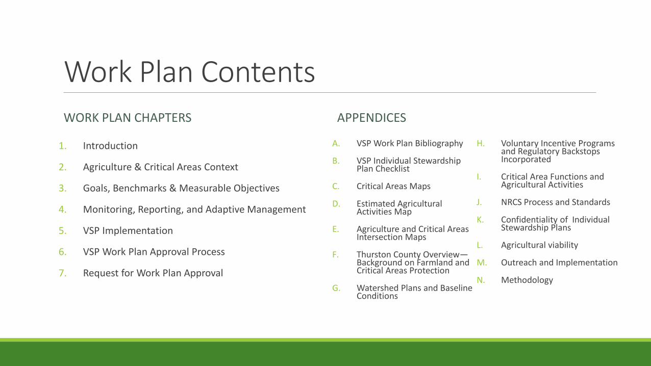
Work Plan ContentsWORK PLAN CHAPTERS
1. Introduction
2. Agriculture & Critical Areas Context
3. Goals, Benchmarks & Measurable Objectives
4. Monitoring, Reporting, and Adaptive Management
5. VSP Implementation
6. VSP Work Plan Approval Process
7. Request for Work Plan Approval
APPENDICES
A. VSP Work Plan Bibliography
B. VSP Individual Stewardship Plan Checklist
C. Critical Areas Maps
D. Estimated Agricultural Activities Map
E. Agriculture and Critical Areas Intersection Maps
F. Thurston County Overview—Background on Farmland and Critical Areas Protection
G. Watershed Plans and Baseline Conditions
H. Voluntary Incentive Programs and Regulatory Backstops Incorporated
I. Critical Area Functions and Agricultural Activities
J. NRCS Process and Standards
K. Confidentiality of Individual Stewardship Plans
L. Agricultural viability
M. Outreach and Implementation
N. Methodology

Chapter 1. Introduction Purpose and Goals Overview and History Definitions Plan Development Details Workgroup Structure and
Duties Work Plan Approval Tests
Plan Section Title
Work Plan Requirements
(RCW 36.70A.720(1) a through l
4. Introduction and Plan Development Details b
1.4.2, Appendix J
& M
Work Group Duties, Technical Assistance and Outreach
d, f, g
1.4.3, Section 3 & Appendix L
Work Plan Approval Tests: Protect Critical Areas and Maintain and Improve Ag Viability
RCW 36.70A.725
2, 4, & Appendices
C-G
Baseline information and Monitoring i
3 & Appendix I
Goals, Benchmarks and Measurable Objectives c, e
Appendix F & G
Background Information, Watershed Baseline Conditions, Other Plans
a
3 & Appendix H
Voluntary Incentives and Regulatory Backstop h
4 & Appendix N
Monitoring, Reporting, and Adaptive Management
j, k, l

Chapter 2. Agriculture and Critical Areas Context
Total Economic Value: $122,423,000 Cropland (40%) $48,843,000 Livestock (60%) $73,581,000
2.1: Agriculture Context in Thurston County
2.2: Critical Areas Context in Thurston County
USDA Census (2012) TRPC Agriculture (2014) VSP Ag ActivitiesMapping (2011)
76,638 acres 54,326 acres 125,618 acres
See Also:Appendix F. Thurston County OverviewAppendix G. Watershed Plans and Baseline Conditions
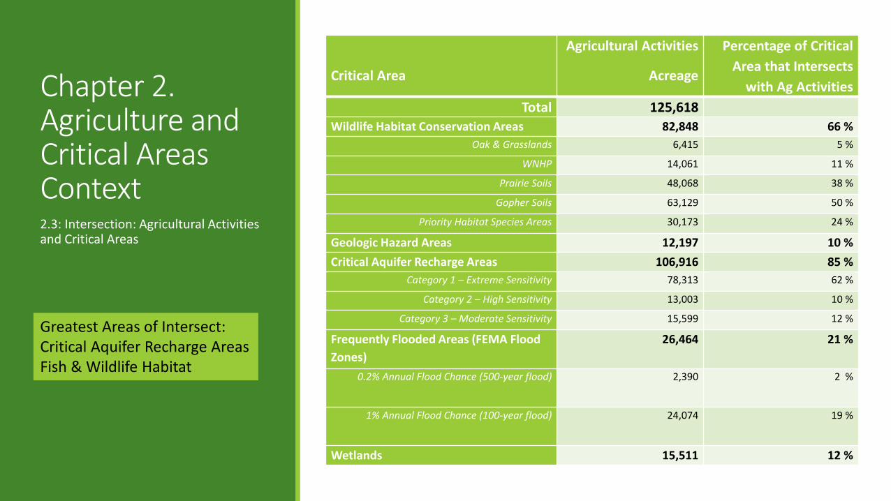
Chapter 2. Agriculture and Critical Areas Context2.3: Intersection: Agricultural Activities and Critical Areas
Greatest Areas of Intersect:Critical Aquifer Recharge AreasFish & Wildlife Habitat
Critical Area
Agricultural Activities
Acreage
Percentage of Critical Area that Intersects
with Ag ActivitiesTotal 125,618
Wildlife Habitat Conservation Areas 82,848 66 %Oak & Grasslands 6,415 5 %
WNHP 14,061 11 %
Prairie Soils 48,068 38 %
Gopher Soils 63,129 50 %
Priority Habitat Species Areas 30,173 24 %
Geologic Hazard Areas 12,197 10 %Critical Aquifer Recharge Areas 106,916 85 %
Category 1 – Extreme Sensitivity 78,313 62 %
Category 2 – High Sensitivity 13,003 10 %
Category 3 – Moderate Sensitivity 15,599 12 %
Frequently Flooded Areas (FEMA Flood Zones)
26,464 21 %
0.2% Annual Flood Chance (500-year flood) 2,390 2 %
1% Annual Flood Chance (100-year flood) 24,074 19 %
Wetlands 15,511 12 %

Chapter 3. Overarching Goals, Benchmarks & Measurable Objectives
Critical Area Protection (RCW 36.70A.720 (1)(e)(i) and (i)(iii))
I. Prevent the degradation of critical area functions and values existing as of the July 22, 2011 baseline due to agricultural activities, including:• Geologically hazardous areas• Fish and wildlife habitat conservation areas • Wetlands• Frequently flooded areas• Critical aquifer recharge areas
Benchmark 1. Baseline critical area conditions (functions and values) are protected (no net loss) in each watershed in areas of intersection with agricultural activities.
2. Baseline critical area conditions (functions and values) are enhanced in each watershed through voluntary measures in areas of intersection with agricultural activities.
Critical Areas Measurement and Monitoring
a. Repeat baseline critical area assessment for each reporting period to identify significant changes in the extent, amount, or quality of critical areas intersecting agriculture.
b. Measures of agricultural activities that have implemented conservation practices in an Individual Stewardship Plan for the protection and/or enhancement of critical areas.
3.1: Measurable Objectives for Each Critical Area and Agriculture Intersection

Geologic HazardsPurpose—Agriculture and Geologic Hazard Areas1. Avoid and minimize impacts of erosion and landslide hazards on stream quality, important fish and wildlife habitats, and protect areas
designated or with high potential for marine aquaculture activities from degradation by upland agriculture uses.2. Avoid and minimize damage to agricultural activities due to erosion, landslides or other naturally occurring geologic event. Geologic Hazard Areas Benchmark1. At each five year benchmark reporting period, baseline conditions of geologically hazardous areas are protected or enhanced in areas with
agricultural activities.2. At each five year benchmark reporting period, baseline conditions of fish and wildlife habitat conservation areas are enhanced through
voluntary measures in areas with agricultural activities.Geologic Hazard Area Measurable ObjectivesPromote and monitor practices that:CA Obj-1. Maintain or reduce erosion and sediment loads. Focus efforts in watersheds with water quality impairments and TMDL allocations for sediment.CA Obj-2. Stabilize steep slopes.CA Obj-3. Manage risk of landslides.CA Obj-4. Avoid compaction of soil.CA Obj-5. Avoid disturbing top and toe of steep slopes.CA Obj-6. Avoid irrigating unstable slopes.

Fish and Wildlife Habitat AreasPurpose—Agriculture and Fish and Wildlife Habitat Conservation Areas 1. Preserve habitat adequate to support viable populations of native fish and wildlife, protect the functions and values of priority
and locally important habitat, and provide for connectivity among habitats.2. Encourage non-regulatory methods of habitat retention through education, incentives, and other programs.Fish and Wildlife Habitat Benchmarks1. At each five year benchmark reporting period, baseline conditions of fish and wildlife habitat conservation areas are protected in
areas with agricultural activities.2. At each five year benchmark reporting period, baseline conditions of fish and wildlife habitat conservation areas are enhanced
through voluntary measures in areas with agricultural activities.Fish and Wildlife Habitat Measurable ObjectivesPromote and monitor practices that:CA Obj-7. Maintain or increase acreage of suitable native plant communities in areas with agricultural activities. This includesrecognizing individual or unique habitats or populations and tailoring appropriate conservation practices to protect and/or enhance those functions and values.CA Obj-8. Maintain or increase stream miles or total area of riparian areas. Focus efforts in watersheds with water quality impairments (most current list of EPA approved water quality assessments of category 4 and 5 waters).CA Obj-9. Replace culverts and other salmon passage barriers on agricultural lands to expand salmonid access to high priority habitat.CA Obj-10. Maintain or increase acreage of functional habitat for important, priority, and rare species. Focus on preserving thefunctions and values of priority habitats, including but not limited to: Oregon white oak, prairie, and riparian areas.

WetlandsPurpose—Agriculture and Wetlands1. Achieve no net loss of wetlands (maintain baseline conditions), avoid and minimize adverse impacts, and increase the quality and
functions of wetlands through voluntary measures. Establish wetland protection areas based on the wetland’s functions and values, sensitivity to impacts, rarity, and site conditions, and maintain wetland riparian area functions.
2. Encourage agricultural uses and activities in wetlands and riparian areas in a way that will avoid or minimize potential impacts.Wetlands Benchmarks1. At each five year benchmark reporting period, baseline conditions of wetlands are protected in areas with agricultural activities.2. At each five year benchmark reporting period, baseline conditions of wetlands are enhanced through voluntary measures in areas
with agricultural activities.Wetland Measurable ObjectivesPromote and monitor practices that:CA Obj-11. Maintain baseline (no net loss) extent of wetland functions and values.CA Obj-12. Avoid unmitigated alterations to wetlands.CA Obj-13. Maintain or increase suitable native plant communities in wetlands and associated riparian protection areas. CA Obj-14. Implement conservation practices for wetland management, creation, or enhancement.

Frequently Flooded AreasPurpose—Agriculture and Frequently Flooded Areas 1. Preserve natural flood control, stormwater storage and drainage, and maintain the linkages of the stream to its floodplain,
including flood channels or high-flow channels.2. Minimize flood damage to agricultural properties and operations.Frequently Flooded Areas Benchmark1. At each five year benchmark reporting period, baseline conditions of frequently flooded areas are protected or enhanced in areas
with agricultural activities.2. At each five year benchmark reporting period, baseline conditions of frequently flooded areas are enhanced through voluntary
measures in areas with agricultural activities.Frequently Flooded Areas Measurable ObjectivesPromote and monitor practices that:CA Obj-15. Maintain or reduce impervious surfaces.CA Obj-16. Avoid permanent unmitigated alterations to floodplain areas that increase net floodwater displacement in the watershed.CA Obj-17. Where development or permanent alterations are necessary, follow Ch. 14.38.CA Obj-18. Maintain and/or enhance floodplain area functions and connectivity of streams to their floodplains.

Critical Aquifer Recharge AreasPurpose—Agriculture and Critical Aquifer Recharge Areas 1. Maintain groundwater recharge and prevent the degradation of groundwater resources. Maintain the delicate balance between
surface water and groundwater in order to preserve essential biological, physical, and geochemical functions.2. Protect vital groundwater resources that serve as the primary water source for agricultural activities and balance competing needs
for water while preserving natural functions and processes.Critical Aquifer Recharge Benchmark1. At each five year benchmark reporting period, baseline conditions of critical aquifer recharge areas are protected in areas with
agricultural activities. 2. At each five year benchmark reporting period, baseline conditions of critical aquifer recharge areas are enhanced through voluntary
measures in areas with agricultural activities.Critical Aquifer Recharge Areas Measurable ObjectivesPromote and monitor practices that:CA Obj-19. Avoid or minimize the risks of ground water contamination from agricultural activities, consistent with state water quality standards.CA Obj-20. Maintain or improve groundwater recharge and ensure sufficient infiltration of water at the land’s surface to sustainaquifers, maintain base flows in fish-bearing streams, and maintain wetland water levels.

Chapter 3
Participation (RCW 36.70A.720 (1)(c))
Goal Promote participation and stewardship activities by agricultural operators conducting commercial and noncommercial agricultural activities in order to meet the protection and enhancement benchmarks.
Participation Objectives
1. Promote producer participation and progress toward meeting the protection and enhancement benchmarks of this work plan with a proactive conservation program delivery process.
2. Provide adequate technical assistance and information to agricultural producers and operators, encouraging the protection and enhancement of critical areas through voluntary measures.
3. Increase direct participation over 10 years by commercial and noncommercial agricultural operators.
4. Maintain or increase indirect participation over 10 years by commercial and noncommercial agricultural operators in conservation practices on agricultural land (including but not limited to those listed in Appendix J and tracked in Table 1: Restoration and Conservation Actions since 2011 in Appendix F).
3.2: Participation and Stewardship Activities (RCW 36.70A.720(1)(c))
Chapter 3
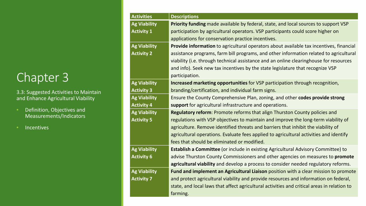
Activities DescriptionsAg Viability Activity 1
Priority funding made available by federal, state, and local sources to support VSP participation by agricultural operators. VSP participants could score higher on applications for conservation practice incentives.
Ag Viability Activity 2
Provide information to agricultural operators about available tax incentives, financial assistance programs, farm bill programs, and other information related to agricultural viability (i.e. through technical assistance and an online clearinghouse for resources and info). Seek new tax incentives by the state legislature that recognize VSP participation.
Ag Viability Activity 3
Increased marketing opportunities for VSP participation through recognition, branding/certification, and individual farm signs.
Ag Viability Activity 4
Ensure the County Comprehensive Plan, zoning, and other codes provide strong support for agricultural infrastructure and operations.
Ag Viability Activity 5
Regulatory reform: Promote reforms that align Thurston County policies and regulations with VSP objectives to maintain and improve the long-term viability of agriculture. Remove identified threats and barriers that inhibit the viability of agricultural operations. Evaluate fees applied to agricultural activities and identify fees that should be eliminated or modified.
Ag Viability Activity 6
Establish a Committee (or include in existing Agricultural Advisory Committee) to advise Thurston County Commissioners and other agencies on measures to promote agricultural viability and develop a process to consider needed regulatory reforms.
Ag ViabilityActivity 7
Fund and implement an Agricultural Liaison position with a clear mission to promote and protect agricultural viability and provide resources and information on federal, state, and local laws that affect agricultural activities and critical areas in relation to farming.
3.3: Suggested Activities to Maintain and Enhance Agricultural Viability
• Definition, Objectives and Measurements/Indicators
• Incentives

Chapter 4. Monitoring and Adaptive Management
Benchmark Performance Metric Monitoring Method
Adaptive Management
Action Threshold
Adaptive Management
Action
Environmental conditions desired from project
What will be measured to show progress toward objective or if adaptive management is needed
How the performance metric will be measured
Project result that, if achieved, must be
addressed with an action
Action that will be taken if threshold is
reached
CA B-1. Baseline critical area conditions (functions and values) are protected (no net loss) or enhanced (net
gain) in each watershed through
voluntary measures in areas of intersection
with agricultural activities
CA M-a. Repeat baseline critical area assessment for each reporting period to identify significant
changes in the extent, amount, or quality of
critical areas intersecting agriculture.
Measured on the watershed level
(e.g. by the agricultural liaison).
Decline below the 2011 baseline OR trend of decline in
critical area assessments
(extent, amount and quality) for 3 out of
5 years
Assess issue based on
metric and determine
appropriate action
CA M-b. Measure of agricultural activities
that have implemented
conservation practices for the protection
and/or enhancement of critical areas.
Measured on the parcel level by the
technical assistance provider and
reported in the aggregate for each
watershed.
Decline below the 2011 baseline OR
trend of decline for 3 out of 5 years
Assess issue based on
metric and determine
appropriate action
4.1: Monitoring VSP Baselines
4.2: Monitoring Baselines for Participation
4.3: Monitoring VSP Effects on Critical Area Baselines
4.4: Monitoring VSP Effects on Agricultural Viability Baselines
4.5: Reporting and Adaptive Management

Adaptive Management
•Outreach and Technical Assistance Provided
•Conservation Practices –Stewardship Plan Checklist
•Protection and Voluntary Enhancement Actions
Participation and Action
•Technical Assistance Provider Tracks Conservation Practices and Enhancement Projects
•Annual Output and Review•NRCS based procedures
Tracking Tools•Monitor progress towards
goals and benchmarks•Assess conditions based on
metrics identified in the work plan and determine appropriate action
Adaptive Management
Matrix
Adaptive Management Actions

Ch 5. Implementation – Stewardship PlanWATERING FACILITY
I DO THIS I’M INTERESTED IN THIS NOT APPLICABLE
Definition. A watering facility is a means of providing drinking water to livestock or wildlife.
Purpose. To store or provide designated access to drinking water for livestock or wildlife to:
• Supply daily water requirements • Improve animal distribution • Provide a water source that is an alternative to a
sensitive resource
Technical Providers work with producers to identify, document, and implement conservation practices Becomes individual VSP Stewardship Plan in RCW 36.70A.750 (1) Confidentiality important

Stewardship Plan – Process & Tracking 1. Administrative – Checklist, signature sheets,
table of contents.2. Narrative Inventory – A plan summary and
consideration for the five critical areas with definition of each area, current inventory, and management plan.
3. Maps – A selection of critical areas maps and final plan map.
4. Specifications – The “Record of Decisions” tracking tool and practice specifications.
5. Worksheets – Includes resource concerns checklist and supporting risk assessments.
6. Additional Information – All additional information both for landowner reference and supporting documentation.

Chapter 6. Plan Approval Process and Timeline •Submit the full
work plan for technical panel review by March 1, 2017
Approval Deadline July
2017
•If work plan approved (as early as April 26, 2017). •Outreach and
participation methods, as identified in the Work Plan
Begin Outreach to farmers •Farmers can use
the Stewardship Plan to begin VSP process•TCD will verify critical areas and conservation practices
Begin Implementation
– TCD using Stewardship
Plans
•Every 2 years: The work group will report on progress at the end of each biennium•Every five years: work group will report – determine next steps to adaptively management
July 2019 – first 5 year reporting period (5 years after receipt of
funding) •The work group reports on whether or not the benchmarks have been met at the ten year reporting period
July 2024 – ten year reporting

Next StepsNext Steps
Finalize Work Plan and Stewardship Plan Checklist
Finalize Adaptive Management Matrix
Seek Input and Confirm Roles (who’s doing what)
Submit the Work Plan by March 1st
Develop Outreach Materials

![Thurston County Agricultural Land Pocket Gopher Evaluation · [THURSTON COUNTY AGRICULTURAL LAND POCKET GOPHER EVALUATION] March 30, 2014 3 Thurston County Agricultural Land Pocket](https://static.fdocuments.net/doc/165x107/5b00b2377f8b9a256b90627a/thurston-county-agricultural-land-pocket-gopher-evaluation-thurston-county-agricultural.jpg)