
This Handbook is made possible with funding by the ... filerisk screening model: pollutant –...
70
1
Transcript of This Handbook is made possible with funding by the ... filerisk screening model: pollutant –...
1

2
This Handbook is made possible with funding by the European Union

1
Table of Contents
ABOUT PURE EARTH AND THE TOXIC SITE IDENTIFICATION PROGRAM 3 PURE EARTH 3 TOXIC SITES IDENTIFICATION PROGRAM 3 PROGRAM SCOPE 5 RISK SCREENING MODEL: POLLUTANT – MIGRATION – PATHWAY – PEOPLE 5 TSIP OVERALL PROCESS 7 TSIP MANAGEMENT STRUCTURE 8
BEFORE YOUR SITE SCREENING 9
DURING YOUR SITE SCREENING 11
SOIL SAMPLING PROTOCOL FOR METALS (XRF) 13
SOIL SAMPLING PROTOCOL FOR METALS (LAB ANALYSIS) 15
WATER SAMPLING PROTOCL 17
AFTER YOUR SITE SCREENING 17
SAMPLES AND LAB DATA 18
USING THE ONLINE DATABASE 19 PART 1. SCREENING RISK SCREENING 19 PART 2. PHYSICAL DESCRIPTION 24 PART 3. RELEASE RISK 27 PART 4. SITE STAKEHOLDERS – MEETING DETAILS 28 PART 5. EXPECTED INTERVENTION DESCRIPTION 28 PART 6. LINKED REPORTS AND IMAGES 29
CONTACT INFORMATION 32
APPENDIX A – HOW TO DRAW AND PLOT A SITE MAP 33
APPENDIX B – FINANCIAL REPORTS AND PAYMENT 36
APPENDIX C – HEALTH AND SAFETY GUIDELINES FOR INVESTIGATORS 39

2
APPENDIX D - POLLUTANT INFORMATION 44 LEAD, PB 44 MERCURY, HG 46 CHROMIUM, CR 48 CADMIUM, CD 50 ARSENIC, AS 51 RADIATION 52 ASBESTOS 54 CYANIDE 55 DIOXIN (2,3,7,8-TCDD) 56 FLUORIDES 57 PAHS (POLYCYCLIC AROMATIC HYDROCARBONS) 58 PESTICIDES 60 POLYCHLORINATED BIPHENYLS (PCBS) 62 VOLATILE ORGANIC COMPOUNDS (VOCS) 64
APPENDIX E – USING AN XRF AND EXPORTING DATA 65

3
About Pure Earth and the Toxic Site Identification Program
Pure Earth Pure Earth is a New York based not-for-profit organization that partners with governments, NGOs and community groups to solve life-threatening pollution problems in low- and middle-income countries. In addition to leading the Toxic Site Identification Program, Pure Earth conducts cleanup projects to mitigate health risks at toxic sites. See Pure Earth’s website at www.pureearth.org.
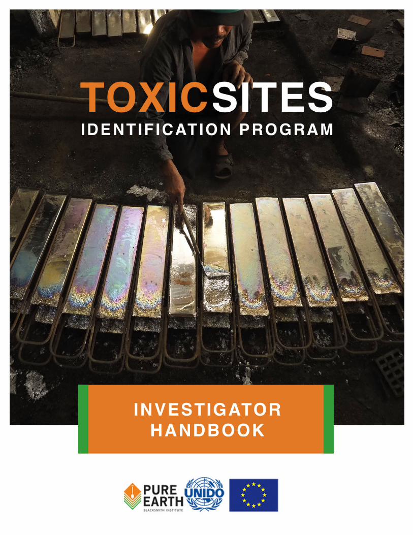
Toxic Sites Identification Program Pure Earth, with funding by the European Union, is assisting governments and communities to reduce the threats of toxic pollution to human health in low-and middle-income countries. Since 2009, the European Commission, along with the World Bank, Asian Development Bank and other donors, has invested significant resources into improving knowledge about the scope and extent of toxic pollution in low- and middle-income countries; the prior extent of which was largely unknown. One result of this investment is the Toxic Sites Identification Program (TSIP), a unique effort to identify and assess contaminated sites executed by Blacksmith Institute/ Pure Earth (BI/PE) and the United Nations Development Program (UNIDO). This project aims to help governments and communities heavily impacted by pollution in low- and middle-income countries, especially least developed countries (LDCs), take locally-led action to improve the health of those communities by breaking pollution exposure pathways and preventing future toxic emissions. It will strengthen the Global Alliance on Health and Pollution’s (GAHP) ability to influence and enable national, regional and international decision-makers to take concrete action to address the impacts of pollution on the environment, natural resources (land, water and air) and public health. It will secure long-lasting results for affected poor and marginalized populations by mitigating, preventing and reducing exposures to pollution, and building the capacity of civil society/non state actors and government agencies to take concrete action. The project will also place emphasis on implementing successful models that have significant replication potential, as well as potential for market-based solutions to a variety of pollution problems.
4
The Project has the following five major objectives: 1. Encourage national, regional and international decision-makers to mainstream
the issue of pollution and associated impacts on human health, the environment and natural resources into development agendas through awareness raising and presentation of scientifically-based evidence regarding its health, economic, and social impacts;
2. Assist decision-makers in LMICs to mitigate the impacts of pollution on human health, the environment and natural resources by improving understanding of the scope of toxic pollution in their respective countries, conducting training and capacity building, and assisting on the design and implementation of National Toxics Action Plans (NTAPs).
3. Provide technical expertise and financial support for pilot clean up or other relevant interventions in order to demonstrate the feasibility of market-led and industry-led solutions to pollution; and
4. Assess GAHP’s relevance, added value and potential regarding prevention and mitigation of toxic pollution on a sustainable and cost-effective basis, so as to re-define the future role of the alliance in this respect.
5. Monitoring and evaluation, including establishment of a Steering Committee whose members will include DEVCO, DG Environment, UNIDO, Pure Earth and others.
As part of the TSIP program more than 3,400 sites have been screened in nearly 50 countries. An additional 1,000 sites have been identified for future screening. The actual number of contaminated sites in low- and middle-income countries with a potential human health impact is clearly much greater. By comparison, there are an estimated 90,000 contaminated sites in the United States alone. No good estimates currently exist on the potential number of sites in low- and middle-countries, but the total is likely to exceed the current number of sites identified by the TSIP by at least an order of magnitude. The TSIP is not intended to be a comprehensive inventory of such sites, but rather an effort to begin to understand the scope of the problem globally. Between 2012 and 2014, the program was expanded to new regions where gaps existed previously. In 2012, the program was expanded to 15 countries in Latin America, Africa, Eastern Europe and Central Asia. Once Pure Earth has compiled a representative inventory of polluted sites in a given country, the organization works with the national government to assess priorities, develop action plans, and attract international support to address the most severe human health risks.

5
Program Scope
The program aims to assess sites that have:
• Toxic pollution • From a “point-source” (a fixed location, not air pollution from cars and trucks) • In concentrations or levels that can cause adverse human health impacts • Where there is a migration route and exposure pathway to humans • In low- and middle-income countries as designated by the World Bank
The program focuses specifically on legacy sites (i.e. abandoned or non-active) and artisanal sites (i.e. small-scale or informal industries).
Risk Screening Model: Pollutant – Migration – Pathway – People Central to Pure Earth’s approach is the model of Pollution-Migration-Pathway-People as the basis for understanding and assessing risks at a particular site. This model is consistent with risk screening approaches used internationally (by U.S. EPA, WHO and others) but is simplified for the purpose of conducting rapid risk screenings. Pure Earth is focused on people’s health. However, many health impacts from pollution are chronic and are difficult to attribute directly to one source. In the context of an Initial Site Screening (ISS) it is unusual to be able to demonstrate clearly the health consequences of a particular site. What can be done is to show that there is a credible risk attached to the site and that this risk deserves further investigation, as part of the design of an intervention. In simple terms, the health impact of a compound on an individual is a function of its toxicity and the dose received by people. The dose is a function of the concentration of the toxic compound, the time that people are exposed, and the pathway into the body. There are three basic pathways: inhalation – entry into the body through breathing; ingestion – entry through eating or drinking; and dermal – entry through skin contact and absorption. The existence of a public health risk at a site depends on three components: 1) There must be a source of pollution with a severe enough toxicity and a high enough level or concentration to be hazardous; 2) There must be a migration route for the pollution get to an area used or occupied by people; and 3) There must be a pathway into the body whereby people have the contaminant in their bodies for a long enough time for a significant dose to occur. The ISS is the process by which these components are identified and assessed at a site.

6
Pollutant. There are many substances that are hazardous to peoples’ health. In Pure Earth’s work on legacy industrial, artisanal and mining sites, there are a relatively small number of key pollutants that occur repeatedly. These include heavy metals, some organic chemicals, and in certain places, radionuclides. The form and characteristics of the pollutant are important (mercury, for example, is relatively harmless as a solid but toxic as a vapor). The amount of the pollutant is also critical. Investigators try to estimate the total area affected by a hazardous material and the level of contamination. A key factor here is the concentration, which is measured by sampling and subsequent testing. The critical parameter is the “over-standard” – the factor by which the concentrations of the pollutant exceed relevant international standards. This is the quantitative indicator of the hazard posed by the site. Migration Route. The migration route should not be confused with the “pathway.” Pathway relates to how a substance enters the body. Migration route refers to how a contaminant is spread from a source to a community or the environment. Common migration routes include:
• Airborne emission of dust or vapors from a specific source • Spread of dust by wind from waste piles or contaminated areas • Spread of dust or contaminated waste or soil by direct transport, such as by
trucks carrying waste • Spread of dust or contaminated soil by water, such as in storm runoff, and then
deposition in an area used by people • Transport of soluble toxics or very fine particles in surface or ground water, to
places where the water is used as a drinking water source (such as a well, pond or stream)
• Uptake of toxic contaminants into plants or animals, most often from contaminated water, which then enter the food chain of people
Pathway. A pathway is the physical mechanism by which the pollution enters the body. Substances can be toxic through ingestion (swallowing, often in food or water), through inhalation (as dust or vapor), or by direct dermal (skin) contact. Radioactivity can, in some forms, acts at a distance without direct contact and so proximity itself is a pathway. Note that most dust, unless of a very small size (less than 2.5 microns), actually enters the body through ingestion. Dust that is breathed in is often caught on nose, throat and lung tissue and then coughed up and swallowed. In practical terms, people can be directly exposed to toxic chemicals from a waste site if they inhale or ingest dust or vapor from the site, get dust or vapor from the site on their skin, or drink groundwater or surface water flowing under or through the site. People can be indirectly exposed if they eat food (plants or animals) grown on land contaminated by dust or vapor from the site or irrigated with water contaminated with toxic chemicals from the site.
7
People. A hazard becomes a risk when a population is actually exposed to or is impacted by the pollution at a dose high enough to potentially cause health impacts. A challenge for the investigator is to identify the relevant population, as the levels of contamination, substance toxicity, migration routes and pathways that exist will determine the exposure. The first step is to identify all the population groups within the probable area of influence of the polluted site, starting with populations immediately adjacent to the site, as well as those downstream and downwind from the site. This is best done using a local map and local information to identify nearby villages and urban areas (with estimated populations). Not all of these people will be at risk: that depends on the pollutant, migration route and pathways. The overall result of going through this logic is to be able to identify the populations that are potentially affected though the Pollution-Migration-Pathway-People connection. These people are the population at risk. Public health risk is easier to demonstrate when the migration routes are direct, the pathways are clear and the data on contamination is good. However, the objective of the ISS is not to conclusively prove or quantify a specific health impact. It is to identify a credible and significant risk to a population. Further studies are generally necessary to evaluate and quantify the risks and health impacts, which then hopefully lead to interventions to reduce the risks and impacts. Note that interventions can be focused on any or all of the components creating a toxic contamination problem. These could include: elimination of the source (such as waste removal or elimination of use of a toxic substance in a process); control of migration routes (such as installation of pollution control equipment or covering waste piles); elimination of pathways (such as covering or paving contaminated areas or providing clean drinking water sources); or reducing the people in contaminated areas (such as by fencing off disposal sites).
TSIP Overall Process Step 1: Create a National Inventory of site screenings. Step 2: Hold a conference with government Ministries, local partners, Pure Earth
and international donor agencies. Review National Inventory to identify national priorities and critical sites. Identify sources of funding for cleanup projects. Create a “Toxics Action Plan.”
Step 3: Implement cleanup projects at priority sites.

8
TSIP Management Structure TSIP Director – Bret Ericson is the TSIP Director and oversees all aspects of the project. Regional Directors – Each region has a Regional Director in the New York office (see contacts list). This person oversees Regional Coordinators in their regions. The Regional Director is responsible for setting regional priorities and budgets, coordinating regional activities, reviewing site screenings, and processing financial reports. Regional Coordinators – Regional Coordinators are Pure Earth staff members or consultants who are located in the region they coordinate. Regional Coordinators are responsible for coordinating site screenings with investigators, reviewing site screenings to ensure quality, reviewing financial reports, and helping Regional Directors with other regional program activities. Country Coordinators – Pure Earth has Country Coordinators in countries where the organization is very active,
including China, Indonesia, India, Mexico, Philippines, Russia, Ukraine, Vietnam, among others. Investigators – Investigators are paid consultants that conduct site screenings in their home country. Investigators report to the Regional or Country Coordinator, and must coordinator their site screening schedule with that Coordinator.
RegionalDirector(NewYork)
TSIPDirector(NewYork)
CountryCoordinator(locatedinregion)
SiteInvestigator(locatedincountry)

9
Before Your Site Screening
Before you visit a site, please make these preparations: Step 1: Coordinate your site screening with your Country Coordinator to make
sure your plans are consistent with the regional priorities, budget, and timeline. Discuss any potential health and safety issues at the site.
Step 2: Research your site. Look for sampling data from other research projects.
Examine available maps, such as from Google Maps, Google Earth or government sources, to familiarize yourself with the area and key features such as the locations of roads, residential areas, industrial or mining areas and water bodies. Try to make sure the site is within the Toxic Site Identification Program scope of interest. The TSIP is primarily focused on legacy pollution and therefore does not normally include sites which involve ongoing operations and which should be controlled by the relevant Regulator (i.e. the owner or entity that controls the site). We are only interested in site that have: 1. Toxic pollution (including heavy metals, POPs, radionuclides, dioxins,
PCBs, POPs, VOCs, among others—not biological pollution, such as from poor sewage treatment)
2. In concentrations above the health standards 3. From a “point source” (not cars and trucks, or multi-source
contamination in an entire river system) 4. With migration to areas occupied or used by people 5. With an exposure pathway to humans
Step 3: Identify a local contact or guide. Call local people to schedule
interviews, including interviews to take place at the field site on the day of testing. Try to meet with: 1. Local authorities (mayor, environmental agency, health agency) 2. Local organizations and community groups 3. Local health professionals 4. Local residents affected by the problem
Step 4: Prepare your equipment. You will need:
1. A camera. Please check your batteries and set your camera to take large, high-resolution photos.
2. Program Summary. Bring information about the TSIP project to share with local officials and residents.
3. A notepad and pen. Please take detailed notes. 4. A map of the site (try printing from Google Earth or a local map) 5. GPS device (if you have access to one)
10
6. Personal protective equipment. Protective equipment is necessary if the investigator could be exposed to the pollutant. If you need to purchase protective equipment, please contact the Country Coordinator or Regional Director in New York. Safety is very important. Please be careful and avoid potentially dangerous situations. See the Health and Safety section for further information.
Step 5: Identify Laboratories and Prepare for Sampling
1. Identify likely contaminates for which samples will be taken and analysis will be required.
2. Identify the laboratory to be used. In general, the Country Coordinator should advise investigators on laboratories that should be used. Where possible these will be certified laboratories. If no certified lab is available, the labs should be the best environmental lab readily available, which may be connected to government health or environmental departments or universities.
3. Obtain prices for sample analyses and alert the laboratory that they may be receiving samples. Confirm that they can do the desired analysis. Ask about and record the method they intend to use. When you receive the price quote from the lab, contact your Country Coordinator and Regional Director in New York to see if the price is acceptable.
4. Ask the laboratory about any specific requirements regarding sampling containers, quantities needed and sample preservation requirements. Also ask the laboratory about labeling or packaging requirements for the samples.
5. Prepare Sampling equipment. The equipment will depend on the pollutant and the type of sampling (soil, water, food, etc.). Follow the laboratory instructions. Generally, you will need: • Something to collect samples (shovel, spoon, bottle) • A permanent pen to mark samples (like a Sharpie) • Storage containers for samples (bags for soil, bottles for water)
See the Sampling Protocol Guidance for further information. If there are multiple sites in an area, plan to visit all of the sites in one trip to the extent possible.

11
During Your Site Screening Please take lots of notes and pictures, and keep all receipts for expenses. Step 1: Interview. Meet with local people that understand the site and may be
aware of health impacts from the site or community health problems. Ask them about the source, the migration routes, pathways, and the points where people are exposed. These local people could be a Mayor, employees of environmental organizations, a local doctor or nurse, the owner of the site, local school officials or other residents.
Ask these locals if they have any reports, studies, maps, about the site. If they have these, make copies there. Upload these documents to the online database when you return.
Step 2: Explore Site. Walk around site to understand the source, the pollutant, the migration routes, the pathways and the impacts. Use appropriate personal protective equipment if necessary. Take lots of pictures (at least 10) of the pollution source, migration routes, and the contaminated areas (such as streams, storm runoff channels or off-site waste piles). If there are people in or near the impacted area, please take pictures to show that potential for contact between the pollution and people (ask their permission to be photographed). Define the areas that might be impacted by the pollution and which should be considered part of the “site” for our purpose.
Step 3: Map. The map can be drawn as below, or made using free mapping
software (Google Earth, Bing, etc.) Divide the map into sectors based on land use (Agriculture; Critically Sensitive Receptors (Schools, Hospitals, Etc.); Dumpsite; Housing/Residential; Industrial (active); Industrial (vacant or closed facility); Natural Area; Vacant Land) as per Appendix A. On your map, mark the location of the pollution source, the migration route, the local neighborhoods that are affected, the location of your samples, and any other important landmarks or sites:
Step 4: GPS. If you have a GPS recording unit, record GPS coordinates for:
• The pollution source • The center of the affected area (you will enter this coordinate into
the second page of the online database in the GPS mapping field) See Appendix A for directions on entering GPS coordinates.

12
Step 5: Sample. If there are no credible test results from other reports, please take samples (see the Sampling Guides page 11-15). Please record your sampling locations on your map and record the GPS coordinates for each sampling location. If you are collecting target samples, please take the GPS coordinate of each sample. If you are collecting a composite sample, take the GPS coordinate for the area most center of your collection points.
Step 6: Estimate Population at Risk. Explore the community to try to
understand how many people could possibly be affected by the pollution. If the impacted area is a residential area, count or estimate the number of dwellings and estimate the number of people per dwelling, using available maps, information for governments or community leaders and your own observation. If schools are present, ask about the number of students. If a contaminated water source (wells or surface water) is suspected, ask about and estimate the number of people using this water source. At the end of the screening you will enter the “estimated population at risk” based on the number of people that could possibly be exposed through the pollution migration pathways.
List the number of people in the following categories:
On Site Within 50 meters Within 100 meters
Within 500 meters
Live Work Visit Total Across All Categories
Remember to keep all of your receipts (See Appendix B for Financial Reporting Instructions).

13
Soil Sampling Protocol for Metals (XRF)
SOIL SAMPLING PROTOCOL FOR METALS (XRF)
MATERIALS REQUIRED• GPSdeviceifavailable• XRF(withTroubleshootingGuide)• Camera• Mapofsite;Notepadandpen• Clear,polypropylenebagsorothercollectionmethodasspecifiedbylab
• Permanentmarker(preferablySharpie®)• SampleLog• Metalspoon(1);Spatula(1);Shovel(notusu-allyrequired)
• Gloves• PersonalProtectiveEquipment(PPE)asneeded
HEALTH AND SAFETY FollowhealthandsafetyguidelinesdetailedintheInvestigatorHandbook.
MAPPINGAmapshouldbemadeofthesitethatproperlyindicatessamplinglocationsandkeyfeatures(Schools,homes,andthepollutionsource).Electronicmapsarepreferable,thoughascanorphotographofahand-drawnmapisperfectlyacceptable.
INTERVIEWINGInterviewswithlocalresidentsandcommunityleadersarekeytounderstandingthepathwayspresent.Trytounderstandwhichareasarecommonlyusedandwhicharerarelyused.Thiswillhelpguidehowyoudividesectors.
XRF READINGSDividethesiteinto‘sectors’basedonuse(residential;public;agricultural;school;industrial).Largersitesmayrequireasmanyas6sectors,smallersitesmaybecoveredinasfewas2(SeeFigure1).
Samplingnotonlydeterminesconcentrationofcontamination,butitalsohelpstodeterminehowfarfromasourcecontaminationhasspread.Thus,whenpossibleradialsequentialsamplingistobeusedineachsector:
•Establishlinesfromthesourceofcontaminationinthedirectionthatthecontaminationmayhavebeenspread*
•Takereadingsalongeachline,typicallyoneevery5mfor50m,foratotalof10readings
ESTIMATING POPULATIONEstimatetheapproximatenumberofpeoplecomingintocontactwiththepollutantineachsector.Makenoteofthegroupsatrisk(suchaschildren,workers,elderly).RefertoPopulationTableintheHandbook.
Agricultural Residential Public
fig. 1
1
2
3
4
5 6

14
•Ifcontaminantispresentinthefirst50m,take10morereadingsalongthesamelineforthenext50m,andsoonuntilcontaminationisnotdetectedoruntil200misreached(indicatingwidespreadcontamination;goingfurtherisnotrecommendedduetotimelimitations)
•RecordresultsinSampleLog
NOTE: AT ANY SITE A MINIMUM OF 15 SAMPLE MEASUREMENTS IS REQUIRED
*Choosingthelinesneedstobedonewithcare.Atasiteintheopenwithnonotablefeaturesinthearea,onewouldchoosefourlinesinthecardinaldirections–north,south,east,west.However,otherfactorsneedtobetakenintoconsideration:
•Avillageorotherinhabitedareanearby(beyond100maway),inwhichcasealinetowardthatvillageisdesirabletoknowhowclosecontaminationcomestovillage
•Prevailingwinddirectioninareaswherewind-spreaddustisaconcern,alineinthedown-winddirectionisdesirable
HUMAN EXPOSURE PATHWAYNotethatsamplesshouldonlybetakenfromareaswithapotentialhumanexposurepathway.
SamplesshouldNOTbetakenfromareaswithoutahumanexposurepathway.Forinstance,theinsideofapesticidescontainerisNOTanacceptablesamplinglocation.Similarly,asecureareathatissufficientlyfencedoffwithappropriatesignageisNOTasuitablesamplinglocation.
• WearappropriatePersonalProtectiveEquipment(PPE)asneeded
• Washhandsbeforeeating• DoNot-underanycircumstance-enterconfined
areas.Theseareareaslargeenoughforapersontoenterbutwithlimitedventilationand/orlimitedorrestrictedmeansofentryorexit(e.g.wells,tanks,pits,vessels,sewersystems,pipelines).
• Becautiousinareasthatmaybeslipperyduetowater,mudorsteppslopes.
INVESTIGATOR PRECAUTIONS
• Becautiousifusingladdersorstairways.• Becautiousinexposedelevatedareas• Beawarethathazardousmaterialandtoxiccontami-
nationmaylookharmless–takeprecautionsanyway.Donotassumethatbecausepeople(e.g.localcom-munitymembers)arelivingintheareawithoutanyprotectionorwithoutpresentinganyobviousadversehealthsymptomsthatthereisnohazard.
475RiversideDrive,860NewYork,NY10115USA+12128703490

15
Soil Sampling Protocol for Metals (Lab Analysis)SOIL SAMPLING PROTOCOL FOR METALS (LAB)
MATERIALS REQUIRED• GPSdeviceifavailable• Camera• Mapofsite;Notepadandpen• Clear,polypropylenebagsorothercollectionmethodasspecifiedbylab
• Permanentmarker(preferablySharpie®)• SampleLog• Labelsforbags,printedandcut• Metalspoon(1);Spatula(1);Shovel(notusu-allyrequired)
• Gloves• PersonalProtectiveEquipment(PPE)asneeded
HEALTH AND SAFETY FollowhealthandsafetyguidelinesdetailedintheInvestigatorHandbook.
MAPPINGAmapshouldbemadeofthesitethatproperlyindicatessamplinglocationsandkeyfeatures(Schools,homes,andthepollutionsource).Electronicmapsarepreferable,thoughascanorphotographofahand-drawnmapisperfectlyacceptable.
INTERVIEWINGInterviewswithlocalresidentsandcommunityleadersarekeytounderstandingthepathwayspresent.Trytounderstandwhichareasarecommonlyusedandwhicharerarelyused.Thiswillhelpguidehowyoudividesectors.
COMPOSITE SAMPLINGDividethesiteinto‘sectors’basedonuse(residential;public;agricultural;school;industrial).Largersitesmayrequireasmanyas6sectors,smallersitesmaybecoveredinasfewas2(SeeFigure1).
Dependingonsectorsize,collectfrom3to10samplesofsurfacesoilpersector,evenlydistributed.Notethatlargersectorswillrequiremoresamples.Eachsampleshouldbeaboutonehalfteaspoon(2.5cubiccm,5grams).Combineallthesamplesinthesamebagandblendthematerialtoforma‘composite.’LabelaccordingtoLabelingSamplesinstructionsonreverse.
ForCompositeSampling,recordonesetofGPScoordinatesusingdecimaldegrees.Usethecentermostpointofyourcollected
ESTIMATING POPULATIONEstimatetheapproximatenumberofpeoplecomingintocontactwiththepollutantineachsector.Makenoteofthegroupsatrisk(suchaschildren,workers,elderly).RefertoPopulationTableintheHandbook.
Agricultural Residential Public
fig. 1
1
2
3
4
5 6

16
HUMAN EXPOSURE PATHWAYNotethatsamplesshouldonlybetakenfromareaswithapotentialhumanexposurepathway.SamplesshouldNOTbetakenfromareaswithoutahumanexposurepathway.Forinstance,theinsideofapesticidescontainerisNOTanacceptablesamplinglocation.Similarly,asecureareathatissufficientlyfencedoffwithappropriatesignageisNOTasuitablesamplinglocation.
• WearappropriatePersonalProtectiveEquipment(PPE)asneeded
• Washhandsbeforeeating• DoNot-underanycircumstance-enterconfined
areas.Theseareareaslargeenoughforapersontoenterbutwithlimitedventilationand/orlimitedorrestrictedmeansofentryorexit(e.g.wells,tanks,pits,vessels,sewersystems,pipelines).
• Becautiousinareasthatmaybeslipperyduetowater,mudorsteppslopes.
TARGETED SAMPLINGInadditiontocompositesampling,upto4targetsamplesshouldbetaken(SeeFigure2).Targetsamplesshouldbeindividualsurfacesoilsamplesof25to30grams*andshouldbetakenfromsuspected‘hotspots,’suchasresidentialareasadjacenttoacontaminationsource.GPScoordinatesshouldalsobetakenforeachtargetedsample.Labelsamplesaccordingtoinstructionsbelow(Labelsshouldbepre-printedandcut).
*Makesuretoconfirmwithlocallabthespecifiedamountsand/orotherspecialhandlingrequirementstheymayhave.
INVESTIGATOR PRECAUTIONS
LABELING SAMPLESEachsampleshouldbelabeledinthefollowingorder:1. Sample#2. SiteName(Town)3. Date4. GPSCoordinates
Labels should be pre-printed and cut. Samples should be double bagged with labels placed in between bags.
• Becautiousifusingladdersorstairways.• Becautiousinexposedelevatedareas• Beawarethathazardousmaterialandtoxiccontami-
nationmaylookharmless–takeprecautionsanyway.Donotassumethatbecausepeople(e.g.localcom-munitymembers)arelivingintheareawithoutanyprotectionorwithoutpresentinganyobviousadversehealthsymptomsthatthereisnohazard.
Targeted
Composite fig. 2
475RiversideDrive,860NewYork,NY10115USA+12128703490

17
Water Sampling Protocl
After Your Site Screening Step 1: Enter Data. Enter your notes and data into the online database as soon
as possible once you return. It is best to enter you screening into the database on the same day you return. We do not want you to forget any details about the site.
Step 2: Upload. Upload your photos, notes from interviews, maps, reports, and
any other documents into the online database. Step 3: Contact Laboratory. If you took samples, contact the laboratory
previously identified for use, and inform them of the number of samples collected and the contaminates for which the samples are to be analyzed. Bring or ship the samples to the laboratory according to their instructions. Confirm the cost for the analysis and how long it will take to get results. Be clear and specific as to whom the results should be sent and how (such as a specific name and email address.) Follow up with the laboratory if results are not received when expected.
Step 4: Finalize and Notify. Once your site screening is entered into the online
database, mark “ISS Complete” in the online site screening and tell the Regional Coordinator and Regional Director that your site is complete.
Step 5: Submit Financial Report. At the end of each month, create a financial
report showing the number of full days you worked, the number of travel days (for per diem payment), and your expenses. (See Appendix B for Financial Reporting Instructions)

18
Samples and Lab DataIn this program, we base our evaluation on whether health effects are likely to exist according to widely accepted and peer-reviewed literature. We do not undertake health studies, but look to existing studies, and assume similar health impacts. We use international health standards, as calculated by WHO, the U.S EPA, the European Union, and others as our baselines in determining acceptable levels of pollutants found in air, water, and soil. Health studies conducted by local authorities at sites investigators visit are valuable to support our screening. These studies should always be copied, scanned and uploaded. However, we will not generally use these data to make decisions about site remediation. Instead, we will use credible and accurate sampling results, compared against international standards, as our basis for determining the existence of, or potential for health risks associated with, contamination at the site. Other local studies should be scanned and appended to the ISS if available as background information. In many cases, a separate agency may have already carried out sampling at a site. When these samples are available and credible, the mean of all samples should be taken and entered into the Credible Test Results box. Individual sample results should be listed on the second page of the ISS in the Samples Taken box and uploaded as an attachment.
If no sampling data exists, investigators should conduct sampling according to Pure Earth’s guidelines. Each sample should come from a known or suspected human exposure area and should relate to an identifiable pathway. For example, samples collected from a drinking water source are better than samples from an industrial effluent pipe. Similarly, samples from soil inside a community are better than samples from inside an industrial estate or workshop. Once samples are collected, send them to a reliable and certified regional laboratory. Tell the laboratory which parameters/pollutants to test for based on which pollutants are most harmful to human health and your investigation of the pollution source. Try to be as specific as possible. For example, Total Volatile Organic Compounds (VOCs) is an acceptable parameter, however if the source of the pollution is petroleum production, it may be better to test for Toluene or Benzene because they are commonly associated with petroleum. Similarly, laboratories can be asked to analyze for all heavy metals, but it is far better to specify specific metals such as lead, mercury, cadmium or chromium (preferably for hexavalent chromium). Enter composite test results in the sample matrix of the first page of the ISS, and enter any other test result details in the second page in the Other Pollutants fields, and upload the laboratory results as an attached document.

19
Using the Online Database
If you ever have a question about a section of the online database, please click on the question mark [?] next to that section. If that does not answer you question, please ask your Regional Coordinator or Regional Director in New York. Database URL: www.XX.dbisa.org (XX= country prefix). For example, in Vietnam the database URL is www.nv.dbisa.org. In Mexico, the database is www.mx.dbisa.org. Ask your Country Coordinator for your country prefix. Language: You are free to enter the site screening information in your local language or English. If you enter your screening in your local language, we will translate it and paste in English text above or below to your original text. ISS Approval: For the data of your investigation to be approved, fill out the database fields listed below.
Part 1. Screening Risk Screening ISS Complete: Please click this box when you believe your screening is complete and you would like the New York staff to review your screening. The New York staff will not review your site screening until this box is checked. This does not necessarily mean your job is finished. The New York staff might review the site and label it “needs more information.” If that happens, please look at the “ISS Status/Notes” box to see what information is missing. Please be aware that an ISS is considered complete when the on-site assessment is finished and all necessary information has been entered into the online database according to the indications of the manual. Furthermore, if you have updated the site and provided more information regarding lacking areas, please click “Updated by Site Investigator” located in the “Notes Box”. Site Name: Please select a name that identifies the source of pollution AND the location (city and state). For example: “John’s Lead Smelter, New York City, New York State.” If the site is a whole village with many sources or no clear source, please use the village name. For example: “Bati Village, Thumen Country, Trivoli State.” Country: Please select the appropriate country. Province: Please select the appropriate province. If the province is not available, please contact your Regional Coordinator or Regional Director in New York. Issue: Please select if the issue is an isolated site or if it is a regional problem. A regional problem is defined as: one source impacting different locations (for example

20
several villages) or several small sources (for example several small mining operations) affecting a whole region. For instance, artisanal gold mining commonly occurs across regions. It is not necessary for our purposes to assess every village where artisanal and small-scale gold mining is occurring. Rather, assess the health exposures in one of the affected villages, and estimate the population for the region; In this case, mark the “regional problem” check box. Similarly contaminated river basins occur in many major cities around the world, and can impact millions of people. The pollution is diffuse and the sources are often disparate. In these cases, mark “regional problem” and estimate the population affected. By contrast local site is categorized as having a well-defined population and clear pollution source. Several small-scale battery recyclers in a single village would compose a "local" site. Abstract: Please enter a 2 to 4-sentence description of the problem. Clearly identify the source, the pollutant, the migration route and the pathway. For example: “A leather tannery in the town of Smithville dumped chromium waste behind the facility. The waste is not protected by walls or covered from rain or wind. The waste is leaching chromium into the local surface waters and groundwater. The local community uses wells dug into the contaminated groundwater aquifer as a potable water source.” ISS Date: Date when you conducted your screening. Note: the ISS will automatically fill in the date of the data entry. However, it is important to put in the date when you actually conducted the site screening, not when you are entering the data. Key Pollutant: Please select the key pollutant for the site from the drop down menu. The “Key Pollutant” is the contaminant that both has known toxicological effects and exceeds the recommended level. You are likely to encounter multiple sites where several pollutants are present. In these cases it is your responsibility to select the appropriate chemical as the key pollutant. Consider the following example. River sediment in a community has become contaminated by runoff from nearby mine tailings. Samples collected and analyzed show copper at very high levels. They also show arsenic slightly below the recommended level, and lead (Pb) at 1.5 times the recommended level. Arsenic is a known carcinogen and its levels are clearly elevated, though they are still within international standards. Copper levels well exceed international standards, though the toxicological effects of copper are not as significant. Finally, lead (Pb) has known neurological and cardiovascular effects and exceeds the international standard. Therefore lead (Pb) is the Key Pollutant. Select “Lead” from the drop down menu on the Screening Risk Assessment page. On the Physical Description page (Part 2), list arsenic under “Other Pollutants” and enter its analysis results. Finally, originals of all sampling data (including that for copper) should be uploaded as an attachment.

21
If the pollutant is a “Poly Aromatic Hydrocarbon” or a “Pesticide” or a “Volatile Organic Compound," select the specific pollutant from the specific drop-down menus. If the pollutant is a “Radionuclide” enter details in the free text field. If the pollutant is not listed, please select “other” and enter the pollutant name in the free text field. It is essential that the Key Pollutant field be properly completed. Direct any questions to your Country Coordinator, Regional Coordinator, or Regional Director. Sample Matrix: After you have selected the “key pollutant” please enter the following information in the matrix for each sample you have taken (please refer to the “Guidelines for Taking Samples” for further information). A minimum of 15 readings should be taken using XRF, and a maximum of 10 soil samples per site should be taken if you are using laboratory analysis.
• Sample sector: Please indicate the sector (as defined on your map from page 11) this sample was obtained from.
• Sample type: Please indicate if the sample is a composite or a targeted sample (see sample guidelines on pages 12-13 for definitions).
• Media: Please select the type of substance that was sampled (air, soil, water, urine, hair, blood, etc.)
• Pathway: Please select how the population enters in contact with the pollutant. • Population: Please enter the number of people that could be exposed to the
key pollutant in the sector where the sample was taken. However DO NOT double count. For example, if sector one is a school and sector two is a residential area, the children that get exposed in the school should not be counted again when reporting the number of people exposed in the residential area. See “estimated population at risk" below for more details.
• Test Results: Please enter the pollution concentration from each sample. The measurement units will be automatically entered once you select a “media”. Please make sure the sampling data you enter uses the same units that are automatically generated. Please consult with your Country Coordinator for help converting units.
• Coordinates of Sampling Data: Please input a latitude and longitude for each sample. These samples should be tagged in the map in Part 2 of the database (Physical Description). Note: GPS coordinates should be entered as decimals, not degrees (e.g. 18.418789, not 18°41’87).
Estimated Additional Population at Risk: This is your estimate of the number of people that could be exposed to this pollution at a level (dose) that could impair their health. The ISS should identify both the likely number of people impacted and the total number that might be impacted in a worst case. For example the likely population at risk could be:
• The local residents in a neighborhood with contaminated soil; or • The number of school children and residents in the immediate vicinity of a lead
smelter or other toxic air pollution source; or

22
• The population drinking contaminated groundwater. A worst-case impacted population at risk estimate would include a larger number -the number of people who could be exposed to the toxic pollution. Examples might be:
• The total population in a ½ kilometer radius of a lead smelter or other air pollution source; or
• The entire population of a town in which a large industrial estate is located; or • The entire population of an area relying on a contaminated aquifer or surface
water source (as opposed to just the population relying on wells sampled and found to be contaminated.
Good professional judgment should be used in developing population estimates, using available information from maps, government sources (regarding such things as town population and water sources) and your own observations. An approximate estimate of the Population At Risk is OK. You may round to the nearest thousand. For example, if 750 people are exposed, then round-up to 1,000. Keep in mind that it is not uncommon to have exposed populations in the 10’s of thousands. Please note that contaminant migration and pathways define the population at risk. Once a pollutant has been shown to be above the standard, consider the aerial extent of the contamination and how it gets inside of humans. Are people absorbing it by drinking it, breathing the air, inhaling or accidentally ingesting dust, eating food? This pathway will help you ask the right questions and determine the population at risk. There are often multiple pathways at a given site. Soil that contains lead can contaminate barefoot children through dermal contact or ingestion, though it can also be inhaled as dust by local community members. Similarly, dust containing arsenic can be inhaled or ingested, and can also migrate to drinking water supplies and be ingested. Multiple pathways must be considered when reviewing a site. The total Population At Risk is therefore the total number of people considering all pathways at a site.

23
Consider the chart below: AIR WATER SOIL Note that a single person may be put at risk by more than one pathway, though they can only be counted once in the total Population At Risk. The chart above illustrates that while multiple pathways can impact the same group, each group can only be counted once. Finally, remember that you are only expected to estimate Population At Risk to within reasonable range. Make an educated guess by using your screening information and tools such as local maps or census data, or Google Earth to estimate the number of nearby housing units. Data Source Type: Please select the type of source used to get the sample results (for example: investigator sampling, government report, etc) Data Source Description/citation: Please include a detailed description or citation of your data source. Please remember to upload in PART 6 any available source documents. If you took samples, please describe the sample types, dates, and locations, and upload a scan of the laboratory results. Test Data Certainty: Please use your judgment to indicate the reliability of the data source. For example, if you took samples that were analyzed in a certified lab, the certainty should be high. If the data is old, or comes from a local advocacy group, the certainty may be low. Save: Please remember to save your information every time you make a change in the database. If you do not click “Save” before you move to another page, your changes will be lost.
4,000250250
DONOTDOUBLECOUNTPOPULATIONSAir:4,750(4,000+250+250+250)Soil:1,500(1250+250)Water:2,000
250 250 1,250
2,000
24
Part 2. Physical Description Location & Site Description: Please write at least 4 detailed paragraphs that include:
1. Location and geographical description of the site (size, topography, distance from town, nearby rivers, lakes, mountains, etc.)
2. Detailed description of the pollution source (for example: is it a factory? Is it abandoned? What did it make? How many people worked there? What kinds of wastes did it produce? Where were they dumped?)
3. Description of the contaminant migration route (for example fugitive dust carried off-site from a lead smelter to the neighboring community; contaminated soil dumped in the open next to a school; or a surface stream contaminated by storm runoff from a sludge pile)
4. Description of the pathway into the body (for example, dust inhalation/ingestion, surface water ingestion, contaminated food ingestion, etc.)
5. Description of the population that is affected (for example: Where do they live? Where do they get their drinking water? What kind of houses do they have? Are their many kids? Do the kids have direct contact with the pollution? Are they downwind from the pollution source? Do they pass the source on their way to work/school?)
This site description should be easy to understand for a non-local and non-expert. Please also upload a map of the site as an attachment. Population estimate explanation: Explain in two or three sentences how the population affected was estimated. For example, “only people living within 300m2 around the source were included, national census data from 2009 was used.” GPS Coordinates: GPS coordinates should be entered as decimals, not degrees (e.g. 18.418789, not 18°41’87). To convert degrees to decimals go to: www.fcc.gov/mb/audio/bickel/DDDMMSS-decimal.html If you are converting degrees to decimals, you might have to add a minus (-) sign in front of the decimal to get the correct coordinate. Once you enter the GPS coordinates and save the page, please look at the map to see if it shows the correct location. Size of Contaminated Areas: Please select if the area affected is : <100m2, 100-500m2, 500-1,000m2; 5,000-1000m2 (1 hectare); 1 hectare-5 hectare; > 5 hectare.

25
Approximate Surface Area: If the contaminated area is land, please describe the size of the site in in hectares (1 hectare = 10,000m; 1 km2 = 100 ha). Estimated Depth of Contamination: Enter value in meters. Was a test pit dug to determine the depth of contamination: Please select from the menu (yes/no). Is there a strong smell associated with the site attributed to contamination: Please select from the menu (yes/no). Land use: If the contaminated area is a land area, please select the category that best describes use given to land: Agriculture; Critically Sensitive Receptors (Schools, Hospitals, Etc.); Dumpsite; Housing/Residential; Industrial (active); Industrial (vacant or closed facility); Natural Area; Vacant Land Type of water body: If the contaminated site affects a water body, please select the category that best describes this water body: 1) Not Applicable, 2) pond, 3) small lake, 4) large lake, 5) estuaries, 6) ocean, 7) small river/stream, 8) large river, 9) wetland, 10) ground water. Estimate the number of people in categories (table): Enter population data into the 4x3 table (4 categories of location and 3 categories of activity). Site accessibility to animals that are later consumed by humans: Choose which best describes the area: 1) food animals/fish on site 2) food animals/fish within 100m, 3) accessible to occasional food animals Distance to the source of potentially contaminated drinking or bathing water: Choose how far: 1) > 5 km, 2) 1km to 5 km, 3) 300m to 1km, 4) 0 to 300 m In which direction: 1) North, 2) Northeast, 3) East, 4) Southeast, 5) South,
6) Southwest, 7) West, 8)Northwest What is it [water] used for: 1) Other, 2) Unknown, 3) Irrigation, 4) Fishing, 5) Bathing/Washing, 6) Drinking, 7) Not Used How far are crops produced form the contaminated area: 1) No crops are produced within 100m, 2) Crops are produced within 100m of contaminated area, 3) Crops are produced within 10m of contaminated area, 4) Crops are produced in contaminated area If water at the site is contaminated, is there another source of clean water available?: Please select from the menu (yes/no).

26
Describe the access to the contaminated area: 1) Controlled access; entry difficult, 2) Remote locations; less accessible, 3) Moderate access; entry more difficult, 4) Easy access; few barriers to entry Describe the ground cover over the contaminated area: 1) The site is covered by a concrete slab or other type of engineering, 2) There is complete grass cover and other vegetation, 3) There is sparse grass cover, 4) The contaminated area is bare Source Industry: This section is very important. Please choose the primary industry that is the source of the pollution. Please read the full list of industries. Some industries are very similar, for example “mining and ore processing” and “artisanal mining.” Please choose carefully. Active, Legacy, or Both: An “active” site is one where the industrial process or facility is open and active. A “legacy” site is one where the facility or process has ended or is closed. A “Both” site is one where the facility or process is open and active, but where soil or groundwater pollution exist from year of past industrial activities. For example, an active facility that is the source of years of heavy metal pollution in soil and sediments is a “both.” Other Pollutants: List all known pollutants. Chemical Group 2 and Chemical group 3: if more than one pollutant is present at the site, please select the two other major pollutants. Test data available for other pollutants: Click the link if sample data is available for other pollutant 2 and 3. This will bring another “Sample matrix” please fill the sample matrix according to the instructions give above under “Part 1”. Documented Health Effects: Please select from the menu (yes/no) if there are documented health effects caused by the pollutant to the population at risk. Describe credible health impact of pollutant: Please describe the health impact of the pollutant and its particular pathway to the population at risk. Anecdotal, peer-reviewed, or media accounts of any health effects on local pollution are accepted. Attach any existing studies (scan and pdf). Other pollutant sample notes:
• If you took samples for other pollutants (besides the key pollutant reported on “Part 1”, please describe the type of sample, the number of samples, the location of each sample, the date and time that you took the samples.
• Please describe the exposure pathway that you took the samples from. • If you sent the samples to a laboratory, please list the name and address of the
laboratory as well.

27
• If test data comes from an outside source like a government report or peer-
reviewed study, please cite that report (i.e. author, title, date…) and briefly describe its sampling method and test data, including quality assurance/quality control (QA/QC) data.
• Additionally, upload any previous tests by other credible agencies, and add their test results and QA/QC data.
• Please upload test results from field sampling as soon as they are available. Additional notes: Any information that does not fall into one of the above categories may be placed here.
Part 3. Release Risk Is there permanent surface water on the site: Please select from the menu (yes/no).
What is it used for: 1) Other, 2) Unknown, 3) Irrigation, 4) Fishing, 5) Bathing/Washing, 6) Drinking
Is there evidence of a high water table or ground water: Please select from the menu (yes/no). Depth of the water table: 1) Shallow <2m; 2) Medium 2 – 10m; 3) Deep 10-50m; Very Deep > 50m Is the site in a flood plain: Please select from the menu (yes/no). Distance to the closest river or water body: 1) No water source in vicinity; 2) Within 500m of contamination; 3) Within 100m of contamination; 4) Within 50m of contamination; 5) Running through the contaminated site Distance to the closest well: 1) No well in vicinity; 2) Within 500m of contamination; 3) Within 100m of contamination; 4) Within 50m of contamination In which direction: 1) North, 2) Northeast, 3) East, 4) Southeast, 5) South,
6) Southwest, 7) West, 8)Northwest Position of the contaminant(s) relative to the slope: This question is asking where the contaminant is relative to the ground. Is it on the surface (above ground) or deeper in the soil (below ground)? The second part of the question is asking if the site is on a hill -intermediate for a hill that does not rise quickly, or steep if the hill has a sharp rise- or flat.
Given this information, Please choose the description that fits best: 1) Contaminants above ground level and slope is steep, 2) Contaminants at or below ground level and slope is steep, 3) Contaminants above ground level and

28
slope is intermediate; 4) Contaminants at or below ground level and slope is intermediate, 5) Contaminants above ground level and slope is flat, 6) Contaminants at or below ground level and slope is flat, 7) Do not know
Is this a storage facility for pollutants: Please select from the menu (yes/no).
Part 4. Site Stakeholders – Meeting Details Please identify all relevant government agencies, non-profit organizations and business that have any authority or interest in the site. If any government official accompanied you to the site visit, please document his/her name and title in this section.
Part 5. Expected Intervention Description Describe short-term strategy required to initiate site remediation: If you have experience in site remediation, please describe the initial steps required to begin remediation. Estimated Volume of Contaminant: Please enter an estimate in cubic meters of the amount of material contaminated. Estimated Weight of Hazardous Material: Please enter an estimate in tons of the amount of hazardous material. Initial Intervention Type: If you have experience in site remediation, please identify all of the remediation methods that are needed at the site. Describe expected likely final remediation plan: Include a range of technologies if applicable; Review Pure Earth ‘Quick Sheets’; Timeframe; Biometric evaluation strategies, including likely agency. Note any physical, political, or social barriers to remediation efforts. Who is Local Champion: Please provide information about any person, organization or agency that is interested in cleaning up the site and that might be a good partner or advisor for a cleanup project. Remediation Activities Carried out to Date: Please describe any past cleanup activities (For example: Who designed it? Who was in charge? Did they finish? What was the budget? Why did they stop?)
29
Part 6. Linked Reports and Images For all files, indicate whether or not you are uploading a document or an image and write a brief description of the document’s content. Public View: Certain sections of the TSIP database are accessible to the public, including linked reports and images. Therefore, when uploading documents, you are given the option of whether or not to make that particular document accessible to the public. Please exercise caution in choosing “yes.” Documents that include any biological samples results or names of any people should NOT be made public. Images of people should also be checked “no.” Published papers and images of the site (that do not include people) can be made public, as are maps and other documentation that describes the site in general. Please collect and upload the following key documents:
• A document with the sample results. Also, if the document is long (i.e. over 20 pages), specify the page number of the page results in the Part 1 “Data Source Description/Citation”.
• At least 10 photos of the site, source, pollution, exposure pathways and affected population (ask permission before taking photos of people).
• A site map (copied or drawn) showing the boundaries of the site, location of the source of pollution, the location of the affected population, the pathway to people and the most contaminated areas (scan and pdf).
• Studies of health impacts (scan and pdf). • Other reports or articles with relevant information (scan and pdf). • Any Internet links to source of data, media information, etc.
Contact your Regional Coordinator and Director when finished.

30
Frequently Asked Questions
What is the definition of a “site”? A “site” typically includes the pollution source (which may be an active or legacy site), the migration route, and any areas where people can be exposed to pollution above standards. How does Pure Earth use the information in the database? Pure Earth uses the database to help national governments evaluate existing and potential environmental health problems, analyze trends, and set priorities for cleanup.. Will my site screening lead to a cleanup project at the site? One goal of the inventory is to help Pure Earth and local governments identify sites that require immediate attention. There is never a guarantee that your site screening will lead to a cleanup project, but if the screening indicates there is a significant public health risk, it is a possibility. Investigators should explain the program goals to any curious locals, but should not promise any further action or create expectations among the local population that the site will be cleaned. How do I locate polluted sites to assess? There are many ways to identify sites. Here are some good sources:
• Ask your Country Coordinator or Regional Coordinator for a site list.
• Ask a local environmental organization or university
environmental studies department.
• Ask the local government (starting with the pollution control agency or health agency). Specifically ask about industrial areas, and if industries for which Pure Earth often finds contamination issues are present.
• Search newspaper records for articles about polluted sites.
• Search for reports from the government, World Health Organization, United Nations Environment Programme, or other organizations.
• Search for peer-reviewed journal articles about polluted sites.
What if a site does not currently affect people, but could in the near future? Some sites do not have immediate chemical exposures to humans but may pose a risk to people in the near future. For example, a rusting storage tank of ammonia is threatening to burst, and then poison a local population. While there are no test results that show an immediate pathway to a population, clearly this site is a risk to human health. In this case, list the affected population as the number of people at risk if the tank fails and leaks. List as much information related to the potential hazard as you can – describing the issue to others so they can visualize the

31
problem, and your thinking on your screening. What language should I use when I enter information into the database? You are free to enter information in your local language or English. If you enter your screening in your local language, we will translate it and paste English text next to your original text. We will not delete your text. What is the Pure Earth Index? The Pure Earth Index is a score from 0-10 that indicates the relative human health risk posed by a site (10 indicates the highest risk). The Pure Earth Index
is automatically generated from data about pollutant types, pollutant concentrations, pathways, and populations at risk that investigators enter into the database. Can I get an advance payment for site screening costs? In certain cases it is possible for Pure Earth to send an advance payment for site screening expenses, particularly for your first site screenings. This must be negotiated with your Regional Director. Pure Earth will not send regular advances every month.

32
Contact Information Program Directors and other New York Staff: Bret Ericson – Director of Operations [email protected] 212-870-3481 Lara Crampe – Regional Program Director, Southeast Asia [email protected] 212-870-3483 Petr Sharov – Regional Director, Former Soviet Union [email protected] 212-870-3484 Andrew (Drew) McCartor – Regional Program Director, East Asia and South Asia [email protected] 503-347-8545 Sandra Gualtero – Regional Program Director, Latin America and the Caribbean [email protected] 212-870-3994 Eric Fecci – Chief Financial Officer [email protected] 212-870-3479 Russell Dowling – Program Officer, Africa [email protected] 212-870-3493 Lina Hernandez – Program Officer, Latin America and the Caribbean [email protected] 212-870-3495 Anthony Rivera – Program Officer, Southeast Asia [email protected] 212-870-3496

33
Appendix A – How to Draw and Plot a Site Map Draw or copy a map of the site that shows the pollution source, the pathways to humans, the location of your samples and any pollution hotspots, neighborhoods that might be affected, and any other relevant landmarks or sites (i.e. wells, health clinics etc). A digital map is preferable, though a hand-drawn map is acceptable. Marking GPS Coordinates A GPS device should be used to mark each point where sampling occurs. If you are taking composite samples Digital Maps Digital maps can be drawn using Bing, Google Earth, or a number of other software applications (i.e. Gliffy, GIS, etc). Bing Maps: http://www.bing.com/maps
1. Right Click on location > “Add a Pushpin.” 2. Name and Save the Pushpin 3. Mark an area of contamination using area tool in “My Places Editor.” 4. Actions > Export > KML
Google Earth: https:/www.google.com/earth/
1. Use the Path Tool to draw area 2. Save Path 3. Right Click “Path in Places” Menu > Save Place As > KM
GPS coordinates can also be added into an excel spreadsheet using one column for latitude and one for longitude. This spreadsheet can then be uploaded into many map-making sites such as Google Earth to auto-population sampling points. To import as a singular spreadsheet please click on File, > Import and upload the spreadsheet. NOTE: Spreadsheet may have to be in .csv format rather than .xls or xlsx.
34
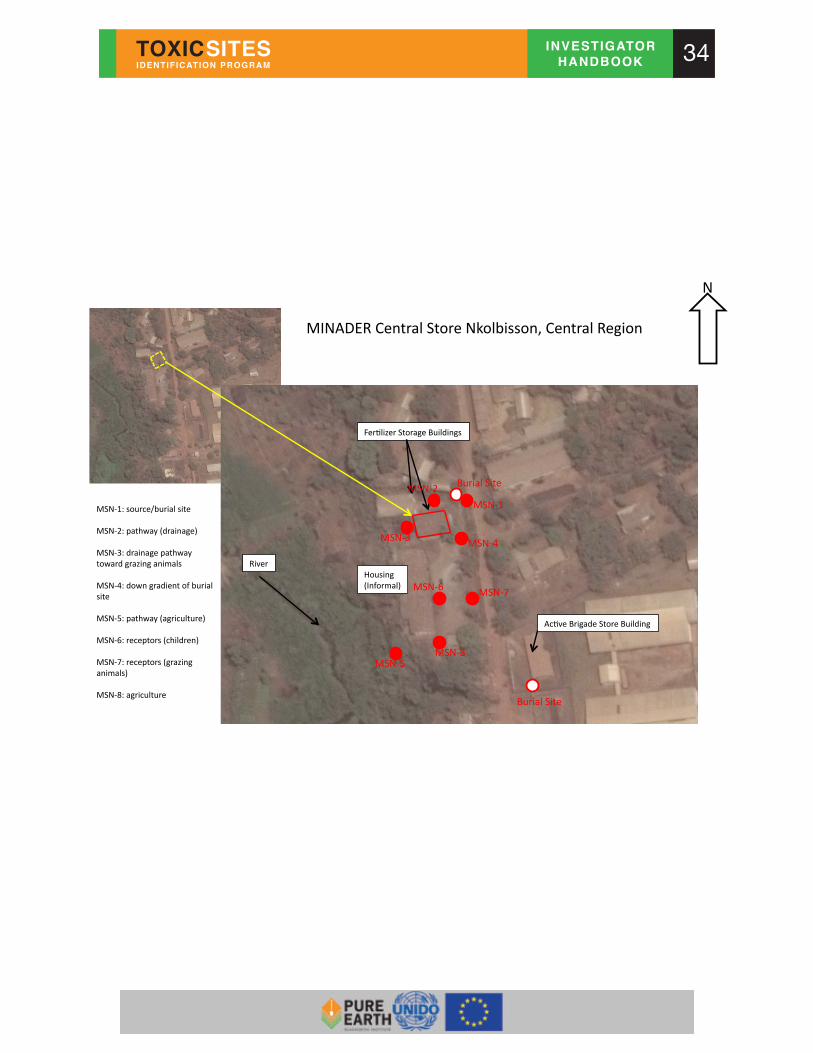
Ac#ve&Brigade&Store&Building&
MSN51:&source/burial&site&
MSN52:&pathway&(drainage)&
MSN53:&drainage&pathway&&toward&grazing&animals&
MSN54:&down&gradient&of&burial&site&
MSN55:&pathway&(agriculture)&
MSN56:&receptors&(children)&
MSN57:&receptors&(grazing&animals)&
MSN58:&agriculture&
MINADER&Central&Store&Nkolbisson,&Central&Region&&
N&
Housing&(Informal)&
Fer#lizer&Storage&Buildings&
Burial&Site&
River&
Burial&Site&
MSN55&MSN58&
MSN56& MSN57&
MSN54&MSN53&
MSN51&
MSN52&

35
Hand-Drawn Map Distances can be ascertained with hand-drawn maps in the field by counting strides. 1 (large) stride equals approximately 1 meter. Maps can then be drawn using a pre-determined scale (i.e. 1 cm = 1 m). A simple key or legend should also be created to show the person reading the map the meaning of each feature.

36
Appendix B – Financial Reports and Payment Investigators receive a daily consultant rate for full days that they have worked, a per diem (food and accommodation payment) for travel days, and reimbursement for site investigation expenses. It is very important for investigators to keep detailed records of the amount of time they work, their travel, and receipts for all related expenses. Investigators will submit a detailed financial report at the end of each month. Investigator Daily Consultant Rate Your daily consultant rate is stated in your contract. The daily rate is payment for a full day of work (8 hours). If you work for half a day on Monday and half a day on Tuesday, that counts as one day on your financial report. Each month you will create a new financial report and enter your daily rate and the number of full and half days you worked during that month. Per Diem for Travel Days Pure Earth will pay a per diem to cover the cost of hotel and food for travel days that require an overnight stay in a hotel. A per diem is not paid for day trips, or days when you are traveling back to your home, only days that end at a hotel. Transportation costs are covered by the per diem. Transportation costs are reported on your monthly financial report and reimbursed at the end of the month. The per diem amount is fixed, and does not change based on the cost of your hotel and meals. If your hotel costs more than your per diem payment, Pure Earth will not pay the extra charge. If your hotel costs less than the per diem payment, you can keep the remaining per diem amount. If you have food expenses from a day that does not end at a hotel, please report that expense on your monthly financial report and include the receipt, just like other travel expenses. Reimbursing Expenses Pure Earth will reimburse most expenses related to site screenings as long as the investigator provides receipts for each expense. Pure Earth will not reimburse expenses without a proper receipt attached to the financial report. Reimbursable expenses may include:
• Travel costs. Pure Earth will reimburse purchases of bus or train tickets, taxi from a train station to the site. If you are going to use your own car, please contact your Regional Director in New York to discuss reimbursement for fuel. If you require an airplane ticket to visit a site, you must ask your New York Regional Director for approval before buying the ticket. Pure Earth will not reimburse the cost of an airplane ticket if the Regional Director in New York did not authorize the purchase.

37
• Equipment. If you think you need a piece of equipment for a site screening, please discuss this with your Regional Director in New York. Pure Earth may be able to send you equipment, and may authorize you to purchase equipment. Review the Sampling Guidelines section to see if you will require sampling equipment for a site screening. All sampling equipment purchases require authorization from your New York Regional Director.
• Food costs during a site screening that does not require a per diem payment (for example, lunch on a day trip that will end at your home).
• Laboratory analysis of samples. Before sending samples to a lab, ask the lab for a price quote for the number of samples that you want analyzed. Review the price quote with you Regional Director in New York. If the Regional Director approves, send the samples for analysis.
• Internet café, photocopying, shipping, etc. Pure Earth will reimburse you for limited administrative costs associated with site screenings. This does not include payment for Internet in your home.
Non-Reimbursable Expenses Pure Earth will not reimburse investigators for:
• Bribes, payment to government employees (except per diems), or payments to individuals for information.
• Hotels. Hotel expenses are covered by your per diem. • Food on a day when a per diem is paid. • Expenses that do not have a proper receipt attached to the financial report. • Purchases over $100 that did not receive prior approval from a Regional Director
in New York. Monthly Financial Report Investigators must submit a financial report for each month that they conduct site screenings. Investigators can download a blank Investigator Monthly Financial Report at http://www.pureearth.org/Pure Earth-institute/coordinator-resources/. It is important to fill in all of the white sections of the report. To receive reimbursement for expenses, investigators must list each expense individually and record:
• The date of the expense, • The cost in local currency, • The receipt number (you will write the same number on the actual receipt), and • A description of the expense (for example: bus ticket from City A to City B)

38
Example of Scanned Receipts

39
Appendix C – Health and Safety Guidelines for investigators Introduction
Investigations must be conducted in a safe manner. This document provides an overview of the health and safety guidelines investigators should follow before, during and after the “initial site screening” (ISS) visits. Before each site screening, investigators must:
• Evaluate potential health and safety hazards; and • Identify appropriate controls and precautions to eliminate or reduce risks; and • Brief other parties coming to the site on general and any specific health and
safety requirements See “Before the site screening visit” below for more information Responsibilities:
Investigators are responsible for their own safety. Investigators must avoid situations where their lives and well-being are endangered. Regional and country coordinators, with the support of the Pure Earth Regional Directors, should ensure that investigators have been informed of general health and safety requirements and will support investigators in obtaining any data or measurements needed to address risks posed by specific site investigations. Before the site screening visit:
1. Perform a risk screening Before conducting a site screening, investigators must identify the potential hazards that they may encounter at the site, including: Type of hazard Examples Notes Chemical hazard - Chemical pollutants present in
the area Review previous studies or publications related the area, identify potential sources, etc.
Physical hazard Radiation Noise - Excessive cold or hot weather - Slips, trips, falls
Take into account the layout and state of the site, particularly any shafts, excavations, buildings etc. Attention should be paid to expected local weather and of other factors such as quality of the access. For radiation hazards see “Radiation safety” below
Biological hazard Bacteria, viruses, parasites - Animal bites
If blood or urine tests will be conducted see “Bio-safety” below (note that Pure Earth staff do not carry out such tests themselves)
40
Once hazards have been identified, the investigator must estimate the likelihood that the expected extent of exposure to the identified hazards will put the investigation team at significant risk. The principal pathways of exposure at contaminated sites are normally ingestion, inhalation, and direct contact but other possible exposures should be considered. Estimating the potential risk should take into account the activities the investigator will carry on during the site investigation and the amount of time that the investigator is planning on staying at the site. Next, the investigator must determine what measures he/she must take to reduce the probability that the exposure to these hazards will cause injury or endanger his/her wellbeing (such as wearing personal protective equipment, etc.). The investigator must communicate these conclusions to all those invited to the visit including government officials. Particular attention should be paid to planning for sites where there is a possibility of radiation exposures. In such cases, a detailed safety plan must be prepared, including the use of appropriate radiation monitoring devices. No investigator should plan to enter a site with possible radiation hazards without specific advice and approval from the Coordinator or Program Director, who will obtain specialist advice as needed. Additionally, the investigator should evaluate any security concerns (such as risks posed by violence, crime, etc.) and take appropriate measurements to address those as well. Reproductive hazards: Women who are pregnant or who are planning on becoming pregnant should evaluate potential contaminants that could be found at a site to specifically determine potential reproductive hazards. If there are potential reproductive hazards, they should discuss with their physician about the potential risks of performing these site evaluations and appropriate ways to address them. 2. Get personal protective equipment (PPE) ready The investigator must have access to essential personal protective equipment and must identify and use the appropriate PPE the during site visits. Basic equipment includes:
• Boots (closed shoes – open toes shoes must not be worn) • Protective clothing such as long sleeve pants and shirt • N-95 Respirator (i.e. basic dusk mask): Dusk mask must be worn whenever
there is potential exposure to hazardous dust. However, masks may not be necessary if there is no reason to believe significant dust exposure risks are present. These respirators should only be used once (they should NOT be cleaned or washed and/or reused)
• Goggles or safety glasses: must be worn whenever there is the presence of particles in the air that may damage the eyes (for example, flying debris or

41
significant amounts of dust) or when there is the risk of splash or splatter of contaminated substances.
• Gloves: if touching or picking up any material that may be contaminated Other PPE may be identified as relevant to a specific site. If the investigator believes that such PPE is required and is not easily available or is expensive, then, she/he should contact the appropriate Coordinator. PPE should be inspected before every site visit and it should be cleaned, repaired or replaced if needed. The site screening visit: 1. Traveling to and from the site:
• Vehicles used to travel to and from the site must comply with local regulations (up to date inspections if required, etc.)
• The number of occupants must not exceed the number of people that can be seated.
• Seat belts, if available, must be used by those riding in the front of the vehicle or in all seats if required by local regulations
• Drivers must adhere to speed limits, signs and all other traffic norms • Vehicles must never be driven by anyone under the influence of alcohol.
2. During the site screening: During the site screening, the investigator must:
• Wear appropriate PPE (see above). • Wash hands before eating anything (even if gloves are worn during the
screening) • Must NOT - under ANY circumstance - enter confined areas. These are areas
large enough for a person to enter but with limited ventilation and/or limited or restricted means of entry or exit (for example wells, tanks, pits, vessels, sewer systems, pipelines, etc.)
• Be cautious in areas that may be slippery due to water, mud, steep slopes, etc. • Be cautious if using ladders or stairways that may be unsafe • Be cautious in exposed elevated areas • Be aware that hazardous material and toxic contamination may look innocuous
–take precautions anyway. Do not assume that because people (e.g. local community members) are living in the area without any protection or without presenting any obvious adverse health symptoms that there is no hazard.

42
Bio-safety Biological agents such as bacteria, viruses, parasites can be present in human and animal fluids and waste such as blood, feces and urine. Touching or any contact with human and animal fluids and waste, or dead animals, should be avoided during investigations. Collection of human fluid samples, such as urine or blood samples, should only be done by persons with specific responsibility and training for such sample collection, and must be done following protective protocols. Pure Earth investigators do NOT take human samples but may be present when authorized persons (normally local medical staff) do so. Good practice in such situations includes:
• Wearing disposable gloves and safety glasses at all times • Good handling and disposal practices for needles, vials, tubes or other materials
used in the sampling process • Protective clothes, such as a lab coat or uniform must be worn during sample
collection, and should be removed before entering in contact with other people, especially children and pregnant women
Radiation Safety Ionizing radiation is composed of particles with enough energy to produce tissue damage. These can be found in wastes from uranium and other similar processing facilities, and in defunct nuclear weapons production or storage facilities, among others. If investigations are going to be carried out in or near sources where radiation may be present, a detailed safety plan must be designed by the investigator with the support and approval of the country and regional coordinators and the program director. After the site screening: After the site visit the investigator must:
• Wash hands and face before eating anything • Change from working clothes and shoes. Take showers before entering into
close contact with other people, particularly pregnant women and/or children. • Clean shoes to remove any mud or soil on them, wearing gloves during the
cleaning and making sure that the removed soil is collected and disposed of properly or is left at the site. Soiled material or scraping from shoes must not be left on floors, in cars or around door entrances or other places where people gather
• Wash clothing before wearing again • If any safety related incidents occurred during the visit, these must be
communicated to the Country and Regional Coordinators and Program Director. • If there are any lessons learned during the visit that can be shared with other
investigators to prevent future incidents, these also should be communicated to

43
the program director for the region so that they can be shared with other investigators.
Further health and safety information can be found at: US Center for Disease Control and Prevention – Workplace safety and health topics (http://www.cdc.gov/niosh/topics/chemical.html). US Occupational Safety and Health Administration (OSHA)– Health and safety topics (http://www.osha.gov/SLTC/). Further information on toxic pollutants can be found at: Agency for Toxic Substances and Disease Registry – Case studies in Environmental Medicine (http://www.atsdr.cdc.gov/csem/csem.html).

44
Appendix D - Pollutant Information
Lead, Pb Description of Pollutant Lead is a bluish-gray metal that occurs naturally in the earth’s crust. It has been used by humans for hundreds of years to produce pipes, and was widely used as a gasoline additive until the 1980’s, when a worldwide movement began to ban its usage in fuel Common Sources
• Mining and smelting operations. • Fossil fuel combustion from industries and vehicles • Industrial sources like battery production and recycling facilities, gun and
ammunition factories, metal disposal and recycling facilities and electrical components manufacture
• Domestic sources like flaking lead-based paint and water supply pipes Human Exposure Pathways
• Exposure to lead occurs mainly via inhalation or ingestion of lead dust. Lead can also be absorbed through the skin if present in dust or soil to which people come into routine contact
• In areas near lead contamination sources, ingestion of contaminated dust or soil is often the pathway of most concern. Food on the ground or exposed to lead dust may become contaminated and then eaten, children may eat with contaminated hands after playing in contaminated areas, and dust may be caught in nose, throat and lung tissue and subsequently be coughed up and swallowed. In general, if adults and children swallow the same amount of lead, a bigger proportion of the amount swallowed will enter the blood in children than in adults. Children absorb about 50% of ingested lead
• Humans can be exposed to lead through drinking water where contamination has occurred by the corrosion of old lead pipes
• Drinking water may be of concern where soluble forms of lead are present in surface or groundwater used as a water supply. Note that lead solubility varies depending on the chemical form, with lead oxide and lead sulfate being highly insoluble (and therefore less of a risk from drinking water) while organic lead compounds are often quite soluble
Human Health Effects
• Neurological disorders such as lead encephalopathy • According to the WHO, children with blood lead concentrations of between 12
micrograms per deciliter (μg/dL) and 120μg/dL can suffer from lower IQ, shorter

45
attention span, reading or learning disabilities, hyperactivity, impaired physical growth, hearing and visual problems or impaired motor skills
• At blood concentrations above 70μg/dL, risk of encephalopathy is high and treatment is required
• At blood concentrations of 70μg/dL in adults, symptoms are difficult to detect, but may include increased fatigue, short term memory loss or lack of coordination. At levels of 150 μg/dL acute poisoning, which can cause adult encephalopathy can occur and can ultimately lead to brain damage
• Acute symptoms from high levels of exposure include stomachache, irritation of the colon, kidney malfunction, blood anemia and eventually brain damage.
• Unborn children can be exposed to lead through their mothers. Harmful effects include premature births, smaller babies, decreased mental ability in the infant, learning difficulties, and reduced growth in children
• In pregnant women, high levels of exposure to lead may cause miscarriage. High-level exposure in men can damage the organs responsible for sperm production

46
Mercury, Hg Description of Pollutant Mercury occurs naturally in the environment and exists in several forms that can be broadly categorized into metallic mercury (elemental mercury), organic (bound with carbon), and inorganic mercury (not bound with carbon). Inorganic mercury compounds occur when mercury combines with elements such as chlorine, sulfur, or oxygen. It is a dense, silvery white, shiny metal, which is liquid at room temperature in its elemental form. The most common organic form of mercury, methyl mercury, is of particular concern as it can accumulate in fish and thus get transferred through the food chain. Mercury is widespread and persistent in the environment. Common Sources
• Burning of fossil fuels (particularly coal-fired utilities) - the major source of mercury emissions to the atmosphere;
• Any facility using mercury in its process is a potential source of mercury emission;
• Smelting processes • Fungicides with inorganic mercury compounds • Measuring and control equipment (thermometers, medical equipment) • Copper and silver amalgams in tooth filling materials • Mercury-containing products such as batteries and electric lamps in municipal
and hazardous waste dumps, which may leach out from landfills • Medical waste incinerators • Atmospheric deposition from chlor-alkali plants, metal processing, and mining of
gold and mercury • Volcanoes, geologic deposits of mercury, and volatilization from the ocean, as
sources of atmospheric mercury • Local mineral occurrences and thermal springs can be naturally high in mercury • Bioaccumulation in fish, which can expose individuals with a high fish diet to
high levels of mercury Human Exposure Pathways
• The general population is commonly exposed to mercury primarily by consuming mercury-contaminated fish. There is about 95% absorption in the gastrointestinal tract of methylmercury and generally less than 10% absorption in the case of inorganic mercury.
• Common exposure also occurs via the release of elemental mercury from dental amalgams used in fillings
• Humans can be exposed to metallic mercury vapor in the atmosphere, which can be very dangerous when inhaled.

47
• Additional exposure may occur occupationally and in heavily polluted areas or in areas where mercury-containing fungicides are used extensively.
• Elemental mercury can also be absorbed through the skin Human Health Effects
• In general, mercury affects the immune system, alters genetic and enzyme systems, and damages the nervous system, including coordination and the senses of touch, taste, and sight. But the specific health effects of mercury and its compounds depend on its chemical form owing to differences in toxicokinetics.
Methylmercury
• Exposure to very small amounts of methyl mercury can result in devastating neurological damage or death
• Can also cause permanent damage to the brain and kidneys. • Symptoms of acute mercury poisoning include cough, chest tightness, trouble
with breathing, and an upset stomach. Pneumonia can develop, which can be fatal
• Mental retardation, blindness, and cerebral palsy have been observed in children born to women having high levels of methyl mercury exposure. Exposure could have a negative impact on their neurological development resulting in psychological abnormalities like deficits in short-term memory, irritability, and social withdrawal
Inorganic Mercury
• Ingestion of inorganic mercury compounds can cause renal and gastrointestinal toxicity
• Swallowing inorganic mercury compounds results in nausea, vomiting, diarrhea, and severe kidney damage
Elemental Mercury
• Inhalation of vapors of elemental mercury, the form released from broken thermometers, over long periods of time causes tremors, gingivitis, and excitability

48
Chromium, Cr Description of Pollutant Chromium is a steel-gray, naturally occurring element found as ore in natural deposits. It is commonly used in metal alloys like stainless steel, plumbing coatings, magnetic tapes, and pigments for paints, cement, paper, and rubber. It also finds application in wood preservatives. Although it is found widely in plants and soils, it is rare in natural waters. The most hazardous form of chromium is hexavalent chromium (Cr VI). Trivalent chromium (Cr III) is non-toxic. However, in certain circumstances, trivalent chromium can covert to hexavalent chromium. Common Sources
• Tanneries • Dye manufacturers • Chemical manufacturing industry or hazardous waste facility • Combustion of natural gas, coal, and oil • Metallurgical facilities, electroplating • Small amounts of chromium are found in fruits, nuts, vegetables, grains, and
cereals • Implants like cobalt-chromium knee and hip arthroplasts • Contaminated landfills • Cement dust
Human Exposure Pathways
• People can be exposed to chromium by eating food, drinking water, or breathing air that is contaminated
• In air, chromium compounds are present mostly as fine dust particles that eventually settle over land and water
• Cigarettes contain 0.24 to 14.6 milligrams (mg) chromium per kilogram (kg). Thus cigarette smoking might constitute a significant source of chromium intake
• Skin contact with chromium-contaminated dust, dirt, and puddles Human Health Effects
• Hexavalent chromium, the most hazardous form, can cause cancer. It has been shown to cause tumors in the stomach, intestinal tract, and lungs
• Hexavalent chromium can also cause damage to the male reproductive system. • Chromic acid or chromate dusts can cause permanent eye damage • Short-term exposure causes skin irritation and ulceration • Chronic health effects include damage to liver, kidney, circulatory and nerve
tissues, and skin irritation • Can cause allergic reactions, such as skin rash. Breathing it can cause nose
irritations and nosebleeds.

49
• Inhalation of hexavalent chromium compounds can result in ulceration, asthmatic bronchitis, edema, cough, shortness of breath, and wheezing.
• Other health effects include: upset stomach and ulcers, respiratory problems, weakened immune systems, and alteration of genetic material.

50
Cadmium, Cd Description of Pollutant Cadmium is a soft, silver-white metal that occurs naturally in the environment. It is usually found as a mineral combined with other elements and is extracted during the production of metals like zinc, lead, and copper. It finds application in the manufacture of batteries, pigments, metal coatings, and plastics, as it does not corrode easily. Common Sources
• Release of cadmium compounds from copper, lead, and zinc smelters and municipal incinerators;
• Natural release into the environment (~25,000 tons a year); • Application of phosphate fertilizers or sewage sludge to soils; • Tobacco leaves can accumulate high levels of cadmium from the soil; and • Smelting and electroplating.
Human Exposure Pathways
• Human uptake of cadmium takes place mainly through food. Liver, mushrooms, shellfish, mussels, cocoa powder, dried seaweed, oysters, shrimp, lobster, and fish are potential sources. Cadmium also tends to bio-accumulate in aquatic life. Additionally, leafy vegetables such as lettuce and spinach can contain high levels of cadmium.
• Smoking exposes people to significant amounts of cadmium. Tobacco smoke transports cadmium into the lungs.
• People who live near hazardous waste sites or factories that release cadmium into the air and people who work in the metal refinery industry are significantly exposed to cadmium via inhalation of dust or fumes.
Human Health Effects
• Damage to kidneys and lungs • Diarrhea, stomach pains and severe vomiting • Debilitating effects on bones and the skeletal structure • Reproductive failure and possibly even infertility • Damage to the central nervous system • Damage to the immune system • Psychological disorders • Possibly DNA damage or cancer development • Lung cancer is one potential result of chronic inhalation of fine-particle cadmium
compounds, particularly cadmium oxide, which readily dissolves in the body

51
Arsenic, As Description of Pollutant Arsenic is a naturally occurring, brittle, steel gray semi-metallic solid. Arsenic and its compounds are highly toxic. It finds application in the manufacture of insecticides, pesticides and various alloys. It is also used for bronzing and as a wood preservative. Common Sources
• Human activities like mining, smelting and agricultural applications • Release from pesticides and wood preservatives • Natural sources, such as volcanic activity, the erosion of rocks and minerals,
and forest fires Human Exposure Pathways
• Arsenic exposure occurs by ingestion, inhalation of dust, and, to a much lesser degree, by absorption through the skin
• Accidental poisoning has been reported to occur from wearing inadequate clothing when applying arsenic-based products
• Arsenic exposure in the workplace occurs through inhalation, ingestion, or dermal or eye contact
• Most arsenic compounds are white or colorless powders that do not evaporate. They have no smell, and most have no special taste. Thus, you usually cannot tell if arsenic is present in your food, water, or air
Human Health Effects
• Arsenic in drinking water causes bladder, lung and skin cancer, and may cause kidney and liver cancer. Studies have also found that arsenic harms the central and peripheral nervous systems, as well as heart and blood vessels, and causes serious skin problems. It also may cause birth defects and reproductive problems
• Arsenic can be carcinogenic at very low levels and one-tenth of a gram accumulated over a two-month period can be fatal
• Symptoms of mild poisoning include loss of appetite, nausea, diarrhea, stomachache, and vomiting
• Severe exposure causes cramps, vomiting, neurological effects like restlessness, chronic headache, fainting, dizziness, convulsions or coma.
• Acute exposures can cause lung distress and death • Chronic exposure to arsenic (known as arsenicosis) can lead to dermatitis,
pigmentation of the skin, wart formation, hard patches on ones palms or soles of their feet, decreased nerve conduction velocity, and lung cancer

52
Radiation Description of Pollutant Radiation refers to the ionizing energy released from naturally occurring radioactive compounds in the environment. These compounds are usually referred to as radionuclides. Over 2,000 radionuclides exist on the earth, most of them naturally occurring (USEPA). The most common pollutants among radionuclides are Cs-137, Ss-90, U-238, Ra-226, Th-230, and Pb-210. They are unstable in the environment and are constantly decaying - a process that causes them to release radiation. Since each compound releases different types (alpha, beta and gamma radiation) and intensities of radiation, using mass per unit weight (ppm) does not allow for comparisons on toxicity. Therefore we use radiation instead of parts per million. The type of radiation that is emitted (alpha, beta or gamma) is what determines whether or not the radionuclide poses a risk. Beta and gamma can penetrate the body and cause damage to the cells, whereas alpha is harmful when released from inside the body after being inhaled or ingested. You cannot see or feel radiation. You will need an instrument that measures energy, namely a radiation dosimeter when exploring a radionuclide site. The normal level of radiation usually doesn’t exceed 0.50 microsieverts per hour. Pay attention to the site if you find places where radiation exceeds the normal value by 2-3 times. If you see high levels of radiation, record the levels and move away from the area. Do not spend extended periods of time near radiation hotspots. Common Sources
• Mining of uranium • Nuclear power production • Nuclear weapons manufacturing and test sites; • Spent nuclear fuel • Erosion of natural deposits of certain minerals that are radioactive; • Decay of natural and man-made deposits of radioactive minerals
Human Exposure Pathways Airborne dust can be inhaled
• Once in soil, it can be absorbed into water used for drinking. • Walking on contaminated soil directly exposes humans to radiation. • Medical tests and treatments • Another pathway can be through food that has been contaminated with
radiation like milk (if cow feeds on contaminated vegetation) and fish (found in contaminated waters)

53
Human Health Effects • Cancer is the major effect of concern from the long-term exposure to radiation. • Short-term exposure to high levels of radiation can cause acute radiation
poisoning, symptoms of which include radiation burns, nausea, fatigue, vomiting and hair loss. Other effects include diarrhea, hemorrhage, internal bleeding, and death in cases of severe exposure
• Internal exposure to plutonium may cause damage to the kidneys • Chronic (long-term) inhalation exposure to uranium and radon in humans has
been linked to respiratory effects, such as chronic lung disease, while radium exposure has resulted in acute leukopenia, anemia, and necrosis of the jaw.
• Radium, via oral exposure, is known to cause bone, head, and nasal passage tumors in humans. Radon, via inhalation exposure, causes lung cancer in humans. Uranium may cause lung cancer and tumors of the lymphatic and hematopoietic tissues
• Internal exposure to strontium-90 is linked to bone cancer, cancer of the soft tissue near the bone, and leukemia
• More information on the health effects from radionuclides can be found at: http://www.epa.gov/ttnatw01/hlthef/radionuc.html.

54
Asbestos Description of Pollutant Asbestos is a mineral fiber resistant to heat and corrosive chemicals that was commonly used for insulation and as a fire retardant. Widespread application occurred in the construction industry prior to the 1970s, but it was widely used up through the 1980s or later in many parts of the world. Typically, asbestos appears as a whitish, fibrous material that may release fibers that can be dangerous if inhaled. Sources
• Deteriorating, damaged, or disturbed insulation; • Fireproofing and/or acoustical materials; • Ceiling and floor tiles; • Erosion of asbestos-bearing rocks; • Asbestos-related industries; • Clutches and brakes on vehicles; and • Corrosion from asbestos-cement pipes
Human Exposure Pathways
• We are all exposed to low levels of asbestos in the air we breathe. • People working in industries that make or use asbestos products (shipbuilding,
mining, milling, and fabricating) are exposed to high levels of asbestos. • People living near these industries may also be exposed to high levels of
asbestos in air • Most fibers are removed from your lungs by being carried away or coughed up
in a layer of mucus to the throat, where they are swallowed into the stomach. This usually takes place within a few hours. Fibers that are deposited in the deepest parts of the lung are removed more slowly
• Drinking water may contain asbestos from natural sources or from asbestos containing cement pipes
Human Health Effects
• Lung cancer • Mesothelioma (cancer of chest and abdominal lining) • Asbestosis (irreversible lung scarring that can be fatal) • Asbestos exposure via inhalation causes pulmonary hypertension and
immunological effects

55
Cyanide Description of Pollutant Cyanide is a carbon-nitrogen chemical unit that is a rapidly acting, potentially deadly chemical that can exist in various forms. Cyanide is manmade but also occurs naturally in the environment. Very small amounts of cyanide are essential in the human diet in the form of Vitamin B12. The most common cyanide compounds are hydrogen cyanide, sodium cyanide, and potassium cyanide. Common Sources
• Smoke inhalation from residential or industrial fires • Vehicle exhaust • Emissions from chemical processing industries, metallurgical industries,
metal plating and finishing industries, and petroleum refineries • Waste incinerators • Use of cyanide-containing pesticides • Burning of certain types of plastics, silk, wool, and paper; • Discharges from publicly owned wastewater treatment works, iron and
steel production plants, and organic chemical industries • Cyanide wastes in landfills • Use of cyanide-containing road salts • Cyanide gas used to exterminate pests and vermin in ships and buildings.
Human Exposure Pathways
• Cyanides are readily absorbed by the inhalation, oral, and dermal routes of exposure. Cyanide in water, however, does not build up in fish tissue
Human Health Effects
• Skin contact with dust from certain cyanide compounds can cause skin irritation and ulcerations
• Inhalation exposure to cyanide causes rapid effects. Exposure of humans at a level of 110 ppm can cause death within 30 minutes to 1 hour
• Occupational exposure to lower concentrations causes breathing difficulties, nervousness, vertigo, headache, nausea, vomiting, precordial pain, and electrocardiogram (EKG) abnormalities
• Exposure to higher concentrations results in convulsions, low blood pressure, slow heart rate, loss of consciousness, lung injury and respiratory failure leading to death
• Neurotoxicity has been observed following their ingestion and inhalation • Effects on the nervous system believed to be from long-term exposure
include deafness, vision problems, and loss of muscle coordination. Effects on the thyroid gland can cause cretinism (retarded physical and mental growth in children), or enlargement and over activity of the gland
• Survivors of serious cyanide poisoning may have heart and brain damage.

56
Dioxin (2,3,7,8-TCDD) Description of Pollutant 2,3,7,8-Tetrachlorodibenzo-p-dioxin (2,3,7,8-TCDD) is formed as an unintentional by-product of incomplete combustion. It is often the most prevalent dioxin, and also the most toxic dioxin. It is typically released into the environment during the combustion of fossil fuels and wood, and during the incineration of municipal and industrial wastes. The most common health effect associated with 2,3,7,8-TCDD in humans is chloracne, a severe acne-like condition. It is known to be a developmental toxicant in animals, causing skeletal deformities, kidney defects, and weakened immune responses in the offspring of animals. Human studies have shown an association between 2,3,7,8-TCDD and soft-tissue sarcomas, lymphomas, and stomach carcinomas. EPA has classified 2,3,7,8- TCDD as a probable human carcinogen (Group B2). Sources
• Formation through chlorine bleaching process used by pulp and paper mills • Formation (as a byproduct) from the manufacture of certain chlorinated organic
chemicals, such as chlorinated phenols • Natural processes, such as forest fires and volcanoes • Byproducts of smelting, chlorine bleaching of paper pulp
Human Exposure Pathways
• Over 95% of the human intake of dioxins is through food, mainly from meat, dairy products, and fish
• Very low levels of 2,3,7,8-TCDD are found throughout the environment, including air, food, and soil
Human Health Effects
• Short-term exposure of humans to high levels of 2,3,7,8-TCDD may result in skin lesions, such as chloracne and patchy darkening of the skin, and altered liver function. (Chloracne is also the major effect seen from chronic exposure
• Long-term exposure is linked to impairment of the immune system, the developing nervous system, the endocrine system and reproductive functions
• Human studies, primarily of workers occupationally exposed to 2,3,7,8-TCDD by inhalation, have found an association between 2,3,7,8-TCDD and lung cancer, soft-tissue sarcomas, lymphomas, and stomach carcinomas, although for malignant lymphomas, the increase in risk is not consistent
• More information on health effects from exposure to dioxins can be found at: http://www.epa.gov/ttnatw01/hlthef/dioxin.html

57
Fluorides Description of Pollutant Fluorides are chemical compounds that occur naturally in air, water, soil and most foods. They are properly defined as binary compounds, or salts of fluorine and another element. Examples of fluorides include sodium fluoride and calcium fluoride. Sources
• Coal combustion; • Waste from steel manufacture, primary aluminum, copper and nickel production,
phosphate ore processing, phosphate fertilizer production and use, glass, brick and ceramic manufacturing, and glue and adhesive production;
• Pesticides and controlled fluoridation of drinking-water supplies; • Phosphate ore production and aluminum manufacture are the major industrial
sources of fluoride release into the environment; and • Natural sources, such as weathering and dissolution of minerals, volcanic
emissions and marine aerosols Human Exposure Pathways
• For adults, the consumption of foodstuffs and drinking water is the principal route for the intake of fluoride.
• In areas of the world in which coal rich in fluoride is used for heating and food preparation, the inhalation of indoor air and consumption of foodstuffs containing increased levels of fluoride also contribute to elevated intakes.
• Infants fed formula receive 50–100 times more fluoride than exclusively breast-fed infants.
• Swallowing toothpaste and other dental products can account for a large percentage of the fluoride to which a small child might be exposed.
• Occupational exposure to fluoride via inhalation or dermal contact likely occurs in individuals involved in the operation of welding equipment or in the processing of aluminum, iron ore or phosphate ore.
Human Health Effects
• Increased incidence of lung & bladder cancer; increased mortality due to cancer • Skeletal fluorosis • Eating large amounts at one time can cause stomachaches, vomiting, and
diarrhea. Extremely large amounts can cause death by affecting your heart • Dental fluorosis develops only while the teeth are forming in the jaw and before
they erupt into the mouth (age <8 years) • Several human studies found an increase in birth defects or lower IQ scores in
children living in areas with very high levels of fluoride in the drinking water • Fluorine and hydrogen fluoride are very irritating to the skin, eyes, and
respiratory tract.

58
PAHs (Polycyclic Aromatic Hydrocarbons) Description of Pollutant Polycyclic aromatic hydrocarbons (PAHs) are hydrocarbon compounds with multiple benzene rings. PAHs are typical components of asphalts, fuels, oils, and greases and a few are used in medicines or to make dyes, plastics, and pesticides. They are also called Polynuclear Aromatic Hydrocarbons. Although hundreds of PAHs exist, two of the more common ones are benzo(a)pyrene and naphthalene Sources
• Incomplete burning of coal, oil and gas, and garbage • Forest fires and volcanoes • Tobacco smoke, smoke from wood burning stoves and fireplaces, creosote-
treated wood products and some food • Barbecuing, smoking or charring food • Roasted coffee, roasted peanuts, refined vegetable oil, grains vegetables and
fruits (low levels) • Cosmetics and shampoos made with coal tar and therefore may contain PAHs; • Mothballs (specifically a source for the PAH compound naphthalene) • Discharges from industrial and wastewater treatment plants
Human Exposure Pathways
• Exposure to polycyclic aromatic hydrocarbons usually occurs by breathing air contaminated by wild fires or coal tar
• PAHs are more likely to be concentrated in plants and animals thank in soil or water, mainly because PAHs do not dissolve in water
• Exposure to soils contaminated with PAHs may occur as well as PAHs tend to slightly stick to particles.
• Eating foods that have been grilled • PAH can be absorbed through the skin. Exposure can come from handling
contaminated soil or bathing in contaminated water. Low levels of these chemicals may be absorbed when a person uses medicated skin cream or shampoo containing PAHs
Human Health Effects
• Short-term exposure may cause red blood cell damage leading to anemia and consequently a suppressed immune system
• Long-term exposure is believed to cause developmental and reproductive effects and cancer
• Other long-term health effects caused by exposure to PAHs may include cataracts, kidney and liver damage and jaundice.

59
• Dermal contact can result in skin redness and irritation • The Department of Health and Human Services in the USA has determined that
some PAHs may reasonably be expected to be carcinogens. • Some people who have breathed or touched mixtures of PAHs for long periods
of time have developed cancer

60
Pesticides Description of Pollutant Pesticides are used in the agricultural industry to protect food from pests, such as insects, rodents, weeds, mold, and bacteria. The term pesticide also applies to herbicides, fungicides and so forth. Pesticides are often referred to according to the type of pest they control or grouped by chemical types of pesticides. These include organophosphate, carbamate, organochlorine and pyrethroid pesticides. Pesticide contamination typically results from pesticide projection facilities, pesticide application on agricultural fields, and abandoned storage facilities or dumpsites for obsolete pesticides. Because pesticides are widely used in agricultural practices, most people are exposed to low levels of pesticide residues through their diets. Sources
• Runoff from agricultural fields • Illegal dumping or inadequate storage • Waste from pesticide production facilities
Human Exposure Pathways
• People can be exposed to pesticides and insecticides by eating food on which it has been applied or by drinking water from sources contaminated by pesticides
• Children maybe exposed to pesticide residues from their agriculture-worker parents through dust and soil
Human Health Effects
• Children, infants, and fetuses may be especially vulnerable to the health effects of pesticides. Children may be more susceptible to loss of brain function if exposed to neurotoxins, and may be more susceptible to damage to their reproductive systems. Increased odds of childhood leukemia, brain cancer and soft tissue sarcoma have been associated with children living in households where pesticides are used. Other childhood malignancies associated with pesticide exposures include neuroblastoma, Wilms’ tumor, Ewing’s sarcoma, non-Hodgkin’s lymphoma, and cancers of the brain, colorectum, and testes.
• Pesticides are intentionally toxic substances. Some chemicals commonly used on lawns and gardens have been associated with birth defects, mutations, adverse reproductive effects, and cancer in laboratory animals.
• Toxicology and Industrial Health published a study showing that the natural mix of chemical pesticides and fertilizers – in concentrations mirroring levels found in groundwater – can significantly affect immune and endocrine systems as well as neurological health.
• The Canadian Institute for Child Health has found that children are increasingly at risk of serious diseases from pesticides. The study said cancer rates in children grew 25 percent since 1975.

61
• Results from Agricultural Health Study showed that farm families with ongoing exposure to pesticides have increased headaches, fatigue, insomnia, dizziness, hand tremors, and other neurological symptoms.

62
Polychlorinated biphenyls (PCBs) Description of Pollutant PCBs or polychlorinated biphenyls are manmade industrial chemicals. They have been used in many different types of products including hydraulic fluid, casting wax, pigments, carbonless copy paper, vacuum pumps, compressors, heat transfer systems, and electrical equipment. Because of their fire resistance and insulating properties they were the fluid of choice for transformers and capacitors. PCBs are resistant to degradation and therefore persist for many years in the environment. They bioaccumulate in the food chain and are stored in the body fat of animals and humans. PCBs were banned from use in the U.S. in the early 70's, however they are still found in the environment due to their widespread use and resistance to degradation. PCB’s are highly persistent in the environment and bind strongly to soils, organic particles, and bottom sediments. PCB’s accumulate in fish and marine mammals and can be magnified several thousand times above background levels. Sources
• Manufacture, use, or by the careless disposal of materials and obsolete equipment
• Accidental leakage and spills during transport or from fires and leaks in products containing PCBs
• Leaching in hazardous waste disposal sites and landfills • Illegally dumped industrial wastes
Human Exposure Pathways
• A major route of human PCB exposure is through eating PCB-contaminated fish • Inhalation is a more direct exposure route to certain sensitive tissues (such as
the nasal passages) and the blood stream • Several occupational health studies have detected PCB health effects primarily
through inhalation of PCB vapors • PCBs can be rapidly absorbed through the skin. Experts with the National
Institute of Health speculate that, due to the transport of PCBs on dust particles, the current primary route of exposure of most people (non-fish-consumers) to PCBs is through skin exposure
• Occupational studies show that skin absorption of PCBs is generally the route of entry into the bodies of exposed workers
• PCBs are known to be passed from the mother to the fetus through placental blood, and to the baby via breast milk
Health Effects
• Skin ailments called chloracne • Reproductive disorders

63
• Nervous system damage, such as Parkinson’s, mood disorders, memory problems, etc.
• Liver damage - jaundice, nausea, weight loss, edema, abdominal pain from internal poisoning
• Rice Oil Disease in Japan (2000 ppm) caused eye discharge, acne, uterine ulcer, excess pigmentation, miscarriage, stillbirth, and abnormal pigmentation on infants
• Chronic PCB toxicities can result in liver damage in mammals, damaged pericardia, kidneys, spleen and liver and shell thinning in birds
• Progressive weight loss, bone marrow depression, abdominal pain, numbness of limbs, swelling of joints, chronic cough, menstrual irregularity, abnormal tooth development, low birth weight, hyperpigmentation, fatigue and headache Elevations in blood pressure, serum triglyceride, and serum cholesterol have also been reported with increasing serum levels of PCBs in humans
• Women who are exposed to relatively high levels of PCBs through the workplace or through ingestion tend to have babies weighing slightly less than women who were not exposed
• Newborns exposed to PCBs in-utero have shown behavior problems such as slow motor skills and decrease in short-term memory lasting several years.
• PCB's are a known animal carcinogen. The EPA and the International Agency for Research on Cancer (IARC) have determined that PCBs are probably carcinogenic to humans

64
Volatile Organic Compounds (VOCs) Description of Pollutant VOCs are carbon-based compounds that easily evaporate into the atmosphere. VOCs typically are industrial solvents, such as trichloroethylene; fuel oxygenates, such as Methyl Tertiary Butyl Ether (MTBE); or by-products of chlorination in water treatment, such as chloroform. VOCs are often components of petroleum fuels, hydraulic fluids, paint thinners, and dry cleaning agents and are common ground-water contaminants. Concentrations of VOCs are generally higher indoors than outdoors and emitted from a wide array of products including paints and lacquers, paint strippers, cleaning supplies, pesticides, building materials, office equipment and so forth. Sources
• Emissions from paints, varnishes, moth balls, solvents, gasoline and newspapers
• Exhaust fumes, cigarette smoke, synthetic materials and household chemicals; • Chemical plants, cement manufacturers, steel mills, power plants, surface
coating operations, and printing operations • Construction and industrial machinery, farm equipment, railroads, lawn and
garden equipment, boats, and aircrafts Human Exposure Pathways
• Inhalation of VOCs from new carpeting, adhesives, draperies; wood products that use certain glues, finishes, and waxes in the manufacturing process; and vinyl type flooring and wall coverings
• VOCs may enter the water supply through agricultural or industrial run-off. • Dermal contact is another exposure pathway
Human Health Effects
• Acute health effects are eye, nose and throat irritation, headaches, nausea, vomiting, dizziness and asthma exacerbation
• Chronic effects are cancer, liver, kidney and central nervous system damage. • It could be irritating to the skin upon contact • Some VOCs are suspected or known to cause cancer in humans

65
Appendix E – Using an XRF and Exporting Data NOTE: Be sure to charge both XRF batteries AND the iPAQ before taking the XRF into the field to do analysis. When not using the XRF, turn it off, disconnect the iPAQ, and make sure the iPAQ is also turned off. Using the XRF to analyze soil:
1. Before using the XRF, you must receive training in the safe operation of the equipment. Using the XRF incorrectly can be dangerous, and proper safety precautions are required.
2. Place a battery in the XRF unit by releasing the rubber guard at the front of the base of the handle.
3. Place the iPAQ into the XRF unit by first placing the top of the iPAQ into the slot near the “Innov-X-Systems” logo.
4. Push the iPAQ up to slide the plastic with “Innov-X-Systems” logo forward. This creates a space to drop the bottom of the iPAQ into the cradle where is connects to the XRF unit. Slide the iPAQ down to connect the two devises.
5. Turn on iPAQ by pushing the button on the top right, and turn on the XRF by pushing the power button on the back of the machine (the part facing you).
6. You may want to change the date and time in the iPAQ to reflect your current location, date and time.
7. Click the Windows button in the top left of the iPAQ screen. 8. Select InnovX. 9. When you see the radiation notice, click “start”. 10. Select “soil”. 11. The analyzer will undergo a 60 second hardware initialization. Wait. 12. When you see the sign reading “standardization required…” place the
metal clip from the XRF case over the front (analyzer end) of the XRF and click the message on the screen.
13. When the standardization is complete, click “ok”. 14. Remove the metal clip and place it back in the case. DO NOT LOSE THE
CLIP. If you lose the clip, go to a metal shop and get #316 stainless steel and use that to standardize.
15. You are now ready to analyze soils. 16. Test the Pb standard to verify instrument performance. 17. To begin analyzing, hold the trigger down for the desired duration (10
seconds or more) or until the XRF automatically stops the analysis (you will hear a click)

66
18. All data is saved automatically, BUT when collecting XRF data, always record the sample number, the sample number on the XRF, the latitude, longitude, contamination level, and any comments on paper in addition to storing that information in the XRF and GPS devices.
19. To begin a second analysis, simply pull and hold the trigger again. 20. Before turning the iPAQ and XRF off, back out of all programs in the
iPAQ. Trouble Shooting:
1. Low PDA power causes problems. Even when it’s 50% full, recharge the PDA and try again.
2. A soft reset (using a paper clip) often fixes problems. 3. Do a hard reset if that fails. 4. This machine does not like high temperatures. Cool the machine then
restart. Shut it off if traveling to distant sites. 5. Sometimes the SD card is corrupted. Remove it and try it again with no
card in slot. 6. RELOAD the XRF software - take out CF card and install new software
from website (contact Pure Earth staff). Exporting XRF data using Bluetooth:
1. Before exporting data from the iPAQ, you first must export the data from the Innov-x software to the iPAQ.
2. Go the screen that lists the choices “Analytical, Soil, Process Analytical” (to find this screen, select “file” and “exit” until you reach this home screen.
3. Select the “view” option at the bottom, and then select “results”. 4. Select “file” at the bottom, and then “export results”. 5. Select the dates of the reading you want to export. 6. Select the analytical mode you want to export (probably “soil”). 7. Click “ok”. 8. Name your results folder or use the default name. 9. Go down to “location” and select “main memory”. 10. Then go up to “folder” and select “Innovx”. 11. Click “save” and then “ok”. 12. Now your file of results is in the “main memory” of the iPAQ in the InnovX
folder. 13. To connect the iPAQ to a computer using Bluetooth, back out of the
Innov-X software by clicking “file” and “exit” until you are at the iPAQ home screen.

67
14. Click the Windows button in the top left of the iPAQ screen and select “settings”.
15. Located at the bottom of the screen, choose “connections”. 16. Click the “Bluetooth” icon. 17. Click the “turn on” button. 18. On your computer, open the Bluetooth icon or Bluetooth preferences and
look for “pocket PC”. 19. Click “pair”. 20. The iPAQ will make a noise and your computer will generate a numeric
code 21. Enter the code into the iPAQ and click “ok”. 22. On your computer, try to open the “Pocket PC” or select “browse files on
device”. 23. The iPAQ will make another sound and ask you if you want to allow the
computer to browse its files. Select “yes”. 24. Your computer should open a window showing the iPAQ files. 25. Open “InnovX”. 26. You should see your results file. 27. Drag it onto your desktop.
Recording GPS Data on a Garmin Etrex:
1. Before starting your field trip, turn on the GPS unit so it can begin finding satellites, otherwise you might have to wait at the site while the GPS finds satellites.
2. Once you arrive at your sampling location, use the joystick to move to the “map” option. Select “map” by pressing the joystick in. The map will display your current location. Make sure the GPS unit is displaying the correct location. If there is a flashing question mark (“?”) in the middle of the map, the GPS unit has not yet found a satellite and will not record accurate GPS readings. Keep waiting.
3. If the map location is correct, click “back” to go to the main menu. 4. Click on “mark waypoint”. 5. The next screen will show you the coordinates for your waypoint and
allow you to edit the icon, name, number, GPS coordinates or elevation for your waypoint.
6. Record GPS coordinates manually on your paper sample log along with the sample number, contaminate concentration and any other necessary notes. Note: If you are collecting a composite sample, please take the GPS coordinates for the area most center of your collecting points.
7. Make any necessary changes and then click “done”.

68
8. Move to your next sampling location and repeat steps 4-6. Exporting GPS Data from a Garmin:
1. Download and install the free Garmin software called Garmin Basecamp on your computer.
2. Open Garmin Basecamp software. 3. Plug in your Garmin GPS unit using the USB cable. 4. After the computer finds the GPS unit (automatic) you will see the GPS
unit in the top left of the Basecamp screen. Click on the GPS unit to show your waypoints in the section called “eTrex…” below in the same left-hand column.
5. Highlight the waypoint you want to export. 6. At the top of the computer screen (if using a Mac) select the “file” option
from the menu across the top, then select a complete export of all waypoints, or an export of the waypoints you have highlighted.
7. Export data as a .CSV file.


