This document was developed by the Lido Beach and Point · This document was developed by the Lido...
41
Transcript of This document was developed by the Lido Beach and Point · This document was developed by the Lido...


This document was developed by the Lido Beach and Point
Lookout Planning Committee as part of the NY Rising
Community Reconstruction (NYRCR) Program within the
Governor’s Office of Storm Recovery. The NYRCR Program is
supported by NYS Homes and Community Renewal, NYS
Department of State, and NYS Department of Transportation.
Assistance was provided by the following consulting firms:
• URS Corporation
• The LiRo Group
• Sustainable Long Island
Lido Beach and Point Lookout Conceptual Plan i
Foreword
The New York Rising Community Reconstruction (NYRCR) program was established by
Governor Andrew M. Cuomo to provide additional rebuilding and revitalization assistance
to communities damaged by Superstorm Sandy, Hurricane Irene, and Tropical Storm Lee.
This program empowers communities to prepare locally-driven recovery plans to identify
innovative reconstruction projects and other needed actions to allow each community not
only to survive, but also to thrive in an era when natural risks will become increasingly
common.
The NYRCR program is managed by the Governor’s Office of Storm Recovery in
conjunction with New York State Homes and Community Renewal and the Department of
State. The NYRCR program consists of both planning and implementation phases, to
assist communities in making informed recovery decisions.
The development of this conceptual plan is the result of innumerable hours of effort from
volunteer planning committee members, members of the public, municipal employees,
elected officials, state employees, and planning consultants. Across the state, over 102
communities are working together to build back better and stronger.
This conceptual plan is a snapshot of the current thoughts of the community and planning
committee. The plans will evolve as communities analyze the risk to their assets, their
needs and opportunities, the potential costs and benefits of projects and actions, and their
priorities. As projects are more fully defined, the potential impact on neighboring
municipalities or the region as a whole may lead to further modifications.
In the months ahead, communities will develop ways to implement additional strategies
for economic revitalization, human services, housing, infrastructure, natural and cultural
resources, and the community’s capacity to implement changes.
Implementation of the proposed projects and actions found in this conceptual plan is
subject to applicable federal, state, and local laws and regulations. Inclusion of a project or
action in this conceptual plan does not guarantee that a particular project or action will be
eligible for Community Development Block Grant – Disaster Recovery (CDBG-DR)
funding. Proposed projects or actions may be eligible for other state or federal funding, or
could be accomplished with municipal, nonprofit or private investment.
Each NYRCR Community will continue to engage the public as they develop a final plan
for community reconstruction. Events will be held to receive feedback on the conceptual
plan, to provide an understanding of risk to assets, and to gather additional ideas for
strategies, projects and actions.

Lido Beach and Point Lookout Conceptual Plan ii
Table of Contents
1 Introduction and Background ............................................................................................................ 1
1.1 Conceptual Plan for the Lido Beach and Point Lookout Community Reconstruction Plan ........... 2
1.2 Geographic Scope of the Lido Beach and Point Lookout Community Reconstruction Plan ......... 3
1.3 Community Overview .................................................................................................................... 4
1.4 Existing Development .................................................................................................................... 6
2 Summary of the Effects of Superstorm Sandy ................................................................................ 7
3 Existing Conditions ............................................................................................................................. 9
3.1 Review of Existing Plans and Studies ........................................................................................... 9
3.2 Actions since Superstorm Sandy ................................................................................................ 10
4 Community Vision Statement .......................................................................................................... 10
5 Description of Assets and Risks ..................................................................................................... 11
5.1 Identification of Assets................................................................................................................. 11
5.2 Identification and Understanding of Risk ..................................................................................... 14
6 Public Involvement Process ............................................................................................................ 16
7 Identification of Needs and Opportunities ...................................................................................... 16
7.1 Community Planning and Capacity Building ............................................................................... 17
7.2 Economic Development............................................................................................................... 18
7.3 Housing ....................................................................................................................................... 19
7.4 Health and Social Services ......................................................................................................... 20
7.5 Infrastructure ............................................................................................................................... 21
7.6 Natural and Cultural Resources .................................................................................................. 22
8 Key Strategies and Potential Actions to Implement Strategies ................................................... 23
8.1 Community Planning and Capacity Building ............................................................................... 24
8.2 Economic Development............................................................................................................... 24
8.3 Housing ....................................................................................................................................... 24
8.4 Health and Social Services ......................................................................................................... 25
8.5 Infrastructure ............................................................................................................................... 25
8.6 Natural and Cultural Resources .................................................................................................. 25
8.7 Socially Vulnerable Populations .................................................................................................. 26
9 Potential Key Projects Ready to Go ................................................................................................ 26
10 Regional Perspectives ...................................................................................................................... 27
11 Process for Evaluating Potential Actions and Projects ................................................................ 30

Lido Beach and Point Lookout Conceptual Plan iii
12 Implementation Structure ................................................................................................................. 31
13 Next Steps .......................................................................................................................................... 31
Appendix A: Reviewed Plans and Studies Relevant to Lido Beach and Point Lookout
Appendix B: Community Asset Map
Figures
Figure 1: Location of Lido Beach and Point Lookout ................................................................................... 3
Figure 2: Geographic scope of the Lido Beach and Point Lookout NYRCR Plan ....................................... 4
Figure 3: Lido Beach and Point Lookout floodplain map ........................................................................... 14
Figure 4: Strategy Implementation steps ................................................................................................... 31
Figure B-1: Community Asset Map ...........................................................................................................B-1
Tables
Table 1: Members of the Lido Beach and Point Lookout NYRCR Planning Committee .............................. 2
Table 2: Draft List of Community Assets ..................................................................................................... 12
Table 3: New York State Department of State Risk Areas ......................................................................... 15
Table 4: FEMA Public Assistance Projects in Lido Beach and Point Lookout ............................................ 29
Table 5: Sample Implementation Schedule ................................................................................................ 31

Lido Beach and Point Lookout Conceptual Plan 1
1 Introduction and Background
The State of New York has developed the New York Rising Community Reconstruction
(NYRCR) Program, an innovative post-disaster planning process, to help communities
hardest hit by Superstorm Sandy, Hurricane Irene and Tropical Storm Lee rebuild better
and safer based on a community-driven planning process.
Communities will use the planning process to assess their vulnerabilities to future natural
disasters, and will develop NYRCR Plans. The NYRCR Plans will address repairing
existing damage, mitigating future threats to the community, and fostering the economic
future of the community. In a manner consistent with the National Disaster Recovery
Framework, NYRCR Plans will include the needs, risks, and opportunities related to six
Recovery Support Functions: Community Planning and Capacity Building, Economic
Development, Health and Social Services, Housing, Infrastructure, and Natural and
Cultural Resources.
The planning process used to develop an NYRCR Plan will help communities to become
more resilient, develop an understanding of risk, and identify measures that will reduce or
manage that risk. The planning process will include an evaluation of factors that
contribute to risk, including the potential intensity of storms in the community, local
topographic and shoreline conditions that may affect the impact of storms on assets, and
the capacity of assets to return to service after a storm. Community assets include, but are
not limited to, housing, roads, schools, utilities, natural areas, and commercial areas.
By developing an NYRCR Plan, a community will position itself to obtain funding to
implement projects that will enhance resiliency in the face of future threats.
The NYRCR Plan for Lido Beach and Point
Lookout will:
Assess the community’s vulnerability
to the adverse effects of future natural
disasters
Identify where funds should be used to
repair or reconstruct critical facilities
and essential public assets damaged or
destroyed by Superstorm Sandy
Point Lookout Beach, September 2013
Lido Beach and Point Lookout Conceptual Plan 2
Identify projects that will increase the
communities’ resilience, provide
protection to vulnerable populations,
and protect economic assets
Approximately $3 million has been allocated
for each of Lido Beach and Point Lookout by
the State of New York through the
Community Development Block Grant for
Disaster Recovery for reconstruction. The
NYRCR Plan will identify other potential
funding sources.
1.1 Conceptual Plan for the Lido Beach and Point Lookout Community Reconstruction Plan
This document contains the Conceptual Plan for developing the Lido Beach and Point
Lookout NYRCR Plan, which will be led by the NYRCR Planning Committee and will
include input from the public. A conceptual plan is a snapshot of the current thoughts of
the community and planning committee. The plan will evolve by March 2014 as
communities analyze risk, needs and opportunities, and potential costs and benefits of
alternative projects and actions, and establish priorities.
The NYRCR Planning Committee consists of the community representatives listed in
Table 1.
Table 1: Members of the Lido Beach and Point Lookout NYRCR Planning Committee
Member Organization/Affiliation
Co-Chair Adeline Quinn Co-Chair Denis Collins Joseph Brennan Henry Cuttler, DDS Thomas Doheny Darlene Haut Gregory Goldberg Donald Kelly Elizabeth Kelly Pauline Seremetis
Jeremy Thornton
Richard Tighe
Business owner, Environmental Scientist
Fire Chief of Point Lookout Lido Fire District Business owner
President, Lido South Homeowners Association
Business owner
President, Lido Homes Civic Association Point Lookout Civic Association President, Point Lookout Lido Property Owners, Inc.
President, Board of Managers for Lido Townhouses Business owner, Lido Beach Civic Association
National Surfrider Foundation President, Point Lookout Civic Association
The NYRCR Planning Committee co-chairs were selected by the State of New York in
consultation with community members. The remaining members of the Committee
Lido Beach Passive Nature Preserve, September 2013

Lido Beach and Point Lookout Conceptual Plan 3
represent several established Lido Beach and Point Lookout community organizations and
businesses. The NYRCR Planning Committee will partner with planning experts from the
New York Department of State, New York Department of Transportation, the New York
State Homes and Community Renewal, and the Planning Team.1
1.2 Geographic Scope of the Lido Beach and Point Lookout Community Reconstruction Plan
The NYRCR Planning Committee identified all of Lido Beach and Point Lookout as the
geographic scope of the NYRCR Plan (see Figures 1 and 2). The geographic scope, which is
also referred to as the NYRCR Planning Area, includes areas that were damaged, including
from flooding, as a result of Superstorm Sandy.
Figure 1: Location of Lido Beach and Point Lookout
1 The Planning Team, which consists of staff from URS Corporation, Sustainable Long Island, the LiRo Group,
Planning4Places, and AIM Development, was hired through a State process administered by New York State
Homes and Community Renewal through its Office of Community Renewal and the Housing Trust Fund
Corporation.

Lido Beach and Point Lookout Conceptual Plan 4
Figure 2: Geographic scope of the Lido Beach and Point Lookout NYRCR Plan
1.3 Community Overview
The communities of Lido Beach and Point Lookout are in the Town of Hempstead in
Nassau County, NY on the south shore of Long Island. The two communities are on the
eastern end of Long Beach Island, the westernmost of the outer barrier islands off Long
Island’s South Shore.
The communities are surrounded by Reynolds Channel to the north, the Atlantic Ocean to
the south, Jones Inlet to the east, and the City of Long Beach to the west. According to the
U.S. Census Bureau, the land area of Lido Beach is approximately 1.7 square miles, and the
land area of Point Lookout is approximately 0.2 square mile.2
Lido Beach and Point Lookout share health and social services and infrastructure assets
with the adjacent City of Long Beach. The City of Long Beach School District serves both
Lido Beach and Point Lookout. Lido Elementary School / Long Beach Pre-K Center, Long
Beach Middle School, and Long Beach High School are in Lido Beach. The City of Long
Beach wastewater treatment plant receives sanitary sewage from Lido Beach.
The communities are connected to the mainland by the Loop Parkway Bridge, which is
between Point Lookout and Lido Beach, the Long Beach Bridge in the City of Long Beach,
and the Atlantic Beach Bridge at the western end of the island.
Lido Beach 1.3.1
Lido Beach is a Census Designated Place (CDP) and an unincorporated area of the Town of
Hempstead with a population of 2,897.3 Of the 1,084 households in Lido Beach,
2 City Data. 2013. Point Lookout, NY. Available at http://www.city-data.com/city/Point-Lookout-New-York.html.
Accessed October 25, 2013.
3 U.S. Census Bureau. 2013. 2010 Population Finder. Available at http://www.census.gov/popfinder/. Accessed
October 25, 2013; U.S. Census Bureau. 1990. Table 3: Land Area, Population, and Density. Available at
http://www.census.gov/population/www/censusdata/files/places/36ny.txt. Accessed October 25, 2013.

Lido Beach and Point Lookout Conceptual Plan 5
approximately 39 percent have at least one person over 65 years, which is higher than the
State average of 25 percent. Approximately 9 percent of the population of Lido Beach is
veterans, which is higher than the State average of 6 percent.
Approximately 80 percent of Lido Beach’s residential structures were built before 1960.
Building codes have gone through substantial updates since 1960 to increase the
resistance to seismic, wind, and flood events and to incorporate revisions related to life
safety and accessibility. Older housing stock may be more vulnerable to damage by storm
events than more modern buildings constructed to meet modern codes.
The median income of Lido Beach is $113,430, and the median value of owner-occupied
units is $754,800. Approximately 95 percent of the homes are owner-occupied.4 On
average, homeowners and renters in Lido Beach spend more than 35 percent of their total
annual income for housing. The U.S. Department of Housing and Urban Development’s
threshold for affordability is 30 percent of a household’s annual income for housing costs.5
Point Lookout 1.3.2
Point Lookout is a CDP at the eastern end of Long Beach Island and an unincorporated
area of the Town of Hempstead. Approximately 37 percent of households in Point Lookout
have at least one person over 65. Veterans comprise nearly 10 percent of the community’s
population. The percentages of senior citizens and veterans closely mirror those of Lido
Beach, with both percentages higher than those of the State.
More than half (63 percent) of Point Lookout’s housing stock was constructed before 1939.
As with Lido Beach, this older housing stock may be more vulnerable to damage from
storm events than buildings constructed more recently.
Of the approximately 815 residences in Point Lookout, 78 percent are occupied. Of the 636
occupied residences, most are owner occupied and 130 are renter occupied.6
In Point Lookout, approximately 38 percent of the homeowners spend more than 35
percent of their income on mortgage payments. The median income is $107,354, and the
median home value is $777,893.7
4 U.S. Census Bureau. 2007-2011. American Fact Finder. Available at
http://factfinder2.census.gov/faces/tableservices/jsf/pages/productview.xhtml?pid=ACS_11_5YR_DP04.
Accessed October 25, 2013.
5 U.S. Housing and Urban Development. Affordable Housing (October 28, 2013). Available at
http://portal.hud.gov/hudportal/HUD?src=/program_offices/comm_planning/affordablehousing/. Accessed
October 28, 2013.
6 City Data. 2013. Point Lookout. Available at http://www.city-data.com/housing/houses-Point-Lookout-New-
York.html. Accessed October 25, 2013.

Lido Beach and Point Lookout Conceptual Plan 6
1.4 Existing Development
Lido Beach has five areas of residential
development. Development began in the
early 1920s, starting with the Lido Dunes
neighborhood8 and proceeded in phases.
Approximately 44 percent of the housing
units in Lido Beach were constructed
between 1960 and 1969.9
Most of the current housing stock in Point
Lookout (approximately 53 percent) was
constructed before 1939.10
Infill of newer single-family residences has occurred throughout the history of both
communities.
Lido Beach has two Passive Nature Preserves that occupy approximately 50 acres. The
preserves are located to the north of Lido Boulevard. The western preserve is adjacent to
Long Beach schools and covers approximately 37 acres. The eastern preserve is the Town
of Hempstead Lido Nature Preserve.
Lido Beach has a tidal salt marsh on the bay side of the island that covers 185 acres from
the Lido Beach Golf Course to the Town of Hempstead West Marina. The tidal salt marsh
is owned by New York State Department of Environmental Conservation and the U. S.
Fish and Wildlife Service.
7 Ibid.
8 Lido Beach Civic Association. Undated. Lido History. Available at
http://www.lidodunes.org/sandbar_community.php. Accessed October 25, 2013.
9 Onboard Informatics. 2012. Lido Beach, NY Houses and Residents. Available at http://www.city-
data.com/housing/houses-Lido-Beach-New-York.html. Accessed October 25, 2013.
10 Ibid.
Point Lookout Playground, September 2013

Lido Beach and Point Lookout Conceptual Plan 7
Both Lido Beach and Point Lookout are 98
percent developed. Development in the Lido
Beach Passive Nature Area Nature Preserves, tidal salt marsh, and parkland is prohibited.
Well over 50 percent of the land in the communities is tax exempt. Tax exempt land
includes the public schools, which comprise the largest amount of tax exempt land, the
nature preserves, the tidal salt marsh, and the Town of Hempstead and Nassau County
parks and beaches. Development is primarily residential and is regulated by the Town of
Hempstead Municipal Building Code Ordinance.
2 Summary of the Effects of Superstorm Sandy
Superstorm Sandy struck New York on October 29, 2012, bringing a storm surge of 9 to 12
feet above normal tide levels from Kings Point on the western end of Long Island Sound to
the Battery on the southern tip of Manhattan.11
Superstorm Sandy is the largest storm in New York’s recorded history to land ashore and
devastated New York. The storm caused 53 fatalities,12 destroyed an estimated 305,000
homes,13 affected more than 2,000 miles of roads, produced catastrophic flooding in
subways and tunnels, and damaged major power transmission systems. Fourteen counties
in New York were declared Federal disaster areas.14 Economic losses in New York were
estimated to be between $30 and $50 billion, with an estimated $10 to $20 billion in
insured losses.15
According to the NYRCR Planning Committee, the majority of homes and businesses in
Lido Beach and Point Lookout experienced flooding and sustained various levels of
structural damage as a result of Superstorm Sandy.
11 National Hurricane Center. Tropical Cyclone Report Hurricane Sandy (AL182012) 22-29 October 2012 (February
12, 2013). Available at: http://www.nhc.noaa.gov/data/tcr/AL182012_Sandy.pdf. Accessed October 25, 2013.
12 Centers for Disease Control and Prevention. “Deaths Associated with Hurricane Sandy, October – November
2012.” Morbidity and Mortality Weekly Report (May 24, 2013). Available at
http://www.cdc.gov/mmwr/preview/mmwrhtml/mm6220a1.htm. Accessed October 25, 2013.
13 National Hurricane Center. Tropical Cyclone Report Hurricane Sandy (AL182012) 22-29 October 2012 (February
12, 2013). Available at: http://www.nhc.noaa.gov/data/tcr/AL182012_Sandy.pdf. Accessed October 25, 2013.
14 State of New York. State of New York Action Plan for Community Development Block Grant Program Disaster
Recovery (April 2013). Prepared by the New York Homes and Community Renewal Office of Community Renewal.
Federal Register Docket No. FR-5696-N-01.
15 EQECAT. “Post-Landfall Loss Estimates for Superstorm Sandy” (November 1, 2012). Available at
http://www.eqecat.com/catwatch/post-landfall-loss-estimates-superstorm-sandy-released-2012-11-01/. Accessed
October 25, 2013.
Malibu Park, Lido Beach, September 2013
Lido Beach and Point Lookout Conceptual Plan 8
U.S. Housing and Urban Development (HUD) statistics show that as few as 10 percent of
homes in the eastern part of Point Lookout and between 73 and 100 percent of homes in
the western part of Point Lookout sustained damage.16 HUD data show that damage was
sustained by 73 to 100 percent of homes in most of Lido Beach, but that 25 to 47 percent
of homes in the areas of Lido Beach to the west of Lido Beach Town Park and between
Lido Boulevard and Ocean Boulevard were damaged.17 Some structures, including the
high school, sustained wind damage. Power was out for at least 2 weeks in the area. The
storm did not disrupt the supply of potable water, which is derived from an aquifer
approximately 1,500 feet below ground. The storm seriously damaged the wastewater
treatment plant in the City of Long Beach that serves part of Lido Beach, and septic tanks
in the remainder of Lido Beach and throughout Point Lookout failed to function properly
because of inundation. The storm seriously damaged the stormwater drainage system in
Lido Beach and Point Lookout, causing some conveyance structures to fill with sand and
others to collapse or break.
Lido Beach Towers experienced flooding that reached the ceiling of the first floor, with 18
first-floor apartments damaged or destroyed. Sandy also destroyed the building’s electrical
system and elevators.18
The Federal Emergency Management Agency (FEMA) deployed a Mitigation Assessment
Team (MAT) to New Jersey and New York to investigate building performance during the
storm. Based on the assessment, the MAT reached these conclusions:19
Buildings: Buildings on strong foundations above the level of flooding that
occurred from Superstorm Sandy performed well. Buildings below the flood level
sustained damage as a result of inundation, hydrodynamic forces, waves, or floating
debris loads. Many buildings affected by flooding had basements with finishes,
contents, and mechanical, electrical, and plumbing systems that were damaged.
Dunes: The presence of wide beaches and tall, wide dune fields reduced damage to
buildings and infrastructure landward of the dunes; conversely, low and narrow
beaches and dunes were completely eroded in many areas, and buildings and
infrastructure landward of low and narrow dunes were subject to damage by waves
and inundation.
16 HUD. 2013. Sandy Damage Estimated by Block Group. Available at
http://www.huduser.org/maps/map_sandy_blockgroup.html. Accessed October 25, 2013.
17 Ibid.
18 Peter Applebome, “Towers rich in history, await rebirth after storms” (November 12, 2012), The New York Times.
New York.
19 FEMA, Mitigation Assessment Team Report: Hurricane Sandy in New Jersey and New York (in press)

Lido Beach and Point Lookout Conceptual Plan 9
Erosion control structures: The effectiveness of erosion control structures (e.g.,
bulkheads, seawalls, revetments) varied widely, depending on the height, age, and
condition of the structures and on the beach condition seaward of the structures.
Some buildings within 10 to 20 feet of erosion control structures parallel to the
shore were damaged by floodwater and/or erosion, even when the erosion control
structures survived.
A storm tide is the water height above the North American Vertical Datum of 1988.20 The
storm tide at the Lido Townhouses was observed to be a U.S. Geological Survey (USGS)
high-water mark of 10.2 feet, and the storm tide near the intersection of Hewlett Avenue
and Beech Street was recorded as a USGS high-water mark of 9.3 feet.
Sustained winds of 49 knots with gusts of up to 64 knots were recorded in Point Lookout.21
Because the dune system provided protection along the ocean side of Lido Beach and
Point Lookout, the majority of flooding occurred from the bay side.
3 Existing Conditions
This section contains a summary of the review of relevant plans and studies and the
actions that have been taken since Superstorm Sandy as part of the recovery.
3.1 Review of Existing Plans and Studies
Existing local, regional, State, and Federal plans and studies relevant to Lido Beach and
Point Lookout were reviewed to identify goals, regional visions, and ongoing or proposed
projects.
The Planning Team reviewed more than 20 Nassau County, Town of Hempstead, and
regional plans and studies with direct or indirect connections to Lido Beach and Point
Lookout. Most of the documents were at least 4 years old and did not address the lingering
financial effects of the recession that began in 2008, or the effects of Hurricane Irene in
2011 or Superstorm Sandy in 2012.
The regional plans may not apply directly to the conditions in Lido Beach or Point
Lookout. The key issues from the plans are listed in Section 7. A list of the plans that were
reviewed is provided in Appendix A.
20 National Hurricane Center. Tropical Cyclone Report Hurricane Sandy (AL182012) 22-29 October 2012 (February
12, 2013). Available at http://www.nhc.noaa.gov/data/tcr/AL182012_Sandy.pdf. Accessed October 25, 2013.
21 Ibid.

Lido Beach and Point Lookout Conceptual Plan 10
3.2 Actions since Superstorm Sandy
Since Superstorm Sandy, Lido Beach and Point Lookout have used FEMA funding to
implement the following actions:
Repair of public facilities in Point Lookout
Repair of parks and recreation facilities in Point Lookout
Repair of schools in Lido Beach
Repair of Lido Boulevard pump station in Lido Beach
Repair of private homes and places of business
4 Community Vision Statement
Discussion of a community Vision Statement began during an NYRCR Planning
Committee meeting on September 24, 2013. Two draft Vision Statements were developed
and presented for discussion to the NYRCR Planning Committee on October 8, 2013. The
NYRCR Planning Committee indicated that blending the two Vision Statements would be
preferable. A blended Vision Statement might read as follows:
At a Public Engagement Meeting on October 15, 2013, the majority of the attendees
selected the following vision statement:
Vision Statement for the Communities of Lido Beach and Point Lookout
Point Lookout and Lido Beach will continue to be vibrant,
island residential communities that provide a healthy
environment and resilient infrastructure and maintain a high
quality of life for residents and visitors by preserving natural
resources, providing beautiful beaches, bay, and other
recreational opportunities, and through the working
waterfront.
Lido Beach and Point Lookout Conceptual Plan 11
The NYRCR Planning Committee will review all vision statements to achieve consensus on
a single statement that will be finalized by March 31, 2014.
5 Description of Assets and Risks
This section describes the progress that has been made to date on the identification of
community assets and the risk assessment for Lido Beach and Point Lookout.
5.1 Identification of Assets
An asset is a resource whose loss or
impairment would compromise any
critical facilities or any essential cultural,
social, economic, or environmental
functions of the community.22 Assets can
be but are not limited to people,
community services, natural resources, or
physical locations.
The NYRCR Planning Committee has not
finalized the list of community assets for
the Lido Beach and Point Lookout NYRCR
Plan. The list is anticipated to be finalized by March 31, 2014.
However, the NYRCR Planning Committee has completed a preliminary identification of
community assets. Table 2 is a draft list of community assets. Appendix B provides a map
of the identified community assets.
22 NYCRZ Guidance (2013).
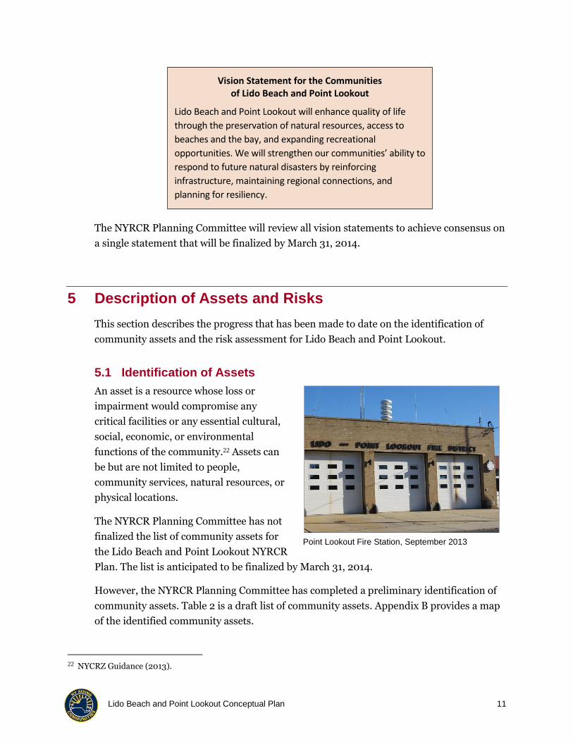
Point Lookout Fire Station, September 2013
Vision Statement for the Communities of Lido Beach and Point Lookout
Lido Beach and Point Lookout will enhance quality of life
through the preservation of natural resources, access to
beaches and the bay, and expanding recreational
opportunities. We will strengthen our communities’ ability to
respond to future natural disasters by reinforcing
infrastructure, maintaining regional connections, and
planning for resiliency.

Lido Beach and Point Lookout Conceptual Plan 12
Table 2: Draft List of Community Assets
Lido Beach
Asset Name Location
Storm drainage infrastructure —
Lido Beach Synagogue 1 Fairway Rd.
Town Park at Malibu 1150 Lido Blvd.
Lido Beach – Point Lookout Fire District
150 Lido Blvd at Greenway Rd.
Lido Beach Golf Club 225 Lido Blvd.
Town Park Lido Beach West 232 Lido Blvd.
Lido Elementary School / Long Beach Pre-K Center
237 Lido Blvd.
Long Beach Middle School 239 Lido Blvd.
Marvel Dairy Whip 258 Lido Blvd.
Dunes Delicatessen 300 Lido Blvd.
Long Beach High School 322 Lagoon Dr. West
Town Dept. of Water Facility 616 Lido Blvd.
Camp Anchor 630 Lido Blvd.
Lido Beach Town Park 630 Lido Blvd.
School District Offices 630 Lido Blvd.
CNG fueling facility for school buses
659 Lido Blvd.
Nike Alternative School and Environmental Center
659 Lido Blvd.
District school bus parking area 659 Lido Blvd.
Town Park at Sands 710 Lido Blvd.
Lido townhouses 750 Lido Blvd.
Adult group homes Adjacent to western boundary of Point Lookout Town Park
Point Lookout
Asset Name Location
Housing (single family) —
Storm drainage infrastructure —
Town of Hempstead Dept. of Conservation and Waterways Laboratory
1 Parksdale Dr.
Lido Point Lookout Fire Dist. 102 Lido Blvd.
U.S. Post Office 110 Lido Blvd.
Point Lookout Town Park 1300 Lido Blvd.
Town Public Safety Facility (Point Lookout)
1300 Lido Blvd.
Ted's Fishing Station 143 Bayside Dr.
Town Dept. of Water, Main Treatment Plant
330 Lido Blvd.
Town Dept. of Water, Well #1 330 Lido Blvd.
Town Dept. of Water, Well #2 330 Lido Blvd.
Water tower 330 Lido Blvd.
Cedarhurst Ave. Playground 35 Cedarhurst Ave.
Point Lookout Community Church 60 Freeport Ave.
Scotty's Marina and Fishing Station and Restaurant
72 Bayside Dr.
Our Lady of the Miraculous Medal 75 Parkside Dr.
Point Lookout Rescue Company Bayside Dr. at Parksdale Dr.
Recreation area (Point Lookout) East end of Lido Blvd.
Point Lookout Volunteer Fire Company
East of 102 Lido Blvd.
Ye Olde Firehouse (meeting hall) East of Point Lookout Fire Station

Lido Beach and Point Lookout Conceptual Plan 13
Lido Beach
Asset Name Street
Lido Beach Park District From Allevard Street to Prescott Street (ocean side)
Nickerson Beach Lido Blvd.
Housing (single-family homes and townhomes)
Lido Homes; Lido Towers; Lido South; Lido Dunes; Lido Townhouses
Pumping station Regent Dr.
Point Lookout
Asset Name Street
Fire Dept. Training Facility Point Lookout Town Park
Town Dept. of Parks and Recreation Facility
In Point Lookout Town Park
Lido Beach Passive Nature Preserve Lido Blvd.
East Marina Lido Blvd.
West Marina Lido Blvd.
Town Energy Park Lido Blvd., Point Lookout
Groins and Erosion Control/Protection
Oceanside of Point Lookout
Commercial buildings Lido Blvd. and Bayside Dr.
Lido Beach and Point Lookout Conceptual Plan 14
Once the list of assets has been finalized, detailed information about each asset, landscape
attributes in the vicinity of the asset, and the vulnerability of the asset to flood damage will
be collected for the Community Asset Inventory. Assets will then be prioritized based on
factors such as importance to the communities, probability of being affected by flooding,
and restoration time.
5.2 Identification and Understanding of Risk
The NYRCR Planning Committee has not finalized the risk assessment. The assessment
will be finalized by March 31, 2014.
Table 2 displays the working list of community assets. The list was developed by the
NYRCR Planning Committee during their October 8, 2013, meeting and was expanded on
during the October 15, 2013, Public Engagement Meeting. Appendix B is a map showing
the locations of identified community assets.
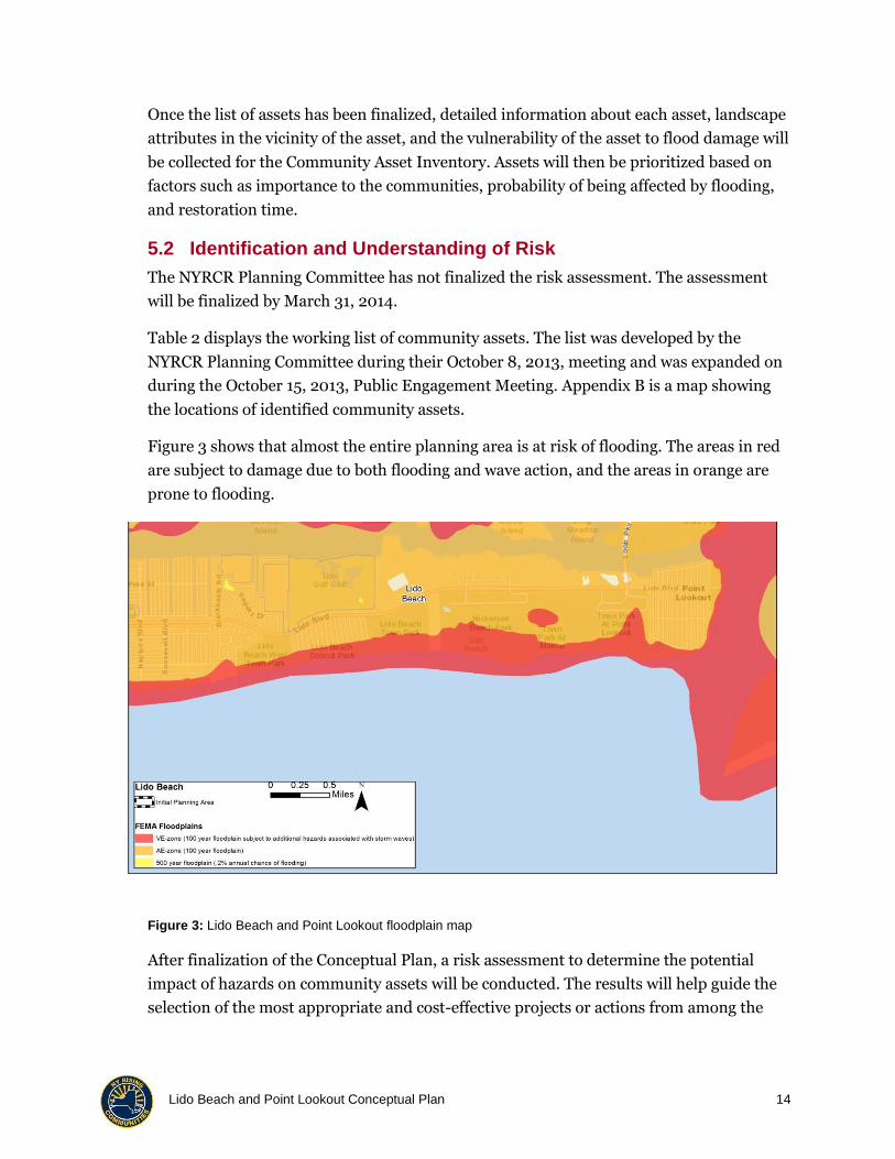
Figure 3 shows that almost the entire planning area is at risk of flooding. The areas in red
are subject to damage due to both flooding and wave action, and the areas in orange are
prone to flooding.
Figure 3: Lido Beach and Point Lookout floodplain map
After finalization of the Conceptual Plan, a risk assessment to determine the potential
impact of hazards on community assets will be conducted. The results will help guide the
selection of the most appropriate and cost-effective projects or actions from among the

Lido Beach and Point Lookout Conceptual Plan 15
various alternatives suggested during the planning process. The risk assessment will help
the communities select the methods of mitigating future risk.
The risk assessment process starts with calculating a Risk Score based on the Risk
Assessment Tool developed by the New York State Department of State. The Risk Score is
calculated using the following formula:
Hazard × Exposure × Vulnerability = Risk
In this equation, Hazard represents the severity of the hazard event; exposure represents
the risk area; and vulnerability represents potential level of impairment. New York State
Department of State risk areas are described in Table 3.
Table 3: New York State Department of State Risk Areas
Extreme Risk Area High Risk Area Moderate Risk Area
FEMA Coastal V Zones FEMA 1% (100-year) annual flood risk (FEMA Zone V and Zone A)
FEMA 0.2% (500-year) annual flood risk
NWS advisory thresholds for shallow coastal flooding
Areas within 3 feet elevation of NWS advisory thresholds for shallow coastal flooding
Areas within 3 feet of elevation of FEMA 1% annual flood risk (base flood elevations)
Areas within 3 feet of elevation of mean higher high water shoreline from the National Oceanic and Atmospheric Administration
— Area bounded by SLOSH Category 3 hurricane inundation zone
Areas prone to erosion — —
Source: New York State Department of State
FEMA = Federal Emergency Management Agency
NWS = National Weather Service
SLOSH = Sea, Lake, and Overland Surge from Hurricanes
The assessment of risk will include a cost-benefit evaluation for mitigation projects that
are of particular importance to the communities. The final list of proposed projects and
actions will consist of projects and actions that will effectively reduce risk and be cost
effective.

Lido Beach and Point Lookout Conceptual Plan 16
6 Public Involvement Process
Lido Beach and Point Lookout have a
long history of active resident
participation in community meetings.
The NYRCR Planning Committee
meetings on September 24, October 8,
and October 22, 2013, were open to the
public, and audience participation was
invited (through questions at the end of
the meeting and public comment cards).
The first Public Engagement Meeting was held on October 15, 2013, and was attended by
more than 30 residents. The meeting opened with an overview of the NYRCR planning
process. The overview was presented by the committee Co-Chairs and the Planning Team.
Most of the meeting involved a facilitated breakout session during which participants were
asked for feedback on the Vision Statement, assets, needs, and vulnerabilities. Attendees
provided suggestions for strategies that may make the communities more resilient and for
potential projects or actions. Near the end of the meeting, the attendees at each table
presented their key concerns and recommendations.
The public was notified of the Public Engagement Meeting and informed about the
NYRCR planning process through information and flyers distributed electronically by:
1. NYRCR Planning Committee
2. Civic associations
3. Facebook
7 Identification of Needs and Opportunities
This section describes the needs and resilience and revitalization opportunities that have
been identified to date, primarily from the review of relevant plans and studies, the
NYRCR Planning Committee meetings on September and October 2013, and the Public
Engagement Meeting on October 15, 2013.
The needs and opportunities include a local focus, but mitigating the risk of damage from
future storms to increase resilience requires local action and regional coordination (see
Section 10).
Public Engagement Meeting, October 15, 2013

Lido Beach and Point Lookout Conceptual Plan 17
The NYRCR Planning Committee has not finalized the identification of needs and
opportunities. Finalization will occur by March 31, 2014. The needs and opportunities that
have been identified to date are described in the following sections.
7.1 Community Planning and Capacity Building
Needs
Zoning regulation modification. Zoning regulations restrict the allowable distance
(30 feet or approximately 2.5 stories) from the existing grade of the road to the peak of
a roof, which makes elevating a two-story house and remaining in compliance with
zoning nearly impossible. Zoning regulation modification would be necessary.
Electric power. Power was not available in homes or businesses for at least 2 weeks
after Superstorm Sandy in either Lido Beach or Point Lookout.
Less fragmentation of maintenance responsibility. Municipal and county
government departments are responsible for maintaining designated parts of Lido
Boulevard, resulting in inefficiencies in making repairs and plowing snow.
Expedited process for obtaining permits required by New York State. The
established process for obtaining a permit from the New York Department of
Environmental Conservation for land-water interface projects, such as for bulkheads,
revetment, or dredging, has been very time-consuming for local government.
Opportunities
Electricity from wind. The Town of Hempstead Energy Park in Point Lookout
provides electric power from a wind generator. The facility could be used as a
community resource for recharging cell phones during power outages.
Alternative sources of energy. The Town of Hempstead Conservation and
Waterways Department can identify opportunities for alternative sources of energy so
businesses can operate during and after a storm.

Lido Beach and Point Lookout Conceptual Plan 18
7.2 Economic Development
Needs
Establishment of a steady
customer base. Small businesses
struggled to rebuild a steady customer
base after Sandy. There is a need for
building a larger customer base, which
could include residents and visitors.
Viable working waterfront in
Point Lookout. The waterfront
provides recreation and economic
benefits to the communities, but
enhanced and expanded docking space is needed.
Protection of businesses from flooding. Small businesses were flooded because
of Superstorm Sandy and also experience a frequent loss of business from nuisance
flooding on roads that prevents customers from accessing the businesses.
Opportunities
Increase in business opportunities. Economic development investments and
financial assistance programs and grants are available for small businesses. Business
owners can work with the Nassau County Industrial Development Agency and the
Town of Hempstead Economic Development Agency to increase business
opportunities.
Development of gateways. Point Lookout and Lido Beach can develop aesthetically
pleasing gateways at entry points to attract visitors. (There is a gateway into Point
Lookout along Lido Boulevard, but not at the entrance from Loop Parkway.)
Commercial Development, Point Lookout, September 2103

Lido Beach and Point Lookout Conceptual Plan 19
7.3 Housing
Needs
Flooding. Flooding from the ocean
and the bay as a result of Superstorm
Sandy affected almost every home in
the NYRCR Planning Area. There is a
need to protect homes from flooding
while maintaining the character of the
existing neighborhoods.
Repetitive flood loss.
Approximately 20 properties in Lido
Beach and 7 properties in Point
Lookout are classified by the National
Flood Insurance Program as repetitive flood loss properties.
Alternative power. All homes in Lido Beach and Point Lookout were without power
or gas for at least 2 weeks after Superstorm Sandy. An alternative source of electricity
or a back-up source of power is needed to avoid similar outages in the future.
Maintenance of the residential character of communities. Residents indicated
during meetings of the NYRCR Planning Committee in September 2013 that they are
not generally in favor of increasing tourism or public access to beaches, preferring to
keep traffic to a minimum so that streets remain safe for walking and biking. Moreover,
neither Lido Beach nor Point Lookout is identified in the Nassau County Master Plan as
a “target growth area” 23 or in the New York Metropolitan Transportation Council Plan
2040 - Regional Transportation Plan as a “desired growth area.”24
Opportunities
Alternative power generation systems. The three adult group homes in Lido
Beach have pioneered the use of solar panels for power generation and could provide
information to homeowners in Lido Beach and Point Lookout on the panel sizes that
23 Nassau County. Nassau County Master Plan Land Use: Target Sustainable Development to Growth Areas (2010).
Available at
http://www.nassaucountyny.gov/agencies/EconomicDevelopment/Docs/PDF/Chapter3LandUse_000.pdf.
Accessed October 28, 2013.
24 New York Metropolitan Transportation Council. Plan 2040 - Regional Transportation Plan (September 4, 2013).
Available at
http://www.nymtc.org/files/RTP_PLAN_2040_docs/Public%20Review%20Drafts/Plan%202040%20Full%20Do
cument/Plan%202040%20Main%20Document.pdf. Accessed October 28, 2013.
House in Lido Beach, September 2013

Lido Beach and Point Lookout Conceptual Plan 20
are appropriate for single-family homes and how to secure solar panels to withstand
hurricane force wind.
Alternative energy pilot program. The Energy Master Plan of the Town of
Hempstead Conservation and Waterways Division25 proposes the development of a
micro-grid that could provide a limited amount of electric power to homes and
businesses in Point Lookout.
7.4 Health and Social Services
Needs
Emergency medical care. The Long Beach Medical Center has been closed since
Superstorm Sandy. Traveling to the next closest hospital is time-consuming and
potentially dangerous.
Protection of school buildings from flood and wind damage. Superstorm
Sandy caused flood damage to the elementary and middle schools in Lido Beach and
wind and flood damage to the high school in Lido Beach.
Increase resiliency of fire department facilities. The emergency response
facilities in Lido Beach and Point Lookout are older, ground-level structures and are at
risk of flood and wind damage. Increased resiliency may be achieved by retrofitting the
buildings with hurricane-resistant doors, windows, and roofs and elevating utility
systems above anticipated levels of flooding.
Continuation of services for disabled youth and adults. Services need to be
continued through the adult group homes and Camp Anchor and the potential for
future damage should be reduced by rebuilding damaged dunes.
Opportunities
Use of schools for community hot meals. The schools that were damaged are
being repaired through the FEMA Public Assistance Program. The schools could be
retrofitted to be used as a community resource for hot meals because the cafeterias are
on the second floor.
Electricity for food storage at high school. Generators with a sufficient amount
of fuel could be used to generate electricity for food storage in the high school cafeteria.
25 Energy Master Plan of the Town of Hempstead Conservation and Waterways Division. Town of Hempstead Project
Energy (Undated). Available at http://www1.eere.energy.gov/office_eere/pdfs/schneider_hempstead.pdf.
Accessed October 28, 2013.

Lido Beach and Point Lookout Conceptual Plan 21
Urgent or emergency care center. Medical providers have expressed an interest in
opening an urgent care or emergency care center on the island.
Wind damage mitigation. The potential for wind damage could be reduced by
installing wind-resistant roofs and windows.
Flood damage mitigation. The potential for damage from flooding of fire
department facilities could be reduced by wet floodproofing (elevating utilities above
anticipated flood levels and allowing water to temporarily inundate the building) or by
using temporary flood barriers.
Services for disabled adults and children. The adult group homes and Camp
Anchor were protected during Superstorm Sandy by dunes along the ocean side in Lido
Beach. Dunes would protect the facilities in the future and allow them to continue to
provide services to disabled adults and children.
7.5 Infrastructure
Needs
Stormwater management. The
lack of stormwater management is a
regional issue. Localized flooding
occurs even in small rain events
because of the inadequate capacity of
the stormwater system.
Maintenance of the stormwater
drainage system. Clogged storm
drains and pipes limit the
effectiveness of existing stormwater
sewers.
Improvement of the stormwater
drainage system. Mechanical
modifications to the existing
stormwater drainage system, such as the installation of back flow preventers and
Tideflex valves, may improve performance.
Consistent elevations of bulkheads. Many private homeowners, business owners,
and public facilities have installed bulkheads, but protection is only effective to the
elevation of the lowest bulkhead.
Ocean Boulevard Path, Lido Beach, September 2013
Lido Beach and Point Lookout Conceptual Plan 22
Sanitary sewer system improvements. Part of Lido Beach is connected to the City
of Long Beach sewage treatment facility. The plant was rehabilitated in 2002 but needs
further improvements.
Improved ability to manage wastewater. Point Lookout uses cesspools and septic
tanks, which discharge sewage into the groundwater during periods of flooding.
Opportunities
Study of the stormwater drainage system. A stormwater drainage system study
that includes mapping areas that experience frequent, nuisance flooding from tidal and
rain events may identify ways to repair and retrofit the existing stormwater drainage
system.
Enhancement of the drainage system maintenance. Residents and business
owners may have opportunities to work with the Town of Hempstead and Nassau
County to increase the number of inspections and the speed of repairs of stormwater
drainage systems along roadways maintained by either governmental entity.
Bulkheading. Developing or raising bulkheads in coordination with the Town of
Hempstead and the City of Long Beach may reduce the potential for erosion.
Reduction of potential for erosion. The system of revetment or hard protection on
the east side of Point Lookout could be expanded to reduce the potential for erosion.
Coordination with other municipalities on wastewater treatment. The City
of Long Beach and Bay Park are discussing ways to improve their wastewater treatment
plants, which provide an opportunity for Lido Beach and Point Lookout to use their
facilities and support a regional project.
7.6 Natural and Cultural Resources
Needs
Restoration of beaches. Coastal
erosion is a significant problem in Lido
Beach and Point Lookout. Littoral drift
moves sand from the eastern to the
western end of Long Beach Island.
Restoration and replanting of
dunes. The front dune of the dual
dune system that provided protection
to Lido Beach was lost during
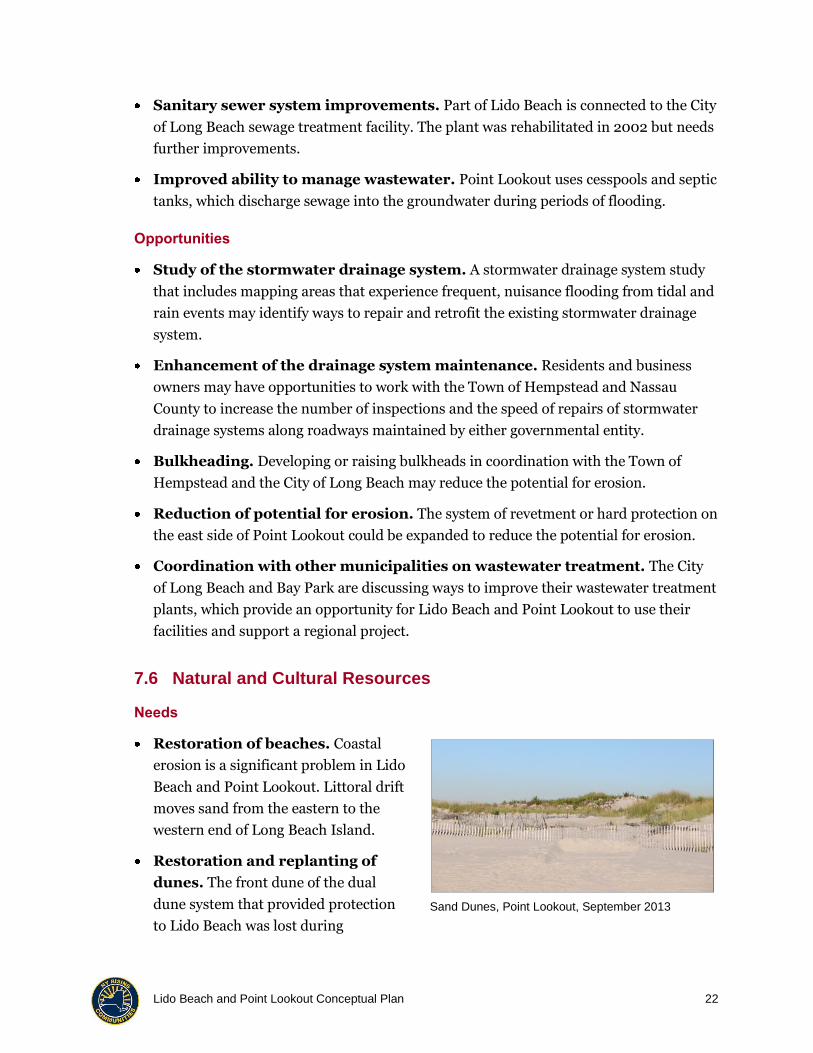
Sand Dunes, Point Lookout, September 2013

Lido Beach and Point Lookout Conceptual Plan 23
Superstorm Sandy. The engineered dunes were breached in two areas of Point Lookout,
resulting in significant flooding from the ocean side.
Protection of native salt marshes. Salt marshes have been largely filled and
developed in the NYRCR Planning Area. A 185-acre salt marsh exists on the north side
of Lido Beach and provides protection from bayside flooding. This area is protected by
regulation from development.
Opportunities
Vegetation. The Town of Hempstead may develop or increase the size of vegetated
buffers and dune plantings along the ocean side to reduce the potential for erosion.
Marsh protection regulation. Residents and business owners may support the
Town of Hempstead’s efforts to work with the New York Department of Environmental
Conservation to permit revitalization of marshlands.
Protection of natural resources. The Town of Hempstead is investigating the
changes in marshes, small islands, and natural protection systems. The study may
provide valuable information about trends and opportunities for protecting these
resources.
8 Key Strategies and Potential Actions to Implement Strategies
Key strategies for increasing community resiliency were identified during initial
discussions of the NYRCR Planning Committee and were validated during table
discussions at the October 15, 2013, Public Engagement Meeting. Strategies will guide
project and investment decisions and gradually transition at-risk assets from high-risk
conditions to an acceptable lower level of risk.
This section lists one or more key strategies for each of the six Recovery Support
Functions. Under each strategy, a few of the projects or actions that have been suggested
by the NYRCR Planning Committee, by the public, or as a result of the review of existing
planning documents are listed. At this point, these are only suggestions. As the plan
development process continues, structural projects or other types of suggested actions will
be closely examined. Feasible and cost-effective projects and actions that have potential to
enhance resiliency will be proposed in the March 2014 NYRCR Plan.
Lido Beach and Point Lookout Conceptual Plan 24
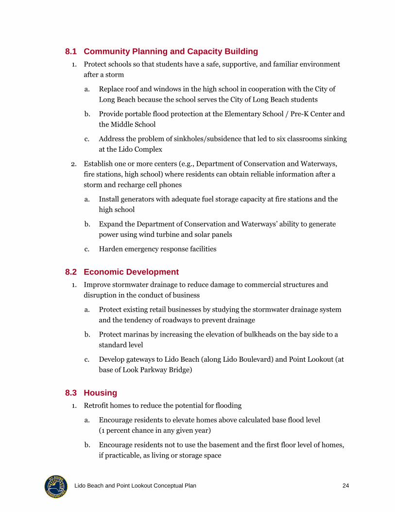
8.1 Community Planning and Capacity Building
1. Protect schools so that students have a safe, supportive, and familiar environment
after a storm
a. Replace roof and windows in the high school in cooperation with the City of
Long Beach because the school serves the City of Long Beach students
b. Provide portable flood protection at the Elementary School / Pre-K Center and
the Middle School
c. Address the problem of sinkholes/subsidence that led to six classrooms sinking
at the Lido Complex
2. Establish one or more centers (e.g., Department of Conservation and Waterways,
fire stations, high school) where residents can obtain reliable information after a
storm and recharge cell phones
a. Install generators with adequate fuel storage capacity at fire stations and the
high school
b. Expand the Department of Conservation and Waterways’ ability to generate
power using wind turbine and solar panels
c. Harden emergency response facilities
8.2 Economic Development
1. Improve stormwater drainage to reduce damage to commercial structures and
disruption in the conduct of business
a. Protect existing retail businesses by studying the stormwater drainage system
and the tendency of roadways to prevent drainage
b. Protect marinas by increasing the elevation of bulkheads on the bay side to a
standard level
c. Develop gateways to Lido Beach (along Lido Boulevard) and Point Lookout (at
base of Look Parkway Bridge)
8.3 Housing
1. Retrofit homes to reduce the potential for flooding
a. Encourage residents to elevate homes above calculated base flood level
(1 percent chance in any given year)
b. Encourage residents not to use the basement and the first floor level of homes,
if practicable, as living or storage space

Lido Beach and Point Lookout Conceptual Plan 25
c. Encourage homeowners to invest in solar or other alternative sources of power
to reduce the negative impact of a long-term power outage
8.4 Health and Social Services
1. Support a regional solution for medical services
a. Work with the City of Long Beach to restore emergency medical services
8.5 Infrastructure
1. Improve stormwater drainage
a. Determine the current capacity of the stormwater drainage system
b. Identify and repair blockages or breaks in the stormwater drainage system
c. Examine the potential for using valves and other mechanisms (e.g., Tideflex
valves) to improve the efficiency of the stormwater drainage system
d. Study the nature of flooding along Lido Boulevard to identify mitigation
measures
e. Raise the grade of land in areas where subsidence or sinking has been observed
2. Improve the protection provided by bulkheads
a. Determine a standard height for bulkheads
b. Work with the Town of Hempstead and City of Long Beach to raise and
reinforce bulkheads to a standard height in areas where the Town has
responsibility for bulkheads
c. Encourage private property owners to raise and reinforce bulkheads on their
property to a standard height
8.6 Natural and Cultural Resources
1. Restore natural protective systems (dunes and salt marsh)
a. Work with the U.S. Army Corps of Engineers (USACE) to study the feasibility of
replacing dunes lost during Superstorm Sandy
b. Work with the Town of Hempstead to use regulatory mechanisms to continue
to protect existing salt marshes from development
2. Reduce potential for coastal erosion

Lido Beach and Point Lookout Conceptual Plan 26
a. Expand the system of revetment along the east side of Point Lookout by
working with the New York Department of Environmental Conservation and
Department of State to obtain permits
b. Replant existing dunes to prevent erosion by wind and water
c. Replace dunes, which were breached and damaged by Superstorm Sandy, in
front of Lido Towers and Town Park at Lido West
8.7 Socially Vulnerable Populations
1. Protect adult group homes and Camp Anchor from future ocean-side flooding
a. Work with the USACE and New York Department of Environmental
Conservation to study the feasibility of replacing dunes lost during Superstorm
Sandy and to identify opportunities for obtaining sand needed to replace and
rebuild dunes
b. Replant existing dunes to prevent erosion by wind and water
2. Work with the Town of Hempstead to maintain a list of residents with special
medical needs that should be addressed during a power outage or evacuation
9 Potential Key Projects Ready to Go
The NYRCR Planning Committee has not finalized the identification of the potential key
projects. Finalization will occur by March 31, 2014.
The NYRCR Planning Committee has begun discussions of projects that are underway
(under or close to construction), ready to go (securing funding or will start soon), and
planned (initial scope/plan to pursue in the next 6 months).
Following a final determination of the key projects, project descriptions will be developed
and will include the following information:

Lido Beach and Point Lookout Conceptual Plan 27
● Project sponsor
● Project name and location
● Categorization according to the six
Recovery Support Functions
● Brief project description
● Community benefits
● Sustainability factors detailed as part
of a regional sustainability plan
● Economic impacts
● Environmental benefits
● Health and social benefits
● Support for project (high, medium,
and minimal)
● Estimated project cost
● Potential sources of funding
● Initial feasibility assessment
● Status of implementation
● Implementation timeline: immediate (less
than 2 years), intermediate (within 2 to
5 years), long-range (more than 5 years)
● Regional coordination
● Coordination with outside agencies
● Project impact
● Alternatives
● Context map
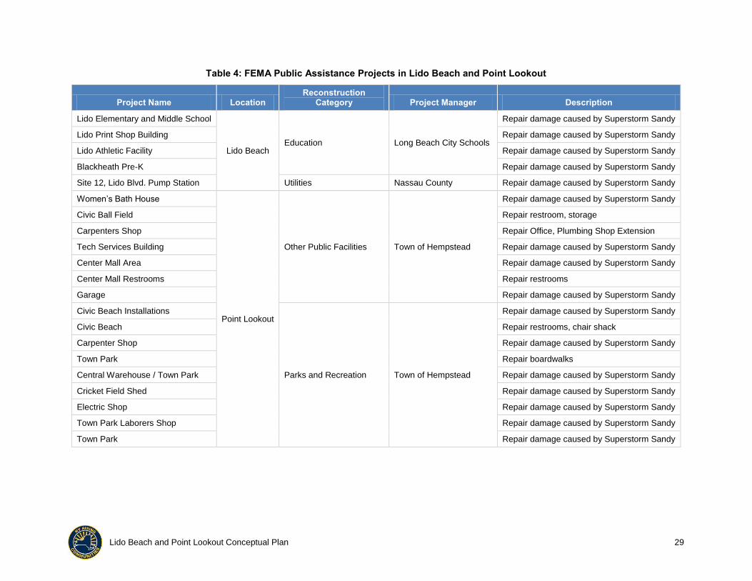
Table 4 provides a list of repair projects that have been funded through the FEMA Public
Assistance Program to prevent duplicating projects that are proposed in the NYRCR Plan.
The Town of Hempstead has applied to the State of New York for Hazard Mitigation Grant
Program funding for mitigation projects.
10 Regional Perspectives
Some of the issues addressed in the NYRCR Plan cross political jurisdictions and need to
be coordinated on a regional basis. Coordination and further discussion will be needed
with:
National Grid
Long Island Power Authority (LIPA)
City of Long Beach
Atlantic Beach / East Atlantic Beach
Island Park
LIREDC
Nassau County
Town of Hempstead
USACE
Lido Beach and Point Lookout Conceptual Plan 28
New York Department of Environmental Conservation AND Department of
Sanitation
Lido Beach and Point Lookout Conceptual Plan 29
Table 4: FEMA Public Assistance Projects in Lido Beach and Point Lookout
Project Name Location Reconstruction
Category Project Manager Description
Lido Elementary and Middle School
Lido Beach Education Long Beach City Schools
Repair damage caused by Superstorm Sandy
Lido Print Shop Building Repair damage caused by Superstorm Sandy
Lido Athletic Facility Repair damage caused by Superstorm Sandy
Blackheath Pre-K Repair damage caused by Superstorm Sandy
Site 12, Lido Blvd. Pump Station Utilities Nassau County Repair damage caused by Superstorm Sandy
Women’s Bath House
Point Lookout
Other Public Facilities Town of Hempstead
Repair damage caused by Superstorm Sandy
Civic Ball Field Repair restroom, storage
Carpenters Shop Repair Office, Plumbing Shop Extension
Tech Services Building Repair damage caused by Superstorm Sandy
Center Mall Area Repair damage caused by Superstorm Sandy
Center Mall Restrooms Repair restrooms
Garage Repair damage caused by Superstorm Sandy
Civic Beach Installations
Parks and Recreation Town of Hempstead
Repair damage caused by Superstorm Sandy
Civic Beach Repair restrooms, chair shack
Carpenter Shop Repair damage caused by Superstorm Sandy
Town Park Repair boardwalks
Central Warehouse / Town Park Repair damage caused by Superstorm Sandy
Cricket Field Shed Repair damage caused by Superstorm Sandy
Electric Shop Repair damage caused by Superstorm Sandy
Town Park Laborers Shop Repair damage caused by Superstorm Sandy
Town Park Repair damage caused by Superstorm Sandy

Lido Beach and Point Lookout Conceptual Plan 30
The potential projects with a regional focus that have been discussed include:
Partnering with the LIREDC to develop a pilot project for a micro-grid providing
electric power in Point Lookout and/or Lido Beach
Coordinating with LIPA to protect electrical power transmission and distribution
facilities
Working with LIPA to install smart meters on homes and businesses to better
monitor energy usage and to build a smart grid
Coordinating with the Town of Hempstead and Nassau County on restoring marsh
and wetlands throughout the region
Evaluating the need for intergovernmental agreements with neighboring
jurisdictions during disaster response
11 Process for Evaluating Potential Actions and Projects
The NYRCR Planning Committee has not finalized the process for evaluating potential
actions and projects to implement the strategies. The process will be finalized by March
31, 2014.
The NYRCR Planning Committee will prioritize the strategies under consideration during
the development of the final NYRCR Plan using knowledge gained from the visioning
process, information in the Community Asset Inventory, the needs and opportunities
assessment, the risk assessment, and agreed-upon metrics, such as cost, time frame, and
others, as identified through the outreach process.
Strategies may include bricks-and-mortar projects, policy decisions, political cooperative
efforts, or other actions. Actions will be discussed in terms of reconstruction category,
community benefits, extent of public support for the project, estimated project cost,
funding, feasibility assessment, implementation measures, regional and outside agency
coordination, project impact, and alternatives.
The process will also include a cost-benefit analysis for recommended capital projects and
a suitable equivalent analysis for non-capital projects.
The result will be a prioritized list of projects, investments, and initiatives that include a
detailed project descriptions, a list of potential funding sources, and ranking for
implementation.
Implementation of the strategies will follow the three-step process shown in Figure 4.
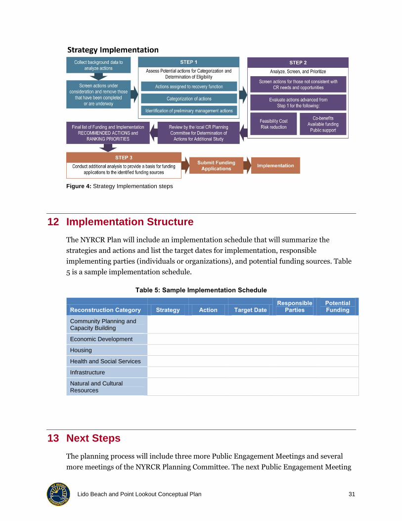
Lido Beach and Point Lookout Conceptual Plan 31
Figure 4: Strategy Implementation steps
12 Implementation Structure
The NYRCR Plan will include an implementation schedule that will summarize the
strategies and actions and list the target dates for implementation, responsible
implementing parties (individuals or organizations), and potential funding sources. Table
5 is a sample implementation schedule.
Table 5: Sample Implementation Schedule
Reconstruction Category Strategy Action Target Date Responsible
Parties Potential Funding
Community Planning and Capacity Building
Economic Development
Housing
Health and Social Services
Infrastructure
Natural and Cultural Resources
13 Next Steps
The planning process will include three more Public Engagement Meetings and several
more meetings of the NYRCR Planning Committee. The next Public Engagement Meeting
Lido Beach and Point Lookout Conceptual Plan 32
for Lido Beach and Point Lookout is scheduled for Monday, November 4, 2013, at 7:00
PM. On November 4, the public will review this Conceptual Plan, determine if the key
strategies and potential projects and actions are consistent with community sentiment,
suggest additional projects and actions, and provide additional information about
damages and vulnerabilities.
The planning process defined by the NYRCR Program consists of seven steps:
Step 1: Organize for Action has been completed with the establishment of the NYRCR
Planning Committee.
Step 2: Inventory Assets is well underway, as illustrated in Table 2 and Appendix B.
Step 3: Assess Risk will occur as described in Section 5.2 as GIS data about the exact
location of assets relative to the shoreline, presence of shore defenses, and of protective
vegetation are further developed to assign a hazard, exposure, and vulnerability score and
calculate a risk score.
Step 4: Determine Needs and Opportunities is well underway as illustrated in Section 7 of
this document.
Step 5: Engage in Regional Planning Process to examine challenges that cut across
political jurisdictions and must be considered on a regional basis began with the
examination of existing planning documents and will continue over the next several
months.
Step 6: Develop Strategies for Investment and Action began with the work of the NYRCR
Planning Committee during September and October 2013 and will continue as the plan is
developed. Section 8 of this document summarizes the key strategies and suggested
projects and actions that may be effective in realizing the strategies. The list of alternative
projects and actions will expand as the process continues and project and actions that are
most appropriate for increasing resiliency in Lido Beach and Point Lookout will be
identified through quantitative and qualitative analyses.
Step 7: Complete the NYRCR Plan will be accomplished by March 31, 2014. The NYRCR
Plan will propose projects and actions that the communities of Lido Beach and Point
Lookout have determined will most effectively enhance resilience.

Lido Beach and Point Lookout Conceptual Plan A-1
Appendix A: Reviewed Plans and Studies Relevant to Lido Beach and Point Lookout
Plan/Study Reviewed Date Relevant Information
Cleaner, Greener Long Island Regional Sustainability Plan
2013
Plan includes State’s goals of reducing the amount of waste transported to landfills and reducing water pollution through improved management of stormwater runoff.
Cleaner, Greener Long Island Regional Sustainability Plan Appendices
2013
Appendix includes detailed information about projects and policies that advance green development in the Town of Hempstead, including Point Lookout and Lido Beach projects:
Construction of a 100-kilowatt solar photo-voltaic car canopy at East Marina in Point Lookout
Town of Hempstead Conservation and Waterways Department Energy Park in Point Lookout
Hydrogen Fueling station in Point Lookout
Compressed Natural Gas station in Lido Beach
New York State Action Plan for City of Long Beach Waste Water Treatment Plant Program Disaster Recovery
2013
Plan addresses natural hazards in Nassau County and concludes that the Town of Hempstead experienced the greatest level of damage to housing as a result of Superstorm Sandy in 2012 and the fourth greatest level of damage as a result of Hurricane Irene in 2011. The plan identified the re-opening of businesses that were closed following Superstorm Sandy as a top priority.
U.S. Army Corps of Engineers (USACE) Long Beach Island Re-Evaluation Report
2012
Report notes that all four groins at Lido Beach were in poor condition and in need of replacement and that while two of the three groins at Point Lookout were in good condition, they need to be extended by 100 feet.
New York Metropolitan Transportation Council Transportation Improvement Program
2011 Plan describes transportation preservation and rehabilitation projects, including inventory, replacement, and management of Town of Hempstead traffic signs. The plan does not identify the Loop Parkway Bridge or any other roadways in Lido Beach or Point Lookout as needing replacement.
Nassau County Community Health Assessment
2010 Study provides an overview of health care facilities in Nassau County.
Nassau County Community Health Assessment Update
2010
Study provides specific information on the services provided by each health care facility in the county. There are no health care facilities located in Lido Beach or Point Lookout. The closest facilities are located in the City of Long Beach: a county hospital (Long Beach Medical Center) and four nursing homes (Beach Terrace Care Center, Grandell Rehabilitation and Nursing Center, Komanoff Center for Geriatric and Rehabilitative Medicine, and Park Avenue Extended Care Center).
Nassau County Master Plan 2010 Plan provides goals for development in the County with a focus on downtown and transit-oriented development. The plan emphasizes the goals of preserving open space. The plan does not identify projects for Lido Beach or Point Lookout.

Lido Beach and Point Lookout Conceptual Plan A-2
Plan/Study Reviewed Date Relevant Information
New York Metropolitan Transportation Council 2005–2030 Regional Transportation Plan
2010
Goals presented in the plan include the preservation of open space and wetlands, increasing the ability of residents to safely walk and bicycle, and the incorporation of the anticipated effects of climate change into transportation planning. Neither Lido Beach nor Point Lookout is identified as a “desired growth area.” Lido Boulevard Traffic Calming Improvements are proposed in the plan.
New York State Scenic Byway Corridor Management Plan for Select Historic Long Island Parkways, Nassau and Suffolk Counties, New York
2010
Plan outlines strategies to protect, improve, and promote New York State and National Scenic Byways including the Loop Parkway. Loop Parkway was constructed in 1934 and is eligible for listing in the State and National Register of Historic Places. Recent improvements were construction of wood guard rails and addition of wood light poles to maintain the Parkway’s historic character. The plan does not propose additional improvement on Loop Parkway.
Places to Grow: An Analysis of the Potential for Transit-Accessible Housing and Jobs in Long Island’s Downtowns and Station Areas
2010 Plan identifies Long Beach, but not Lido Beach or Point Lookout, as an area with high potential for transit-oriented development.
Long Beach City Oceanside Coastal Protection Plan
2009
Plan summarizes existing (2009) conditions of groins in Lido Beach and Point Lookout and summarizes a USACE erosion analysis for both communities: Lido Beach gains an average 4.2 feet of shoreline a year and Point Lookout loses 8.3 feet of shoreline a year. Summarizes information in both 2006 and 1995 USACE Storm Reduction Plans and recommends vital improvements/actions to correct deficiencies in the flood protection network of the oceanside of the City of Long Beach: groins 51 through 54 in Lido Beach were observed to be in poor condition and in need of replacement; in Point Lookout groins 55 and 56 were observed to be in good condition but required roughly 100 feet of additional length, needed to be repositioned, and should be replenished with additional armor and groin 58 (the terminal groin) was recommended for rehabilitation and to be extended by roughly 100 feet.
Coastal Protection Study, City of Long Beach, NY – Bayside Shore Protection Plan
2009
Study provides information on the existing conditions of the City of Long Beach’s stormwater management system and bulkheads. Recommends vital improvements/actions to correct deficiencies in the flood protection network of the bayside of the City of Long Beach. Predicts sea level rise of between 2.6 and 6.6 feet per year by 2100.
Long Island 2034 Visioning Initiative 2009
Regional goals presented in this document include enhancing economic prosperity, expanding social equity, and providing a healthy environment by protecting air and water quality and providing open space for recreational purposes. The plan identifies an island-wide community preference for redevelopment of already-developed properties through infill development and preservation of as much open space as possible.
Nassau County Stormwater Management Plan: Stormwater Runoff Impact Analysis
2007 Plan provides standard procedures for analyzing stormwater runoff.
Nassau County Multi-Jurisdictional Natural Hazard Mitigation Plan
2007 Plan identifies coastal erosion on the south shore of the island as well as along back bay as hazards.
Lido Beach and Point Lookout Conceptual Plan A-3
Plan/Study Reviewed Date Relevant Information
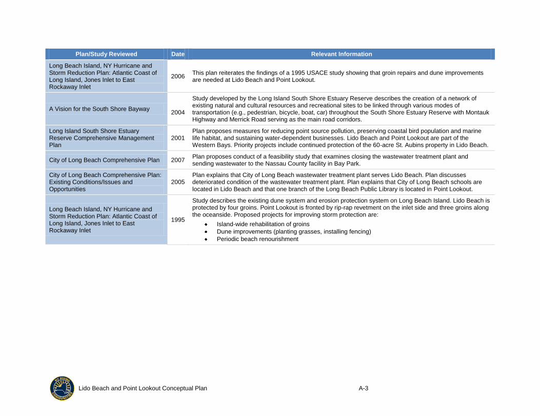
Long Beach Island, NY Hurricane and Storm Reduction Plan: Atlantic Coast of Long Island, Jones Inlet to East Rockaway Inlet
2006 This plan reiterates the findings of a 1995 USACE study showing that groin repairs and dune improvements are needed at Lido Beach and Point Lookout.
A Vision for the South Shore Bayway 2004
Study developed by the Long Island South Shore Estuary Reserve describes the creation of a network of existing natural and cultural resources and recreational sites to be linked through various modes of transportation (e.g., pedestrian, bicycle, boat, car) throughout the South Shore Estuary Reserve with Montauk Highway and Merrick Road serving as the main road corridors.
Long Island South Shore Estuary Reserve Comprehensive Management Plan
2001 Plan proposes measures for reducing point source pollution, preserving coastal bird population and marine life habitat, and sustaining water-dependent businesses. Lido Beach and Point Lookout are part of the Western Bays. Priority projects include continued protection of the 60-acre St. Aubins property in Lido Beach.
City of Long Beach Comprehensive Plan 2007 Plan proposes conduct of a feasibility study that examines closing the wastewater treatment plant and sending wastewater to the Nassau County facility in Bay Park.
City of Long Beach Comprehensive Plan: Existing Conditions/Issues and Opportunities
2005 Plan explains that City of Long Beach wastewater treatment plant serves Lido Beach. Plan discusses deteriorated condition of the wastewater treatment plant. Plan explains that City of Long Beach schools are located in Lido Beach and that one branch of the Long Beach Public Library is located in Point Lookout.
Long Beach Island, NY Hurricane and Storm Reduction Plan: Atlantic Coast of Long Island, Jones Inlet to East Rockaway Inlet
1995
Study describes the existing dune system and erosion protection system on Long Beach Island. Lido Beach is protected by four groins. Point Lookout is fronted by rip-rap revetment on the inlet side and three groins along the oceanside. Proposed projects for improving storm protection are:
Island-wide rehabilitation of groins
Dune improvements (planting grasses, installing fencing)
Periodic beach renourishment

Lido Beach and Point Lookout Conceptual Plan B-1
Appendix B: Community Asset Map
Figure B-1: Community Asset Map