Third Five-Year Review Report Homestake Mining … Five-Year Review Report Homestake Mining Company...
133
Third Five-Year Review Report Homestake Mining Company Superfund Site (EPA ID: NMD007860935) Cibola County, New Mexico September 2011 Region 6 United States Environmental Protection Agency Dallas, Texas
Transcript of Third Five-Year Review Report Homestake Mining … Five-Year Review Report Homestake Mining Company...
Third Five-Year Review Report
Homestake Mining Company Superfund Site
(EPA ID: NMD007860935)
Cibola County, New Mexico
September 2011
Region 6
United States Environmental Protection Agency
Dallas, Texas
CONCURRENCES
Third Fi,'c-Ycar Re\'iew
Forthc
Romestakc Mining Compally Site
BY:c§aV-~ Sairam S. Appaji Remedial Project Manager
ByCti% ~ Cathy Gilmore, Chief Louisiana/Oklahoma and New Mexico Section
Bi7A~).#~ Donald Williams Deputy ssociatc Director
By.····~~~~~~~stf~~2f~f~ aries Fau Associate Director
B~d/~Pamela J. Tra\I'lSCfli;«orncy om at COUIlSC uperfund Branch
By:~:;:;Q~~~~~__ Mark Peycke, Chi Superfund Branch, Office of Regional Counscl
By:~~e:tk~~J.d4$A,~-Sam Coleman, Divisi Superfund Division
Date: ., Iv] 1--'-1LI__
Date: _qL'+-/"':/....'1--11-'-1-,--I _
Date: _~;~"""""'~'-L.-__
Date:-H~~h;_
Date: -,(}"-'0'-f-!L~.f?I.s;'a,-,,'/,--_-
Date: ~E>::...~.:..,hL:::..9:.!.~_I_I _
Date JlM// (I

HOMESTAKE MINING COMPANY SUPERFUND SITE
THIRD FIVE-YEAR REVIEW REPORT
Table of Contents
List of Abbreviations and Acronyms .......................................................................................... iv
Executive Summary........................................................................................................................ 1
Five-Year Review Summary Form................................................................................................. 6
1.0 Introduction.......................................................................................................................... 1
2.0 Site Chronology ................................................................................................................... 4
3.0 Background .......................................................................................................................... 5
3.1 Physical Characteristics.................................................................................................... 5
3.2 Land and Resource Use.................................................................................................... 6
3.3 History of Contamination................................................................................................. 6
3.4 Initial Response ................................................................................................................ 7
3.5 Basis for Taking Action ................................................................................................... 7
4.0 Remedial Actions................................................................................................................. 9
4.1 Operable Unit 1 – Groundwater Restoration.................................................................... 9
4.1.1 Remedy Selection (OU1).......................................................................................... 9
4.1.2 Remedy Implementation (OU1) ............................................................................. 10
4.1.3 System Operation/Operation and Maintenance (OU1)........................................... 11
4.2 Operable Unit 2 – Mill Decommissioning, Surface Soils and Tailings Reclamation.... 13
4.2.1 Remedy Selection (OU2)........................................................................................ 13
4.2.2 Remedy Implementation (OU2) ............................................................................. 14
4.2.3 System Operation/Operation and Maintenance (OU2)........................................... 15
5.0 Progress Since Last Review............................................................................................... 16
6.0 Five-Year Review Process................................................................................................. 18
6.1 Administrative Components........................................................................................... 18
6.2 Community Involvement................................................................................................ 18
6.3 Document Review.......................................................................................................... 18
6.4 Data Review ................................................................................................................... 18
6.4.1 Operable Unit 1....................................................................................................... 18
6.4.2 Operable Unit 2....................................................................................................... 19
6.5 Evaluation of Historical COC Concentration Trends .................................................... 19
6.5.1 OU 1 Concentration Trends .................................................................................... 19
6.5.2 OU2 Concentration Trends ..................................................................................... 21
6.6 Site Inspection ................................................................................................................ 21
6.7 Interviews ....................................................................................................................... 22
7.0 Technical Assessment........................................................................................................ 23
7.1 Question A: Is the remedy functioning as intended by the decision documents?......... 23
7.1.1 OPERABLE UNIT 1 .............................................................................................. 23
7.1.2 OPERABLE UNIT 2 .............................................................................................. 25
7.2 Question B: Are the exposure assumptions, toxicity data, cleanup levels, and remedial
action objectives (RAOs) used at the time of the remedy selection still valid? ............ 27
7.2.1 OPERABLE UNIT 1 .............................................................................................. 27
7.2.2 OPERABLE UNIT 2 .............................................................................................. 30
7.2.3 OPERABLE UNIT 3 .............................................................................................. 32
i

HOMESTAKE MINING COMPANY SUPERFUND SITE
THIRD FIVE-YEAR REVIEW REPORT
7.3 Question C: Has any other information come to light that could call into question the
protectiveness of the remedy?........................................................................................ 34
7.3.1 Ecological Risks...................................................................................................... 34
7.3.2 Natural Disaster Impacts......................................................................................... 34
7.3.3 Any Other Information That Could Call Into Question the Protectiveness of the
Remedy.. ............................................................................................................................... 35
7.4 Technical Assessment Summary.................................................................................... 35
8.0 Issues.................................................................................................................................. 38
9.0 Recommendations and Follow-up Actions........................................................................ 39
10.0 Protectiveness Statement ................................................................................................... 40
11.0 Next Review....................................................................................................................... 41
Tables
Table 1: Issues
Table 2: Recommendations and Follow-up Actions
Table 3: Chronology of Site Events
Table 4: Table 2.1-1 – Quantities of Constituents Collected
Table 5: Table 4-1 – Proposed Compliance Monitoring Program
Table 6: Groundwater Protection Standards at Beginning of Review Period
Table 7: Revised Groundwater Protection Standards
Table 8: Changes in Toxicity Values for Chemicals of Concern
Exhibits
Exhibit 1: Figure 1.2-1 – Location of the Grants Project
Exhibit 2: Distribution Ditches Running Through the Homestake Mill Property in 1958
Exhibit 3a: Figure 9 – San Mateo and Lobo Creek Drainage and Surface Geology
Exhibit 3b: Figure 11 – Geologic Index for Figures 9 and 10
Exhibit 4: Figure 4 – Location of Collection/Injection Wells, 1983
Exhibit 5: Figure 3-2 – Site Map Showing the Inner and Outer Zones for Verification Done
After March 1, 1995
Exhibit 6: Figure 12 – Typical Geologic Cross Section
Exhibit 7a: Residential Wells Sampled by NMED 2005-2007 in the Vicinity of the Homestake
Mining Company Superfund Site, Milan, NM
Exhibit 7b: Attachment B – Memorandum of Agreement – Property Listing
Exhibit 8a: Figure 4.2-12 – Water-level Elevation for Wells I, KEB, KF and X
Exhibit 8b: Figure 4.3-60 – Uranium Concentrations for Wells KEB, KF, KZ and X
Exhibit 8c: Figure 4.2-9 – Water-level Elevation for Wells B13, C2, D1, M5 and S3
Exhibit 8d: Figure 4.3-57 – Uranium Concentrations for Wells B, D1, M3 and M5
Exhibit 8e: Figure 4.2-6 – Water-level Elevation for Wells BC, DC, MU, S, S4 and S11
Exhibit 8f: Figure 4.3-55 – Uranium Concentrations for Wells NC, S2, S4, S11 and ST
Exhibit 9a: Figure 4.3-53 – Uranium Concentrations of the Alluvial Aquifer, 2009
Exhibit 9b: Figure 4.3-53 – Uranium Concentrations of the Alluvial Aquifer, 2005
Exhibit 10: Figure 4.2-1 – Water-Level Elevations of the Alluvial Aquifer, Fall 2009
ii
HOMESTAKE MINING COMPANY SUPERFUND SITE
THIRD FIVE-YEAR REVIEW REPORT
Note: Exhibits 1 through 10 were reproduced from various existing documents.
Attachments
Attachment 1: Site Inspection Checklist/Inspection Roster
Attachment 2: Interview Records
Attachment 3: Photographs Documenting Site Conditions
Attachment 4: List of Documents Reviewed
Attachment 5: Public Notice
iii

HOMESTAKE MINING COMPANY SUPERFUND SITE
THIRD FIVE-YEAR REVIEW REPORT
List of Abbreviations and Acronyms�
amsl above mean sea level
ARAR applicable or relevant and appropriate requirement
CAP Corrective Action Plan
CD Consent Decree
CENWK U.S. Army Corps of Engineers, Kansas City District
CERCLA Comprehensive Environmental Response, Compensation, and Liability Act
CFR Code of Federal Regulations
Cm Centimeters
COC chemical of concern
DOE U.S. Department of Energy
EPA U.S. Environmental Protection Agency
ft Feet
FYR Five-year Review
HMC Homestake Mining Company
IC Institutional Control
IRIS Integrated Risk Information System
MCL Maximum Contaminant Level
mg/L Milligram Per Liter
NCP National Contingency Plan
NMED New Mexico Environment Department
NMEID New Mexico Environment Improvement Division
NPL National Priorities List
NRC Nuclear Regulatory Commission
O&M Operation and Maintenance
OU Operable Unit
pCi/L Picocurie Per Liter
POC Point-of-Compliance
PRG Preliminary Remediation Goal
RAGS Risk Assessment Guidance for Superfund
RAO Remedial Action Objective
RfC Reference Concentration
RfD Reference Dose
RI Remedial Investigation
RO Reverse Osmosis
ROD Record of Decision
RPM Remedial Project Manager
SARA Superfund Amendments and Reauthorization Act
iv

HOMESTAKE MINING COMPANY SUPERFUND SITE
THIRD FIVE-YEAR REVIEW REPORT
Site Homestake Mining Company Superfund Site
tpd Tons Per Day
v

HOMESTAKE MINING COMPANY SUPERFUND SITE
THIRD FIVE-YEAR REVIEW REPORT
Executive Summary
This is the third five-year review (FYR) for the Homestake Mining Company (HMC) Superfund
Site (Site). The Site is located in Cibola County, approximately 5.5 miles north of the Village of
Milan in Cibola County, New Mexico. The Site includes the former uranium mill [Operable
Unit 2 (OU2) or facility] and those portions of the underlying groundwater aquifers that have
been contaminated from waste byproduct materials (tailings) disposed of at the mill site OU1), as
well as contamination in the neighboring subdivisions (OU3). The Site location is shown on
Exhibit 1.
The uranium mill was built in 1958 in a remote ranch-land area. It was operated by HMC
through a variety of partnerships and joint venture associations until 1990. Two milling facilities
were constructed and operated as two distinct partnerships, with HMC acting as the managing
partner of both. The larger of the two mills was organized as Homestake-Sapin Partners, and had
a nominal milling capacity of 1,750 tons per day (tpd). The smaller of the two mills was
organized as Homestake-New Mexico Partners and had a nominal milling capacity of 1,650 tpd.
Both mills used alkaline leach-caustic precipitation processes for concentrating uranium oxide
from ores. Tailings from the mill operations, entrained in solutions from the milling process,
were placed into lagoons on the top of two disposal piles at the site. These piles were closed and
covered by interim covers upon closure of the mill. Windblown materials from the tailings piles
were scraped from surrounding areas and placed on the piles before covering. The mill was
decommissioned and demolished between 1993 and 1995 and the debris was buried at the former
mill site. The mill reclamation work was required under the U.S. Nuclear Regulatory
Commission (NRC) Source Materials License No. SUA-1471 (License SUA-1471).
The facility is currently inactive with the exception of ongoing remediation and monitoring
activities which were implemented in 1977. Remediation continues with two tailings piles, a
groundwater extraction and injection system, a reverse osmosis (RO) water treatment facility,
two lined collection ponds, three lined evaporation ponds for disposal of contaminated
groundwater, and associated equipment and structures. The large tailings pile covers an area of
approximately 170 acres and is 85 to 100 feet high, containing an estimated 21 million tons of
tailings. The cover was constructed of natural soils and coarse and fine fraction slurried mill
tailings. The small tailings pile cover, constructed entirely of natural soils, encompasses an area
of approximately 40 acres and is 25 feet high. It contains approximately 1.2 million tons of
tailings. Seepage from the two tailings piles has resulted in contamination of the underlying
groundwater aquifers. Groundwater contaminants include both radioactive and non-radioactive
constituents, including uranium, thorium-230, radium-226, radium-228, selenium, vanadium,
molybdenum, sulfate, chloride, nitrate and total dissolved solids. Soil contaminants include
radium-226. Airborne contaminants include radon-222.
The area surrounding the former mill facility is used for residential, agricultural, and commercial
purposes. Large areas north and west of the former mill are largely unused except for grazing.
In the 1960s and 1970s several residential subdivisions were developed in the vicinity of the
mill. Currently, five subdivisions, Broadview Acres, Felice Acres, Murray Acres, Pleasant
Valley Estates, and Valle Verde, are located within two miles south and southwest of the facility.
ES-1

HOMESTAKE MINING COMPANY SUPERFUND SITE
THIRD FIVE-YEAR REVIEW REPORT
In a mid-1970s study of the uranium industry, the state of New Mexico and EPA detected
elevated selenium levels in domestic water in one of the subdivisions. A more comprehensive
groundwater sampling program undertaken by HMC did not definitively identify the source of
the selenium. However, without regard to the source(s) of the selenium, HMC began supplying
bottled drinking water to any of the subdivision residents requesting it.
The Site remediation activities have been divided into three distinct phases or operable units
(OUs). The first operable unit (OU1) is the restoration of ground water that is contaminated by
tailings seepage. The second operable unit (OU2) consists of the long-term stabilization of the
tailings, surface reclamation, and decommissioning and closure of the mill. The third operable
unit (OU3) addresses indoor and outdoor radon concentrations in residential areas adjacent to the
mill site.
HMC implemented OU1 remedial activities in 1977 by operating a state-approved groundwater
collection and injection system at the Site. Using this system, fresh water is injected into three
separate aquifers (Middle and Upper Chinle Formation and Alluvial aquifers) at wells located at
or within the boundary of the facility to reverse the natural flow of groundwater back toward the
groundwater collection wells. The water is injected at a rate of 400 to 600 gallons per minute
(gpm) to build a hydraulic barrier between the contaminated zone on the facility and the
residential areas. The collected groundwater is then piped either to the RO treatment plant for
treatment and subsequent re-injection into the aquifer or to one of three lined evaporation ponds
for disposal. This system has undergone several operating adjustments since it was first
constructed, including the installation of additional groundwater injection and collection wells
and a series of toe drains within the large tailings pile to dewater the tailings. Over three billion
gallons of contaminated groundwater have been recovered by the collection wells, tailings wells
and the toe drains since 1977 (Table 4).
The groundwater restoration program is being implemented under License SUA-1471, a
Groundwater Corrective Action Program (CAP), and New Mexico Environment Department
(NMED) groundwater discharge plans DP-200 and DP-725. DP-200 includes the requirements
for groundwater corrective action, while DP-725 specifically addresses discharge of
contaminated groundwater to the evaporation ponds. Groundwater cleanup standards are
established by both NRC (License SUA-1471) and NMED (DP-200). HMC is also
implementing a secondary groundwater collection and irrigation system to remediate those
portions of the contaminant plumes which have migrated beyond the facility’s licensed
boundary. This secondary system is not currently a required part of the CAP or DP-200.
However, it is being incorporated by HMC into a revised CAP to be submitted to NRC for
approval. It is also being incorporated into DP-200 as part of a renewal process and is currently
under review by NMED. It is estimated that some components of the CAP will be necessary
through 2017; however, the actual duration and the components of the CAP that will be
necessary will be dependent upon future system performance (MFG, 2006).
In 1981 the U.S. Environmental Protection Agency (EPA) proposed the Site for inclusion on the
National Priorities List (NPL). In 1983 the Site was placed on the NPL because of potential
radon emissions from the tailings piles. Further investigations at the Site identified groundwater
ES-2

HOMESTAKE MINING COMPANY SUPERFUND SITE
THIRD FIVE-YEAR REVIEW REPORT
contamination in on-site monitoring wells and some residential wells. As a result, in 1983 an
agreement was signed by EPA and HMC which required HMC to provide for an extension of the
Village of Milan municipal water system to the affected residents who were then living in four
residential subdivisions located south and southwest of the facility. The agreement also required
HMC to pay for those residents’ use of the water supply for 10 years. The connection of the
subdivisions’ residences to the Village of Milan’s water supply was completed in 1985. HMC
paid for the residents’ water use until 1994 and met the terms of the agreement.
In September 2005 NMED and EPA conducted a well survey in the subdivisions located south
and southwest of the Site to verify that no residents were consuming contaminated well water.
During the survey samples were collected from 34 private drinking water wells. In November
2005 EPA Region 6 contacted the Agency for Toxic Substances and Disease Registry (ATSDR)
requesting that they review the results and determine whether a public health hazard exists.
EPA and NMED performed additional sampling in 2006 and 2007. Sampling identified several
well owners with selenium and uranium levels above the Maximum Contaminant Level (MCL).
Some of these owners were using the Village of Milan water supply while others were still using
their private well(s). ATSDR recommended that owners using the wells as a source of potable
water and having concentrations above the MCL obtain another source of potable water. They
further recommended that owners with connections to the Village of Milan water supply
continue to use this source of water to prevent exposure to elevated levels of uranium and
selenium in the alluvial and Chinle aquifers. ATSDR calculated exposure doses for the
contaminants above MCLs from 2005 through 2007 sample results and determined that
contaminant concentrations within those wells being used as a source of potable water were not
at levels that would produce known adverse health effects. ATSDR categorized groundwater in
the private wells, not connected to the Village of Milan water supply, as “a no apparent public
health hazard.” They define the “no apparent public health hazard” category as those sites where
exposure to site-related chemicals might have occurred in the past or is still occurring, but the
exposures are not at levels likely to cause adverse health effects (ATSDR, 2009).
Since the last FYR, HMC financed the hook-up of additional residential properties to the Village
of Milan water system and NMED issued a health advisory to minimize the possibility of new
wells being installed within the area of contamination. Although the health advisory was issued,
residents have the option to use contaminated groundwater for irrigation purposes and for
watering livestock.
The state of New Mexico’s standard for uranium in groundwater was changed in June 2007 from
5,000 parts per billion (ppb) to 30 ppb. EPA’s MCL for uranium is 30 ppb and has remained
unchanged since 2000.
OU2 remedial activities involve the stabilization of the tailings piles, surface reclamation, and
decommissioning of the mill. The soil contaminated by windblown tailings was excavated and
disposed of in the large tailings pile. Beginning in 1993, the mill facility was decontaminated,
demolished, and parts were either buried in place or placed in the large tailings pile. A radon
barrier and erosion-protection cover were constructed on the sides of the large tailings pile, and
ES-3

HOMESTAKE MINING COMPANY SUPERFUND SITE
THIRD FIVE-YEAR REVIEW REPORT
an interim soil cover was constructed on its top and on the small tailings pile. A final radon
barrier will be constructed on top of the large pile after the tailings are dewatered. A final radon
barrier will also be constructed on the small tailings pile once the groundwater restoration is
completed, and the remaining facilities are dismantled and disposed of properly. Following
reclamation and closure activities at the Site, NRC will terminate License SUA-1471 and the
HMC property will be turned over to the U.S. Department of Energy (DOE) for long-term care in
perpetuity. At that time, it is expected that all areas outside the portion of the HMC property that
will be deeded to the DOE will be released by NRC for unrestricted use.
OU3 remedial activities addressed indoor and outdoor radon concentrations in subdivisions
adjacent to the Site. Although the Record of Decision (ROD) for OU3, signed in September
1989, called for no further action, the NRC license condition requires HMC to monitor outdoor
radon and windblown particulate levels south of the disposal area to assure that conditions in the
subdivisions do not significantly change prior to final site closure. Therefore, EPA continues to
review outdoor radon monitoring and particulates data collected at the facility boundary.
In December 1993 a Memorandum of Understanding (MOU) was signed by NRC and EPA
designating NRC as the lead federal agency for all remedial and reclamation activities at OU1
and OU2 (covered by License SUA-1471). Under the MOU, EPA was to monitor remedial and
reclamation activities required by NRC in the Corrective Action Plan (CAP) and provide reviews
and comments directly to NRC. EPA was also responsible for assuring that the activities
conducted under NRC’s regulatory authority allow attainment of applicable or relevant and
appropriate requirements (ARARs) under the Comprehensive Environmental Response,
Compensation and Liability Act (CERCLA), as amended.
Since remedial activities began in 1977 monitoring results have shown that contaminants have
been removed from the various aquifers. The large mass of contaminants removed demonstrate
the effectiveness of the groundwater collection/injection system in moving portions of the
contaminant plumes back toward the collection wells and, hence, preventing the further
migration of contamination.
The remedy, exclusive of OU3 at the Homestake Mining Company Site, is protective of human
health and the environment through the combined effects of HMC’s ongoing groundwater
remedial action with associated groundwater monitoring, and the dissemination of a health
advisory through the State’s well permitting process, which advises prospective well owners of
the potential existence of groundwater exceeding drinking water standards..
Based on current information, the remedy at OU1 is protective of human health and the
environment through the use of a groundwater collection and injection system at the Site and the
issuance of a health advisory which is designed to limit the primary exposure pathway of
ingestion. There is no evidence of current exposure from any media at this time.
Based on current information, the remedy at OU 2 is protective of human health and the
environment due to the stabilization of the tailings piles, surface reclamation, and
decommissioning of the mill. Soil contaminated by windblown tailings was excavated and
ES-4

HOMESTAKE MINING COMPANY SUPERFUND SITE
THIRD FIVE-YEAR REVIEW REPORT
disposed of in the large tailings pile. The mill facility was decontaminated, demolished, and
parts were either buried in place or placed in the large tailings pile. A radon barrier and erosion
protection cover were constructed on the sides of the large tailings pile, and an interim soil cover
was constructed on its top and on the small tailings pile.
Even though the OU3 ROD called for no further action, the NRC license requires HMC to
monitor outdoor radon and windblown particulate levels south of the disposal area to ensure that
conditions in the subdivisions remain protective until final site closure. Therefore, EPA
continues to review outdoor radon monitoring and particulates data collected at the facility
boundary. Based on community concerns, in September 2010, EPA began collecting sample
data to support the development of a Human Health Risk Assessment, to include indoor and
outdoor radon samples. The sample collection will continue on a quarterly basis until November
2011. A final Human Health Risk Assessment is expected in spring 2012 which will provide
information needed to support a determination of the protectiveness of the OU3 remedy. The
determination of protectiveness for OU3 is, therefore, deferred until the Human Health Risk
Assessment is completed.
ES-5

HOMESTAKE MINING COMPANY SUPERFUND SITE
THIRD FIVE-YEAR REVIEW REPORT
Five-Year Review Summary Form
SITE IDENTIFICATION
Site name (from WasteLAN): Homestake Mining Company Superfund Site
EPA ID (from WasteLAN): NMD0077860935
Region: 6 State: NM City/County: Grants/Cibola County
SITE STATUS
NPL status: √ Final Deleted Other (specify)
Remediation status (choose all that apply): Under Construction √ Operating Complete
Multiple OUs? √ YES NO Construction completion date: NA
Has Site been put into reuse? YES √ NO
REVIEW STATUS
Lead agency: √ EPA State Tribe Other Federal Agency ______________________
Author name: Sai Appaji/EPA Region 6 supported by the U.S. Army Corps of Engineers, Kansas
City District
Author title: Remedial Project Manager Author affiliation: U.S. EPA Region 6
Review period: November 2010 through June 2011
Date(s) of site inspection: 01/18/2011
Type of review: Statutory
√ Policy
√ Post-SARA Pre-SARA NPL-Removal only
Non-NPL Remedial Action Site NPL State/Tribe-lead
Regional Discretion
Review number: 1 (first) 2 (second) √ 3 (third) Other (specify) __________
Triggering action:
Actual RA Onsite Construction at OU #____
Actual RA Start
Construction Completion (of first interim response action [installation of
two aerators at WDMWW in 11/04])
√ Previous Five-Year Review Report
Other (specify)
Triggering action date (from WasteLAN): 09/26/2006
Due date (five years after triggering action date): 09/26/2011
ES-6

HOMESTAKE MINING COMPANY SUPERFUND SITE
THIRD FIVE-YEAR REVIEW REPORT
Issues: The following issues were identified during the FYR. These issues are identified in
Section 8.0 and Table 1 (Issues) of the FYR Report, as is presented below.
Operable Unit 1
• Extraction of large quantities of water from the San Andres Formation and subsequent
injection, primarily into the alluvial aquifer, has created localized areas with an artificial head
difference of approximately 100 ft that, combined with the presence of faults and associated
fracturing in the bedrock, increases the risk of downward migration of contaminants. In
addition, significant geochemical differences between the injected San Andres water and
receiving alluvial water may cause reduction of permeability over time as minerals precipitate
in the mixing zone.
• The tailings flushing program is expected to continue until 2014 before reaching the uranium
cleanup target concentration of 2 mg/l in the leachate. However, the potential for rebound of
contaminant concentrations conditions are unknown in the tailings flushing program. The
flushing program likely is also decreasing the stability of the large tailings pile due to the
increased saturation of the pore spaces. The earthquake stability analysis assumed unsaturated
tailings and did not account for the increased percentage of fluid-filled pore space resulting
from the tailings flushing program.
Operable Unit 2
• A persistent plume of elevated uranium contamination just south of the former mill site likely a
remnant of the large tailings pile may continue to impact groundwater. In addition, an historic
irrigation ditch, established in the 1920s, that ran through the future Homestake Mill property
(Exhibit 2), and presumably was backfilled to original grade during construction of the mill,
may be serving as a preferential pathway for leached contaminants to groundwater (Gordon,
1961).
• The east side slope of the small tailings pile/Evaporation Pond 1 had moderate to large furrows
and the west side of the westernmost collection pond had moderate furrows, both of which
appeared to be the result of rainfall/erosion.
Operable Unit 3
• Annual air monitoring reports in 2006 – 2010 indicate releases of radon outside the area
covered by the NRC license, in concentrations exceeding EPA standards.
• The 2006 - 2010 annual air monitoring report indicates that releases of radon exceeded the
annual average concentrations allowed under 40 CFR 192.02(b)(2).
ES-7

HOMESTAKE MINING COMPANY SUPERFUND SITE
THIRD FIVE-YEAR REVIEW REPORT
• Radon air monitors along the Homestake fenceline have continuously recorded outdoor
ambient air radon concentrations associated with cancer risk levels that are greater than EPA’s -4 -6
acceptable cancer risk range of 1 x 10 to 1 x 10 , as published in the National Contingency
Plan.
Recommendations and Follow-up Actions: The Site Manager should work with EPA to ensure
that the issues identified above are addressed in the following manner. These recommendations
and follow-up action are also identified in Section 9.0 and Table 2 (Recommendations and
Follow-Up Actions).
Operable Unit 1
• Minimize use of clean water and develop alternate source such as treatment of extracted
groundwater for use in injection into the alluvial and Chinle Formation aquifers remedy.
• Conduct a pilot study in a portion of the large tailings pile to quantify possible contaminant
concentration rebound effects and demonstrate that rebound will not occur once the flushing
program has ended. The earthquake stability analysis should be reevaluated to account for the
increased fluid-filled pore space resulting from the relatively recent tailings flushing program.
The protectiveness is dependent on a revised earthquake-risk analysis.
Operable Unit 2
• Determine whether a remnant of the large tailings pile contaminant plume is continuing to
impact groundwater. Investigate the backfilled irrigation ditch that ran through the HMC
property to determine whether it serves as a preferential pathway for the migration of leached
contaminants to groundwater.
• Provide some type of native vegetative cover or erosion-protection cover to the east side slope
of the small tailings pile/Evaporation Pond 1 and the west side of the westernmost collection
pond to prevent erosion.
Operable Unit 3
• EPA is currently in the process of completing a radon survey and a determination of the radon
source (if possible), and specific recommendations will be made upon completion of the
survey. This information will be incorporated into human health risk assessment in the spring
of 2012.
Protectiveness Statement(s): The remedy, exclusive of OU3 at the Homestake Mining Company
Site, is protective of human health and the environment through the combined effects of HMC’s
ongoing ground water remedial action with associated ground water monitoring, and the
dissemination of a health advisory through the State’s well permitting process, which advises
prospective well owners of the potential existence of ground water exceeding drinking water
standards.
ES-8

HOMESTAKE MINING COMPANY SUPERFUND SITE
THIRD FIVE-YEAR REVIEW REPORT
Based on current information, the remedy at OU1 is protective of human health and the
environment through the use of a groundwater collection and injection system at the Site and the
use of a health advisory. The health advisory informs current and future residents of potential
risks of drinking water standard exceedances in the use of water from private wells and minimizes
the possibility of new wells being installed within the area of contamination thus limiting the
primary exposure pathway of ingestion. There is no evidence of current exposure from any media
at this time.
Based on current information, the remedy at OU 2 is protective of human health and the
environment due to the stabilization of the tailings piles, surface reclamation, and
decommissioning of the mill. Soil contaminated by windblown tailings was excavated and
disposed of in the large tailings pile and the mill facility was decontaminated, demolished, and
parts were either buried in place or placed in the large tailings pile. A radon barrier and erosion
protection cover were constructed on the sides of the large tailings pile, and an interim soil cover
was constructed on its top and on the small tailings pile.***
Even though the OU3 ROD called for no further action, EPA recognized the need to monitor
outdoor radon and windblown particulate levels south of the disposal area to ensure that
conditions in the subdivisions remain protective until final site closure. Therefore, EPA continues
to review outdoor radon monitoring and particulates data collected at the facility boundary. Also,
in September 2010, EPA began collecting sample data to support the development of a Human
Health Risk Assessment, to include indoor and outdoor radon samples. The sample collection will
continue on a quarterly basis until November 2011. A final Human Health Risk Assessment is
expected in spring 2012 which will provide information needed to support a determination of the
protectiveness of the OU3 remedy. The determination of protectiveness for OU3 is, therefore,
deferred until the Human Health Risk Assessment is completed.
Other Comment(s): The annual reports present large amounts of information collected from the
hundreds of monitoring/injection/extraction wells during the previous year. In a hydrogeologic
setting as complicated as that encountered at the Site, cross-sections through the various
contaminant plumes and aquifers should be included in these reports, along with an analysis of the
data depicted.
The cross-section included in many site documents (see Exhibit 6), does not seem geologically
plausible since it depicts a very steeply-dipping monocline that is not supported by other geologic
information.
Overall the Site appears to be well maintained, and the operators are effectively implementing and
maintaining the system as designed and installed. The various parties involved with the site
cleanup are NRC, NMED, Homestake, and EPA.
ES-9

HOMESTAKE MINING COMPANY SUPERFUND SITE
THIRD FIVE-YEAR REVIEW REPORT
1.0 Introduction
The purpose of the five-year review (FYR) is to evaluate the implementation and performance of
the remedy to determine whether the remedy is protective of human health and the environment,
and functions as intended based on the decision documents. Furthermore, the five-year review
assesses whether the remedy will continue to be protective in the future. It determines whether
the exposure assumptions, toxicity data, cleanup levels, and remedial action objectives (RAOs),
used at the time of the remedy selection are still valid and whether any other information has
come to light that could call into question the protectiveness of the remedy.
The U.S. Environmental Protection Agency (EPA) is preparing this FYR pursuant to the
Comprehensive Environmental Response, Compensation, and Liability Act (CERCLA) Section
121(c) and the National Contingency Plan (NCP). CERCLA § 121(c), as amended, states:
If the President selects a remedial action that results in any hazardous substances,
pollutants, or contaminants remaining at the site, the President shall review such remedial
action no less often than each five years after the initiation of such remedial action to
assure that human health and the environment are being protected by the remedial action
being implemented. In addition, if upon such review it is the judgment of the President that
action is appropriate at such site in accordance with section [104] or [106], the President
shall take or require such action. The President shall report to the Congress a list of
facilities for which such review is required, the results of all such reviews, and any actions
taken as a result of such reviews.
In the NCP implementing regulations, Code of Federal Regulations (CFR) 40 CFR §
300.430(f)(4)(ii), EPA provided the following interpretation:
If a remedial action is selected that results in hazardous substances, pollutants, or
contaminants remaining at the site above levels that allow for unlimited use and
unrestricted exposure, the lead agency shall review such action no less often than every
five years after the initiation of the selected remedial action.
EPA Region 6 has conducted a FYR of the remedial actions implemented at the Homestake
Mining Company (HMC) Superfund Site (Site) in Cibola County, New Mexico. This review
was conducted from November 2010 through June 2011. This report documents the results of
that review.
This is the third FYR for the Site. The Site consists of three project areas called operable units
(OUs). OU1 is identified as tailings seepage contamination of groundwater aquifers; OU2 is
identified as long-term tailings stabilization, surface reclamation, and site closure; and OU3 is
identified as radon concentrations in the neighboring subdivisions (EPA, 1989). All remedial
actions at the Site are being undertaken by HMC. The triggering action for this policy review is
the signature date of the previous FYR Report which was signed on September 26, 2006. The
FYR is required because the remedial actions to remove hazardous substances, pollutants, or
1

HOMESTAKE MINING COMPANY SUPERFUND SITE
THIRD FIVE-YEAR REVIEW REPORT
contaminants to levels that will allow for unlimited use and unrestricted exposure, will require
five or more years to complete.
OU1 remedial activities are being conducted in accordance with a groundwater restoration
program under License SUA-1471, a groundwater CAP, and NMED groundwater discharge
plans DP-200 and DP-725.
OU2 remedial activities are being addressed by the Nuclear Regulatory Commission (NRC)
under mill tailings regulations in 10 Code of Federal Regulations (CFR) 40, Appendix A
(Criteria Relating to the Operation of Uranium Mills and the Disposition of Tailings or Wastes
Produced by the Extraction or Concentration of Source Material from Ores Processes Primarily
for Their Source Material Content). According to these regulations, NRC will require HMC to
submit a final reclamation plan for NRC approval, and upon HMC's decision to terminate its
operations, to implement the plan for the tailings disposal area which meets the technical
requirements of 10 CFR 40, Appendix A, as amended, which conform with EPA standards in 40
CFR 192.
The OU3 ROD was signed on September 27, 1989. Even though the selected remedial action for
OU3 was No Further Action and, therefore, there are no current RAOs under CERCLA, the
decision formalized in the ROD did not constitute a finding by EPA that adequate protection had
been achieved within the neighboring subdivisions. The ROD recommended radon reduction
techniques to residents in the adjacent subdivisions having elevated indoor radon levels. This
was based on results from the Remedial Investigation (RI) which found that eight of 66
residences investigated for radon (radon-222) had annual indoor radon concentrations exceeding
the 4 picocurie per liter (pCi/L) action level guideline (between 4.1 pCi/L and 6.7 pCi/L). These
observations indicated that uranium and radium levels in surface soils collected beneath or
adjacent to homes with elevated indoor radon concentrations were indicative of background
levels and provided no evidence that tailings were significant in the soil in the vicinity of the
residences. In view of these findings, it was concluded that the primary source of indoor radon
in homes in the subdivisions is local soil which emits radon gas.
As a result of these findings, EPA continues to review outdoor radon monitoring and particulates
data collected at the facility boundary. Under 10 CFR 20 (Standards for Protection Against
Radiation) the concentration of radon-222 is limited to 3 pCi/L above background at HMC’s
property boundary. In December 1993 a Memorandum of Understanding (MOU) was signed by
NRC and EPA designating NRC as the lead federal agency for all remedial and reclamation
activities at the facility (within the NRC Source Materials License SUA 1471 [License SUA
1471] boundary). Under the MOU, EPA is to monitor all remedial and reclamation activities and
provide reviews and comments directly to NRC. EPA is also responsible for assuring that the
activities conducted under NRC’s regulatory authority allow attainment of applicable or relevant
and appropriate requirements (ARARs) under CERCLA, as amended.
In September of 2010 EPA began collecting sample data to support the development of a Human
Health Risk Assessment, to include indoor and outdoor radon samples. Sample collection will
continue on a quarterly basis until November 2011. A final Human Health Risk Assessment is
2

HOMESTAKE MINING COMPANY SUPERFUND SITE
THIRD FIVE-YEAR REVIEW REPORT
expected in spring of 2012. A determination of the protectiveness of the OU3 remedy will be
deferred until the Human Health Risk Assessment is completed.
3

HOMESTAKE MINING COMPANY SUPERFUND SITE
THIRD FIVE-YEAR REVIEW REPORT
2.0 Site Chronology
Significant events and/or milestones for the Site are presented in Table 3.
4

HOMESTAKE MINING COMPANY SUPERFUND SITE
THIRD FIVE-YEAR REVIEW REPORT
3.0 Background
3.1 Physical Characteristics
The Site is located approximately six miles north of Grants, New Mexico near the intersection of
State Highway 605 and County Road 63 (Exhibit 1). Prior to development of the Grants
Uranium Mining Belt in the 1950s, the area was sparsely settled, and agriculture (ranching,
truck-farming) was the primary industry. A local irrigation district had been established, with
one of three distribution ditches running through what would become the Homestake Mill
property in 1958 (Exhibit 2 [Figure 11 from Gordon, 1961]). The original mill property was
confined to Section 26, Township 12 North, Range 10 West (Section 26-T12N-R10W), and was
the only development within several miles other than the agricultural activities. The Anaconda
Corporation had developed a uranium mill approximately five miles west of the Site a couple of
years earlier. Within a few years following development of the uranium mills, the booming
population led to the creation of a new town, Milan, northwest of Grants, and several residential
subdivisions to the south and southwest of the HMC property. HMC has acquired additional
property surrounding the original parcel over the years, but little additional development has
occurred. The mill facility was decommissioned/demolished in the early 1990s. Currently, the
facility includes a small office and maintenance complex, large and small tailings-disposal
structures, a groundwater treatment building, and several engineered reservoirs related to the
ongoing groundwater remediation project.
The Site lies at an elevation of approximately 6,500 feet above mean sea level within a
geologically-complex zone known as the Jemez Lineament. This lineament is a major flaw in
the earth’s crust along which volcanoes have erupted for the past 16 million years, including
flows as recent as a few thousand to several hundred years ago. Although these volcanic features
are conspicuous in the region, they are not hydrogeologically important in the area of the Site.
Prior to the geologically recent volcanic activity, the region was subject to deposition of
thousands of feet of marine and continental sedimentary deposits from the Permian through
Cretaceous Periods. At the conclusion of the Cretaceous, the Zuni Uplift to the southwest of the
Site began slowly rising, eventually exposing its Precambrian core and resulting in extensive
faulting and tilting of the surrounding sedimentary units. Finally, concurrent with the recent
volcanic activity, the Ice Age of the past 2 to 3 million years resulted in alternating cycles of
erosion and alluvial deposition, with alluvial thicknesses of up to 200+ feet. Exhibit 3a is a
geologic map showing the Site location within an extensive complex of alluvial deposits, and
Exhibit 3b contains the index for the various geologic units.
The Site lies above the alluvial aquifer at the confluence of the San Mateo Creek and Lobo Creek
drainages (Exhibit 3a-3b). Although these watersheds drain over 300 square miles to the north
and west of the Site, surface flow rarely occurs with the prevailing arid climate. However,
during Pleistocene glacial advances, a wetter climate and much lower sea levels created
conditions of perennial streams actively downcutting and eroding the local valleys. These
former valleys are now buried, and the current streambeds are poorly defined and typically dry.
The alluvial sediments consist of unconsolidated clay, silt, sand, and gravel that can exceed 100
feet in thickness in the area of the Site. Coarse-grained units within the saturated portion of the
5

HOMESTAKE MINING COMPANY SUPERFUND SITE
THIRD FIVE-YEAR REVIEW REPORT
alluvium have historically been used for water supplies. Below the alluvial deposits is the
Triassic-age Chinle Formation, which is composed primarily of shale and siltstone, with three
sandstone units that have been exploited for water supplies. The Chinle beds have been tilted up
to ten degrees (generally to the northeast) and been extensively faulted in the Site area due to
uplift of the Zuni Mountains southwest of the Site.
The climate of the area is arid to semi-arid, with an average of 10 to 12 inches of total annual
precipitation, of which about half occurs during the summer monsoon season, which typically
occurs July through September. Potential evapotranspiration exceeds precipitation in this high
desert environment even during the monsoon season. The depth to groundwater in the Site area
ranges from approximately 40 to 60 feet below ground surface. The natural groundwater flow in
the alluvial aquifer is generally to the southwest, while flow direction in the bedrock aquifers is
generally eastward (downdip) under natural conditions.
3.2 Land and Resource Use
In 1977 when groundwater remedial activities were initiated, the Site consisted of most of
Section 26, the northwest part of Section 35, and the southeast part of Section 27-T12N-R10W
(Exhibit 4 [Figure 4 from 2006 MFG CAP]). Since that time, the OU1 Site has expanded to the
south and west as the full extent of impact to groundwater in the alluvial aquifer was delineated
(Exhibits 9a-9b). OU2 included decommissioning of the former mill facilities which were
located in the northeast part of Section 26 and associated impacts to soils from operation of the
mill. Impacted soils were removed from the mill site and areas to the north and east in the early
1990s (Exhibit 5 [Figure 3-2 from 1995 soils report]). The impacted areas resulted from
windblown dust that accumulated on the tailings piles and leachate from former ore storage
areas.
Land use in the OU1/OU2 areas is currently primarily agricultural, with some low-density
residential. The region has experienced the “boom and bust” of the Grants Uranium Mining
Belt, and the nearby population decline is likely due to the general lack of activity in the industry
since the 1990s. The only significant difference in land use since the previous FYR is the
addition of Evaporation Pond No. 3 to the northwest of the large tailings pile (Exhibit 5). Future
land use in the area of the Site is anticipated to be similar to current uses, although there is talk of
a rebound in the uranium mining industry, which could create another local boom in the
economy.
3.3 History of Contamination
Since the tailings piles were not constructed with engineered liners, they likely began leaking
soon after milling operations began in 1958. The previous FYR reports state that groundwater
contamination was first observed in 1961; however, the source of this information could not be
corroborated. In the mid-1970s high levels of selenium were detected in residential wells
completed in the alluvial aquifer, which prompted the beginning of groundwater remedial
activities. In addition to the tailings pile sources, areas of soil contamination from the uranium
ore storage and windblown tailings began occurring from the start of mill operations and
6

HOMESTAKE MINING COMPANY SUPERFUND SITE
THIRD FIVE-YEAR REVIEW REPORT
continued until the soil cleanup was completed as a part of the OU2 remedy. It is possible that
leaching of soil contaminants left in place continue to impact groundwater, since the soil cleanup
standard was based on human-health risk rather than potential for contaminants to leach to
groundwater, and may explain the area of persistent groundwater contamination just south of the
former mill site.
An important change in the remedial strategy occurred approximately ten years ago when the
tailings-flushing program began. As designed, this flushing has resulted in considerable
mobilization of contaminant mass that would not otherwise be occurring. Injection of “clean”
groundwater into impacted alluvial and Chinle Formation aquifers has been a major part of the
OU1 remedial strategy from the very beginning. This has been done to assist in hydraulic
control of the contaminant plumes; however, it has also caused dilution of contaminant
concentrations in samples from nearby monitoring wells, making it difficult to assess
contaminant trends. Periodic movement and/or addition of injection lines over the years has
added to the difficulty in assessing such trends.
3.4 Initial Response
The OU1 initial response was due to the detection of elevated levels of selenium in residential
water-supply wells just southwest of the mill facility in 1976. The original groundwater remedy
has been continuously revised and expanded over the years on HMC’s initiative, to the current
system consisting of hundreds of monitoring, injection, and extraction wells located over
thousands of acres.
The initial response for OU2 was triggered by the decision to close the mill facility. Cleanup of
the mill facilities and impacted soils was completed in 1995; however, the closure of the tailings
piles has not yet occurred due to a change in remedial strategy from that presented in the original
tailings piles closure plan. The original strategy was to dewater the large tailings pile as much as
possible, assure that at least 90% consolidation had occurred, and then construct the final radon
cover. However, in 2000 the tailings flushing program began which entails injection of
considerable quantities of water and, therefore, final closure of the large tailings pile has been
postponed. NRC is the lead agency. HMC follows the NRC closure process, approved pursuant
to the NRC license. There have been no interim response actions.
3.5 Basis for Taking Action
The basis for taking action at the Site includes detections of the following constituents in each
media:
Groundwater Soil Uranium Mill Tailings
• Uranium • radium-226 • radon-222 emissions
• selenium • thorium-230
• molybdenum
• vanadium
• chromium
7

HOMESTAKE MINING COMPANY SUPERFUND SITE
THIRD FIVE-YEAR REVIEW REPORT
Groundwater Soil Uranium Mill Tailings
• radium-226+radium228
• thorium-230
• sulfate
• chloride
• nitrate
• total dissolved solids
The initial response at the Site was taken to address exposure to residents in the subdivisions to
groundwater contaminated with radiological and non-radiological constituents. Additional
response actions at the Site were taken due to concerns associated with exposure to indoor radon
levels in nearby homes. Other potential historical exposures at the Site included exposure to the
following: uranium by-products; contaminated surface soil; buildings; equipment; and radon
emissions to ambient air from the tailings piles.
8

HOMESTAKE MINING COMPANY SUPERFUND SITE
THIRD FIVE-YEAR REVIEW REPORT
4.0 Remedial Actions
4.1 Operable Unit 1 – Groundwater Restoration
4.1.1 Remedy Selection (OU1)
Documents that detail the remedial decisions for the Site include the following: License SUA
1471; the NRC-approved Reclamation Plan; the NRC-approved groundwater CAP; 1989 EPA
ROD and NMED-approved Discharge Plans DP-200 and DP-725.
Remedial activities are being addressed by NRC under mill tailings regulations in 10 CFR 40,
Appendix A, as amended, which conform with EPA standards in 40 CFR 192. RAOs for
groundwater restoration are defined in License SUA-1471, the groundwater CAP, NMED DP
200, and the Consent Decree signed in 1983 by EPA and HMC. RAOs for decommissioning the
mill, surface reclamation, long-term stabilization of the tailings and closure (OU2) are defined in
License SUA-1471. In general, the objectives of the remedial activities are as follows:
• limit radon emissions from the tailings impoundments
• remediate contamination in soil that resulted from windblown tailings
• remediate groundwater to levels stipulated in License SUA-1471 and NMED DP-200
• dewater the large tailings pile to remove this area as a continuing source of groundwater
contamination
• prevent the consumption of contaminated groundwater by residents in the subdivisions
Remedy selection at the Site has been based on the procedures specified by NRC, NMED, and
the 1983 Consent Decree. The remedy has been primarily driven by the CAP with NRC,
NMED, and EPA providing approval and oversight of the remedy. The groundwater CAP
describes the remediation plan approved by NRC for contaminated groundwater at the mill site.
DP-200 contains the NMED-approved groundwater restoration plan for the Site. Also, License
SUA-1471, as amended, defines the plans for mill decommissioning, surface reclamation, long
term stabilization of the tailings impoundments and closure of the mill site.
The major components of the remedy employed at the Site include the following:
• Decontamination of the mill facilities and equipment
• Demolition of the mill facilities and equipment
• Burial of contaminated debris and asbestos-containing materials in the out slope of the large
tailings pile
• Burial of uncontaminated debris and equipment in pits on the mill site
• Excavation of surface soils contaminated with windblown tailings and burial in the out slope
of the large tailings pile
• Construction of a final radon barrier on the two tailings piles to minimize radon emissions
and reduce erosion
9

HOMESTAKE MINING COMPANY SUPERFUND SITE
THIRD FIVE-YEAR REVIEW REPORT
• Dewatering the large tailings pile to remove contaminated groundwater and control the
source area of the groundwater contamination
• Provisions for an alternate and permanent water supply for residents of the subdivisions and
finance the cost of residents’ water use for a period of ten years
• Operation of a groundwater collection and injection system to reverse groundwater flow back
toward the collection wells adjacent to the tailings piles, with treatment of the collected
groundwater by reverse osmosis for re-injection or by evaporation, and tailings flushing and
dewatering
4.1.2 Remedy Implementation (OU1)
HMC implemented the state-approved groundwater restoration program in 1977. The
groundwater restoration program was modified on September 15, 1989, to incorporate the
groundwater CAP, approved by NRC, and modified by the RO system described in a January 15,
1998, submittal to NRC. The current program consists of the following: a groundwater
collection/injection system for the San Mateo alluvial aquifer and the Upper and Middle Chinle
aquifers; a tailings collection/injection system within the large tailings pile; a tailings
impoundment toe drain; an RO treatment plant; two collection ponds; and three evaporation
ponds. Fresh water is injected into the alluvial aquifer and the Upper and Middle Chinle aquifers
to reverse the natural gradients and to flush contaminants from the impacted portions of the
aquifer. Fresh water and treated water are injected into the San Mateo alluvial aquifer at wells
located along or near the south and southwest boundary of the mill site, between the subdivisions
and the tailings piles, to reverse the natural flow direction of the groundwater away from the
residences and back toward the tailings piles. Modifications have been made over time,
including discontinuing injection in some of the downgradient alluvial wells and expanding
injection closer to the collection wells as restoration has progressed. The injection and collection
system was expanded to include the Upper and Middle Chinle aquifers. Also, upgradient
collection Well P1 was added in 1993 to help maintain the reversal of flow in the alluvial aquifer
and to prevent any upgradient contaminant contributions.
Collected groundwater is pumped to either the RO treatment plant for treatment and aquifer re
injection or to the two collection ponds. The water in the collection ponds is then piped to one of
three lined evaporation ponds for disposal along with RO treatment brines. Evaporation of water
at the ponds is enhanced through spray misters (Photo 11). Fresh water for injection is obtained
from the San Andres limestone aquifer and from product water that has been treated at the RO
treatment plant. Since the last FYR, HMC has performed several operating modifications or
adjustments under the oversight of NMED and NRC.
Additional injection wells have been periodically installed closer to the tailings impoundments as
the groundwater has been restored downgradient. Additional injection and collection wells in the
large tailings pile have been installed. Since the last FYR a third evaporation pond (Evaporation
Pond 3) was constructed north of the large tailings pile to increase the evaporative treatment
capacity for collected groundwater. In addition to the components of the remedy listed above,
HMC has been investigating options to optimize the operations and enhance the rate of
groundwater remediation at the Site. HMC is currently conducting a pilot test to evaluate the
10

HOMESTAKE MINING COMPANY SUPERFUND SITE
THIRD FIVE-YEAR REVIEW REPORT
efficacy of zeolite treatment of contaminated groundwater, and is reportedly considering in-situ
immobilization pilot-testing.
HMC is operating a second groundwater restoration system to remediate those portions of the
groundwater contaminant plumes that have migrated off the mill site and are beyond the
influence of the primary groundwater collection and injection system. This system includes
extraction of affected groundwater and land application treatment using an irrigation system.
Initially, the off-site groundwater restoration system was comprised of 13 collection wells and
two irrigation systems located south and southwest of the subdivisions. By 2005 the off-site
groundwater restoration system had been expanded to four irrigation systems and groundwater
collection at 35 wells. The collection wells extract contaminated groundwater by pumping,
thereby gradually reducing the contaminant levels within the aquifer, provided that the
upgradient source of contamination from the tailings seepage is effectively contained by the
groundwater collection/injection system at the mill site.
The four irrigation systems consist of two center pivot spray irrigation systems and two flood
irrigation locations. The irrigation systems provide land application treatment of the collected
contaminated groundwater. HMC has recently completed a study of the effects of irrigating with
contaminated water in an effort to gain approval for the continued use of the system. NMED has
prohibited application of water in three of the four irrigation areas. Currently, irrigation is only
permitted in the 100-acre center pivot irrigation area.
Pursuant to the 1983 Consent Decree, HMC financed the extension of the Village of Milan’s
municipal water supply to then-existing residences of the subdivisions and made payments to the
Village of Milan for the residents’ water usage over a period of ten years. The extension of the
water supply was completed in 1985 (EPA 1989). Since the last FYR, HMC financed the hook
up of additional residential properties to the Village of Milan water system (Exhibit 7b), and a
health advisory was issued to minimize the possibility of new wells being installed within the
area of contamination.
4.1.3 System Operation/Operation and Maintenance (O&M) (OU1)
Since NRC is the lead federal agency for the Site, there is no O&M Plan typically found under
CERCLA. Required O&M activities at the Site are stipulated in License SUA-1471 and the
NMED discharge permits DP-200 and DP-725. O&M activities are also specified in a number of
internal documents kept at the Site. The O&M activities include:
• Operation, maintenance, and monitoring of the groundwater injection and collection wells
and associated piping
• Operation and maintenance of the large tailings pile flushing and dewatering system using
collection and injection wells within the tailings pile and toe drains
• Maintenance of interim covers on the large and small tailings piles
• Operation and maintenance of the RO treatment plant, collection ponds, and evaporation
ponds
• Groundwater sampling and monitoring
11

HOMESTAKE MINING COMPANY SUPERFUND SITE
THIRD FIVE-YEAR REVIEW REPORT
• Air monitoring
• Maintenance of air monitoring stations and groundwater monitoring wells
• Operation and maintenance of the collection wells and the spray irrigation and flood
irrigation components of the off-site groundwater restoration system
HMC personnel are at the Site daily during the week performing O&M activities. Daily and
weekly inspections are conducted to verify the condition of the components of the two
groundwater restoration systems, including the RO treatment plant and the collection and
evaporation ponds. The groundwater restoration and treatment/disposal systems are also
monitored by computer, and the systems are capable of calling HMC personnel at home during
non-working hours if a problem occurs. Monitoring of collected water is performed as a part of
the operation and maintenance. Total volume of groundwater collected and quantities of
constituents removed by the contaminated groundwater collection and tailings dewatering
systems from 1978 to 2009 are shown in Table 4.
The O&M costs are not provided in any of the reporting or decision documents for the Site.
License SUA-1471 contains a condition requiring HMC to provide a financial surety to cover the
cost to implement the remaining reclamation and closure activities. During the January 19,
2011, site inspection, the HMC representative stated that it costs approximately $3.5 million to
operate the facility annually. Given the fact that operations at the Site have varied from one year
to the next and that HMC continues to investigate methods to enhance and accelerate the rate of
groundwater restoration, it is likely that annual O&M costs may increase.
The OU1 remedial system’s O&M involves periodic monitoring of several hundred groundwater
monitoring wells, in addition to continual O&M of dozens of extraction and injection wells, the
collection and evaporation ponds, the irrigation system, and the RO treatment facility. It is a
complex system requiring considerable human resources to oversee and manage. Using
groundwater injection wells and trenches to assist in hydraulic control of contaminant plumes
creates the following issues that should be considered:
• Determining groundwater remedial progress by assessing contaminant trends in adjacent
monitoring wells is made practically impossible due to the localized dilution of the
groundwater, in addition to periodic revisions to the system over the years that have resulted
in a hydrogeologic system in a constant transient state.
• The heavy pumpage from the San Andres Formation to supply water for the injection
program has resulted in significant hydraulic head differences that may be inducing
downward migration of impacted groundwater through secondary permeability features such
as faults and fractures associated with faulting, and increasing the amount of water that must
be extracted.
The hydrogeology in the project area is complex with regard to the faulted Chinle Formation,
with its three separate aquifers (upper, middle, and lower units) tilted to the northeast. A cross
section parallel to the east and west faults is included in several of the documents reviewed for
this FYR, and indicates a very steeply-dipping monocline in the area about 1.5 miles south of the
12

HOMESTAKE MINING COMPANY SUPERFUND SITE
THIRD FIVE-YEAR REVIEW REPORT
large tailings pile (Exhibit 6). It is suggested that this may not be a correct interpretation, and
could be an east-west fault downthrown to the north. Since there is some question whether the
Chinle aquifers are adequately monitored based on the recommendations in the Addendum to the
Remedy System Evaluation (RSE), extra attention should be given to providing evidence to
confirm that the Chinle Formation is adequately monitored and understood. An additional
complicating factor is that the Chinle Formation is a continental deposit, with deposition of its
shales/siltstones/sandstones occurring within a few feet of sea level, and these types of deposits
are known to be generally discontinuous and difficult to correlate. HMC should demonstrate that
the bedrock aquifers are reasonably correlated in addition to providing evidence of a plausible
structural interpretation supported by the development of detailed cross-sections. HMC should
also conduct a thorough geochemical assessment of the various aquifers.
The San Andres Formation should also be given special attention given the recent detections of
uranium in some San Andres monitoring wells. The top of this aquifer is as shallow as
approximately 500 feet below ground surface in the vicinity of the west fault, and may be
receiving recharge from the alluvial and/or Chinle aquifers due to potentiometric head
differences induced by pumpage in the San Andres and subsequent injection mostly in the
alluvial aquifer.
4.2 Operable Unit 2 – Mill Decommissioning, Surface Soils and Tailings Reclamation
4.2.1 Remedy Selection (OU2)
The OU2 remedy selection was addressed through a closure plan finalized in 1995 between
HMC and NRC. The strategy for closure of the tailings piles was documented in this plan.
RAOs for decommissioning the mill, surface reclamation, long-term stabilization of the tailings
and closure are defined in License SUA-1471. In general, the objectives of the remedial
activities are as follows:
• limit radon emissions from the tailings impoundments
• remediate contamination in soil that resulted from windblown tailings
• remediate groundwater to levels stipulated in License SUA-1471 and NMED DP-200
• dewater the large tailings pile to remove this area as a continuing source of groundwater
contamination
• prevent the consumption of contaminated groundwater by residents in the subdivisions
Remedy selection at the Site has been based on the procedures specified by NRC, NMED, and
the 1983 agreement between the EPA and HMC. The groundwater CAP describes the
remediation plan approved by NRC for contaminated groundwater at the mill site. DP-200
contains the NMED-approved groundwater restoration plan for the Site. Also, License SUA
1471, as amended, defines the plans for mill decommissioning, surface reclamation, long-term
stabilization of the tailings impoundments and closure of the mill site. Remedial activities are
being addressed by NRC under mill tailings regulations in 10 CFR 40, Appendix A, as amended,
which conform with EPA standards in 40 CFR 192.
13

HOMESTAKE MINING COMPANY SUPERFUND SITE
THIRD FIVE-YEAR REVIEW REPORT
The major components of the remedy employed at the Site include the following:
• Decontamination of the mill facilities and equipment
• Demolition of the mill facilities and equipment
• Burial of contaminated debris and asbestos-containing materials in the out slope of the large
tailings pile
• Burial of uncontaminated debris and equipment in pits on the mill site
• Excavation of surface soils contaminated with windblown tailings and burial in the out slope
of the large tailings pile
• Construction of a final radon barrier on the two tailings piles to minimize radon emissions
and reduce erosion
• Dewatering the large tailings pile to remove contaminated groundwater and control the
source area of the groundwater contamination
• Provisions for an alternate and permanent water supply for residents of the subdivisions and
finance the cost of residents’ water use for a period of ten years
• Operation of a groundwater collection and injection system to reverse groundwater flow back
toward the collection wells adjacent to the tailings piles, with treatment of the collected
groundwater by reverse osmosis for re-injection or by evaporation, and tailings flushing and
dewatering
4.2.2 Remedy Implementation (OU2)
The mill was decommissioned and dismantled in the early 1990s, with some of the waste
materials deposited in the large tailings pile or buried adjacent to the south side of the large
tailings pile. Soil that had been impacted by windblown tailings and/or storage/processing of
uranium ore was removed following demolition of the mill facility. The large tailings pile was
also re-contoured to provide for better long-term stability and as preparation for final closure.
All of these activities were approved by NRC, in addition to the 1995 plan for reclamation and
closure of the tailings piles.
Soil remediation was based on human-health risk rather than the potential to leach contaminants
to the groundwater. This approach was probably sufficient to prevent leaching of contaminants
in the areas of windblown impact, but may have left sufficient source mass in place in the former
ore storage/processing areas that continued impacts to groundwater are occurring. This may
explain the persistent plume of elevated uranium contamination just south of the former mill site.
The closure plan identified the location of a “north ore storage” pad, but it is believed that
another ore storage pad had been located south of the mill site. It is recommended that this issue
be addressed by HMC to determine whether these ore storage areas are continuing to impact
groundwater. It is also recommended that the backfilled former irrigation ditch that ran through
the area of the mill site be investigated, since this feature could serve as a preferential pathway
for migration of leached contaminants to groundwater.
The 1995 reclamation plan stated that the large tailings pile was in the final phase of dewatering,
and upon sufficient additional dewatering it was to begin undergoing final closure. However, in
2000, HMC began a program of tailings flushing. This program involved the installation of
14

HOMESTAKE MINING COMPANY SUPERFUND SITE
THIRD FIVE-YEAR REVIEW REPORT
injection wells, starting with a relatively small number of wells with additional wells added each
year, until reaching the current configuration. This deviation from the plan has resulted in
delaying indefinitely the closure of the large tailings pile. In addition to the delay in closure, the
increased saturation of the tailings reduces the stability of the large tailings pile. Although re
contouring of the large tailings pile was done primarily for purposes of geotechnical stability,
safety factors were calculated assuming that the tailings were dewatered, which is currently not
the case. The stability analysis may also have determined that the tailings pile would not fail in
an earthquake event in this seismically-active area; however it is not known whether this
assessment assumed dewatered tailings.
4.2.3 System Operation/Operation and Maintenance (OU2)
Currently, O&M for OU2 is restricted to the tailings flushing program. This program was not
anticipated in the closure plan, but HMC has been continually expanding it over the past ten
years. Neither the OU1 nor OU2 remedies can be expected to be completed by 2017 with
continued operation of the tailings flushing program, therefore, this strategy should be re
evaluated. HMC is currently conducting a pilot study in a portion of the large tailings pile to
demonstrate that rebound will not occur once the flushing program has ended. Any decision to
discontinue flushing will depend on the findings of this study.
15
HOMESTAKE MINING COMPANY SUPERFUND SITE
THIRD FIVE-YEAR REVIEW REPORT
5.0 Progress Since Last Review
The previous FYR contained the following Protectiveness Statement:
“The remedy involving the decommissioning and reclamation of the mill site, including the
decommissioning and dismantling of the mill, soil remediation, long-term stabilization of
the tailings, and closure, is considered protective of human health and the environment in
the short-term because the tailings (uranium mill byproduct) have been contained under the
temporary radon barrier that limits emissions of radiological constituents into ambient air
and protects against erosion. Tailings dewatering and use of evaporation ponds for
treatment of collected water during the ongoing groundwater restoration activities is
necessary. The second and final phase of reclamation of the tailing impoundments and
evaporation ponds will be implemented following completion of the groundwater
restoration program. The remedy involving groundwater is also considered protective of
human health and the environment in the short-term because a groundwater collection and
injection system is in place. The system appears to have already been effective in
preventing further migration of contaminants and in partially restoring portions of the
affected aquifers, and because an alternate water supply has been provided to residents
within the affected area.
Currently, 15 residences within and near the subdivisions use groundwater as a domestic
water supply, and EPA, NMED, NRC, and HMC are working to eliminate use of
groundwater by these residences as a primary source of drinking water. Three of these
wells have been sampled, and uranium concentrations in two of the private wells are
slightly above EPA’s drinking water MCL, but below the Site proposed background
concentrations, supported by EPA and NMED. The uranium concentrations in these two
private alluvial wells are not definitively impacted by the Site, and may be from other
sources or from variations in the natural background concentrations. Short-term exposure
to a drinking water supply with uranium at concentrations observed in these wells would be -4 -6
considered protective under EPA’s 10 to 10 risk range. Therefore, the remedy is still
considered protective in the short-term. However, to assure long-term protectiveness, on
going efforts to monitor and evaluate the potential risk of groundwater use by local
residents should continue. HMC should explore options to eliminate the potential for local
residents and landowners to use groundwater when concentrations exceed MCLs,
regardless of whether the source of contamination is site related or due to background
conditions. Also, efforts to connect all residences within the affected area to the Village of
Milan municipal water system should continue.”
Following are issues identified during the previous FYR along with their current status:
1. In 1985 an alternate drinking water supply was provided for the community, however, based
on recent surveys additional residents whose wells are in the affected area are targeted for
alternate water supply.
16
HOMESTAKE MINING COMPANY SUPERFUND SITE
THIRD FIVE-YEAR REVIEW REPORT
Current status: Since the last FYR, HMC financed the hook-up of additional residential
properties to the Village of Milan water system under an agreement with NMED.
2. There is a need to establish legally enforceable, effective institutional controls (ICs)
restricting the potential use of contaminated groundwater by local residents and ensuring that
they are connected to the alternate drinking water supply previously implemented.
Current status: In 2009 a health advisory was issued to minimize the possibility of new
wells being installed within the area of contamination. Although a health advisory was
issued, it does not prevent residents from drinking contaminated groundwater or using it
for irrigation purposes or for watering livestock. Also, NMED requires the New Mexico
Office of State Engineer to issue a health advisory to every person who applies for a well
permit within the area referenced in the drinking water advisory (Exhibit 7b). The
advisory was published in two newspapers of general circulation in Cibola and McKinley
Counties (HMC, 2009).
3. Specific objectives/monitoring requirements need to be established for the groundwater
restoration that is ongoing downgradient of the mill site.
Current status: Off-site groundwater restoration is addressed under DP-200, however, no
specific objectives or monitoring requirements have been established.
4. When the revised groundwater clean-up levels, based on the proposed background
concentrations supported by EPA and NMED, are approved by NRC, new Point of
Compliance (POC)s for the upper and middle Chinle aquifers and the mixing zone should be
established. With these changes, some form of groundwater CAP would need to be
implemented until the groundwater clean-up levels are attained at the specified POCs in all of
the regulated aquifer units. However, it is likely that when these cleanup levels are met,
some constituents could be at concentrations above the applicable MCL in various aquifer
units, since the cleanup levels based on the background concentrations are above the MCLs.
Current status: Although revised background cleanup levels were approved by NRC, no
new POCs were established for the upper and middle Chinle aquifers and mixing zone.
However, New Mexico Water Quality Control Commission regulations require the entire
aquifer that has been impacted to be restored. It is acknowledged by all stakeholders that
once HMC meets the NRC-approved groundwater cleanup goals, concentrations in the
aquifers will not meet the MCLs. The regulatory agencies will still be responsible for
protecting human health and the environment.
17

HOMESTAKE MINING COMPANY SUPERFUND SITE
THIRD FIVE-YEAR REVIEW REPORT
6.0 Five-Year Review Process
6.1 Administrative Components
The Homestake Mining Company Superfund Site FYR included the following team members:
Sai Appaji, Remedial Project Manager (RPM), EPA Region 6; and David Daniel, Risk Assessor,
Chuck Williams, Geologist, and Fred Molloy, Project Manager, U.S. Army Corps of Engineers,
Kansas City District (CENWK). Angelo Ortelli, NMED; George Hoffman, Hydro-Engineering
L.L.C.; Alan Cox, Patrick Malone, and Dan Kump, HMC; and John Buckley, NRC, were
notified of the FYR and FYR site inspection on January 19 and 20, 2011. The community was
also notified through a newspaper notification and in a public meeting.
6.2 Community Involvement
A public notice was placed in a local newspaper by EPA Region 6 announcing the initiation of
the FYR. At the end of the five-year review, a second newspaper notice will indicate the
availability of the FYR report for viewing by the public. The completed FYR report will be
available in the Site information repository, the New Mexico State University, Grants Campus
Library, 1500 North Third Street, Grants, New Mexico 87020; the EPA Superfund Division
Records Center, 1445 Ross Avenue, Dallas, Texas 75202-2733; and the NMED Ground Water
Quality Bureau, 1190 St. Francis Drive, Santa Fe, New Mexico 87502. The FYR report will also
be available on the NMED Ground Water Quality Bureau website at
http://www.nmenv.state.nm.us/gwb/NMED-GWQB-SOS-HomestakeMine.htm.
6.3 Document Review
This FYR included a review of relevant information contained in a variety of site-related
documents, with emphasis on those published during the past five years. However, a review of a
considerable number of historic documents was also necessary to gain an adequate understanding
of the project. An attempt was made to conduct an assessment of the condition of the
Administrative Record located at the New Mexico State University, Grants Campus Library, but
the library was closed for remodeling at the time of the site visit. A list of site-related
documents, reviewed in total or in part during preparation of this FYR, is presented in
Attachment 3.
6.4 Data Review
6.4.1 Operable Unit 1
The data review for OU1 was conducted primarily through annual reports prepared by a
contractor that has been involved with the Site since the 1970s. The format of these reports has
evolved over the years but has remained relatively consistent over the past ten years or so. These
reports contain operational and monitoring data for each individual calendar year for the
hundreds of monitoring, injection, and extraction wells that make up the groundwater remedial
system. In addition, much of the monitoring data is presented over the most recent ten-year
18
HOMESTAKE MINING COMPANY SUPERFUND SITE
THIRD FIVE-YEAR REVIEW REPORT
period in an effort to illustrate trending of data sets. The information is presented both textually
and through liberal use of figures and tables.
The current monitoring program consists of several hundred groundwater monitoring wells, most
of which are completed in the alluvial aquifer but with a significant number within the Chinle
Formation divided between its three separate aquifers, and several that monitor the San Andres
aquifer. These wells are sampled at least annually, with some sampled semi-annually or even
more frequently. Water levels are measured prior to sampling; however, the time necessary to
sample so many wells results in water-level data sets that cannot be considered representative of
the water level for the Site.
In addition to the groundwater monitoring wells, a large network of injection and extraction
wells is in place which operates in tandem to control/remediate the various plumes of impacted
groundwater. Operation of this system, which has been modified over the years, results in a
groundwater hydrologic regime that is in a constant state of flux. Evaluating the adequacy of
capture of the site contaminants is difficult, if not impossible, under the current remedial
strategy.
6.4.2 Operable Unit 2
Data review for OU2 consisted of analysis of the tailings flushing program for the large tailings
pile. Flushing of the tailings via injection wells was started approximately ten years ago, and
new injection wells are added every year in an effort to reduce contaminant mass remaining,
primarily in the fine-grained fraction of the waste tailings. The efficacy of this program is
questionable, as it postpones indefinitely the closure of the tailings piles due to mobilization of
contaminants that could otherwise be left relatively immobile, while only transferring the
contaminants from the large tailings pile to the evaporation ponds. This affects not only the
closure of the tailings piles, but also extends indefinitely the OU1 remedy due to the rejuvenation
of this source. The flushing program is believed to have resulted in significantly changed
geochemical conditions that further complicate this issue. HMC is currently conducting a pilot
study in a portion of the large tailings pile to demonstrate that rebound will not occur once the
flushing program has ended. Though the regulatory agencies agree that the flushing program
should continue to completion, the decision to discontinue the program will depend on the
findings of the pilot study.
6.5 Evaluation of Historical COC Concentration Trends
6.5.1 OU 1 Concentration Trends
Due to the complex and evolving nature of the groundwater remedial system, a trend analysis is
difficult, if not impossible to conduct. Injection wells/trenches cause dilution of contaminants in
their vicinity and downgradient, and the location of injection has been modified periodically
throughout the life of the project. Further complicating the validity of concentration trends is the
re-mobilization of contaminants within the large tailings pile, particularly for wells located in the
vicinity of the large tailings pile. As examples of this difficulty, the three designated POC wells,
19
HOMESTAKE MINING COMPANY SUPERFUND SITE
THIRD FIVE-YEAR REVIEW REPORT
Wells X, D1, and S4 were analyzed with respect to water-level and contaminant concentration
graphs over the past ten years of operation (Exhibits 8a-8f). Trend analyses were also
conducted as part of the 2010 Addendum to the RSE, and the data interpretation is similar to that
discussed below for the POC wells.
Beginning in early 2000, Well S4 had a water level of approximately 6,524 feet (ft) above mean
sea level (amsl) and a uranium concentration of over 10 milligrams per liter (mg/L). During
2000, the WR-series injection wells was installed to the west, which seems to have had little
effect on the water level in S4, but slowly caused the uranium concentration to decrease to below
2 mg/L by mid-2003. In 2003, the S-series injection wells were installed just north of S4 which
has caused a slow rise in water levels that had reached 6,534 ft. amsl by 2009. However, unlike
the WR-series injection wells, operation of the S-series wells resulted in an initial rise in uranium
concentrations to nearly 6 mg/L, followed by a gradual decrease to approximately 0.2 mg/L by
2009. Well S4 is not believed to be affected by the tailings flushing program begun in 2000 due
to its location west of the extraction wells at the southwest corner of the large tailings pile.
Well D1 is approximately the same distance from the large tailings pile as Well S4, but to the
south rather than west, and its water level elevation trend is similar, showing no discernible
effect from the WR-series injection wells and an eventual six-foot rise after startup of the S
series injection wells. Uranium concentrations from Well D1 started at just below 2 mg/L in
early 2000 and slowly decreased to just over 1 mg/L by the end of 2003. Concentrations then
slightly increased but remained stable through 2007, at which point a concentration spike of
approximately 5 mg/L was measured in 2008. The most recent three samples have contained
approximately 2 mg/L of uranium, essentially what was being measured in 2000.
Well X is located at the toe of the small tailings pile on the south side, in an area that has not
been subject to remedial system modification since 1995. Although new injection/extraction
wells have not been installed since 1995, it is evident from the hydrograph for Well X that
injection rates increased considerably between 2000 and 2003, based on a water-level increase of
approximately 20 feet. Since 2003, water levels have been gradually decreasing so that the level
in 2009 was only ten feet higher than in 2000, and this decline is probably due to a decreased
injection rate in late 2003. During this same time period, the uranium concentration measured in
samples from Well X decreased from 0.7 mg/L in 2003 to nearly undetectable in early 2003, and
has fluctuated since that time both above and below 0.1 mg/L.
These examples demonstrate the continual flux of the groundwater hydrologic regime over the
past ten years, and it is expected that the situation was similar during the first 20+ years of the
remediation project. Based on the review of the three POC wells and other trend analyses from
the RSE, there is uncertainty that the remediation will be complete by 2017 as HMC has stated.
Because the project has been operating approximately 35 years with still years away from the
end goal the CAP should reevaluate the overall remedial strategy. This re-evaluation should
include developing a monitoring strategy and associated metrics to provide an unbiased
indication of remedial progress.
20

HOMESTAKE MINING COMPANY SUPERFUND SITE
THIRD FIVE-YEAR REVIEW REPORT
6.5.2 OU2 Concentration Trends
Closure of OU2 involves the cleanup and disposal of any soils contaminated by irrigation or
evaporative spraying to levels above 10 CFR, Appendix 40, Criterion 6 (6) levels, consolidation,
disposal of, and covering of the evaporation and collection ponds, and the final cover for the
large tailings pile. The tailings flushing program that was begun in 2000 has postponed closure
of the large tailings pile indefinitely. It is assumed that concentration trends for monitoring wells
installed in the alluvium below the large tailings pile showed a decreasing trend in contaminant
concentrations prior to initiation of tailings flushing. Flushing of the tailings has resulted in
increased flux through the bottom of the large tailings pile for uranium and other COCs, but a
reduction in selenium flux may indicate that significant geochemical changes have resulted from
the flushing program. OU2 closure is not possible until tailings flushing ends, the tailings are
allowed to drain and settle, and the final cover is constructed.
6.6 Site Inspection
A site inspection was conducted at the Site on January 19 and 20, 2011. Participants on January
19, 2011, included Sai Appaji, EPA; Angelo Ortelli, NMED; George Hoffman, Hydro-
Engineering L.L.C.; Alan Cox, Patrick Malone, and Dan Kump, HMC; and Chuck Williams and
Fred Molloy, CENWK. Angelo Ortelli, NMED, and Patrick Malone, HMC, were not present on
January 20, 2011.
The purpose of the site inspection was to assess the condition of the remedy and identify any
issues that could negatively affect its protectiveness. The site inspection assessed the small and
large tailings piles, two lined collection ponds, three lined evaporation ponds, the RO water
treatment facility, various monitoring wells, the groundwater extraction and injection system
(and associated equipment and structures), and the overall maintenance of the site.
Prior to the site inspection, the inspection team met for introductions, and to discuss current and
historic remedial activities. The meeting was conducted in the office of Alan Cox at the HMC
facility at Highway 605, Cibola County, New Mexico. Interviews were also conducted during
the meeting and are discussed in Section 6.7 below.
The site inspection began by driving up the south side slope of the large tailings pile to get an
overall perspective of the site. Evaporation Pond 1 on top of the small tailings pile, Evaporation
Pond 2, the collection ponds, and the RO water treatment plant were viewed from the top of the
large tailings pile (Photos 1through 4). The inspection team was led by Dan Kump, HMC
Senior Project Engineer.
The team then drove to various locations on top of the large tailings pile, observing piping used
to convey collected groundwater to the RO treatment plant or to one of the evaporation ponds for
disposal (Photo 5). Various injection and extraction wells and associated piping were also
observed (Photo 6). Still on top of the large tailings pile, the team drove to a location on the
south side where a zeolite pilot test was underway (Photos 7 and 8). The zeolite was set in a pit
with a 60 millimeter thick high density polyethylene (HPDE) liner. The zeolite is used to extract
21
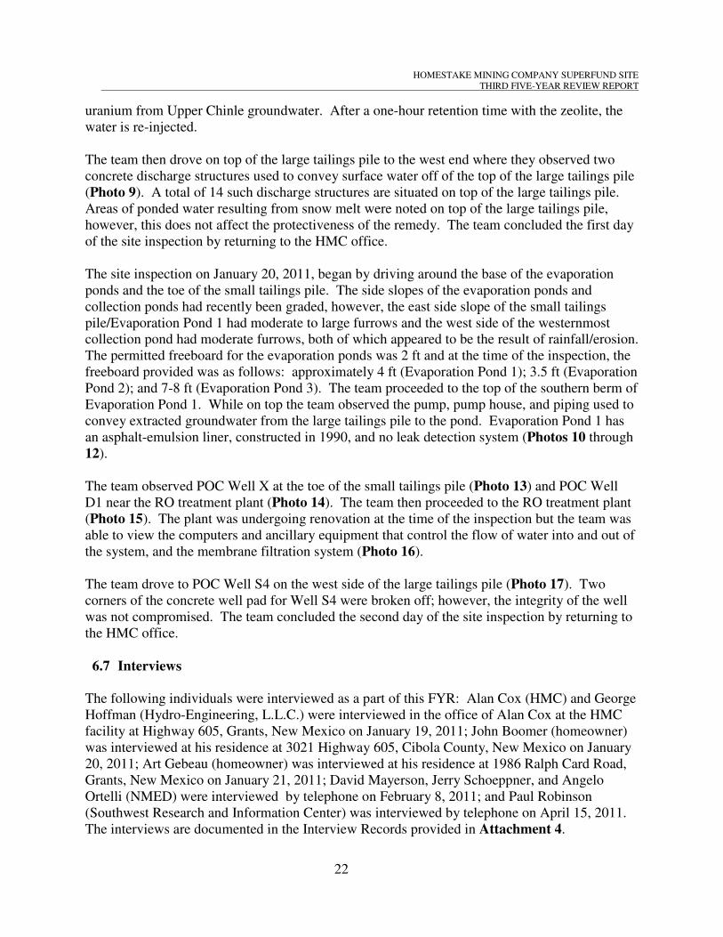
HOMESTAKE MINING COMPANY SUPERFUND SITE
THIRD FIVE-YEAR REVIEW REPORT
uranium from Upper Chinle groundwater. After a one-hour retention time with the zeolite, the
water is re-injected.
The team then drove on top of the large tailings pile to the west end where they observed two
concrete discharge structures used to convey surface water off of the top of the large tailings pile
(Photo 9). A total of 14 such discharge structures are situated on top of the large tailings pile.
Areas of ponded water resulting from snow melt were noted on top of the large tailings pile,
however, this does not affect the protectiveness of the remedy. The team concluded the first day
of the site inspection by returning to the HMC office.
The site inspection on January 20, 2011, began by driving around the base of the evaporation
ponds and the toe of the small tailings pile. The side slopes of the evaporation ponds and
collection ponds had recently been graded, however, the east side slope of the small tailings
pile/Evaporation Pond 1 had moderate to large furrows and the west side of the westernmost
collection pond had moderate furrows, both of which appeared to be the result of rainfall/erosion.
The permitted freeboard for the evaporation ponds was 2 ft and at the time of the inspection, the
freeboard provided was as follows: approximately 4 ft (Evaporation Pond 1); 3.5 ft (Evaporation
Pond 2); and 7-8 ft (Evaporation Pond 3). The team proceeded to the top of the southern berm of
Evaporation Pond 1. While on top the team observed the pump, pump house, and piping used to
convey extracted groundwater from the large tailings pile to the pond. Evaporation Pond 1 has
an asphalt-emulsion liner, constructed in 1990, and no leak detection system (Photos 10 through
12).
The team observed POC Well X at the toe of the small tailings pile (Photo 13) and POC Well
D1 near the RO treatment plant (Photo 14). The team then proceeded to the RO treatment plant
(Photo 15). The plant was undergoing renovation at the time of the inspection but the team was
able to view the computers and ancillary equipment that control the flow of water into and out of
the system, and the membrane filtration system (Photo 16).
The team drove to POC Well S4 on the west side of the large tailings pile (Photo 17). Two
corners of the concrete well pad for Well S4 were broken off; however, the integrity of the well
was not compromised. The team concluded the second day of the site inspection by returning to
the HMC office.
6.7 Interviews
The following individuals were interviewed as a part of this FYR: Alan Cox (HMC) and George
Hoffman (Hydro-Engineering, L.L.C.) were interviewed in the office of Alan Cox at the HMC
facility at Highway 605, Grants, New Mexico on January 19, 2011; John Boomer (homeowner)
was interviewed at his residence at 3021 Highway 605, Cibola County, New Mexico on January
20, 2011; Art Gebeau (homeowner) was interviewed at his residence at 1986 Ralph Card Road,
Grants, New Mexico on January 21, 2011; David Mayerson, Jerry Schoeppner, and Angelo
Ortelli (NMED) were interviewed by telephone on February 8, 2011; and Paul Robinson
(Southwest Research and Information Center) was interviewed by telephone on April 15, 2011.
The interviews are documented in the Interview Records provided in Attachment 4.
22

HOMESTAKE MINING COMPANY SUPERFUND SITE
THIRD FIVE-YEAR REVIEW REPORT
7.0 Technical Assessment
As identified in Section 1.0, the type of review performed is considered to be a policy review.
According to EPA’s Comprehensive Five-Year Review Guidance, a policy review is conducted
for post-SARA (Superfund Amendments and Reauthorization Act) remedial actions that leave
hazardous substances, pollutants, or contaminants on site above levels that allow for unlimited
use and unrestricted exposure, but requires five or more years to complete. The remedial action
for the Homestake Mining Company Superfund Site meets this criterion. EPA guidance also
identifies the trigger for subsequent policy reviews as the signature date of the previous FYR.
The previous FYR Report for this Site was signed on September 26, 2006. This document
constitutes the FYR for the entire site.
This section presents a technical assessment and is formulated based on the answers to Questions
A, B, and C, presented below. As answers were formulated, consideration was given to the
status of the remedial action. For consistency with FYR guidance, each question is summarily
answered yes or no. Supporting information is provided in the previous sections and referenced
documents with additional analysis provided, as needed. Section 7.4 presents a summary of the
technical assessment.
Question A: Is the remedy functioning as intended by the decision documents?
Question B: Are the exposure assumptions, toxicity data, cleanup levels, and remedial action
objectives (RAOs) used at the time of the remedy selection still valid?
Question C: Has any other information come to light that could call into question the
protectiveness of the remedy?
7.1 Question A: Is the remedy functioning as intended by the decision documents?
7.1.1 OPERABLE UNIT 1
Yes.
7.1.1.1 Remedial Action Performance (OU1)
The 1989 ROD did not address the groundwater issues and stated that it was being addressed by
NRC licensing activities. Modern RODs generally contain a summary of the CERCLA process
and the approved remedy, but this project began before CERCLA was enacted and, therefore, the
Preliminary Assessment/Site Inspection, RI/Feasibility Study, and Remedial Design/Remedial
Action process was not done. HMC has been proactive in their response to groundwater
contamination and has cooperated with site regulators throughout the history of the project.
From a protectiveness standpoint, it would appear that potential receptors of impacted
groundwater have been prevented from becoming actual receptors through HMC’s actions.
However, there are other potential protectiveness issues that have emerged during this FYR,
including the following:
23

HOMESTAKE MINING COMPANY SUPERFUND SITE
THIRD FIVE-YEAR REVIEW REPORT
• While the contaminant plumes in the alluvial aquifer appear to be sufficiently characterized
and contained based on planimetric potentiometric data (see Exhibit 10), the complexity of
the system requires additional cross-sections to present a complete picture. For example,
screened intervals of the various remediation-system wells (injection/extraction/monitoring)
within the alluvial sequence are crucial in interpreting the data.
• The bedrock aquifers do not appear to have been adequately characterized, especially with
respect to structural geology but also possibly with respect to correlation of Chinle aquifers,
and planimetric maps by themselves cannot provide the reviewer with sufficient information
to assess capture of site-related contaminants.
• Considerable quantities of water have been pumped from wells in the San Andres aquifer,
which unconformably underlies the Chinle Formation, and reinjected into the alluvial aquifer
for 30+ years for hydraulic control purposes. The natural vertical hydraulic gradient in the
vicinity of the Site was probably upward, or possibly neutral, as is usually the case in valleys.
However, an artificial downward hydraulic gradient has developed due to the remediation,
and coupled with the faulted/fractured nature of the bedrock units may be causing
contaminants to escape vertical containment. In addition, geochemical differences of waters
in the various aquifers may cause precipitation of dissolved minerals within the injection
zones, changing the ground water flow regime.
• The evaporation ponds are the ultimate destination for the onsite COCs, and eventually
Evaporation Pond 1 (EP-1) will be used to consolidate the wastes from all of the evaporation
ponds and collection ponds. This pond has a single liner that is 20 years old with no leak
detection system other than the nearby monitoring wells.
7.1.1.2 System Operations and Maintenance (OU1)
The ROD does not specify the methodology for groundwater remediation, and the remedial
system has evolved over the years on HMC’s initiative. HMC recently constructed a third
evaporation pond (see Exhibit 5), and has been making substantial upgrades to the RO treatment
facility. The complexity of the remedial system requires daily O&M and HMC has full-time
staff engaged for that purpose. This level of O&M appears to be adequate to maintain the
groundwater remedial system.
7.1.1.3 Opportunities for Optimization (OU1)
An RSE was conducted under EPA contract in 2009, and was followed up with an Addendum to
the RSE, prepared by the USACE Environmental and Munitions Center of Expertise in 2010.
The Addendum focused on several specific issues raised by the original RSE. Both documents
recommended changes to the remedial strategy for optimization purposes. Some of the RSE
recommendations may be implemented in the overall context of the remedial process and will be
incorporated into the CAP. HMC is currently implementing several projects that mirror the RSE
recommendations, including pilot testing the rebounding effects of the large tailings pile flushing
24

HOMESTAKE MINING COMPANY SUPERFUND SITE
THIRD FIVE-YEAR REVIEW REPORT
program, and several groundwater treatment technologies including zeolite, bioremediation, and
zero-valent iron.
7.1.1.4 Early Indicators of Potential Issues (OU1)
There have been intermittent elevated concentrations of site-related contaminants in at least one
of the San Andres wells, possibly signaling the downward migration of impacted groundwater.
Under natural conditions, the vertical gradient would be expected to be generally upward or
neutral, owing to the site being in the San Mateo Valley. However, after decades of pumping
water from the San Andres and subsequently injecting it mostly in the alluvial aquifer, a
downward head differential of approximately 100 feet exists in the site area. This artificially
high head differential, coupled with the presence of considerable faulting/fracturing of the Chinle
Formation, could be causing alluvial water to migrate to the San Andres. In addition, mixing of
groundwaters of significantly different geochemical composition may be resulting in
precipitation of minerals, progressively decreasing aquifer permeability in the injection zone.
7.1.1.5 Implementation of Institutional Controls (ICs) and Other Measures (OU1)
The lack of a formal IC process has been an issue in the past. HMC paid for the extension of the
Village of Milan water system to residents of the nearby subdivisions in the 1980s, and paid the
water bills for those users for ten years following hookup. However, approximately 20 years
later it was discovered that new domestic-use wells had been drilled in the area. The second
FYR discusses this situation and its resolution, and in 2009 an agreement between NMED and
HMC took steps to minimize exposure within the area of contamination and minimize the
possibility of new wells being installed. NMED requires that the New Mexico Office of State
Engineer issue a health advisory to every person who applies for a well permit within the area
referenced in the drinking water advisory (Exhibit 7a); and that the advisory be published in two
newspapers of general circulation in Cibola and McKinley Counties (HMC, 2009). Also, HMC
is required to determine if any new wells have been installed within the area of contamination
and report their findings in the annual report.
7.1.2 OPERABLE UNIT 2
7.1.2.1 Remedial Action Performance (OU2)
In 1995, HMC completed the decommissioning of the former mill facility and remediation of
soils impacted by operation of the mill and/or windblown tailings. In addition, the large tailings
pile was re-contoured for stability and an interim radon cover was provided. It was also in the
process of being dewatered to provide the final measure of geotechnical stability needed for
closure of the waste facility. At that time, it was estimated that a few more years of dewatering
would be conducted before constructing the final radon barrier. However, in 2000, HMC began
the tailings flushing program which has postponed OU2 closure indefinitely.
Soil remediation was conducted by using human-health risk criteria. However, it is possible that
sufficient residual contaminant concentrations were left in place that continue to act as a source
25
HOMESTAKE MINING COMPANY SUPERFUND SITE
THIRD FIVE-YEAR REVIEW REPORT
to groundwater through leaching, especially in the areas of the mill site where the uranium ore
was stored. If this leaching is occurring, the OU1 remedy may be prolonged and, therefore, it is
recommended that an assessment of the subject area be conducted with respect to leaching
potential of residual contamination.
7.1.2.2 System Operations and Maintenance (OU2)
The tailings flushing program began in 2000 with a couple of dozen injection wells. More
injection wells have periodically been added over the past ten years. HMC plans to continue
installation of new injection wells in an effort to close gaps in the coverage of flushing water
until the mass-flux of contaminants drops substantially. The flushing program is believed to
have resulted in geochemical changes within the large tailings pile, and the cessation of flushing
may cause a slow return to the original geochemical situation. HMC should include geochemical
parameters in its analytical suite for large tailings-pile wells to assess the geochemical regime,
its affect on the COCs, and to evaluate the potential for long-term reducing conditions and
rebound.
7.1.2.3 Opportunities for Optimization (OU2)
HMC considers the tailings flushing program to be a continual optimization of the OU2 remedy,
by mobilizing additional contaminant mass and subsequently capturing the aqueous-phase
contamination. The RSE and Addendum to the RSE recommended that the tailings flushing
program be reconsidered. HMC is considering the RSE recommendation concerning tailings
flushing and is currently conducting a pilot test to study the rebound in discontinuing the large
tailings pile flushing program. Though not a protectiveness issue, extraction of all flushed
contaminants within the alluvial aquifer prolongs closure of the large tailings pile directly.
7.1.2.4 Early Indicators of Potential Issues (OU2)
No early indicators of potential issues were identified that could place the protectiveness of the
remedy at risk. However, the timeliness for remedy completion is a concern.
7.1.2.5 Implementation of Institutional Controls and Other Measures (OU2)
Following approved closure of the large tailings pile, NRC will implement ICs for the former
mill facility in perpetuity through periodic inspections. Following HMC’s specific license
termination a custodial agency (U.S. Department of Energy) will ensure continued long-term
care, including monitoring and maintenance to protect the public health and safety, as required
by 10 CFR 40.28. At that point, HMC would still be responsible for completing remedial actions
for OU1 by meeting groundwater cleanup standards.
26

HOMESTAKE MINING COMPANY SUPERFUND SITE
THIRD FIVE-YEAR REVIEW REPORT
7.2 Question B: Are the exposure assumptions, toxicity data, cleanup levels, and RAOs
used at the time of the remedy selection still valid?
Yes. However, it should be noted that the exposure assumptions, toxicity data, cleanup levels,
and RAOs used at the time of the remedy selection were all drawn from NRC closure
requirements, NMED requirements, and 40 CFR, Part 192. Additional CERCLA ARARs or
risk-based protectiveness standards have not been comprehensively identified to date.
7.2.1 OPERABLE UNIT 1
7.2.1.1 Changes in Standards and To-Be-Considered Criteria (OU1)
• Have there been changes to risk-based cleanup levels or standards identified as ARARs in
the ROD that call into question the protectiveness of the remedy?
Radiological and some non-radiological contaminants in groundwater are regulated under NRC’s
Corrective Action Program (License SUA-1471) and under the New Mexico Water Quality
Control Commission’s (NMWQCC) groundwater restoration requirements (NMED Discharge
Permit DP-200). The groundwater standards in place at the beginning of the review period are
presented in Table 6.
In 2000, HMC requested updated groundwater standards based on a more detailed evaluation of
background concentrations. The requested standards were based on 95% Upper Tolerance
Limits of background concentrations, which are higher than health risk-based levels and
promulgated legal standards. After coordinating with EPA and NMED, NRC published an
Environmental Assessment in May 2006 and a Finding of No Significant Impact in June 2006.
License Amendment 39 to NRC License SUA-1471 was issued in July 2006 with a more
detailed revised list of groundwater standards, which is presented in Table 7. These
groundwater protection standards have also been incorporated into the NMED discharge permit.
Table 7 shows that uranium is regulated based on site-specific background levels for all zones
except the Lower Chinle Non-Mixing Zone. The NMWQCC groundwater protection standard
for uranium has decreased from 5.0 mg/L to 0.03 mg/L while the molybdenum standard has
decreased from 1.0 mg/L to 0.1 mg/L. The radium-226 and -228, thorium-230, and chloride
groundwater protection standards have remained constant.
7.2.1.2 Changes in Exposure Pathways (OU1)
• Has land use or expected land use on or near the site changed (e.g., industrial to residential,
commercial to residential)?
Land use in OU1 has been primarily agricultural with some low density residential use. The
region has experienced the “boom and bust” cycle of the Grants Uranium Mining Belt with the
trend being toward declining populations since 1992. Future land use in the area of the Site is
anticipated to be similar to current uses, although there is talk of a rebound in the uranium
27

HOMESTAKE MINING COMPANY SUPERFUND SITE
THIRD FIVE-YEAR REVIEW REPORT
mining industry that might create another “boom” in the local economy and draw in more
people. The city of Milan has annexed property southwest of the Site for creation of a
subdivision.
• Have any human health or ecological routes of exposure or receptors changed or been newly
identified (e.g., dermal contact where none previously existed, new populations or species
identified on site or near the site) that could affect the protectiveness of the remedy?
No human health or ecological routes of exposure or receptors have changed or been newly
identified that could affect the protectiveness of the remedy at OU1.
• Are there newly identified contaminants or contaminant sources?
No new contaminants or contaminant sources were identified at OU1 during the FYR. However,
recently-constructed EP-3 should be considered a potential source. EP-3 was constructed with a
double-lined synthetic liner, a leak detection system, and pipes to carry the reclamation water to
the pond for evaporation. A monitoring well proposed near the southeast side of the EP-3
location will monitor the alluvial aquifer downgradient of EP-3.
• Are there unanticipated toxic byproducts of the remedy not previously addressed by the
decision documents (e.g., byproducts not evaluated at the time of remedy selection)?
No unanticipated toxic byproducts of the remedy have been identified at OU1.
• Have physical site conditions (e.g., changes in anticipated direction or rate of groundwater
flow) or the understanding of these conditions (e.g., changes in anticipated direction or rate
of groundwater flow) changed in a way that could affect the protectiveness of the remedy?
No changes in site conditions were identified at OU1 during this FYR that would affect exposure
pathways. There have been no land-use changes, although it is possible that a rebound in
uranium mining might fuel a “boom” in the area. No new contaminants, sources, or routes of
exposure were identified. The aquifers have been better characterized than when the original
groundwater protection standards were determined. The groundwater protection standards have
been adjusted to incorporate new knowledge concerning background values and the presence or
absence of specific contaminants in different zones.
7.2.1.3 Changes in Toxicity and Other Contaminant Characteristics (OU1)
• Have toxicity factors for contaminants of concern at the site changed in a way that could
affect the protectiveness of the remedy?
Toxicity values for COCs that have changed since the last FYR are summarized in Table 9.
Using the 2004 Region 9 Preliminary Remediation Goals (PRGs) Table for the toxicity values
that would most likely have been in place in 2006, toxicity values for three chemicals of concern
have changed. A Reference Dose has been put into place in the Integrated Risk Information
28

HOMESTAKE MINING COMPANY SUPERFUND SITE
THIRD FIVE-YEAR REVIEW REPORT
System (IRIS) for nitrate. Selenium has a Reference Concentration that has been added to IRIS;
however, the inhalation pathway is not significant for selenium exposures from drinking water.
The Reference Dose for uranium has increased by 15-fold, indicating that the estimate of oral
toxicity of uranium decreased by 15-fold. A Reference Concentration for uranium has also been
posted to IRIS, but is not relevant to exposures to uranium in drinking water.
• Have other contaminant characteristics changed in a way that could affect protectiveness of
the remedy?
Other contaminant characteristics have not changed in a way that would affect the protectiveness
of the remedy.
7.2.1.4 Changes in Risk Assessment Methods (OU1)
• Have standardized risk assessment methodologies changed in a way that could affect the
protectiveness of the remedy?
Risk assessment methodologies have not changed in a way that could affect the protectiveness of
the remedy.
7.2.1.5 Expected Progress Towards Meeting RAOs (OU1)
The RAOs for groundwater restoration are defined in License SUA-1471, the groundwater CAP,
NMED DP-200, and the 1983 agreement between EPA and HMC. Progress toward meeting
each of the OU1 RAOs is described below:
• Limit radon emissions from the tailings impoundments
o A radon barrier and an erosion-protection cover were constructed on the sides of the large
tailings pile, and an interim soil cover was constructed on the top and on the sides of the
small tailings pile
• Remediate contamination in soil that resulted from windblown tailings
o Excavation of surface soil contaminated with windblown tailings and disposal occurred
between 1988 and 1995
• Remediate groundwater to levels stipulated in License SUA-1471 and NMED DP-200
o Although significant efforts have taken place since 1977 toward the remediation of
groundwater, cleanup standards have not been achieved at the POC wells
• Dewater the large tailings pile to remove this area as a continuing source of groundwater
contamination
o The tailings pile flushing program has delayed dewatering of the large tailings pile and,
therefore, this area continues to serve as a source of groundwater contamination
• Prevent the consumption of contaminated groundwater by residents in the subdivisions
29

HOMESTAKE MINING COMPANY SUPERFUND SITE
THIRD FIVE-YEAR REVIEW REPORT
o Between 1983 and 1985 HMC provided for an extension of the Village of Milan
municipal water system to the affected residents in four residential subdivisions located
south and southwest of the Site, and paid for the residents’ use of the water supply until
1994. Since the last FYR, HMC financed the hook-up of additional residential properties
to the Village of Milan water system. A health advisory was also issued to minimize the
possibility of new wells being installed within the area of contamination. This health
advisory, however, does not prevent the residents from drinking contaminated
groundwater or using it for irrigation purposes or for watering livestock.
7.2.2 OPERABLE UNIT 2
7.2.2.1 Changes in Standards and To-Be-Considered Criteria (OU2)
• Have there been changes to risk-based cleanup levels or standards identified as ARARs in
the ROD that call into question the protectiveness of the remedy?
The cleanup criteria for OU2 were based on the NRC requirements in 10 CFR 40, Appendix A,
Criterion 6, which are repeated in the EPA requirements specified in 40 CFR 192. These
regulations include a cleanup standard for radium-226 in the top 15 centimeters (cm) of soil of 5
picocuries/gram (pCi/g) above background and 15 pCi/g above background for each 15-cm depth
increment below the top 15 cm. The background level for radium-226 at the mill site was
established as 5.5 pCi/g. Therefore, the cleanup standards were 10.5 pCi/g for the top 15 cm of
soil, 20.5 pCi/g for the next, 15-cm depth increment, increasing by 15 pCi/g for each successive
15 cm of depth. This standard has not changed. There are, therefore, no changes in these
standards that would call into question the protectiveness of the remedy.
The requirements in 10 CFR 40, Appendix A, Criterion 6 (6) were revised to include a
benchmark dose criterion to address residual uranium and thorium during mill cleanups. Though
the requirement does not apply to sites with a previously-approved decommissioning plan, NRC
has indicated that it would be applied to new areas contaminated by spraying or future cleanup
actions that the Site.
7.2.2.2 Changes in Exposure Pathways (OU2)
• Has land use or expected land use on or near the site changed (e.g., industrial to residential,
commercial to residential)?
OU2 is still a licensed uranium mill tailings disposal site. Land use near OU2 has been primarily
agricultural with some low density residential use. The region has experienced the “boom and
bust” cycle of the Grants Uranium Mining Belt with the trend being toward declining
populations since the 1990s. Future land use in the area of the Site is anticipated to be similar to
current uses, although there is talk of a rebound in the uranium mining industry that might create
another “boom” in the local economy and draw in more people.
30

HOMESTAKE MINING COMPANY SUPERFUND SITE
THIRD FIVE-YEAR REVIEW REPORT
• Have any human health or ecological routes of exposure or receptors changed or been newly
identified (e.g., dermal contact where none previously existed, new populations or species
identified on site or near the site) that could affect the protectiveness of the remedy?
No human health or ecological routes of exposure or receptors have changed or been newly
identified that could affect the protectiveness of the remedy at OU2.
• Are there newly identified contaminants or contaminant sources?
No new contaminants or contaminant sources were identified at OU2 during the FYR.
• Are there unanticipated toxic byproducts of the remedy not previously addressed by the
decision documents (e.g., byproducts not evaluated at the time of remedy selection)?
No unanticipated toxic byproducts of the remedy have been identified at OU2.
• Have physical site conditions (e.g., changes in anticipated direction or rate of groundwater
flow) or the understanding of these conditions (e.g., changes in anticipated direction or rate
of groundwater flow) changed in a way that could affect the protectiveness of the remedy?
No changes in site conditions were identified at OU2 during this FYR that would affect exposure
pathways. There have been no land-use changes nor are any land-use changes anticipated. No
new contaminants, sources, or routes of exposure were identified.
7.2.2.3 Changes in Toxicity and Other Contaminant Characteristics (OU2)
Toxicity values for radium-226, radium-228, and thorium -230 have not changed since the last
FYR.
• Have other contaminant characteristics changed in a way that could affect protectiveness of
the remedy?
Other contaminant characteristics have not changed in a way that would affect the protectiveness
of the remedy.
7.2.2.4 Changes in Risk Assessment Methods (OU2)
Risk assessment methodologies have not changed in a way that could affect the protectiveness of
the remedy. The method of calculating cancer and non-cancer risks by the inhalation exposure
route were changed in the Risk Assessment Guidance for Superfund (RAGS) Part F (EPA,
2009), but this change should not result in risk estimate changes sufficient to affect the
protectiveness of the remedy.
31

HOMESTAKE MINING COMPANY SUPERFUND SITE
THIRD FIVE-YEAR REVIEW REPORT
7.2.2.5 Expected Progress Towards Meeting RAOs (OU2)
The RAOs for decommissioning the mill, surface reclamation, long-term stabilization of the
tailings and closure are defined in License SUA-1471. To date, HMC has completed the
following OU2 remedial activities at the Site:
• Decontamination of the mill facilities and equipment
• Demolition of the mill facilities and equipment
• Burial of contaminated debris and asbestos-containing materials in the out slope of the large
tailings pile
• Burial of uncontaminated debris and equipment in pits on the mill site
• Excavation of surface soils contaminated with windblown tailings and burial in the out slope
of the large tailings pile
• Construction of a temporary radon barrier on the two tailings piles to minimize radon
emissions and reduce erosion
Closure of the tailings piles has been delayed as a result of the tailings flushing program and
soils remediation conducted as part of the mill decommissioning may have left contaminants in
place that continue to leach contaminants to the groundwater.
7.2.3 OPERABLE UNIT 3
7.2.3.1 Changes in Standards and To-Be-Considered Criteria (OU3)
• Have there been changes to risk-based cleanup levels or standards identified as ARARs in
the ROD that call into question the protectiveness of the remedy?
There is no identified cleanup standard for OU3. The EPA action level for radon in homes of 4.0
pCi/L was used to make house-specific radon reduction recommendations to residents and has
not changed. This is the only standard relevant to OU3.
7.2.3.2 Changes in Exposure Pathways (OU3)
• Has land use or expected land use on or near the site changed (e.g., industrial to residential,
commercial to residential)?
The only recent land-use change on Site has been the recent construction of EP-3. Land use near
the Site is primarily agricultural with low-density residential. The population trend since the
1990s has been on the decline, although a rebound in uranium mining might result in a regional
“boom.” Land use is not expected to change significantly in the area.
• Have any human health or ecological routes of exposure or receptors changed or been newly
identified (e.g., dermal contact where none previously existed, new populations or species
identified on site or near the site) that could affect the protectiveness of the remedy?
32

HOMESTAKE MINING COMPANY SUPERFUND SITE
THIRD FIVE-YEAR REVIEW REPORT
The human health route of exposure and receptors have not changed nor have additional routes
of exposure or receptors been newly identified that could affect the protectiveness of the remedy
at OU3. Ecological receptors are not considered for OU3. In September 2010 EPA began
collecting sample data to support the development of a Human Health Risk Assessment, to
include indoor and outdoor radon samples. The sample collection will continue on a quarterly
basis until November 2011. A final Human Health Risk Assessment is expected in spring 2012
which will provide information needed to support a protectiveness determination of the OU3
remedy.
• Are there newly identified contaminants or contaminant sources?
No new contaminants or contaminant sources were identified at OU3 during the FYR.
• Are there unanticipated toxic byproducts of the remedy not previously addressed by the
decision documents (e.g., byproducts not evaluated at the time of remedy selection)?
No unanticipated toxic byproducts of the remedy have been identified at OU3.
• Have physical site conditions (e.g., changes in anticipated direction or rate of groundwater
flow) or the understanding of these conditions (e.g., changes in anticipated direction or rate
of groundwater flow) changed in a way that could affect the protectiveness of the remedy?
No changes in site conditions were identified at OU3 during this FYR that would affect exposure
pathways. There have been no land-use changes nor are any land-use change anticipated. No
new contaminants, sources, or routes of exposure were identified. There is no indication that
hydrologic or geologic conditions were inadequately characterized. The contaminant levels in
the groundwater are consistent with expectations at the time of the ROD.
7.2.3.3 Changes in Toxicity and Other Contaminant Characteristics (OU3)
There has been no change in the toxicity factors for radon.
• Have other contaminant characteristics changed in a way that could affect protectiveness of
the remedy?
Other contaminant characteristics have not changed in a way that would affect the protectiveness
of the remedy.
7.2.3.4 Changes in Risk Assessment Methods (OU3)
Risk assessment methodologies have not changed in a way that could affect the protectiveness of
the remedy. The method of calculating cancer and non-cancer risks by the inhalation exposure
route were changed in RAGS Part F (EPA, 2009), but this change should not result in risk
estimate changes sufficient to affect the protectiveness of the remedy.
33

HOMESTAKE MINING COMPANY SUPERFUND SITE
THIRD FIVE-YEAR REVIEW REPORT
7.2.3.5 Expected Progress Towards Meeting RAOs (OU3)
Because the ROD for OU3 identified No Further Action, there are no current RAOs.
7.3 Question C: Has any other information come to light that could call into question
the protectiveness of the remedy?
Yes. The annual air monitoring reports 2006 – 2010 indicate releases of radon gas outside
the area covered by NRC license in concentrations exceeding EPA standards and potential
ARARs. Over the last few years, the radon air monitors at the Homestake fenceline
(especially air monitors HMC#4 and HMC#5, the closest monitors to the residential
community) have been continuously recording outdoor ambient air radon concentrations
-3 associated with 1 x 10 and higher cancer risk levels. The cancer risks are greater than the
-4 -6 EPA’s acceptable cancer risk range of 1 x 10 to 1 x 10 as published in the NCP.
Therefore the EPA is currently conducting a risk assessment to determine the protectiveness
of human health.
7.3.1 Ecological Risks
With respect to OU1, contaminants occur in groundwater with no identified releases to surface
water. They are, therefore, not expected to adversely affect environmental receptors at the Site.
With respect to OU2, nothing has changed that would affect the protectiveness of the remedy.
With respect to OU3, radon entering houses and buildings is not expected to affect ecological
receptors.
Overall, no information has been found with respect to ecological receptors that would call into
question the protectiveness of the remedy.
7.3.2 Natural Disaster Impacts
The large tailings pile has been engineered to withstand the probable maximum flood event
occurring within the San Mateo Creek watershed, and the probable maximum earthquake event,
although it is unclear whether the earthquake stability analysis assumed unsaturated tailings. In
light of the relatively recent tailings flushing program, which has increased the percentage of
fluid-filled pore-space, this issue should be revisited. Although this part of New Mexico is not as
seismically active as the Rio Grande Valley to the east-southeast, earthquakes do occur in the
Grants area, and the large tailings pile sits above a fault.
With respect to the continued competence of the tailings piles and other engineered structures,
volcanism may pose the highest potential risk from a natural disaster standpoint. The Site is
within the Jemez Lineament, a zone of crustal weakness that has experienced periodic eruptions
34

HOMESTAKE MINING COMPANY SUPERFUND SITE
THIRD FIVE-YEAR REVIEW REPORT
over the past 16 million years. The Bluewater basalt flow that originated from the El Tintero
cinder cone approximately eight miles northwest of the site came to within a mile of the west
side of the large tailings pile, and is dated at approximately 50,000 years before present. The
McCarty’s basalt flow southeast of Grants may be as young as a few hundred years. Obviously
it is not practical to engineer for a potential basalt flow in the area, and there would likely be
bigger concerns should renewed volcanism occur, but it should be understood that it is a
possibility that could compromise the integrity of engineered structures at the Site. Also, the
waste disposal area design should provide a reasonable assurance that it will effectively control
radiological hazards for 1,000 years, to the extent reasonably achievable, and, in any case, for at
least 200 years (10 CFR 40, Appendix A, Criterion 6 (1)).
7.3.3 Any Other Information That Could Call Into Question the Protectiveness of the
Remedy
Although the OU3 ROD called for no further action, EPA recognized the need to monitor
outdoor radon and windblown particulate levels south of the disposal area to ensure that
conditions in the subdivisions remain protective until final site closure. Therefore, in September
2010, EPA began collecting sample data to support the development of a Human Health Risk
Assessment, to include indoor and outdoor radon samples. The sample collection will continue
on a quarterly basis until September 2011. A final Human Health Risk Assessment is expected
in March 2012. A determination of the protectiveness of the remedy for OU3 is deferred until
the HHRA is completed.
7.4 Technical Assessment Summary
The relatively small groundwater remediation system that started in 1977 has become a large,
complex system costing in excess of $3 million per year to operate and maintain. HMC has been
proactive and creative throughout the process in its efforts to maintain an appropriate level of
protectiveness to the nearby residents. However, after 34 years of aggressively working to
remediate groundwater, contamination levels remain that are up to three orders of magnitude
greater than the action levels.
The groundwater remediation can actually be broken down into three phases when considering
contaminant flux. From 1977 to approximately 1990 the milling operation was active and,
during that time, contaminant flux was kept steady due to continued processing of ore. From
approximately 1990 to 2000, contaminant flux presumably declined because no new mass was
added into the system. From 2000 to the present, the tailings flushing program has increased the
contaminant flux due to the enhanced mobilization of contaminants from the fines portion of the
tailings.
Due to the age of the project and the large volume of documents generated over the 30+ years
since project inception, this FYR focused on those documents thought to be relevant to an overall
understanding of the site rather than detailed analyses of the various components of the complex
remedial system. This general technical assessment includes the following observations:
35

HOMESTAKE MINING COMPANY SUPERFUND SITE
THIRD FIVE-YEAR REVIEW REPORT
• The remedial system is somewhat unconventional with its considerable use of injection wells
as part of the system; however, the injection of “clean” water into the alluvium continues to
be an important component of the remedy to maintain hydraulic control and prevent potential
breakthrough of the contaminant plume downgradient.
• The remedial system began operating 34 years ago, and although system operation has
removed contaminants from the impacted aquifers, clean-up contaminant concentrations have
not been achieved.
• Injection of “clean” water into the alluvial aquifer and continual modification of the system
results in an inability to determine meaningful concentration trends. This has also increased
the downward hydraulic-head differential which puts vertical containment at risk.
Progressive reduction of permeability may occur due to mineral precipitation in injection
zones due to significant geochemical differences of the various aquifers.
• The documents reviewed generally do not include sufficient information on the
hydrogeologic conceptual model in which the engineered system operates, including
geochemical considerations.
• The persistence of some portions of the contaminant plumes may be indicative of residual
soil source(s) left in place during the mill decommissioning process.
Since a health advisory has been issued to minimize the possibility of new water-supply wells
being installed in the project area, the primary concern with the protectiveness of the OU1 and
OU2 remedies are timeliness and vertical containment.
HMC has continued to remove contaminant mass from the groundwater, and has continually
adjusted the unconventional remedial system in efforts to remediate the Site. However, there
may be significant residual soil sources beneath the former ore storage areas that continue to
leach contaminants to groundwater, and the tailings flushing program has mobilized
contaminants that may be better left in place in the large tailings pile. The current remedial
strategy may result in delaying closure of OU1 and OU2 indefinitely. In addition, injection of
clean water for hydraulic control purposes has created a situation where it is nearly impossible to
determine how much progress has been made by diluting some parts of the aquifers and pushing
contaminants into other areas. The system is modified so frequently that the hydrologic regime
is in a constant state of flux. An unintended consequence of the injection programs may be loss
of containment below the alluvium due to the faulted/fractured bedrock and persistence of
significant downward vertical hydraulic gradients that have been artificially created.
The system is complicated and the results of the current pilot study should be evaluated to
determine whether rebounding will occur once the flushing program has ended. Construction of
a final engineered radon/recharge reduction cover on the large tailings pile will result in
drastically lower contaminant flux in this semi-arid climate. Current plans call for all solid
wastes from the collection and evaporation ponds to be placed in EP-1. EP-1 is the oldest of the
36

HOMESTAKE MINING COMPANY SUPERFUND SITE
THIRD FIVE-YEAR REVIEW REPORT
evaporation ponds, has only a single liner near the end of its design life, and no dedicated leak
detection system.
37

HOMESTAKE MINING COMPANY SUPERFUND SITE
THIRD FIVE-YEAR REVIEW REPORT
8.0 Issues
Issues that affect either the protectiveness of the remedy, the timeliness of the remedy, or both
are presented in Table 1.
38

HOMESTAKE MINING COMPANY SUPERFUND SITE
THIRD FIVE-YEAR REVIEW REPORT
9.0 Recommendations and Follow-up Actions
Table 2 presents a recommended action to address the potential issues identified in Section 8.0.
While not all of the issues relate to protectiveness, some relate more to timeliness of the remedy.
While timeliness is not a protectiveness issue, there is an indirect correlation since Site workers
are subject to more cumulative exposure the longer remediation continues.
39
HOMESTAKE MINING COMPANY SUPERFUND SITE
THIRD FIVE-YEAR REVIEW REPORT
10.0 Protectiveness Statement
The remedy, exclusive of OU3 at the Homestake Mining Company Site, is protective of human
health and the environment through the combined effects of HMC’s ongoing ground water
remedial action with associated ground water monitoring, and the dissemination of a health
advisory through the State’s well permitting process, which advises prospective wellowners of
the potential existence of ground water exceeding drinking water standards. Potential exposure
to onsite contamination has been minimized through stabilization of the tailings piles, surface
reclamation, and decommissioning of the former mill. Radon barrier and erosion protection
covers were constructed on the sides of the large tailings pile, and an interim soil cover was
constructed on its top and on the small tailings pile. Groundwater contamination is controlled
through the use of a groundwater collection and injection system and issuance of a health
advisory to limit the primary exposure pathway of ingestion.
Based on current information, the remedy at OU1 is protective of human health and the
environment through the use of a groundwater collection and injection system at the Site and the
use of a health advisory which limits the primary exposure pathway of ingestion. There is no
evidence of current exposure from any media at this time.
Based on current information, the remedy at OU 2 is protective of human health and the
environment due to the stabilization of the tailings piles, surface reclamation, and
decommissioning of the mill. Soil contaminated by windblown tailings was excavated and
disposed of in the large tailings pile and the mill facility was decontaminated, demolished, and
parts were either buried in place or placed in the large tailings pile. A radon barrier and erosion
protection cover were constructed on the sides of the large tailings pile, and an interim soil cover
was constructed on its top and on the small tailings pile.
Even though the OU3 ROD called for no further action, EPA recognized the need to monitor
outdoor radon and windblown particulate levels south of the disposal area to ensure that
conditions in the subdivisions remain protective until final site closure. Therefore, EPA
continues to review outdoor radon monitoring and particulates data collected at the facility
boundary. Also, in September 2010, EPA began collecting sample data to support the
development of a Human Health Risk Assessment, to include indoor and outdoor radon samples.
The sample collection will continue on a quarterly basis until September 2011. A final Human
Health Risk Assessment is expected in March 2012 which will provide information needed to
support a determination of the protectiveness of the OU3 remedy. The determination of
protectiveness for OU3 is, therefore, deferred until the Human Health Risk Assessment is
completed.
40

11.0 Next Review
The next FYR will be conducted within five years of the signature date of this review by EPA.
41

TABLES

Table 1
Issues
Homestake Mining Company Superfund Site
Cibola County, New Mexico
Issue No.
Issue Affects Protectiveness
(Y/N) Current Future
Operable Unit 1
1
Extraction of large quantities of water from the San
Andres Formation and subsequent injection,
primarily into the alluvial aquifer, has created
localized areas with an artificial head difference of
approximately 100 ft that, combined with the
presence of faults and associated fracturing in the
bedrock, increases the risk of downward migration
of contaminants.
No Yes
2
Rebound conditions are unknown in the tailings
flushing program. The flushing program is also
likely decreasing the stability of the large tailings
pile due to the increased saturation of the pore
spaces. The earthquake stability analysis assumed
unsaturated tailings and did not account for the
increased percentage of fluid-filled pore space
resulting from the relatively recent tailings flushing
program.
No Yes
Operable Unit 2
1
A persistent plume of elevated uranium
contamination just south of the former mill site may
be a remnant of the large tailings pile contaminant
plume and may continue to impact groundwater. In
addition, an historic irrigation ditch established in
the 1920s that ran through the future Homestake
Mill property, and presumably was backfilled to
original grade during construction of the mill, may
be serving as a preferential pathway for leached
contaminants to groundwater.
No Yes
2
The east side slope of the small tailings
pile/Evaporation Pond 1 had moderate to large
furrows and the west side of the westernmost
collection pond had moderate furrows, both of
which appeared to be the result of rainfall/erosion.
No No
Operable Unit 3
1
Annual air monitoring reports in 2006 – 2010
indicate releases of radon outside the area covered
by the NRC license, in concentrations exceeding
EPA standards.
Yes Yes
1
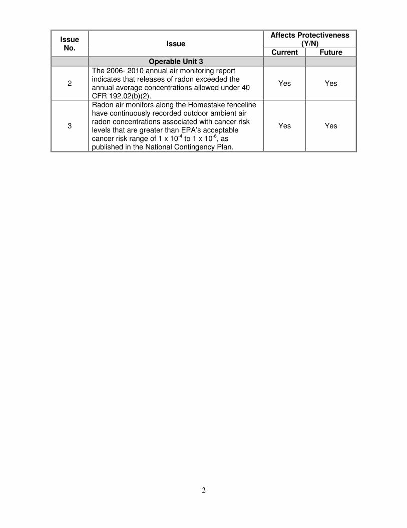
Issue No.
Issue Affects Protectiveness
(Y/N) Current Future
Operable Unit 3
2
The 2006- 2010 annual air monitoring report
indicates that releases of radon exceeded the
annual average concentrations allowed under 40
CFR 192.02(b)(2).
Yes Yes
3
Radon air monitors along the Homestake fenceline
have continuously recorded outdoor ambient air
radon concentrations associated with cancer risk
levels that are greater than EPA’s acceptable
cancer risk range of 1 x 10 -4
to 1 x 10 -6
, as
published in the National Contingency Plan.
Yes Yes
2
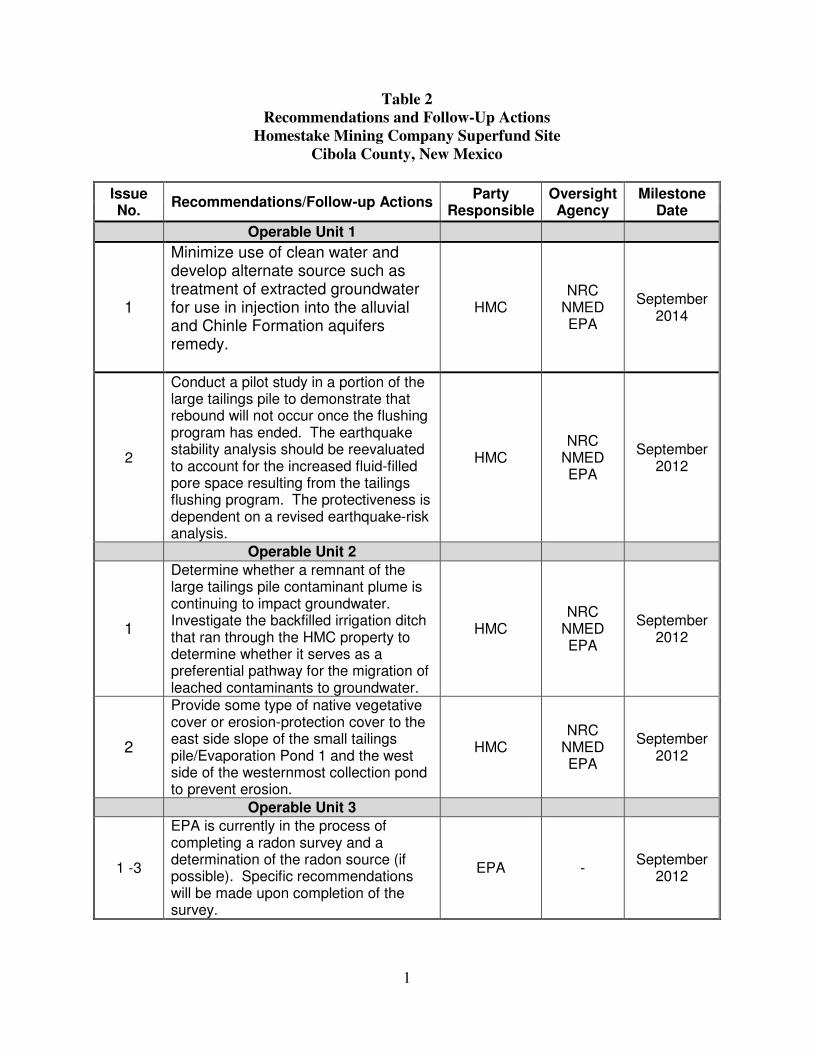
Table 2
Recommendations and Follow-Up Actions
Homestake Mining Company Superfund Site
Cibola County, New Mexico
Issue No.
Recommendations/Follow-up Actions Party
Responsible Oversight Agency
Milestone Date
Operable Unit 1
1
Minimize use of clean water and
develop alternate source such as
treatment of extracted groundwater
for use in injection into the alluvial
and Chinle Formation aquifers
remedy.
HMC
NRC
NMED
EPA
September
2014
2
Conduct a pilot study in a portion of the
large tailings pile to demonstrate that
rebound will not occur once the flushing
program has ended. The earthquake
stability analysis should be reevaluated
to account for the increased fluid-filled
pore space resulting from the tailings
flushing program. The protectiveness is
dependent on a revised earthquake-risk
analysis.
HMC
NRC
NMED
EPA
September
2012
Operable Unit 2
1
Determine whether a remnant of the
large tailings pile contaminant plume is
continuing to impact groundwater.
Investigate the backfilled irrigation ditch
that ran through the HMC property to
determine whether it serves as a
preferential pathway for the migration of
leached contaminants to groundwater.
HMC
NRC
NMED
EPA
September
2012
2
Provide some type of native vegetative
cover or erosion-protection cover to the
east side slope of the small tailings
pile/Evaporation Pond 1 and the west
side of the westernmost collection pond
to prevent erosion.
HMC
NRC
NMED
EPA
September
2012
Operable Unit 3
1 -3
EPA is currently in the process of
completing a radon survey and a
determination of the radon source (if
possible). Specific recommendations
will be made upon completion of the
survey.
EPA -September
2012
1

Notes:
HMC Homestake Mining Company
NMED New Mexico Environment Department
NRC Nuclear Regulatory Commission
2
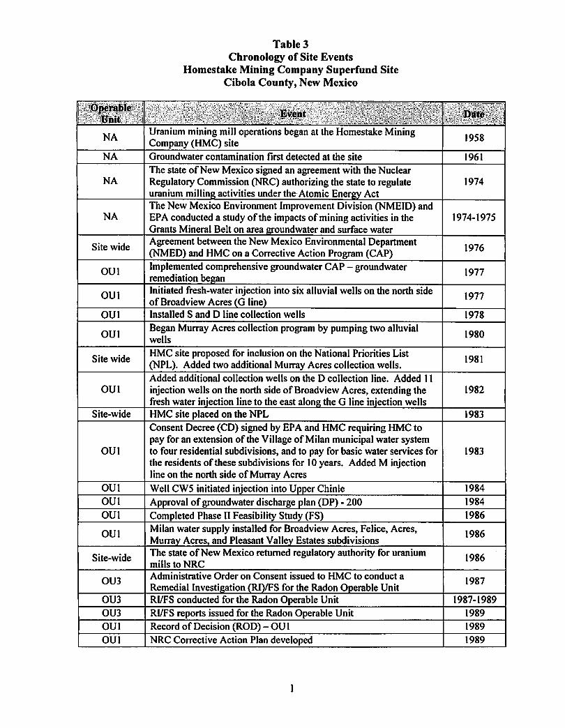
Table 3 Chronology of Site Events
Homestake Mining Company Superfund Site Cibola County, New Mexico
NA Uranium mining mill operations began at the Homestake Mining Company (HMC) site 1958
NA Groundwater contamination first detected at the site 1961 The state ofNew Mexico signed an agreement with the Nuclear
NA Regulatory Commission (NRC) authorizing the state to regulate 1974 uranium millin activities under the- Atomic Ener Act The New Mexico Environment Improvement Division (NMEID) and
NA EPA conducted a study of the impacts of mining activities in the 1974-1975 Grants Mineral Belt on area oundwater and surface water
Site wide Agreement between the New Mexico Environmental Department (NMED) and HMC on a Corrective Action Program (CAP) 1976
OUI Implemented comprehensive groundwater CAP - groundwater remediation be an
1977
OUI Initiated fresh-water injection into six alluvial wells on the north side of Broadview Acres G line
1977
OUI Installed Sand D line collection wells 1978
OUI Began Murray Acres collection program by pumping two alluvial wells 1980
Site wide HMC site proposed for inclusion on the National Priorities List (NPL). Added two additional Murray Acres collection wells.
1981
Added additional collection wells on the D collection line. Added II OUI injection wells on the north side of Broadview Acres, extending the 1982
fresh water in'ection line to the east alon the G line in'ection wells Site-wide HMC site placed on the NPL 1983
Consent Decree (CD) signed by EPA and HMC requiring HMC to pay for an extension ofthe Village of Milan municipal water system
OUI to four residential subdivisions, and to pay for basic water services for 1983 the residents of these subdivisions for 10 years. Added M injection line on the north side of Murray Acres
OUI Well CW5 initiated injection into U er Chinle 1984 OUI Ap roval of groundwater discharge Ian (DP) - 200 1984 OUI Completed Phase II Feasibility Study (FS) 1986
OUI Milan water supply installed for Broadview Acres, Felice, Acres, Murra Acres, and Pleasant Valle Estates subdivisions
1986
Site-wide The state ofNew Mexico returned regulatory authority for uranium mills to NRC
1986
OU3 Administrative Order on Consent issued to HMC to conduct a Remedial Investi ation RI IFS for the Radon 0 erable Unit
1987
OU3 RIIFS conducted for the Radon Operable Unit 1987-1989 OU3 RIIFS reports issued for the Radon Operable Unit 1989 OUI Record of Decision (ROD) - OU I 1989 OUI NRC Corrective Action Plan developed 1989

" i: ,1"~V~nT,.", <~2B'.:t:,(i~l!i!~j'!'iJ:~ if~~!~~:fij:ill':'~'~''f},'::')':1' '.i'''i'iV ,,' >:.'j:( i'I>,'" "'.'.";":;"'/
ROD for the Radon Operable Unit selecting no further action was OU3 1989
necessary Site-wide Uranium milling operations at the site ceased 1990
Modified Murray Acres collection system by closing well AWand adding collection wells E, Z, and JC. Added injection well AW OUI 1990(Murray Acres) and wells GWl, GW2, and GW3 (north of Broadview Acres) to the iniection system.
OUI 1990 OUI
Started using Evaporation Pond No. 1 Installed toe drains around the tailings 1992 Began reclamation activities to clean up soils and decommission the OU2 1993mill. Reclamation plan submitted to NRC. Memorandum of Understanding signed by EPA Region 6 and NRC
Site-wide 1993 HMCsite Turned off the last two Murray Acres collection wells. Added three wells in the K line to the collection program. Upgradient P wells
Region 4 detailing each agency's responsibilities and authority at the
OUI 1993began pumping upgradient alluvial water and transferring it to the drainaf!e to the west.
OU2 1993 OUI
Re-contoured west side oflarge tailings pile 1993
OUI Ceased operation ofGW injection wells
1993 OUI
J injection line started EPA released HMC from 1983 CD 1994
OUI Added additional K line wells 1994 OU2 Re-contoured east side of large tailings pile 1994
Drilled additional downgradient wells in the alluvial aquifer and OUI 1995/1996Chinle fonnations
OU2 1995 Began collection of lower concentration water for re-injection into the Completed demolition ofthe mill and surface reclamation activities
OUI 1995hif!her concentration areas in the alluvial aauifer
OU2 1995 Began using C collection wells. Ceased injection into Upper Chinle Tested dewatering of the large tailings pile
OUI 1995well CW5.
OUI 1996 OUI
Extended M injection line to the north 1996
OUI Began using Evaporation Pond No.2
1996 Resumed injection into Upper Chinle well CW5. Initiated injection
OUI
Initiated fresh-water injection in Upper Chinle well CW13
1997 wells. Ceased injection into Murray Acres well AW. Added additional
into Middle Chinle well CWI4. Installed additional M injection
1998OUI uPf!fadient collection wells.
OU2 1999 Added reverse osmosis (RO) unit to treat water and produce RO Soil cleanup and mill reclamation approved by NRC
1999OUI product water for iniection into the alluvial aauifer
OUI 1999 Moved M injection line to the WR injection line; initiated irrigation Initiated collection from Upper Chinle well CE2
2000OUI of270 acres; and initiated injection into Upper Chinle well CW25.
OU2 2000Initiated flushing program for the large tailings pile.
2

Site-wide First EPA Five-year Review (FYR) approved. 2001 OUI Added 60 acres of irrigation area 2002
OUI
Initiated fresh-water injection in Section 28; fresh-water injection into Upper Chinle well 944; fresh-water injection into the alluvial aquifer east of Felice Acres; and fresh-water injection east of Broadview Acres.
2002
OU2 Second RO unit added to the treatment plant to increase RO treatment capacity from 300 to 600 l!:allons per minute
2002
OU2 Added fresh-water injection line west of the large tailings pile. Initiated fresh-water injection into Section 3.
2003
OU2 Added 24 acres of flood irrigation area in Section 33; injection lines in Section 3; and injection lines east of Broadview Acres and in southern Felice Acres.
2004
OUI
Expansion of groundwater collection and irrigation system completed - added 40 acres of irrigation to the Section 28 center pivot; extended the S injection line west of the large tailings pile to the north; added fresh-water injection lines NPI - NP8 in Sections 27 and 28; initiated injection into NP I - NP6; added three fresh-water injection lines to the east of the large tailings pile; added freshwater injection lines EBA3 - EBA5 near the L collection line; added injection lines EMA I - EMA5 to the south and west of the large tailings pile; and initiated fresh-water injection into EMA I and RO product water into EMA2 -EMA5.
2005
OUI NMED approved revised site groundwater background concentrations for each aquifer unit
2005
OUI NMED performed sampling of residential wells at nearby subdivisions
2005
OUI Implemented Revised CAP 2006 Site-wide Second EPA FYR approved 2006
Site -wide EPA begins a Remedy System Evaluation 2008 Site-wide NMED issues a Health Advisory to limit ground water exposure 2009
Site-wide Memorandum of Agreement between NMED and HMC to provide water hook-ups to residents
2009
Site-wide ATSDR issues a Health Consultation Report 2009 OU 1-2 NMED approves DP-725 and Evaporation Pond 3 2009
Site-wide EPA begins year long multi-media sampling including radon, water and soil to support a risk assessment effort
2010
Site -wide EPA - Addendum to Remedy System Evaluation 2010
OU 1-2 EPA recommends implementation of Remedy System Evaluation Recommendations
2011
OU 1-2 EPA issues a deficiency letter to NRC regarding HMC's noncompliance with radon standards and potential ARARs
2011
au 1-2 NMED - Temporary permission granted for land application of alluvial water in Section 28
2011
OU 1-2 NMED - Temporary permission denied for land application of alluvial water in Section 33 center pivot and Sections 33 and 34 flood irril!:ation areas .
2011
3

TABLE 2.1-1. QUANTInES OF CONSTITUENTS COLLECTED• • YEAR SOURCE TOTAL VOLUME SULFATE (504) URANIUM (U) MOLYBDENUM (MO) SELENIUM (SE) PUMPED CONC.AMY. CONC.AMY. CONC.AMT. CONC.AMT.
(GAL) (MG/L) (LB) (MG/L) (LB) (MG/L) (LB) (MG/L) (LB)
•
1978 G.W. 27670033 5200 1200620 35 8081 40 9236 2 462 1979 G.W. 46371629 5200 2012095 35 13543 40 15478 2 774 1980 G.W. 39385860 5200 1708978 35 11503 40 13146 2 657 1981 G.W. 91613183 5200 3975155 35 26756 40 30578 2 1529 1982 G.W. 159848025 5200 6935910 35 46684 40 53353 2 2668 1983 G.W. 167018540 5200 7247043 35 48778 40 55746 2 2787 1984 G.W. 203258522 5200 8819519 35 59362 40 67842 2 3392 1985 G.W. 194074421 5200 8421015 35 56680 40 64777 2 3239 1986 G.W. 199326030 5200 8648886 35 58214 40 66530 2 3326 1987 G.W. 180881740 5200 7848576 35 52827 40 60374 2 3019 1988 G.W. 166460826 5200 7222843 35 48615 40 55560 2 2778 1989 G.W. 175780800 5200 7627243 35 51337 40 58671 2 2934 1990 G.W. 164378919 5200 7132508 35 48007 40 54865 2 2743 1991 G.W. 171497720 5200 7441397 35 50086 40 57242 2 2862 1992 G.W. 128398849 4925 5276234 27.2 29134 35.9 38419 1.60 1718 1992 TOE 8544670 12117 864006 53.2 3793 106.5 7595 1.73 123 1993 G.W. 115795020 5011 4841203 28.1 27130 45.4 43885 1.47 1425 1993 TOE 18357680 12117 1856262 53.2 8150 106.5 16315 1.73 265 1994 G.W. 98294087 4423 3624762 26.0 21146 27.3 22349 1.42 1162 1994 TOE 18337680 12117 1854240 53.2 8141 106.5 16299 1.73 264 1995 G.W. 108306398 3256 2942827 16.1 14553 19.2 17355 1.65 1491 1995 TOE 17711370 11370 1680500 54.6 8069 94.4 13952 2.25 332 1995 TAILS 5905740 8191 403680 36.1 1778 89.7 4420 0.15 7 1996 G.W. 122064160 3899 3967919 20.9 21225 26.8 27259 1.92 1950 1996 TOE 15431810 11537 1484295 46.4 5970 105.0 13509 1.29 166 1996 TAILS 9181390 9434 722129 40.2 3077 108.0 8236 0.18 14 1997 G.W. 94465562 4955 3836678 26.9 20892 33.4 25887 3.17 2456 1997 TOE 12029390 11094 1113808 41.8 419 100.0 10040 0.81 81 1997 TAILS . 21292900 10284 1827575 45.8 8139 92.4 16420 0.14 25 1998 G.W. 74459130 5088 3161866 29.6 18385 34.8 21625 1.85 1151 1998 TOE 10321780 9870 850257 42.5 3665 95.2 8203 0.73 63 1999 G.W. 117752408 3363 3305027 16.6 16314 14.8 14545 2.06 2024 1999 TOE 8809890 11560 849976 54.3 3993 106.0 7794 0.46 34 1999 TAILS 120550 9420 9478 40.9 41 111.5 112 0.19 0 2000 G.W. 146609842 3358 4108868 18.8 23004 20.6 25206 1.94 2374 2000 TOE 8032870 9734 652590 58.6 3929 118.0 7911 0.34 23 2000 TAILS 12446810 9710 1008685 37.8 3927 127.0 13193 0.30 31 2001 G.W. 144925056 2770 3350438 19.6 23707 21.4 25884 1.65 1996 2001 TOE 9606280 9935 796529 43.1 3455 95.7 7673 0.78 63 2001 TAILS 31465370 8688 2281555 34.6 9086 89.2 ~25 0.19 50 2002 G.W. 201357360 2748 4618092 14.9 25040 16.7 28065 1.23 2067 2002 TOE 17975520 9210 1381718 33.4 5011 88.7 13307 0.76 114 2002 TAILS 17817840 7670 1140588 23.5 3495 40.8 6067 0.12 18 2003 G.W. 177727419 2417 3585168 13.8 20470 15.5 22991 0.73 1083 2003 TOE 28418871 9457 2243048 35.6 8444 78.9 18714 4.35 1032 2003 TAILS 8890076 9800 727126 28.0 2078 92.0 6826 0.30 22 2004 G.W. 154422720 2272 2931913 11.3 14633 16.6 21386 0.79 1017 2004 TOE 26720928 8007 1787722 31.9 7115 67.6 15102 2.78 622 2004 TAILS 44745696 6360 2377848 23.1 8637 60.9 22769 0.20 75 2005 G.W. 130810679 2478 2705346 11.8 12883 15.5 16922 . 0.59 644 2005 TOE 20704320 8228 1421784 43.5 7517 87.5 15120 2.63 454 2005 TAILS 45685786 4389 1673497 18.7 7130 56.3 21467 0.18 69 2006 G.W. 132406109 1990 2199072 9.6 10609 14.3 15802 0.73 807 2006 TOE 20374782 7432 1263796 38.0 6462 76.2 12958 1.09 185 2006 TAILS 43707760 4278 1560550 17.6 6420 51.9 18932 0.14 51 2007 G.W. 137707200 2420 2781316 10.3 11838 16.7 19193 0.52 598 2007 TOE 25037779 6829 1427024 31.9 6666 67.3 14063 1.20 251 2007 TAILS 24561680 4130 846616 19.9 4079 61.1 12525 0.15 31 2008 G.W. 137145174 2672 3058408 11.5 13163 16.5 18886 0.61 698 2008 TOE 26140850 7847 1711992 31.6 6894 68.5 14945 1.58 345 2008 TAILS 5950324 4671 231968 16.0 795 42.8 2126 0.24 12 2009 G.W. 131564160 3145 3401818 15.5 16766 19.1 20660 0.85 919 2009 TOE 27238830 7792 1771396 35.0 7957 69.9 15891 0.81 184 2009 TAILS 29403070 3850 944782 13.7 3362 38.6 9472 0.24 59
'. SUM G.W. 4,341,777,581 149,938,744 921,363 1,089,718 58,750 SUM TOE 319,795,300 25,010,943 105,649 229,390 4,600 SUM TAILS 301,174,992 15,756,079 62,044 165,990 463 COMBINED SUM 4,962,747,873 190,705,766 1,089,056 1,485,098 63,813
NOTE: Average concentrations for 1978 to 1991 were used in calculating the quantities of constituents removed. Concentrations from the collection wells have gradually decreased from 1978 through 1991. G.W. =Ground water; TOE =Toe drains on edge of tailings; TAILS =large tailings collection wells
Grants Reclamation Project 2.1-17 2009 Annual Report Monitoring / Perfonnance Review
g5epxcew
Typewritten Text
Table 4

Homestake Grants Revised Corrective Action Program
4.3 QA Program
• A comprehensive field and laboratory quality control program has been used, and will continue to be
used, to assure the quality of the monitoring data, The program (which is anticipated for use) is presented
in Appendix B.
a - om ormgT bl e 41 Proposedeompllancer M 't . Program
•
Well Parameters to be Monitored FreQuencv of Monitorin2 POINT-OF-COMPLIANCE WELLS
Point-of-compliance wells Dl, B,F Annually X, S4, CE2, CE8 H Semi-Annually Background wells P, Q B,F Annually
G Semi-Annually
COMPLIANCE MONITORING WELLS ALLUVIAL WELLS Broadview Acres wells B,F Annually SUBl, SUB2, SUB3 G Semi-Annually Felice Acres wells 490, 491, 496 G Semi-Annually Murray Acres wells 802, 844 G Semi-Annually Pleasant Valley wells 688, 846 G Semi-Annually Regional wells 631, 649, 687, G Semi-Annually 869,881,920,942 Site monitoring wells F, FB, G Semi-Annually GH, GN, MO, MR, MX, R, S2 Collection system wells Total volume Monthly Injection system wells Total volume Monthly Reversal wells B, BA, KZ, DZ, Water level Weekly SO, SP, S2, S5
I CHINLE WELLS I I Broadview Acres well CE9 G Semi-Annually Felice Acres wells 493, 494, G Semi-Annually CW45 Regional wells CWI8, CW29, G Semi-Annually CW42 Site monitoring wells CW25, G Semi-Annually CW50 SAN ANDRES WELLS #1 Deep, #2 Deep, 943, 951 D Annually
G Semi-Annually
*Parameters: B: Water level, pH, TDS, S04, Cl, HC03, C03, Na, Ca, Mg, K, N03, U, Se, Mo, Ra-226 D: pH, TDS, Ca, Mg, K, Na, S04, CI, HC03, C03, N03 as N, Se, Mo, AI, As, Ba, Cd, Cu, CN, F, Fe, Pb, Mn, Hg,
Ni, Ag, Zn, U, Ra-226 (filtered) F: V, Ra-228, Th-230 G: Water level, TDS, S04, U, Se, Mo H: Water level, TDS, S04, U, Se, Mo, CI
'. Homestake Mining Company MFG,Inc. P:\180899-HMC Granls IRCArpl. doc 29 December 12, 2006
I
G5EDEFWM
Highlight
G5EDEFWM
Highlight
g5epxcew
Typewritten Text
g5epxcew
Typewritten Text
Table 5

Table 6 Groundwater Protection Standards at Beginning of Review Period
Homestake Mining Company Superfund Site Cibola County, New Mexico
Constituent License SUA-1471 GWPS NMED DP-200 GWCL uranium 0.04 mg/L1 5.0 mg/L selenium 0.10 mg/L1 0.12 mg/L1
molybdenum 0.03 mg/L1 1.0 mg/L (irrigation) vanadium 0.02 mg/L1 -chromium 0.06 mg/L1 0.05 mg/L
radium-226 and -228 5.0 pCi/L 30 pCi/L thorium-230 0.30 pCi/L1 -
sulfate - 976 mg/L1
chloride - 250 mg/L total dissolved solids - 1770 mg/L1
nitrate - 12.4 mg/L1
Notes: 1 Values based on site-specific groundwater background concentrations pCi/L – picocurie per liter mg/L – milligram per liter
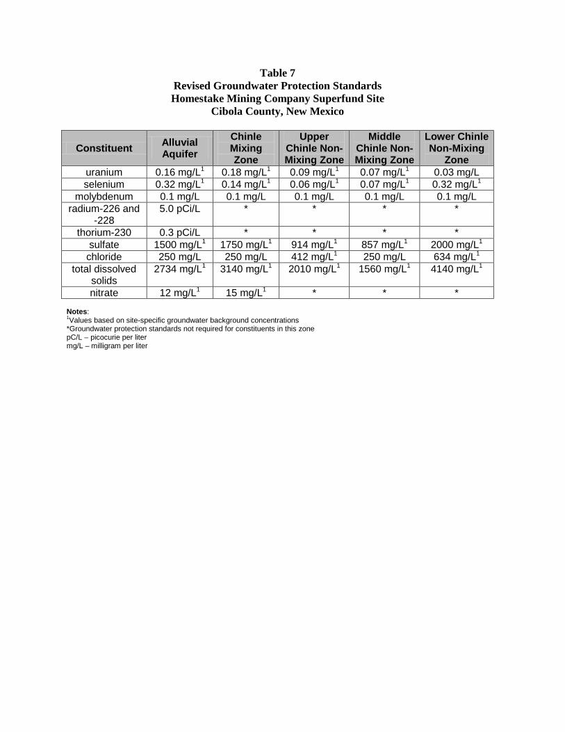
Table 7 Revised Groundwater Protection Standards Homestake Mining Company Superfund Site
Cibola County, New Mexico
uranium
Constituent
0.16 mg/L1
Alluvial Aquifer
0.18 mg/L1
Chinle Mixing Zone
0.09 mg/L1
Upper Chinle Non-Mixing Zone
0.07 mg/L1
Middle Chinle Non-Mixing Zone
0.03 mg/L
Lower Chinle Non-Mixing
Zone
selenium 0.32 mg/L1 0.14 mg/L1 0.06 mg/L1 0.07 mg/L1 0.32 mg/L1
molybdenum 0.1 mg/L 0.1 mg/L 0.1 mg/L 0.1 mg/L 0.1 mg/L radium-226 and
-228 5.0 pCi/L * * * *
thorium-230 0.3 pCi/L * * * * sulfate 1500 mg/L1 1750 mg/L1 914 mg/L1 857 mg/L1 2000 mg/L1
chloride 250 mg/L 250 mg/L 412 mg/L1 250 mg/L 634 mg/L1
total dissolved solids
2734 mg/L1 3140 mg/L1 2010 mg/L1 1560 mg/L1 4140 mg/L1
nitrate 12 mg/L1 15 mg/L1 * * *
Notes: 1Values based on site-specific groundwater background concentrations *Groundwater protection standards not required for constituents in this zone pC/L – picocurie per liter mg/L – milligram per liter

Table 8 Changes in Toxicity Values for Chemicals of Concern
Homestake Mining Company Superfund Site Cibola County, New Mexico
Constituent Old RfD Old RfC Current RfD Current RfC nitrate NA NA 1.6 mg/kg/day NA
selenium 5x10⁻³ mg/kg/day NA 5x10⁻³ mg/kg/day 2.0x10⁻² mg/m3
uranium 2x10⁻⁴ mg/kg/day NA 3x10⁻³ mg/kg/day 3.0x10⁻⁴ mg/m3
Notes: NA = not available RfC – reference concentration RfD – reference dose mg/m3 – milligram per cubic millimeter mg/kg/day – milligram per kilogram per day

EXHIBITS

g5epxcew
Typewritten Text
g5epxcew
Typewritten Text
Exhibit 1
g5epxcew
Typewritten Text

T 12 N
T II N
i i.,--' -'"l"--" I
Glology t:o~pil~d by E"lli~ 0 GOrdonRIOWR IIW
-49
•7500
',; \ '" ;..
(JQSQ c.oJ1'l~I ...d from U. S G S 1QP09tOtll'ljC l'\'l"Pi end 5 C S, pl-arllrnc-~.ric: q.uMrc"91(l 19~6o J M~l(o,tl'IOP$. 1957 '--'---'--'_LI --'- -' -',
EXPLANATION
e X ~-----u5625 6660 Altitude of top of San And~es Approximate altitude of top Faul t; dashed whe ~e app ,'ox,
limestone in well; + follow of San Andres limestone at mately located or dOUbtful; ing altitude figure denotes selected points on outcrop. dotted where covered by eroded top of formation. alluvium or basalt (D, down
thrown blocl'; U, up thrown block) .
FIGURE 11. -- Map of a part of the Grants-Bluewater area shOWing principal faults and the altitude of the top of the San Andres limestone at selected points in wells and on the outcrop, Valencia County, N. Mex.
g5epxcew
Typewritten Text
g5epxcew
Typewritten Text
Exhibit 2
g5epxcew
Typewritten Text
g5epxcew
Typewritten Text
X
g5epxcew
Typewritten Text
HMC

• • •
HOMESTAKE-MILL-AND-ADJACENT-PROPERTIES GRANTS-NM-TOWNSHIP-11&12-N-RANGE-10-W
Dote: 10/24/2006 Filename: E: \160699\GEO-figs.dwg
FIGURE 9 SAN MATEO AND LOBO CREEK
DRAINAGE AND SURFACE GEOLOGY
g5epxcew
Typewritten Text
g5epxcew
Typewritten Text
Exhibit 3a

II
Alluvium Colluvium ", } Holocene and
and Terrace Gravel '--_..J Pleistocene QUATERNARY
QUATERNARY
Basalt Flows OR TERTIARY
Santa Fe Formation 1Pliocene
Pliocene and Miocene
TERTIARY
IJNCONFORMlTr
•
•
CORRELATION OF MAP UNITS
Cleary Coal Member and
Gibson Coal Member
Upper CRETACEOUSDileo Coal Member Cretaceous
Gallup Sandstone
Mancos Shale
Dakota Sandstone
Morrison Formation Eolian Sandstooe
} JURASSICWanakah Formation Entrada Sandstone
CbinJe Formation } } TRIASSICMoenkopi Formation San Andres Limestone } IJIiCOItfORMlTY,
Glorieta Sandstone Lower } PERMIAN} Permian Abo Formation 1liC0Itf0RMITY
Yeso Formation
} PRECAMBRIANPrecambrian Granite
From Map C-113-A Dillinger, 1990
HOMESTAKE-MILL-AND-ADJACENT-PROPERTIES FIGURE 11GRANTS-NM-TOWNSHIP-11 &12-N-RANGE-1 O-W GEOLOGIC INDEX FOR FIGURES 9 AND 10
Date: 10/24/2006 Filename: E: \180899\GEO-fig8.dwg
II
g5epxcew
Typewritten Text
Exhibit 3b
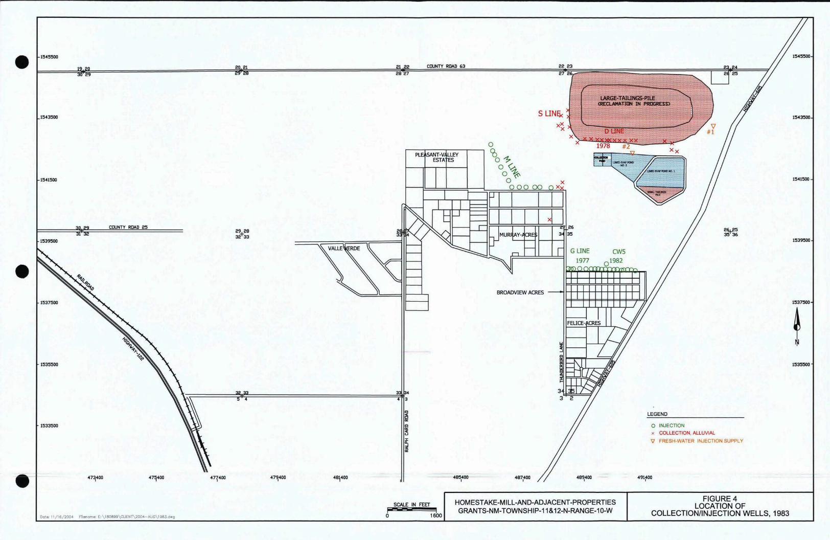
• 1545500
20 21
1543500
1541500
COUNTY ROAD 25
1539500
•
\.~~==========:~~===============:::::l~44
.-SCALE IN FEET
I'"' i Dot.: 11/16/200~ F11enom.: E:\lB0699\CUENT\2004-AUG\1983.dwg o 1600
1539500
1541500
1545500
1543500
1535500
1537500
o INJECTION
x COLLECTION, ALLUVIAL
'iJ FRESH-WATER INJECTION SUPPLY
LEGEND
491fOO---485400I
21 22 COUNTY ROAD 63
2827
3
HOMESTAKE-MILL-AND-ADJACENT-PROPERTIES GRANTS-NM-TOWNSHIP-11 &12-N-RANGE-1o-w
FIGURE 4 LOCATION OF
COLLECTION/INJECTION WELLS, 1983
g5epxcew
Typewritten Text
g5epxcew
Typewritten Text
g5epxcew
Typewritten Text
Exhibit 4
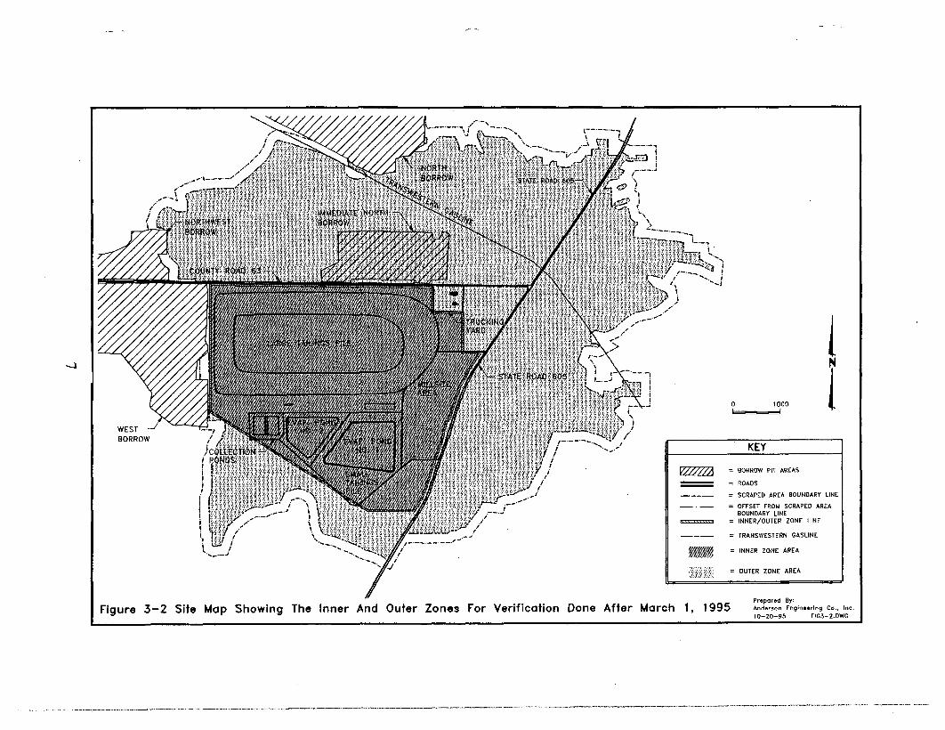
l .~ ....
t:J i ;
.... ~J
o 1000
ROADS
SCRAPED AREA BOUNDARY LINE
orrsn FROM SCRAP[O ~REA
BOUNDARY LINE INNER/OUTER ZONE LINE
= TRANSWESTERN GASLINE
KEY
BORROW PIT ~R~S
INNER ZONE AREA
OUTER ZONE AREA
=
--
.__ ._.,
--.E':J \ I!-.__ .~
) " i
(
.', \.1_.__.__.__
L._.,
.........
Prepared By: Anderson Engineedng Co., Inc.Figure 3-2 Site Map Showing The Inner And Outer Zones For Verification Done After March 1, 1995 10-20-95 F1G3-2.DWG
g5epxcew
Typewritten Text
Exhibit 5
g5epxcew
Typewritten Text
g5epxcew
Typewritten Text
EP#3

II
•
•
•
A B
ALLUVIUt.4
, I--------j ::l I--------j----_---!..._--------I ~ ~
~ Q
'i
6580
6540
6500
6460
6420
I LAND SURFACE ::l
6380 ~
6340 t: ~
6300 ~
< ~
6260 ~ ....J UJ
6220
6180
6140
6100
6060
6020
HOMESTAKE-MILL-AND-ADJACENT-PROPERTIES GRANTS-NM-TOWNSHIP-11 &12-N-RANGE-1 D-W
Dot.: 11/17/2004 Fllonomo: E: \1 80899\CUENT\2004-NOI!\BCKGXSEC.dwg
FIGURE 12 TYPICAL GEOLOGIC CROSS SECTION
g5epxcew
Typewritten Text
g5epxcew
Typewritten Text
Exhibit 6

Ii:D "'-.00 fOJT,,"_of"'on~__V
• ...""'_...... """,",,,,,",,,,,,,,,,,,,, fd' U, So, fOJ3, "" ""'."''"'00.....<>o>n_,......~, __==~_~=~ ========,MilesN -..."'" .~'_"'d~ <> ,...pool'" ''''oroood ._dono<. '" U, So, ""', '"
1 o -..... ,,-.-........._._,,"..... '-«> o 05 1 2 3
"'..h_b __ """~"".>OMd""". ,,,...,,,,. D "'""0 A of Coooom."""",,... ,...-.."',..-..,"" Residential wells sampled by NMED 2005·2007 in the vicinity of the .'h......-.....,'''' o Ito. of '" "'"'to"' ...... "" «""""'..h_b.....__oooo.-t,*,"."'-""" .."'-,,",= Homestake Mining Company Super1und Site, Milan, NM.........~_.II ,~""'."'" "",. """""V""," """~,,,, ........."" ''''-,'' .,~
david.mayerson
Text Box
Attachment A
g5epxcew
Typewritten Text
g5epxcew
Typewritten Text
g5epxcew
Typewritten Text
Exhibit 7a

ATTACHMENT B Memorandum of Agreement
Property Listing
Offer to Reimburse for Cost of Hookup to Village of Milan Water System
State Well ID Reference No.
Property Description
Subdivision Block / Lot Assessor Parcel No. Assessor Map Code RW-44 TBD TBD NA 10-08348 2-056-067-225-320 RW-42 21-01596 2-057-066-465-492 RW-43 La Siembra Estates Block 1, Lot 21 RW-46 La Siembra Estates Block 2, Lot 1 RW-40 Valle Verde Estates Block 4, Lot 14 RW-6 Valle Verde Estates Block 3, Lot 2 RW-45 Valle Verde Estates Block2, Lot 6 RW-57 Valle Verde Estates Block 5, Lot 12 RW-58 Valle Verde Estates Block 3, Lot 3
Offer to Reimburse for Past Cost of Current Service Hookup with Village of Milan Water System
State Well ID Reference No.
Property Description
Subdivision Block / Lot Assessor Parcel No. Assessor Map Code RW-47 10-15997 2-057-066-055-248 RW-37 10-00858 2-057-066-025-265 RW-38 10-03406 2-057-066-046-202 RW-49 10-03205 2-056-066-260-512 RW-7 Valle Verde Estates Block 2, Lot 5 RW-56 Valle Verde Estates Block 4, Lot11
g5epxcew
Typewritten Text
g5epxcew
Typewritten Text
Exhibit 7b

- ~- - --~ .._......_.-
• • X
•6560
Vi 6550E
... Z'*0
~ -J 6540UJ -J
~ UJ N [ijI ..... '.J -J
I
0:::: UJ
Legend
••... I
KEB KF
•
..... ~ 6530
FIGURE 4.2-12. WATER-LEVEL ELEVATION FOR WELLS I, KEB, KF AND X.
g5epxcew
Typewritten Text
Exhibit 8a

• • •2
Legend
• KEB
• KF .... KZ
• X1.6
-.... Cl 1.2 E
-. :E ::::> ..... z ~ ::::> 0.8
0.4
FIGURE 4.3-60. URANIUM CONCENTRATIONS FOR WELLS KEB, KF, KZ AND X.
g5epxcew
Typewritten Text
g5epxcew
Typewritten Text
Exhibit 8b

• • 6540
Vi E 6530
~ ...
Z 0
~ (rj ...J 6520UJ ...J
~ UJ N
I.... ~
(rj ...J, ~ UJ I
~ 6510 Legend
• ..••
813 C2
01 M5
S3
FIGURE 4.2-9. WATER-LEVEL ELEVATION FOR WELLS B13, C2, Dl, MS AND S3.
6500
g5epxcew
Typewritten Text
g5epxcew
Typewritten Text
Exhibit 8c
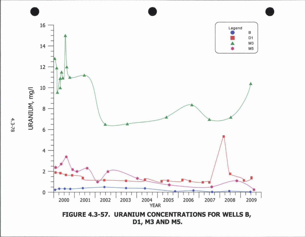
• • 14
•16
Legend
D1
• M3
••.. B
M5
12
10""'-C1 E
-. ::E :::::> 8 t-4
Z ~
W ~ I "'-I :::::> ex> 6
2000 2001 2002 2003 2004 YEAR
2005 2006 2007 2008 2009
FIGURE 4.3-57. URANIUM CONCENTRATIONS FOR WELLS S, Dl, M3 AND M5.
g5epxcew
Typewritten Text
Exhibit 8d
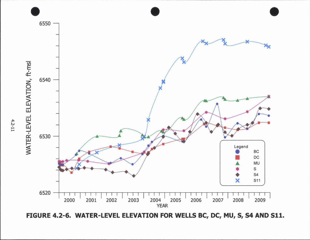
----------------------------
• • •6550
Vi
'*zE
... 6540 0
~ Gj ...J UJ ...J
~ UJ IN Gj.... .... ...J
I
ex:: 6530 UJ
Legend~ •• BC~
• DC
MU
• 5 54
X 511
•
2000 2001 2002 2003 2004 2005 2006 2007 2008 2009 YEAR
FIGURE 4.2-6. WATER-LEVEL ELEVATION FOR WELLS BC, DC, MU, S, S4 AND Sll.
g5epxcew
Typewritten Text
g5epxcew
Typewritten Text
g5epxcew
Typewritten Text
Exhibit 8e

• • • 30
Legend
• NC
• 52 ... 54
--... en E
... :E :::> ...... z
~
W ~ I ....... :::>0'
20
10
• 511
• ST
2000 2001 2002 2003 2004 YEAR
2005 2006 2007 2008 2009
FIGURE 4.3-55. URANIUM CONCENTRATIONS FOR WELLS NC, 52, 54, 511 AND ST.
g5epxcew
Typewritten Text
g5epxcew
Typewritten Text
Exhibit 8f

1537500
et22 COUNTY ROAD 63 28 27
1543500
1541500
COUNTY ROAD 25
0.05
0.04 •0.04
0.02
1535500
32 33 0~01 0112
1533500
00.05
47 400 400 479400 485400 487400
0.01
• 0.03 0.03
0.02
1480'
0.05
0.03
J3160' 0.2
1545500
1543500
1541500
1539500
1537500
0.23 DATil - 0.1 CONTDJR IIHD LAllEL
S1'I1l sr.utDARD
>0.'6 mgfi
c::::l IlU.UVlAl.. AQUIfER491400
FIGURE 4.3-53. URANIUM CONCENTRATIONS
OF THE ALLUVIAL AQUIFER. 2009 mg/l ".3-7"
1535500
g5epxcew
Typewritten Text
g5epxcew
Typewritten Text
Exhibit 9a

g5epxcew
Typewritten Text
Exhibit 9b

1545500
1539500
DATA 'oIATER-l£VEl. £LEV. CONTlIUR Ft.OIJ DIRECTION
LEGEND 6569.4
6515---
6541.8 •
FIGURE 4.2-1. WATER-LEVEL ELEVATIONS OF THE ALLUVIAL AQUIFER, FALL 2009, FI'-Mst
• .2-8
491<400
./
489400
6539.8
4874(10
6475.4
485400
21 22 COUNTY ROAD 63 28 27
6446.7 .484004 40047 400
45500
C:\PRO.IBC'l'S\ 2010-08 1 DATE: 2/22/2010
SCALE: l-=UlOO'
1537500 ",.-- 1537500
I Nw+, S
1535500 1535500
1543500 1543500
\ 6491.4
~\68.5 6495.8
.6 6491.8
1541500 •
• 1541500
646\
1533500
g5epxcew
Typewritten Text
g5epxcew
Typewritten Text
g5epxcew
Typewritten Text
Exhibit 10

ATTACHMENTS

Attachment 1
Site Inspection Checklist/Inspection Roster

Site Inspection Checklist
I. SITE INFORMATION
Site name: Homestake Mining Company of California Date of inspection: January 19, 2011
Location and Region: Cibola County, New Mexico/Region 6
EPA ID: NMD007860935
Agency, office, or company leading the five-year review: U.S. EPA Region 6
Weather/temperature: Sunny / 50ºF
Remedy Includes: (Check all that apply) Tailings pile cover¹/containment Monitored natural attenuation Access controls Groundwater containment Institutional controls Vertical barrier walls Groundwater pump and treatment Surface water collection and treatment Other: Fourteen concrete conduits (letdown channels) drain surface water off the top of the large
tailings pile ¹Radon barrier and erosion protection on small and large tailings pile
Attachments: Inspection team roster attached Site map attached
II. INTERVIEWS (Check all that apply)
1. O&M site manager – Homestake Mining Company Name: Alan Cox Title: Project Manager Date: January 19, 2011
Interviewed at site at office by phone Phone no. ______________ Problems, suggestions; Report attached: Mr. Cox stated that, historically, they [Homestake Mining
Company (HMC)] had been pretty well supported by the regulatory agencies. However, he cited problems gaining timely permit approvals and frustrations with the appeals and protests related to the regulatory agencies, stating that HMC wanted to move forward (with remediation) but that they had been hamstrung the last couple of years.
2. O&M consultant – Hydro-Engineering L.L.C. Name: George Hoffman Title: Hydrologist Date: January 19, 2011
Interviewed at site at office by phone Phone no. ______________ Problems, suggestions; Report attached: Mr. Hoffman referred to Mr. Cox’s responses regarding problems
with the permits, approvals, appeals, and protests. He added that help was needed from the regulatory agencies in approving the testing of alternative restoration methods.
Five-year Review Report - 1

3. Local regulatory authorities and response agencies (i.e., State and Tribal offices, emergency response office, police department, office of public health or environmental health, zoning office, recorder of deeds, or other city and county offices, etc.) Fill in all that apply.
Agency: New Mexico Environment Department Contact: Angelo Ortelli Project Manager-Geoscientist February 8, 2011 505-827-2866
Name Title Date Phone no.
David Mayerson Former Project Manager February 8, 2011 505-476-3787 Name Title Date Phone no.
Jerry Schoeppner Mining/Environmental Compliance February 8, 2011 505-827-0652 Name Title Date Phone no.
Problems; suggestions; Report attached: Mr. Schoeppner stated that there was some question whether there is capture of the western alluvial plume from the large tailings pile but it is mixing with upgradient contamination from an unidentified source. He also stated that they were losing ground on the western and southern plume footprints. Mr. Schoeppner stated that HMC needs to relay the public relations issues to the state so that they are well informed. He also stated that as the lead agency, the Nuclear Regulatory Commission is continually revising the monitoring system - changes in wells or new wells installed – without notification to NMED. Mr. Mayerson stated that HMC has a lot of data but, because of the way it is organized, the data is hard to relate to specific remediation goals. Mr. Ortelli stated that the data should be related to data quality objectives. Mr. Schoeppner and Mr. Mayerson suggested conference calls every six months so that HMC could update all parties about ongoing site activities and also suggested having public meetings with the regulators and HMC every six months.
4. Other interviews (optional) Reports attached.
Contact: John Boomer Property owner January 20, 2011 505-979-3917 Name Title Date Phone no.
Interviewed at home
Problems; suggestions; Report attached: Mr. Boomer cited the following problems/suggestions: would like to be better informed (on activities associated with remediation); would like to hear about innovative technologies being tested; would like to see the [large] tailings pile moved isolated; would like to see additional monitoring system every half mile or so; would like better monitoring out in front of the groundwater plume; wants an independent analysis of the alluvial floodplain to establish a baseline for planned mining further up in the San Mateo Drainage Basin; and wants better community education.
Contact: Art Gebeau Property owner January 21, 2011 505-287-3613 Name Title Date Phone no.
Interviewed at home
Problems; suggestions; Report attached: Mr. Gebeau cited the following problems/suggestions: concerned with remediation involving flushing of the large tailings pile; they (HMC) should spend a little more money and do the remediation right; they should move the (large) tailings pile; they did not get out in front of the problem (groundwater plume) early enough and had a poor understanding of the geology of the area; they installed injection wells and pushed the groundwater plume out away from the HMC property; and they should increase the size of the reverse osmosis treatment plant (to handle all of the extracted groundwater).
III. ON-SITE DOCUMENTS & RECORDS VERIFIED (Check all that apply)
Five-year Review Report - 2

1. O&M Documents O&M manual Readily available Up to date N/A As-built drawings Readily available Up to date N/A Maintenance logs Readily available Up to date N/A
Remarks: Documents related to operation and maintenance (O&M) of the varying ongoing remedial activities are available at the site. However, there is no single, all-encompassing “O&M Manual” for the site.
2. Site-Specific Health and Safety Plan Readily available Up to date N/A Contingency plan/emergency response plan Readily available Up to date N/A
Remarks__ __________________________________________________
3. O&M and OSHA Training Records Readily available Up to date N/A Remarks: Not evaluated
4. Permits and Service Agreements Air discharge permit Readily available Up to date N/A Effluent discharge Readily available Up to date N/A Waste disposal, POTW Readily available Up to date N/A Other permits_____________________ Readily available Up to date N/A
Remarks__________________________________________________________________________ _________________________________________________________________________________
5. Gas Generation Records Readily available Up to date N/A Remarks__________________________________________________________________________ _________________________________________________________________________________
6. Settlement Monument Records Readily available Up to date N/A Remarks: Settlement monuments are surveyed annually by the Nuclear Regulatory Commission (NRC)
7. Groundwater Monitoring Records Readily available Up to date N/A Remarks: None
8. Leachate Extraction Records Readily available Up to date N/A Remarks: None
9. Discharge Compliance Records Air Readily available Up to date N/A Water (effluent) Readily available Up to date N/A
Remarks__________________________________________________________________________ _________________________________________________________________________________
10. Daily Access/Security Logs Readily available Up to date N/A Remarks: None
IV. O&M COSTS
1. O&M Organization State in-house Contractor for State PRP in-house Contractor for PRP Federal Facility in-house Contractor for Federal Facility Other: O&M costs are not captured and reported as with typical Superfund sites. NRC License
SUA-1471 requires HMC to periodically submit estimated costs for reclamation milestones as a part of the federal surety requirements. Mr. Cox stated that annual O&M costs were approximately $3.5 million per year but that the costs may increase with improvements in the remedial system.
Five-year Review Report - 3

_________________________________________________________________________________ _________________________________________________________________________________ _________________________________________________________________________________ _________________________________________________________________________________ _________________________________________________________________________________
2. O&M Cost Records Readily available Up to date Funding mechanism/agreement in place
Original O&M cost estimate____________________ Breakdown attached
Total annual cost by year for review period if available
From__________ To__________ __________________ Breakdown attached Date Date Total cost
From__________ To__________ __________________ Breakdown attached Date Date Total cost
From__________ To__________ __________________ Breakdown attached Date Date Total cost
From__________ To__________ __________________ Breakdown attached Date Date Total cost
From__________ To__________ __________________ Breakdown attached Date Date Total cost
3. Unanticipated or Unusually High O&M Costs During Review Period Describe costs and reasons: _None_____________________________________________________
V. ACCESS AND INSTITUTIONAL CONTROLS Applicable N/A
A. Fencing
1. Fencing damaged Location shown on site map Gates secured N/A Remarks: The HMC property includes an office building, maintenance/storage buildings, water towers, tailings piles, evaporation ponds, collection ponds, and a reverse osmosis treatment plant. The office building and maintenance/storage buildings are surrounded by a chain link fence which is unlocked only during business hours. The remainder of the property is surrounded by barbed wire fencing.
B. Other Access Restrictions
1. Signs and other security measures Location shown on site map N/A Remarks_____________________________________________________________________________
C. Institutional Controls (ICs)
Five-year Review Report - 4

1. Implementation and enforcement Site conditions imply ICs not properly implemented Yes No N/A Site conditions imply ICs not being fully enforced Yes No N/A
Type of monitoring (e.g., self-reporting, drive by): Under the IC put into place in 2007, NMED requires the New Mexico Office of the State Engineer to issue a health advisory to every person who applies for a well permit with the area referenced in the drinking water advisory (Exhibit 7a); and the advisory is to be published in two newspapers of general circulation in Cibola and McKinley Counties. Frequency: N/A Responsible party/agency: New Mexico Office of the State Engineer Contact ______________________ ___________ _________ (505) 827-6091
Name Title Date Phone no.
Reporting is up-to-date Yes No N/A Reports are verified by the lead agency Yes No N/A
Specific requirements in deed or decision documents have been met Yes No N/A Violations have been reported Yes No N/A Other problems or suggestions: Report attached
2. Adequacy ICs are adequate ICs are inadequate N/A Remarks_____________________________________________________________________________
D. General
1. Vandalism/trespassing Location shown on site map No vandalism evident Remarks: No vandalism or trespassing reported during in the last five years.
2. Land use changes on site N/A Remarks__________________________________________________________________________ _________________________________________________________________________________
3. Land use changes off site N/A Remarks: Evaporation Pond 3 was installed in 2010 northwest of the large tailings impoundment. No other land-use changes were documented.
VI. GENERAL SITE CONDITIONS
A. Roads Applicable N/A
1. Roads damaged Location shown on site map Roads adequate N/A Remarks: None
B. Other Site Conditions Remarks: None
VII. LANDFILL COVERS Applicable N/A
A. Temporary Radon Cover
1. Settlement (Low spots) Location shown on site map Settlement not evident Areal extent______________ Depth____________ Remarks: Settlement of the large tailings pile is monitored annually by NRC. Settlement of seven to eight monuments was noted on the north side of the large tailings pile in 1998 – 1999. No current settlement evident, however, soil is stockpiled on the top of the large tailings pile to be used for fill.
Five-year Review Report - 5

2. Cracks Location shown on site map Cracking not evident Lengths____________ Widths___________ Depths__________ Remarks: None
3. Erosion Location shown on site map Erosion not evident Areal extent______________ Depth____________ Remarks: No erosion was evident on the large tailings pile. Erosion was, however, moderate to pronounced on the southeast and southwest sides of the small tailings pile/Evaporation Pond 1 and on the west side of the west collection pond.
4. Holes Location shown on site map Holes not evident Areal extent______________ Dimensions : 10’ wide x 15’ long x 6’ deep) Remarks: Approximately seven pits and associated mounded dirt observed on the top of the large tailings pile. Pits associated with emplacement of new monitoring wells.
5. Vegetative Cover Grass Cover properly established No signs of stress G Trees/Shrubs (indicate size and locations on a diagram) Remarks: Vegetative cover consists of native grasses and low-lying bushes. Vegetative cover minimal to lacking on the southeast and southwest sides of the small tailings pile/Evaporation Pond 1 and on the west side of the west collection pond.
6. Alternative Cover (armored rock, concrete, etc.) N/A Remarks: The cover on top of the temporary radon barrier consists of large rocks
7. Bulges Location shown on site map Bulges not evident Areal extent______________ Height____________ Remarks: None
8. Wet Areas/Water Damage Wet areas/water damage not evident Wet areas Location shown on site map Areal extent______________ Ponding Location shown on site map Areal extent______________ Seeps Location shown on site map Areal extent______________ Soft subgrade Location shown on site map Areal extent______________
Remarks: Two small areas of ponding (10’ x 20’) and (3’ x 5’) observed near the zeolite pilot-test pit on the top of the south side of the large tailings pile. Ponded water due to melting snow.
9. Slope Instability Slides Location shown on site map No evidence of slope instability Areal extent_______________________________________________________________________ Remarks: None
B. Benches Applicable N/A (Horizontally constructed mounds of earth placed across landfill side slope to interrupt the slope in order to slow down the velocity of surface runoff and intercept and convey the runoff to a lined channel.)
1. Flows Bypass Bench Location shown on site map N/A or okay Remarks__________________________________________________________________________ _________________________________________________________________________________
2. Bench Breached Location shown on site map N/A or okay Remarks__________________________________________________________________________ _________________________________________________________________________________
3. Bench Overtopped Location shown on site map N/A or okay Remarks__________________________________________________________________________ _________________________________________________________________________________
Five-year Review Report - 6
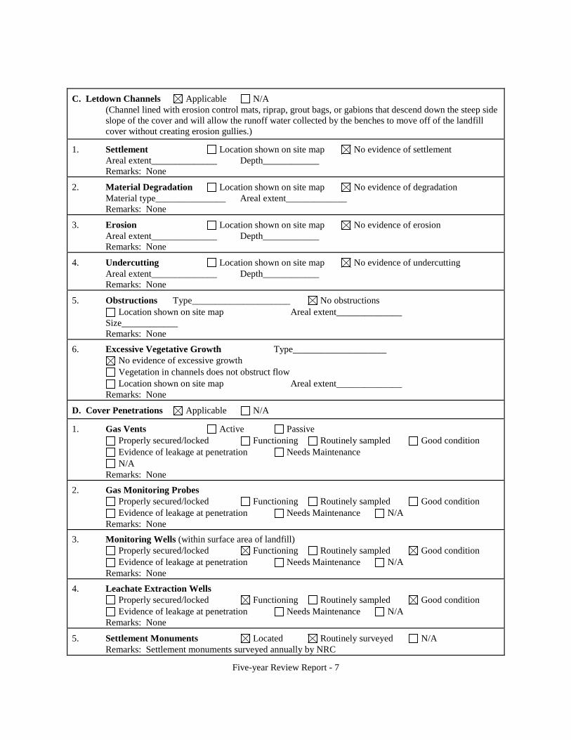
C. Letdown Channels Applicable N/A (Channel lined with erosion control mats, riprap, grout bags, or gabions that descend down the steep side slope of the cover and will allow the runoff water collected by the benches to move off of the landfill cover without creating erosion gullies.)
1. Settlement Location shown on site map No evidence of settlement Areal extent______________ Depth____________ Remarks: None
2. Material Degradation Location shown on site map No evidence of degradation Material type_______________ Areal extent_____________ Remarks: None
3. Erosion Location shown on site map No evidence of erosion Areal extent______________ Depth____________ Remarks: None
4. Undercutting Location shown on site map No evidence of undercutting Areal extent______________ Depth____________ Remarks: None
5. Obstructions Type_____________________ No obstructions Location shown on site map Areal extent______________
Size____________ Remarks: None
6. Excessive Vegetative Growth Type____________________ No evidence of excessive growth Vegetation in channels does not obstruct flow Location shown on site map Areal extent______________
Remarks: None
D. Cover Penetrations Applicable N/A
1. Gas Vents Active Passive Properly secured/locked Functioning Routinely sampled Good condition Evidence of leakage at penetration Needs Maintenance N/A
Remarks: None
2. Gas Monitoring Probes Properly secured/locked Functioning Routinely sampled Good condition Evidence of leakage at penetration Needs Maintenance N/A
Remarks: None
3. Monitoring Wells (within surface area of landfill) Properly secured/locked Functioning Routinely sampled Good condition Evidence of leakage at penetration Needs Maintenance N/A
Remarks: None
4. Leachate Extraction Wells Properly secured/locked Functioning Routinely sampled Good condition Evidence of leakage at penetration Needs Maintenance N/A
Remarks: None
5. Settlement Monuments Located Routinely surveyed N/A Remarks: Settlement monuments surveyed annually by NRC
Five-year Review Report - 7

E. Gas Collection and Treatment Applicable N/A
1. Gas Treatment Facilities Flaring Thermal destruction Collection for reuse Good condition Needs Maintenance
Remarks: None
2. Gas Collection Wells, Manifolds and Piping Good condition Needs Maintenance
Remarks: None
3. Gas Monitoring Facilities (e.g., gas monitoring of adjacent homes or buildings) Good condition Needs Maintenance N/A
Remarks: None
F. Cover Drainage Layer Applicable N/A
1. Outlet Pipes Inspected Functioning N/A Remarks: None
2. Outlet Rock Inspected Functioning N/A Remarks: None
G. Collection Ponds Applicable N/A
1. Siltation Areal extent______________ Depth____________ N/A Siltation not evident
Remarks: There is some sediment buildup in the collection and evaporation ponds (Evaporation Ponds 1 and 2) according to HMC
2. Erosion Areal extent______________ Depth____________ Erosion not evident
Remarks: Moderate to pronounced erosion observed on the southeast and southwest sides of the small tailings pile/Evaporation Pond 1 and on the west side of the west collection pond
3. Outlet Works Functioning N/A Remarks____________________________________________________________________________ ___________________________________________________________________________________
4. Dam Functioning N/A Remarks__________________________________________________________________________ _________________________________________________________________________________
H. Retaining Walls Applicable N/A
1. Deformations Location shown on site map Deformation not evident Horizontal displacement____________ Vertical displacement_______________ Rotational displacement____________ Remarks: None
2. Degradation Location shown on site map Degradation not evident Remarks: None
I. Perimeter Ditches/Off-Site Discharge Applicable N/A
1. Siltation Location shown on site map Siltation not evident Areal extent______________ Depth____________ Remarks: None
Five-year Review Report - 8

2. Vegetative Growth Location shown on site map N/A Vegetation does not impede flow
Areal extent______________ Type____________ Remarks: None
3. Erosion Location shown on site map Erosion not evident Areal extent______________ Depth____________ Remarks: None
4. Discharge Structure Functioning N/A Remarks: None
VIII. VERTICAL BARRIER WALLS Applicable N/A
1. Settlement Location shown on site map Settlement not evident Areal extent______________ Depth____________ Remarks: None
2. Performance MonitoringType of monitoring__________________________ Performance not monitored
Frequency_______________________________ Evidence of breaching Head differential__________________________ Remarks: None
IX. GROUNDWATER/SURFACE WATER REMEDIES Applicable N/A
A. Groundwater Extraction Wells, Pumps, and Pipelines Applicable N/A
1. Pumps, Wellhead Plumbing, and Electrical Good condition All required wells properly operating Needs Maintenance N/A
Remarks: Identified extraction wells observed during the inspection were functioning properly.
2. Extraction System Pipelines, Valves, Valve Boxes, and Other Appurtenances Good condition Needs Maintenance
Remarks: Pipelines and associated equipment used to convey extracted and treated groundwater observed during the inspection were functioning properly.
3. Spare Parts and Equipment Readily available Good condition Requires upgrade Needs to be provided
Remarks: None
B. Surface Water Collection Structures, Pumps, and Pipelines Applicable N/A
1. Collection Structures, Pumps, and Electrical Good condition Needs Maintenance
Remarks: None
2. Surface Water Collection System Pipelines, Valves, Valve Boxes, and Other Appurtenances Good condition Needs Maintenance
Remarks: None
3. Spare Parts and Equipment Readily available Good condition Requires upgrade Needs to be provided
Remarks: None
C. Treatment System Applicable N/A
Five-year Review Report - 9

1. Treatment Train (Check components that apply) Metals removal Oil/water separation Bioremediation Air stripping Carbon adsorbers Filters_________________________________________________________________________ Additive (e.g., chelation agent, flocculent)_____________________________________________ Others: Extraction wells, evaporation ponds (EP1, EP2, EP3) and associated spray misters, east and
west collection ponds, and a Reverse Osmosis (RO) Treatment Plant Good condition Needs Maintenance Sampling ports properly marked and functional Sampling/maintenance log displayed and up to date Equipment properly identified Quantity of groundwater treated annually: 256 gallons per minute (gpm) (RO Treatment Plant and
159 gpm (spray misters for EP1/EP2) Quantity of surface water treated annually________________________
Remarks: EP1, EP2, and EP3 include spray misters to increase their evaporative capacity. Due to the high winds, the spray misters were not operating at EP1 and EP2 during the site inspection. The misters were not yet operational at EPA3. The RO Treatment Plant was undergoing maintenance during the site inspection and was, therefore, not operational.
2. Electrical Enclosures and Panels (properly rated and functional) N/A Good condition Needs Maintenance
Remarks: The computer control panel used to activities within the RO Treatment Plant (influent, effluent, fluid levels, among others) was in working condition but not operational due the maintenance shutdown.
3. Tanks, Vaults, Storage Vessels N/A Good condition Proper secondary containment Needs Maintenance
Remarks__________________________________________________________________________ _________________________________________________________________________________
4. Discharge Structure and Appurtenances N/A Good condition Needs Maintenance
Remarks: Discharge structures observed during the site inspection that are used to convey surface water from the top of the large tailings pile were in good condition. Discharge lines observed during the site inspection, used to convey water to the evaporation ponds and collection ponds, were in good condition.
5. Treatment Building(s) N/A Good condition (esp. roof and doorways) Needs repair Chemicals and equipment properly stored
Remarks: The RO Treatment Plant was shut down for maintenance during the site inspection but observed piping, holding tanks, electrical conveyances, and the physical building, including concrete flooring, were in good condition.
6. Monitoring Wells (pump and treatment remedy) Properly secured/locked Functioning Routinely sampled Good condition All required wells located Needs Maintenance N/A
Remarks: Due to the extremely large number of monitoring wells at this site not all wells were located or inspected. However, the point-of-compliance wells were in good condition and were wired for operation. Monitoring well sampling schedules are dependent upon their status as permitted monitoring wells, non-permitted monitoring wells, wells on the property boundary, key wells (downgradient of irrigation areas for example), and other wells.
D. Monitoring Data
Five-year Review Report - 10
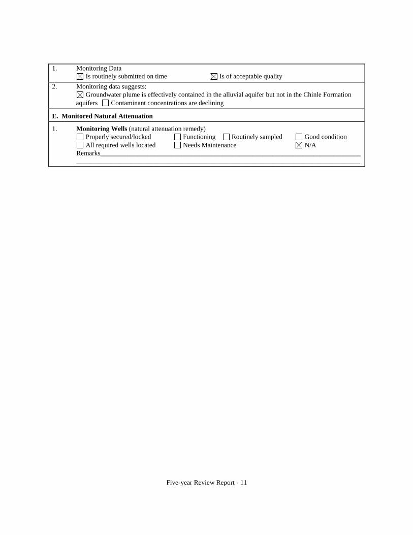
1. Monitoring Data Is routinely submitted on time Is of acceptable quality
2. Monitoring data suggests: Groundwater plume is effectively contained in the alluvial aquifer but not in the Chinle Formation
aquifers Contaminant concentrations are declining
E. Monitored Natural Attenuation
1. Monitoring Wells (natural attenuation remedy) Properly secured/locked Functioning Routinely sampled Good condition All required wells located Needs Maintenance N/A
Remarks_____________________________________________________________________________ ____________________________________________________________________________________
Five-year Review Report - 11

X. OTHER REMEDIES The restoration program involves stabilization of the tailings piles, surface reclamation, and the removal of target contaminants from site groundwater and consists of an injection and collection system, using deep-well-supplied fresh water or water produced from the RO Treatment Plant. The established groundwater collection area is hydraulically bounded by a downgradient perimeter of injection and infiltration systems consisting of groundwater wells and infiltration lines. The RO Treatment Plant was designed to augment the groundwater clean-up activities and a series of collection wells is used to collect the contaminated water, which is pumped to the plant for treatment or, alternatively, pumped to a series of evaporation ponds. In addition to treating the groundwater, the RO Treatment Plant also treats water extracted from the large tailings pile. Treatment consists of a clarifier (with the addition of lime), filtration primarily via sand filters, and RO. The RO system includes both high- and low-pressure units.
Brine from the RO system and some water extracted from the large tailings pile are disposed of directly in the evaporation ponds. Solids from the clarifier and filtration system also go into the ponds. The ponds are used to concentrate salts and sprayers installed in the evaporation ponds increase the evaporative loss of contaminated water (forced evaporation).
Evaporation Pond 1 has a single liner and is the easternmost evaporation pond, located on top of and covering the majority of the small tailings pile. Evaporation Pond 2 is double lined and is located adjacent to and west of Evaporation Pond 1. Evaporation Pond 3, installed in 2009, is double lined and is located approximately 1,800 feet north of County Road 63 northwest of the large tailings pile. It has an evaporative surface of approximately 26.5 acres.
The side slopes of the large tailings pile consists of the final radon barrier and rock cover for erosion protection; however, the top consists of only an interim cover. The cover on the small tailings pile is also an interim cover. Installation of the final radon barriers will be implemented following completion of the groundwater restoration program. Also, settlement on the top of the large tailings pile must meet NRC requirements before the final radon barrier/cover can be installed.
During the five-year review period restoration activities involved flushing and dewatering of the large tailings pile using a series of injection/extraction wells, treatment, and use of the collection and evaporation ponds. Seleniumand uranium-contaminated irrigation water was applied to four fields corresponding to approximately 400 acres. The following alternative treatment pilot tests were conducted during this review period on the large tailings pile:
• Water with low concentrations of uranium was being pumped from the Upper Chinle formation into test pits filled with zeolite. The zeolite would act as an absorbent, binding the uranium, and the supernatent would then be re-injected at a rate of 50 – 100 gpm.
• A soluble sodium tripolyphosphate or STPP amendment was injected into groundwater having a pH of 6 and a uranium concentration of less than 2 µg/L. The goal of the pilot test was to study the effects of STPP injections on uranium stabilization.
Five-year Review Report - 12
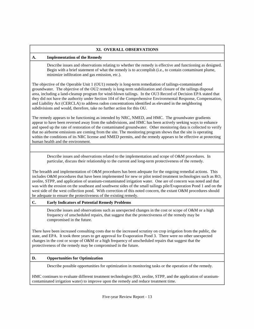
XI. OVERALL OBSERVATIONS
A. Implementation of the Remedy
Describe issues and observations relating to whether the remedy is effective and functioning as designed. Begin with a brief statement of what the remedy is to accomplish (i.e., to contain contaminant plume, minimize infiltration and gas emission, etc.).
The objective of the Operable Unit 1 (OU1) remedy is long-term remediation of tailings-contaminated groundwater. The objective of the OU2 remedy is long-term stabilization and closure of the tailings disposal area, including a land-cleanup program for wind-blown tailings. In the OU3 Record of Decision EPA stated that they did not have the authority under Section 104 of the Comprehensive Environmental Response, Compensation, and Liability Act (CERCLA) to address radon concentrations identified as elevated in the neighboring subdivisions and would, therefore, take no further action for this OU.
The remedy appears to be functioning as intended by NRC, NMED, and HMC. The groundwater gradients appear to have been reversed away from the subdivisions, and HMC has been actively seeking ways to enhance and speed up the rate of restoration of the contaminated groundwater. Other monitoring data is collected to verify that no airborne emissions are coming from the site. The monitoring program shows that the site is operating within the conditions of its NRC license and NMED permits, and the remedy appears to be effective at protecting human health and the environment.
Describe issues and observations related to the implementation and scope of O&M procedures. In particular, discuss their relationship to the current and long-term protectiveness of the remedy.
The breadth and implementation of O&M procedures has been adequate for the ongoing remedial actions. This includes O&M procedures that have been implemented for new or pilot tested treatment technologies such as RO, zeolite, STPP, and application of uranium-contaminated irrigation water. One are of concern was noted and that was with the erosion on the southeast and southwest sides of the small tailings pile/Evaporation Pond 1 and on the west side of the west collection pond. With correction of this noted concern, the extant O&M procedures should be adequate to ensure the protectiveness of the existing remedy.
C. Early Indicators of Potential Remedy Problems
Describe issues and observations such as unexpected changes in the cost or scope of O&M or a high frequency of unscheduled repairs, that suggest that the protectiveness of the remedy may be compromised in the future.
There have been increased consulting costs due to the increased scrutiny on crop irrigation from the public, the state, and EPA. It took three years to get approval for Evaporation Pond 3. There were no other unexpected changes in the cost or scope of O&M or a high frequency of unscheduled repairs that suggest that the protectiveness of the remedy may be compromised in the future.
D. Opportunities for Optimization
Describe possible opportunities for optimization in monitoring tasks or the operation of the remedy.
HMC continues to evaluate different treatment technologies (RO, zeolite, STPP, and the application of uraniumcontaminated irrigation water) to improve upon the remedy and reduce treatment time.
Five-year Review Report - 13

Five-year Review Site Inspection Homestake Mining Company Site
January 19, 2011 Sign-in Sheet
Personnel Title Representing Phone Number
Sai Appaji Remedial Project Manager U.S. EPA Region 6 214-665-3126
Fred Molloy Technical Lead U.S. Army Corps of Engineers, Kansas City District 816-389-3499
Chuck Williams Project Hydrogeologist U.S. Army Corps of Engineers, Kansas City District 816-389-3575
Angelo Ortelli Project Manager - Geoscientist New Mexico Environment Department Superfund Oversight Section 505-827-2866
George Hoffman Hydrologist Hydro-Engineering L.L.C. 307-261-6597
Alan Cox Project Manager Homestake Mining Company 505-400-2794
Patrick Malone Senior Counsel Homestake Mining Company 801-990-3846
Dan Kump Senior Project Engineer Homestake Mining Company 505-287-4456
Five-year Review Report - 14

Attachment 2
Interview Records
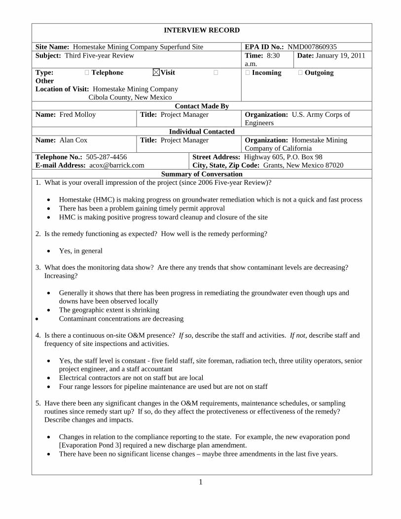
INTERVIEW RECORD
Site Name: Homestake Mining Company Superfund Site EPA ID No.: NMD007860935 Subject: Third Five-year Review Time: 8:30
a.m. Date: January 19, 2011
Type: Telephone Visit Other Location of Visit: Homestake Mining Company
Cibola County, New Mexico
Incoming Outgoing
Contact Made By Name: Fred Molloy Title: Project Manager Organization: U.S. Army Corps of
Engineers Individual Contacted
Name: Alan Cox Title: Project Manager Organization: Homestake Mining Company of California
Telephone No.: 505-287-4456 E-mail Address: [email protected]
Street Address: Highway 605, P.O. Box 98 City, State, Zip Code: Grants, New Mexico 87020
Summary of Conversation 1. What is your overall impression of the project (since 2006 Five-year Review)?
• Homestake (HMC) is making progress on groundwater remediation which is not a quick and fast process • There has been a problem gaining timely permit approval • HMC is making positive progress toward cleanup and closure of the site
2. Is the remedy functioning as expected? How well is the remedy performing?
• Yes, in general
3. What does the monitoring data show? Are there any trends that show contaminant levels are decreasing? Increasing?
• Generally it shows that there has been progress in remediating the groundwater even though ups and downs have been observed locally
• The geographic extent is shrinking • Contaminant concentrations are decreasing
4. Is there a continuous on-site O&M presence? If so, describe the staff and activities. If not, describe staff and frequency of site inspections and activities.
• Yes, the staff level is constant - five field staff, site foreman, radiation tech, three utility operators, senior project engineer, and a staff accountant
• Electrical contractors are not on staff but are local • Four range lessors for pipeline maintenance are used but are not on staff
5. Have there been any significant changes in the O&M requirements, maintenance schedules, or sampling routines since remedy start up? If so, do they affect the protectiveness or effectiveness of the remedy? Describe changes and impacts.
• Changes in relation to the compliance reporting to the state. For example, the new evaporation pond [Evaporation Pond 3] required a new discharge plan amendment.
• There have been no significant license changes – maybe three amendments in the last five years.
1
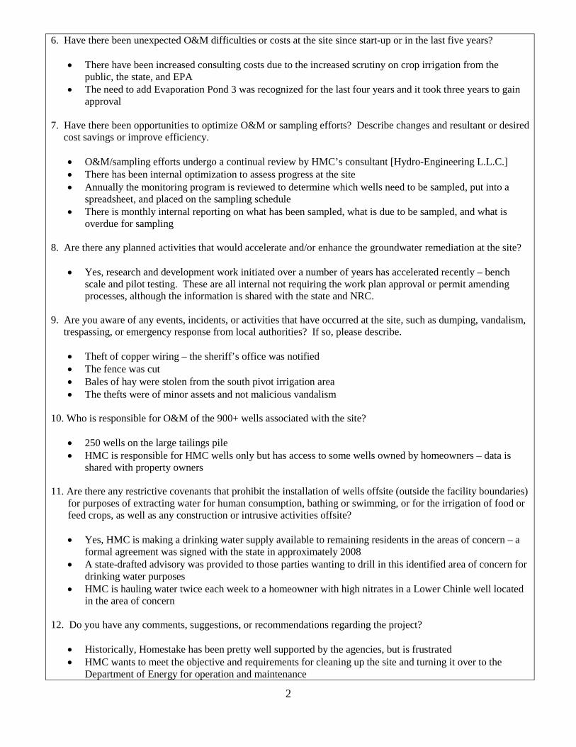
6. Have there been unexpected O&M difficulties or costs at the site since start-up or in the last five years?
• There have been increased consulting costs due to the increased scrutiny on crop irrigation from the public, the state, and EPA
• The need to add Evaporation Pond 3 was recognized for the last four years and it took three years to gain approval
7. Have there been opportunities to optimize O&M or sampling efforts? Describe changes and resultant or desired cost savings or improve efficiency.
• O&M/sampling efforts undergo a continual review by HMC’s consultant [Hydro-Engineering L.L.C.] • There has been internal optimization to assess progress at the site • Annually the monitoring program is reviewed to determine which wells need to be sampled, put into a
spreadsheet, and placed on the sampling schedule • There is monthly internal reporting on what has been sampled, what is due to be sampled, and what is
overdue for sampling
8. Are there any planned activities that would accelerate and/or enhance the groundwater remediation at the site?
• Yes, research and development work initiated over a number of years has accelerated recently – bench scale and pilot testing. These are all internal not requiring the work plan approval or permit amending processes, although the information is shared with the state and NRC.
9. Are you aware of any events, incidents, or activities that have occurred at the site, such as dumping, vandalism, trespassing, or emergency response from local authorities? If so, please describe.
• Theft of copper wiring – the sheriff’s office was notified • The fence was cut • Bales of hay were stolen from the south pivot irrigation area • The thefts were of minor assets and not malicious vandalism
10. Who is responsible for O&M of the 900+ wells associated with the site?
• 250 wells on the large tailings pile • HMC is responsible for HMC wells only but has access to some wells owned by homeowners – data is
shared with property owners
11. Are there any restrictive covenants that prohibit the installation of wells offsite (outside the facility boundaries) for purposes of extracting water for human consumption, bathing or swimming, or for the irrigation of food or feed crops, as well as any construction or intrusive activities offsite?
• Yes, HMC is making a drinking water supply available to remaining residents in the areas of concern – a formal agreement was signed with the state in approximately 2008
• A state-drafted advisory was provided to those parties wanting to drill in this identified area of concern for drinking water purposes
• HMC is hauling water twice each week to a homeowner with high nitrates in a Lower Chinle well located in the area of concern
12. Do you have any comments, suggestions, or recommendations regarding the project?
• Historically, Homestake has been pretty well supported by the agencies, but is frustrated • HMC wants to meet the objective and requirements for cleaning up the site and turning it over to the
Department of Energy for operation and maintenance
2
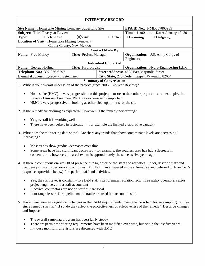
INTERVIEW RECORD
Site Name: Homestake Mining Company Superfund Site EPA ID No.: NMD007860935 Subject: Third Five-year Review Time: 11:00 a.m. Date: January 19, 2011 Type: Telephone Visit Other Location of Visit: Homestake Mining Company
Cibola County, New Mexico
Incoming Outgoing
Contact Made By Name: Fred Molloy Title: Project Manager Organization: U.S. Army Corps of
Engineers Individual Contacted
Name: George Hoffman Title: Hydrologist Organization: Hydro-Engineering L.L.C. Telephone No.: 307-266-6597 E-mail Address: [email protected]
Street Address: 4685 East Magnolia Street City, State, Zip Code: Casper, Wyoming 82604
Summary of Conversation 1. What is your overall impression of the project (since 2006 Five-year Review)?
• Homestake (HMC) is very progressive on this project – more so than other projects – as an example, the Reverse Osmosis Treatment Plant was expensive by important
• HMC is very progressive in looking at other cleanup options for the site
2. Is the remedy functioning as expected? How well is the remedy performing?
• Yes, overall it is working well • There have been delays in restoration – for example the limited evaporative capacity
3. What does the monitoring data show? Are there any trends that show contaminant levels are decreasing? Increasing?
• Most trends show gradual decreases over time • Some areas have had significant decreases – for example, the southern area has had a decrease in
concentration, however, the areal extent is approximately the same as five years ago
4. Is there a continuous on-site O&M presence? If so, describe the staff and activities. If not, describe staff and frequency of site inspections and activities. Mr. Hoffman answered in the affirmative and deferred to Alan Cox’s responses (provided below) for specific staff and activities.
• Yes, the staff level is constant - five field staff, site foreman, radiation tech, three utility operators, senior project engineer, and a staff accountant
• Electrical contractors are not on staff but are local • Four range lessors for pipeline maintenance are used but are not on staff
5. Have there been any significant changes in the O&M requirements, maintenance schedules, or sampling routines since remedy start up? If so, do they affect the protectiveness or effectiveness of the remedy? Describe changes and impacts.
• The overall sampling program has been fairly steady • There are permit monitoring requirements have been modified over time, but not in the last five years • In-house monitoring revisions are discussed with HMC
3

6. Have there been unexpected O&M difficulties or costs at the site since start-up or in the last five years? Mr. Hoffman deferred to Alan Cox’s responses provided below
• There have been increased consulting costs due to the increased scrutiny on crop irrigation from the public, the state, and EPA
• The need to add Evaporation Pond 3 was recognized for the last four years and it took three years to gain approval
7. Have there been opportunities to optimize O&M or sampling efforts? Describe changes and resultant or desired cost savings or improve efficiency.
• There have not been any major opportunities yet – as restoration continues there will be more opportunities
8. Are there any planned activities that would accelerate and/or enhance the groundwater remediation at the site?
• Alternate restoration should enhance restoration and decrease the time needed to restore low concentrations in the groundwater
9. Are you aware of any events, incidents, or activities that have occurred at the site, such as dumping, vandalism, trespassing, or emergency response from local authorities? If so, please describe. Mr. Hoffman deferred to Alan Cox’s responses provided below.
• Theft of copper wiring – the sheriff’s office was notified • The fence was cut • Bales of hay were stolen from the south pivot irrigation area • The thefts were of minor assets and not malicious vandalism
10. Who is responsible for O&M of the 900+ wells associated with the site?
• HMC is responsible for the majority of the wells • Private wells are sampled but the O&M is their responsibility
11. Are there any restrictive covenants that prohibit the installation of wells offsite (outside the facility boundaries) for purposes of extracting water for human consumption, bathing or swimming, or for the irrigation of food or feed crops, as well as any construction or intrusive activities offsite? Mr. Hoffman deferred to Alan Cox’s responses provided below.
• Yes, HMC is making a drinking water supply available to remaining residents in the areas of concern – a formal agreement was signed with the state in approximately 2008
• A state-drafted advisory was provided to those parties wanting to drill in this identified area of concern for drinking water purposes
• HMC is hauling water twice each week to a homeowner with high nitrates in a Lower Chinle well located in the area of concern
12. Do you have any comments, suggestions, or recommendations regarding the project? Mr. Hoffman said that he would like to see help from the agencies on their approval on testing alternative restoration methods but deferred to Alan Cox’s responses (provided below) for the remainder of the responses.
• Historically, HMC has been pretty well supported by the agencies, but is frustrated • HMC wants to meet the objective and requirements for cleaning up the site and turning it over to the
Department of Energy for operation and maintenance
4

INTERVIEW RECORD
Site Name: Homestake Mining Company Superfund Site EPA ID No.: NMD007860935 Subject: Third Five-year Review Time: 4:00 p.m. Date: January 20, 2011 Type: Telephone Visit Other Location of Visit: Residence at 3021 Highway 605
Cibola County, New Mexico
Incoming Outgoing
Contact Made By Name: Fred Molloy Title: Project Manager Organization: U.S. Army Corps of
Engineers Individual Contacted
Name: John Boomer Title: Property Owner Organization: Not applicable Telephone No.: 505- 979-3917 E-mail Address: Not available
Street Address: 3021 Highway 605 City, State, Zip Code: Cibola County, New Mexico
Summary of Conversation 1. What is your overall impression of the project (since 2006 Five-year Review)?
• Gives Homestake (HMC) a grade of D• Does not think the remediation is effective – it’s dilution instead of treating the water • Mr. Boomer referenced a breach of one of the evaporation ponds in the 1980s as the reason for elevated
uranium levels recently detected in soils in his backyard • There are a lot of unanswered questions – for example, regarding irrigation and how clean water is being
pumped into contaminated water – it’s mixing with a little bit of treatment
2. What effects have site operations had on the surrounding community?
• Concerned with the affects that contamination from this site will have when combined with discharge from other mining operations proposed for the area
• Impacts are the spread of the plume, initially going to the edge of the HMC property, and that no one really looked for the plume downgradient
• Remediation has divided the community – those that speak up against are ostracized
3. Are you aware of any community concerns regarding the site or its operation and administration?
• Yes, see above responses • Have grown to mistrust a lot of HMC’s efforts
4. Are you aware of any events, incidents, or activities at the sites such as vandalism or emergency responses from local authorities?
• Not aware of any since arriving in town in January 2001
5. Do you feel well informed about the sites’ activities and progress?
• Moderately so – can’t keep up with the site’s activities • Does not receive local newspaper • Does not know whether the community has been canvassed regarding their feelings about what is going on
and how the cleanup is progressing
5

6. Do you have any comments, suggestions, or recommendations regarding the site’s management or operation?
• Would like to see the large tailings pile moved and isolated – moving the site would show responsibility and provide relief to the community
• Would like to see the source removed and to see a feasibility study on the effort • If existing remedial system continues, would like to see additional monitoring system established in the
community – possibly every one-half mile • Would like to see better monitoring in front of the plume and would like to see a plan for this monitoring • Would like independent analysis of the alluvial floodplain to set a baseline for other mining operations
proposed for the area (five more mining companies trying to obtain permits to mine for uranium in the Mount Taylor area)
• Gives HMC a grade of D- on community education
6

INTERVIEW RECORD
Site Name: Homestake Mining Company Superfund Site EPA ID No.: NMD007860935 Subject: Third Five-year Review Time: 9:30 a.m. Date: January 21, 2011 Type: Telephone Visit Other Location of Visit: Residence at 1986 Ralph Card Road
Grants, New Mexico
Incoming Outgoing
Contact Made By Name: Fred Molloy Title: Project Manager Organization: U.S. Army Corps of
Engineers Individual Contacted
Name: Art Gebeau Title: Property Owner Organization: Bluewater Valley Downstream Alliance*
Telephone No.: 505- 287-3613 E-mail Address: Not available
Street Address: 1986 Ralph Card Road City, State, Zip Code: Grants, New Mexico
Summary of Conversation *Note – Mr. Gebeau, while involved with the Bluewater Valley Downstream Alliance (BVDA), was interviewed in his capacity as a property owner.
1. What is your overall impression of the project (since 2006 Five-year Review)?
• Poor – Homestake (HMC) got off to a terrible start and the remediation cannot be handled • The major problems are water, radon, and blowing dust • Homeowners have found residue on their cars as much as one-half mile away from the spray irrigation • The center pivot irrigation has started new areas of contamination • HMC is trying to dilute as a means of treating the problem • The reverse osmosis treatment facility should be enlarged
2. What effects have site operations had on the surrounding community?
• The issues with water, radon, and blowing dust have taken away our enjoyment of life, particularly close by • Taken away the use of our wells and imposed costs on us from water supplied by the city of Milan
3. Are you aware of any community concerns regarding the site or its operation and administration?
• Definitely so – BVDA joined with MASE (Multicultural Alliance for a Safe Environment) and both are represented by the Southwest Research and Information Center
4. Are you aware of any events, incidents, or activities at the sites such as vandalism or emergency responses from local authorities?
• Not aware of any
5. Do you feel well informed about the sites’ activities and progress?
• Not from HMC • EPA has been good in the last year or so and this interview is a positive step – three or four years ago we
wouldn’t even be sitting here • NRC promotes but doesn’t regulate the industry • Any economic relief will have to come from EPA and not the New Mexico Environment Department – EPA
seems to be the one chance people have
7

6. Do you have any comments, suggestions, or recommendations regarding the site’s management or operation?
• HMC has not done their job – they ignored their job • Corporately, HMC is owned by the largest gold mining company in the world – and a little more money
should be spent to do the job right – it would be a drop in the bucket to what they [Barrick] are making • Would like to see the large tailings pile moved to an appropriate place in the area – moving can be
accomplished by slurrying or a conveyor belt • HMC should take the same approach as was used at Durango, Colorado and Moab, Utah and move the
tailings pile • HMC has not gotten out in front of the problem – they have a poor knowledge of the geology of the area –
they put in injection wells and pushed the groundwater plume out away from the HMC property
8
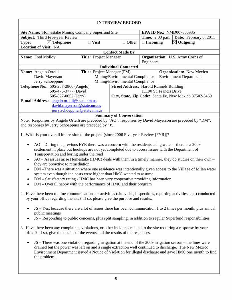
INTERVIEW RECORD
Site Name: Homestake Mining Company Superfund Site EPA ID No.: NMD007860935 Subject: Third Five-year Review Time: 2:00 p.m. Date: February 8, 2011 Type: Telephone Visit Other Location of Visit: NA
Incoming Outgoing
Contact Made By Name: Fred Molloy Title: Project Manager Organization: U.S. Army Corps of
Engineers Individual Contacted
Name: Angelo Ortelli David Mayerson Jerry Schoeppner
Title: Project Manager (PM) Mining/Environmental Compliance Mining/Environmental Compliance
Organization: New Mexico Environment Department
Telephone No.: 505-287-2866 (Angelo) 505-476-3777 (David) 505-827-0652 (Jerry)
E-mail Address: [email protected] [email protected] [email protected]
Street Address: Harold Runnels Building 11190 St. Francis Drive
City, State, Zip Code: Santa Fe, New Mexico 87502-5469
Summary of Conversation Note: Responses by Angelo Ortelli are preceded by “AO”; responses by David Mayerson are preceded by “DM”; and responses by Jerry Schoeppner are preceded by “JS.”
1. What is your overall impression of the project (since 2006 Five-year Review [FYR])?
• AO – During the previous FYR there was a concern with the residents using water – there is a 2009 settlement in place but hookups are not yet completed due to access issues with the Department of Transportation and boring under the road
• AO – As issues arise Homestake (HMC) deals with them in a timely manner, they do studies on their own – they are proactive to remediation
• DM –There was a situation where one residence was intentionally given access to the Village of Milan water system even though the costs were higher than HMC wanted to assume
• DM – Satisfactory rating - HMC has been very cooperative providing information • DM – Overall happy with the performance of HMC and their program
2. Have there been routine communications or activities (site visits, inspections, reporting activities, etc.) conducted by your office regarding the site? If so, please give the purpose and results.
• JS – Yes, because there are a lot of issues there has been communication 1 to 2 times per month, plus annual public meetings
• JS – Responding to public concerns, plus split sampling, in addition to regular Superfund responsibilities
3. Have there been any complaints, violations, or other incidents related to the site requiring a response by your office? If so, give the details of the events and the results of the responses.
• JS – There was one violation regarding irrigation at the end of the 2009 irrigation season – the lines were drained but the power was left on and a single extraction well continued to discharge. The New Mexico Environment Department issued a Notice of Violation for illegal discharge and gave HMC one month to find the problem.
9

4. Have there been any changes in the state’s environmental standards since implementing the remdy such ahtat the protectiveness or effectiveness of the remedy would be called into question?
• JS – The uranium standard changed but that did not affect the protectiveness; however, this standard change affected the land application, through irrigation, from the alluvial aquifer. NRC license (0.44 µg/L), 1.6 µg/L (background), and 0.03 µg/L (NMED/EPA standard) for discharge – but the protectiveness has not been an issue.
5. Is groundwater remediation progressing according to the state’s expectations? Does the state have any concerns with the status of groundwater remediation being conducted at the site?
• JS – There is some question whether the western alluvial plume from the large tailings pile is being captured. It is mixing with contamination from an unidentified source upgradient of the HMC site.
• JS – We’re happy to have hydraulic containment but we’re losing ground on the western and southern footprints – held up in regulations as to whether NMED will allow land application in the future.
• DM – Evaporation Pond 3 is already too small – JS - but it was assumed that land application would continue.
6. From a regulator’s perspective, are adequate data being collected to allow for an adequate evaluation of the remedy’s performance? If not, what additional data would be useful?
• DM – They have a lot of data, however, one of the recommendations of the Remediation System Evaluation was the reorganization of monitoring, related to specific remediation goals. Currently is it hard to relate data to remediation goals, although a lot is captured. We want to see how HMC responds to this recommendation.
• AO – The data needs to be related to data quality objectives.
7. Do you feel well informed about the site’s activities and progress?
• JS – Due to regulatory oversight, HMC usually notifies NMED, but sometimes they have not. The community is the watchdog.
• JS – HMC needs to relay the public relations issues to the state so that the state is well informed.’ • JS – Because NRC is the lead agency they tweak the system on a continual basis – changing wells to be
monitored or installing wells without notification to NMED/ • DM – EPA ought to have more public meetings describing what has been done and providing a status report.
8. Do you have any comments, suggestions, or recommendations regarding the site’s management or operation?
• JS – No. About one year ago David [Mayerson] took the lead on having more regular conference calls with the regulators on issues. HMC was brought in on some of the calls. It is good to have calls approximately six months so that HMC can update the parties on what has been done. DM – This shows a more unified front to the public as a result of these more frequent calls.
• DM – I would like to have more public meetings with the regulators and HMC every six months. • DM – HMC is the most downgradient of the legacy uranium sites in the basin [San Mateo Creek]. They’re
near the community and so it is difficult to understand the regulation of the HMC site with the upstream contribution and how it fits into the overall picture.
• DM – There is a lot of fanfare about investigating the upgradient sites, but not much has been done.
10
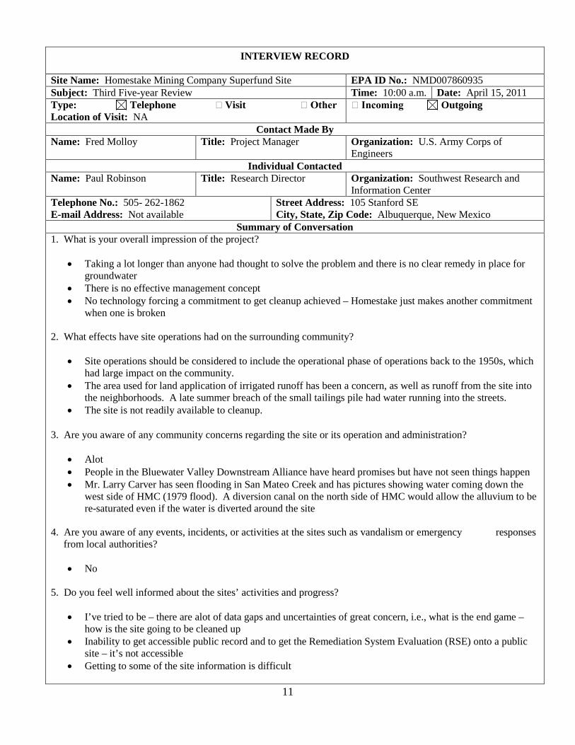
INTERVIEW RECORD
Site Name: Homestake Mining Company Superfund Site EPA ID No.: NMD007860935 Subject: Third Five-year Review Time: 10:00 a.m. Date: April 15, 2011 Type: Telephone Visit Other Location of Visit: NA
Incoming Outgoing
Contact Made By Name: Fred Molloy Title: Project Manager Organization: U.S. Army Corps of
Engineers Individual Contacted
Name: Paul Robinson Title: Research Director Organization: Southwest Research and Information Center
Telephone No.: 505- 262-1862 E-mail Address: Not available
Street Address: 105 Stanford SE City, State, Zip Code: Albuquerque, New Mexico
Summary of Conversation 1. What is your overall impression of the project?
• Taking a lot longer than anyone had thought to solve the problem and there is no clear remedy in place for groundwater
• There is no effective management concept • No technology forcing a commitment to get cleanup achieved – Homestake just makes another commitment
when one is broken
2. What effects have site operations had on the surrounding community?
• Site operations should be considered to include the operational phase of operations back to the 1950s, which had large impact on the community.
• The area used for land application of irrigated runoff has been a concern, as well as runoff from the site into the neighborhoods. A late summer breach of the small tailings pile had water running into the streets.
• The site is not readily available to cleanup.
3. Are you aware of any community concerns regarding the site or its operation and administration?
• Alot • People in the Bluewater Valley Downstream Alliance have heard promises but have not seen things happen • Mr. Larry Carver has seen flooding in San Mateo Creek and has pictures showing water coming down the
west side of HMC (1979 flood). A diversion canal on the north side of HMC would allow the alluvium to be re-saturated even if the water is diverted around the site
4. Are you aware of any events, incidents, or activities at the sites such as vandalism or emergency responses from local authorities?
• No
5. Do you feel well informed about the sites’ activities and progress?
• I’ve tried to be – there are alot of data gaps and uncertainties of great concern, i.e., what is the end game – how is the site going to be cleaned up
• Inability to get accessible public record and to get the Remediation System Evaluation (RSE) onto a public site – it’s not accessible
• Getting to some of the site information is difficult
11

6. Do you have any comments, suggestions, or recommendations regarding the site’s management or operation?
• There is good reason to think that EPA and the Nuclear Regulatory Commission (NRC) do not have a partnership.
• NRC has been a hesitant participant in the RSE process. • There is no idea what the costs for remediation will be – are the taxpayers getting a good deal? • There is no good accounting for how much taxpayers have paid. • There is no effective government oversight over the quality of the remediation – only oversight on the goals. • A regional solution for all the area mine sites should be considered.
12

Attachment 3
Photographs Documenting Site Conditions
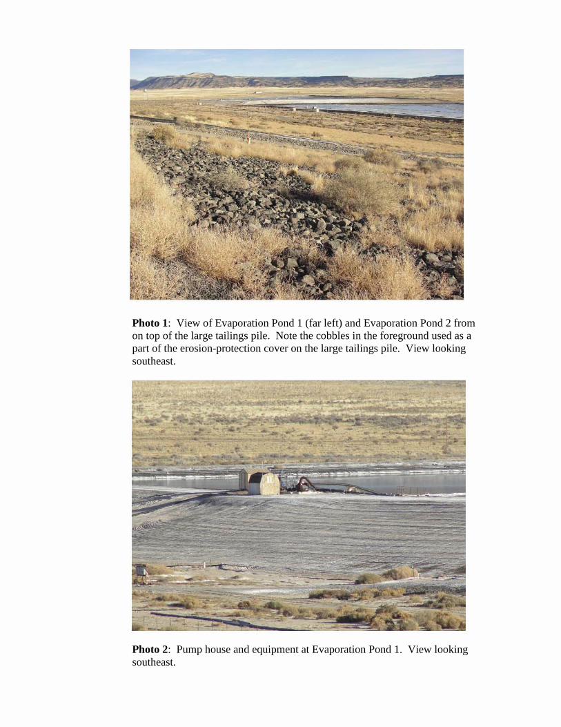
Photo 1: View of Evaporation Pond 1 (far left) and Evaporation Pond 2 from on top of the large tailings pile. Note the cobbles in the foreground used as a part of the erosion-protection cover on the large tailings pile. View looking southeast.
Photo 2: Pump house and equipment at Evaporation Pond 1. View looking southeast.

Photo 3: Collection ponds (in center of photo) on the south side of the large tailings pile. A portion of Evaporation Pond 2 is visible on the left side of the photo. View looking south.
Photo 4: Reverse osmosis (RO) treatment plant on southwest side of the large tailings pile. View looking southwest.

Photo 5: Roads leading up to (foreground) and on top of the large tailings pile. Piping on the opposite side of the road is used to convey collected groundwater to the RO treatment plant or to one of the evaporation ponds for disposal. Note the water towers marking the locations of the two former mill sites. View looking east.
Photo 6: Extraction wells and piping on top of the large tailings pile. View looking east.
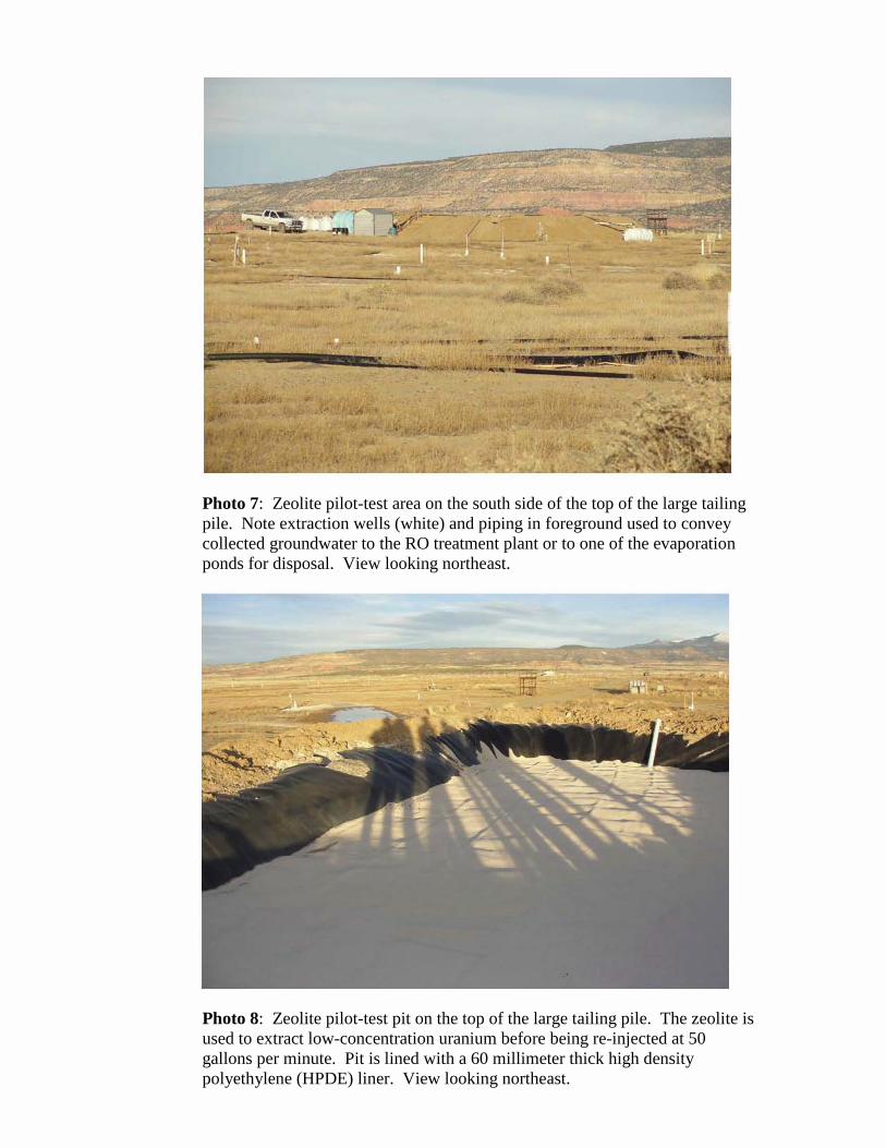
-."... ..
Photo 7: Zeolite pilot-test area on the south side of the top of the large tailing pile. Note extraction wells (white) and piping in foreground used to convey collected groundwater to the RO treatment plant or to one of the evaporation ponds for disposal. View looking northeast.
Photo 8: Zeolite pilot-test pit on the top of the large tailing pile. The zeolite is used to extract low-concentration uranium before being re-injected at 50 gallons per minute. Pit is lined with a 60 millimeter thick high density polyethylene (HPDE) liner. View looking northeast.

Photo 9: Two of 14 discharge structures used to convey surface water off of the top of the large tailings pile. View looking northwest.
Photo 10: Pump, pump house, and piping at Evaporation Pond 1. Equipment is used to convey extracted groundwater from the large tailings pile (to the right out of the photo) to the evaporation pond. The black surface is an asphalt-emulsion liner that forms the base for the pond. View looking west.

Photo 11: Evaporation Pond 1. Piping used to conve y extracted groundwater from the large tailings pile to the evaporation pond and to the spray misters (structures in the center of the pond). View looking south.
Photo 12: South side of the large tailings pile viewed from the south berm of Evaporation Pond 1. Extracted groundwater is pumped from the large tailings pile to the evaporation ponds using the piping in the center of the pictured. View looking north.

•
Photo 13: Point-of-Compliance (POC) Well X at the toe of the small tailings pile. The well was installed in 1975 and monitors the base of the alluvium at approximately 51 feet below ground surface. View looking northeast.
Photo 14: POC Well D1 near the RO treatment plant. Well D1 is a replacement well for the original POC Well D.
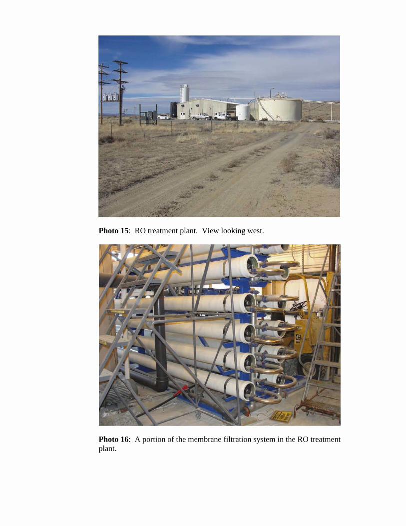
Photo 15: RO treatment plant. View looking west.
Photo 16: A portion of the membrane filtration system in the RO treatment plant.
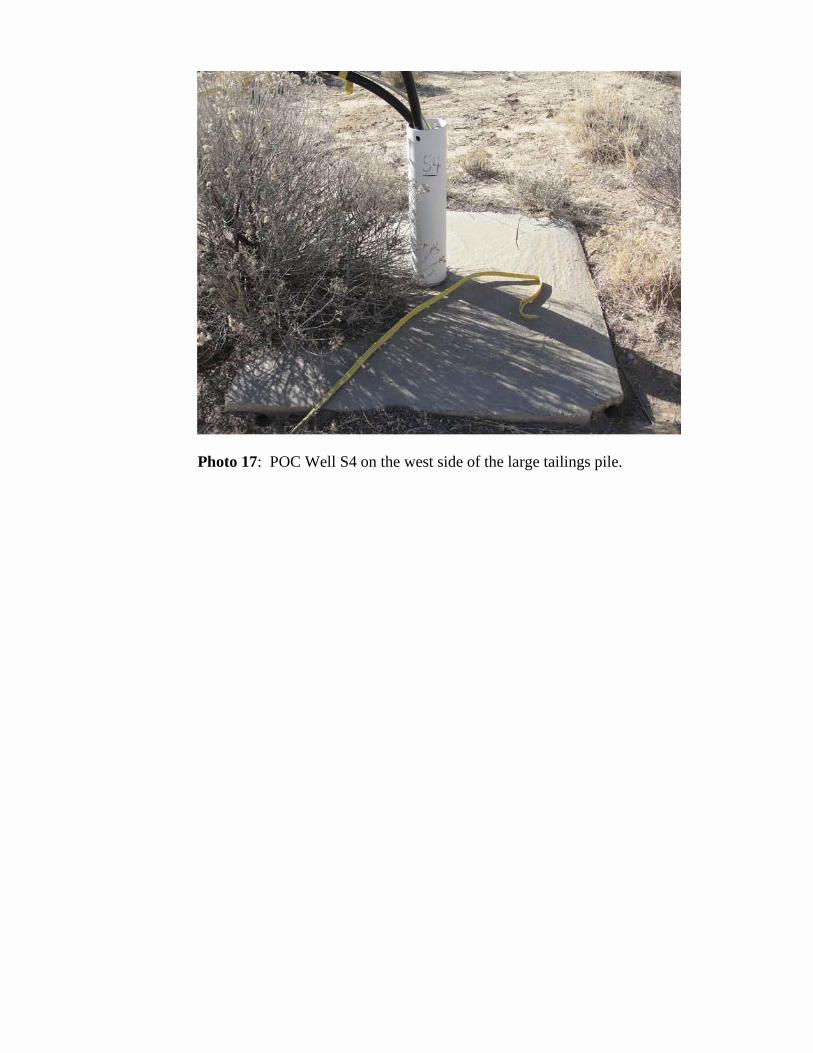
Photo 17: POC Well S4 on the west side of the large tailings pile.

Attachment 4
List of Documents Reviewed

List of Documents Reviewed
Agency for Toxic Substances and Disease Registry (ATSDR), 2008. Health Consultation, Homestake Mining Company Mill Site, Milan, Cibola County, New Mexico. May.
ATSDR, 2009. Health Consultation, Homestake Mining Company Mill Site, Milan, Cibola County, New Mexico. June.
Baldwin, Joe A. and Rankin, Dale R., 1995. Hydrogeology of Cibola County, New Mexico. Prepared in cooperation with the New Mexico Bureau of Mines and Mineral Resources and the New Mexico State Engineer Office.
CH2M HILL, 2001. First Five-Year Review Report for Homestake Mining Company Superfund Site, Cibola County, New Mexico. Prepared for Region 6, United States Environmental Protection Agency, Dallas, Texas. September.
Coleman, S., 2011. Personal communication, U.S. Environmental Protection Agency (EPA), Division of Waste Management and Environmental Protection. Letter and correspondence to L. Camper, U.S. Nuclear Regulatory Commission. July 8, 2011.
Environmental Restoration Group, Inc., 1995. Completion Report for Reclamation of Off-Pile Areas at the Homestake Mining Company of California Uranium Mill, Grants Operation, License No. SUA-1471. Prepared for Homestake Mining Company of California, Grants Operations. November.
Environmental Restoration Group, Inc., RIMCON, and Hydro-Engineering, L.L.C., 2011. Grants Reclamation Project, Evaluation of Years 2000 Through 2010, Irrigation with Alluvial Ground Water. Prepared for Homestake Mining Company. January.
Gordon, Ellis D., 1961. Geology and Ground-Water Resources of the Grants-Bluewater Area, Valencia County, New Mexico
Homestake Mining Company of California (HMC) and New Mexico Environment Department, 2009. Memorandum of Agreement Between Homestake Mining Company of California and the New Mexico Environment Department, Agreement Regarding Provision of Access to Drinking Water System. January.
1

HMC & Hydro-Engineering, LLC & Environmental Restoration Group &RIMCON, 2010. Evaluation of Years 2000 through 2009, Irrigation with Alluvial Ground Water. Prepared for New Mexico Environment Department & U.S. Nuclear Regulatory Commission. Homestake Mining Company. March.
HMC & Hydro-Engineering, LLC, 2010. 2009 Annual Monitoring Report/Performance Review for Homestake’s Grants Project Pursuant to NRC License SUA-1471 and Discharge Plan DP-200. Prepared for U.S. Nuclear Regulatory Commission and New Mexico Environment Department. March.
HMC & Hydro-Engineering, LLC, 2006. 2005 Annual Monitoring Report/Performance Review for Homestake’s Grants Project Pursuant to NRC License SUA-1471 and Discharge Plan DP-200. Prepared for U.S. Nuclear Regulatory Commission and New Mexico Environment Department. March.
Laughlin, A. William, Charles, Robert W., Reid, Kevin and White, Carol, 1993. Fieldtrip guide to the geochronology of El Malpais National Monument and the Zuni-Bandera volcanic field, New Mexico, Bulletin 149, New Mexico Buraeu of Mines and Mineral Resources.
MFG, Inc. (MFG), 2006. Grants Reclamation Project Groundwater Corrective Action Program (CAP) Revision. Prepared for Homestake Mining Company of California. December.
U.S. Environmental Protection Agency (EPA), 1989. Record of Decision, Homestake Mining Company Radon Operable Unit, Cibola County, New Mexico. September.
EPA, 1992. Technical Support Document for the 1992 Citizen’s Guide to Radon. EPA400-R92-011. Radon Division. Office of Radiation Programs. May.
EPA, 2001. Comprehensive Five-Year Review Guidance, EPA/540-R-01-007. Office of Emergency and Remedial Response. June.
EPA, 2004. Region 9 PRG Table. On the Web at www.epa.gov/region9/superfund/prg/files/04prgtable.pdf.
EPA, 2006. Second Five-Year Review Report for Homestake Mining Company Superfund Site, Cibola County, New Mexico. September.
U.S. Environmental Protection Agency, 2009. Risk Assessment Guidance for Superfund, Volume I: Human Health Evaluation Manual (Part F, Supplemental Guidance for Inhalation Risk Assessment). Final. EPA-540-R-070-002. Office of Superfund Remediation and Technology Innovation. January.
2

EPA, 2010. Focused Review of Specific Remediation Issues, An Addendum to the Remediation System Evaluation for the Homestake Mining Company (Grants) Superfund Site, New Mexico. Draft Final. Prepared by the US Army Corps of Engineers Environmental and Munitions Center of Expertise for US Environmental Protection Agency, Region 6. August.
EPA, 2010. Focused Review of Specific Remediation Issues, An Addendum to the Remediation System Evaluation for the Homestake Mining Company (Grants) Superfund Site, New Mexico. Final. Prepared by the US Army Corps of Engineers Environmental and Munitions Center of Expertise for US Environmental Protection Agency, Region 6. December.
EPA, 2011. Regional Screening Level (RSL) Master Table. May. On the Web at http://www.epa.gov/reg3hwmd/risk/human/rbconcentration_table/Generic_Tables/index.htm.
EPA, 2011. Regional Screening Level (RSL) Master Table. May. On the Web at http://www.epa.gov/reg3hwmd/risk/human/rbconcentration_table/Generic_Tables/index.htm.
EPA. Integrated Risk Information System (IRIS). Available on the Web at http://www.epa.gov/iris
3

Attachment 5
Public Notice