Five Themes of Geography: Location Lesson on Absolute Location Grade 6 Humanities.
Upload
irene-perryCategory
view
223download
1
THINKING GEOGRAPHICALLY: NATURE AND PERSPECTIVES
Human Geography
Physical Geography
Five themes of Geography1. Location (absolute and relative)2. Movement (ideas, people, goods)3. Regions – what do areas have in common
4. Place – what is unique about a location
5. Human Environment Interaction a. Modify b. adapt
Famous Geographers: Eratosthenes – Father of Geography – circumference of the Earth
Ptolemy: Compiled first Atlas “ Guide to Geography”. It was Ptolemy's incorrect map that Columbus used to determine he could sail around the world.
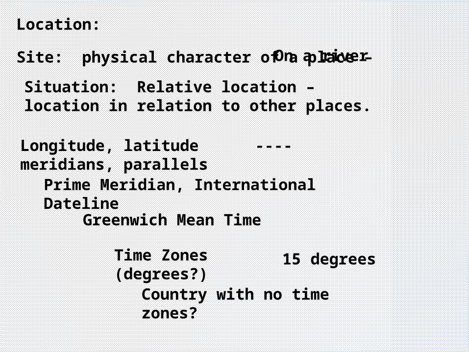
Location:
Site: physical character of a place –
Situation: Relative location – location in relation to other places.
Longitude, latitude ----meridians, parallels
Prime Meridian, International Dateline
Greenwich Mean Time
Time Zones (degrees?)
Country with no time zones?
15 degrees
On a river

MAPS AND MAP PROJECTIONS:
All maps have distortion.The type of projection is determined by the projection.
The Mercator projection distorts shapes around the poles. Perfect for ship navigation.

A Robinson projection distorts all features a little but no area to a large degree.

A Peter’s projection “spreads “ countries near the equator but squashes them near the poles.
An azimuthal map shows the earth from a particular point. Doesn’t show all of the planet.

Map Scale
Large scale map
1” = 5 miles. Would be used on a local map.
Small scale map
1” = 500 miles. Would be used on a larger map.
Large scale = small mapSmall scale = large map

Geographer’s are interested in the way places and things are arranged and organized on the surface of the Earth.
In simple terms, spatial means “space.”
This spatial perspective means they notice patterns, environments, distributions of people and locations of all kinds of objects.
Spatial analysis, spatial distribution
Look at the spatial distribution of the desks in your classrooms.


Spatial Analysis
• Geographers search for patterns in the distribution and movement of human activities and environmental processes.
Where is AIDs?Where do we find hunger?Where are American blacks (region) ?Where are cattle raised?

Spatial Analysis: Crime Mapping


Describing Distributions

Types of density
Arithmetic density: How many or how much in a given space

Physiological density:
Number of people per unit of farmland
Agricultural density:
Number of farmers per unit of farm land
Can this information define an LDC or MDC?

Chloropleth Maps
Cartogram
Types of maps

Dot Map
Isoline map

Mental mapping
You have a “mental image” of a place or location. The closer to familiar places, the more accurate it tends to be.
Map projection
How to get a round map onto a flat sheet of paper. Something will always be distorted.

Geographic Information Systems (GIS)
Satellite imaging takes photos of “layers” of the surface. These can be separated and studied for a particular purpose.

Scale can also be used to identify the importance of an occurrence. These exist on levels from a small to large scale.
If 25 people die in a flood in Burkina Faso, the scale of the tragedy is important there, but not on a world scale.
If 250,000 people die in a Tsunami in the Indian Ocean, the scale is important on a worldwide scale.
Think ZOOM
A murder in Cypress is important in scale to us, but not necessarily to someone in Duluth.
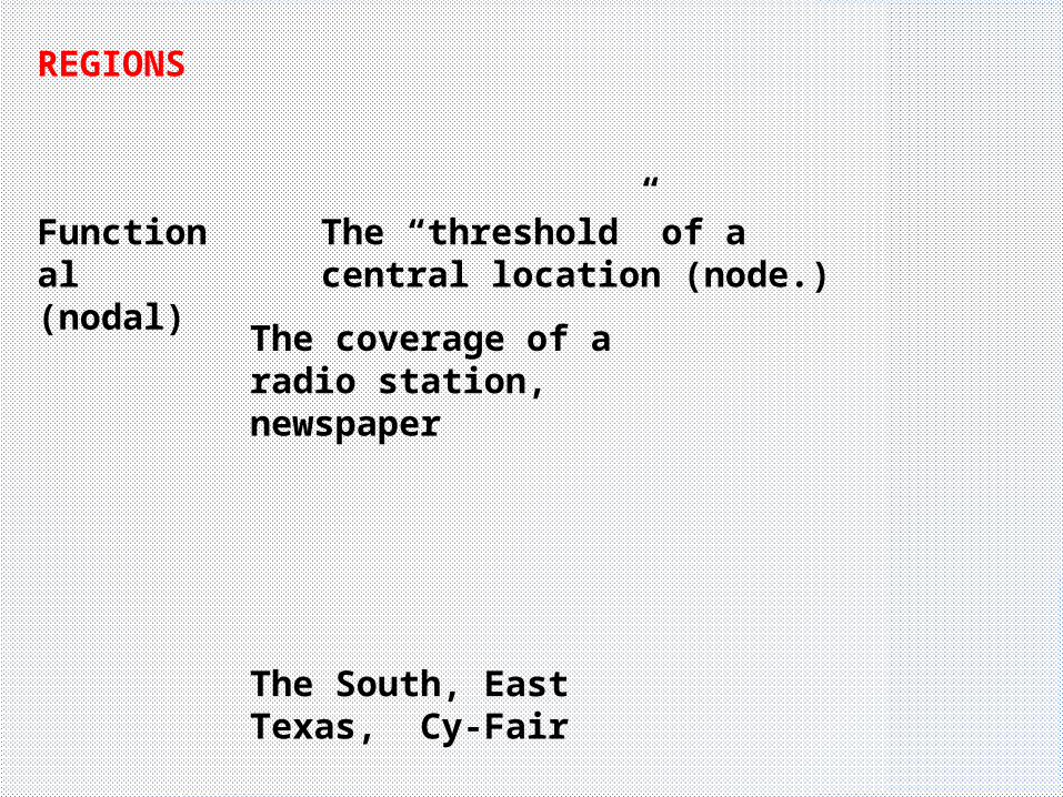
REGIONS
Functional(nodal)
The “threshold” of a central location (node.)
The coverage of a radio station, newspaper
The South, East Texas, Cy-Fair

Types of regions: perceptual (vernacular)
We know where it is, but it is not an “official” region
The Panhandle of Texas
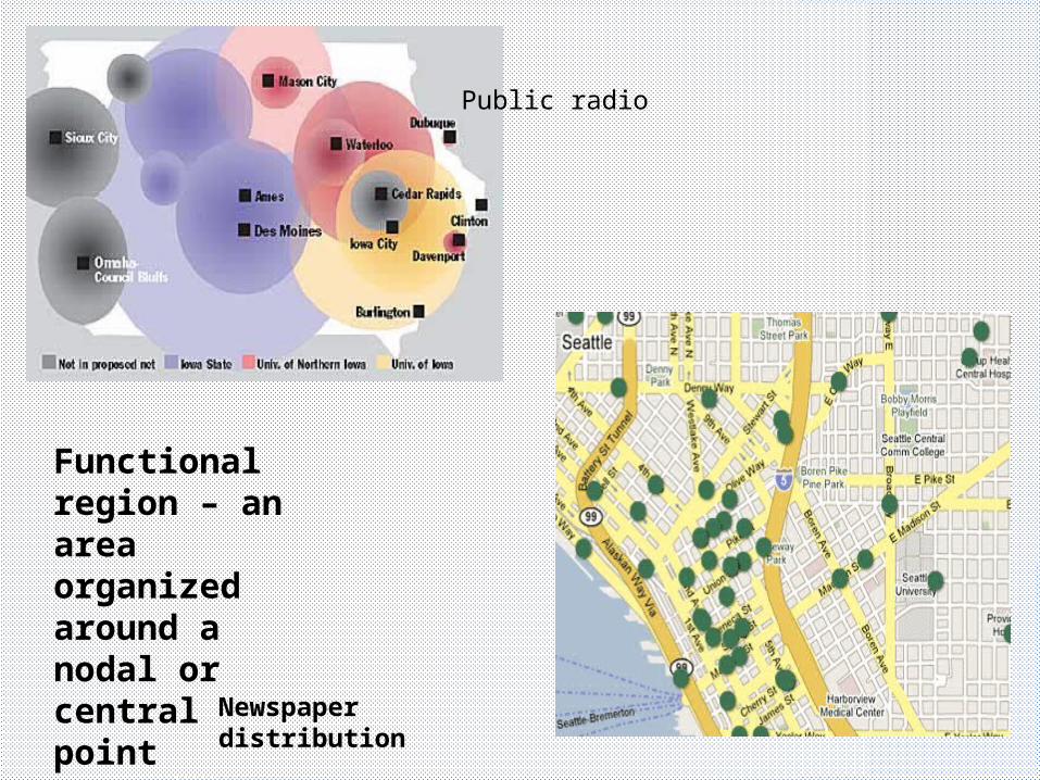
Functional region – an area organized around a nodal or central point
Public radio
Newspaper distribution

Formal regions have an “official” designation such as precincts, counties, states, countries, etc…
The “corn belt” is also considered a formal region because everything in the region is built around corn production.

• All things are related. However, all other things being equal, those things that are closest together are more related.
• Related Concepts:– Distance Decay– Friction of Distance– Gravity Model (influence of one place on another)
Tobler’s 1st Law of Geography

DIFFUSION
EXPANSION DIFFUSION
RELOCATION DIFFUSION
Spread of an idea from the physical movement of people.
Hierarchal Diffusion: spread of an idea from persons or nodes of authority to other persons or places. (top down diffusion)
Contagious Diffusion: The rapid and widespread diffusion of a characteristic throughout a population.
Stimulus diffusion: The spread of a principle even though the characteristic itself does not diffuse. Apple vs Microsoft

GENERAL INFORMATION
Space-time compression
The reduction in time it takes something to diffuse to a distant place. (technology)
Toponyms: Place namesSan Antonio, Red Bluff Mountain, Longwood Golf Club
Sequence occupance
The change over time as to what is “occupying” a particular space.
Prairie to sod hut to house to apartments to vacant lot

Environmental Determinism: the environment determines the relative success of failure of a group of people. The physical environment causes and restricts human development.
Distance decay: the diminishing importance and eventual disappearance of a phenomena the further away it is from its origin.
Possibilism: the environment may set limits on development, but people have the ability to overcome their environments.

Density
Pattern
Concentration-Irregular
Arithmetic
Concentration - regular
dispersed
Linear or clustered?
end

Arithmetic density
The number of an item in a given space.
Physiological density
Number of people per given amount of arable land.
Arable or agricultural density
Number of farmers per given amount of arable land.
end