The Wylye Hoard - Wiltshire Archaeology Field...
30
[Type text] Wiltshire Archaeology Field Group The Wylye Hoard Excavation Report 2 nd March 2016 Report Number: 2016.01 WILTSHIRE ARCHAEOLOGY AND NATURAL HISTORY SOCIETY 41 LONG STREET DEVIZES WILTSHIRE SN10 1NS
Transcript of The Wylye Hoard - Wiltshire Archaeology Field...
[Type text]
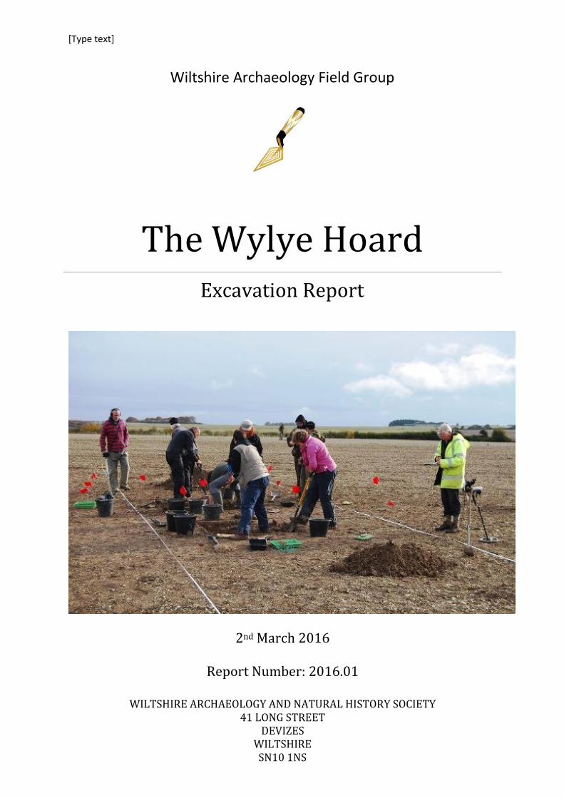
Wiltshire Archaeology Field Group
The Wylye Hoard Excavation Report
2nd March 2016
Report Number: 2016.01
WILTSHIRE ARCHAEOLOGY AND NATURAL HISTORY SOCIETY 41 LONG STREET
DEVIZES WILTSHIRE SN10 1NS
WH12 - The Wylye Hoard Excavation Report 2nd March 2016
Page | 1
Table of Contents
Treasure Act 1996 ................................................................................................................................... 3
Summary ................................................................................................................................................. 3
Date of Investigations ............................................................................................................................. 3
Site Owner............................................................................................................................................... 3
Authorship .............................................................................................................................................. 3
Disclaimer................................................................................................................................................ 3
Acknowledgements ................................................................................................................................. 4
1 Location ........................................................................................................................................... 5
2 Topography and Geology ................................................................................................................ 6
3 Archaeological and Historical Background ..................................................................................... 6
4 Aims................................................................................................................................................. 7
5 Methodology ................................................................................................................................... 8
6 Results ............................................................................................................................................. 8
6.1 Test Pit A ................................................................................................................................. 9
6.1.1 Pit [A05]......................................................................................................................... 11
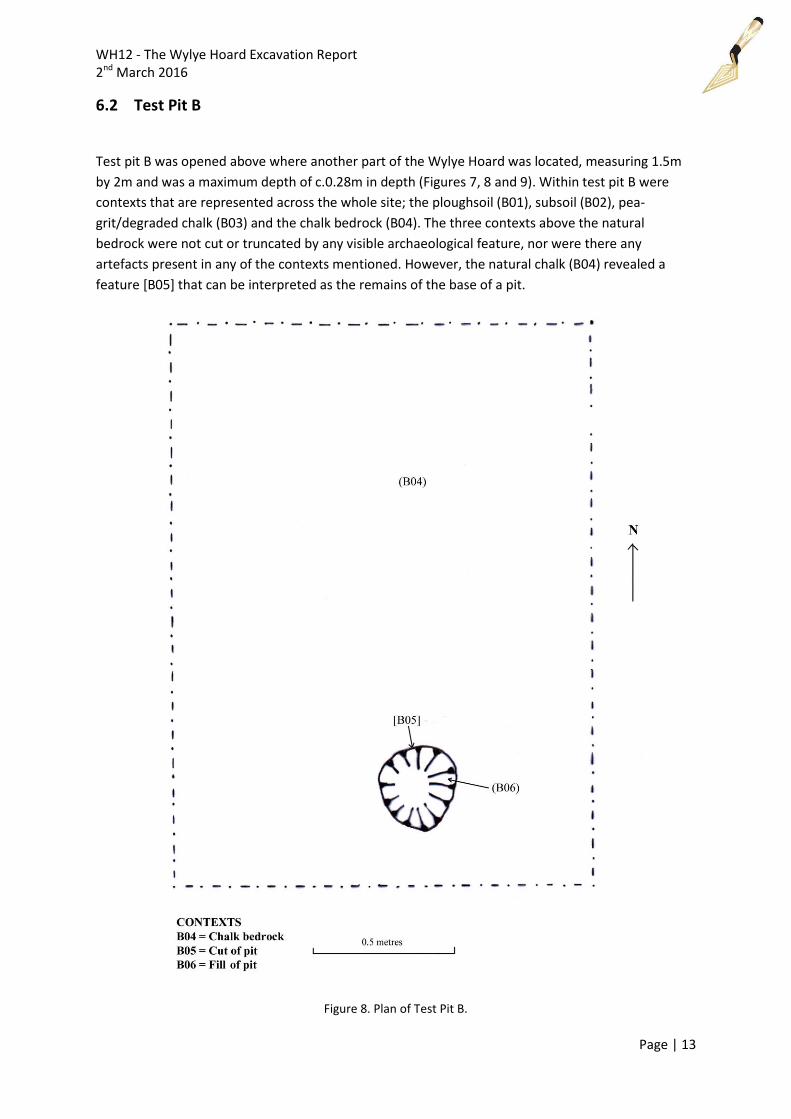
6.2 Test Pit B ............................................................................................................................... 13
6.2.1 Pit [B05] ......................................................................................................................... 14
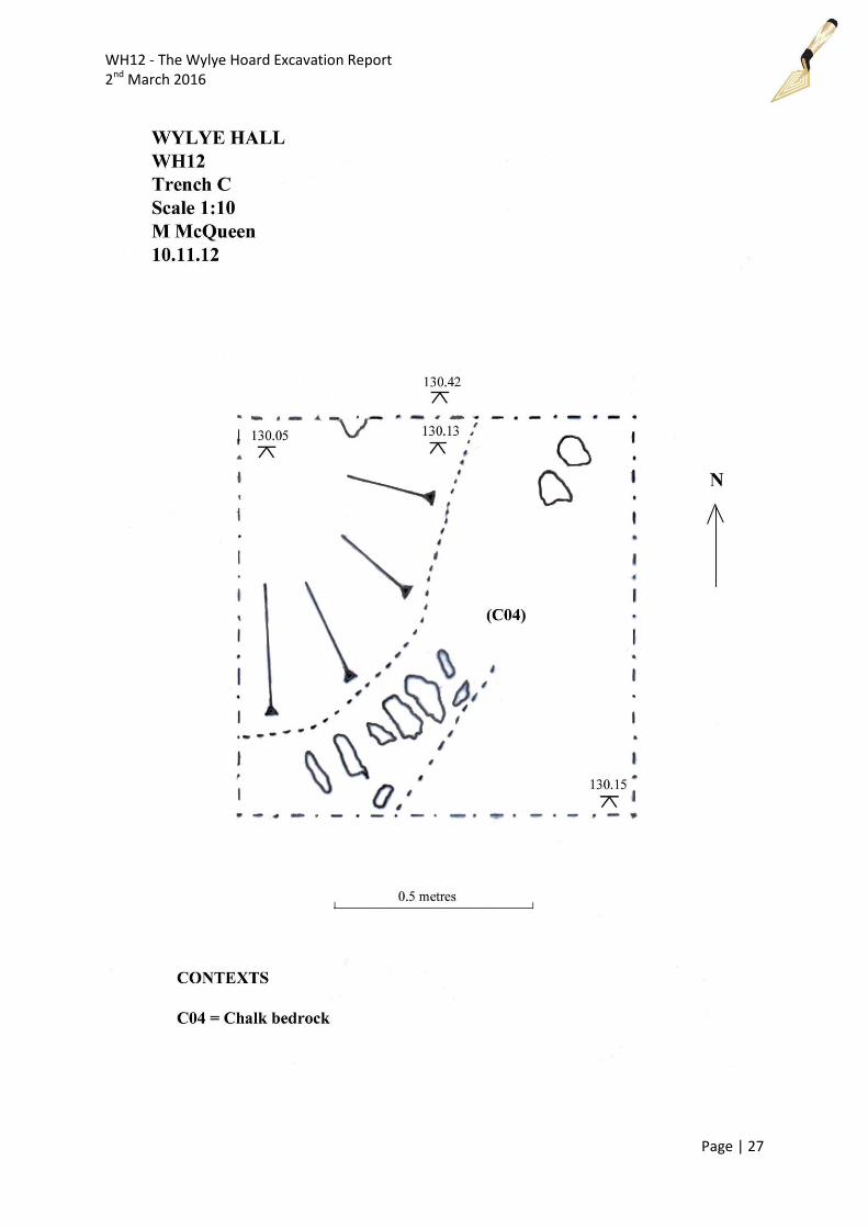
6.3 Test Pit C ............................................................................................................................... 16
7 Finds .............................................................................................................................................. 17
7.1 The Hoard .............................................................................................................................. 17
7.2 Flint ....................................................................................................................................... 18
8 Environmental Sample, by Robin Holley ....................................................................................... 19
8.1 Introduction .......................................................................................................................... 19
8.2 Methodology ......................................................................................................................... 19
8.3 Charred Plant Remains .......................................................................................................... 20
8.4 Residue .................................................................................................................................. 20
8.5 Summary ............................................................................................................................... 20
9 Interpretation................................................................................................................................ 20
10 Discussion .................................................................................................................................. 21
11 Conclusion ................................................................................................................................. 22
12 Archive Location ........................................................................................................................ 23
13 Bibliography .............................................................................................................................. 23

WH12 - The Wylye Hoard Excavation Report 2nd March 2016
Page | 2
14 Appendix 1 – Graphics with Levels ........................................................................................... 25
15 Appendix 2 – Trench Tables ...................................................................................................... 28
Table of Figures
Figure 1. Map of the location of the Wylye Hoard in Wiltshire, England. .............................................. 5
Figure 2. Map of enclosures within the wider region of the Wylye Hoard. ........................................... 7
Figure 3. Plan of all three test pits excavated. ........................................................................................ 9
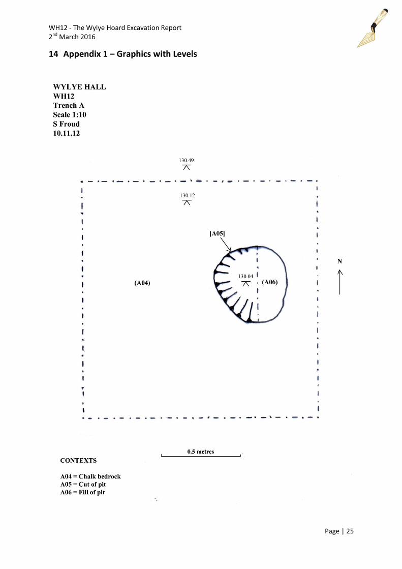
Figure 4. Plan of Test Pit A. ................................................................................................................... 10
Figure 5. Excavation of test pit A revealing pit [A05). ........................................................................... 11
Figure 6. Photograph of test pit A with pit [A05] fully excavated. ....................................................... 12
Figure 7. West facing section of pit [A06] in test pit A. ........................................................................ 12
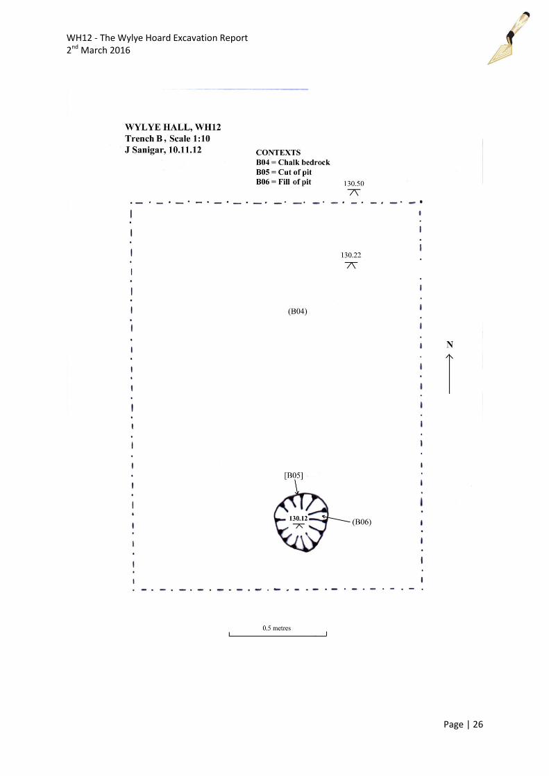
Figure 8. Plan of Test Pit B. ................................................................................................................... 13
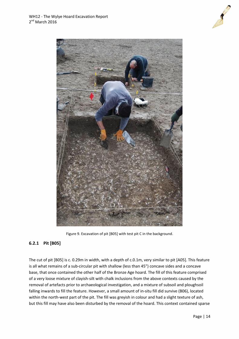
Figure 9. Excavation of pit [B05] with test pit C in the background. .................................................... 14
Figure 10. Photograph of Test Pit B. ..................................................................................................... 15
Figure 11. West facing shot of test pit B with pit [B05] fully excavated. Note a lighter shade of grey in
the feature where a layer of ash like clay with bits of charcoal was found. ........................................ 16
Figure 12. North facing shot of test pit C. ............................................................................................. 17
Figure 13. The hoard immediately after it had been discovered by the West London Archaeological
Searchers.. ............................................................................................................................................. 18
Figure 14. Mesolithic flint bladelet from pit [B05] found within the environmental sample of context
(B06). ..................................................................................................................................................... 19
WH12 - The Wylye Hoard Excavation Report 2nd March 2016
Page | 3
Treasure Act 1996
The Wylye Hoard has been declared treasure under the Treasure Act 1996. It is legal requirements of
the Treasure Act that the find spot location has to remain secure, which is why the location of the
hoard has to be described in the broadest terms with the known as Wylye, and detailed maps cannot
be disclosed to the public.
Summary
A Middle Bronze Age (1400-1300 B.C.) ornament hoard, consisting of 41 bronze objects was
discovered by Stuart Gullick and Michael Barker of the West London Archaeological Searchers on the
Deptford Downs near the village of Wylye, Wiltshire on 4th November 2012. The find was reported to
David Dawson, Director of the Wiltshire Museum, who went out to record the discovery and liaised
with the landowner and the County Archaeologist. An excavation by members of the Wiltshire
Archaeology Field Group was undertaken on the 10th November to locate more of the hoard, its
associated archaeological features and any other artefacts within the immediate vicinity of the site.
Three test pits were opened revealing two shallow archaeological features interpreted as the pits
that contained the hoard. These archaeological features were subsequently excavated revealing no
further in-situ bronze artefacts.
Date of Investigations
The excavation was undertaken on the Deptford Downs, Wylye, Wiltshire, on the 10th November
2012. The work was carried out by The Wiltshire Archaeological Field Group, a part of the Wiltshire
Archaeological and Natural History Society.
Site Owner
The Location is owned by Lucy Cassels, who not only gave permission for the archaeological
investigation but actively encouraged, excavated, funded and enthusiastically supported the project.
Authorship
This report was written by Jon Sanigar (B.A., M.A.), with a contribution by Robin Holley.
Disclaimer
This report has been compiled with all reasonable skill, care and attention to detail within the terms
of the project design and within the general operating procedures of the Wiltshire Archaeology Field
Group and WANHS. No responsibility is accepted whatsoever to third parties to whom this report or
any part thereof is made known. Any such party relies upon this report at their own risk.
WH12 - The Wylye Hoard Excavation Report 2nd March 2016
Page | 4
Acknowledgements
The Wiltshire Archaeology Field Group would like to thank Lucy Cassels for access to the site, and for
her enthusiasm and assistance during the location and excavation of the hoard.
We would like to thank the West London Archaeological Searchers for their assistance on site and
ultimately for locating the hoard itself, and to David Dawson, Director of the Wiltshire Museum for
recording the discovery and liaising with the landowner.
We would also like to express our thanks and gratitude to members of the Wiltshire Archaeology
Field Group - David Dawson, Brian Clarke, Jan Dando, Steven Froud, Jim Gunter, Stella Maddock and
Mike McQueen - who took part in the excavation of the hoard; Richard Henry of the Portable
Antiquities Scheme for Wiltshire for his valuable advice; David Dawson, Dan Miles and Jan Dando for
their assistance and advice in editing this report; Mike McQueen for producing GIS plans of the test
pits and maps; Robin Holley for carrying out the environment sample and writing a report; and Lucy
Ellis and Neil Wilkin of the British Museum for their advice, guidance and letting the WAFG to use
their published report of the hoard.
We would like to thank flint specialist James Dilley of the University of Southampton for his
comments on the flint bladelet. (www.ancientcraft.co.uk)
WH12 - The Wylye Hoard Excavation Report 2nd March 2016
Page | 5
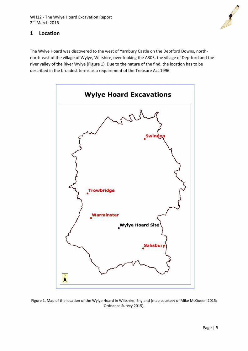
1 Location
The Wylye Hoard was discovered to the west of Yarnbury Castle on the Deptford Downs, north-
north-east of the village of Wylye, Wiltshire, over-looking the A303, the village of Deptford and the
river valley of the River Wylye (Figure 1). Due to the nature of the find, the location has to be
described in the broadest terms as a requirement of the Treasure Act 1996.
Figure 1. Map of the location of the Wylye Hoard in Wiltshire, England (map courtesy of Mike McQueen 2015; Ordnance Survey 2015).
WH12 - The Wylye Hoard Excavation Report 2nd March 2016
Page | 6
2 Topography and Geology
The landscape and the natural geology of the site is an area that consists of undulating Chalk Downs
(Seaford Chalk Formations and Lewes Nodular Chalk) which was observed across the excavation
area, and riverine-type valleys with Zig-Zag Chalk Formations (BGS 2013), typical of southern
Wiltshire. The site lies at a height of approximately 132 MASL and was used for arable farming. The
River Wylye lies approximately 2km to the south.
The overlying soils across the site are from the Upton 1 association which are grey rendzinas. These
consist of shallow, well-drained, calcareous, silty soils over chalk (Soil Survey of England and Wales
1983).
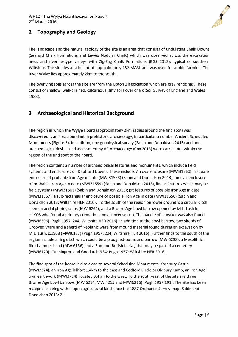
3 Archaeological and Historical Background
The region in which the Wylye Hoard (approximately 2km radius around the find spot) was
discovered is an area abundant in prehistoric archaeology, in particular a number Ancient Scheduled
Monuments (Figure 2). In addition, one geophysical survey (Sabin and Donaldson 2013) and one
archaeological desk-based assessment by AC Archaeology (Cox 2013) were carried out within the
region of the find spot of the hoard.
The region contains a number of archaeological features and monuments, which include field
systems and enclosures on Deptford Downs. These include: An oval enclosure (MWI31560); a square
enclosure of probable Iron Age in date (MWI31558) (Sabin and Donaldson 2013); an oval enclosure
of probable Iron Age in date (MWI31559) (Sabin and Donaldson 2013), linear features which may be
field systems (MWI31561) (Sabin and Donaldson 2013); pit features of possible Iron Age in date
(MWI31557); a sub-rectangular enclosure of possible Iron Age in date (MWI31556) (Sabin and
Donaldson 2013; Wiltshire HER 2016). To the south of the region on lower ground is a circular ditch
seen on aerial photographs (MWI6262), and a Bronze Age bowl barrow opened by M.L. Lush in
c.1908 who found a primary cremation and an incense cup. The handle of a beaker was also found
(MWI6206) (Pugh 1957: 204; Wiltshire HER 2016). In addition to the bowl barrow, two sherds of
Grooved Ware and a sherd of Neolithic ware from mound material found during an excavation by
M.L. Lush, c.1908 (MWI6137) (Pugh 1957: 204; Wiltshire HER 2016). Further finds to the south of the
region include a ring ditch which could be a ploughed-out round barrow (MWI6238), a Mesolithic
flint hammer head (MWI6156) and a Romano-British burial, that may be part of a cemetery
(MWI6179) (Cunnington and Goddard 1934; Pugh 1957; Wiltshire HER 2016).
The find spot of the hoard is also close to several Scheduled Monuments, Yarnbury Castle
(MWI7224), an Iron Age hillfort 1.4km to the east and Codford Circle or Oldbury Camp, an Iron Age
oval earthwork (MWI3714), located 3.4km to the west. To the south-east of the site are three
Bronze Age bowl barrows (MWI6214, MWI4215 and MWI6216) (Pugh 1957:191). The site has been
mapped as being within open agricultural land since the 1887 Ordnance Survey map (Sabin and
Donaldson 2013: 2).
WH12 - The Wylye Hoard Excavation Report 2nd March 2016
Page | 7
Figure 2. Map of enclosures within the wider region of the Wylye Hoard (Wiltshire and Swindon HLC and under the copyright of Wiltshire Council 2015; Ordnance Survey 2015).
4 Aims
The excavation had three aims:
1. To locate more of the Bronze Age hoard and
2. To locate any archaeological features which the hoards were placed into, or associated
with.
3. To locate any further metallic objects within the vicinity of the hoard’s location with the use
of metal-detectors.
There were also two additional aims of trying to ascertain if there was any link between the two
archaeological features which contained the hoard, and to assess the archaeological potential of a
highly structured deposit or deposits.
WH12 - The Wylye Hoard Excavation Report 2nd March 2016
Page | 8
5 Methodology
The methodology used to locate and excavate the Wylye Hoard came in two stages:
1. The hoard was located by Stuart Gullick and Michael Barker of the West London
Archaeological Searchers using metal detectors on 4th November 2012. The find was
reported to the Wiltshire Museum and the Director, David Dawson, visited the site that day
and made an initial record of the site as dusk approached. By this stage the hoard had been
removed from the ground.
2. On 10th November 2012, members of the West London Archaeological Searchers located the
find sport and surveyed the field and located two areas that delivered high readings. Three
test pits were dug to investigate the location of the numerous pieces of copper alloy that
was uncovered during the metal-detecting survey. Two test pits were opened over the
location of the two parts of the hoard discovered the week before the 10th November. A
third test pit was opened over an area that had a high iron reading located on the day of
excavation.
The excavation was carried out using handheld tools such as spades, shovels, trowels and hand
shovels because of the delicate nature of the artefacts found, and the potential significance and
importance of surviving in-situ archaeological features and deposits. A machine/heavy plant was not
readily available, but due to the nature of the find it was decided that hand tools were to be used.
The three test pits and their archaeological features were recorded with context sheets, plans of the
excavated pits on permatrace, and all contexts and fully excavated archaeological features were
photographed using a Digital SLR camera. The position of the test pits was surveyed using a
handheld GPS.
Any archaeological features discovered with surviving contexts within them were excavated and
placed into bags as an environmental sample. These were processed at a microscopic level to extract
detailed information of those contexts, for example small fragments of copper alloy.
All archaeological work was carried out in accordance with the Chartered Institute for Archaeologists
Standard and Guidelines for Archaeological Excavation 2008 and WAFG standard operating
procedures.
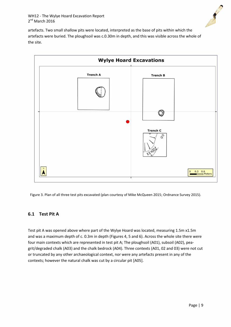
6 Results
The excavation of the Wylye Hoard was carried out by opening three test pits within close proximity
to one another: Test pit A at 1.5m x 1.5m, Test pit B at 2m x 1.5m, and Test pit C at 1m x 1m (Figure
3). At the beginning of the excavation, test pits A and B were opened above where the hoard was
located by metal-detectorists. It was later decided that a third smaller test pit, test pit C, was to be
opened above a strong metallic signal approximately 1.5m from the hoard’s discovery. These test
pits were stripped and excavated down to the natural chalk with the use of heavy tools, with the aim
of exposing any associated archaeological features that could have contained the Bronze Age
WH12 - The Wylye Hoard Excavation Report 2nd March 2016
Page | 9
artefacts. Two small shallow pits were located, interpreted as the base of pits within which the
artefacts were buried. The ploughsoil was c.0.30m in depth, and this was visible across the whole of
the site.
Figure 3. Plan of all three test pits excavated (plan courtesy of Mike McQueen 2015; Ordnance Survey 2015).
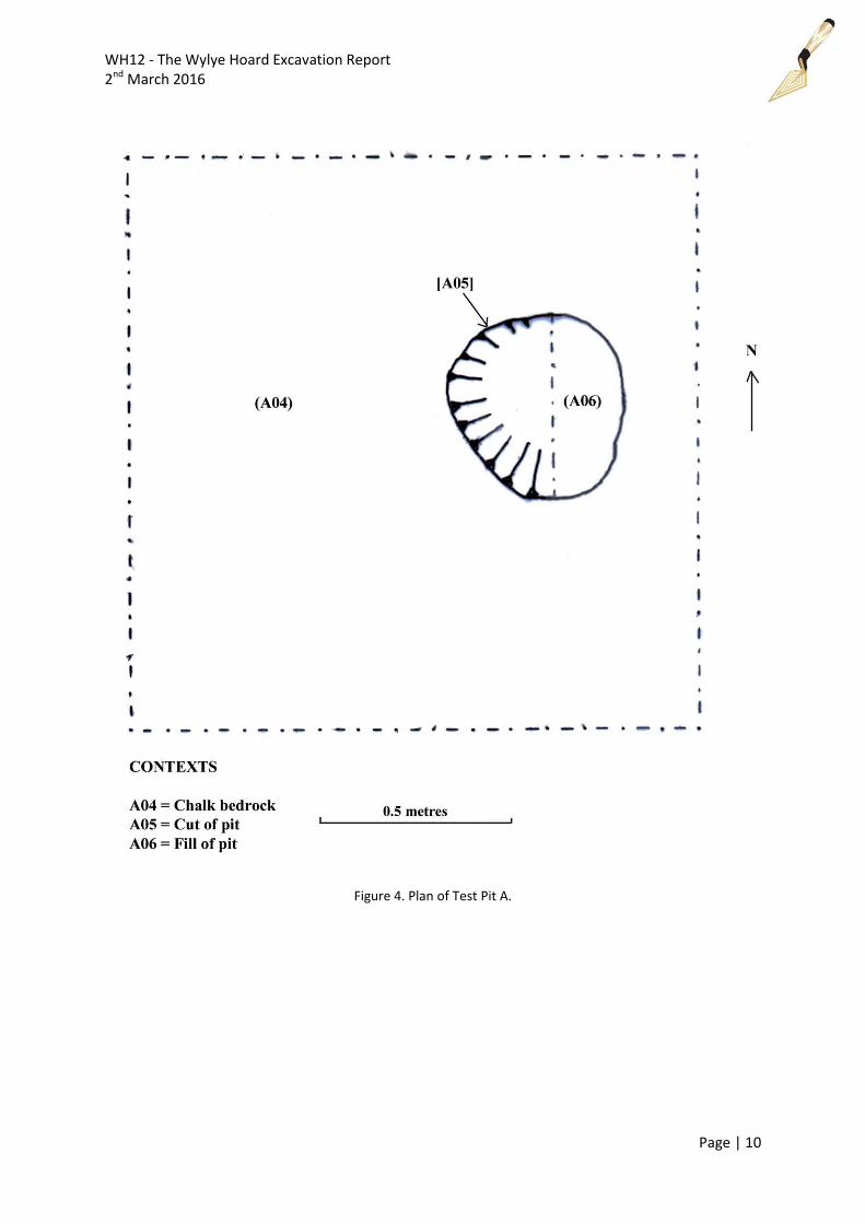
6.1 Test Pit A
Test pit A was opened above where part of the Wylye Hoard was located, measuring 1.5m x1.5m
and was a maximum depth of c. 0.3m in depth (Figures 4, 5 and 6). Across the whole site there were
four main contexts which are represented in test pit A; The ploughsoil (A01), subsoil (A02), pea-
grit/degraded chalk (A03) and the chalk bedrock (A04). Three contexts (A01, 02 and 03) were not cut
or truncated by any other archaeological context, nor were any artefacts present in any of the
contexts; however the natural chalk was cut by a circular pit [A05].
WH12 - The Wylye Hoard Excavation Report 2nd March 2016
Page | 10
Figure 4. Plan of Test Pit A.
WH12 - The Wylye Hoard Excavation Report 2nd March 2016
Page | 11
Figure 5. Excavation of test pit A revealing pit [A05).
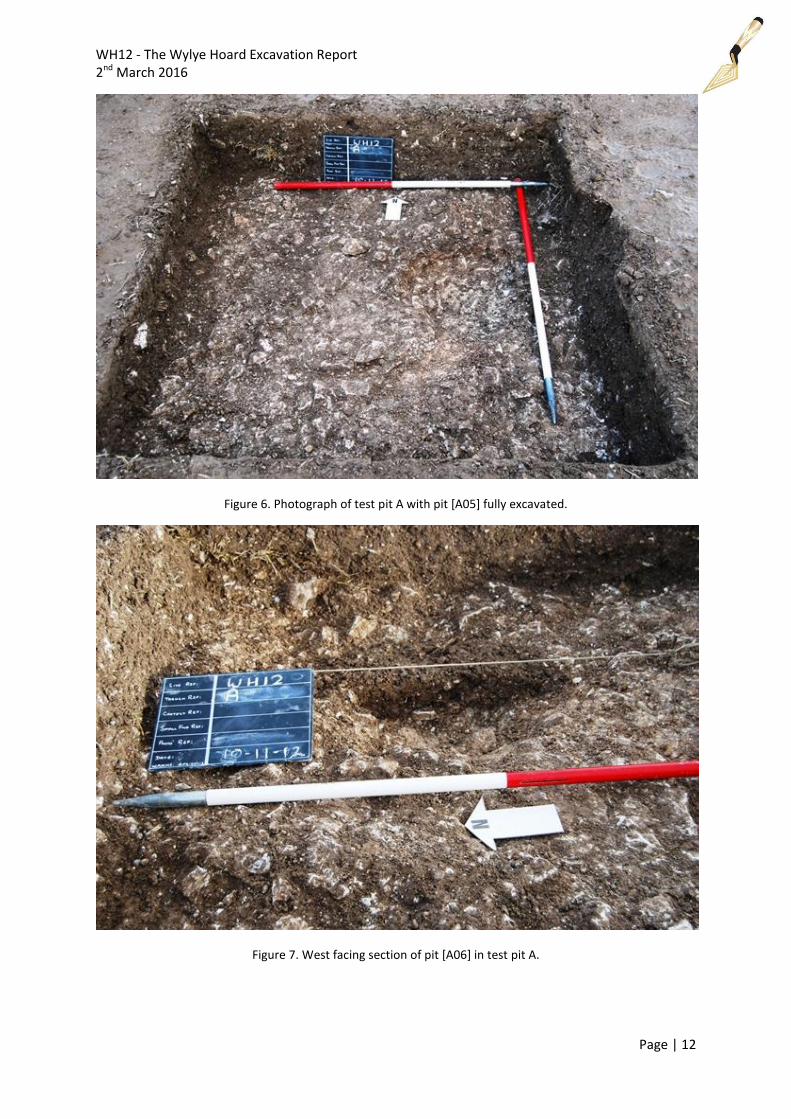
6.1.1 Pit [A05]
The cut of the archaeological feature is 0.5m x 0.43m in length and width, with a depth of 0.09m,
and can be interpreted as a shallow sub-circular pit, with moderate (approximate 45° slope) concave
sides and a concave base. The fill of this feature comprised of a loose mixture of clayish silt with
sparse chalk inclusions (A06) from the above contexts, caused by the earlier removal of in-situ
artefacts and a mixture of subsoil and ploughsoil falling inwards to fill the feature. This feature
included a small fragment of copper alloy (2mm x 2mm), and a larger fragment of copper alloy (8mm
x 8mm) located in the upper part of the fill. This fragment was found with the assistance of a
handheld metal detecting probe from a member of the West London Archaeological Searchers. No
further artefacts were contained in this feature.
These fragments of copper alloy are a clear indicator that this feature once contained a part of the
Middle Bronze Age hoard. Similarly to pit [B05], pit [A05] did not reveal any in-situ deposits within.
There may have been sealed deposits within the feature; however they could have been lost when
the hoard was discovered prior to archaeological excavation. It was not possible to retrieve the soil
in order to take a sample as it had been spread across the site once the hoard was removed; nor was
fill (A06) sampled as this comprised of a loose mixture of ploughsoil and subsoil.
WH12 - The Wylye Hoard Excavation Report 2nd March 2016
Page | 12
Figure 6. Photograph of test pit A with pit [A05] fully excavated.
Figure 7. West facing section of pit [A06] in test pit A.
WH12 - The Wylye Hoard Excavation Report 2nd March 2016
Page | 13
6.2 Test Pit B
Test pit B was opened above where another part of the Wylye Hoard was located, measuring 1.5m
by 2m and was a maximum depth of c.0.28m in depth (Figures 7, 8 and 9). Within test pit B were
contexts that are represented across the whole site; the ploughsoil (B01), subsoil (B02), pea-
grit/degraded chalk (B03) and the chalk bedrock (B04). The three contexts above the natural
bedrock were not cut or truncated by any visible archaeological feature, nor were there any
artefacts present in any of the contexts mentioned. However, the natural chalk (B04) revealed a
feature [B05] that can be interpreted as the remains of the base of a pit.
Figure 8. Plan of Test Pit B.
WH12 - The Wylye Hoard Excavation Report 2nd March 2016
Page | 14
Figure 9. Excavation of pit [B05] with test pit C in the background.
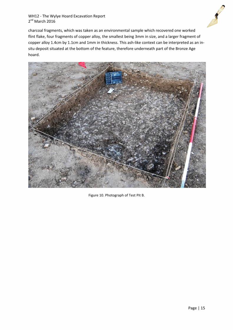
6.2.1 Pit [B05]
The cut of pit [B05] is c. 0.29m in width, with a depth of c.0.1m, very similar to pit [A05]. This feature
is all what remains of a sub-circular pit with shallow (less than 45°) concave sides and a concave
base, that once contained the other half of the Bronze Age hoard. The fill of this feature comprised
of a very loose mixture of clayish-silt with chalk inclusions from the above contexts caused by the
removal of artefacts prior to archaeological investigation, and a mixture of subsoil and ploughsoil
falling inwards to fill the feature. However, a small amount of in-situ fill did survive (B06), located
within the north-west part of the pit. The fill was greyish in colour and had a slight texture of ash,
but this fill may have also been disturbed by the removal of the hoard. This context contained sparse
WH12 - The Wylye Hoard Excavation Report 2nd March 2016
Page | 15
charcoal fragments, which was taken as an environmental sample which recovered one worked
flint flake, four fragments of copper alloy, the smallest being 3mm in size, and a larger fragment of
copper alloy 1.4cm by 1.1cm and 1mm in thickness. This ash-like context can be interpreted as an in-
situ deposit situated at the bottom of the feature, therefore underneath part of the Bronze Age
hoard.
Figure 10. Photograph of Test Pit B.
WH12 - The Wylye Hoard Excavation Report 2nd March 2016
Page | 16
Figure 11. West facing shot of test pit B with pit [B05] fully excavated. Note a lighter shade of grey in the feature where a layer of ash like clay with bits of charcoal was found.
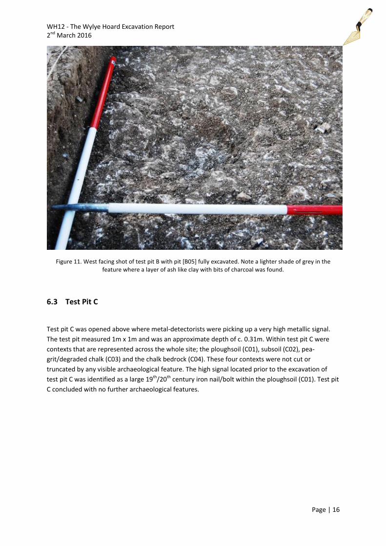
6.3 Test Pit C
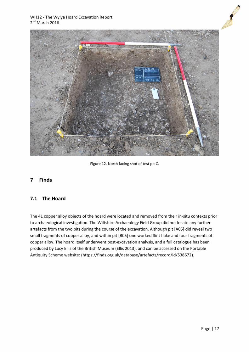
Test pit C was opened above where metal-detectorists were picking up a very high metallic signal.
The test pit measured 1m x 1m and was an approximate depth of c. 0.31m. Within test pit C were
contexts that are represented across the whole site; the ploughsoil (C01), subsoil (C02), pea-
grit/degraded chalk (C03) and the chalk bedrock (C04). These four contexts were not cut or
truncated by any visible archaeological feature. The high signal located prior to the excavation of
test pit C was identified as a large 19th/20th century iron nail/bolt within the ploughsoil (C01). Test pit
C concluded with no further archaeological features.
WH12 - The Wylye Hoard Excavation Report 2nd March 2016
Page | 17
Figure 12. North facing shot of test pit C.
7 Finds
7.1 The Hoard
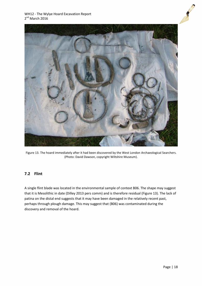
The 41 copper alloy objects of the hoard were located and removed from their in-situ contexts prior
to archaeological investigation. The Wiltshire Archaeology Field Group did not locate any further
artefacts from the two pits during the course of the excavation. Although pit [A05] did reveal two
small fragments of copper alloy, and within pit [B05] one worked flint flake and four fragments of
copper alloy. The hoard itself underwent post-excavation analysis, and a full catalogue has been
produced by Lucy Ellis of the British Museum (Ellis 2013), and can be accessed on the Portable
Antiquity Scheme website: (https://finds.org.uk/database/artefacts/record/id/538672).
WH12 - The Wylye Hoard Excavation Report 2nd March 2016
Page | 18
Figure 13. The hoard immediately after it had been discovered by the West London Archaeological Searchers. (Photo: David Dawson, copyright Wiltshire Museum).
7.2 Flint
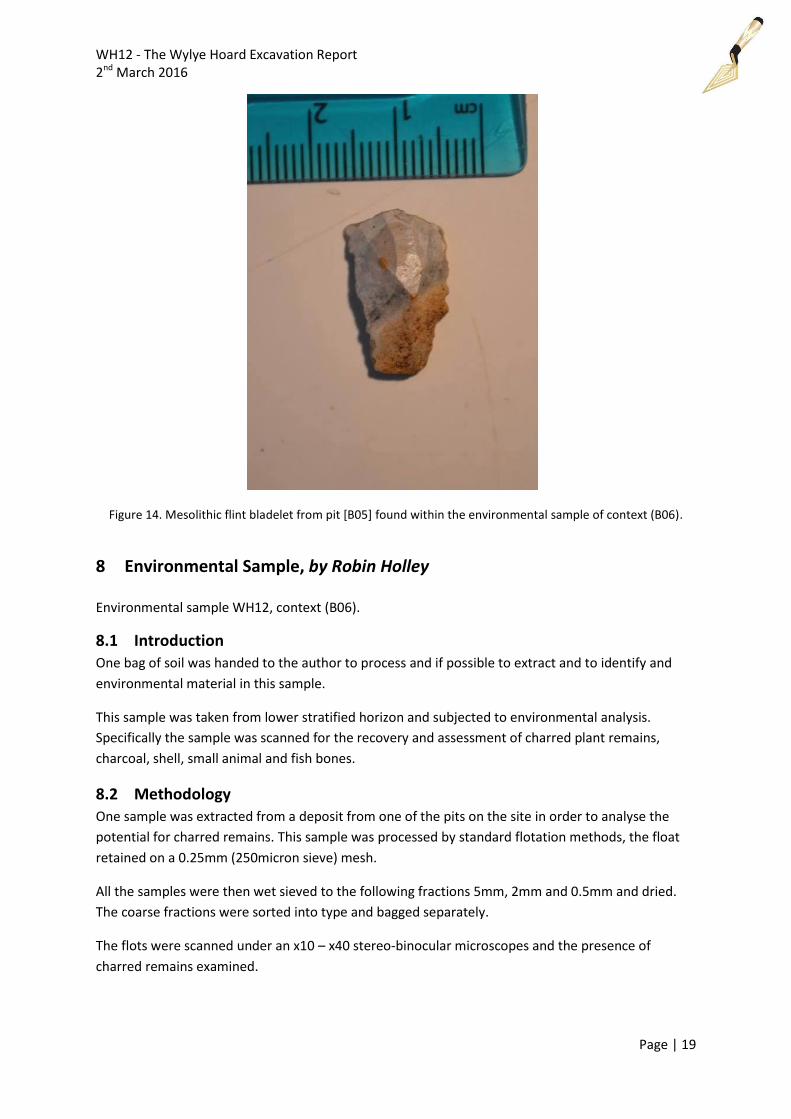
A single flint blade was located in the environmental sample of context B06. The shape may suggest
that it is Mesolithic in date (Dilley 2013 pers comm) and is therefore residual (Figure 13). The lack of
patina on the distal end suggests that it may have been damaged in the relatively recent past,
perhaps through plough damage. This may suggest that (B06) was contaminated during the
discovery and removal of the hoard.
WH12 - The Wylye Hoard Excavation Report 2nd March 2016
Page | 19
Figure 14. Mesolithic flint bladelet from pit [B05] found within the environmental sample of context (B06).
8 Environmental Sample, by Robin Holley Environmental sample WH12, context (B06).
8.1 Introduction
One bag of soil was handed to the author to process and if possible to extract and to identify and
environmental material in this sample.
This sample was taken from lower stratified horizon and subjected to environmental analysis.
Specifically the sample was scanned for the recovery and assessment of charred plant remains,
charcoal, shell, small animal and fish bones.
8.2 Methodology
One sample was extracted from a deposit from one of the pits on the site in order to analyse the
potential for charred remains. This sample was processed by standard flotation methods, the float
retained on a 0.25mm (250micron sieve) mesh.
All the samples were then wet sieved to the following fractions 5mm, 2mm and 0.5mm and dried.
The coarse fractions were sorted into type and bagged separately.
The flots were scanned under an x10 – x40 stereo-binocular microscopes and the presence of
charred remains examined.
WH12 - The Wylye Hoard Excavation Report 2nd March 2016
Page | 20
8.3 Charred Plant Remains
Assessment of the material from the flotation process showed that it contained amounts of charred
plant remains.
Findings consisted of a mixed deposit of charred macrofossils also present were fragments of
unidentifiable charcoal, bark, and monocotyledon root material.
8.4 Residue
From the residue there were pieces of flint, one showing signs of flakes being struck off, four tiny
fragments of Copper Alloy and a circular Copper Alloy object.
8.5 Summary
The samples were of some bio-archaeological interest. The small amount of charred material
recovered indicates that there is potential for the preservation of larger amounts of larger bio-
archaeological remains on this site.
Whether these are the remains of a woven basket or bag which the copper alloy objects were
carried is problematic and not proven.
9 Interpretation
The archaeological evidence suggests that the hoard comprised of two individual hoards, each
deposited within a small pit. The two pits were located approximately 2.1m from each other and are
very shallow. The depth of the ploughsoil suggests that the objects must have been tightly packed
within the features. It would seem that the field had been subject to shallow ploughing.
The hoard was placed within the two pits as two deposits, and it was noted that there was some
form of structure to the deposits by the metal-detectorists when the hoard was found. The
detectorist explained this in a recording made by David Dawson at the time of the discovery, and is
recorded in the catalogue produced by the British Museum. The first deposit appears to have been a
closed deposit, with the finders noting that the torcs were 'stacked' on top of one another within the
pit (verbal communication recording). The second deposit is likely to have been disturbed by
agricultural operations as the objects were dispersed across a small area (Ellis 2013).
Within one of the pits - [B05] – the remains of an in-situ deposit (B06) was recovered and
environmentally sampled. This revealed a small amount of charred material. It is possible that this
could be the remains of a woven basket or bag into which part of the hoard was placed cannot be
proven. There was no evidence of a fire or intense burning within any of the pits, or burnt flint as a
result of a fire, nor were there any visible remains of burnt material in pit [A05]. Therefore, the
evidence suggests that one part of the hoard at least had been placed with burnt material. A flint
bladelet was also found within context (B06), but may have been residual in the pit and fill when the
hoard was removed, and can therefore not be associated with the hoard itself.
WH12 - The Wylye Hoard Excavation Report 2nd March 2016
Page | 21
10 Discussion
This discussion will focus on the Wylye Hoard’s wider contextual interpretation, for example its
situation within its landscape context and its relation to the south coast of England. The bronze
objects alone are only part of the story – the place of burial is equally worthy of consideration
(Barber 2003: 60).
It is argued by Roberts that Bronze Age ornament hoards appear to have an “overwhelmingly coastal
distribution” (Roberts 2007: 9), and that “even those (ornament hoards) further inland are generally
located close to major navigable rivers” (Roberts 2007: 9). The Wylye hoard is located 2km (1.2
miles) north of the River Wylye, which flows to the River Nadder, into the Salisbury River Avon, and
into Christchurch Harbour, Dorset, a major prehistoric harbour where trade and exchange with
mainland Europe occurred frequently in prehistoric southern England. The Christchurch area was
densely occupied in the third and second millennia (Cunliffe 1978: 25), and into the Iron Age. In
addition, there was a settlement site at Hengistbury Head over-looking Christchurch Harbour, and all
the major occupations of this site took place in periods of close relations with the continent, during
the Early Bronze Age and the Late Bronze Age/Early Iron Age transition (Bradley 1984: 146).
Christchurch Harbour was not the only natural harbour ideal for domestic and cross-Channel trade
and exchange along the Dorset coast. Poole Harbour is located to the west of Christchurch Harbour,
and appears to have been an important destination for prehistoric journeys and a terminus of
prehistoric cross-Channel routes (Wilkes 2007: 124). Therefore, the location of hoard is near a
navigable watercourse that flows towards the Dorset coastline. Unlike the recently discovered 'Near
Lewes' hoard (2011 T192), which combined 'insular' and rare Continental objects and practices, the
Wylye hoard was primarily composed of finds that are local and common in southern England
(e.g. the quoit headed pin and spiral twisted ornaments). The hoard does, however, reflect inter-
regional connections and/or trade within Southern England (Ellis 2013). The Dorset coastline with its
natural harbours and access inland via rivers to the Wylye region makes this a likely place for bronze
objects to have been traded and exchanged and carried inland up-river. Therefore, archaeological
evidence suggests that the depositional act of the Wylye Hoard would have been in an area where
the local inhabitants would have had access to the southern coast of England by means of water-
transport, but this theory by no means rules out the transport of bronze items over land.
The hoard report composed by the British Museum (Ellis 2013) states that the combination of
ornaments, tools and other elements and metalworking waste in the Wylye hoard is comparable to
other large and 'complex' ornament hoards from Southern Britain (Rowlands 1976, 99-114; cf.
Roberts 2007, 147-8; Ellis 2013). The overall composition of the ornaments within the Wylye hoard is
generally typical of 'Ornament Horizon' hoards: dominated by armrings and bracelets (c.58%), with a
considerable proportion of torcs (29%), and rings (c.10%), and pins (3%) occurring in smaller
numbers (cf. Roberts 2007, 139; Ellis 2013). However, the variety of particular ornament types
contained within the Wylye hoard is notable. Although the fragmentary nature of some objects
makes comparison of hoard size (and quality) difficult, the c.29 ornaments from the Wylye hoard
makes it one of the largest 'complex' hoards discovered, comparable to Taunton Union Workhouse,
Somerset (c.33 ornaments) and the recently discovered 'near Lewes' hoard (c.28 ornaments). The
overall size of the hoard (including 'tools' and 'other/unidentified' objects) is also comparable: 43
compared to c.51 and c.53 objects respectively. In terms of composition, the closest parallels among
WH12 - The Wylye Hoard Excavation Report 2nd March 2016
Page | 22
the large, 'complex' hoards are from Somerset (the Monkswood Hoard and the Taunton
Workhouse Hoard) and Norfolk (the Barton Bendish hoard). Five of the six ornament types found in
the Monkswood hoard, four of the five ornament types in the Taunton hoard, and five of the five
ornament types found in the Barton Bendish hoard are paralleled in the Wylye hoard. All four of
these comparable 'complex' hoards combine ornaments and tools (Ellis 2013).
There is one example of a Bronze Age hoard being deposited in a similar location in Wiltshire, and
that is the Manton Copse hoard, Preshute (Lawson et al 2011). This hoard was situated with far
reaching views across the valley and the Marlborough Downs beyond are gained from the ridge, but
in the area of the find the views to the south are more restricted by the undulating topography
(Lawson et al 2011: 31). The situation of the Manton Copse hoard is similar to that of the Wylye
Hoard, on a ridge facing south with restricted views of the downs on the other side of the valley;
therefore the people who deposited these hoards may be following a distinct set of depositional
practices.
The presence of burnt or carbonised material and four small fragments of copper-allow within a
lighter ash-like layer (B06) at the bottom of pit [B05] in test pit B, may suggest that the bronze
objects were placed with either the remains of a metal-casting process, a ceremony associated with
the nature of the deposits, or the remains of a woven basket. There are a few fragments of possible
casting waste identified in the hoard report, object number 25 (Ellis. 2013). There are known
examples of hoards contained within organic containers, for example two hoards found at Petter’s
Sports Field, Runnymeade, Surrey (Needham 1990a). These were broadly similar in content and
appear to have been buried one on top of the other, underlining the possibility of such containers
being used (Barber 1990: 54). On the other hand, to find ash-like deposits within a pit with a hoard is
by no means an isolated incident. For example, the Manton Copse 1 hoard when it was first located
in 1914, seven whole and two broken socketed axes were found lying together with ashes (Goddard
1917: 478; Lawson et al 2011: 35).
The archaeological evidence raises the question of which deposit came first? There is little chance of
ascertaining the absolute length of time between the two acts of deposition, but because both pits
were dug just a couple of metres from each other, it may have been just days or months after one
part of the hoard was deposited. The hoard report does not state individual object dates, but places
the hoard to the earlier centuries of the Middle Bronze Age, c.1400-1250 BC (Ellis 2013). This raises a
second question, was there something in the immediate landscape to indicate where the first part of
the hoard was placed, perhaps a prominent tree or a marker post? Therefore, further archaeological
investigation of the find spot and surrounding landscape is recommended, as there are four
enclosures positioned close to one another located on the magnetometer survey that might be
associated with the hoard (Sabin and Donaldson 2013).
11 Conclusion
The Wylye Hoard can be considered as a very dynamic and diverse ornament hoard within the
county of Wiltshire, consisting of two small hoards placed very close together in small shallow pits
approximately 2.1m from each other. The hoard’s overall landscape context suggests the bronze
WH12 - The Wylye Hoard Excavation Report 2nd March 2016
Page | 23
objects and the people who deposited them may have had links with Christchurch Harbour due to
its close proximity to the River Wylye, as the hoard reflects inter-regional connections and/or trade
within Southern England (Ellis 2013). In addition, the hoard is set within a prehistoric landscape
surrounded by Bronze Age round barrows, field systems and enclosures, which were located in a
recent geophysical survey (Sabin and Donaldson 2013), therefore the hoard is possibly located
within close proximity to a number of settlements; however further archaeological investigation
needs to be carried out in order to confirm the dating of these enclosures. There may be a possible
‘ritual’ action as one part of the hoard was placed along with a small amount of burnt material,
which could be the remains of a casting process or a burnt woven container. What is interesting is
that the two deposits of bronze objects were placed within two pits very close to each other,
suggesting that the hoard as a whole was deposited quickly in two depository actions. However,
which part of the hoard was deposited first and the other second requires further investigation.
Either there was a marker in the landscape to indicate the first deposit, or the person or persons
who deposited the first part of the hoard returned not long after and knew the exact location in
order to deposit the second part of the hoard.
12 Archive Location
All archive material (the hoard, artefacts, soil sample residues, paper archive, a hard copy of this
report, a digital copy of this report and a digital copy on two CDs of the photographs, interview
recordings with the metal-detectorists and associated paperwork) will be deposited with the
Salisbury Museum, Salisbury, Wiltshire. A digital copy of this report will be deposited at the Wiltshire
Museum, Wiltshire’s Historic Environment Record and on the OASIS Portal.
13 Bibliography
Barber, M. 2003. Bronze and the Bronze Age: Metalwork and Society in Britain c.2500 – 800BC.
Tempus Publishing Ltd: Stroud.
Bradley, R. 1984. The Social Foundations of Prehistoric Britain: Themes and variations in the
archaeology of power. Longman Group Limited: Harlow.
Bradley, R. 1985. Exchange and social distance: The structure of bronze artefact distributions. In,
MAN. Volume 20. PP 692 – 704.
British Geological Survey, 2013. www.bgs.ac.uk (11/04/13)
Cox, P. 2013. Proposed solar photo-voltaic panels at Deptford, Wiltshire: Assessment of predicted effects on the setting of heritage assets. Document No: ACW518/1/0. AC Archaeology: Wiltshire. Cunnington, M E; Goddard, E H, 1934. Devizes Museum Cat 3, 203 No 228. Cunliffe, B. 1978. Hengistbury Head. Elek Books Ltd: London.
WH12 - The Wylye Hoard Excavation Report 2nd March 2016
Page | 24
Darvill, T. 2010. Prehistoric Britain. Second Edition. Routledge: London.
Ellis, L. (2013) WILT-038191: A BRONZE AGE HOARD. Web page available at:
https://finds.org.uk/database/artefacts/record/id/538672 [Accessed: 8 Nov 2015 19:25:12]
Goddard, Rev. E. H. 1917. Bronze implements of the Bronze Age found in Wiltshire, not previously reported. Supplementary List (Feb., 1917.) Wiltshire Studies: The Wiltshire Archaeological and Natural History Magazine. Volume 34. PP 477-84).
Harding, A.F. 2000. European Societies in the Bronze Age. Cambridge University Press: Cambridge.
Lawson, A. J., Robinson, P. and Swanton, G. 2011. Bronze Age metalwork from Manton Copse,
Preshute, Wiltshire. In, Wiltshire Studies: The Wiltshire Archaeological and Natural History
Magazine. Volume 104. Wiltshire Archaeology and Natural History Society: Devizes. PP 31- 43.
Needham, S.P. 1990. The Petters Late Bronze Age Metalwork. An analytical study of the Thames
Valley metalworking in its settlement context. British Museum Occasional Paper 70, British Museum
Press, London.
Needham, S. 2008. Exchange, Object Biographies and the Shaping of Identities, 10,000 – 1000 B.C.
In, Pollard, J. (ed), Prehistoric Britain. Blackwell Publishing: Oxford. PP 310 – 329.
O’Connor, B. 1980. Cross Channel Relations in the Later Bronze Age. Oxford: British Archaeological
Report S91.
Pryor, F. 2004. Britain B.C. Life in Britain and Ireland before the Romans. Harper Perennial: London.
Pugh, R. B. (ed.). 1957. The Victoria History of the Counties of England: A History of Wiltshire. Volume
1. Part 1. Oxford University Press: Oxford.
Roberts, B. Adorning the Living but Not the Dead: Understanding Ornaments in Britain c.1400-1100
cal B.C. Proceedings of the Prehistoric Society 73. 2007. PP 1 -31.
Rowlands, MJ. 1976, The Production and Distribution of Metalwork in the Middle Bronze Age in
Southern Britain, British Archaeological Reports 31 (i-ii), Oxford.
Sabin, D. and Donaldson, K. 2013. Deptford Farm, Wiltshire: Magnetometer Survey Report.
Archaeological Surveys Ltd: Calne.
Taylor, R.J. Hoards of the Bronze Age in Southern Britain: Analysis and Interpretation. BAR British
Series 228. Tempus Reparatum: Oxford.
Wilkes, E. 2007. Prehistoric Sea Journeys and Port Approaches: The South Coast and Poole Harbour.
In, Cummings, V. and Johnson, R. Prehistoric Journeys. Oxbow Books: Oxford. PP 121 – 129.
Wiltshire HER -
http://www.wiltshire.gov.uk/artsheritageandlibraries/museumhistoryheritage/wiltshireandswindon
historicenvironmentrecord/wshermap.htm (Accessed 17/01/2016)
WH12 - The Wylye Hoard Excavation Report 2nd March 2016
Page | 25
14 Appendix 1 – Graphics with Levels
WH12 - The Wylye Hoard Excavation Report 2nd March 2016
Page | 26
WH12 - The Wylye Hoard Excavation Report 2nd March 2016
Page | 27
WH12 - The Wylye Hoard Excavation Report 2nd March 2016
Page | 28
15 Appendix 2 – Trench Tables
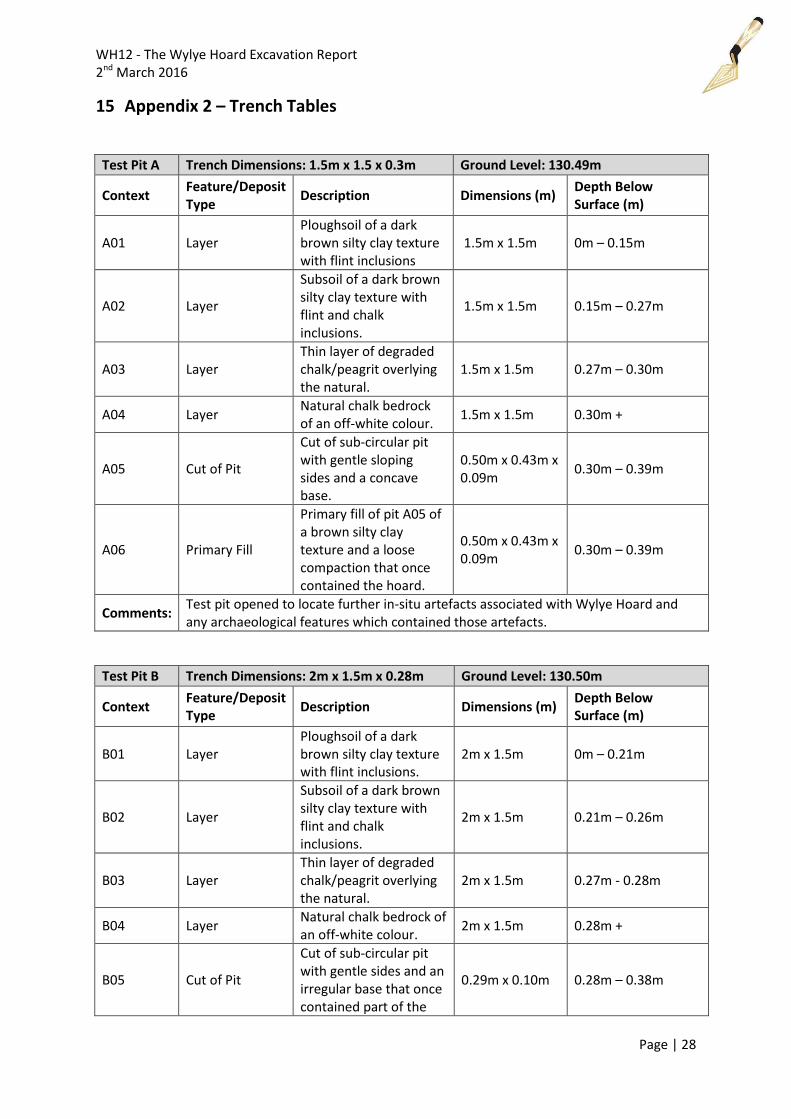
Test Pit A Trench Dimensions: 1.5m x 1.5 x 0.3m Ground Level: 130.49m
Context Feature/Deposit Type
Description Dimensions (m) Depth Below Surface (m)
A01 Layer Ploughsoil of a dark brown silty clay texture with flint inclusions
1.5m x 1.5m 0m – 0.15m
A02 Layer
Subsoil of a dark brown silty clay texture with flint and chalk inclusions.
1.5m x 1.5m 0.15m – 0.27m
A03 Layer Thin layer of degraded chalk/peagrit overlying the natural.
1.5m x 1.5m 0.27m – 0.30m
A04 Layer Natural chalk bedrock of an off-white colour.
1.5m x 1.5m 0.30m +
A05 Cut of Pit
Cut of sub-circular pit with gentle sloping sides and a concave base.
0.50m x 0.43m x 0.09m
0.30m – 0.39m
A06 Primary Fill
Primary fill of pit A05 of a brown silty clay texture and a loose compaction that once contained the hoard.
0.50m x 0.43m x 0.09m
0.30m – 0.39m
Comments: Test pit opened to locate further in-situ artefacts associated with Wylye Hoard and any archaeological features which contained those artefacts.
Test Pit B Trench Dimensions: 2m x 1.5m x 0.28m Ground Level: 130.50m
Context Feature/Deposit Type
Description Dimensions (m) Depth Below Surface (m)
B01 Layer Ploughsoil of a dark brown silty clay texture with flint inclusions.
2m x 1.5m 0m – 0.21m
B02 Layer
Subsoil of a dark brown silty clay texture with flint and chalk inclusions.
2m x 1.5m 0.21m – 0.26m
B03 Layer Thin layer of degraded chalk/peagrit overlying the natural.
2m x 1.5m 0.27m - 0.28m
B04 Layer Natural chalk bedrock of an off-white colour.
2m x 1.5m 0.28m +
B05 Cut of Pit
Cut of sub-circular pit with gentle sides and an irregular base that once contained part of the
0.29m x 0.10m 0.28m – 0.38m
WH12 - The Wylye Hoard Excavation Report 2nd March 2016
Page | 29
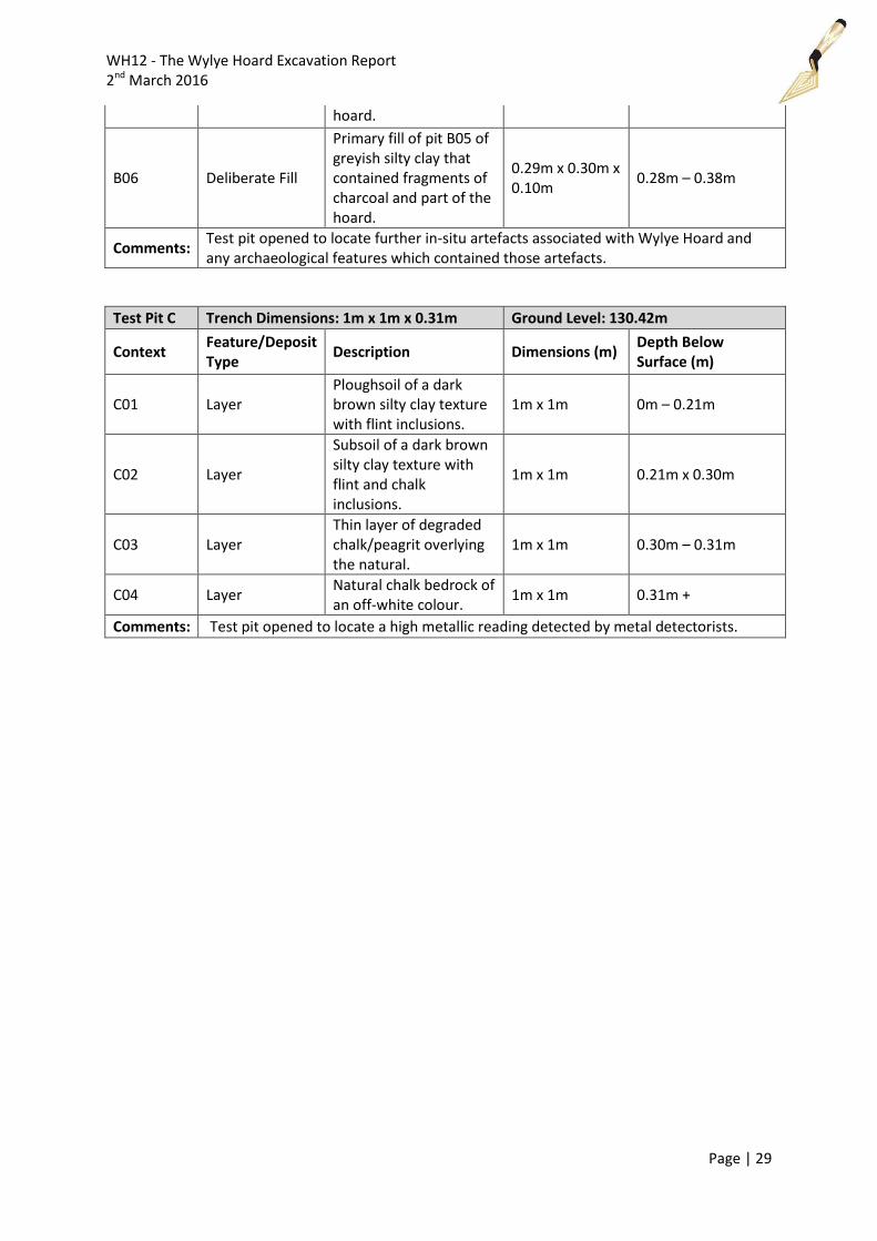
hoard.
B06 Deliberate Fill
Primary fill of pit B05 of greyish silty clay that contained fragments of charcoal and part of the hoard.
0.29m x 0.30m x 0.10m
0.28m – 0.38m
Comments: Test pit opened to locate further in-situ artefacts associated with Wylye Hoard and any archaeological features which contained those artefacts.
Test Pit C Trench Dimensions: 1m x 1m x 0.31m Ground Level: 130.42m
Context Feature/Deposit Type
Description Dimensions (m) Depth Below Surface (m)
C01 Layer Ploughsoil of a dark brown silty clay texture with flint inclusions.
1m x 1m 0m – 0.21m
C02 Layer
Subsoil of a dark brown silty clay texture with flint and chalk inclusions.
1m x 1m 0.21m x 0.30m
C03 Layer Thin layer of degraded chalk/peagrit overlying the natural.
1m x 1m 0.30m – 0.31m
C04 Layer Natural chalk bedrock of an off-white colour.
1m x 1m 0.31m +
Comments: Test pit opened to locate a high metallic reading detected by metal detectorists.