The World Bankdocuments.worldbank.org/curated/en/405861468000593624/pdf/PAD12… · FUNDEP Research...
71
Document of The World Bank FOR OFFICIAL USE ONLY Report No: PAD1234 INTERNATIONAL BANK FOR RECONSTRUCTION AND DEVELOPMENT PROJECT APPRAISAL DOCUMENT ON A PROPOSED STRATEGIC CLIMATE FUND (SCF) GRANT IN THE AMOUNT OF US$ 9.25 MILLION TO THE RESEARCH DEVELOPMENT FOUNDATION (Fundação de Desenvolvimento da Pesquisa) FOR A DEVELOPMENT OF SYSTEMS TO PREVENT FOREST FIRES AND MONITOR VEGETATION COVER IN THE BRAZILIAN CERRADO PROJECT March 2, 2016 Environment and Natural Resources Global Practice Latin America and Caribbean Region This document has a restricted distribution and may be used by recipients only in the performance of their official duties. Its contents may not otherwise be disclosed without World Bank authorization. Public Disclosure Authorized Public Disclosure Authorized Public Disclosure Authorized Public Disclosure Authorized
Transcript of The World Bankdocuments.worldbank.org/curated/en/405861468000593624/pdf/PAD12… · FUNDEP Research...

Document of
The World Bank
FOR OFFICIAL USE ONLY
Report No: PAD1234
INTERNATIONAL BANK FOR RECONSTRUCTION AND DEVELOPMENT
PROJECT APPRAISAL DOCUMENT
ON A
PROPOSED STRATEGIC CLIMATE FUND (SCF) GRANT
IN THE AMOUNT OF US$ 9.25 MILLION
TO THE
RESEARCH DEVELOPMENT FOUNDATION
(Fundação de Desenvolvimento da Pesquisa)
FOR A
DEVELOPMENT OF SYSTEMS TO PREVENT FOREST FIRES AND MONITOR
VEGETATION COVER IN THE BRAZILIAN CERRADO PROJECT
March 2, 2016
Environment and Natural Resources Global Practice
Latin America and Caribbean Region
This document has a restricted distribution and may be used by recipients only in the performance of their official
duties. Its contents may not otherwise be disclosed without World Bank authorization.
Pub
lic D
iscl
osur
e A
utho
rized
Pub
lic D
iscl
osur
e A
utho
rized
Pub
lic D
iscl
osur
e A
utho
rized
Pub
lic D
iscl
osur
e A
utho
rized

CURRENCY EQUIVALENTS
(Exchange Rate Effective October 2015)
Currency Unit = BRL BRL 3.8 = US$ 1
0.27 US$ = BRL 1
FISCAL YEAR
January 1 – December 31
ABBREVIATIONS AND ACRONYMS
ABC Low Carbon Emissions Agriculture Program (Agricultura de Baixa Emissão de
Carbono) APP Permanent Preservation Area on private land (Área de Preservação Permanente) BIP Brazil Investment Plan of the Forest Investment Program CAR Rural Environmental Registry (Cadastro Ambiental Rural) CH4 Methane CIF Climate Investment Fund COP Conference of the Parties CPS
CSR Country Partnership Strategy
Center for Remote Sensing (Centro de Sensoriamento Remoto) of the Federal
University of Minas Gerais DETER Real-time deforestation detection system (Sistema de Detecção do Desmatamento em
Tempo Real) EMBRAPA Brazilian Agricultural Research Corporation (Empresa Brasileira de Pesquisa
Agropecuária) FIP Forest Investment Program FISC Fire Ignition, Spread and Carbon Model FUNDEP Research Development Foundation (Fundação de Desenvolvimento da Pesquisa)
GDP Gross Domestic Product GHG Greenhouse gas emissions GIS Geographic Information System GoB Government of Brazil IBAMA Brazilian Institute of Environment and Renewable Natural Resources
(Instituto Brasileiro de Meio Ambiente e dos Recursos Naturais Renováveis) IBGE Brazilian Institute for Geography and Statistics (Instituto Brasileiro de Geografia e
Estatística) ICMBio Chico Mendes Institute for Biodiversity Conservation (Instituto Chico Mendes de
Conservação de Biodiversidade) IFR Interim Financial Report INPE National Institute for Space Research (Instituto Nacional de Pesquisas Espaciais) INPE-EM
IPAM INPE’s greenhouse gas emissions estimation system
Institute for Amazon Studies (Instituto de Pesquisas Amazônicas) IRR Internal Rate of Return LAPIG Laboratory for the processing of geographic images (Laboratório de Processamento de
Imagens e Geoprocessamento) of the Federal University of Goiás LCCS Land Cover Classification System LULUCF Land Use, Land Use Change and Forestry

ii
MAPA Brazilian Ministry of Agriculture, Livestock, and Food Supply (Ministério da
Agricultura, Pecuária e Abastecimento) MCTI Brazilian Ministry of Science, Technology, and Innovation (Ministério da Ciência,
Tecnologia e Inovação) MMA Brazilian Ministry of Environment (Ministério do Meio Ambiente) MODIS Moderate Resolution Imaging Spectroradiometer NAMA Nationally Appropriate Mitigation Actions
NASA National Aeronautics and Space Administration NGO Non-Governmental Organization NPCC National Policy on Climate Change NPV Net Present Value OM Project Operational Manual
PICC Project Institutional Coordination Committee (Comitê de Coordenação Institucional do
Projeto) PPCDAM Action Plan for the Prevention and the Control of Deforestation in the Amazon PPCerrado Action Plan to Prevent and Control Deforestation and Fires in the Cerrado Biome PREVFOGO National Center for (forest) Fire Prevention and Suppression PROARCO Program for the prevention of forest and grassland fires in the legal Amazon PRODES Program for Measuring Deforestation in the Amazon REDD-plus
Reducing emissions from deforestation and forest degradation and the role of
conservation, sustainable management of forests and enhancement of forest carbon
stocks RL Legal Reserve on private land (Reserva Legal) SCF Strategic Climate Fund tCO2eq Tons of Carbon Dioxide equivalent UFG Federal University of Goiás (Universidade Federal de Goiás) UFMG Federal University of Minas Gerais (Universidade Federal de Minas Gerais) UNFCCC United Nations Framework Convention on Climate Change
Regional Vice President: Jorge Familiar
Country Director: Martin Raiser
Senior Global Practice Director: Paula Caballero
Practice Manager: Raúl Alfaro-Pelico
Task Team Leader: David Tuchschneider


iii
BRAZIL
TABLE OF CONTENTS
Page
I. STRATEGIC CONTEXT .................................................................................................... 1
A. Country Context .................................................................................................................. 1
B. Sector and Institutional Context.......................................................................................... 3
C. Higher Level Objectives to which the Project Contributes ................................................ 6
II. PROJECT DEVELOPMENT OBJECTIVE ........................................................................ 7
A. Project Development Objective (PDO) .............................................................................. 7
B. Project Beneficiaries. .......................................................................................................... 7
C. PDO Level Results Indicators ............................................................................................. 7
III. PROJECT DESCRIPTION .................................................................................................. 8
A. Project Components ............................................................................................................ 8
B. Project Financing ................................................................................................................ 9
C. Lessons Learned and Reflected in the Project Design ........................................................ 9
IV. IMPLEMENTATION .......................................................................................................... 10
A. Institutional and Implementation Arrangements .............................................................. 10
B. Results Monitoring and Evaluation (M&E) ...................................................................... 11
C. Sustainability ..................................................................................................................... 11
V. KEY RISKS AND MITIGATION MEASURES ............................................................... 11
A. Overall Risk Rating and Explanation of Key Risks.......................................................... 11
VI. APPRAISAL SUMMARY ................................................................................................... 12
A. Technical ........................................................................................................................... 12
B. Economic and Financial Analysis .................................................................................... 12
C. Financial Management ...................................................................................................... 13
D. Procurement ...................................................................................................................... 14
E. Social (including Safeguards) ........................................................................................... 14
F. Environment (including Safeguards) ................................................................................ 15
G. World Bank Grievance Redress ........................................................................................ 15

iv
Annex 1: Results Framework and Monitoring ........................................................................ 16
Annex 2: Detailed Project Description ...................................................................................... 21
Annex 3: Implementation Arrangements ................................................................................. 34
Annex 4: Implementation Support Plan ................................................................................... 46
Annex 5: Relationship with the Forest Investment Program (FIP) .................................... 46
Annex 6: Map of Brazil: (IBRD41777) ..................................................................................... 56
PAD DATA SHEET
Brazil
Development of systems to prevent forest fires and monitor vegetation cover in the Brazilian
Cerrado (P143185)
PROJECT APPRAISAL DOCUMENT
LATIN AMERICA AND CARIBBEAN
ENVIRONMENT AND NATURAL RESOURCES
Report No.: PAD1234
Basic Information
Project ID EA Category Team Leader(s)
P143185 C - Not Required David Tuchschneider
Lending Instrument Fragile and/or Capacity Constraints [ ]
Investment Project Financing Financial Intermediaries [ ]
Series of Projects [ ]
Project Implementation Start Date Project Implementation End Date
23-May-2016 29-May-2020
Expected Effectiveness Date Expected Closing Date
16-May-2016 29-May-2020
Joint IFC
No
Practice
Manager/Manager
Senior Global Practice
Director Country Director Regional Vice President
Raul Ivan Alfaro-Pelico Paula Caballero Martin Raiser Jorge Familiar
Approval Authority
Approval Authority
Board/AOB Decision
please explain
This is a Strategic Climate Fund Grant under the Forest Investment Program (FIP).
Borrower: Fundacao de Desenvolvimento da Pesquisa (FUNDEP)
Responsible Agency: Ministerio da Ciencia, Tecnologia e Inovacao (MCTI)
vi
Contact: Andrea Ferreira Portela Nunes Title: Coordenadora Geral de Gestao de
Ecossistemas
Telephone No.: 6133177918 Email: [email protected]
Responsible Agency: Fundacao de Desenvolvimento da Pesquisa
Contact: Fabiano Melo Siqueira Title: Gerente de Projetos
Telephone No.: 3134094200 Email: [email protected]
Project Financing Data(in US$ Million)
[ ] Loan [ ] IDA Grant [ ] Guarantee
[ ] Credit [ X ] Grant [ ] Other
Total Project Cost: 9.25 Total Bank Financing: 0.00
Financing Gap: 0.00
Financing Source Amount
Borrower 0.00
Strategic Climate Fund Grant 9.25
Total 9.25
Expected Disbursements (in US$ Million)
Fiscal Year 2016 2017 2018 2019 2020
Annual 0.20 2.25 2.60 2.40 1.80
Cumulative 0.20 2.45 5.05 7.45 9.25
Institutional Data
Practice Area (Lead)
Environment & Natural Resources
Contributing Practice Areas
Agriculture, Climate Change
Cross Cutting Topics
[ X ] Climate Change
[ ] Fragile, Conflict & Violence
[ ] Gender
[ ] Jobs
[ ] Public Private Partnership
Sectors / Climate Change

vii
Sector (Maximum 5 and total % must equal 100)
Major Sector Sector % Adaptation Co-
benefits %
Mitigation Co-
benefits %
Agriculture, fishing, and forestry Forestry 65 100
Agriculture, fishing, and forestry General agriculture,
fishing and forestry
sector
20 100
Public Administration, Law, and
Justice
Public administration-
Agriculture, fishing and
forestry
15
Total 100
I certify that there is no Adaptation and Mitigation Climate Change Co-benefits information
applicable to this project.
Themes
Theme (Maximum 5 and total % must equal 100)
Major theme Theme %
Environment and natural resources
management
Land administration and management 60
Environment and natural resources
management
Environmental policies and institutions 20
Environment and natural resources
management
Climate change 20
Total 100
Proposed Development Objective(s)
The objective of the Project is to enhance the Member Country’s institutional capacity in monitoring
deforestation, in providing information on fire risks, and in estimating related GHG emissions in the
Cerrado.
Components
Component Name Cost (US$ Millions)
Deforestation monitoring 4.39
Information systems on forest fire risk and GHG emissions
estimation
3.31
Project management, monitoring and evaluation 1.55
viii
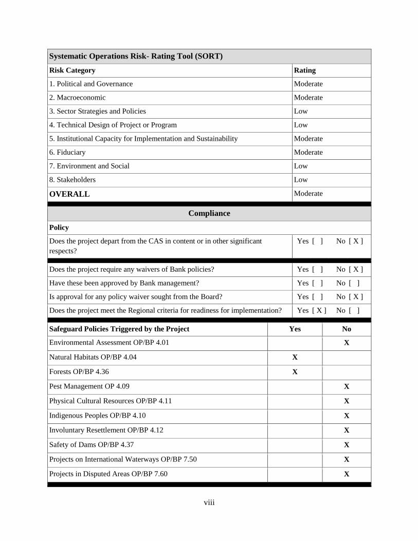
Systematic Operations Risk- Rating Tool (SORT)
Risk Category Rating
1. Political and Governance Moderate
2. Macroeconomic Moderate
3. Sector Strategies and Policies Low
4. Technical Design of Project or Program Low
5. Institutional Capacity for Implementation and Sustainability Moderate
6. Fiduciary Moderate
7. Environment and Social Low
8. Stakeholders Low
OVERALL Moderate
Compliance
Policy
Does the project depart from the CAS in content or in other significant
respects?
Yes [ ] No [ X ]
Does the project require any waivers of Bank policies? Yes [ ] No [ X ]
Have these been approved by Bank management? Yes [ ] No [ ]
Is approval for any policy waiver sought from the Board? Yes [ ] No [ X ]
Does the project meet the Regional criteria for readiness for implementation? Yes [ X ] No [ ]
Safeguard Policies Triggered by the Project Yes No
Environmental Assessment OP/BP 4.01 X
Natural Habitats OP/BP 4.04 X
Forests OP/BP 4.36 X
Pest Management OP 4.09 X
Physical Cultural Resources OP/BP 4.11 X
Indigenous Peoples OP/BP 4.10 X
Involuntary Resettlement OP/BP 4.12 X
Safety of Dams OP/BP 4.37 X
Projects on International Waterways OP/BP 7.50 X
Projects in Disputed Areas OP/BP 7.60 X
ix
Legal Covenants
Name Recurrent Due Date Frequency
Schedule 2, I A 5. Project Institutional
Coordination Committee
16-Aug-2016
Description of Covenant
The Recipient shall cause Ministry of Science, Technology, and Innovation (MCTI) to establish, by no
later than 90 days after the Effectiveness date, and thereafter operate and maintain at all times during
Project implementation, the Project Institutional Coordination Committee (PICC), an advisory committee
which shall consist of representatives of the Recipient, MCTI, National Institute for Space Research
(INPE), Federal University of Goiás (UFG), and Federal University of Minas Gerais (UFMG).
Name Recurrent Due Date Frequency
Schedule 2, I A 3. Key staff in FUNDEP X CONTINUOUS
Description of Covenant
At all times during Project implementation maintain professional staff in adequate numbers, and with
terms of reference, qualifications and functions acceptable to the World Bank, including, but not limited
to, a Project leader, and a procurement specialist.
Name Recurrent Due Date Frequency
Schedule 2, II A 1. Project reports X Semi-Annual
Description of Covenant
The Recipient shall monitor and evaluate the progress of the Project, with MCTI’s assistance and
collaboration, and prepare Project Reports in accordance with the provisions of Section 2.06 of the
Standard Conditions and on the basis of indicators acceptable to the World Bank.
Name Recurrent Due Date Frequency
Schedule 2, I A 4. Project’s Annual
Operational Plan (POA)
X Yearly
Description of Covenant
The Recipient shall, at least once a year during Project implementation on or about December 1,
commencing on the first such date after the Effective Date, prepare and furnish to the Bank the POA,
including financial management, in terms and conditions acceptable to the Bank, for the Project’s
operation during the following twelve months.
Conditions
Source Of Fund Name Type
SCF Grant IV. 4.01 (a) The Operational Manual has been
adopted by the Recipient
Effectiveness

x
Description of Condition
Adoption by FUNDEP of the Project's Operational Manual.
Source Of Fund Name Type
SCF Grant IV 4.01 (b) The execution and delivery of the
Technical Cooperation Agreement.
Effectiveness
Description of Condition
Execution and delivery of the Technical Cooperation Agreement on behalf of the Recipient, MCTI, INPE
(as represented by MCTI), UFG, and UFMG, duly authorized or ratified, executed and delivered by all
parties and by all necessary action.
Source Of Fund Name Type
SCF Grant IV 4.01 (c) The execution and delivery of the Grant
Agreement.
Effectiveness
Description of Condition
The execution and delivery of the Grant Agreement on behalf of the Recipient have been duly authorized
or ratified by all necessary corporate action.
Source Of Fund Name Type
SCF Grant IV 4.02 Legal opinions on the Grant and Technical
Cooperation Agreements
Effectiveness
Description of Condition
Legal opinions to the effect that the Grant Agreement and the Technical Cooperation Agreement are
legally binding upon each party in accordance with their respective terms.
Team Composition
Bank Staff
Name Role Title Specialization Unit
David Tuchschneider Team Leader (ADM
Responsible)
Sr Rural Development
Specialist
GFA04
Danilo Pereira de
Carvalho
Procurement Specialist
(ADM Responsible)
Procurement Specialist GGO04
Thiago De Oliveira
Teodoro
Financial Management
Specialist
Consultant GGODR
Alberto Coelho
Gomes Costa
Safeguards Specialist Sr Social Development
Specialist
GSU04
Gregor V. Wolf Team Member Program Leader LCC5C
Gustavo de Montalvao
G. Abath
Team Member Program Assistant GFA04
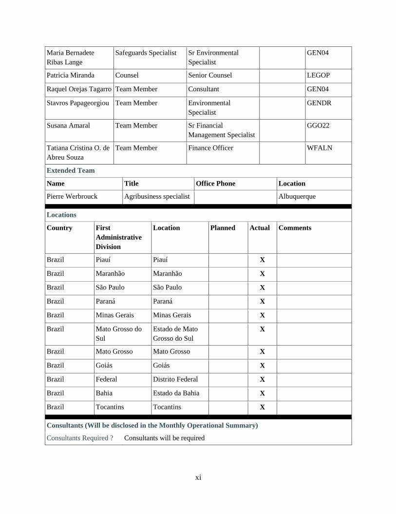
xi
Maria Bernadete
Ribas Lange
Safeguards Specialist Sr Environmental
Specialist
GEN04
Patricia Miranda Counsel Senior Counsel LEGOP
Raquel Orejas Tagarro Team Member Consultant GEN04
Stavros Papageorgiou Team Member Environmental
Specialist
GENDR
Susana Amaral Team Member Sr Financial
Management Specialist
GGO22
Tatiana Cristina O. de
Abreu Souza
Team Member Finance Officer WFALN
Extended Team
Name Title Office Phone Location
Pierre Werbrouck Agribusiness specialist Albuquerque
Locations
Country First
Administrative
Division
Location Planned Actual Comments
Brazil Piauí Piauí X
Brazil Maranhão Maranhão X
Brazil São Paulo São Paulo X
Brazil Paraná Paraná X
Brazil Minas Gerais Minas Gerais X
Brazil Mato Grosso do
Sul
Estado de Mato
Grosso do Sul
X
Brazil Mato Grosso Mato Grosso X
Brazil Goiás Goiás X
Brazil Federal Distrito Federal X
Brazil Bahia Estado da Bahia X
Brazil Tocantins Tocantins X
Consultants (Will be disclosed in the Monthly Operational Summary)
Consultants Required ? Consultants will be required


I. STRATEGIC CONTEXT
A. Country Context
1. Brazil is a developing country with a complex and dynamic economy. In 2014 it was
the seventh largest economy in the world in Gross Domestic Product (GDP) terms (US$ 2.4
trillion), but only number 59 in terms of GDP per capita (US$ 11,384). Between 2000 and 2014
the average annual economic growth rate was 3.3 percent, but it is estimated to have declined by
3.7 percent in 2015. By population, it is the sixth largest country in the world, with 204 million
inhabitants, of which 84 percent live in urban areas. Strong progress has been made in reducing
poverty and increasing shared prosperity in recent years, with extreme poverty and poverty rates
dropping to 2.8 percent and 7.4 percent, respectively. However, the extreme poverty rate is
estimated at 7.5 percent among the rural population, and particularly among Indigenous People
and Quilombola communities (PNAD, 2014)1.
2. Brazil’s economy is partly anchored in the export of primary products, including
agricultural commodities. The country is ranked first as an exporter of sugarcane, beef, poultry,
coffee, tobacco and ethanol. Brazil is also the second largest exporter of soybeans and corn, the
fourth largest exporter of pork, and has the second largest cattle herd in the world. The country
exports around 1,500 different agricultural products to over 200 markets in Europe, Asia, Africa,
the Americas and the Middle East. Agriculture and livestock contribute to eight percent of GDP,
account for 30 percent of the country's exports and for 19 percent of its employment. Much of
this agricultural growth has occurred over the last decade, and much of it has taken place in the
Brazilian savanna, known as the Cerrado Biome.
3. The Cerrado. The Cerrado biome covers approximately 2 million km2 of the Brazilian
Central Plateau (24 percent of the country’s total area) and is the second largest phyto-
geographic province in Brazil, sharing transitions with other Brazilian biomes: the Amazon
Forest, Caatinga, Pantanal and Atlantic Forest. It is one of the richest and most diverse savannas
in the world2, with 23 types of vegetation consisting mostly of tropical savannas, grasslands,
forests and dry forests. It is considered as one of the 34 global hotspots of biodiversity because of
the high level of endemism and rapid loss of its original habitat3.
4. Until the late 1950s, the contribution of the Cerrado to Brazil's agricultural output
was still low, at less than 10 percent of the national total. However, the construction of
Brasilia fostered an intense flow of migrants to the Cerrado region to work on infrastructure
projects and colonization programs. In addition, the development of agricultural technologies in
the 70s solved problems of soil fertility deficiencies. Thus productivity of soybean, maize and
cotton in the Cerrado is among the highest in the world now, turning the Cerrado into Brazil's
new agricultural frontier. There are now about 50 million head of cattle in the Cerrado,
representing 33 percent of the national herd, with pastures being the most important form of land
use in the region, covering over 60 million hectares. The Cerrado is also responsible for over half
1 http://www.ibge.gov.br/english/estatistica/indicadores/trabalhoerendimento/pnad_continua/
2 T. Lewinsohn and P. Prado, 2005, How many species are there in Brazil? Conservation Biology, 19-3, pp. 619-24.
3 R.A. Mittermeier et al., 2005, A Brief History of Biodiversity Conservation in Brazil, Conservation Biology, 19-3,
pp. 601-607.

2
of Brazil's soybean production, most of it for export. It is estimated that 50 to 60 percent of the
pasture area shows some degree of degradation.
5. Twenty two percent of Brazil’s population (42.7 million4) lives in the Cerrado but
only 14 percent of its population resides in rural areas. Distributed over 11 Federative Units
(Goiás, Tocantins, Mato Grosso, Mato Grosso do Sul, Minas Gerais, Bahia, Maranhão, Piauí,
São Paulo, and Paraná States, and the Federal District), the Cerrado Biome is mostly occupied by
private landholdings with a high concentration of smallholders: some 78 percent of about 1
million landholdings in the biome are small (up to 4 fiscal modules)5 but they occupy only 15
percent of the area of all landholdings; 22 percent of the larger landholdings occupy 85 percent
of the area.6 Protected Areas represent 8.2 percent of the Cerrado Biome, while Indigenous
Lands occupy 4.3 percent of the area. Poverty and extreme poverty rates in the rural areas of the
States that encompass the Cerrado are 19.1% and 7.2% respectively, well above the national
average of 7.4% and 2.8% (PNAD, 2014).
6. Carbon. The structural diversity of vegetation types in the Cerrado involves a wide
spectrum of biomass amounts. Total biomass (the sum of biomass above and below ground up to
2 meters deep) in Central Brazil varies from 21.8 Mg/ha in the campo sujo (parkland) to 77.8
Mg/ha in dense Cerrado (dry forest). The root/shoot ratio in all Cerrado vegetation types shows
values above 1, ranging from 2.6 in the open Cerrado (woodland) to 7.7 in campo limpo
(grassland)7. Organic matter in the soil represents the most substantial carbon stock in the
Cerrado’s ecosystems. The total estimated carbon stock amounts to 265 Mg/ha, with soil organic
matter comprising 70 percent (185 Mg/ha), when considering the vegetation and the soil up to
1m depth.
7. Deforestation. Studies have shown that this biome is now severely threatened, as the rate
of land cover change has been extremely high over the last decades – even higher than in the
Amazon. It is estimated that only about 52 percent of the area covered by native vegetation
remains (around 1 million km2), compared to 82 percent in the Amazon. During the 2002-2008
period, the Cerrado biome lost 4.1 percent of its cover (14,200 km2/yr), compared to 3.2 percent
in the Amazon (18,954 km2/yr). Deforestation however is on a declining trend in both biomes; in
2010, the area deforested in the Cerrado was similar to the area deforested in the Amazon (6,400
km2), though still representing a higher percentage in relative terms (0.32 percent vs. 0.15
percent respectively). Continuing along such a path would threaten the long-term future of the
Brazilian Cerrado Biome and its natural resources, and consequently the process of its economic
growth and poverty reduction.
4 Instituto Brasileiro de Geografia e Estatística (IBGE), Brazilian Census 2010.
5 The fiscal module (módulo fiscal) is a land unit established by the National Institute of Colonization and Agrarian
Reform (Instituto Nacional de Colonização e Reforma Agrária, INCRA) mainly for rural real estate taxation
according to Federal Decree Nº 8.485/1980 and INCRA NIo 20/1980. The fiscal module in Cerrado municipalities
varies from 0.04 to 0.1 km2, with an average of 0.46 km
2 (46 ha).
6 Statistics for the biome were derived from 2006 agricultural census data for municipalities that are located partially
or wholly in the Cerrado. Absolute numbers (1,066,000 landholdings over 1.5 km2) overstate the total number of
landholdings and area actually in the Cerrado Biome. 7 Castro, EA, & Kauffman, JB. 1998. Ecosystem structure in the Brazilian Cerrado: a vegetation gradient of
aboveground biomass, root mass and consumption by fire. Journal of Tropical Ecology, vol. 14, no. 3, pp. 263–283.

3
8. Fire. The dynamics of natural vegetation of the Cerrado biome is often associated with
fire. Whereas fires in the humid forests of Amazonia are a rare natural phenomenon, they occur
more frequently in the Cerrado and play a key role in its ecological functioning. Nevertheless,
human land use practices have altered the natural fire regime. Fires set by ranchers to induce
regrowth of pastures in the dry season often get out of control and spread over wide areas,
affecting protected areas, indigenous lands and remnants of natural vegetation. The widespread
use of fire continues to be observed despite regulations and fines imposed by the authorities8.
Consistent and reliable estimates of the burned surface for the Cerrado are not found in the
literature. Preliminary data from the Ministry of Environment (MMA) using low resolution
satellite imagery indicates an average of 410.000 km2 for the 2005-2010 period, with extremes of
217.000 km2 in the wet year of 2009 and 659.000 km
2 in the dry year of 2007
9. Those values
correspond to about 20 percent of the biome being affected by fire on average, and up to 32
percent on dry years, following a similar pattern of fire regimes in the African savannas.
9. Anthropogenic climate change may further increase the frequency of fires, not only
because of longer dry seasons in some regions10
but also due to an increase in extreme drought
events, such as the ones that occurred in 2005 and 2010 in southern Amazonia and northern
Cerrado11
. Additionally, because fires are associated with deforestation and, especially,
fragmentation, they are predicted to increase in frequency as native vegetation continues to be
converted into croplands.
10. GHG emissions. According to the Second Brazilian Greenhouse Gas Inventory (Brazil,
2010), carbon emissions due to deforestation in the Cerrado increased from 0.05 petagrams of
carbon per year (1988 to 1994) to 0.06 between 2002 and 2008. Recent estimates12
indicate that
deforestation and burning (including CH4 and N2O) in the Cerrado between 2003 and 2008
resulted in the emission of 1,450 MtCO2eq, of which conversion to pastures corresponds to 819
MtCO2eq (or 136.5 MtCO2eq/year).
B. Sector and Institutional Context
11. Brazil has developed a suite of sector-specific greenhouse gas (GHG) mitigation
actions that it estimates will result in a reduction of 36.1 to 38.9 percent below a projected
baseline by 202013
. During the 2009 15th Conference of the Parties (COP) to the United Nations
Framework Convention on Climate Change (UNFCCC) in Copenhagen, Brazil announced its
voluntary targets, followed by a communication of its Nationally Appropriate Mitigation Actions
8 See INPE’s Fires (Queimadas) website at : http://queimadas.cptec.inpe.br/~rqueimaimg/videos/ focosdeCalor_
cerrado_1998a2014.mp4. 9 See MMA’s information at: http://www.mma.gov.br/florestas/controle-e-preven%C3%A7%C3%A3o-do-
desmatamento/plano-de-a%C3%A7%C3%A3o-para-cerrado-%E2%80%93-ppcerrado/projetos-de-apoio-ao-
ppcerrado. 10
Nobre, C.A., P.J. Sellers, J. Shukla. 1991. Amazonian deforestation and regional climate change. Journal of
Climate, 4, 957-988. 10
Malhi, Y.J., T. Roberts, R.A. Betts, T.J. Killeen, W. Li, C.A. Nobre. 2008. Climate change, deforestation and the
fate of the Amazon. Science, 319, 169-172. 11
Philips et al. 2009; Lewis SL, Brando PM, Phillips OL, van der Heijden G-F, Nepstad D (2011) The 2010
Amazon drought. Science 331:554-554. 12
Bustamante, MC, Nobre, C, Smeraldi, R, Aguiar, APD, Barioni, LG, Ferreira LG, Longo, K, May, P, Pinto, AS,
Ometto, JPHB. 2012. Estimating Greenhouse GasEmissions from Cattle Raising in Brazil, Climatic Change. 13
Equivalent to an estimated 1.17 to 1.26 billion tonnes CO2 equivalent reduction relative to the 2020 projection.

4
(NAMAs) to Annex II of the Copenhagen Accord14
. In December 2009, shortly after the COP
announcement, Brazil instituted this goal in Law No. 12.187/2009, establishing the National
Policy on Climate Change (NPCC). The NPCC defines the objectives and guidelines for
domestic operations in Brazil for dealing with climate change, and is the main reference point for
Brazil's REDD+ type actions. In December 2010, the Brazilian Government approved
regulations of the NPCC15
, establishing specific targets for reducing GHG emissions through
sectoral plans and initiatives.
12. Sector plans. For the agriculture, forestry, and other land use (AFOLU) sector, these
initiatives include the Action Plan to Prevent and Control Deforestation in the Amazon
(PPCDAm), the Action Plan to Prevent and Control Deforestation and Fire in the Cerrado
(PPCerrado), and the Low-Carbon Agriculture Plan (ABC Plan). Decree 7,390 included the
following targets: (i) 80 percent reduction of deforestation in the Amazon compared to the 1996-
2005 average (19,535 km²/yr); (ii) 40 percent reduction of deforestation in the Cerrado compared
to the 1999-2008 average (15,700 km²/yr); (iii) recovery of 15 million ha of degraded pastures;
(iv) expansion of crop, livestock and forestry integrated systems by 4 million ha; (v) expansion
of no-tillage farming systems by 8 million ha; (vi) expansion of planted forests by 3 million ha;
(vii) increase the treatment of animal waste by 4.4 million m3; and (viii) increased use of
charcoal from planted forests in steelmaking.
13. In addition to these sector plans, the Forest Code16
is considered the most important
land-use regulation in the country, given its national scope and the constraints it imposes on
private property for the purpose of protecting public goods such as forests and other vegetation.
The code requires farmers to preserve the most fragile areas of their property such as riparian
forests, steep slopes, mountain tops, etc. (Permanent Preservation Areas – APP), with an
additional obligation to ensure that part of the original native vegetation is maintained (Legal
Reserves –RL). The percentage to be held as RLs varies from 80 percent in the Amazon to 20-35
percent in the Cerrado (depending on location), to 20 percent in the rest of Brazil. Landowners
must seek official authorization from the relevant state agencies to convert native vegetation (not
already classified as RLs or APPs) to other uses permitted by law. Recent estimates show that
the Cerrado is the biome with by far the vastest extent of native vegetation still available for
legal deforestation, estimated at 88±6 million hectares, with a potential to emit 18±4 GtCO2e 17
.
The Forest Code includes the creation of the Rural Environmental Cadaster (Cadastro Ambiental
Rural, CAR), which sets a deadline for farmers to register APPs and RLs on their farms, and to
submit proposals for restoring their degraded areas if they are not compliant with the legislation.
14. The Action Plan to Prevent and Control Deforestation and Fires in the Cerrado
Biome (PPCerrado)18
, launched in September 2010, aims to promote a sustained reduction in
14
See Annex II of Copenhagen Accord: Nationally Appropriate Mitigation Actions (NAMAs) by developing
countries. Available at: http://unfccc.int/meetings/cop_15/copenhagen_accord/items/5265.php 15
Decreto No 7.390, de 9 de Dezembro de 2010. Available at: http://www.planalto.gov.br/ccivil_03/_Ato2007-
2010/2010/Decreto/D7390.htm 16
Enacted by Federal Law 12.651, May 2012, as amended by Law 12.727 of October 2012 and Federal Decree
7.830 of October 2012. 17
Soares-Filho et al., 2014. Cracking Brazil’s forest code. Science Vol. 344 no. 6182 pp. 363-364 18
The Plan can be found in: http://www.mma.gov.br/florestas/controle-e-preven%C3%A7%C3%A3o-do-
desmatamento/plano-de-a%C3%A7%C3%A3o-para-cerrado-%E2%80%93-ppcerrado; and
http://www.mma.gov.br/images/arquivos / florestas/controle_ e_prevencao/PPCerrado/PPCerrado_2fase.pdf
5
the rate of deforestation and forest degradation in the biome, as well as in the incidence of forest
fires, through a coordinated set of actions organized around four major pillars: i) monitoring and
control; ii) protected areas and territorial planning; iii) sustainable production activities; and iv)
environmental education. It is managed by an executive commission comprising representatives
from 17 ministries and coordinated by the Presidency of the Republic. It is based on the National
Program for the Conservation and Sustainable Use of the Cerrado Biome - Sustainable Cerrado
Program (PCS)19
, established by Decree No. 5.577/2005, which aims to promote conservation,
recovery, and sustainable management of natural ecosystems in the Cerrado biome, as well as to
revert the present negative socio-environmental impacts. Thus, the PPCerrado can be seen as a
continuation of the PCS, although focused on the issue of deforestation and forest fires.
15. Brazil has an institutional, normative and policy structure with proven capacity for
reducing deforestation and promoting the sustainable use of natural resources, and has set
ambitious goals for reducing deforestation in the Amazonia and Cerrado biomes while increasing
production and exports of cash crops and biofuels, and intensifying cattle production. In
Amazonia, emissions peaked in mid-1990s and early 2000s, and have had a big drop since 2005
after the onset of the PPCDAm20
. Data from the National Institute of Spatial Research (INPE) to
present these achievements in Amazonian deforestation reduction has supported the Brazilian
position in multilateral forums such as the UNFCCC21
and backed bilateral agreements. The
government wants to use its successful experience in controlling deforestation in Amazonia to
increase control and protection of the Cerrado. However, while Brazil has set up in INPE a good
monitoring infrastructure for land cover change in the Amazon, it lacks a similar information
system for the Cerrado and the other biomes.
16. One of PPCerrado’s key challenges is to establish a monitoring system for
deforestation and degradation in the Cerrado biome. Unlike in the Amazon, attempts to
monitor deforestation and degradation in the Cerrado are relatively new. A current effort by the
Ministry of Environment to monitor forest cover change in the Cerrado, has limited resources,
and does not measure deforestation and degradation in real time and with the same level of
accuracy as is the case in the Amazon.
17. Given the extent of land available for legal deforestation in the Cerrado and its
potentially high productivity, it is expected that agriculture will continue to increase in the
region for some time. New technologies have been developed for tropical agriculture, which
allow for significant productivity gains without expanding into new Cerrado areas. The
challenges are to: (i) promote a broader adoption of such practices22
, and (ii) enable full
implementation of the Forest Code and compliance with APP and RL requirements. In this
context, the generation and provision of spatially and temporally consistent information on forest
resources and change is needed to underpin the elaboration and implementation of strategies for
improving land-use sustainability and efficiency. These actions would contribute to the
19
See: http://www.mma.gov.br/biomas/cerrado/conservacao-e-uso-sustentavel 20
Nepstad et al., 2014 Slowing Amazon deforestation through public policy and interventions in beef and soy
supply chains. Science 344 (6188): 1118-1123. 21
Brazil was recently the first country to submit a REDD+ Reference Emission Level to the UNFCCC, including the
Amazon biome: http://www.mma.gov.br/redd/index.php/nivel-referencia 22
A challenge taken up by the FIP-financed Sustainable Production in Areas Previously Converted to Agricultural
Production (P143184), approved by the Bank on July 28, 2014.

6
maintenance of natural ecosystems, together with their biodiversity and associated environmental
services.
18. Brazil Investment Plan (BIP) under the Forest Investment Program (FIP)23
. The BIP
seeks to promote sustainable land use and forest management improvement in the Cerrado
Biome in order to reduce pressure on remaining forests, reduce GHG emissions and increase
carbon dioxide (CO2) sequestration. The BIP’s specific objectives are to: (i) improve
environmental management in previously converted areas in the Cerrado Biome, and (ii) produce
and disseminate environmental information at the biome scale. Figure 1 summarizes the
activities financed by BIP; project 2.2 would be financed by this Project.
Figure 1. The Brazil Investment Plan under the FIP
19. The continental size and environmental complexity of Brazil’s Cerrado Biome and
the need to ensure the consistency of the various instruments employed, coordinate efforts
in the regions, and share timely and relevant information are all challenges that call for the
building of synergies among the various actors and activities with a view toward securing
cost-effective solutions. Each of the projects in the BIP will contribute to this coordinated effort
by funding investments and activities designed to support actions by the various executors and
their working relationships with other government entities involved. The BIP will contribute to
the efforts being undertaken by the GoB to reduce emissions and maintain the carbon stock of
the country’s second largest biome (Please refer to Annex 5 for detailed information regarding
FIP and BIP).
C. Higher Level Objectives to which the Project Contributes
20. The Project is part of the Brazil Investment Plan (BIP) under the Forest Investment
Program (FIP) managed by the World Bank (WB). The higher level objective of the BIP, to
which the project contributes, is to promote sustainable land use and improved forest
management in the Cerrado, the second largest biome in Brazil and South America, leading to
reduced pressure on its remaining forests, reduced GHG emissions and increased CO2
23
The FIP is a targeted program of the Strategic Climate Fund (SCF), which is one of two funds under the
framework of the Climate Investment Funds (CIF) managed by the World Bank. The BIP was approved by the FIP
Subcommittee in May 2012.

7
sequestration. The implementation of BIP is also expected to have a co-benefit in poverty
alleviation, as it will have direct impacts on areas such as settlements and small agriculture
farmers, and will provide improved environmental information in order to develop refined
strategies on biodiversity use and conservation. The Project is part of thematic area 2, producing
and disseminating environmental information at the biome scale.
21. The Project’s objectives are fully in line with the World Bank Group Country Partnership
Strategy (CPS 2012-2015), discussed by the Executive Directors on November 1, 2011 (Report
No 63731 BR), under Strategic Objective 4: Improving sustainable natural resource management
and climate resilience. The engagement in the biome seeks to: (i) support the mapping of
degraded areas across all Brazilian biomes and help develop financial incentives to promote their
rehabilitation; (ii) support increased sustainability of agricultural production and forestry in the
Cerrado; (iii) support efforts by the Federal Government and selected subnational governments
to further strengthen and integrate their environmental management systems, including those at
the metropolitan level, and ensure environmental compliance in rural areas; (iv) help improve the
efficiency and effectiveness of environmental licensing and monitoring systems, and (v) help the
Federal Government and the private sector to implement Brazil’s National Climate Change Plan.
22. The proposed Project’s objectives and strategy are fully in line with the World Bank
Group’s twin global goals of boosting shared prosperity and ending extreme poverty. The Project
will improve the Government’s capacity to monitor and manage forest fires by providing data
tools to environmental agencies improving control and management of out-of-control fires,
which often crossover into indigenous lands, smallholder farms and protected areas. Forest fires
have deleterious effects on health in a much wider area, through exposure to smoke. By
improving fire management and deforestation control, the Project will provide the basis for
enhanced management of soil, water and forest resources, which linked to the other FIP financed
projects in Brazil is expected to lead to better productivity and higher incomes for small and
medium farmers in the Cerrado.
II. PROJECT DEVELOPMENT OBJECTIVE
A. Project Development Objective (PDO)
23. The objective of the Project is to enhance the Member Country’s24
institutional capacity
in monitoring deforestation, in providing information on fire risks, and in estimating related
GHG emissions in the Cerrado.
B. Project Beneficiaries.
24. The beneficiaries of the proposed Project are the institutions and actors involved in the
monitoring and conservation of the Cerrado Biome. They include the National Space Research
Institute (INPE), the Brazilian Institute of Environment and Renewable Natural Resources
(IBAMA), the National Center for (forest) Fire Prevention and Suppression (PREVFOGO), State
and Municipal Environmental Organizations, the Federal Police, Municipal governments and
their fire brigades, the National Institute for Colonization and Agrarian Reform (INCRA), the
Ministry of the Environment (MMA), the Ministry for Rural Development (MDA), the Ministry
of Agriculture, Livestock and Food Supply (MAPA), the Chico Mendes Institute for Biodiversity
24
“Member Country” means the Federative Republic of Brazil.
8
Conservation (ICMBio), the Brazilian Indian Foundation (FUNAI), the Brazilian Forest Service
(SFB), the Brazilian Institute for Geography and Statistics (IBGE), Protected Area managers,
academic and training institutions, civil society organizations, farmer associations and
landholders. More than 3,000 clients consult regularly (and some of them daily) the websites of
the Project’s participating entities.
C. PDO Level Results Indicators
25. The achievements of the PDO will be measured through the following PDO indicators:
(i) Information on deforestation in the Cerrado is regularly made available to the public
and relevant institutions;
(ii) Improved information on forest fire risk is publicly available;
(iii) Near real-time information on potential fire spread in the Cerrado is publicly available;
(iv) GHG emissions estimates for the Cerrado are publicly available; and
(v) Government institutions in charge of policy, deforestation control and fire prevention
use the information on deforestation and fire risk in the Cerrado.
26. Intermediate indicators are:
(i) Government institutions provided with capacity building support to improve
management of forest resources [core sector indicator];
(ii) Annual deforestation maps on the scale of 1:250,000 are publicly available
(PRODES25
-Cerrado);
(iii) Deforestation data on the scale of 1:500,000 is delivered daily to deforestation control
agencies and monthly to the public (DETER26
-Cerrado);
(iv) New fire risk information products are available to users on INPE’s Queimadas
website and on interactive communication devices;
(v) On-line fire ignition and spread risk (FISC) data is published on INPE’s website;
(vi) Off-line fire ignition and spread risk (FISC) model is piloted in selected conservation
areas; and
(vii) Independent reports on the quality of the project products.
III. PROJECT DESCRIPTION
A. Project Components
27. The Project has three components: (i) deforestation monitoring; (ii) information systems
on forest fire risk and GHG emissions estimation; and (iii) project management, monitoring and
evaluation. The Project will be implemented over four years. The Project will not support direct
firefighting activities or purchase of equipment for them.
25
PRODES (Program for Measuring Deforestation in the Amazon) operated by the Instituto Nacional de Pesquisas
Espaciais (INPE), produces the annual gross deforestation map of the Brazilian Amazonia. 26
DETER (Real-time deforestation detection system) also led by INPE, works like an alert system to detect
incipient deforestation in quasi-real time.

9
28. Component 1: Deforestation monitoring (US$4.39 million). The component will
finance strengthening the monitoring of deforestation in the Cerrado by:
(a) designing and implementing a deforestation monitoring system of the Cerrado,
including annual deforestation mapping and near real-time deforestation detection
based on the PRODES and DETER systems;
(b) training selected stakeholders on access, interpretation and use of the information
generated by the deforestation monitoring system for the Cerrado; and
(c) designing and implementing a data quality control system for the deforestation
monitoring system for the Cerrado.
29. Component 2: Information systems on forest fire risk and GHG emissions
estimation (US$ 3.31 million). The component will finance:
(a) Improving INPE’s fire risk information system by designing, implementing and
providing, inter alia, (i) localized fire risk warning barometers, (ii) applications for
interactive fire risk updates, (iii) higher fire risk resolution maps, (iv) instruments for
fire risk statistical analysis, and (v) automatic status updates.
(b) Adapting a fire ignition, spread and carbon model to the Cerrado, including the
integration of daily-updated, on-line fire spread forecast information on INPE’s
Queimadas website, and applying such model in selected conservation units as a fire
management tool.
(c) Adapting INPE’s GHG emissions estimation system to the Cerrado; and
(d) Carrying out a program of hands-on training on the practical application of fire risk
modelling tools to selected stakeholders.
30. Component 3: Project management, monitoring and evaluation (US$US$ 1.55
million). The component will provide support for managing the technical and administrative
aspects of the Project, including financial management, procurement, the carrying out of audits,
overall Project coordination, monitoring and evaluation of Project implementation.
B. Project Financing
31. A US$ 9.25 million grant from the Strategic Climate Fund will finance the costs of
the proposed Project. The Project will involve important resources from the agencies involved,
which will finance the costs of their existing staff and operations.
Table 1: Project Costs and Financing – Incremental costs (US$ million)
Project Components Project cost
FIP
FIP
Financing
% of total
1. Deforestation monitoring
2. Fire risk and emissions systems
3. Project Management, Monitoring
and Evaluation
Total Base Costs
4.39
3.31
1.55
9.25
4.39
3.31
1.55
9.25
100%
100%
100%
100%

10
Total Project Costs (US$ million) 9.25 9.25 100%
C. Lessons Learned and Reflected in the Project Design
32. Information provided by the forest cover monitoring systems (PRODES-DETER)
has enabled Brazil’s reduction of deforestation rates in the Amazon. The Project would
adapt these systems, currently operated by INPE, to the Cerrado biome, creating the basis for
securing similar achievements there.
33. Brazil is a leader in monitoring and early-warning systems for fire forecasting in
different biomes and forest areas and for monitoring land use, so it has the capacity and
vision necessary for their improved application in the Cerrado; however; institutional
coordination is crucial for ensuring effective use of information. The successful collaboration
between the three key ministries involved in land use regulation (MMA, MAPA and MCTI) in
the design of the Project has allowed the development of a strategic approach capable to foster
synergies not only among Brazil Investment Plan and its projects, but also with ongoing Cerrado
government plans and policies already in implementation at federal, state and municipal levels
(e.g. PPCerrado).
IV. IMPLEMENTATION
A. Institutional and Implementation Arrangements
34. The Federative Republic of Brazil through the Ministry of Science, Technology and
Innovation (MCTI) endorsed the Project on May 13, 2013 and appointed the Research
Development Foundation (Fundação de Desenvolvimento da Pesquisa - FUNDEP) as the
Recipient and Project implementing agency. FUNDEP is a private foundation with extensive
experience in project management. FUNDEP will sign a Technical Cooperation Agreement with
MCTI and the three other participating institutions (see below), establishing the Project
governance structure and its administrative procedures. FUNDEP will adopt an Operational
Manual satisfactory to the Bank. Its responsibilities include: (i) procurement and financial
administration; and (ii) monitoring and reporting (jointly with MCTI).
35. The Ministry of Science, Technology and Innovation (Ministério da Ciência,
Tecnologia e Inovação - MCTI), through the Secretariat for Policies and Research Programs
and Development (SEPED), will approve the Project’s Annual Operational Plans (POA) and
budgets and will be responsible for institutional coordination, implementation monitoring,
quality assurance and results evaluation. SEPED will appoint a staff member as project director
and contract a project coordinator/manager with extensive experience to run day-to-day
operations.
36. A Project Institutional Coordination Committee (PICC) will be created through a
MCTI Ministerial Ordinance (portaría), to ensure coordination between FUNDEP, MCTI and
the three participating institutions: the National Institute for Space Research (INPE), the Federal
University of Minas Gerais (UFMG) and the Federal University of Goiás (UFG). MMA will be
invited to participate as needed to facilitate coordination at the level of the FIP Plan and
PPCerrado. The PICC will be responsible for: (i) commenting on proposals to adjust the
Operational Manual of the Project (MOP); (ii) validating POAs; (iii) reviewing the physical and
financial implementation progress reports; (iv) ensuring that project execution and results are

11
timely, consistent and ultimately contribute to the attainment of the strategic objectives of the
Project; and (v) providing strategic recommendations to strengthen project implementation.
37. INPE, a research institution linked to MCTI, will be in charge of PRODES/DETER
Cerrado monitoring system development and implementation (and related sub-products and
systems), improvements to the fire risk information system, GHG emissions estimations system
and related training and dissemination. UFMG will be in charge of developing and adapting the
FISC model, its application in four conservation units and training in the use of the model. UFG
will be in charge of the PRODES/DETER data quality control system.
38. Project execution. FUNDEP will administer the Project and MCTI will be in charge of
technical supervision. INPE, UFMG and UFG will be responsible for delivering the Project
products respectively assigned to each of them. Activity execution will proceed as follows: (i)
the POA will be inserted into FUNDEP’s management system, (ii) INPE, UFMG and UFG will
prepare the technical specifications of the goods to be procured as well as the terms of reference
of the consultants to be recruited; (iii) INPE, UFG, UFMG will request the purchase of goods
and services and hiring of consultants through FUNDEP’s system; (iii) SEPED will review and
approve these requests directly in the system; and (iv) FUNDEP will carry out the procurement
and execute payments. Ownership of all goods purchased with project funds will be transferred
to each institution at the end of the Project, in accordance with instructions from MCTI.
B. Results Monitoring and Evaluation (M&E)
39. FUNDEP will monitor implementation progress jointly with MCTI-SEPED and issue
progress reports on a six-monthly basis. MCTI will also monitor results and impacts in two
ways. The participating entities will provide intermediate product output reports in accordance
with the POA and the Results Framework. MCTI will designate an independent technical
evaluation group to review and assess the quality of the intermediate products and reports and to
provide feedback to the PICC and the participating entities. MCTI will also contract an agency
to carry out intermediate surveys on how useful the information generated under the Project is
for the end-users and feedback the conclusions to the participating entities and the PICC. Such
surveys will help improving the quality and effectiveness of the information. At the end of the
second Project year, it will carry out a mid-term review together with the World Bank and at the
end of the Project it will carry out a final evaluation based on user surveys.
C. Sustainability
40. INPE, UFMG and UFG are technically solid institutions that have significant budgets to
update and maintain the information data banks generated under the Project. PPCerrado
provides the legal framework to finance the operation of these systems and MCTI will present
information maintenance budgets to be included in the national multi-annual budget allocations.
V. KEY RISKS AND MITIGATION MEASURES
A. Overall Risk Rating and Explanation of Key Risks
41. The overall risk of the Project not achieving its development objective is Moderate.
The participating entities have state of the art experience with PRODES and DETER in the
Amazon and there is no reason to suggest that they will have difficulties applying their

12
knowledge and experience to the Cerrado. There is a moderate risk with FUNDEP and MCTI,
which will need to coordinate closely to ensure timely delivery between themselves and with the
cooperating agencies (INPE, UFMG and UFG), for which they will participate in the Project
Institutional Coordination Committee. This is the first Bank-financed project FUNDEP will
manage and some teething management issues may arise. FUNDEP will reinforce its
procurement staff and the Bank will provide training and implementation support. Fiduciary
risks and mitigation actions are described below in the Appraisal Summary and in Annex 3.
VI. APPRAISAL SUMMARY
A. Technical
42. Brazil has set up in INPE a solid monitoring infrastructure for land cover change in the
Amazon, but lacks a good information system for the Cerrado. The government wants to use its
successful experience in controlling deforestation in Amazonia to increase control and protection
of the Cerrado.
43. The deforestation monitoring system will be an adaptation of the existing systems in use
in the Amazon (PRODES and DETER). These are already tested, validated and cited as best
practice internationally27.
In the case of the early warning systems for forest fires, the
improvements will enhance the existing system to increase the capacity to predict the risk of
forest fire and fire spread, one of the major threats to the Cerrado. Finally, the information
generated will expand existing systems for estimating GHG emissions in the biome as an
indicator of effectiveness of its mitigation actions. Together, these actions will ensure a steady
flow of high quality information to policy makers and actors involved in ground operations,
providing them with crucial support tools for planning, control and prevention of forest fires and
deforestation activities.
B. Economic and Financial Analysis
44. The technical assistance nature of the Project does not lend itself to conducting a
traditional economic and financial analysis. As an alternative, the analysis was based on a review
of the costs and benefits related to deforestation and the use of fire in the Cerrado, based on
research carried out in the country. The following aspects have been taken into account and
confirm the economic and financial relevance of the Project.
45. Deforestation and fire are part of the Cerrado’s farming system. Farmers and ranchers
contribute to deforestation and use fire to extend pastures, increase short-term productivity and
control pests and diseases. Without legal impediments, deforestation will continue, as it is
financially profitable. In most smallholder situations, burning forest and pasture is more cost
effective than agricultural intensification28
(Alternatives to Slash-and-Burn in Brazil report,
ICRAF, 2002). Deforestation and burning in the Cerrado is legal in up to 80 percent of the farm
property, excluding protected sectors. Deforestation and managed burning permits are required,
although most ranchers do not request them.
27
See GOFC-GOLD, 2013. REDD+ Sourcebook, COP19 version. Available at: http://www.gofcgold.wur.nl/redd/ 28
http://www.asb.cgiar.org/publication/alternatives-slash-and-burn-programme-asb-brazil
13
46. From the environmental point of view, deforestation increases GHG emissions and
negatively affects climate change. Controlled burning in the Cerrado has some positive
environmental effects, such as reducing wood fuel, which in turn reduces wildfires. Many fires,
however, get out of hand and burn more pasture than intended, extend to adjacent forests and,
cumulatively, have negative respiratory health effects. This Project intends to strengthen
institutions to reduce the unintended or illegal deforestation as well as the uncontrolled burning
of the savannah. This will reduce the social and environmental costs of deforestation and fires
and ultimately impact GHG emissions.
47. More precise, up-to-date, real-time and widespread information on (illegal) deforestation,
risk of (wild) fires and GHG emissions have, potentially, the following economic and financial
benefits.
(i) potential increases in the cost-efficiency and effectiveness of IBAMA and other
environmental control agencies to reduce illegal deforestation;
(ii) forest fire prevention and firefighting agencies can intervene more rapidly and
effectively, and thus reduce unintended forest fire damage;
(iii)protected and conservation areas can introduce controlled fires based on better calibrated
fire ignition and spread models and reduce unintended forest fire damage and
management costs;
(iv) federal, state and local policy makers can base their deforestation reduction and fire
prevention policies on more accurate data and increase the policy efficiency and
effectiveness;
(v) more accurate estimates of GHG emissions in Brazil can contribute to increased
knowledge of climate change patterns and adaptation measures; and
(vi) improved information can enhance the management of Brazil’s natural resources, and
considering its size and economic importance, lead to world economic and financial
benefits.
48. The main economic and financial benefits of deforestation and burning go to the private
sector while the costs are borne by society in Brazil and elsewhere in the form of a negative
externality. This justifies the international public financing of institutional strengthening to
improve information generation and flows. Moreover, most direct beneficiaries of the
information flows are national and international public institutions.
49. Value Added. The Bank is part of the management structure of the Forest Investment
Program and the lead IFI supporting the Brazil Investment Plan. The Bank’s international
experience in project design and supervision as well as in climate change issues increases the
quality and impact of this type of project. The Bank supervises the money flows and ensures that
the funding is used efficiently to reach the Project’s objectives.
C. Financial Management
50. The World Bank will disburse the grant to FUNDEP. FUNDEP will pay the suppliers of
goods and services, consultants and for operational costs. INPE, UFMG and UFG will not
receive or manage any funds.
51. A Financial Management (FM) Assessment for the Project was conducted in April 2015
at FUNDEP in accordance with OP/BP 10.00 and the Financial Management Practice Manual
14
and Guidelines. The objective of the assessment was to determine whether FUNDEP has
acceptable FM and disbursement arrangements in place to adequately control, manage, account
for and report on the use of project funds. The scope of the assessment included (i) an evaluation
of existing financial management systems to be used for project monitoring, accounting and
reporting; (ii) a review of the staffing requirements of the project; (iii) a review of the flow of
funds and disbursement arrangements for the project; (iv) a review of the internal control
mechanisms in place; (v) a review of the systems reports and their suitability to be used as IFR’s;
and (vi) a review of the internal and external audit arrangements.
52. The Bank’s financial management assessment identified the following actions: (i) close
coordination between FUNDEP and MCTI; (ii) FUNDEP will control the budgeting process for
the Project, based upon a detailed Annual Operating Plan, Procurement Plan and related
disbursement forecasts; and (iii) FUNDEP will be responsible for Project execution (financial
management and procurement) with no funds flowing to the other entities.
53. Based on the assessment, FUNDEP has acceptable FM and disbursement arrangements in
place to adequately control, manage, account for and report on the use of Project funds.
D. Procurement
54. Procurement for the proposed Project would be carried out in accordance with the World
Bank’s "Guidelines: Procurement under IBRD Loans and IDA Credits" January 2011 (revised
July 2014); "Guidelines: Selection and Employment of Consultants by World Bank Borrowers"
January 2011 (revised July 2014); and the provisions stipulated in the Grant Agreement.
55. The Bank’s procurement capacity assessment of FUNDEP identified the following
challenges: (a) lack of familiarity with the Bank’s procurement policies; and (b) a lack of
experience in implementing Bank-financed projects. FUNDEP will take mitigation measures in
collaboration with the Bank, including (i) training of procurement and technical staff on Bank
procurement policies; and (ii) maintaining a procurement specialist with qualifications and
functions acceptable to the World Bank.
E. Social (including Safeguards)
56. The Project will not finance any physical construction, firefighting activities on the
ground or the purchase of equipment thereof. The Project will not interfere with Indigenous
Peoples and/or traditional communities as its activities focus on generating and providing
information. The Project’s Operational Manual will specify the procedures to be adopted if some
unexpected negative social impact arising from the project is identified. Additionally, Project
implementation will be supervised in accordance with the social policies of the World Bank and
in accordance with its guidelines for the application of safeguard policies to Technical
Assistance operations ("Interim Guidelines on the Application of Safeguard Policies to Technical
assistance (TA) Activities in Bank-Financed Projects and Trust Funds Administered by the
Bank").
57. Consultations. The BIP, of which this Project forms part, was prepared through an
intensive consultation process with key stakeholders. The first stage involved two meetings and
informative workshops – convening 161 participants. The second stage included a virtual
consultation process carried out from January 25 to March 5, 2012, and three workshops carried
out in Brasilia. The first workshop was held on February 7, 2012 and convened 52

15
representatives of Federal, State and Municipal government agencies and civil society
organizations. The second workshop was held on February 15, 2012 and convened about 70
participants – including representatives of Indigenous Peoples – in two sections. The final round
was held on March 5, 2012 and convened 22 participants, including representatives of
Environment State Secretariats. The Program received strong support from the groups consulted
because of its focus on the Cerrado biome, inter-institutional implementation arrangements and
synergies with policies and programs already in place.29
F. Environment (including Safeguards)
58. The Project is expected to have an overall positive impact on the environment as it seeks
to increase information on patterns of deforestation and fire risks in forests and grasslands.
Environmental Category of the Project is C. The Operational Policies on Natural Habitats (OP /
BP 4.04) and Forests (OP / BP 4.36) of the World Bank are triggered, as the Project is expected
to have positive impacts in natural habitats and forests. The information generated by the project
will be used to implement existing fire management regimes as well as introduce new
management policies and methods. The monitoring system to be implemented under the Project
should lead to positive impacts on natural habitats, including protected areas. The proposed
systems will be used to monitor natural forests and enhance public policies’ focus on protection.
The Project’s Operational Manual will include the Bank principles and guidelines for the
application of safeguard policies to Technical Assistance operations ("Interim Guidelines on the
Application of Safeguard Policies to Technical assistance (TA) Activities in Bank-Financed
Projects and Trust Funds Administered by the Bank").
G. World Bank Grievance Redress
59. Communities and individuals who believe that they are adversely affected by a World
Bank (WB) supported project may submit complaints to existing project-level grievance redress
mechanisms or the WB’s Grievance Redress Service (GRS). The GRS ensures that complaints
received are promptly reviewed in order to address project-related concerns. Project affected
communities and individuals may submit their complaint to the WB’s independent Inspection
Panel which determines whether harm occurred, or could occur, as a result of WB non-
compliance with its policies and procedures. Complaints may be submitted at any time after
concerns have been brought directly to the WB's attention, and Bank Management has been
given an opportunity to respond. For information on how to submit complaints to the WB’s
corporate Grievance Redress Service (GRS), please visit www.worldbank.org/grs. For
information on how to submit complaints to the World Bank Inspection Panel, please visit
www.inspectionpanel.org.
29
The Report on the Consultation Workshop remains publically disclosed at the following website:
http://www.mma.gov.br/estruturas/252/_arquivos/fip_relatorio_consulta_presencial_20120215_252.pdf.

16
Annex 1: Results Framework and Monitoring
Brazil
Development of systems to prevent forest fires and monitor vegetation cover in the Brazilian Cerrado (P143185)
Results Framework
Project Development Objectives
PDO Statement
The project development objective is to enhance Brazil's institutional capacity to monitor deforestation, provide information on fire risks and
estimate related GHG emissions in the Cerrado.
These results are at Project Level
Project Development Objective Indicators
Cumulative Target Values
Indicator Name Baseline YR1 YR2 YR3 YR4 End Target
Information on deforestation in the Cerrado is
regularly made available to the public and relevant
institutions
(Yes/No)
No No No Yes Yes Yes
Improved information on forest fire risk is publicly
available
(Yes/No)
No No No No Yes Yes
Real-time information on potential fire spread in the
Cerrado is publicly available
(Yes/No)
No No No No Yes Yes
GHG emissions estimates for the Cerrado available
are publicly available
(Yes/No)
No No No Yes Yes Yes
Government institutions in charge of policy, 0.00 0.00 10.00 15.00 15.00 15.00

17
deforestation control and fire prevention using use the
information on deforestation and fire risk in the
Cerrado
(Number)
Intermediate Results Indicators
Cumulative Target Values
Indicator Name Baseline YR1 YR2 YR3 YR4 End Target
Government institutions provided w/ capacity
building to improve management of forest resources
(Number) - (Core)
0.00 0.00 5.00 10.00 15.00 15.00
Annual deforestation maps on the scale of 1:250.000
are publicly available (PRODES-Cerrado)
(Number)
0.00 1.00 2.00 3.00 4.00 4.00
Deforestation data on the scale of 1:500,000 is
delivered daily to deforestation control agencies and
monthly to the public (DETER-Cerrado)
(Number)
0.00 0.00 4.00 8.00 12.00 12.00
New fire risk information products are available to
users on interactive communication devices
(Number)
0.00 0.00 10.00 20.00 26.00 26.00
On-line fire ignition and fire spread risk (FISC) data
is published on INPE’s website.
(Percentage)
0.00 20.00 40.00 60.00 100.00 100.00
Off-line fire ignition and spread risk (FISC) model is
piloted in selected conservation areas
(Number)
0.00 0.00 1.00 2.00 4.00 4.00
Independent reports on the quality of the project
products
(Number)
0.00 0.00 1.00 2.00 3.00 3.00
18
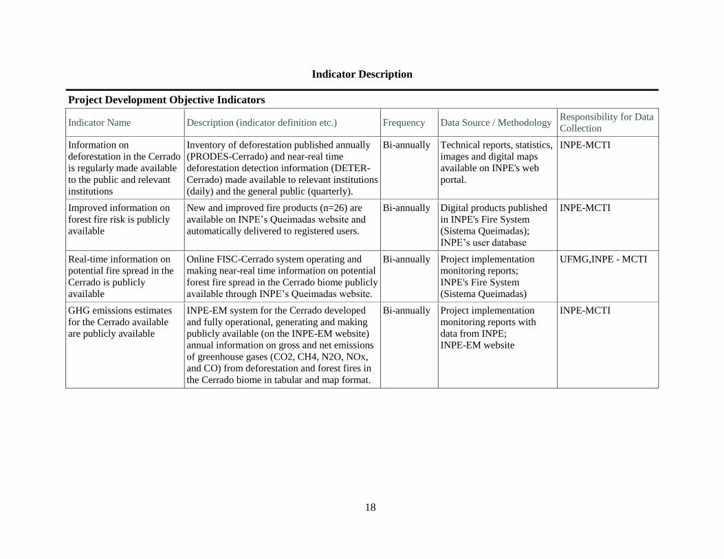
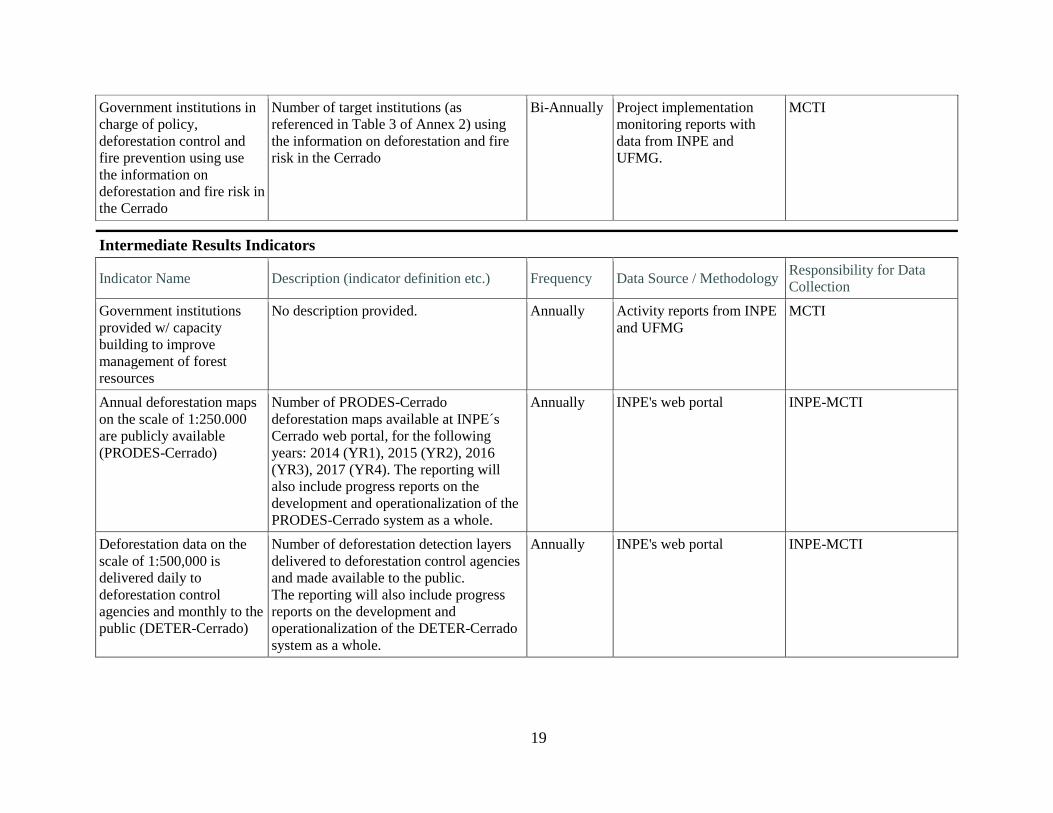
Indicator Description
Project Development Objective Indicators
Indicator Name Description (indicator definition etc.) Frequency Data Source / Methodology Responsibility for Data
Collection
Information on
deforestation in the Cerrado
is regularly made available
to the public and relevant
institutions
Inventory of deforestation published annually
(PRODES-Cerrado) and near-real time
deforestation detection information (DETER-
Cerrado) made available to relevant institutions
(daily) and the general public (quarterly).
Bi-annually Technical reports, statistics,
images and digital maps
available on INPE's web
portal.
INPE-MCTI
Improved information on
forest fire risk is publicly
available
New and improved fire products (n=26) are
available on INPE’s Queimadas website and
automatically delivered to registered users.
Bi-annually Digital products published
in INPE's Fire System
(Sistema Queimadas);
INPE’s user database
INPE-MCTI
Real-time information on
potential fire spread in the
Cerrado is publicly
available
Online FISC-Cerrado system operating and
making near-real time information on potential
forest fire spread in the Cerrado biome publicly
available through INPE’s Queimadas website.
Bi-annually Project implementation
monitoring reports;
INPE's Fire System
(Sistema Queimadas)
UFMG,INPE - MCTI
GHG emissions estimates
for the Cerrado available
are publicly available
INPE-EM system for the Cerrado developed
and fully operational, generating and making
publicly available (on the INPE-EM website)
annual information on gross and net emissions
of greenhouse gases (CO2, CH4, N2O, NOx,
and CO) from deforestation and forest fires in
the Cerrado biome in tabular and map format.
Bi-annually Project implementation
monitoring reports with
data from INPE;
INPE-EM website
INPE-MCTI
19
Government institutions in
charge of policy,
deforestation control and
fire prevention using use
the information on
deforestation and fire risk in
the Cerrado
Number of target institutions (as
referenced in Table 3 of Annex 2) using
the information on deforestation and fire
risk in the Cerrado
Bi-Annually Project implementation
monitoring reports with
data from INPE and
UFMG.
MCTI
Intermediate Results Indicators
Indicator Name Description (indicator definition etc.) Frequency Data Source / Methodology Responsibility for Data
Collection
Government institutions
provided w/ capacity
building to improve
management of forest
resources
No description provided. Annually Activity reports from INPE
and UFMG
MCTI
Annual deforestation maps
on the scale of 1:250.000
are publicly available
(PRODES-Cerrado)
Number of PRODES-Cerrado
deforestation maps available at INPE´s
Cerrado web portal, for the following
years: 2014 (YR1), 2015 (YR2), 2016
(YR3), 2017 (YR4). The reporting will
also include progress reports on the
development and operationalization of the
PRODES-Cerrado system as a whole.
Annually INPE's web portal INPE-MCTI
Deforestation data on the
scale of 1:500,000 is
delivered daily to
deforestation control
agencies and monthly to the
public (DETER-Cerrado)
Number of deforestation detection layers
delivered to deforestation control agencies
and made available to the public.
The reporting will also include progress
reports on the development and
operationalization of the DETER-Cerrado
system as a whole.
Annually INPE's web portal INPE-MCTI
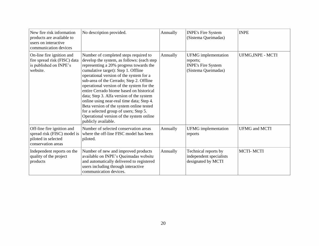
20
New fire risk information
products are available to
users on interactive
communication devices
No description provided. Annually INPE's Fire System
(Sistema Queimadas)
INPE
On-line fire ignition and
fire spread risk (FISC) data
is published on INPE’s
website.
Number of completed steps required to
develop the system, as follows: (each step
representing a 20% progress towards the
cumulative target): Step 1. Offline
operational version of the system for a
sub-area of the Cerrado; Step 2. Offline
operational version of the system for the
entire Cerrado biome based on historical
data; Step 3. Alfa version of the system
online using near-real time data; Step 4.
Beta version of the system online tested
for a selected group of users; Step 5.
Operational version of the system online
publicly available.
Annually UFMG implementation
reports;
INPE's Fire System
(Sistema Queimadas)
UFMG,INPE - MCTI
Off-line fire ignition and
spread risk (FISC) model is
piloted in selected
conservation areas
Number of selected conservation areas
where the off-line FISC model has been
piloted.
Annually UFMG implementation
reports
UFMG and MCTI
Independent reports on the
quality of the project
products
Number of new and improved products
available on INPE’s Queimadas website
and automatically delivered to registered
users including through interactive
communication devices.
Annually Technical reports by
independent specialists
designated by MCTI
MCTI- MCTI

21
Annex 2: Detailed Project Description
BRAZIL
1. The rationale for the Project’s focus on enhancing the institutional capacity of Brazilian
institutions to monitor deforestation and provide improved information on forest fires and
GHG emissions in the Cerrado stems from: (i) the economic and ecological importance and
size of the Cerrado; (ii) the huge risks that fires pose to the economy, ecology, GHG
emissions and forest cover; and (iii) the significance of the remaining Cerrado forest in terms
of biodiversity and carbon stocks.
2. The Project does not include direct action to either combat forest fires or the provision of
equipment thereof. Through the information provided, it will set a framework to allow
improved monitoring, measurement, reporting and enforcement of land use change activities
and fire. Thus, while it will not lead directly to GHG emissions reductions, the Project will
help to establish the foundations for policies and measures to reduce deforestation and
emissions.
3. The project will have three components.
(i) Component 1: Deforestation monitoring
(ii) Component 2: Information systems on forest fire risk and GHG emissions estimation
(iii) Component 3: Project management, monitoring and evaluation
Component 1: Deforestation Monitoring (FIP US$4.39 million)
4. The expected result of this component is the design and implementation of a
deforestation monitoring system for the Cerrado biome, consistent with the one used for the
Amazon. Since 1988, Brazil has systematically monitored changes in vegetation cover in
Amazonia, generating annual deforestation data with the PRODES (Project for the estimation of
deforestation in Amazonia) remote sensing system, as well as near real-time alerts for rapid
control intervention actions (DETER system). Both systems were developed and are operated by
Brazil’s National Space Research Institute - INPE. Surveys of vegetation cover are periodically
conducted in other Brazilian biomes such as the Cerrado, Caatinga and Pantanal; however, the
Brazilian Government does not currently have the same capacity installed to monitor
deforestation in these biomes at the same level as in the Amazon.
5. The component will finance strengthening the monitoring of deforestation by:
(a) designing and implementing a deforestation monitoring system of the Cerrado,
including annual deforestation mapping and near real-time deforestation detection
based on the PRODES and DETER systems;
(b) training selected stakeholders on access, interpretation and use of the information
generated by the deforestation monitoring system for the Cerrado; and
(c) designing and implementing a data quality control system for the deforestation
monitoring system for the Cerrado.

22
6. Subcomponent 1.1. Deforestation monitoring in the Cerrado. The subcomponent will
generate the following products:
a. Land Cover Classification System (LCCS). INPE will modify the existing land
cover classification system for the Cerrado developed by IBGE on the basis of the
Food and Agriculture Organization’s (FAO) Land Cover Classification System
(LCCS) framework30
. The effort will combine remote sensing, techniques,
geospatial tools, and ecological knowledge of the Cerrado’s ecosystem. It will
allow to discriminate forest from non-forest vegetation within the Cerrado’s
spectrum of structural complexity. This will allow for a more precise monitoring
of deforestation dynamics and carbon accounting across the biome, while
providing better land cover data for applications in land use planning, biodiversity
protection, and water resources management. In addition, the LCCS will permit
international benchmarking and comparison.
b. On-line geographical data management platform (TERRABRASILIS). To
provide a basis for both deforestation measurement and mapping, and for
measuring GHG emissions, INPE will develop a geographical data management
system for vegetation cover in the Cerrado (TerraBrasilis), similar to the one that
exists for the Amazon31
. Using its geospatial technology, all geographical data
and models generated by INPE and other relevant institutions and research
entities will be integrated into a “knowledge platform”. The platform will also
allow interested researchers to access each other’s data and scientific studies,
replicate INPE’s work and tailor it to their own needs for research on the evolving
land use in the Cerrado or elsewhere. INPE will build a website to support the
platform. The website will contain all data collected by the Project, including
large remote sensing data sets and also models and algorithms that were
developed with project funds. All such data and software will be available as
open access and open source.
c. Deforestation mapping on the 1:250,000 scale and near-real time
deforestation detection. INPE will apply its experience from the PRODES and
DETER systems in the Amazon to build deforestation maps and early alert
systems for the Cerrado. PRODES32
uses wall-to-wall mapping to get yearly data
on the spatial distribution and extent of the deforestation in the Brazilian Legal
Amazon, an area of 5 million km2. It uses remote sensing data with 20 to 30 meter
resolution and produces annual deforestation maps in the 1:250.000 scale with a
6.25 ha and 1 ha minimum mapping unit (MMU) at the representation and
working scales respectively. Its products include deforestation maps, the images
used, and the derived statistics at the level of the biome, states, municipalities,
protected areas, and indigenous territories. Since 2003, INPE makes PRODES
data freely available through the internet, with a dataset extending back to 2000. It
is cited as best practice in forums such as the Global Forest Observation Initiative
and GOFC-GOLD.
30
http://www.fao.org/docrep/003/x0596e/X0596e01.htm 31
http://terraamazon.org/index.php 32
PRODES (Project for the satellite monitoring of the Brazilian Amazon forest): www.obt.inpe.br/prodes/index.php

23
7. PRODES-Cerrado will maintain the same technical characteristics as PRODES-
Amazonia in order to maintain consistency and comparability across biomes and within states
covering more than one biome. This will also support the country’s commitment to build a
consistent forest monitoring system at the national level. Brazil is the first country to have
recently submitted a (subnational) Forest Reference Emission Level (FREL) to the UNFCCC
covering the Amazon biome as an interim measure, while transitioning to a national scale
through a step-wise approach33
. The intention is to advance in the development of FREL
submissions for the other biomes in order of emissions importance, the Cerrado biome being the
second in this respect34
.
8. INPE will produce a Cerrado deforestation map for 2014 with a 30 meter resolution in
the first semester of the Project. Further deforestation information for 2015 and 2016 will be
produced in time to be presented by the GoB during subsequent Conference of the Parties to the
UNFCCC as deemed appropriate.
9. DETER35
has been operating since 2005 as a near-real time deforestation alert system for
the Amazon. It uses TERRA/MODIS and CBERS-2/WFI images with a spatial resolution of
250m to map the location associated with deforestation events larger than 25 ha on a daily basis,
with delays of 1 to 5 days between data acquisition and product delivery to its main user,
IBAMA. DETER reports data at the municipality, state, IBAMA field office, and protected area
level in order to support enforcement activities by the competent authorities. It presents some
limitations as it captures only part of the actual deforestation occurring due to the lower
resolution of the images used, while there might be a time lag between the time of occurrence
and detection of a deforestation event, due to cloud cover or to the time needed for the area
deforested to reach the scale needed in order to be interpreted and mapped.
10. INPE will draw on DETER’s experience in the Amazon to create an early alert system
for the Cerrado. The system is expected to detect deforestation accurately for all events larger
than 100 ha, with a target MMU of 25ha. TERRA/MODIS images will be used as the de facto
option, though given the particularities of the biome’s vegetation cover a higher resolution
(below 100m) might be needed. INPE is currently considering options based on the availability
of other sensors, such as ResourceSat-2/AwiFS, UK-DMC 2, and CBERS-4/AWFI. It plans to
produce monthly deforestation detection information within the first semester of the Project,
biweekly products by the end of 2015 and daily information in 2016. After the first year of
operation, INPE will make available all images, maps and statistics of DETER-Cerrado in the
internet and will establish a schedule to update public disclosure of all DETER-Cerrado data.
11. DETER has been designed mainly as a system to support enforcement activities aimed at
controlling deforestation. Given Cerrado’s treatment within the Forest Code (requirement to
preserve 20-35% of native vegetation as a Legal Reserve, in comparison with 80% in the
Amazon), coordination with the Environment Registry (CAR) and with state environmental
authorities in charge of emitting deforestation permits will be key in order to be able to
distinguish between legal and illegal deforestation. IBAMA deforestation control staff will
33
http://www.mma.gov.br/redd/index.php/en/informma/item/71-entrega-frel-bonn 34
See Annex 3 of the Amazon FREL submission, where FIP is specifically mentioned as one of the initiatives
supporting the Cerrado FREL 35
DETER (Real time deforestation detection system in the Amazon): http://www.obt.inpe.br/deter/

24
closely assist the development of DETER-Cerrado through regular meetings with INPE staff.

25
Table 2 – Expected outputs of subcomponent 1.1
Products Description Potential Users Use Potential
impact
LCCS-
CERRADO
A hierarchical
structure of
vegetation types and
harmonization of
the existing
terminology into
this structure
Universities and
research centers
Environment
Ministry
MCTI
Studies on Cerrado
vegetation and
ecology
Inventory of the
Cerrado ecosystems
Inventory of GHG
emissions for land
use and land use
change
Increased
knowledge of
Cerrado vegetation
and its evolution
Policy decisions
based on uniform
information
Improved reporting
for UNFCCC
TERRA
BRASILIS
Web portal for the
dissemination and
analysis of the
deforestation
monitoring products
Academia
Researchers
General public
Access to
deforestation data
and use of analytical
instruments
Improved
understanding of
landscape
transformation
processes in the
Cerrado
PRODES-
CERRADO
Annual
deforestation maps
(natural and human
induced vegetation
conversion) with
maps covering of
minimum 6 ha and
the production of
annual deforestation
statistics
Academia
IBAMA
OEMAS
Territorial managers
Ministry of the
Environment
MCTI
Analytical capacity
on deforestation
Policy
implementation
effectiveness
indicators
Deforestation
control management
indicators
Identification of
critical areas for
biodiversity
protection
Information for
GHG reporting
Improved
understanding of the
factors affecting
deforestation
Improved
deforestation
control planning
and reduced
deforestation
Improved
environmental
management of the
Cerrado including
biodiversity
More detailed and
accurate reporting
DETER
CERRADO
Deforestation alerts
mapping (monthly,
weekly and daily)
on areas of 25ha or
more.
IBAMA
OEMAS
Territorial managers
Planning of
deforestation
control operations
Illegal deforestation
reduction

26
13. Subcomponent 1.2. Dissemination and training. To facilitate adequate use of the products
generated by the component, this activity will finance training sessions and working meetings
with the prime users of the systems, principally environmental authorities with a mandate to
control illegal deforestation (see Table 3). At least eight courses will be organized by INPE for
prime users. INPE has already experience in building the capacity of such institutions through its
work in the Amazon. This interaction will be maintained for the implementation of the DETER-
Cerrado system. Given the particular legal framework of the Cerrado with regards to
deforestation permits, strong coordination will be required with the CAR and state agencies that
emit deforestation permits to allow distinguishing between legal and illegal deforestation.
PRODES has a wider audience and INPE will develop web-based tutorial courses in the use of
PRODES and will organize PRODES seminars in the Cerrado States. For both systems, the
Cerrado States with the highest deforestation rates will be given priority.
Table 3 - Prime users of INPE’s information
Institution Function Use of project information
Instituto Brasileiro de
Meio Ambiente e
Recursos Naturais
Renováveis (IBAMA)
and its state
superintendencies
The Ministry of the Environment's
(MMA) administrative arm in charge
of the execution, regulation, and
control of environmental policies in
the country.
Uses deforestation, fire risk and
occurrence data on their inspection
activities; support for the
implementation of PPCerrado
Instituto Chico Mendes
de Conservação da
Biodiversidade
(ICMBio)
MMA’s agency responsible for the
administration of federal protected
areas and conservation of biodiversity
in Brazil.
Uses deforestation, fire risk and
occurrence data with a focus on
conservations units.
Ministério da
Agricultura (MAPA)
The MAPA is in charge of the
planning and implementation of the
agricultural policies in the country
Uses deforestation, fire risk and
occurrence data with a focus on
preservation of planted crop areas.
Potential link to ABC Program.
Secretarias Estaduais de
Agricultura
Institutions in charge of coordinating
the formulation, approval and
execution of environmental policies
and actions at their corresponding
levels.
Use deforestation, fire risk and
occurrence data with a focus on
preservation of planted crop areas.
Potential link to ABC Program.
Centro Nacional de
Prevenção e Combate
aos Incêndios Florestais
(PrevFogo)
A specialized center under IBAMA,
established to promote, support,
coordinate and monitor forest fire
prevention and control.
Uses fire risk and occurrence
information at their local activities to
fight forest fires.
Centro de
Monitoramento e Alerta
de Desastres Naturais
(CEMADEN)
MCTI’s branch in charge of
developing, testing and implementing
an early warning system for natural
disasters.
Uses deforestation, fire risk and
occurrence data as supplementary
information to help the assessment of
vulnerability to natural disasters.
Serviço Florestal
Brasileiro (SFB)
The Forest Service’s mission is to
promote economic and sustainable use
of forests. It is also in charge of
managing forest concessions.
Uses deforestation, fire risk and
occurrence data with a focus on
forests preservation.

27
Institution Function Use of project information
Secretaria Nacional de
Proteção e Defesa Civil
(SEDEC)
Under the Ministry of National
Integration, SEDEC is responsible for
coordinating the actions of protection
and civil defense (disaster prevention,
mitigation, preparedness, response
and recovery) throughout the national
territory.
Uses deforestation, fire risk and
occurrence data to help coordinate
actions with other federal government
agencies.
Secretarias Municipais e
Estaduais de Meio
Ambiente
Institutions in charge of coordinating
the formulation, approval and
execution of environmental policies
and actions at their corresponding
levels.
Use deforestation, fire risk and
occurrence data to establish local
policies, for territorial planning and
environmental management.
Fundação Nacional do
Índio (FUNAI)
Federal agency in charge of protecting
interests of indigenous groups,
including land demarcation and
defense of rights.
Uses deforestation, fire risk and
occurrence data with a focus on
indigenous land management.
Operador Nacional do
Sistema Elétrico (ONS)
Autonomous organization responsible
for coordinating and controlling
energy generation and transmission in
the National Interconnected System.
Uses fire risk information to ensure a
well-functioning energy system
(mainly regarding transmission).
Instituto Nacional de
Colonização e Reforma
Agrária (INCRA)
Federal agency responsible for land
reform.
Uses deforestation, fire risk and
occurrence data for inspections
activities to evaluate potential areas
for land distribution.
Ministério do Meio
Ambiente (MMA)
Federal ministry in charge of the
environment, promotion of
sustainable use of natural resources,
the valuation of environmental
services and sustainable development.
Uses deforestation, fire risk,
occurrence and emissions estimates
on its national policies, policy tools
and actions plans to promote
sustainable development.
Ministério do
Desenvolvimento
Agrário (MDA)
Federal ministry responsible for
promoting family farming
development and land reform.
Uses deforestation, fire risk and
occurrence data on their inspection
activities on preservation of planted
crop areas.
Ministério da Ciência,
Tecnologia e Inovação
(MCTI)
Federal ministry responsible for the
formulation and implementation of
the National Science and Technology
Policy.
Uses deforestation, fire risk,
occurrence and emissions estimates in
national communications with the
UNCCCF and as layers within the
SiBBr (Information system on
Brazilian Biodiversity).
14. Subcomponent 1.3. PRODES and DETER Cerrado Quality Control. This activity
aims at building a computational tool for automatic estimation of the associated uncertainty of all
the polygons generated under PRODES and DETER-Cerrado. These estimates will also be used
in models of error propagation to estimate the accuracy and precision of GHG emissions data
generated by INPE-EM, while serving as a feedback for the continuous improvement in
deforestation detections generated by PRODES and DETER.

28
15. The Federal University of Goiás (UFG) will develop and implement a set of metrics from
which a score will be assigned for every possible deforestation event detected through PRODES
and DETER. The output of this software (results) will be presented in vector formats (maps),
with each polygon (PRODES or DETER) represented by a set of colors/tones (as well as a
number in its table of attributes), whose variation (blue to red) indicates the probability/reliability
level that a given polygon effectively corresponds to a deforestation. This tool will allow for
continuous improvement of the PRODES and DETER systems in the Cerrado, The software will
be open source, and available to all other products and users of the project (for example, in
models of error propagation to estimate the accuracy and precision of GHG emissions data
generated by INPE-EM). The experience of the UFG in the development of other free systems
(e.g. LAPIG Maps, SIAD Cerrado)36
underpins the maintenance and continuity of new releases
of the tool post-project.
Component 2: Information systems on forest fire risk and GHG emissions estimation (FIP
US$ 3.31 million).
16. The component will finance consultants, services, information equipment and
incremental operational costs of INPE and the Center for Remote Sensing (CSR) of the Institute
of Geosciences of the Federal University of Minas Gerais to carry out the following:
(a) Improving INPE’s fire risk information system by designing, implementing and
providing, inter alia, (i) localized fire risk warning barometers, (ii) applications for
interactive fire risk updates, (iii) higher fire risk resolution maps, (iv) instruments for fire
risk statistical analysis, and (v) automatic status updates.
(b) Adapting a fire ignition, spread and carbon model (FISC)37
to the Cerrado, including the
integration of daily-updated, on-line fire spread forecast information on INPE’s
Queimadas website38
, and applying such model in selected conservation units as a fire
management tool.
(c) Adapting INPE’s GHG emissions estimation system39
to the Cerrado.
(d) Carrying out a program of hands-on training on the practical application of fire risk
modelling tools to selected stakeholders.
17. Subcomponent 2.1. Improvement of INPE’s fire risk information system
(“Queimadas”). This activity aims to improve the existing fire risk model used by INPE, which
currently includes mainly climatic variables, and provide a series of new information products on
fire risk to be available at INPE’s Queimadas website. The existing system is comprised of four
components: (i) detection of active fires obtained from 250 images/day from nine different
satellites; (ii) estimates of fire risk using weather data from the last 120 days and numerical five-
day forecasts (and on a monthly basis); (iii) ad-hoc support for users with specific fire control
36
http://www.lapig.iesa.ufg.br/lapig/ 37
Originally developed and tested for the Xingu area. See: Soares-Filho et al., 2012. Forest fragmentation, climate
change and understory fire regimes on the Amazonian landscapes of the Xingu headwaters. Landscape Ecology,
Vol. 27 Issue 4, p585 38
www.inpe.br/queimadas/abasFogo.php 39
www.inpe-em.ccst.inpe.br

29
and prevention responsibilities through Special Operational Products (e.g. IBAMA, ICMBio,
CIMAN, state environmental agencies, fire brigades, etc.); and (iv) automatic estimates of
burned area in images with low (~1 km) and medium (~ 30 m) spatial resolution40
.
18. The Queimadas system has been in continuous development since the mid-1980s, with
dozens of different products generated, including e-mail alerts of detected fires in protected areas
and daily reports of the vegetation fire situation, and state/country level statistics. Among the
thousands of registered users are PrevFogo, IBAMA, MMA, ICMBio, MMA, FUNIA, ONS, the
Ministry of Health, IBGE, SIPAM, State Environmental Departments, several research groups
and NGOs. In addition to standard products, these users receive alerts of fire outbreaks in
conservation areas every three hours41. Special users such as IBAMA, ICMBio and ONS have
access to near-real-time detection of outbreaks. Comparisons of fire occurrences with the
weather are updated daily. Fire risks are forecasted by the system on a daily, weekly, and
seasonal scale.
19. The INPE fire risk method (the second component of the Queimadas system)42 is based
on an algorithm that calculates risk based on a hypothetical sequence of dry days, vegetation
type, air temperature, relative humidity, and fire occurrence43
. The project will help INPE to
upgrade this fire risk model and associated operational products. The new system will integrate
new variables such as terrain elevation, latitude and inclination, vegetation cover maps at the
highest resolution available, and monthly vegetation status updates from satellite imagery with
500 m resolution.
20. New tools for the production and dissemination of fire risk information will also be
incorporated. The graphics of the current web pages will be redesigned, and will include daily
maps of fire risk, one-to-five-day forecasts, firegrams, clock displays, and graphs and tables for
continuous assessment of the model’s performance. The email alerts will be expanded and its
graphic displays will be adapted to enable interactive use in new communication devices
(smartphones, tablets, etc.).
21. In conclusion, the resources of the proposed Project will enhance INPE’s fire risk
information system through the inclusion of new variables in the existing fire risk model, the
availability of new fire information products and an increase in the accuracy and resolution of
the graphics for modern communication devices. This will significantly increase the quality and
effectiveness of the products, resulting in more time and cost effective results from the user's
perspective.
40
This activity will also be supported through another project with GIZ support. 41
http://www.inpe.br/queimadas/sitAreaProt.php 42
http://www.inpe.br/queimadas/abasFogo.php 43
http://queimadas.cptec.inpe.br/~rqueimadas/documentos/RiscoFogo_Sucinto.pdf

30
Table 4 – Expected outputs of subcomponent 2.1
Products Description Potential Users Use Potential Impact
New method of
analysis and seven-
day forecast
calculation for fire
risk.
Additional variables
included:
topography and
terrain elevation,
detailed vegetation
maps, and latitude.
All the users of
INPE’s Queimadas/
Incêndios System,
including special
products for
preferential users
such as MMA,
IBAMA, ICMBio,
ONS, SFB, Ciman,
SEMA, SUDAM.
A more accurate
estimate and forecast
of fire risk at varied
scales.
Greater capacity and
certainty for
planning field
activities. Better
quality data for
technical and
scientific
publications, and for
vegetation fire
management.
New operational
maps for analysis
and seven-day
forecasting of the
Fire Risk for Brazil.
More accurate and
complete fire risk
maps generated
automatically in
response to the local
individual needs of
users.
Same as above. Same as above. Same as above.
New graphics
formats of fire risk
products for
continuous display
on compu-ters,
tablets and
smartphones. New
online graphic
interfaces for
selection of
products.
A new visual
presentation of risk
maps and firegramas
and interactive
applications.
Same as above More efficient visual
and communicative
analysis of
information
Improved
understanding and
ease of use of fire
risk products by
technicians and the
general population.
Statistical summaries
of risk values of fire
and weather
conditions with
dynamic queries for
states,
municipalities,
conservation areas
and any point in
Brazil.
Online access with
display options of
statistical summaries
for instant analysis
of fire risk in
relation to current
and past conditions,
indicating the
relative severity of
risks and past
performance. Data
will be available for
download.
Same as above, and
also technicians and
researchers
searching data for
reports and surveys.
For the comparative
analysis of
meteorological and
climatic conditions
of fire risk,
including the values
and performance of
generated.
Continuous
improvement in
analysis and
forecasts through
analysis of past
performance.
22. Subcomponent 2.2. Development of a system to predict the risk of fire spread in the
Cerrado. The detection of fire outbreaks and estimation of fire risk are two basic tools for
supporting both fire prevention and active combat operations. Modelling the direction, intensity,
and speed of fire propagation under different atmospheric, terrain, and land management
conditions can help to fully understand the potential for fire spread which determines the extent
of the burned area and, ultimately, the extent of economic losses, biodiversity impacts and CO2
emissions. To this effect, INPE will partner with the Remote Sensing Centre (CSR) of the
Federal University of Minas Gerais (UFMG) to develop two products:

31
a. an on-line, daily system with high spatial and temporal resolution for the continuous
prediction of fire spread risk, based on terrain and meteorological conditions and on the
current monitoring of fire outbreaks. The information generated will be integrated in the
Queimadas platform in visual formats that facilitate interpretation of the data by users,
such as maps, tabular data and infographics; and
b. an off-line fire spread simulation tool developed for use by both government and non-
governmental agencies that directly work in the prevention and active combat of forest
fires on the ground.
23. Both products will be based on the Fire Ignition, Spread and Carbon (FISC) model
developed at UFMG44
, which was successfully applied in the Cerrado/Amazon transition zone at
the headwaters of the Xingu basin in Mato Grosso45
. The model simulates the effects of land use,
forest fragmentation, and fire prevention activities on the probability and extent of fire spread. It
allows predicting, given a certain ignition source (hotpixel), the direction of fire propagation, the
total area burned, the fire duration, biomass consumption and resulting CO2 emissions. The
model incorporates the effect of a number of anthropogenic factors, including land zoning,
proximity to highways and urban areas, and climatic conditions to predict ignition sources46
.
24. With Project resources, UFMG will adapt, improve and expand the FISC to the Cerrado
biome. This effort will rely on series of data production steps for calibrating the model, which
includes generating a time series of fire scar maps, intensive field work for collecting data on fire
dynamics, local and regional meteorological parameters, vegetation status including fuel load,
and detailed land cover and use maps. Specifically, the following activities will be carried out as
part of this subcomponent:
a. characterization of the spatial and temporal dynamics of fire in the Cerrado, which
includes generating a time series of fire scar maps47
and field data collection on fuel loads
and biomass consumption from burning;
b. adaptation of the FISC model to the Cerrado biome, which includes calibration and
validation of the model through field data and improving the model’s performance;
c. operationalization of the online FISC-Cerrado system, which includes development of an
online interface on the Queimadas website of fire spread risk maps, tabular data and
infographics, as well as operation and maintenance of the online system and regular
support for online system users;
d. operationalization of the off-line FISC-Cerrado system in four pilot conservation areas48
,
44
See: Soares-Filho et al., 2012. Forest fragmentation, climate change and understory fire regimes on the
Amazonian landscapes of the Xingu headwaters. Landscape Ecology, Vol. 27 Issue 4, p585 45
www.aliancadaterra.org.br 46
Silvestrini RA, Soares-Filho BS, Nepstad D, Coe M, Rodrigues HO, Assunção R (2011) Simulating fire regimes
in the Amazon in response to climate change and deforestation. Ecological Applications 21(5):1573–1590. 47
For this, the UFMG team will use 30m resolution Landsat scenes and a classification algorithm for burned area
developed by Alencar et al. (2011), calibrated and validated for the Cerrado. (Alencar A, Asner GP, Knapp D et al.
(2011). Temporal variability of forest fires in eastern Amazonia. Ecol Appl 21(7):2397-2412). 48
Provisionally, four National parks have been selected for piloting the off-line FISC-Cerrado tool, based on the
frequency of fire occurrence and existing operational capacity. These are Serra da Canastra, Serra do Cipo, Chapada
das Mesas, Grande Sertao Veredas.

32
which includes development of a user-friendly interface for the offline FISC-Cerrado
system for use by end users such as protected area managers, development of educational
and outreach material (e.g. manual, booklet, CDs), and training of key potential users
(eight 3-day trainings provided, delivered by two members of the CSR/UFMG team).
25. Both products will constitute strategic tools for supporting fire management operations in
protected areas, state and local environmental agencies, the National Center for Prevention and
Control of Forest Fires (PrevFogo) as well as local fire prevention and management programs.
The online model, which will be integrated with the online Queimadas platform through a
WebGIS interface, will constitute the first initiative in Brazil to regularly monitor the risk of fire
spread. The off-line model, as a tool for ex-ante simulation of the risk and impact of fire spread
under different environmental conditions and fire management options, will enable users to gain
an in-depth understanding of local fire dynamics (e.g. extent of burned areas, vegetation type
affected, cycles of fire recurrence), assess the effectiveness and improve the design of current
local fire prevention and management strategies.
26. Subcomponent 2.3. Extension of INPE’s GHG emission estimation system (INPE-
EM) for the Cerrado. This activity will contribute to one of the central objectives of the Brazil
Investment Plan; namely, providing a set of tools for estimating and monitoring GHG emissions
from deforestation and related processes with an increased level of accuracy. The results will
also be used as an input for the SMMARE system (Modular System for Monitoring Actions and
GHG Emission Reductions), currently under development by the Brazilian Government to
provide a framework for monitoring the effectiveness of the actions and potentially emissions
reductions achieved by its different sectoral mitigation plans under the National Plan on Climate
Change, such as the PPCerrado and the PPCDAm49
.
27. Operating since 2012, the current application of the model provides annual CO2
emissions and removals estimates from clear cutting of primary forest and secondary vegetation
dynamics in the Amazon biome since 2012, based on the annual deforestation data provided by
PRODES50
. Estimates of reduced deforestation are also provided after 2006, taking the average
deforestation rate between 1996 and 2005 as a baseline. The INPE-EM results for the Amazon
will be presented in Brazil’s Third National Communication to the UNFCCC under the National
Circumstances chapter as a potential for improvement of the current GHG estimates.
28. FIP resources will support INPE’s efforts to advance the methodological developments
necessary to improve and extend the system to the Cerrado, in order to generate detailed GHG
emissions estimates for the Amazonia and Cerrado biomes. For the latter, the system will use the
deforestation maps generated by PRODES-Cerrado (component 1 of the Project), combined with
the biomass maps for the Cerrado developed by the Brazilian Forest Service under another FIP-
financed project. The proposal includes several improvements and new features to make the
system more flexible and adapt it to the needs of different users. In particular, INPE will develop
three products:
a. INPE-EM/PRODES: annual estimates of GHG emissions from clear-cutting of primary
forest and secondary vegetation dynamics, and made available on the INPE-EM website.
49
See: https://unfccc.int/files/focus/mitigation/application/pdf/brazil_namas_and_mrv.pdf 50
In combination with the biomass map provided by Saatchi, SS, Houghton RA, Alvalá R, Soares JV, Yu Y (2007),
Distribution of aboveground live biomass in the Amazon basin, Global Change Biology, 13(4), 816-837.
33
The current information will be improved to include the following options, displayed as
results to be chosen by the user: first/second order estimates; gross/net emissions;
different GHG (CO2, CH4, N2O, NOx, CO); tabular statistics by biome, state, and
municipality; and maps for every gas considered.
b. INPE-EM/DISTURBANCES: annual estimates derived from fire and degradation
processes available on the INPE-EM website. These estimates will constitute an
extension of the current INPE-EM system and will include data on occurrence of
disturbances and representation of post-disturbance regeneration processes. In the
Cerrado, where fire is the most significant disturbance, data on burned area produced by
INPE will be aggregated annually; in the Amazon, data from the DEGRAD/DETEX51
will be considered. The process of post-disturbance regeneration will be modelled
through the integration of INPE-EM with INLAND52
, allowing the estimation of net
emissions from such processes.
c. INPE-EM/IPCC: this component will support the calculations of the estimates included
in the National GHG Inventory and in the Biannual Update Reports, through the
development of a separate module covering all the LULUCF transitions considered in the
National Communications to the UNFCCC, based on the 2006 IPCC Guidelines. This
module will be initially tested based on the land use maps generated for the second and
third National Communication, as well as with data from the INPE/Terra-Class system53
,
assessing its compatibility. Its results (data and codes) will be made available for use by
the MCTI.
29. Subcomponent 2.4. Capacity building and training in the use of the systems and
products generated by the component.
30. At least twelve training courses will be delivered to key users in the practical application
of the fire risk modelling products. The courses will be aimed at prime users (see Table 3,
above), differentiated by the relevance of specific content to their institutional mandates. The
courses will be taught in person and delivered by two instructors for about 20 participants, using
real data and situations, allowing for the configuration of individual products by incorporating
meteorological and climatic conditions for each region.
31. The duration of each course will be of three days, preferably at the end of May of each
year for the duration of the project, anticipating the period of most intense use of fire in the
central and southeast regions of the country, and southern Amazon. The courses will also be
made more widely available through a series of online tutorials.
51
http://www.obt.inpe.br/degrad/ 52
The Integrated Model of Land Surface Processes (INLAND) is the land surface package for the Brazilian Earth
System Model, developed by INPE/CCST and other partner institutions based on the IBIS model (Integrated
Biosphere Simulator, Foley et al., 1996 and Kucharik et al., 2000). It is a model of surface processes and natural and
agricultural ecosystems representing the surface effects on climate, as well as climate effect on surface processes,
including vegetation growth. Its integration with INPE-EM is already underway in CCST. 53
Terra-Class is an INPE project aiming at classifying the post-deforestation land cover and use of the areas mapped
by PRODES. It is currently operational for the Amazon and under development for the Cerrado. See:
http://www.inpe.br/cra/projetos_pesquisas/terraclass2010.php

34
Component 3. Project management, monitoring and evaluation (US$1.55 million).
32. The component will provide support for managing the technical and administrative
aspects of the Project, including financial management, procurement, the carrying out of audits,
overall Project coordination, monitoring and evaluation of Project implementation.
33. This component includes all activities related to project implementation, encompassing
the management, coordination, financial management, monitoring of the project and its results.
The objective is to ensure project implementation within deadlines, efficient resource
management and achievement of the intended results. The component includes the following
activities:
a. Administrative and financial management. FUNDEP will be responsible for the
administrative and financial management of the project including procurement and
physical and financial monitoring.
b. Institutional coordination. MCTI will coordinate Project implementation and lead the
Project Institutional Coordination Committee, which will meet on a regular basis to
ensure alignment of all involved institutions, resolve arising issues and coordinate
activities with other sector and FIP-financed activities.
c. Technical evaluation of developed products. Technical evaluations of key products
developed under the Project will be conducted regularly from the end of the first year of
implementation by an independent group of experts designated by MCTI. These
assessments aim to ensure the technical quality of products.
d. Monitoring and evaluation. MCTI will develop a monitoring system based on the
Project’s Results Framework to monitor project progress and to measure the achievement
of results. This system aims to give the project coordinator an accurate view of the
progress of each activity and the project as a whole. This will also enable the MCTI and
FUNDEP to intervene to ensure the timely delivery of products and the achievement of
goals and expected results. Both the design and the implementation of the monitoring
system are the responsibility of MCTI, with data provided by the implementing partners.
e. Reporting. Bi-annual reports will document and report on the project’s technical
implementation. These reports will be based on an analysis of the progress vis-a-vis
planning contained in the Annual Operational Plans and Indicator Matrix for Monitoring
and Evaluation activities. MCTI will be responsible for preparing the technical reports,
with inputs provided by the implementing partners.
f. Mid-term and final project evaluation of the project. Independent evaluations will be
hired to conduct the mid-term evaluation and final evaluation of the implementation. The
main purpose of the assessments is to measure the overall achievement of results and
indicators designed by the Project.

35
Annex 3: Implementation Arrangements
BRAZIL
A. Project Institutional and Implementation Arrangements
1. The Federative Republic of Brazil through the Ministry of Science, Technology and
Innovation (MCTI) endorsed the Project on May 13, 2013 and appointed the Research
Development Foundation (Fundação de Desenvolvimento da Pesquisa - FUNDEP) as the
Recipient and Project implementing agency. FUNDEP is a private foundation with extensive
experience in project management. FUNDEP will sign a Technical Cooperation Agreement with
MCTI and the three other participating institutions (see below), establishing the Project
governance structure and its administrative procedures. FUNDEP will adopt an Operational
Manual satisfactory to the Bank. Its responsibilities include: (i) procurement and financial
administration; and (ii) monitoring and reporting (jointly with MCTI).
2. FUNDEP will be responsible for the financial and fiduciary administration of the Project
including, among others: (i) the project accounting system; (ii) the planning and financial
monitoring systems; (iii) all procurement activities for goods and services contained in each of
the Project’s components; (iv) the introduction of control systems to ensure the efficiency and
transparency in the management of the Project’s physical and financial resources; (v) the
management of a bank account for the exclusive administration of the project resources; (vi)
preparing the disbursement requests and submitting them to the World Bank, along with all the
supporting documentation; (vii) coordination with the participating entities, verifying the quality
of the goods and services provided by contractors and vendors; (viii) preparing the financial
progress reports of the project; and (ix) ensuring compliance with the grant agreement with the
World Bank
3. The Project will benefit from FUNDEP’s capacity for integrated procurement, financial
administration and reporting, as well as project management and monitoring systems. FUNDEP
will ensure the compatibility of its systems with Bank’s norms, procedures and control and
reporting systems requirements. FUNDEP will designate a Project Leader and will allocate
additional technical and administrative human resources as needed.
4. The Ministry of Science, Technology and Innovation (Ministério da Ciência, Tecnologia
e Inovação - MCTI), through the Secretariat for Policies and Research Programs and
Development (SEPED), will approve the Project’s Annual Operational Plan (POA), the
procurement plan and budget. It will also be responsible for institutional coordination,
implementation monitoring, quality assurance and results evaluation. SEPED will appoint a staff
member as project director and contract a project coordinator/manager with extensive experience
to run day-to-day operations.

36
Figure 2.
5. A Project Institutional Coordination Committee (PICC), will be created through an
MCTI Ministerial Ordinance (portaría), to ensure coordination between FUNDEP, MCTI and
the three participating institutions: the National Institute for Space Research (INPE), the Federal
University of Minas Gerais (UFMG) and the Federal University of Goías (UFG). The PICC will
be composed of representatives of all these institutions and also of the Ministry of Environment
(MMA), to facilitate coordination at the level of the Brazil FIP Plan and PPCerrado. The PICC
will be responsible for: (i) reviewing the Project Operational Manual (OM); (ii) support the
formulation of the POA and procurement plan; (iii) reviewing the physical and financial
implementation progress reports; (iv) ensuring that project execution and results are timely,
consistent and ultimately contribute to the attainment of the strategic objectives of the Project;
and (v) providing strategic recommendations to strengthen Project implementation.
6. Project execution. FUNDEP will administer the Project and MCTI will be in charge of
technical supervision. INPE, UFMG and UFG will be responsible for delivering the Project
products and results respectively assigned to each of them. Activity execution will proceed as
follows: (i) the POA will be inserted into the system FUNDEP’s management system, (ii) INPE,
UFMG and UFG will prepare the technical specifications of the goods to be procured as well as
the terms of reference of the consultants to be recruited; (iii) INPE, UFG, UFMG will request the
purchase of goods and services and hiring of consultants through FUNDEP’s system; (iii)
SEPED will review and approve these requests directly in the system; and (iv) FUNDEP will
carry out the procurement and execute payments.

37
7. The National Institute for Space Research (Instituto Nacional de Pesquisas Espaciais -
INPE), an institution linked to MCTI, will be in charge of PRODES/DETER Cerrado
development and implementation (and related sub-products and systems), improvements to the
fire risk information system, GHG emissions estimations and related training and dissemination.
8. Three units of INPE are involved in the Project: the Directorate for Earth Observation
(OBT), responsible for the land cover monitoring activities; the Center for Weather Forecast and
Climate Research (CPTEC) and the Center for Earth System Science (CCST). INPE has been
working in satellite remote sensing activities since the late 1960s, combining research and
applications in earth observation with satellite data reception, processing, archival and
distribution. Currently, INPE’s Directorate for Earth Observation has three Divisions: the
Remote Sensing Division (DSR), the Image Processing Division (DPI) and the Remote Sensing
Data Center (CDSR). The focus of DSR is on remote sensing research and applied research on
earth sciences such as geology, forestry, ecology, oceanography, and on cultural features such as
agriculture, land use, and urbanization. The skills of the DPI are in research in remote sensing
image processing and geo-informatics. DPI’s team develops state of the art software for handling
large-scale environmental data. The CDSR handles Brazil’s remote sensing data archive,
including LANDSAT images going back to 1973. CDSR’s full archive is openly accessible on
the internet. To date, it has delivered more than 2 million images to users worldwide. INPE’s
Directorate for Earth Observation is a unique group that brings together all the skills needed for
advanced earth observation research and applications.
9. INPE’s Earth System Science Center (CCST) develops research on regional and global
climate change, including the generation of future climate change scenarios. This center
coordinates the activities linked to the Brazilian Earth System Model (BESM), and hosts the
headquarters of the Executive Secretary of the Brazilian Climate Change Network and a program
on Global Climate Change.
10. There are strong interactions between INPE and the Ministry of Environment (in
particular PrevFogo / IBAMA and ICMBio) in the development of products related to
monitoring burnings and wildfires. For example, INPE generates the daily reports PrevFogo-
Cerrado54 and INPE data feature heavily in ICMBio bulletins55. INPE has multiple users its
information system in a universe of more than 3,000 registered users and hundreds of thousands
of accesses annually.
11. The Federal University of Minas Gerais (Universidade Federal de Minas Gerais –
UFMG) will be in charge of further developing the FISC model, its on-line application for the
Cerrado and its application in four conservation units. It will also carry out training in the use of
the model. In 1990 UFMG, in association with FUNDEP, founded the Center for Remote
Sensing (CSR) at the Institute of Geosciences. CSR has executed major research projects in the
Amazon region, focusing on land-use changes and their effects on the regional environment,
human health and local economies. In collaboration with other institutions, CSR has developed a
modeling system for conducting integrated (economic and ecological) assessment of policy
scenarios for the Amazon (SimAmazonia). As a result, CSR has become a worldwide reference
for integrated simulation of land-use changes in tropical forest regions and assessment of
54 http://peassaba.cptec.inpe.br/queimada/boletim_cerrado/cerrado.pdf 55 http://www.icmbio.gov.br/portal/index.php
38
associated impacts on climate, river regime, carbon balance, agriculture and forestry rents, and
biodiversity.
12. The Federal University of Goiás (Universidade Federal de Goiás – UFG) will be in
charge of the PRODES/DETER data quality control system.
13. The Image Processing and GIS Lab of the Federal University of Goiás (LAPIG/UFG) is a
major reference center in Brazil for the processing and analysis of moderate spatial resolution
satellite imagery for environmental monitoring and territorial governance. Primarily focused on
the Cerrado biome, LAPIG has either led or actively participated in many different research and
operational projects related to the regional mapping of the Cerrado land cover and land use
dynamics and understanding of the ecosystem processes in natural and converted landscapes.
Currently, LAPIG’s efforts are mostly concentrated in the development of metrics and protocols
for pasture quality assessments, modeling land conversion trends with respect to sugarcane
expansion and estimation of regional water balance through a synergistic approach based on the
use of optical, thermal, microwave and gravimetric (GRACE) remote sensing data.
14. Project Operational Manual (OM). FUNDEP and the participating institutions will
implement the project in accordance with a Project Operational Manual, satisfactory to the
World Bank and adopted by FUNDEP, which shall include the rules, methods, guidelines,
standard documents and procedures for the carrying out of the Project, including the following:
(a) the detailed description of project implementation activities and the detailed institutional
arrangements of the project; (b) the Project administrative, accounting, auditing, reporting,
financial, procurement and disbursement procedures; (c) the monitoring indicators for the
Project; (d) the Project evaluation strategy; (e) the procedures to be adopted if some unexpected
negative social impact arises during Project implementation; and (f) the Interim Guidelines on
the Application of Safeguard Policies to Technical assistance (TA) Activities in Bank-Financed
Projects and Trust Funds Administered by the Bank.
B. Financial Management, Disbursements and Procurement
Financial management
15. A Financial Management Assessment (FMA) was carried out in accordance with OP/BP
10.00 and the Financial Management Practice Manual and Guidelines. This section details the
arrangements related to (a) budgeting; (b) flow of funds; (c) accounting and maintenance of
accounting records; (d) internal controls; (e) periodic financial reporting, and (f) arrangements
for external audits, to effectively execute the financial management and monitoring of this
project financed by the Bank.
16. In accordance with the requirements of OP/BP 10.00, FUNDEP will maintain financial
management arrangements that are acceptable to the Bank and that, as part of the overall
arrangements that the Recipient has in place for implementing the operation, provide reasonable
assurance that the proceeds of the grant are used for the purposes for which it was intended.
FUNDEP will prepare the Project Operational Manual (OM), which will describe the financial
management, accounting and reporting responsibilities of each entity.
17. Grant disbursements will be made for goods, consulting services, non-consulting
services, operating costs and training on a transaction basis and expenditures will be documented

39
to the Bank using Statements of Expenditure (SOEs), as specified in the Disbursement Letter.
The Direct-Payment disbursement method will not be used. The Advance and Reimbursement
disbursement methods will be used, with the Advance method being the primary disbursement
method. The Bank will disburse the proceeds of the grant to a segregated Designated Account in
Brazilian Reais (R$) held and managed by the FUNDEP at a commercial bank (Banco do Brasil,
Branch 1.615-2, Account 955.220-0) acceptable to the Bank. Payments for project goods and
services will be made directly from this account. The Designated Account will have a fixed
ceiling of R$2.800.000. The frequency for documenting eligible expenditures paid from
Designated Account will be at least once a quarter. The Minimum Application Size will be
R$560,000 equivalent. The Project will also have a four-month grace period after the closing
date, during which the Bank will accept withdrawal applications documenting eligible
expenditures incurred prior to the closing date.
18. MCTI will consolidate and approve each request for project expenditure before
submitting it to FUNDEP for preparation/capturing/contracting and payment. FUNDEP will not
maintain any petty cash for small project payments.
Figure 3.
Budgeting Preparation and Expenditures Requests Diagram
FM Implementation
UFGUFMG INPE
FUNDEP
MCTI
19. MCTI will be responsible for approving the general budget that will consolidate the
financial needs /requests of the Federal University of Goiás (UFG), National Institute for Space
Research (INPE), and University of Minas Gerais (UFMG).
20. Flow of Funds to the Designated Account. The following diagram indicates the flow of
funds mechanism to be used for the project:

40
Figure 4. Flow of Funds
World Bank FUNDEP Suppliers
Designated
Account
Funds
(1)
IFR, SOE, Audit
Reports (3)
Invoices (2)
Payments (2)
‘
Disbursement Diagram
(1) Funds will be transferred to a specific/segregated bank account for the Project maintained by the FUNDEP.
The account will be maintained in Brazilian Reais (R$).
(2) Project activities will be registered in the information system “GPF.net” administered by FUNDEP. Goods
and services will be requested by INPE/MCTI, UFMG and UFG to MCTI, who in turn will centralize and
consolidate theses requests and then submit them on-line to FUNDEP. Upon receiving the requests from
MCTI, FUNDEP will prepare the acquisition procedure/capturing/contracting and make the payments.
(3) The IFR’s and SOE’s will be prepared in MS Excel and they will be supported by the accounting reports
and data available at the GPF.net. The supporting documents will be retained at FUNDEP for up to two
years after the completion of the project.
21. FUNDEP will be responsible for preparing and sending withdrawal applications to the
Bank. Project expenditures will be reported on after they are approved by FUNDEP and fully
documented, ensuring that the grant proceeds were exclusively used for eligible expenditures.
22. FUNDEP will have access to the Bank’s Client Connection system for up to date
information relating to the disbursement of the proceeds of the grant. The Project’s records will
be reconciled on a regular basis with this information in Client Connection.
23. For monitoring purposes, the FUNDEP will prepare semi-annual Project Interim
Financial Reports and submit them to the Bank within 45 days after the end of each semester.
Interim Unaudited Financial Reports (IFRs) will be prepared on a cash-basis and will show the
budgeted and expenditure figures by semester, accumulated for the year and accumulated for the
Project. A specific ledger will be created in the system to record all grant transactions, and will
be aligned with the structures of the grant cost and disbursement tables to record transactions by
category and component/subcomponent. The following semi-annual IFRs will be prepared for
management purposes and submitted to the Bank:
(a) IFR 1-A – Source and application of funds by cost category, cumulative (project-to-date,
year-to-date), and for the period
(b) IFR 1-B – Uses of Funds by project components, cumulative (project-to-date, year-to-
date) and for the period, showing budgeted amounts versus actual expenditures, (i.e.,
documented expenditures), including a variance analysis;
(c) IFR 1-C – Disbursements reconciliation with the Bank’s Client Connection site; and

41
24. The external auditing will be conducted annually by an independent audit firm acceptable
to the Bank and carried out under TORs acceptable to the Bank and in accordance with the
Bank’s audit policy. The audit will be due no later than six months after the end of the fiscal
year. Auditors will be required to issue a single opinion on the Project’s financial statements and
the Designated Account, as well as to produce a management letter in which relevant internal
control weaknesses will be identified.
25. Internal Auditing. FUNDEP has an Internal Audit Department. Project transactions may
be selected by the Internal Audit Department as part of their normal review, but they will not
adjust their workplans to specifically focus on the Grant activities.
26. The table below specifies the categories of eligible expenditures that may be financed out
of the proceeds of the Project and the percentage of expenditures to be financed for eligible
expenditures in each category:
Category Amount
Allocated
(US$)
Percentage of
Expenditures to be
Financed
(1) Goods and Non-Consulting
Service, Consulting Services,
Training, and Operating Costs.
9,250,000
100%
Total Amount 9,250,000 100%
27. “Training” means expenditures (other than those for consultants’ services) incurred by
the Recipient in connection with the carrying out of training, seminars, and workshops, including
the reasonable travel costs (e.g. accommodations, transportation costs and per diem) of trainees
and trainers (if applicable), catering, rental of training facilities and equipment, logistics and
printing services, as well as training materials and equipment under the Project.
28. “Operating Costs” means the reasonable incremental operational costs (which would not
have been incurred absent the Project) under the Project, including, inter alia, (i) operation and
maintenance of vehicles; (ii) incremental office equipment and supplies; (iii) shipment costs
(whenever these costs are not included in the cost of goods); (iv) rent for office facilities;
(v) utilities; (vi) travel and per diem costs for technical staff; (vii) communication costs including
advertisement for procurement purposes; and (viii) administrative and operational support staff.
Procurement
29. The Project will be technically implemented by MCTI, INPE, UFMG and UFG while
FUNDEP will be responsible for procuring goods, works and services as well as for selecting
consultants, in accordance with the Bank’s procurement policies. FUNDEP will also be
responsible for contract management. MCTI and INPE will provide the necessary technical
inputs (TORs, technical specifications, etc.) to allow FUNDEP to carry out the procurement
process with due diligence.
30. Procurement for the proposed Project would be carried out in accordance with the World
Bank’s "Guidelines: Procurement under IBRD Loans and IDA Credits" dated January 2011
(revised July 2014); "Guidelines: Selection and Employment of Consultants by World Bank

42
Borrowers" dated January 2011 (revised July 2014); and the provisions stipulated in the Grant
Agreement.
31. The project includes the following types of purchases: (i) individual consultants and
consulting firms; (ii) equipment and software; (iii) training costs and operational costs; and (iv)
non-consultant services.
32. Procurement of goods. Procurement of goods will be done using the national Standard
Bidding Documents (SBD) agreed with or satisfactory to the World Bank for all national
competitive bidding (NCB). Small value contracts not to exceed US$ 100,000 would follow
shopping procedures. The pregão eletrônico (e-reverse auction) defined in Brazilian law
10,520/2002 would be used as an alternative to shopping and NCB methods. Direct contracting
may be used when the conditions of paragraph 3.7 of the guidelines are met. Goods contracts
estimated to cost less than US$ 2,000,000 would follow NCB procedures. The first process
under NCB method and all contracts estimated to cost more than US$ 1,500,000 equivalent per
contract would be subject to prior review by the Bank. The first process based on Shopping,
regardless of the amount involved, would be subject to prior review by the Bank. Prior review
procedures would be applied for procurement of goods under Direct Contracting method only if
one these conditions are in place: (i) for the first process of direct contracting regardless the
amount involved; and (ii) all contracts estimated to cost more than US$ 50,000.
33. Special provision for NCB: only the competitive procurement method pregão eletrônico
(e-reverse auction) as defined in law 10,520/2002 may be used as an alternative method to NCB.
Provisions of the Bank’s guidelines would apply to all other aspects of the procurement carried
out following NCB procedures. Only standard bidding documents previously accepted by the
Bank will be used for the pregão eletrônico. Bidding documents must include anticorruption
and right to audit clauses, acceptable to the Bank, and the legal agreement will include a
provision that the NCB bidding documents shall be acceptable to the Bank.
34. Procurement of non-consultants services. Procurement of non-consulting services will
be done using the national SBD agreed with or satisfactory to the Bank for all NCB. Small value
contracts not to exceed US$100,000 may follow shopping procedures. Direct contracting may
be used when the conditions of paragraph 3.7 of the guidelines are met. Non-consulting services
contracts estimated to cost less than US$ 2,000,000 would follow NCB procedures. Only the
competitive procurement method pregão eletrônico (e-reverse auction) as defined in law
10,520/2002 may be used as alternative method to NCB. Provisions of the Bank’s guidelines
would apply to all other aspects of the procurement carried out following NCB procedures. Only
standard bidding documents previously accepted by the Bank would be used for the pregão
eletrônico. Bidding documents must include anticorruption and right to audit clauses to be
considered acceptable to the Bank. The first process under NCB or pregão eletrônico methods
and all contracts estimated to cost more than US$ 1,500,000 equivalent per contract would be
subject to prior review procedures. The first process on Shopping basis, regardless of the amount
involved, would be subject to Bank’s prior review procedures. Prior review procedures would be
applied for procurement of non-consulting services under Direct Contracting method only if one
these conditions are in place: (i) for the first process of direct contracting regardless the amount
involved; and (ii) all contracts estimated to cost more than US$ 50,000.
35. Selection of consultants. Consulting services from firms and individuals required for
the project include a wide array of technical assistances and advisory services. Short lists of

43
consultants for services estimated to cost less than US$ 1,500,000 equivalent per contract may be
composed entirely of national consultants in accordance with the provisions of the consultant
guidelines. All contracts estimated to cost more than US$ 500,000 equivalent per contract and
the first process under each selection method regardless amount involved would be subject to
prior review procedures. The first process under Single Source Selection method and all
estimated to cost more than US$ 100,000 would be subject to prior review by the Bank. Quality
and cost based selection (QCBS) would be the default method for the selection of firms, but
quality-based selection (QBS), least-cost selection (LCS), selection under a fixed budget (FBS),
selection based on the consultants’ qualifications (CQS), and single source selection (SSS) could
also be used if the requirements of the guidelines are met. Individual consultants will be selected
in accordance with procedures of section v of the Bank’s Consultant Guidelines.
36. Assessment of the agency’s capacity to implement procurement. A procurement
assessment of FUNDEP’s capacity to implement procurement transactions was carried out in
October 2014. The assessment reviewed FUNDEP’s organizational structure and the current
operation environment available for implementing the project. Risks concerning the
procurement function for implementation of the project have been identified and include: (a) lack
of familiarity by FUNDEP staff with procedures to select consultants and procure goods and
services in accordance Bank’s procurement policies; (b) lack of experience in implementing
Bank-financed projects. In view of FUNDEP’s established capacity and the small number of
potential situations which could involve issues/risks for the procurement function, the overall
risk for procurement is rated as MODERATE. Below is a list of proposed mitigation measures.
Table 5: Procurement Risk Assessment and Mitigation Matrix
Risk Assessment
Risk Mitigation Measures Residual
Risk H S M L
Project Level
X
Bank staff will train FUNDEP’s
procurement and technical staff on Bank-
procurement policies;
FUNDEP will appoint from its own staff or
hire an external procurement specialist to
prepare documents, supervise and support
FUNDEP and other agencies regarding
procurement aspects and to strengthen
FUNDEP’s procurement capacity.
FUNDEP prepared a detailed procurement
plan through the SEPA System by
Negotiations
M
Overall Rating
X M

44
37. Frequency of Procurement Supervision. In addition to the prior review supervision to
be carried out by the Bank, the capacity assessment of the Implementing Agencies suggests the
need for yearly supervision missions to visit the field to carry out post-review of procurement
actions.
38. A yearly external procurement audit satisfactory to the Bank or yearly Independent
Procurement Reviews (IPR) would be a covenant in the grant agreement and would be required
to assess and verify a sample of processes procured under project.
Procurement Plan. The procurement plan for implementation of the proposed project was
presented through the SEPA system and approved by the Bank on October 26, 2015. During
project execution the plan may be updated annually or as required to reflect the actual project
implementation needs and improvements in institutional capacity. The recommended thresholds
for the use of the procurement methods specified in the grant agreement are identified in the
following table.
Table 6: Thresholds for Procurement Methods and Prior Review
Expenditure
category
Contract value
threshold
(US$ thousands)
Procurement
method Processes subject to prior review
Goods < 2,000 NCB
First process and all those above US$ 1,500,000
<100 Shopping The first process
Non-consulting
services
< 2,000 NCB First process and all those above US$ 1,500,000
< 100 Shopping Three first processes
Consulting
Services
(firms)
≥ 200 QCBS / QBS First process for each selection method regardless the
amount involved and all processes above US$ 500,000
< 200 ≥ 100 LCS / FBS
< 100 CQS
Individual
consultants Section V in the Guidelines
Single Source
Selection (firms) Any Any
First process regardless the amount involved and all contract
estimated to cost more than US$ 100,000
Direct
contracting of
goods or non-
consulting
services
First process regardless the amount involved and all contract
estimated to cost more than US$ 50,000
Note: NCB = National Competitive Bidding; QCBS = Quality- and Cost-Based Selection; QBS = Quality-Based Selection; FBS
= Fixed Budget Selection; LCS = Least-Cost Selection; CQS = Selection Based on Consultants' Qualifications.
C. Environmental and Social (including safeguards)
39. Operational policies OP 4.10 (Indigenous Peoples) and OP 4.12 (Involuntary
Resettlement) are not triggered. The project will not interfere with Indigenous Peoples and/or
traditional communities as its activities focus on providing information. No physical
construction will take place. The Project’s operational manual will specify what procedures will
be adopted if some unexpected negative social impact arising from the project is identified.
Additionally, Project implementation will be supervised in accordance with the social policies of

45
the World Bank and in accordance with its guidelines for the application of safeguard policies to
Technical Assistance operations ("Interim Guidelines on the Application of Safeguard Policies to
Technical assistance (TA) Activities in Bank-Financed Projects and Trust Funds Administered
by the Bank").
40. Gender. The Project has a neutral gender strategy as there is no on the ground activity
that specifically favors gender. Consultants will be selected based on the Bank’s guidelines that
do neither discriminate against nor favor gender issues.
41. Environment. The Project is essentially an environmental information enhancement
project with environmental category C. The Project is expected to have an overall positive
impact on the environment as it seeks to increase information on patterns of deforestation and
forest and grassland fire risks. The Natural Habitat Operational Policies (OP / BP 4.04) and
Forests (OP / BP 4.36) of the World Bank are applicable. The Project’s operational manual will
include the Bank principles and guidelines for the application of safeguard policies to Technical
Assistance operations ("Interim Guidelines on the Application of Safeguard Policies to Technical
assistance (TA) Activities in Bank-Financed Projects and Trust Funds Administered by the
Bank").
D. Monitoring & Evaluation
42. FUNDEP will monitor implementation progress jointly with MCTI-SEPED and issue
progress reports on a six-monthly basis. MCTI will also monitor results and impacts in two
ways. The participating entities will provide intermediate product output reports in accordance
with the POA and the Results Framework. MCTI will designate an independent technical
evaluation group to review and assess the quality of the intermediate products and reports and to
provide feedback to the PICC and the participating entities. MCTI will also contract an agency
to carry out intermediate surveys on how useful the information generated under the Project is
for the end-users and feedback the conclusions to the participating entities and the PICC. Such
surveys will help improving the quality and effectiveness of the information.
43. Reporting. Six-monthly reports will document and discuss the Project’s implementation.
These reports will be based on an analysis of progress in relation to planned activities and
disbursements as indicated in the annual operational plans (POA), approved by the Bank, and
indicator matrix for monitoring and evaluation activities. MCTI will be responsible for preparing
the technical reports, with inputs provided by FUNDEP (physical and financial progress) and the
implementing partners.
44. Mid-term and final project evaluation. At the end of the second Project year, it will carry
out a mid-term review together with the Bank and at the end of the Project it will carry out an
impact evaluation based on user surveys. These evaluations will be conducted with the support
of independent consultants. Their main purpose is to measure the overall achievement of results
and indicators designed by the project.
45. Technical evaluation of developed products. Technical evaluations of key products
developed under the Project will be conducted regularly from the end of the first year of
implementation by an independent group of experts designated by MCTI. These assessments will
help to ensure the technical quality of the products.

46
Annex 4: Implementation Support Plan
COUNTRY: BRAZIL
1. The Project will require support at the technical and fiduciary levels. Disbursement and
financial management at the project level will follow standard FUNDEP procedures and will not
require extraordinary attention, except in the beginning of the Project. Procurement may require
some more attention, all procurement goes through shopping procedures and selection of
consultants will mostly be based on quality.
2. Safeguards management will not require specific interventions or mitigation actions besides
regular monitoring of compliance.
3. The WB office in Brasilia will be the main source of project support as it has qualified
safeguards and fiduciary staff available to follow-up on the Project’s implementation. Every
year two specific support missions will be required to assist with the yearly planning, analysis of
project progress and implementation quality.
Table 1: Implementation support focus, skills, resources and origin
Time Focus Skills needed Resource Estimate
Year 1 - Project planning and
programming
- Fiduciary processes
- Project management
- Fiduciary Management
- Monitoring and
evaluation
- 2 specific support missions
- intense support from country
office
Year
2- 3
- Project
implementation
- Monitoring
- Reporting
- Project management
- Carbon forestry
- Monitoring specialist
- Training specialist
- Fiduciary (FM,
Procurement, Safeguards)
- 2 yearly support missions
- support from country office at
the technical and fiduciary level
Year 4 - Monitoring and
evaluation
- Project management
-Carbon forestry
- Monitoring and
evaluation
- 2 follow-up missions by
monitoring and evaluation
specialists
Table 2: Skills Mix Required
Skills Needed Number of Staff Weeks Number of Trips
Project management - six staff weeks per year
- 2 per year
Operational specialist - 8 staff weeks per year - In country office
Fiduciary Specialists
(FM and
Procurement)
- 2 x 3 weeks per year - In country office
Technical Specialists
including M&E
- 8 weeks per year and 12 weeks
in year 4
- 2 trips per year

47
Annex 5: Relationship with the Forest Investment Program
COUNTRY: BRAZIL
A. The Forest Investment Program
1. The Forest Investment Program (FIP) is a targeted program under the Strategic Climate
Fund (SCF), one of the two Climate Investment Funds (CIF) managed by the World Bank. The
SCF provides financing for developing or up-scaling activities that seek to respond to specific
challenges related to climate change or to provide a sector response through directed programs.
2. The main purpose of FIP is to support developing countries’ REDD-plus efforts56
,
providing up-front bridge financing for readiness reforms and public and private investments
identified through national REDD readiness strategy building efforts, while taking into account
opportunities to help them adapt to the impacts of climate change on forests and to contribute to
multiple benefits such as biodiversity conservation, protection of the rights of indigenous
peoples and local communities, poverty reduction and rural livelihoods enhancements. FIP
finances efforts to address the underlying causes of deforestation and forest degradation and to
overcome barriers that have hindered past efforts to do so.
3. The FIP was designed to achieve four specific objectives57
: (i) initiate and facilitate steps
towards transformational change in developing countries’ forest related policies and practices;
(ii) pilot replicable models to generate understanding and learning of the links between the
implementation of forest-related investments, policies and measures and long-term emission
reductions from REDD-plus; (iii) facilitate the leveraging of additional financial resources for
REDD, including through a possible UNFCCC forest mechanism; and (iv) provide valuable
experience and feedback in the context of the UNFCCC deliberations on REDD.
4. To achieve these objectives, the FIP supports and promotes, inter alia, investments in the
following areas: (a) institutional capacity, forest governance and information; (b) investments in
forest mitigation measures, including forest ecosystem services; and (c) investments outside the
forest sector necessary to reduce the pressure on forests.
B. The Brazil Investment Plan (BIP)
5. Overall objective. The Brazil Investment Plan under the FIP seeks to promote
sustainable land use and forest management improvement in the Cerrado, the second largest
biome in Brazil and South America, contributing to reducing pressure on the remaining forests,
reducing GHG emissions and increasing CO2 sequestration. It was approved by the FIP Sub-
56 REDD-plus stands for “Reducing Emissions from Deforestation and forest Degradation, and the role of conservation,
sustainable management of forests, and the enhancement of forest carbon stocks in developing countries”. It is a policy
mechanism being negotiated under the UNFCCC. 57 See FIP Design Document, available at: www.climateinvestmentfunds.org/cif/keydocuments/FIP
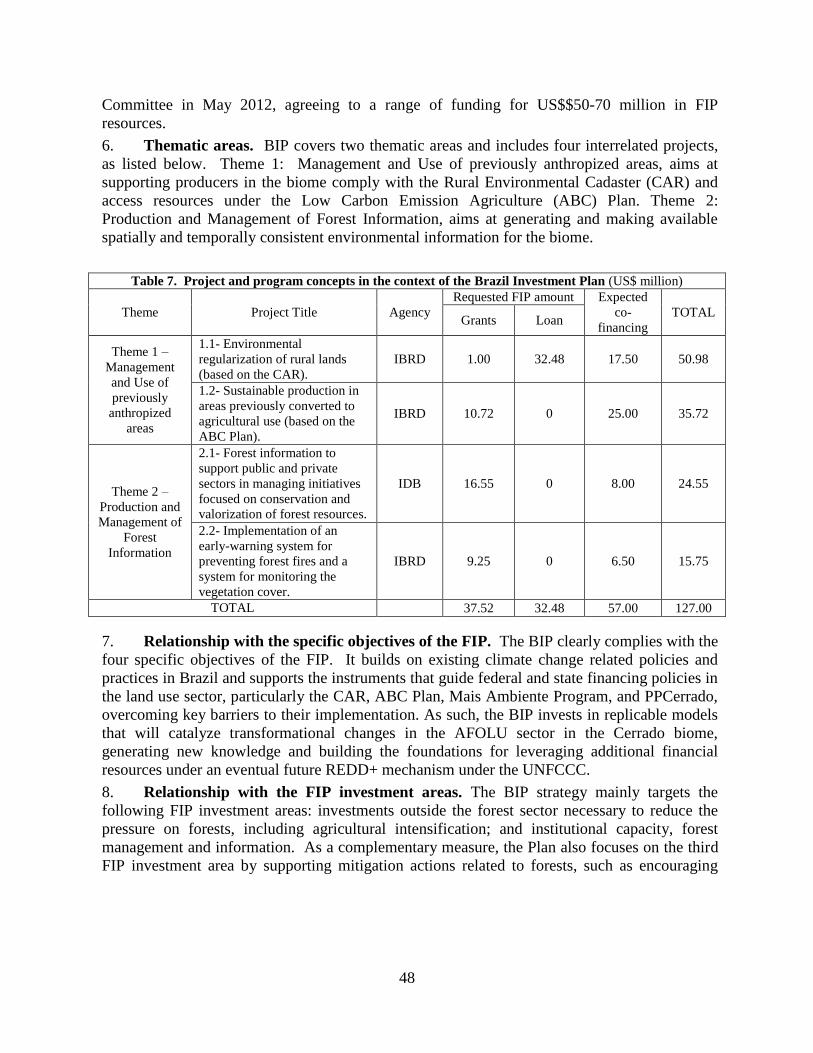
48
Committee in May 2012, agreeing to a range of funding for US$$50-70 million in FIP
resources.
6. Thematic areas. BIP covers two thematic areas and includes four interrelated projects,
as listed below. Theme 1: Management and Use of previously anthropized areas, aims at
supporting producers in the biome comply with the Rural Environmental Cadaster (CAR) and
access resources under the Low Carbon Emission Agriculture (ABC) Plan. Theme 2:
Production and Management of Forest Information, aims at generating and making available
spatially and temporally consistent environmental information for the biome.
Table 7. Project and program concepts in the context of the Brazil Investment Plan (US$ million)
Theme Project Title Agency
Requested FIP amount Expected
co-
financing
TOTAL Grants Loan
Theme 1 –
Management
and Use of
previously
anthropized
areas
1.1- Environmental
regularization of rural lands
(based on the CAR).
IBRD 1.00 32.48 17.50 50.98
1.2- Sustainable production in
areas previously converted to
agricultural use (based on the
ABC Plan).
IBRD 10.72 0 25.00 35.72
Theme 2 –
Production and
Management of
Forest
Information
2.1- Forest information to
support public and private
sectors in managing initiatives
focused on conservation and
valorization of forest resources.
IDB 16.55 0 8.00 24.55
2.2- Implementation of an
early-warning system for
preventing forest fires and a
system for monitoring the
vegetation cover.
IBRD 9.25 0 6.50 15.75
TOTAL 37.52 32.48 57.00 127.00
7. Relationship with the specific objectives of the FIP. The BIP clearly complies with the
four specific objectives of the FIP. It builds on existing climate change related policies and
practices in Brazil and supports the instruments that guide federal and state financing policies in
the land use sector, particularly the CAR, ABC Plan, Mais Ambiente Program, and PPCerrado,
overcoming key barriers to their implementation. As such, the BIP invests in replicable models
that will catalyze transformational changes in the AFOLU sector in the Cerrado biome,
generating new knowledge and building the foundations for leveraging additional financial
resources under an eventual future REDD+ mechanism under the UNFCCC.
8. Relationship with the FIP investment areas. The BIP strategy mainly targets the
following FIP investment areas: investments outside the forest sector necessary to reduce the
pressure on forests, including agricultural intensification; and institutional capacity, forest
management and information. As a complementary measure, the Plan also focuses on the third
FIP investment area by supporting mitigation actions related to forests, such as encouraging

49
forest recovery of Legal Reserves (RLs) and Permanent Preservation Areas (APPs) in
landholdings58
.
9. Relationship with the FIP results framework. The results expected from the
implementation of the BIP are: sustainable management adopted in previously converted areas;
environmental information produced and disseminated and forests and forest landscapes
managed in a sustainable way in order to address the drivers of deforestation and forest
degradation; capacity for tackling the immediate and underlying causes of deforestation and
increased degradation; new and additional resources for forests and projects related to forests;
Incorporation of learning through the development of stakeholders thoroughly familiar with
REDD-plus. The BIP therefore is fully consistent with and well in place to contribute to the FIP
results framework at the programmatic level59
.
C. Project Relationship with the BIP and FIP Investment Criteria
10. Relationship with the BIP. The objective of the BIP is to promote sustainable land use
and forest management in the Cerrado biome, contributing to reducing pressure on the
remaining forests, reducing GHG emissions and increasing CO2 sequestration. The Project’s
objective is to enhance Brazil’s institutional capacity to monitor deforestation, provide
information on fire risks and estimate related GHG emissions in the Cerrado biome. The Project
thus is fully in line with the overall objective of the BIP and falls under theme (2) Production
and Management of Forest Information. The Results Framework of the project will be
integrated at the Program (BIP) level contributing to the annual reporting requirements under
the FIP.
11. Relationship with the FIP investment areas and criteria. The project targets mainly
the following FIP investment area: (a) institutional capacity, forest governance and information.
It fully complies with the FIP investment criteria, as illustrated below60
:
Climate change
mitigation potential
The deforestation monitoring system will provide near-real time information as
well as more accurate, yearly figures, on land use changes in the Cerrado. In the
case of the early warning systems for forest fires, the improvements will enhance
the existing capacity to predict the risk of forest fires and spread, one of the major
threats to the Cerrado. Finally, the information generated will expand existing
systems for estimating GHG emissions in the biome as an indicator of
effectiveness of the GoB’s mitigation actions. Together, these actions will ensure
a steady flow of high quality information to policy makers and actors involved in
ground operations, providing them with crucial support tools for their planning,
control and prevention of forest fires and deforestation activities.
The project thus will not result in a direct generation of GHG emissions
reductions. Rather, by promoting investments in the establishment and
improvement of these key forest information systems in the Cerrado it will create
the enabling conditions for land use institutions to monitor, measure, and enforce
regulations in the future, leading to emissions reductions. A detailed calculation of
58
See FIP Design Document, available at: www.climateinvestmentfunds.org/cif/keydocuments/FIP 59
See FIP Results Framework, available at: www.climateinvestmentfunds.org/cif/keydocuments/FIP 60
See FIP Investment Criteria and Financing Modalities, available at: www.climateinvestmentfunds.org/cif/keydocuments/FIP

50
potential GHG emissions reductions attributable to the project as compared to a
business as usual scenario is therefore not applicable to this operation. For
information, recent estimates61
indicate that emissions from deforestation and
burning (including CH4 and N2O) in the Cerrado between 2003 and 2008 resulted
in the emission of 1,450 MtCO2eq, of which conversion to pastures corresponds to
819 MtCO2eq (or 136.5 MtCO2eq/year).
Demonstration
potential at scale
The proposed FIP investment will cover the entire Cerrado biome, the second
largest phyto-geographic province in Brazil, covering an area of approximately 2
million km2 of the Brazilian Central Plateau (24% of the country’s total area) with
about 52% of its original vegetation cover still remaining (as opposed to 82% in
the Amazon).
The proposed FIP investment clearly represents a REDD+ priority in the country
as it is closely linked with the PPCerrado, the GoB’s Action Plan to Prevent and
Control Deforestation and Forest Fires in the Cerrado (Decree 5.577/2005). The
Plan directly supports the National Policy on Climate Change (Law 12.187/2009
and Decree 7.390/2010), whereby the GoB made a voluntary commitment to
reduce by 40% the annual rates of deforestation in the biome based on the average
deforestation rates between 1999 and 2008 (15,700 km2/yr). Improving the
biome’s forest monitoring systems is a clear goal expressed in the PPCerrado62
. In
addition, the outputs of the project will also support Brazil’s submission of a
Forest Reference Emission Level (FREL) for the Cerrado biome to the UNFCCC,
as specified in Brazil’s Amazon FREL submission63
.
The systems supported by the FIP investment will largely represent an adaptation
and/or improvement of the existing systems already in use in the Amazon and in
the country (PRODES, DETER, INPE’s Fire Risk model, and INPE-EM), already
tested, validated and cited as best practice internationally64
. The participating
entities have state of the art experience in the application of such systems in the
Amazon and the FIP investment will not only allow their expansion in the
Cerrado, but will also form the basis for their future expansion in the rest of
Brazil’s biomes (Caatinga, Pantanal, and Atlantic Forest), based on the experience
generated with the application of the systems in the transition zones of such
biomes with the Cerrado.
Cost-effectiveness A number of public and private sector institutions (mainly academia) are involved
in the implementation of the project. The National Institute for Space Research
(INPE) will be in charge of land cover classification, PRODES/DETER Cerrado
development and implementation, the land use knowledge platform, fire risk
information, GHG emissions estimation and training and dissemination. The
Federal University of Minas Gerais (UFMG) will be in charge of developing and
adapting the fire spread model (FISC), its application in four conservation units,
and training in the use of the model. The Federal University of Goías (UFG) will
be in charge of the PRODES/DETER data quality control system. INPE, UFMG
61
Bustamante, MC, Nobre, C, Smeraldi, R, Aguiar, APD, Barioni, LG, Ferreira LG, Longo, K, May, P, Pinto, AS, Ometto, JPHB. 2012.
Estimating Greenhouse GasEmissions from Cattle Raising in Brazil, Climatic Change. 62
http://www.mma.gov.br/florestas/controle-e-preven%C3%A7%C3%A3o-do-desmatamento/plano-de-
a%C3%A7%C3%A3o-para-cerrado-%E2%80%93-ppcerrado 63
http://unfccc.int/methods/redd/items/8414.php 64
See GOFC-GOLD, 2013. REDD+ Sourcebook, COP19 version. Available at: http://www.gofcgold.wur.nl/redd/

51
and UFG are financially solid institutions that have significant budgets to
maintain the information data banks generated under the Project. The Action Plan
to Prevent and Control Deforestation and Fires in the Cerrado Biome (PPCerrado)
provides the legal framework to finance the maintenance of these systems in the
Cerrado and MCTI will present information maintenance budgets to be included
in the national multi-annual budget allocations. If necessary, the fire risk
information system can generate localized advertising revenue from the website.
A calculation of the costs per ton of CO2eq avoided is not presented here as the
project represents a public investment in institutional strengthening to improve
information generation and flows, mostly to national and international institutions.
However, the provision of more precise, up-to-date, real-time and widespread
information on (illegal) deforestation, risk of (wild)fires and GHG emissions
have, potentially, the following economic and financial benefits: (i) potential
increases in the cost-efficiency and effectiveness of IBAMA and other
environmental control agencies to reduce illegal deforestation; (ii) forest fire
prevention and firefighting agencies can intervene more rapidly and effectively,
and thus reduce unintended forest fire damage; (iii) protected and conservation
areas can introduce controlled fires based on better calibrated fire ignition and
spread models and reduce unintended forest fire damage and management costs;
(iv) federal, state and local policy makers can base their deforestation reduction
and fire prevention policies on more accurate data and increase the policy
efficiency and effectiveness; (v) more accurate estimates of GHG emissions in
Brazil can contribute to increased knowledge of climate change patterns and
adaptation measures; and (vi) improved information can enhance the management
of Brazil’s natural resources, and considering its size and economic importance,
lead to world economic and financial benefits.
Implementation
potential
Brazil has an institutional, normative and policy structure with proven capacity for
reducing deforestation and promoting the sustainable use of natural resources, and
has set ambitious goals for reducing deforestation in the Amazonia and Cerrado
biomes while increasing production and exports of cash crops and biofuels, and
intensifying cattle production (See section D. REDD+ Background in Brazil for
further details on the policy framework). In Amazonia, emissions peaked in mid-
1990s and early 2000s, and have had a big drop since 2005 after the onset of the
PPCDAm65
. Data from the National Institute of Spatial Research (INPE) to
present these achievements in Amazonian deforestation reduction has supported
the Brazilian position in multilateral forums such as the UNFCCC66
and backed
bilateral agreements for results-based payments. Since 2008, the country receives
payments for results through the Amazon Fund, which is a REDD+ demonstration
fund managed by the National Bank for Economic and Social Development
(BNDES). The GoB wants to use its successful experience in controlling
deforestation in the Amazon to increase control and protection of the Cerrado.
INPE has state of the art experience with PRODES and DETER in the Amazon
and there is no reason to suggest that they will have difficulties applying their
knowledge and experience to the Cerrado. The FIP investment thus will help
65
Nepstad et al., 2014 Slowing Amazon deforestation through public policy and interventions in beef and soy
supply chains. Science 344 (6188): 1118-1123 66
Brazil was recently the first country to submit a REDD+ Reference Emission Level to the UNFCCC, including the
Amazon biome: http://www.mma.gov.br/redd/index.php/nivel-referencia

52
overcome a key barrier to the implementation of the PPCerrado, such as the
generation of timely and high quality information required for public institutions
to monitor, measure, and enforce applicable land use regulations. In addition, the
FIP investment will support Brazil’s submission of a FREL for the Cerrado biome
to the UNFCCC, possibly opening the door for performance-based payments for
the results obtained in the Cerrado.
The GoB has set up strong institutional coordination mechanisms to manage the
BIP. Since the beginning of the design phase, the successful collaboration
between the three key ministries involved in land use regulation (MMA, MAPA
and MCTI) has allowed the development of a strategic approach capable to foster
synergies not only among the BIP and its projects, but also with ongoing Cerrado
government plans and policies already in implementation at federal, state and
municipal levels (e.g. PPCerrado). To ensure effective implementation of the
operation, a Project Institutional Coordination Committee (PICC) will be created
through a MCTI Ministerial ordinance (portaría), to ensure coordination between
FUNDEP, MCTI and the three participating institutions: the National Institute for
Space Research (INPE), the Federal University of Minas Gerais (UFMG) and the
Federal University of Goiás (UFG). The PICC will be composed of
representatives of all these institutions and also of the Ministry of Environment
(MMA), to facilitate coordination at the level of the FIP Plan and PPCerrado. The
PICC will be responsible for: (i) reviewing the Operational Manual of the Project
(MOP); (ii) validating POAs; (iii) reviewing the physical and financial
implementation progress reports; (iv) ensuring that project execution and results
are timely, consistent and ultimately contribute to the attainment of the strategic
objectives of the Project; and (v) providing strategic recommendations to
strengthen project implementation. In addition, the project includes a strong
emphasis on capacity building of local and national institutions on the use of the
systems, with specific indicators included in the results framework. INPE has
already experience in building the capacity of such institutions as part of the
Amazon Monitoring systems, which includes training sessions and frequent
meetings to answer any emerging systems. This interaction will be maintained for
the implementation of the Cerrado systems.
Integrating
sustainable
development (co-
benefits)
The Cerrado is considered as one of the 34 global hotspots of biodiversity because
of the high level of endemism and rapid loss of its original habitat67
. Given the
extent of land still available for legal deforestation in the biome (estimated at
88±6 Mha68
) and its potentially high productivity, it is expected that agriculture
will continue to increase in the region for some time. New technologies have been
developed for tropical agriculture, which allow for significant productivity gains
without expanding into new Cerrado areas. The challenges are to: (i) promote a
broader adoption of such practices69
, and (ii) enable full implementation of the
Forest Code and compliance with APP and RL requirements. In this context, the
generation and provision of spatially and temporally consistent information on
forest resources and change is needed to underpin the elaboration and
implementation of strategies for improving land-use sustainability and efficiency.
67 Mittermeier et al., 2005 68 Soares-Filho et al., 2014. Cracking Brazil’s forest code. Science Vol. 344 no. 6182 pp. 363-364 69 A challenge taken up by the FIP-financed Sustainable Production in Areas Previously Converted to Agricultural Production
(P143184), approved by the Bank on July 28, 2014.

53
These actions would contribute to the maintenance of natural ecosystems, together
with their biodiversity and associated environmental services. In particular, the
main co-benefits of the project are:
Environmental: a) Increased conservation of biodiversity and carbon stocks in the
remaining forest areas through the reduction of the frequency and intensity of
forest fires, thereby resulting in increased integrity of the forest ecosystems; b)
Protection of soil and water resources; c) Promotion of the maintenance of the
natural fertility of the soil which suffers less degradation from the high
temperatures produced by fires, thereby reducing costs arising from the use of
agrochemicals; d) Detection of areas that are vulnerable to socio-economic and
environmental pressures, thereby lessening the risks of fragmentation and
degradation of the Protected Areas and indigenous territories.
Socio-economic: a) Enhanced capacity for land use planning and management in
Brazil by generating environmental information at biome scale; b) Reduction of
drivers of forest degradation and conservation of soil nutrients, thereby reducing
the costs involved in restoring them in the Protected Areas and on private land,
specially to small and medium farmers; c) Reduction of material and human
losses resulting from uncontrolled fires and reduction of the risk of losses faced
by conservation, agricultural, forest producers and public health; d) Updating
legislation and policies related to controlled fires.
Institutional: a) Development and management of existing initiatives for
conservation and sustainable development.
Safeguards The project will make a key contribution to strengthening forest governance and
safeguarding the integrity of natural forests in the Cerrado by providing essential,
timely and high quality information to policy makers and other stakeholders for
monitoring, measuring, and enforcing land use regulations across the biome. It is
expected to have an overall positive impact with minimal environmental and
social risks as it is essentially an environmental information enhancement project
with environmental category C. The Project will not finance any physical
construction, firefighting activities on the ground or the purchase of equipment
thereof, and will not interfere with Indigenous Peoples and/or traditional
communities as its activities focus on generating and providing information.
Project implementation will be supervised in accordance with the operational
policies of the World Bank and in accordance with its guidelines for the
application of safeguard policies to Technical Assistance operations. The
application of World Bank Safeguards Policies should be sufficient to promote
and support the REDD-plus safeguards agreed in Cancun under the UNFCCC
(Decision 1/CP.16, appendix I), as noted in a recent note by the Facility
Management Team of the FCPF70
. Detailed information on the safeguards to be
applied to the project are provided in sections VI-E and VI-F of the PAD.
The BIP, including this project, has been widely and publicly submitted for the
consideration of a diverse range of stakeholders (including representatives of the
private sector, academia, NGOs, social movements and State environmental
agencies, as well as indigenous peoples and traditional communities).
70 FMT Note CF-2013-3 “World Bank Safeguard Policies and the UNFCCC REDD+ Safeguards”. August 28, 2013. Available
at: https://www.forestcarbonpartnership.org

54
13. Current Brazil FIP portfolio. The following table summarizes the projects and implementations
arrangements agreed under the BIP.
Table 8. FIP Portfolio
Bra
zil
Inv
estm
en
t P
lan
Project MDB Gov’t
Agency
FIP
Grant
FIP
Loan Others
Total
US$
M
Environmental regularization of
rural lands IBRD MMA 32.48 26.43 58.91
Sustainable production in areas
previously converted to
agricultural use
IBRD MAPA 10.62 -- 0.50 11.12
Forest information to support
public and private sectors in
managing initiatives
IDB
MMA/
Forest
Service
16.55 -- 8.00 24.55
BIP Coordination IBRD MMA 1.00 -- -- 1.00
Implementation of an early-
warning system for preventing
forest fires and a system for
monitoring
IBRD MCTI 9.25 -- 00 9.25
DGM Brazil Dedicated Grant
Mechanism IBRD -- 6.50 -- -- 6.50
Priva
te set-
aside
Brazil: Macaúba Palm Oil in
Silvicultural Systems IDB -- -- 3.00 3.00 6.00
IFC allocation IFC -- -- 15.00 97.00 112.00
Total 44.02 50.48 134.9 229.33
D. REDD-plus background in Brazil
14. Brazil’s commitment with respect to climate change has been constant since 1992, when
the country hosted the United Nations Conference on Environmental and Development in Rio.
In the context of the 15th
Conference of the Parties to the UNFCCC in Copenhagen in 2009,
Brazil voluntarily committed to a GHG emissions reduction target between 36.1% and 38.9% of
projected emissions by 2020, implying a reduction in emissions of around 1.2 billion tCO2eq71
.
Shortly thereafter, Brazil instituted this goal in Law No. 12,187, December 2009, establishing
the National Policy on Climate Change (NPCC). The NPCC, which includes the National Plan
as one of its instruments, defines the objectives and guidelines for domestic operations in Brazil
for dealing with climate change, and is the main reference points for Brazil's REDD+ type
actions.
15. The set of mitigation actions stipulated by the NPCC to achieve its targets include
reducing the rates of deforestation by biome, and initiating alternative processes in the
agricultural, energy and steel manufacturing sectors. Decree No. 7,390, December 2010, which
regulates the NPCC, establishes specific targets for reducing GHG emissions, such as: (i) 80%
reduction of deforestation in Amazon compared to the 1996-2005 average (19,535 km²/yr); (ii)
40% reduction of deforestation in the Cerrado compared to the 1999-2008 average (15,700
km²/yr); (iii) recovery of 15 million ha of degraded pastures, (iv) expansion crop, livestock and
71 See Annex II of Copenhagen Accord: Nationally Appropriate Mitigation Actions (NAMAs) by developing countries. Available
at: http://unfccc.int/meetings/cop_15/copenhagen_accord/items/5265.php

55
forestry integrated systems in 4 million ha, (v) expansion of no-tillage farming systems in 8
million ha, (vi) expansion of planted commercial forests in 3 million ha, (vii) increase in 4.4
million m3 the treatment of animal waste and (viii) increased use of charcoal from planted
forests in steelmaking.
16. The instruments stipulated by the NPCC for reducing deforestation build on the previous
work under the Action Plan for the Protection and Control of Deforestation in the Legal
Amazon (PPCDAm), and stipulate the launch of a new plan focused on the Cerrado region: the
Action Plan to Prevent and Control Deforestation and Fires in the Cerrado Biome (PPCerrado).
The PPCDAm, launched in March 2004, aims to promote the reduction of deforestation in the
Amazon by focusing on land and territorial planning, monitoring, control and sustainable
production activities. The PPCerrado, launched in September 2010, aims to promote sustained
reduction in the rate of deforestation and forest degradation (including fires) in the biome by
improving monitoring and control capabilities of federal agencies, while promoting the
regularization of rural properties, sustainable production activities, and the restoration of
degraded lands72
.
17. Complementary to these plans, the Forest Code is considered the most important land-use
regulation in the country, given its national scope and the constraints it imposes on private
property for the purpose of protecting public goods such as forests and vegetation. The code
requires farmers to preserve the most fragile areas of their property (Permanent Preservation
Areas – APP), with an additional obligation to ensure that part of the original native vegetation
is maintained (Legal Reserves –RL). The Forest Code involves the creation of the Rural
Environmental Cadastre (CAR), which sets a deadline for landholders to register APPs and RLs
on their land, and to submit proposals for restoring their degraded areas if they are not
compliant with the legislation. It is estimated that nearly 30 million hectares of APP and RL
across the country require restoration to comply with the Forest Code; and currently over half of
Brazilian landholdings (about 2.5 million farmers) are thought to be illegal73
. Compliance with
the environmental legislation in the Forest Code is a prerequisite for small and medium
producers to access rural credit available in the ABC Program.
18. Smallholders, land reform settlers, family farmers and traditional peoples/communities
are special beneficiaries of the Forest Code and receive, free of charge, government support to
restore the degraded APPs and RLs on their lands, through technical assistance, environmental
education, provision of seeds/seedlings and appropriate training.
19. In addition, the NPCC also provides for the preparation of sectoral plans for mitigating
and adapting to climate change, with a view to consolidate a low carbon economy and meeting
the national voluntary commitments announced under its policy. As part of the objectives of
reducing GHG emissions, some of these sector plans are also expected to make a direct or
indirect contribution to reducing deforestation and increasing the value of standing forests. The
Sector Plan for the Mitigation and Adaptation of Climate Change for a Low Carbon Emission
Agriculture (ABC Plan), for example, seeks to ensure continuous and sustainable improvement
of management practices which reduce greenhouse gas emissions and enhance atmospheric CO2
uptake on vegetation and land used by the Brazilian farming sector. The plan is expected to
72 The PPCerrado is supported by a separate, but related, Bank-executed project as part of the FIP Brazil Investment Plan. 73 The regularization of rural properties under the CAR in 47 municipalities in the Cerrado is supported by a separate, but related,
Bank-executed project as part of the Brazil Investment Plan under the FIP.

56
help reduce pressure on forests by promoting greater productivity of existing agricultural
systems, sustainable management practices and recovery of degraded areas.
20. The NPCC also provides financial mechanisms aimed at supporting the implementation
of the planned initiatives. The Amazon Fund (Fundo Amazônia), launched in August 2008,
shows that Brazil is a pioneer at world level in the development of mechanisms to support
actions aimed at REDD-plus in developing countries. The Amazon Fund is a financial
instrument aimed at raising grant funds, in Brazil and abroad, to help maintain the reduction of
GHG emissions from deforestation in the Amazon. This initiative is a result of the Brazilian
proposal to provide positive incentives for reducing deforestation emissions in developing
countries presented at the 12th UNFCCC CoP, held in Nairobi in 2006. In 2008, Norway,
which had already committed US$ 244 million, announced its intention to contribute a total of
US$ 1 billion to the Amazon Fund. In December 2010, a new financial contribution worth EUR
21 million was received from the Federal Republic of Germany.
21. The National Fund on Climate Change was established to secure resources to support
projects and studies aimed at climate change mitigation and adaptation to its effects. The
Fund’s income derives from 60% of the tax on crude oil production and sales designated to the
Ministry of the Environment (MMA). This is an innovative financial arrangement in
developing countries. In the first two years of its implementation, the initial budget was BRL
620 million (approximately US$ 355 million). Of this total, BRL 560 million is from loans
destined to the production sector, managed by the BNDES. The remaining BRL 60 million will
be managed and invested by the MMA, and could be transferred to States, municipalities
research institutions and non-governmental institutions on the basis of cooperation agreements
and contracts. The Fund has already had projects approved in areas of sustainable forest
management to the region of Caatinga. This year, the Fund will support the development of
environmental management plans for Indigenous Lands in Caatinga and Cerrado, as well as
more projects dealing with sustainable forest management in Caatinga biome. Those target
areas are susceptible to desertification.
22. Brazil is not a member of the Forest Carbon Partnership Facility (FCPF) or the UN-
REDD program. Nonetheless, the actions proposed under the BIP are a sub-set of the Brazil’s
National Climate Change Plan and are consistent with activities being considered under those
two international initiatives, as well as under the REDD-plus mechanism under the UNFCCC.
23. The country is currently in the process of finalizing the assembly of all its existing
initiatives around a National REDD-plus Strategy (ENREDD, for its acronyms in Portuguese)74
.
Since June 2010, the MMA launched a participatory process where about 150 actors contributed
with recommendations, summarized in the "Document summarizing recommendations of
multiple actors to prepare for the National Strategy on REDD+" available on the MMA’s
REDD-plus Portal75
. Since then, the draft ENREDD has been subject to discussion at the
ministerial level as well as within the Executive Group of the Interministerial Committee.
74 http://www.mma.gov.br/informma/item/9053-em-defesa-da-amazonia 75 http://www.mma.gov.br/redd/

57
Annex 6: Map of Brazil (IBRD 41777)
COUNTRY: BRAZIL