The Wisconsin Scenic Byways...
72
The Wisconsin Scenic Byways Program Citizen’s Handbook A guide for designating Wisconsin Scenic Byways Prepared by: Wisconsin Department of Transportation First Edition October 2005
Transcript of The Wisconsin Scenic Byways...
The Wisconsin Scenic Byways Program
Citizen’s HandbookA guide for designatingWisconsin Scenic Byways
Prepared by:Wisconsin Department of Transportation
First EditionOctober 2005

Wisconsin State Scenic Byways Program 3
AcknowledgementsThe Wisconsin State Scenic Byways Program and an earlier version of the Citizen’s Handbook were prepared by the Wisconsin Department of Transportation with assistance from Carter & Burgess, Inc.
Jane V. Carrola, former Wisconsin Scenic Byways Coordinator and Lynne Marie Whately, Project Manager, Carter & Burgess are the primary authors of this Handbook.
Significant assistance and input was provided by the Scenic Byways Advisory Group; also by Dennis Leong, Leif Hubbard, and Matt Rauch of the Wisconsin Department of Transportation; and by Frank Carlile and Joe Sumrall of Carter & Burgess.
Funding for the creation of the Wisconsin State Scenic Byways Program and this Handbook was provided in part through a National Scenic Byways Program grant from the Federal Highways Administration.
For questions, please contact Diane Paoni at 608-267-7914 or by e-mail: [email protected]

Wisconsin State Scenic Byways Program 5
Table of Contents
Introduction............................................................................... 7Purpose of the Citizen’s Handbook................................................................. 7Helpful Handbook Hints ..................................................................................8
The Designation Process..................................................................................8
The Byway Group or Applicant...................................................................... 10
Scenic Quality and Distractions ...................................................................... 11
Scenic Byway benefits ................................................................................... 12
Step 1: Scenic Assessment ...................................................... 13Scenic Quality Evaluation sheet...................................................................... 13
Detailed Corridor Map .................................................................................. 18
Photographs ................................................................................................. 19
Narratives...................................................................................................... 19
Summary ......................................................................................................20
Step 2: Application Process .................................................... 23Corridor Management Plan ...........................................................................23
Outdoor advertising on Scenic Byways ..........................................................26
Segmentation & the Business areas along the byway..................................26
What does this mean for our route?...........................................................26
Segmentation & the designated byway route .............................................27
Resolutions from Local Governments.............................................................27
After Designation.................................................................... 29The Importance of Corridor Management
Plan Implementation .....................................................................................29
Ability to Apply for Federal Highways
Scenic Byways Discretionary Funds ................................................................29
Option to Pursue National Designation ..........................................................30
What Happens if there is Change
(i.e. Development) on our Route? ..................................................................30
How do we remove our status as a Scenic Byway?......................................... 31
6 Wisconsin State Scenic Byways Program
Appendix 1: Scenic Assessment .................................................... 33Item 1: Resource Regions of Wisconsin ............................................................. 33
Item 2: Resource Region Descriptions ............................................................... 34
Region 1: Lake Superior Lowland........................................................................ 34
Region 2: Northern Wisconsin Highland ............................................................. 35
Region 3: Lake Michigan Shoreline ..................................................................... 36
Region 4: Central Sands ..................................................................................... 37
Region 5: Southeastern Wisconsin Ridge ............................................................ 38
Region 6: Drifters Area....................................................................................... 39
Item 3: Moderate and Major Distractions ........................................................40
Appendix 2: Corridor Management Plan (CMP)........................... 43The Scenic Byway Vision ....................................................................................... 43
Scenic Byway Goals............................................................................................... 45
Protection Techniques ........................................................................................... 47
Promotion............................................................................................................. 49
Schedule and Responsible Agencies....................................................................... 51
Appendix 3: Historic Designation ................................................. 53The Byway Group or Applicant.............................................................................. 54
Historic Quality and Distractions ............................................................................ 55
Scenic Byway benefits ........................................................................................... 56
The Designation Process........................................................................................ 57
Historic Quality Evaluation Sheets....................................................................... 58
Detailed Corridor Map ....................................................................................... 62
Photographs ...................................................................................................... 62
Narratives ......................................................................................................... 62
Summary .............................................................................................................. 63
Step 2: Application................................................................................................ 63
Attachment A: Historical Inventory Matrix .............................................................64
Attachment B: Distractions.................................................................................... 65
Appendix 4: Definitions................................................................. 67
Wisconsin State Scenic Byways Program 7
Introduction
The Wisconsin Department of Transportation (WisDOT) has, with agency and public input, developed a new Wisconsin Scenic Byways Program. The purpose
of this program is to identify, through local government initiatives, State Trunk Highway routes with outstanding scenic characteristics and other related qualities and resources that provide travelers with an exceptional travel experience.
The Wisconsin Scenic Byways Program is a voluntary program that identifies a system of State Trunk Highways that are officially designated by the WisDOT Secretary as Wisconsin Scenic Byways. These byways are recognized for their outstanding aesthetic qualities and for their exceptional scenic views. These views are formed through a combination of landforms, man-made features, vegetation and bodies of water that are visible from the road.
A designated Wisconsin State Scenic Byway can be any numbered State or Federal highway (other than interstate highways) at least 30 miles long that is proposed by a local government sponsor and so designated by the WisDOT Secretary pursuant to Section 84.106, Wisconsin State Statutes. These roadways offer travelers exceptional scenic or historic resources and provide a relaxing travel experience. The intrinsic resources of the byway must be considered of significant value by the surrounding communities, and the byway may provide vistas, rest areas, and other amenities in harmony with the scenic character of the road.
It is important to note that the Wisconsin Scenic Byways Program is a promotional program and is not intended to inhibit or prevent improvement projects to highways such as safety or capacity improvements. The program cannot stop development from occurring, but can help a community with future development to ensure it fits with the character of the route. Lastly, the program is not intended to guide land-use planning under the State’s Smart Growth legislation, nor may the program be used to turn the scenic route into a rustic or country road.
Purpose of the Citizen’s HandbookThe purpose of this Citizen’s Handbook is to describe the process by which a corridor becomes designated as a Wisconsin Scenic Byway and to outline all the materials required for a scenic byways application.
This Handbook is intended for use by citizens and local governments interested in sponsoring a route for designation. The Handbook describes each step of the process and provides the forms to be completed and submitted as part of the
8 Wisconsin State Scenic Byways Program
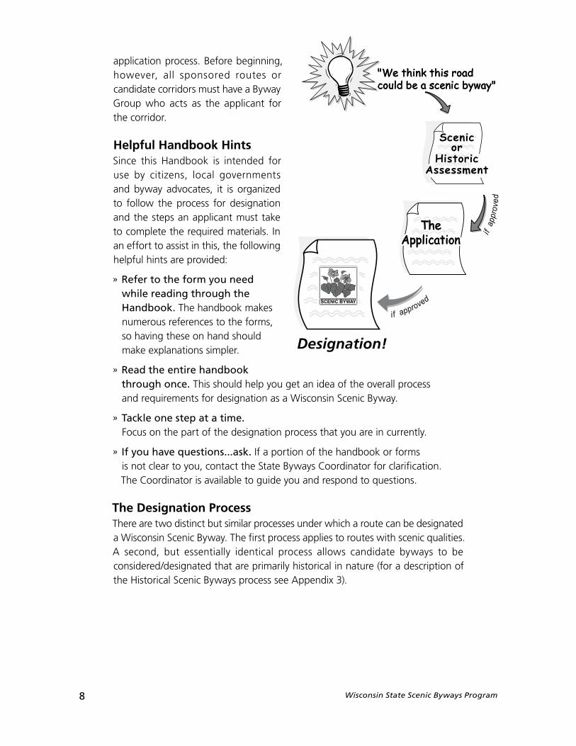
Scenicor
HistoricAssessment
application process. Before beginning, however, all sponsored routes or candidate corridors must have a Byway Group who acts as the applicant for the corridor.
Helpful Handbook HintsSince this Handbook is intended for use by citizens, local governments and byway advocates, it is organized to follow the process for designation and the steps an applicant must take to complete the required materials. In an effort to assist in this, the following helpful hints are provided:
» Refer to the form you need while reading through the Handbook. The handbook makes numerous references to the forms, so having these on hand should make explanations simpler.
» Read the entire handbook through once. This should help you get an idea of the overall process and requirements for designation as a Wisconsin Scenic Byway.
» Tackle one step at a time. Focus on the part of the designation process that you are in currently.
» If you have questions...ask. If a portion of the handbook or forms is not clear to you, contact the State Byways Coordinator for clarification. The Coordinator is available to guide you and respond to questions.
The Designation ProcessThere are two distinct but similar processes under which a route can be designated a Wisconsin Scenic Byway. The first process applies to routes with scenic qualities.A second, but essentially identical process allows candidate byways to be considered/designated that are primarily historical in nature (for a description of the Historical Scenic Byways process see Appendix 3).
Wisconsin State Scenic Byways Program 9
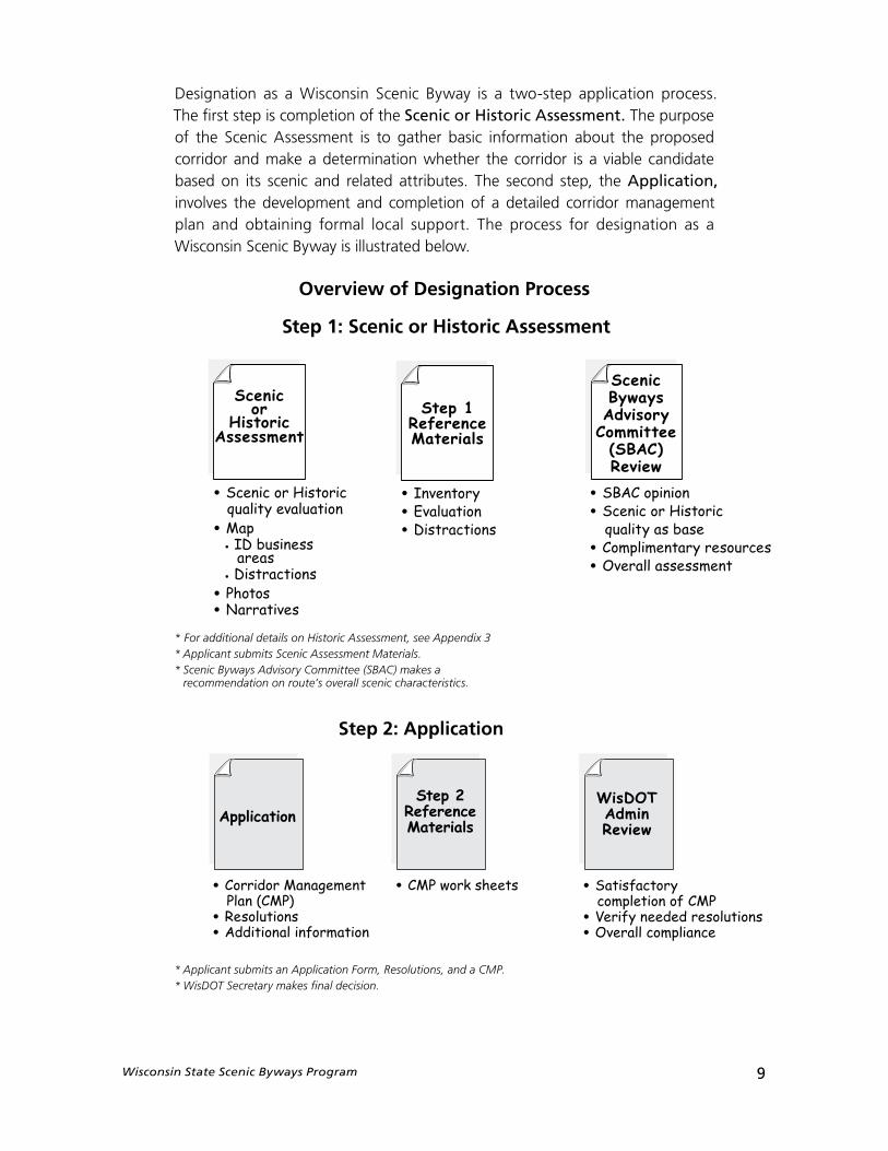
* For additional details on Historic Assessment, see Appendix 3* Applicant submits Scenic Assessment Materials.* Scenic Byways Advisory Committee (SBAC) makes a
recommendation on route’s overall scenic characteristics.
* Applicant submits an Application Form, Resolutions, and a CMP.* WisDOT Secretary makes final decision.
Scenicor
HistoricAssessment
• Scenic or Historic quality evaluation
• Map• ID business
areas • Distractions
• Photos
• Narratives
Step 1ReferenceMaterials
• Inventory
• Evaluation
• Distractions
ScenicBywaysAdvisory
Committee(SBAC)Review
• SBAC opinion
• Scenic or Historic quality as base
• Complimentary resources
• Overall assessment
WisDOTAdminReview
Step 2ReferenceMaterials
Application
• Corridor Management Plan (CMP)
• Resolutions
• Additional information
• CMP work sheets • Satisfactory completion of CMP
• Verify needed resolutions
• Overall compliance
Designation as a Wisconsin Scenic Byway is a two-step application process. The first step is completion of the Scenic or Historic Assessment. The purpose of the Scenic Assessment is to gather basic information about the proposed corridor and make a determination whether the corridor is a viable candidate based on its scenic and related attributes. The second step, the Application, involves the development and completion of a detailed corridor management plan and obtaining formal local support. The process for designation as a Wisconsin Scenic Byway is illustrated below.
Overview of Designation Process
10 Wisconsin State Scenic Byways Program
The Byway Group or ApplicantHow do you form a Byway Group and apply for designation of your route? You get people together!
Potential members of your Byway Group
» Citizens
» Local governments
» Tourism offices
» Service Clubs
The Wisconsin Scenic Byways Program was developed to be a voluntary, local program initiated by citizens and local governments. So, the first course of action in getting your byway designated is to get everyone together who would be interested and support the cause. This could include citizens, local business owners, interest groups such as a Garden Club or Bicycle Club, property owners, environmentalists, Chambers of Commerce, and anyone else you think would want to know about or be interested in the corridor’s designation. In all, you should seek to develop a broad base of support for the designation of your corridor. The more people you have supporting your effort and available to help, the stronger your byway support will become.
The next vital link will be obtaining official support from local government—a city, village, town, or county that has jurisdiction over the land uses sur-rounding the proposed byway corridor. At least one government sponsor is needed to apply for Scenic Byway Designation. That sponsor will formally sign the application forms while also providing resolutions of support and commitment to future management of the corridor. Citizen supporters will partner with the local government sponsor or sponsors to cooperatively complete all the required applications.
Wisconsin State Scenic Byways Program 11
Scenic Quality and Distractions
Scenic Quality
Scenic Quality and Distractions are two main ideas on which the scenic assessment is based. They are discussed below.
The Wisconsin Scenic Byways Program has been developed to identify corridors throughout the state which are high in aesthetic qualities and that offer travelers exceptional scenic views. These views are formed through a combination of landforms, man-made features, vegetation and bodies of water that are visible from the road. In the National Scenic Byways Program publication, Byway Beginnings, the Federal Highway Administration states that byways with Scenic as the primary intrinsic quality should provide travelers with landscape characteristics that are “strikingly distinct and offer a pleasing and most memorable visual experience”. The publication also states that “all elements of the landscape—landform, water, vegetation, and man-made development— contribute to the quality of the corridor’s visual environment.”
Since each individual’s interpretation of scenic qualities may be different, an objective process has been developed to assist community groups in Wisconsin with evaluating their corridor’s scenic qualities in comparison to standards set for regions throughout the State.
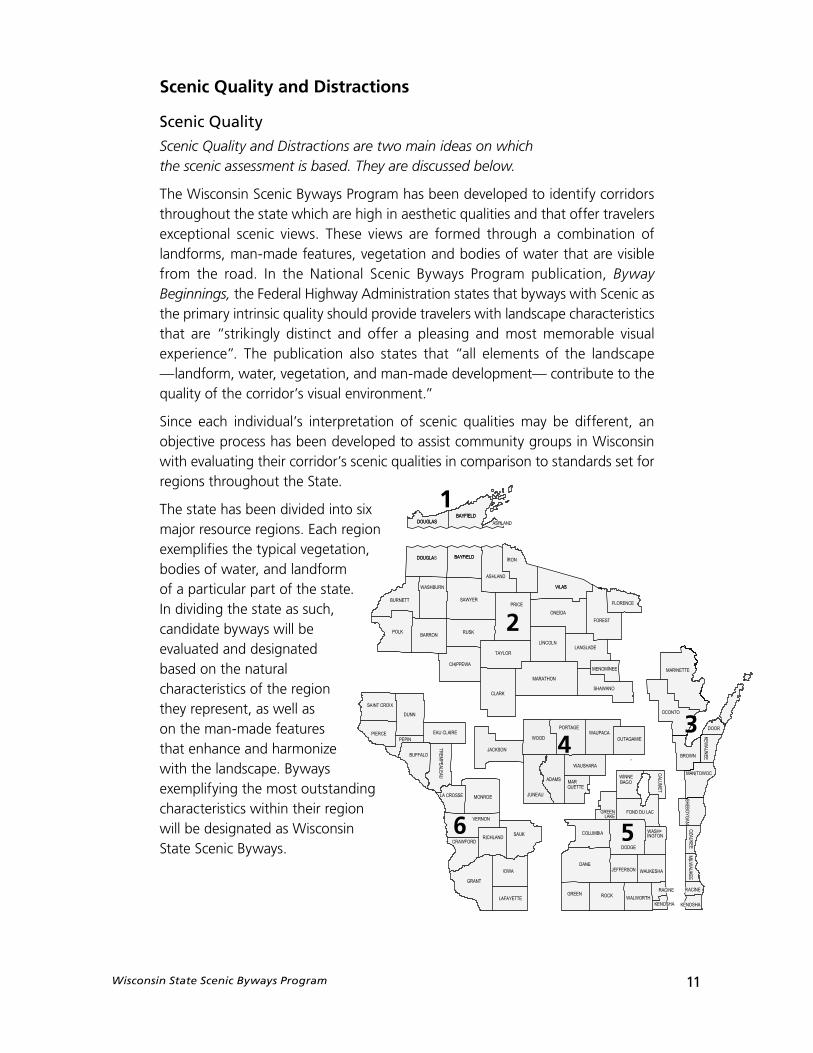
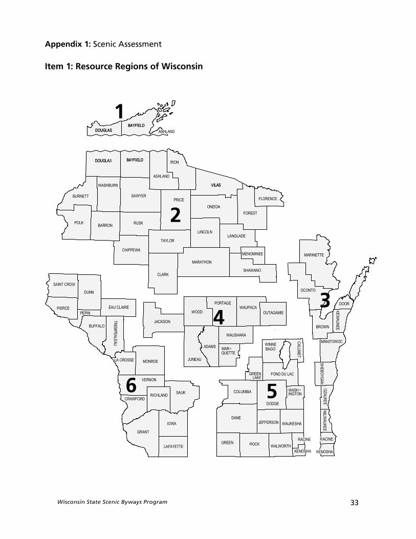
The state has been divided into six major resource regions. Each region exemplifies the typical vegetation, bodies of water, and landform of a particular part of the state. In dividing the state as such, candidate byways will be evaluated and designated based on the natural characteristics of the region they represent, as well as on the man-made features that enhance and harmonize with the landscape. Byways exemplifying the most outstanding characteristics within their region will be designated as Wisconsin State Scenic Byways.
1
2
34
56
12 Wisconsin State Scenic Byways Program
Corridor DistractionsSometimes an applicant corridor will have elements or features along it that can be considered distractions to the visual experience. Distractions may include poorly maintained buildings, unsightly land uses, power lines, parking lots, or outdoor advertising. These distracting features may be large or small and may alter the scenic quality of the corridor. In many cases, small distractions, such as a nicely maintained residence, will only affect certain views or appear in single occurrences along a corridor. Other times, a large distraction or numerous small distractions, such as power lines (i.e. minor distraction), may distract from the overall scenic quality of the corridor and limit its opportunity for designation as a scenic byway. Keep in mind that the more pristine and unaffected by distractions, the more likely a candidate corridor will qualify for designation as a Wisconsin Scenic Byway. In areas where distractions exist, the less effect they have on the landscape the more likely the candidate corridor will be considered as scenic.
Distractions come in many forms and in varying degrees. For this Scenic Assessment, distractions are to be rated Moderate or Major. Moderate distractions are those that are integrated into the landscape and do not degrade or obstruct scenic views. Major distractions are those that dominate the landscape, degrading or obstructing scenic views.
Scenic Byway benefits
Benefits of Scenic Byway designation include:
» supports tourism and economic development in communities all along a designated byway.
» unique signs, markers, brochures and ongoing promotional efforts can enhance a community’s “marketability.”
» state Scenic Byways can potentially be designated a National Scenic Byway or All–American Road. Such byways are marketed to national and international travelers, bringing additional recognition and potential economic benefits to area communities.
» Both state or nationally–designated scenic byways are eligibleto compete for federal funds.
» promotes partnerships between local governments, businesses, civic groups and community leaders.
» strengthens civic pride, and makes communities an even more attractive place to live and work.
» serves to promote an area’s scenic, historical and recreational
Wisconsin State Scenic Byways Program 13
Step 1: Scenic Assessment
Introduction
T his reference material will assist an applicant with completing their Scenic Assessment which is the cornerstone of the Wisconsin Scenic Byways Program.
Designation as a Wisconsin Scenic Byway is a two-step application process.
The purpose of first step is to gather information about the proposed corridor and make a determination whether the overall corridor has medium to high scenic attributes with a minimum of distractions. The second step of the application process will involve the development of a corridor management plan based on the scenic assessment and the demonstration of local support through resolutions.
This section describes in detail what must be completed for the first step. The Scenic Assessment is compromised of four major products:
» Scenic Quality Evaluation Sheet» Detailed Corridor Map» Photographs» Narratives
» Scenic Quality Evaluation sheetThe Scenic Quality Evaluation Sheet, is intended to document all the resources in the corridor. Resources would include scenic views and significant historic sites as well as their location and general condition. Elements of the corridor that are considered to be distractions to the visual experience will also be identified and noted on the Evaluation Sheet. Then the applicant needs to evaluate and determine whether each individual mile can be considered Exceptional, Typical,or Marginal based on the descriptions for each region of the state and the distractions, if present. Lastly, a point value based on the resources and distractions must be assessed.
Page 3 of the Scenic Quality Evaluation sheet allows for the documentation of other Complementary Resources including Historical/archeological resources, Recreational resources or Cultural resources. The applicant needs to document these Complementary Resources but does not need to assign a point value to each resource. Rather, a quarter-point (.25) is given for each significant complimentary resource found along a proposed route. An example of completed Scenic Quality Evaluation Sheets follows.
The reference documents needed to complete the Evaluation Sheets are in Appendix 1. Included are: 1) the Resource Region map; 2) the matrices for each region of the State; and 3) the list of moderate and major distractions.
14 Wisconsin State Scenic Byways Program
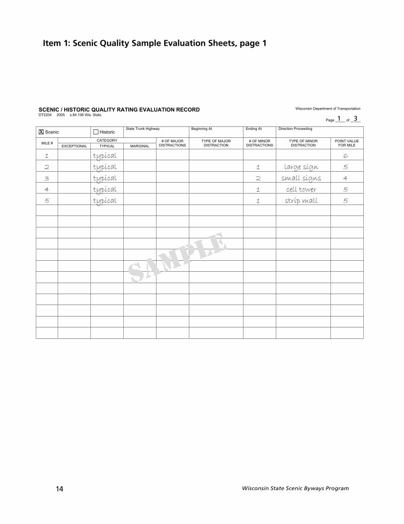
Item 1: Scenic Quality Sample Evaluation Sheets, page 1
YTILAUQCIROTSIH/CINECS DROCERNOITAULAVEGNITAR noitatropsnarTfotnemtrapeDnisnocsiW
.statS.siW601.48.s50024022TD
_____fo_____egaP
cinecS cirotsiHtAgninnigeByawhgiHknurTetatS gnideecorPnoitceriDtAgnidnE
YROGETAC#ELIM
LANIGRAMLACIPYTLANOITPECXE
ROJAMFO#SNOITCARTSID
ROJAMFOEPYTNOITCARTSID
RONIMFO#SNOITCARTSID
RONIMFOEPYTNOITCARTSID
EULAVTNIOPELIMROF
1 typical 6
2 typical 1 large sign 5
3 typical 2 small signs 4
4 typical 1 cell tower 5
5 typical 1 strip mall 5
sample
X
1 3
Wisconsin State Scenic Byways Program 15
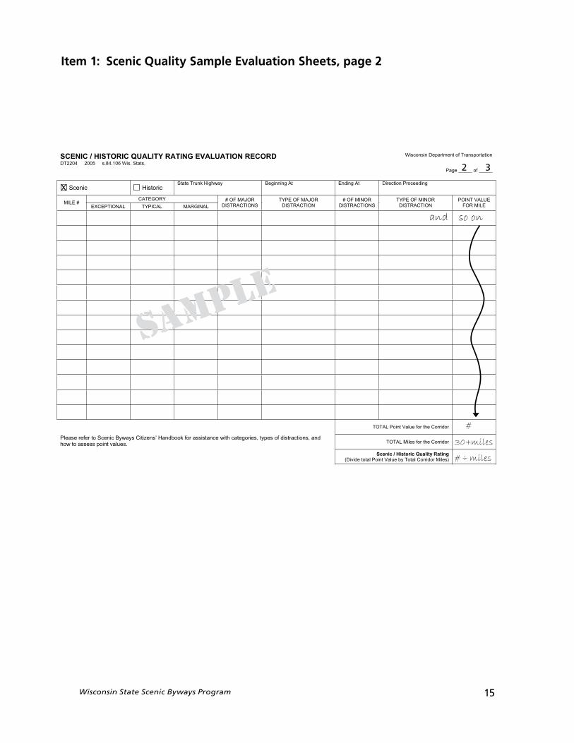
Item 1: Scenic Quality Sample Evaluation Sheets, page 2
YTILAUQCIROTSIH/CINECS DROCERNOITAULAVEGNITAR noitatropsnarTfotnemtrapeDnisnocsiW
.statS.siW601.48.s50024022TD
_____fo_____egaP
cinecS cirotsiHtAgninnigeByawhgiHknurTetatS gnideecorPnoitceriDtAgnidnE
YROGETAC#ELIM
LANIGRAMLACIPYTLANOITPECXE
ROJAMFO#SNOITCARTSID
ROJAMFOEPYTNOITCARTSID
RONIMFO#SNOITCARTSID
RONIMFOEPYTNOITCARTSID
EULAVTNIOPELIMROF
rodirroCehtrofeulaVtnioPLATOT
issarofkoobdnaH’snezitiCsyawyBcinecSotreferesaelP dna,snoitcartsidfosepyt,seirogetachtiwecnats.seulavtniopssessaotwoh rodirroCehtrofseliMLATOT
gnitaRytilauQcirotsiH/cinecS)seliMrodirroClatoTybeulaVtnioPlatotediviD(
and so on
#
30+miles
# ÷ miles
sample
X
2 3
16 Wisconsin State Scenic Byways Program
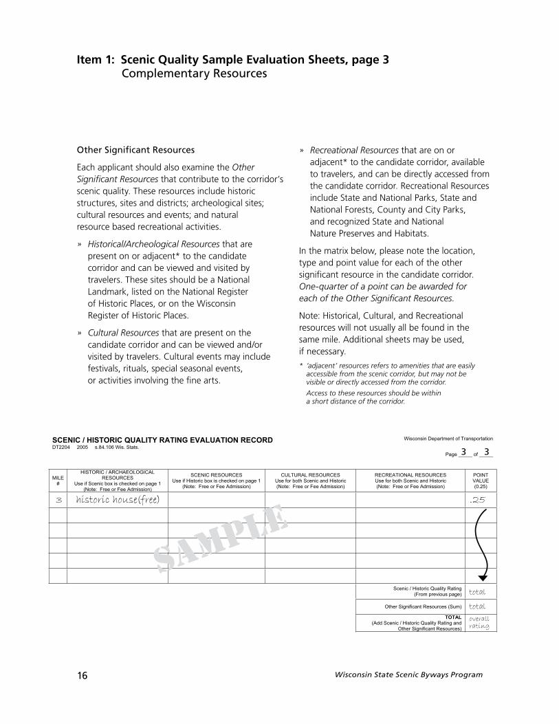
Other Significant Resources
Each applicant should also examine the Other Significant Resources that contribute to the corridor’s scenic quality. These resources include historic structures, sites and districts; archeological sites; cultural resources and events; and natural resource based recreational activities.
» Historical/Archeological Resources that are present on or adjacent* to the candidate corridor and can be viewed and visited by travelers. These sites should be a National Landmark, listed on the National Register of Historic Places, or on the Wisconsin Register of Historic Places.
» Cultural Resources that are present on the candidate corridor and can be viewed and/or visited by travelers. Cultural events may include festivals, rituals, special seasonal events, or activities involving the fine arts.
» Recreational Resources that are on or adjacent* to the candidate corridor, available to travelers, and can be directly accessed from the candidate corridor. Recreational Resources include State and National Parks, State and National Forests, County and City Parks, and recognized State and National Nature Preserves and Habitats.
In the matrix below, please note the location, type and point value for each of the other significant resource in the candidate corridor. One-quarter of a point can be awarded for each of the Other Significant Resources.
Note: Historical, Cultural, and Recreational resources will not usually all be found in the same mile. Additional sheets may be used, if necessary.
* ‘adjacent’ resources refers to amenities that are easily accessible from the scenic corridor, but may not be visible or directly accessed from the corridor.
Access to these resources should be within a short distance of the corridor.
Item 1: Scenic Quality Sample Evaluation Sheets, page 3Complementary Resources
YTILAUQCIROTSIH/CINECS DROCERNOITAULAVEGNITAR noitatropsnarTfotnemtrapeDnisnocsiW
.statS.siW601.48.s50024022TD
_____fo_____egaP
ELIM#
LACIGOLOEAHCRA/CIROTSIHSECRUOSER
1egapnodekcehcsixobcinecSfiesU)noissimdAeeFroeerF:etoN(
SECRUOSERCINECS1egapnodekcehcsixobcirotsiHfiesU
)noissimdAeeFroeerF:etoN(
SECRUOSERLARUTLUCcirotsiHdnacinecShtobrofesU)noissimdAeeFroeerF:etoN(
SECRUOSERLANOITAERCERcirotsiHdnacinecShtobrofesU)noissimdAeeFroeerF:etoN(
TNIOPEULAV)52.0(
gnitaRytilauQcirotsiH/cinecS)egapsuoiverpmorF(
)muS(secruoseRtnacifingiSrehtO
LATOTdnagnitaRytilauQcirotsiH/cinecSddA()secruoseRtnacifingiSrehtO
3 historic house(free) .25
total
total
overallrating
sample
3 3
Wisconsin State Scenic Byways Program 17
In order to complete the Scenic Quality Evaluation Sheet, each applicant should...
1. Determine the appropriate Resource Region. (See Appendix 1, Item 1)
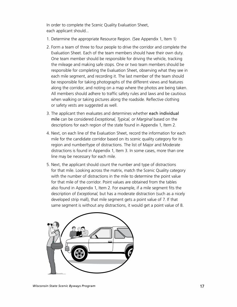
2. Form a team of three to four people to drive the corridor and complete the Evaluation Sheet. Each of the team members should have their own duty. One team member should be responsible for driving the vehicle, tracking the mileage and making safe stops. One or two team members should be responsible for completing the Evaluation Sheet, observing what they see in each mile segment, and recording it. The last member of the team should be responsible for taking photographs of the different views and features along the corridor, and noting on a map where the photos are being taken. All members should adhere to traffic safety rules and laws and be cautious when walking or taking pictures along the roadside. Reflective clothing or safety vests are suggested as well.
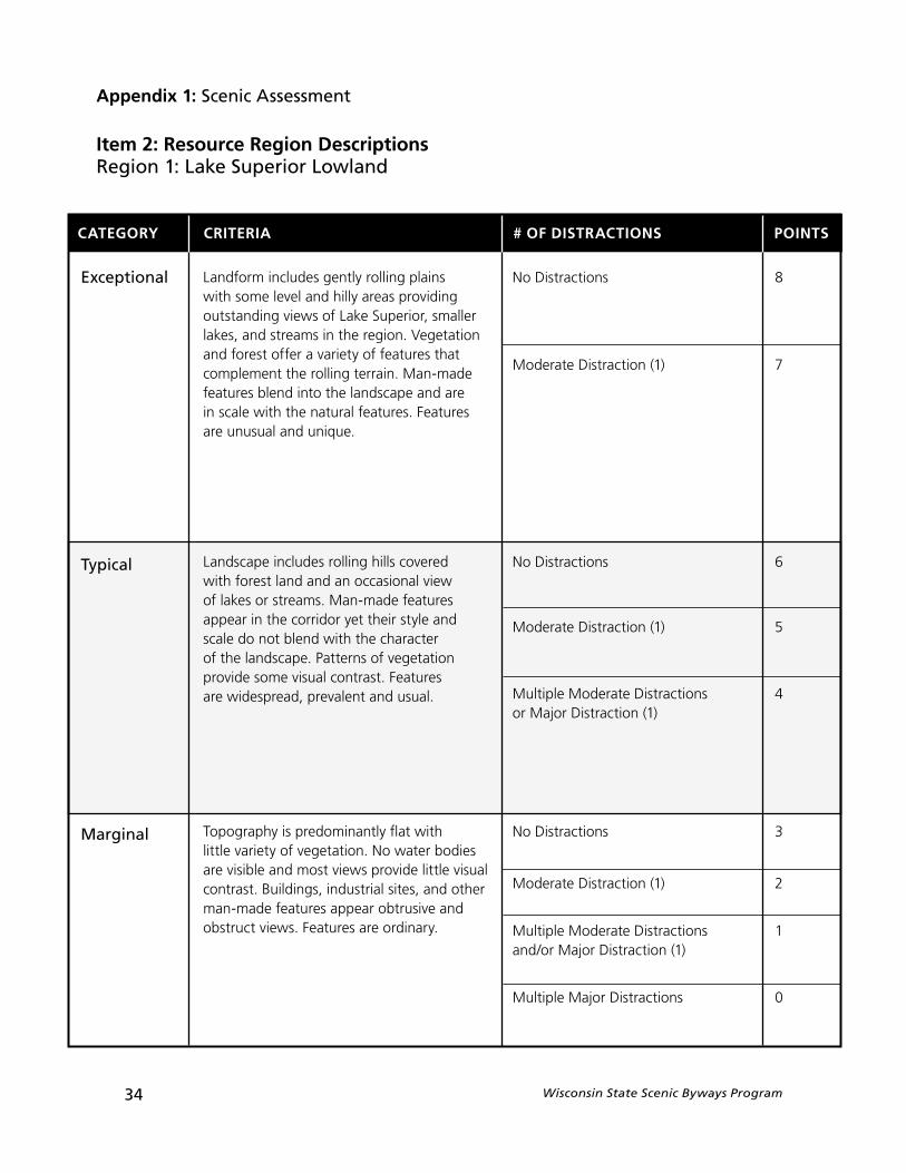
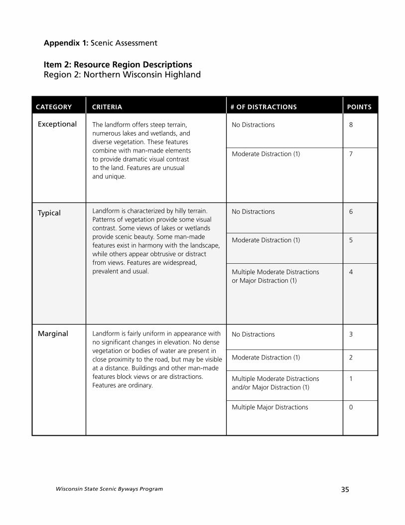
3. The applicant then evaluates and determines whether each individual mile can be considered Exceptional, Typical, or Marginal based on the descriptions for each region of the state found in Appendix 1, Item 2.
4. Next, on each line of the Evaluation Sheet, record the information for each mile for the candidate corridor based on its scenic quality category for its region and number/type of distractions. The list of Major and Moderate distractions is found in Appendix 1, Item 3. In some cases, more than one line may be necessary for each mile.
5. Next, the applicant should count the number and type of distractions for that mile. Looking across the matrix, match the Scenic Quality category with the number of distractions in the mile to determine the point value for that mile of the corridor. Point values are obtained from the tables also found in Appendix 1, Item 2. For example, if a mile segment fits the description of Exceptional, but has a moderate distraction (such as a nicely developed strip mall), that mile segment gets a point value of 7. If that same segment is without any distractions, it would get a point value of 8.
18 Wisconsin State Scenic Byways Program
6. Once the entire corridor has been evaluated, the applicant should total the number of points for each mile segment and divide them by the total miles in the corridor. This will produce an overall Scenic Quality Rating for the corridor.
7. On the 3rd page of the Evaluation Sheet, the applicant needs to evaluate the other factors and resources in the corridor that can contribute to its scenic quality and viability as a state scenic byway. These resources include Historical, Archeological, Cultural, and Recreational Resources in the corridor and have point values associated with them. In some cases more than one line may be necessary for each mile.
8. The total of the Scenic/Historic Quality Rating and the scores for the other resources in the corridor will produce a overall rating. Add the extra points for other resources to the Scenic/Historic Quality Rating. This is the overall Rating. A rating of 6 or better is required for a candidate corridor to be considered for designation. The better the rating, the more likely the Scenic Byways Advisory Committee will recommend designation for the candidate corridor as a Wisconsin State Scenic Byway.
The Wisconsin Department of Transportation requires that a majority of a candidate corridor (70%) exhibit scenic qualities, while not more than (30%) can display major distractions to the scenic character of the area. Moderate distractions in a candidate corridor will be evaluated on an individual basis within the context of the overall scenic quality of the route.
» Detailed Corridor Map
For this portion of the Scenic Assesment, all applicants must complete a mile-by-mile inventory of their corridor and create a corridor map depicting the qualities of the corridor.
Each applicant should...
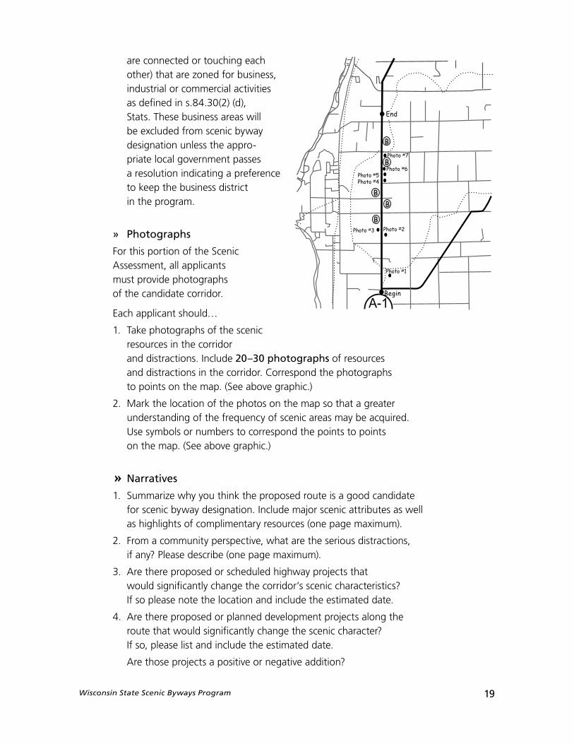
1. Divide the corridor into mile segments (each segment equals one mile).
2. Note the corridor limits and the major and moderate distractions on the Corridor Map. The Wisconsin Department of Transportation will provide the applicant with a base map for this use.
All moderate distractions should be noted in orange and major distractions noted in red.
See Appendix 1, Item 3 for examples of distractions.
Identify all business areas along the route and outline them in green. A business area means any portion of a highway where there are continuous abutting parcels of land (i.e. parcels that
Wisconsin State Scenic Byways Program 19
are connected or touching each other) that are zoned for business, industrial or commercial activities as defined in s.84.30(2) (d), Stats. These business areas will be excluded from scenic byway designation unless the appro-priate local government passes a resolution indicating a preference to keep the business district in the program.
» Photographs
For this portion of the Scenic Assessment, all applicants must provide photographs of the candidate corridor.
Each applicant should…
1. Take photographs of the scenic resources in the corridor and distractions. Include 20–30 photographs of resources and distractions in the corridor. Correspond the photographs to points on the map. (See above graphic.)
2. Mark the location of the photos on the map so that a greater understanding of the frequency of scenic areas may be acquired. Use symbols or numbers to correspond the points to points on the map. (See above graphic.)
» Narratives
1. Summarize why you think the proposed route is a good candidate for scenic byway designation. Include major scenic attributes as well as highlights of complimentary resources (one page maximum).
2. From a community perspective, what are the serious distractions, if any? Please describe (one page maximum).
3. Are there proposed or scheduled highway projects that would significantly change the corridor‘s scenic characteristics? If so please note the location and include the estimated date.
4. Are there proposed or planned development projects along the route that would significantly change the scenic character? If so, please list and include the estimated date.
Are those projects a positive or negative addition?
20 Wisconsin State Scenic Byways Program
Note: If a highway or development project is scheduled which would significantly alter the scenic character of the candidate corridor, approval to proceed to Step 2 may not be given until the project is completed and its effect on the byway measured. The applicant may choose to apply for designation after the project has been completed.
Summary
The applicant should have developed or completed the following for the Scenic Assessment:
The Wisconsin State Scenic Byways program materials describe the methods for completing a Scenic Assessment for the candidate corridor. This Step is intended to document all the scenic resources on the corridor as well as their location and general condition. Elements of the corridor that could be considered distractions to the viewing experience should also be thoroughly identified and mapped. The Wisconsin Department of Transportation requires that a majority of the candidate corridor (70%) exhibit scenic qualities, while no more than 30% can display major distractions to the scenic character of the area. Moderate distractions in a candidate corridor will be evaluated on an individual basis within the context of the overall scenic quality of the route.
1. Attach the completed Scenic Quality Evaluation Sheet(s) for the candidate corridor. This is a mile–by–mile inventory of both the scenic quality and distractions. Applicants should asses a rating for each mile.
2. Include a detailed Corridor Map. The Wisconsin Department of Transportation provides applicants with a base map for this purpose. The corridor limits, the major and moderate distractions in the corridor and business areas should be noted on the map. All Moderate distractions should be noted in orange and major distractions in red, business areas should be outlined in green.
3. 20 – 30 photographs of resources and distractions in the corridor should be included. The photographs should correspond to points on the map.
4. Also provide written narratives of the highlights of the route, the distractions and any highway improvements or development projects. (up to one page each).
Wisconsin State Scenic Byways Program 21
Mailing Information
Once the materials and all the required documentation are complete, the applicant should mail two (2) complete packages to:
Jane CarrolaWisconsin State Scenic Byways CoordinatorWisconsin Department of TransportationP. O. Box 7913Madison, WI 53707-7913
If an applicant has any questions or concerns while completing the Scenic Assessment, please contact the State Scenic Byways Coordinator at (608) 266-0649, fax (608) 267-0294 or e-mail [email protected].

Wisconsin State Scenic Byways Program 23
Step 2 :Application Process
Introduction
This reference material will assist an applicant with the development of two other major products required before byway designation can be bestowed including
developing a corridor management plan and demonstrating wide-spread local support through the passage of local resolutions.
As noted previously, designation as a Wisconsin Scenic Byway is a two-step application process. In the first step, infor-mation was gathered about the proposed corridor and a determination made that the overall corridor has medium to high scenic attributes with a minimum of distractions.
The second step of the application process will involve the development of a corridor management plan based on the scenic assessment and the demonstration of local support through resolutions. Included in this step is a decision about whether business areas should be included as part of the designated scenic byway route.
This section describes in detail what must be completed for the second step. The major topics covered are:
» Development of a Corridor Management Plan (CMP)» Outdoor Advertising and Scenic Byways» Resolutions from Local Governments
» Corridor Management PlanEach corridor designated as a scenic byway must have a Corridor Management Plan (CMP). The CMP will be based on the Scenic Assessment that was completed in Step 1.
A CMP is a written document created by each byway group that describes the vision and goals for the byway: how the byway will be managed, promoted, and protected; and who will have responsibility for various projects along the byway. The CMP is intended to document the future management, protection, and promotion of the designated scenic byway and will serve as the guiding document for a byway’s plans and activities. Other plans may currently exist for the corridor and the CMP should not be viewed as a comprehensive plan for the byway. The CMP is intended to complement other planning documents and convey the vision for the byway.
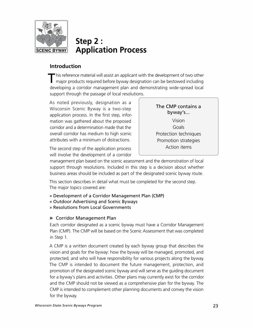
The CMP contains a byway’s...
VisionGoals
Protection techniquesPromotion strategies
Action items
24 Wisconsin State Scenic Byways Program
The Corridor Management Plan will answer certain universal questions:
1. What are the current conditions of the byway?
2. What do we want the byway to be like in the future? In 10 years? In 20 years? What are our goals?
3. What are some specific objectives/strategies that will move us towards achieving those goals?
4. What are some specific action items that we can take now and in the near future? Who is going to be responsible for doing those?
Besides this primary purpose, the CMP will also provide a record of scenic byway information relating to its designation such as existing protection techniques and a planned schedule of activities. The majority of the information required in the CMP will be built upon the information collected and documented in theFirst Step. The applicant should use the information from Scenic Assessment basis for developing the CMP. This includes using the Scenic Quality Evaluation sheet, prepared as part of the designation application, to assist in creating the CMP. The Scenic Assesment and the CMP are closely related. Whereas the Scenic Assesment and corresponding map describes what the corridor has to offer, the CMP addresses how the resources will be protected and promoted in the future.
Keep in mind that the CMP does not cover every aspect of a byway corridor and should not be viewed as a comprehensive plan for the byway. Rather, a CMP is a guiding document that captures the ideals for the corridor and outlines its plans and protections in a general.
The final consideration of a roadway as a scenic byway will not occur until WisDOT is in agreement with the CMP, resolutions are procured and WisDOT has reviewed all information for completeness. Final designation will occur when the WisDOT Secretary approves the route. It is expected that the applicant, local government sponsors, and other byway advocates can develop an appropriate CMP by working closely together throughout the designation process. The CMP is designed to be self-administered. WisDOT will answer questions. However, due to staff constraints, the department will not be part of the CMP development process.
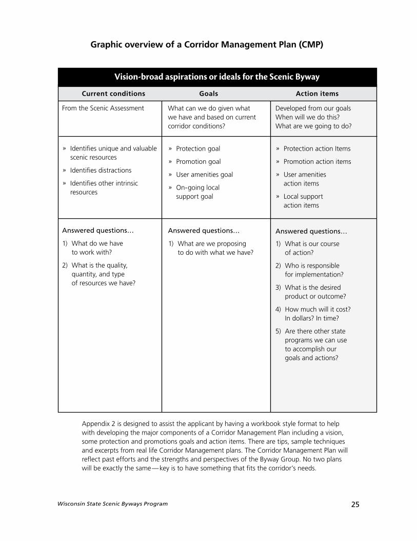
Corridor Management Plan (CMP) frameworkIn thinking about your CMP, it is helpful to consider how each element described in this section of the Wisconsin Scenic Byways Citizen Handbook fits together. The chart on the following page gives a visual example of how the elements of a CMP work together to provide for the future management, protection, and promotion of a byway.
Wisconsin State Scenic Byways Program 25
Graphic overview of a Corridor Management Plan (CMP)
Vision-broad aspirations or ideals for the Scenic Byway
Current conditions Goals Action items
From the Scenic Assessment
» Identifies unique and valuable scenic resources
» Identifies distractions
» Identifies other intrinsic resources
Answered questions…
1) What do we have to work with?
2) What is the quality, quantity, and type of resources we have?
Developed from our goals When will we do this? What are we going to do?
» Protection action Items
» Promotion action items
» User amenities action items
» Local support action items
Answered questions…
1) What are we proposing to do with what we have?
1) What is our course of action?
2) Who is responsible for implementation?
3) What is the desired product or outcome?
4) How much will it cost? In dollars? In time?
5) Are there other stateprograms we can use to accomplish our goals and actions?
What can we do given what we have and based on current corridor conditions?
» Protection goal
» Promotion goal
» User amenities goal
» On-going local support goal
Answered questions…
Appendix 2 is designed to assist the applicant by having a workbook style format to help with developing the major components of a Corridor Management Plan including a vision, some protection and promotions goals and action items. There are tips, sample techniques and excerpts from real life Corridor Management plans. The Corridor Management Plan will reflect past efforts and the strengths and perspectives of the Byway Group. No two plans will be exactly the same—key is to have something that fits the corridor’s needs.
26 Wisconsin State Scenic Byways Program
» Outdoor advertising on Scenic BywaysDo all the local governments and agencies involved with the byway understand and acknowledge the Federal Highway Administration’s policy on outdoor advertising on scenic byways?
All applicants should include in their CMP a discussion of their understanding, acknowledgement, and compliance with federal and state provisions on outdoor advertising (billboards) along scenic byways.
Federal Policy on Outdoor AdvertisingIn 1991, 23 USC (United States Code) 131 dealing with outdoor advertising (billboards) was changed to disallow new outdoor advertising structures on designated scenic byways. Existing signs are not affected by these provisions and may remain and can be maintained.
Segmentation & the Business areas along the bywayIn 1991, another new provision was added to subsection (s) to 23 USC 131 which allows a State the ability to exclude or segment from scenic byways designation any segment of a highway that is inconsistent with the State’s criteria for designating State scenic byways.
This Federal provision on segmentation allows the Wisconsin Scenic Byways Program to automatically exclude business areas from byway designation unless formal action is taken by the appropriate local government.
A business area means any portion of a highway where there are contiguous abutting parcels of land (i.e. parcels that are connected or touching each other) that are zoned for business, industrial or commercial activities or unzoned and used for business, industrial or commercial activities as defined in s. 84.30 (2) (d), Stats.
These business areas are then excluded from the prohibition on new outdoor sign structures and from applying for or directly benefiting from National Scenic Byway discretionary grant funds from Federal Highways.
Local governments do have the option of including business areas as part of the designated route by passing a resolution to specifically include them. See the next section on resolutions for more specifics.
What does this mean for our route?1. Federal regulations prohibit any new, off-premise outdoor advertising
signs (billboards) from being erected along state or federal scenic byways. Those outdoor advertising signs that are currently there may stay and be maintained. This provision does not pertain to other types of signs including on-premise signs or directional signs.
2. Per the Wisconsin Administrative Code, business areas, in which outdoor advertising signs are allowed, are automatically exempted from Scenic Byway designation unless a formal resolution by the appropriate local government is adopted to keep the business areas in the scenic byways program.
Wisconsin State Scenic Byways Program 27
Segmentation & the designated byway routeThe Wisconsin Scenic Byways Program follows Federal law and allows segmentation. In accordance with Trans 202.05 (3) (a), “The proposed route shall be as continuous as possible”. The reason is that the traveler may not be able to distinguish from an included segment from one that is excluded by the municipality. The worst case is that the traveler becomes confused or angry because the route does not live up to his or her expectations about being a scenic byway and cuts the trip short.
The overall effect of segmentation along a proposed byway will be examined. The decision to recommend granting or denying scenic byways designation based on segmentation will be handled on a case by case basis.
» Resolutions from Local GovernmentsTo ensure the long term success, promotion and protection of a scenic byway corridor, it is imperative to have support from the local governments surrounding a byway. Each corridor seeking designation as a Wisconsin State Scenic Byway must include with this application signed resolutions from the local governments surrounding the candidate corridor. Local municipalities include the towns, villages, and cities adjacent to and through which a candidate corridor passes.
Each applicant should...
1. Make the appropriate number of copies of the blank Scenic Byway Resolution form (found in Appendix 5) and have them endorsed by the local municipalities adjacent to, and through which a candidate corridor passes.
2. Determine what business areas (if any) should be excluded from potential designation as state scenic byway. The impact of excluding these business areas or other segments is that they are exempted from the scenic byways program and some specific provisions including a Federal prohibition on new outdoor advertising structures. (See previous section for the complete discussion.) The excluded segments are not eligible to apply for nor directly benefit from grant funds from the Federal Scenic Byways program. (In other words, you couldn’t locate a visitor center paid for with national scenic byway grant funds on an excluded segment). However, these exempt areas may allow new outdoor advertising signs with community approval.
3. Determine what, if any, other segments that do not meet the sceniccriteria that you would want excluded. Remember Trans 202.05(3) states the proposed route should be as continuous as possible.
4. Determine what business areas (if any) should be included as part of the proposed route. By including them, they are eligible for grant funds. However the restriction of no new billboards does apply.
5. The signed resolutions should be submitted with the corridor management plan.
28 Wisconsin State Scenic Byways Program
Municipal governments with jurisdiction over at least 70% of the corridor’s length must pass a resolution in support of the proposed scenic byway’s designation. Final Scenic Byway Designation will not be awarded without 70% or more of the local governments (Town, Village or City) submitting signed petitions in support of scenic byway designation for the proposed candidate corridor.
Resolutions from Counties, Metropolitan Planning Organizations (MPO) or Regional Planning Commissions (RPC) are encouraged, but not required.
Wisconsin State Scenic Byways Program 29
After Designation
YEAH!! We have Wisconsin State Scenic Byways Designation! NOW WHAT??In many ways, achieving state scenic byways designation is the end of one journey and the beginning of another. It is the end of the journey of identifying the most suitable or appropriate route, gaining local buy-in and support, and communicating the route’s attributes to the Scenic Byways Advisory Council and WisDOT staff.
It is the beginning of another journey that involves preserving and promoting your route. Your designated byway is special—you’ve got the official designation to back that claim up. Chances are you want to share with visitors the scenic and other attributes that make it such a special place to visit. On the other hand, you probably want to ensure that the resources or amenities for which it was designated are around for future generations to enjoy and appreciate.
The Importance of Corridor Management Plan ImplementationThe purpose of Corridor Management Plan (CMP) is to identify that unique balance of how to preserve what is special and unique about your byway with how it is going to be promoted. Action items are meant to be guides to specific tasks or steps that you undertake in those two areas to keep your designated corridor viable. This is an ongoing process. As one action item finishes up, other action items line up to take its place. See Appendix 2 for help in writing a CMP.
Ability to Apply for Federal Highways Scenic Byways Discretionary FundsHaving Wisconsin state scenic byway designation makes your designated byway corridor eligible to compete for Federal Scenic Byway discretionary grant funds. These funds are primarily for enhancements or amenities along the corridor (i.e. provision of interpretive centers, scenic outlooks, bike trails, etc). These grants are for 80% of the cost of the project. The local sponsor is required to furnish the remaining 20%.
The Federal Scenic Byways Program stresses the need for a corridor management plan to identify needs and potential projects based on the byways vision and goals.
30 Wisconsin State Scenic Byways Program
Option to Pursue National DesignationDesignation as a National Scenic Byway requires that public roadways must possess at least one of six identified intrinsic qualities (cultural, historical, archeological, recreational, natural, or scenic). The characteristics of the intrinsic resources must be recognized as representative of the region in which the corridor lies. These roadways must be recognized by local and state officials as possessing outstanding features and worthy of national recognition.
Roadways considered eligible for designation under the National Scenic Byways Program must meet certain requirements. All designated roads must safely accommodate two wheel drive vehicles. Additionally, designated roadways should attempt to accommodate bicycle and pedestrian travel as well. An important quality of each designated roadway is that of continuity, which implies a continuous, pleasurable driving experience, without too many gaps or intrusions. Each roadway must have a Corridor Management Plan, which is intended to conserve and enhance intrinsic qualities while promoting tourism and economic development.
It should be noted that to o btain national designation, a byway must be first designated as a Wisconsin Scenic Byway.
Under the guidelines of the National Scenic Byways Program (NSBP), all Wisconsin applicants seeking designation as a National Scenic Byway must process their application through WisDOT. Applicants wishing to pursue national level designation should read the nomination instructions for the national program found on the National Scenic Byways Program Web site at www.bywaysonline.org
What Happens if there is Change (i.e. Development) on our Route?Every 10 years following the date of official notification of designation, local units of government through which the route passes shall have the opportunity to re-evaluate the designated route and to determine if they wish to modify the route due to changes in land use or other extenuating circumstances. The local unit of government having zoning authority over the scenic byway corridor shall notify the department in writing, pass a resolution and submit a map indicating the proposed change to the designated route. In unincorporated areas where county zoning is in effect, the request shall also contain a resolution from the county board of the appropriate county supporting the request. The department may require the local government sponsor to coordinate the submission if there are numerous requests for modification of the scenic byway route. Requests under this subsection shall be received by the department no later than 12 months from the 10-year anniversary date.
Wisconsin State Scenic Byways Program 31
How do we remove our status as a Scenic Byway?Designation of a state trunk highway as a scenic byway may be withdrawn at any time after resolution by 2/3 of the local government sponsors and with the approval of the SBAC and the secretary. There shall be at least one public hearing by a local government sponsor before such a removal.
The Scenic Byways Advisory Committee (SBAC) may also recommend to the secretary that a scenic byway designation for a particular state trunk highway be rescinded if the route no longer possesses the scenic or historic character of the route originally qualifying it for designation due to over development, the presence of some other visual detraction, the failure to adequately implement the corridor management plan, or if substantial modifications to the route have taken place.If the SBAC recommends that a scenic byway designation for a particular state trunk highway be rescinded, the department shall hold a public hearing on the removal. After the public hearing is held, the designation as a scenic byway for the particular state trunk highway may be withdrawn upon approval of the secretary.

Wisconsin State Scenic Byways Program 33
1
2
34
56
Appendix 1: Scenic Assessment
Item 1: Resource Regions of Wisconsin
34 Wisconsin State Scenic Byways Program
Landform includes gently rolling plains with some level and hilly areas providing outstanding views of Lake Superior, smaller lakes, and streams in the region. Vegetation and forest offer a variety of features that complement the rolling terrain. Man-made features blend into the landscape and are in scale with the natural features. Features are unusual and unique.
Landscape includes rolling hills covered with forest land and an occasional view of lakes or streams. Man-made features appear in the corridor yet their style and scale do not blend with the character of the landscape. Patterns of vegetation provide some visual contrast. Features are widespread, prevalent and usual.
Topography is predominantly flat with little variety of vegetation. No water bodies are visible and most views provide little visual contrast. Buildings, industrial sites, and other man-made features appear obtrusive and obstruct views. Features are ordinary.
CATEGORY CRITERIA # OF DISTRACTIONS POINTS
Exceptional
Typical
Marginal
No Distractions 8
Moderate Distraction (1) 7
No Distractions 6
Moderate Distraction (1) 5
Multiple Moderate Distractions 4or Major Distraction (1)
No Distractions 3
Moderate Distraction (1) 2
Multiple Moderate Distractions 1and/or Major Distraction (1)
Multiple Major Distractions 0
Appendix 1: Scenic Assessment
Item 2: Resource Region DescriptionsRegion 1: Lake Superior Lowland
Wisconsin State Scenic Byways Program 35
The landform offers steep terrain, numerous lakes and wetlands, and diverse vegetation. These features combine with man-made elements to provide dramatic visual contrast to the land. Features are unusual and unique.
Landform is characterized by hilly terrain. Patterns of vegetation provide some visual contrast. Some views of lakes or wetlands provide scenic beauty. Some man-made features exist in harmony with the landscape, while others appear obtrusive or distract from views. Features are widespread, prevalent and usual.
Landform is fairly uniform in appearance with no significant changes in elevation. No dense vegetation or bodies of water are present in close proximity to the road, but may be visible at a distance. Buildings and other man-made features block views or are distractions. Features are ordinary.
No Distractions 8
Moderate Distraction (1) 7
No Distractions 6
Moderate Distraction (1) 5
Multiple Moderate Distractions 4or Major Distraction (1)
No Distractions 3
Moderate Distraction (1) 2
Multiple Moderate Distractions 1and/or Major Distraction (1)
Multiple Major Distractions 0
CATEGORY CRITERIA # OF DISTRACTIONS POINTS
Appendix 1: Scenic Assessment
Item 2: Resource Region DescriptionsRegion 2: Northern Wisconsin Highland
Exceptional
Typical
Marginal
36 Wisconsin State Scenic Byways Program
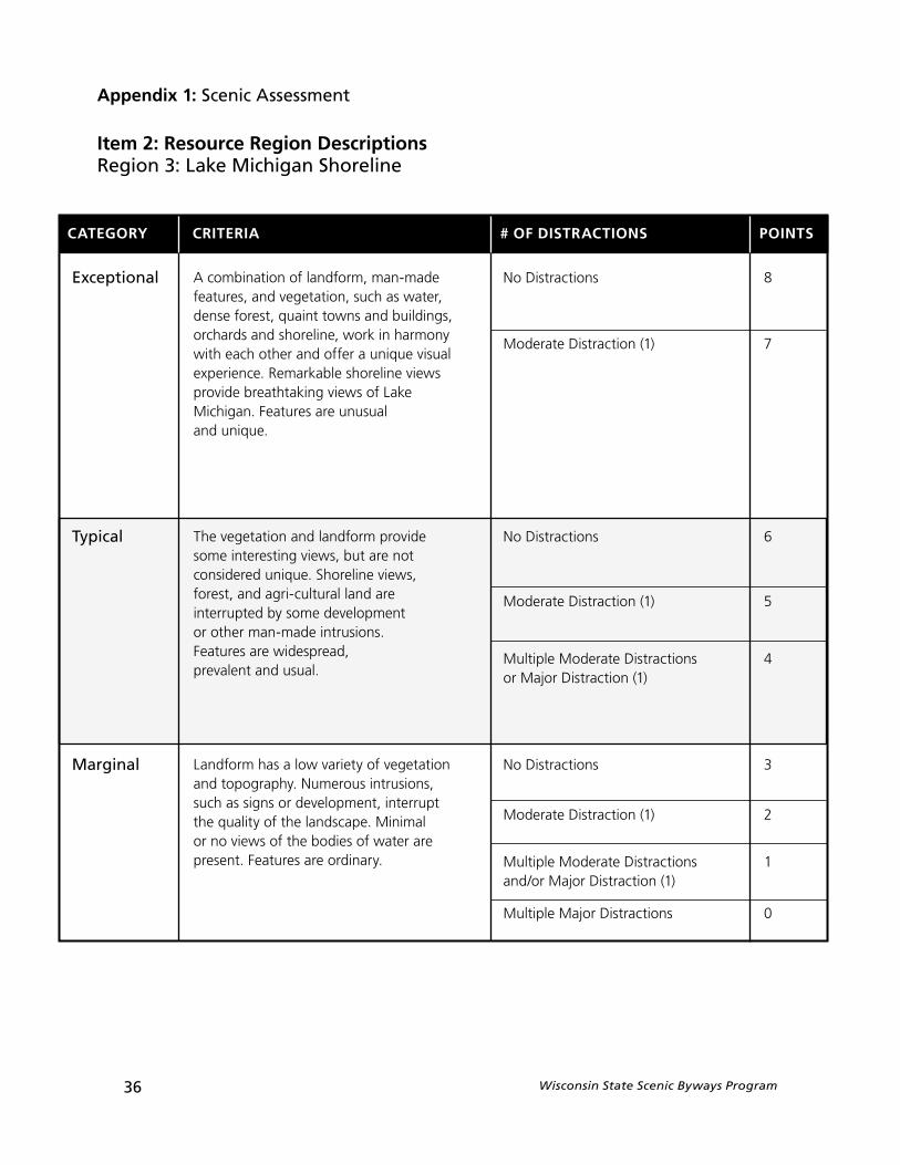
A combination of landform, man-made features, and vegetation, such as water, dense forest, quaint towns and buildings, orchards and shoreline, work in harmony with each other and offer a unique visual experience. Remarkable shoreline views provide breathtaking views of Lake Michigan. Features are unusual and unique.
The vegetation and landform provide some interesting views, but are not considered unique. Shoreline views, forest, and agri-cultural land are interrupted by some development or other man-made intrusions. Features are widespread, prevalent and usual.
Landform has a low variety of vegetation and topography. Numerous intrusions, such as signs or development, interrupt the quality of the landscape. Minimal or no views of the bodies of water are present. Features are ordinary.
No Distractions 8
Moderate Distraction (1) 7
No Distractions 6
Moderate Distraction (1) 5
Multiple Moderate Distractions 4or Major Distraction (1)
No Distractions 3
Moderate Distraction (1) 2
Multiple Moderate Distractions 1and/or Major Distraction (1)
Multiple Major Distractions 0
CATEGORY CRITERIA # OF DISTRACTIONS POINTS
Exceptional
Typical
Marginal
Appendix 1: Scenic Assessment
Item 2: Resource Region DescriptionsRegion 3: Lake Michigan Shoreline
Wisconsin State Scenic Byways Program 37
Landform displays significant topogra-phical change, from buttes to prairies, which provide striking views. Dense vegetation, lakes, and topography complement one another providing dramatic landscapes. Man-made features in the view are in scale with the natural landscape elements and add character to the landscape. Features are unusual and unique.
Landform includes some hills, prairie land or wetlands. Some man-made features are obtrusive or out of scale with the surrounding setting. Features do not appear in combination with each other and provide periodic scenic vistas or occasional scenic beauty. Features are widespread, prevalent and usual.
Topography is relatively flat with uninteresting views. Several man-made features distract from views along the road. Few lakes and wetlands are present, and there is little dense vegetation. Features are ordinary.
No Distractions 8
Moderate Distraction (1) 7
No Distractions 6
Moderate Distraction (1) 5
Multiple Moderate Distractions 4or Major Distraction (1)
No Distractions 3
Moderate Distraction (1) 2
Multiple Moderate Distractions 1and/or Major Distraction (1)
Multiple Major Distractions 0
CATEGORY CRITERIA # OF DISTRACTIONS POINTS
Exceptional
Typical
Marginal
Appendix 1: Scenic Assessment
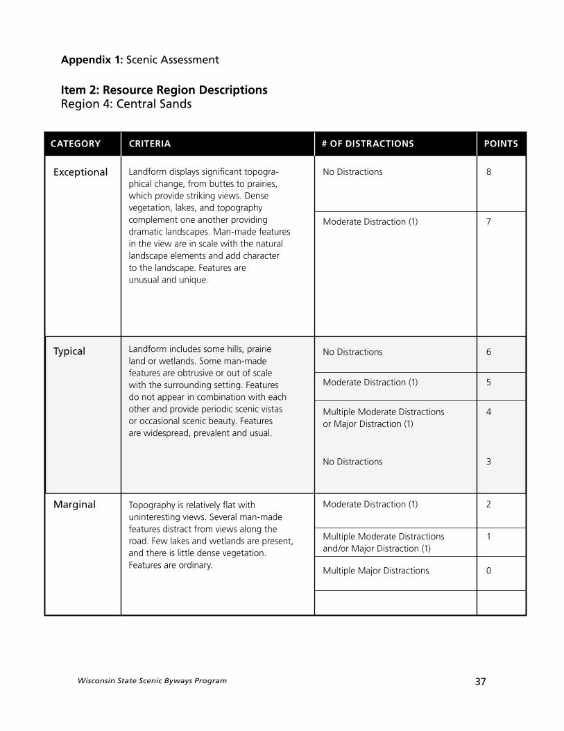
Item 2: Resource Region DescriptionsRegion 4: Central Sands
38 Wisconsin State Scenic Byways Program
Landform includes combinations of steep hills, valleys, lakes, and rock formations providing striking views. Man-made elements fit into the landscape with structures tucked into hills and valleys. A variety of vegetation including forest, pristine farmland, and plains mix to complement the topography. Features are unusual and unique.
Composed of rolling hills that provide some interesting vistas, the landform and vegetation are not very diverse. Occasional steep hills, lakes, and rock formations provide some change in topography giving the landscape a moderate scenic quality. Some man-made features blend with the natural character of the area but distract from the views. Features are widespread, prevalent and usual.
Relatively flat terrain that lacks interesting visual features, such as hills, rock formations, man-made features, or bodies of water. Vegetation is mainly composed of farmland and plains, which offer few interesting views. Features are ordinary.
No Distractions 8
Moderate Distraction (1) 7
No Distractions 6
Moderate Distraction (1) 5
Multiple Moderate Distractions 4or Major Distraction (1)
No Distractions 3
Moderate Distraction (1) 2
Multiple Moderate Distractions 1and/or Major Distraction (1)
Multiple Major Distractions 0
CATEGORY CRITERIA # OF DISTRACTIONS POINTS
Exceptional
Typical
Marginal
Appendix 1: Scenic Assessment
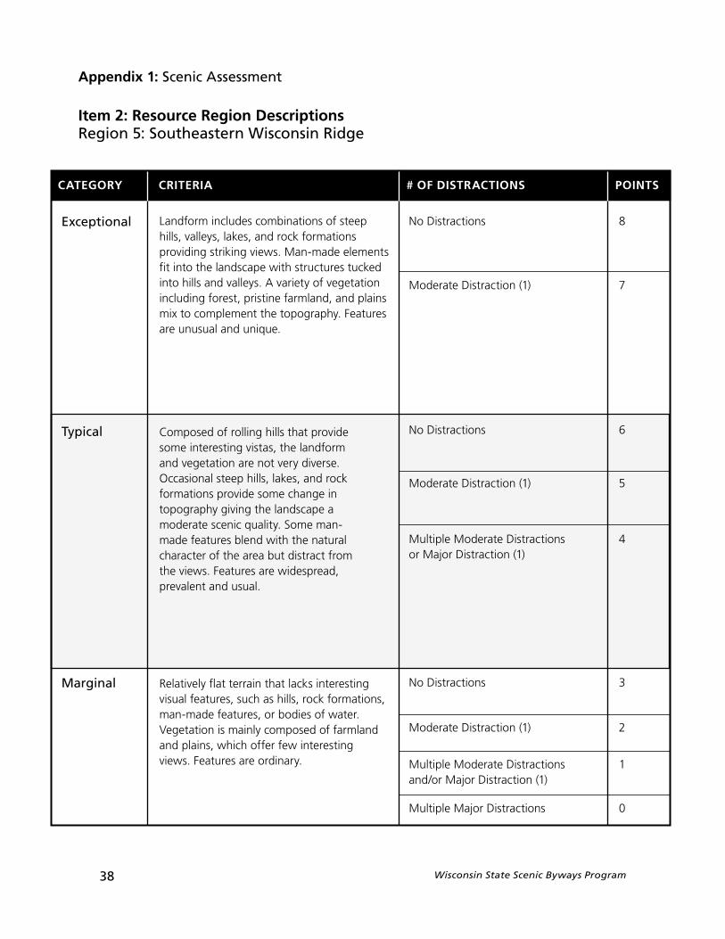
Item 2: Resource Region DescriptionsRegion 5: Southeastern Wisconsin Ridge
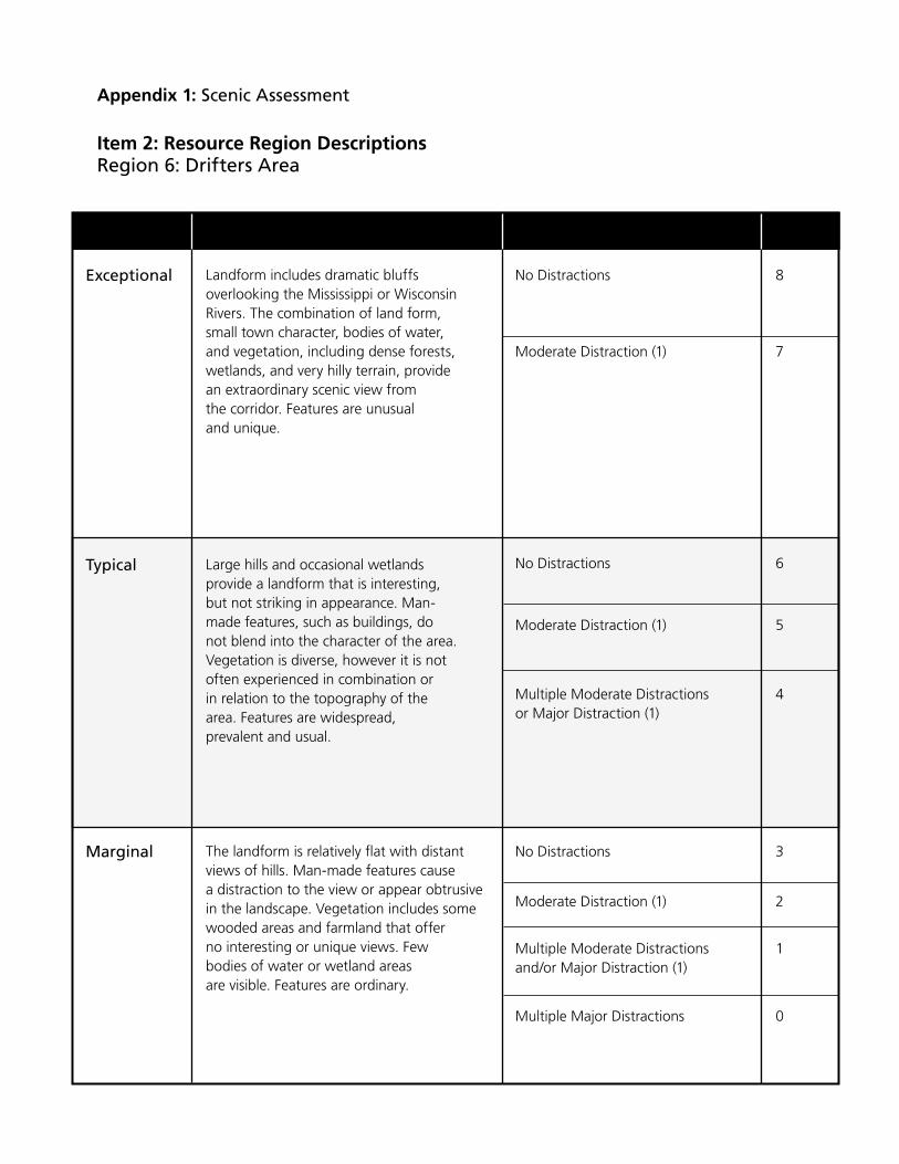
Landform includes dramatic bluffs overlooking the Mississippi or Wisconsin Rivers. The combination of land form, small town character, bodies of water, and vegetation, including dense forests, wetlands, and very hilly terrain, provide an extraordinary scenic view from the corridor. Features are unusual and unique.
Large hills and occasional wetlands provide a landform that is interesting, but not striking in appearance. Man-made features, such as buildings, do not blend into the character of the area. Vegetation is diverse, however it is not often experienced in combination or in relation to the topography of the area. Features are widespread, prevalent and usual.
The landform is relatively flat with distant views of hills. Man-made features cause a distraction to the view or appear obtrusive in the landscape. Vegetation includes some wooded areas and farmland that offer no interesting or unique views. Few bodies of water or wetland areas are visible. Features are ordinary.
No Distractions 8
Moderate Distraction (1) 7
No Distractions 6
Moderate Distraction (1) 5
Multiple Moderate Distractions 4or Major Distraction (1)
No Distractions 3
Moderate Distraction (1) 2
Multiple Moderate Distractions 1and/or Major Distraction (1)
Multiple Major Distractions 0
Exceptional
Typical
Marginal
Appendix 1: Scenic Assessment
Item 2: Resource Region DescriptionsRegion 6: Drifters Area
40 Wisconsin State Scenic Byways Program
Distractions come in many forms and in varying degrees. For this scenic quality assessment, distractions are to be rated Moderate or Major. Moderate distrac-tions are those that are integrated into the landscape and do not degrade or obstruct scenic views from the corridor. Major distractions are those that domi-nate the landscape, degrading or obstructing scenic views.
Some examples of moderate and major distractions are included in the list below. Note that where more than one example is listed, only one example need be applicable for a distraction to occur.
BUILDINGS/STRUCTURES (Residential Development, Commercial Development, Industrial Development, Cellular Towers):
» Moderate (orange) –An increased number of buildings/development exist in the corridor, but are comple-mentary to the landscape. Buildings do not degrade or obstruct scenic view.
» Major (red) – Dense and continuous development exists in the corridor. Buildings may be poorly maintained or the corridor exhibits visible blight. Buildings degrade or obstruct scenic views from the road.
UNSIGHTLY LAND USES (Quarries, Concrete Plants, Auto Dismantling):
» Moderate (orange) –Unsightly land uses are partially screened and/or not fully visible from the corridor.
» Major (red) – Unsightly land uses are not screened and are visible to travelers. No plans exist to remove or modify these land uses. Scenic view is degraded.
STRIP COMMERCIAL AREAS:
» Moderate (orange) –Strip Commercial Areas are neat, single story, and well landscaped. These structures blend with the surroundings of the area.
» Major (red) – Strip Commercial Areas that are not harmonious with the landscape surroundings. These may be poorly maintained, vacant, or blighted.
PARKING LOTS:
» Moderate (orange) –Parking lots and areas are well landscaped and clean, and fit into the surrounding character of the area.
» Major (red) – Parking lots and areas are not screened or landscaped. The scenic view in the area is degraded due to their presence.
Appendix 1: Scenic Assessment
Item 3: Moderate and Major Distractions
Wisconsin State Scenic Byways Program 41
OFF-SITE ADVERTISING STRUCTURES:
» Moderate (orange) –Structures are unlighted and in good condition. Signs are low to the ground and do not obstruct views of the landscape.
» Major (red) – Large and/or lighted billboards degrade or obstruct scenic view. Dilapidated signs appear worn or unreadable.
NOISE BARRIERS:
» Moderate (orange) –Noise barriers are well landscaped and complement the natural landscape. Barriers do not degrade or obstruct the views from the road.
» Major (red) – Noise barriers obstruct scenic view.
POWER LINES:
» Major (red) – Poles and lines dominate views. The quality of the views from the road is degraded due to the presence of the power lines.
AGRICULTURE (Structures, Equipment, Crops):
» Moderate (orange) –Agricultural uses that compete with the landscape for visual dominance.
» Major (red) – Agricultural uses which are incompatible with the landscape and dominate it. Structures, equipment, or crops degrade scenic view or appear obtrusive.
CLEARCUTTING:
» Moderate (orange) –Trees bordering the roadway remain intact or partially intact so that clearcutting is not very evident.
» Major (red) – Clearcutting or deforestation is evident to travelers.
EROSION:
» Moderate (orange) – Views from the road display minor soil erosion. Slopes are beginning to erode and are not stabilized.
» Major (red) – Large slope failures with no vegetation exist in the corridor.
Appendix 1: Scenic Assessment
Item 3: Moderate and Major Distractions (continued)

Wisconsin State Scenic Byways Program 43
Appendix 2: Corridor Management Plan (CMP)
The following outlined topics and questions should be addressed in the CMP.
The Scenic Byway Vision
What is your vision for the byway? What does the byway look like? How does it fit in with the surrounding environment and communities?
Develop a vision for your byway that states the community’s broad aspirations for the byway based on an ideal of what the scenic byway should become. The Vision should be a concise statement written in the present tense and with a frame of reference in the future.
Sample Vision Statement
The Tamiami Trail is a testament to human drive and ambition. It is living history, a tangible reminder of the roots of Collier County. The trail tells a uniquely American-style story of a man willing to bet a fortune on his dream, of the hardships endured and the ingenuity employed in the Trail’s creation.
This highway is also a window on a globally unique ecosystem. Marjory Stoneman Douglas taught us to prize the Everglades and many are teaching us to appreciate its subtle beauty. The government and the park service are committed to its preservation. The segment of the Tamiami Trail east of Naples provides the principal exposure for millions of travelers to the Everglades.
Scenic highway designation is an opportunity for a modern public-private partnership to preserve and build on both these aspects of the Trail. The Scenic corridor will provide improved access to the Everglades environment. It will allow the roadway to be improved in ways that will emphasize the natural beauty of the route. It can be used to preserve the Native American history of the area, as well as the more recent history of growth and development. At the same time, the Tamiami Trail can be maintained, not as a historical artifact, but as a living commercial artery, in keeping with its principal original purpose.- Tamiami Trail Corridor Management Plan
Showcase the Skyway as the most scenic drive in America while preserving the corridor’s out-standing and diverse resources.- San Juan Skyway Corridor Management Plan
The Chief Joseph Scenic Byway corridor will be managed in a manner which enhances visitor appreciation of the scenic, natural, historic, cultural and recreational qualities of the corridor; maintains the quality of life of corridor residents; protects corridor resources; acknowledges multiple use concepts; and integrates the Chief Joseph Scenic Byway with other Park County tourism attractions.- Chief Joseph Scenic Byway Corridor Management Plan
44 Wisconsin State Scenic Byways Program
Appendix 2: Corridor Management Plan (CMP)
The Scenic Byway Vision (continued)
The Scenic Byway Vision should no more than one page.
The work space below and helpful hints are provided to assist you in drafting your Scenic Byways Vision.
Tips for your Corridor Vision
» Speak in broad, general terms
» Think about the future of your byway, but write in the present tense
» Seek to have a single visionfor the byway
» Include all the potentially interested parties in developing your Vision
» Ask yourself questions...What will the byway look like in the future?What are the aspirations of our community regarding this byway?What does a trip along the byway feel like?
Wisconsin State Scenic Byways Program 45
Appendix 2: Corridor Management Plan (CMP)
Scenic Byway Goals
What are the goals for the byway?
Scenic Byway goals are considered the building blocks used to implement the vision for the scenic byway. In general, a goal is a statement that focuses and elaborates on specific concepts in the Scenic Byway Vision. Goals begin to organize the vision into more specific end results and eventually become achievable through subsequent strategies and actions. Goals breakdown the vision for the scenic byway in manageable pieces. When the applicant has developed all their goals, all the concepts in the scenic byway vision should be addressed through these goals.
The CMP should include at least four goals addressing the following issues:
» A goal for the protection of the scenic byway and its resources
» A goal for the promotion of the scenic byway
» A goal for the adequate availability of traveler and user amenities along the scenic byway, such as lodging, rest areas, restrooms, gasoline, or food
» A goal for generating and maintaining general local government and community support for the scenic byway’s designation to keep it alive and viable
46 Wisconsin State Scenic Byways Program
Appendix 2: Corridor Management Plan (CMP)
Scenic Byway Goals (continued)
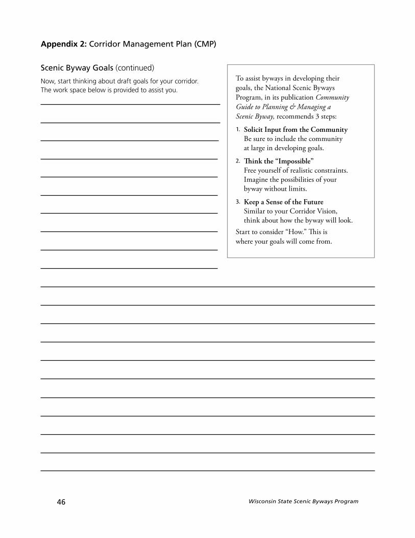
Now, start thinking about draft goals for your corridor. The work space below is provided to assist you.
To assist byways in developing their goals, the National Scenic Byways Program, in its publication Community Guide to Planning & Managing a Scenic Byway, recommends 3 steps:
1. Solicit Input from the Community Be sure to include the community at large in developing goals.
2. Think the “Impossible” Free yourself of realistic constraints. Imagine the possibilities of yourbyway without limits.
3. Keep a Sense of the FutureSimilar to your Corridor Vision, think about how the byway will look.
Start to consider “How.” This iswhere your goals will come from.
Wisconsin State Scenic Byways Program 47
Appendix 2: Corridor Management Plan (CMP)
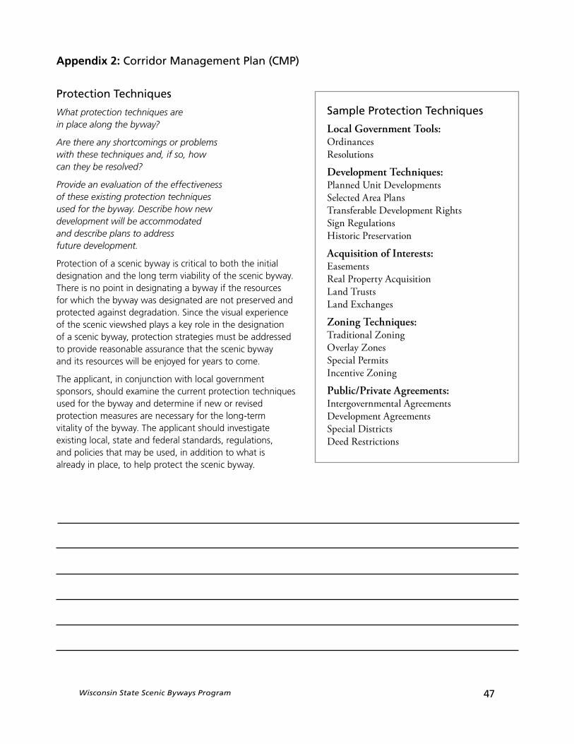
Protection Techniques
What protection techniques are in place along the byway?
Are there any shortcomings or problems with these techniques and, if so, how can they be resolved?
Provide an evaluation of the effectiveness of these existing protection techniques used for the byway. Describe how new development will be accommodated and describe plans to address future development.
Protection of a scenic byway is critical to both the initial designation and the long term viability of the scenic byway. There is no point in designating a byway if the resources for which the byway was designated are not preserved and protected against degradation. Since the visual experience of the scenic viewshed plays a key role in the designation of a scenic byway, protection strategies must be addressed to provide reasonable assurance that the scenic byway and its resources will be enjoyed for years to come.
The applicant, in conjunction with local governmentsponsors, should examine the current protection techniques used for the byway and determine if new or revised protection measures are necessary for the long-term vitality of the byway. The applicant should investigate existing local, state and federal standards, regulations, and policies that may be used, in addition to what is already in place, to help protect the scenic byway.
Sample Protection Techniques
Local Government Tools:OrdinancesResolutions
Development Techniques:Planned Unit DevelopmentsSelected Area PlansTransferable Development RightsSign RegulationsHistoric Preservation
Acquisition of Interests:EasementsReal Property AcquisitionLand TrustsLand Exchanges
Zoning Techniques:Traditional ZoningOverlay ZonesSpecial PermitsIncentive Zoning
Public/Private Agreements:Intergovernmental AgreementsDevelopment AgreementsSpecial DistrictsDeed Restrictions
48 Wisconsin State Scenic Byways Program
Appendix 2: Corridor Management Plan (CMP)
Protection Techniques (continued)
What are some of the existing protection techniques in place for your byway?
Are there some new protection techniques you would like to see for the corridor and its resources?
Use the work space below to draft your ideas for protection of the byway.

Wisconsin State Scenic Byways Program 49
Appendix 2: Corridor Management Plan (CMP)
Promotion
How will the byway be promoted and marketed? Are there current promotional efforts for this byway corridor? What are the strengths and weaknesses of the current byway promotion techniques?How can these techniques be improved?
The potential promotion of a designated scenic byway will include many partners and techniques. No two scenic byways will address promotion in the same way. However, all applicant scenic byways should begin early to identify significant existing promotional efforts. Given the possibility of scenic byway designation, are current efforts sufficient in light of your vision statement and goals? In some cases, promotional efforts can also serve as funding sources for the scenic byway activities and projects.
What are some significant existing promotional efforts or promotional ideas for your byway?
Are there some new steps that you would like to undertake?
50 Wisconsin State Scenic Byways Program
Appendix 2: Corridor Management Plan (CMP)
Promotion (continued)
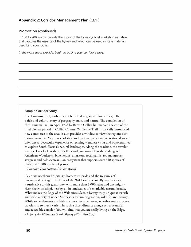
In 150 to 200 words, provide the ‘story’ of the byway (a brief marketing narrative) that captures the essence of the byway and which can be used in state materials describing your route.
In the work space provide, begin to outline your corridor’s story.
Sample Corridor Story
The Tamiami Trail, with miles of breathtaking, scenic landscapes, tells a rich and colorful story of geography, man, and nature. The completion of the Tamiami Trail in April 1928 by Barron Collier hallmarked the end of the final pioneer period in Collier County. While the Trail historically introduced new commerce to the area, it also provides a window to view the region’s rich natural wonders. Vast tracks of state and national parks and recreational areas offer one a spectacular experience of seemingly endless vistas and opportunities to explore South Florida’s natural landscapes. Along the roadside, the traveler gains a closer look at the area’s flora and fauna—such as the endangered American Woodstork, blue herons, alligators, royal palms, red mangroves, sawgrass and bald cypress—an ecosystem that supports over 350 species of birds and 1,000 species of plants.- Tamiami Trail National Scenic Byway
Celebrate northern hospitality, hometown pride and the treasures of our natural heritage. The Edge of the Wilderness Scenic Byway provides a rustic slice of this great state, with more than 1,000 lakes and one mighty river, the Mississippi, nearby, all in landscapes of remarkable natural beauty. What makes the Edge of the Wilderness Scenic Byway truly unique is its rich and wide variety of upper Minnesota terrain, vegetation, wildlife, and history. While some elements are fairly common in other areas, no other route exposes travelers to so much variety in such a short distance along such a beautiful and accessible corridor. You will find that you are really living on the Edge.- Edge of the Wilderness Scenic Byway (NSB Web Site)
Wisconsin State Scenic Byways Program 51
Appendix 2: Corridor Management Plan (CMP)
Schedule and Responsible Agencies
What activities or action items will be completed in order to fulfill the scenic byway’s goals? Who will be the responsible agencies/parties/individuals for these activities and action items?
Are there any funding sources planned for the action items?
What will the products or outcomes be and what is the schedule for completion?
In the CMP, the applicant should address these questions and provide information about what activities or action items will be completed, who will complete them and how they will be completed.
The applicant must be certain to work closely with all the agencies, local government sponsors, and other parties in developing the byway schedule. Every agency identified with responsibility for implementing an action item in the byway schedule must demonstrate their agreement. In some cases, these responsible groups will be different from the local governments that signed resolutions as part of the Step 2 Application (page 37). A park service or chamber of commerce may agree to help complete a task for the byway. These groups should be identified in the CMP with:
» Contact Name
» Contact Phone Number, Fax Number and E-mail Address
The activities outlined in the schedule put forth an opportunity for organizations and agencies along the byway to work together to accomplish byway goals. For each activity, the CMP must include the signature of an individual that can speak on behalf of the agency or organization taking responsibility for the action item. This signature will indicate the agency or organization’s commitment to completing the activity—regardless of any changes in personnel. This will demonstrate to the Wisconsin Department of Transportation that every activity/action item listed has a responsible group and will provide contact information for monitoring completion of the activity. The signature will represent a good faith effort to undertake and complete a task. It does not represent a contractual agreement.
The worksheet on the following page should help you determine the activities and action items the applicant wants to complete in order to fulfill the byway goals; the responsible entity or agency; the funding available or anticipated; and the schedule.
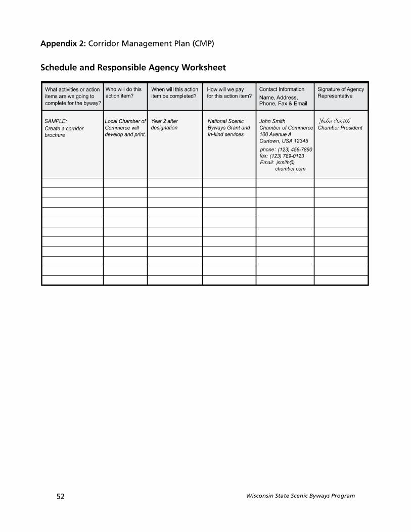
52 Wisconsin State Scenic Byways Program
Appendix 2: Corridor Management Plan (CMP)
Schedule and Responsible Agency Worksheet
Wisconsin State Scenic Byways Program 53
Appendix 3: Historic Designation
Introduction
The Wisconsin Scenic Byways Program also allows State Trunk Highway routes with outstanding historic characteristics along the entire length to be nominated and designated as Wisconsin state scenic byways.
For the purposes of this program, Historical resources are the distinctive, visible sites or structures that demonstrate an important part of Wisconsin history that can help to educate viewers and help foster an appreciation of the past. They are the non-renewable remains of human activity and occupation. These remains may be sites, structures, buildings architecture or ruins that were important in the course of human events.
Trans 202, the formal rules of the Wisconsin Scenic Byways Program specify that historic resources be significant historically, be numerous, be visible, and have a setting or character that is complimentary to the resource. The exact language regarding historical resources in the Administrative Code is provided below.
Trans 202.05 Qualifications for scenic byway designation. (1) The majority of the route proposed as a Wisconsin scenic byway shall have scenic qualities or historic resources, which are unique to the route… The majority of historic resources shall be eligible for, or listed on the National Register of Historic Places, be numerous, be visible, and have a setting or character that is complimentary to the historic resources.
A designated Wisconsin State Scenic Byway can be any State Trunk Highway that is proposed by a local government sponsor and so designated by the WisDOT Secretary pursuant to Section 84.106, Wisconsin State Statutes. These roadways must offer travelers access to exceptional historic resources in a complimentary setting.
It is important to note that participation in the Wisconsin Scenic Byways Program is voluntary. Furthermore, this is a promotional program and is not intended to inhibit or prevent improvement projects to highways such as safety or capacity improvements. The program cannot stop development from occurring, but can help a community with future development to ensure it fits with the character of the route. Lastly, the program is not intended to guide land-use planning under the State’s Smart Growth legislation, nor should the program be used to turn the scenic route into a rustic or country road.
Since each individual’s interpretation of significant historic qualities may be different, an objective process, similar to the scenic assessment, has been developed to assist community groups in Wisconsin with evaluating their corridor’s historic qualities based on the guidelines set forth in Trans 202. There is one set of criteria for the entire state. Byways exemplifying the most outstanding historic resources with a minimum of detractions will most likely be designated as a Wisconsin State Scenic Byway.
The purpose of this appendix is to describe the process by which a corridor becomes designated as a Wisconsin Scenic Byway using history as the primary criteria and outline all the required materials for this scenic byways application. Before beginning, however, all candidate corridors must have a Byway Group who is interested and supports the designation.

54 Wisconsin State Scenic Byways Program
Appendix 3: Historic Designation
The Byway Group or Applicant
So how do you form a Byway Group and apply for designation of your route? You get people together.
Potential members of your Byway Group» Citizens» Local Governments» Service Clubs» Tourism Offices
The Wisconsin Scenic Byways Program was developed to be a voluntary, local program initiated by citizens and local governments. So, the first course of action in getting your byway designated is to get everyone together who would be interested and support the cause. This will include citizens, local business owners, interest groups such as a Garden Club or Bicycle Club, property owners, environmentalists, Chambers of Commerce, and anyone else you think would want to know about or be interested in the corridor’s designation. In all, you should seek to develop a broad base of support for the designation of your corridor. The more people you have supporting your effort and available to help, the stronger your byway support will become.
The next vital link will be to have one or more local government sponsors for the route. Since the local government, whether it be a city, town, village or county, has jurisdiction over the land uses surrounding a corridor, it is important to have their support and sponsorship of the corridor. It will be the local government(s) that formally sponsors and signs the applications and provides resolutions of their support and future management of the corridor. Thus, at least one government sponsor is needed to apply for Scenic Byway Designation. Working in partnership, citizens and the local government sponsor will act as the applicant for the corridor and complete all the required applications.
Wisconsin State Scenic Byways Program 55
Appendix 3: Historic Designation
Historic Quality and Distractions
Historic QualityHistoric Quality and Distractions are two main ideas on which the historic assessment is based. They are discussed below.
Three factors that contribute to having a high-quality historical asset are: 1) Contributions to History; 2) Setting and Access and 3) Interpretation. These factors can be further refined to identify a range in the quality of the historical asset to determine what resource is exceptional or higher quality, what is typical or moderate, and what is marginal or lower quality.
1) Contributions To HistoryThis factor involves the connection between the site or structure to the estimated historical impact/contributions made. This factor includes the consideration of the historical impact on the development of Wisconsin’s heritage in such fields such as transportation, industry, commerce, agriculture, architecture, mining, and culture.
» Exceptional – Has made a major contribution to the heritage of the area that is traversed by the roadway. Ideally the historic resource is listed or eligible on the National Register of Historic Places or the Wisconsin Register of Historic Places .
» Typical – Has made a moderate contribution to the heritage of the area that is traversed by the roadway. Ideally the historic resource is listed or eligible on a local or county inventory of historic resources or can demostrate/document that moderate impact.
» Marginal – Has made a minor contribution to the heritage of the area that is traversed by the roadway. Ideally historic resource is over 50 years oldand is mostly in its original condition.
2) Setting And AccessThe setting refers to the relationship between the building and its environs and how harmonious and complimentary it is. For example, a former one-room schoolhouse located in an industrial park would not have a good setting. Access refers to how close the road is to the historical place or site and how easy it is to reach.
» Exceptional – Setting is very complimentary. Current uses do not detract from site. Site is immediately adjacent to the road. Access is very easy.
» Typical – Setting is somewhat complimentary. Some current uses detract from site. Site is within 1 mile of the road. Access is easy.
» Marginal – Setting is not harmonious. Overall, current uses are a major detraction from site. Site is over 1 mile from the road. Access to site is difficult.
56 Wisconsin State Scenic Byways Program
3) InterpretationA historical site or structure may not be fully intact. Furthermore, visitors may need assistance to understand what it is that they are seeing and help placing that in the appropriate context or time frame. Interpretation refers to offering insights and explanations of what is being seen and the appropriate context.
» Exceptional – Historical site or structure is well defined and clearly shows history. Comprehensive interpretation is provided.
» Typical – Historical site or structure may require some visualization to show history. Moderate interpretation is provided.
» Marginal – Historical site or structure may be difficult to understand. Minimal interpretation is provided.
Distractions
Sometimes an applicant corridor will have elements or features along it that can be considered distractions to historical experience. Distractions may include poorly-maintained buildings, unsightly land uses, power lines, parking lots, or outdoor advertising. These distracting features may be large or small and may alter the quality of the corridor. In many cases, small distractions, such as a nicely maintained residence, will only affect certain views or appear in single occurrences along a corridor. Other times, a large distraction or numerous small distractions, such as power lines (i.e. minor distraction), may distract from the overall historic quality of the corridor and limit its opportunity for designation as a scenic byway. Keep in mind that the more pristine and unaffected by distractions, the more likely a candidate corridor will qualify for designation as a Wisconsin Scenic Byway. In areas where distractions exist, the less effect they have on the setting, the more likely the candidate corridor will be considered as historic.
Distractions come in many forms and in varying degrees. For this historic assessment, distractions are to be rated Moderate or Major. Moderate distractions are those that are integrated into the landscape and do not degrade or obstruct the Historic Resource or its setting. Major distractions are those that dominate the landscape, degrading or obstructing the Historic Resources or its setting.
Scenic Byway benefits
Benefits of Scenic Byway designation include:» supports tourism and economic development in communities
all along a designated byway.» unique signs, markers, brochures and ongoing promotional efforts
can enhance a community’s “marketability.”» both state or nationally–designated scenic byways are eligible
to compete for federal funds.» byways are marketed to national and international travelers, bringing additional
recognition and potential economic benefits to area communities.» serves to promote an area’s historical, scenic and recreational treasures
for the enjoyment of future generations.
Appendix 3: Historic Designation
Wisconsin State Scenic Byways Program 57
Appendix 3: Historic Designation
The Designation Process
Designation as a Wisconsin Scenic Byway is a two-step application process.
The first step is completion of the Historic Assessment. The purpose of the Historic Assessmentis to gather information about the proposed corridor and make a determination whether the overall corridor has medium to high historic attributes with a minimum of distractions. The second step involves the development and completion of a corridor management plan and obtaining formal local support.
This section describes in detail what must be completed for Step 1.The historic assessment is compromised of four major products:» Historic Quality Evaluation Sheet» Detailed Corridor Map» Photographs» Narratives of the highlights, distractions, and
potential changes which could affect the route.
» The Historic Quality Evaluation Sheet
The Historic Quality Evaluation sheet is intended to document all the historic resources in the corridor, such as significant sites and buildings, as well as their location and general condition. Elements of the corridor that are considered distractions to the setting or resource will also be identified and mapped. The applicant needs to evaluate and determine whether each individual mile can be considered Exceptional, Typical, or Marginal based on the descriptions for each category and the distractions, if present. Lastly, a point value based on the resources and distractions must be assessed.
Page 3 of the Historic Quality Evaluation sheet allows for the documentation of other Complimentary Resources including Scenic Resources, Recreational resources, or Cultural resources. The applicant needs to document these Complimentary Resources but does not need to assign a point value to each resource. Rather, a quarter-point is given for each significant complimentary resource found along the proposed route.
An example of a completed Historic Quality Evaluation sheet follows. The reference documents needed to complete the evaluation are the “Historical Inventory Matrix” and a list of “Moderate and Major Distractions”. They can be found at the end of this appendix and are listed as “Attachment A” and “Attachment B” respectively.
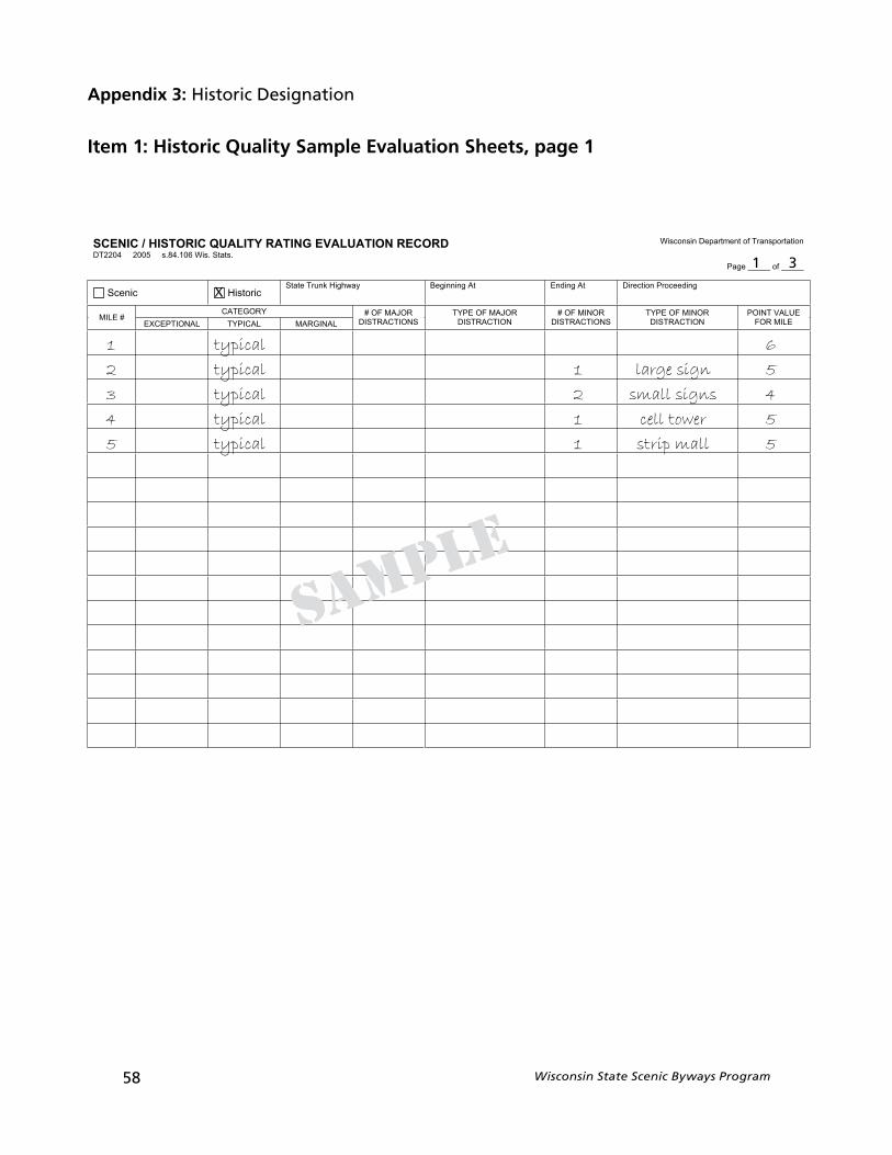
58 Wisconsin State Scenic Byways Program
Appendix 3: Historic Designation
Item 1: Historic Quality Sample Evaluation Sheets, page 1
YTILAUQCIROTSIH/CINECS DROCERNOITAULAVEGNITAR noitatropsnarTfotnemtrapeDnisnocsiW
.statS.siW601.48.s50024022TD
_____fo_____egaP
cinecS cirotsiHtAgninnigeByawhgiHknurTetatS gnideecorPnoitceriDtAgnidnE
YROGETAC#ELIM
LANIGRAMLACIPYTLANOITPECXE
ROJAMFO#SNOITCARTSID
ROJAMFOEPYTNOITCARTSID
RONIMFO#SNOITCARTSID
RONIMFOEPYTNOITCARTSID
EULAVTNIOPELIMROF
1 typical 6
2 typical 1 large sign 5
3 typical 2 small signs 4
4 typical 1 cell tower 5
5 typical 1 strip mall 5
sample
X
1 3
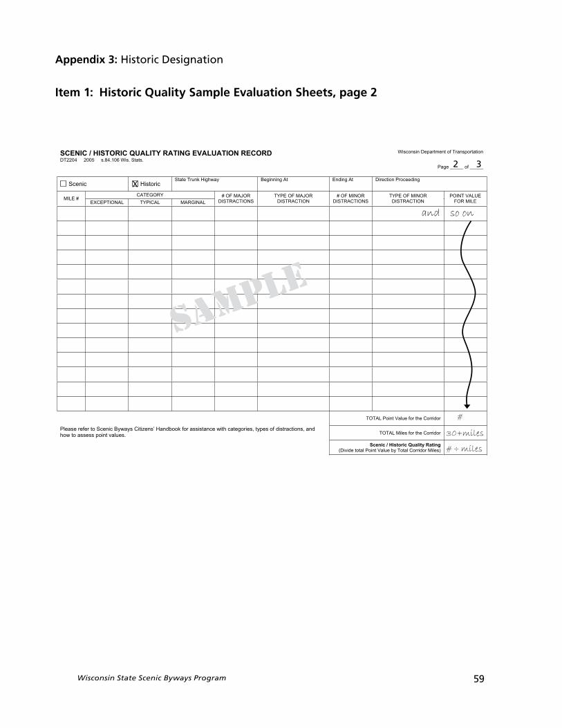
Appendix 3: Historic Designation
Item 1: Historic Quality Sample Evaluation Sheets, page 2
Wisconsin State Scenic Byways Program 59
YTILAUQCIROTSIH/CINECS DROCERNOITAULAVEGNITAR noitatropsnarTfotnemtrapeDnisnocsiW
.statS.siW601.48.s50024022TD
_____fo_____egaP
cinecS cirotsiHtAgninnigeByawhgiHknurTetatS gnideecorPnoitceriDtAgnidnE
YROGETAC#ELIM
LANIGRAMLACIPYTLANOITPECXE
ROJAMFO#SNOITCARTSID
ROJAMFOEPYTNOITCARTSID
RONIMFO#SNOITCARTSID
RONIMFOEPYTNOITCARTSID
EULAVTNIOPELIMROF
rodirroCehtrofeulaVtnioPLATOT
issarofkoobdnaH’snezitiCsyawyBcinecSotreferesaelP dna,snoitcartsidfosepyt,seirogetachtiwecnats.seulavtniopssessaotwoh rodirroCehtrofseliMLATOT
gnitaRytilauQcirotsiH/cinecS)seliMrodirroClatoTybeulaVtnioPlatotediviD(
and so on
#
30+miles
# ÷ miles
sample
X
2 3
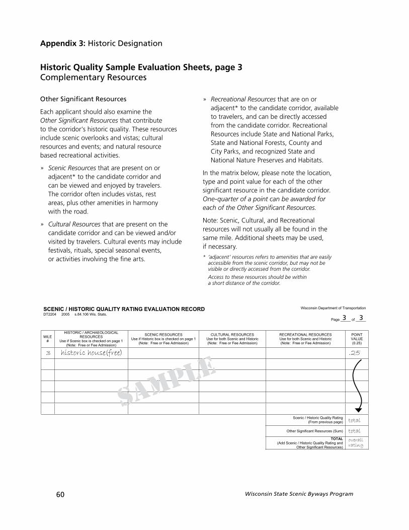
60 Wisconsin State Scenic Byways Program
Other Significant Resources
Each applicant should also examine the Other Significant Resources that contribute to the corridor’s historic quality. These resources include scenic overlooks and vistas; cultural resources and events; and natural resource based recreational activities.
» Scenic Resources that are present on or adjacent* to the candidate corridor and can be viewed and enjoyed by travelers. The corridor often includes vistas, rest areas, plus other amenities in harmonywith the road.
» Cultural Resources that are present on the candidate corridor and can be viewed and/or visited by travelers. Cultural events may include festivals, rituals, special seasonal events, or activities involving the fine arts.
» Recreational Resources that are on or adjacent* to the candidate corridor, available to travelers, and can be directly accessed from the candidate corridor. Recreational Resources include State and National Parks, State and National Forests, County and City Parks, and recognized State and National Nature Preserves and Habitats.
In the matrix below, please note the location, type and point value for each of the other significant resource in the candidate corridor. One-quarter of a point can be awarded for each of the Other Significant Resources.
Note: Scenic, Cultural, and Recreational resources will not usually all be found in the same mile. Additional sheets may be used, if necessary.
* ‘adjacent’ resources refers to amenities that are easily accessible from the scenic corridor, but may not be visible or directly accessed from the corridor.
Access to these resources should be within a short distance of the corridor.
Appendix 3: Historic Designation
Historic Quality Sample Evaluation Sheets, page 3Complementary Resources
YTILAUQCIROTSIH/CINECS DROCERNOITAULAVEGNITAR noitatropsnarTfotnemtrapeDnisnocsiW
.statS.siW601.48.s50024022TD
_____fo_____egaP
ELIM#
LACIGOLOEAHCRA/CIROTSIHSECRUOSER
1egapnodekcehcsixobcinecSfiesU)noissimdAeeFroeerF:etoN(
SECRUOSERCINECS1egapnodekcehcsixobcirotsiHfiesU
)noissimdAeeFroeerF:etoN(
SECRUOSERLARUTLUCcirotsiHdnacinecShtobrofesU)noissimdAeeFroeerF:etoN(
SECRUOSERLANOITAERCERcirotsiHdnacinecShtobrofesU)noissimdAeeFroeerF:etoN(
TNIOPEULAV)52.0(
gnitaRytilauQcirotsiH/cinecS)egapsuoiverpmorF(
)muS(secruoseRtnacifingiSrehtO
LATOTdnagnitaRytilauQcirotsiH/cinecSddA()secruoseRtnacifingiSrehtO
3 historic house(free) .25
total
total
overallrating
sample
3 3
In order to complete the Historic Quality Evaluation sheet, each applicant should...
1. Form a team of 3 to 4 people to drive the corridor and complete the Evaluation Sheet. Each of the team members should have their own duty. One team member should be responsible for driving the vehicle, tracking the mileage and making safe stops. One or two team members should be responsible for completing the Evaluation Sheet, observing what they see in each mile segment, and recording it. The last member of the team should be responsible for taking photographs of the different views and features along the corridor, and noting on a map where the photos are being taken. All members should adhere to traffic safety rules and laws and be cautions when walking or taking pictures along the roadside. Reflective clothing or safety vests are suggested as well.
2. The applicant evaluates and determines whether each individual mile can be considered Exceptional, Typical, or Marginal based on the Historcial Inventory Matrix found in Attachment A .
3. Next, on each line of the Evaluation Sheet, record the information for each mile for the candidate corridor based on the historic matrix. Note the number/type of distractions using the list found in Attachment B. In some cases, more than one line may be necessary for each mile.
4. Next, the applicant should count the number and type of distractions for that mile. Looking across the matrix, match the Historic Quality category with the number of distractions in the mile to determine the point value for that mile of the corridor. For example, if a mile segment fits the description of Exceptional, but has a moderate distraction (such as a nicely developed strip mall), that mile segment gets a point value of 7. If that same segment is without any distractions, it would get a point value of 8.
5. Once the entire corridor has been evaluated, the applicant should total the number of points for each mile segment and divide them by the total miles in the corridor. This will produce an overall Historic Quality Rating for the corridor.
6. On the 3rd page of the Evaluation Sheet, the applicant needs to evaluate the other factors and resources in the corridor that can compliment the historic quality and viability as a State Scenic Byway. These resources include Scenic, Archeological, Cultural, and Recreational Resources in the corridor and have point values associated with them. In some cases more than one line may be necessary for each mile.
7. The total of the Historic Quality Rating and the scores for the other resources in the corridor will produce a overall rating. Add the extra points for other resources to the Scenic/HistoricQuality rating. This is the overall rating. A rating of 6 or better is required for a candidate corridor to be considered for designation. The better the rating, the more likely the Scenic Byways Advisory Committee will recommend designation for the candidate corridor as a Wisconsin State Scenic Byway.
Wisconsin State Scenic Byways Program 61
Appendix 3: Historic Designation
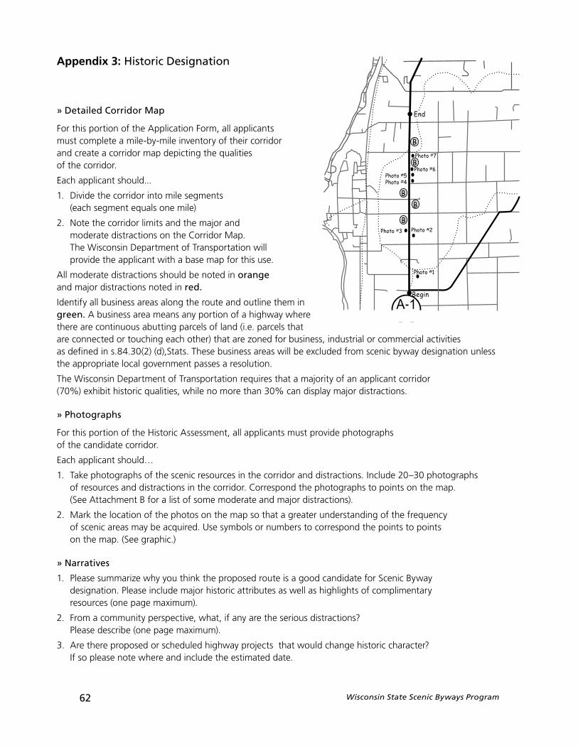
62 Wisconsin State Scenic Byways Program
» Detailed Corridor Map
For this portion of the Application Form, all applicants must complete a mile-by-mile inventory of their corridor and create a corridor map depicting the qualities of the corridor.
Each applicant should...
1. Divide the corridor into mile segments (each segment equals one mile)
2. Note the corridor limits and the major and moderate distractions on the Corridor Map. The Wisconsin Department of Transportation will provide the applicant with a base map for this use.
All moderate distractions should be noted in orangeand major distractions noted in red.
Identify all business areas along the route and outline them in green. A business area means any portion of a highway where there are continuous abutting parcels of land (i.e. parcels that are connected or touching each other) that are zoned for business, industrial or commercial activities as defined in s.84.30(2) (d),Stats. These business areas will be excluded from scenic byway designation unless the appropriate local government passes a resolution.
The Wisconsin Department of Transportation requires that a majority of an applicant corridor (70%) exhibit historic qualities, while no more than 30% can display major distractions.
» Photographs
For this portion of the Historic Assessment, all applicants must provide photographs of the candidate corridor.
Each applicant should…
1. Take photographs of the scenic resources in the corridor and distractions. Include 20–30 photographs of resources and distractions in the corridor. Correspond the photographs to points on the map. (See Attachment B for a list of some moderate and major distractions).
2. Mark the location of the photos on the map so that a greater understanding of the frequency of scenic areas may be acquired. Use symbols or numbers to correspond the points to points on the map. (See graphic.)
» Narratives
1. Please summarize why you think the proposed route is a good candidate for Scenic Byway designation. Please include major historic attributes as well as highlights of complimentary resources (one page maximum).
2. From a community perspective, what, if any are the serious distractions? Please describe (one page maximum).
3. Are there proposed or scheduled highway projects that would change historic character? If so please note where and include the estimated date.
Appendix 3: Historic Designation
4. Are there proposed or planned development projects along the route that would significantly change the historic character of the route? If so please list indicating whether it is positive or negative addition and include the estimated date.
Note: If a highway or development project is scheduled which would significantly alter the scenic character of the candidate corridor, approval to proceed to Step 2 may not be given until the project is completed and its effect on the byway measured. The applicant may choose to apply for designation after the project has been completed.
Summary
The applicant should have developed or completed the following for the historic assessment:
1. The completed Historic Quality Evaluation Sheet(s) for the candidate corridor. This is a mile by mile inventory of both the historic quality and distractions. Applicant should have assessed a rating for each mile.
2. Detailed Corridor Map. The Wisconsin Department of Transportation provided the applicant with a Base Map for this use. The corridor limits, the major and moderate distractions in the corridor and business areas should be noted on the map. All moderate distractions should be noted in orange and major distractions in red, business areas should be outlined in green.
3. 20–30 photographs of resources and distractions in the corridor should be included. The photographs should correspond to points on the map.
4. Written narratives of the highlights of the route, the distractions and highway development projects (up to one page each).
Mailing InformationOnce the materials and all its required documentation are complete, the applicant should mail two (2) complete packages to:
Jane Carrola Wisconsin State Scenic Byways Coordinator Wisconsin Department of Transportation P. O. Box 7913Madison, WI 53707-7913
If an applicant has any questions or concerns while completing the Historic Assessment,please contact the State Scenic Byways Coordinator at (608) 266-0649, fax (608) 267-0294 or e-mail [email protected].
Step 2: ApplicationAs noted earlier, the Historic Designation follows a two-step application process similar to designation based on historic qualities. The purpose of Step 1 was to gather information about the quality of the historic resources in the proposed corridor so that the Scenic Byways Advisory Committee could make a determination on the merit of the candidate corridor proceeding to Step 2.
Assuming the recommendation is positive, the byway group will begin the application process outlined in the Corridor Mangament Plan and Resolutions section of the handbook on appendix 5. This step will involve the development of a corridor management plan based on the historic assessment and the demonstration of local support through resolutions.
Appendix 3: Historic Designation
Wisconsin State Scenic Byways Program 63
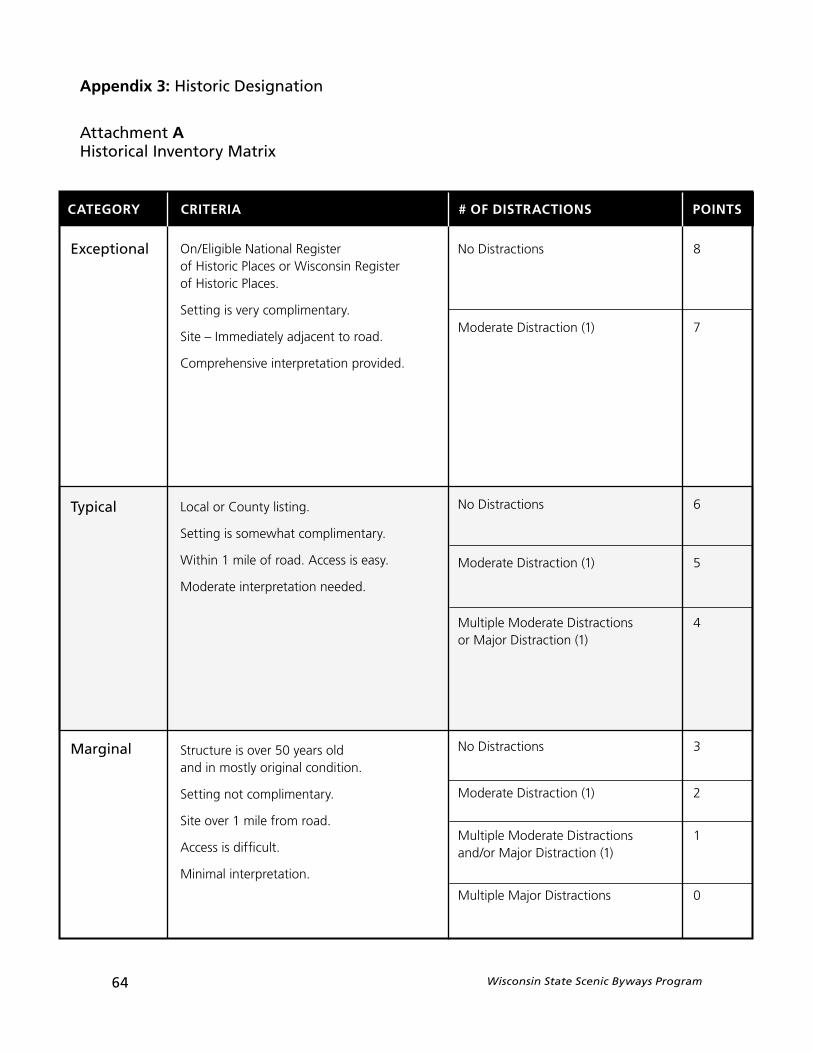
64 Wisconsin State Scenic Byways Program
On/Eligible National Register of Historic Places or Wisconsin Register of Historic Places.
Setting is very complimentary.
Site – Immediately adjacent to road.
Comprehensive interpretation provided.
Local or County listing.
Setting is somewhat complimentary.
Within 1 mile of road. Access is easy.
Moderate interpretation needed.
Structure is over 50 years old and in mostly original condition.
Setting not complimentary.
Site over 1 mile from road.
Access is difficult.
Minimal interpretation.
CATEGORY CRITERIA # OF DISTRACTIONS POINTS
Exceptional
Typical
Marginal
No Distractions 8
Moderate Distraction (1) 7
No Distractions 6
Moderate Distraction (1) 5
Multiple Moderate Distractions 4or Major Distraction (1)
No Distractions 3
Moderate Distraction (1) 2
Multiple Moderate Distractions 1and/or Major Distraction (1)
Multiple Major Distractions 0
Appendix 3: Historic Designation
Attachment AHistorical Inventory Matrix
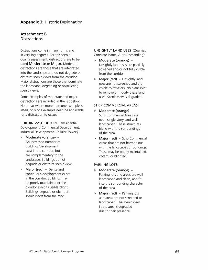
Wisconsin State Scenic Byways Program 65
Distractions come in many forms and in vary-ing degrees. For this scenic quality assessment, distractions are to be rated Moderate or Major. Moderate distractions are those that are integrated into the landscape and do not degrade or obstruct scenic views from the corridor. Major distractions are those that dominate the landscape, degrading or obstructing scenic views.
Some examples of moderate and major distractions are included in the list below. Note that where more than one example is listed, only one example need be applicable for a distraction to occur.
BUILDINGS/STRUCTURES (Residential Development, Commercial Development, Industrial Development, Cellular Towers):
» Moderate (orange) –An increased number of buildings/development exist in the corridor, but are complementary to the landscape. Buildings do not degrade or obstruct scenic view.
» Major (red) – Dense and continuous development exists in the corridor. Buildings may be poorly maintained or the corridor exhibits visible blight. Buildings degrade or obstruct scenic views from the road.
UNSIGHTLY LAND USES (Quarries, Concrete Plants, Auto Dismantling):
» Moderate (orange) –Unsightly land uses are partially screened and/or not fully visible from the corridor.
» Major (red) – Unsightly land uses are not screened and are visible to travelers. No plans exist to remove or modify these land uses. Scenic view is degraded.
STRIP COMMERCIAL AREAS:
» Moderate (orange) –Strip Commercial Areas are neat, single story, and well landscaped. These structures blend with the surroundings of the area.
» Major (red) – Strip Commercial Areas that are not harmonious with the landscape surroundings. These may be poorly maintained, vacant, or blighted.
PARKING LOTS:
» Moderate (orange) –Parking lots and areas are well landscaped and clean, and fit into the surrounding character of the area.
» Major (red) – Parking lots and areas are not screened or landscaped. The scenic view in the area is degraded due to their presence.
Appendix 3: Historic Designation
Attachment BDistractions
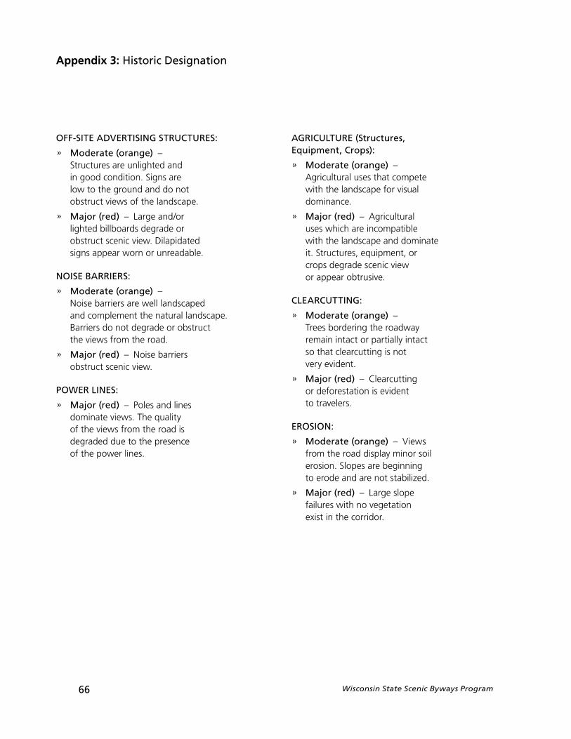
66 Wisconsin State Scenic Byways Program
Appendix 3: Historic Designation
OFF-SITE ADVERTISING STRUCTURES:
» Moderate (orange) –Structures are unlighted and in good condition. Signs are low to the ground and do not obstruct views of the landscape.
» Major (red) – Large and/or lighted billboards degrade or obstruct scenic view. Dilapidated signs appear worn or unreadable.
NOISE BARRIERS:
» Moderate (orange) –Noise barriers are well landscaped and complement the natural landscape. Barriers do not degrade or obstruct the views from the road.
» Major (red) – Noise barriers obstruct scenic view.
POWER LINES:
» Major (red) – Poles and lines dominate views. The quality of the views from the road is degraded due to the presence of the power lines.
AGRICULTURE (Structures, Equipment, Crops):
» Moderate (orange) –Agricultural uses that compete with the landscape for visual dominance.
» Major (red) – Agricultural uses which are incompatible with the landscape and dominate it. Structures, equipment, or crops degrade scenic view or appear obtrusive.
CLEARCUTTING:
» Moderate (orange) –Trees bordering the roadway remain intact or partially intact so that clearcutting is not very evident.
» Major (red) – Clearcutting or deforestation is evident to travelers.
EROSION:
» Moderate (orange) – Views from the road display minor soil erosion. Slopes are beginning to erode and are not stabilized.
» Major (red) – Large slope failures with no vegetation exist in the corridor.
Wisconsin State Scenic Byways Program 67
Appendix 4: Definitions
Definitions
This Section contains definitions and acronyms for commonly used words, titles, or phrases throughout the Wisconsin State Scenic Byways Program and guidance materials.
“All-American Roads” are public roads that have been designated by the federal government as satisfying National Scenic Byways criteria and have satisfied the additional criteria and requirements for designation as All-American Roads pursuant to the National Scenic Byways Program and its implementing legislation and regulations. A road must have State Scenic Byway designation prior to applying for this national level designation.
“Action Items” is the formal application completed to apply for designation as a Wisconsin Scenic Byway.
“Archeological Intrinsic Quality” are the physical evidence or remains of known historic or prehistoric human life, activity or culture in Wisconsin. For example, significant ruins, artifacts, inscriptions, structural and/or human remains may all be considered archeological resources. These resources differ from historic resources in that they may have existed before written records were kept in an area.
“Business Area” a area means any portion of a highway where there are contiguousabutting parcels of land (i.e. parcels that are connected or touching each other) that are zoned for business, industrial or commercial activities or unzoned and used for business, industrial or commercial activities as defined in s. 84.30 (2) (d), Stats.
“Corridor Management Plan” (CMP) is a plan which addresses the goals, protection and promotion strategies, an action schedule, and the responsible entities by which the designated Wisconsin Scenic Byway corridor will be managed. Each Wisconsin Scenic Byway shall have a CMP intended to balance the preservation, protection, and promotion of the scenic resources of the corridor.
“Cultural Intrinsic Resources” are portions of the human environment that express aesthetics, traditions, values and customs. Traditions are usually associated with distinct groups of people and are passed on from one generation to the next. Cultural Resources may include crafts, music, arts, dance, drama, rituals, festivals, languages, museums, foods, special events, vernacular architecture, and past or present customs.
“Department” refers to the Wisconsin Department of Transportation.
68 Wisconsin State Scenic Byways Program
“Distractions” are the physical features in a landscape, whether natural or man-made, that take away from or interfere with a traveler’s enjoyment of a scenic view. Major distractions are considered features that dominate the landscape, degrading or obstructing scenic views. Minor distractions are considered features that are integrated into the landscape and do not obstruct or degrade scenic views.
“District” refers to one of the eight Wisconsin Department of Transportation Field Offices within the State.
“Evaluation Sheet” refers to the sheet included in the Wisconsin Scenic Byways Program Application form and Step 1: Scenic Assessment used to measure the scenic qualities and other important resources in a candidate corridor.
“Federal Highway Administration (FHWA)” is the federal agency which oversees all highway transportation issues for the nation and manages the National Scenic Byways Program.
“Historic Quality” are distinctive physical elements in the landscape, either natural or man-made, that reflect the actions of humans as they relate to past events, sites, or structures. These historical resources symbolize an important era in Wisconsin history and portray a legacy of Wisconsin that educates viewers while providing an appreciation of the past. Resources may include buildings, Indian habitations, trails, engineering structures, settlement patterns, and landscapes.
“Intermodal Surface Transportation Efficiency Act (ISTEA)” refers to the federal legislation which initiated the development of the National Scenic Byways Program.
“Intrinsic Quality” are the cultural, historical, archeological, recreational, natural or scenic qualities, or values along a roadway that are necessary for designation as a National Scenic Byway. As defined by the Federal Highway Administration Interim Policy, dated May 18, 1995, intrinsic resources are features considered significant, exceptional, and distinctive by a community, and are recognized and expressed by that community in its comprehensive plan to be of local, regional, statewide, or national significance and worthy of preservation and management.
“Municipal Government” is a, town, village or city government that has geographic boundaries that abut the corridor.
“Local Government Sponsor” refers to the town, village, city, or county government that initiates a Scenic Assessment a candidate scenic byway. This may also refer to the local governments that sign resolutions in support of an applicant corridor’s designation.
Appendix 4: Definitions
Wisconsin State Scenic Byways Program 69
Appendix 4: Definitions
“Metropolitan Planning Organization (MPO)” is the forum for cooperative transportation decision-making for the metropolitan planning area, as defined by Federal Transportation Planning Regulations. An applicant may consider involving an RPC or an MPO in the corridor management plan or by obtaining letters of support from them for designation.
“National Scenic Byway” is a public highway designated by the federal government as satisfying the criteria for a National Scenic Byway, pursuant to Section 1047 (f) of Title 23 USC and other federal regulation and/or guidelines. A road must have State Scenic Byway designation prior to applying for this national level designation.
“Natural Intrinsic Quality” are the natural environment, such as wetlands, marshes, geological features, forests, landforms, or topography, as well as water bodies and vegetation that are indigenous and characteristic of Wisconsin and its differing regions. These resources should show minimal evidence of exotic vegetation and human activity or disruption.
“Outdoor Advertising” is a sign used to advertise or inform the viewer of products or services not available at an establishment located on the premises on which the sign is erected or maintained.
“Recreational Quality” are those that provide either active or passive outdoor recreational activities directly dependent upon the natural or cultural elements of the landscape. These activities may include boating, saltwater and freshwater fishing, hiking, canoeing, camping (RV/Trailer and tent), biking, beach and lake activities, wildlife viewing, horseback riding, driving, hunting, and picnicking.
“Resource Region” refers to any one of the six regions of Wisconsin as defined in the Wisconsin Scenic Byways Program reference materials. For this program, the State has been divided into regions based on the typical vegetation, bodies of water, and landforms present in each one.
“Regional Planning Commission (RPC)” Regional Planning Commissions in Wisconsin are formed by executive order of the governor and provide intergovernmental planning and coordination for the physical, social, and economic development of a region. All but five counties in the State (Columbia, Dodge, Jefferson, Rock and Sauk) are served by an RPC. An applicant may consider involving an RPC or an MPO in the corridor management plan or by obtaining letters of support from them for designation.
“Scenic Assessment” is the methodology used by applicants to gather information about their candidate corridor and compare it to the standards for each Resource Region of the State.
70 Wisconsin State Scenic Byways Program
“Scenic Byways Advisory Committee” (SBAC) is the Scenic Byways Advisory Committee, as appointed by the Secretary. This is the committee which reviews applications and makes recommendations to the Secretary of the Wisconsin Department of Transportation on granting designation of an applicant corridor.
“State Scenic Byways Coordinator” is the statewide Scenic Byways Coordinator. Who is the official point of contact for all designation applications and grant application packages. All designation applications and grant application packages should be submitted to the statewide Scenic Byways Coordinator for processing.
“Scenic Intrinsic Quality” or “Scenic Quality” are a combination of natural and man-made features that give remarkable character to the visual landscape. These resources are striking in appearance and provide a pleasing and memorable experience to travelers. For the Wisconsin State Scenic Byways Program, all applicant corridors must have this intrinsic resource.
“Secretary” is the Secretary of the Wisconsin Department of Transportation.
“Segmentation” refers to the exclusion of a portion of the highway route from Scenic Byways designation that is in consistent with the State criteria for designation.
“State Trunk Highway” refers to the boundaries of public roadways, thorough-fares and bridges (over public roadway and thoroughfares) that are open for use by the public for vehicular travel and are under the jurisdictional purview of the Wisconsin Department of Transportation. All Wisconsin Scenic Byway applicant corridors must be a State Trunk Highway.
“Viewshed” is the “area of the landscape that is visible from any point along the road” [Copps, 1995].
“Wisconsin Scenic Byway” is any State Trunk Highway that is so designated by the Secretary pursuant to Section 84.106, Wisconsin State Statutes. These roadways offer travelers exceptional scenic views or acces to excepcional historic resources and provide a relaxed travel experience. The intrinsic resources of the corridor must be considered of significant value by the surrounding communities. The corridor often includes vistas, rest areas and other amenities in harmony with the scenic or historic character of the road.
“Wisconsin Scenic Byways Program” encompasses the process and criteria that define a system of State Trunk Highways that are officially designated by the Secretary as Wisconsin Scenic Byways. It may include public roads that are part of the National Scenic Byways Program. The Wisconsin Scenic Byways Program is a voluntary program and there are no penalties attached for local governments not participating in it.
Appendix 4: Definitions