The Way of St. James in the Basque Country Section Le ... · avec des vues spectaculaires sur le...
2
24,6 km 883 m 6h 45’ The beginning of the Coastal Route could not be more heavily loaded with symbolism: it begins on the Santiago Bridge, which crosses the natural frontier of the Bidasoa River, or in Hondarribia, if you wish to cross by boat. This first stage is a perfect synthesis of the constants that will be found throughout the journey: mountain ranges by the sea, such as Jaizkibel or Ulia; river mouths to be crossed, such as the river at Pasaia; paths with excellent views above the coast, fishing villages such as Hondarribia, and an ideal finale, Donostia-San Sebastián. Le début du Chemin du Nord, autre nom du Chemin du Littoral, ne peut être plus chargé de symbolisme : il démarre au pont Saint-Jacques (ou Santiago), qui franchit la frontière naturelle de la Bidassoa, ou à Fontarabie, si on préfère traverser en barque. Cette première étape est une synthèse parfaite des constantes que nous retrouverons tout au long du trajet : cordillères montagneuses se jetant dans la mer, comme Jaizkibel ou Ulía ; embouchures à contourner, comme l’estuaire de Pasaia ; sentiers avec des vues spectaculaires sur le littoral, villages marins comme Fontarabie et pour couronner le tout, Donostia-San Sebastián. Jaizkibel Donostia San Sebastián Hondarribia 0 100 200 300 400 500 600 5 10 15 20 Lezo Pasaia IRUN/HONDARRIBIA DONOSTIA-SAN SEBASTIÁN 1 Vitoria-Gasteiz Bilbao DONOSTIA SAN SEBASTIÁN 24,6 883m. 6 h. 45’ km 5,1 km 3 km 0 IRUN/HONDARRIBIA SANTIAGO BRIDGE (IRUN) After crossing the bridge we follow the cycle path which follows the course of the river as far as Santiago Street. We turn next to the church of Nuestra Señora del Juncal and continue up the steps which lead us to the Town Hall square. Having passed this, the road splits into the Coast Road and the Basque Inland Road. We carry on on the right to walk along Paseo Colón and Hondarribia Street towards Mendelu. After crossing Amute Bridge, we use the zebra crossing and after walking alongside the coastal marsh area we follow a local path as far as the chapel of Santiagotxo (5 km). KAIZARRA JETTY (HONDARRIBIA) We head towards the old part along Santiago Street and climb up to the Plaza de Armas, in front of the castle. We head down Kale Nagusia and pass through the Santa María gate and carry on to the right until we reach a roundabout next to the humilladero shrine of Santa Engrazia. To its right rise some paved steps which lead to a local path by which we reach the chapel of Santiagotxo (3 km). SANTIAGOTXO. The Camino continues along a road between farmsteads. Shortly before reaching a private hostel we take the path that ascends towards the Guadalupe chapel with stunning views over the Bay of Txingudi. Next to the chapel is the fort of the same name, one of the most beautiful defensive constructions in Gipuzkoa. GUADALUPE. We take the woodland track which starts opposite the chapel, and which further on turns to the left to go around the Jaizkibel Mountain on its south face. Although some pilgrims choose to follow this track half way up the slope, the views from the top of Jaizkibel make it well worth the effort to follow the official Camino. This sets off with a sharp ascent, and later links, via the summit ridge, the towers built during the second Carlist War. Irun/Hondarribia > Jaizkibel Section IRUN/HONDARRIBIA PONT SANTIAGO (IRUN) Après avoir traversé le pont, nous prenons la voie cyclable qui longe l’embouchure jusqu’à la rue Santiago. Nous tournons à côté de l’église Nuestra Señora del Juncal et nous continuons par les escaliers qui nous mènent jusqu’à la place de la mairie. Après celle-ci, le Chemin du Littoral et le Chemin Basque de l’Intérieur se séparent. Nous, nous continuons à droite pour prendre le Paseo Colón et la rue Hondarribia jusqu’à Mendelu. Une fois passé le pont d’Amute, nous traverserons le passage piéton puis, après une zone de marécages, nous poursuivrons par un chemin vicinal jusqu’à la chapelle de Santiagotxo (5 km). EMBARCADÈRE DE KAIZARRA (HONDARRIBIA) Nous nous dirigeons par la rue Santiago vers le vieux quartier et nous montons jusqu’à la place d’Armes, devant le château. Nous descendons la Kale Nagusia pour passer sous la porte de Santa María et continuer à droite pour atteindre une rotonde près du calvaire de Santa Engrazia. À la droite de celui- ci, des escaliers en pierre montent et débouchent sur un chemin vicinal qui nous mènera jusqu’à la chapelle de Santiagotxo (3 km). SANTIAGOTXO. Le Chemin se poursuit par une route entre des fermes. Peu avant d’atteindre une auberge privée, nous prenons le chemin qui monte vers la chapelle de Guadalupe, avec des vues impressionnantes sur la baie de Txingudi. À côté de la chapelle se trouve le fort du même nom, l’une des plus belles constructions défensives de Guipúzcoa. GUADALUPE. Nous prenons la piste forestière qui démarre en face du sanctuaire et qui plus loin tourne à gauche pour contourner le mont Jaizkibel par son versant sud. Bien que certains pèlerins optent pour prendre cette piste à mi-versant, les vues depuis les hauteurs de Jaizkibel méritent bien qu’on s’efforce de suivre le Chemin officiel. Celui-ci démarre par une forte ascension puis longe la cime en unissant les tours défensives construites durant la seconde guerre carliste. km 5,1 km 3 km 0 IRUN / HONDARRIBIA WAY OF ST. JAMES CHEMIN DE COMPOSTELLE The Coastal Route Le Chemin du littoral The Way of St. James in the Basque Country Le Chemin de Compostelle au Pays Basque Tips and Advice RECOMMANDATIONS KMZ GPX Plan your next day’s stage: Many of the pilgrim hostels are open only in the summer. We recommend walking the Camino with someone else. Don’t forget to bring your ID, pilgrim’s credential and money or credit card – and be careful with objects of value. Carry a first-aid kit and enough food and water for each stage. Wear appropriate footwear and clothing appropriate to the weather conditions. Make sure your mobile phone is fully charged. Warning: Sometimes the yellow arrows you see are not the official Camino markers. (Shown on the mapas ). Respect the environment and your fellow pilgrims. Planifiez votre étape pour le jour suivant: Beaucoup d’auberges de pèlerins n’ouvrent qu’en été. Il est recommandé de réaliser le Chemin accompagné. N’oubliez pas d’emporter vos papiers d’identité, votre passeport du pèlerin (credencial) et de l’argent – ou une carte de crédit- et faites attention à vos objets de valeu. Prévoyez suffisamment de nourriture et de boisson pour chaque étape ainsi qu’une trousse de secours. Portez des chaussures et des vêtements appropriés, en tenant compte des prévisions météorologiques. Veillez à ce que la batterie de votre téléphone portable soit bien chargée. Soyez attentif : vous trouverez parfois des flèches jaunes qui ne correspondent pas au balisage officiel. (Sur la carte ) Respectez l’environnement et le reste des pèlerins.
-
Upload
trinhnguyet -
Category
Documents
-
view
214 -
download
0
Transcript of The Way of St. James in the Basque Country Section Le ... · avec des vues spectaculaires sur le...

24,6 km 883 m 6h 45’
The beginning of the Coastal Route could not be more heavily loaded with symbolism: it begins on the Santiago Bridge, which crosses the natural frontier of the Bidasoa River, or in Hondarribia, if you wish to cross by boat. This first stage is a perfect synthesis of the constants that will be found throughout the journey: mountain ranges by the sea, such as Jaizkibel or Ulia; river mouths to be crossed, such as the river at Pasaia; paths with excellent views above the coast, fishing villages such as Hondarribia, and an ideal finale, Donostia-San Sebastián.
Le début du Chemin du Nord, autre nom du Chemin du Littoral, ne peut être plus chargé de symbolisme : il démarre au pont Saint-Jacques (ou Santiago), qui franchit la frontière naturelle de la Bidassoa, ou à Fontarabie, si on préfère traverser en barque. Cette première étape est une synthèse parfaite des constantes que nous retrouverons tout au long du trajet : cordillères montagneuses se jetant dans la mer, comme Jaizkibel ou Ulía ; embouchures à contourner, comme l’estuaire de Pasaia ; sentiers avec des vues spectaculaires sur le littoral, villages marins comme Fontarabie et pour couronner le tout, Donostia-San Sebastián.
Jaizk
ibelDo
nost
iaSa
n Se
bast
ián
Hond
arrib
ia
0
100
200
300
400
500
600
5101520
Lezo
Pasa
ia
IRUN/HONDARRIBIADONOSTIA-SAN SEBASTIÁN
1Vitoria-Gasteiz
Bilbao
DONOSTIASAN SEBASTIÁN
24,6 883m. 6 h. 45’
km 5,1
km 3
km 0 IRUN/HONDARRIBIA
SANTIAGO BRIDGE (IRUN)
After crossing the bridge we follow the cycle path which follows the course of the river as far as Santiago Street. We turn next to the church of Nuestra Señora del Juncal and continue up the steps which lead us to the Town Hall square. Having passed this, the road splits into the Coast Road and the Basque Inland Road. We carry on on the right to walk along Paseo Colón and Hondarribia Street towards Mendelu. After crossing Amute Bridge, we use the zebra crossing and after walking alongside the coastal marsh area we follow a local path as far as the chapel of Santiagotxo (5 km).
KAIZARRA JETTY (HONDARRIBIA)
We head towards the old part along Santiago Street and climb up to the Plaza de Armas, in front of the castle. We head down Kale Nagusia and pass through the Santa María gate and carry on to the right until we reach a roundabout next to the humilladero shrine of Santa Engrazia. To its right rise some paved steps which lead to a local path by which we reach the chapel of Santiagotxo (3 km).
SANTIAGOTXO. The Camino continues along a road between farmsteads. Shortly before reaching a private hostel we take the path that ascends towards the Guadalupe chapel with stunning views over the Bay of Txingudi. Next to the chapel is the fort of the same name, one of the most beautiful defensive constructions in Gipuzkoa.
GUADALUPE. We take the woodland track which starts opposite the chapel, and which further on turns to the left to go around the Jaizkibel Mountain on its south face. Although some pilgrims choose to follow this track half way up the slope, the views from the top of Jaizkibel make it well worth the effort to follow the official Camino. This sets off with a sharp ascent, and later links, via the summit ridge, the towers built during the second Carlist War.
Irun/Hondarribia > Jaizkibel
SectionIRUN/HONDARRIBIA
PONT SANTIAGO (IRUN)
Après avoir traversé le pont, nous prenons la voie cyclable qui longe l’embouchure jusqu’à la rue Santiago. Nous tournons à côté de l’église Nuestra Señora del Juncal et nous continuons par les escaliers qui nous mènent jusqu’à la place de la mairie. Après celle-ci, le Chemin du Littoral et le Chemin Basque de l’Intérieur se séparent. Nous, nous continuons à droite pour prendre le Paseo Colón et la rue Hondarribia jusqu’à Mendelu. Une fois passé le pont d’Amute, nous traverserons le passage piéton puis, après une zone de marécages, nous poursuivrons par un chemin vicinal jusqu’à la chapelle de Santiagotxo (5 km).
EMBARCADÈRE DE KAIZARRA (HONDARRIBIA)
Nous nous dirigeons par la rue Santiago vers le vieux quartier et nous montons jusqu’à la place d’Armes, devant le château. Nous descendons la Kale Nagusia pour passer sous la porte de Santa María et continuer à droite pour atteindre une rotonde près du calvaire de Santa Engrazia. À la droite de celui-ci, des escaliers en pierre montent et débouchent sur un chemin vicinal qui nous mènera jusqu’à la chapelle de Santiagotxo (3 km).
SANTIAGOTXO. Le Chemin se poursuit par une route entre des fermes. Peu avant d’atteindre une auberge privée, nous prenons le chemin qui monte vers la chapelle de Guadalupe, avec des vues impressionnantes sur la baie de Txingudi. À côté de la chapelle se trouve le fort du même nom, l’une des plus belles constructions défensives de Guipúzcoa.
GUADALUPE. Nous prenons la piste forestière qui démarre en face du sanctuaire et qui plus loin tourne à gauche pour contourner le mont Jaizkibel par son versant sud. Bien que certains pèlerins optent pour prendre cette piste à mi-versant, les vues depuis les hauteurs de Jaizkibel méritent bien qu’on s’efforce de suivre le Chemin officiel. Celui-ci démarre par une forte ascension puis longe la cime en unissant les tours défensives construites durant la seconde guerre carliste.
km 5,1
km 3
km 0
IRUN /HONDARRIBIA
WAY OF ST. JAMESCHEMIN DE COMPOSTELLE
The Coastal Route Le Chemin du littoral
The Way of St. James in the Basque CountryLe Chemin de Compostelle au Pays Basque
Tips and AdviceRECOMMANDATIONS
KMZ GPX
Plan your next day’s stage: Many of the pilgrim hostels are open only in the summer.
We recommend walking the Camino with someone else.
Don’t forget to bring your ID, pilgrim’s credential and money or credit card – and be careful with objects of value.
Carry a first-aid kit and enough food and water for each stage.
Wear appropriate footwear and clothing appropriate to the weather conditions.
Make sure your mobile phone is fully charged.
Warning: Sometimes the yellow arrows you see are not the official Camino markers. (Shown on the mapas ).
Respect the environment and your fellow pilgrims.
Planifiez votre étape pour le jour suivant: Beaucoup d’auberges de pèlerins n’ouvrent qu’en été.
Il est recommandé de réaliser le Chemin accompagné.
N’oubliez pas d’emporter vos papiers d’identité, votre passeport du pèlerin (credencial) et de l’argent – ou une carte de crédit- et faites attention à vos objets de valeu.
Prévoyez suffisamment de nourriture et de boisson pour chaque étape ainsi qu’une trousse de secours.
Portez des chaussures et des vêtements appropriés, en tenant compte des prévisions météorologiques.
Veillez à ce que la batterie de votre téléphone portable soit bien chargée.
Soyez attentif : vous trouverez parfois des flèches jaunes qui ne correspondent pas au balisage officiel. (Sur la carte )
Respectez l’environnement et le reste des pèlerins.
Must-sees!NE MANQUEZ PAS !
Bear in mind:RAPPELEZ-VOUS
If you are in Irun on 30 June and in Hondarribia on 8 September, don’t miss the alarde parades in these towns. The alarde tradition dates back to the review of arms that was carried out annually in Gipuzkoa towns.
Si vous êtes à Irun le 30 juin et à Fontarabie le 8 septembre, ne manquez surtout pas les défilés (alardes) de ces localités, une tradition qui remonte aux revues d’armes qui avaient lieu tous les ans dans les cités de Guipúzcoa.
The Albaola Basque Maritime Factory, located at the mouth of the port in Pasaia San Pedro, is an innovative space devoted to the construction of historic boats. It is open to the public and offers diverse activities revolving around the sea and artisanal shipbuilding.
Albaola Faktoria Maritime Basque, à l’entrée du port à Pasai San Pedro, est un espace original consacré à la construction d’embarcations historiques. Il est ouvert au public et propose diverses activités en rapport avec la mer et la construction navale artisanale.
The ports and historic quarters of Hondarribia, Pasaia and Donostia-San Sebastián tempt us to lose ourselves in their streets and enjoy their rich heritage, their hostelry and their marine character.
Les ports et les quartiers historiques de Fontarabie, Pasaia et San Sebastián nous invitent à nous perdre dans leurs rues et à découvrir leur riche patrimoine et leur caractère marin, ainsi que leur gastronomie.
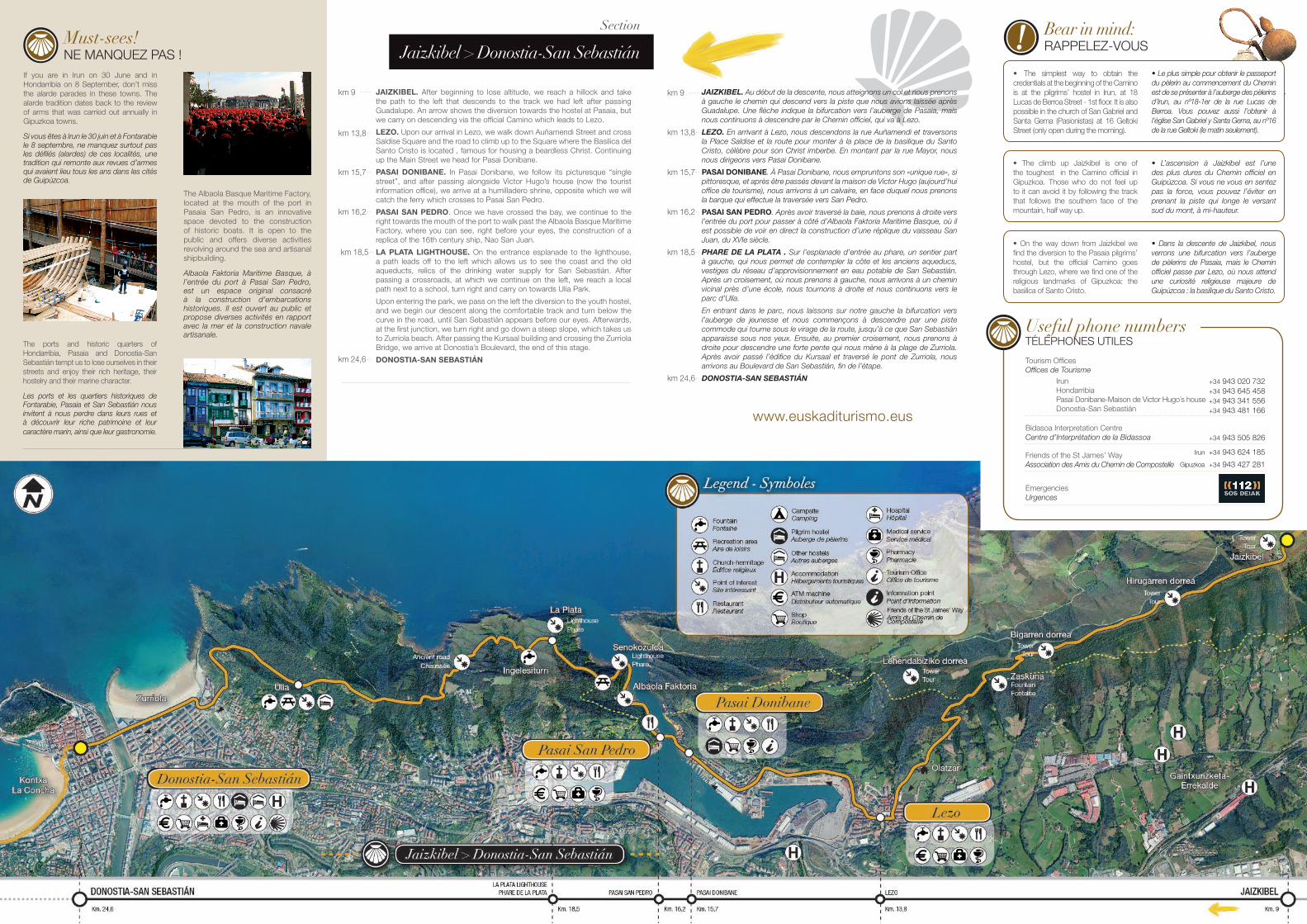
Jaizkibel > Donostia-San Sebastián
Section
km 9
km 16,2
km 18,5
km 9
km 13,8
km 15,7• The climb up Jaizkibel is one of the toughest in the Camino official in Gipuzkoa. Those who do not feel up to it can avoid it by following the track that follows the southern face of the mountain, half way up.
• L’ascension à Jaizkibel est l’une des plus dures du Chemin officiel en Guipúzcoa. Si vous ne vous en sentez pas la force, vous pouvez l’éviter en prenant la piste qui longe le versant sud du mont, à mi-hauteur.
• The simplest way to obtain the credentials at the beginning of the Camino is at the pilgrims’ hostel in Irun, at 18 Lucas de Berroa Street - 1st floor. It is also possible in the church of San Gabriel and Santa Gema (Pasionistas) at 16 Geltoki Street (only open during the morning).
• Le plus simple pour obtenir le passeport du pèlerin au commencement du Chemin est de se présenter à l’auberge des pèlerins d’Irun, au nº18-1er de la rue Lucas de Berroa. Vous pouvez aussi l’obtenir à l’église San Gabriel y Santa Gema, au nº16 de la rue Geltoki (le matin seulement).
• On the way down from Jaizkibel we find the diversion to the Pasaia pilgrims’ hostel, but the official Camino goes through Lezo, where we find one of the religious landmarks of Gipuzkoa: the basilica of Santo Cristo.
• Dans la descente de Jaizkibel, nous verrons une bifurcation vers l’auberge de pèlerins de Pasaia, mais le Chemin officiel passe par Lezo, où nous attend une curiosité religieuse majeure de Guipúzcoa : la basilique du Santo Cristo.
www.euskaditurismo.eus
JAIZKIBEL. Au début de la descente, nous atteignons un col et nous prenons à gauche le chemin qui descend vers la piste que nous avions laissée après Guadalupe. Une flèche indique la bifurcation vers l’auberge de Pasaia, mais nous continuons à descendre par le Chemin officiel, qui va à Lezo.
LEZO. En arrivant à Lezo, nous descendons la rue Auñamendi et traversons la Place Saldise et la route pour monter à la place de la basilique du Santo Cristo, célèbre pour son Christ imberbe. En montant par la rue Mayor, nous nous dirigeons vers Pasai Donibane.
PASAI DONIBANE. À Pasai Donibane, nous empruntons son «unique rue», si pittoresque, et après être passés devant la maison de Victor Hugo (aujourd’hui office de tourisme), nous arrivons à un calvaire, en face duquel nous prenons la barque qui effectue la traversée vers San Pedro.
PASAI SAN PEDRO. Après avoir traversé la baie, nous prenons à droite vers l’entrée du port pour passer à côté d’Albaola Faktoria Maritime Basque, où il est possible de voir en direct la construction d’une réplique du vaisseau San Juan, du XVIe siècle.
PHARE DE LA PLATA . Sur l’esplanade d’entrée au phare, un sentier part à gauche, qui nous permet de contempler la côte et les anciens aqueducs, vestiges du réseau d’approvisionnement en eau potable de San Sebastián. Après un croisement, où nous prenons à gauche, nous arrivons à un chemin vicinal près d’une école, nous tournons à droite et nous continuons vers le parc d’Ulía.
En entrant dans le parc, nous laissons sur notre gauche la bifurcation vers l’auberge de jeunesse et nous commençons à descendre par une piste commode qui tourne sous le virage de la route, jusqu’à ce que San Sebastián apparaisse sous nos yeux. Ensuite, au premier croisement, nous prenons à droite pour descendre une forte pente qui nous mène à la plage de Zurriola. Après avoir passé l’édifice du Kursaal et traversé le pont de Zurriola, nous arrivons au Boulevard de San Sebastián, fin de l’étape.
DONOSTIA-SAN SEBASTIÁN
JAIZKIBEL. After beginning to lose altitude, we reach a hillock and take the path to the left that descends to the track we had left after passing Guadalupe. An arrow shows the diversion towards the hostel at Pasaia, but we carry on descending via the official Camino which leads to Lezo.
LEZO. Upon our arrival in Lezo, we walk down Auñamendi Street and cross Saldise Square and the road to climb up to the Square where the Basilica del Santo Cristo is located , famous for housing a beardless Christ. Continuing up the Main Street we head for Pasai Donibane.
PASAI DONIBANE. In Pasai Donibane, we follow its picturesque “single street”, and after passing alongside Victor Hugo’s house (now the tourist information office), we arrive at a humilladero shrine, opposite which we will catch the ferry which crosses to Pasai San Pedro.
PASAI SAN PEDRO. Once we have crossed the bay, we continue to the right towards the mouth of the port to walk past the Albaola Basque Maritime Factory, where you can see, right before your eyes, the construction of a replica of the 16th century ship, Nao San Juan.
LA PLATA LIGHTHOUSE. On the entrance esplanade to the lighthouse, a path leads off to the left which allows us to see the coast and the old aqueducts, relics of the drinking water supply for San Sebastián. After passing a crossroads, at which we continue on the left, we reach a local path next to a school, turn right and carry on towards Ulia Park.
Upon entering the park, we pass on the left the diversion to the youth hostel, and we begin our descent along the comfortable track and turn below the curve in the road, until San Sebastián appears before our eyes. Afterwards, at the first junction, we turn right and go down a steep slope, which takes us to Zurriola beach. After passing the Kursaal building and crossing the Zurriola Bridge, we arrive at Donostia’s Boulevard, the end of this stage.
DONOSTIA-SAN SEBASTIÁN
km 13,8
km 18,5
Useful phone numbersTÉLÉPHONES UTILES
EmergenciesUrgences
+34 943 505 826 Bidasoa Interpretation CentreCentre d’Interprétation de la Bidassoa
+34 943 020 732+34 943 645 458+34 943 341 556+34 943 481 166
Tourism OfficesOffices de Tourisme
+34 943 624 185
+34 943 427 281Friends of the St James’ Way Association des Amis du Chemin de Compostelle
Irun
Gipuzkoa
IrunHondarribiaPasai Donibane-Maison de Victor Hugo´s houseDonostia-San Sebastián
km 16,2
km 24,6
km 15,7
km 24,6