The Water Balance of South African Coal Mine Pit Lakes
6
679 Wolkersdorfer, Ch.; Sartz, L.; Weber, A.; Burgess, J.; Tremblay, G. (Editors) Abstract Pit lakes form in open cast mines which extend below the groundwater level, aſter de- watering stops. Groundwater levels are disturbed during mining and associated dewa- tering operations. e information presented in this paper serves to determine if pit lakes are an environmentally stable/ viable solution for South African coal mines aſter closure. Pit lake water balances to approximate the final water volume and rest water eleva- tion were constructed with the use of a Goldsim program. Two case studies of South African Coal Mine Pit Lakes will be discussed; • e first study area is a standalone pit lake located in the Waterberg Coalfield and no backfilled has been used in attempt to close the final void; and • e second study area consists of a series of 7 pit lake (of which only 4 are investi- gated for this study) associated with a single mining operation and is located in the Highveld Coalfield. Some portions of the mine have been rehabilitated. Both study areas are located in climatic settings where average annual rainfall exceeds mean annual evaporation. Pit lake water balance modelling demonstrates that both study areas operate as terminal sinks, with the great evaporation potential keeping the pit lake water levels below discharge points. Climate plays an important role in under- standing the key drivers of the pit lake water balance and therefore extreme weather conditions to address the effects of wet and dry scenarios were applied to the models to determine if the pit lakes would result in mine water discharge during wet weather events. e net losses or gains of the pit lakes were determined from stage curves which were based on the bathymetric survey of each pit lake. While the accuracy of the water balances is dependent in the accuracy of the input parameters, a limitation to the water balance modelling is gaps in the data. Water balance modelling is applied to determine the behaviour of the coal mine pit lakes under investigation and their potential for mine water overflow. Keywords: Pit Lakes, Water Balance, Closure Option The Water Balance of South African Coal Mines Pit Lakes Matsatsi Mpetle 1 , Andrew Johnstone 2 1 University of the Free State, 205 Nelson Mandela Dr, Park West, Bloemfontein, 9301, [email protected] 2 GCS Water and Environmental (Pty) Ltd, 63 Wessel Road, Rivonia, 2128, South Africa, [email protected] Introduction A water balance model is described as an ac- counting for the volume of water flow rate from all probable sources (Gholamnejad, 2008). e final pit lake volume is influenced by a range of factors such as rainfall, evapo- ration, hydrogeology and the pit geometry. Water balance models are generally based on the law of conservation of mass which states that whatever water enters the storage should equal to the water stored or released from storage. In its simplest form, the equation may be written as: Inflow = Outflow ± ΔStorage e aim of the present study is to develop water balance models for South African Coal pit lakes, to increase understanding of the pit lake hydrology before concluding whether or not pit lakes are an environmentally suitable method for South African open pit coal mines. Depending on the components of the pit lake
Transcript of The Water Balance of South African Coal Mine Pit Lakes
679Wolkersdorfer, Ch.; Sartz, L.; Weber, A.; Burgess, J.; Tremblay, G. (Editors)
AbstractPit lakes form in open cast mines which extend below the groundwater level, a� er de-watering stops. Groundwater levels are disturbed during mining and associated dewa-tering operations. � e information presented in this paper serves to determine if pit lakes are an environmentally stable/ viable solution for South African coal mines a� er closure.
Pit lake water balances to approximate the � nal water volume and rest water eleva-tion were constructed with the use of a Goldsim program. Two case studies of South African Coal Mine Pit Lakes will be discussed;• � e � rst study area is a standalone pit lake located in the Waterberg Coal� eld and
no back� lled has been used in attempt to close the � nal void; and• � e second study area consists of a series of 7 pit lake (of which only 4 are investi-
gated for this study) associated with a single mining operation and is located in the Highveld Coal� eld. Some portions of the mine have been rehabilitated.
Both study areas are located in climatic settings where average annual rainfall exceeds mean annual evaporation. Pit lake water balance modelling demonstrates that both study areas operate as terminal sinks, with the great evaporation potential keeping the pit lake water levels below discharge points. Climate plays an important role in under-standing the key drivers of the pit lake water balance and therefore extreme weather conditions to address the e� ects of wet and dry scenarios were applied to the models to determine if the pit lakes would result in mine water discharge during wet weather events.
� e net losses or gains of the pit lakes were determined from stage curves which were based on the bathymetric survey of each pit lake. While the accuracy of the water balances is dependent in the accuracy of the input parameters, a limitation to the water balance modelling is gaps in the data. Water balance modelling is applied to determine the behaviour of the coal mine pit lakes under investigation and their potential for mine water over� ow.Keywords: Pit Lakes, Water Balance, Closure Option
The Water Balance of South African Coal Mines Pit Lakes Matsatsi Mpetle1, Andrew Johnstone2
1University of the Free State, 205 Nelson Mandela Dr, Park West, Bloemfontein, 9301, [email protected]
2GCS Water and Environmental (Pty) Ltd, 63 Wessel Road, Rivonia, 2128, South Africa, [email protected]
Introduction A water balance model is described as an ac-counting for the volume of water � ow rate from all probable sources (Gholamnejad, 2008). � e � nal pit lake volume is in� uenced by a range of factors such as rainfall, evapo-ration, hydrogeology and the pit geometry. Water balance models are generally based on the law of conservation of mass which states that whatever water enters the storage should equal to the water stored or released from
storage. In its simplest form, the equation may be written as:
In� ow = Out� ow ± ∆Storage
� e aim of the present study is to develop water balance models for South African Coal pit lakes, to increase understanding of the pit lake hydrology before concluding whether or not pit lakes are an environmentally suitable method for South African open pit coal mines. Depending on the components of the pit lake
9_Geochemistry Hydogeology BOOK.indb 679 9/3/18 12:35 PM
11th ICARD | IMWA | MWD Conference – “Risk to Opportunity”
680 Wolkersdorfer, Ch.; Sartz, L.; Weber, A.; Burgess, J.; Tremblay, G. (Editors)
water balance, it may take several years before equilibrium state is reached (ÜNSAL, 2013). Calculations are conducted to determine the behaviour of the pit lakes over a predictive pe-riod of 20 years (2018-2038).
Pit lakes in semi-arid climatic settings are usually classi� ed as ‘� ow-through’ or ‘terminal sinks’ (McCullough et al., 2013). Once mining stops, groundwater levels re-bound and together with rainfall and run-o� , contribute to � ll the � nal void. Terminal sinks may form in arid environments where the potential evaporation is higher than the mean precipitation and the pit lake water el-evation is below the surrounding pre-min-ing groundwater level (Niccoli, 2009). If the pit lake water level reaches the pre-mining groundwater elevation and water is released into the aquifer as groundwater seepage, the pit lake is classi� ed as a ‘� ow-through’ (Mc-Cullough et al., 2013).
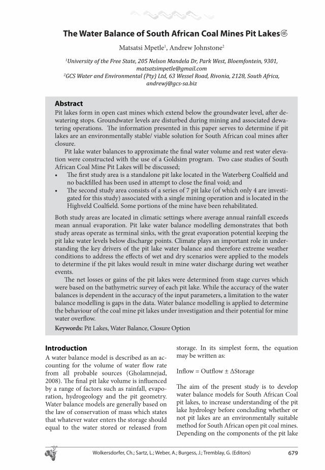
Figure 1 shows the locations of the areas under investigation. Each study area dem-onstrates unique hydrogeological conditions and therefore, conceptual models were con-structed separately.
Methods Climatic data for input were obtained from Water Resources of South Africa database (WRC, 2015). Aquifer parameters were ob-
tained by means of constant drawdown test, which involved the abstraction of a measured volume of water from a borehole whilst the water levels are recorded. Pump test data was analysed using the Jacob-Cooper solution.
Runo� coe� cients suggested by (Hodgson and Krantz, 1998) were applied to the runo� calculations using the equation provided by (Castendyk, 2009) which is as follows:
Q=CIA
Where Q is the runo� in� ow volume, C is the runo� coe� cient, I is the total precipitation and A is the area over which runo� occurs.
(Marinelli and Niccoli, 2000) provides a set of analytical equations for groundwater in� ow to a cylindrical pit (used to estimate � ow to Pit Lake A), as follows:
Q1=Wπ (r02-rp
2)
Where Q1 is the in� ow from the pit walls, W is the recharge � ux, r0 is the radius of in� u-ence, and rp is the radius of the pit lake.
Groundwater in� ow through the pit bot-tom is given by the equation:
Q2 = 4×rp × (Kh2/m2) × (h0 – d); m2 = (Kh2/Kv2)
1/2
Figure 1 Locality map of study areas
9_Geochemistry Hydogeology BOOK.indb 680 9/3/18 12:35 PM

11th ICARD | IMWA | MWD Conference – “Risk to Opportunity”
681Wolkersdorfer, Ch.; Sartz, L.; Weber, A.; Burgess, J.; Tremblay, G. (Editors)
Where rp is the radius of the pit lake, Kh2 and Kv2 are the hydraulic conductivity for the materials below the con� ning layer, h0 is the pre-mining groundwater level and d is the pit lake depth.
� e Dupuit-Forchheimer analytical equation given below was used to estimate groundwater in� ow to Pit Lake B:
Qg = π.K (h02-hw
2)/ln (r0/rw)
Where K is hydraulic conductivity (m/d), h0 is the pre-mining groundwater level (m), hw is the depth of the pit lake (m), r0 is the radius of in� uence (m) and rw is the radius of the pit lake (m).
(Singh and Atkins, 1985) suggests the usage of an equation given by (Mansur and Kaufman, 1962) to calculate the radius of a rectangular open pit:
r = (2/π) × (Y.W)1/2
Where Y is the length of the open pit, W is the width of the open pit and r is the equivalent radius of the mine. � is equation is applied to Pit Lake B to account for the irregular shape.
� e conceptual models were constructed from all available information, including borehole logs, to graphically illustrate the hy-drogeological factors a� ecting the open pits. Water balance models were developed with the use of Goldsim Academic version to ac-count for the volume of water in the pit lakes and to predict future pit lake water levels and volumes over wet and dry scenarios.
Models were run under probabilistic simulations using the Monte Carlo approach
with 50 realizations. Rainfall was modelled as a stochastic element, assuming a gamma distribution. � is simulation approach was used with intend to account for uncertainty and incorporate variability (McPhail, 2005).
Case Study 1Pit Lake A is situated in the Waterberg Coal-� eld of South Africa, and formed as a result of bulk sample excavation. � e total volume of the pit lake is approximately 101 99 00 m3. Mining started in 2009 and ended in 2010, af-ter which the � nal void � lled with water. Main facilities of the mine consists of the open pit of approximately 90 m depth, with a waste rock storage area located southwest of the open pit. Groundwater � ow is towards the Limpopo River, in a north easterly direction. � e area experiences mean annual precipitation of 438 mm and an average potential evaporation of 1950 mm/a. � e Waterberg Coal� eld is clas-si� ed as an arid climate area. Topography of the area is naturally undulating, dipping gently towards the Limpopo River. Geological setting of the area consists of the complete Karoo Su-pergroup succession with coal-bearing zones present in the Vryheid and Grootegeluk For-mations of the Ecca Group.
Figure 2 illustrates the components of the water balance model take into consider-ation during calculation. � e topography of the area is fairly � at and therefore runo� is minimal. Runo� from in-pit slopes is how-ever, expected to a� ect the water balance as the slopes are more compacted compared to the topsoil.
Pit in-� lling time series data which has been monitored from the time of closure was
Figure 2 Pit Lake A Conceptual Model
9_Geochemistry Hydogeology BOOK.indb 681 9/3/18 12:35 PM

11th ICARD | IMWA | MWD Conference – “Risk to Opportunity”
682 Wolkersdorfer, Ch.; Sartz, L.; Weber, A.; Burgess, J.; Tremblay, G. (Editors)
used to calibrate the model and Figure 3 com-pares the simulated pit lake elevation results determined using the most probable scenario and the observed pit lake elevation. A 98% correlation exists between the simulated and observed results.
Table 1 below is a summary of the cumu-lative volumes of water which has contributed to the current balance of water in the pit lake. Groundwater accounts for. 90% of the total volume contribution. Rainfall and Runo� ac-count for 8% and 2% respectively.
Wet case scenario shows that the volume of water in the pit lake could reach 549 580 m3 at an elevation of 844 mamsl, while the dry case scenario shows that the volume of water in the pit lake could reach 455 577 m3 at an elevation of 838.5 mamsl.
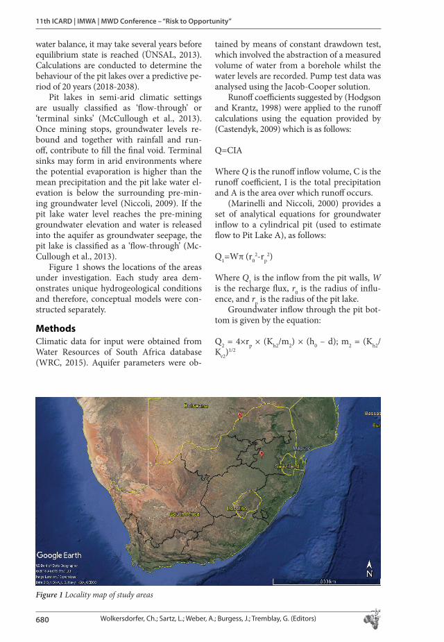
Case Study 2Pit Lake B is situated in the Highveld Coal-� eld of the Mpumalanga Province of South Africa. Seven pit lakes are present at this site which is partially back� lled and rehabilitated. Two streams are within the vicinity of the mining area, serving as the lowest elevations for surface drainage. Geologically, the study area is underlain by a thin sequence of Dwyka and Middle Ecca strata lying on an undulat-ing � oor composed of felsites, granites and diabase associated with the Bushveld Com-plex (Buchan et al., 1980). � e coal bearing zone is approximately 70 m thick with � ve coal seams. Mean annual precipitation value
for the catchment is 671 mm and average an-nual evaporation is 1600 mm.
Figure 4 demonstrates the conceptual model for the Kriel site where material has been back� lled into the open pit in an at-tempt to close the void. However, the pit lakes remained as � nal voids a� er back� lling. Ar-eas near the streams where not mined, these areas are represented by the undisturbed Ka-roo strata as illustrated. Information regard-ing the undisturbed geology were obtained from borehole geological logs.
Final pit lake voids are of varying sizes and ages. Properties of the pit lakes were de-termined from analyses bathymetric surveys. Points at which mine water will over� ow to the surface were modelled using the digital elevation model of the mine area surface and pit lake bathymetries. Global Mapper version 13 was used to simulate water level elevations to the points where over� ow would occur.
No in-pit � lling data were available for Pit Lake B, however, simulated results were compared to LiDAR elevation data which was only recorded from 2013. Table 3 shows is a summary of the cumulative volumes of water which have contributed to the current balance of water in the pit lakes.
� e rest water elevation of the pit lakes at the time of reporting was 1536 mamsl, which is also assumed to be the water elevation in the back� lled material. Extreme wet weather conditions could potentially cause the pit lakes to over� ow.
771781791801811821831841
25.5
.201
0
25.5
.201
1
25.5
.201
2
25.5
.201
3
25.5
.201
4
25.5
.201
5
25.5
.201
6
25.5
.201
7
Observed
Simulated
Figure 3 Simulated vs. Ob-served pit lake water levels
Ta ble 1. Water balance summary for Pit Lake A
Runo� (m3) Rainfall (m3) Groundwater In� ow (m3)
Evaporation (m3) Volume of water in pit lake (m3)
Percentage Filled (%)
14066 58896 644384 218087 499259 49
9_Geochemistry Hydogeology BOOK.indb 682 9/3/18 12:35 PM
11th ICARD | IMWA | MWD Conference – “Risk to Opportunity”
683Wolkersdorfer, Ch.; Sartz, L.; Weber, A.; Burgess, J.; Tremblay, G. (Editors)
Figure 4 Pit Lake B Conceptual Model
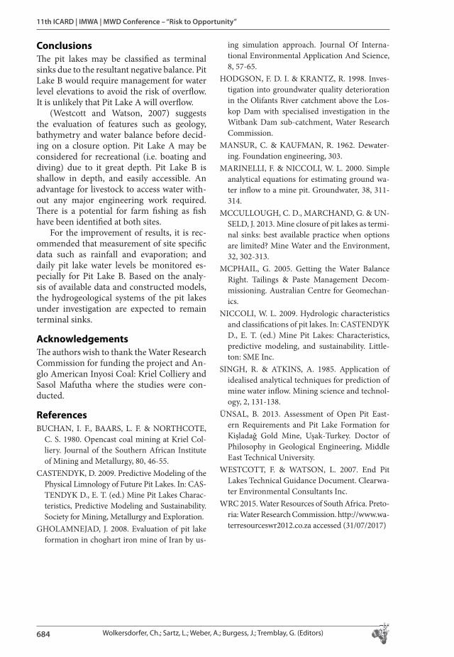
Ta ble 2. Geometrical properties of the pit lakes
Pit Name Age (years) Depth (m) Total Volume (m3) Point of Over� ow(mamsl)
44a44b44cR42
13131313
65.4
10.513.1
42493296687
202428356489
1537153715371537
Ta ble 3. Water balance summary for Pit Lake B
Pit Name Groundwater In� ow (m3)
Rainfall (m3) Runo� (m3) Out� ow (m3) Volume achieved (m3)
Percentage � lled
44a44b44cR42
1108000222846250828564644
1100000344601236866400940
24579518781714646086477
2198000687884472094724813
25571367379
162060327268
60708092
9_Geochemistry Hydogeology BOOK.indb 683 9/3/18 12:36 PM
11th ICARD | IMWA | MWD Conference – “Risk to Opportunity”
684 Wolkersdorfer, Ch.; Sartz, L.; Weber, A.; Burgess, J.; Tremblay, G. (Editors)
Conclusions� e pit lakes may be classi� ed as terminal sinks due to the resultant negative balance. Pit Lake B would require management for water level elevations to avoid the risk of over� ow. It is unlikely that Pit Lake A will over� ow.
(Westcott and Watson, 2007) suggests the evaluation of features such as geology, bathymetry and water balance before decid-ing on a closure option. Pit Lake A may be considered for recreational (i.e. boating and diving) due to it great depth. Pit Lake B is shallow in depth, and easily accessible. An advantage for livestock to access water with-out any major engineering work required. � ere is a potential for farm � shing as � sh have been identi� ed at both sites.
For the improvement of results, it is rec-ommended that measurement of site speci� c data such as rainfall and evaporation; and daily pit lake water levels be monitored es-pecially for Pit Lake B. Based on the analy-sis of available data and constructed models, the hydrogeological systems of the pit lakes under investigation are expected to remain terminal sinks.
Acknowledgements� e authors wish to thank the Water Research Commission for funding the project and An-glo American Inyosi Coal: Kriel Colliery and Sasol Mafutha where the studies were con-ducted.
References BUCHAN, I. F., BAARS, L. F. & NORTHCOTE,
C. S. 1980. Opencast coal mining at Kriel Col-liery. Journal of the Southern African Institute of Mining and Metallurgy, 80, 46-55.
CASTENDYK, D. 2009. Predictive Modeling of the Physical Limnology of Future Pit Lakes. In: CAS-TENDYK D., E. T. (ed.) Mine Pit Lakes Charac-teristics, Predictive Modeling and Sustainability. Society for Mining, Metallurgy and Exploration.
GHOLAMNEJAD, J. 2008. Evaluation of pit lake formation in choghart iron mine of Iran by us-
ing simulation approach. Journal Of Interna-tional Environmental Application And Science, 8, 57-65.
HODGSON, F. D. I. & KRANTZ, R. 1998. Inves-tigation into groundwater quality deterioration in the Olifants River catchment above the Los-kop Dam with specialised investigation in the Witbank Dam sub-catchment, Water Research Commission.
MANSUR, C. & KAUFMAN, R. 1962. Dewater-ing. Foundation engineering, 303.
MARINELLI, F. & NICCOLI, W. L. 2000. Simple analytical equations for estimating ground wa-ter in� ow to a mine pit. Groundwater, 38, 311-314.
MCCULLOUGH, C. D., MARCHAND, G. & UN-SELD, J. 2013. Mine closure of pit lakes as termi-nal sinks: best available practice when options are limited? Mine Water and the Environment, 32, 302-313.
MCPHAIL, G. 2005. Getting the Water Balance Right. Tailings & Paste Management Decom-missioning. Australian Centre for Geomechan-ics.
NICCOLI, W. L. 2009. Hydrologic characteristics and classi� cations of pit lakes. In: CASTENDYK D., E. T. (ed.) Mine Pit Lakes: Characteristics, predictive modeling, and sustainability. Little-ton: SME Inc.
SINGH, R. & ATKINS, A. 1985. Application of idealised analytical techniques for prediction of mine water in� ow. Mining science and technol-ogy, 2, 131-138.
ÜNSAL, B. 2013. Assessment of Open Pit East-ern Requirements and Pit Lake Formation for Kişladağ Gold Mine, Uşak-Turkey. Doctor of Philosophy in Geological Engineering, Middle East Technical University.
WESTCOTT, F. & WATSON, L. 2007. End Pit Lakes Technical Guidance Document. Clearwa-ter Environmental Consultants Inc.
WRC 2015. Water Resources of South Africa. Preto-ria: Water Research Commission. http://www.wa-terresourceswr2012.co.za accessed (31/07/2017)
9_Geochemistry Hydogeology BOOK.indb 684 9/3/18 12:36 PM