Geologic framework of the Boise Warm Springs geothermal area ...

UNITED STATES DEPARTMENT OF THE INTERIOR Harold L. Ickes, Secretary
GEOLOGICAL SURVEY W. C. Mendenhall, Director
Water-Supply Paper 819
THE WARM SPRINGS OF GEORGIA
THEIR GEOLOGIC RELATIONS AND ORIGIN
RY REPORT
D. F. HEWT«NDOG. W. CRICKMAY
V » **t*Prepared in cqope?ktio^^lh the
GEORGIA DEPARTipSff OFJiipRESTRY AND
UNITED STATES
GOVERNMENT PRINTING OFFICE
WASHINGTON : 1937
For sale by theJBuperintendent of Documents, Washington, D. C. Price 25 cents

CONTENTS
PageAbstract _________________________________________________________ 1Introduction ______________________________________________________ 1Scope of the investigation._________________________________________ 2Acknowledgments- ________________________________________________ 2Surface features.___--_------___-_-___________.________-_--_____-__ 2Warm springs of the region_________________________________________ 3
Warm Springs.___________________________________ ___________ 4Parkman Spring_______________________________________________ 9Brown's Spring_________-_-____________________________________ 10Thundering Spring___________________________________________ 10Barker Spring.._______________________________________________ 10Lifsey Spring._________________________________________________ 10Taylor Spring.________________________________________________ 11Summary of the warm springs_________--_-___-_______--__-_---_- 11
Cold springs of the region._-_-____--______________-----_---__-____- 11Cold Spring______________._____._________________ ._________ 11Trammel's Spring.____________ ________________________________ 13Blue Spring___.__.__________________________________ 13Cold chalybeate springs._______________________________________ 13Summary of the cold springs.___________________________________ 14
Chemical character of the waters.__-______________________--__--_-_- 15Gases in the spring waters._________________________________________ 21Other hydrologic investigations____________________________________ 21
Rainfall__________________________________________________ 22Water levels in wells.__________________________________________ 23Streams ______________________________________________________ 23
Rock formations___-___---_-_.___-_________-_-__-____-__-____-_-_ 25Pre-Cambrian rocks north of Towaliga fault ______________________ 26
Carolina gneiss____________________________________________ 26Snelson granite_______---_______-_-_ v ---_____-_____-____--_ 26
Pre-Cambrian rocks south of Towaliga fault______________________ 27Sparks schist_____________________________________________ 27Hollis quartzite.__________ _______________________________ 27Manchester schist________--______-______------_--------__- 29Woodland gneiss_______________-___--____--__-_-_---_-_-__ 29Cunningham granite.______________________________________ 30
Triassic igneous rocks.-_-_-_-_-_________-_-___-__--_-_-_--_---_ 30Tertiary (?) and later sedimentary rocks_________-___-____-_-__- 30
Structural features_________________________________________________ 31Source of the Warm Springs water_________________________________ 32Source of the heat of Warm Springs water.__________--__-__----_--__- 34Source of the Cold Spring water___________________________________ 35Measures for improving the Warm Springs ___________________________ 36Index._________________________________________________________ 39
in

ILLUSTKATIONS
PLATE 1. Geologic map of Warm Springs quadrangle, Ga_-__ ____ In pocket2. Generalized geologic map of west-central Georgia and east-
central Alabama, showing location of Warm Springs quad rangle and principal springs. _____________________________ 4
3. Map of the Warm Springs area showing sources of warm water,pools, drains, and improvements.________ ______________ 4
4. Relation of discharge of Warm Springs to rainfall and ground- water level at Roosevelt farm, January 1, 1934, to June 30, 1935________________________________ 12
5. Weekly average discharge of North Spring and weekly rainfall atRoosevelt farm_____ ____________________________________ 12
6. Fluctuations of ground-water level in four wells and relation torainfall, eastern part of Pine Mountain area_ ____.___.__.___ 20
7. Outline map of Pine Mountain drainage basins showing streamdischarge March 12,13,14, 23,1934_ _______________ 24
8. Outline map of Pine Mountain drainage basins showing averagestream discharge July 1,1934, to June 30,1935_ ________ 24
FIGUBE 1. Cross section through Pine Mountain and Warm Springs showing geologic structure and probable course of the water discharged at Warm Springs_______._____-____--_____-_______-_-._ 33
IV
THE WARM SPRINGS OF GEORGIATHEIR GEOLOGIC RELATIONS AND ORIGIN A SUMMARY
REPORT
By D. F. HEWETT and G. W. CBICKMAY
ABSTRACT
Seven groups of warm springs are known in Georgia, but popular interest centers in Warm Springs, in the western central part of the State, which is improved for use in the Georgia Warm Springs Foundation. A geologic study shows that the several warm springs are confined to a belt of pre-Cambrian metamorphic rocks and that their general distribution is determined by one of the members, the Hollis quartzite. ,A hydrologic study that extended over about 21 months included observations on rainfall, water levels in wells, spring and stream dis charge from an area of 32 square miles, and chemical character and temperature of the water. The data show that the water of Warm Springs is that which falls on the crest of Pine Mountain and is carried in the Hollis quartzite to a depth of about 3,000 feet so that it absorbs heat from the rocks and is delivered at the surface with a temperature of 88° F.
INTRODUCTION
Long before the War between the States, Warm Springs, Ga., was a health and bathing resort for the people of the region. In recent years, and especially since the establishment in 1926 of the Georgia Warm Springs Foundation for the treatment of victims of infantile paralysis, with the improvement of the springs and the erection of adequate buildings, interest in the area has greatly broadened.
The group of springs, some of them warm, along the north base of Pine Mountain have long been recognized as presenting interesting geologic problems worthy of study. Why are these springs found where they are? Why are some warm and others cold? What is the source of the warm water? Is all or a part of it derived from great depths, possibly from the same sources as igneous rocks, or is all or a part of it water that has fallen as rain on the surface? By what channels does it rise to the point of outlet? What improvements might be made to conserve the warm water and to maintain or increase its temperature? These are questions that require geologic research for their solution.
Funds allotted by the Public Works Administration in 1933 enabled the Geological Survey to undertake a study of these problems.
I

2 THE WARM SPRINGS OF GEORGIA
SCOPE OF THE INVESTIGATION
The program included a geologic reconnaissance of a large part of the region, the making of a geologic map of the Warm Springs quad rangle (pi. 1) for which a new topographic base map was prepared, and a detailed study of the geologic features of the part of Pine Mountain that lies near Warm Springs. Inits.&y;eb^logic^f*eote the investiga tion included a study of the distribution, environment, discharge, chemical character, and temperature of the spring waters-of tkeregpsm; also, because of their bearing on the probable source of the spring waters, measurements of the local rainfall and of water levels in select ed wells, and determinations of the distribution of the run-off of the streams from an area of 32 square miles on Pine Mountain near Warm Springs. Field studies in the region extended from October 1, 1933, to June 30, 1935.
This report presents in brief form the essential data and outstanding conclusions of each phase of the investigation. Inasmuch as interest centers on the springs, only such geologic data as are necessary to their study are presented here. A complete report is in preparation.
ACKNOWLEDGMENTS
In a full sense, this was a cooperative investigation. The Georgia Department of Forestry and Geological Development cooperated with the Geological Survey, of the United States Department of the Interior, in the broad plan and in the study of the geologic features of the region. O. E. Meinzer, W. D. Collins, L. K. Wenzel, and other members of the water-resources branch of the Federal Survey cooper ated in the planning and execution of the field and laboratory work. W. L. Lamar, also of the Federal Survey, collected numerous samples of water and made all water analyses. Analyses of the gases were made by W. P. Yant, of the Bureau of Mines. The equipment for measuring rainfall and stream and spring discharge was installed by C. E. McCashin and D. H. Barker, resident engineers in the Mont gomery office of the Geological Survey. From March to September 1934 L. D. Cannon, of the Georgia Warm Springs Foundation, made observations on rainfall, water levels in wells, and spring discharge. From September 1934 to June 30, 1935, D. E. Booth, engineer, was employed to make all local observations and measurements. C. E. Van Orstrand, of the Geological Survey, gave advice concerning the method of measuring earth temperatures and supplied the equipment used for that purpose.
SURFACE FEATURES
Most of the Warm Springs quadrangle is a gently rolling upland, known as the Greenville Plateau, above which rise two persistent ridges, Pine and Oak Mountains, and into which the streams have

WARM SPRINGS OF THE REGION 3
carved small open valleys. The entire area lies within the broad, relatively flat belt of central Georgia known as the Central Upland, a local subdivision of the Piedmont province. South of it lies the lower, flat Coastal Plain region that makes up the south half of the State, and to the north lies a mountainous region that comprises parts of th©^Lookout Plateau, the Valley and Ridge province, and the Appalachian Highlands. 1
In the vicinity of Warm Springs the rolling upland lies at an altitude of 760 to 980 feet. Above it Pine Mountain rises to altitudes that range generally from 1,100 to 1,200 feet, but at Dowdell Knob it attains the maximum of 1,395 feet. In this region Pine Mountain departs from the simple linear ridge that is characteristic of most of its length in western Georgia. South of Warm Springs it broadens to a flat-topped mountain 3 miles wide, and eastward the ridge joins a peculiar circular ridge that encloses the depression locally known as the Cove. Near the southern border of the Warm Springs quad rangle is Oak Mountain, a linear ridge that largely ranges in altitude from 900 to 1,100 feet and therefore rises several hundred feet above 'the-adj&ee&t plateau.
The dominant streams of west-central Georgia are the Flint and Chattahoochee Rivers, both of which flow generally southward. The Flint River lies within the eastern border of the Warm Springs quadrangle, and many of the minor streams of this region drain east ward and southeastward to it. The Chattahoochee River lies beyond the western border of the quadrangle, and several streams of this region flow westward and southwestward to it. The divide between the streams that are tributary to these two rivers extends northward from Warm Springs.
In its primitive state, all of this region was doubtless covered with dense forest, mostly oak and other hardwoods but including pine of /-several. varieties. At present about two-thirds of the -area north of Pine Mountain has been cleared and is under cultivation. About half of the area south of Pine Mountain has been cleared. On Pine Mountain the lower slopes are locally cleared and in part are planted with orchards. Most of the marketable timber has been removed from the forest areas by selective cutting. Although the rocks under lying the upland of the Greenville Plateau are of different kinds, the residual soils have* much resemblance, and all are susceptible to erosion and gullying, with the result that large areas have been ren dered unfit for further cultivation.
WARM SPRINGS OF THE REGION
The, known «Wlfem; springs of Georgia are found in a belt that ex tends from Barnesville southwestward about 40 miles to Warm Springs. It has been known for more than a hundred years that the
i LaForge, Laurence, Physical geography of Georgia: Oeorgia Oeol. Survey Bull. 42, pp. 77-80, 1925.

4 THE WABM SPRINGS OP GEORGIA
waters of some of these springs were appreciably warm, and when the present investigation was undertaken the pools produced by five of the springs Warm Springs, Thundering Spring, Barker Spring, Lifsey Spring, and Taylor Spring (pi. 2) had been used from time to time for either swimming or bathing. During this investigation two more warm springs were discovered, Parkman and Brown's Springs, and additional sources of warm water were' found near Thundering Spring. The spring having the highest temperature, Warm Springs (88° F.), has also the largest discharge (594 to 678 gallons a minute), and the warm spring having the lowest temperature, Brown's Spring (69° F.), has the smallest discharge (15 to 30 gallons a minute).
According to the records of the United States Weather Bureau, the average air temperature at West Point, 28 miles west of Warm Springs, is 63.3° F., and at Talbotton, 17 miles southeast, 64.1° F. The aver age temperature of the water in 36 wells in the lowland adjacent to the Pine Mountain area is 62.1° F. In this investigation springs whose temperature is higher than 66° F. have been classified as warm.
All these warm springs, as well as several large cold springs, issue in the Wacoochee belt, a large part of which is made up of a series of altered sedimentary rocks, called by Galpin 3 the Pine Mountain formation (pi. 2). This series extends from Barnesville southwest- ward almost to Notasulga, Ala., a distance of 100 miles. The most conspicuous unit of the series is a formation known as the Hollis quartzite, usually 275 to 800 feet thick in this region. In the part of the belt under consideration the quartzite underlies a group of extensive but poorly defined ridges that make up Pine Mountain, which here rises 200 to 500 feet above the surrounding upland. All the warm springs issue at the surface in the upland areas, near the ridges. All except Warm Springs rise through the Manchester schist, which overlies the quartzite, or through local alluvium.
Warm Springs (no. 1, pi. 2). The warm springs for which this region has become nationally famous issue at the north base of a low knoll which is the site of the Georgia Warm Springs Foundation. They are half a mile west of the town of Warm Springs, where the Columbus branch of the Southern Kailway crosses the Atlanta, Birmingham & Coast Kailway, which extends from Brunswick, Ga., to Birmingham, Ala. The population of the town of Warm Springs is about 300, but 250 more reside at the Foundation. The pools and bathhouses used for therapeutic treatments are adjacent to the springs (pi. 3), but the other buildings xof the institution are in fc grove of pine and oak that covers the knoll. About 200 acres of land that includes the knoll and the springs is owned by the Georgia Warm Springs Foundation, an incorporated nonprofit organization.
This investigation reveals a record of the springs as early as 1819, when they were improved with bathhouses and there was a
1 Galpin, S. L., Feldspar and mica deposits of Georgia: Georgia Geol. Surrey Boll. 30, p. 74,1915.

GEOLOGICAL SUBVEY WATER-SUPPLY PAPER 819 PLATE 3
84°
ndian Springs o
%, O THOMASTON
LIST OF SPRINGS1.'Warm Springs 6.Lifsey Sprin2. Parkman Spring 7. Taylor Sprin3. Brown's Spring 8-Blue Spring4. Thundering Spring 9. Trammels Spring5. Barker Spring
EXPLANATION
Chewacla marble
Known outcrop of Hollis quartzite
GENERALIZED GEOLOGIC MAP OF WEST-CENTRAL GEORGIA AND EAST-CENTRAL ALABAMA, SHOWING LOCATION OF WARM SPRINGS QUADRANGLE (SHADED AREA) AND PRINCIPAL SPRINGS (NUMBERED).

GEOLOGICAL SURVEY WATER-SUPPLY PAPER 819 PLATS 3
EXPLANATION
«43
Point of measurement of discharge and temperatureNumbers correspond to
those in table in text
MAP OF THE WARM SPRINGS AREA, SHOWING SOURCES OF WARM WATER, POOLS, DRAINS, AND IMPROVEMENTSNumbers indicate points where discharge was measured.

WARM SPRINGS OF THE REGION $
liotel nearby, but doubtless they were in use long before that time.8 In 187 5 the water was conveyed by an open ditch to six uncovered masonry chambers, each 10 by 10 feet, which were used for bathing. These masonry chambers, now covered with concrete roofs, are used as a reservoir from which the water is distributed to the places of use. Plate 3 shows the known sources of warm water and the build ings that have been erected to use it.
The main sources of warm water lie south of the group of masonry chambers, but minor sources are found as much as 250 feet to the east and 250 feet to the west. At present only the water from the main sources is under control for use. From December 14, 1933, to June 30, 1935, the discharge under control ranged from 594 to 678 gallons a minute (pp. 7-9). Measurements of ,the discharge of all the minor sources during the same period ranged from 233 to 294 gallons a minute (p. 9). The total discharge of all sources, therefore, ranged from 844 to 914 gallons a minute. Several measurements made as much as 40 years ago indicated a discharge of 666 to 1,890 gallons a minute, but when the place and method of measurement are considered, there is no reason for thinking that the total discharge from all sources has varied greatly-^-probably not more than 20 percent during this period.
The main source of the supply may be examined in a chamber 24 feet long and 4 feet high that lies south of the eastern group of three masonry chambers (pi. 3). Most of this chamber is lined with loosely laid quartzite blocks, from the cracks of which considerable water issues, but a recess in the wall reveals an open fissure in hard quartzite from which about 200 gallons a minute is flowing almost horizontally. Some water and bubbles of gas rise from the sand that covers the bottom of the eastern two chambers. The only additional water that enters the reservoir about 75 gallons a minute is discharged from a hole in the south wall of the westernmost of the six chambers, but the conditions behind the wall are not known.
Precise measurements of the temperature of the Warm Springs water as it issues from the ground at its main east and west sources were made on seven different days in 1933,1934, and 1935 by using a platinum resistance thermometer. At the east source the temperature on different days ranged from 87.7° to 88.2° F., and at the west source from 87.1° to 87.5° F. On the same day the temperature at the east source was found to be 0.6° to 0.7° F. higher than the west source. A recording thermometer reading to single degrees was
* White, George, Statistics of Georgia, p. 424,1849; Historical collections of Georgia, p. 550,1854. Walton, G. E., Mineral springs of the United States and Canada, p. 810,1878. Duggan, J. R., Mineral springs of Georgia, p. 53,1881. Weed, W. H., Notes on certain hot springs of the southern United States: Geol. Survey Water-Supply Paper 145, pp. 187-189, 1905. Hall, B. M. and M. R., Water resources of Georgia: Geol. Survey Water-Supply Paper 197, p. 14,1907. McCallie, S. W., Mineral springs of Georgia, p. 166, Georgia Geol. Surrey, 1913. Watson, T. L., Thermal springs of the southeast Atlantic States; Jour, Geology, vol. 82, pp. 380-382,1924. ,
15468 37 2
6 THE WARM SPRINGS OF
installed in the east source in April 1934, and during the following year and a half it indicated that the temperature at this source varied less than 1° F.
The locations of the places where the discharge from minor sources was measured are shown on plate 3. Doubtless there are other sources in this area, but they cannot be identified now. Stated broadly, warm water issues from numerous sources in a narrow belt about 500 feet long that closely follows the base of a hill of quartzite where it meets a local plain underlain by unconsolidated alluvium. Most of the water, about 550 gallons a minute, is discharged from the middle 25 feet of this belt, and this water shows the highest temperature. During the investigation the temperature of this water ranged from 87.6° to 88.2° F. Progressively outward, both east and west, from this middle part, the discharge of the separate sources was lower and the temperature of the water was lower, dropping to 83° F. at the westernmost source and to 79° F. at the easternmost source.
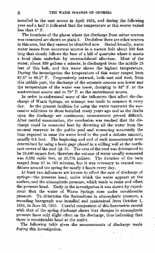
In order to understand some of the influences that affect the dis charge of Warm Springs, an attempt was made to measure it every day. As the present facilities for using the water represent the suc cessive additions to those installed many years ago and as the drafts upon the discharge are continuous, measurement proved difficult. After careful examination, the conclusion was reached that the dis charge could be measured best by diverting all the water from the covered reservoir to the public pool and measuring accurately the time required to raise the water level in the pool a definite amount, usually 0.8 foot. The beginning and end of each measurement were determined by using a hook gage placed in a stilling well at the north east corner of the pool (pi. 3). The area of the pool was determined to be 10,490 square feet; therefore the volume of water usually measured was 8,392 cubic feet, or 62,776 gallons. The duration of the tests ranged from 95 to 105 minutes, but it was necessary to control con ditions around the spring for nearly 3 hours every day.
At least two influences are known to affect the rate of discharge of springs the pressure head, under which the water appears at the surface, and the atmospheric pressure, which tends to resist and offset the pressure head. Early in the investigation it was shown by experi ment that the water of Warm Springs rises under considerable pressure. To determine the fluctuations in atmospheric pressure, a recording barograph was installed and maintained from October 1, 1934, to June 30, 1935. Careful comparison of this barometric record with that of the spring discharge shows that changes in atmospheric pressure have only slight effect on the discharge, thus indicating that there is considerable head at the outlet.
The following table gives the measurements of discharge made during this investigation.

1 SPRINGS OF THE REGION
Flute 4 presents the graph of discharge calculated as the running average over 2 weeks for each week covered by the investigation. The record was intermittent through the spring of 1934 but was regular and very reliable from August 1, 1934, to June 30, 1935.
Measurements of discharge of Warm Springs, in gallons a minute
Date
1933Tlfln 14
Dec 15Dec. 19.......... Dec 20
r»n« 9Qnn« in
1934
Jan. 11 Jan. 12 ... .
Jan. 17 ...
Jan. 19 Jan. 22...-.. ..Jan. 23 ....
Feb. 9. _ .Mar. 15.. __ -- Mar. 16 Mar. 22 . Mar,26 Mar. 27 .Mar. 28 .Mar. 30 .
Apr. 9 ...............
Apr. 21.. _ .........May 1-. ____ --..May 16 ____ ..May 17.. ....May 23. ... -
July. .. ..
Aug. 6... ...Aug. 8 -_-._
Aug. 10.. ..... .Aug. 11.. ....... ... -.Aug. 13- ... Aug. 14.. ... --..Aug. 15 -Aug. 16.. ... -Aug. 18.. ...... ...Aug. 20..... ......Aug. 21. ..!.... ......Aug. 22. .............Aug. 23. ... .... .Aug. 24 ..............Aug. 25.. ... .Augr2T... __ .......Aug. 28. .....Aug. 29.. .Aug. 30..- ... ..Sept. 1... .- _ -.-- ...Sept. 4... ..
Daily rate
623.7626. 9615.7630.7621. 4614.8620.2
636.2618.4623.6628.7628.7615.7fl91 9
628.7618.8621.6614.8615.7617.2618.4631.8
619.4613.6
619.9COO A
637.5636.7622.1619.7634.5fiQO A
622.4620.4632.4623.6633.4639. 5642.7629.0632.4
0)650.5650.5662.6
642.7645 0651.8649.1663.3652.8644.6667.2651.0670.4651.0678.6656.6653:2630.1663.0653.2632.4636.7
Average for week
622.1
626.0
622.4
619 9
623.1619.4613.6
621.4
620.9
637.1632.4
652.0
650.8
656.8
655.9
Running average, 2 weeks
623.7
fi91 Q
fi9l Q
623.1619.4613.6
fi9Q Q
629.7
fi97 9
635.9
651.29
653.8
656.2
648.9
Date
1934 Sept. 5 Sept. 7... ... .Sept. 8
Sept. 11. Sept. 12.. _____ ..Sept. 14. _ ... .-
Spnt 1 QSept. 20 _ . _ .Sept. 21 Sept. 24 Sept. 25. ____ -..-
Sept. 27. Sept. 28... _ . __ -.Sept. 29 Oct. I....' Oct. 2.... ...........Oct. 5.... .... ... ... .Oct. 6.... Oct. 8... Oct. 9 ... Oct. 10....... .-Get: 11. ___ . .. .Oct. 12.., Oct. 13... -Oct. 15 Oct. 16.. _____ ..--Oct. 17 Oct. 18...... Oct. 19 __ . ___ --Oct. 20 __ - __ ..--Oct. 22... . -Oct. 23 Oct. 24 _ . ___ .....Oct. 25... Oct. 26... Oct. 27 Oct. 29...... ..... ....Oct. 30 _ . _____ ..Oct. 31...... ....... -Nov. 1_ .... .Nov. 2. ...... .Nov. 3. ...
Nov. 8. ........
Nov. 13..
Nov. 16 Nov. 17.
Nov. 20.. .... Nov. 21.
Nov. 23.. Nov. 24.... Nov. 27. Nov. 28. Nov. 29
Dec. 3..... ..-
Dec. 5... ....
Daily rate
636.7606.7607.2602.3621.4627.8617.5599.0621.6615.7623.1618.8631.8622.0620.2619.2614.8611.2612.6619.3610.3606.3609.0614.4607.2606.3612.6607.2612.2612.2614,0612.2613.6606.3609.5908.1609.9607.2608.6605.9605.3fins i607.2606.3fiOA 3
600 1604.5605.3609 9604.5602.3606.3614.8611.7
612.6619.0628.7616.3620.2606.0618.1612.2618.0615.6
610.8617.1618.0612.2
Average for week
635.3
613.1
613.4
623.2
614.4
611.1
610.7
fido Q
607.0
605.6
607.9
618.4
614.0
Running average, 2 weeks
621.4
613.2
618.3
618.8
612.7
610.9
610.3
608.5
606.2
606.5
613.6
616.4
613.9
1 No measurements; leaks in main pipe stopped.

8 THE WARM SPRINGS OF GEORGIA
Measurements of discharge of Warm Springy in gallons a minute Continued
Date
1934 Dec. 6.. .............
Dec. 8. _______Dec. 10 ..............Dec. 11. _____ ...Dec. 12. _ .. __ ...Dec. 13... _ . ___Dec. 14. _ ..... _ ..Dec. IS....... .......Dec. 16 ______ .Dec. 17 ..............Dec. 18... __ .... ...Dec. 19... __ .......Dec. 20 __ . .........Dec. 21 ..............Dec. 22........ __ .Dec. 23..... _ ......Dec. 24 ______ .Dec. 25 ..............Dec. 26... _ ........Dec. 27 _____ ....Dec. 28... _____ .Dec. 29. ___ ......Dec. 30. _______Dec. 31.. _____ .
1935Jan. 1................Jan. 2. ...............Jan. 3 __ . .Jan. 4 __ . _ .....Jan. 5 ................Jan. 6 _ .Jan. 7 ............Jan. 8 ................Jan. 9 ___ . .......Jan. 10 _____ ..Jan. 11 __ .... .....Jan. 12...............Jan. 13...............Jan. 14 _ ... ...Jan. 15 __ .. ....Jan. 16. ......Jan. 17 ...........Jan. 18 ...............Jan. 19. ...........Jan. 21. _____ .. .Jan. 22 _ ...........Jan. 23 _______ .Jan. 24. _ ...........Jan. 25.. .....Jan. 26 .............Jan. 27 ...............Jan. 28...............Jan. 29...............Jan. 30.... .....Jan. 31 ...............Feb. 1. ..............Feb. 2. _ . _ .......Feb. 3. ....... ... ....Feb. 5.. ...Feb. 6 ___ .........Feb. 7.. .............Feb. 8.. .............Feb. 9...............Feb. 10.. ............Feb. 11.......... ....Feb. 12 __ ..........Feb. 13... __ ......Feb. 14....... ....Feb. 15... ... .Feb. 16.. ............Feb. 17...... .....Feb. 18- ... ......Feb. 19..............Feb. 20.. ............Feb. 21..............Feb. 22........ __ .Feb. 23. __ .. _ ....Feb. 24.. ............
Daily rate
606.7609.0 610.8607.2603.2602.3601.4603.6602.3601.9613.6608.5602.8600.960S. 4598.7597.3599.2599.7601.4600.0603.6604.5603.2602.8
601.4603.2600.9602.3606.0604.5607.7615.7606.0618.9604.0602.3604.9609.5611.2611.2614.0606.4613.4607.7611.7600.1604.5605.4611.2611.2609.0606.0607.2604.9610.0606.0600.5612.6600.0597.3601.4612.6598.2615.7611.7607.2600.9619.9605.4595.5604.9616.7613.9611.2605.4607.2600.0
Average for week
613.9
605.8
fifU B
600.2
CAO 0
608.7
608.1
607.3
607.8
604 4
606.8
609.6
Runningaverage, 2 weeks
609.8
605.3
602.5
601.5
605.8
608.4
607.8
607.6
(VIA ^
605.7
AnQ O
AAQ 9
Date
1935 Feb. 25. __ .... __ .Feb. 26. __ .........Feb. 27 __ ... __ ..Feb. 28 __ ..........TV/Tan 1TV/Tar 9TWai- 9TV/Tar 19
Mar. 14........ ......
IVtar 19
IVtar 21IV/Tar OO
Mar. 23. ............
IVIsr 27
IVtar 29TV/Tar Qft
Apr. 1 ____ .......Apr. 2....... .'.......
Apr. 4.. ... ATM* H
A rvr ft
Apr. 10. _ ... _ ....Apr. 11.......... ....Apr. 12..... . .-Apr. 13..... . ..Apr. 15....... .......Apr. 16.... _ ..... Apr. 17. __ ....
Apr. 20-.. .. Apr. 22... __ .......Apr. 23. _ . _ - _ .Apr. 24... __
Apr.26 .... .Apr. 27.. __ . _ .
1WQT7 Q
TVTATT 1^TVfo-tr 1 A
May 15..... .....May 16. __May 17. ____ .... .TVT*nr Ifi
TX^ftTr 9*>May 23 __ ..... __May2A. __
May 27 _ ... ...May 28 ___ .......
May 30 ____ .......May 31 __ ... ....
DaUy rate
616.2616.2 610.8607.2
594.2firu n
609.7
627.4
R1Q Q
619.5624.7625.2
ftlQ Q
617.2611.7
619.5625.6627.0632.4632.8625.6
630.1
R1Q O624.7626.5
R1Q O617.1626.0
626.9632.4628.7626.9653.4640.0630.1629.7626.5622.4620.7622.5625.1624.6625.6627.8630.2632.6635.2638.8635.2625.6619.7626:. 9626.6629.4631.8610.0614.0R1Q O
631.4629.3635.7625.6AK1 1
fsAn «
633.5621.6
Average for week
622.5
619.4
AOA 1
620.7
622.0
627.3
635.9
624.1
625.5
635.5
Running average, 2 weeks
607.7
620.2
Aon o
622.5
623.4
621.4
624.4
629.4
627.6
628.2
630.5
628.0

WABM SPRINGS OF THE REGION 9
Measurement of discharge of Warm Springs, in gallons a minute Continued
Date
1935 June 1 ...............
June 10 ..............
Daily rate
616.6616.2618.4614.8612.6616.6609.5612.6609.0610.8
Average for week
617.7
612.0
Running average, 2 weeks
614.8
610.5
Date
1935
June 22 _ . ..........
June 28. . ......
Daily rate
609.0610.3604.1608.1606.3607.7606.3603.2614.0
Average for week
608.5
606.8
608.6
Running average, 2 weeks
608.0
607.4
Measurements of discharge of Warm Springs and surface drains
No. on plate 3
32 1..__....._.... ...........38 1 .......................34 ».
35.... ___ ....................36 ... __ ....................37 .. __ .. 38. __ .. 39 __ ... ....... ..... .....40 41 __ .. ____ ... - _____ ..42 ______ . _ . ____ .
Total (no. 42 minus no. 35).-
43. ....................44 . . . . 45. ______________ ....46. _____________ . ......47 48 __ -... 49 __ ._ _ .50 .
Total (no. 50 minus no. 43) ~
Total discharge of warm water, not including Warm
61 » ___ .... ...........
Tem pera ture Oct.
17-21,1934
(°F.)
65 6565
6582 84 86 79 86 86 80
62 8373 79 85 87 46 81
85
Discharge (gallons a minute)
1934
Oct. 17-21
12.1 6.3
24.2
14.4 34.6 39.9 13.5 4.5
31.4 20.2 85.8
71.4
32.8 24.2 85.8 3.1 1.1
54.8 1.1
194.4
161.6
233.0
Nov. 18
10.8
76.8
66.0
1.7
194.0
192.3
258.3
Dec. 8
12.1 6.3
26.5
16.6
88.0
71.4
16.6
227.0
210.4
281.8
1935
Jan. 5-6
18.8 8.1
26.9
16.6
90.2
73.6
30.1
244.0
213.9
287.5
Jan. 26,27
20.2 7.2
20.2
14.4
83.5
69.1
2.2
220.0
217.8
286.9
Feb. 9
15.7 7.2
11.3
15.7
83.5
67.8
Feb. 23
22.05.8
18.8
15.7
89.9
74.2
15.7
235.0
219.3
293.5
Mar. 23
62.9 9.9
33.2
14.4
81.7
67.3
0
221.0
221.0
288.3
35
Apr. 30
49.8 12.1 37.3
14.4
85.8
71.4
0
184.0
184.0
255.4
May 30
9.0 3.1
28.3
14.4
69.1
54.7
13.5
210.0
196.5
251.2
i Minor cold streams east of area shown on plate 3.' Spring 51 could be measured only when the water of the pond was drained.
Parkman Spring (no. 2, pi. 2). Parkman Spring was identified in December 1933, within the present area of Parkman's pond at a time when it was drained to a low level. The pond is created by a dam below the junction of two broad valleys that drain the eastern slope of a spur from Pine Mountain. The discharge was estimated to be between 50 and 100 gallons a minute, and the temperature of the main source on December 10, 1933, was 76.6° F. An analysis of the water appears in the table on page 17.
10 THE WARM SPRINGS OF GEORGIA
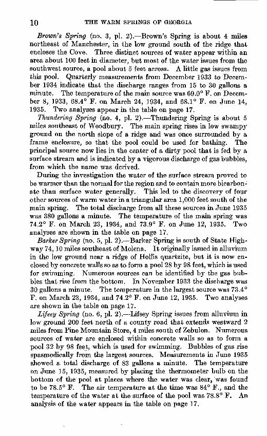
Brown's Spring (no. 3, pi. 2). Brown's Spring is about 4 miles northeast of Manchester, in the low ground south of the ridge that encloses the Cove. Three distinct sources of water appear within an area about 100 feet in diameter, but most of the water issues from the southwest source, a pool about 5 feet across. A little gas issues from this pool. Quarterly measurements from December 1933 to Decem ber 1934 indicate that the discharge ranges from 15 to 30 gallons a minute. The temperature of the main source was 69.0° F. on Decem ber 8, 1933, 68.4° F. on March 24, 1934, and 68.1° F. on June 14, 1935. Two analyses appear in the table on page 17.
Thundering Spring (no. 4, pi. 2). Thundering Spring is about 5 miles southeast of Woodbury. The main spring rises in low swampy ground on the north slope of a ridge and was once surrounded by a frame enclosure, so that the pool could be used for bathing. The principal source now lies in the center of a dirty pool that is fed by a surface stream and is indicated by a vigorous discharge of gas bubbles, from which the name was derived.
During the investigation the water of the surface stream proved to be warmer than the normal for the region and to contain more bicarbon ate than surface water generally. This led to the discovery of four other sources of warm water in a triangular area 1,000 feet south of the main spring. The total discharge from all these sources in June 1935 was 380 gallons a minute. The temperature of the main spring was 74.2° F. on March 23, 1934, and 73.9° F. on June 12, 1935. Two analyses are shown in the table on page 17.
Barker Spring (no. 5, pi. 2). Barker Spring is south of State High way 74,10 miles southeast of Molena. It originally issued in alluvium in the low ground near a ridge of Hollis quartzite, but it is now en closed by concrete walls so as to form a pool 28 by 98 feet, which is used for swimming. Numerous sources can be identified by the gas bub bles that rise from the bottom. In November 1933 the discharge was 30 gallons a minute. The temperature in the largest source was 73.4° F. on March 23, 1934, and 74.2° F. on June 12, 1935. Two analyses are shown in the table on page 17.
Li/sey Spring (no. 6, pi. 2). Lifsey Spring issues from alluvium in low ground 200 feet north of a county road that extends westward 2 miles from Pine Mountain Store, 4 miles south of Zebulon. Numerous sources of water are enclosed within concrete walls so as to form a pool 32 by 98 feet, which is used for swimming. Bubbles of gas rise spasmodically from the largest sources. Measurements in June 1935 showed a total discharge of 83 gallons a minute. The temperature on June 15, 1935, measured by placing the thermometer bulb on the bottom of the pool at places where the water was clear, was found to be 78.5° F. The air temperature at the time was 84° F., and the temperature of the water at the surface of the pool was 78.8° F. An analysis of the water appears in the table on page 17.

COLD SPRINGS OF THE REGION H
Taylor Spring (no. 7, pi. 2). Taylor Spring rises in the alluvium of a wide valley 900 feet west of U. S. Highway 19, 6.5 miles south of Zebulon. The course of the stream that drains the valley has been diverted to a new channel, and the sources of water have been enclosed by an earth embankment so as to form a pool 350 feet long and 100 feet wide at the lowest end. From this reservoir water is drawn to a con crete pool 40 by 130 feet, which is used for swimming. In June 1935 the spring discharge was 385 gallons a minute. The temperature of the water issuing from the springs hi the upper part of the reservoir was 74.8° F. on June 15,1935. An analysis of the water appears in the table on page 17.
Summary of the warm springs. Although this investigation was focused on the features and environment of Warm Springs, it seemed desirable to make general and intermittent observations of all the other warm springs that were known or could be found in the region. There may be unrecorded small springs of warm water in this general region, but it is believed that all that exist in the Warm Springs quadrangle have been found. The temperature and chemical char acter of the warm waters were surprisingly constant during the period of study. The discharge of Warm Springs varies, but not as much as that of the cold springs of the region; the maximum discharge was only 14 percent more than the minimum. Conditions were not favorable for making numerous precise measurements of discharge of the other warm springs. The chemical character of the warm waters is dis tinctive. (See p. 15.) The geologic relations of the warm springs are discussed on pages 32-35.
COLD SPRINGS OF THE REGION
At many places in this region there are springs that discharge several gallons a minute of clear cool water. These are commonly found on the lower slopes of hills and ridges. Such springs are abundant in most regions where the annual rainfall is 40 inches or more. At a few places in this region, however, there are springs that discharge several hundred gallons a minute or more of cool water, and interest is at tached to their origin. Among the springs that discharge only a few gallons a minute, there are some that deposit hydrated oxide of iron. Analyses show that the water from such springs contains much more iron than other waters, and they are commonly known as chalybeate springs.
Cold Spring. Within an area of about 8 acres about a mile south east of Warm Springs, there are four distinct springs which, for the purposes of this investigation, have been called Cold Spring, North Spring, and South Springs nos. 1 and 2. The assemblage is locally known as Cold Spring. All are found within a reservation used as a fish hatchery by the United States Government. This investiga tion indicates that any influence which affects the discharge of Cold

12 THE WARM SPRINGS OF GEORGIA
Spring also affects that of North Spring and that they are closely related. The South Springs, which are about 30 feet apart, are 700 feet southeast of North Spring; They seem to be separate outlets of the same source of water but are not closely related to Cold and North Springs. Each of the four springs is enclosed in a wall of concrete or masonry.
The water of Cold Spring is used for several purposes. A part is drawn to four rams 800 feet to the northwest, which pump a part of the water to an elevated tank that supplies the town of Warm Springs. A part is drawn to two other rams which supply nearby private houses. Of the remainder, a part is drawn to a small reservoir known as the rock house, at the fish hatchery. The water from North Spring supplies the pools of the hatchery; that of the South Springs is used by local residents. The unused and waste water from all these sources constitutes the principal supply of Cold Spring Branch.
Inasmuch as the largest cold spring of this region (Cold Spring) lies within a mile of the largest warm spring (Warm Springs), the sources of their waters present an interesting problem. After a preliminary inspection of the area, it seemed desirable to compare the discharge of Cold Spring with the local rainfall and to obtain a continuous record of the temperature of the water. The nature of the diversions made this plan impossible, however, and in the face of obvious disadvantages, the necessary instruments were installed in a new concrete pool which surrounds North Spring. It was found that the discharge of North Spring ranged from a minimum of 238 gallons a minute early in March 1935 to a maximum of 451 gallons a minute on March 24, 1934. A comparison of the curve of discharge with that of local rain fall as measured at the Koosevelt farm on Pine Mountain (pi. 5) indicates that there is a broad similarity in the succession of highs and lows that seems to be seasonal. For most of the period of observation (December 1933 to June 30, 1935) there seems to have been a lag of 2 or 3 weeks before heavy rainfall is reflected in a corresponding rise in the rate of discharge of the spring.
Precise measurements of the temperature of numerous sources in the Cold Spring pool on November 30, 1933, showed that it ranged from 63.4° to 65° F. The observed range during the period of investiga tion was from 62.8° to 65° F. At North Spring there was no varia tion in temperature in the pool on a single visit, and the range through out the period was from 65.3° to 66.1° F.
The combined discharge of South Springs nos. 1 and 2 was about 50 gallons a minute, but this was not measured accurately, as it was one of several minor contributions to Cold Spring Branch, the discharge of which was accurately measured 32 times during the investigation. The temperature of the waters from the South Springs ranged from 63.4° to 64.3° F.

GEOLOGICAL STTRVBT
660
WATER-SUPPLY PAPER 819 PLATE 4
(O 650
0.3 IOZ640
£0. 630
OZ
OJ620
^Z
<£~ 610 Q
600
UJ
UlUJ
°z o:±
S^
^
\
/
1\
\\
\
/\
\
\
\
/
\s,
V-
26
27
28
29 in2° HO
HZ30 a
31
Week 4 '"825 I 8 1522 I 8 152229512 19 263 10 17 24 31 7 142128 5 12 19 26 2 9 1623306 1320274 H 18 25 I 8 15 II 29 6 13 ZO27 3 10 17 2431 7l42f.'Z67 1421284 II 18252 9 16233Q§ 13 2027ending Jan. Feb. Mar. Apr. May June July Aug. Sept. Oct. Nov. Dec. Jan, Feb. Mar. Apr. May June
1934 1935
RELATION OF DISCHARGE OF WARM SPRINGS TO RAINFALL AND GROUND-WATER LEVEL AT ROOSEVELT FARM, JANUARY 1, 1934, TO JUNE 30, 1935
Altitude of rain page, about 1,310 feet? at top of well, aboat 1^255 feet.

RA
INF
ALL O
N
RO
OS
EV
EL
T
FA
RM
IN
IN
CH
ES
DIS
CH
AR
GE
O
F
NO
RTH
S
PR
ING
IN
G
ALL
ON
S
PE
R
MIN
UT
E
g§
5 <s
' a 8
' 5J t>
"*?
z?

COLD SPRINGS OF THE REGION 13
The discharge of Cold Spring Branch was measured intermittently during the first year and weekly during the last 6 months of this in vestigation at a point about 1,500 feet below the lowest pond in the hatchery. The measured discharge ranged from 1,282 to 1,822 gallons a minute, and the average was 1,546 gallons. As this includes; most of the discharge of Cold, North, and South Springs and very little from other sources, it is a close approximation to the actual dis charge of the four springs.
Analyses of the water from Cold Spring and North Spring appear- in the table on page 17.
Trammel's Spring. Trammel's Spring (no. 9, pi. 2; see also pi. 7) is about 1,500 feet southwest of Fount Trammers house, west of the Warm Springs quadrangle. It is a circular pool about 15 feet in diameter and 2 to 3 feet deep, in swampy ground near the top of the Hollis quartzite that forms the northern slope of Pine Mountain. In December 1933 the temperature of the water was 62.2° F. and the discharge was estimated at 100 gallons a minute. Chemically the water closely resembles that of Cold Spring (17).
Blue Spring (no. 8, pi. 2). Blue Spring is 20 miles southwest of Warm Springs, on the north slope of a low ridge that forms the south side of Pine Mountain. The spring forms a nearly circular pool about 25 by 30 feet, which occupies a recess in the quartzite ridge, half sur rounded by vertical walls covered with laurel, ferns, and ivy. The water is quite clear, so that the bottom, 25 feet below the surface, is- plainly visible. The water drains northward through a channel cut in the rock, and measurements of discharge made weekly during the last 10 months of the investigation showed a range from 282 gallons a minute (June 13, 1934) to 367 gallons (Mar. 22, 1935).
Comparison of the record of discharge with that of the rainfall at West Point, 15 miles to the northwest, indicates that the discharge responds to local rainfall with a lag that ranges from 1 to 3 weeks. The temperature of the water was 64.5° F. on December 8, 1933, and 64.4° F. on June 14, 1935.
Analyses of the water at the beginning and end of the investigation showed almost identical composition. The total solids, bicarbonate, and silica content are intermediate between those in most of the cold- spring and warm-spring waters. (See table, p. 17.)
Cold chalybeate springs. At two localities hi the Warm Springs quadrangle (Chalybeate and Oak Mountain) and at one west of its borders (White Sulphur) iron-bearing springs have been improved so that the waters may be used for bathing and other purposes. At each of these springs a hotel and cottages were maintained for many years, but those at Chalybeate were removed some years ago.
At Chalybeate, 2 miles east of Manchester, four springs that lie in a belt 200 feet long have been improved. The waters of three of these
15458 37 3

14 THE WARM SPRINGS OF GEORGIA
show high total solids and silica and appreciable iron, and they appear to be almost identical chemically; the total measured discharge has ranged from 12 to 24 gallons a minute. The observed temperature ranged from 65.0° to 65.4° F. on December 8, 1933, and from 64.6° to 64.8° F. on June 14, 1935. The fourth spring, at the east end of the belt, yields water much lower in total solids as well as in iron. The temperature of this spring was 61.9° F. on December 8, 1933, and 63.1° F. on June 14, 1935.
Oak Mountain Spring issues in a ravine on the south slope of Oak Mountain, where the underlying rocks are Manchester schist. The measured discharge has ranged from 0.54 to 0.94 gallon a minute, and the observed, temperature from 60° to 64° F. Chemically the water resembles that from the three western springs at Chalybeate. (See p. 17.)
At White Sulphur Springs four sources have been improved White Sulphur, Black Sulphur, Red Sulphur, and Chalybeate. These springs issue in an area of low ground along State Highway 18 near the crossing of Sulphur Creek, 7 miles west of Warm Springs. The underlying rocks are a part of the Carolina gneiss. The discharge of each of these springs is small, the range for the four during this in vestigation being from 0.65 to 1.62 gallons a minute. The tempera ture of the water of three of the springs ranged from 61.9° F. on December 8, 1933, to 63.1° F. on June 14, 1935; the fourth showed slightly higher temperatures, possibly because it rises under a dwelling. Chemically the waters resemble those at Chalybeate. (See p. 17.)
Summary of the cold springs. This investigation indicates that springs of cold water that yield more than 50 gallons a minute are very rare in this region; on the other hand, there are many small springs that yield 1 to 10 gallons a minute. The high discharge of the group of springs at the fish hatchery suggests that some uncommon circumstances account for their existence. (See pp. 35-36.) The improvements around the three groups of chalybeate springs give the impression that they too are very rare in the region. The number of areas where cold spring waters are now depositing oxides of iron and the presence in several areas of bodies of iron oxides large enough to justify mining operations indicate that chalybeate springs are and have been fairly widespread. Both the iron and the sulphate present in these springs indicate that the nearby rocks contain small amounts of disseminated iron sulphide, probably pyrite.
The measurements of discharge and temperature of the chalybeate springs indicate that they respond to seasonal rainfall: the discharge is greatest and the water temperature lowest in the late spring, after the cold rains of late winter, and the discharge is smallest and the water temperature highest during the fall, after the months of low rainfall.

THE WARM SPRINGS OF GEORGIA 15
CHEMICAL CHARACTER OF THE WATERS
The waters of the Warm Springs region show distinct differences in composition that correspond to differences in temperature. This is evident from the analyses in the table on pages 17-18 and from th6 results of a much larger number of tests made in the field. Analyses of samples taken from the same spring at different tunes, however, show no appreciable changes in composition.
The warm waters of the region are characterized by their content of calcium and magnesium bicarbonates, which, as carbonates, make up 68 percent of the total of 120 parts per million of dry residue obtained by evaporation of the water. Silica makes up about 20 percent. The preponderance of calcium and magnesium bicarbonates and the high proportion of silica set off the warm waters as distinctly different from the waters in streams, in shallow wells, and in most of the cold springs of the region.
As it is widely believed than an appreciable amount of boric acid in water indicates a volcanic origin, many samples of both warm and cold water were tested for boron by a method which will detect as small a quantity as 0.1 part per million. None of the samples re sponded to the test. From this evidence alone, even though the boron content of the waters is less than 0.1 part per million, it is conceivable but improbable that a very small part of the water of the warm springs is derived from a volcanic source.
Typical cold water from springs, streams, or wells in the Warm Springs area is characterized by its exceedingly low content of dis solved mineral matter which in general is only a little more than one-tenth that hi the warm water. Furthermore, the silica in the cold water is about 50 percent of the total dissolved material, although its actual concentration in parts per million is only about one-third the concentration of the silica in the typical warm water.
The fact that the warm waters generally contain about 30 parts per million of calcium and magnesium together, whereas most of the samples from cold springs, streams, and shallow wells examined con tain only about 1 part per million, suggests that the warm waters have had a very different history from most of the cold waters.
The composition of the water from one cold spring Blue Spring and several streams suggests that it is the normal cold water of the region to which has been added a portion of water like that of the warm springs. On the other hand, three springs at Chalybeate and four springs at White Sulphur, the Oak Mountain Spring, and the well of the Manchester High School yield water that is intermediate in several respects but in others cannot be considered a mixture of typical warm and cold waters. In their content of calcium, magne sium, and bicarbonate they fall between the typical warm and cold

16 THE WARM SPRINGS OF GEORGIA
springs but are nearer the warm springs. Their sulphate content, however, is about \% to 2 times the sulphate content of the warm- spring waters and from 5 to 10 times that of typical cold-spring waters. Even so, the sulphate makes up only about 10 percent of the mineral content of these intermediate waters. The calcium, magnesium, and carbonate account for more of the residue on evapo ration of the waters than all the other constituents. The total quan tity of dissolved mineral matter in these intermediate waters is about the same as is found in the warm waters, but the silica content is nearly double that of the warm-spring waters, both in parts per mil lion and as percentages of the dried residue on evaporation. Some of the intermediate waters contain much more iron than is found in the other waters of the area, and one, White Sulphur, contains hydrogen sulphide. It seems probable that the history of these intermediate waters must be different from the history of the typical warm or cold waters of the area.
The accompanying table of analyses shows the amounts of constit uents that were found in measurable quantities and is followed by brief descriptions of the sources of the samples analyzed. All the samples were tested for carbonate, and none was found. No boric acid was found in the samples tested for this constituent. A few of the samples from warm springs were tested for manganese, and none was found. The table does not give the results of these tests for carbonate, boric acid, and manganese.

Ana
lyse
s of
spr
ing,
str
eam
, an
d w
ett
wat
ers
in a
nd n
ear
War
m S
prin
gs,
Qa.
[Ana
lyze
d by
W. L
. Lam
ar, e
xcep
t no.
41.
Ana
lyse
s giv
en in
par
ts p
er m
illio
n]
No. 1 2 3 4
4A
a 6 7 8 9 10 11 12 IS 14 15 16 17 is 19 9,0 91 22
WA
BM
SPE
ING
S
War
m S
prin
gs:
Bas
t sou
rce .
....
... ... ...
Par
kman
Spr
ing _
__
__
__
__
_B
row
n's
Spri
ng _
__________
ing
Spri
ng _
__
__
________
Bar
ker
Spri
ng _
__
__
__
__
__
Tay
lor
Spri
ng _
__
__
__
__
__
CO
LD S
PEIN
GS
Blu
e Sp
ring
__
__
__
__
__
__
Tra
mm
el's
Spri
ng _
__
. _ . _
Col
d Sp
ring
__
....
.. ..
............
Cha
lybe
ate
Spri
ng N
o. 1
. _____
Cha
lybe
ate
Snri
ne N
o. 3
_
_
-
Dat
e of
col
le
ctio
n
/Dec
. 11
,193
3\J
une
13,1
935
/Dec
. 11
.193
3\J
une
13,1
935
Dec
. 10
,193
3D
ec.
8, 1
933
June
14
,193
5 A
pr.
2, 1
934
June
12
,193
5 A
pr.
2, 1
934
June
12
,193
5M
ar.
23, 1
934
June
12
,103
5 __ d
o ____
June
15
,193
5
/Deo
. 8,
1933
\Jun
e 14
,193
5 D
ec.
9,19
33D
ec.
10,1
933
June
13,
1935
D
ec.
10,1
933
Mar
. 31
, 193
4Ju
ne
13,1
935
Deo
. 10
,193
3Ju
ne 1
3,19
35
Dec
. 8,
1933
.. d
o .
-..
..... d
o ._
. D
ec.
7, 1
933
Dec
. 8,
1933
.. _
do _
__
./D
ec.
8, 1
933
\Jun
e 14
,193
5 D
ec.
8,19
33.
do
. .
Tem
pe
ratu
re
(°F
.) 88.0
O/.
/87
.4O
<* A
76.6
69.0
74.2
/O.
V72
.671
.973
»41 9t O
78.5
74.8
64.5
64.4
62
.263
.4-6
5.0
OO
. V
-VT
U a
66.1
66
.165
.6
64.3
DO
. v
62.5
62.2
63.8
66.4
62.6
59.0
62.8
65.2
65.4
65.0
Tot
al
dis
so
lved
so
lids
121
J.A
>
117
120
114
144
A*n 66 83 107
141
105 43 45
14 14 14
18 17
14 16
141 15 109
126
Silic
a (S
iOj)
23 21 24
21 25 *O 14 16 18 16 £iQ 30 20 12 14
7.6
7.3
/.
V
9.4
9.0
6.8
6.8
46 8.0
38 41 45
Iron
(F
e) 0.01 .01
.02
.01
.03
.03
.03
.03
.02
.02
.02
.01
.01
.01
.04
.01
.02
.02
.02
.01
.01
.02
.01
.02
.01
8.0
3.4
A.
O
Cal
ci
um
(Oa) 21 41
20 20
19 27 At 9.
910 14 W L
0 23 18 5,0
5.5 .2 .4 .5 .7 .6
.3 .7
17
.2 8.6
12 La
Mag
ne
sium
(M
g) 12 L£ 11 11
11 10 11 5.7
5.9
7.6
11 11
11 10 2.9
V .3 .3 .4 .3 .4 3.2 .3 5.4
5.3
Sodi
um
(N
a) 1.6
1.7
2.6
2.8
. 1
2.1 . o 2,4
2.4 . O
7.4
2.9
2.1 H 1.1
1.0
1.4
1.4
1.5
JL*
a16 1.
5
8.3
8.5
o.
o
Pota
s
sium
(K
) 3.6
3.5 . *
2.
54.
34.
4 2.
0 . O
2.4
3.4
3.2
1.9
1.1
1.5 .5 .2 .4
.5 .7
.2 .4
2.0 .4 3.4
3.3 . ^
Bic
ar
bona
te
(HC
Oa)
118
114
115
111
144
±*O 61 84 82 114
137
111 31 o<£ 3.
02.
0
4.0
3.5
4.4
3.0 u
10
0 97 96 96 2.0
2.0
58 81 oi
83 82
Sul
ph
ate
(SO
O 7.3
/.
0
7.0
7.4
5.1
4.9
5.1
3.0 . U 3 4.0
4,4
*
O
5.6
4.1
1.9
ifi
1.2
1.1 .7
1.4 .8
1.2 a
6.0
6 6 6 1.1
1 13 10 tf.
O10 10
Chl
o
ride
(0
1) 1.8
1.8
2.0
1.8
1.8 O
2 1.8
1.5
1.8
1.6
1.8 U 1.6
1.4
1.5
1.4
1.4
1.5
1.4
1.5
2.1
2 2 2 1.8
2.4
1.8
1.9
2 2
Flu
o-
ride
(F
) 0.1 .1
.1 .1
0 0 0 0 0 0 0 0 .1 0 0 0 0 0 0 0 0 0 0 .3 .0 .6 .1 .0
Ni
tr
ate
(NO
,)
0.10 .15
.15
.15
.05
0A
A
0 .05
0 .05
0 0 .15
0 .05 AA
0 .05 AK
0 0 .06
.43
. o*
0 .0 .05
.05
AQ
Tot
al
hard
ne
ss a
s C
aOO
i
102
102 95 95
93 108 48 66 66 93 103 86 24 26
1.7
2.2
2t
3.4
2.7
2.4
U
56 1.7
44 62 Kfi

Ana
lyse
s of
spr
ing,
str
eam
, an
d w
ell
wat
ers
in a
nd n
ear
War
m S
prin
gs, O
a.
Con
tinu
ed
No. as ?4 ?f> 36 w w 29 30 31 33 38 34 35 36 37 38 39 40 41
COLD
SPR
ING
S co
ntin
ued
Woo
dbur
y Sp
ring
No.
1 ..
....
....
..
SU
RF
AC
E
WA
TE
ES
Do .--- .- '
Mou
ntai
n st
ream
(a
bout
4 m
iles
sout
h of
Shi
loh,
Ga.
)_. _
. .......
Do
....
- .... ..
....
M
anch
este
r res
ervo
ir.. ..
....
....
...
Mou
ntai
n st
ream
on
Pine
Mou
ntai
n.
WE
LL
S
Dat
e of
col
le
ctio
n
Dec
. 8.
193
3M
ar.
24, 1
934
Apr
. 2,
1934
.. d
o.
....
-..-
do
........
June
15,
1935
..
do .
....
Dec
. 9,
193
3D
ec.
7, 19
33
Mar
. 29
, 193
4
Dec
. 9,
193
3D
ec.
10,1
933
Apr.
2,
193
4
Dec
. 11
,193
3M
ar.
28, 1
934
July
23
,192
9
Tem
pe
ratu
re
(°F
.) 61.9
54.0
63.6
63.6
63.6
64.3
48 55 57 50 53 63 47 46
64 59.5
Tot
al
dis
so
lved
so
lids 18 16 15 19 so 23 37 15 23 33 103
Silic
a (S
iOj)
6.9
8.3
7.5
4.5
5.8
14 8.2
14 5.0
5.8
9.8
43
Iron
(F
e) .01
.01
.02
.04
.02
.25
.20
.41 .06
1.7
.01
.25
Cal
ci
um
(Oa) .3 .5 2.
1 .8 1.6 .3 1.5 .5
13
Mag
nes
ium
(M
g) .3 .4 .4 1.2 .6 .9 .3 1.4
1.3
2.5
Sod
i
um
(N
a) 1.5
1.5
1.4
1.6
3.1
1.0
3.2
1.9
1.7
2.3
7.3
Pota
s
sium
(K
) .5 .5 .6 .2 1.6 .4 1.1 .2 .5 3.2
Bic
ar
bona
te
(HC
03)
15 15 2 A
2.0
6.0
3.0
n
r\
3.0
17 3.0
14 29 2.0
11
31 4.0
2.0 59
Sul
ph
ate
(S0
4)
2 2 2C
1.6
1.8
1.8
1.6
1.6
2 1.6
1.4
2 2 1.8 4.1
Chl
o
ride
(0
1) 4 1 1.8
1 2.1
1.6
2.0
2.0
2.1
2 2.1
2.2
2 3.
04.
6 2
Flu
o-
ride
(F
) .0 .0 .6 .0 .0 .0 .0 .0 .0 .0 .0
Ni
tr
ate
(NO
s) .6 1.3 .28
.05
.22
.05
.05
.05
.07
.07
.06
.15
.05
.0 .18
6.8
Tot
al
hard
ne
ss a
s C
aCO
j
2.0
2.0
2.9
9 n
2.9
10 4.5
7.7
2.0
9.5
6.6
43
00

CHEMICAL CHARACTER OF THE WATERS }g
1. Warm Springs, the springs for which the town of Warm Springs, Ga., is named; location shown on plate 2; owned by Warm Springs Foundation. This source supplies much the largest quantity of water of all the warm springs in the region, and its temperature is the highest. It supplies the pool used in the treat ment of patients at the Warm Springs Foundation.
2. Parkman Spring; in Parkman Pond, 2.6 miles southeast of Warm Springs; owned by W. G. Harry. The sample, collected when the pond was drained to a low level, probably contained some surface water, because a stream was flowing over the spring outlet.
3. Brown's Spring; 4 miles in an air line east-northeast of Manchester, Ga.; owned by Tom Brown. Water issues from the ground at three distinct sources; the sample was collected from the source having the largest flow.
4. Thundering Spring; in a small pond 5.1 miles in an air line east-southeast of Woodbury, Ga. The sample was collected directly from the main source in about the center of the pond but may contain some creek water, as the pond is also fed by a creek.
4A. Small spring tributary to Thundering Spring; 5.2 miles in an air line east- southeast of Woodbury, Ga.
5. Barker Spring; on State Highway 74, about 7 miles west-northwest of Thomaston, Ga.; owned by Barker estate. The spring issues in a swimming pool.
6. Lifsey Spring; about 5 miles south of Zebulon, Ga.; owned by John Mangham. The spring issues in a swimming pool 200 feet north of a county road that extends westward from Pine Mountain Store, on U. S. Highway 19.
7. Taylor Spring; 6.5 miles south of Zebulon, on U. S. Highway 19; owned by R. G. Gibson. The sample was collected at the swimming-pool intake, at the lower end of the reservoir fed by the spring.
8. Blue Spring; about 5 miles west-southwest of Hamilton, Ga.; owned by C. J. Galloway. The spring forms a deep pool.
9. Trammers Spring; 6.1 miles in an air line west-southwest of Warm Springs, Ga.; owned by Fount Trammel.
10. Cold Spring; Warm Springs, Ga.; owned by U. S. fish hatchery. The spring issues in a covered reservoir on State Highway 41. Source of public supply for town of Warm Springs.
11. North Spring; Warm Springs, Ga.; owned by U. S. fish hatchery. The spring issues in an open reservoir on State Highway 41.
12. South Spring No. 1; on State Highway 41, Warm Springs, Ga.; owned by U. S. fish hatchery.
13. White Sulphur Spring; White Sulphur Springs, Ga.; owned by Mrs. N. E, Goodman. The spring is covered and discharges from a pipe into a small pool.
14. Black Sulphur Spring; White Sulphur Springs, Ga.; owned by Mrs. N. E. Goodman.
15. Red Sulphur Spring; White Sulphur Springs, Ga.; owned by Mrs. N. E. Goodman.
16. Chalybeate Spring; in a roadside store at White Sulphur Springs, Ga.; owned by Mrs. N. E. Goodman.
17. Kings Gap Spring; 8.2 miles in an air line west-southwest of Warm Springs, Ga. The spring issues in a covered reservoir; source of public supply for Chip- ley, Ga.
18. Pine Mountain Spring; on U. S. Highway 27, Hog Gap, Ga.19. Oak Mountain Spring; about 4 miles south of Shiloh, Ga. The spring is
covered and discharges through a pipe.20. Chalybeate Spring No. 1; Chalybeate Springs, Ga.; owned by W. A.
Reeves.

20 THE WARM SPRINGS OF GEORGIA
21. Chalybeate Spring No. 2; Chalybeate Springs, Ga.; owned by W. A. Reeves.
22. Chalybeate Spring No. 3; Chalybeate Springs, Ga.; owned by W. A. Reeves.23. Chalybeate Spring No. 4; Chalybeate Springs, Ga.; owned by W. A. Reeves.24. Small spring; 4 miles in an air line east-northeast of Manchester, Ga.;
owned by Tom Brown. This spring is close to Brown's Spring (no. 3).25. Gill Spring; 3 miles in an air line south of Woodbury, Ga.; owned by W. R.
Gill. The sample was collected from the largest of three separate springs.26. Woodbury Spring No. 1; the larger of two springs 2.9 miles in an air line
south of Woodbury, Ga.; owned by town of Woodbury. Source of public supply for Woodbury.
27. Woodbury Spring No. 2; the smaller of two springs 2.9 miles in an air line south of Woodbury, Ga.; owned by town of Woodbury.
28. Willingham Spring No. 1; about 7.5 miles northwest of Thomaston, Ga.; owned by W. F. Ellerbee. One of three springs made up of numerous small seeps. The sample was collected from the spring east of the other two.
29. Cascade Branch; 1.5 miles in an air line southwest of Warm Springs, Ga. Sample collected at road crossing.
30. Mount Hope Branch; 2.4 miles in an air line west-southwest of Warm Springs, Ga. Sample collected at road crossing.
31. Mountain stream on Pine Mountain; 8.2 miles on an air line southwest of Warm Springs, Ga. Sample collected at Shiloh-Chipley road crossing.
32. Mountain stream on Pine Mountain; 6.3 miles in an air line southwest of Warm Springs, Ga. Sample collected from west branch just above confluence with east branch at Shiloh-Chipley road crossing.
33. Sparks Creek; 4.5 miles in an air line south-southwest of Warm Springs, Ga. Sample collected from east branch just above confluence with west branch at Shiloh-Chipley road crossing.
34. Mountain stream; about 4 miles south of Shiloh, Ga. Sample collected near the swimming pool in the Oak Mountain Spring resort.
35. Mountain stream; about 4 miles south of Shiloh, Ga. Sample collected in the Oak Mountain Spring resort at a point about 150 feet upstream from Oak Mountain Spring.
36. Manchester reservoir; 2.7 miles in an air line south of Warm Springs, Ga. Source of public supply for Manchester, Ga. Sample collected from reservoir on headwaters of Pigeon Creek above Cooler Branch.
37. Mountain stream on Pine Mountain; 2.6 miles in an air line southeast of Warm Springs, Ga. The stream enters Parkman Pond from the northwest. Sample collected just above Parkman Pond and above Parkman Spring (no. 2), which is located in the pond. The sample collected from Parkman Spring prob ably contained some of this surface water.
38. Mountain stream; 5.2 miles in an air line east-southeast of Woodbury, Ga. This stream is tributary to Thundering Spring. Sample collected about 50 feet below the confluence of two small streams and above all sources of warm water. Warm waters from springs enter this stream below the point at which this sample was collected.
39. Well 27 feet deep; Warm Springs, Ga.; owned by J. E. Mathis.40. Well 35 feet deep; 2 miles in an air line east-northeast of Shiloh, Ga.;
owned by E. A. Fuller.41. Well 530 feet deep, drilled in!928; on the Manchester High School grounds
on State Highway 41, Manchester, Ga.; owned by city of Manchester. The well is used as an emergency source for the Manchester public supply. (See no. 36.) Analysis furnished by the city commissioners of Manchester.

GEOLOGICAL 8TJBVET
4
WATEB-STJPPLY PAPEB 819 PLATE 0
A/\ Ellers S
\\
rson well
VRons
30. B _F«!eb cr
Butt
ending 4llieZ5l 8 I5Z2 I SISZZZaS I2I9263IO!7243I7 I4ZI28 5 1219262 9 1623306 BZOZ74III8Z5I 815222961320273 10172431? I4ZI287I42I284II 18252 3 I6Z330 6 I320^7 Jan. Feb. Mar. Apr. May June July Aug. Sept. Oct Nov. Dec. Jan. Feb. Mar. Apr. May June
1934 " 1935FLUCTUATIONS OF GROUND-WATER LEVEL IN FOUR WELLS AND RELATION TO RAINFALL, EASTERN PART OF PINE MOUNTAIN AREA.
OTHER' HYDR0LOGIC INVESTIGATIONS
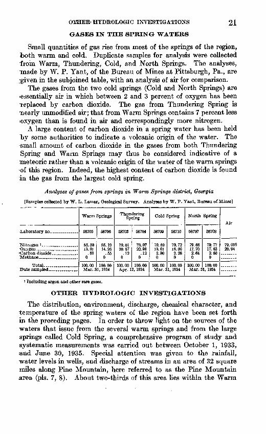
GA3E3 IN THE SPRING WATERS
21
Small quantities of gas rise from most of the springs of the region, both warm and cold. Duplicate samples for analysis were collected rfrom Warm, Thundering, Cold, and North Springs. The analyses, made by W. P. Yant, of the Bureau of Mines at Pittsburgh, Pa., are given in the subjoined table, with an analysis of air for comparison.
The gases from the two cold springs (Cold and North Springs) are essentially air in which between 2 and 3 percent of oxygen has been Teplaced by carbon dioxide. The gas from Thundering Spring is nearly unmodified air; that from Warm Springs contains 7 percent less oxygen than is found in air and correspondingly more nitrogen.
A large content of carbon dioxide in a spring water has been held T>y some authorities to indicate a volcanic origin of the water. The small amount of carbon dioxide in the gases from both Thundering Spring and Warm Springs may thus be considered indicative of a meteoric rather than a volcanic origin of the water of the warm springs >of this region. Indeed, the highest content of carbon dioxide is found in the gas from the largest cold spring.
Analyses of gases from springs in Warm Springs district, Georgia
[Samples collected by W. L. Lamar, Geological Survey. Analyses by W. P. Yant, Bureau of Mines]
Laboratory no _______
"Nitrogen 1... ___ . ___
Total .................
Warm Springs
58705
85.50 13.91
.59 0
100.00 Mar. 3
58706
85.19 14.26
.55 0
100.00 1, 1934
ThunderingSpring
58703
79.01 20.87
.12 0
100.00 Apr. 1
58704
78.97 20.91
.12 0
100.00 2,1934
Cold Spring
58709
79. 69 18.01 2.30 0
100.00 Mar. 3
58710
79.72 18.00 2.28 0
100.00 1,1934
North Spring
58707
79.66 17.70 2.64 0
100.00 Mar. 3
58708
79.77 17.63 2.60 0
100.00 1,1934
Air
79. 059 20.94
i Including argon and other rare gases.
OTHER HYDROLOGIC INVESTIGATIONS
The distribution, environment, discharge, chemical character, and temperature of the spring waters of the region have been set forth In the preceding pages. In order to throw light on the sources of the waters that issue from the several warm springs and from the large springs called Cold Spring, a comprehensive program of study and systematic measurements was carried out between October 1, 1933, and June 30, 1935. Special attention was given to the rainfall, water levels in wells, and discharge of streams in an area of 32 square miles along Pine Mountain, here referred to as the Pine Mountain area (pis. 7, 8). About two-thirds of this area lies within the Warm
22 THE WARM SPRINGS OF GEORGIA.
Springs quadrangle, and one-third lies west of it. In order to deter mine the approximate quantity of water that falls on this area, rain gages were installed on the Roosevelt and Trammel farms, as indi cated on plate 7. Daily readings were made at the Roosevelt gage, and weekly readings at the Trammel gage. The United States Weather Bureau maintains five stations within 35 miles of the area.
To obtain information concerning the level of the ground water and its temperature, four quarterly observations were made at 36 wells in the low country that surrounds the Pine Mountain area, and observations were made weekly from December 1933 to June 30r 1935, at six other wells.
To determine the distribution of run-off from the Pine Mountain area, measurements were made of the discharge from 30 drainage basins in the area. A gaging station was installed on Mill Creekr which is the most accessible of the larger streams, and a continuous- record of discharge was obtained from January 1, 1934, to June 30 r 1935. At selected stations on the other 29 streams, measurements of discharge were made intermittently over the same period.
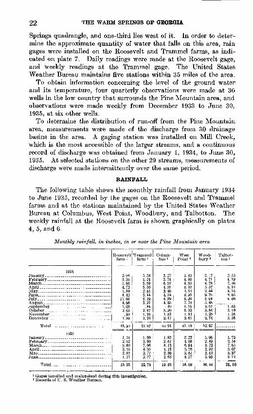
RAINFALL
The following table shows the monthly rainfall from January 1934 to June 1935, recorded by the gages on the Roosevelt and Trammel farms and at the stations maintained by the United States Weather Bureau at Columbus, West Point, Woodbury, and Talbotton. The weekly rainfall at the Roosevelt farm is shown graphically on plates 4, 5, and 6.
Monthly rainfall, in inches, in or near the Pine Mountain area
1934
JuneJuly ...........
November
Total.... ...................... .
1935
MarchApril.. .-_.... ........ ............... - .May
Total..... .......................
Roosevelt farm '
4.721.894.42
2 63.99
1.99
45. 99
1.742.626.69
2 Q7
Trammel farm 1
4.74
5.362.813.448.19Q 97
.84
1.252.23
43.97
1.993.007.964.35
2.77
22.78
Colum bus 2
3.273.786.104.212.404.244.294.25.40
1.332.47
39.94
1.832.616.134.152.302.63
19.65
West Point 2
1.834.864.836.023.63
6.30
4.156.321.842.67
57.18
2.224.096.843.76
4.17
24.69
Wood- bury 2
3.174.71
5.572.449.783.645.484.673.841.252.74
52.07
1.962.496.722.922.423.95
20.46
Talbot ton i
4.197.366.234.15.8.054.66
1.533.191.383.38.
1.732.547.853.073.373.12
21.68
1 Gages installed and maintained during this investigation.2 Records of U. S. Weather Bureau.

OTHER HYDROLOGIC INVESTIGATIONS 23
WATER LEVELS IN WELLS
The records of water levels that were obtained in six wells on and near Pine Mountain indicate that in the lowlands, where the ground- water table is generally near the surface, it rises immediately and abruptly after rains, whereas on Pine Mountain, where the water table lies at greater depths, it rises slowly after rams and the rise is relatively less than in the lowlands (pi. 6). It seems significant that the fluctuations of the water table in the well on the Roosevelt farm, which is sunk in the lower 200 feet of the Hollis quartzite, resemble those of the local rainfall, but 2 to 5 weeks seems to elapse before high rainfall is reflected in a rise in the local water table. Both curves resemble that of the discharge of Warm Springs, in which high dis charge lags 6 or 7 weeks behind high rainfall (pi. 4).
STREAMS
In the hope that a close study of the run-off from the basins of the Pine Mountain area might reveal deficiencies or great differences that would aid in determining the source of the waters that issue at Cold and Warm Springs, a program of measurement of the discharges of the streams was undertaken.
The 30 drainage basins of the Pine Mountain area are shown on plates 7 and 8. They range in area from 44 to 2,520 acres; 11 basins lie south of the crest of Pine Mountain, and 19 lie north of it. There are obvious differences in the form and other features of these basins that are determined largely by the nature and attitude of the under lying rocks. The north slope of Pine Mountain is underlain by the sheet of Hollis quartzite (fig. 1), 700 to 800 feet thick, which, except for several minor folds, dips gently north. The streams that flow north and east from the Pine Mountain divide rise in small swampy areas that lie at the junction of several ravines. As they leave the Pine Mountain area most of them flow through narrow V-shaped notches cut in the quartzite. There are some clearings on the north slope, but most of the area is still covered with the native forest. Considerable clearing has been done in the eastern basins.
For most of its length within this area Pine Mountain presents a steep escarpment toward the south, and the basins that drain south are largely cut in the Woodland gneiss, which underlies the Hollis quartzite. Almost half of the area within these basins is cleared and cultivated. The streams rise in timbered swampy areas near the heads of the basins. So far as possible, the discharge of all the streams wa& measured where they were crossed by the county roads that follow the base of the mountain on its north and south sides.
The geologic study of Pine Mountain indicates that for most of its- length the divide that separates the underground water which flow& north from that which flows south probably lies a few hundred feet

24 THE WARM SPRINGS OF GEORGIA
south of the topographic divide on the surface. In other words, if all other influences that affect the stream discharges were the same, .the average discharge per unit of area from the northern drainage basins should be a little greater than that from the southern basins.
In order to obtain data concerning the discharge of the streams, the following procedure was adopted. As the funds available did not permit installation of gages on all the streams, it was decided to install a continuously recording gage on one large stream, Mill Creek, which drains an area of 556 acres, and to make numerous intermittent measurements of discharge on the other streams. For streams that discharged less than 200 gallons a minute, a small venturi flume was used; for larger streams, a current meter was used at a place of simple cross section. During the period July 1, 1934, to June 30, 1935, dis charge of the larger streams was measured 20 to 25 times; that of the smaller streams, 11 to 15 times. For each measurement the ratio of the discharge of the stream to that of the control stream, Mill Creek, on the same day was calculated. The average of these ratios was assumed to represent the ratio of the discharge to that of Mill Creek over the entire year. As the data of these measurements of Mill XDreek and the other streams are voluminous, only the significant results are presented here; details will be given in the final report.
As a check, the distribution of discharge was determined for a short period late in March 1934 and for the year July 1, 1934, to June 30, 1935.
Plate 7 shows the drainage basins, their area, and the discharge of their streams, in gallons per minute per acre, during the short period late in March 1934. It reveals some interesting features. It shows that there is considerable similarity in the run-off per acre of the basins that drain southward from the Pine Mountain divide. If the run-off from five small basins (nos. 25, 26, 27, 28, 29) is combined, because their separate drainage divides cannot be placed accurately on the only map available, the range in run-off was from 0.50 to 0.90 gallon per minute per acre, and only one exceeded 0.64 gallon. The average run-off from the 11 basins that lie south of Pine Mountain was 0.66 gallon per minute per acre.
The run-off of the basins that lie on the north side of Pine Mountain showed a much wider range. It is noteworthy that most of the basins that lie within 3 miles west and southwest of Warm Springs discharged much less than the average, and that except in time of storms, no surface water leaves the two basins that lie south of Warm and Cold Springs. The average run-off of all the basins on the north slope, exclusive of the discharge of the Warm and Cold Springs, was 0.54 gallon per minute per acre. If to the discharge of the streams there is added the discharge of Cold Spring Branch during this period (1,672 gallons per minute), the average discharge was 0.66 gallon per minute

GEOLOGICAL 8TJEVET WATEK-StTPPLY PAPER 819 PLATE 784°45'
Average discharge of a// streams north of Pine Mountain Divide _ North of Pine Mountain Divide inc/uding Cofd Springs
GALLON PER. MIN-u TE f3^ A CfZE ...... O.54
O.66North of Pine Mountain Divide including Co/d Springs andWarm Springs
1 0L 1 1 I I 1 I I 1 i
O. 73
Mil1 Creek gaging xta.
5O7 SL, etc., area, in acres
Warm Springs
31
aD/schorge
3 MilesAverage discharge of crff streams south of Pine Mountain Divide O.66 gct//on per minute per acr&
32^ 50
84°45'
OUTLINE MAP OF PINE MOUNTAIN DRAINAGE BASINS SHOWING STREAM DISCHARGE, IN GALLONS PER MINUTE PER ACRE, MARCH 12, 13, 14, 23, 1934.Numbers indicate location of stream-gaging stations.

GEOLOGICAL SURVEY WATER-SUPPLY PAPER 819 PLATE 8
84*45GALLON PER MIN-
Averape discharge ofa//^ streams UT£ PE* ACRE north of Pine Mountain Divide _______ O.3INorih of Pine Mountain D/w'de inc/udiny Co/d Spring's 0.43
, 507 a, etc., area /n acres
Warm SpringsNorth of Pine Mountain D/'v/de fftc/udingr Co/d Sprt'ngs and Warm Spr/n<ps _:
Aver acre for stations BS to 29 inclusive (993 tares) is O.4O.
Average discharge of a// streams south ofP/ne Mountain Div/de O.44 get,//on per minute per acre
OUTLINE MAP OF PINE MOUNTAIN DRAINAGE BASINS SHOWING STREAM DISCHARGE, IN GALLONS PER MINUTE PER ACRE, JULY 1, 1934, TO JUNE 30, 1935.Numbers indicate location of stream-gaging stations.

ROCK FORMATIONS 25
per acre, a figure that coincides with the average discharge of the basins south of the divide. The "Warm Springs also rise on the northern border of the Pine Mountain area, however, and if their discharge during this period (617 plus 288, or 905 gallons per minute) is added to that of the streams and Cold Spring Branch, the average discharge was 0.73 gallon per minute per acre.
For the longer period July 1,1934, to June 30,1935 the range in average run-off from the several basins was not so great as it was for the short period. (See pi. 8.) For the basins that lie south of the Pine Mountain divide, the average run-off for the year was 0.44 gallon per minute per acre. For the basins north of the divide, the average run-off was 0.31 gallon per minute per acre. If to the run-off is added the average discharge of Cold Spring Branch for the period (1,546 gallons per minute), the average discharge for all of the area north of the divide was 0.43 gallon per minute per acre. If the dis charge of all the springs of the Warm Springs area (887 gallons per minute) is included in the total, the average discharge was 0.51 gallon per minute per acre.
These data for both the short and long periods indicate 1. That the streams that drain the basins north of the Pine Moun
tain divide discharge less water per minute per acre than those that drain the basins south of the divide.
2. That if the discharge of Cold Spring Branch is added to that of the other streams north of the divide, the total expressed in gallons per minute per acre approximately equals the average of the streams south of the divide. ,
3. That if, to the discharge of the streams north of the divide and- Cold Spring Branch, there is also added the discharge of the springs of the Warm Springs area, the average is slightly higher than that from the basins south of the divide.
The significance attached to these conclusions depends largely upon the confidence that is placed in the stream-discharge data ob tained under the circumstances and upon the accuracy of the deter mination that the ground-water divide lies south of the topographic divide.
Without doubt, many other elements affect the run-off from any topographic basin the elements that affect evaporation, such as soil and vegetation; the elements that affect transpiration, such as kind and distribution of vegetation; the elements that affect rate of absorp tion and discharge of water by the rocks. Few of these can be given quantitative value.
BOCK FORMATIONS
The rocks that underlie the Warm Springs quadrangle represent a wide variety of types. On the basis of their local features and rela tions, supplemented by knowledge of the features and relations of

26 THE WARM SPRINGS OF GEORGIA
similar rocks that are known in northern Georgia, they have been separated into units, whose distribution is shown on the geologic map (pi. 1). With the exception of several diabase dikes that are probably of Triassic age and several areas of surficial sand and gravel that are probably Tertiary or later, all the rocks within the quadrangle are considered to be pre-Cambrian. These include several large masses of igneous rocks that show little evidence of change since they were intruded and large areas of sedimentary and igneous rocks that have undergone considerable alteration (metamorphism) since they were originally formed. They are a part of the belt of crystalline rocks that underlies much of the Central Upland of Georgia and the Pied mont region of the Carolinas and Virginia.
PRE-CAMBRIAN ROCKS NORTH OF TOWAUQA FAULT
Carolina gneiss. The oldest rocks of this area include biotite gneiss and mica schist that are here considered to be the equivalent of rocks known in western North Carolina as the Carolina gneiss. These rocks are restricted to the part of the quadrangle that lies north of the Towaliga fault (pi. 1). Most of them, particularly the fine-grained biotite gneiss and thinly laminated muscovite schist, are considered to be sedimentary deposits that have been recrystal- lized without the addition of much new material. The mapped unit, however, contains large areas of coarser-grained and more strongly foliated rocks, made up of oligoclase, biotite, and quartz with sporadic muscovite and garnet, that are considered to be sedimentary material that has been thoroughly injected by granite. Much of the schist also contains thin lenses of pegmatite that conform to the lamination.
Within the main body of Carolina gneiss there are numerous small lenticular bodies of dark-green to black gneiss made up largely of hornblende, plagioclase, and quartz. The lamination of the Carolina gneiss is in large part steeply inclined, and the trends show that it has been involved in folding. The lenses of dark gneiss conform with the lamination of the Carolina gneiss, and the relations indicate that the dark gneiss may be the equivalent of the Roan gneiss of western North Carolina, which is inferred to be a recrystallized basaltic rock intrusive in the Carolina gneiss.
Snelson granite. A large area in the northwest quarter of the Warm Springs quadrangle is underlain by granite which is made up largely of oligoclase, microcline, quartz, and biotite and which is here called the Snelson granite because it is well exposed near Snelson's Crossroads, * 2Yz miles east of Harris. Most of the biotite flakes are arranged in rudely parallel layers, so that the rock has a persistent foliation. In contrast with the Carolina gneiss, the foliation shows small folds and minute plications. Like the gneiss, however, the Snelson granite is cut by numerous pegmatite dikes, some of which contain tourmaline.

BOOK FORMATIONS 27
Regional and local relations indicate that the granite is intrusive into the gneiss. The contact between these rocks is not sharp but broadly gradational, and near it the gneiss contains numerous lenses of granitic material that have been injected along the planes of lamination.
The area within which the Carolina gneiss, Snelson granite, and Roan gneiss are included ends southward against a narrow belt of sheared rock, largely Carolina gneiss, which has been traced for many miles through western Georgia and is known as the Towaliga fault zone. Without doubt it is a major structural feature, for the rocks that lie north of it are not known south of it, and conversely those that lie south of it are not known north of it.
PBE-CAMBBIAN BOCKS SOUTH tfF TOWALIGA FAULT
Sparks schist. The oldest rocks in the area south of the Towaliga fault are confined to a belt 3 to 5 miles wide that extends eastward across the quadrangle between Pine and Oak Mountains. The belt includes several varieties of mica schist, biotite gneiss, and quartzite, which are so interlayered as not to be separable in areal mapping. These rocks are here called the Sparks schist, because they are well exposed along Sparks Creek, which flows southward near the western border of the quadrangle. The schist is a medium-grained rock made up largely of muscovite, biotite, quartz, and feldspar. The gneiss is made up of feldspar, biotite, and minor quartz and garnet and ranges from fine- to coarse-grained. There are thin beds of quartzite in both the schist and the gneiss. In contrast with the overlying Hollis quartzite, however, they contain more feldspar and grade into feld- spathic quartz-mica schist. The Sparks schist is considered to be a highly metamorphosed sedimentary deposit into which considerable granitic material has been injected.
Hollis quartzite. Overlying the Sparks schist is the Hollis quartzite, a distinctive, persistent unit that is important in the problem of both warm and cold spring waters in this region. The name 'was first applied by Adams 4 to quartzites that crop out near Hollis, on the Central of Georgia Railway, 6 miles southeast of Opelika, Ala. Field work during recent years has shown that the quartzite may be readily traced from the vicinity of Notasulga, Ala., northeastward about 100 miles to Barnesville, Ga. It is well exposed in the "Warm Springs quadrangle, where it sustains the persistent ridges of Pine Mountain and Oak Mountain. All the warm springs of the region and appar ently most of the larger cold springs issue along or near the upper layer of quartzite, where it dips under the overlying Manchester schist. At several localities in Alabama a thick layer of dolomite, the
' Adams, G. D., Geology of Alabama: Alabama Geol. Survey Special Kept. 14, p. 36,1936; The significance of the quartzite of Pine Mountain in the crystallines of west-central Georgia: Jour. Geology, vol, 38, pp. 271-279,1930; General geology of the crystallines of Alabama: Jour. Geology, vol. 41, pp. 169-171,1933.

28 THE WARM SPRINGS OF (GEORGIA
Chewacla marble, is present near the Hollis quartzite, but the sequence- is not clear. The Chewacla marble is not known in western Georgia^
The features of the Hollis quartzite are well shown in the Warm Springs quadrangle at numerous natural exposures on the slopes of Pine and Oak Mountains, especially in the gorges cut by the Flint River and in numerous road and railway cuts. Measurements of its thickness on Pine Mountain range from 275 feet at Dunn's Gap to nearly 800 feet along the Flint River where it passes through the- Cove. Along Oak Mountain the thickness appears rarely to exceed 300 feet. Throughout this region the quartzite is very pure silica_ Muscovite commonly occurs in small amounts; very rarely, green chromium mica is present. Albite feldspar occurs at a few places. Sparse rounded grains of zircon arranged in parallel layers tend to confirm the sedimentary origin of the quartzite. In this region the- upper and lower 100 feet are generally thin-bedded and the middle* part is thick-bedded. Artificial exposures of the upper part commonly show layers of rather pure silica, an eighth of an inch to an inch thick,, separated by thin persistent layers of mica; such material where- weathered is commonly flexible, and the name "itacolumite" has been applied to it. By contrast, the beds of the middle part in numerous natural exposures are 2 to 10 feet thick and are broken only by vertical joints. ^The examination of numerous polished and thin sections of the quartzite failed to reveal evidence of the size and shape of the- original grains of quartz, of which it was doubtless once composed. At present the grains are largest in the thick-bedded material and smallest in the thin-bedded material. In the thick-bedded rock most of the volume is made up of grains 5 to 10 millimeters (0.2 to 0.4 inch> long; in the thin-bedded rock few grains exceed 1 millimeter. In. shape the grains are irregularly elongated parallel to the bedding, but their outlines are also minutely irregular or crenulate and inter locking. Most of the grains show undulatory extinction under the microscope. The plates of muscovite extend from one grain of quartz into another adjoining.
In contrast to most unmetamorphosed sandstones, this quartzite- would seem to be a poor aquifer. Tests of numerous specimens, however, including one from the bottom of the 90-foot Norris well recently dug on Pine Mountain, show that colored liquids penetrate- it rapidly. It is therefore believed that the upper and lower thin- bedded parts, each 100 feet or more thick, are relatively permeable and act as fair water carriers, in contrast with the middle, more- massive part, which seems to be relatively impervious. On the top and along the upper slopes of Pine Mountain the quartzite weathers- to loosely coherent sand. The Butts well, on the top of Pine Moun tain, was dug to a depth of 85 feet in the middle part of the quartzite- by the use of pick and shovel. By contrast, blasting was necessary-

BOOK FORMATIONS 29
in digging the Norris well to a depth of 90 feet in the quartzite about 300 feet below the top.
Where the Hollis quartzite is thin-bedded, it seems quite clear that the laminations represent the stratification of the original sandstone. In the thick-bedded portions, however, local discordances of the part ing surfaces raise doubt concerning the accuracy with which they show the attitude of the entire sheet. The field work shows that in most places the parting surfaces of the upper and lower thin-bedded quartz ite reveal the structure of the unit.
Manchester schist. A thick mass of mica schist and biotite gneiss, here called the Manchester schist, overlies the Hollis quartzite. It is named for the largest town in this quadrangle. The formation is exposed in two belts that extend generally northeast, one of which lies north of Pine Mountain and the other south of Oak Mountain. There is considerable resemblance between the Manchester schist, above the Hollis quartzite, and the Sparks schist, below the quartzite, and it is thought that both were originally sedimentary deposits that have undergone similar changes. The mica schist is largely musco- vite, but variable amounts of quartz, biotite, and oligoclase are present. Accessory minerals include garnet and apatite; more rarely hypersthene and kyanite. In the vicinity of Warm Springs the schist contains enough graphite to mark paper. Most of the gneissic ma terial is present as thin layers, largely a quarter of an inch to several inches thick. The rock contains considerable plagioclase (oligoclase to andesine), some of which forms large augenlike crystals, quartz, biotite, muscovite, and garnet. Accessory minerals include zircon, apatite, orthoclase, tourmaline, and rutile; more rare are chlorite and calcite.
At about 850 feet above the base of the Manchester schists, both south of Oak Mountain and locally north of Pine Mountain, there is a persistent bed of quartzite that ranges from 50 to 300 feet in thick ness. It closely resembles the Hollis quartzite.
Woodland gneiss. The area south of the Towaliga fault contains bodies of pre-Cambrian igneous rocks of two varieties an earlier, here called the Woodland gneiss, and a later, here called the Cun- ningham granite. The earlier rock is confined to the belt that lies between Pine and Oak Mountains; the later rock is found both in this belt and south of Oak Mountain.
The Woodland gneiss is named for the town of Woodland, in the southeast corner of the quadrangle. It is largely a coarse-grained biotite augen gneiss, so called on account of the coarse lenticular orthoclase crystals that are rather uniformly distributed through a medium-grained mass of orthoclase, quartz, and biotite. Muscovite and garnet are common, and apatite and zircon are sparingly present. The Woodland gneiss persistently underlies the basal bed of the

30 THE WARM SPRINGS OF GEORGIA
Hollis quartzite in this quadrangle. The 100 feet or more of gneiss that immediately underlies the quartzite is thinly laminated, locally almost schistose; progressively lower or deeper in the mass the lami nation is more widely spaced, and the rock assumes the common gneissic texture. As this gneiss is the most completely metamor phosed of the igneous rocks of this region, it is assumed to be the oldest.
Cunningham granite. The Cunningham granite forms one large and several small bodies in the south half of the quadrangle. In contrast with the other igneous and metamorphic rocks of the region, it is dark in color, and the boundaries can be traced with confidence. Commonly it is a massive coarse-grained rock made up of orthoclase, andesine, quartz, biotite, garnet, augite, and hypersthene, named in the order of their abundance; apatite, zircon, and piedmontite are accessory minerals. In a few places the rock is gneissic. The boundaries locally cut across the lamination of the Woodland gneiss, and the granite is believed to be intrusive in this rock. It is named for Cunningham Crossroads, southeast of Manchester, where the central part of the largest mass of the rock is exposed.
TBIASSIC IGNEOUS BOOKS
Several diabase dikes are present in the quadrangle. They are interesting because they are uncommonly long for their width and because they cut across all the other rocks of the region. The longest of these, the Talbotton dike, which crosses Oak Mountain 4,000 feet west of Woodland, extends for 35 miles, but its maximum width is only 155 feet. The average width of the other dikes is about 30 feet.
The dike rock is largely made up of laths of labradorite with augite; quartz, biotite, and iron oxides are sparingly present; olivine is not known in the dikes of this area. Such dikes have been found over a large area in the Piedmont region. They are generally assigned to the Triassic.
TERTIARY (?) AND LATER SEDIMENTARY ROCKS
The topographic map shows that the high parts of Pine Mountain in this region are nearly flat. These flat surfaces range in altitude from about 1,250 feet to 1,395 feet on Dowdell Knob, which is the highest point in the quadrangle. They appear to be remnants of a flat surface that was once extensive in this region but is now preserved only where it is underlain by resistant Hollis quartzite. Most of these flat remnants show thin sporadic patches of subangular to round quartzite pebbles, mainly from 1 to 3 inches in diameter. The pebbles do not form a continuous layer but are embedded in the layer of residual sandy soil 1 to 2 feet thick derived from the Hollis quartzite.
Until the geologic features of a large region in central Georgia are further studied the correlation and age of these gravel deposits can

STRUCTURAL FEATURES 31
only be inferred. For the present it seems that they were laid down by coastal streams at some stage in the Tertiary period.
At four localities on the north, east, and south borders of the wide lobe of Pine Mountain south of Warm Springs there are patches of unconsolidated sand and clay that rest on deeply weathered crystalline rocks, mostly Manchester schist. Their outcrops range in altitude from 850 to 980 feet, and the thickest appears to be about 90 feet thick. Particular interest is attached to them because at least one, that near Mount Hope Church, contains masses of bauxite and kaolin, several of which have been explored and have yielded a small production. The age of these deposits is obscure, but they are younger than the gravel on Pine Mountain.
STRUCTURAL FEATURES '
All the rocks of this area, except the diabase dikes and unconsolidated materials, are metamorphic that is, they have been thoroughly re- crystallized since their original formation. The rocks that were once sediments now include mica schist, quartzite, and biotite gneiss; igneous rocks are represented by granite gneiss, augen gneiss, and hornblende gneiss. Furthermore, most of the rocks, as a result of these changes, have assumed a strong foliation. Although the folia tion of the sedimentary rocks now lies in diverse attitudes, it is almost certainly closely coincident with the original bedding. This is par ticularly evident in the Hollis quartzite, where bedding is indicated by layers of different texture and foliation is indicated by alinement of mica scales.
The outstanding fault is that known as the Towaliga fault, which crosses the area north of Warm Springs, extending in a northeasterly direction (pis. 1 and 2). In places the evidence is good that the fault plane dips about 50° NW., but as the Carolina gneiss, which lies north of the fault, is the oldest rock in the region, and the rocks of the Wa- coochee belt, which lie south of the fault, appear to be much younger, it follows that the region north of the fault has been raised, and the fault must be regarded as an overthrust. It also follows from this interpretation that the Hollis quartzite dipping northwest from Pine Mountain must be cut off in depth by this fault. These relations are used to explain the probable course of the water that appears at Warm Springs.
The diabase dikes fill fractures, but these do not appear to be faults. A small fault displaces one of the dikes, and two other faults are indi cated on the south side of Pine Mountain near Nebula. Without doubt there are many other faults and fractures in this region, but they do not appear to be extensive enough or great enough to displace noticeably the boundaries of the formations that have been mapped.
Several large anticlinal folds and numerous small ones are revealed by the mapping of the Hollis quartzite. The largest is that of which

32 THE WARM SPRINGS OF GEORGIA
the outcrops on Pine Mountain form the north limb and those on Oak Mountain the south limb. The Cove is carved out of the center of a nearly circular dome, so that the Hollis quartzite forms the limit ing rim. Numerous small folds, both anticlines and synclines, are revealed by outcrops of the Hollis quartzite on the crest of Pine Mountain south of Warm Springs and near the Flint River and by outcrops of the Manchester schist. The small anticline shown by outcrops of Hollis quartzite around the hill occupied by the Warm Springs Foundation seems to be a factor in localizing the outlet of Warm Springs (pi. 3). Most of the minor folds of the region are indicated on plate 3.
SOURCE OF THE WARM SPRINGS WATER I
The data from several phases of this investigation tend to show that the water issuing from the Warm Springs is that which falls as rain on the high parts of Pine Mountain within several miles of the springs. These data may be summarized briefly as follows:
1. The surface run-off from the drainage basins north of the Pine Mountain divide is less per unit of area than that of the basins south of the divide, and this difference is about made up by the combined dis charge of Warm Springs and Cold Springs (pis. 7,8).
2. The run-off per unit of area of the basins that drain southward from Pine Mountain is rather uniform; by contrast, the basins that drain northward show great variations in run-off, and there is a notable deficiency in the basins that lie within 3 miles south and southwest of Warm Springs. The two fairly large basins that lie south of Warm Springs and Cold Springs yield no run-off except during storms.
3. The fluctuations in discharge of Warm Springs have a definite re semblance to the fluctuations in rainfall as shown by the gage on the top of Pine Mountain, 3 miles south, but the highs and lows of spring discharge lag 6 or 7 weeks behind the highs and lows of rainfall (pi. 4). The water level in a well in the lower part of the Hollis quartzite near the rain gage on Pine Mountain shows similar highs and lows that also lag 2 to 5 weeks behind those of rainfall (pL 4). This relation is one that would be expected if the well penetrates an aquifer that is connected with the conduit by which the water of Warm Springs rises to the surface.
4. The water of Warm Springs is relatively low in dissolved solids; it does not contain boron, and, so far as shown by the analyses, it does not contain any dissolved ingredients that suggest a deep igneous origin.
5. The gases dissolved in the water of Warm Springs are those found in the air, and they occur in about the same proportion that they occur in the air, except that the percentage of nitrogen is slightly higher and the percentage of oxygen slightly lower. Carbon dioxide, if

SOURCES OF THE WARM SPRINGS ;WATER
present in large quantities, might indicate a deep igneous.originybufi this gas occurs in the water of Warm Springs in <)nly moderate amounts,' such as would normally be dissolved by water of surface origin Hfrom the air and soil in fact it is even less in Warm Springs than in Cold Spring.
The structure of the rocks in the vi cinity of Warm Springs is shown in the geologic section given in figure 1. The structure at considerable depths of course could not be observed, but it is inferred from the structure as re vealed at the surface. The arrows in the figure show the probable path of the water discharged by Warm Springs. Starting as rain on parts of Pine Moun tain where the dense middle member of the Hollis quartzite has been re moved by erosion or is sufficiently fractured to permit some downward percolation, the water percolates into the permeable basal beds of the Hollis quartzite and thence northward through these beds to great depths, where it becomes heated by the nat ural heat of the rocks. From the struc ture of the rocks and the thermal gradient (p. 34) it is concluded that the water percolates northward nearly to the Towaliga fault. Near the fault it probably percolates upward, through fractures in the dense middle member of the Hollis quartzite, into the upper permeable beds of this formation. Thence it is forced upward by artesian pressure through these permeable beds, in which it is confined by the nearly impermeable middle member below and by the nearly impermeable Manchester schist above, and even tually it reaches the surface at Warm Springs. In its upward course, before it reaches the surface, the; water flows mainly through one or more natural conduits, which may have been pro duced largely by the solvent action of the water.

34 THE WjSbBM SPRINGS.OF GEORGIA
The remaining warm springs of the region, Parkman, Brown's, Thundering, Barker, LAfsey, and Taylor, rise either from Manchester schist within a few hundred feet above the top of the Hollis quartzite or from the thin layers of local alluvium that overlies the schist. As shown in plate 2, the areal distribution of the warm springs in the Wacoochee belt of rocks clearly indicates a relation to these rocks, particularly to the Hollis quartzite, but the observations which would be needed to indicate the course of the water that now issues at these warm springs have not been made. The water may either have entered the upper layers of the Hollis quartzite and descended several hundred feet below the surface before encountering fractures through which it could rise to the surface, or, conceivably, it may have entered the lower layers of the Hollis quartzite and, after descending below the surface, encountered fractures that crossed the entire thickness of quartzite as well as the overlying Manchester schist.
Without doubt, the Towaliga fault persists to great depth. If it were assumed that it cuts deep reservoirs of water, possibly of volcanic origin, one would expect these waters to rise as warm springs along the fault. Most of the warm springs, however, appear at the surface from 3 to 8 miles distant from the fault. It is believed, therefore, that the fault plays no direct part in localizing the distribution of the springs.
SOURCE OF THE HEAT OF WARM SPRINGS WATER
The diagram that is presented as figure 1 to show the source and path of the water that issues at Warm Springs indicates also the prob able source of the heat. There can be little doubt that the Hollis quartzite extends northward from the springs under the Manchester schist and ends in depth against the Towaliga fault. The dip of the quartzite as it passes downward under the schist and the dips shown in the schist indicate that the quartzite attains a depth of about 3,800 feet below the local surface.
As no record of thermal gradients in the crystalline rocks of Georgia was available, accurate measurements of temperature were made at 100-foot intervals in two wells during this investigation. There are numerous wells in the crystalline rocks as much as 800 feet deep from which water is pumped for use as local domestic supplies. The wells chosen for measurement were one \% miles west of Griffin, Ga., 757 feet deep, and another at Youngs Mill, 6 miles northeast of LaGrange, 618 feet deep, respectively 35 miles northeast and 23 miles northwest of Warm Springs. Neither well had been used for several years before the temperature was measured. Both wells were drilled in granite gneiss, which appears to be included in the Carolina gneiss of this region. Only the temperatures below a depth of 300 feet were used in calculating the thermal gradient. In the Griffin well the temperature increased 0.95° F. for each 100 feet in depth, and in the

SOURCE OF THE COLD SPRING WATER 35
LaGrange well, 1.20° F. These gradients indicate a temperature of 99.2° F. at a depth of 3,800 feet at the Griffin well and of 89.5° F. at
the LaGrange well. It appears that a thermal gradient such as that found at the LaGrange well is sufficient to heat the water so that it could be delivered at the surface at a temperature of 88° F., after allowance is made for the loss of heat that must occur during the up ward movement of the water. This is the temperature of the Warm Springs water.
The geologic and thermal data indicate, therefore, that water enter ing the ground on Pine Mountain at a temperature of 62° F. can be carried in the Hollis quartzite to a depth of about 3,800 feet and re turned to the surface at a temperature of 88° F.
SOURCE OF THE COLD SPRING WATER
Even the casual observer is impressed by the fact that the largest cold spring of this region (Cold Spring) appears at the surface scarcely a mile from the largest warm spring (Warm Springs), and it is natural to wonder whether they may be related.
During the period of study, the discharge of Cold Spring Branch, as noted from 32 measurements, ranged from 1,282 to 1,822 gallons a minute and the average was 1,546 gallons. This is essentially the discharge of the four cold springs. Although the area of the surface drainage basin of Cold Spring Branch is 507 acres, there is no run-off from that part of the basin above Cold Spring. As the average dis charge of Cold Spring Branch represents all the water that would fall as rain on 667 acres at theTate of 45 inches a year, it is clear that Cold Spring must receive water from a larger area than the surface basin that lies above it. Both the chemical character and the temperature of the water indicate that it has not penetrated far below the surface of the ground.
A study of the rainfall and run-off from the Mill Creek Basin, 5 miles west of Warm Springs, indicates that 33 percent of the rainfall is represented by the run-off of the stream, the remaining 67 percent being lost by evaporation, transpiration, percolation out of the basin, and other minor processes. From this study it would appear that these cold springs are discharging the water that is absorbed as rain in the shallow surficial zone of an area that must range from 1,500 to 2,000 acres, south and southwest of the springs. This calculation indicates, therefore, that the water discharged by the cold springs must represent the rainfall,on several Jiearby-surface basins taut that much« of the water, instead of following the surface drains, enters the permeable upper 200 feet of Hollis quartzite, follows this zone laterally eastward below the Manchester schist, and is delivered as cold springs at the lowest surface outcrop of this zone.
The existence of the largest cold spring relatively near the largest warm spring is probably to be explained by the areal extent of the

36 THE WABM SPRINGS,OF GEORGIA
outcrop- and the structure of the Hollis qdartz&e. It has been stated earlier that the distribution of the known warm springs of Georgia seems to be related to and therefore controlled by the belt of Hollis' quartzite. Plate 2 .shows the approximate areal extent of the quartz* ite outcrops. Where the outcrop is narrow the quartzite dips steeply; where it is broad the quartzite is either closely folded, as near the Flint River, or reveals broad gentle folds, as south of Warm Springs. The great lobe of quartzite that forms Pine Mountain south of Warm Springs is the largest outcropping body of the quartzite and, although gently folded, it dips generally north and northeast. Such an area offers the best opportunity in the region for the upper part of the Hollis quartzite to absorb rainfall. The general trend of movement and point of discharge of such absorbed water would be governed by the structure of the beds and the distribution of ravines. It seems reasonable, therefore, that the largest cold spring of the region should be found adjacent to the largest outcrop of gently dipping quartzite, According to the interpretation of the source and underground move ment of the water of Warm Springs, offered here, it is reasonable that this water, too, should be found adjacent to the largest outcrop of Hollis quartzite. Both springs apparently derive their water from rain falling on the surface. The difference in temperature is due to the difference in the depth to which the water percolates in the earth before reappearing at the surface.
MEASURES FOB IMPROVING THE WARM SPRINGS
It was the hope of the officials of the Georgia Warm Springs Foundation that, as the result of this investigation, ways might be found by which the temperature of the water and perhaps the dis charge, might be increased. The investigation shows that about two-thirds of the total supply of warm water in the area, or about
.550 gallons a minute, has an observed temperature ranging only between 87.7° and 88.2° F., and that it issues from a fractured zone in the quartzite scarcely 25 feet wide. The other one-third of the water issues from numerous outlets in alluvium, within 250 feet east or west of the main source, and with temperatures as much as 9° lower than that of the main source. Doubtless all sources of warm water should be controlled sooner or later, but at present the warmest two-thirds should be segregated from the sources of cooler water. It seems that the minor sources of water that issues from local alluvium may be regarded as leakage from a central or main conduit. It would therefore be advisable to enclose the minor sources in walls of impermeable material, making a tight seal with.the bedrock and rising above the present outlets so as to form pools in which water levels would lie several feet above the present outlets. Back pressure

MEASURES FOR IMPROVING THE WARM SPRINGS 37
would thus be created, which would tend to force the water to rise in the central conduit, probably at the present temperature of that portion.
The question has been raised whether it would be possible by drilling to intercept the main or central conduit at depth and permit the water to rise directly to the surface, probably with less loss of heat than takes place in the natural conduit. All that can be learned of the local geology and inferred concerning the path of the rising water indicates that the chance of intercepting the natural conduit at a depth, say, of 500 feet, by one or a few vertical holes, is very small. For the increase in temperature that might be expected, it seems that the expenditure would not be warranted.

INDEX
Abstract__________ Acknowledgments for aid . Agriculture, development of.
Page123
21Analyses 'of spring stream, add well waters... 17-26
Barker Spring, analysis of water of______ 17discharge and temperature of_. ____ 10geologic relations of____________ 10,34location of_________________ 10,19
Black Sulphur Spring, analysis of water of_ 17location and general features of______ 14
Blue Spring, analysis of water of _______ 17chemical character of water of.. ____ 15discharge and temperature of.______ 13location of____.____._....___ 13,19
Brown's Spring, analysis of water of _____ 17discharge and temperature of__..___ 4,10geologic relations of.____________ 34location of _________________ 10,19
Carolina gneiss, general features of______ 26geologic relations pf, to springs._____ 14structural relations of__________ 31thermal gradient in well drilled in. ___ 34
Cascade Branch, analysis of water of.... __ 18Central Upland, relations of _________ 3 Chalybeate, springs at, chemical character of
water of_.....______... 1&-14,15springs at, discharge and temperature of.. 14
Chalybeate Spring (at White SulphurSprings), analysis of water of__ 17
location of__________________ 14,19 Chalybeate Spring Nos. 1-3, analysis of water
of....... ...................... 17Chalybeate Spring No. 4, analysis of water of. 18 Chattahoocb.ee River, relation of streams of
area to_______________ 3Chemical character of the waters, data on__ 15-20Cold Spring, analyses of gases from____.. 21
analysis of water of____________ 17discharge of, relation of, to rainfall__ 12, pi. 5general features of..____________ 11-12location of.._...__..-.---_____... 11,19source of water of_____________ 35-36temperature of____________ __ 12
Cold Spring Branch, discharge of._.__._ 13,25discharge of, relation of, to rainfall____ 35
Cold springs, analyses of waters of._____ 17-18general features of...___....__.__ 11-14summary of._..______.._____ 14
Cold waters, chemical character of_____ 15-16 Columbus, Qa., rainfall at__________ 22 Cove, features of the______________ 3,32 Cunningham granite, general features of___ 30
Dikes, diabase, general features of.----------- 30Dowdell Knob, features of_________.. 3,30Discharge~of.stream&,and-sprkigs,..__.__ 4,
6-9,23-25, pis. 4,7,8program of measurements of..____... 21See also individual springs.
Page Discharge of Warm Springs, relation of, to
rainfall and ground-water level. 23, pi. 4
Faults in the area . 31 Field studlte^durmW of.. 2Flint River, relation of streams of area to 3 Folds in the area. .------ . - - 31-32Fuller well, analysis of water oL 18
Gases in the spring waters, occurrence andanalyses of. 21
Geology of the area_._ ... 25-32, pis. 1, 2 Georgia Warm Springs Foundation, property
of...... 4property of, proposed measures for im
provement of springs on.... 36-37Gill Spring, analysis of water of 18
location of 20Greenville Plateau, erosion and gullying of... 3
general features of...- 2-3Griffin, Ga., thermal gradient in well near.... 34Ground-water level, fluctuations of, in wells. 23, pi. 6
relation of discharge of Warm Springs torainfall and . . 23, pi. 4
Heat of Warm Springs water, source of. 34-35Hollis quartzite, general features of 27-29
relation of springs to. 10,13,33,34,35-36structural relations of 31,32,33,34thickness of.... ._ . 4,28
Igneous rocks, general features of. 30
Kings Gap Spring, analysis of water of-... 17 location of... 19
LaGrange, Ga., thermal gradient in well near. 34-35Lamar, W. L., chemical analyses of water by. 17-18Lifsey Spring, analysis of water of. 17
discharge and temperature of _. _ 10geologic relations of . 34location of.... 10,18
Manchester High School well, analysis of waterof... . . 18
chemical character of water of 15Manchester reservoir, analysis of water of 18Manchester schist, general features of.. 29
relation of warm springs to... 4,34structural relations of____________ 33,34
Mathis well, analysis of water of .-. -. 18Mill Creek, discharge measurements of _ __ 24Mill Creek Basin, study of rainfall in. ..... 35Mountain streams, analyses of water of___ 18Mount Hope Branch, analysis of water of.... 18
North Spring, analyses of gases from..___. 21 analysis of water of_______... 17 discharge of . 12, 13, pi. 5 general features of____.... 11-12leoflftionof-_ 11,10temperature of.... . 12
Oak Mountain, features of.
39

40 INDEX
pageOak Mountain Spring, analysis of water of_ 17
chemical character of water of.._____ 15 discharge and temperature of. ______ 14 geologic relations of ____________ 14 location of , ___. ________ 14,19
Parkman Spring, analysis of water of____ 17 discharge and temperature of_______ 8 geologic relations of_________.,__ 34 location of _________________ 8,19
Pine Mountain, features of_._______ 3 streams on, analyses of water of_____ 18 temperature in wells near_________ 4 warm springs near, geologic problems pre
sented by __.___.___ 1 Pine Mountain area, ground-water level in,
observations of_________ 22, pi. 6 ground-water level in, relation of. to rain
fall.__._____.______ 23, pi. 6 rainfall measurements in_________ 22 stream discharge in___.____ 23, pis. 7, 8
Pine Mountain divide, comparison of run-offnorth and south of________ 24-26
Pine Mountain formation, occurrence andcharacter of___.________ 4
Pine Mountain Spring, analysis of water of 17 location of ____ _____________ 19
Public Works Administration, funds allottedby._______.____....__ 1
Rainfall, measurements of__________ 22relation of, to discharge of Warm Springs.23, pi. 4
to fluctuations of groundwater level.23, pi. 6weekly, at Roosevelt farm_______ 22, pi. 5
Red Sulphur Spring, analysis of water of ___ 17location and general features of..____ 14
Roan gneiss, occurrence of __________ 27 Rock formations, general features of_____ 25-3] Roosevelt farm, rainfall at_____ 12,22, pis. 4,5
well on, fluctuations in water level in.23, pis. 4,6 Run-off, studies of_______________ 23-25
Scope of investigation____.________ 2 Snelson granite, general features of...____ 26-27 South Spring No. 1, analysis of water of __ . 17 South Springs, discharge and temperature of.. 13
genera] features of _ ...__ 12-13 location of . ..._________.... 32,19
Sparks Creek, analysis of water of______ 18 Sparks schist, general features of._______ 27 Streams, discharge of________ 23-25, pis. 7,8 Structural features_____________ 31-32,33 Surface features... ____________ 2-3 Surface waters, analyses of__________ 18
Talbotton, Qa., average air temperature at__ 4 rainfall at _ 22
Taylor Spring, analysis of water of______ 17 discharge and temperature of_______ 11 geologic relations of .. 34 location of___. _____.. ____. _ 11,18
Temperature, in wells. _..__ 34-35 of air_____ ____ ____.... 4 of spring water. See individual springs.
Tertiary (?) and later sedimentary rocks, gen eral features of . __- 30-31
Thermal gradients in wells... __.... 34-35
PageThundering Spring, analyses of gases from__ 21
analysis of water of... ..___.____ 17discharge and temperature of..,_____ 10geologic relations of __ ___ 34location of_________________ 10,1&spring tributary to, analysis of water of_ 17
Towah'ga fault, pre-Cambrian rocks north of. 26-27pre-Cambrian rocks south of_______ 27-30relation of geologic formations to_____ 31,34relation of warm springs to... . .. 33,34
Trammel farm, rainfall at..____ __ 22Trammel's Spring, analysis of water of.___ 17
discharge and temperature of 13geologic relations of. _ 13location of.____._.___ __ 13,19
Triassic igneous rocks, general features of 30
Wacoochee belt, relation of warm springs to. 4,34 structural relations of rocks of... ___ 31
Warm Springs, analyses of gases from 21 analyses of water of 17 discharge of.. 4,6-9, pi. 4
methods of measurement of 6 relation of, to rainfall and ground-
water level .___ ... . 23, pi. 4 history of improvements at... 4-5 measures recommended for improving.; 36-37 sources of supply of 5 structure of rocks in vicinity of. . 33 temperature of 4,5-6 water of, source of.. 32-33
source of heat of 34-35Warm Springs area, map of, showing sources of
warm water, pools, drains, etc. pi, 3Warm Springs quadrangle, geologic map of pi. 1
location of, map showing pi. 2Warm springs, analyses of waters of, 17
distribution of. 3 relation of, to Hollis quartzite 36 summary of... ^ 11
Warm waters, chemical character of 15Wells, analyses of waters of 18
temperature of water of . ' 4 thermal gradient in. 34-35 water levels in s, 23, pi. 6
West Point, Ga., average air temperature at,. 4 rainfall at........... - .- 22
White Sulphur Spring, analysis of water of 17 general features of.. 14 hydrogen sulphide in. 16
White Sulphur Springs, chemical character ofwater of springs at i 16
general features of springs at. t 14 geologic relations of springs at 14 location of springs at . M
Willingham Spring No. 1, analysis of water of. 18 location of 20
Woodbury, Ga., rainfall at 22Woodbury Spring Nos. 1 and 2, analyses of
water of.._ 18 . location of - 20
Woodland gneiss, general features of 29-30
Yant, W. P., chemical analyses by . 21 Youngs Mill, Ga., thermal gradient in well at. 34
o

The use of the subjoined mailing label to return
this report will be official business, and no
postage stamps will be required
UNITED STATES PENALTY FOR PRIVATE USE TO AVOP DEPARTMENT OF THE INTERIOR PAYMENT OF POSTAGE, woo
GEOLOGICAL. SURVEY
OFFICIAL BUSINESS
This label can be used only for returning official publications. The address must not Be changed.
U. S. GEOLOGICAL SURVEY,